the new swiss law on geoinformation and the ordinance on the cadastre on public law ... · pdf...
TRANSCRIPT

TS 7K – Legal and Institutional Aspects in Land Administration Jürg Kaufmann The New Swiss Law on Geoinformation and the Ordinance on the Cadastre on Public Law Restrictions (4064) FIG Congress 2010 Facing the Challenges – Building the Capacity Sydney, Australia, 11-16 April 2010
1/14
The New Swiss Law on Geoinformation and the Ordinance on the Cadastre on Public Law Restrictions (4064)
Jürg KAUFMANN, Switzerland
Key words: Law, Geoinformation, NSDI, Cadastre of public-right restrictions of landownership SUMMARY Switzerland has put to force one of the first laws on geoinformation in the world by July 1, 2008. This law is also the legal base for the implementation of the Swiss NSDI. In this context a Cadastre of public-law restrictions shall be built up. For the regulation of this new cadastre the Ordinance on the Cadastre of Public-right Restrictions of Landownership was developed and put to force by October 1, 2009. This paper gives an overview on the development and the content of these new pieces of legislation. In addition the problems occuring during the drafting process, first experience, and the consequences of the new legislation on the profes-sion are outlined. ZUSAMMENFASSUNG
In der Schweiz wurde per 1. Juli 2008 das Gesetz über die Geoinformation in Kraft gesetzt. Dies ist weltweit einer der ersten umfassenden Geoinformationserlasse und er bildet auch die
Rechtsgrundlage für den Aufbau der nationalen Geodateninfrastruktur NGDI. In diesem Kontext soll auch ein Kataster der öffentlich-rechtlichen Eigentumsbeschränkungen aufgebaut werden. Dieser neue Kataster wurde mittels der Verordnung über den Kataster der öffentlich-
rechtlichen Eigentumsbeschränkungen (ÖREB-Kataster) geregelt, welche per 1. Oktober 2009 in Kraft getreten ist. Diese Präsentation gibt einen Überblick über die Erarbeitung und
den Inhalt dieser zwei neuen Erlasse. Zusätzlich werden die Probleme, welche in der Entwurfsphase aufgetreten sind, die ersten Erfahrungen und die Konsequenzen für den
Berufsstand dargestellt.

TS 7K – Legal and Institutional Aspects in Land Administration Jürg Kaufmann The New Swiss Law on Geoinformation and the Ordinance on the Cadastre on Public Law Restrictions (4064) FIG Congress 2010 Facing the Challenges – Building the Capacity Sydney, Australia, 11-16 April 2010
2/14
The New Swiss Law on Geoinformation and the Ordinance on the Cadastre on Public Law Restrictions (4064)
Jürg KAUFMANN, Switzerland
1. INTRODUCTION In view of a new regulation of the financial compensation between the Swiss Federation and the Cantons a new article was introduced in the Federal Constitution of April 18, 1998. This change concerning the National Survey was among others approved in the popular vote on November 28, 2004 and put to force by January 1, 2008.
Art. 75a1 National Land Survey 1 The National Land Survey shall be the responsibility of the Confederation.
2 The Confederation shall issue regulations on official surveying.
3 It may issue regulations on the harmonization of official information relating to the land
Figure 1 New article in the constitution
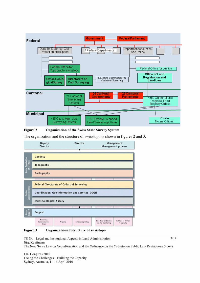
It was the first time the Land Survey was provided with a constitutional base. Before these aspects were regulated by a special federal law, The Federal Act of 21 June 1935 on the Crea-tion of the National Map Series. For the cadastral surveying, called official surveying in Switzerland, the legal foundation was the Ordinance on Official cadastral Surveying of 18th November 1992 based on Article 950 of the Civil Code saying: 1 Registration and description of the properties in the land register have to be done on the basis of a map, which as a rule, has to be the result of an official surveying. The task to elaborate the new legal framework in this field was given to the Federal Office of Topography, swisstopo, the authority concerned with the geographic reference data, the car-tography and the cadastral surveying and the national geological survey. swisstopo was a pure Geodetic and Cartographic Office for a long time and its key business was cartography for defense purposes. It still belongs to the Federal Department of Defense, Civil Protection and Sport. In 1987 the office was transferred from a normal office to a body managed along commercial lines as part of the NPM (New Public Management) pilot project (productivity commitment and global budget). The Federal Directorate of cadastral Surveying was transferred from the Federal Department of Justice and Police to swisstopo in 1999 and in 2000 COGIS the federal coordination unit responsible for the coordination of geoinformation on federal level was built up. In 2005 the National Geological Survey authority was subordinated to swisstopo and its legal base was included into the legislation So swisstopo has a rather strong position in the field of geoinformation.
TS 7K – Legal and Institutional Aspects in Land Administration Jürg Kaufmann The New Swiss Law on Geoinformation and the Ordinance on the Cadastre on Public Law Restrictions (4064) FIG Congress 2010 Facing the Challenges – Building the Capacity Sydney, Australia, 11-16 April 2010
3/14
Figure 2 Organization of the Swiss State Survey System
The organization and the structure of swisstopo is shown in figures 2 and 3.
Figure 3 Organizational Structure of swisstopo

TS 7K – Legal and Institutional Aspects in Land Administration Jürg Kaufmann The New Swiss Law on Geoinformation and the Ordinance on the Cadastre on Public Law Restrictions (4064) FIG Congress 2010 Facing the Challenges – Building the Capacity Sydney, Australia, 11-16 April 2010
4/14
2. STARTING CONDITIONS Due to the fact that the Swiss legislation on the cadastre was fully re-engineered after 1980 with a totally new approach to the application of modern IT for the cadastral surveying sig-nificant experience was available, The result of this re-engineering work was a new standard for cadastral surveying, called AV93 (official surveying 1993), because the new regulations entered into effect in 1993. This new standard can be characterized as follows:
These achievements are illustrated by figure 4 to 6.
Figure 4 The information layers of AV93
TS 7K – Legal and Institutional Aspects in Land Administration Jürg Kaufmann The New Swiss Law on Geoinformation and the Ordinance on the Cadastre on Public Law Restrictions (4064) FIG Congress 2010 Facing the Challenges – Building the Capacity Sydney, Australia, 11-16 April 2010
5/14
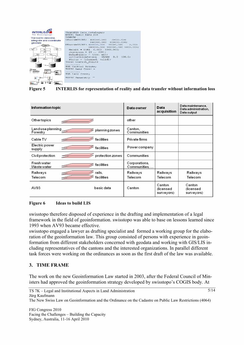
Figure 5 INTERLIS for representation of reality and data transfer without information loss
Figure 6 Ideas to build LIS swisstopo therefore disposed of experience in the drafting and implementation of a legal framework in the field of geoinformation. swisstopo was able to base on lessons learned since 1993 when AV93 became effective. swisstopo engaged a lawyer as drafting specialist and formed a working group for the elabo-ration of the geoinformation law. This group consisted of persons with experience in geoin-formation from different stakeholders concerned with geodata and working with GIS/LIS in-cluding representatives of the cantons and the interested organizations. In parallel different task forces were working on the ordinances as soon as the first draft of the law was available. 3. TIME FRAME The work on the new Geoinformation Law started in 2003, after the Federal Council of Min-isters had approved the geoinformation strategy developed by swisstopo’s COGIS body. At

TS 7K – Legal and Institutional Aspects in Land Administration Jürg Kaufmann The New Swiss Law on Geoinformation and the Ordinance on the Cadastre on Public Law Restrictions (4064) FIG Congress 2010 Facing the Challenges – Building the Capacity Sydney, Australia, 11-16 April 2010
6/14
the same time the strategy for a new financial compensation scheme was adopted by the Swiss parliament, which created the need to accelerate the legislation process. The time frame for the elaboration of the law package can be seen in figure 7.
Figure 7 Time frame for the law development work 4. RESULT OF THE WORK 4.1 Structure of the Law The result of the work is first the Federal Act on Geoinformation with 47 articles on 14 pages. Its structure is shown in figure 8.
Figure 8 Structure of the Act on Geoinformation 4.2 Effectiveness The general provisions have direct impacts on the special parts, regulating the tasks National Land Survey and Cadastre Survey given by constitution as well as the National Geological

TS 7K – Legal and Institutional Aspects in Land Administration Jürg Kaufmann The New Swiss Law on Geoinformation and the Ordinance on the Cadastre on Public Law Restrictions (4064) FIG Congress 2010 Facing the Challenges – Building the Capacity Sydney, Australia, 11-16 April 2010
7/14
Survey and the Cadastre of the public-right restrictions of the landownership. At the same time it impacts all special laws, which deal in one or another way with space related arrange-ments, be it plans, maps, description of boundaries and places - in short geoinformation. 4.3 Ordinances
In addition 11 ordinances were on the topics shown in figure 9 were drafted and 9 of them entered in effect together with the Act. The Ordinance on the Cadastre of Public-right Restric-tions of Landownership was put into force on October 1st, 2009 and the Ordnance on the Fees for Geoinformation on January 1st, 2010.
Figure 9 Ordinances connected with the Act on Geoinformation The Ordinance on the Geoinformation regulates the details concerning geodata. In the annex all the official geodata identified in the different special laws of the federal legislation are listed in the Official Data Catalogue, which contains 175 data sets, describing spatial objects. An extract of this catalogue is presented as an example in figure 10.

TS 7K – Legal and Institutional Aspects in Land Administration Jürg Kaufmann The New Swiss Law on Geoinformation and the Ordinance on the Cadastre on Public Law Restrictions (4064) FIG Congress 2010 Facing the Challenges – Building the Capacity Sydney, Australia, 11-16 April 2010
8/14
Nr. Description Legal base
Responsible
Georefernce
PRL
R C
ad
Access right
Online access
95 Groundwater protection zone SR 814.20, §20 cantons no yes A
yes
96 Groundwater protection area SR 814.20, §21 cantons no yes A
yes
97 Groundwater source SR 814.201, 30 cantons no no A
yes
98 Inventory of groundw.sources SR 814.20, §82 cantons no no A
no
99 Inventory of water rights SR 721.80, § 31 BAFU no no B
no
100 Regional sewerage plan SR 814.20, § 7 cantons no no A
yes
101 Municipal sewerage plan SR 814.20, § cantons no no A
yes
Figure 10 Extract from the official geodata catalogue 5. CONTENT OF THE ACT ON GEOINFORMATION
The List of chapters and Sections of the Act can be seen from figure 11. The highlights of the different regulations are
− The aim is it to make available the geodata on the whole territory of Switzerland easily available to every interested person or institution at reasonable cost;
− The law covers all official geodata under federal legislation; − The technical requirements include data and representation models for geodata and
metadata; − The responsibility for geodata is with the authority which according to the law has to
collect, update and manage the respective data and which is to make the data available in every moment;
− The geodata are public unless public or private interests are violated; − The cadastre of the restriction on landowner rights is introduced and shall be operated
by the cantons;

TS 7K – Legal and Institutional Aspects in Land Administration Jürg Kaufmann The New Swiss Law on Geoinformation and the Ordinance on the Cadastre on Public Law Restrictions (4064) FIG Congress 2010 Facing the Challenges – Building the Capacity Sydney, Australia, 11-16 April 2010
9/14
− The legal base has priority on every other regulation concerning geoinformation.
Figure 11 Content of the Act on Geoinformation 6. CADASTRE OF THE PUBLIC-RIGHT RESTRICTIONS ON LANDOWNER-
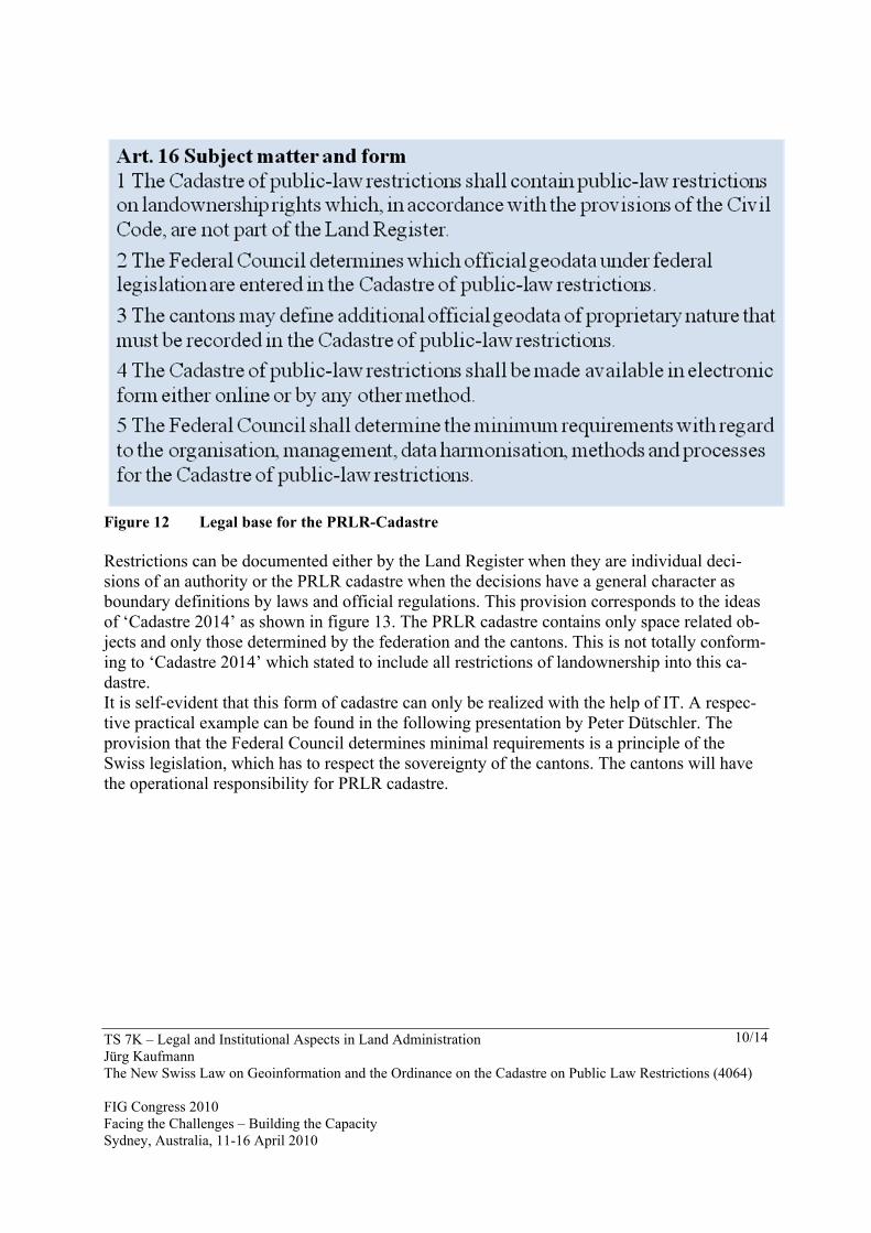
SHIP (PRLR) The really new instrument introduced by the Act on Geoinformation is the Cadastre of public-right restrictions on landownership. The base for this decision was significantly influenced by the FIG publication ‘Cadastre 2014’ – A Vision for a Future Cadastral System. The need for reliable information on facts restricting the landownership rights was expressed already in the years 1970 - 1980 by land experts concerned with physical planning. In their request for a better documentation of restrictions on landownership they wrote: The most important information of the planning and housing legislation worthy to be pub-lished are the public-right restrictions of the landownership rights. Those restrictions have their base in a confusing amount of laws and regulations of the federation, the cantons and the municipalities and public bodies of different domains of the public law. After different initiatives on all political levels, the Law on Geoinformation brings now a so-lution of this problem which creates legal insecurity for all stakeholders in the field of territo-rial work. The base for this new cadastre is laid in the Act on Geoinformation Art. 16 and the wording is shown in figure 12.
TS 7K – Legal and Institutional Aspects in Land Administration Jürg Kaufmann The New Swiss Law on Geoinformation and the Ordinance on the Cadastre on Public Law Restrictions (4064) FIG Congress 2010 Facing the Challenges – Building the Capacity Sydney, Australia, 11-16 April 2010
10/14
Figure 12 Legal base for the PRLR-Cadastre Restrictions can be documented either by the Land Register when they are individual deci-sions of an authority or the PRLR cadastre when the decisions have a general character as boundary definitions by laws and official regulations. This provision corresponds to the ideas of ‘Cadastre 2014’ as shown in figure 13. The PRLR cadastre contains only space related ob-jects and only those determined by the federation and the cantons. This is not totally conform-ing to ‘Cadastre 2014’ which stated to include all restrictions of landownership into this ca-dastre. It is self-evident that this form of cadastre can only be realized with the help of IT. A respec-tive practical example can be found in the following presentation by Peter Dütschler. The provision that the Federal Council determines minimal requirements is a principle of the Swiss legislation, which has to respect the sovereignty of the cantons. The cantons will have the operational responsibility for PRLR cadastre.

TS 7K – Legal and Institutional Aspects in Land Administration Jürg Kaufmann The New Swiss Law on Geoinformation and the Ordinance on the Cadastre on Public Law Restrictions (4064) FIG Congress 2010 Facing the Challenges – Building the Capacity Sydney, Australia, 11-16 April 2010
11/14
Figure 13 Idea of Cadastre 2014 The ordinance contains the sections represented in figure 14.
Figure 14 Content of the Ordinance on the Cadastre on public-right restriction of landown-
ership The most important provisions of this ordinance are:

TS 7K – Legal and Institutional Aspects in Land Administration Jürg Kaufmann The New Swiss Law on Geoinformation and the Ordinance on the Cadastre on Public Law Restrictions (4064) FIG Congress 2010 Facing the Challenges – Building the Capacity Sydney, Australia, 11-16 April 2010
12/14
− The responsibility for the determination of the restrictions remains with the authorities charged with the execution of legal prescriptions. These fix the boundaries where the restrictions are effective. The cadastre has to include these arrangements;
− The boundaries are to be fixed on the basis of the cadastral data; − Every interested person will get an extract from the cadastre concerning one or several
land parcels; − The person getting an extract can ask for an authentication of the content of the extract
by the cadastre manager; − The cantons can declare the cadastre to be the official gazette on respective decisions; − The cantons are responsible for the management of the cadastre while the federation
keeps the strategy and the supervision; − The implementation of the cadastre is co-funded by the federation and the cantons, the
cost of maintenance is to be borne by the bodies which cause the changes in the ca-dastre;
− The implementation of the cadastre is taking place in two steps. First some pilot can-tons will develop their regulations until 2014 and start operation by January 1st, 2015. All other cantons are to be ready to operate the cadastre from beginning of the year 2020.
7. LESSONS LEARNED
The elaboration of this law package was a challenging task. It was not easy to get all the in-volved bodies and their ideas together and to achieve a comprehensive and coherent solution. The following problems and their solutions are to be mentioned as lessons learned:
− The whole topic was new to the involved bodies and it needed a lot of discussions to achieve a common view;
− Most of the involved persons were involved in the implementation of GIS-Systems in different fields and they did do that in an unregulated way. To be forced to follow rules was not liked very much. The reserves created disputes;
− The prescription to model all the data in a formal and strict manner still creates big problems. It seems that GIS people in contrary to the cadastral survey officers which have positive experience with data modeling do not like the binding force of the ar-rangements;
− The cadastre on the public-right restrictions created a lot of resistance. Everybody feared the binding force and they were anxious that surveyors would take over their work. This was finally the reason for the determination of a subset of official geodata to be content of the PRLR-cadastre by federation and cantons and a step wise imple-mentation of the cadastre.
− The persons working on the data catalogue found the only reasonable way to define the official geodata is a systematic scan of the laws to find spatial related arrange-ments. This corresponds exactly to the recommendations of ‘Cadastre 2014’and all of these legal arrangements have the characteristic of restrictions of landownership rights;
TS 7K – Legal and Institutional Aspects in Land Administration Jürg Kaufmann The New Swiss Law on Geoinformation and the Ordinance on the Cadastre on Public Law Restrictions (4064) FIG Congress 2010 Facing the Challenges – Building the Capacity Sydney, Australia, 11-16 April 2010
13/14
− It is a big chance to have a law on geoinformation as a guideline for the implementa-tion of an NSDI. But it will take still some time to get the NSDI working correctly and to have the complete information available.
REFERENCES
Kaufmann, J. and D. Steudler. (1998). Cadastre 2014 – A Vision for a Future Cadastral Sys-tem. Rüdlingen and Bern, Switzerland, July 1998. BIOGRAPHICAL NOTES Jürg Kaufmann Date of birth: 22. August 1942 Nationality: Swiss Education – Federal Institute of Technology ETHZ, Dep. Mathematics/Physics, 1962, 1963 – Federal Institute of Technology ETHZ, Dep. Rural Engineering and Surveying, 1967 – Diploma of Business-School, 1968 – Licence as Swiss Federal Licensed Surveyor, 1981 Languages: German, English, French, Italian Consulting Experience – Member of the Project Management Board of 'Reform of the Swiss Cadastral Survey' – Consultant to Swiss national, cantonal and municipal authorities for Cadastre and NSDI – Consultant Cadastre Projects in Belarus, Ukraine, Kosovo, Serbia, Macedonia, Azerbaijan – Chief Technical Advisor UN Cadastre Project of for Georgia – Consultant to the Government of the Principality of Liechtenstein for NSDI – Member of the drafting committee for the Swiss Law and Ordinances on Geoinformation Professional Experience – since 1988: Independant Consulting Engineer, KAUFMANN CONSULTING – 1981-1988: Keller Vermessungen AG, Switzerland, Chief Executive Officer – 1979-1981: Federal Institute of Technology Zürich ETHZ , Senior Assistant – 1970-1979: Digital Ltd, Zürich, Informatics Services for Engineering, CEO – 1967-1970: ETHZ, Assistant Land Management and Cadastre International activities – Delegate of the Swiss professional organization of surveyors in FIG, Commission 7, Cadastre and Land Management – Member of working group 'Statement on the Cadastre' – Chairman of working group 'Cadastral reform and procedures; Cadastre 2014‘ and ‘Benchmarking cadastral Systems’
TS 7K – Legal and Institutional Aspects in Land Administration Jürg Kaufmann The New Swiss Law on Geoinformation and the Ordinance on the Cadastre on Public Law Restrictions (4064) FIG Congress 2010 Facing the Challenges – Building the Capacity Sydney, Australia, 11-16 April 2010
14/14
CONTACTS Dipl. Ing. Jürg Kaufmann KAUFMANN CONSULTING Hauffeld 109 CH-8455 Rüdlingen SWITZERLAND Tel. +41 44 867 14 36 Fax +41 44 867 34 89 Email: [email protected]