the oregon modeling improvement program: an overvie · the oregon modeling improvement program: an...
TRANSCRIPT

The Oregon Modeling Improvement Program:
An Overview
prepared by
Oregon Department of Transportation - Transportation Planning Analysis Unit
MW Consulting PB Consult, Inc.
Updated October 2008

The Oregon Modeling Improvement Program: An Overview
Prepared by: Oregon Department of Transportation -
Transportation Planning Analysis Unit
MW Consulting
PB Consult, Inc.
Copyright @2008 by the Oregon Department of Transportation. Permission is given to quote
and reproduce parts of this document if credit is given to the source. This project was funded in
part by the Federal Highway Administration, U.S. Department of Transportation.
The contents of this report reflect the views of the Oregon Department of Transportation,
Transportation Analysis Unit, which is responsible for the facts and accuracy of the data
presented herein. The contents do not necessarily reflect the official views or policies of the
Federal Highway Administration. This report does not constitute a standard, specification or
regulation.
For copies or more information about this report contact:
William J. Upton
Transportation Modeling Program Manager
Oregon Department of Transportation
555 13th
Street N.E., Suite 2
Salem, Oregon 97301-4178
Telephone: (503) 986-4106
Fax: (503) 986-4174
E-mail: [email protected]

The Oregon Modeling Improvement Program October 2008
i
Table of Contents
Table of Contents ............................................................................................................................. i
List of Abbreviations and Symbols................................................................................................ iii
EXECUTIVE SUMMARY ............................................................................................................ v
BACKGROUND ........................................................................................................................ v
RESOURCES ............................................................................................................................. v
OUTREACH .............................................................................................................................. vi
DEVELOPMENT ..................................................................................................................... vii
IMPLEMENTATION .............................................................................................................. viii
DATA ........................................................................................................................................ ix
THE FUTURE OF OMIP .......................................................................................................... ix
INTRODUCTION .......................................................................................................................... 1
HISTORICAL PERSPECTIVE .................................................................................................. 1
OREGON MODELING IMPROVEMENT PROGRAM .......................................................... 2
RESOURCES ................................................................................................................................. 3
OUTREACH ................................................................................................................................... 6
THE OREGON MODELING STEERING COMMITTEE ........................................................ 6
PEER REVIEW .......................................................................................................................... 7
International Peer Review Panel ............................................................................................. 7
OMSC Peer Review ................................................................................................................ 8
OREGON MODELING USERS GROUP (OMUG) .................................................................. 8
TRAINING AND FORMAL EDUCATION ............................................................................. 8
INFORMATION SHARING ...................................................................................................... 9
COMMUNICATION ................................................................................................................ 10
DEVELOPMENT ......................................................................................................................... 11
RESEARCH .............................................................................................................................. 11
BEST PRACTICES .................................................................................................................. 12
DOCUMENTATION ............................................................................................................... 13
MODEL DEVELOPMENT ...................................................................................................... 13
Transportation and Land Use Model Integration Project (TLUMIP) ................................... 13
Design of First Generation Statewide Integrated Models ................................................. 14
Second Generation Statewide Integrated Model............................................................... 18
Joint Estimation Model in R Code (JEMnR) ........................................................................ 21
Oregon Small Urban Models (OSUM) ................................................................................. 22
Regional Models ................................................................................................................... 22
Specialty Models ................................................................................................................... 23
Land Use Scenario DevelopeR (LUSDR) ........................................................................ 23
Greenhouse Gas Statewide Transportation Emissions Planning Model (GreenSTEP) .... 24
IMPLEMENTATION ................................................................................................................... 26
DECISION-MAKING PROCESSES ....................................................................................... 26
CASE STUDIES ....................................................................................................................... 27
UrbanSim .............................................................................................................................. 27

The Oregon Modeling Improvement Program October 2008
ii
SWIM1 Model ...................................................................................................................... 28
Willamette Valley Livability Forum ................................................................................. 28
House Bill 3090 ................................................................................................................ 31
Newberg-Dundee Bypass Induced Growth Analysis ....................................................... 31
Economic and Transportation Modeling and Analysis of Bridge Options ....................... 32
Oregon Transportation Plan .............................................................................................. 33
Regional Models ................................................................................................................... 34
Rogue Valley MPO ........................................................................................................... 34
DATA ........................................................................................................................................... 36
HOUSEHOLD ACTIVITY AND TRAVEL SURVEY ........................................................... 36
RECREATION/TOURISM ACTIVITY SURVEY ................................................................. 36
OREGON TRAVEL BEHAVIOR SURVEY FOR 8 COUNTIES .......................................... 37
OREGON HOUSEHOLD ACTIVITY SURVEY.................................................................... 37
FREIGHT DATA COLLECTION ........................................................................................... 38
Commodity Flow Data Collection ........................................................................................ 38
Freight Shipper and Carrier Survey ...................................................................................... 39
Truck Intercept Survey ......................................................................................................... 39
Freight Data Collection Project ............................................................................................ 39
THE FUTURE OF OMIP ............................................................................................................. 41
APPENDIX A: MAY 1996-TLUMIP GOALS & OBJECTIVES .............................................. 45
APPENDIX B: JUNE 1998-TLUMIP GOALS & OBJECTIVES .............................................. 49
APPENDIX C: REFERENCES ................................................................................................... 52
LIST OF TABLES
Table 1. OR Integrated Model – Desired Capabilities to Address Policy Issues ........................ 15
Table 2. Willamette Valley Livability Forum Scenarios with Policy Variables ......................... 29
LIST OF FIGURES
Figure 1. OMIP Strategic Elements .............................................................................................. xi
Figure 2. Schematic Representation of the First Generation Statewide Model ........................... 17
Figure 3. SWIM2 Model Structure .............................................................................................. 18
Figure 4. SWIM2 Model Area ..................................................................................................... 19
Figure 5. Linear Decision-Making Process ................................................................................. 26
Figure 6. Iterative Decision-Making Process............................................................................... 27

The Oregon Modeling Improvement Program October 2008
iii
List of Abbreviations and Symbols
ALD Aggregate Land Development Model in SWIM2
ATF Alternative Transportation Futures Study by the Willamette Valley Livability
Forum
BMPO Bend Metropolitan Planning Organization
CAAA Clean Air Act as Amended
CAMPO Corvallis Area Metropolitan Planning Organization
CSS Cross-Sectional Survey
CT Commercial Transport Model in SWIM2
CTPP Census Transportation Planning Package
DASH Dynamic Activity Simulator for Households
DEIS Draft Environmental Impact Statement
DEQ Oregon Department of Environmental Quality
DLCD Oregon Department of Land Conservation and Development
DTA Dynamic Traffic Assignment
ED Regional Economic Model in SWIM2
EIS Environmental Impact Statement
ET External Truck Transport Model in SWIM2
FHWA US Federal Highway Administration
FTA US Federal Transit Administration
GIS Geographic Information System
GreenSTEP Greenhouse gas Statewide Transportation Emissions Planning Model
FHWA Federal Highway Administration
GHG Greenhouse Gas
GreenSTEP Greenhouse gas Statewide Transportation Emissions Planning Model
GPS Global positioning system
HERS Highway Economic Requirement System software
HH Household
HPMS-AP Highway Performance Monitoring System-Analytical Package
IMPLAN System of software and data sets for policy analysis
I-O Model Input-Output Model
ISTEA Intermodal Surface Transportation Efficiency Act
JEMnR Joint Estimation Model in R Code
LANL Los Alamos National Laboratory
LCOG Lane Council of Governments
LPS Longitudinal Panel Survey
LUSDR Land Use Scenario DevelopeR Model
Metro Portland Metropolitan Area Metropolitan Planning Organization
MWVCOG Mid-Willamette Valley Council of Governments
MPO Metropolitan Planning Organization
OCMS Oregon Congestino Management System
O-D Origin-destination
ODOE Oregon Department of Energy
ODOT Oregon Department of Transportation

The Oregon Modeling Improvement Program October 2008
iv
OEA Oregon Office of Economic Analysis
OECD Oregon Department of Economic & Community Development
OHAS Oregon Household Activity Survey
OHCS Oregon Department of Housing & Community Services
OMC Oregon Modeling Center
OMIP Oregon Modeling Improvement Program
OMUG Oregon Modeling Users Group
OMSC Oregon Modeling Steering Committee
OSUM Oregon Small Urban Models
OTC Oregon Transportation Commission
OTP Oregon Transportation Plan
OTREC Oregon Transportation Research & Education Consortium
PECAS Production, Exchange and Consumption Allocation System Model
PI Production allocations & Interactions Model in SWIM2
PT Personal Travel Model in SWIM2
RPS Regional Problem-Solving Program
RTC SW Washington Regional Transportation Council
RTP Regional Transportation Plan
RVCOG Rogue Valley Council of Governments
SIP Strategic Implementation Plan
SPG1 Synthetic Population Synthesizer (sample) used in SWIM2
SPG2 Synthetic Population Synthesizer (locate) used in SWIM2
SPR State Planning and Research Program
STEAM FHWA Surface Transportation Efficiency Analysis Model
PSU Portland State University
PUMS Public Use Microdata Sample
RTC Southwest Washington Regional Transportation Council
RVCOG Rogue Valley Council of Governments
SWIM1 First generation of the Oregon Statewide Integrated Model
SWIM2 Second generation of the Oregon Statewide Integrated Model
TAZ Transportation Analysis Zone
TCSP Transportation and Community System Preservation USDOT grant program
TDM Transportation Demand Management
TLUMIP Transportation and Land Use Model Integration Program
TOD Transit-oriented development
TPR Oregon Transportation Planning Rule
TRANSIMS TRANSportation SIMulationS model framework by USDOT
TRANUS Modeling package for land use and transportation policies
TS Transport Supply Assignment in SWIM2
TSP Transportation System Plan
UrbanSim Urban land use-transportation model
USDOT U.S. Department of Transportation
VMT Vehicle miles travelled
WSDOT Washington State Department of Transportation
WVLF Willamette Valley Livability Forum
The Oregon Modeling Improvement Program October 2008
v
EXECUTIVE SUMMARY
BACKGROUND
State highway departments historically responded to the broad public view that roads are
fundamental to a mobile, accessible and prosperous America. Beginning in the 1970s, several
mandates dealing with how projects are selected and designed resulted from public concerns
about the environmental and social impacts of road construction. Generally, they require an
open public process, agency coordination, and alternative solutions. The mandates prescribed
the process of considering how transportation infrastructure investments are decided and
designed, and specified measures to ensure compliance and coordination.
To address these mandates, changing how to think about providing transportation services is
important. Recognizing that land use, economic and transportation decisions and investments
are related and interdependent is a big step towards addressing the intent of the mandates. The
historic mathematical models used by engineers and planners are inadequate to analyze and
predict the multi-dimensional environment of today. New methods that analyze travel behavior,
location preferences, market forces, transportation infrastructure, and policies and how they
interact with one another are needed.
The Oregon Department of Transportation (ODOT) embarked upon a comprehensive Oregon
Modeling Improvement Program (OMIP) in 1994. OMIP was developed to consider how to
meet the new rules and regulations. It includes three primary areas of focus:
It is important to bring together all stakeholders and to provide forums for information
exchange and development of new ideas.
New and expanded modeling tools are required to provide information for efficient and
effective-decision making. These tools need to address the number and type of interactions
involved to allow analysis of complex relationships of land use, transportation and
economics. Results need to be presented in a manner that can easily be understood by a wide
variety of users.
Formal education and training on the need for and application of these tools is an ongoing
program.
The Oregon program developed with a five-track approach that is intended to make the modeling
program useful and accessible to decision-makers, stakeholders, and practitioners. The five
OMIP tracks include Resources, Outreach, Development, Implementation, and Data.
RESOURCES
Establishing and maintaining adequate funding is critical to the overall success of the program.
This track is intended to ensure the availability of adequate staffing and resources to implement
OMIP and to provide the necessary modeling support to customers at the federal, state,

The Oregon Modeling Improvement Program October 2008
vi
metropolitan planning organization (MPO), and local levels. A large part of the OMIP program
is to maximize resources across agency lines. This is accomplished in several ways, including
sharing staff, joint contracting and partnership agreements. OMIP is also working to create
career ladders within the agencies for modelers and to bring about comparable pay between
agencies. Creating an attractive environment for recruiting and retaining employees is one of the
most important functions of the OMIP program.
The Oregon Transportation Research and Education Consortium (OTREC) provides an excellent
opportunity for collaboration and cooperation among Oregon universities and the Oregon
modeling program. Development of an Oregon Transportation Modeling Center at Portland
State University will complement and support activities of OTREC, ODOT, the MPOs and
others involved in transportation modeling in Oregon.
OUTREACH
A major component to the success of the Oregon program comes from the collaboration and
cooperation among everyone involved in program development and application. Several
cooperative forums meet regularly to discuss and provide direction on OMIP.
The Oregon Modeling Steering Committee (OMSC) is a consortium of federal, state, and local
agencies that provides oversight to the Oregon program. The OMSC regularly provides peer
review for a variety of models and model applications. An internationally prominent Peer
Review Panel meets regularly to review progress on the Transportation and Land Use Model
Integration Program (TLUMIP) and to recommend improvements or modifications. Local peer
panels review new model applications around the state. A statewide Modeling Users Group
meets regularly to exchange information, solve problems, and provide training. This group
includes technical staff from local jurisdictions and state agencies, consultants, and others
involved in the day-to-day application of the tools.
Training and formal education are important OMSC activities to develop and implement the
OMIP. Training stresses the multi-dimensional nature and connections between land use,
transportation, economics and the environment when developing community solutions to
transportation issues. Thinking in an integrated manner using integrated tools requires a new
level of technical and policy competency. OTREC and the Oregon Modeling Center are
emerging as significant opportunities for research, formal education and collaboration to meet
the needs of the modeling community. Coordination with academia will provide the necessary
skills to implement fully the OMIP initiatives and to assist the evolution of simulation and
modeling into public policy analysis.
Information sharing and good communication are important to engage decision-makers and staff
to define needs and opportunities. ODOT and the OMSC regularly sponsor an international
symposium on Integrated Land Use-Transportation modeling, and modelers throughout Oregon
regularly publish papers, make presentations, and meet with interested groups to discuss the
Oregon program. Every project that uses transportation analysis is an opportunity to improve

The Oregon Modeling Improvement Program October 2008
vii
communication and understanding of the Oregon modeling program and how it can be used to
support good decision-making.
DEVELOPMENT
Modeling in Oregon occurs primarily at two levels - at the local and statewide levels. Locally,
most MPOs develop models and provide analysis for their member jurisdictions. ODOT
develops models and provides analysis for non-MPO areas and MPOs that require assistance.
ODOT also addresses the need for regional and statewide complex integrated models.
The integrated statewide transportation modeling concept was introduced in 1995. Research,
clear development and implementation best practices, and documentation are important activities
to support development of interactive and integrated modeling tools. Continuing research is also
important to expand the Oregon program. Over the past several years, cooperative OMSC
efforts resulted in funding for several research projects. The OMSC Applications Subcommittee
maintains a list of research topics of interest to OMSC members.
Modeling development and application practices at the MPO and local levels continue to be
upgraded and standardized throughout the state. Several documents guide model development
and application in Oregon, including:
Travel Demand Model Development and Applications Guidelines
Strategic Plan for Development of new Modeling Tools
Modeling Protocol
Model Documentation Guidelines
Clear and timely documentation of development of all models in Oregon is a goal of OMIP. It is
the intent to conduct peer review of all models developed in Oregon.
A major component of the OMIP program is to have analysis tools available at the statewide,
regional, and local levels. Several model development and enhancement programs are on-going
to provide the broadest analysis capabilities that are required to support the many levels of
decision-making around the state.
The Transportation and Land Use Model Integration Project (TLUMIP) is a significant
component of the OMIP. In 1996, TLUMIP was begun to develop and refine interactive
statewide and urban transportation and land use models for use in planning and policy analyses
at varying scales of geography. The design of the first generation models began with an
assessment of the policy and investment issues they should be able to address. The initial model
vision was to operate at three geographic levels: statewide, substate and urban area.
The first generation of the statewide integrated model (SWIM1) was completed for application in
2001. It has been used to examine a variety of transportation and land use policy actions,
investments and their interactions through time.
The Oregon Modeling Improvement Program October 2008
viii
Building on the experiences with SWIM1, ODOT embarked on a more extensive second
generation model (SWIM2). It uses the PECAS economic input-output activity allocation
framework, an aggregate model of spatial development and micro-simulation models of freight
and person transport. SWIM2 is a modular, component-based modeling system developed in an
open source environment, enabling others to use and contribute to the development of the
software. The initial results from calibration of SWIM2 have demonstrated reasonable behavior,
consistent with expectations. Further scenario testing will be conducted to increase confidence
in the model but the initial indications are positive.
The Joint Model Estimation in R code (JEMnR) is an estimated travel demand model using
combined data for all Oregon MPOs. It has been calibrated and is available for use in the MPO
areas. Similarly, an Oregon Small Urban Models (OSUM) program is a joint model estimation
for urban non-MPO areas in Oregon. OSUM uses data from eight rural counties to do estimation
and calibration. Local social and demographic data is used in the joint estimation model
structures for both MPO and urban non-MPO areas to create locally validated models. This
method has proven to be very cost-effective while providing more robust models for all areas,
including Portland Metro.
With the success of TLUMIP, JEMnR and OSUM, planners and decision-makers in Oregon are
recognizing the usefulness of modeling tools and analysis to understand the complex interactions
of transportation, land use and economics. ODOT staff continues to expand modeling
capabilities to meet customer needs. Building on the JEMnR structure, regional models are
being developed in Deschutes and Marion Counties. Specialty models are also being developed
to respond to special requests. The Land Use Scenario DevelopeR (LUSDR) model is a land use
model that was developed to provide modeling support for a long-range urban growth study of a
small metropolitan area in Jackson County. The Greenhouse gas Statewide Transportation
Emissions Planning (GreenSTEP) model is being developed to support the Oregon Global
Warming Commission to develop a statewide strategy for managing greenhouse gas emissions
from transportation sources.
IMPLEMENTATION
The Oregon modeling efforts have succeeded because of the cooperative and collaborative
efforts of policy-makers and technical staff in Oregon and with developers from around the
world. The OMSC provides a unique forum for intergovernmental discussion and debate on
federal, state and local issues. Training and education programs cross agency and jurisdictional
boundaries and further integrate staff understanding and awareness of land use, economic and
transportation interactions. OTREC and the Oregon Modeling Center will be important for
formal and continuing education and research to support OMIP.
Decision- and policy-makers are regularly faced with more difficult and complex issues.
Traditionally, decision-making occurred in a linear process. Today’s analysis tools support and
encourage a more iterative decision-making process. An iterative decision-making process

The Oregon Modeling Improvement Program October 2008
ix
encourages policy and technical people to work together to define and address how these
complex interactions respond to different policy choices.
Case studies provide an opportunity to test methodologies and technical capabilities of the
models, and to provide results. Several case studies are described to show the wide range of
applications and how modeling tools and analysis can support decision-making. Consistently,
case studies demonstrate the importance of presenting analysis results in clear, non-technical
terms in a manner that can be easily understood by a wide and varied audience. Presenting
modeling and analysis results as a logical “story” helps users understand the assumptions used in
the application and the potential impacts of results.
DATA
Improved data collection and analysis methods are needed to provide coordinated, complete and
reliable date for the improved models. A household activity and travel survey was conducted in
1994 by ODOT and the five Oregon and SW Washington MPOs. This resulted in a rich database
of activity and travel information for almost 12,000 households. In 1997, ODOT sponsored a
recreational/tourism activity survey to address information gaps in recreational/tourism travel
and to provide a better picture of recreational travel behavior within the state. Additional data
was collected in 2000 for an eight-county area in Oregon to support small-scale regional
transportation models being built outside the MPOs.
To consider new data collection methods for behavioral and demographic information, a panel of
survey and modeling experts convened in May 2002 to help determine the best method of
updating data for the Oregon models. This panel helped set direction for Oregon in establishing
new methods of collecting time series data for continued improvements to model development.
A major Oregon Household Activity Survey (OHAS) was initiated by the OMSC in 2007 and a
comprehensive survey will be conducted from 2008-2011 throughout the state. OHAS will use a
core survey with common data elements for all participating jurisdictions, including questions
unique to a region. Supplemental surveys can be done for data elements unique to a region.
Several research and data collection projects have been conducted to better assess ways to
support freight movement within and through the Oregon economy. These include freight data
collection in the Portland area, commodity flow data collection, freight shipper and carrier
survey, and a truck intercept survey.
THE FUTURE OF OMIP
With the broad “family of analysis tools” that was developed under OMIP, a major focus for the
next several years is to identify new opportunities and ways to apply these tools to address
important policy and project development issues. A continued aggressive outreach and
communications program, combined with a broad formal education and training program,
informs customers and other model users of the tools available and how to use them. The intent
continues to be to move decision-makers and practitioners to a new way of thinking about and

The Oregon Modeling Improvement Program October 2008
x
evaluating public policy and infrastructure investment decisions and to provide the tools to help
make increasingly difficult and complex tradeoffs and decisions.
An increased level of understanding and comfort with OMIP tools and processes will maximize
their value and ensure their use as the way we do business in Oregon. High profile projects, an
aggressive outreach and communications program, combined with formal education and training,
will bring the tools and processes of the OMIP to decision-makers and practitioners throughout
Oregon. It will also provide a new generation of skilled practitioners to continue to develop and
use these new and sophisticated analysis tools.
International symposia will continue to be held to disseminate and discuss the most current
advances in integrated modeling. OMIP is also exploring opportunities for European and North
American collaborative efforts. Coordination between OTREC and the OMSC will be important
to continue research and education in transportation planning, simulation and modeling. An
Oregon Modeling Center at Portland State University will coordinate research on integrated and
regional models, provide a resource for interns and collaborative projects, and be a focus for
distance learning and formal education, communication and a data repository.
The OMIP has been very successful since its inception. The foundation of the program has been
that everything is done in a non-mandatory and cooperative environment. Because of the level of
coordination and cooperation that has been developed, Oregon has made remarkable strides in all
areas of modeling in a very short time period. The cooperative nature of the OMSC is the
foundation that will continue to support future growth of OMIP. OMIP will continue to move
forward relying on its three components to continued success: frequent and clear
communication, consistency, and broad cooperation.

Figure 1. OMIP Strategic Elements
OREGON MODELING IMPROVEMENT PROGRAM
Strategic Elements
Equipment
Qualified Staff
Funding
RESOURCES
Communication
Information Sharing
Training & Formal
Education
Oregon Modeling
Users Group
International & Local
Peer Review
Oregon Modeling
Steering Committee
OUTREACH
Model Development
- TLUMIP
- SWIM1-SWIM2
- JEMnR
- OSUM
- Regional Models
- LUSDR
- GreenSTEP
Documentation
Best Practices
Research
DEVELOPMENT
Case Studies
Decision-Making
Processes
IMPLEMENTATION
Oregon Household
Activity Survey
Freight Data Collection
Oregon Travel
Behavior Survey
Recreation/Tourism
Activity Survey
Household Activity &
Travel Survey
DATA

The Oregon Modeling Improvement Program xi October 2008
The Oregon Modeling Improvement Program 1 October 2008
INTRODUCTION
An overview of the Oregon Modeling Improvement Program (OMIP) was prepared in 2002 to
document the development and implementation of the OMIP program. This update of the 2002
publication includes the progress of the OMIP program through 2008.
HISTORICAL PERSPECTIVE
Originally, travel demand modeling was performed within the Highway Division of the Oregon
Department of Transportation (ODOT). The principal effort was geared toward forecasting
demand and testing highway project impacts relative to average daily travel patterns of
automobiles. This standard practice is referred to as the Quick Response methodology, or "Black
Box" approach. Travel modeling continued this way through the Surface Transportation Act era
and the building of the national highway infrastructure.
In the early 1990s, the federal government was interested in integrating land use, transportation,
economics and environmental issues. The Federal Intermodal Surface Transportation Efficiency
Act (ISTEA) and the 1990 Clean Air Act Amendments (CAAA) were enacted to encourage local
and state agencies to do a better job of integrating land use and transportation decisions. The
level of analysis and type of information requested from modeling changed nationally in
response to these acts. Oregon responded to ISTEA and the CAAA with the adoption of policy
documents and regulations, including the Oregon Transportation Plan (OTP), the Transportation
Planning Rule (TPR) and the Oregon Clean Air Conformity Rule. The demand on modeling
results no longer focused on building roadways, but rather on analysis and discussion of the total
system, linking land use and transportation.
Methods to analyze the complex ways in which travel behavior, location preferences, market
forces, infrastructure and policies interact have become important to inform policy-makers and to
maximize private and public investments. Through regulation, public policies affect land prices
and the distribution of uses. Infrastructure investments likewise drive private investment and
business location decisions. The ability to simulate land use and travel behavior and to correlate
the economic impacts is important for better growth management and more efficient, cost-
effective investment in the transportation system.
Like other states, Oregon faces two issues for public policy decision-making for transportation
investments. First is the issue of how to evolve the thought process of decision-makers and
practitioners into a comprehensive, multi-dimensional manner integrating transportation
investments, community values, economic opportunities and livability. Second, modeling
practitioners recognize that the standard practices and modeling tools of the past decades are no
longer adequate to support an interactive problem solving approach.
Average daily automobile models based on national averages are no longer adequate tools to
address these policy issues. Peak hour mode choice models, based on local trip behavior
integrated with land use, is the new standard. Consistency in model development is required and

The Oregon Modeling Improvement Program 2 October 2008
it is clear that no one agency can develop a comprehensive program on its own. The key to a
successful program is one that involves and maximizes resources across public agency,
jurisdictional and private business lines.
OREGON MODELING IMPROVEMENT PROGRAM
ODOT embarked upon the OMIP in 1994. It was developed considering how to meet the new
rules and regulations and includes three primary areas of focus. First, it is important to bring
together all stakeholders and to provide forums for information exchange and development of
new ideas. Second, new and expanded modeling tools are required to provide information for
efficient and effective decision-making. These tools need to address the number and type of
interactions involved to allow analysis of complex relationships of land use, transportation, the
environment, and economics. Third, formal education and training on the need for and
application of these tools is an ongoing program. This includes education and training for
policy- and decision-makers, as well as improving and expanding staff skills and providing new
and expanded career opportunities.
OMIP has a five-track approach intended to make the modeling program useful and accessible to
decision-makers, stakeholders, and practitioners. The five OMIP tracks include:
Resources
Outreach
Development
Implementation
Data
This report documents the work completed through 2008 in the OMIP under each of the five
tracks. Each track is equally important to the overall success of the Oregon program.

The Oregon Modeling Improvement Program 3 October 2008
RESOURCES
Each metropolitan planning organization (MPO) and ODOT provide transportation modeling
services to local jurisdictions and other clients to meet federal requirements and for planning and
project development. Each MPO has the responsibility for providing this technical capability to
its constituent jurisdictions. In addition to Portland Metro, Mid-Willamette Valley Council of
Governments (MWVCOG), Lane Council of Governments (LCOG), and Rogue Valley Council
of Governments (RVCOG), Bend and Corvallis were designated MPOs in 2003. Albany is
expected to become an MPO after the 2010 Census.
ODOT is charged with coordinating statewide transportation programs to ensure consistency and
compatibility of model development and application. It has the responsibility to provide
technical assistance to jurisdictions not included in an MPO. ODOT worked closely with the
Bend MPO (BMPO) and the Corvallis area MPO (CAMPO) to develop fully functional
transportation modeling and analysis capabilities to support the planning activities of these new
MPOs.
Agreements are frequent between ODOT and individual MPOs and among the MPOs (especially
Metro) to supplement staff or to provide specialized assistance as necessary. All of these
programs are coordinated independently with the Federal Highway Administration (FHWA).
The relationships among ODOT, the MPOs, and FHWA, especially through the Oregon
Modeling Steering Committee (OMSC) umbrella, are excellent and many joint and cooperative
programs are undertaken as a result of these relationships. Discussions are ongoing on how other
state agencies can make better use of the Oregon range of modeling tools through the OMSC.
Closer coordination among jurisdictions, MPOs, ODOT and other state agencies is also dictated
by the expansion of areas of interest. Traditional modeling boundaries are no longer appropriate.
Areas of influence have broadened outside of MPO boundaries and many projects cover a
broader area than the MPO boundary, including commuter and high speed rail, urban growth
boundary analyses, and regional analysis and problem-solving. Statewide and MPO modeling
efforts are starting to merge and overlap, requiring greater coordination at the boundary
interface. ODOT also works closely with MPOs to analyze regional issues beyond a single city
or county boundary. A regional approach to solving complex problems is becoming more
commonplace, requiring more sophisticated and specialty analysis tools to assist decision-makers
in evaluating future policy options and impacts.
Opportunities for improving the state of transportation analysis in Oregon and maximizing
resources are becoming evident. These include:
Better data collection mechanisms to limit duplication of efforts.
Compatible and coordinated model development throughout the state.
Streamlining contracting to ODOT for modeling assistance.
More comprehensive and complete analyses that cover broader jurisdictional areas.
Better consistency of data collection and maintenance, and model development and
application.

The Oregon Modeling Improvement Program 4 October 2008
Integrated efforts to help gain grants or other funding.
Broader technical and talent base available to all jurisdictions and agencies.
Larger, more diverse staff that attracts more qualified people and encourages staff synergy.
Senior and specialized experience spread among modeling groups.
Better integration of land use and transportation issues statewide.
More efficient and broader based problem-solving.
Expanded formal education to build a future generation of skilled practitioners.
Greater cooperation and resource efficiencies have resulted in cost-effectiveness and more
integrated programs throughout Oregon. As closer cooperation and coordination continues
through the OMSC and among modeling partners, several issues must be kept in mind:
Local control of modeling is important and must be maintained, in both actuality and
perception.
Different agency and jurisdiction missions and priorities can conflict.
With management and technical turnover in agencies and local jurisdictions, effort is
required to maintain management understanding and continuous support for this complex,
multi-year program.
Close coordination between decision-makers and practitioners is paramount to effective use
of analysis tools.
Despite the cooperation among agencies and jurisdictions, resources are a major concern for
implementation of OMIP. ODOT and Metro closely coordinate their activities and, through
different management structures, work to apply staff and funding resources as efficiently and
effectively as they can to address their separate work programs and to support other MPOs.
ODOT provides additional support to MPOs through annual agreements. Work loads and
staffing in the MPOs and ODOT, however, are often subject to changing local priorities. For
example, the focus by ODOT on maintenance and preservation of the existing highway system is
greatly reducing the monies available for corridor and other system planning. This directly
affects the amount of money available to the ODOT modeling program and MPOs and makes it
difficult to manage a long-term program and maintain qualified staff. Budgets are routinely
affected by non-modeling issues, such as funding shifts, unforeseen special projects, and projects
delayed to address environmental issues. With fewer large planning projects (environmental
impact statements, corridor planning) base loads for several MPOs are changing, affecting the
core modeling group.
Demand has increased for transportation modeling and analysis as awareness of the value and
availability of the broad analysis tools has increased. It has been a goal of OMIP to help
jurisdictions throughout Oregon to develop reasonable and effective transportation models, and
to provide the technical staff to develop specialty models that address such issues as regional
land use and transportation, and climate change. However, with the success in these areas
comes greater demand for resources to develop and apply analysis tools. Although demand for
these services has increased significantly since 2002, no additional resources have been added to
ODOT or MPO programs.
The Oregon Modeling Improvement Program 5 October 2008
Travel demand modeling, and integrated modeling in particular, are increasingly the way
business is done, not only in Oregon but also nationally and internationally. This trend creates
an increased demand for experienced technical staff and it is difficult to attract and retain
qualified employees to ODOT and Oregon MPOs. To address this staffing need, the OMSC is
working with Oregon universities and MPOs to develop programs for internships, distance
learning, and degree programs to produce the new modelers and analysts that will develop and
apply the wide range of sophisticated tools available to support local, state and federal decision-
and policy-makers. Development of an Oregon Modeling Center (OMC) at Portland State
University (PSU) will be an important step in producing the resources and coordination
necessary for this important statewide program to continue to grow and expand.
Resources continue to be a major focus of OMIP as it strives to build partnerships and to provide
adequate technical resources for development and implementation of a wide range of analysis
tools.

The Oregon Modeling Improvement Program 6 October 2008
OUTREACH
An important component of the success of the Oregon program is the collaboration and
cooperation among everyone involved in program development and application. Several
cooperative forums meet regularly to provide direction and discussion on OMIP. In addition,
education and training, information sharing and general communication occurs regularly to
ensure the highest levels of understanding and collaboration.
THE OREGON MODELING STEERING COMMITTEE
The success of the Oregon modeling program is attributable to an uncommon level of
collaboration and cooperation facilitated by the OMSC. The OMSC mission is to:
Improve the state-of-the-practice and promote state-of-the-art land use and transportation
modeling in the state of Oregon.
Serve as a consensus forum and support group to coordinate the land use-transportation
modeling efforts of federal, state, regional and local agencies.
Five goals guide the OMSC in meeting its mission:
1. Support to Decision-makers: Provide technical information and analyses to support informed
decision-making.
2. Communication and Coordination: provide a forum for exchange of ideas, and encourage use
of and share current and future technology.
3. Technical Excellence: Support research, development and application of models at the local,
regional and statewide level, to improve and expand capabilities, integration and use of
transportation models statewide.
4. Education and Training: Proactively promote and educate modelers on the capabilities of
transportation modeling as an analytical tool to support decision-making, through
coursework, training, symposiums and case studies. Inform policy-makers of analysis as an
objective technical support for decision-making.
5. Peer coordination and Support: Serve as a technical and professional support group to
members, agencies, local governments, consultants and others to further transportation
modeling knowledge and expertise, and to maximize resources.
The OMSC is a voluntary consortium comprised of representatives of local, state, and federal
agencies and all Oregon MPOs. Membership includes the key state agencies responsible for land
use, transportation, economic and environmental policy development and implementation. The
Southwest Washington MPO is a member of the OMSC because of the mutual issues between
Vancouver and Portland for transportation and community development.
Membership has evolved over time as agency missions and technical staff interests or
capabilities change. In 2008, members of the OMSC include:
Federal Highway Administration (FHWA)
Oregon Department of Transportation (ODOT)
Oregon Department of Land Conservation and Development (DLCD)

The Oregon Modeling Improvement Program 7 October 2008
Oregon Department of Environmental Quality (DEQ)
Oregon Department of Administrative Services-Office of Economic Analysis (OEA)
Oregon Department of Energy (ODOE)
Portland Metro (Metro)
Mid-Willamette Valley Council of Governments (MWVCOG)
Corvallis Area Metropolitan Planning Organization (CAMPO)
Lane Council of Governments (LCOG)
Rogue Valley Council of Governments (RVCOG)
Bend Metropolitan Planning Organization (BMPO)
Southwest Washington Regional Transportation Council (RTC)
Oregon Transportation Research & Education Consortium (OTREC)
Port of Portland (POP)
The MPOs have been important partners in the program since its inception. In addition to their
participation in the OMSC, some have an active role in the Transportation and Land Use Model
Integration Program (TLUMIP). LCOG in Eugene hosted the application and testing of the first
generation urban area model. Portland Metro contributes substantial experience and results from
its pioneering work in activity-based travel modeling.
Among OMSC state agency members, information sharing, education, and opportunities to
develop joint projects and integrate agency programs occur regularly. Metro and ODOT work
closely with the Port of Portland on freight planning issues, and they coordinate their efforts with
parallel work in the Metro and statewide freight models. ODOT and OEA discuss how the
statewide model can be used for comprehensive planning and to define how local and state
agencies can work together to use it effectively. The DLCD and ODOE have interests in how
analysis can support Oregon decision-makers as they grapple with the complex issue of climate
change. With OMSC oversight, a major statewide joint data collection effort is underway to
update the Oregon Household Activity Survey (OHAS). Metro and PSU are working together
on several development projects, including dynamic traffic assignments (DTA) and the Dynamic
Activity Simulator for Households (DASH).
The OMSC meets quarterly and encourages presentations to keep members up-to-date on
significant statewide projects and topics of interest. Speakers are invited to talk about their
programs, and to learn more about the OMSC. Ad hoc subcommittees are formed when major
issues or opportunities require oversight or direction, such as the OHAS and climate change
subcommittees. The OMSC continues to work to expand capabilities in modeling transportation,
land use, economic and environmental issues.
PEER REVIEW
International Peer Review Panel
An internationally prominent Peer Review Panel maintains a significant role in the TLUMIP
program. This panel meets regularly to review progress on the models and to recommend

The Oregon Modeling Improvement Program 8 October 2008
improvements and modifications. Their invaluable contributions shaped the TLUMIP work
program and heavily influenced the design of the models. TLUMIP has been fortunate to have
the same Panel members throughout the program. Members of the Peer Review Panel include:
David Simmonds, David Simmonds Consulting, Inc., Cambridge, England
Michael Wegener, Spiekermann & Wegener, Dortmund, Germany
Frank Koppelman, Northwestern University, Evanston, IL
Keith Lawton, Keith Lawton Consulting, Newberg, Oregon
Julie Dunbar, Dunbar Transportation Consulting, Bloomington, IL
Kim Fisher, Transportation Research Board, Washington, DC
OMSC Peer Review
As ODOT develops models for a variety of clients, it intends to have all models peer reviewed.
The OMSC Applications Subcommittee coordinates peer review of models as requested and has
organized peer review for the Corvallis, Bend and Rogue Valley MPO models. The expectation
is that all models used in Oregon will be peer reviewed to ensure compliance with best practices
and adopted procedures.
OREGON MODELING USERS GROUP (OMUG)
A statewide users group includes technical staff from local and state agencies and jurisdictions,
consultants, and others involved in the day-to-day application of these modeling tools.
Participation on the users group is open to everyone in private business or public agencies to
encourage understanding, cooperation, and technical excellence. This group of practitioners
from throughout Oregon meets regularly to exchange knowledge and information, solve
problems, and provide training. OMUG is an important part of the OMSC program and it is
coordinated and managed by the OMSC Professional Development Subcommittee.
TRAINING AND FORMAL EDUCATION
It was recognized in 1994 that Oregon MPOs, counties, and individual cities would require
technical assistance and guidance in developing and applying travel demand models to the wide
spectrum of their planning and design study needs. Several training programs were developed to
impart the necessary modeling skills. Early training focused on the theoretical underpinnings of
integrated land use-transportation modeling, while more recent sessions focus on software
implementation and data requirements. Education and training on the OMIP program helps staff
from diverse agencies and jurisdictions understand the integrated nature of their programs, and
the importance of considering the broader range of impacts in analysis and decision-making.
On-going training on modeling and modeling applications is provided as credit curriculum and to
agencies as cooperative efforts with state universities. Because modeling and analysis are
continuing to evolve and improve, on-the-job training is important – both to develop staff and to
continue to advance the state of modeling and analysis.

The Oregon Modeling Improvement Program 9 October 2008
Training and formal education are fundamental activities of the OMSC in the development and
implementation of the OMIP. Training stresses a different way of thinking about and solving
community and transportation issues, considering the multi-dimensional nature and
interconnectedness of land use, transportation, economics, and the environment. Training and
education is part of every project, helping policy- and decision-makers understand and
effectively apply new approaches to community and infrastructure planning and development.
TLUMIP has expanded beyond the theoretical and practical limitations of current transportation
planning practices. The innovative program attempts to create consistent and connected models
of land use, transportation, the economy, and the environment. The current generation of
TLUMIP models is based upon stochastic simulations of travel and land use in Oregon. The
transportation components of these models are based upon innovative research into activity-
based travel modeling, as well as unique extensions to freight modeling. The software
implementation for such models was built from scratch, and employs a cluster of
microcomputers to address the problem.
TLUMIP drew from numerous disciplines not normally encountered in travel demand
forecasting. The unique skills are required for almost any scientific or engineering pursuit.
Recent advances and techniques from other large scale simulations in meteorology, operations
research, natural resources modeling, and logistics are integral parts of the current work. The
project team has expanded its skill set and exposure to parallel works in related disciplines, in
effect creating a new niche within the larger realm of simulation and modeling.
Much of this same theoretical and practical knowledge is needed to maintain and use the
TLUMIP models. Their successful implementation requires an expanded academic foundation.
Users of the TLUMIP models will clearly require a diverse skill set and capabilities not presently
developed in the transportation planning profession. The emerging Oregon Modeling Center,
jointly sponsored and supported by Portland State University and the OMSC, will provide the
opportunity to develop appropriate creative academic programs to provide the necessary skills to
engineers and planners to fully implement the OMIP initiatives. This joint program will provide
internships, distance learning, formal classes, and seminars on emerging technologies and
applications. It will continue the simulation and modeling in public policy analysis evolution.
INFORMATION SHARING
ODOT’s website (https://www.oregon.gov/ODOT/Planning/Pages/OMIP.aspx) provides
information on OMSC meetings, key contacts throughout the state, research methodologies
and findings, and related studies and reports. Technical reports on model development and
research are also regularly posted on the website. Minutes of OMSC meetings are posted to
share information beyond the OMSC membership.
ODOT and the OMSC sponsored five Symposiums on Integrated Land Use-
Transportation Modeling in 1998, 2000, 2002, 2005 and 2008. These Symposia
emphasized OMIP and TLUMIP, and related international research and development. These
Portland conferences draw

The Oregon Modeling Improvement Program 10 October 2008
a worldwide attendance, and have evolved from presentations on the theory of TLUMIP, through
development and applications, and most recently on the next generation of TLUMIP.
Agency staff and consultants involved in OMIP and the TLUMIP programs regularly publish
papers, make presentations at professional meetings and conferences, and conduct small group
discussions with interested groups. Interest in OMIP and TLUMIP were expressed by the
Japanese Ministry of Land, Infrastructure and Transport and the Tokyo Institute of Behavioral
Sciences, and by The World Bank East Asia and Pacific Region for modeling in China.
Presentations and small group discussions are available for those interested in learning more
about the Oregon program.
COMMUNICATION
To make OMIP more than a technical exercise, it has been important to communicate effectively
on the availability and value of Oregon analysis tools and applications. The Oregon modeling
program has increased awareness of modeling and analysis tools and their capabilities through
small- and large-scale applications, general presentations, conferences, publications and
brochures. This communication benefits those in Oregon who will use the models for planning
and project development, and those outside Oregon who can benefit from the Oregon program’s
research and documentation. Every modeling and analysis project is an opportunity to improve
communication and understanding of the modeling program, and how analysis tools can be used
to support good decision-making.
Consistently, the most important lesson learned from the application of Oregon analysis tools is
the importance of clear, non-technical information presented in a manner that can be easily
understood by a wide and varied audience. Modeling and analysis results must be a logical
“story” that helps users understand the assumptions used in the application and the potential
impacts of results. The OMIP program provides the Oregon technical community, policy- and
decision-makers with new tools and processes that help redefine ways of thinking and problem-
solving to be more comprehensive and collaborative. The on-going success of OMIP is its
acceptance as the way business is conducted in Oregon.

The Oregon Modeling Improvement Program 11 October 2008
DEVELOPMENT
Modeling in Oregon occurs primarily at two levels - at the local and statewide levels. Locally,
MPOs develop models and provide analysis for their member jurisdictions, and ODOT develops
models and provides analysis for non-MPO areas and MPOs that require assistance. ODOT also
addresses the overall, statewide need for more complex integrated and regional models.
The integrated statewide transportation modeling concept was introduced in 1995. It is intended
to have all Oregon cities, counties, MPOs and state agencies working together, using state-of-
the-art transportation analysis tools. These range from sophisticated statewide and MPO models
to representative small urban community models. Through the OMSC partnership, the analytical
integrity and data consistency of model development and analysis is maintained at all levels.
Research, documentation, and clear best practices are all important elements of model
development.
RESEARCH
Continuing research is important to expand the Oregon program. Over the past several years,
cooperative OMSC efforts resulted in funding for several projects under the Federal
Transportation and Community and System Preservation (TCSP) program and the State Planning
and Research (SPR) program. The OMSC Applications Subcommittee maintains a list of
research topics of interest to OMSC members.
Examples of research projects funded or developed through cooperative OMSC efforts include:
Performance Measurements: Difficulties were identified with how different state policy
documents use performance measures. For example, all MPOs have used alternatives to the
TPR vehicle miles traveled requirements. Several state documents provide policy direction,
such as maintaining the state’s economic viability, but reliable and consistent performance
measures dealing with policies are generally unavailable. Decision-makers need better
performance measures to improve public policy and investments. This research incorporated
and built upon recent studies in land use and transportation system multi-modal accessibility
measures; economic system sensitivity changes in accessibility; the interactions among land
use, transport, and ecological systems; and environmental justice. This research identified
and tested transportation plan performance measures that could potentially augment or
replace the current TPR requirements. Specific plan performance measures to evaluate
transportation systems plans (TSPs) and other policy documents were recommended.
Freight survey: More detailed information on freight movement in Oregon is critical for the
statewide model to reflect actual use of the transportation system for this critical economic
component. This effort was to obtain information about the quantity and type of goods
handled, where goods are going regionally, how they are being carried, and what are the key
business factors considered in making shipment decisions.
Statistical Analysis of Urban Design Variables and Their Use in Travel Demand Models: A
subcommittee of the OMSC conducted research to understand how aspects of urban design
influence transportation choices. From over 100 urban design variables considered, nine

The Oregon Modeling Improvement Program 12 October 2008
quantifiable aspects of urban design were identified and analyzed. The design variables were
evaluated for such things as explanatory power (e.g., auto ownership, mode choice),
development difficulty, and ease of data collection. Three co-linear accessibility-related
variables were successfully integrated into a single statistically significant variable. The
composite variable was tested in both auto ownership and mode choice models. Sensitivity
tests were conducted to see how changes in the urban design variable would affect the
predicted use of non-automobile travel modes. There were two important results of this
research: it defined a way to design variables so that the relative significance of each
component is preserved in the composite urban design variable; and it demonstrated that it
takes a very large density change to effect even a small change in auto use - only extreme
changes have any significant impact. A report was prepared to document the process and
findings.
Bicycle use and route choice: PSU Professor Jennifer Dill conducted research into bicycle
use and route choice in Portland. Metro and LCOG intend to use data from this research to
develop improvements to mode choice and route choice models for the bike mode.
ODOT routinely works with universities to conduct research to support OMIP:
ODOT funded research at the University of Texas at Austin titled Towards Behaviorally
Consistent Integrated Transport/Land Use Models In Support of Infrastructure Systems
Decisions. The goal of this research was significant behavioral and statistical improvements
in integrated transportation/land use modeling methods. The proposed framework
incorporated travel demand, location choice, and transport supply decisions in a way that is
both accurate and comprehensive.
ODOT and Metro have several contracts in process or programmed with PSU to:
- Make improvements to the LUSDR model.
- Conduct a literature review on how large land use applications are evaluated relative to
transportation system impacts. This information will be used as background to develop
a manual for modeling procedures for land use changes that impact transportation
systems.
- Update the commercial transport module of the second generation of the Oregon
statewide model.
- Develop a dynamic traffic assignment model.
- Develop a Dynamic Activity Simulator for Households
BEST PRACTICES
The Travel Demand Model Development and Applications Guidelines are intended to support
best practice as the yardstick of acceptable practice in Oregon, while simultaneously supporting
extending the methodology to advanced or state-of-the-art practices. The specification of model
development and application guidelines is formulated in the context of a two-dimensional
framework -- region size and model capability.
These guidelines recognize the proper level of complexity of mathematical formulation and level
of detail required for a range of sizes. These range from Portland Metro, a region diverse in

The Oregon Modeling Improvement Program 13 October 2008
transportation infrastructure, to the five other Oregon MPOs (with populations exceeding
50,000), and entire regions with population less than 50,000. These are stratified into those in air
quality non-attainment and those who are in attainment. Similarly, the level of complexity
considers the full range of model complexity from typical or common practice (generally found
in most MPOs) through acceptable practice, "best" practice, advanced practice, and finally
"state-of-the-art", which often borders on academic research. The travel demand modeling
capabilities within the Portland region generally represent advanced practice, with some of its
initiatives considered "state-of-the-art".
Modeling practices at all levels continue to be upgraded and standardized throughout the state.
The following documents guide model development and application in Oregon:
Strategic Plan for Development of Modeling Tools. The purpose of this plan is to lay the
groundwork for the coordinated development of modeling tools at the statewide, MPO and
local levels. It promotes cost-effective expenditure of modeling resources by matching the
development of new modeling tools with prioritized needs.
Modeling Protocol. The protocol sets requirements for the development and use of the
statewide, MPO and local urban area models to ensure that these activities are performed at
acceptable professional levels and that modeling products conform to federal and state
requirements.
Model Documentation Guidelines. These guidelines respond to the need for clear, thorough
documentation to be prepared in a standardized format as a part of all model development
projects. The intent is for models to be reviewed for compliance with specific modeling
requirements, such as those for air quality conformity analysis.
DOCUMENTATION
Clear and timely documentation of development of all models in Oregon is a goal of OMIP. It is
also the intent of OMIP to have peer review of all models developed in Oregon. Travel Demand
Model Development and Applications Guidelines, developed in June 1995, is under contract to
be updated to define the process and documentation for development and application of
transportation models in Oregon.
MODEL DEVELOPMENT
A major component of the OMIP program is to have analysis tools available at the statewide,
regional, and local levels. Several model development and enhancement programs are on-going
to provide the broadest analysis capabilities that are required to support the many levels of
decision-making around the state.
Transportation and Land Use Model Integration Project (TLUMIP) In 1996, ODOT embarked upon TLUMIP to develop analytical tools to help policy makers better
understand the complex relationships of transportation, land use, the economy and the

The Oregon Modeling Improvement Program 14 October 2008
environment. TLUMIP was intended to develop and refine an interactive statewide
transportation and land use model for use in transportation planning and policy analyses at
varying scales of geography. Goals and objectives identified to guide the initial TLUMIP
program are included in Appendix A.
Design of First Generation Statewide Integrated Models The design of the first generation models began with an assessment of the policy and investment
issues they should be able to address. The need to evaluate unique Oregon issues, such as urban
growth boundaries, influenced the design of the model. Key Oregon policy makers were
interviewed to define important issues that the model should address. The study team, with help
from the International Peer Review Panel and OMSC members, identified eleven key issues that
the candidate models should assess. Table 1 lists these key policy issues and the level of
modeling analysis.
The initial model vision was to operate at three geographic levels: statewide, substate and urban
area. The statewide model assesses broad policy options and intercity travel and provides the
basis for the substate model. The regional substate model gives a finer level of analysis along
the major transportation corridors. Finally, the urban model handles the high-resolution analysis
of the local impacts of policy decisions and investments. All three model levels address the first
five issues identified in Table 1. The next four issues are germane to the substate and urban
levels, while the last two issues are considered only in the urban model context.
The program began by assessing the existing integrated land use and transportation models in the
United States and abroad. Consensus that existing models were not suited to examine many of
the identified key issues was quickly reached. Most existing models operated at the extremes of
geographic detail – they were either too abstract or only suited to small area studies. The study
team concluded that a series of nested models of activity, location, and travel choice offered the
most promise, since it held the best possibility to operate at the various specified geographic
levels, as well as reflecting current literature. Unfortunately, no existing model possessed the
desired characteristics, so the team decided to pursue parallel model development efforts.
The first of these efforts, UrbanSim, was a dynamic, non-balanced framework of individual
choice at the urban level. UrbanSim was designed to operate in tandem with the urban travel
models already in use in Oregon. Since developing the urban and statewide geography levels of
models overstressed resources, the UrbanSim program was set aside so the team could
concentrate on the statewide effort.
After considerable discussion and research, it was decided to build the statewide and substate
models using the TRANUS package, an existing modeling framework task. Some functions were
carried out in Excel spreadsheets and R.

The Oregon Modeling Improvement Program 15 October 2008
Tab
le 1
. O
R I
nte
gra
ted M
odel
– D
esir
ed C
apab
ilit
ies
to A
ddre
ss P
oli
cy I
ssues
M
od
eled
Res
po
nse
(s)1
Ch
ang
es in
re
sid
enti
al an
d co
mm
erci
al la
nd p
rice
s,
chan
ges
in
la
nd
con
sum
pti
on
b
y
cate
go
ry
of
use
,
mig
rati
on
of
emp
loy
men
t.2
Ch
ang
es i
n z
on
al a
cces
sib
ilit
y a
nd
its
in
dir
ect
effe
ct
on
res
iden
tial
and
bu
sin
ess
loca
tio
n c
ho
ice.
Cu
rren
t an
d l
agg
ed c
han
ges
in
lan
d p
rice
s an
d l
and
use
in
th
e ta
rget
an
d
adja
cen
t zo
nes
, in
crea
sed
infr
astr
uct
ure
co
st as
a
fun
ctio
n o
f in
crea
sed
tr
avel
dem
and
, ch
ang
es
in
zon
al
acce
ssib
ilit
y
and
des
tin
atio
n c
ho
ice.
Ch
ang
es
in
trip
g
ener
atio
n
as
a fu
nct
ion
o
f zo
nal
acce
ssib
ilit
y a
nd
co
ng
esti
on
3,
chan
ges
in
des
tin
atio
n
cho
ice
as
a fu
nct
ion
of
chan
ges
in
re
sid
enti
al
and
bu
sin
ess
loca
tio
n c
ho
ice.
Ch
ang
es i
n t
rip
gen
erat
ion a
nd
des
tin
atio
n c
ho
ice
by
trip
p
urp
ose
, ch
ang
es
in
corr
idor
and
sy
stem
ic
net
wo
rk m
easu
res5
, ch
ang
es i
n t
rav
el d
isu
tili
ty b
y t
rip
pu
rpo
se a
nd
are
a (c
ou
nty
, zo
ne
gro
up
, et
c.).
Ch
ang
es i
n t
rip
gen
erat
ion
and
des
tin
atio
n c
ho
ice
as a
fun
ctio
n of
zon
al ac
cess
ibil
ity
, ch
ang
es in
n
etw
ork
mea
sure
s fo
r th
e st
udy
are
a.
1S
om
e m
easu
res
of
effe
ctiv
enes
s w
ill
be
app
lica
ble
fo
r al
l an
aly
ses,
su
ch a
s ch
ang
es i
n c
on
sum
er s
urp
lus
(fo
r p
erso
ns)
or
agg
reg
ate
chan
ges
in
tran
spo
rt c
ost
(fo
r fr
eig
ht)
.
2Z
on
al a
cces
sib
ilit
y i
s a
der
ived
ou
tpu
t o
f th
e tr
avel
mo
del
th
at i
s fe
d b
ack
in
to t
he
lan
d u
se m
od
el u
nti
l u
ser-
def
ined
eq
uil
ibri
um
occ
urs
; it
is
pri
mar
ily
a f
un
ctio
n o
f zo
nal
den
sity
an
d t
he
lev
el o
f co
ng
esti
on
on
th
e n
etw
ork
ser
vin
g i
t.
3T
hes
e ch
ang
es c
an b
e m
easu
red
bo
th i
n t
erm
s o
f ch
ang
es f
or
a si
ng
le z
on
e o
r g
rou
p o
f zo
nes
, o
r sy
stem
wid
e u
sin
g m
easu
res
such
as
chan
ges
in
veh
icle
mil
es a
nd
ho
use
of
trav
el b
y a
rea,
co
rrid
or,
tri
p p
urp
ose
, m
od
e o
f tr
ansp
ort
, et
c.
4T
hes
e ef
fect
s ar
e st
ill
no
t w
ell
un
der
sto
od
; se
e T
RB
Sp
ecia
l R
epo
rt 2
45.
5In
clu
des
bu
t n
ot
lim
ited
to c
han
ges
in
veh
icle
mil
es a
nd
ho
use
s o
f tr
avel
by
mod
e an
d t
rip
pu
rpo
se (
un
der
co
ng
este
d c
on
dit
ion
s an
d t
ota
l) f
or
the
corr
idor
und
er s
tudy
, a
bu
ffer
zo
ne
arou
nd i
t, a
nd
fo
r th
e st
ate
or
sub
stat
e ar
ea a
s a
wh
ole
.
Req
uir
ed D
ata
Zo
nal
are
a, e
mp
loym
ent
and
hou
sin
g b
y t
yp
e,
net
wo
rk t
rav
el t
imes
by
mo
de,
ex
og
eno
us
con
stra
ints
on
gro
wth
(no
n-m
ov
able
bu
sin
esse
s,
urb
an g
row
th b
oun
dar
ies)
.
Em
plo
ym
ent
and
ho
use
ho
ld s
up
ply
by
zo
ne,
net
wo
rk t
rav
el t
imes
an
d
cost
by
mod
e, e
stim
ates
of
the
elas
tici
ty o
f tr
ip
gen
erat
ion
by
tri
p p
urp
ose
Appli
cable
Sca
le
Lo
cal
Su
bst
ate
Sta
tew
ide
An
aly
sis
Issu
e
Eff
ect
of
lan
d s
upp
ly o
n
lan
d u
se a
nd l
oca
tio
n
dec
isio
ns
Eff
ect
of
con
ges
tio
n o
n l
and
use
an
d l
oca
tio
n d
ecis
ion
s
Cu
mu
lati
ve
effe
cts
of
reta
il
loca
tio
n c
ho
ice
Eff
ect
of
larg
e co
mm
erci
al
dev
elo
pm
ent
on p
erip
her
y
of
the
gro
wth
bo
und
arie
s
Eff
ect
of
lan
d s
upp
ly o
n
trav
el b
ehav
ior
Eff
ect
of
hig
hw
ay c
apac
ity
incr
ease
s o
n t
rav
el b
ehav
ior4
Eff
ect
of
net
wo
rk
con
nec
tiv
ity
on
tra
vel
beh
avio
r

The Oregon Modeling Improvement Program 16 October 2008
Tab
le 1
. O
R I
nte
gra
ted M
odel
– D
esir
ed C
apab
ilit
ies
to A
ddre
ss P
oli
cy I
ssues
(co
nti
nued
)
Mo
del
ed R
esp
onse
(s)6
Ch
ang
es
In
mod
e ch
oic
e as
a
fun
ctio
n
of
par
kin
g
cost
at
th
e d
esti
nat
ion
, la
gg
ed
resi
den
tial
an
d b
usi
nes
s lo
cati
on
ch
oic
es a
s a
fun
ctio
n o
f d
ecre
ased
acc
essi
bil
ity
an
d c
han
ges
in l
and
pri
ces.
Ch
ang
es
in
mo
de
cho
ice
as
a fu
nct
ion
o
f
des
tin
atio
n p
ark
ing
co
sts
and
dif
fere
nti
al
trav
el
tim
es a
nd
co
sts,
lag
ged
ch
ang
es i
n r
esid
enti
al
and
b
usi
nes
s lo
cati
on
ch
oic
e an
d
atte
nd
ant
chan
ges
in
tr
ip
gen
erat
ion
and
des
tin
atio
n
cho
ice.
Tru
ck-r
ail
div
ersi
on b
y c
om
mo
dit
y g
rou
p a
s a
fun
ctio
n o
f cu
rren
t an
d l
agg
ed c
ost
an
d t
rav
el
tim
e d
iffe
ren
tial
s,
chan
ges
in
u
nit
tr
ansp
ort
cost
b
y
mod
e,
pas
sen
ger
m
od
e ch
oic
e as
a
fun
ctio
n o
f tr
avel
tim
e an
d c
ost
dif
fere
nti
al a
nd
chan
ges
in
con
sum
er s
urp
lus.
7
Ch
ang
es
in
trip
g
ener
atio
n
by
ar
ea
and
ho
use
ho
ld
typ
e8,
chan
ges
in
th
e d
eman
d
for
emp
loy
men
t b
y b
usi
nes
ses,
in
du
cem
ent
6S
om
e m
easu
res
of
effe
ctiv
enes
s w
ill
be
app
lica
ble
fo
r al
l an
aly
ses,
su
ch a
s ch
ang
es i
n c
on
sum
er s
urp
lus
(for
per
son
s) o
r ag
gre
gat
e ch
ang
es i
n
tran
spo
rt c
ost
(fo
r fr
eig
ht)
.
7E
stim
atio
n o
f p
asse
ng
er p
atro
nag
e w
ill
no
t b
e po
ssib
le u
sin
g t
he
Ph
ase
II m
od
el. E
xog
eno
us
esti
mat
es o
f m
od
al s
hif
ts c
an b
e ac
com
mo
dat
ed b
ut
no
t
exp
lici
tly
mo
del
ed i
n t
he
stat
ewid
e m
od
el.
8T
hre
e h
ou
seh
old
cla
ssif
icat
ion
s b
ased
on
in
com
e (l
ow
, m
ediu
m a
nd
hig
h)
hav
e b
een
sp
ecif
ied
fo
r th
e st
atew
ide
mo
del
, bas
ed u
po
n d
ata
avai
lab
ilit
y.
Req
uir
ed D
ata
To
tal
trav
el
tim
e an
d
cost
b
y
mo
de,
em
plo
ym
ent
and
hou
seh
old
sup
ply
b
y
zon
e,
exog
eno
us
fore
cast
of
par
kin
g c
ost
an
d s
up
ply
by
zo
ne.
Zo
nal
ar
ea
and
d
ensi
ty,
par
kin
g
cost
an
d
sup
ply
by
zo
ne,
tr
avel
cost
an
d t
ime
by m
od
e.
Rai
l se
rvic
e an
d
net
wo
rk
attr
ibu
tes,
ra
il
pas
sen
ger
an
d
frei
gh
t o
rig
in-d
esti
nat
ion
d
ata
by
mo
de
of
acce
ss
and
tr
ip
purp
ose
(per
son
s)
or
com
mo
dit
y
fam
ily
(fre
igh
t),
zon
al a
cces
sib
ilit
y.
Ch
ang
es i
n h
ou
seh
old
co
mp
osi
tio
n
by
ti
me
per
iod
, es
tim
ates
o
f tr
ip
gen
erat
ion e
last
icit
y b
y h
ou
seh
old
typ
e.
Appli
cable
Sca
le L
oca
l
Su
bst
ate
Sta
tew
ide
An
aly
sis
Issu
e
Eff
ect
of
par
kin
g s
upp
ly
on
tra
vel
beh
avio
r
Eff
ect
of
urb
an f
orm
on
mo
de
cho
ice
Eff
ect
of
rail
in
ves
tmen
t
on
hig
hw
ay u
se
Eff
ect
of
chan
ges
in
th
e
dem
og
rap
hic
com
po
siti
on
of
Ore
gon
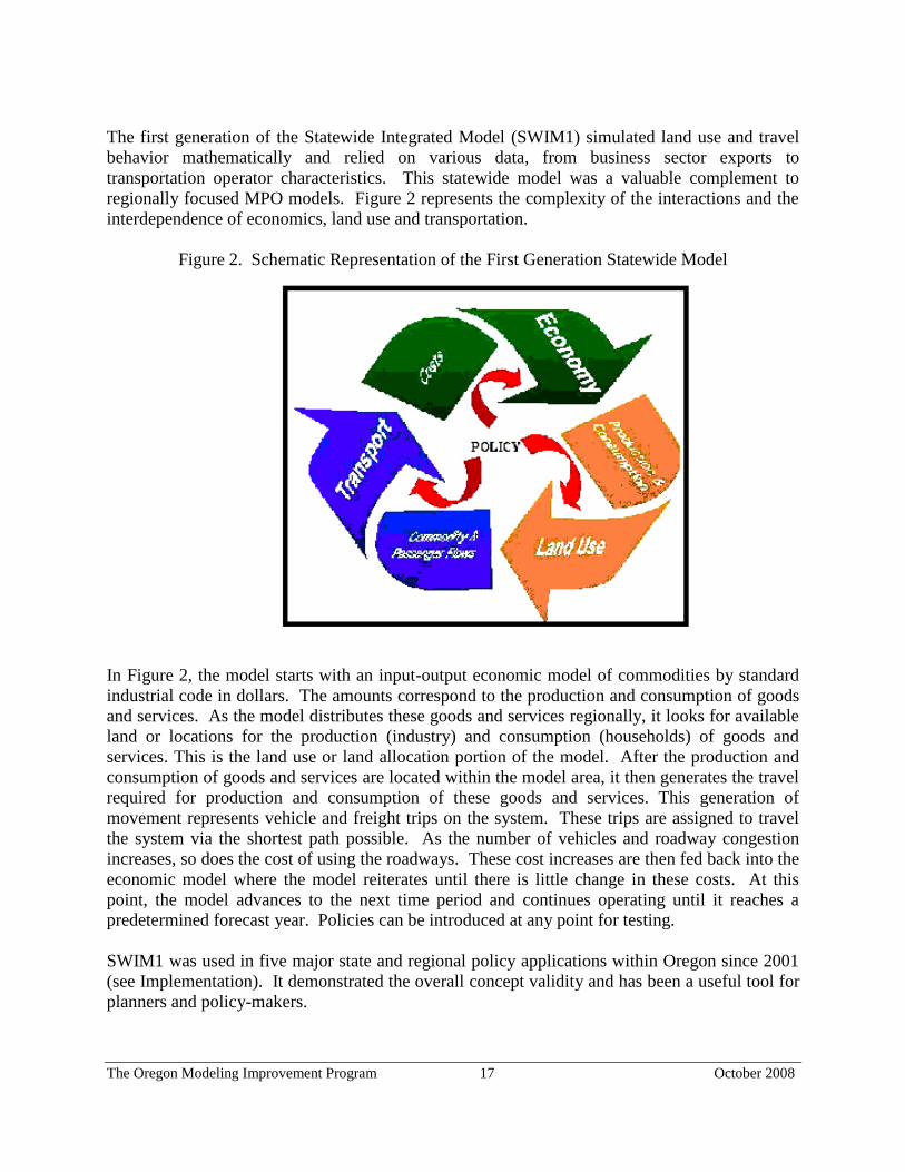
The Oregon Modeling Improvement Program 17 October 2008
The first generation of the Statewide Integrated Model (SWIM1) simulated land use and travel
behavior mathematically and relied on various data, from business sector exports to
transportation operator characteristics. This statewide model was a valuable complement to
regionally focused MPO models. Figure 2 represents the complexity of the interactions and the
interdependence of economics, land use and transportation.
Figure 2. Schematic Representation of the First Generation Statewide Model
In Figure 2, the model starts with an input-output economic model of commodities by standard
industrial code in dollars. The amounts correspond to the production and consumption of goods
and services. As the model distributes these goods and services regionally, it looks for available
land or locations for the production (industry) and consumption (households) of goods and
services. This is the land use or land allocation portion of the model. After the production and
consumption of goods and services are located within the model area, it then generates the travel
required for production and consumption of these goods and services. This generation of
movement represents vehicle and freight trips on the system. These trips are assigned to travel
the system via the shortest path possible. As the number of vehicles and roadway congestion
increases, so does the cost of using the roadways. These cost increases are then fed back into the
economic model where the model reiterates until there is little change in these costs. At this
point, the model advances to the next time period and continues operating until it reaches a
predetermined forecast year. Policies can be introduced at any point for testing.
SWIM1 was used in five major state and regional policy applications within Oregon since 2001
(see Implementation). It demonstrated the overall concept validity and has been a useful tool for
planners and policy-makers.

The Oregon Modeling Improvement Program 18 October 2008
Second Generation Statewide Integrated Model
Building on the experiences with SWIM1, ODOT embarked on a more extensive second
generation model (SWIM2). The goals and objectives established for the second-generation
model are included in Appendix B.
Modeling requirements for SWIM2 were thoroughly reviewed and a new model specification
developed. This underwent extensive revision through the peer review process. The original
plans for the second generation model were very ambitious and eventually were scaled back to
meet the timelines for anticipated analysis.
SWIM2 is a modular, component-based modeling system developed in an open source
environment, enabling others to use and contribute to the development of the software. The
model structure is shown in Figure 3. It uses the PECAS economic input-output activity
allocation framework, an aggregate model of spatial development and micro-simulation models
of freight and person transport.
Figure 3. SWIM2 Model Structure
ED
SPG1
CT
Employmentby Industry
Construction$Totals
LaborFlows$
TS (equilibrium)
ED-Regional Economics & Demographics
ALD-Aggregate Land Development
SPG1-Synthetic Population Synthesizer (sample)
PI-Production Allocations & Interactions
SPG2-Synthetic Population Synthesizer (locate)
PT-Personal Travel (auto/transit)
CT-Commercial Transport (truck)
ET-External Truck Transport (truck)
TS-Transport Supply (assignment)
Aggregate/Equilibrium
Micro-simulation
Alpha-Beta Zone Conversion
Next Time Period Feedback
Production Totals
SpaceInventory
TravelTime/Costs
OD Trip TablesTravelTime/Costs
Space PricesOccupied Space
Demand
SPG2 Mode ChoiceLogsums
PI
PT
ALD
HH Labor by zone
SyntheticPopulation
ET
Commodity Flows$(internal, import, export)
ECONOMY
LAND
DEVELOPMENT
SYNTHETIC
POPULATIONALLOCATION
TRANSPORT
ASSIGNMENT
Person Goods External
The top half of Figure 3 shows a spatial activity model, which starts with a regional economic
model (ED). The model-wide construction and industry activity totals are then allocated to
zones using a spatial input-output model that respects economic relationships among businesses

The Oregon Modeling Improvement Program 19 October 2008
and households, and responds to price signals and travel costs. This includes 3000 zones in
Oregon and surrounding counties in adjacent states. Floor space development is allocated in the
Aggregate Land Development (ALD) model and industry activity is allocated in the Production
Allocations & Interactions (PI) model. PI is an earlier version of the PECAS model, while ALD
is an aggregate land use model. A synthetic population is then developed in the Synthetic
Population Synthesizer (SPG) consistent with the employment totals. The assigned home and
work locations are assigned consistent with labor flow patterns from PI. It should be noted that
there is currently no feedback to the economic model. Therefore, the regional economic activity
is not impacted by changes in land use and commodity prices resulting from location decisions
and travel costs in the rest of the model.
The bottom half of Figure 3 shows the transportation components of the SWIM2 model. They
include micro-simulation tour-based models of personal travel (PT) and commercial/goods
movement (CT), and a simple model of external truck travel (ET). PT simulates daily activity
patterns and resulting trips for over five million people in the study area (from SPG’s synthetic
population). CT translates the flow of goods (in dollars from PI) into vehicle trips, combining
shipments for a typical weekday. The resulting vehicle trips are assigned to the network using a
standard equilibrium approach.
SWIM2 operates using a system of geographic zones that cover the entire state of Oregon and a
‘halo’ of about 50 miles, including counties immediately adjacent to the state boundaries. This
system is shown in Figure 4.
Figure 4. SWIM2 Model Area
Oregon MPOs:
Portland Metro
Salem/Keizer
Corvallis
Eugene/Springfield
Bend
Rogue Valley
Willamette Valley

The Oregon Modeling Improvement Program 20 October 2008
Calibration Process. Calibration of an integrated model is significantly more challenging than a
standard transportation model. The addition of components covering the economic and land use
dimensions lead to a large number of potential calibration targets, not all of which are consistent
and typically do not fall on a single year. Some inputs, such as base-year floor space inventory,
are not available in the real world so must be synthesized for use in the model. Integrated model
calibration is an iterative development process, where all models are incrementally increased to a
mutual level of accuracy in each cycle, avoiding throwing any one module and its downstream
effects too askew.
Given these issues, more emphasis was placed on testing the model’s overall behavioral response
through sensitivity tests of likely policy applications rather than focusing on a tight match to any
set of static target data. As an extension of the formal calibration of SWIM2, two policy
sensitivity tests were made to assess the model’s behavioral response to increasing highway
capacity and increasing travel costs. The input in each scenario consisted of an unrealistically
large change to delineate clearly the direction of the impact on the rest of the system resulting
from this type of action. These “proof-of-concept” tests will reveal how the model responds to
changes in policy levers built within the model.
Preparation for Model Application. The sensitivity testing and final phases of model calibration
occurred at the ODOT offices as part of the transition of SWIM2 from the development team to
the Agency staff. Once the model was ready for performance evaluation, a strategy was formed
to move from the development phase to model application. Several tasks were identified as
necessary preparation for real-world policy applications:
Training. Agency staff needs to be trained on how to use the model. Scenario set-up and
familiarity with the graphic user interface is necessary for staff to run the model
independently. This training will be provided as the team works through the evaluation
scenarios. Continuing support will be needed once the model is in use.
File Management. File organization and archiving are very important aspects of modeling.
The model produces 60 gigabytes of data with a 30-year run, so efficient management of disk
space is important. As issues are identified, improvements will be made to the folder
structure while conducting the scenario tests to improve user-interface.
Model Variability. A solid understanding of the model responsiveness to specific policy-
levers and variability due to the micro-simulation modules is important before starting policy
application. The test scenarios are designed to reveal model responsiveness, identify
performance issues and push the model beyond likely real-world changes to understand the
limits to the performance of the model.
Output Processing. Given the large amount of output data, a major task associated with the
test scenarios is creating automated scripts to summarize model output and produce tables
and graphs in a form useful for reviewing, interpreting and reporting model results. This
should also allow disk space savings if the summaries can replace the need to keep full model
outputs. It currently requires 5-10 megabytes for a 30-year model run. At this point, most of
the output is processed using the R programming language. Some functionality and use of
other data processing tools will be added to the model in the future.

The Oregon Modeling Improvement Program 21 October 2008
Calibration Results. Development and calibration of SWIM2 is judged a success based on the
testing done so far. The direction of predicted changes as well as relative magnitude pass the
initial test of reasonableness, but further investigation is needed. Several successes have been
realized in this modeling work.
The model runs over time covering 30 years and accommodating “extreme” changes in the
system.
Including a model halo area around the state border takes on a useful role in representing the
regions surrounding Oregon, as was intended.
The effort needed to obtain computing capability was worth the time and expense to the state.
Careful consideration and effort spent on sound file structure, naming conventions, and
strategic organization was helpful to making progress throughout the scenario test phase.
Key to the successful use of the model was conducting analysis by using a base reference
scenario. It is much easier to interpret and communicate analytical results by comparisons with a
constant base scenario. Creating a valid reference scenario requires a lot of time and data
collection, but saves resources in the long-run.
Clearly, there are many challenges that remain. In addition to evaluating and refining the model
through evaluation of additional sensitivity tests, there are several implementation challenges:
Model runtimes are longer than desired. A 30-year run takes nearly five days to complete and
outputs consume 60 gigabyte of disk space.
Added to the run time is time required to process the model output into summary tables and
graphs, taking an additional eight hours.
Convergence became more time consuming in the later years in the more extreme high cost
scenario, revealing the potential for longer runtimes for some analyses.
The model produces a large quantity of information. This must be reviewed and analytical
conclusions made quickly to meet the deadlines of policy analysis. A methodical, careful
approach to automating the production of data summaries from the model is critical to
building an understandable, descriptive story of what the model is forecasting in a timely
manner.
Overall, the SWIM2 model has demonstrated reasonable behavior, consistent with expectations.
The reasons for confidence in the results and the appropriateness of some further adjustments
were identified in this testing as intended in a calibration exercise. This is judged to have been
essential as part of taking SWIM2 from development into use in forecasting and assessment.
Further scenario testing will be important to increased confidence in the model, but the initial
indications are positive.
Joint Estimation Model in R Code (JEMnR)
ODOT, Metro, LCOG, MWVCOG and RVCOG used information from the 1994/1995 Travel
Activity Survey to jointly estimate a travel demand model for all MPO areas within Oregon.
JEMnR incorporates the unique characteristics of each MPO into data sets that others can use.
Localized data reflects how Oregonians respond in Oregon situations – Eugene/Springfield for
bicycle/pedestrian data, Salem for government data, and Portland for high-density urban area

The Oregon Modeling Improvement Program 22 October 2008
data. This effort combines the best of all models into a model more robust than any single
existing model.
JEMnR includes destination-choice considerations, e.g., certain income levels are more likely to
go to job A than job B. Bringing in mode choice allows pricing considerations. Various income
levels value time differently, so this can be considered in road pricing analyses. The explicit
value of multi-modal accessibility is included in the model. Other models have depended on
auto accessibility but this uses all modes, weighs them, and the value of these modes becomes
part of destination choice.
The joint estimation was developed in the R open source dynamic code language. It brings best
modeling practices to all areas of the state and saves development cost and effort by eliminating
duplication of efforts. Because the model structures are all consistent, peer review efforts are
simplified. The JEMnR was validated in 2001.
Building on the JEMnR structure, ODOT developed fully operational integrated models for the
new MPOs of Bend and Corvallis areas.
Oregon Small Urban Models (OSUM)
Most of Oregon is outside an MPO and many local jurisdictions cannot afford to build models to
analyze their infrastructure needs and opportunities. To address this need, a joint estimation
model was developed for urban non-MPO areas. It uses local data from eight Oregon rural
counties to do estimation and calibration. This process is broadly applied to replace individual
city models in rural areas. It provides an effective and more efficient method of modeling with
greater sensitivity for smaller jurisdictions. Several prototype rural models were also estimated to
provide cost-effective modeling tools for areas outside MPOs.
Regional Models
Deschutes County Model
TPAU is working with Deschutes County to develop a new travel demand model to be used in
preparing an update of its TSP. The outcome of the project will be a travel demand forecasting
model for the County that can be used to support the TSP update. The County model is being
developed by TPAU, with the County and ODOT Region 4 staff providing data support. The
model uses the JEMnR structure, extending the Bend MPO structure to the rest of the County. A
total of 972 zones are used in the model structure. The Bend MPO model and the Redmond
model structures are mirrored in the County model. Part of Crook County to the east and
Jefferson County to the north is included in the model.
Marion County Model
Initial work on the Marion County Model started in 2003. The goal of the project was to develop
an intercity vehicle travel model for Marion County that has all the components needed for

The Oregon Modeling Improvement Program 23 October 2008
transportation planning for Marion County, the Mid-Willamette Valley Council of Governments,
and cities in the County. The model was to take advantage of local household travel data and
origin-destination data from the 1994-1995 survey, thus minimizing the use of aggregated and
synthesized factors and parameters. The model was to be built so that forecasts would be
sensitive to the transportation and land use policy questions of interest to the County. This
includes how growth of the cities in the County will affect traffic volumes and how road and
highway projects would affect travel patterns. The model infrastructure was developed in 2003
but further development was set aside until 2004. TPAU is in the process of updating the
modeling structure and moving forward with development of the Marion County model.
Specialty Models With the success of TLUMIP, JEMnR and OSUM, planners and decision-makers in Oregon are
recognizing the usefulness of modeling tools and analysis to understand the complex interactions
of transportation, land use and economics. ODOT staff continues to expand modeling
capabilities to meet customer needs, and specialty models are being developed to respond to
special requests.
Land Use Scenario DevelopeR (LUSDR)
The impetus for the development of LUSDR was to provide modeling support for a long-range urban
growth study of a small metropolitan area in southern Oregon. Land use models are generally
recognized as useful tools for forecasting land use inputs to transportation models and for analyzing
the land use effects of transportation projects. Unfortunately, the complexity of most land use models
gets in the way of their widespread use by planning agencies. LUSDR is a land use model that
incorporates most of the land use behavior and policy sensitivity desired in a land use model and yet
has a simple structure and manageable data requirements.
LUSDR operates at the level of individual households and employment establishments and
microsimulates location decisions of land developments. The model produces a synthetic population
of households having the attributes of size, workers, age-of-household-head, income, dwelling
tenure, and dwelling type. Households are packaged into residential developments. Employment is
calculated from workers and allocated to economic sectors, employment establishments, and business
developments (e.g. shopping centers, office parks, etc.). Residential and business developments are
allocated to zones using an iterative process that identifies candidate zones based on land availability
and plan compatibility, chooses zones using a location model, and reconciles land supply and
demand in each zone through a bidding process.
Although the model application influenced the design of the model, it did not establish constraints
limiting the applicability of the model to urban growth studies. LUSDR may be used to provide land
use forecasts for transportation modeling studies, and may be run in a connected manner with a
transportation model to support a variety of integrated modeling studies.
What sets LUSDR apart from other land use models is its support for strategic planning and the
assessment of uncertainty and risk. LUSDR demonstrates the value and practicality of implementing
land use models as stochastic microsimulations. The model explicitly addresses uncertainty and

The Oregon Modeling Improvement Program 24 October 2008
supports a more realistic strategic planning approach. Consideration of the tradeoffs between
modeling completeness and model comprehensiveness resulted in a model that runs quickly and
addresses the most important land use behavioral elements. The approach also permits land use
models to be built with a modest amount of data.
LUSDR is on the way to becoming a standard model in Oregon’s toolbox of models. It will enable
modelers to improve land use forecasts for transportation modeling and will provide useful modeling
support for land use and transportation planning studies. In the simplest applications, it will assist
local planners with developing the long-range forecasts that are used for transportation modeling and
other studies. Even if a consensus process is used to get agreement on a final forecast, LUSDR can
help by producing a set of plausible alternatives that are consistent with comprehensive plan
regulations and market behavior as a starting point for discussions.
For more complex integrated land use and transport studies, LUSDR will be coupled with an urban
travel model to assess the effects of proposed transportation system changes on urban development
patterns. LUSDR produces the transportation analysis zone (TAZ)-level population and employment
inputs required by transportation models, and it uses transportation model outputs to calculate the
accessibility and travel exposure variables used in its location model component. LUSDR and the
transportation model can be run iteratively through time, passing this information back and forth to
simulate the effects of land use and transport interactions.
LUSDR will also be used to support a risk-assessment approach to transportation and land use
planning. It is helpful in identifying the magnitude of transportation problems and the relationship
between land use patterns and transportation problems.
The following enhancements are planned for LUSDR:
Develop housing compositions for each interim model year from demographic forecasts.
Keep track of an inventory of developed space over time - allocating household and employment
establishment demand to existing space and then creating new developments to accommodate the
excess demand.
Run LUSDR and the regional transportation model in a connected fashion through time.
Incorporate densification and redevelopment into the model.
Model the additions to urban growth boundaries incrementally rather than as long-range
aggregate amounts.
Greenhouse Gas Statewide Transportation Emissions Planning Model (GreenSTEP) ODOT is developing the GreenSTEP model for use by the Land Use and Transportation
Subcommittee of Oregon’s Global Warming Commission to develop a statewide strategy for
managing greenhouse gas (GHG) emissions from transportation sources. The existing set of
transportation, land use, and emissions models used in Oregon cannot address the range of
scenarios that need to be tested in the amount of time available. Existing models can address
transportation and land use interactions more thoroughly than GreenSTEP will be able to do, but
these models take too long to run and do not address all the factors of interest to the
Subcommittee.
The Oregon Modeling Improvement Program 25 October 2008
GreenSTEP will be used to estimate the effects of a number of factors on GHG emissions,
including relative amounts of urban and rural development, metropolitan and other urban area
densities, amounts of metropolitan area transit service, highway capacity, vehicle fuel efficiency,
use of electric vehicles, fuel costs, other vehicle charges that may be levied, carbon content of
fuels, and carbon production from electrical power generation. Design objectives include
making travel forecasts be sensitive to forecasted changes in age demographics. It is expected
that the rate of future travel growth will be affected by the aging of the population. For example,
travel of the baby-boom generation will decline as they retire and leave the work force.
GreenSTEP must also address the entire state but do so on a regional basis to be responsive to
regional differences. Because it is expected that the strategies developed for metropolitan areas
will be different from those developed for other urban and rural areas, the model needs to be able
to distinguish between these types of areas.
The model needs to be able to be run in minutes rather than hours so that a number of iterations
of scenario development, modeling, and analysis can be accomplished in a short timeframe. It
needs to be operational quickly so that a number of strategies can be evaluated to help develop
recommendations. The Commission has about six-months to develop recommendations to be
considered in the 2009 Oregon Legislative Session.
The OMSC established a subcommittee to serve as a resource/peer review panel for development
of the GreenSTEP model. Following the 2009 Legislative Session, this subcommittee will begin
to address how to incorporate elements of the GreenSTEP model into all Oregon models to make
them more sensitive to address GHG issues at all levels of planning.

The Oregon Modeling Improvement Program 26 October 2008
IMPLEMENTATION
The Oregon modeling efforts have succeeded because of the cooperative and collaborative
efforts of policy-makers and technical staff in Oregon and with developers from around the
world. The OMSC provides a unique forum for intergovernmental discussion and debate on
federal, state and local issues. Through model application projects, policy-makers and technical
staff work together and with the broader public to develop and define the complex questions,
evaluate the probable results of different alternatives and actions, and make difficult choices and
decisions to maintain a livable Oregon. Lessons learned from application of the modeling tools
and analyses enable OMIP to continue to refine and improve the overall program.
DECISION-MAKING PROCESSES
Decision- and policy-makers are regularly faced with difficult and complex issues. Elements are
integrated and there is often a complex interaction of issues. They must balance among land use,
economic development, housing, transportation and other issues. Their constituents are often
sophisticated, and consistency and legal sufficiency are becoming more important. The process
of decision-making has become as important as the data upon which the decision is based.
Traditionally, decision-making occurred in a linear process. The policy or decision-maker asked
the question, technical staff conducted analysis and provided results, and the decision-maker
took action or made a decision (Figure 5).
Figure 5. Linear Decision-Making Process
POLICY TECHNICAL TECHNICAL POLICY
Today’s analysis tools support and encourage a more iterative decision-making process. During
applications of the analysis tools, how the question is asked is important. What decision-makers
really are interested in is often different than the question they ask. It is important for technical
staff and decision-makers to work together to clearly define the question. Technical staff can
then decide the appropriate analysis tools to provide analysis and information. Results must be
presented in a simple and easy to understand manner, and the technical staff and decision-makers
again work together to analyze the results. If the results raise additional questions, the process is
repeated to provide additional information (Figure 6).
Policy Question
Technical Analysis
Results Decision/
Action

The Oregon Modeling Improvement Program 27 October 2008
Pose Question
Figure 6. Iterative Decision-Making Process
POLICY POLICY/TECHNICAL
Policy Question Refine Question
Results Technical Analysis
TECHNICAL/POLICY TECHNICAL
The analysis tools developed in OMIP help decision-makers consider and evaluate how issues
interact. They help answer complex questions, such as:
How do investments affect development patterns?
How do investments disperse population and jobs?
How do people respond to different policies?
What futures will result from the decisions made today?
CASE STUDIES
Case studies provide an opportunity to test methodologies and technical capabilities of the
models, and to present results. They also provide a public forum for discussions on policy issues
and how these tools can help decision-makers in the future. It is important that modeling tools
be developed that provide accurate and reliable information. It is just as important that decision-
makers understand the potential of these tools and use them to explore public policy issues in a
multi-dimensional and comprehensive manner. The importance of presenting analysis results in
clear, non-technical terms in a manner that can be easily understood by a wide and varied
audience cannot be overstated. Presenting modeling and analysis results as a logical “story”
helps users understand the assumptions used in the application and the potential impacts of
results.
UrbanSim The UrbanSim prototype model was applied to a case study in Eugene-Springfield, Oregon. The
case study was designed to test the model for performance (longitudinal calibration) and to
assess how it worked over time. A simulation was conducted from 1980 through 1994.
Considerable work went into the development of the dataset and associated calibration targets.
Developing the 1980 dataset almost two decades later proved to be a formidable challenge.
The Oregon Modeling Improvement Program 28 October 2008
While LCOG could provide some GIS coverage from that period, a large amount of manual data
processing was required. Most parcel data did not contain the year the buildings were built or
their commercial square footage. There was some mismatch between parcel boundaries between
1980 and 1994. Most of these data problems were overcome using manually generated data.
The case study results provided useful insights into the model behavior over the historical period
of the calibration. The simulated 1994 values of key variables of population and employment
achieved fairly high correlation and goodness-of-fit measures. On the other hand, the model
results showed considerably lower ability to reproduce the observed changes from 1980 to 1994.
The corresponding correlation and goodness-of-fit measures were quite low. Extensive
sensitivity testing of the model was performed to evaluate the behavior of the model. Simulated
annealing techniques (smoothing results to compensate for variability in raw data) were used to
search for coefficient and parameter values capable of matching the calibration targets. A
detailed review of the longitudinal calibration results can be found in Waddell, et al. (2000).
SWIM1 Model
Willamette Valley Livability Forum
The Willamette Valley Livability Forum (WVLF) facilitated and coordinated a long-range look
at the future of land use and transportation in Oregon’s Willamette Valley. The WVLF is a
voluntary organization of local governments, MPOs, business and citizen groups, and state
agencies formed to promote dialog and recommend actions on regional land use and
transportation issues. In 1999, the Forum initiated a long-range, comprehensive, regional look at
the future of land use and transportation in the Willamette Valley. This effort brought together
the following three innovative analytical modeling efforts. The leaders of these studies were
partners in the WVLF project:
Environmental effects of alternative land use futures by the Pacific Northwest Ecosystem
Research Consortium, a consortium of the U.S. Environmental Protection Agency, Oregon
State University, University of Oregon, and University of Washington.
Economic effects of alternative land use futures on the farming and forestry industries and
public infrastructure by the Willamette Valley Alternative Futures project, a collaborative
research study coordinated by the 1000 Friends of Oregon.
Economic, land use and transportation effects of alternative land use and transportation
policies by ODOT and the OMSC for the Alternative Transportation Futures (ATF) project.
The ODOT/OMSC modeling project was the first application of the integrated statewide
transportation and land use model. The ATF project was funded by a TCSP grant from the U.S.
Department of Transportation. An ATF Steering Committee provided direction for development
of scenarios to be modeled. Eight transportation and land use scenarios were modeled. The
scenarios with their respective policy variables are summarized in Table 2.

The Oregon Modeling Improvement Program 29 October 2008
Table 2. Willamette Valley Livability Forum Scenarios with Policy Variables
Scenario Policy Variables
Road Network Transit Network Mileage Tax (TDM) Land Use
No Action
(reference scenario)
No major
improvements
No major
improvements
No major programs Historical
Trend
Highway Emphasis Major improvements No major
improvements
No major programs Historical
Trend
Transit Emphasis No major
improvements Major
improvements
No major programs Historical
Trend
Mileage Tax
Emphasis
No major
improvements
No major
improvements Major program Historical
Trend
Compact
Development
Emphasis
No major
improvements
No major
improvements
No major programs Plan Trend
Hybrid 1 Only rural
improvements
Major
improvements
Graduated Mileage
tax- 10¢ to 20¢
Plan Trend
Hybrid 2 Moderate
improvements-urban
& rural
Moderate
improvements
Graduated mileage
tax-5¢ to 10¢
Plan Trend
Hybrid 3 Moderate
improvements -
urban & rural
Moderate
improvements
No Major Programs Historical
Trend
The scenarios vary by land use, road networks, public transit networks and mileage tax
(transportation demand management). Five scenarios were chosen to test the responsiveness of
land use and transportation patterns to various public policies. The scenarios do not represent
proposals but were chosen to represent a range of possible policy types. The objective was to
identify scenarios with clear differences and variance from the reference scenario in only one
respect to facilitate the evaluation. After evaluating the five scenarios, the ATF Steering
Committee defined two additional scenarios that blended elements of the five policies to assess
their aggregate effects. An eighth scenario was defined as part of a separate project and blended
policies in a third hybrid combination.
To focus the statewide model outputs, the WVLF ATF Steering Committee identified the
following evaluation measures:
Distribution of growth in households within the Willamette Valley and surrounding regions.
Distribution of growth in jobs within the Willamette Valley and surrounding regions.
Changes in per capita passenger and vehicle miles traveled in the Willamette Valley.
Changes in per capita passenger and vehicle hours traveled in the Willamette Valley.
Changes in passenger and vehicle travel times in the Willamette Valley.
Changes in auto and truck speeds on urban and rural freeways and arterials in the Valley.
Changes in auto travel times between selected Willamette Valley cities.
Emissions from vehicles in motion in the Willamette Valley.
Changes in residential and industrial/commercial land prices in the Willamette Valley.

The Oregon Modeling Improvement Program 30 October 2008
A summary of the more significant modeling results from this analysis includes:
Congestion will increase and vehicle miles traveled per person will decrease.
The model assumed that the Willamette Valley population would double by 2050. With this
projected population increase, even if major investments are made in highways and public
transit, travel delay and traffic congestion will increase. Passenger vehicle miles traveled
decreases for all scenarios because of this increased congestion. Even so, the transportation
policies chosen today can make a difference in how the transportation system works in the
years ahead. For example, the increase in travel time is significantly less for the three
hybrids.
Of the policy choices modeled, city-to-city traffic congestion increases the least when the
highway and transit infrastructure expansion is coupled with taxes to reduce demand. Over
the 50-year period, Hybrids 1 and 2 result in the smallest increases in average travel time.
Hybrid 3, which excludes the mileage tax, results in a significantly greater increase in
average travel time over the other Hybrid scenarios. The Highway scenario, with no public
transit expansion, has the greatest increase in travel time of all scenarios tested.
The policy effects are different for trucks than for passenger vehicles. Truck travel times
increase more under all scenarios. Moreover, truck travel time increases are mitigated more
by highway improvements than are passenger vehicle travel time increases.
There is much inertia in the current system.
Regional growth varies little among scenarios. It takes major policy shifts over a long time
period to effect significant change because development patterns and travel behavior change
very slowly. Modeling shows that, even after projects are constructed and in use, it takes
years for them to manifest themselves into different land use patterns and travel levels.
Substantial policy shifts can alter overall growth of the Willamette Valley, but due to
geographic circumstances and local policies, impacts are greater at the local level than at a
regional level.
The hybrids show more pronounced differences because of the combined economic, land use
and transportation elements. It should be noted that the future year population was fixed,
constraining the distribution around the state responding to the various economic, land use
and transportation variables. Realistically, some population migration out of the study area
would occur, responding to the policy variables applied.
Where people and jobs locate is affected by several elements:
- Transportation improvements and location - Highway expansion decentralizes both jobs
and housing, while transit expansion centralizes jobs and decentralizes housing. Highway
expansion tends to keep growth within the Willamette Valley, while transit expansion and
a mileage tax tend to move some growth to areas outside the Valley. Increased mobility
by any mode increases the population of metropolitan fringe areas and neighboring cities.
- Supply of land, which affects land price - Strong urban growth boundaries influence land
use more than they do travel. The Compact scenario constrains the availability of land to
develop, increasing land prices. As a result, land prices within metropolitan areas
increase, directing more development to smaller cities and outside the Willamette Valley.
This scenario also increases city-to-city and longer distance travel. Hybrid scenarios
increase the compact scenario effects - the land price push combined with the city-to-city
mobility pull increases the population shift to smaller cities.

The Oregon Modeling Improvement Program 31 October 2008
- Transportation costs - Mileage tax increases private vehicle costs in the Willamette Valley
and decreases the overall amount of travel in the Valley. It shifts more development
outside of the Valley where there is no tax, offsetting some travel reductions within the
Willamette Valley.
Growth in areas outside the Willamette Valley is greatest for scenarios that restrict land
supply and impose taxes in the Valley (Hybrids 1 and 2). Adding improved mobility further
reinforces movement out of the Valley. The area south of the Willamette Valley in the I-5
corridor experiences the greatest growth as a result of Hybrid scenarios 1 or 2.
Transit ridership increases with increases in transit infrastructure, mileage taxes, and
restrictions on highway expansion. Transit service as a percentage of total trips increases
most significantly relative to strong investment in public transportation and mileage taxes.
It is clear that different policy choices will have different impacts for the future and that
combinations of policies will provide the most significant change. This project provided several
scenarios with very different results. By modeling various combinations of land use, economic
and transportation policy options, decision-makers can anticipate events and adopt policies to
help shape the Willamette Valley for future generations.
House Bill 3090 The 1999 Oregon Legislature asked ODOT to look at the results of designating a north-south
freeway in Central or Eastern Oregon, from the Washington to California borders. The objectives
of House Bill 3090 were to:
Define a better north-south connection to I-82 in Eastern Oregon.
Increase growth of Central/Eastern Oregon.
Decrease growth in the Willamette Valley.
Decrease travel and congestion on I-5 in the Willamette Valley.
SWIM1 was used to identify and evaluate three alternative alignments to connect with existing
freeways in Washington and California. The same parameters were used for this study as for the
WVLF ATF model runs. Results of this model run concluded that a new freeway from
Washington to California through Central or Eastern Oregon would:
Significantly reduce travel time from Washington to California.
Improve market accessibility to both Central Oregon and the Willamette Valley.
Result in minimal differences in growth in Central and Eastern Oregon.
The US 97 improvement could slightly increase growth of the Willamette Valley.
Overall, the proposal did not meet the objectives of transferring growth from the Willamette
Valley to Central or Eastern Oregon and the project did not go forward. The results of this
model run were also used as one of the hybrid alternatives considered for the ATF project.
Newberg-Dundee Bypass Induced Growth Analysis
The Newberg-Dundee Bypass is proposed to bypass Highway 99W, a major recreation route
through rural Yamhill County. Yamhill County is within commuting distance of the Portland

The Oregon Modeling Improvement Program 32 October 2008
metropolitan area. In 2002, as part of the draft environmental impact statement (DEIS), the
project was modeled to assess the potential for induced growth on small communities in Yamhill
County as a result of building and not building the bypass. The modeling effort provided
information to decision-makers and helped withstand legal challenges to the DEIS.
Economic and Transportation Modeling and Analysis of Bridge Options
When it identified a growing number of structural deficiencies in Oregon bridges, ODOT used
its state-of-the-art integrated economic, land use and transport model to analyze the effects of
different courses of action on the Oregon transportation system, its economy, local roads and
communities. In the absence of sufficient funding for repair or replacement, many of these
bridges would be subject to weight restrictions. These weight-restricted bridges could reduce
freight mobility on major roadways, potentially disrupting local and regional livability and the
Oregon economy.
Using SWIM1 and supplementary information, ODOT assessed the possible ramifications of
several investment strategies to highway users, Oregon communities and the Oregon economy.
These strategies ranged from no new investment, the repair or replacement of certain bridges, to
fixing all bridges. Modeling information was combined with information from Motor Carrier
Division, Bridge Section and others to develop a recommended investment strategy to address
the bridge problem.
The interstates I-5 and I-84 support commerce throughout Oregon. The Portland metropolitan
area and the Willamette Valley represent the economic heart of the state and rely heavily on the
interstate system for movement of goods and services. Their connection to ports and markets
within Oregon, with neighboring states, and overseas is vital to the state’s economic health. The
backbone of that connection is the interstate system. Two-thirds of the state’s economic benefit
can be derived by connecting I-84 and I-5 to Portland. The Interstate and U.S. highway systems
in Oregon not only facilitate trade within Oregon, but also are an integral part of the North
American trade network. Therefore, restoration of I-5 and I-84 as unrestricted freight routes
needed to be the ultimate goal of a bridge replacement strategy.
At the same time, it was imperative that other areas of the state continue to have unrestricted
access for movement of goods and services. Deteriorating bridges in these areas, far from the
interstate highways, were a serious threat because businesses in rural and coastal Oregon tend to
rely more on goods typically shipped in heavy trucks, such as wood and agricultural products.
Such heavy commodities and remote area businesses already demand high transportation costs.
Any increased cost brought about by truck detours or load limits would erode what is in many
cases a slim profit margin. Heavy loads that cannot be divided into smaller loads are essentially
“landlocked” if they cannot cross load-restricted bridges. Given the nature of the heavy goods
moved in rural Oregon and the importance of these goods to the local economy, it was critical to
maintain key freight routes across the state.
Modeling results showed that Oregon’s bridge problem had the potential to cost the state
economy as much as $123 billion in lost production and 88,000 lost jobs over the next 25 years.

The Oregon Modeling Improvement Program 33 October 2008
In addition to the potential economic cost, the bridge problem posed a threat to the livability and
safety of many communities throughout Oregon. Weight limits lead to truck detours, which put
trucks on city streets and other roadways that often have inadequate maintenance funding and
were not built for these loads. In addition to safety concerns with increased traffic detours
through local communities, deterioration of local bridges could impede the response time of
emergency personnel to reach citizens and forest fires. As bridges continue to age and crack,
communities increasingly experience these impacts. Without significant investment, 30 percent
of Oregon’s bridges were expected to be weight-limited, with associated heavy truck detours, by
2010.
Expenditures to repair or replace components of the transportation infrastructure serve two
purposes. An investment in state and local bridges maintains accessibility, avoiding loss of jobs
and productivity growth in the long term. Money spent on bridges throughout Oregon sustains
family-wage construction jobs in the short-term. These jobs, in turn, generate income that is
spent on goods, services, and income taxes for the Oregon General Fund. This issue was
important to the Governor and the 2003 Oregon Legislature, facing one of the highest
unemployment rates in the nation.
The bridge improvement strategy needed to balance these issues in a timely manner. Because
half of the critical bridges are on the interstate system, the time and the cost (over $1 billion)
required to address them made them problematic as a first step.
In January 2003, ODOT submitted a report to the Oregon Transportation Commission (OTC),
outlining a recommended 10-year $2 billion bridge investment strategy. The strategy restored
heavy haul access to a skeletal freight system extending to all parts of the state. It strategically
restored detour routes for the major interstate routes first to accommodate heavy truck traffic
during the 10-year construction period and unexpected emergency bridge failures. SWIM1
provided information to support the dialogue of tradeoffs, particularly state versus regional
economic impacts under various investment scenarios. This discussion of tradeoffs framed the
ODOT recommendation to the OTC and ultimately shaped state legislature funding discussions.
This recommendation was accepted by the Oregon Legislature and it approved the largest public
infrastructure investment in Oregon since World War II.
Oregon Transportation Plan
The OTP was originally adopted by ODOT in 1992. The Plan was updated in 2005 to address
the future from 2005-2030. This statewide multi-model plan provides umbrella policies and
investment strategies for modal, facility, regional and local plans.
SWIM1 was used to provide a reference case for alternative scenarios. It showed that
modernization projects do not necessarily improve mobility and provided data to support what
was suspected but not confirmed. It reinforced and supported other analysis processes and tools.
The OTP received the Transportation Research Board’s 2008 Transportation Planning
Excellence Award. This biennial awards program was developed by FHWA and FTA to

The Oregon Modeling Improvement Program 34 October 2008
recognize outstanding initiatives across the country to develop, plan and implement innovative
transportation planning practices. SWIM1 was an important element of the award recognition.
Regional Models Rogue Valley MPO The Greater Bear Creek Valley in Jackson County, Oregon, is a relatively small but rapidly growing
metropolitan area. A Regional Problem-Solving (RPS) study was conducted to identify additional
lands needed for urban development to accommodate a doubling of the region’s population. The
RPS process will create a coordinated urban expansion plan for Jackson County and the cities of
Ashland, Central Point, Eagle Point, Jacksonville, Medford, Phoenix and Talent.
The jurisdictions involved in the RPS process agreed upon and adopted a set of goals and
policies to guide the outcome of the process. These policies identify a number of issues of
concern regarding land utilization, public facilities and services, resource lands, housing, jobs,
and community identity. A number of analyses were commissioned in order to determine how
growth proposals might affect these concerns.
ODOT was requested to help evaluate transportation effects of the growth proposals. LUSDR
was developed to provide the land use inputs required by the Rogue Valley MPO regional
transportation model to evaluate the potential transportation consequences of alternative land use
patterns and transportation system additions that might occur given the proposed urban reserve
areas. The modeling objectives were to:
Develop a set of plausible future land use patterns consistent with the study goals.
Test the effects of this set of future land use patterns on the transportation system.
Identify the features of land use patterns that most affect transportation performance.
Assist in identifying additions to the transportation network needed to serve future development
of the urban reserves.
The modeling proceeded in the following stages:
Model the transportation performance of the adopted regional transportation plan (RTP) for a
range of land use futures that could plausibly occur given the proposed urban growth areas.
Model the transportation performance of this same set of plausible land use futures on a road
network with additional capacity expansion (beyond what is addressed by the RTP).
Model the transportation performance for different land use and transportation policy
scenarios. The land use scenarios include growth with no change in policy, growth according
to a policy that concentrates mixed use development in nodes, and growth according to a
policy that creates regional employment centers. The transportation scenarios include
different levels of road and public transportation network expansion.
Modeling provided the following information to assist the RPS decision-making process and
subsequent planning.
By the time the region’s population doubles, the road system will have to be expanded
substantially in order to avoid extensive and severe congestion. Making the road
The Oregon Modeling Improvement Program 35 October 2008
improvements identified in the current regional transportation plan will be insufficient to
avoid congestion. Enhancing the RTP road network with more capacity and road connections
will do much to reduce congestion but major new roads may be needed as well. None of the
model scenarios was able to eliminate all severe congestion on the road system. The analysis
was not designed to determine what would be necessary to do so.
The analysis showed that travel patterns, amounts of travel, congestion, and travel times will
be significantly affected by the way in which the region grows. This is seen most clearly in
the third stage results. The results showed that a nodal development pattern, where higher
density mixed development is clustered in nodes, would significantly reduce travel distances,
congestion, and average travel time relative to the other land use scenarios. The regional
attractor scenario, which simulates the development of major employment centers, produces
more vehicle miles travelled (VMT) and less benefit from road improvements than the no-
policy-change scenario.
Planning should consider the effects of uncertainty in how land in the region will develop
over time. There are many ways that land could be developed that are consistent with the
growth area proposals, comprehensive plans, and market tendencies. Overall travel is
unlikely to be affected, but individual portions of the road system will be affected. The
results revealed that congestion on freeway ramps is most sensitive to how land development
proceeds.
The results for congestion on the I-5 mainline showed predictable growth of congestion. The
second stage of modeling showed large increases in I-5 congestion and only small
differences among the land use scenarios.
Development of all of the growth areas will result in increased travel on congested roadway
sections. The high capacity scenario would eliminate most, but not all of the affected
congested roadway sections. This information can be used to help identify where road
improvements will be needed. Determining what should be done in these areas to
accommodate development will require more detailed analysis that is beyond the scope of
this study.
The Oregon Modeling Improvement Program 36 October 2008
DATA
Data to support the Oregon modeling program can consume a significant amount of resources,
both for collection and analysis. Historically, data has been collected independently by different
jurisdictions and agencies, using different methodologies for data collection and recording. This
has made it difficult to compare or transfer data from one jurisdiction or one model to another.
As Oregon modeling and analysis tools continue to evolve, they place increasing demands on the
data upon which they are built. To conduct meaningful policy analysis for decision-makers, it is
necessary to collect consistent and current information regarding household choices, such as
activities, automobile acquisition and travel behavior. The OMSC has undertaken several
collaborative data collection efforts to ensure consistent collection methodologies and model
applications.
HOUSEHOLD ACTIVITY AND TRAVEL SURVEY
In spring 1994, a household activity and travel survey was conducted in the Willamette Valley in
Oregon and in Southwest Washington. This cooperative research project was sponsored by
ODOT and the five MPOs in Oregon and SW Washington - Metro, MWVCOG, LCOG,
RVCOG, and RTC. This cross-sectional survey provided Oregon data to support OMIP activity-
based models. The result was a rich database of activity and travel information for almost 12,000
households.
Each of the MPOs was considered as a distinct universe for the purposes of sampling. The same
design was customized to meet the needs of each MPO and they helped to define the geographic
areas to be included in the sample universe. In four of the five MPOs, the sampling strategy was
a stratified sample based on location categories of the immediate environment or situation, such
as inner urban, satellite cities, suburban areas. In one of the MPOs, a random sampling design
was used.
The survey was conducted in three phases: survey design and implementation, revealed
preference survey implementation, and stated preference survey implementation. In addition to
traditional travel data, the MWVCOG survey collected time-use activity data for a 48-hour
period to capture day-to-day variation in personal travel behavior. The survey also included an
enrichment sample of public transit users.
RECREATION/TOURISM ACTIVITY SURVEY
Recreation and tourism play a significant role in the Oregon economy. In-state and out-of-state
visitors to Oregon recreation and tourist attractions contributed more than $4 billion to the state
economy in 1995, a 52 percent increase over 1990.
In 1997, ODOT sponsored a recreational/tourism activity survey to address information gaps in
recreational/tourism travel and to provide a better picture of recreational travel behavior within

The Oregon Modeling Improvement Program 37 October 2008
the state. Between April and June 1997, demographic data and 48-hour travel data were
collected from two separate sources. One source was the guests of 95 lodgings in Multnomah,
Lane, Hood River, Deschutes and Lincoln Counties who were provided with self-administering
surveys that were returned to the lodging staff. The second was visitors to recreational
attractions who were interviewed by survey teams at eight key Oregon attractions. The response
rate for the lodging surveys yielded 355 completed surveys for the five counties. The intercept
surveys at recreational attractions collected data from 1329 visitors.
OREGON TRAVEL BEHAVIOR SURVEY FOR 8 COUNTIES
Using the 1994 household activity and travel survey instrument as a base, ODOT collected data
in eight rural Oregon counties in 1996 to examine travel behavior and trip generation by
households in the small rural areas of Oregon (non-MPOs). This analysis estimated trip-making
characteristics to support small-scale regional transportation models being built outside the four
MPO areas in Oregon. The data for this analysis came from approximately 3200 two-day
household activity surveys.
Small rural areas account for about 31 percent of the population and 86 percent of the area of
Oregon. Since most of this area is sparsely populated, the eight counties were selected to
provide a good cross-section of Oregon's rural areas, and surveys were conducted in the more
populous parts of those counties. The surveyed counties included Clatsop, Coos, Deschutes,
Josephine, Klamath, Lincoln, Malheur and Umatilla. The data collected from this survey is the
data base for the Oregon Small Urban Models (OSUM) developed in non-MPO areas.
OREGON HOUSEHOLD ACTIVITY SURVEY
In 2001, the OMSC began discussions on updating the 1994 household activity and travel
survey. A panel of experts was convened to discuss the merits of a longitudinal panel survey
(LPS) vs. a cross-sectional survey (CSS). There is evidence that LPS data can significantly
enhance the ability to understand and forecast travel behavior. A panel survey is one of the few
methods available to the analyst to understand how traveler behavior is influenced by
information acquisition, experimentation, and learning. It provides an opportunity to identify
behavioral change over time. In effect, the LPS provides information to understand cause and
effect relationships and the process of change. A pilot survey was developed and conducted to
test specific survey methods and data collection approaches.
Following the pilot study, each Oregon MPO and ODOT was interviewed to define specific data
needs unique to each region of the state. A stakeholder meeting was held in June 2007 and the
main issues that drive modeling were discussed. In 2008, ODOT entered into a contract with a
consultant team to perform survey design, data collection and database preparation for the
Oregon Household Activity Survey (OHAS). The overall process to define the next household
activity and travel survey and to secure funding took time, but the methodical approach allowed
the OMSC to work through several issues and define a solid process and cooperative funding
program.

The Oregon Modeling Improvement Program 38 October 2008
The OHAS project is intended to expand coverage to include seasonal and possibly weekend
(Saturday) information. Operationally, it is hoped that a continuous survey program can be
funded as an annual expense and the survey process and data storage can be institutionalized in a
centrally accessible location(s). OMSC members, including MPOs, multiple government
agencies and OTREC universities, are partners in developing and funding this survey. ODOT is
managing the overall program, with oversight by a subcommittee of the OMSC and local
management by MPOs for their parts of the survey. ODOT entered into Intergovernmental
Agreements with all participants to define terms of cooperation and financial participation.
OHAS will use a core survey with common data elements for all participating jurisdictions,
including up to four questions unique to a region. Supplemental surveys can be done for data
elements unique to a region. This could include additional surveys, special deliverables, region-
specific data elements, a specialized sampling approach such as for a special population, or
unique data collection methods, such as non-typical global positioning systems (GPS). The core
survey design, covering most needs that are common across all participants, will determine the
base cost per survey. The additional costs associated with tailoring the core survey to meet
regional needs will be paid by the jurisdiction requesting the changes.
A pilot project for the core survey was conducted in summer 2008. The first survey will be
conducted in fall 2008, with additional surveys conducted according to funding commitments in
2009, 2010 and 2011.
FREIGHT DATA COLLECTION
With increasing demands on the transportation system and a reduction in financing for new
major transportation facilities, movement of goods and services throughout the state of Oregon is
becoming a bigger challenge. The Portland metropolitan area has succeeded in establishing a
market as a regional distribution and transshipment center for international commerce. The
combination of the four “R’s” -- rivers, rail, roads and runways -- and the available
transportation services help the region build on this historically competitive advantage. The
economy of Portland and the rest of Oregon depend on the ability to move freight through this
regional and multi-state hub.
Commodity Flow Data Collection Metro, in cooperation with the Port of Portland and ODOT, conducted a commodity flow data
collection and analysis project in 1997 to understand how commodities move in and through the
region. This effort obtained information about the amount and type of goods being handled,
where they are headed within the region, how they are being carried, and what factors businesses
consider in making shipment decisions. The study resulted in several work products: commodity
scoping and 2040 projection refinement, truck/commodity origin-destination data collection,
design and implementation of a stated preference survey to determine the elasticities of factors

The Oregon Modeling Improvement Program 39 October 2008
influencing shipping decisions, and development of a commodity carrier forecasting model. This
information is currently being updated.
Freight Shipper and Carrier Survey At the same time as the Commodity Flow Data Collection project, ODOT conducted a freight
shipper and carrier survey to obtain better freight movement information throughout the state.
This survey focused on identifying concerns, bottlenecks and other problems with moving
freight over the Oregon transportation system.
Truck Intercept Survey
In 1998, ODOT sponsored a statewide commodity flow survey to support statewide travel model
development. Using an intercept survey of freight trucks, data was collected at Oregon ports of
entry. Data collected included weight, vehicle and commodity classification, and origin-
destination information. Over 16,000 truck drivers were interviewed, providing an extensive
database on goods movement by freight trucks within Oregon. The survey focused on long-haul
truck movements on the Interstate and U.S. highway system. The data was analyzed to determine
the flow of goods by truck volumes, payload weight and cargo value between three general
regions within Oregon. Diurnal distribution and fleet ownership attributes by commodity group
were also defined. This study tried to understand the economic and transportation relationships
between Oregon regions and the degree to which highways help facilitate these movements.
Freight Data Collection Project
The Freight Data Collection Project was a joint project with the Port of Portland, Metro,
Multnomah County, WSDOT and ODOT. Concluded in 2007, it was conducted in the Portland
area to identify freight flows around the region and to fill in other data needs.
The project was conducted in two phases. Phase I defined freight data questions on goods
movement and the economy, land use and goods movement, truck routes and utilization,
relationship of trucking to other modes, and corridor/project specific data needs. Phase II was
the freight data collection program. Sources of data included road intercept, terminal gate and
motor carrier surveys, a truck following study, and vehicle classification counts. Data types
included origin-destination (O-D) data, freight facility flow information, transportation network
information, truck count data, commodity information, routing information, temporal variability
of freight flows, and truck classification and carrier information.
Hourly vehicle classification counts helped with understanding patterns by truck type, facility
type and trip type, and validated analytical tools. Collecting vehicle classification data for the
first 15 minutes every hour maximized project resources. Roadside truck O-D surveys provided
a detailed understanding of interregional trip patterns and an understanding of land use
relationships. Routing information should be useful for future planning. Roadside truck O-D
surveys at port terminals and intermodal yards should allow for better modeling of gateway
The Oregon Modeling Improvement Program 40 October 2008
facilities. The truck-following survey was well-suited for collecting truck O-D data for a small
subregion and provided useful routing information.

The Oregon Modeling Improvement Program 41 October 2008
THE FUTURE OF OMIP
With the broad “family of analysis tools” that was developed under OMIP, a major focus for the
next several years is to identify new opportunities and ways to apply these tools to address
important policy and project development issues. A continued aggressive outreach and
communications program, combined with a broad education and training program, informs
customers and other model users of the tools available and how to use them. It also provides
skilled practitioners to work for local governments and agencies to develop and use the tools
effectively. The intent continues to be to move decision-makers and practitioners to a new way
of thinking about and evaluating public policy and infrastructure investment decisions and to
provide the tools to help make increasingly difficult and complex tradeoffs and decisions. An
increased level of understanding and comfort with OMIP tools and processes will maximize their
value and ensure their use as the way we do business in Oregon.
OMIP will continue to see high profile projects. The fact that specialized models are being
developed to address issues of local land use/transportation interactions and greenhouse gas
impacts means that the value of the Oregon modeling program is well recognized. Policy-
makers and communities continue to request assistance that challenges the technical capabilities
and skills of the program.
OMIP has made substantial gains in large-scale integrated models and urban level transport
models but these efforts need to be brought together to provide advances in urban level
integrated modeling. As the statewide integrated model continues to be refined, interactive links
must be built between the statewide, local urban and rural models. Visualization and animation
of modeling and analysis results will be necessary to engage users and the general public and to
help them understand analysis results. The importance of presenting analysis results in clear,
non-technical terms in a manner that can be easily understood by a wide and varied audience
cannot be overstated. Presenting modeling and analysis results as a logical “story” helps users
understand the assumptions used in the application and the potential impacts of results.
From a practical perspective, best practices and guidelines will continue to be updated and
refined as model development, applications, and refinement occurs. Clearly defined processes
and good documentation are increasingly important for consistency and legal sufficiency. Peer
review of all models developed in Oregon should become common practice.
The international symposia held in Portland every few years continue to be good forums to
disseminate the most current advances in integrated modeling. OMIP continues to explore
opportunities for European and North American collaborative efforts. Bringing together
resources from both Europe and North America will accelerate advances in the industry. The
interest of Japanese and Chinese government modelers in the Oregon program provides
opportunities to share and expand the knowledge and application of OMIP.
With the creation of OTREC and expanded collaborative programs with OTREC universities, the
opportunity to develop a multi-disciplined advanced degree program in transportation planning
and/or simulation and modeling is within reach. To support this goal, the OMSC has initiated

The Oregon Modeling Improvement Program 42 October 2008
discussions to establish an Oregon Modeling Center at Portland State University. This Center
will coordinate research on integrated and regional models, and provide a resource for interns
and collaborative projects. As the Center becomes well established, it can be a focus for distance
learning, communication, and can serve as a data repository. The Oregon Modeling Center and
the OMSC will become partners to expand the educational program in Oregon to provide new
and experienced staff to meet the needs of the increasingly complex modeling community.
The key to the successful OMIP program has been that everything is done in a non-mandatory
environment. All participating agencies and jurisdictions agree that this type of working
environment is preferred because it offers the most latitude to perform within the local political
environment while maintaining the ability to influence the big picture of modeling in Oregon.
Individual ownership to the program has created a healthy working relationship among agencies
and jurisdictions that previously had little contact or communication. These agencies and
jurisdictions are now communicating regularly and are building work plans together, assisting
each other to raise the level of performance of modeling in Oregon. Because of this coordination
and cooperation, Oregon has made remarkable strides in all areas of modeling in a very short
time period.
The cooperative nature of the OMSC is the foundation that will continue to support future
growth of OMIP. As the program moves forward, three fundamental elements will ensure
continued success: frequent and clear communication, consistency, and broad cooperation.
The Oregon Modeling Improvement Program 43 October 2008
APPENDIXES

The Oregon Modeling Improvement Program 44 October 2008

The Oregon Modeling Improvement Program 45 October 2008
APPENDIX A: MAY 1996-TLUMIP GOALS & OBJECTIVES
OREGON DEPARTMENT OF TRANSPORTATION TRANSPORTATION AND LAND USE MODEL
INTEGRATION PROGRAM Original Goals and Objectives - May 1996
TLUMIP Goals
The Oregon Transportation and Land Use Model Integration Program (TLUMIP) has four
important goals. These goals are designed to provide the basis for a truly statewide system of
land use and transportation analysis that is comprehensive, consistent and coordinated and that
address key elements of ODOT’s mission in the areas of statewide transportation planning and
statewide planning.
Goal #1: Develop long-term economic, demographic, passenger and commodity flow forecasts for statewide and substate regions, and maintain databases needed for periodic updates.
The State should provide long range forecasts (i.e., for a minimum of twenty years) of sufficient
detail to support travel demand modeling, land use allocation models, and policy analysis as
required under ISTEA, the Statewide Planning Program and the TPR. These data bases and
forecasts should directly support statewide planning for intrastate commodity flow analysis and
freight and goods movement, and should provide the level of detail necessary to provide control
totals to metropolitan, city and county planning agencies for use in developing and applying land
use allocation models and travel demand models. Forecasts and databases available at the
substate level should include interregional commodity, freight and passenger flows.
Goal #2: Integrate statewide and metropolitan level land use data bases, land use modeling, and spatial analysis methods to support transportation and statewide planning in the state of Oregon.
In addition to providing the data bases and forecasts needed for planning and evaluation of
transportation facilities and long term assessment of land use patterns, ODOT, in conjunction
with metropolitan, city and county planning organizations, should provide a lead role in
establishing the administrative procedures and planning processes necessary to develop,
coordinate and review data bases, forecasts and models produced under this program. This effort
will be designed to be integrated into the work programs of both ODOT and participating
agencies, and will be designed to foster and provide a sustainable, long term commitment by all
study participants.

The Oregon Modeling Improvement Program 46 October 2008
Goal #3: Establish methods for evaluating key policies in the Oregon Transportation Plan, implementing the Statewide Transportation Planning Rules and assessing progress made toward achieving goals implicit in Oregon’s Statewide Benchmarks.
A significant goal for ODOT, other state agencies, and the metropolitan and local planning
organizations participating in this program, is preparing a comprehensive inventory of the
policies and plan elements that must be addressed by the models and data bases developed under
this work program. This goal will be addressed by preparing a formal inventory of statewide
policies and developing evaluation methods that relate these policies to the data and models
required to analyze them. Emphasis will be placed on the relationship between policy evaluation
and the modeling processes, the relationship of policies to data and forecasts, and the ability of
modeling process(es) developed through this program to aid in evaluating the effectiveness of
pubic policy as they apply to the OTP and the TPR.
The Oregon Statewide Benchmark program has established a comprehensive catalogue of
measures designed to show the progress being made in attaining the goals and objectives of the
Statewide Planning Program and the relationship of planning goals to the overall quality of life
throughout the state. Many of the benchmarks in this program affect and are affected by elements
of the OTP and requirements in the TPR. Evaluation procedures, databases, and forecasts related
to key benchmark data will be identified through this program. Recommendations will be
developed and periodically reviewed to assess whether the goals stated in the Oregon
benchmarks program are being attained as they relate to the OTP and the TPR.
Goal #4: Develop the tools, guidelines and institutional support necessary for ODOT and other planning agencies to sustain the models and data bases needed for integrated land use and transportation facility analysis.
The investment in developing the data and models needed to analyze the implications of
statewide policies and track information necessary to evaluate the success of these policies needs
to be supported and sustained as efficiently and cost-effectively as possible. To achieve these
goals, written guidelines will be developed under the Transportation and Land Use Model
Integration Program describing the best practices for applying the models developed under this
program. Interagency cooperative agreements and protocols for sustaining the databases and
models will also be developed through this program. A long-term strategy for maintaining and
updating the analytic processes, models, forecasts and databases developed through this program
will be prepared.
These four broad goals form the basis that policymakers and senior staff of ODOT and
participating state, metropolitan, city and county organizations will use to evaluate the
effectiveness and continuing viability of the Transportation and Land Use Model Integration
Program.
As the Transportation and Land Use Model Integration Program is implemented and applied to
transportation and statewide planning policy analysis and decision making, ODOT and

The Oregon Modeling Improvement Program 47 October 2008
participating governmental agencies will be using the processes and data bases developed
through the program to meet several of the primary objectives of their respective agencies. These
objectives may be modified over time, but include:
TLUMIP Objectives Objective #1: Provide a framework for improving land use forecasting methods and developing true integration and feedback between travel demand models and land use allocation models at the substate and metropolitan level.
Developing models that include meaningful feedback between traditional travel demand models
and the advanced land use allocation models developed through this work program is one of the
most important technical requirements of this work program. Such feedback should go well
beyond the integration of composite impedance functions used in typical adaptations of existing
land use models and include interrelationships that are reflective of statewide and local planning
policy.
Feedback and the integration of land use and travel demand models should also fully reflect
planning guidelines included in rules and regulations implemented under federal guidance in
ISTEA and state guidelines in the TPR. The modeling effort should be designed to be conducted
in an environment that leads to significantly improved methods for forecasting future land use,
and supports a process of evaluating the consequences of implementing alternative transportation
plans and evaluating the implications of current and proposed changes in policy on the pattern of
future land use and development. These processes should also reflect recommendations for
advanced state-of-the-art and state-of-the-practice as identified by, among others, the National
Association of Regional Councils and the federally sponsored Travel Model Improvement
Program.
Objective #2: Improve and enhance growth management, corridor planning and congestion management system studies that rely on long range economic forecasting, land use allocation models and data that can be generated by the Land Use Model Integration Program.
The work program will support TSP development and MPO/urban area modeling programs in
Oregon by providing consistent statewide demographic and employment forecasts, improving
external passenger and commodity flow forecasts at the metropolitan, city and county level and
improving the data and analysis that supports the Oregon Congestion Management System
(OCMS).
Objective #3: Improve and enhance the Oregon Highway Monitoring System’s analytical processes (OHMS).
The OHMS is a key contributor of data and information to the OCMS, the Statewide Highway
Plan, and Statewide Corridor Planning. Key elements of the OHMS include:
Improving traffic forecasting methods;

The Oregon Modeling Improvement Program 48 October 2008
Providing the necessary sensitivity of travel demand models to land uses and land use
related variables;
Integration of statewide travel demand with urban area modeling;
Improving land use and travel demand modeling in urban areas of the state; and
Improving the ability to model, display and analyze travel demand, land use and policy
sensitive information.
Objective #4: Provide technical support for the Highway Plan update, reengineering of Project Selection and Development, and special projects (such as the Willamette Valley Strategy) that advance comprehensive transportation planning in the State of Oregon.
Future updates of the Oregon Highway Plan will be based on policies in the OTP and on a
comprehensive assessment of transportation facilities and system needs. Statewide modeling and
databases, as developed for this program, will support analysis of alternative policies and
strategies for meeting the objectives of the plan. The reengineering of the Project Selection and
Development process will be supported by this program by enabling ODOT to identify
transportation needs in a timely manner and evaluate prospective alternatives taking into account
the effect of an individual project on land use and other transportation facilities in the same
corridor or transportation “market”. Finally, several corridor level studies and initiatives are
either underway or contemplated by ODOT for the future. Among those already underway is the
Willamette Valley Strategy. Development of statewide travel demand forecasts and integrated
land use models are expected to improve the quality and level of analysis available to ODOT and
participating agencies as they develop and refine corridor level studies in other parts of the State.
From Request for Proposals, May 9, 1996

The Oregon Modeling Improvement Program 49 October 2008
APPENDIX B: JUNE 1998-TLUMIP GOALS & OBJECTIVES
OREGON DEPARTMENT OF TRANSPORTATION TRANSPORTATION AND LAND USE MODEL
INTEGRATION PROGRAM Updated Goals & Objectives - June 1998
TLUMIP Goals
Goal #1: Develop a set of integrated land use and transportation models that will enable ODOT and the MPOs to do analysis needed to support land use and transportation decision making. The goal is to produce models that:
Can be used to analyze the potential effects of transportation and land use policies, plans,
programs and projects on travel behavior and location choices.
Are integrated at the statewide and substate levels and are connected with metropolitan
transportation models.
Are connected by a consistent theoretical framework, automated linkages for passing data,
and procedures for coordinating between ODOT, MPOs and local governments.
Are built on platforms that can be modified and extended as necessary to implement
improved analysis methods.
Produce outputs that can be used in other analysis packages for assessing transportation
system performance.
Goal #2: Develop and maintain databases needed to make periodic long-term economic, demographic, passenger and commodity flow forecasts for statewide and substate regions.
The State should work with the MPOs to develop and maintain the databases needed to produce
twenty-year forecasts of sufficient detail to support travel demand modeling, land use allocation
models, and policy analysis as required under ISTEA, the Statewide Planning Program and the
TPR. These databases and forecasts should directly support statewide planning for intrastate
freight and passenger movements and distribution of population and employment growth. The
forecasts should provide the level of detail necessary to provide control totals to metropolitan,
city and county planning agencies for use in developing and applying land use allocation models
and travel demand models.
Goal #3: Develop the expertise, guidelines and institutional support necessary to sustain the models and data bases needed for integrated land use and transportation facility analysis.

The Oregon Modeling Improvement Program 50 October 2008
The investment in developing the data and models needed to analyze the implications of
statewide policies and track information necessary to evaluate the success of these policies needs
to be supported and sustained as efficiently and cost-effectively as possible. To achieve these
goals, written guidelines will be developed under the Transportation and Land Use Model
Integration Program describing the best practices for applying the models developed under this
program. Interagency cooperative agreements and protocols for sustaining the databases and
models will also be developed through this program. A long-term strategy for maintaining and
updating the analytic processes, models, forecasts and databases developed through this program
will be prepared.
These program goals form the basis that policymakers and senior staff of ODOT and
participating state, metropolitan, city and county organizations will use to evaluate the
effectiveness and continuing viability of TLUMIP.
TLUMIP Objectives
Objective #1: Provide training on the integrated transportation and land use models.
The models need to be presented to a wide technical audience. This will be done through a
statewide conference and model documentation. Selected ODOT staff and MPO staff will be
trained so they may acquire a working knowledge of the theory of the models, how the models
work, the data used in the development and updating of the models, the procedures for
calibration and validation of models, and methods for applying the models.
Objective #2: Connect the statewide and substate models with the metropolitan area models.
The first generation work began with a vision of a nested model framework for the metropolitan,
substate and statewide components. The 1st generation statewide and substate models do nest,
but the metropolitan model does not. Although it now appears that a fully nesting structure may
not be possible, the models should be built on consistent frameworks, produce consistent results
and efficiently pass information between one another.
Objective #3: Transfer the statewide and substate model to a platform that is extensible and can be modified by ODOT in the future.
The first generation model was developed using TRANUS. This off-the-shelf modeling
application was chosen because it appeared to be able to accomplish the objectives of fully
integrating transportation and land use modeling, being affordable and being open. The state and
substate models are large implementations of integrated models using TRANUS and have
revealed some limitations of the application. Furthermore, the application has not been as open
as had been anticipated. It is ODOT’s desire to have the models implemented using applications
that ODOT can extend and modify as necessary to make future model improvements.

The Oregon Modeling Improvement Program 51 October 2008
Objective #4: Integrate rail transportation into the statewide and substate model.
The 1st generation models do not model rail transportation. The 2nd generation models should
include this component so that ODOT may assess passenger and freight mode choices.
Objective #5: Develop a working metropolitan model that integrates transportation and land use components.
The metropolitan area prototype model does not fully integrate transportation and land use
components. The model connects the simulation of residential and business locations with the
existing metropolitan travel demand model implemented with the EMME/2 software. The
transportation model feeds accessibility parameters to the land use model. The land use model in
turn feeds the transportation model land use allocation information that then is used for trip
generation and distribution. The objective is to develop the prototype into a working model and
create logical and efficient connections between land use and transportation components.
Objective #6: Establish data linkages between the statewide, substate and metropolitan models and analytical software for assessing highway system performance.
ODOT periodically evaluates highway system performance for updates of the state Congestion
Management System, Highway Plan, Oregon Transportation Plan, Corridor Plans and STIP. The
primary analysis tools have been the Highway Performance Monitoring System-Analytical
Package (HPMS-AP) and the Highway Economic Requirement System software (HERS). In the
future, ODOT may be using the FHWA Surface Transportation Efficiency Analysis Model
(STEAM) and other similar software. Presently ODOT does not have effective methods for
combining the results of metropolitan transportation models with ODOT data to produce a
combined dataset that can be used in these analysis packages. Therefore, one objective of the
second stage work is to develop efficient methods for combining the outputs of models at all
geographic scales to produce the needed datasets.
Objective #7: Establish university research linkages.
ODOT believes that research links with universities are an important part of a continuing
program to develop good and practical models. University research has always been important to
the development of modeling practice. ODOT would like to support university research that uses
Oregon data so that the results will have practical applications for the Department.
From Request for Proposals, June 22, 1998
The Oregon Modeling Improvement Program 52 October 2008
APPENDIX C: REFERENCES
Abraham, JE, JD Hunt. 2008. Random utility location/production/exchange choice, the additive
logit model, and spatial choice microsimulations. Transportation Research Record 2003:1-6.
Beckman, R., et al. 1996. Creating synthetic baseline populations. Transportation Research
30A(6), 415-435.
Chang, JS. May 2006. Models of the Relationship between Transport and Land-use: A Review;
Transport Reviews, Vol. 26, No. 3, pp. 325-350.
de la Barra, T. 1989. Integrated Land Use-Transport Modeling. London: Cambridge University
Press.
de la Barra, T. 1998. The mathematical and algorithmic structure of TRANUS.
Department for Transport, Transport Analysis Guidance. June 2003. Land-Use/Transport
Interaction models, TAG Unit 3.1.3.
Gregor, Brian, Oregon Department of Transportation. November 13, 2007. Land Use and
Transportation Modeling for Regional Problem Solving.
Gregor, Brian, Oregon Department of Transportation. March 23, 2007. The Land Use Scenario
DevelopeR (LUSDR): A Practical Land Use Model Using a Stochastic Microsimulation
Framework. Submitted for Publication by Transportation Research Record.
Hunt, JD, DS Kriger, EJ Miller. May 2005. Current Operational Urban Land-use-Transport
Modeling Frameworks: A Review. Transport Reviews, Vol. 25, No. 3, 329-376.
Hunt, JD, JE Abraham. 2005. Design and implementation of PECAS: A generalized system for
the allocation of economic production, exchange and consumption quantities. Chapter 11. In:
Foundations of Integrated Land-Use and Transportation Models: Assumptions and New
Conceptual Frameworks. Elsevier, Oxford UK, pp:217-238.
Hunt, JD, R Donnelly, JE Abraham, C Batten, J Freedman, J Hicks, PJ Costinett, WJ Upton.
2001. Design of a Statewide Land Use Transport Interaction Model for Oregon. World
Conference on Transport Research (WCTR)
National Cooperative Highway Research Program. 1998. Land Use Impacts of Transportation:
A Guidebook; NCHRP Report 423.
The Oregon Modeling Improvement Program 53 October 2008
Oregon Department of Transportation, Parsons Brinckerhoff, MW Consulting. August 2001.
Transportation and Land Use Model Integration Program: Overview of the First Generation
Models.
Oregon Department of Transportation. Transportation Development Division, Transportation
Planning Analysis Unit. 2001. Modeling Analysis of Willamette Valley Transportation and
Land Use Alternatives.
Oregon Department of Transportation, Summary of the Peer Review Panel and Modeling
Steering Group Meeting, 16-17 December 1996.
Oregon Department of Transportation, Transportation Development Division, Transportation
Planning Analysis Unit. 2001. Oregon Modeling Improvement Program - Statewide Model.
PowerPoint presentation to the Oregon Transportation Commission on May 9, 2001.
Oregon Department of Transportation, Transportation and Land Use Model Integration
Program: Overview of the First Generation Models, August 2001.
Oregon Department of Transportation, Transportation and Land Use Model Integration
Program Request for Proposals, June 22, 1998.
Oregon Department of Transportation, Transportation and Land Use Model Integration
Program Request for Proposals, May 9, 1996.
Oregon Modeling Steering Committee. Annual Reports from 1998-2007.
Parsons Brinckerhoff Quade & Douglas, Inc., et al. 2000. Revised design of a second generation
land use-transport model for Oregon. Oregon Department of Transportation technical report.
PB Consult, HBA Specto, EcoNorthwest. May 2005. Oregon2 Transitional Model, Model
Description at Finalization.. version 1.2, submitted to the Oregon Department of Transportation.
Waddell, P., et al. 2000. Longitudinal calibration of UrbanSim for Eugene-Springfield. Oregon
Department of Transportation technical report.

The Oregon Modeling Improvement Program 54 October 2008
Wegener , M., Winter 1994. Operational urban models. State of the Art. Journal of the
American Planning Association, Vol. 60, Issue 1, pp.17-30.