the pai approach of the surveying administration brandenburg frank gielsdorftu berlin eckhardt...
Post on 21-Dec-2015
214 views
TRANSCRIPT

The PAI Approach of the Surveying Administration
Brandenburg
Frank Gielsdorf TU BerlinEckhardt Seyfert Surveying Administration Brandenburg

Frank Gielsdorf, Eckhardt Seyfert: The PAI Approach of the Surveying Administration Brandenburg 2
Overview
• Why is PAI an adjustment problem?
• Why is PAI a topological problem?
• The process of geometrical updating
• Pilot project Brandenburg

Frank Gielsdorf, Eckhardt Seyfert: The PAI Approach of the Surveying Administration Brandenburg 3
Principle of Adjacent Points
0 x
d1 d2 d3 d4 d5 d6 d7 d8 d9
Error Propagation
Tllxx FCFC
29
28
27
26
25
24
23
22
21
111111111
11111111
1111111
111111
11111
1111
111
11
1
d
d
d
d
d
d
d
d
d
ll
CF
Absolute Accuracy (sigma x)
0,00
0,50
1,00
1,50
2,00
2,50
3,00
3,50
1 2 3 4 5 6 7 8 9

Frank Gielsdorf, Eckhardt Seyfert: The PAI Approach of the Surveying Administration Brandenburg 4
Absolute and Relative Accuracy
1 1 1 1 1 1 1 1 1
1 2 2 2 2 2 2 2 2
1 2 3 3 3 3 3 3 3
1 2 3 4 4 4 4 4 4
1 2 3 4 5 5 5 5 5
1 2 3 4 5 6 6 6 6
1 2 3 4 5 6 7 7 7
1 2 3 4 5 6 7 8 8
1 2 3 4 5 6 7 8 9
Covariance Matrix of x-ValuesCxx
Standard Deviation of d8
Wrong Approach
m87.3
87
8
28
278
d
xxd
Right Approach
m1
1487
),cov(2
8
8728
278
d
xxd xx

Frank Gielsdorf, Eckhardt Seyfert: The PAI Approach of the Surveying Administration Brandenburg 5
Adjustment Neglecting the Correlations
Point x GIS x GPS
1 105
2 107 105,65
3 113
4 122
5 124
6 134
7 139
8 143 143,53
9 145
10 154
11 163
12 166 165,13
m02.0
m3
GPS
GISObservations: GPS Coordinates
GIS Coordinates
0
1 2 3 4 5 6 7 8 9 10 11 12 x
GPSGPS GPS
! ! !
Violation of Neighborhood Relationships
Resulting Standard Deviations
0,00
0,20
0,40
0,60
0,80
1,00
1,20
1,40
100,00 110,00 120,00 130,00 140,00 150,00 160,00 170,00
Frank Gielsdorf, Eckhardt Seyfert: The PAI Approach of the Surveying Administration Brandenburg 6
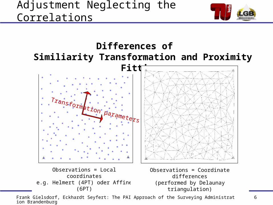
Differences of Similiarity Transformation and Proximity Fitting
Observations = Local coordinatese.g. Helmert (4PT) oder Affine (6PT)
Observations = Coordinate differences(performed by Delaunay triangulation)
Transformation parameters
Adjustment Neglecting the Correlations

Frank Gielsdorf, Eckhardt Seyfert: The PAI Approach of the Surveying Administration Brandenburg 7
Observations: GPS coordinates GIS coordinate differences (pseudo observations)
Adjustment Considering the Correlations
Point X GPS DX GIS
1 -
2 105,65 2
3 6
4 7
5 4
6 10
7 5
8 143,53 4
9 2
10 9
11 9
12 165,13 3
Standard Deviations of Coordinates
0,00
0,10
0,20
0,30
0,40
0,50
0,60
0,70
0,80
0,90
1,00
100,00 110,00 120,00 130,00 140,00 150,00 160,00 170,00
1 2 3 4 5 6 7 8 9 10 11 12 x
GPSGPS GPS
d56
Standard Deviations of Coordinates
0,00
0,10
0,20
0,30
0,40
0,50
0,60
0,70
0,80
0,90
100,00 110,00 120,00 130,00 140,00 150,00 160,00 170,00
Frank Gielsdorf, Eckhardt Seyfert: The PAI Approach of the Surveying Administration Brandenburg 8
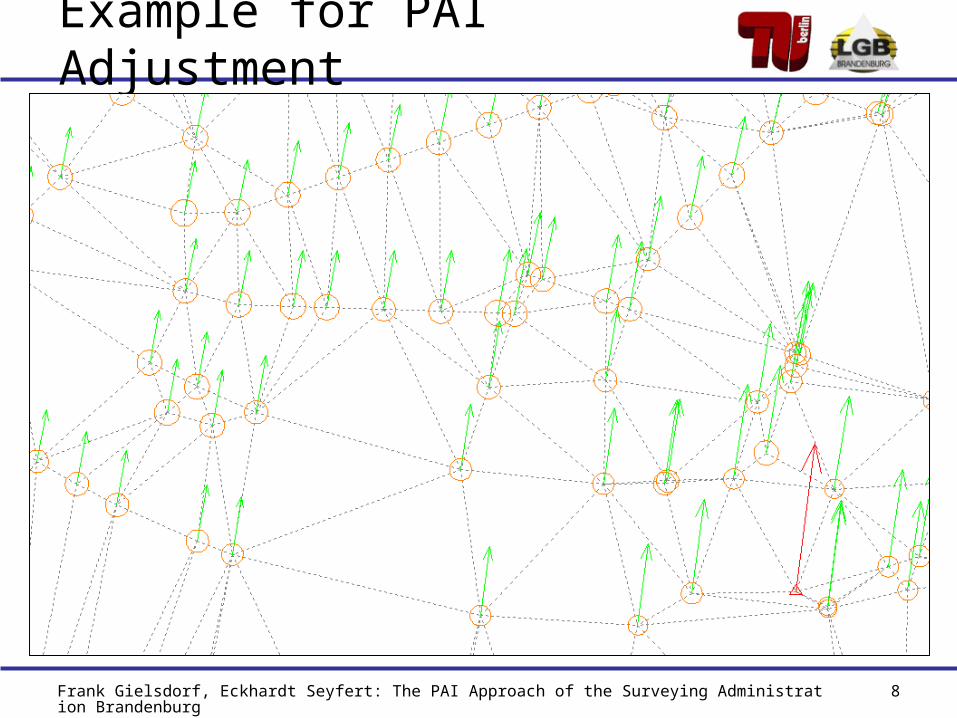
Example for PAI Adjustment

Frank Gielsdorf, Eckhardt Seyfert: The PAI Approach of the Surveying Administration Brandenburg 9
Integration of Geodesic Measurements
Collinear
Orthogonal
Parallel
Circle Continuities
Global Coordinates
Local Coordinates
Distances
28.37
35.2221.46
17.12
12.14
7.88
4.76
10.95
Membrane Triangles- 14.36 - - 20.08 -

Frank Gielsdorf, Eckhardt Seyfert: The PAI Approach of the Surveying Administration Brandenburg 10
Geometry and TopologyNeglected Topology
Neg
lect
edC
orre
latio
n
Frank Gielsdorf, Eckhardt Seyfert: The PAI Approach of the Surveying Administration Brandenburg 11
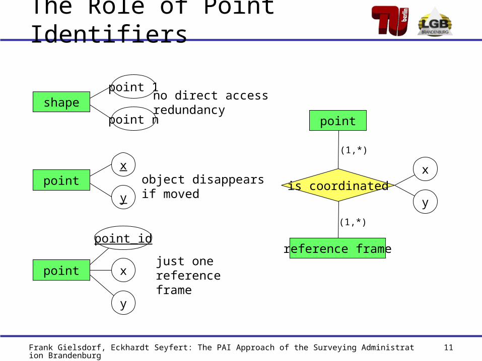
The Role of Point Identifiers
shapepoint 1
point n
pointx
y
point x
y
point_id
no direct accessredundancy
object disappearsif moved
just one reference frame
point
reference frame
is coordinatedx
y
(1,*)
(1,*)

Frank Gielsdorf, Eckhardt Seyfert: The PAI Approach of the Surveying Administration Brandenburg 12
Topology of Pseudo Observations
Distance weighted interpolation Delaunay Triangulation
Observation Topology
Frank Gielsdorf, Eckhardt Seyfert: The PAI Approach of the Surveying Administration Brandenburg 13
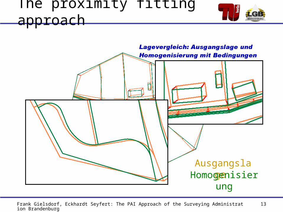
Ausgangslage Homogenisierung
The proximity fitting approach

Frank Gielsdorf, Eckhardt Seyfert: The PAI Approach of the Surveying Administration Brandenburg 14
Federal Country Brandenburg
Brandenburg Germany
Area 29 477 km2 357 020 km2
Population 2.6 Mio 82.2 Mio
Population Density
88 230

Frank Gielsdorf, Eckhardt Seyfert: The PAI Approach of the Surveying Administration Brandenburg 15
Pilot Project Fredersdorf
Federal StateBrandenburg
DistrictUckermark
ComunityFredersdorf
Points: 30.000, Area: 50 km2
Primary data acquisition for ALK is finished
Observations: GPS coordinates, cadastral field books

Frank Gielsdorf, Eckhardt Seyfert: The PAI Approach of the Surveying Administration Brandenburg 16
Temporal Partitioning of PAI
Primary Data Observations
View Coordinates
l0 xi
1
0
l
l
2
1
0
l
l
l
nl
l
l
l
2
1
0
xi+1
xi+2
xi+n
copy
adjustment
adjustment
adjustment
Status at time i
view 1
view 2
view n
1. update
2. update
n. update
time
Frank Gielsdorf, Eckhardt Seyfert: The PAI Approach of the Surveying Administration Brandenburg 17
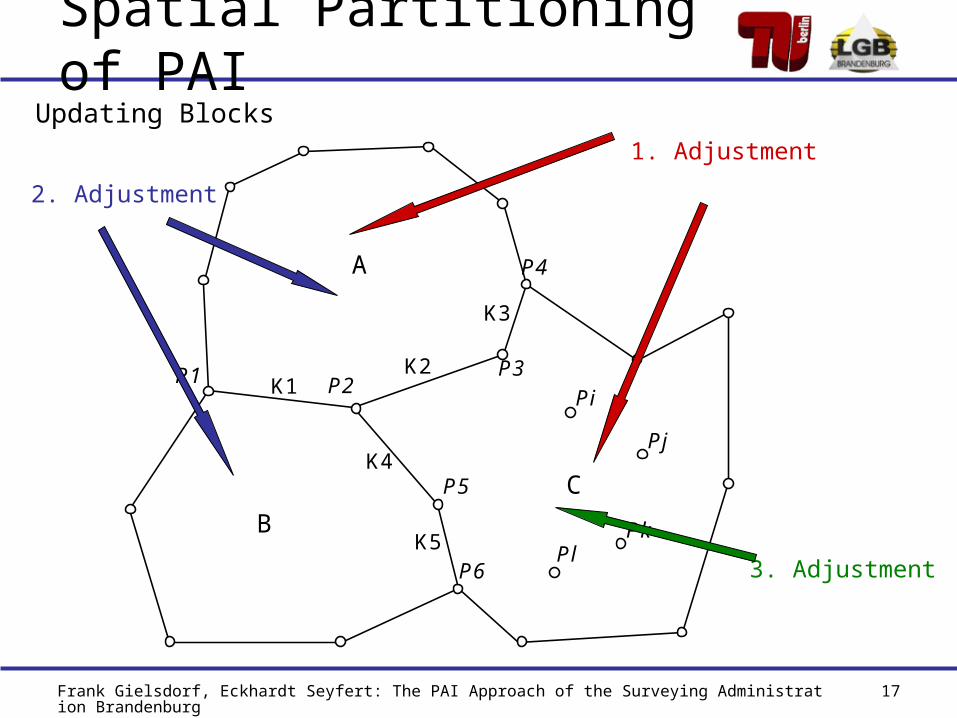
Spatial Partitioning of PAI
A
B
C
Pi K1 K2
K3
K4
K5
P1 P2 P3
P4
P5
P6
Pj
Pk Pl
Updating Blocks1. Adjustment
2. Adjustment
3. Adjustment
Frank Gielsdorf, Eckhardt Seyfert: The PAI Approach of the Surveying Administration Brandenburg 18
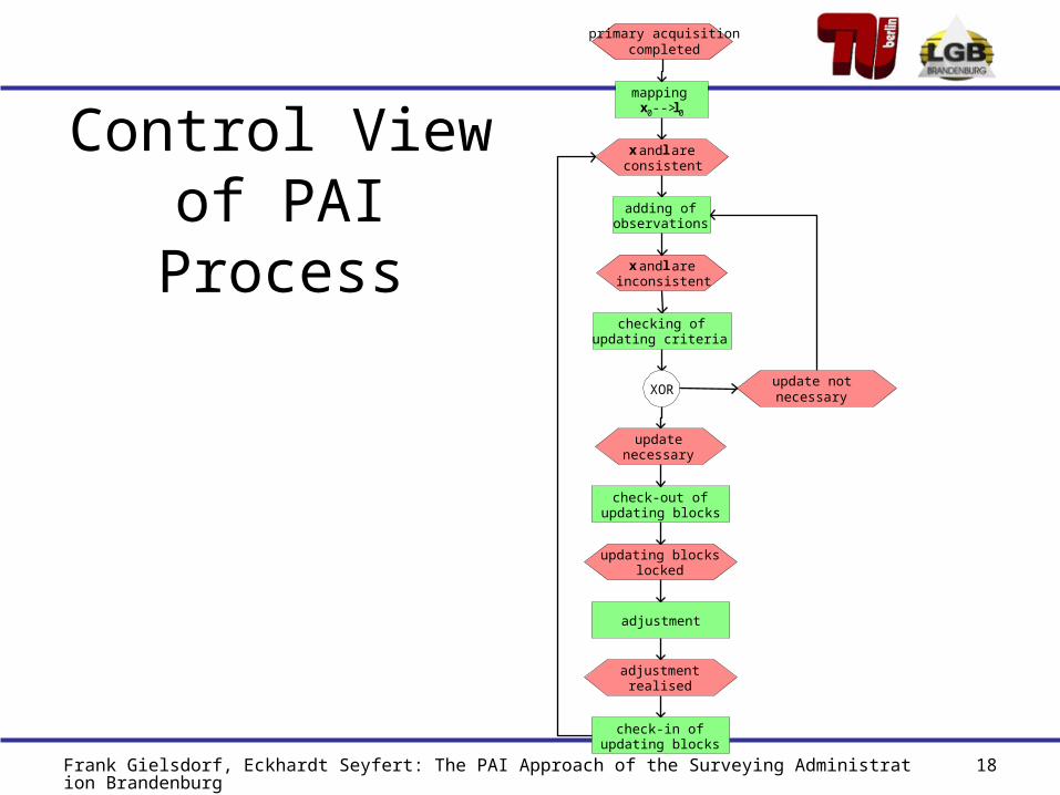
Control Viewof PAI Process
primary acquisitioncompleted
mappingx0 --> l0
x and l areconsistent
adding ofobservations
x and l areinconsistent
checking ofupdating criteria
updatenecessary
update notnecessaryXOR
check-out ofupdating blocks
updating blockslocked
adjustment
adjustmentrealised
check-in ofupdating blocks
Frank Gielsdorf, Eckhardt Seyfert: The PAI Approach of the Surveying Administration Brandenburg 19
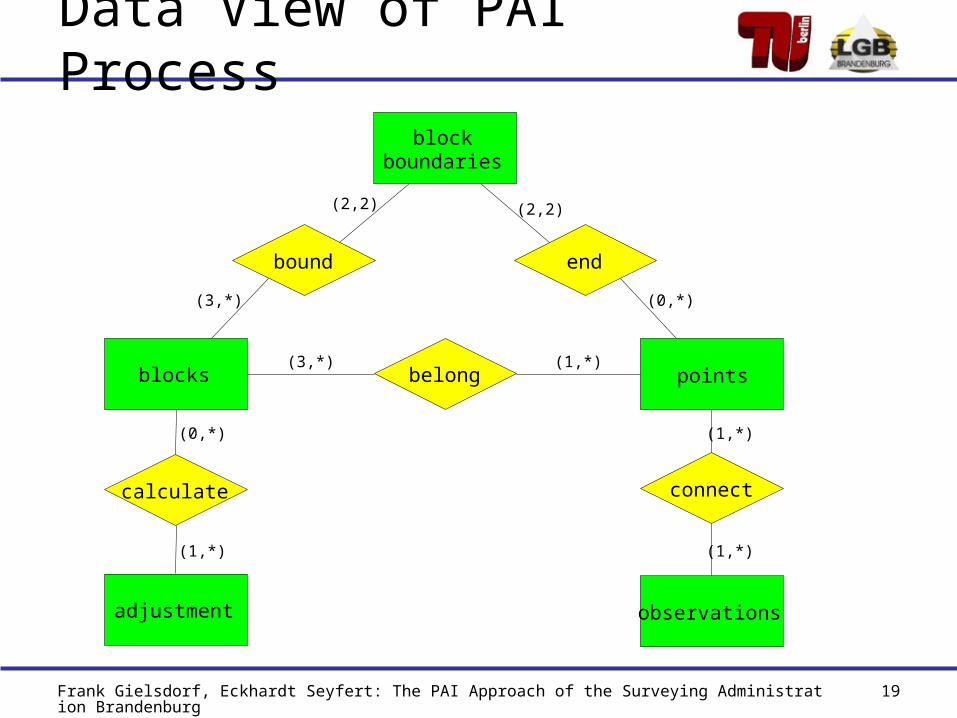
Data View of PAI Process
blocks points
blockboundaries
bound end
belong
(2,2)
(3,*)
(2,2)
(0,*)
(3,*) (1,*)
observations
connect
(1,*)
(1,*)
adjustment
calculate
(0,*)
(1,*)

Frank Gielsdorf, Eckhardt Seyfert: The PAI Approach of the Surveying Administration Brandenburg 20
Data Flow
ALK-GIAP
GEOgraf
SYSTRA
GEOgraf
ALK-GIAP
EDBS
EDBS
coordinates
coordinates
Observations
No identifiers for all pointsNo topology
Generation of topologyDefinition of update blocksPoint identifier
Adjustment calculationsAcquisition and management of observations
Moving the points

Frank Gielsdorf, Eckhardt Seyfert: The PAI Approach of the Surveying Administration Brandenburg 21
Unique Point Identifier
Federal State 12Cadastral District (Gemarkung): 1175Cadastral Section (Flur): 002Number: 23
P12316000700023Point Identifier
Rule On block boundaries obtain the lower point number
Organisation Structures
Important: prefix of point ID is datum independent – no coordinate grid!

Frank Gielsdorf, Eckhardt Seyfert: The PAI Approach of the Surveying Administration Brandenburg 22
PAI Test Project of OS
PRE: Old Geobase data
CUST: Customer data
POST: New Geobase data
Links PRE-POST transformed as Point Identities
Links PRE-CUST generated as Point Identities
No geometrical constraints as wanted

Frank Gielsdorf, Eckhardt Seyfert: The PAI Approach of the Surveying Administration Brandenburg 23
PAI Test Project of OS
Links PRE-POST as Point Identities
Moving vectors = Local residuals
Links PRE-CUST as Point Identities

Frank Gielsdorf, Eckhardt Seyfert: The PAI Approach of the Surveying Administration Brandenburg 24
Thank you for your attention!