the role of the kaharoa eruption in the early polynesian...
TRANSCRIPT
The role of the Kaharoa eruption in the early Polynesian perception of
Aotearoa A research article prepared by Isabella Bennett, Samuel Hampton and Daniel Hikuroa
Isabella Bennett
University of Canterbury
Kirkwood Ave, Upper Riccarton, Christchurch 8041, New Zealand
Skidmore College
815 North Broadway, Saratoga Springs, NY 12866, USA
Samuel Hampton
University of Canterbury
20 Kirkwood Ave, Upper Riccarton, Christchurch 8041, New Zealand
Daniel Hikuroa
University of Auckland
22 Princes Street, Auckland 1142 New Zealand
1
Abstract
In this study, we investigate the plausibility of Polynesian observation of the 1314 (+/-
12) Kaharoa eruption of the Tarawera complex in Northland, New Zealand. The almost
coincident nature of this eruption with the postulated date of 1280-1300 for Polynesian
arrival to New Zealand raised the question; did this eruption produce an eruptive plume
large enough to be seen from significant distance? If so, did this plume initially alert
voyaging Polynesians to the presence of New Zealand? The likelihood of this occurrence
was assessed using SketchUp and Google Earth to model the eruption plumes produced
by a series of 11 plinian eruptions that occurred within the 4-5 year Kaharoa eruption.
The model was based on data provided within previous studies regarding this eruption,
and relies primarily on Pythagorean theorem to assess the visibility of these plumes from
significant locations within greater Polynesia. The size and dimensions of these plume
models ultimately demonstrates that this scenario is unlikely to have occurred. Based on
the relative dates of Polynesian arrival to New Zealand and the Kaharoa eruption, it is
more likely that the Polynesians witnessed this eruption as newly established
inhabitants of New Zealand. In either case, the Polynesian observation of this eruption
may have had a greater impact than has previously been explored, and the term Aotearoa
(land of the long white cloud) may be a reference to the eruptive plumes produced by this
eruption.
Keywords
Aotearoa, Kaharoa, eruption, plume, Maori, oral tradition, New Zealand, Tarawera,
SketchUp, Google Earth
Introduction
When Polynesians set foot on the North Island of New Zealand they claimed the world’s
last uninhabited landmass (Newnham et al., 1998; McGlone and Wilmshurst, 1999; Lowe
et al., 2000; Hogg et al., 2002, 2008; Lowe, 2008). The most widely agreed upon date of
Polynesian arrival to New Zealand is between 1280 and 1300 AD (Newnham et al., 1998;
McGlone and Wilmshurst, 1999; Lowe et al., 2000; Hogg et al., 2002, 2008; Lowe,
2008). Central to Maori oral traditions is the notion that these Polynesians originated
2
from Hawaiki (Evans, 1997). Hawaiki is more of a conceptual location of Maori origin
rather than a physical location; however there is evidence in support of Hawaii, Tahiti
and Ra’iātea (an island in the Society Islands, north of Tahiti) as the origins of some of
the first peoples to inhabit New Zealand (Best, 1915; Hiroa, 1949). In each of these
instances, reaching New Zealand required the Polynesians to deviate from the previously
employed navigational methods. The Polynesians are known to have sailed from west to
east through Polynesia from Melanesia; which positioned waka into the prevailing winds
and ensured that return journeys could be made more quickly (Evans, 1997; Goodenough,
1996). However, voyaging to New Zealand from Hawaii, Tahiti or Ra’iātea requires
voyagers to sail south-westward.
Ra’iātea is about 4,000 km SW from the west coast of the North Island, where the
Polynesians first settled, and Hawaii is about 7000 km. While voyaging waka could
travel up to 250 km in a day under good conditions, extensive distances such as these
could take more than 40 days, and would require stopping at multiple islands and a
definitive destination (Taonui, 2012). How did Polynesians on Ra’iātea or Tahiti know
that land awaited them some 4,000 km away? What convinced early Hawaiians to travel
some 7,000 km south in search of land?
The purpose of this study is to examine whether volcanic plumes produced by the 1314
(+/- 12) Kaharoa eruption in the Taupo Volcanic Zone (TVZ) were visible to the
Polynesians and therefore aided in the discovery of New Zealand. The estimated period
of Polynesian arrival to New Zealand is based on carbon-dated artifacts, all of which
have been found above the volcanic material extruded by the Kaharoa eruption (Nairn et
al. 2000; Lowe, 2008). There is no evidence of human interaction with the land prior to
the Kaharoa eruption (Lowe, 2008). The Kaharoa eruption series took place in the
Tarawera complex over the course of 4-5 years, during which ~5 km3 of tephra was
extruded across the North Island (Bonadonna, et al., 2005). This eruption began as a
pheatomagmatic eruption, followed by a more explosive plinian phase of 11 total
eruptions, and concluded after a phase of dome extrusion (Bonadonna, et al., 2005). For
the purpose of this study, we will focus on the plinian eruptions, as these eruptions
3
generated the most extensive volcanic plumes and would therefore have been the most
visible of the three phases. Plinian eruptions are characterized by massive ash plumes and
significant, explosive tephra dispersal (Bonadonna, et al., 2005). Previously conducted
modeling has shown that Kaharoa plinian eruptions lasted between 2-6 hours and
produced plumes between 16 and 26 km high, which extended to the northeast due to
southwesterly prevailing winds (Bonadonna, et al., 2005). In order to understand if these
plumes would have been visible to voyaging Polynesians, a model of the largest plume
was created using empirical data sets where possible, and information regarding recent
eruptions of comparable measure where historical data was not available.
Methods
1. Oral traditions
Information regarding Maori oral traditions was gleaned primarily from Nga waka o
nehera: The first voyaging canoes (Evans, 1997). Specifically, this portion of the study
was significant in determining a physical location for Hawaiki and the history behind the
meanings behind the name Aotearoa. Information regarding historic Polynesian
navigational tactics and voyaging oral traditions was primarily gathered by Daniel
Hikuroa.
2. Plume modeling
Visual
The likelihood that voyaging Polynesians observed the volcanic plumes generated by the
Kaharoa plinian eruptions is entirely reliant on where the Polynesians were positioned in
relation to New Zealand, and the visibility of the plume from that location (Table 3). In
order to assess this, the size and visible extent of the largest plume was modeled using
SketchUp Pro 2016 (hereafter referred to as SketchUp) (Figures 1, 2 & 3). SketchUp
modeling software and Google Earth Pro were used to provide a visual, georeferenced
model of the Kaharoa eruption plume (Figure 1). The model was created and edited
within SketchUp and exported into Google Earth (Figures 1, 2 & 3).
4
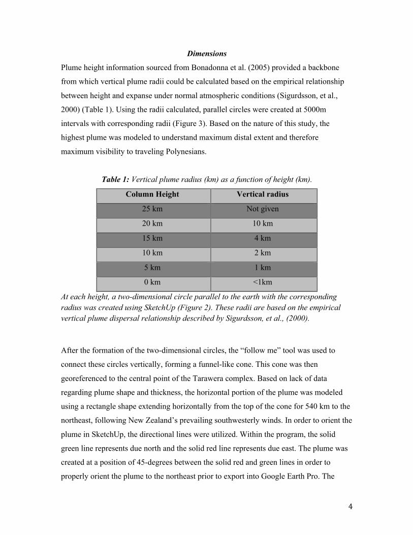
Dimensions
Plume height information sourced from Bonadonna et al. (2005) provided a backbone
from which vertical plume radii could be calculated based on the empirical relationship
between height and expanse under normal atmospheric conditions (Sigurdsson, et al.,
2000) (Table 1). Using the radii calculated, parallel circles were created at 5000m
intervals with corresponding radii (Figure 3). Based on the nature of this study, the
highest plume was modeled to understand maximum distal extent and therefore
maximum visibility to traveling Polynesians.
Table 1: Vertical plume radius (km) as a function of height (km).
Column Height Vertical radius
25 km Not given
20 km 10 km
15 km 4 km
10 km 2 km
5 km 1 km
0 km <1km
At each height, a two-dimensional circle parallel to the earth with the corresponding radius was created using SketchUp (Figure 2). These radii are based on the empirical vertical plume dispersal relationship described by Sigurdsson, et al., (2000). After the formation of the two-dimensional circles, the “follow me” tool was used to
connect these circles vertically, forming a funnel-like cone. This cone was then
georeferenced to the central point of the Tarawera complex. Based on lack of data
regarding plume shape and thickness, the horizontal portion of the plume was modeled
using a rectangle shape extending horizontally from the top of the cone for 540 km to the
northeast, following New Zealand’s prevailing southwesterly winds. In order to orient the
plume in SketchUp, the directional lines were utilized. Within the program, the solid
green line represents due north and the solid red line represents due east. The plume was
created at a position of 45-degrees between the solid red and green lines in order to
properly orient the plume to the northeast prior to export into Google Earth Pro. The

5
measurement of 540 km was based on plume data from recent, well-documented
eruptions of comparable size (i.e. Eyjafjallajökull, 2010; and Klyuchevskaya, 1994)
(Table 2). 540 km was chosen as a conservative yet viable length of visible plume to rule
out overestimation and therefore minimize error, especially given the range of eruption
sizes throughout the Kaharoa plinian series and 2-6 hour duration of each eruption.
Table 2: Comparison of well-documented eruptions to the Kaharoa eruption
The comparative nature of these three eruptions is based primarily on shared VEI, which implies at least ~1km3 of total erupted mass, and explosive plinian style eruptions, as well as extensive plume height. For the purpose of this study, Kliuchevskoi and Eyjafjallajökull provide hypothetical visible dispersal of plume data where it is unavailable and therefore “unknown” for the Kaharoa eruption. Note specifically the 565km visible dispersal of Kliuchevskoi, after which Figure 2 was modeled.
Curvature of the earth and plume height
The curvature of the earth was applied to the SketchUp model using the Pythagorean
theorem in order to maintain a constant plume height above the surface of the earth
(Figure 2). Essentially this meant curving the originally straight, rectangular plume to
follow the Earth’s mean radius of curvature in a non-direction-specific orient at height.
Constant plume height was modeled due to lack of empirical data regarding plume
Eruption VEI Duration Column height
Visible dispersal Total estimated erupted mass
Kaharoa, New Zealand ~1314 AD
4 4-5 years 16-26 km Unknown ~5 km3
Kliuchevskoi, Russia September 15, 1994
4 ~20 days 15-20 km 565 km ~1km3
Eyjafjallajökull, Iceland April 17, 2010
4 6 days ~9 km Significant particle dispersal as far as 2400 km from source (sized at 20 micrometers in Germany)
~0.8 km3
6
thickness, and the relationship between vertical dispersal and distance from source
(figures 2 & 3).
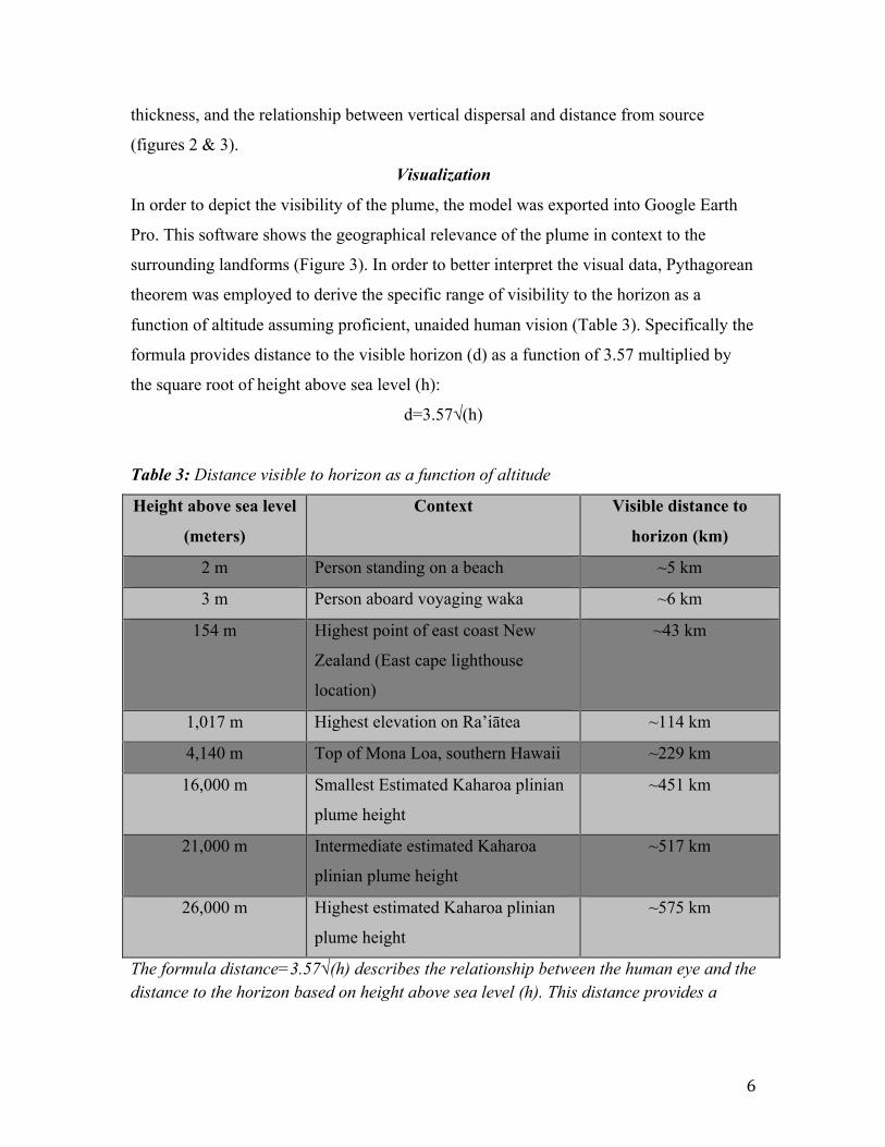
Visualization
In order to depict the visibility of the plume, the model was exported into Google Earth
Pro. This software shows the geographical relevance of the plume in context to the
surrounding landforms (Figure 3). In order to better interpret the visual data, Pythagorean
theorem was employed to derive the specific range of visibility to the horizon as a
function of altitude assuming proficient, unaided human vision (Table 3). Specifically the
formula provides distance to the visible horizon (d) as a function of 3.57 multiplied by
the square root of height above sea level (h):
d=3.57√(h)
Table 3: Distance visible to horizon as a function of altitude
Height above sea level
(meters)
Context Visible distance to
horizon (km)
2 m Person standing on a beach ~5 km
3 m Person aboard voyaging waka ~6 km
154 m Highest point of east coast New
Zealand (East cape lighthouse
location)
~43 km
1,017 m Highest elevation on Ra’iātea ~114 km
4,140 m Top of Mona Loa, southern Hawaii ~229 km
16,000 m Smallest Estimated Kaharoa plinian
plume height
~451 km
21,000 m Intermediate estimated Kaharoa
plinian plume height
~517 km
26,000 m Highest estimated Kaharoa plinian
plume height
~575 km
The formula distance=3.57√(h) describes the relationship between the human eye and the distance to the horizon based on height above sea level (h). This distance provides a

7
measure of how far the plume could be seen from, assuming normal atmospheric conditions. Note that a plume 26,000m high would be visible from ~575km away.
3. Data extraction
The collation of data from both the SketchUp model and the mathematical formula
representing distance to the visible horizon served to provide a clear boundary of
visibility surrounding the plume, assuming normal atmospheric conditions (Table 3,
Figure 1). Using Google Earth, it is possible to observe the model from sea level, which
provides a rough idea of when the model is no longer visible, however in order to
establish accurate data, the mathematical modeling provided more reliable data. The
model instead served more as a visual representation of the data gleaned through
mathematical reasoning, especially at the ~575 km boundary (Table 3). Within the green
boundary circle, the plume is visible, and this is reflected in the Google Earth model at a
view from sea level.
Considerations
The prevailing winds over the North Island of New Zealand are subject to change based
on seasonality, however southwesterlies are dominant. For lack of data regarding exact
dates of each eruption within the Kaharoa plinian series, the model was created assuming
winds originating in the southwest, which would carry the plume out to the northeast as
the model depicts (Figures 1 & 2).
There is not currently a method to accurately model an undocumented eruptive plume.
The thickness, or horizontal and vertical dispersion of a plume varies immensely between
eruptions based on duration, eruptive mass and velocity, wind speed and direction, and
atmospheric conditions. These conditions much be observed or measured in order to
accurately model a plume. In the absence of this information, satellite images and data
collected from recent eruptions of similar size and composition were used to infer a
probable plume size and extent. In this case, the Kaharoa eruption relates most closely
with the Eyjafjallajökull and Klyuchevskaya eruptions, off of which the plume extent is
modeled (table 3).
8
Discussion and Results
A plume of these dimensions would have been visible on the horizon to a person at sea
level from ~575 km away (Table 3, Figure 1). Being that the largest plume is estimated to
have extended at least 540 km from the source, the endpoint of the visible plume would
be visible a total of ~1115 km away from the source of the eruption at the Tarawera
complex, or ~1070 km from the coast of the Bay of Plenty (green circle, Figure 1). In
context to Hawaii, Ra’iātea and Tahiti, this is too significant a distance to stumble upon,
and would instead require the Polynesians to have previous knowledge of land prior to
embarking to New Zealand.
As depicted, there are no significant islands within this boundary of visibility, and the
Polynesians would therefore have to have been coincidentally sailing straight for New
Zealand during or directly following an eruption in order to have witnessed any portion
of the Kaharoa plinian eruption phase (Figure 1). It is possible that the 540 km plume
length is an overly conservative estimation based on the notion that the Eyjafjallajökull
eruptionspreadtephraupto20micrometersasfarasGermany(2,400km)(Table
3).However,theKliuchevskoieruption,uponwhichthismodelisprimarilybased,
hadavisibledispersalto~565km.Becausethereiscurrentlynodatatoprovidea
guidelineastothetotalextentoftheseeruptions,whichvariedwidelyinsize,a
conservativeestimationof540kmisbetterthananoverestimation.Thisbeingsaid,
unlesstheseeruptionsweresignificantlylarger,anincreasebytheorderoftensof
kilometerswouldnothaveaseriousimpactontheviabilityofthishypothesis,asit
isstillarelativelyinsignificantdistalplumeincontexttothedistanceto
surroundinglandforms.UnlesstheplumereachedasfarasTongaorasimilarly
significantisland,itisstillunlikelythattheseplumeswouldhavebeenvisibleto
travelingPolynesians.
The likelihood that voyaging Polynesians witnessed the Kaharoa plinian eruptions is
therefore small. This being said, there is not currently enough data available to rule out
this theory. Given more time and access to Maori court records of oral traditions, more
definitive evidence may have been attainable. There are however multiple avenues for
9
future study that may yield evidence in support of the hypothesis that the Polynesians
relied on the Kaharoa plinian eruption series in the discovery of New Zealand. Namely,
this study would benefit greatly from the provision of more information regarding
specific plume dimensions and dispersal patterns in order to more accurately model the
eruption and therefore provide more conclusive data.
A lesser known translation of Aotearoa, “land of the glowing cloud,” (McLintock, 1966)
may also provide more conclusive evidence that the early Maori witnessed this eruption,
as the particulate friction within VEI 4 eruptions such as these can cause volcanic
lightning, which would in turn cause the plume to glow. Would a glowing plume be
visible from farther away? Specifically, would the light generated by the lightning reflect
off of the ocean’s surface and back into the cloud and so forth, enhance the visibility of
the cloud during the night? Furthermore, due to the proximity of the Tarawera complex to
the Bay of Plenty, large amounts of tephra would have been deposited into the ocean
during each of these eruptions. Depending on the porosity and permeability of the pumice
within these deposits, oceanic currents could conceivably transport floating pumice rafts
to great distances, which could then have been witnessed by the Polynesians and
understood as a sign of proximity to land.
Finally, it is important to consider the notion that the Polynesians may have found New
Zealand prior to the Kaharoa eruption. In this case, the name Aotearoa may still be a
reference to the Kaharoa eruptive plumes, as these eruptions would most certainly affect
the Polynesian perception of New Zealand through the prolonged presence of expansive
plumes, the deterrence of sunlight, dispersal of sizable tephra in areas proximal to the
eruption, among other factors of VEI 4 eruptions, depending on the proximity of
settlements to the Tarawera complex.
Acknowledgments
The authors would like to thank Tom Wilson for providing guidance regarding
volcanology, and Dan Linkinhoker for providing technological support. The Frontiers
10
Abroad community is also greatly appreciated for the continuous provision of support
and guidance.
References
Best, E. (1915). Maori Voyagers and their Vessels: How the Maori explored the Pacific
Ocean, and laid down the Sea Roads for all Time. National Library of New
Zealand, 48 (454). Retrieved from
http://rsnz.natlib.govt.nz/volume/rsnz_48/rsnz_48_00_005060.html
Bonadonna, C., C. B. Connor, B. F. Houghton, L. Connor, M. Byrne, A. Laing, and T. K.
Hincks (2005), Probabilistic modeling of tephra dispersal: Hazard assessment of a
multiphase rhyolitic eruption at Tarawera, New Zealand, J. Geophys. Res., 110,
B03203, doi:10.1029/2003JB002896
Cashman, K. V., & Cronin, S. J. (2008). Welcoming a monster to the world: Myths, oral
tradition, and modern societal response to volcanic disasters. Journal of
Volcanology and Geothermal Research, 176(3), 407-418.
Evans, J. (1997). Nga waka o nehera: The first voyaging canoes. Auckland, N.Z.: Reed
Pub.
Goodenough, W. (1996). Prehistoric Settlement of the Pacific. Transactions of the
American Philosophical Society, 86(5), 1-10. doi:1. Retrieved from
http://www.jstor.org.ezproxy.canterbury.ac.nz/stable/1006617
Hogg, A. G., Higham, T. F., Lowe, D. J., Palmer, J. G., Reimer, P. J., & Newnham, R. M.
(2003). A wiggle-match date for Polynesian settlement of New Zealand.
Antiquity, 77(295), 116-125.
Lowe, D.J. 2008. Polynesian settlement of New Zealand and the impacts of volcanism on
early Maori society: an update. In: Lowe, D.J. (editor) Guidebook for Pre-
conference North Island Field Trip A1 ‘Ashes and Issues’ (28-30 November,
2008). Australian and New Zealand 4th Joint Soils Conference, Massey
University, Palmerston North (1-5 Dec. 2008). New Zealand Society of Soil
Science. Pp.142-147. ISBN 978-0-473-14476-0
Lowe, D., Newnham, R., Mcfadgen, B., & Higham, T. (2000). Tephras and New Zealand
Archaeology. Journal of Archaeological Science, 27(10), 859-870.

11
McGlone, M. S. (1989). The Polynesian settlement of New Zealand in relation to
environmental and biotic changes. New Zealand Journal of Ecology,
12(Supplement), 115-129.
McGlone, M. S., & Wilmshurst, J. M. (1999). Dating initial Maori environmental impact
in New Zealand. Quaternary International, 59(1), 5-16.
McLintock, A. H., & Wilson, J. O. (Eds.). (1966). An encyclopaedia of New Zealand.
Wellington, N.Z.: Govt. Printer.
Nairn, I. A., Self, S., Cole, J. W., Leonard, G. S., & Scutter, C. (2001). Distribution,
stratigraphy, and history of proximal deposits from the c. AD 1305 Kaharoa
eruptive episode at Tarawera Volcano, New Zealand. New Zealand Journal of
Geology and Geophysics, 44(3), 467-484. doi:10.1080/00288306.2001.9514950
Newnham, R., Lowe, D., Mcglone, M., Wilmshurst, J., & Higham, T. (1998). The
Kaharoa Tephra as a Critical Datum for Earliest Human Impact in Northern New
Zealand. Journal of Archaeological Science, 25(6), 533-544.
Pyle, D. M. (1989). The thickness, volume and grainsize of tephra fall deposits. Bulletin
of Volcanology Bull Volcanol, 51(1), 1-15. doi:10.1007/bf01086757
Hiroa, TR. (1949). The Coming of the Maori: Hawaiki. Victoria University of Wellington
Library, retrieved from http://nzetc.victoria.ac.nz/tm/scholarly/tei-BucTheC-t1-
g1-t1-body1-d5-d2.html
Sigurdsson, H., Houghton, B. F., McNutt, S. R., Rymer, H., & Stix, J. (2000).
Encyclopedia of volcanoes. 527-544. San Diego: Academic Press.
Sutton, D. G. (1986). A Paradigmatic Shift in Polynesian Prehistory : Implications for
New Zealand. New Zealand Journal of Archaeology, 135-155.
Taonui, R. (2012, September 22). Canoe navigation: Locating land. Retrieved from
http://www.TeAra.govt.nz/en/canoe-navigation/page-3
12
Figures
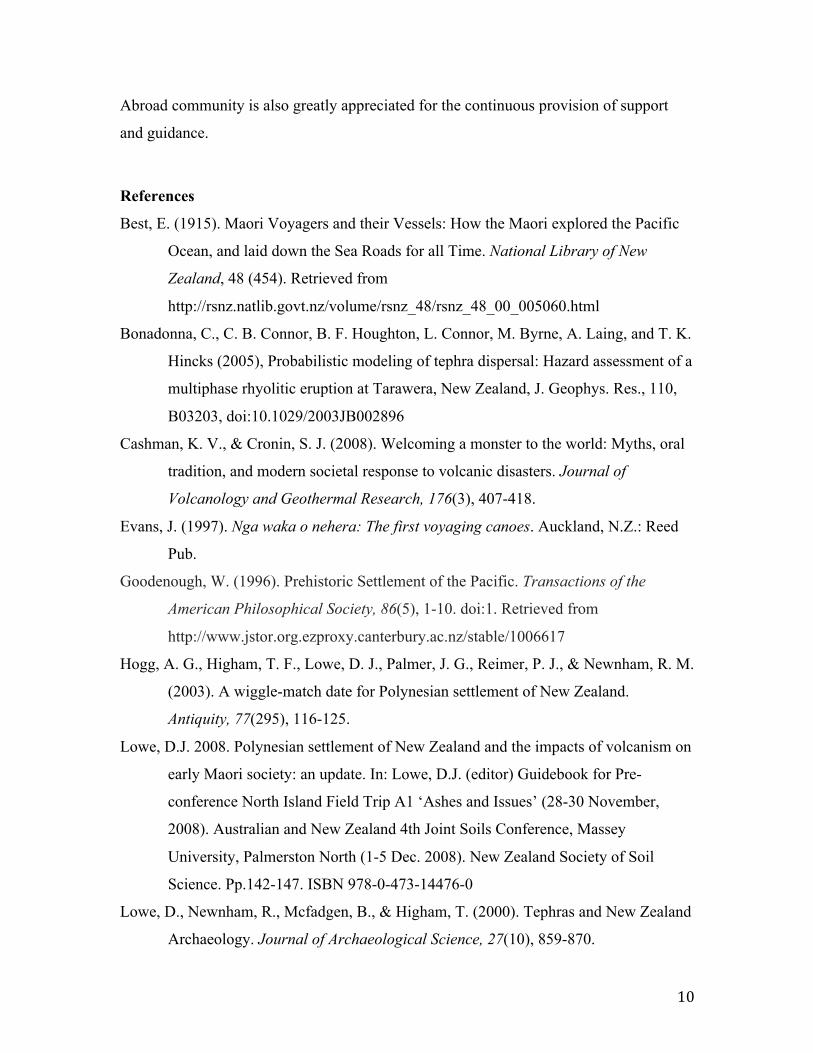
Figure 1: Google Earth representation of Plume visibility
The central rectangular feature is a simplified model of a 540 km long, 26 km wide volcanic plume originating from the Tarawera complex. Concentric circles denote the level of visibility of the farthest northeastern portion of the plume. The blue circles radiate at 100 km intervals and represent the area within which the plume would be visible to a person at sea level. The green circle lies at 575 km from the estimated tip of the plume, and represents the boundary of visibility, after which it a plume of these dimensions would no longer be visible on the horizon (Table 3). Note the abundance of proximal South Pacific Islands, upon which the Polynesians are known to have sought shelter and supplies during voyages.

13
Figure 2: Sketchup plume model dimensions and curvature
The model plume is curved to follow the curvature of the Earth. The dimensions of the
plume are based off of the size of the eruption column and data from recent, comparable
eruptions (Table 2).
14
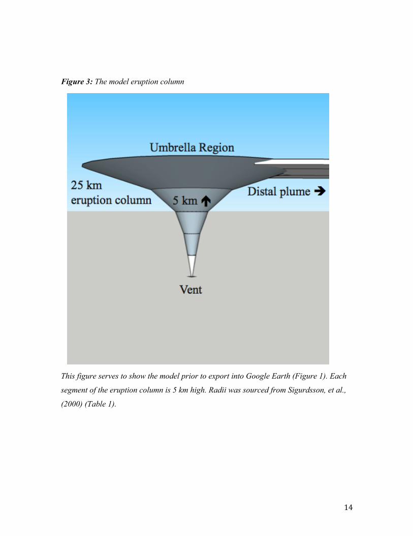
Figure 3: The model eruption column
This figure serves to show the model prior to export into Google Earth (Figure 1). Each
segment of the eruption column is 5 km high. Radii was sourced from Sigurdsson, et al.,
(2000) (Table 1).