the romanian carpathians under communism: the … · the romanian carpathians under communism: the...
TRANSCRIPT
Review of Historical Geography and Toponomastics, vol. I, no.2, 2006, pp 157-206
THE ROMANIAN CARPATHIANS UNDER COMMUNISM: THE CHANGING SIGNIFICANCE OF A
MOUNTAIN REGION
David TURNOCK*
∗ Geography Department, The University Leicester LE1 7RH, U.K. Abstract: This paper arises out of a research project on the historical geography of Carpathians as a whole, although this study of the communist period is restricted to Romania in view of the complexity of the material available. The primary aim is to assess the ways in which the significance of the mountain region changed over four decades of intensive development under a totalitarian system that undermined civil society in order to concentrate leadership in the hands of the Romanian Communist Party. Further acceleration of industrialisation was always the priority, although the high level of self-sufficiency (encouraged by the very nature of the central planning system) was further exaggerated by Romania’s insistence of national industrialisation instead of the more selective programme envisaged under Comecon. With conventional pricing disregarded it was possible for intensive exploitation of low-grade fuels and minerals to continue throughout the period; thereby boosting the importance of key industrial regions in the mountains which are thoroughly examining in the paper. At the same time the great demand for electricity not only enhanced the value of the Jiu valley coalfield but also prompted the comprehensive development of the Carpathian hydropower potential. Along with the further opening-up of the forests to commercial exploitation, this impressive programme – of great aesthetic as well as technical quality – help to establish an infrastructure for tourism which attracted people in unprecedented numbers to the mountain hiking trails as well as the established spa and climatic resorts; with further potential arising from the cultural landscapes (extending back to Dacian-Roman times) which further enhance the heritage role of the Carpathians. Thus, although there was no specific programme of mountain development (indeed the western ‘mountainology’ agenda was largely ignored) – and the bulk of investment in agriculture and industry went to lowland areas where important ‘backward area’ problems were addressed – the montains retained a central role in national life and not least because their scale and disposition required much attention to the basic infrastructure as the studies of railway development and electricity distribution amply demonstrate.
David TURNOCK
Rezumat: Carpaţii Româneşti în perioada comunismului: semnificaţia transformărilor într-o regiune montană. Articolul este rezultatul unui proiect de cercetare privitor la geografia istorică a Carpaţilor, deşi pentru perioada comunismului studiul este restrâns doar la România. Scopul principal al cercetării este să redăm semnificaţia transformărilor regionale montane de-a lungul celor patru decenii de dezvoltare intensivă într-un sistem totalitar, care a subjugat societatea civilă, astfel încât să-şi concentreze conducerea în braţele Partidului Comunist Român. Accelerarea industrializării a constituit o prioritate, cu toate că nivelul suficienţei personale (încurajată de natura sistemului planificat centralizat) a fost exagerată prin insistenţa asupra industrializării naţionale în loc de a urmări programul selectiv acordat de Comecon. Cu preţuri convenţionale neurmărite eficient a fost posibil ca exploatarea combustibililor şi a mineralelor să continue în toată perioada comunistă, sprijinindu-se pe regiuni industriale de bază, analizate în aceast articol. În acelaşi timp, marea cerere de electricitate a crescut valoarea carboniferă a Văii Jiului şi a determinat valorificarea potenţialului hidroenergetic al Carpaţilor. Odată cu deschiderea activităţilor forestiere spre latura comercială, acest program – bazat pe estetică şi calitate tehnică – a ajutat stabilirea unei infrastructuri turistice care a atras populaţia spre staţiunile climatice şi balneoclimaterice; dacă adăugăm şi potenţialul cultural (ce datează din perioada daco-romană) observăm rolul moştenirilor culturale în Carpaţi. Astfel, deşi nu a existat un program specific de dezvoltare montană (agenda montanologică occidentală fiind profound ignorată) – iar investiţiile în industrie şi agricultură erau orientate spre regiunile mai puţin înalte, spaţiile montane au avut rolul esenţial în viaţa naţională a românilor după cum planurile de infrastructură, de dezvoltare a căilor ferate şi de distribuire a energiei electrice le demonstrează. Key words: The Romanian Carpathians, communism Cuvinte cheie: Carpații Românești, perioada comunistă
1. INTRODUCTION
The Carpathians are a fundamental element in Romania’s topography and also its
heritage, since tradition emphasises the importance of the mountain girdle as the core of the national territory encompassing the Transylvanian Plateau and acting as a cultural hearth that sheltered the Romanisd Dacian population during the ‘dark age’ of migration (Giurcăneanu 1988). A talented ‘moşneni’ peasantry provided the demographic resources for a reoccupation of the lowlands in modern times, while the German and Hungarian minorities (enjoying a historic supremacy within the Habsburg state) contributed to the relatively advanced (albeit neo-colonial) economy in Transylvania, drawing on the forests and minerals of the mountains that were fully integrated into the Central European trading sphere during the railway age. The creation of ‘România Mare’ after the First World War secured for Romanians an effectively-unified Carpathian-Danubian state with the mountain core playing a key role in terms of both historic identity and economic progress, although it was inevitable that the lowland areas of Moldavia, Wallachia and Dobrogea – industrially-backward in many cases, though crucial in terms of cereal exports in the modern period - would gradually become relatively more important. The inter-war years – dominated by reconstruction, depression and the renewed danger of war - were too short for any major transformation; but the second half of the nineteenth century provided the opportunity for sustained progress, mostly under the control of a communist regime that concentrated on industrialisation. This paper examines the changing role of the mountain territory defined in
158

The Romanian Carpathians under communism: the changing significance of a mountain region
Figure 1 and shows how the inevitable decline in relative industrial importance has been balanced by new functions at the start of a new period of national prosperity and European integration.
�
� ����
���� ���
��� ������
����
���
������� ���
���
�
������������� ������������
�������������
�����������!�
������ �����
"����������
������#����
$����������
���������������� ���
%��������������� �� ���
�&�'
�&�'
��&�'
(� ���
�&�'
�&�'
���� ���)�� �*�� ���+�,�
�������������$��$�����������#������!�
-�+�,�������� �� ���
��
��
����
��
��
��
��
����
��
����
���
����
��
��
������
����
����
����
.�,�����������/� ����� ���� ���!��������+�����*�0�!�0 �,����� �1�!� �2����*��3���� �/�� * �����*4����4 ����(�� ����(��� �������5�����16���78�� �8�1�,��� ��9�:���
�������������� ����������
��
�
�� �
;
<
<
;
;
�
��
����
Figure 1: The Romanian Carpathians showing aspects of employment in agriculture and industry 1992.
2. AGRICULTURE AND FORESTRY
The communist state was able to subvert the logic of the market by replacing private enterprise with a system controlled by the party and in its way it was successful: maintaining production and offering social security while limiting incentives so that younger people would leave the land and seek employment in the priority sectors. Although Soviet tutelage made it politically impossible not to collectivise – and so provide a reliable ‘second string’ to the centrally-controlled state farm system, there was an element of pragmatism in that the programme allowed the retention of private plots for part-time work (Kideckel 1982). Moreover, the programme was not completed until after 1960 when the logistical difficulties of cooperation in highly dispersed mountain settlements were accepted and individual farms continued to operate under a modified quota system through a ‘plan de producţie’ negotiated at the commune level. This arrangement allowed for domestic consumption, as well as local exchanges and sales on the open markets, while the state ensured that it would gain more from
159

David TURNOCK
the peasants that it would by undertaking the costly work of organising them into cooperatives. Individual farms accounted for 15% of all farmland in the Carpathian counties (only 0.3% elsewhere) and reached 22% in the northern counties of the Eastern Carpathians (Table 1). The arrangements were not static however since labour became scarcer as young people moved into industry as commuters or left the countryside altogether (Cernea 1974). For the cooperatives the ‘acord global’ provided for piece-work and in effect re-introduced share-cropping by allowing peasants to look after the entire seasonal round of cultivation tasks on designated plots (which included traditional textile crops: flax and hemp) with payment through a share of the harvest. And for individual farms, stimulative measures were advocated in the 1970s whereby the local authorities would give private households more assistance in improving the fodder supply and the general quality of production, including mechanisation. But holdings remained small and the labour force became increasingly elderly, especially in areas where the young people had to leave home in order to find non-agricultural work. Furthermore additional outside support (though fodder deliveries and milk collection) tended to bring with more demanding contractual obligations.
Table 1. Farm types in the Romanian Carpathians 1980
Section State Farms Cooperatives Individual Fs All Farms No(th) % No(th) % No(th) % No(th) % Eastern Carpathians – North 316.3 24.8 669.3 52.4 292.3 22.9 1277.9 100.0 Eastern Carpathians – South 349.9 24.6 922.1 64.9 148.2 10.4 1420.2 100.0 Curvature Carpathians 439.2 30.9 846.0 59.5 136.1 9.6 1421.3 100.0 Southern Carpathians 414.5 28.9 746.4 52.1 272.8 19.0 1433.7 100.0 Western Carpathians – North 550.0 32.6 1012.5 60.1 122.4 7.3 1684.9 100.0 Western Carpathians – South 748.5 35.8 915.9 43.8 427.7 20.4 2092.1 100.0 Total 2818.4 30.2 5112.2 54.8 1399.5 15.0 9330.1 100.0 Lowlands 1669.8 29.6 3949.1 70.1 14.4 0.3 5633.3 100.0 Romania 4488.2 30.0 9061.3 60.6 1413.9 9.4 14963.4. 100.0
Figures relate to whole counties and include considerable areas of lowland adjacent to the mountains themselves.
Source: Anuarul Statistic 1980
In the 1980s the state increased its demands through higher quotas coupled with livestock registration procedures (more stringent than the formalities for human births required only after four weeks) and price limits on the open markets. Agriculture was now given an enhanced role in order to pay off all foreign debts and thereby eliminate the pressures from international banking organisations which were constraining Ceauşescu’s economic planning. Overall, investment in the mountains did not compare with the lowlands with their drainage and irrigation schemes, intensive liverstock and poultry farms, along with mechanisation and the provision of fertilisers and pesticides. However funding was needed for new central farm buildings and improved networks for veterinary assistance and plant protection. Livestock rearing was an important speciality which, in Maramureş (Iacob 1974,1980) involved better feeding through applying fertiliser to pastures and improved breeding of the local brown cattle for both beef and milk production; also regular monthly stock marketing. Full use was made of the ‘stâna’ system for sheep: with large flocks 300-800 assembled at distant stations (up to 100kms away on the Ukrainian frontier) with smaller units on either side of the Iza valley involving distances below 20kms. Fruit growing became a more important speciality in the
160

The Romanian Carpathians under communism: the changing significance of a mountain region
‘muscel’ country of the south and southeast with intricate landuse mosaics (involving woodland, pasture and orchards) typical the Subcarpathians (Velcea 1970). Indeed, Giurcăneanu (1988, pp. 136-7) mentions the trend towards specialisation along the mountain edge through cereals, fruit and grapes to produce „peisajele agro-cerealiere/viti-pomicole” compared with a broad-based subsistence agriculture of „peisajele agro-pastorale” in the core areas (purely „pastorale” around the summer grazing stations); while „peisajele forestiere” characterized the main Charpatian massif and „peisajele industriale” appeared in many valleys and depressions. 2.1. Silviculture
The forests also experienced radical change through nationalisation in 1948 followed by a similar measure in respect of hunting rights which denied peasant access to game while reserving a substantial interest for a privileged hunting and fishing organisation. Nationalisation was supported by many silvicultural interests which saw the abolition of private ownership as a preconditon for sustainable management (Turnock 1988) and it was certainly very necessary that action should be taken to ensure a recovery from years of heavy cutting since the demands of the Second World War were extended by reparations made to the Soviet Union which rose from 1.1mln.cu.m of wood in 1948 to 4.3mln in 1951; sustained by the provision of timber transport in areas hitherto inaccessible. After a modest replanting effort amounting to 33,000ha during the 1930s, 1.3mln.ha were covered during 1948-73 (with priority for the 700,000ha of woodland taken over under nationalisation). Much publicity was given to species change i.e. modifying the usual altitudinal zonation of the major tree species in order to increase the area with the more valuable resinous timber (fir and spruce) at the expense of beech. Although this produced some optimistic forecasts (Călinescu & Bunescu 1955), the results were not encouraging and the political pressure was relaxed in favour of more informed local decision-making by experienced foresters. Again, as more forests were opened up and wood for manufacturing (as opposed to firewood) rose from half in 1950 to 75% in the 1970s, more attention had to be given to protection woodland in critical areas to guard against erosion and water pollution. Indeed, after a failed attempt to limit cutting in 1962, a ‘National Programme for the Conservation & Development if the Forest Area’ was launched for the 1976-2010 period with the aim of restricting annual cutting to 20mln.cu.m so that the natural growth (28mln.cu.m) would gradually restore the great forest massifs where density was being seriously reduced. At the same time it was intended that whole tree harvesting should ensure that all the wood mass was used by the processors since board production was now an important consideration. However the results were unsatisfactory and the problem of reconciling cutting and regeneration remained unresolved (Giurescu 1980, p.100). Meanwhile logging provided much work for countrymen, typically with weekdays spent in local forests using temporary accommodation. However Iacob (1961) notes a traditional of long-wave commuting from Maramureş for seasonal work in the forests, with some reduction by the 1960s through the expansion of logging within this northern region. Yet there were still substantial migrations to Dorna, Rodna and the upper Moldova valley; also the Bistriţa and Trotuş valleys of the Eastern Carpathians as well as the Southern Carpathians (especially the Retezat). At the same some workers came into Maramureş from nearby Oaş (as well as Beiuş and Muscel further afield) with skills in building transport facilities (light railways, forest roads and artificial canals, known as ‘jilipuri’ or ‘scocuri’).
161

David TURNOCK
2.2. Land use patterns
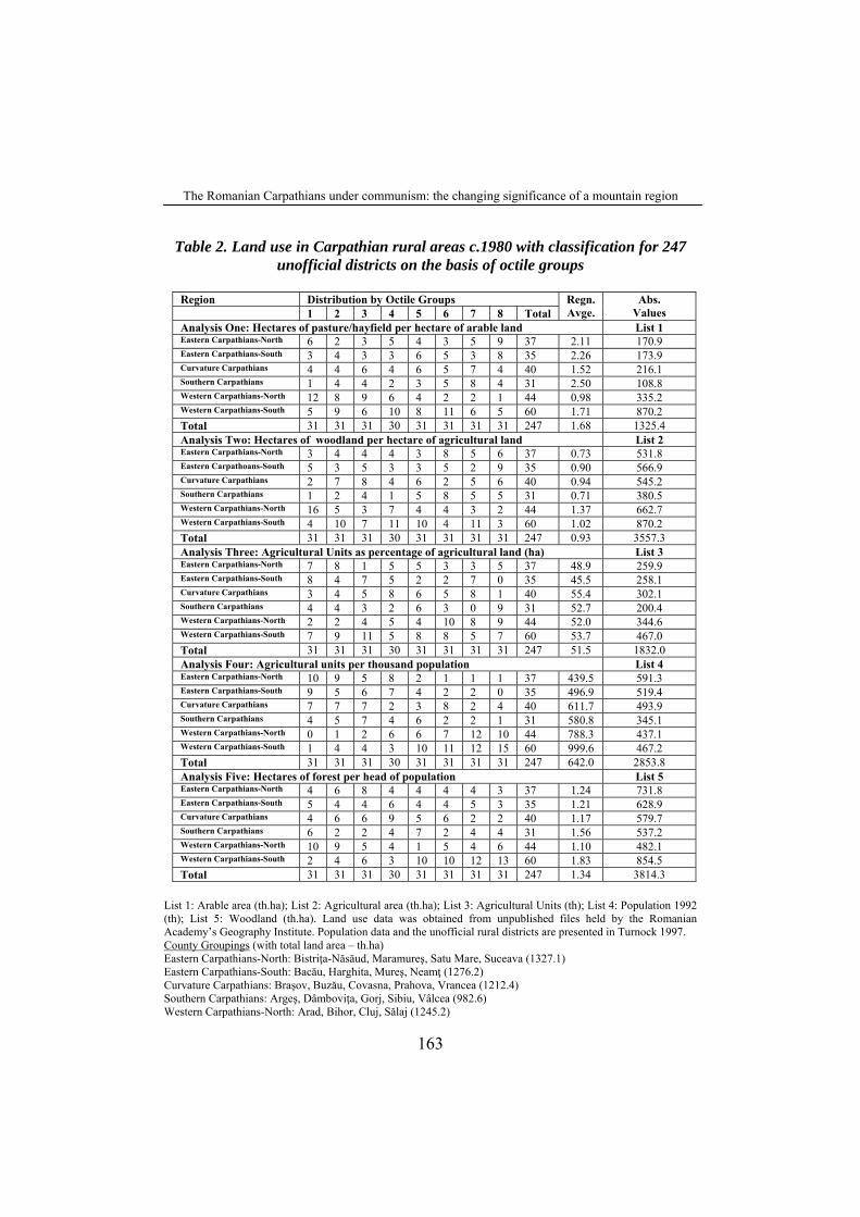
Changes in land uses are difficult to examine at the local level due to the lack of statistics but data for the Banat counties of Arad, Caraş-Severin and Timiş, allowing a comparison between Ministry of Agriculture figures of the early 1990s with the Romanian Academy’s lists used in the 1980s (see below), shows only a small change with agricultural land increasing by 5.6% to 593,700ha (though arable decreased by 8.4%) while the forests decreased by 0.1% to 592,600ha; although with discrepancies in the grand totals which could relate to some farmland ‘lost’ during communism and any real change in farming-forest balance may have been insignificant (Turnock 1999). Meanwhile Table 2 shows some of the major variations within the Carpathians with regard to the Academy data for the 1980s where the communes are aggregated into 247 rural districts and summarised on the basis of octile groups. As regards the balance of arable and pasture (with the latter including the special category of hayfields) the Western Carpathians are quite distinct in having 34 districts in the lowest two octile groups and only 14 in the top two, pointing to a relatively high proportion of arable land. The other areas have 48 districts in the top two octiles against 28 in the lowest two with the greatest imbalance in the South (12:5), followed by the East as a whole (25:15). When the agricultural land is set against the woodland, the Western Carpathians North have 21 districts in the lowest two octile groups against five in the top two; reflecting the extensive colonisation of the high plateau lands in the ‘Moti’ areas of Alba country and adjacent areas. The other extreme is highlighted by the South with the opposite emphasis (3:10), followed by the East as a whole (15:22) with the other two areas roughly in balance (23:25). Another indicator of the prominence of agriculture is the calculation of ‘agricultural units’ which allow a premium per hectare for orchards and vegetable gardens while devaluing pasture and hay meadow (Turnock 1997, p.52). Against an average for the rural Carpathians of 51.5% (units against hectares), the Eastern Carpathians are well below average (especially the sothern part) – correlating with the finding from the first analysis): the East as a whole has a ratio of 27:15 for the two lowest groups against the two highest, compared with 35:47 the other four groups within which the Curvature Carpathians have the highest rating (55.4%) reflecting the relatively high prominence of intensive cultures close to the contact wih the lower ground. Population is brought into the fourth analysis. Here the special position of the Western Carpathians as whole is demonstrated because the prominence of farmland, especially in the north, is combined with sustained depopulation giving high per capita values: a ratio of 35:25 when the top two octiles and placed against the lowest two. And reflecting the demographic gradient the Eastern Carpathians have the opposite profile to an exaggerated degree (4:33) while the other two sections show the same bias but to a more moderate degree (9:23). Finally when population is related to woodland, the depopulation in the West produces the highest figure in the southern part of the Western Carpathians where the forests are also quite massive: hence a ratio of 25:6 when the two highest octiles are set against the two lowest. However in the northern part, where the forests are less prominent, the balance is revesed (10:19). The south shows a balance (8:8) while other three areas, with substantiual forests and a high population are biased to the lower end (29:19).
162
The Romanian Carpathians under communism: the changing significance of a mountain region
Table 2. Land use in Carpathian rural areas c.1980 with classification for 247 unofficial districts on the basis of octile groups
Region Distribution by Octile Groups 1 2 3 4 5 6 7 8 Total
Regn. Avge.
Abs. Values
Analysis One: Hectares of pasture/hayfield per hectare of arable land List 1 Eastern Carpathians-North 6 2 3 5 4 3 5 9 37 2.11 170.9 Eastern Carpathians-South 3 4 3 3 6 5 3 8 35 2.26 173.9 Curvature Carpathians 4 4 6 4 6 5 7 4 40 1.52 216.1 Southern Carpathians 1 4 4 2 3 5 8 4 31 2.50 108.8 Western Carpathians-North 12 8 9 6 4 2 2 1 44 0.98 335.2 Western Carpathians-South 5 9 6 10 8 11 6 5 60 1.71 870.2 Total 31 31 31 30 31 31 31 31 247 1.68 1325.4 Analysis Two: Hectares of woodland per hectare of agricultural land List 2 Eastern Carpathians-North 3 4 4 4 3 8 5 6 37 0.73 531.8 Eastern Carpathoans-South 5 3 5 3 3 5 2 9 35 0.90 566.9 Curvature Carpathians 2 7 8 4 6 2 5 6 40 0.94 545.2 Southern Carpathians 1 2 4 1 5 8 5 5 31 0.71 380.5 Western Carpathians-North 16 5 3 7 4 4 3 2 44 1.37 662.7 Western Carpathians-South 4 10 7 11 10 4 11 3 60 1.02 870.2 Total 31 31 31 30 31 31 31 31 247 0.93 3557.3 Analysis Three: Agricultural Units as percentage of agricultural land (ha) List 3 Eastern Carpathians-North 7 8 1 5 5 3 3 5 37 48.9 259.9 Eastern Carpathians-South 8 4 7 5 2 2 7 0 35 45.5 258.1 Curvature Carpathians 3 4 5 8 6 5 8 1 40 55.4 302.1 Southern Carpathians 4 4 3 2 6 3 0 9 31 52.7 200.4 Western Carpathians-North 2 2 4 5 4 10 8 9 44 52.0 344.6 Western Carpathians-South 7 9 11 5 8 8 5 7 60 53.7 467.0 Total 31 31 31 30 31 31 31 31 247 51.5 1832.0 Analysis Four: Agricultural units per thousand population List 4 Eastern Carpathians-North 10 9 5 8 2 1 1 1 37 439.5 591.3 Eastern Carpathians-South 9 5 6 7 4 2 2 0 35 496.9 519.4 Curvature Carpathians 7 7 7 2 3 8 2 4 40 611.7 493.9 Southern Carpathians 4 5 7 4 6 2 2 1 31 580.8 345.1 Western Carpathians-North 0 1 2 6 6 7 12 10 44 788.3 437.1 Western Carpathians-South 1 4 4 3 10 11 12 15 60 999.6 467.2 Total 31 31 31 30 31 31 31 31 247 642.0 2853.8 Analysis Five: Hectares of forest per head of population List 5 Eastern Carpathians-North 4 6 8 4 4 4 4 3 37 1.24 731.8 Eastern Carpathians-South 5 4 4 6 4 4 5 3 35 1.21 628.9 Curvature Carpathians 4 6 6 9 5 6 2 2 40 1.17 579.7 Southern Carpathians 6 2 2 4 7 2 4 4 31 1.56 537.2 Western Carpathians-North 10 9 5 4 1 5 4 6 44 1.10 482.1 Western Carpathians-South 2 4 6 3 10 10 12 13 60 1.83 854.5 Total 31 31 31 30 31 31 31 31 247 1.34 3814.3
List 1: Arable area (th.ha); List 2: Agricultural area (th.ha); List 3: Agricultural Units (th); List 4: Population 1992 (th); List 5: Woodland (th.ha). Land use data was obtained from unpublished files held by the Romanian Academy’s Geography Institute. Population data and the unofficial rural districts are presented in Turnock 1997. County Groupings (with total land area – th.ha) Eastern Carpathians-North: Bistriţa-Năsăud, Maramureş, Satu Mare, Suceava (1327.1) Eastern Carpathians-South: Bacău, Harghita, Mureş, Neamţ (1276.2) Curvature Carpathians: Braşov, Buzău, Covasna, Prahova, Vrancea (1212.4) Southern Carpathians: Argeş, Dâmboviţa, Gorj, Sibiu, Vâlcea (982.6) Western Carpathians-North: Arad, Bihor, Cluj, Sălaj (1245.2)
163

David TURNOCK
Western Carpathians-South: Alba, Caraş-Severin, Hunedoara, Mehedinţi, Timiş (1861.2) Values for Octile Bands: Analysis One: 1: 0.18-0.58; 2: 0.60-0.90; 3: 0.95-1.20; 4: 1.24-1.69; 5: 1.75-3.25; 6: 2.33- 3.36; 7: 3.36-5.50; 8: 5.72-111.05; Analysis Two: 1: 0.05-0.36; 2: 0.36-0.51; 3: 0.52-0.73; 4: 0.73-0.92; 5: 0.94-1.23; 6: 1.25-1.63; 7: 1.66-2.20; 8: 2.21-8.86; Analysis Three: 1: 8.6-32.5; 2: 33.0-40.3; 3: 40.7- 44.6; 4: 46.6-53.3; 5: 53.7- 60.0; 6: 60.3-68.4; 7: 68.7-80.9; 8: 81.0-156.9; Analysis Four: 1: 151.8-285-6; 2: 285.7-408.8; 3: 411.6-541.3; 4: 543.3-670.6; 5: 672.9-810.0; 6: 816.8-981.4; 7: 983.8-1280.2; 8: 1316.1-5474.4; Analysis Five: 1: 0.047-0.405; 2: 0.407-0.618; 3: 0.636-0.910; 4: 0.923-1.206; 5: 1.215-1.505; 6: 1.516-1.964; 7: 2.006-3.078; 8: 3.118-13,771
3. INDUSTRY
There can be no doubt about the expansion of industry during the communist period since the system was dedicated to this key objective. The results were substantial in terms of investment, production and employment. Industry’s share of national income rose nationally from 30.8% 1938 to 57.1% 1972 (Alexandru et al. 1973) although this was not all down to the communist era. Employment figures for the Carpathians (Table 3) reveal just 0.66 jobs in industry for each one in agriculture in 1966 but 2.81 in 2002 (3.72 and 15.99 in urban areas; 0.28 and 0.84 in rural areas). The Outer East figure was much lower than the average in 1966 (0.45) and relatively poorer in 2002 (1.40): 2.31 and 13.02 in urban areas and 0.28 and 0.64 in rural areas. Unfortunately no comparable figures are available for 1950. It will always be a moot point how far the communist system was a precondition for this performance (bearing in mind the progress of industry in the inter-war period) and also for its changing spatial pattern, especially the spread into formerly backward areas. The Soviet system was geared to the strategic imperative of a new industrial base in Siberia that required the suppression of classical location theory, but arguably Romania’s regional problems were of an entirely different order in terms of scale that did not require the shock therapy of comprehensive nationalisation and state direction; though the imperatives of state control with a dogmatic bias towards heavy industry certainly did require the utmost centralisation. The same can be said for the emphasis on very large units of production that were thought to be more efficient (with further benefits in terms of prestige and state/party supervision). Enterprises employing over 3,000 people accounted for 19.8% of all the industrial workers in 1950, rising to 20.0% in 1960, 27.6% in 1970, 47.7% in 1980 and 59.8% in 1989, although interestingly in terms of the share of the production they exceeded the share of workers in 1970 (31.1%) and 1980 (50.1%), pointing to possible efficiency gains, but substantially underachieved in 1989 (50.5%) (Popescu 2000, p.109).
However this feature is conspicuously absent from Popescu’s (2000, p.102) presentation of 10 communist location principles which cover raw material and market orientations; the opposing objectives of specialised national production and regional self-sufficiency; and dispersal in the interest of national defence, a better division of labour for Comecon, and assistance to backward regions (overcoming town-country differences), ethnic minorities and ‘bastioanele proletare ale socialismului’ (Ibid p.102). Clearly there are such built-in contradictions that any location could be validated in some way while none necessarily run counter to the conventional capitalism wisdom of location to secure the greatest profit. Hence, in the absence of information on location decision-making and enterprise performance it is quite impossible to subject individual decisions to close scrutiny and although Popescu notes the ‘subjectivism’ inherent in Ceauşescu’s support for
164

The Romanian Carpathians under communism: the changing significance of a mountain region
his home in Scorniceşti and the contradiction between a power station at Anina burning low-grade domestic fuel and an oil refinery at Năvodari dependent on imported crude (neither of which are fundamentally irrational) there are no criticisms of individual decisions. What can be challenged however is the propaganda insistence on the location of industry to accelerate development in backward areas. This was certainly important, but progress was made very gradually in a way that did not compromise the overall national interest in taking full advantage of such well-resourced cities as Braşov, which for some years was ‘honoured’ with the ‘Oraşul Stalin’. Success was facilitated by the construction of an electricity grid (the inevitable consequence of modernisation) and by the economic logic of progressively seeking out new sources of labour and raw materials.
Table 3. Population and occupations in the Romanian Carpathians 1911-2002
Section Sect’n Population (th) Occupation (th) 1911-2 1966 2002 1966 2002 Active Agr. Indy. Active Agr. Indy.
East-Inner Urban 219.0 353.7 638.9 162.4 42.1 59.4 300.4 13.8 151.7
Rural 481.1 584.2 579.4 338.9 249.3 51.0 254.4 112.0 66.9
Total 700.1 937.8 1218.3 501.3 291.4 110.5 554.8 125.7 218.7
East-Outer Urban 135.5 282.4 462.4 132.1 22.6 52.2 217.9 8.9 115.9
Rural 478.8 671.5 674.0 366.9 244.6 68.5 315.7 135.3 86.6
Total 614.3 953.9 1136.4 499.0 267.2 120.7 533.5 144.3 202.5
South-Inner Urban 200.5 501.6 859.8 256.2 28.4 134.7 415.1 13.9 235.3
Rural 304.2 324.8 285.3 184.4 111.0 43.3 108.8 26.9 44.9
Total 504.7 826.3 1145.1 440.5 139.4 178.0 523.9 40.8 280.3
South-Outer Urban 194.8 374.2 689.6 182.2 32.5 74.0 335.1 12.0 171.4
Rural 359.3 465.6 432.7 248.8 143.9 52.0 199.7 62.0 74.8
Total 554.1 839.8 1122.3 430.9 176.4 126.0 534.8 73.9 246.1
West-Inner Urban 302.4 719.6 1156.0 336.0 35.6 157.7 540.6 12.3 297.6
Rural 555.3 532.1 405.0 327.0 192.9 50.8 180.3 59.3 56.4
Total 857.7 1251.8 1561.0 663.1 228.5 208.5 720.9 71.6 354.1
West-Outer Urban 224.1 394.2 593.7 191.0 20.2 82.3 273.0 8.5 138.1
Rural 679.2 605.3 477.5 379.1 201.6 55.6 205.1 69.8 59.7
Total 903.3 999.5 1071.2 570.0 221.8 137.9 478,1 78.3 197.9
Carpathians Urban 1276.3 2625.7 4400.4 1259.9 181.4 560.3 2082.1 69.4 1110.0
Rural 2857.9 3183.5 2853.9 1845.1 1143.3 321.2 1264.0 465.3 389.3
Total 4134.2 5809.1 7254.3 3104.8 1324.7 881.6 3346.0 534.6 1499.6
Source: Census
Another fundamental aspect of the industrial geography is the level of emphasis on the Carpathians compared with the lowlands. Historically the mountain resource areas have held an advantage but this has been reversed through faster growth in lowland cities linked with the growing dependence on imported raw materials and the more balanced use of labour resources (although some lowland countries still remained remained surprisingly
165
David TURNOCK
under-industrialised). The change can be measured using the maps presented by Popescu (2000, pp.95-111) locating all significant new industrial developments during four periods: (a) pre-1918, (b) 1918-1945; (c) 1945-1968 and (d) 1968-89. The first period generated 112 significant projects (in the context of Hungarian and Romanian government, plus the Austrians in Bucovina) with 52.7% falling to the Carpathians; while the inter-war period generated 270 projects with the Carpathian share falling to 44.4%; and the communist period produced a total of 546 projects of which only 38.6% were located in the Carpathians. This trend could be regarded as inevitable, but is all the more interesting because there was no political significance attaching to the topographical divide.
However if there was a genuine decentralisation to accompany the revised administrative structure of 1968 – albeit with disproportionate emphasis on county towns - there was little sign of this in 1948 when a string of small market towns (potential growth points in poor rural districts) lost their urban status. Although there were only two cases relevant to the Carpathians – Baia de Aramă and Huedin, both of which regained their urban status by 1968 – this was a sign of consolidation in order to maximise resources for key projects that gave a Romanian expression to the Soviet demand for industrial growth thoughout the bloc as part of a global strategy to enhance the Soviet position in Korea and other contested world regions. When the Five Year Plans were rolled out in the 1950s they focused on a progressively smaller number of regions: 28 in 1950 but 18 in 1952 and 16 in 1956. This safeguarded the political imperatives of new industrial growth points in the classic backward areas of Moldavia and Oltenia, especially at Bacău (including the Trotuş Valley) and Iaşi in the former and Craiova in the latter – despite infrastructure weaknesses - while maintaining emphasis on the key (developed) regions with long industrial experience which were crucial for the state in maintaining its sectoral preferences when the national industrialisation agenda was being contested within the socialist bloc in the interest of Comecon specialisation which Romania strenuously opposed. The mineral resources of the Carpathians were very highly valued – for the early plans were heavily autarkic (carrying the the additional burden of reparations demanded by the USSR); although pipeline distribution of Transylvanian natural gas was of the greastest benefit for relatively rapid progress in new ‘token’ centres of heavy industry, including scope for electricity generation ahead of a national grid. Meanwhile, a relatively conservative location policy overall did little for the poorer regions (even when Soviet assistance became more forthcoming after the early years of postwar reconstruction) and it was only in 1968 that significant changes were made.
The picture therefore reflects a balance. There was massive restructuring at Braşov to create the tractor and lorry factories: the former based on the old aircraft factory IAR with machinery acquired from a range from newly-nationalised factories as far afield as Bucharest, Galaţi, Iaşi, Ploieşti and Sibiu. Rapid expansion was sustained by in-migration of labour from Moldavia, although engineering spread the the suburban town of Săcele and component suppliers developed elsewhere. Reşiţa continued to play a key role for steel and engineering, with some decentralisation to Bocşa (for metal construction) and Caransebeş (where work on a new strip mill evenetually started in 1985); also further afield with Reşiţa as the ‘mother’ nurturing ‘daughter’ factories like Electroputere (Craiova) to which the production of some electric motors and transformers was transferred during 1957-9. However as the basic infrastructure was put in place there was scope for a more balanced location of production of key commodities like cement, furniture, paper, ready-made clothing and basic foodstuffs across a range of regional centres (Turnock 1974, pp.146-
166
The Romanian Carpathians under communism: the changing significance of a mountain region
202). Thus new cement mills appeared at Aleşd, Bicaz/Taşca, Bârseşti (Târgu Jiu) and Câmpulung – also Hoghiz replacing Braşov – to supplement the older units at Fieni and Turda. And there were great opportunities in chemicals where the theoretical extreme of mammoth vertically-integrated units - to derive intermediates (ammonia, chlorine, soda etc) from raw materials such as oil, gas and minerals and work these up into final products such as fertilisers, pesticides, synthetic fibres and plastics - was broken down into a variety of locations which (for the mountain area) included sulphuric acid at established locations such as Baia Mare and Zlatna and the processing of minerals at Moldova Nouă (copper pyrites) and the Trotuş valley (potassium salts). And while production of nitrogen fertilisers involved the whole production sequence involving ammonia and urea at Făgăraş and Roznov – likewise the sequence at Oneşti from chlorine to pesticides and synthetic rubber - there were location changes for finished products such as acrylic fibres (using acrylonitrile from Ploieşti) at Săvineşti, and plastics at Râmnicu Vâlcea, using ethylene from Piteşti; with further spatial changes to obtain items of clothing and specific plastic goods. While the established centres of heavy industry continued to expand with only limited diversification (usually in the interest of providing more female employment) – and in some cases like the Baia Mare area of Maramureş (examined below) failed to graduate towards a more complex structure - it is possible to point to a historical process in which a range of Carpathian centres initially concerned mainly with wood processing gradually assumed broader profiles. The process was evident in many areas before 1968 after which some of the new county towns that had been relatively neglected in the past came more strongly into the picture
A striking case is the Trotuş valley of Moldavia, with sawmilling established at Comăneşti and Oneşti, which saw more intensive oil exploration and the piping of natural gas to the local saltfield at Oneşti where the new socialist town of Gh.Gheorghiu-Dej developed beside the large chemical complex already referred to (Şandru 1956). In the adjacent Bistriţa valley wood processing at Piatra Neamţ was joined by the country’s first major hydropower project near the new town of Bicaz and a synthetic fibre factory at Săvineşti down-valley. Diversification in these parts of Moldavia was also evident through oil production and processing; oilfield engineering, engineering, textiles, glass and food processing. In the Southern Carpathian the mountain block between the Jiu and Olt rivers was highlighted by a constellation of large wood processing units at Râmnicu Vâlcea, Sebeş, Sibiu, Târgu Jiu complemented by smaller units at Baia de Fier/Novaci, Brezoi, Cisnădie/Raşinari, Haţeg, Horezu/Vaideeni, Livezeni, Orlat/Gura Râului, Orăştie amd Tălmaciu; while Iacob (1991b) explains that some of the timber was sent for processing over a much wider area extending to Brăila and Tulcea in the east, Dej and Oradea in the north, Arad and Timişoara in the west and Craiova, Slatina and Turnu Măgurele in the south. Meanwhile there was also a traditition in woollen textiles at Sebeş and Sibiu/Cisnădie, diversifying into cotton cloth (with Cisnădie a distributor of yarn). Under communism, the area has also acquired a new generation of integrated wood processing complexes including board production at Orăştie, Râmnicu Vâlcea, Sebeş and Târgu Jiu; while the textile industry diversified into readymades. But there were also new branches including cement production near Târgu Jiu, petrochemicals and plastics at Râmnicu Vâlcea and food processing in all the county towns arising from a new generation of milling, baking, brewing, sugar refining and meat packing units. Elsewhere, several of the new county towns came more strongly into the picture: Bistriţa, Focşani and Miercurea Ciuc. Meanwhile of course the wood processing sector become more complex: As the
167

David TURNOCK
reparation burden was removed further investment in sawmilling took place in the Eastern Carpathians at Gheorgheni, Nehoiu, Oneşti, Piatra Neamţ and Vatra Dornei; followed by the integrated complexes in the 1960s: Caransebeş, Comăneşti, Drobeta-Turnu Severin, Piteşti; Blaj, Gălăuţaş (Topliţa) and Sighet as well as the locations already noted. Finally, the inherited papermills at Busteni, Letea (Bacău), Petreşti (Sebeş), Prundul Bârgăului (Bistriţa) and Zărneşti were supplemented by new units at Drobeta-Turnu Severin, Piatra Neamţ and Suceava.
3.1. Industrial Regions, Groups and Centres Eight regions have been proposed for the Carpathians before communism:
Hunedoara and Călan with the Jiu Valley, the Reşiţa area including Ferdinand (Oţelul Roşu), the Sibiu area including Cisnădie and Tălmaciu entirely within the Carpathians; plus another three areas extending away from the edge of the mountains: Baia Mare, extending to Satu Mare; Turda-Zlatna extending to Mediaş and Târgu Mureş; and Piatra Neamţ extending to Buhuşi and Bacău (Rădoi & Stan 1958, pp.186-7). However two-thirds of the production came from eight centres only two of which were Carpathian: Braşov and Cluj. With the subsequent expansion of industry classification became something of an art form assisted by detailed (generally unpublished) statistics of production value from individual enterprises that appeared in statistical yearbooks in a highly aggregated form. This data made it possible to discriminate on the basis of complexity (the number of branches present at a particular location) with threshold values and inter-enterprise linkages helping in the classification of individual centres. The Soviet concept of the ‘territorial production complex’ - drawing the attention of different ministries to resource areas where various production cycles could be integrated without wasteful duplication of infrastructure – was hardly appropriate to a relatively small country with an established infrastructure. Instead the basic administrative system with its regions (‘regiune’) and districts (‘raione’) produced a network appropriate for large centrally-planned projects and small ventures in ‘local industry’. But clusters of industries in particular sectors (combined into ‘centrale’) might generate industrial nodes – extending over some 50kms - to highlight shared use of infrastructure and scope for the development of linkages (Herbst et al. 1964). Industrial groups developed around single large centres: Baia Mare, Braşov, Hunedoara, Oradea, Petroşani, Reşiţa and Sibiu; or they could extend over wider zones involving dual centres or groups of smaller towns (underpinned by a railway/navigable river or mining axis) – as in the Bistriţa, Moldova, Prahova and Trotuş valleys, the Cluj-Turda-Ocna Mureş axis and the Târgu Jiu-Motru area, most of which extended outwith the Carpathian region. However classifications could change. While Gruescu (1972) wrote about the Hunedoara-Valea Jiului grouping as one large integrated unit, linking the Jiu Valley coalfield with the Hunedoara metallurgical complex, Caloianu & Alexandru (1984) refer to two quite separate groups. Also work in the 1960s recognising ‘groups’ at Brad, Miercurea Ciuc, Petru Groza and Zalău was revised in 1984 when these places (although larger by this time) were simple nodes; while the group in the upper Moldova centred on Câmpulung Moldovenec was reduced as Vatra Dornei (in the adjacent Bistriţa valley) was regarded as an independent node (Table 4).
168

The Romanian Carpathians under communism: the changing significance of a mountain region
Table 4. Industrial regions, groups and centres (organised according to the present planning regions)
Region/Group/Centre CENTRE Rg.I,Gp.Brasov+ Bod,Codlea,Feldioara,Ghimbav/Lunca,Predeal,Râşnov,Săcele,Sf.Gheorghe+,Zărne
şti Rg.I,Gp.Sibiu Avrig-Mârşa,Cisnădie,Orlat,Sadu,Săliste,Tălmaciu Rg.I,Centres Baraolt,Făgăraş,Gheorgheni,Rupea/Hoghiz/Homorod,Victoria Centres Abrud*,Alba Iulia/Sântimbru,Baia de
Arieş,Bălan*,Beclean,Bistriţa,Bistriţa/Prundul/ SuseniiBârgăului,Borsec,Breţcu,Câmpeni,Ditrău,Covasna/Comandău,Gâceag/Şugag, Gheorgheni/Joseni,Ilva Mică/Lunca Ilvei,Lunca Bradului,Întorsura Buzăului,Lunca de Jos,Năsăud,Miercurea-Ciuc,Miercurea Sibiului,Petreşti, Rupea/Hoghiz/Homorod, Sâncrăeni, Sândominic,Sânsimion,Sângeorz-Băi,Reghin, Rodna*,Teaca,Topliţa /Gălăuţaş,Sebeş,Sovata/Praid,Târgu Secuiesc, Vlăhita,Zlatna*
NORTHEAST Rg.IV,Gp.PiatraNeamt+
Bicaz,Roznov,Tarcău,Taşca,Săvineşti
Rg.IV,Gh.Gh.Dej* Agăş,Comăneşti,Dărmăneşti,Moineşti Gp.Campulung Mold. Frasin,Gura Humorului,Molid,Vama Centres Broşteni,Falcău,Fălticeni,Mânăstirea Neamţ,Moldoviţa,Rădăuţi,Siret,Solca,
Suceava, Târgu Neamţ,Tazlău NORTHWEST Rg.II,Gp.Cluj-Napoca Câmpia Turzii,Ocna Mureş,Turda Gp.Baia Mare+* Baia Sprie,Cavnic,Herja,Ilba,Poiana Codrului,Săsar,Seini,Şuior,Tăuţii de Sus Gp.Oradea+ Aştileu,Ceta,Chistag,Diosig,Sălard,Tileagd Other Centres Ardud,Beiuş/Ioaniş,Borşa*, Carei,Cehul Silvaniei/Ulmeni,Dej,Huedin/Mărişel,
Marghita/Suplacu de Barcău*,Gherla,Negreşti-Oaş/Bixad,Pădurea Neagră; Petru Groza (Stei),Poieni/BuceaRemeţi,Salonta,Sighet/Câmpulung,Târgu Lăpuş,Tăşnad, Tinca,Valea lui Mihai,Vaşcău,Vişeu de Jos
SOUTH Rg.1[Gp.Ploieşti+*] Azuga,Buşteni,Câmpina+,Comarnic, Sinaia,Telega Rg.1[Gp.Târgovişte*] Fieni,Pucioasa Rg.1Centres Câmpulung,Cetăţeni,Domneşti,Curtea de Argeş/Argeş,Nehoiu, Pătârlagele,Rucar,
Vălenii de Munte/Mâneciu SOUTH EAST Centres Năruja,Vidra SOUTH WEST Gp.Târgu Jiu+* Bârseşti, Bumbeşti-Jiu,Motru Gp.Porţile de Fier Drobeta-Turnu Severin+, Orşova, Porţile de Fier I,Topleţ Rg.1,Centres Băbeni, Govora, Râmnicu Vâlcea+ Other Centres Baia de Aramă,Novaci/Baia de Fier,Brezoi,Horezu, Tismana, Voineasa/Lotru WEST Rg.III,Gp.Hunedoara* Bârcea Mică,Călan,Chişcădaga, Deva,Gura Apei,Haţeg,Mintia,Simeria Rg.III,Gp.Petroşani* Aninoasa,Baru Mare,Câmpu lui
Neag,Lonea,Lupeni/Paroşeni,Petrila,Uricani,Vulcan Rg.III,Gp.Reşiţa* Anina, Bocşa, Dognecea, Ocna de Fier Rg.III,Centres Caransebeş,Făget/Margina/Mănăştiur/Tomeşti,Lugoj,Nădrag,Oţelul Roşu,Zăvoi Other Centres Bârzava,Borlovenii Noi/Bozovici,Brad,Cruşovăţ, Cugir,Ineu/Bocsig,Gurahonţ/
Hălmagiu,Lipova,Moldova Nouă*,Oraviţa, Orăştie,Pâncota,Sebiş,Vaţa * mining areas; + centre with a complex structure; italic denotes a rural or suburban area; [] indicates a group with its centre outside the Carpathian region. Source: Caloianu & Alexandru 1984, p.308
169

David TURNOCK
Finally the 1984 study recognised four regions of industrial concentration impinging on the Carpathians: I South-Central Region, including the Braşov Group and the upper part of the Prahova Group); II Central Region (with the Cluj and Sibiu Groups), III South West Region (Petroşani, Hunedoara and Reşiţa Groups) and IV Eastern Region (Bistriţa Valley and Trotuş Valley Groups). The four regions accounted for 56.3% of the country’s population, 66.4% of industrial employment and 67.3% of industrial oriduction (Ibid, p.311). All the Carpathian Groups lie within the four regions except Baia Mare, Bihor, Iron Gates, Târgu Jiu and Upper Moldova. Finally, Caloianu & Alexandru (1984) recognise an industrialised axis extending from the southeast (Bucharest) to the northwest (Cluj-Oradea): with the inter-war Bucharest-Banat axis fanning out in the west to recognise expansion in Cluj and central Transylvania in addition to enlargement generally, and most especially through engineering in Braşov.
The Sibiu group could be taken as an example with the core comprising Sibiu and Cisnădie (Caloianu 1967), a major node for engineering and textiles along with food and wood processing by 1914. Carpathian resources were sucked into the local commercial centre with its extensive trade network served by railway links such as the Olt valley line of 1897. There was ample processing water while limited while energy was provided by transmission of hydropower locally from Sadu and, later, a supply of gas from Cetatea de Baltă in 1937. Communist restructuring created ‘Independenţa’ in Sibiu for engineering (also ‘Balanţa’ and ‘Mecanică’) and ‘Uzinele Textile’ in Cisnădie, extending into ready-mades. More specialised outlers developed further afield: Avrig-Mârsă (tipping lorries), Ocna Sibiului (cutlery), Orlat (‘Progresul’ cotton textile factory; also wood processing), Sadu (brewing) and Tălmaciu (wood processing/furniture and ‘Firul Roşu’ textile factory). Urban status was extended to Cisnădie in 1965, Ocna Sibiului in 1968 and both Avrig and Tălmaciu in 1989 (after Tălmaciu had first been declared a suburban settlement in 1968 along with Cristian, Răşinari, Poplaca and Şelimbăr). Linkages arose in various ways for Avrig got some components (forged parts and driving shafts) from ‘Independenţa’, while glass scales went from Avrig to ‘Balanţa’; and ‘Mecanică’ supplied the textile industry with machines and parts. Again, washed wool was sent from Cisnădie to Sibiu and Orlat - also yarn from Cisnădie (and Tămaciu) to Sibiu – while Sibiu malt went to Sadu brewery. Finally, half the Sibiu furniture factory’s resinous timber was supplied from Orlat and Tălmaciu (also 60% of the beechwood came from Tălmaciu). Commuter movements further unified the group although the predominant flows by rail, bus – and the Răşinari tramway – were from the outlying areas to workplaces in Sibiu. Reference may also be made to the new industrial group that appeared at the Iron Gates (‘Porţile de Fier’) endowed with it river, rail and road transport in an area with building materials (at Hinova) and timber in addition to agricultural production (livestock especially); not to mention the local hydropower station (Herbst et al. 1972). There was a significant historical basis however with Topleţ – producing milling equipment (modernised under socialism) along with the long-established shipyards of Orşova and Drobeta-Turnu Severin, complemented by textiles/clothing, brewing and dairy products – also some engineering and ore processing – at Orşova; while diversification at Turnu Severin extended beyond the old food/wood processing industries to metals/engineering and more advanced wood products including cellulose.
170

The Romanian Carpathians under communism: the changing significance of a mountain region
3.2. Industry study: the Petroșani-Hunedoara-Reșița integration It is appropriate to consider three major zones of Carpathian industry that were of
great importace as an integrated unit under communism. Indeed close linkage of the Hunedoara metallurgical complex with the Jiu Valley coalfield was the key objective of the first Five Year Plan, following the conception of a ‘grup’ debated by the party as early as 1945 (Gruescu 1972). Brown coal from Jiu valley was exploited on a large scale after the railway arrived in 1870 but this fuel was not acceptable for coking at the time. Indeed in the 1930s when Romania’s oil industry was growing fast, the ready availability of oil residue depressed the market for coal and some the Jiu Valley mines were forced to close during the depression and failed to reopen until after the war. Meanwhile, some 75kms. to the north lay an important metallurgical industry based on the iron ore of the Poiana Ruscă. Blast furnaces were opened in Hunedoara in 1882 to supply Budapest (and the Romanian market after 1918) but no steel was produced until 1941 (25t/day initially). The ore came from Ghelar by narrow-gauge railway. But shortly before Hunedoara opened there was a relocation of the small-scale iron industry (of an older generation) beside the new Petroşani railway at Călan in 1863, with iron brought in by narrow gauge railway from Teliuc. In 1924 a link was made between with engineering industry in Bucharest (Titan) and also with a foundry at Nădrag (at the western end of the Poiana Ruscă) where a long history of iron ore mining and iron production came to an end in 1920. The new company Titan-Nădrag-Călan continued to nationalisation with about half Călan’s iron (totalling 18,000t/yr) processed at the Nădrag foundry with additional cast iron production (mainly sewer pipes) at Călan. Some limited metallurgical use was being made of coal from the western (Lupeni) section of the Petroşani coalfield at this location too – also at Reşiţa – which raised the possibility of a much stronger linkage under autarkic central planning with the profit motive suppressed and hence the integration of the two complementary groups became the foundation of communist plans for the postwar economy; greatly assisted by the direct railway connection. Rapid growth occurred in this area in the 1950s as coal from the Vulcan-Lupeni-Uricani area (processed at Coroeşti) was used for coking and also for power generation (see below). Coking at Hunedoara reached 30,000t by 1955, 0.70mln in 1960 and 1.00mln in 1970.
Meanwhile in the eastern section where the Lonea mines had closed during the depression there was reopening at Lonea I/II – followed by the new Lonea III – supplying coal that could be first processed for ‘semi-coke’ and then mixed with coke from Hunedoara for use in a new specially-designed blast furnace installed at Călan, making full use of the infrastructure already in place for cast iron production. Meanwhile additional iron ore was supplied from Teliuc by means of a funicular in 1951 (and the two supply areas – Ghelar and Teliuc – were subsequently combined through a 6.1km tunnel to a concentration plant at Teliuc in 1966, when the railway from Ghelar to Hunedoara closed). Meanwhile the increasing depth of the Teliuc quarry caused the railway to Călan to be replaced by lorries. However the local ore supply became inadequate, even with an additional domestic supply from Căpuş near Cluj from 1962, and imports were necessary. Meanwhile a more adequate limestone supply was brought in by narrow gauge railway from Crăciuneşti in the Zlaşti valley, 40kms away; while refractory materials were supplied from Baru Mare (20kms distant, between Hundoara and Petroşani) and later over a greater distance (90kms) from Alba Iulia as well. Electricity was another key input with only 12MW at Hunedoara, while the Jiu Valley provided additional power from Vulcan power
171
David TURNOCK
stations (21.5MW), supplementing smaller units at Lupeni and Petrila, before a 300MW station opened at Paroşeni (connected to the 220Kv grid running north-south between Luduş in central Transylvania and Oltenia). With the cooling water capacity in the coalfield then exhausted, four 210MW generating sets (840MW in all) were installed at Mintia on the Mureş near Deva and supplied with coal from Petroşani. The entire complex was heavily biased to male employment but some light industry was introduced beginning with the ‘Viscoza’ artificial fibre mill at Lupeni (dating to the 1930s) using cellulose from Zărneşti. And while the Jiu Valley was the great provider of energy there was a token element of exchange through the meat supply from Deva combined with dairy produce from Simeria.
Reşiţa.The integration extended to Reşiţa since coking coal from Lupeni was also supplied to this area in a bid to increase steel production eventually to 1.0mlnt.t. Here the historical roots were much deeper since metallurgy dated back without interruption to the Habsburg mercantilist experiment in Banat in the eighteenth century with the Reşiţa furnace lit in 1776 (after earlier ventures in the Bocşa area closer to the iron ore of Dognecea and Ocna de Fier). The new location was better for the harnessing of water power and the supply of timber from the upper Bârzava catchment, but charcoal smelting gave way to the use of coke since – providentially – good quality coal was found in the area and a secondary smelting location developed at Anina (Figure 2). Also, hydropower technology was applied in the Bârzava valley in 1904: 5.0MW at Grebla above Reşiţa – plus 0.4MW installed at Breazova in 1916 to supply the Secu mine (on top of the thermal power capacity at Anina established in 1901 and extended to 12MW by the First World War, with a transmission line to Reşiţa in 1916) in such a way as to enhance the capacity for industry while providing a much improved transport system for timber. The main canal was supplied by a number of feeders completed by 1912: Gropoş-Bogatu, Şafra (to Crăinicel), with Zănoaga and Semenic on the southern edge of the catchment (Figure 3). Initially however Anina coal was seen as important for Danube steamships leading to the conception of an Anina-Oraviţa-Baziaş railway started during the Crimean War and completed in 1863. All this was the work of the Austrian company Staatseisenbahngesellschaft who acquired the furnaces and estates from the government in 1854. Another element in the picture was provided by the bituminous schist worked along with with coal and iron ore in 1860: a distillation unit was built in Anina (and the oil refined at Oraviţa) but the plant closed when Austria-Hungary became a major buyer of Romanian oil in 1882 (Hillinger & Turnock 1999).
172

The Romanian Carpathians under communism: the changing significance of a mountain region
4 �!���
(�����*�
7 �,��
�
�
�
����*��/� �
/��� �*�
=�!����/� �
� �!��
>����/�����
>����
1�*0���
>����0�����
�����
0�������
=��*
0���*��
4*����2��
��*��
�� ���!�
7� �����
=���!�
�����
� �?������ ��
7 ���� �
���� ����
2� ���*
1 �*�/� �
0�*��
1��*�������
�� @�!��
� ��@�!�
�����������
������� ���
����������
�����������������������
������������
�������
�
� ��4 �����������!��/������=�������(��� �������
� �1����%���� ��
/����� ��*����� ��
4�8� ���*����5����
5�������������� ������
5���������� �������
�� @�!���A��*�
�
Figure 2. The Reșița industrial area.
173

David TURNOCK
������� �
��������
���
�
�
���
�
�
�
�
�
���� �����������
������
����
��
�������
������
���
������
������������ ������ ������ �!"�"�# !"�"�# !"�"�#
��� �
��$%�&�#���$%�&�#���$%�&�#�
��$�'#��&���$�'#��&���$�'#��&����"#��$���"#��$���"#��$
�$(��$(��$(�
�$%�� �$%�� �$%��
�����������������������$�&��$��$�&��$��$�&��$
�$(��$(��$(�
���� �($�&����� �($�&����� �($�&����� �($�&������ �($�&������ �($�&��
��$�'#��&����$�'#��&����$�'#��&��
���
�����
�������
�������
����
���
���
���
����
���
������� ������
��������������
����� ��
�
��
� ��
��!"
�#
���
��!������!������!����
����������!" �����!" �����!" �
������
��������������
��!����
)#��$�& ���#*)#��$�& ���#*)#��$�& ���#*����$&����*�+����$&����*�+����$&����*�+
������� �
���� �($����� �($����� �($�,
��������
���
�
�
���
�
��
�
�
�
������
���� �����������
����
��
�������
������
����!
������������ ������ ������ �!"�"�# !"�"�# !"�"�#
��� �
��$%�&�#���$%�&�#���$%�&�#�
��$�'#����$�'#����$�'#�����"#��$���"#��$���"#��$
�$(��$(��$(�
�$%�� �$%�� �$%��
���
�������
�������
����
���
���
���
�����
����
���
������� ������
��������������
����� ��
�
��
� ��
��!"
�#
���
��!������!������!����$ �� ����%$ �� ����%$ �� ����%
����������!" �����!" �����!" �
$ �� ����%$ �� ����%$ �� ����%
������
��������������
�"� -��-&����$�"� -��-&����$�"� -��-&����$����*�+����*�+����*�+
���!������!������!���
��� ����� ����� �����������
& ��& ��& �����������
������������������������������
�'����
��������
������
�������
(���(���(������������
�
�
����#*&����$����#*&����$����#*&����$����*�+����*�+����*�+
#�-#�-#�-�� ���� ���� ��.!��/�($0"� $�!1.!��/�($0"� $�!1.!��/�($0"� $�!1�$*0�$/��%�!2$-�$*0�$/��%�!2$-�$*0�$/��%�!2$-(� ��!&��#�#!$-(� ��!&��#�#!$-(� ��!&��#�#!$-��"(2�$ "&��$���"(2�$ "&��$���"(2�$ "&��$�%#� -��+%#� -��+%#� -��+
�#*$�&!"�"�# �#*$�&!"�"�# �#*$�&!"�"�# ��#�#!$-&�#*$���#�#!$-&�#*$���#�#!$-&�#*$�!"�"�# !"�"�# !"�"�# ������$������$������$
��$���$���$�
3 45��#�$"�$!
���
��� �#� "�� &�$!#�"�#� "�� &�$!#�"�#� "�� &�$!#�"
,
&
&
,
&
&
� �������������
&
�'����
������)
����������
���!������!������!���
& ��& ��& �����������
������������������������������
������
(���(���(������������
��!���������!���������!�������$ �� ����%$ �� ����%$ �� ����%
�
������)����)&���������
�
�
#�-#�-#�-�� ���� ���� ��.!��/�($0"� $�!1.!��/�($0"� $�!1.!��/�($0"� $�!1�$*&(� ��!�$*&(� ��!�$*&(� ��!��#�#!$-��#�#!$-��#�#!$-��"(2�$ "&��$���"(2�$ "&��$���"(2�$ "&��$�%#� -��+%#� -��+%#� -��+
�#*$�&!"�"�# �#*$�&!"�"�# �#*$�&!"�"�# ��#�#!$-&�#*$���#�#!$-&�#*$���#�#!$-&�#*$�!"�"�# !"�"�# !"�"�# ������$������$������$
��$���$���$�
3 45��#�$"�$!
���
��� �#� "�� &�$!#�"�#� "�� &�$!#�"�#� "�� &�$!#�"��6$&�$!#�"��6$&�$!#�"��6$&�$!#�"���
�"� -��-&����$�"� -��-&����$�"� -��-&����$����*�+����*�+����*�+
,
&
&
,
&
&
� �������������
&
&
&
,
,
&
&
Figure 3. Development of hydropower and timber transport in the Bârzava valley.
After the First World War the complex was reconstituted under the title ‘Uzinele şi Domeniile din Reşiţa’ (UDR) with foreign links secured through a stake held by the British company Vickers. The complex was of the greatest importance to the Romanian state since the pre-war state had no significant iron production and – along the furnaces of Hunedoara – the UDR establishment greatly enhanced the capacity for national defence. Rationalisation occurred through the closure in 1927 of the Anina ironworks, undermined by the exhaustion of the local blackband ores, and the transport of coal to Reşiţa for use (along with coal from the local mine of Secu) in two new batteries of coke ovens built in 1934-5; reversing the policy of 1913 (when Anina was made the centre of coke production) because in order to increase capacity additional coal was brought in from Lupeni and mixed with the local sources. Even so steel production from seven Siemens-Martin furnaces moved way ahead of pig iron output thanks to the use of scrap. Meanwhile the engineering industry expanded on the basis on the basis of a highly productive link with Şcoala Politechnică din Timişoara set up in 1920. This industry (which had developed strongly during the half-century before the First World War) diversified through construction of standard-gauge locomotives, oilfield equipment and armaments. More direct linkage with Bucharest was secured through a new railway link with Caransebeş (on the Timişoara-Craiova-Bucharest main line), while the local network of narrow-gauge industrial railways was developed by a line from Anina to the Bârzava timber transport canal at Secu enabling some coal to reach Reşiţa (as an alternative to the more circuitous standard-gauge route via
174

The Romanian Carpathians under communism: the changing significance of a mountain region
Oraviţa and Berzovia) but more particularly to supply timber from the Anina catchment to the wood distillation factory built in Reşiţa in connection with the Axis cause during World War Two. There was naturally a major cultural change in the old ‘foyer de magyarisme’ through a big increase in the Romanian population and construction of new public buildings like the Palatul Cultural (1928) and the Orthodox Church (1938).
The communist government naturally saw Reşiţa as central to its plans for rapid expansion of metallurgy and engineering: basic for an intensified national industrialisation programme. Petroşani coal was seen as the obvious basis for a massive increase in coking (as at Hunedoara) although substantial imports of both iron ore and coking coal were also needed. This would not have been economically efficient under normal circumstances, but the suppression of conventional pricing for natural resources and transport - linked with central planning on the basis of autarky (applied at the level of both the Romanian state and the sider Soviet bloc) - allowed steel capacity to rise to 1.0mln.t by 1974 – a level maintained until 1980 (more than four times greater than the record of 234.300t achieved in 1943 on the basis of imported scrap) with pig iron output some way behind at 0.72mln.t. Blast furnace capacity was increased from 250 to 1,400cu.m when two new 700cu.m furnaces were installed in 1961-2 (following a new thermal power station which provided the necessary air compression). Reconstruction of Siemens Martin steel furnaces was carried out in 1957-8 with two of the old furnaces retained while the other five were replaced by by three new furnaces each of 120t capacity (followed a another new furnaces of 250t in 1966). A new iron ore reception facility was provided during the 1960s to mix local and imported ore and make up a charge combined with lime brought in for calcining in by means of a funicular – a significant element in the townscape where it dominated the new square of Piaţa Doman - from a new quarry in Valea Domanului (superseding the old lime furnaces of Colţan on the railway to Bocşa). The sinter was then taken by a further funicular system over Dealul Crucii to the blast furnaces. It was envisaged in the 1980s that the steel furnaces would be replaced under a ten year plan (1985-1995) by new LD converters and two electric furnaces (each of 100t); while rolling capacity (previously augmented by reconstruction during 1968-71) was to be supplemented by a new strip mill at Caransebeş. Moreover to sustain steel production at 1.1mln.t work started in 1983 on a new coke-chemical plant in Valea Ţerovei (some distance from the old coking plant) to realise the long-held ambition of self-sufficiency in coke - although large imports of coking coal would have been needed instead - and at the same time to obtain various sophisticatsd coal-based chemical products. The economic power of the Reşiţa ‘central’ was also seen in the further expansion of the Nădrag enterprise already referred to in connection with Călan.. The foundry and rolling mill had been supplemented during the war by a tinning plant transferred from Galaţi while chain-making for the shipyards became an important speciality under communism. Further diversication into non-ferrous castings occurred in the 1980s with capacities for tin and lead coating that were never actually commissioned (Linc & Getvan 2006).
Hydroelectricity continued to play a role in meeting the rising demand for energy. Further capacity was contemplated in the 1930s to allow for a growth in steel production and the famous Romanian engineer D.Pavel proposed further dams in the upper reaches of the Bârzava catchment at Gozna to supply a power station at Crainicel (70m below), lying just to the north of the Breazova dam; with smaller dams at Crivaia and Claus (Hillinger et al. 2001). This project was belatedly implemented during 1948-53 (though without the two smaller storages) and contributed another 8.2MW of generating capacity. This could be
175
David TURNOCK
used more fully after 1970 when off-peak pumping of water to a new Trei Ape lake (in the adjacent Timiş basin) boosted the flow in the Semenic Canal. This also permitted a much greater output at Grebla where two 5.5MW generators more than doubled the original capacity. Moreover, although the national grid system made small local electricity stations irrelevant, the autonomy granted to the industrial centrals like Reşiţa attracted further attention to the Pavel plan through additional dams (Crivaia, Crăinic and Gropoş) along with canals to bring water from the Nera and Nergăniţa catchments to a level 542m above Crăinicel. Along with an augmented delivery from Trei Ape this would justify a 20MW Crăinicel II power station. Part of this plan was implemented in order to operate one of the two Pelton turbines in the new power station and the enhanced hydropower helped to expedite the privatisation of restructuring of the Reşiţa steelworks through a new electric furnace. Moreover, the strong emphasis on national self-sufficiency, so evident under communism and in particular the later Ceauşescu years, also impacted on the Reşiţa area through the drive to boost electricity generation using low grade bituminous schist and the first of a serious of quarries was opened along the Steierdorf-Ponor-Crivina axis. A massive opencast operation was started and a preparation plant installed to supply the first 300MW generator at a new power station (with the supply of certain rare elements through the schist processing a significant accessory interest). The power station was designed for an ultimate capacity of 900MW and required natural gas (brought in specially by pipeline) to ensure combustion. But the huge quantity of ash produced in the power station boilers created insoluable problems that resulted in the closure of the entire project in the early transition years. Since then coal output has been drastically reduced to a more viable level and while the core steel and engineering industries remain in Reşiţa the incredible scale of the industrial activity grounded in the dubious logic of communist autarky is now a distant memory. Another casualty of the revolution has been the uranium mining developed around two of the stations on the Oraviţa-Anina railway: Ciudanoviţa and Lisava. 3.3. Industry study: Baia Mare – A Key Mining Region
The country’s leading area for non-ferrous metals (including gold and silver) provides further insight into the emphasis of the communist period on large-scale production without a clear priority for efficiency and profitability. Minerals have long been exploited along an axis running WNW-ESE from the upper Ilba valley some 20kms.northwest of Baia Mare - below Purcareţul (623m) - to Băiuţ-Ţibleş in the east with the mines occurring in a series of valleys aligned roughly north-south, drained by small tributaries that join the Săsar (or the Someş which the Săsar joins (via the Lăpuş) near Tăuţii de Jos. The mines are at Ilba (already referred to), Nistru in the valley of that name; then Băiţa, Valea Borcutului and Valea Roşie (below Dl.Crucii) on the northern edge of Baia Mare where only the Săsar remains active; then the Firiza valley, with the Herja mine on the eastern side in the hills in the direction of Chiuzbaia village; Baia Sprie in the upper Săsar valley; Şuior in the hills further east below Negoi mountain (1243m); Cavnic in the valley of that name; and finally Băiuţ, situated some 30kms ESE of Baia Mare (Iacob 1978). Complex ore bodies are worked but gold and silver occurs especially at Ilba, Săsar and Şuior; copper at Ilba, Nistru and Săsar; and lead-zinc at Herja. Further away are the pyrites deposits around Borşa and further resources in the Bucovina and Rodna areas that have often been administratively linked with Baia Mare. While a lengthy historical survey would not be appropriate is is worth noting that these resources were exploited for centuries
176

The Romanian Carpathians under communism: the changing significance of a mountain region
by the Habsburg Empire before they were taken over by the Romanian state after First World War. As in the case of the coal and iron industries already examined, they were highly valued by Bucharest (given the Old Romania’s general poverty in all metalliferous ores) and while prices were low in the 1920s (discouraging investment), they rose in the 1930s when economic growth accelerated and Romania found itself developing close ties with Germany in the run-up to the Second World War.
The state owned the underground resources under the Mining Law of 1924 but it was happy enough to lease many of these to private companies as concessions. So while there was a state mining company RIMMA (‘Regia Intreprinderilor Miniere şi Metalurgice ale Statului din Ardeal’) in 1919 which became Minaur (‘Minele de Aur ale Statului din România’) in 1940 and ‘Centrala Auro-Argentiferă şi de Metale Neferoase’ in 1948 (after the 1940-1945 period of Hungarian occupation when northern Transylvania was temporarily regained and Minaur had to withdraw to Zlatna), there were various private companies operating as concessionaires. RIMMA’s own main interests were at Baia Sprie (extending westwards across the Ferneziu valley to Dl.Crucii/ Valea Roşie) along with Băiuţ (Vărătec) and Cavnic (Bălănescu et al. 2002). This effort was complemented by Creditul Minier in the Ilba valley (Valea Marcului), while the French-Romanian company ‘Societatea Franceză de Mine de Aur din Transilvania’ won the Băiţa concession in 1931 (taken over by Mica in 1937); while at Săsar development of the Jereapăn mine was in the hands of the ‘Petroşani’ coal mining company diverted by the economic crisis in the coal industry to invest in the Baia Mare goldfield when prices rose (while also taking advantage of its technical expertise gained in part through good relations with the Mica company in the Apuseni): operations started in 1936 and rapid progress was made in driving the new Săsar gallery. Finally the smelting company Phoenix also has their own mining interests, notably at Herja in the hills to the east of the Ferneziu valley close the the mountain village of Chiuzbaia, but also the Domnişoara mine in the Nistru valley (which has been closed as uneconomic in 1922) and the Sf.Ioan mine at Băiţa where operations resumed in 1938. Smaller concessionaires were also at work although their assets were relatively modest e.g. the ‘Coroana de Aur’ and ‘Zlatna’ companies in the Nistru valley along with ‘Aurum’ and ‘Asociaţia Maramureşană’ in Valea Borcutului.
Substantial investments were made during this period with the state taking a leading role as the old system of processing using Californian-type crushing mills gave way to more advanced milling and flotation systems - including the use of cyanide process (‘cianurare’) for the ore with a gold/silver content - set up at Baia Sprie and Dl.Crucii in 1931 – and Băiuţ in 1933 - which finally put paid to the ‘staţia de şteampare’ with its 14 stamps closed the following year. Expansion occurred at Valea Roşie with a new shaft (Sf.Nicolae) in 1934 and a 5.5km railway link to the new flotation facility in the lower Ferneziu valley (increased in capacity to cope with he additional output in 1935) although there were separate mills installed from 1946: one of 200t/day capacity for Dl.Crucii mine and another of 100t/day for Valea Roşie. Meanwhile Cavnic abandoned its Californian mill in 1935 and sent its ore to the Baia Sprie flotation using a 9.5km funicular system. Underground transport was dieselised in all these mines during 1933-7 (as was the transport from Valea Roşie to the flotation unit already noted) although horses were retained at Dl.Crucii for the 1t ‘vagonete’ given the short distance invoved from the gallery to the flotation. Mechanical drilling (aided by compressors) was introduced during 1929-38 and greater pumping capacity was provided by centrifugal electric pumps. In these various ways it was possible to increase production through the 1930s. The concessionaires followed a
177
David TURNOCK
similar path: indeed Creditul Minier opened the very first flotation in the region in 1927 while Phoenix installed the system at the Domnişoara mine in 1937 (while using the Societatea Franceză’s capacity at Băiţa, opened in 1929. for its Sf.Ioan mine).
Petroşani then installed a ‘cianuraţia’ - at the mouth the valley (2.0kms from Baia Mare on the main road to Satu Mare) - considered the most modern in South Eastern Europe in 1939; along with a ‘topitor’ (refinery) for gold and other precious metals linked by funicular with the Jereapăn mine (though lorries were used in the case of a new adit opened during 1937-9); while the mines themselves were dieselised. Meanwhile Baita was more traditional with manpower haulage of tubs into the mine and horsepower outside (but steam locomotives to the flotation unit) (Maghiar & Olteanu 1970 pp.279-84). Separation for gold and silver has been done by the Hungarian state in Slovakia but RIMMA organied a ‘Secţia de Afinare’ in 1925 followed by a more modern installation in 1933 with a 24,000kg gold/yr capacuty. Smelting of other metals took place at Ferneziu where the water power system in the Ferneziu valley was modified by a turbine in 1895, converted to AC in 1910 with a larger capacity in 1931 and a completely new installation in 1935. By this time an amalgamation had taken place between the smelter copper-lead smelter and associated chemical plant producing acids and fertiliser that had developed as a private interest of the Weiser family (who has also absorbed a local glassworks in 1925 which would provide as site for the relocation of copper smelting unfer communism). Electricity came from the Ganz electricity utility in Baia Mare but also from mine generators – particularly necessary at the remoter mines like Băiţa where 30hp capacity was installed in 1931 and Cavnic in 1936. Phoenix at Firiza started their own generator in 1927 which reached 3,200hp in 1942, while the Petroşani company used hydropower from Valea Mare at Jereapăn.
3.4. The Communist Period When Romania regained control in 1946 after the wartime period of Hungarian
and Soviet occupation (Salagean 2002), production was about 40% below normal and the installations were rundown, although there had been some increase in hydropower capacity (0.3MW in 1943 using a wooden ‘conductă’; while 16 mining concessions were reported in 1947. Some shortages restricted output: the Phoenix flotation opened in the Nistru velley in 1938 was out of action during 1944-8 due to a lack of cyanide and Minaur took the decision to close the Dl.Crucii mine due to the very low grade nature the ore and the site subsequently became a lorry park (although it is likely that underground operations from neighbouring mines were able to exploit the reserves without the need to reopen the shaft and surface installations). Another early priority was the overhaul of the Phoenix smelter which was badly degraded in 1946 but reconditioned with a 60m smokestack, power station and sulphuric acid section by 1948, when nationalisation finally created a unified mining industry (although the links with coal mining through the Petroşani company meant that Săsar was tied up with the Soviets through the joint company ‘Sovromcărbune’ during 1949-55). It was now decided the Baia Mare would be the headquarters of a large ‘combinat’ or ‘trust’ – eventually ‘Centrala Minereulilor şi Metalurgiei Neferoase’ (1969) - including not only the local mines but those of Borşa, Bucovina and Rodna. Local expansion was achieved through an independent processing unit at Cavnic (with abandonment of the funicular link with Baia Sprie): this was a significant achievement during 1952-4 based on the Hungarian ‘Jászbereny’ model (‘amplasată în cascadă’): built on a hillside close to the Ferdinand gallery with gravity working and an inclined plane to
178

The Romanian Carpathians under communism: the changing significance of a mountain region
raise the ore to the required levels. There was also a decantation lake provided in 1954 (enlarged in 1963). Priority was also given to the pyrites north of Borşa where the local ‘Intrep.Minieră’ developed the Burloaia and Toroioaga workings and the Băile Borşa flotation in addition to the original mine of Gura Băii started in 1915 under the Hungarians, followed by the Romanian ‘Pyrit’ company from 1923. The local potentials became much better understood thanks to two talented mine specialists: Victor Apostol and Mircea Socolescu. With much improvisation over machinery and parts, an integrated unit was established with the mine at Gura Băii (1,600m) linked by a 3.1km funicular.with a preparation plant 900m below. In the Rodna Mountains south of Borşa lead-zinc ore mining at Valea Vinului was revived from 1951; while in Bucovina mining traditionally associated with the manganese ores of Iacobeni (greatly valued by the Germans during the Second World War) was extended to Pojorâta in 1950; while copper ore/pyrites was extracted from Fundul Moldovei (Dl.Negru) from 1956.
The drive for a higher output required a steady growth in employment that provided opportunities for the peasantry throughout Maramureş (though most especially the Codru, Chioar and Lăpuş districts to the south); with some encouragement through assistance over the construction of individual houses under a scheme launched in 1953 enabling beneficiaries to collect building materials in order to build houses for themselves in the Baia Mare, Baia Sprie or the outlying centres such as Băiuţ and Cavnic. This was before major schemes of apartment building got under way in Baia Mare and Borşa especially (some 5,000 apartments and hostel place during 1978-85 alone). Also 1,500 political detainees were brought to a ‘colonia de munca’ established at Baia Sprie, Cavnic and Nistru during 1950-4 (Ciolte & Achim 2000). Power was also a problem until the area was connected to the national grid system in 1963 (initially through a 110Kv line to Cluj): a unified local supply was achieved in 1952 (with 6kv and 22kv networks) combining 15 local stations with a central power station that was overhauled and extended with new generating units by 1958. Further development occurred after prospecting at Şuior (east of Baia Sprie) where a central 5.0m shaft reached 500m in 1960 (a great depth also achieved at Baia Sprie). Flotation capacity had to be increased: at Baia Sprie in 1950 (with equipment from Dl.Crucii) but again in 1952, 1954, 1959, 1960, 1962 to reach a capacity of 1,200t/day with the artificial L.Bodi providing a reserve of water. The Băiuţ flotation was also enlarged in 1958. But reference should also be made to a new central flotation opened in 1962 at Tăuţii de Sus between Baia Mare and Baia Sprie (with a second decantation lake further down valley at Bozânta Mare) in order to cope with increased production from Cavnic, Herja, Ilba and Şuior. The new system allowed some of the old local units to be closed e.g. at the old Phoenix site in the Ferneziu valley (where the Romplumb lead smelter continued to operate). New transport arrangements were needed and so instead of the old funicular from Herja to the smelter there was a cable-operated underground passage ‘Galeria Bulat’ from Herja to the new complex ready in 1989 wih the use of lorried in the meantime. It is also believed that there was an underground link from Cavnic to transport any ore beyond what the local processing unit could handle. There was also reorganisation of transport to the flotation unit from Săsar in 1984. Meanwehile research went on from the 1950s to improve the purity of the concentrate, especially the separarion of the lead and copper in the ‘concentratul colectiv’ at Burloaia; also from copper concentrate at Baia Sprie.
Development continued in the core area with some interesting refinements in transport through the underground access provided for lorries at Şuior in 1979 so that
179
David TURNOCK
vehicles could load within the mine and proceed directly to the central flotation. Further afield Socea limonite mine near Turţ (in the Oaş district of Satu Mare) reopend in 1973 while the Răzoare iron-manganese operation near Târgu Lăpus (south of Baia Mare), worked intermittently earlier in the century, started to deliver ore to the Galaţi steelworks in 1988 via the Gâlgău railhead (Iacob 1991a). At Borşa several new perimeters opened after 1970 including Colbu, Dl.Bucăţii, Dl. Negru and Măgura; with the original flotation unit of 1954 enlarged (as Uzina I) and then supplemented by Uzina II from 1978 – plus the Novăţ storage complex in the Vaser catchment started before 1989 and finished in 1994. In the Rodna area new workings opened at Valea Blaznei in 1972 and Făget in 1983 (with processing at the local flotation works of Anieş from 1973). Futher manganese workings opened in Bucovina in 1973 and 1975, with granulated dolomite supplied to Galaţi and Târgovişte from 1978; while a new processing unit opened at Iacobeni in 1989. The mining of pyrites was extended to Leşu Ursului 1965 (reaching a peak of over 1.0mln.t in 1982-3) and Căliman sulphur was exploited from a base at Vatra Dornei from 1977, long after the initial prospecting carried out during 1963-73. Prospecting continued to identify new mining areas where low grade ore could be obtained e.g. Ţibleş east of Târgu Lăpuş, Muncelu Popii in the Vaser valley north of Vişeu de Sus and at no fewer than 12 prospection and exploration areas in the Borşa area (Iacob 1995). Finally, smelting involved a new location (closer to the centre of Baia Mare) where a new hall for electrolytic refining of copper was installed during 1955-7. The factory also handled the separation of gold and silver (also rare metals) while lead and zinc smelting remained at Ferneziu. However smelting capacity was well ahead of the local ore production for in 1981 the production of refined copper, lead and zinc totalled 93.2th.t while the locally-produed concentrate was 69.0th.t (with gap filled by concentrate from other domestic sources and imports)
The Baia Mare complex fully exemplified the communist penchant for ‘gigantism’ as the total employment reached 35,174 in 1975 with only modest increases thereafter as more emphasis was placed on higher productivity. Comparable figures with the pre-communist era are difficult to establish but taking the cluster of mines east opf Baia Mare (Baia Sprie, Băiuţ, Cavnic and Şuior along with the central flotation) a total of 8,945 employees in 1988 compares with 1,449 under Minaur in 1947 (Bălănescu et al., p.260). The mining and processing was complemented by a mammoth social programme most evident through apartment and hostel accommodation which taxed even the most competent management – under Valer Gabrian during 1966-83 – facing the proverbial ‘multitude of problems’. On the technical side quality was always an issue given the collective flotation methods employed. A vast research/ planning programme during 1986-90 sought better use of resources with massive investments to modernise the central flotation and the Săsar mine facilities (where a new zone was opened) although the impurity problems were never fully solved. Other priorities were greater transport capacity (with lower fuel consumption); better pumping; and special measures to secure higher worker productivity linked with better ventilation to cope with the high temperatures in the eastern section of Baia Sprie (though 1989 output of 1.42mln.t of processed ore in 1989 dipped below the level of 1.50 in 1985). Waste recovery became a priority though the 1981-5 programme to deal with metallurgical slag (‘zgură’), overburden (‘steril’, especially at Iacobeni) and the decantation lakers at Băiuţ and Baia Sprie). Improved quality was partly required to increase national self-sufficiency in rare metals like cadmium present at Ilba and wolfram at Baia Sprie. There was also pressure to maximise output of mercury; also antimony extracted from the
180

The Romanian Carpathians under communism: the changing significance of a mountain region
Herja and Baia Sprie flotations, while tin occurred at Burloaia and Lesu Urşului (Şandru 1975).
But anomalies were apparent in the way that concentrate was left stocked in the open air while the drive to pay off foreign debts compromised production through a lack of spare parts; while working conditions deteriorated after the progress made through the change from eight- to six-hour shifts in 1970 was reversed in 1984. And while environmental problems were addressed in the 1960s through purification of waters from mines and decantation lakes there was mounting evidence in the 1980s of damage to agriculture and fish stocks as well as human health. Pressure on the forests at Borşa was evident through the 20ha taken for storage of 5.5mln.t of waste from the mine galleries and the migration of game across the then Soviet frontier; while the nuisance of dust through the transport of concentrate in open lorries attracted recommendations that containerisation should be adopted or even a railway or funicular system (Iacob 1995). The smelters were also a problem and it is recorded that Elena Ceauşescu was upset by the pollution from the copper smelter during a visit to Baia Sprie in 1970; although it was only during 1988-95 that a 351m high chimney was built to disperse the emissions over a wider area (and worse was to follow with the spillage of cyanide in 2000). Certainly the communist strategy of maximising self-sufficiency produced striking results. Maghiar & Olteanu (1970, p.317) commend the government’s readiness to develop the minerals at Şuior opened in 1962 after prospecting restarted in 1955 (following earlier interest in the 1930s when development was resisted); yet if the aim becomes the production of very low grade ore on a massive scale, regardless of cost (e.g. the huge investment in opening up the 4.5km tunnel in 1979, enabling 20t lorries to reach the mine workings) it is not surprising that feasibility assessments will differ; not top mention the heavy loss of life through a series of disasters involving gas, water and fire (Bălănescu et al. p.461).
4. TRANSPORT
In this section particular attention is given to the railway system which involved several mountain crossings given the disposition of the Carpathian system that in relation to inter-city routes (Turnock 2005)(Figure 4). Although a substantial network was already in place, including newly-completed lines through the Jiu gorges south of Petroşani and a link in northern Transylvania from Salva to the isolated town of Sighetul Marmaţiei in 1949, there were still several uncompleted projects and interest fluctuated between further new construction and qualitative improvements to the existing network. The government was initially anxious to continue the major programme of public works and the first Five Year Plan envisaged some 300kms.of new railway. It was not revealed just which lines were involved but it is possible that the Curtea de Argeş-Râmnicu Vâlcea and Întorsura Buzăului-Nehoiaşu lines were prioritised in order to reduce pressure on the overloaded Ploieşti-Predeal-Braşov route. But Peaha (1965) states that while some outstanding main line projects were reconsidered, no work was undertaken at this time. Another priority could have been the early completion of the Deva-Brad line (where the Stoeneşti-Dl.Feţii section had been outstanding since 1944) and the plugging of a further gap between Vârfuri and Vaşcău to complete the strategic axis between Oradea and Craiova. Another possibility was a direct central railway from Cluj-Napoca to Târgu Mureş and Ciceu, for reports during 1948-9 reconstruction phase referred to activity between Apahida near Cluj and even suggested that the line was almost ready. This appears to
181
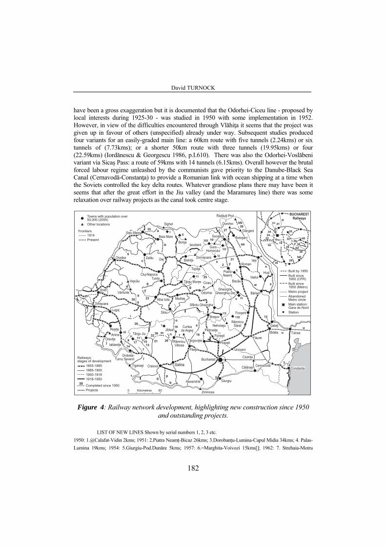
David TURNOCK
have been a gross exaggeration but it is documented that the Odorhei-Ciceu line - proposed by local interests during 1925-30 - was studied in 1950 with some implementation in 1952. However, in view of the difficulties encountered through Vlăhiţa it seems that the project was given up in favour of others (unspecified) already under way. Subsequent studies produced four variants for an easily-graded main line: a 60km route with five tunnels (2.24kms) or six tunnels of (7.73kms); or a shorter 50km route with three tunnels (19.95kms) or four (22.59kms) (Iordănescu & Georgescu 1986, p.I.610). There was also the Odorhei-Voslăbeni variant via Sicaş Pass: a route of 59kms with 14 tunnels (6.15kms). Overall however the brutal forced labour regime unleashed by the communists gave priority to the Danube-Black Sea Canal (Cernavodă-Constanţa) to provide a Romanian link with ocean shipping at a time when the Soviets controlled the key delta routes. Whatever grandiose plans there may have been it seems that after the great effort in the Jiu valley (and the Maramureş line) there was some relaxation over railway projects as the canal took centre stage.
�#�#2#��#�#2#�
�-��"�����"�-��"�����"
�#�#2#��#�#2#�
7� �(�7� �(�����"����"
)�#�$!"�)�#�$!"�
��$"�#!�"���$"�#!�"�����"$����"$�-$&���$!-$&���$!
��%�� �"���%�� �"�88
�����"������"�
���� �!����� �!�
�
�
��
�
�
�
����
���
��
�
�� ��
����
��
��
�� ��
�� ���
��
�
�
����
���� �
�
��
�
� �
�
��
�
�
�
!!
"
#
$
$
%&
��
�
���
��
���
��
�����
�
��
��
�
����
��
����
��
����
��
���
��
�
��
����
��
��
��
��
��
�
�
����
�# !"� "�
��#�$!"�
��$"�#!�"�
��#%$"����� �&�$�$��
����!#���
2$#��2$ 2$#��2����$9
������#�����
�7 �$ �
�-��"�����"
8�$� ��#-�
���($�
���"�8
������)���$�
���� �"�8
8������!�
��� �($�
��(2��$!"
,�'�($ ���"$!"�8
�7��#��!"$88
)�#�$!"�8
8���"$�-$&���$!8:�%�$�
7� �(��7�($�
�$2#��!�87� �(�����"
)#(!� �8
�7���-
��!�����!�8
��!�8
8
�#�#2#�
�#"#!� �8��($���
��(#%$ ��#�!�8
��!"��"�8�#� �!#���8
���"� ����"� ����"� �����#������ �!�8
�7���&:��
��%�� �"�8
�����"�8� � �
$!�"�8 8
���#9
8
���-
��!(��8
�7�/����$
���-$� ����� �$9
���9����#(����-�
��%�&�����
��%��
�$-��!8
�#���"�8
����&���$��"�&���$
��($��7���&���$!8
�-#�2$�
���"���$��"8
��(��
#��
�/7 "�& 2$#��2$
���!#�8
���2$"
��������$;� -���
'()*+,-./, ��# %�
��� &!"�"�# < ���&-$&�#�-
=>44�=>>4
���*�+!<!"��$!&#/&-$�$�#��$ "
=>>4�=?33=?33�=?=>=?=>�=?43
�#���$"$-&!� ($&=?43
�#* !&*�"2&�#����"�# &#�$�43�333&.@3331�"2$�&�#(�"�# !
5��#�$"�$!3 >3
������
)�# "�$�!=?=A��$!$ "
��#9$("!
����"&%+&=?43����"&!� ($=?43&.�)1
�$"�#&��#9$("�%� -# $-�$"�#&(��(�$
����"&!� ($=?43&.�$"�#1
�"�"�#
���
Figure 4: Railway network development, highlighting new construction since 1950 and outstanding projects.
LIST OF NEW LINES Shown by serial numbers 1, 2, 3 etc.
1950: 1.@Calafat-Vidin 2kms; 1951: 2.Piatra Neamţ-Bicaz 26kms; 3.Dorobanţu-Lumina-Capul Midia 34kms; 4. Palas-Lumina 19kms; 1954: 5.Giurgiu-Pod.Dunăre 5kms; 1957: 6.=Marghita-Voivozi 15kms[]; 1962: 7. Strehaia-Motru
182

The Romanian Carpathians under communism: the changing significance of a mountain region
31kms; 1963: 8.Deva-Stoeneşti 14kms; 9.Brad-Dealul Fetii 7kms; 1964: 10.Suceava-Păltinoasa 42kms; 11. Târgu Jiu-Rovinari 15kms; 1966: 12.Barboşi-Smârdan 8kms; 1967: 13.Rovinari-Turceni-Filiaşi 62kms; 1968: 14.*Gura Văii-Orşova 23kms; 1971: 15.=Amaradia-Bârseşti 10kms[]; 1977: 16.=Câmpulung-Argeşel 14kms; 1978: 17.Turceni-Dragoteşti 28kms; 1979 18.+Semănătoarea-Eroilor-Tîmpuri Noi 9kms; 1981: 19.*Cozia-Lotru 8kms; 20.+Tîmpuri Noi-Dristor-Republica 10kms; 1983: 21.Târgu Cărbuneşti-Albeni 9kms; 22 +Eroilor-Industriilor 7kms; 1984: 23. #Alba Iulia-Zlatna 42kms; 24.+Semănătoarea-Crângaşi 1km; 1985: 25.=#Voşlăbeni-Chileni 15kms; 1986: 26.Băbeni-Alunu 44kms; 27. Dorneşti-Siret 16kms; 28.+Lupeni-Bărbăteni 5kms[]; 29. +IMGB-Piaţa Uniri 10kms; 1987: 30.Dealul Fetii-Stoeneşti 15kms; 31.Paşcani-Târgu Neamţ 31kms; 32.Albeni-Calnic 5kms[]; 33.#Satu Mare-Bixad 51kms; 34.+Crangasi-Gara de Nord 2kms; 35.+Piata Unirii-Pipera 9kms; 1989: 36.Calnic-Seciuri 5kms[]; 37.+Gara de Nord-Dristor 8kms; By 1990: 38.=Jihlava-Dărăşti-Ilfov 8kms; 1991: 39.Dângeni-Săveni 16kms; 40+Republica-Antilopa 1km; 2000: 41.+Gara de Nord-I Mai 4kms<>@ train ferry; # narrow gauge conversion; + Bucharest metro; = freight only; * diversion; [] estimate; <> extension to Laromet expected
NEW/EXTENDED FORESTRY SYSTEMS Shown by Roman numbers I, II, III etc. I Ocna Şugatag; II Vişeu de Sus; III Teregova; IV; Tismana [a] V Vâlcea [b] VI Câmpu Cetăţii; VII Întorsura Buzăului [c] VIII Vrancea; IX Oneşti-Râşca; X Roznov [d]; X1 Bistriţa and Pipirig [d]; XII Fălticeni [e]; XIII Moldoviţa [a] partly replacing the Apa Neagră-Turnu Severin narrow gauge railway [b] Bistriţa, Lotru and other systems: see case study. [c] developed from the CFR narrow gauge line transferred to forestry ownership in 1951 [d] built by the Soviet-Romanian joint timber company Sovromlemn [e] incorporating the isolated Găineşti system
OUTSDTANDING PROJECTS shown by letters a, b, c etc. a.Bixad-Sarasău (i); b.Gâlgău-Târgu Lăpuş-Baia Sprie (iii); c.Stana-Zalău (iii); d.Vaşcău-Vârfurile (i/ii); e.Turda-Abrud (ii); f.#Abrud-Zlatna (ii); g.Sighişoara-Târgu Mureş (ii); h.Odorhei-Ciceu (ii); i.*Bouţari-Sarmizegetusa (ii); j.Răcăjdia-Moldova Nouă (ii); k.Băile Herculane-Balota (ii); l.Stehaia-Ostrovu Mare (Iron Gates II) (ii); m.Alunu-Seciuri (ii); n.Popeşti-Horezu (ii); o.*Lotru-Avrig (ii); p.Leu-Bechet (ii); q.Portăreşti-Bechet-Corabia (ii); r.Vâlcele-Râmnicu Vâlcea (ii); s.Zărneşti-Câmpulung (ii); t.Întorsura Buzăului-Nehoiaşu (i/ii); u.Brăila-Tulcea-Sulina (ii); v.Breţcu-Oneşti (i); w. Bacău-Bârlad (i); x.Iaşi-Huşi-Galaţi (i); y.Piatra Neamţ-Târgu Neamt-Fălticeni-Suceava (i); z..Topliţa-Târgu Neamţ (i/ii); aa. Hârlau-Botoşani (i); bb. Săveni-Darabani (i) cc.+I Mai-Laromet (iii); dd.+Grigorescu-Linia de Centura (iii); ee.+Universitatea-Ghencea (iii); ff.+Gara de Nord-Otopeni (iii) Sources (i) Groza & Muntele (1998); (ii) Iordanescu and Georgescu (1986); (iii) Metrorex and others.
The 1950s saw only a short branch to the lignite workings of Voivozi northeast of
Oradea in 1957. But in 1964 a more notable achievement was the direct line of 42kms between Iţcani (Suceava) and Păltinoasa (1964) to replace the earlier route of the same length through Cacica that involved sharp curves and a difficult bank at Strigoaia. The old route was acceptable in the context of the original ‘Bukowiner Lokalbahn’ of 1888 (branching from the Suceava-Cernăuţi main line at Dărmăneşti) but was not appropriate for the Cluj-Iaşi inter-city created by the extension from Vatra Dornei to Ilva Mică in northern Transylvania in 1938. Construction started during 1951-5 but was interrupted for financial considerations and resumed 1959-64. There was a single tunnel (Lucăceşti: 426m, finished in 1961) and six viaducts with a total length of 0.69km. More ambitious construction became necessary in connection with hydropower and navigation schemes, most notably at the Iron Gates where a 24km Coramnic-Valea Cladovei diversion was required between Drobeta-Turnu Severin and Topleţ), with ten tunnels (combined length of 1.60kms) and 21 viaducts (1.85kms), in response
183

David TURNOCK
to the hydropower scheme. After studies identifying the site (1957-60) and compiling detailed plans (1960-3), construction of a new single-track railway at a higher level through Iron Gates I began in 1964 and was ready in 1968, in good time for the completion of the hydro scheme in 1971 (whereupon the original line through the gorge was flooded). Modifications were also required as a result of the Olt valley hydropower complex over a lengthy period extending from 1977 to 1988, particularly between Călimăneşti and Lotru. With the additional complication of double track, a substantial amount of tunnelling was required at Cârligu, Cozia, Lotrioara and Turnu where a total of 10 single-bore tunnels extended cumulatively over 7.34kms.
Another project was launched in Transylvania to finish the Brad-Deva line which had been started in 1939 as part of a strategic link between Oradea and Craiova and it retained its importance after the loss of northern Transylvania to Hungary in 1940. Construction advanced across the Mureş at Mintia, where a bridge of 301m was required, but the viaduct needed at Stoeneşti was not built and the line was eventually opened for the transport of limestone from Crăciuneşti in 1963. At the Brad end, Luncoiu viduct (217m) was built so the railway could access the Dl.Feţii mine, while the Hagău and Valea Arinilor viaducts were left incomplete. These outstanding works were now made ready in 1987, along with tunnelling at Valişoara/Ormindea (0.29kms during 1979-82 on top of the two other others – 0.57kms – already built). But apart from completing ‘unfinished business’, it is difficult to see what this project achieved since traffic was always light and since 1989 even the modest passenger service (which provided a token ‘accelerat’ service through Brad to Arad) has disappeared. It is possible that a link with Oradea (via Vârfuri-Vaşcău) was intended to follow on and that the aberration of a ‘road to rail’ policy was also driving the project. Meanwhile, a railway to Moldova Nouă had already been discussed, first in the context of a Hungarian project just before 1914 for the Nera valley to connect Iablaniţa near Orşova with the Timişoara-Baziaş line. After World War Two the mining and metallurgical company operating in the Anina-Reşiţa area (UDR) envisaged a dam on the Nera at Sasca and a branch railway from Răcăjdia near Oraviţa to Moldova Nouă was studied (with summit tunnel of 3.0kms on the route to Pojejena). However this was abandoned in preference to rehabilitation of the Turnu Severin-Orşova line (Iordănescu & Georgescu pp.I.609-10) presumably before the agenda moved further ahead with realignment for the hydropower scheme.
Meanwhile electrification was a massive achievement. This was considered in the 1930s and when steam traction struggled to cope with wartime intensification of traffic (even with the provision of a second track in 1940) a CFR Electrification Department was set up in 1942 under the engineer D.Leonida. But no works were implemented, although after planning resumed in 1947 there was a reference to rauilways in the 1950 electrification plan. A commission in 1951 decided on Bucharest-Braşov section; with with blessing of Transoectroproekt (USSR) in 1953 and the 25kW/50Hz system (for European integration) was chosen in 1959 after an IPCF (Rail Project Institute) study in 1958 and several international congresses during the decade. Under Romania’s ‘new course’ after Stalin’s death in 1952, dieselisation was initially preferred, but electrification was considered more feasible by 1959 given the development of the national grid and, inevitably, the help from Russian specialists as was normal at the time. The first pillar to support the catenary was installed at the very end of 1960 and the Brasov-Predeal section was finished in 1963 althoiugh it was not commissioned until 1965; then Câmpina was reached in 1966 and Bucharest in 1967 (170kms). Subsequent development involved several Carpathian lines beginning with Reşiţa-Turnu Severin by 1971 (including the entirely new alignment in the Iron Gates already referred to); Filiaşi-Deva via
184

The Romanian Carpathians under communism: the changing significance of a mountain region
the Jiu valley (1973); and Braşov-Ciceu-Dej as well as Ciceu-Adjud by 1978: mostly single-track lines where conversion increased capacity and postponed the need for widening. However by the 1980s, when the widening of more main lines was becoming a priority, the impossibility of increasing capacity at Iron Gates (due to flooding) was raising the possibly of a second track using a mountain route to the north. Even the widened line at Predeal was approaching full capacity and this raised the possibility of the Curtea de Argeş-Râmnicu Vâlcea line as an alternative. It had first been considered in 1890s and further endorsed by a series of inter-war railway development plans by R.Băiulescu, A.Cottescu, N.Petculescu and M.Tudoran in which this project vied for priority with the Ilva Mică-Vatra Dornei line of 1938 and the Bumbeşti-Livezeni line of 1948. It was seen as the best solution to the Predeal bottleneck since the summit level would be much lower and the distance from Bucharest to most parts of Transylvania and the northwest would be reduced. On the other hand impplemetation had always been resisted because the cost would be greater than incremental improvements to the Predeal line through dieselisation, widening and electrification. Studies were carried out in 1931-2, 1942, 1948-9 and 1957 before a new study in 1975 favoured the route from Vâlcele (22kms northwest of Piteşti) to Bujoreni Vâlcea offering a shorter distance from Piteşti to Râmnicu Vâlcea compared with Curtea de Argeş (62kms compared with 73kms) but with 40kms of new construction instead of 35kms. And it is also significant that the construction of new railways between Râmnicu Vâlcea and Târgu Jiu to serve new lignite mines raised the possibility of a more direct link between Bucharest and Târgu Jiu (288kms instead of 359 via Craiova) – as well as Petroşani (339kms instead of 410).
The chosen route required two tunnels (4.20kms, built during 1987-90) and 10 viaducts as well as the Argeş and Olt bridges (3.25kms). The line was nearly finished when the revolution occurred and a train service was actually included in the 1989-90 timetable. But the line was never opened and the project was immediately abandoned in 1990 However, despite the subsequent reduction in rail traffic, the degraded works could be saved to provide a freight route that might be needed if the Predeal route is reserved for high-speed train in the future. Meanwhile short extensions were made for industrial purposes at Câmpulung (1977) and Lupeni (1986) and, more significantly, attempts were made during the final communist decade to switch traffic from the roads to the electrified railways (supported by increased electricity generation that now included a nuclear project). Railway services to small towns improved through conversions from narrow to standard gauge: Alba Iulia-Zlatna in 1984 and Satu Mare-Bixad in 1987 (also Voşlăbeni-Chileni in 1985, although this was a mineral line); while it was intended that the Băbeni-Alunu mineral line would throw off a branch from Popeşti to Horezu with an extension to the Bistriţa limestone quarry. But most progress was made in Moldavia where one of several new branches impinged on the Carpathians through the Paşcani-Târgu Neamţ line of 31kms (1987): proposed in 1891 and started on three previous occasions (1900, 1914 and 1962 – the latter following a new study in 1961) with the transport of ballast from Timişeşti to Holboca power station near Iaşi a significant factor. This line had also been envisaged as part of a through route across Romania (via Oradea-Cluj-Topliţa-Iaşi; with electrification linked with the hydropower of the Bistriţa valley) conceived in the 1930s to improve the link between Central Europe and the Middle East. However this grandiose project failed to materialise, while the national interest in a new railway across the Eastern Carpathians was amply served by the lIlva Mică-Vatra Dornei line finished in 1938. Overall the communist achievements were substantial but far short of what some visionaries had advocated so that Groza & Muntele (1998) were still able to deplore the lack of connectivity on the rail system arising from a series of ‘missing links’ of which six (Bixad-Sarasău; Vaşcău-Vârfurile;
185
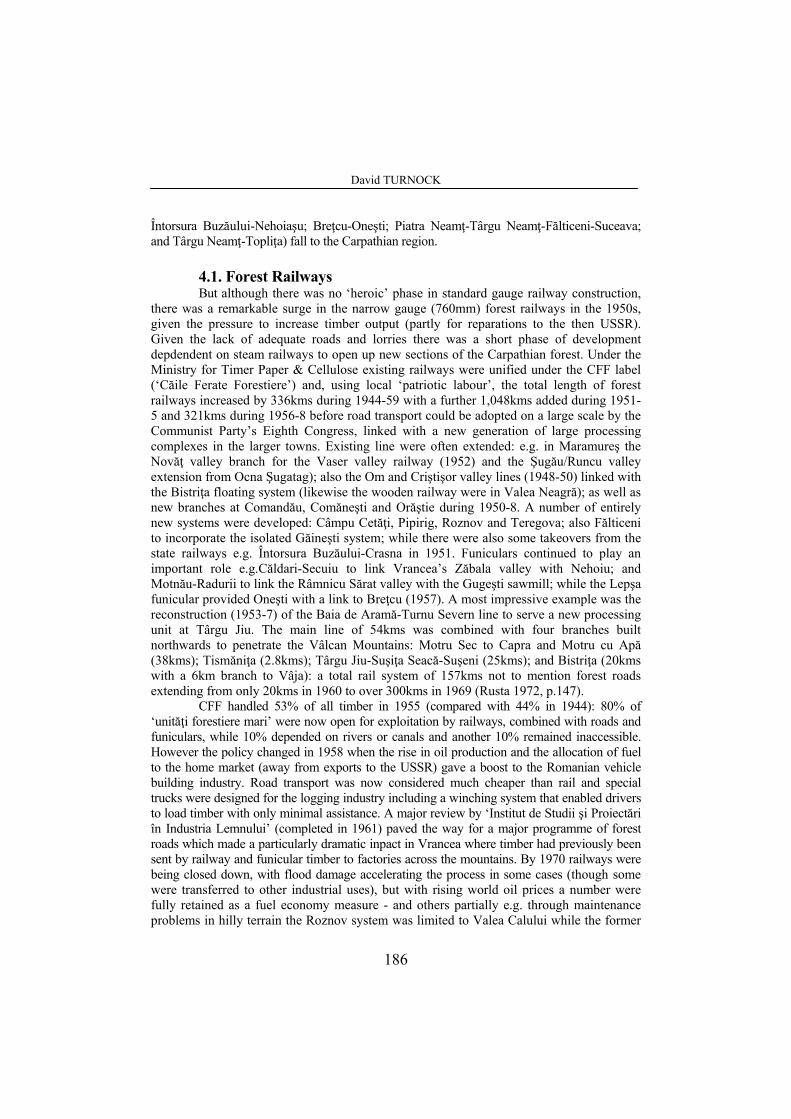
David TURNOCK
Întorsura Buzăului-Nehoiaşu; Breţcu-Oneşti; Piatra Neamţ-Târgu Neamţ-Fălticeni-Suceava; and Târgu Neamţ-Topliţa) fall to the Carpathian region. 4.1. Forest Railways
But although there was no ‘heroic’ phase in standard gauge railway construction, there was a remarkable surge in the narrow gauge (760mm) forest railways in the 1950s, given the pressure to increase timber output (partly for reparations to the then USSR). Given the lack of adequate roads and lorries there was a short phase of development depdendent on steam railways to open up new sections of the Carpathian forest. Under the Ministry for Timer Paper & Cellulose existing railways were unified under the CFF label (‘Căile Ferate Forestiere’) and, using local ‘patriotic labour’, the total length of forest railways increased by 336kms during 1944-59 with a further 1,048kms added during 1951-5 and 321kms during 1956-8 before road transport could be adopted on a large scale by the Communist Party’s Eighth Congress, linked with a new generation of large processing complexes in the larger towns. Existing line were often extended: e.g. in Maramureş the Novăţ valley branch for the Vaser valley railway (1952) and the Şugău/Runcu valley extension from Ocna Şugatag); also the Om and Criştişor valley lines (1948-50) linked with the Bistriţa floating system (likewise the wooden railway were in Valea Neagră); as well as new branches at Comandău, Comăneşti and Orăştie during 1950-8. A number of entirely new systems were developed: Câmpu Cetăţi, Pipirig, Roznov and Teregova; also Fălticeni to incorporate the isolated Găineşti system; while there were also some takeovers from the state railways e.g. Întorsura Buzăului-Crasna in 1951. Funiculars continued to play an important role e.g.Căldari-Secuiu to link Vrancea’s Zăbala valley with Nehoiu; and Motnău-Radurii to link the Râmnicu Sărat valley with the Gugeşti sawmill; while the Lepşa funicular provided Oneşti with a link to Breţcu (1957). A most impressive example was the reconstruction (1953-7) of the Baia de Aramă-Turnu Severn line to serve a new processing unit at Târgu Jiu. The main line of 54kms was combined with four branches built northwards to penetrate the Vâlcan Mountains: Motru Sec to Capra and Motru cu Apă (38kms); Tismăniţa (2.8kms); Târgu Jiu-Suşiţa Seacă-Suşeni (25kms); and Bistriţa (20kms with a 6km branch to Vâja): a total rail system of 157kms not to mention forest roads extending from only 20kms in 1960 to over 300kms in 1969 (Rusta 1972, p.147).
CFF handled 53% of all timber in 1955 (compared with 44% in 1944): 80% of ‘unităţi forestiere mari’ were now open for exploitation by railways, combined with roads and funiculars, while 10% depended on rivers or canals and another 10% remained inaccessible. However the policy changed in 1958 when the rise in oil production and the allocation of fuel to the home market (away from exports to the USSR) gave a boost to the Romanian vehicle building industry. Road transport was now considered much cheaper than rail and special trucks were designed for the logging industry including a winching system that enabled drivers to load timber with only minimal assistance. A major review by ‘Institut de Studii şi Proiectări în Industria Lemnului’ (completed in 1961) paved the way for a major programme of forest roads which made a particularly dramatic inpact in Vrancea where timber had previously been sent by railway and funicular timber to factories across the mountains. By 1970 railways were being closed down, with flood damage accelerating the process in some cases (though some were transferred to other industrial uses), but with rising world oil prices a number were fully retained as a fuel economy measure - and others partially e.g. through maintenance problems in hilly terrain the Roznov system was limited to Valea Calului while the former
186

The Romanian Carpathians under communism: the changing significance of a mountain region
link with Tazlău via Borleşti was closed; resulting in localised railway working at Tazlău linked with road transport (likewise the Caşin system at Scutaru and the Fălticeni system at Râşca). On this basis, steam (wood-burning) traction surviving until the end of communism on nearly twenty separate systems. There were even some extensions made in the 1980s at Moldoviţa and Râşca; while the Caransebeş-based loggig and transport company (IFET) planned new lines at Voislova and Zăvoi.
The Valcea Carpathians provide an interesting mix of examples (Figure 5). Short railways were already in existence in the tributary valleys of the Lotru before the floating system employed on the main river to reach the Brezoi sawmill was replaced by continuous line during 1948-54, with a number of funiculars to open up remote parts of the catchment (it should be noted however that the isolated lines in the Călineşti and Uria valleys did not operate after 1945). In the case of the Căpătânii mountains the existing funicular from the Lotru valley above Brezoi was complemented by a 4.0km railway along the Căprăreasa headwater of he Cheia. Then the railway from Băbeni through the Bistriţa gorges (developed friom 1935) was extended in the 1950s to the adjacent Prislop valley which was too steep above Pietreni – with an average gradient of 1 in 17.6 over three kilometres for the planned railway to be built from Costeşti. The solution was a separate 750mm line running for six kilometres along this valley to connect with the Bistriţa by a funicular to Între Răuri. By 1970 forest roads had put all these systems out of business although the railway below Arnota is retained for the transport of limestone to the chemical factory at Govora (with the intention during the 1980s of a standard gauge connection as part of a branch from the Băbeni-Alunu mineral line to serve Horezu). The forest roads also overtook the plan of the 1950s to use the Bistriţa valley line as a means of opening the adjacent Prislop valley to the east and the Horezu, Luncavăţ, Cerna and Olteţ valleys to the west: only the line to the Luncavăţ valley (extending north of Vaideeni) was ever built.
The railway engineers were also exercised by the Cozia massif east of the Olt. Steep valley profiles prevented construction directly from the river, so a start was made as Stoeneşti in ther Sălătruc, following the Brădisor through Dângeşti village to the east of Cozia mountain; crossing the watershed into the Băiaşu catchment at the 738m Greşilor Saddle to access the forest below; which meant that loaded wagons had to be hauled uphill from the north four at a time for full trains to be marshalled at the summit (although Casian sawmill helped by processing some of the timber close to the source). However even more complex was arrangement for crossing a lower but steeper watershed at 700m between the upper Brădisor (Valea Mică) and the parallel Rădoaia stream where a zig-zag layout was conceived by CFF chief engineer Nicolae Armăsescu, requiring the locomotive to reverse four times. Another interesting arrangement involved the railway from the Olt at Cornet through the Ţiteşti valley to connect with a funicular originating in the forests of the upper Topolog valley and crossing the Zănoaga mountain ridge (though the funicular was later extended to the Olt after the railway was damaged by fire). Road building brought an end to all these systems by 1970 and the fact that none survived into the later communist years is an indication of the difficulties of operation and maintenance. The roads themselvers were works of art, even in the main valleys like the Prislop north of Pietreni which had defied the railway builders. Figure 5 shows the winding road towards the Buila ridge while a tunnel was necessary under Stogu mountain to reach the uppermost section of Cheia (Turnock 2005, pp.42-3).
187
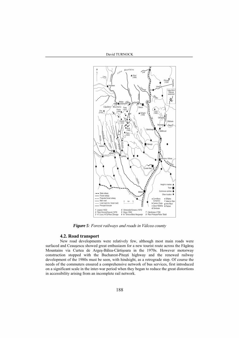
David TURNOCK
.��#9$("$-1
� �*���!!!��������
7� �(�&�7�($�
������
��$'#�
����+
&����+
*�����+
,�����
������+
-�����
�.��
/������+
/���
/��
�����
+
���
-����
�����
��������
++
��������+
&��
�������+ +
+ ���
� �#��$0122%
�&���$3034% �
-����$0254%
��������$0133%
�
6���$0147%
� ���$0142%
�-���$0849%
�����$0881%
�(���$0554%
��*�������$05:2%
������ $!"�+
��� $!"�+
�( $�$&����
��%$ �
�#�$'�
�#� $�!�
������
��-$$ �
�#!"$!"�+
�"#$ $!"�+
�7 �$!"�+
�����
��
�
�
�
����
�
��
�
���
�
����"��($�
������
���
������
�� ����
�
���
��� ���!$0133%-����!�����;(������!$0272%�'�!���!$0479%;-����!(���
���
�*�������;�������!$0175%�����!$0424%��!�*�������; ����!��������+
�
� ����!$0722%-����!-����� ��;-���!���
�
�� �� �
���� � � � �
+
�
���
����
+
+
�����"����#��� �(��� "# &�2$������&��-�����7 -#���
����!"$����$�&���&�"� � "�$&7�����$"�$ �
�"�"$&����*�+)#�$!"&����*�+��#9$("$-&/#�$!"&����*�+��� &�#�-�#(��&�#�-&.� (B&/#�$!"&�#�-1��� (����&/� �(����
�#*
�#��� $&($ "�$!
�"2$�&�#(�"�#
�$��2"&� &�$"�$!
�
3 46�
���$�&��(���-#���*�"$�!2$-
Figure 5: Forest railways and roads in Vâlcea county
4.2. Road transport New road developments were relatively few, although most main roads were
surfaced and Ceauşescu showed great enthusiasm for a new tourist route across the Făgăraş Mountains via Curtea de Argeş-Bâlea-Cârtişoara in the 1970s. However motorway construction stopped with the Bucharest-Piteşti highway and the renewed railway development of the 1980s must be seen, with hindsight, as a retrograde step. Of course the needs of the commuters ensured a comprehensive network of bus services, first introduced on a significant scale in the inter-war period when they began to reduce the great distortions in accessibility arising from an incomplete rail network.
188

The Romanian Carpathians under communism: the changing significance of a mountain region
Table 5. Speciman bus and rail services in the Carpathians 1972-1973
Section and Route Kms A Journey Time Average Speed km/h
EASTERN (North) *Baia Mare-Sighetul Marmaţiei 66 3 2.30 26.4 *Bistriţa-Vatra Dornei 85 2 3.13 26.4 +Câmpulung Mold.-Ilva Mică 112 4 4.48-2.44 23.3-41.0 *Câmpulung Mold.-Izvoarele Sucevei 53 2 2.10 24.4 *Câmpulung Mold.-Rădăuţi 64 1 2.36 24.6 *Dej-Târgu Lapuş 45 2 2.00 22.5 *Groşi Ţibleş-Năsăud 126 1 6.00 21.0 *Poiana Stampei-Prundul Bârgăului 42 2 1.48 23.3 *Negreşti Oaş-Sighetul Marmaţiei 56 3 1.45 32.0 +Salva-Vişeu de Jos 61 5 2.07-1.23 28.8-44.2 *Vatra Dornei-Vişeu de Sus 112 1 4.30 24.9 EASTERN (South) +Beclean-Miercurea Ciuc-Braşov 300 3 7.33-5.32 39.7-54.2 *Bicaz-Gheorgheni 63 1 1.55 32.8 *Bicaz-Vatra Dornei 134 2 5.05 26.4 *Breţcu-Gh.Gheorghiu-Dej 52 4 1.34 33.1 *Piatra Neamţ-Comăneşti 92 3 2.54 31.7 +Ciuc-Comăneşti 76 4 1.49-2.58 41.7-25.6 *Gheorgheni-Sovata 70 2 2.39 26.4 *Miercuea Ciuc-Sovata 103 5 3.20 30.9 *Miercurea Ciuc-Târgu Secuiesc# 70 1 3.00 23.3 *Piatra Neamţ-Suceava 105 1 3.30 30.0 *Piatra Neamţ-Topliţa 148 1 4.49 30.7 *Topliţa-Paşcani 159 1 5.39 28.1 *Topliţa-Vatra Dornei 165 1 6.23 25.9 CURVATURE/SOUTH +Braşov-Câmpina 74 4 1.46-1.20 41.8-55.6 *Braşov-Câmpulung 85 6 3.12 26.6 *Întorsura Buzăului-Nehoiu 42 3 2.21 17.9 *Pietrosiţa-Sinaia 28 3 1.09 24.3 +Podul Olt-Râmnicu Vâlcea 77 7 3.22-1.32 22.8-50.3 +Simeria-Târgu Jiu 131 3 5.09-3.18 25.4-39.7 BANAT/WESTERN *Abrud-Brad 41 2 1.58 20.8 *Abrud-Zlatna 30 2 1.31 19.7 +Abrud-Turda narrow gauge 94 3 5.21 17.6 *Băile Herculane-Oraviţa 112 1 4.56 22.7 *Băile Herculane-Reşiţa via Anina 130 2 3.50 33.9 +Bucova-Zăicani rack railway 36 2 3.18 10.9 *Câmpeni-Alba Iulia 78 1 3.20 23.4 *Câmpeni-Stei (Petru Groza) 82 3 3.54 21.0 +Caransebeş-Drobeta-Turnu Severin 112 7 5.02-3.31 22.3-31.8 +Cluj Napoca-Oradea 153 7 5.01-2.10 30.6-70.8 *Deva-Stei(Petru Groza) 107 2 3.14-2.48 33.1-38.2
A Distance (kms); B Time (hrs/mins) for stopping services (and express/limited stop where available); C Average speed (km/h). #via Caşinu Nou (3h.02 for the 75km route via Balvanyos) * bus; + rail Source: Mersul Autobuzelor and Mersul Trenurilor de Călători 1972-3
189

David TURNOCK
However, journies were very slow, especially on unmodernised roads since almost all were seen as essentially local services without the inter-city dimension common on the railways through faster trains on which supplements were payable. The fastest ordinary bus services did not exceed 34km/h (but 38.2 for the limited stop service between Deva and Petru Groza) while very few fall below 20 with variations reflecting road conditions and the frequency of stops (Table 5). Average speeds of 30-40km/h were also recorded for some very long limited stop services involving Carpathian sections like the 9h.50 journey over 360kms from Arad to Sighetul Marmaţiei (36.6km/h) or the journeys from Bucharest to Carpathian resorts like Voineasa (270kms in 7h.37: 35.4km/h) or Peştera Muierii (255kms in 6h.51: 37.2km/h). The railways are not always better with the slowest journey of all being 10.9km/h for Bucova-Zăicani rack section (through the Iron Gate Pass) of the Caransebeş-Subcetate cross-country line (followed by 17.6km/h for the Turda-Abrud narrow gauge line along the Aries valley taking 5h.21m for 94 kms). The steeply-graded heavily-loaded main line between Caransebeş and Drobeta-Turnu Severin managed only 22.3km/h for stopping trains and 31.8 for expresses; though other routes scored in excess of 40 or 50km/h while the non-stop Balt-Orient Express averaged 70.8km/h for the 153kms between Cluj and Oradea. There can also be little doubt as to the relative deterioration in roads and road services during the 1980s which has still not been adequately addressed under the present transition. Moreover fuel shortages meant that bus services were regularly cancelled while few new vehicles were brought into service.
5. ELECTRICITY
Meanwhile heavy investment was made in electricity generation and distribution. It had been a much vaunted priority for the Soviets but also prominent in inter-war Romania where the consumption of electricity in Bucharest alone increased 6.6 times from 31.65mln.Kwh in 1926 to 206.04 in 1941. Under communism development accelerated with an inelastic oil supply (already under strain through reparation obligations) diverting attention to lower grade fuels as well as the vast hydropower potential; previously left largely untouched given the massive scale of development required in relation to current demand (for which there was an adequate supply of oil residue during the inter-war years). A complementary issue was the distribution system: while the cities could build their thermal power stations (and/or develop hydropower from the nearest available source) there was scope for greater overall efficiency in distributing power over wider areas based on the most attractive generating sites, following the German and Soviet examples. An incipient regionalisation was already evident in Muntenia through power lines to Bucharest from Dobreşti (hydropower) and Schitu Goleşti (thermal power from lignite); also central and northwestern Transylvania based on supplies to Sibiu and Cluj respectively; and Banat where there were expanding systems around Reşiţa and Timişoara especially. Elsewhere there were relatively small scattered isolated power stations with little integration. Following the proposals of D.Leonida in 1941, ‘Plan General de Electrificarea României’ in 1945 balanced the relatively straightforwardv expansion of thermal power (based on the Transylvanian natural gas) with major hydropower schemes on the Bistriţa at Bicaz and the Danube at the Iron Gates - as ‘supercentrale-pivoţi’ - with distribution by means of a 220Kv line from Mediaş to Bucharest via Braşov complemented by a circuit to connect the two hydro projects both along the Carpathian edge (via Bucharest) and through
190
The Romanian Carpathians under communism: the changing significance of a mountain region
Transylvania; with branches extending to the other parts of the country: previously proposed by the electrical engineer D.A.Pastia in 1936 with reference to such places as Arad, Baia Mare, Constanţa, Galaţi, Oradea and Reşiţa (as well as Cernăuţi and Chişinău which were then within Romania).
A more prescriptive ten year electrification plan followed in 1950 seeking rational use of energy resources including a major role for hydropower. 603 stations had a combined capacity of 740MW (1.23MW per station on average) of which only 600MW were in use; but the 1960 target was 2,600MW (1,665 thermal, through new stations, extensions and industrial plants) and 835 hydro through 24 large stations and a number of smaller units. The main target was the Bicaz project (210MW) along with projects on the Argeş, Ialomiţa, Lotru, Moldova and Râul Mare: various other rivers were mentioned but without specific projects. Interestingly the Iron Gates was ignored in view of the complex technical problems, not to mention the difficult state of relations with Yugoslavia (over Tito’s defiance of Stalin) which would soon result in the expulsion of all ‘unreliable’ elements from the border strip from Vama Veche to Turnu Severin. However the selected projects offered inspiration to Moldavia and Oltenia (as relatively undeveloped regions) with Bicaz as the clear priority to which technical and forced labour resources were immediately directed. Meanwhile, the Argeş and Râul Mare projects were relevant to the crucial growth areas of Bucharest and Hunedoara/Reşiţa. The project was quite unprecedented and included major electrotechnical projects (like the steam turbine plant at Reşiţa started in 1951) and increased copper output from Baia Mare where the new smelter has already been noted. Detailed implementation of the plan is not well documented but not surprisingly it fell behind schedule, as might well have been anticipated under the ‘new course’ that followed Stalin’s death. In 1960 total capacity was 1,779MW which was 68.4% of plan target (but 59.0|% of the planned incremental capacity) with a sharp contrast between thermal capacity of 1,569MW (94.2%) and hydro capacity 210MW (only 25.1%). The hydro share certainly increased to 11.8% of total capacity compared with 8.1% in 1950 but fell well below the 32.1% planned; with just a fifth of the planned additional capacity realised compared with 91.4% for thermal power. Clearly the hydropower programme was wildly over-optimistic, although the Bicaz project was half-complete in 1960 with 110MW of capacity available in that year and was certainly a great achievement given its complexity. There were also smaller projects at Aştileu near Oradea, Crăinicel (Reşiţa). Moroeni (on the upper Ialomiţa) and Sadu/Gura Râului near Sibiu: 45.7MW in all (Pop 1996).
Progress with the larger schemes followed in sequence: Argeş, Lotru/Sebeş and
Râul Mare while a new relationship with Yugoslavia allowed the Iron Gates project to proceed in the late 1960s with completion in 1971 (Figure 6).
191

David TURNOCK
�����
�����
888
888
888
888
888
888888
�������,���
���
888 888��� �������������
888
��($���
��(��
��'��
7� �(��7�($�
�7���&:��
����!#���
���-
���-$�
�����
���9����#(�
��%�&�����
��%��
�-#�2$���$(��$!(
��!"��"�
�������$
��$�(��$����(
�$��
���"��&�$��"
��#%$"����� �&�$�$��
-���!&�����
������"����
/��
*��!���)�����
��#��
��#��
����)�����)�����
*���
$!�"�
�����
<���
����)��
6����
�����)����
����!����
������
���!#�
�#��%�"�
888
�����; ����
��;���
���
���
�����
=��
��� ���
���
���
���
888
���
888
���
888
888
888
���
888888
888888
888
��#�� 7�($���������!(�#���$"�$!"�
�
888888888
888����� ����!$���� �"��#�$! ����
��
888888
888888
888
888
888888
888
888
888
888
888
888
888888
888
888888888
888"����
888 ������
888����;��<���
�
888������
�����888
����,������
�C� �,�����
�����
�,� ���������,
����� ����,
888
�������
�����
���,��
���������� ����
���
�� ������,��������
����,��������
��� ������
�����
�,��,
���:�
)� ������
��D� ������
����
����������:
�,�
���
���
�,�����������
888
�����"2�� &'# $
�#� "�� !&��#�$�
��� &"#* !
��� &�#� "�� ��$�!
E&#/&"#"�������"2�� &��$�
�� /���&-�!"��%�"�# *�"2&���� �&� �$��"�# &"#&��"��
F; A; 4;
����$&2+-�#&!"�"�# !.�#!"�+&%���"&!� ($&=?A41
�G&(���(�"+=343
=33
433
@3
3 435��#�$"�$!
>B=E
=BHEAB@E �%#�$&��$���$
�#���$&#/&*�"$�� &�$��"�# &"#&��$�
�����&2+-�#&!"�"�# !.�#!"�+&%���"&��$�=?A41
�
8
�
8
8
88
�
��
�� ���� �
0 ���1��1�%���� ����1������������1�����
*��!���)�����
$"$'�"��#�"����!"�#���&��(0���$�7� $!"�&�0����(��!��#"$!"�&�0����"$����$�
�
/�� ��� ������� $!"����$!"�7� �(�&�7�($�
� �
�
����� ��� �$"���������-�!#�
�#%�$!"��#�#$ �
6���� �"�7�"#��
�$!��� "$ �$�$"�
����!�
����)�����)�����
�#"����!�� ���#(#"�!
�"$9���&.��(�'1�7 ����"���-������"��&�$��"#' #�&�0���� $!"��#!"�!�
�
�
�7�!� ����� �"����$!��%$!"��$�%��$ ����$�&��!�������"$�&-$&���$!
Figure 6: Carpathian hydropower projects. In the process seven separate energy systems (the four already mentioned plus
north Moldavia, south Moldavia/Dobrogea and Oltenia) were integrated by a national grid with a crucial trans-Carpathian link between Transylvania and Muntenia finished in 1954. Unification was claimed in 1959 with the 110Kv link from Ploieşti to Focşani at the southwestern edge of the Moldavian ‘island’, within which a crucial role was played not so much by the Bicaz hydropower plant (not yet finished) but by stations in the Trotuş valley burning brown coal at Comăneşti and natural gas (piped from Transylvania) at Borzeşti (initially 15MW enlarged to 125MW), with regional transmission lines to Galaţi, Iaşi and Suceava. Small outliers remained for a few more years (e.g. Baia Mare, Constanţa and Oradea connected by 1965) but the national pattern was established. The circuit concept of 1945 ceased to be the immediate priority (though it was eventually realised through piecemeal development) partly because the Iron Gates project was delayed and it was not until the 1970s that this project – supplemented by the lignite-based power stations in the Craiova/Târgu Jiu area – was sending power to Muntenia: hence the very high capacity link now existing between Craiova and Bucharest). Meanwhile the northern half of the circuit, powered by the new gas-based power stations in central Transylvania (with Sângeorgiu de Pădure, between Sighişoara and Târgu Mureş, the key project in the pre-integration era) the links with Deva, Petroşani and Reşiţa (1955) were certainly an early priority but a line to Muntenia line via Sibiu and Braşov was vitally important while connetion with Bicaz (geared very much to its regional market until the 1960s) was postponed. In the end the
192

The Romanian Carpathians under communism: the changing significance of a mountain region
most important trans-Carpathian emerged as a product of Comecon integration with western Ukraine occupying a strategic position from where a 400Kv line was built in the 1960s running south via Baia Mare, Luduş (the site of another gas-based power station in central Transylvania: 800MW in 1967), Vidraru on the Argeş and Slatina en route to Bulgaria.
The later years have not affected the position of the Carpathians greatly since the fuels of the mountain region are fully utilised and the key hydro sites have all been developed. However there is an important matter of scale, for Şandru (1975, p.107) claims that the communists discovered major cost savings by having very large generating units and this was apparently responsible for a new generation of stations built in the 1960s and 1970s, achieving a high level of technical efficiency, with a reduction in conventional fuel/1000Kwh from 723kg. in 1955 to 336 in 1972. Concentation on larger units can be seen on the edge of the Carpathians where lignite was worked in the areas of Doiceşti (north of Târgovişte) and Filipeştii de Pădure (northwest of Ploieşti), with the latter envisaged in the 1930s as the site of a power station to supply the projected Ploieşti-Braşov electrified railway. However this was not a priority in the 1950s when the communist government decided on a power station at Doiceşti beside the standard gauge railway and later increased capacity to 120MW with production from Palanga and other mines in the Filipeştii de Pădure area brought across by rail with the regauging of the local industrial system to provide direct access via Diţeşti and I.L.Caragiale on a newly-constructed link between Ploieşti and Târgovişte. Meanwhile, Jiu valley coal raises an interesting question because the large potential for production of low-grade coal for use in power stations might have suggested this area as a major generating complex, but lack of cooling water prevented this potential from realisation, beyond the stations already mentioned (among which Paroşeni was the largest). Instead coal was sent by rail southwards to Craiova - for a power station that supported a greatly-increased industrial establishment in what was the centre of the backward region of Oltenia - and subsequently northjwards to Mintia near Deva (with cooling water from the Mureş) where 840MW of capacity wss installed. Clearly the Petroşani basin, close to the source of the Jiu, could not experience expansion of the kind that occurred at Deva (and also Craiova, where enlargement to 980MW was based on the local lignite). Curiously however, while the Anina energy project (already mentioned) was expected to the support a 900MW power station – with the first 300MW unit operating briefly during 1989-90 before closure due to choking by ash – Ceauşescu insisted that wateer be pumped up from the valley to provide a cooling system on the dry limestone plateau: in this way the schist quarries, the new town of Anina and the power station would comprise an integrated unit of socialist construction. Buy evidently such self-indulgence was not an option in the early communiust years! However district heating function preluded excessive concentration of electricity generation and hence the thermal station at Oradea (105MW) as well as smaller units at (for example) Făgăraş, Hunedoara and Reşiţa.
6. POPULATION AND SETTLEMENT
It is not the purpose of this article to explore this complex matter in detail but there was clearly a major rural-urban transition with urban share of the population rising from 30.9% in 1911-2 to 45.2 in 1966 and 60.6 in 2002 (Table 3); but at the same time there was an overall population growth of 75.5% so that the rural population in 1992 was virtually
193

David TURNOCK
identical to the level in 1911-2; albeit with a gradient from Eastern Carpathians to the Western Carpathians in that rural population grew by 40.8% (East-Outer) and 20.4% (East-Inner) compated with -27.1% (West-Inner) and -29.7% (West-Outer); while the Southern Carpathians were in an intermediate position: +20.4% for the Outer flank and -6.2% for the Inner. There was even an absolute increase between 1966 and 1992 in the East-Outer zone (+0.4%) and only a tiny decrease of -0.8% for the East-Inner zone compared with the overall trend of -10.4%. All this had a bearing on the scale of commuting and the labour available for agriculture and forest work. Meanwhile the urban population increased 3.4 times (2.1 times during the earlier period and 1.7 times for the later one), although growth is understated because the table uses the 1992 network throughout and while there were 112 towns in the Carpathian region in 1992, 70 of these were created from 1948 onwards (typically by promoting the more dynamic rural settlements with significant central place functions and industrial potential) and only 52 before. Taking the major sections, there were 30 towns in the Eastern Carpathians of which 17 (57%) date to the communist years; 41 for the Southern Carpathians (25 – 61%); and 51 for the Western Carpathians (28 – 55%). There were however inconsistencies in the urban development process which suggest an ad hoc approach rather than any sustained drive for regional development. The 1948 changes balanced a crop of new designations with many demotions (though only Baia de Aramă and Huedin from the mountain region) possibly as an exercise to provide a basic list of industrial centres on which the planners could concentrate their attention. But while additional promotions followed up to 1968 (with urban status restored to many of the places that had previously lost out) the fluctuating support for radical settlement planning (through ‘sistematizare’) meant that only seven new towns were created in the years to 1992. And when all the promotions are looked at by county there were seven each in Braşov and Hunedoara, five each in Bihor, Caraş-Severin and Maramureş, four each in Alba, Bacău, Harghita, Prahova and Vâlcea, and three each in Arad, Covasna and Sibiu: thus 13 counties accounted for 58 of the new towns leaving just 12 for the other 13, many of which were relatively poor.
Urban growth rates show quite remarkable variations, pointing to uneven nature of investments in the early years especially. It is impossible to rationalise all the investment decisions that affected the growth prospects of indvidual towns, but there was always a tendency to concentrate on centres of the administrative areas: first the regions (‘regiune’) of which were initially 28 in 1950, quickly reduced to 18 in 1952 under the new course when the larger number of growth centres was seen as plainly over-ambitious; with a further modest adjustment. in 1956 (Berelméri 2007). The casualties affected the Carpathians only in respect of Bistriţa, Râmnicu Vâlcea and Târgu Jiu; leaving Baia Mare, Braşov, Cluj, Deva and Oradea: all of these apart from Cluj and Oradea (both large cities already) grew very rapidly (Table 6). But several towns that were not regional centres doubled or almost doubled their population, especially mining centres in the Petroşani coal basin, while a group of climatic and spa resorts was strongly supported by the Ministry of Health which evidently exerted a powerful influence as a means of improving public health. It is also interesting to note that the 1948 new town creations included a number of resorts (Băile Govora, Băile Herculane, Băile Olăneşti, Băile Tuşnad, Borsec, Predeal, Slănic Moldova and Sovata) and several feature in both lists.
194

The Romanian Carpathians under communism: the changing significance of a mountain region
Table 6. Urban population growth 1948-1966 (towns created after 1966 are not included)
Population (th) SizeGp.
1966 No. 1966 1948
Percent Growth
Towns increasing population by more than 90% during 1948- 1966. Industrial centres where not stated otherwise
50,000 andover
7 768.6 418.5 83.6 Baia Mare*, Braşov(Orasul Stalin)*,Hunedoara,Reşiţa
20,000-50,000
21 614.4 353.5 73.8 Deva*,Făgăraş,Gh.Gheorghiu-Dej(Oneşti),Lupeni#,Petrila#, Petroşani#,Vulcan#
Below 20,000
61 647.2 409.3 58.1 BaiaSprie#,BăileGovora+,BăileHerculane+,Bicaz,CâmpiaTurzii, Moineşti#,MoldovaNouă#,Nucet#,PetruGroza#,Predeal+,Rupea, Săcele,SlănicMoldova+,VatraDornei+,Victoria, Zărneşti
Total 89 2030.2 1181.3 71.9 * regional centre; # mining centre; + spa resort. Compiled from data in Ronnas 1984
Attention may also be given to the district (‘raion’) centres which formed a second tier of administration in respect of agricultural and educational matters. The uneven distriubution of towns meant that some raions embraced several towns e.g. Petroşani initially had Lupeni and Petrila (later Uricani and Vulcan also). Further imbalance then arose through some ‘raion’ amalgamations: thus Râmnicu Vâlcea’s district first included Băile Govora, Băile Olăneşti and Ocnele Mări, but Călimăneşti (and later Brezoi) were added with the annexation of the Loviştea district in 1956; likewise Câmpina with Băicoi and Moreni, but also Buşteni and Sinaia (later Azuga and Comarnic also) by taking in the Sinaia ‘raion’. On the other hand some districts had no towns and the centre was therefore a commune: a situation that often provided a route to urban status eventually (Table 7). In one case (Loviştea) the administration was placed in a village (Brezoi, later a town) rather than the spa town of Călimăneşti presumably because of the importance of increased wood production in this district, though the centre moved to Călimăneşti in 1952 and the district was amalgamated with Râmnicu Vâlcea in 1956 as already noted (Patrascu & Daneş 2008). Baia de Aramă, merged with Targu Jiu, was another casualty while the centre of Mehadia-Almaş moved to the town of Orsova in 1952 (although a small Almaş district was separated off in 1956 with a rural centre at Bozovici). On the other hand Lunca Vaşcăului was also set up in 1956 within part of the territory of Beiuş, presumably to give greater attention to the uranium mining that generated two new towns: Nucet and Stei (remaned Petru Groza in honour of the first ‘socialist’ prime minister) although this ‘raion’ was suppressed before 1968. Topliţa (carved out of the former Ciuc and Mureş regions) was added in 1952 – perhaps as a means of supporting the Romanian community in this area - following the creation of a Hungarian Autonomous Region. And there was also a tendency to transfer ‘raion’ functions out of the regional centre: from Deva to the village Ilia (1952) and Braşov to the town of Codlea although the latter arrangement was scapped before 1968.
195

David TURNOCK
Table 7. District ‘Raion’ Centres 1950-1968
Section Raion Centres: bold indicates a town by 1950, standard a town by 1990; italic a village. Towns underlined were among the 28 regions created in 1950 (+ indicates the loss of this function when the number of regions was progressively reduced)
Eastern Baia Mare, Bicaz (Ceahlău), Bistriţa+, Braşov/Stalin, Câmpulung, Fălticeni, Gheorgheni, Gura Humorului, Miercurea Ciuc (Ciuc), Moineşti, Năsăud, Negreşti-Oaş (Ţara Oaşului/Oaş), Odorhei, Panciu, Pătârlagele (Cislău), Piatra Neamţ+, Rădăuţi, Reghin, Sfântu Gheorghe, Sighetul Marmaţiei, Târgu Lăpuş, Târgu Ocna, Târgu Secuiesc, Toplita#, Vatra Dornei, Vidra (Vrancea),Vişeu de Sus (Vişeu),
Southern Baia de Aramă, Brezoi (Loviştea)@, Călimăneşti (Loviştea)*, Câmpulung (Muscel), Codlea@, Făgăraş, Horezu, Novaci (Gilort), Pucioasa, Râmnicu Vâlcea+, Sebeş, Sibiu+, Sinaia, Targu Jiu+, Turnu Severin, Vălenii de Munte (Teleajen)
Western Aiud, Alba Iulia, Aleşd, Beiuş, Bozovici (Almaş)#, Brad, Câmpeni, Caransebeş+, Cluj, Deva, Făget, Gurahonţ, Haţeg, Hunedoara, Ineu, Ilia#, Câmpeni, Huedin, Lipova, Marghita, Mehadia (Mehadia-Almaş)@, Moldova Nouă, Oradea, Orăştie, Oraviţa, Orşova, Petroşani, Reşiţa, Şimleu Silvaniei, Stei/Petru Groza (Lunca Vaşcăului)#@,Turda
*centre of administration changed; @ eliminated before 1968; # introduced after 1950; + region eliminated 1952-6. Compiled from Stănică 2007 and other sources
Although the totalitarian nature of the system meant that the ‘raions’ were first and foremost tools of the central government, responsible for local services (including education), it is possible that there was some interest in stimulating rural development in the more backward areas through the development of local industry, although it is unclear how far local communist leaders could influence investment decisions. Deică & Karţeva (1967) mention Câmpeni, Huedin and Rădăuţi as expanding industrial centres, mentioning the role of wood processing in the Eastern Carpathians. They also concede that any such development was was strongest in the raion centre with relatively limited activity in peripheral areas and that the zones of influence of the various centres may not have coincided with their administrative limit (Ibid, p.48). The districts generated a number of geographical studies which pointed to levels of success in expanding some of the remoter centres like Negreşti in the Oaş district north of Satu Mare where the sawmill was joined by a ‘fabrica de lăzi’ (1952), as well as a bakery, abattoir, and ‘Oaşana’ processing fruit for larger factories (Velcea & Cucu 1956) while Iordan’s (1958) work on Vrancea was complemented by sociological studies (Dobrovici 1972; Dumitru 1972). Sawmilling was seen as a suitable industry for many of the smaller ‘raion’ centres including Baia de Aramă, Bicaz, Bozovici, Ditrău, Întorsura Buzăului, Sovata, Roznov, Târgu Lăpuş and Vidra, as well as the larger towns of Fălticeni, Odorhei, Orsova, Petroşani, Rădăuţi and Reghin. 6.1. Rural Settlement
For a revolutionary party dedicated to industrial development, the rural areas were bound to suffer neglect and while the cooperartive farms acted as de facto local authorities helping in various ways to improve the housing stock and maintain basic systems of distribution, they were born in may cases out of political pressures which handed authority
196

The Romanian Carpathians under communism: the changing significance of a mountain region
to poor families with potential leadership skills. Meanwhile despite rural skills in specific forms of production (Ştefănescu 1959), the interest in centralising industry to focus on regional and district centres conveniently reinforced prejudice against mill or distillery owners charged with exploitation in the new ideological climate. A fiscal regime of high taxes deliberately set out to undermine most village industry and although some survived they ceased to provide any basis for prosperity. In the 1980s a miller in the remote commune of Poienile de sub Munte (Maramureş) had to deliver 2,000kg of maize to the state in Vişeu de Sus each year (with payment at just a tenth of the market price) in order to stay in business: as was the case with quota impositions in the early communist period, the owner might be forced to sell cows in order to buy maize from his neighbours before selling on to the state for much less. The other side of the coin could be seen in the ‘raion’ centres where, as at Pătârlagele, a new distillery would take fermented plums (‘borhot’) from peasants who were now forbidden to produce brandy themselves. These changes, on top of collectivisation and the nationalisation of forests and hunting rights, constituted a massive blow to all but the ‘poor peasants’ who now found themselves privileged if they could claim such status; whereas young people from a rural landowning background would often feel obliged to leave the villages and find a new life as anonymous urban dwellers.
The social upheavals were complemented by an urban ‘takeover’ of the countryside and those who had sensed a ‘crisis’in the 1930s through rural overpopulation that might be resolved by a scheme of interdependence between town and country, had no conception of urban revolution that lay around the corner, linked with the doctrine of the plan (rather than the market) to maximise output of a wide range of commodities – and especially strategic minerals of the kind already described. In the process many traditional aspects of rural life disappeared in the face of rigorous standardisation in education, health and local government. And whereas geographers and sociologists still wanted to look at villages in an ecological context in the 1930s, it was clear under communism that all villages could be subjected to a standard functional analysis, linked with their contributions to the plan and their links with the towns as commuter settlements (Dragu 1967) which might even point to satellite status (Panaite et al. 1964). Yet there was a clear urban-rural split with jobs in industry and services greatly exceeding agricultural employment in the towns while agriculture provided for the majority in rural areas (though much less strongly in 1992 than 1966). Salaries became all-important even if they might be gained by casual or seasonal wotk on remote building sites or hydropower projects. Living within range of better opportunities might justify migration as with the peasants of Obârşia Cloşani and Padeş who moved to their former ‘conace’ (detached grazings) in the Cerna valley during the 1970s to create the new permanent settlement at Cerna Sat given the availability of work on the Cerna-Motru-Tismana water transfer project, along with new road access down-valley to Băile Herculane and Orşova.
Interesting variations emerge however. Nixon (1998 p.161) describes the Romanian community at Hodac in the Giurghiu valley of northern Transylvania where the peasants were not collectivised, although they could not employ farmworkers or operate as partnerships or friendly societies. Pressure to work in industry extended to the Roma musicians - previously required for traditional four-day wedding celebrations - who were coerced into the Reghin sawmill under threats of violence and loss of welfare services. When the Hodac peasants lost fertile down-valley land close to Reghin their opposition brought terrible retribution through the marginalisation of the village and the promotion of
197

David TURNOCK
an alternative commune centre and ecclesiastical establishment in Toaca. Hodac was also subjected to a campaign against the Uniate Church; while local folk culture was subverted by communists: not only through the ‘Song for Romania’ syndrome of the Ceauşescu era, but a preceding campaign against superstition through prohibition of ‘caluş’ dances - concerned with fertility and healing - and heightened authority for the medical profession to ensure that there were no births at home (given the risks of infanticide which could arise ‘accidentally’ when families slept together). On the other hand the poor peasants of Poiana Mărului (already Orthodox in 1945) did not face any significant intimidation and were able to combine their small farms with commuting to highly remunerative factory employment in Zărneşti. Although the work was hard, the peasants were able to prosper by taking advantage of all available opportunities (Muică et al. 1999). Among their achievements was the local manufacture - thanks to the regions’s engineering industry - of the simple petrol-driven winch (‘troleu’) which could draw a cartload of timber by cable up a steep hillsides inaccessible to motor vehicles. Even more remarkable were the strategies adopted at Jina, a Mărginenii Sibiului village of foresters and shepherds. After nationalisation the villagers concentrated on sheep and managed to avoid confiscations and collectivisation: a cooperative project in the 1960s failed despite a local Roma being put in charge with backing from teachers drafted in from outside. Jina shepherds also managed to enlarge their flocks - up to 600 animals or more - through winter grazing on the plains where cooperative farm officials were bribed into accepting only token payments. The animals and their wool were then sold to the state at a good price since the market was protected: “each sheep paid for its entire annual cost with a single kilogram of washed wool” (Stewart 1997 p.70) and not surprisingly people visiting Jina considered they were ‘going to America’. The proximity to Sibiu also made for a high level of non-agricultural employment and higher living standards. 6.2. “Sistematizare“
In the 1980s: an intensified assault on peasant individualism was orchestrated most comprehensively through ‘sistematizare’ which involved a radical consolidation of rural settlement: reducing the number of villages and, at the same time, confining all construction to specific building perimeters, while altering the balance of the housing stock to give greater prominence to apartment blocks and individual two-storey houses in contrast to the traditional cottages. The plan was also seen as a means of urbanising the contryside through the creation of some 550 new ‘agro-industrial’ towns, representing the most dynamic and centrally-placed communes where the coordination of agriculture and food processing within each small district could be based. And the increases in non-agricultural employment in these centres, along with migration controls, would stabilise the workforce and contain the problems of labour shortage (Turnock 1991a). Consolidation of settlement was expected to provide 320,000-350,000 hectares of additional arable land. The programme, first articulated in the 1970s but then postponed, was conceived as a means of completing the rural revolution by bring all settlements and their respective agricultural resources into a unitary system. The ‘awkward’ non-cooperativised areas previously left aside were now to be more fully integrated in the context of draconian planning that would eliminate more than half the country’s villages and demand a high level of architectural uniformity. There were obvious threats to rural culture bound up with dispersed settlements of fragile communities in areas like the Apuseni (Apolzan 1987) and Obcinele Bucovinei (Filip 1987). Some aspects of the plan
198
The Romanian Carpathians under communism: the changing significance of a mountain region
were progressive, particular improved services and more even access to urban centres. There was also a focus on ‘ecological plans’ that would result is better integration of farm types within each area and ensure that as far as possible urban food requirements would be met from the surrounding countryside. The concept of economic potential for rural settlements was also much discussed (Văcăraşu 1986) and there was now an enthusiasm for unofficial local development planning among academics. Thus Iacob (1991a) examined the Preluca plateau close to Târgu Lăpuş and noted a considerable resource base that was largely untouched (apart from the Răzoare iron ore): not only minerals such as bentonite and mica which had never been worked with any consistency, but the agricultural potential (especially fruit growing), the scope of a massive extension of the forests, hydropower in the Chioar valley and agrotourism linked a reconstructiom of the ruined Cetatea de Piatra, as well as a fog-free airport and a rail link wirh Gâlgău.
Life became very stressful since the programme was unfurled at a time when Ceauşescu ordained that at all the country’s foreign debts must be paid off. Nixon (1998) explains that for the Hodac peasants at this time, commuting to work in Reghin - with the added pressure of longer shifts and the obligation to work private holdings subject to state production plans supervised by economic managers - could mean working days from 0500 to midnight. Survival required clandestine activities (e.g. spinning, weaving and the rearing of unregistered stock) but always with the strain of evading detection: e.g. the amount of wool being spun might be seen to exceed the yield from the sheep officially declared. To be sure agriculture improved throughout the Carpathians with the supply of machines, fertilisers and professional advice. But land could not be regarded as personal property: it was part of the nation’s wealth and subject to central planning; hence all landholders were obliged to work as the state required. The totalitarian system that could only offer the comfort of the crude philosophy of protochronism: specific Romanian values were not only different from those of the sophisticated West but were also superior. Such a view might gain some spiritual content when embellished through the Orthodox Church but would remain singularly unattractive to the ethnic minorities and the Hungarians in particular. New organisations were suggested as being more appropriate for mountain conditions: specifically a ‘Direcţia pentru Zona de Munte Necooperativizată’ providing services in each county and locality (Rey 1978). But there was no official compromise between a government concerned primarily with state ownership and the collective ethos of the ‘new man’ and a peasantry mistrustful of central initiatives. Fortunately ‘sistematizare’ was side-tracked by the decision to mount a demonstration in Ilfov county, as which point the revolution intervened. Previously local authorities had been known to subvert the programme e.g. by fragmenting what were meant to be a consolidated building perimeters (enabling housing improvements to be made on isolated sites) and delaying construction of apartment blocks for bureaucratic reasons such a planned gas pipeline.
7. ECOLOGY AND TOURISM
This final section covers, in outline only, a broad field in which the state became more involved through the interests of the ruling party. Peasants generally behaved sustainably and the Carpathians were, very largely, populated by communities indigenous to the area and subsistence pressures are generally lower than they were in the nineteenth
199

David TURNOCK
century. Landslides continued to occur in the flysch Carpathians and the slopes affected were not suitable for building and were often unused by agriculture, though roads and railways were vulnerable and there was a real need for better monitoring and forecasting. Meanwhile the Romanians in the Subcarpathians learnt to exploit landslides with their humid, immature soils (without clear horizons) for fruit trees and small arable plots; accepting occasional damage to property and even some settlement relocation, as in the Reghior Basin of Vrancea. Early measures in support of agriculture saw some great fires started in the late 1940s and in the early communist years to eliminate scrub vegetation (Pinus mugho and Juniperus sibirca) in the Cindrel Mountains behind Sibiu, while similar state farm interest in the Crinţ summer grazing station (1,320m) resulted in generous use of fertiliser to improve the grazing quality. Gradually however the silvicultural interest gained an ascendancy on the higher ground - with grazing controlled by the ‘Ocol Silvic’ – while many degraded areas have been planted (Untaru 1986); although cutting rates tended to be too high, while delay in replanting aggravated erosion and threatened reservoirs through silting: a third of 6.0mlncu.m storage lake might be filled in just two years. Meanwhile, there was a logic is good environmental management linking hydropower with its water storages with the various demands for water including irrigation of the dry lowlands: hence a special institute to plan the improvement of watercourses in the context of protecting water catchments and carrying out appropriate hydrotechnical works; leading to the ‘Program Naţional privind Gospodărirea Raţională a Resurselor de Apă’ of 1969-70 which covered irrigation and erosion control. However just as the voracious demands of industry undermined the efforts of the foresters, so the massive scale of pollution posed a constanrt threat to lowland water supplies e.g. the Trotuş was affected by wood processing at Comăneşti, oil refining at Dărmăneşti and the complex at Gh.Gheorghiu-Dej involving oil refining and chemicals.
Meanwhile the growth of tourism widened popular appreciation of the Carpathian region as a major national resource. The traditional health services of the spa and climatic resorts along with the winter sports centres themselves represented massive investment, including special rescue measures such as were taken at Băile Herculane when the Cerna-Motru-Tismana water diversion (to supply the dry southwest) threatened to leave the resourt high and dry; thereby necessitating a second, more local, diversion from the Bela Reca. But there has also been an expansion of rambling along waymarked tracks serviced by chalet accommodation and a mountain rescue service. Access has been greatly enhanced if not by surfaced roads then at least by the unmodernised tracks constructed for use by foresters, the logging industry and the hydropower engineers (Turnock 1991b). There is for example a unified road system for the Lotru valley where some of the accommodation built initially with a dual function in mind. Hence the popular climatic station of Voineasa enhanced by the water storages (Surd 1988) and a network of mountain trails publicised by a popular series of guidebooks under the title ‘Munţii Nostrii’ which included particularly detailed maps. Tourism became a significant element in rural settlement planning e.g. Şandru’s (1981) proposal for rebuilding the resort of Poiana Şarata-Hârja. And despite the state’s ambivalence over private enterprise, it was argued that if remote villages in the Apuseni Mountains could get their electricity and water supply, along with surfaced roads, there would opportunities in agrotourism and handicraft industries to stablise the population (Cocean 1984). On this basis agriculture in the mountains could expand with improved arrangements for fertiliser and mechanisation (with ‘minimaşini’ for small mountain farms)
200

The Romanian Carpathians under communism: the changing significance of a mountain region
so that all the available fodder could be collected. Much the same approach was taken in Maramureş (Iacob 1981, 1986) and other areas where cultural values were given good coverage by contemporary literature (Andron 1977, Irimie et al 1985).
The final strand in this summary concerns the hunting resources which were greatly valued by many elements in the Communist Party and none more than Ceauşescu himself. While the peasants lost their shooting rights in 1953 and strict gun control came into force, the number of wild animals increased (bears from an estimated 850 in 1950 to over 4,000 by 1965). And while high fees were paid by foreign hunters, some of the 2,226 hunting units (‘fonduri de vânătoare’), each extending over 60sq.kms or more, were available to a privileged Association of Sporting Hunters and Anglers. In the Carpathian forests hunting was a major aspect of the secondary or non-timber forest products with the Apuseni managed carefully for bears and deer after heavy pressure during the 1930s. 60,000ha of forests were restocked annually with deer during the 1950s with a scientific approach to establish optimum levels (Almăşan & Drugescu 1989). The situation arose where there were too many animals, with resulting damage to the trees and also to farming; with further reductions needed as a young forest evolved into an establishe ‘massif’ with the food supply is reduced. Ceauşescu himself, nicknamed ‘impuşcatul’ (the marksman), was well-known at Domneşti (Argeş) where bear cubs were hand-reared and returned to the wild. He is also credited with the ‘Bistriţa Massacre’ of 1984 at Cuşma (taking in three hunting areas converging on the Dl.Negru lodge) when 24 bears were killed in one day; while 10 bears were shot during a day’s at Izvorul Mureşului (Harghita) in 1989 with Ceauşescu hopping between ‘high seats’ by helicopter (Quammen 2003). Arguably the sporting interests of prominent party members contributed some momentum to the conservation movement and an appreciation of the mountain region. And in the case of the president the political importance of well-appointed forest lodges, placed at his disposal in many Carpathian counties, should not be exaggerated but there is no doubt that they did provide an effective means of communication.
8. CONCLUSIONS
Given the vast extent of the Carpathians and their central position within Romania their significance under communism was inevitably very great; although from the viewpoint of a foreign academic a great frustration is the lack of knowledge on decision-making processes, stemming in part from the ‘unreformed’ nature of the system and its emergence under quite unique circumstances when the national interest lay in the hands of a small minority operating in a highly unstable environment. Any development of land-based communications must come to terms with challenging terrain although few new routes were developed. Outstanding achievements were the new road across the Făgăraş Mountains and the rebuilding of the railway through the Iron Gates. However the electricity grid comprised an entirely new system of which relatively little is known; and it complements a magnificent range of hydropower projects – with technical and aesthetic qualities – that achieved a scale far exceeding all the projects of the previous 60 years. However the Carpathians are not a negative area where significance lies only in overcoming barriers. While the Carpathian cities tend to lie at the contact like Cluj or within depressions like Braşov and Miercurea Ciuc with few distinguishing characteristics, rural settlement combines classic nucleations with extreme dispersal across high surfaces. And while the latter were supported under communism, the state did not go out of its way
201
David TURNOCK
to assist with innovatory systems of economic and social development: hence the Western ‘mountainology’ agenda has had much to offer since 1989. However for an authoritarian regime with an industrialising mission deployed in the context of maximum self-sufficiency, Carpathian natural resources played a major role, albeit one of declining importance; while the trend towards labour/market orientation has inevitably made the lowland areas more important especially in the context of foreign trade. On the other hand the ecological value of the Carpathians have been appreciated more widely as people who did not have the option of travelling abroad were able to discover the landscapes of their own country with the advantyage of affordable travel and accommodation. And if some were ambivalent about their Dacian/Roman origins, the remarkable depth of the cultural landscape has remained intact for enjoyment and conservation in a new age of European unity.
REFERENCES
Alexandru, D., Ceoponea, M., Tănase, Gh., (1973), Aspecte privind repartizarea industriei pe teritoriul României, în Realizări în geografia României: culegere de studii, Ed. Ştiinţifică, București, p. 245-84.
Almăşan, H., Drugescu C., (1989), Some problems of the rational administration of the hunting stock, în Revue Roumaine de Géographie 33, p. 75-83.
Andron, I.G., (1977), Ţara Oaşului, Ed. Dacia, Cluj-Napoca. Apolzan, L., (1987), Carpaţii: tezaur de istorie - perenitatea aşezărilor de inalţimi, Ed. Ştiinţifică şi
Enciclopedică, București. Bălănescu, C.,Achim, V., Ciolte, A., (2002), Istoria conducerii mineritului a metalurgiei neferoase şi
preţioase din nord-vestul României, Ed. Gutinul, Baia Mare. Berekméri, M.E., (2007), Urbanization under socialism, Rural space and local development, Presa
Universitară Cujeană, Cluj-Napoca, p. 242-248. Călinescu, R., Bunescu, A., (1955), Modificări antropogene în distribuţia geografică a pădurilor din
raionul Petroşani, în Probleme de Geografie 2, p. 93-108. Caloianu, N., (1967), The industrial node of Sibiu, în Revue Roumaine de Géographie 11, p. 91-7. Caloianu, N., Alexandru, D. (1984), Tipologia şi regionarea industriei, în Geografia României:
geografia umană şi economică, Ed. Academiei RSR, p. 305-12. Cernea, M., (1974), Organizational build-up and reintegrative regional development in planned
agriculture, Sociologia Ruralis 14, p. 30-43. Ciolte, A., Achim, V., (2000), Triunghiul morţii, Ed. Guţinul, Baia Mare. Cocean, P., (1984), Potentialul economic al carstului in Muntii Apuseni, Ed. Academiei RSR,
București. Deica, D., Karţeva, V., (1967), Geografia reşedinţelor raionale din RSR, în Studii şi Cercetări:
Geografie 14, p. 41-9. Dobrovici, S., (1972), Cercetarea complexă a zonei montane Vrancea: realităţi perspective şi
optimizarea proceselor sociale, Viitorul Social 1, p. 825-926. Dragu, G., (1967), Studiul geoografic al deplasării zilnice a forţei de muncă spre oraşele Făgăraş şi
Victoria, Studia Universitatis Babeş-Bolyai: Geologia-Geographia, p. 247-252. Dumitru, N.S., (1972), Ponderea si implicăţiile factorului natural în optimizarea sistemului socio-
economic al unei zone depresionare, în: Sociologie militans: sociologie geografică, Ed. Ştiinţifică, București, p 115-200.
202

The Romanian Carpathians under communism: the changing significance of a mountain region
Filip, D., (1987), Satele mici de altitudine din Obcinele Bucovinei, în Studii şi Cercetări de Geografie 34, p. 76-79.
Giurcăneanu, C., (1988), Populaţia şi aşezările din Carpaţii Româneşti, Ed. Ştiinţifică şi Enciclopedică, București.
Giurescu, C.C., (1980), A history of the Romanian forest, Ed. Academiei RSR, București. Groza, O., Muntele, I., (1998), L’efficacité du reseau ferroviaire et l’accessibilité territoriale en
Roumanie, în Revue Roumaine de Géographie 42, p. 15-28. Gruescu, I.S., (1972), Gruparea industrială Hunedoara-Valea Jiului: studiu de geografie economică,
Ed. Academiei RSR, București. Herbst, C., Băcănaru, I., Caloianu, N., (1964), Types de concentration territoriale de l’industrie, în
Revue Roumaine de Géographie 8, p. 39-43. Herst, C.,Caloianu, N., Letea, I., (1972), Le groupement industriel des Portes de Fer, în Revue
Roumaine de Géographie 16, p. 197-202
Hillinger, N., Olaru, M., Turnock, D., (2001), The role of industrial archaeology in conservation: the Reşiţa area of the Romanian Carpathians, GeoJournal 55, p. 607-630.
Hillinger, N., Turnock, D., (1999), Historical-geographical change and restructuring at the Reşiţa industrial complex, în Geographical essays on Romanian Banat, Leicester University Geography Department, p. 223-336.
Iacob, G., (1961), Contribuţii a studiul deplăsărilor sezionere ale ‘buţinarilor’ Maramureşeni, în Comunicări de Geografie 8, p. 527-35.
Iacob, G., (1974), Aspecte geografice privind studiul creşterii animalelor în Ţara Maramureşului, în Studii şi Cercetări de Geografie 21, p. 203-212.
Iacob, G., (1978), Aspects geographiques de la mise en valeur du potential économique des monts Igniş-Gutâi, în Revue Roumaine: Géographie 22, p. 95-106.
Iacob, G., (1980), Aspecte geografice privind valorificărea a principalelor resurse naturale ale Munţilor Maramureşului, în Studii si Cercetări: Geografie 27, 291-297.
Iacob, G., (1981), Valorisation des ressources naturelles et du potentiel touristique des monts Oaş-Igniş-Gutîi, în Revue Roumaine: Géographie 25, p. 95-102.
Iacob, G., (1986), Le rôle du Maramureş dans l'économie nationale, în Revue Roumaine: Géographie 30, p. 13-19.
Iacob, G., (1991), Masivul Preluca: valorificarea actuală şi de perspectivă a potentialului natural şi de uman, în Studii şi Cercetări: Geografie 38, 73-80.
Iacob, G., (1991), Valorificarea patrimoniului forestier al Carpaţilor Meridionali: sectorul dintre Olt şi Jiu, Memoriile Secţiilor Ştiinţifice 10(1), p. 301-307.
Iacob, G., (1995), Activităţile miniere din estul Munţilor Maramureşului şi implicăţiile acestora asupra mediului, în Studii si Cercetări de Geografie 42, p. 73-79.
Iordan, I., (1958), Economia agrară a raionului Vidra, în Probleme de Geografie 5, p. 339-354.
Iordănescu, D., Georgescu, D., (1986), Construcţii pentru transporturi în Romania, vol. I și II, Centrala de Construcţii Căi Ferate, București.
Irimie, C., Dunăre, N., Petrescu, P., (1985), Mărgineni Sibiului: civilizaţie şi cultura populară românească, Ed. Ştiinţifică şi Enciclopedică, București.
Kideckel, D., (1982), The socialist transformation of agriculture in a Romanian commune 1945-1962, American Ethnologist 9, p. 320-340.
Linc, Ribana, Getvan, A., (2006), Nădrag village: between the power of history and the geographic destiny, Review of Historical Geography and Toponomastics 1(1), p. 103-109.
Maghiar, N., Olteanu, Ș., (1970), Din istoria mineritului în România, Ed. Ştiinţifică, București.
203

David TURNOCK
Muică, N., Roberts, L., Turnock, D., (1999), Transformation of a border region: dispersed agricultural communities in Brașov County, Romania, Geo Journal 46, p.305-317.
Nixon, P., (1998), Sociality-music-dance: human figurations in a Transylvanian valley, (Göteborg: Göteborg University, Department of Musicology).
Panaite, L., Caloianu, N., Dragu, G., (1964), Aşezările satelit ale oraşelor din sudul regiunii Braşov, în Analele Univertsităţii Bucureşti: Ştiinţele Naturii 13, p. 155-161.
Patrascu, M., Daneş, N., (2008), Monografia comunei Căineni, Ed. Fortuna, Sibiu. Peaha, M., (1965), Contribuţii la studiul posibilităţilor de construire căi ferate Curtea de Argeş-
Râmnicu Vâlcea, în Comunicări de Geografie 3, p. 287-300. Pop, P.Gr., (1996), România: geografie hidroenergetică, Ed. Presa Univesitară Clujeană, Cluj-
Napoca. Popescu, C.R., (2000), Industria României în secolul XX: analiză geografică, Ed. Oscar Print,
București. Quammen, D., (2003), The bear slayer, Atlantic Monthly 292 (1), p. 45-64 Rădoi, A., Stan, C., (1958), Schimbări în geografia industriei noastre în primul deceniu al RPR
1947-1957, în Realizări în gografia RPR în perioada 1947-1957, Ed. Științifică, București, p. 184-211.
Rey, R., (1978), Perspective ale dezvoltării complexe a zonelor de munte din România, în Viitorul Social 2, p. 355-360.
Ronnas, P., (1984), Urbanization in Romania: a geography of social and economic development since independence, Stockholm: Economic Research Institute, Stockholm School of Economics.
Rusta, Z., (1972), Aspecte economice-geografice ale reţelei de transport forestier din nord-vestul judeţului Gorj, în Analele Universităti din Craiova: Istorie Geografie Filologie 1, p. 146-151.
Salagean, M., (2002), Soviet administration in northern Transylvania, Columbia University Press, New York
Şandru, I., (1956), Regiunea subcarpatică Oneşti Bacău: studiu de geografie fizică şi economică, în Analele Ştiinţifice Universităţii A.I.Cuza din Iaşi II, 2(2), p. 400-415.
Şandru, I., (1975), România: geografie economică, Ed. Didactică şi Pedogogică, București. Şandru, I., (1981), Depresiunea intracarpatică Poiana Şarata-Hîrja, în Terra 13(2), p. 3-8. Stănică, V., (2007), Territorial-administrative organisation in Romania during 1950-1990 and its
effects on rural space, în Rural space and local development, Ed. Presa Universitară Cujeană, Cluj-Napoca, p. 607-624.
Surd, V., (1988), Tourist monograph of the Carpathians: the Romanian Carpathians, Zeszyty Naukowe Uniwersytetu Jagiellonskiego, Prace Geografiezne, 74, Krakow
Ştefănescu, I., (1959), Meşteşuguri săteşti în regiunea Ploeşti, în Probleme de Geografie 6, p. 253-260.
Turnock, D., (1974), Economic geography of Romania, Ed.Bell, London. Turnock, D., (1988), Woodland conservation: the emergence of rational land use policies in Romania, în
GeoJournal 17, p. 413-433. Turnock, D., (1991), Romanian villages: rural planning under communism, Rural History 2, p. 81-112 Turnock, D., (1991b), Forest exploitation and its impact on transport and settlement in Romanian
Carpathians, în Journal of Transport History 12, p. 37-60 Turnock, D., (1997), The Romanian Carpathians in transition: human resources and development
potential in the context of national demographic trends, University of Leicester Faculty of Social Sciences Discussion Papers in Geography G97/1, Leicester.
Turnock, D., (1999), Land and land use in the mountain regions of Banat: D.Turnock ed., Geographical essays on the Romanian Banat (Leicester: University of Leicester, Department of Geography), p. 347-349.
204
The Romanian Carpathians under communism: the changing significance of a mountain region
Turnock, D., (2005), Romania’s railway development 1950-1989: changing priorities for socialist construction, Geographica Pannonica 9, p. 32-43.
Untaru, E., (1986), Valoricarea prin impădurire a terenurilor excesiv degradate prin eroziune şi alunecari în zona Vrancea, Terra 18(2), p. 39-42.
Văcăraşu, I., (1986), Contribuţii la studiul geografic al resurselor umane din zona Ceahlău, Lucrările Seminarului Geografic Dimitrie Cantemir 7, p. 185-192.
Velcea, I., (1970), Le système de production agricole du type ‘muscele’: contenu et strcture agrogéographique, Revue Roumaine de Géographie 14, p. 159-166.
Velcea, I., Cucu, V., (1956), Geografia economică a raionului Novaci, Probleme de Geografie 3, p. 271-288.
205

David TURNOCK
206