the stone landscape of the hyblaean mountains: the...
TRANSCRIPT

The stone landscape of the Hyblaean Mountains: the
geometry, structure, shape and nature of the muragghio.
Franca Restuccia1, Corrado Fianchino
2, Mariateresa Galizia
3, Cettina Santagati
4
Abstract Among the rural artefacts of the Iblean plateau there are still today constructions
belonging to vernacular tradition. They are made of dried and assembled with megalithic
method and represent the history and the rural culture of Southern East Sicily.
The muragghio has got a truncated cone shape. The construction is enveloped by
helicoidal ramps which reach the top of the viewpoint from which it is possible to admire
landscape.
The interior is covered by a dome built in stone without mortar, showing great
constructive skills. This is a dome hidden from the outside and it rises by concentric
circles of overlapping stones.
The aim of this interdisciplinariety study carried out by Drawing and Architectural
Technique researchers, through survey, geometric analysis and the study of constructive
techniques, is to investigate the relation which exists in the muragghi through
geometry/construction/shape and the nature of the places, in the Iblei's stone landscape. Keywords laser scanning, geometry, building techniques
1. INTRODUCTION
The long and hard work of clearance of stones of the fields for the cultivation of the lands by the local
populations, which increased, above all, in the first half of the nineteenth century following the
abolition of feudalism which made the land free, has modified and characterised the territory of
Ragusa over the centuries.
Over time the lands destined for agriculture have been shaped as well as marked through local limestone
which, thanks to its clear and ductile characteristics, draws a system of lines (dry stone walls) and
landmarks (huts, fods) on the land which represent deep material and social connections in the territory.
Stone, therefore, plays the role of raw material as well as that of an instrument and a sign of the
contadino's work who uses it as a defence from dangers and the elements as well as a means for the
economy of the territory.
It is a stone landscape consisting of a thick geometric mesh made up of matter and man‟s work, the
result of a huge work and of a culture of stone which has developed in the various Mediterranean
territories according to the peculiarities of the natural and socio-economic resources as well as to the
various historical events. A wealth of artefacts of stone ashlars, stacked with no binding mortar, which
has developed formal and building expressions closely linked to the territory, in which the use of stone
affects the whole context of the agricultural system: from the functional element of the containment
1 Franca Restuccia, Department of Architecture, University of Catania, Italy, [email protected]
2 Corrado Fianchino, Department of Architecture, University of Catania, Italy, [email protected]
3 Mariateresa Galizia, Department of Architecture, University of Catania, Italy, [email protected]
4 Cettina Santagati, Department of Architecture, University of Catania, Italy, [email protected]

wall, which levels and increases cultivatable land, to the construction of infrastructures (stairs, paths,
boundary walls) and of small buildings.
The small constructions and the dry stone artefacts which were part of the cultivated lands, and which
still dot the Hyblaean landscape, are the sign of a way of life as well as of human work which embody
the material culture of the territory. These elements contain de facto all evident aspects of local
culture, and for this reason they are themselves the memory not only of the architecture of the time but
also of a past reality, of the ideas of the people and of the conditions of the territory, of the connection
with the craft and the territory, of the procedures and techniques used to create, to use or to destroy the
artefacts themselves. Thus, they have the value of material role as they are the result of traditional
techniques of production and transformation of nature, at the same time representing the sedimentation
of past experiences, as they were determined by the different economic, social, and cultural needs.
This work is the result of an interdisciplinary collaboration between Drawing and Technical
Architecture researchers; it aims at the scientific documentation of typical “architecture without
architects”, that is, the muragghi – which are watchtowers distinctive of the Hyblaean farms, in the
shape of a truncated cone – in order to understand their deepest meanings. Through the techniques/aid
of Survey and of Representation the Ragusan muragghio of Villa Trippatore has been carefully studied
in order to understand the geometry and the building methods as well as the technique and the
arrangement of the elements connected to it, and to infer the historical and anthropological meaning
these constructions have assumed over time.
Figure 1 – Territorial identification of the muragghio of Villa Trippatore in Sampieri, Ragusa
An instrument survey through 3D laser scanner was carried out, in order to obtain some synthesis
images which convey the infinite amount of data essential to document the architectural element in all
its form and material nature: from structure to morphology, from geometry to methods, from details to
the material used. In this way a survey has been obtained which is, at the same time, a faithful
representation of the actual situation and which represents an effective aid to the understanding of the
relationship between geometry/structure/form and the nature of the territory. The use of technical
solutions has been investigated in depth in order to understand “the use of materials and their
becoming a building system” (Giandebiaggi: 2006), within the uniform stone landscape of the
Hyblaean Mountains.
This example case is part of a wider research work carried out by the interdisciplinary team, which
compares similar architecture in order to understand, mark and describe all possible homogeneous as
well as diverse aspects essential to a conservative and restoring action on the artefact on the one hand,
and to include such cultural and landscape heritage within the context of the enhancement of the
Sicilian territory on the other.
These spontaneous constructions represent the Meditarrenean nature: they are artefacts shaped by the
place itself and by the relationship established with the place chosen according to the various needs,

which affect the choice of the forms and of the building materials. Today, such constructions, a
synthesis of brilliant pragmatism and vital needs, are mostly in a serious state of disrepair, because of
changes in the use of the land and in the socio-economic development.
Figure 2 -3 – (on the left) The double-flight-of-stairs system of the muragghio of Villa Trippatore in Sampieri,
Ragusa; (on the right) the muragghio and the system of terraces, cisterns, garden in which it lies.
This leads us to suggest an action for the recovery of these assets which contain a series of values
ranging from visual-formal values, to craftmanship, recreational, cultural values, and, thus, are an
authentic heritage to be safeguarded and enhanced not only as a source of immaterial well-being but
also as an economic resource to be used, for example, for the development of cultural and rural
tourism, in keeping with the principles of sustainable development, and, finally, as a form of defence
of the territory and of the environment.
2. THE MATERIAL CULTURE OF THE TERRITORY
The geological conformation of the territory of the Hyblaean plateau is characterised by the presence
of calcarenite formations with alternations of fine grain grey limestone, soft marly limestone, white
yellowish calcarenite more or less soft and more or less cemented alternating with greyish marly
calcarenite, laminated and stratified calcarenite and calcirudite. The calcaranites are sometimes more
or less impregnated with bitumen. Other times, within the territories of Buccheri and Vizzini there are
also vast areas of basalt such as the remains of lava flows. The presence of so many varieties of
calcarenite formations has created, over time, an authentic Natural Stone Culture and a material
culture mainly based on the extraction, production and manufacturing of stone material. Throughout
the Hyblaean territory, basically the south-east of Sicily, various ornamental and building stones are
used. The main ornamental stone is the Soft Limestone, or Siracusa Stone, or Noto Stone, which is
easily workable and which gave rise to the eighteenth-century late baroque architecture as well as
determining the colour of the cities rebuilt in the eighteenth century, that is, Modica, Ragusa, and Noto
which, today, are all UNESCO World Heritage sites. The soft limestone, in the area of Ragusa, is
sometimes impregnated with bitumen, and appears so dark that it is called Pitch Stone. Another stone
material widely used as both ornamental stone and building stone is the so called “Comiso Stone”,
which is quarried in the area of Comiso from the quarry walls with various layers of calcisiltite of a
whitish colour and of a different thickness.
Another stone material is that which comes in the form of white-yellowish stratified calcarenite
protruding in thin (30-50 cm) layers, which is easily identifiable in the incontaminated context of
countryside of the Hyblaean plateau. Stratified thin plates of calcarenite can be seen which,
appropriately cut, result in the so called “Modica Stone” (Fianchino: 1988).
Such widely spread protruding plates provided that stone, slightly hewed, to be used directly on the
spot, as erratic rocks, in order to build that thick network of dry stone walls which characterises the
Hyblaean plateau. The function of the tiny dry stone walls was either to delimit the areas of land or for
changes in ownership or to diversify the cultivations. The passing of time and the changes in

ownership or in cultivation caused the destruction of these walls. The scattering of the stone over the
lands together with the ashlars resulting from the spontaneous or natural breaking of the plates made
agricultural work difficult and required special work of stone clearance of the fields in which such
scattered stone accumulate in large heaps.
Figure 4 – Working of the Modica stone plates
The abudance of such basic material stimulated the creativity of the craftsmen who organised the stone
in authentic “spontaneous” constructions according to empirical working methods typical of the
territories rich in stone material. Such constructions concerned “capanni [huts], carcare [kilns],
manniri [fods], cuccumeddi [circular dry stone walls used to protect trees], muragghi”. The forms are
ogival, circular, spiral, terraced, and are already classified (Tiralongo: 2006).
Figure 5 – Capanni, carcare, manniri and cuccumeddi

Among these spontaneous constructions the most interesting ones are the so called muragghi, which
reproduce circular forms and create authentic interior spaces with overhanging dome roof.
Figure 6 – Muragghi in the Hyblaean territory
Thus, a laser scanner survey of one of the most ineresting muragghi existing in the territorial context
concerning this research, that is, the muragghio lying near “Villa Trippatore”, was carried out.
According to the information provided by the owner Baroness Gravina, it was built during the first
decades of the twentieth century on the occasion of extension work at the villa and the reorganisation
of its external spaces. The muragghio appears as a massive construction, still in good condition, lying
on a high terrace in order to have good viewing characteristics from the belvedere terrace on the
levelled roof. The characteristics of a geometric nature and of inclusion in the territorial context will
be examined in the following paragraphs of this paper.
3. IL MURAGGHIO DI VILLA TRIPPATORE A SAMPIERI: ARCHITETTURA IN
PIETRA A SECCO
The containment walls of the land or those dividing the various estates, the capanni, the macere (heaps
of stones), the muragghi, are artefacts which draw simple stone geometries on the territory, and which
enrich the Sicilian countryside with history and ancient knowledge.
This spontaneous architecture is characteristic of south-east Sicily as well as other parts of the
Mediterranean region – Puglia, Abruzzo, Sardinia, Spain, France – and they exist thanks to the
abundance of suitable stone material and the need to clear the land of stones in order to cultivate it
besides the natural demand for the construction of structures for the defence of the territory and for the
accomodation of farm implements, animals, and people.
The origins of the culture of the working of stone for construction as an aid to agriculture are very old,
a practice which was refined over time so as to reach special geometrical/formal and
technological/building solutions in the Ragusan muragghi which find their archetypal models in the
cabin, in the tholos, or in the natural cave.
Rural stone constructions, the muragghi, are signs of old agricultural traditions of the Ragusan
territory in which the warm colour of limestone merges with the blue of the sea and the green of the
cultivated lands. They represent a typology of artefacts which uses dry stone building methods, which
are common to prehistoric or protohistoric buildings of major historical and architectural importance
(Mycenaean and Greek funeral tholoi), and which are based on the use of stone as the only building
material, with no use of mortar.
Similar to other Mediterranean constructions – the nuraghes in Sardinia, the trulli and the pajari in
Puglia, the cubburri in the Nebrodi Mountains – the muragghio, dialect for walls, is a distinctive
watchtower of the farm, in the shape of a truncated cone, which lies directly on the ground, or on
terraces lying on a higher level which make the building stand out even more in the rural landscape.
The often monumental dimensions this tiny architecture assumes are visually conveyed by the flat
surfaces, mostly quadrilateral-based „podiums‟, and by the terraces of circular concentric planes with
decreasing diameters, which, like in the ziggurat, raise the structure towards the sky.
The muragghio is characterised by hard local limestone ramps, mostly helix-shaped, carved into the
mighty wall thickness of the construction, which reach the top of the belvedere from where it is
possible to control/admire the surrounding landscape.
Besides, one of the characteristics these rural constructions have in common is the inner space covered
with an overhanging dome consisting, with great practical/building expertise, of concentric lines of
stones stacked with no mortar to support one another during construction without using any centring.
The muragghio of Villa Trippatore in Sampieri, which once was a fishing village and now is a hamlet
on the Scicli coast in the territory of Ragusa, rises in the contrada with the same name. The rural
construction stands inside the estate as part of the villa which was originally the summer residence of
the Barons Penna, now Barons Gravina.
The villa, aristocratic architecture dating back to the second half of the nineteenth century, was built
on ancient structures belonging to the church and privatised following the state laws of expropriation
of church property. Immersed inside the vast estate, the mansion was enriched with constructions to
support agriculture in the twentieth century: a wide cistern and a muragghio to watch the farm, by
using Modica stone obtained from the stone clearance carried out for the creation of the large area at
the back of the villa.
The muragghio-belvedere, imposing and elegant in its forms, is immersed among the palms of the
Italian style garden which lies at its foot, in a single composition system together with the semi-
underground cistern.
Unlike the other examples in the Ragusan territory, the Trippatore muragghio represents the key
element of a carefully planned and large-scale design solution. It rises at a terrain level higher than the
villa, thus dominating the view of the coast southwards and controlling the estate from the other sides.
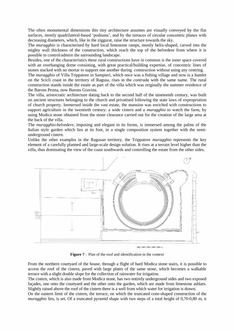
Figure 7 – Plan of the roof and identification in the context
From the northern courtyard of the house, through a flight of hard Modica stone stairs, it is possible to
access the roof of the cistern, paved with large plates of the same stone, which becomes a walkable
terrace with a slight double slope for the collection of rainwater for irrigation.
The cistern, which is also made from Modica stone, has two entirely underground sides and two exposed
façades, one onto the courtyard and the other onto the garden, which are made from limestone ashlars.
Slightly raised above the roof of the cistern there is a well from which water for irrigation is drawn.
On the eastern limit of the cistern, the terrace, on which the truncated cone-shaped construction of the
muragghio lies, is set. Of a truncated pyramid shape with two steps of a total height of 0,70-0,80 m, it

consists of containment walls built in stacked lines of squared limestone ashlars of a homogeneous size,
except for the edges which consist of large stone blocks which function as corners. Another terrace, lying
on a lower level, surrounds the construction only from two sides (east and south), and a stone ramp runs
along the eastern side reaching the garden below with a slight slope.
Inscribed in the rectangle which forms the base of the terrace, at a higher level and lying on it, a
truncated cone-shaped „podium‟, which has a circular base with a radius of about 6 metres and consists
of six/seven lines of stacked ashlars on which the whole construction rests, rises as a tangent to the
southern side.
The muragghio, made entirely from large blocks of roughly squared local calcarenite, rises for a total
height of about 5 metres on slightly indenting (about 5 cm) large steps, that is, to be precise, five
concentric truncated cone-shaped surfaces.
The development of the constructon according to successive rings of smaller diameter and of variable
height (lines at the bottom no. 7, in the middle no. 4, at the top no. 5) gives this simple architecture a
greater verticality; besides, the solid and compact wall mass is interrupted by the chiaroscuro of the
shadows which form on the exposed edges of the terraces.
Figure 8 – Northern façade and plan of the muragghio
The whole wall mass is made lighter by four openings facing the cardinal points – the ogival entrance
and the three rectangular windows with rectilinear architraves – which illuminate the interior. The
frames of the openings consist of stone ashlars which are uneven and larger than those of the lines, and
form a frame around the opening.
Two helicoidal two-flight stairs, lying symetrically at the entrance and with no parapet, stand on the
surface of the muragghio and are partly carved into the wall thickness. Such an arrangement entails a
constant width in the first flight (about 0,95 m), since it is external to the perimeter wall, unlike the
second ramp which presents, as the level increases, a section which becomes narrower near the top
(about 0,60 m). The steps appear slanted towards the inside, and maintain their perpendicularity with
the truncated cone-shaped surface on which they stand, as if to defeat the eventual centrifugal force
generated by the building's geometry.
At the top the flat roof, with a slight slope towards the outside, is covered with shapeless limestone of
small size and edged along the circular perimeter by the upper side of the ashlars of the last line.
The entrance with an ogival arch facing north, in Modica stone ashlars arranged radially, stands on
frames consisting of large stones of various size; it leads to a passage area, a narrow corridor covered
with a barrel vault with ogival diretrix, and rectilinear and horizontal generatrices.
The inner room with a circular plan, illuminated by the four openings, is covered with a dome standing
on the main walls. Hidden inside, this dome rises on 27 concentric lines of stone ashlars gradually
projecting towards the centre, ending at the top of the room. It is, thus, a self-supporting structure, a
overhanging dome, which rises according to successive horizontal rings of decreasing diameter,
distributed on a mainly horizontal level. A building arrangement similar to the tholos-shaped roofs of
Mycenaean or Etruscan tombs, in which stone elements are self-supporting, thus avoiding the use of
centring.
From the very first inspections carried out it was assumed that the dome consists, at the top, of a
conical surface with rectilinear generatrices, standing on about one quarter sphere which concerns the
first 14 lines. The outline of the vertical sides of the ashlars of the intrados of the dome determines the
geometry of the vault in order to obtain a continuos and non-jagged surface.
In the last part of the dome, the profile becomes curvilinear again with ashlars having a slanted or
horizontal position according to the the level to be reached for the end capstone.
A fast and economic, yet thrustful, building method. An aid to the stability of the construction, the
thick wall mass, arranged into large steps, acts as a counterweight.
The vertical clousure is a double-face “a sacco” wall, about 1,20 metres thick in total, consisting of
two masonry in solid limestone ashlars roughly squared in staggered joints; two masonry in the middle
of which, through the fissures, the filling consisting of small, shapeless stones can be seen.
The whole construction represents, for its geometrical-formal and technical-building features, an
example of local material culture which still today characterises the Ragusan territory, and offers
evocative images which portray the union of nature and inhabited space, stone and man.
4. DIGITAL SURVEY FOR THE KNOWLEDGE OF THE TRIPPATORE MURAGGHIO
4.1. Problems concerning the survey and the representation of dry stone artefacts through 3D
laser scanner
The research carried out on the Trippatore muragghio aims to obtain a complete documentation of the
artefact from the point of view of both its form and construction in order to be able to study its
geometry by concentrating, as a first hypothesis, on the analysis of the overhanging dome which
covers the inner room.
Indeed, only through a detailed geometrical analysis, despite the irregularities of the stone ashlars, has
it been possible to give answers to the questions and hypotheses formulated from the very first
inspections in order to understand the building method with which the muragghio was built in relation
to the examples already known in the literature.
Despite being aware of analysing a rural artefact made in ashlars of irregular size by craftsmen highly
skilled in dry stone walls, the dimensional and material characteristics of the muragghio have led us to
use the 3D laser scanner technology so as to acquire as much information as possible and to make all the
tests necessary for the geometrical analysis in an accurate manner.
The obtained digital model – a cloud of points – documents exhaustively both the form and the material
of the artefact, thus revealing its three-dimensional complexity in the virtual space of the computer.
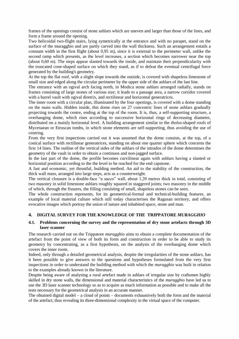
The 3D HDS 3000 laser scanner belonging to the “Luigi Andreozzi” Laboratory of Architectural
Photogrammetry and Survey of the Department of Architecture of the University of Catania has been used5.
The phase of on-site survey took into consideration the morphological-dimensional characteristics of the
muragghio, and was influenced by the presence of trees and vegetation near the artefact which forced us to
increase the number of scans in order to obtain a total coverage of the object. Three-dimensional targets,
where possible, were used, since they allow us greater precision, and are time-saving during the following
phases of editing and recording of the various scannings into a unique reference system (Santagati: 2009;
Santagati: 2011). Attention was paid, in any case, to make scans with a good overlap margin so as to be
able to proceed, during the recording phase, also through collimation of homologous points.
From an operational point of view the survey of the truncated cone shape of the building made the
verification of data necessary in the areas in which the laser affects tangency because of the loss of
data in the model which could cause subsequent overlap problems between one scan and the next.
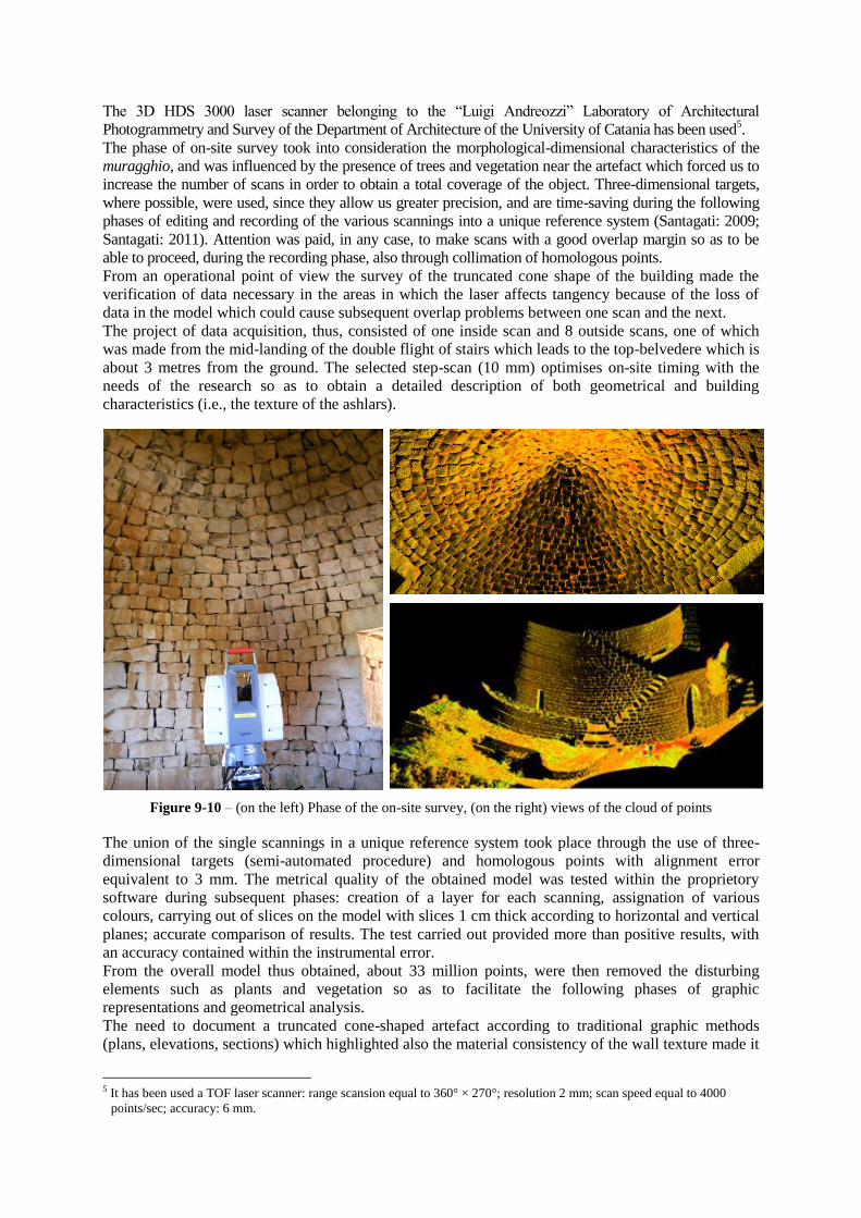
The project of data acquisition, thus, consisted of one inside scan and 8 outside scans, one of which
was made from the mid-landing of the double flight of stairs which leads to the top-belvedere which is
about 3 metres from the ground. The selected step-scan (10 mm) optimises on-site timing with the
needs of the research so as to obtain a detailed description of both geometrical and building
characteristics (i.e., the texture of the ashlars).
Figure 9-10 – (on the left) Phase of the on-site survey, (on the right) views of the cloud of points
The union of the single scannings in a unique reference system took place through the use of three-
dimensional targets (semi-automated procedure) and homologous points with alignment error
equivalent to 3 mm. The metrical quality of the obtained model was tested within the proprietory
software during subsequent phases: creation of a layer for each scanning, assignation of various
colours, carrying out of slices on the model with slices 1 cm thick according to horizontal and vertical
planes; accurate comparison of results. The test carried out provided more than positive results, with
an accuracy contained within the instrumental error.
From the overall model thus obtained, about 33 million points, were then removed the disturbing
elements such as plants and vegetation so as to facilitate the following phases of graphic
representations and geometrical analysis.
The need to document a truncated cone-shaped artefact according to traditional graphic methods
(plans, elevations, sections) which highlighted also the material consistency of the wall texture made it
5 It has been used a TOF laser scanner: range scansion equal to 360° × 270°; resolution 2 mm; scan speed equal to 4000
points/sec; accuracy: 6 mm.

necessary to pay great attention to the choice of the reference systems to use for the relevant graphic
representations of the elevations and of the sections.
The first objective was to identify the virtual centre of the inner circumference of the base for the
creations of vertical radial planes of sections joined to the axes of the openings. Subsequent
approximations were made by slicing the cloud of points at different levels with horizontal sections
profiles, by drawing, through points, the relevant theoretical circumferences, and by interpolating the
average of the centres so as to identify the theoretical centre.
Then, two sections, one longitudinal and the other transversal, passing through the theoretical centre of
the circumference at the base and the axes of the openings, were set; the non orthogonality between
the axes made the definition of two different reference systems (UCS) necessary.
Figure 11-12 – Longitudinal and transversal sections of the Trippatore muragghio
As for the elevations, the reference planes on which to make the projection were chosen according to
the two reference systems previously used so that, despite the projection of a curved surface, the
openings and the relevant frames and architraves were represented in their actual form and size.
4.2. Geometrical analysis of the overhanging dome
The geometrical analysis of the overhanging dome which covers the inner room required the creation
of other graphic works to better understand the object being studied. For this reason, besides the
sections previously created, 4 other radial profiles-sections, necessary to verify the formulated
hypotheses on the course of the inner curvature and on the methods for the installation of the ashlars,
were extrapolated.
Moreover, we created a hyposcopic plan, which made it possible to observe, in a clear manner, the
course of the exposed surface of the ashlars whose dimensions increase gradually from the impost
block at the top, as well as a plan view of the dome through level curves with profiles extrapolated
with a 30 cm step which made it possible to verify – when the laser managed to penetrate between one
ashlar and the next – the parallelepiped shape of the ashlars.

This latter graphic work proved to be of great importance since it confirmed the change, which was
noticed from the very first inspections, of the course of the horizontal section of the dome which,
gradually moving towards the top, from a circular form, assumes a more flattened shape which can be
recognised as an ellipse with the minor axis corresponding with the entrance to the artefact.
Figure 13-14 – (on the left) hyposcopic plan with texture of the ashlars; (on the right) 3d view of the orizontal
and radial profiles.
The analysis of the radial profiles created through planes passing from the centre of the ideal
circumference of the base revealed various elements which supported the verification of a few
formulated hypotheses, and, at the same time, raised fresh issues to be solved by seeking feedback
from both traditional building techniques and historical references.
The impost of the dome lies at the same level as the windowsill, at about 1.28 metres from the ground;
the curvature of the generating profile is not just one piece but consists of a portion of the circular
profile which goes from the impost up to about 3.40 metres from the ground including 14 lines (with
an underlying angle of about 50°) on which an almost tangent rectilinear profile stands, which then
again becomes curvilinear in correspondence with the last 4 lines of the end of the dome (at about 4.40
metres from the ground).
To sum up, after disregarding all inevitable geometrical irregularities due to imperfections of
installation, to the size of the ashlars, and to possible structural failures, it can be said that the inside of
the muragghio is a room with a cylidrical base on which a portion of a hemispherical dome (about one
quarter), surmounted by a cone with nearly rectilinear generatrices, stands.
As has already been said, since dry stone walling is involved, when the laser managed to penetrate between
one joint and the next, it was possible to verify the dimentions of the installed ashlars. At the lower end of
the dome, in correspondence with the first part consisting of the hemispherical portion, it has been noticed
that, in some parts (above all, in correspondence with the openings), the ashlars, of a parallepipedal shape,
are arranged according to inclined layers (maximum inclination of about 27-30 degrees).
The passage from the circular curving to the rectilinear curving, which is necessary to increase the
total height of the muragghio, in certain points takes place as a tangent, in the other points it is
possible to observe some discontinuities. As a first hypothesis it can be assumed that the decision to
change the profile was made during the work: presumably the craftsmen realised that by continuing
the installation with slanted ashlars the height of the muragghio would be too low to control the
territory. For this reason, the dome was raised with the consequent modification of the curving, from
circular to rectilinear, thus obtaining a higher turret.
The conformation of the faces of the ashlars of the truncated cone-shaped part of the muragghio reveals
the construction of the overhanging dome. In practice, the height of the ashlar remains almost constant
for the whole elevation of the dome (about 12-15 cm), the curving being obtained by shaping the
exposed face of the ashlar according to a constant inclination of about 47° with a projection of the
ashlars of about 10 cm.

Figure 15 – Geometrical analysis of the inner room of the muragghio
Finally, the last part of the profile, that which ends the dome, presents a curvilinear course curving with
the ashlars arranged in either a horizontal or an inclined line according to the level to be reached for the
end capstone.
5. BUILDING FEATURES
The sections of the inner surface of the intrados of the dome roof highlight some characteristics of the
joints among the ashlars which, criss-crossed with the direct survey of the same ashlars, seen from the
inside, suggest the use of the “overhanging ashlars method”, also known as “False vault”, but applied
with a mixed technique. The overhanging ashlars method creates the curve form with a simple
superimposition of parallelepiped ashlars with horizontal overhanging lines and setting bed/lines with no
overturning occurring. Stability is ensured through counterbalancing of the above wall mass. As it
clearly appears, it does not require the use of centring for its construction. The unique characteristic of
the method is represented by the horizontal setting bed/line of the various ashlars, which, in this way,
appear as parallelepipeds with the upper face and the lower face parallel and horizontal, and the exposed
face slanted. The sections, however, reveal that the ashlars of the first lines are not horizontal but
inclined. It has also been observed, from the direct survey, that all of the ashlars, also those of the first
lines, have parallel upper and lower faces, and inclination is obtained by the use of stone chippings
which raise the ashlar at the back thus giving it a certain inclination. They are always positioned with the
exposed face inclined and overhanging from the lower ashlar. It is difficult to be precise about the angle
of inclination of these lines since the irregularity of the ashlars and of the installation does not ensure the
accuracy of the survey, although the survey with 3D laser scanner has revealed a maximum inclination
of 27-30 degrees. In this case, it is assumed that an inclination was used which ensured stability, during
the construction, thanks to the friction between the stones, which are mostly below 30 degrees. This is
the mixed technique between ashlars arranged in horizontal ranks in the upper lines and ashlars arranged
in an inclined rank in the lower lines. A mixed technique belonging to the history of construction which
has built up over time. It has remained as empirical practice in the technical actions of the spontaneous
building culture of the craftsmen: the so called murassiccari. It has also been observed in the dome of
Hagia Sofia in Constantinople in an essay by R. Gulli and G. Mochi (Gulli R., Mochi G.: 1997) who
mention other historical monuments built with inclined ashlars such as the famous warehouses of the
Ramesseum and the vault of Chosroes I‟s palace in Ctesiphon. In the essay they write: “I pennacchi,…,
sono realizzati con una tecnica intermedia tra quella a falsa volta, caratterizzata dall’impiego di conci
successivamente aggettanti e posati su letti di posa piani privi di legante, e il sistema costruttivo che
prevede l’utilizzo di filari di laterizi inclinati e posti in opera senza l’ausilio di alcuna centina,
usufruendo pertanto della capacità adesiva offerta da una malta grassa. L’apparecchio costruttivo
prevede la messa in opera di laterizi secondo letti conici di malta aventi come vertice non il centro della
sfera che costituisce l’inviluppo delle serie di quattro pennacchi, bensì un punto situato a quota più alta
in modo che l’inclinazione dei laterizi risulti sempre inferiore al limite di scorrimento relativo tra malta
e laterizio. Con maggiore profitto questo apparecchio viene impiegato dai costruttori anche
nell’erezione della cupola; infatti l’autoportanza connessa all’utilizzo di una malta grassa rende più

semplice la realizzazione della copertura eliminando la necessità di sostenere i laterizi sino alla
chiusura dell’anello.”6 This method of mortar conical bed was well-known at an operational level also
by craftsmen who used it for the construction of small false vault domes with firebricks. They would
raise the brick at the extrados with plaster conical bed, in this way managing to end the ring and to
reduce the number of lines (Fianchino: 1983). The use of mixed techniques for the domes with the
overhanging ashlars system is fairly common in the Hyblaean region, and they have already been
observed in the building systems of the Byzantine domes still existing in the south-east of Sicily. This
technique has been observed in the example of the dome of the Trigona of Cittadella near Vendicari, for
the construction of which the use of the overhanging ashlars technique for the first five lines on the one
hand and the use of a juxtaposing ashlars method for the last four lines on the other has been
hypothesised (Margani: 2005).
Figure 16-17 – (on the left) building method of a dome with bricks arranged on horizontal layers and inclined
conical layers; (on the right) building section of a dome with horizontal and radial beds
This method is also hypothesised in the case of the circular plan construction with domed roof, called the
“Favorita” in contrada Frammedica in which the remains of the monument highlight the survival of the
first lines (today three, perhaps 5 in the drawing by Houel) of ashlars with a horizontal setting bed whereas
for the lines of the roof the use of a juxtaposing ashlars technique is hypothesised (Trapani: 2008).
Figure 18-19 – (on the left) the “Favorita” in a 2008 recent photo and (on the right) in a guache by Jean Houel
The presence of intermediate and mixed techniques in the same structure, even within the same
method of overhanging ashlars, demonstrates great building wealth, and, thus, a phase of the evolution
towards a major definition of the building methods of the ashlar vaults in the south-east area of Sicily
in which the material culture is characterised by the use of natural stone.
6 “The pendentives, ..., are built according to a technique halfway between the false vault technique, characterised by the use
of successively overhanging ashlars standing on flat setting beds with no binder, and the building system based on the use
of lines of inclined bricks positioned with no centring, thus exploiting the adhesive capacity offered by fat mortar. The
building system entails the installation of bricks according to mortar conical beds having as their vertex not the centre of the
sphere which is the union of the series of four pendentives, but a point lying at a higher level so that the inclination of the
bricks is always lower than the creep limit between the mortar and the brick. This method is used, with greater benefit, by
the builders also in the construction of the dome; the self-supporting quality connected to the use of fat mortar makes the
construction of the roof easier by eliminating the need to support the bricks up to the end of the ring.”

ACKNOWLEDGMENTS
The authors wish to thank the Baroness Fanny Gravina for granting access to Villa Trippatore and the
engineer Umberto Grimaldi, technician of the section of the “Luigi Andreozzi” laboratory of architectural
photogrammetry and architectural survey of the Mediterranean Laboratory of “Survey and Diagnostics for
Architecture” of the University of Catania, for his assistance during the phases of on-site survey.
CREDITS
Despite the joint nature of the research work carried out, the editorial responsibility for the paragraphs
is attributed to: paragraph 1, Franca Restuccia; paragraphs 2 and 5, Corrado Fianchino; paragraph 3,
Mariateresa Galizia; paragraph 4, Cettina Santagati.
REFERENCES
“Carta geologica della Sicilia sud-orientale 1/100.000, Università di Catania, Istituto di Scienze della
terra, Selca, Firenze 1984.
D‟Aurea V., (2008), I “trulli” di Polignano a Mare (Ba). Costruzioni a secco e società moderna: la
sfida della conservazione, in Bollettino Ingegneri Toscana, n. 11.
Fianchino C. (1983), “Caratteri tecnologici della ricostruzione settecentesca nella Sicilia sud-
orientale”, Documento 7 I.D.A.U., Catania, footnote 12.
Fianchino C. (1988), Le Pietre nell’Architettura, Documento 15, I.D.A.U., Catania, 1988.
Giandebbiaggi P., (2006), Rilievo e conoscenza dell’architettura: ricerca delle innovazioni nella
tradizione costruita, in (editors, Bertozzi P., Ghini A., Guardigli L.,) Le forme della tradizione
in architettura. Esperienze a confronto, Franco Angeli.
Gulli R., Mochi G. (1997), “Il modello bizantino, La cupola di Santa Sofia a Costantinopoli”, (editor
Conforti C.) Lo specchio del cielo forme significati tecniche e funzioni della cupola dal
Pantheon al Novecento, Electa, Milano.
Margani G. (2005), “Celle tricore edifici a pianta trilobata nella tradizione costruttiva siciliana”,
Documento 28 D.A.U., Editrice Il Lunario, Enna 2005.
Rossi G., Leserri M. (2007), Le geometrie delle architetture in pietra a secco salentine. La cupola in
aggetto, in Atti del quinto forum internazionale di studi “Le vie dei mercanti Rappresentare il
Mediterraneo”, Capri 14-15-16 giugno 2007. La scuola di Pitagora editrice, 777-782.
Santagati C. (2009), Il rilievo mediante laser scanner 3D. Problemi di metodo e procedure inerenti ai
beni archeologici e paesaggistici, in AA.VV. Il modello digitale per il progetto: l'esperienza del
parco archeologico di Kaukana a Santa Croce Camerina (RG) Sesto congresso UID XXXI
Convegno Internazionale delle discipline della rappresentazione - Disegno e progetto - Lerici
13,14,15 ottobre 2009.
Santagati C. (2011), “Metodologie digitali per il disegno delle torri di Enna”, in Galizia M., Il disegno
delle torri medievali di enna nel paesaggio urbano tra passato e presente, Giuseppe Maimone
Editore, Catania, pag 129-160.
Tiralongo P. (2006), Pietra su Pietra architettura in pietra a secco degli Iblei, EdiARGO, Ragusa,
Trapani F., (2008) “La „Favorita‟ presso l‟Asinaro. A proposito della cristianizzazione del Mediterraneo
Occidentale. Alcune considerazioni.” In Progetto KASA 2, sito www.progetto Kasa.net.
Figure 4. Fianchino, 1988 pp. 104,125
Figure 5. Tiralongo, 2006 pp 124-122-121-125-127-128
Figure 6. Tiralongo, 2006 pp 98-106 -104-84
Figure 16. Gulli R, Mochi G., 1997 pag.46
Figure 17. Margani G, 2005 pag 47
Figure 18 -19. Trapani, 2008 pag.338