the villanueva state park - new...
TRANSCRIPT
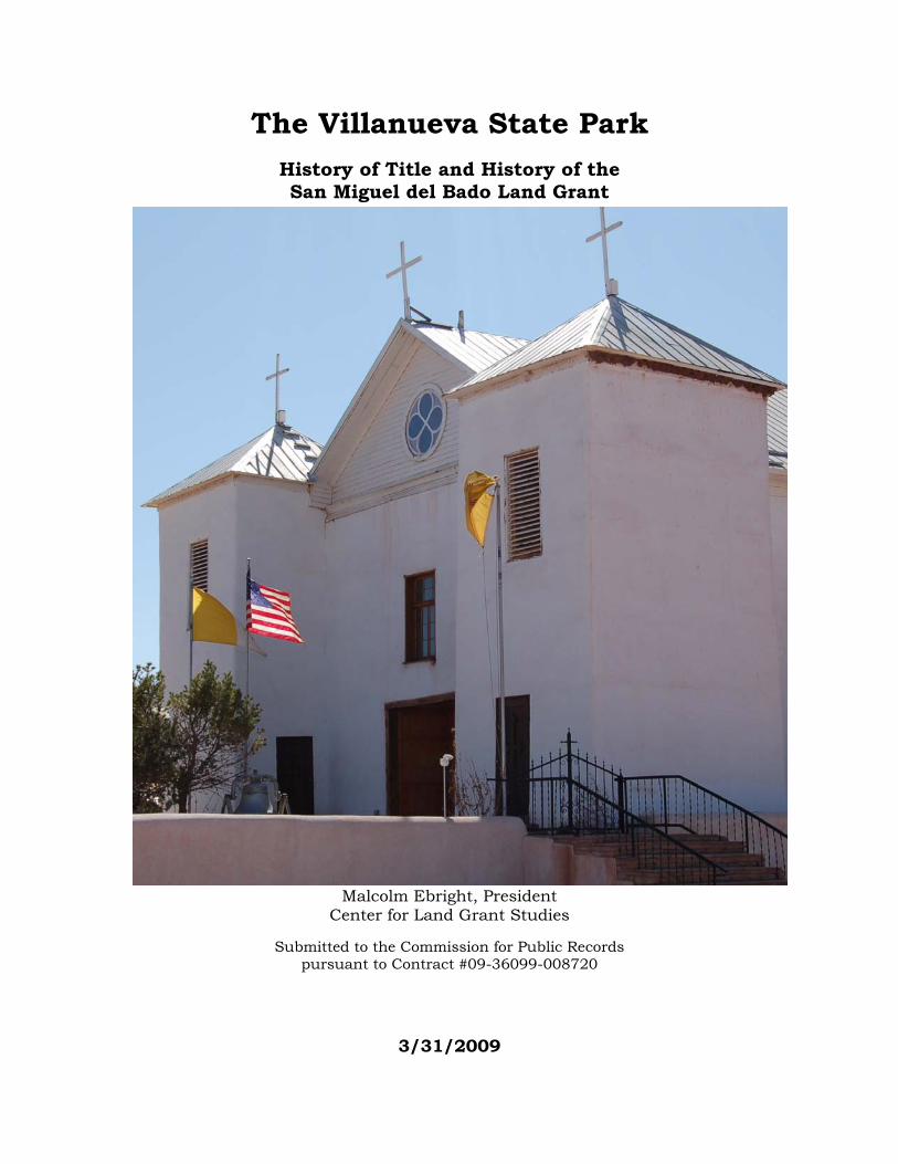
The Villanueva State Park History of Title and History of the San Miguel del Bado Land Grant
Malcolm Ebright, President
Center for Land Grant Studies
Submitted to the Commission for Public Records pursuant to Contract #09-36099-008720
3/31/2009
Table of Contents
1. Introduction – Scope of the Project ............................................................................4 2. Pecos Pueblo: Early History to 1838 ..........................................................................5 3. Pecos Pueblo: Privatization of the Pecos Pueblo League – 1838 to the present..........11 4. The San Miguel del Bado Grant ...............................................................................13 5. Villanueva, San Miguel del Bado and other communities.........................................19 6. Settlement on the San Miguel del Bado Grant and Neighboring Grants ...................24 7. Adjudication of the San Miguel del Bado Grant .......................................................35 8. Villanueva State Park Abstract: Narrative ................................................................44 9. Operation of Villanueva State Park ..........................................................................48 10. Conclusion ............................................................................................................50 Bibliography................................................................................................................52 Appendix A – Chain of Title of Villanueva State Park ...................................................53 Appendix B – 1803 Settlers at San Miguel del Bado.....................................................57 Appendix C – 1803 Settlers at San José del Bado ........................................................59 Appendix D – 1841 Census of San Miguel del Bado .....................................................60 Appendix E – Genízaros and Non-Pecos Indians in San Miguel Baptismal Records ......72 Appendix F – Map........................................................................................................74
Cover – San Miguel del Bado church, photo by Malcolm Ebright
2
Table of Figures
Figure 1. Land ownership around the Ciénega of Pecos. ......................................11 Figure 2. San Miguel del Vado Grant, based on John Shaw Survey of 1879,
containing 315,300 acres. ....................................................................15 Figure 3. Sena [Puertecito] church.......................................................................20 Figure 4. The Upper Pecos Valley.........................................................................21 Figure 5. Villanueva [La Cuesta] church. .............................................................22 Figure 6. El Cerrito church and congregation, 1941. ...........................................23 Figure 7. Map of Northern New Mexico Land Grants............................................24 Figure 8. San Miguel del Bado grant allotted lands per 1903 Wendell Hall survey.43 Figure 9. Ruins located at Villanueva State Park. ................................................47 Figure 10. The Road to Villanueva State Park (State Road 3) runs beside the Pecos
River.....................................................................................................48 Figure 11. Children’s playground at Villanueva State Park.....................................49 Figure 12. Bridge over the Pecos River at Villanueva State Park. ............................50
Photo credits
Figure 1. Hall, Four Leagues of Pecos, 64.
Figure 2 Nostrand, El Cerrito, p. 5.
Figure 3. Photo by Malcolm Ebright
Figure 4. Kessell, Kiva, Cross, and Crown, 440.
Figure 5. Photo by Malcolm Ebright.
Figure 6. Nostrand, El Cerrito, 124.
Figure 7. Ebright, Land Grants and Lawsuits, 172.
Figure 8. Nostrand, El Cerrito,
Figure 9. NMSRCA, Governor Cargo papers.
Figure 9. Photo by Steve Hardin.
Figure 10. Young, State Parks of New Mexico, 152.
Figure 11. Photo by Malcolm Ebright.
Figure 12. Photo by Malcolm Ebright.
3
1. Introduction – Scope of the Project
This report on the Villanueva State Park is rendered pursuant to a contract
between the Center for Land Grant Studies and the Commission of Public Records (the
Agency) dated September 9, 2008. Paragraph 1 of the contract provides for a review by
the Center for Land Grant Studies of each of seven abstracts to be provided by the
Agency. After making a detailed review of the abstract the contractor shall provide, “a
synopsis of the chain of title, identification of any discrepancies or breaks in the chain
of title, and a brief history of the land grant in which the State Park is located.” This
report covers the findings concerning the Villanueva State Park within the San Miguel
del Bado Land Grant (deliverable 1A4) and was written by Malcolm Ebright.
The abstract provided for the Villanueva State Park was incomplete with many
gaps that required additional research to fill in. For example, the latest patent from the
Bureau of Land Management (BLM) shown as tract 7 on the map is not listed in the
Territorial Title Abstract. It has been necessary to rely heavily on the abstract provided
by the New Mexico State Parks Division rather than the Territorial Title Abstract,
though I did examine all the deeds in the latter abstract (see section 8, Appendix A, and
map at Appendix F). The map attached as Appendix F relies on the New Mexico State
Parks abstract, showing graphically how the Villanueva State Park was acquired
initially with deeds from the Board of Trustees of the San Miguel del Bado Grant, later
augmented by land patented from the BLM and from the BLM and land deeded from
private land owners. These lands were once part of the San Miguel del Bado
community land grant: the BLM lands were part of the common lands, and the San
Miguel del Bado Grant board of Trustees land was part of the private lands confirmed to
the grant.
Because of the close connection between the San Miguel del Bado grant and the
Pecos Pueblo (the grantees apparently included some Pecos Indians), Sections 2 and 3
deal with a brief history of the Pecos Pueblo, before and after 1838 when the Pueblo was
abandoned. Section 4 deals with the San Miguel del Bado grant, section 5 and 6 with
settlement on the grant and neighboring grants and section 7 with the adjudication of
San Miguel del Bado grant. Section 8 describes how the Villanueva State Park was
created out of what had been the common lands and the private lands of the San
Miguel del Bado Grant and Section 9 describes the operation of the Villanueva State
Park. Finally the conclusion attempts to tie together the story of how this most famous
4
of New Mexico land grants led to the creation of the flagship of the New Mexico state
parks.
Research assistance was provided by Carisa Williams Joseph, Moss Joseph,
former State Archivist Richard Salazar, map-maker Steve Hardin and community
members. Special thanks to Sandra Jaramillo, Christy Tafoya, Faith Yoman and
members of the staff of the State Records Center and Archives.
2. Pecos Pueblo: Early History to 1838
The following section and section three, dealing with the Pecos Pueblo people
prior to 1838 and with the Pecos Pueblo land after 1838 is largely taken from Frances
Levine, Our Prayers are in this Place: Pecos Pueblo Identity Over the Centuries.
Indians from what is now called Pecos Pueblo encountered Spanish explorers
very soon after the Spaniards first entered New Mexico. A man named Estevan who
traveled north from Mexico as part of the Fray Marcos de Niza expedition of 1539
entered an ancestral Zuni village; the next year the much larger expedition led by
Francisco Vasquez Coronado, reportedly consisting of more than 1500 people and well
provisioned, reached Zuni. Pecos Pueblo was the only group to send a contingent when
invited to meet with Coronado. The leader of this delegation, called Bigotes for his long
mustache, presented Coronado with gifts of tanned hides, shields, and headpieces, and
when Coronado’s troops reached Pecos they received gifts of cotton cloth, feather robes,
and animal skins. 1
Pedro de Castañeda, a chronicler of the Coronado expedition provides the first
image of Pecos at that time. The Pueblo was called Cicuye by Castañeda, likely a Tiwa
(Tiguex) name that the Spanish explorers learned, the name Pecos was probably a Towa
name glossed by the Spaniards.2 Castañeda described the pueblo:
“it is a square, situated on a rock, with a large court or yard in the middle, containing the estufas [kivas]. The houses are all alike, four stories high. One can go over the top of the whole village without there being a street to hinder. There are corridors going all around it at the first two stories, by which one can go around the whole village. These are like outside balconies, and they are able to protect themselves under these. The houses do not have doors below, but they use ladders which can be lifted up like a drawbridge, and so go up to the corridors which are on the inside of the village. As doors of the houses open on the corridor of that story, the corridor serves as a street. The houses that
1 Frances Levine, Our Prayers Are in This Place: Pecos Pueblo Identity Over the Centuries, (Albuquerque: University of New Mexico Press, 1999), 11-13. 2 Levine, Our Prayers Are in This Place, 162, n. 8, citing Carroll Riley, The Frontier People: The Greater Southwest in the Protohistoric Period, Occasional Paper no. 1, Center for Anthropological Studies, Southern Illinois University at Carbondale.
5
open on the plain are right back of these that open on the court, and in time of war they go through those behind them. The village is enclosed by a low wall of stone. There is a spring of water inside, which they are able to divert.” 3 “Other chroniclers of the Coronado expedition added that the village had eight plazas, reached four or five stories in places, and contained about 50 houses.”4
Coronado retreated further south in 1542. For various reasons it was forty
years before Spaniards again became interested in exploring the northern area
surrounding the Rio Grande. “In 1580 the expedition of Fray Agustín Rodriguez and
Captain Francisco Sánchez Chamuscado, the next Spanish explorers to travel through
the region, passed along the flanks of the Glorieta Mesa immediately to the west of
Pecos Pueblo en route to the buffalo plains. 5
The next Spaniards to visit the region were the expedition of Antonio de Espejo,
sent to New Mexico to rescue two friars who had remained behind when the
Chamuscado-Rodríguez party returned to Mexico. Espejo reached Pecos Pueblo in early
July 1583. It was described as the finest and largest of the Pueblos seen by the party.
Although the Pecos Indians initially refused to give the explorers any food, a
compromise was reached through the negotiations of a survivor of the Coronado
expedition, a Mexican Indian who was evidently in residence at the pueblo.6
The right to colonize New Mexico was won by Juan de Oñate in September 1595,
but he was not the first to attempt to claim the far north for Spain. Gaspar Castaño de
Sosa led an unauthorized expedition to New Mexico in the fall of 1590. He traveled up
the Pecos River, reaching Pecos Pueblo at the end of December 1590. His party was
greeted by an armed and hostile contingent of the village. Sosa’s journal reflects
mounting despair over bitter cold, the colonists’ dwindling food supplies, and a violent
clash with the Pecos.7 Sosa entered the village on January 1, 1591, and spent several
3 Winship, George Parker, “The Coronado Expedition, 1540-1542” in The Fourteenth Annual Report of the Bureau of Ethnology, Smithsonian Institution, 1892-1893, (Washington, D.C.: Smithsonian Institution, 1896), part 1, 329-613; Levine, Our Prayers Are in This Place, 13. 4 Levine, Our Prayers Are in This Place, 13. 5 Levine, Our Prayers Are in This Place, 14-15. 6 John Kessell, Kiva, Cross, and Crown: The Pecos Indians and New Mexico, (1979; reprint edition, Albuquerque: University of New Mexico Press, 1987), 42; Levine, Our Prayers Are in This Place, 15. 7 George P. Hammond and Agapito Rey, The Rediscovery of New Mexico, 1580-1594: The Explorations of Chamuscado, Espejo, Castaño de Sosa, Morlete, and Leyta de Bonilla and Humaña, Coronado Cuarto Centennial Publications, 1540-1940, vol. 3 (Albuquerque: University of New Mexico Press, 1916); Levine, Our Prayers Are in This Place, 15.
6
days camped there.8 He provided a detailed description of the village, the dress of the
villagers, and the abundant stores of corn, herbs, squash, and chile. He noted great
quantities of pottery, including some colorful glazed ceramics, and plentiful firewood
and timbers for building. The expedition recorded 16 kivas, which were interpreted as a
form of winter housing.9 “After a few days Sosa took some of the food stores and
resumed his march toward his destination at Santo Domingo Pueblo. Sosa’s colony on
the Río Grande was short-lived. He was arrested and returned to Mexico in the spring
of 1591, where he was punished for this illegal entry.”10
Meanwhile Juan de Oñate was staging the expedition that would colonize New
Mexico. It took more than three years for Juan de Oñate to complete the task of
assembling the people, supplies, and authorizations needed before the settlers began
their journey north. Finally, in the winter of 1598, a caravan of some 80 ox carts and
wagons, 7,000 head of domestic livestock, and perhaps as many as 500 people headed
up the camino real. Oñate’s colonists, called pobladores in Spanish, extended the royal
road more than 600 miles to their base at San Juan Pueblo in the Tewa province. The
colonists reached San Juan Pueblo in the Tewa province. The colonists reached San
Juan in two groups during the summer of 1598. The Hispanic settlement, San
Gabriel, was built in the Tewa pueblo of Yunque, on the west bank of the Rio Grande.11
Oñate rewarded the pobladores with encomiendas, or grants of Indian labor, for
meritorious service. The encomenderos were obligated to defend the Pueblo
communities and to participate in their religious conversion. In return for this defense
and religious instruction, each Pueblo household was required to pay a tax, or ‘tribute,’
of one fanegas of corn and a cotton manta.12
Kessell identified only two encomenderos at Pecos in the period 1620 to 1680.
Francisco Gómez, a Portuguese colonist who came to New Mexico about 1605,
occupied the position of encomendero at Pecos from the 1620s until about 1656. His
son, Francisco Gómez Robledo, succeeded him, serving until the Pueblo Revolt in
8 Hammond and Rey, Rediscovery, 277-80, Albert H. Schroeder and Dan S. Matson, A Colony on the Move: Gaspar Castaño de Sosa’s Journal, 1590-1591 (Santa Fe: School of American Research, 1965), 107-112; Levine, Our Prayers Are in This Place, 15. 9 Hammond and Rey, Rediscovery, 277-278; Levine, Our Prayers Are in This Place, 15-16. 10 Schroeder and Matson, A Colony on the Move, 98-100; Levine, Our Prayers Are in This Place, 16. 11 Herbert E. Bolton, ed., Spanish Exploration in the Southwest, 1542-1706, (1908; reprint edition, New York: Barnes and Noble, 1976), 201, Marc Simmons, The Last Conquistador: Juan de Oñate and the Settling of the Far Southwest (Norman: University of Oklahoma Press, 1991), 93-97; Levine, Our Prayers Are in This Place, 16-17. 12 Charles W. Hackett, ed. and trans., Historical Documents Related to New Mexico, Nueva Vizcaya, and Approaches Thereto, to 1773, vol. 3 (Washington, D.C.: Carnegie Institution of Washington: 1937), 110; Levine, Our Prayers Are in This Place, 17.
7
1680. Gómez Robledo evidently shared Pecos with Pedro Lucero de Godoy, who held
the tribute of twenty-four houses in the village. Pecos was considered to be the richest
encomienda, owing to its central role in procuring buffalo hides, an important export
item, from the plains.13
The Spaniards used Catholic missions to encultrate native people throughout
the Americas. The missionaries’ goals went well beyond the teachings of Christianity.
Natives would be taught to live like Europeans, to eat like Europeans, and to think like
Europeans. By these means, the philosophy of the time held, the natives would be
uplifted to the spiritual level of Spaniards themselves. Oñate assigned friars to specific
pueblos to begin converting the people. The pace of conversion and of the construction
of mission complexes seems to have remained slow in the first decades of colonial
occupation.14
Alden Hayes traced the history of church construction at Pecos. There were
four churches at Pecos Pueblo, two built before the Pueblo Revolt of 1680 and two after
the Spanish Reconquest in 1692. The first church stood a short distance to the north
of the pueblo room blocks, perhaps indicating that the missionaries were not
immediately welcomed in the village. Also known as the ‘Lost Church,’ it was
abandoned even before it was completed. Construction of the second church began at
the south end of the mesita on which Pecos sits and south of the population center of
the community. This church, dedicated to ‘Nuestra Señora de los Ángeles de
Porciúncula,’ was constructed by Fray Andrés Juarez (also written Suárez) in the early
1620s. Kessell estimated that the Pecos made nearly 300,000 adobes to complete
Juarez’s vision. When it was completed, Fray Alonso de Benavides described it
(sometime between 1625 and 1629) as a particularly beautiful church, large enough to
hold all of the people of the pueblo, then numbering 1,189 souls. This church was
destroyed in the Pueblo Revolt of 1680. 15
At the time of the revolt, the Hispanic population numbered between 2,000 and
2,800 people living along the Río Grande from Taos on the north to the vicinity of
Socorro on [the] south. By then the Pueblo population had been reduced to 16,000 or
17,000 people living in about 30 settlements. This was approximately one-half to one-
third of the population recorded in the chronicles of the sixteenth-century expeditions.
13 Levine, Our Prayers Are in This Place, 163-4, n. 13, citing Kessell, Kiva, Cross and Crown, p. 504-506 and 186, 188. 14 Weber, David J., The Spanish Frontier in North America (Albuquerque: University of New Mexico Press, 1992), 106; Levine, Our Prayers Are in This Place, 17. 15 Alden C. Hayes, The Four Churches of Pecos (Albuquerque: University of New Mexico Press, 1974), 2-5, 124, Kessell, Kiva, Cross, and Crown, 124; Levine, Our Prayers Are in This Place, 18-19.
8
Like many other villages, Pecos seems to have had factions allied with the Pueblo
liberators as well as factions loyal to the Spaniards. Fray Fernando de Belasco was
spared by the Pecos but later killed in the Tano pueblos. At least one priest and one
Spanish family were killed at Pecos, according to Kessell. Some Pecos Indians were
party to the attack on Santa Fe. Pecos would play an equally ambivalent role in the
reconquest. The Pueblo Revolt of 1680 marked a hiatus in colonial occupation and an
attempted revitalization of native hegemony. In all, 380 colonists and 21 missionaries
were killed.16
The pueblos of Pecos, Zia, Santa Ana, San Felipe, and Tesuque did not join the
second Pueblo Revolt.”17 Kessell suggests that Pecos saw an economic advantage in
allying with the Spaniards. Ironically this helped because the Pueblo's decline as the
Pueblo’s trade was eclipsed by Spanish traders with more desirable trade goods.18
Vargas’s army of reconquest entered Pecos Pueblo on Tuesday, September 23,
1692. The village was empty. Tracks showed that the people had scattered to
mountain retreats. By September 27, Vargas had reclaimed Pecos, negotiating the
surrender through captive emissaries. In all of the Pueblo villages Vargas identified
relatives of Spanish colonists and relatives of Pueblo people who had retreated to El
Paso with the colonists and established the pueblo of Ysleta del Sur. At Pecos, there
were three Tewa women and their infants who were related to those in Ysleta del Sur.
There were also a Spanish-speaking Jumano, or Plains Indian, woman and the son of
the Spanish settler Cristóbal de Anaya, whom John Kessell and Rick Hendricks and
Fray Angélico Chávez identified as Francisco de Anaya Almazán. Vargas performed the
ritual repossession of Pecos on October 17, 1692. Two friars baptized 248 men,
women and children, about one-third of the resident population of the village.19
In the early years following the reconquest, non-Pueblo population centers grew
with recruits enlisted in Mexico by the Spanish government, although relatively few
colonists immigrated from Mexico and fewer from Spain until after 1790. The
‘Spanish’ towns were enlarged by an influx of Pueblo peoples as well. Ramón Gutiérrez
calculated that the ‘Spanish’ population of New Mexico – comprising people of
16 Kessell, Kiva, Cross, and Crown, 232; Charles W. Hackett, ed., and C. C. Shelby, trans., Revolt of the Pueblo Indians of New Mexico and Otermín’s Attempted Reconquest, 1680-1682, 2 vols. (Albuquerque: University of New Mexico Press, 1942), 3; Levine, Our Prayers Are in This Place, 21. 17 Levine, Our Prayers Are in This Place, p. 22. 18 Kessell, Kiva, Cross, and Crown, 263. 19 John Kessell and Rick Hendricks, eds., By Force of Arms: The Journals of Don Diego de Vargas, 1691-1693 (Albuquerque: University of New Mexico Press, 1992), 421-34, 488 n. 67, Fray Angélico Chávez, Origins of New Mexico Families, (1954; reprint, Santa Fe: William Gannon, 1975), 4; Levine, Our Prayers Are in This Place, 22-23.
9
European, Pueblo, and mixed ancestry – grew from about 800 in 1693 to 4,353 in
1749. This fivefold increase had its greatest concentration in the Santa Cruz-Expañola
area. For the same period, Gutiérrez calculated that the Pueblo population declined
from about 14,000 in 1693 to 8,388 in 1750. He concluded that the Pueblo population
decline and rapid Spanish population growth were closely related.”20 “A count of the
resident population of Pecos in 1694 recorded a total of 736 resident natives, including
186 men, 230 women, and 320 children below the age of 12 or 13.21
Pecos Pueblo may have housed a garrison of ten Spanish soldiers along with
family members from 1750 until the 1794 establishment of the San Miguel del Bado
Grant. These soldiers may have rotated among several garrisons, staying at Pecos only
part of the time, and in any case the “Spanish population was always quite small, and
confined mostly to the immediate vicinity of the church, convento, and casas reales,
(which housed the alcalde mayor, travelers, and served as the local courthouse).”22
The year 1838 is often given as the date that a group of Pecos accepted the
invitation to join Jémez Pueblo. Mariano Ruiz, the caretaker at Pecos Pueblo, told
Adolph Bandelier in 1880 that the last group of Pecos, five men whom he named, moved
to Jémez in 1840. Kessell found no record of these events in the Mexican Archives of
New Mexico, and the Jémez sacramental records for that time period were missing, but
Levine found Pecos emigrants on the 1845 census of Jémez Pueblo.23
Jemez Pueblo and the contemporary community of Pecos continue to venerate
Nuestra Señora de los Ángeles de Porciúncula (also spelled Porcingula) at feast-day
celebrations in August. Jémez Pueblo celebrates the feast on August 2. The
community of Pecos holds its annual feast day at Pecos National Historical Park on the
first Sunday in August.24
20 Gutiérrez, When Jesus Came, the Corn Mothers Went Away, 166-175, Tzarks, “Demographic, Ethnic, and Occupational Structure of New Mexico, 1790,” 59 n. 33; Levine, Our Prayers Are in This Place, 24. 21 Levine, Our Prayers Are in This Place, 164, n. 18, citing Kessell, Kiva, Cross and Crown, 276. 22 Hayes, The Four Churches of Pecos, 15, 58, Kessell, Kiva, Cross and Crown, 380; Levine, Our Prayers Are in This Place, 90. 23 Levine, Our Prayers Are in This Place, 165, n. 21, citing Charles H. Lange, Carroll L. Riley, and Elizabeth M. Lange, editors and annotators, The Southwestern Journals of Adolph Bandelier, 1885-1888, (Albuquerque: University of New Mexico Press, 1975). 24 Levine, Our Prayers Are in This Place, 164, n. 19, citing Frances Levine, Marilyn Norcini and Morris Foster, An Ethnographic Overview of Pecos National Historical Park, manuscript on file, National Park Service, Southwest Region, Santa Fe, 1994.
10
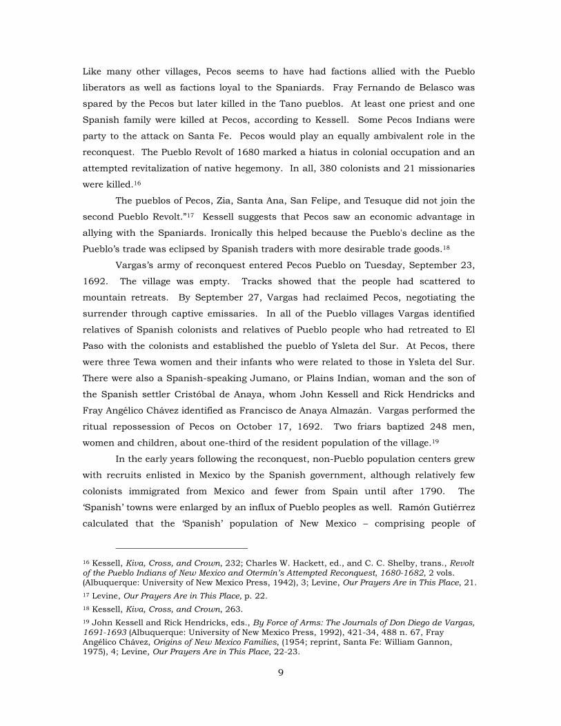
3. Pecos Pueblo: Privatization of the Pecos Pueblo League – 1838 to the present
By 1838 the population of Pecos Pueblo had dwindled to a handful of
inhabitants and the remaining Pecos Indians decided to move to Jemez Pueblo. That
left the lands of Pecos Pueblo, most of which had been acquired by their Hispanic
neighbors, completely vacant. Like other Indian villages vacated by their Indian
inhabitants (San Marcos, La Cienega, and Galisteo), the Pecos Pueblo league of
approximately 17,000 acres became the subject of complex land transactions. Hispanic
land speculators such as Juan Estévan Pino, Donaciano Vigil and smaller land owners
started the process. In 1824 and 1825 irrigated land in the north and south part of the
Ciénega of Pecos in the heart of Pecos Pueblo was granted by the New Mexico Territorial
deputation (legislature) led by Juan Estévan Pino to various non-Indians as shown on
the map below.
Figure 1. Land ownership around the Ciénega of Pecos.
The original inhabitants of Pecos Pueblo, led by Rafael Aguilar and José Cota
had vigorously protested this privatization of Pueblo lands, which was based on earlier
decrees25 of the Spanish Cortes regarding privatization of “unused” Pueblo lands. The
Indians of Pecos retained the central portion of the Cienega of Pecos (as shown on the
25 For a discussion of these decrees see, G. Emlen Hall and David J. Weber, Mexican Liberals and the Pueblo Indians, 1821-1829, New Mexico Historical Review, 39 (January 1984) 5-32.
11
map above) until 1830. On September 22 of that year José Cota switched sides, signing
a deed with an X, Cota conveyed the rest of the Cienega of Pecos to Juan Estévan Pino,
stating that he was acting on behalf of the entire Pueblo of Pecos.26 With the best,
irrigated lands in the hands of non-Indians, it was only a few more years before the
remaining Pecos Indians were forced to leave. “Hispanic Pecoseños, according to the
Indians, killed the pueblos few remaining animals and poisoned its water holes between
1830 and 1840. Life became increasingly isolated and intolerable for the Indians.”27
Partly through the machinations of the owners of the neighboring Alexander Valle and
Los Trigos grants, the rest of the 17,000 plus acre Pecos Pueblo league was soon
privatized.
The later history of this land, which ironically led in part to the establishment of
the Pecos National Monument in 1965 to protect the “ancient Indian Pueblo” is well
summarized in the book Our Prayers Are in This Place.28
“The land [of the Pecos league] was resold and divided through lawsuits that
lasted well into the first decade of the twentieth century. In 1897, Gross, Kelly and
company, a mercantile company with immense landholdings and commercial ventures
in New Mexico, acquired the Pecos grant. The new owners attempted to clear title to
their holdings through a quiet title suit, but they did not attempt to settle any claims
that the Pecos descendants might have had. They presumed, perhaps, that earlier sales
had terminated the pueblo’s rights to the grant. A suit heard in San Miguel County
District Court in 1919 upheld the Gross, Kelly claim to the majority of the land of the
Pecos Pueblo league.29 Soon after the suit was settled, the company sold its interest in
the Pecos league. By 1924, a tract of almost 10,890 acres of the Pecos league and
about 6,144 of the neighboring Los Trigos community land grant were consolidated in
the ownership of Continental Insurance Company. Continental sold its land in the
Pecos league to the rodeo cowboy and entrepreneur J. V. “Tex” Austin and a partner,
William Mann, formed the Forked Lighting Ranch in 1927, operating it as a cattle
ranch, dude ranch, and trading post. The magnificent headquarters building that they
constructed along the river was designed by Santa Fe architect John Gaw Meem. By
1933, the operation failed and went into receivership. Austin lived in Santa Fe until his
suicide in 1938.30
26 G. Emlen Hall, Four Leagues of Pecos: A Legal History of the Pecos Grant, 1800-1933 (Albuquerque: University of New Mexico Press, 1984), 31-66. 27 Hall, Four Leagues of Pecos, 60. 28 Levine, Our Prayers are in This Place, n. 14, 179-180. 29 Hall, Four Leagues of Pecos, 212-220. 30 Levine, Our Prayers Are in This Place, 180.
12
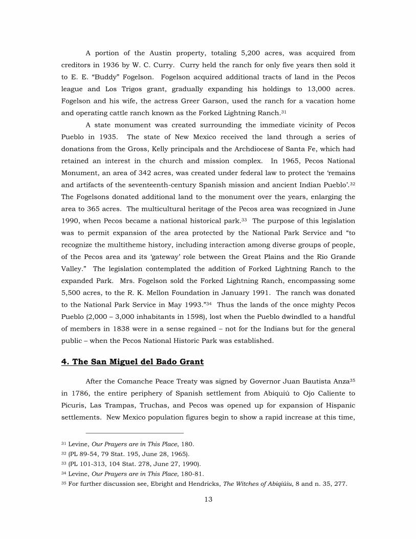
A portion of the Austin property, totaling 5,200 acres, was acquired from
creditors in 1936 by W. C. Curry. Curry held the ranch for only five years then sold it
to E. E. “Buddy” Fogelson. Fogelson acquired additional tracts of land in the Pecos
league and Los Trigos grant, gradually expanding his holdings to 13,000 acres.
Fogelson and his wife, the actress Greer Garson, used the ranch for a vacation home
and operating cattle ranch known as the Forked Lightning Ranch.31
A state monument was created surrounding the immediate vicinity of Pecos
Pueblo in 1935. The state of New Mexico received the land through a series of
donations from the Gross, Kelly principals and the Archdiocese of Santa Fe, which had
retained an interest in the church and mission complex. In 1965, Pecos National
Monument, an area of 342 acres, was created under federal law to protect the ‘remains
and artifacts of the seventeenth-century Spanish mission and ancient Indian Pueblo’.32
The Fogelsons donated additional land to the monument over the years, enlarging the
area to 365 acres. The multicultural heritage of the Pecos area was recognized in June
1990, when Pecos became a national historical park.33 The purpose of this legislation
was to permit expansion of the area protected by the National Park Service and “to
recognize the multitheme history, including interaction among diverse groups of people,
of the Pecos area and its ‘gateway’ role between the Great Plains and the Rio Grande
Valley.” The legislation contemplated the addition of Forked Lightning Ranch to the
expanded Park. Mrs. Fogelson sold the Forked Lightning Ranch, encompassing some
5,500 acres, to the R. K. Mellon Foundation in January 1991. The ranch was donated
to the National Park Service in May 1993.”34 Thus the lands of the once mighty Pecos
Pueblo (2,000 – 3,000 inhabitants in 1598), lost when the Pueblo dwindled to a handful
of members in 1838 were in a sense regained – not for the Indians but for the general
public – when the Pecos National Historic Park was established.
4. The San Miguel del Bado Grant
After the Comanche Peace Treaty was signed by Governor Juan Bautista Anza35
in 1786, the entire periphery of Spanish settlement from Abiquiú to Ojo Caliente to
Picuris, Las Trampas, Truchas, and Pecos was opened up for expansion of Hispanic
settlements. New Mexico population figures begin to show a rapid increase at this time,
31 Levine, Our Prayers are in This Place, 180. 32 (PL 89-54, 79 Stat. 195, June 28, 1965). 33 (PL 101-313, 104 Stat. 278, June 27, 1990). 34 Levine, Our Prayers are in This Place, 180-81. 35 For further discussion see, Ebright and Hendricks, The Witches of Abiqiúiu, 8 and n. 35, 277.
13
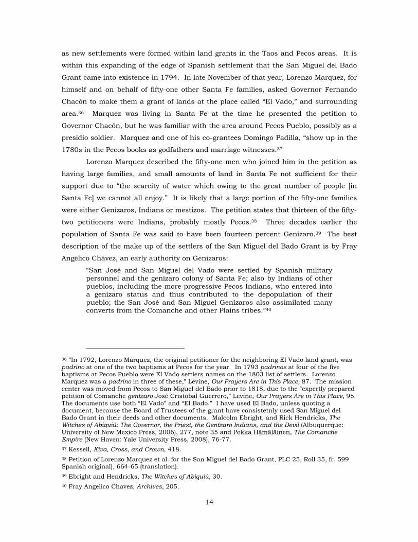
as new settlements were formed within land grants in the Taos and Pecos areas. It is
within this expanding of the edge of Spanish settlement that the San Miguel del Bado
Grant came into existence in 1794. In late November of that year, Lorenzo Marquez, for
himself and on behalf of fifty-one other Santa Fe families, asked Governor Fernando
Chacón to make them a grant of lands at the place called “El Vado,” and surrounding
area.36 Marquez was living in Santa Fe at the time he presented the petition to
Governor Chacón, but he was familiar with the area around Pecos Pueblo, possibly as a
presidio soldier. Marquez and one of his co-grantees Domingo Padilla, “show up in the
1780s in the Pecos books as godfathers and marriage witnesses.37
Lorenzo Marquez described the fifty-one men who joined him in the petition as
having large families, and small amounts of land in Santa Fe not sufficient for their
support due to “the scarcity of water which owing to the great number of people [in
Santa Fe] we cannot all enjoy.” It is likely that a large portion of the fifty-one families
were either Genízaros, Indians or mestizos. The petition states that thirteen of the fifty-
two petitioners were Indians, probably mostly Pecos.38 Three decades earlier the
population of Santa Fe was said to have been fourteen percent Genízaro.39 The best
description of the make up of the settlers of the San Miguel del Bado Grant is by Fray
Angélico Chávez, an early authority on Genízaros:
“San José and San Miguel del Vado were settled by Spanish military personnel and the genízaro colony of Santa Fe; also by Indians of other pueblos, including the more progressive Pecos Indians, who entered into a genízaro status and thus contributed to the depopulation of their pueblo; the San José and San Miguel Genízaros also assimilated many converts from the Comanche and other Plains tribes.”40
36 “In 1792, Lorenzo Márquez, the original petitioner for the neighboring El Vado land grant, was padrino at one of the two baptisms at Pecos for the year. In 1793 padrinos at four of the five baptisms at Pecos Pueblo were El Vado settlers names on the 1803 list of settlers. Lorenzo Marquez was a padrino in three of these,” Levine, Our Prayers Are in This Place, 87. The mission center was moved from Pecos to San Miguel del Bado prior to 1818, due to the “expertly prepared petition of Comanche genízaro José Cristóbal Guerrero,” Levine, Our Prayers Are in This Place, 95. The documents use both “El Vado” and “El Bado.” I have used El Bado, unless quoting a document, because the Board of Trustees of the grant have consistetnly used San Miguel del Bado Grant in their deeds and other documents. Malcolm Ebright, and Rick Hendricks, The Witches of Abiquiú: The Governor, the Priest, the Genízaro Indians, and the Devil (Albuquerque: University of New Mexico Press, 2006), 277, note 35 and Pekka Hämäläinen, The Comanche Empire (New Haven: Yale University Press, 2008), 76-77. 37 Kessell, Kiva, Cross, and Crown, 418. 38 Petition of Lorenzo Marquez et al. for the San Miguel del Bado Grant, PLC 25, Roll 35, fr. 599 Spanish original), 664-65 (translation). 39 Ebright and Hendricks, The Witches of Abiquiú, 30. 40 Fray Angelico Chavez, Archives, 205.
14
The petition and granting decree seem to follow a form similar to other land
grants of that period, suggesting that there was a form or model followed during the
latter part of the eighteenth and early nineteenth century. The Arroyo Hondo grant
near Taos is almost identical in its wording.41
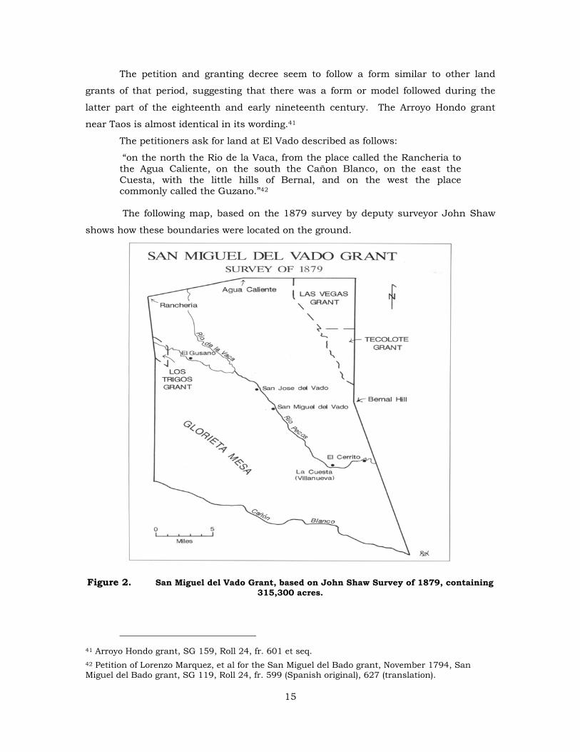
The petitioners ask for land at El Vado described as follows:
“on the north the Rio de la Vaca, from the place called the Rancheria to the Agua Caliente, on the south the Cañon Blanco, on the east the Cuesta, with the little hills of Bernal, and on the west the place commonly called the Guzano.”42 The following map, based on the 1879 survey by deputy surveyor John Shaw
shows how these boundaries were located on the ground.
Figure 2. San Miguel del Vado Grant, based on John Shaw Survey of 1879, containing 315,300 acres.
41 Arroyo Hondo grant, SG 159, Roll 24, fr. 601 et seq. 42 Petition of Lorenzo Marquez, et al for the San Miguel del Bado grant, November 1794, San Miguel del Bado grant, SG 119, Roll 24, fr. 599 (Spanish original), 627 (translation).
15
The petitioners said they had twenty-five guns among themselves and promised
to “enclose ourselves in a plaza well fortified with bulwarks and towers,” as well as
supply themselves with more firearms and ammunition. They told the governor there
was room enough on the land for themselves and “for everyone in the province not
supplied.” It is clear from the petition that protection against Indian raids was one of
the primary concerns of the settlers.43
Governor Fernando Chacón made the grant to the petitioners on November 25,
1794 and directed Alcalde Antonio José Ortiz to put the grantees in possession of the
grant.44 On November 26, 1794 Alcalde Ortiz brought the fifty-two petitioners to El
Vado (today’s San Miguel del Bado) and performed the traditional ceremonies of delivery
of possession to the grantees, though he did not allot them specific tracts of land. The
list of petitioners attached to the petition has been lost, as was often the case, so other
than Lorenzo Marquez, we do not know who the grantees of the San Miguel del Bado
grant were.
The alcalde notified the grantees of five conditions, which were as follows:
“First. That the tract aforesaid has to be in common, not only in regard to themselves, but also to all the settlers who may join them in the future. Second. That with respect to the dangers of the place, they shall have to keep themselves equipped with firearms, and bows and arrows, in which they shall be inspected as well at the time of settling as at any time the alcalde in office may deem proper, provided that after two years settlement all the arms they have must be firearms, under the penalty that all who do not comply with this requirement shall be sent out of the settlement. Third. That the plaza they may construct shall be according as expressed in their petition; and in the man time they shall reside in the pueblo of Pecos, where there are sufficient accommodations for the aforesaid fifty-two families. Fourth. That to the alcalde in office in said pueblo they shall set apart a small, separate piece of these lands for him to cultivate for himself at his will, without their children or successors making any objection thereto; and the same for his successor in office. Fifth. That the construction of their plaza, as well as the opening of acequias, and all other work that may be deemed proper for the common welfare, shall be performed by the community with that union which in their government they must preserve.45
These conditions make it clear that the San Miguel del Bado Grant was intended
to be a community grant with a defensive plaza at San Miguel del Bado. All members of
the community were required to have firearms within two years, though there is no
43 Petition of Lorenzo Marquez, et al for the San Miguel del Bado grant, November 1794, San Miguel del Bado grant, SG 119, Roll 24, fr. 599 (Spanish original), 627 (translation). 44 Grant by Governor Fernando Chacón, November 26, 1794, San Miguel del Bado grant, SG 119, Roll 24, fr 600 (Spanish original), 628 (translation). 45 Act of possession by Alcalde Antonio José Ortiz, San Miguel del Bado grant, November 26, 1794, SG 119, Roll 24, fr. 600 (Spanish original), 627-28 (translation).
16
evidence in any community of settlers being ejected from the community because they
had not acquired firearms. Finally, as a means of compensating the alcalde for his
services, he was to receive a small tract of land that would pass to the next alcalde
when the first alcalde retired and would not pass to the heirs of the first alcalde.46
Other than the last mentioned condition, these were standard conditions included in
many of the land grants of this period.47
Finally, Alcalde Ortiz notified the grantees of the boundaries, indicating that the
pastures and watering places were to be held in common, and then performed the
traditional ceremony of possession followed in all Spanish and Mexican land grants,
whereby title passed from the king to the grantees. Alcalde Ortiz “led them over said
lands, and they plucked up grass, cast stones, and shouted ‘Long live the king!’ taking
possession of said land quietly and peaceably, without any objection.”48 It is likely that
the grantees started farming, digging acequias and building their houses as soon as the
grant was made if not before, but formal allotments of land were not made until 1803.
On March 12 of that year Pedro Bautista Pino, an official of the cabildo of Santa Fe,
traveled to San Miguel del Bado to distribute “the lands under cultivation to all the
individuals who occupy said settlement.” Pino, whose family would become heavily
involved in land speculation in the Pecos/ San Miguel del Bado area, measured the
cultivated lands from north to south and attempted to divide them equally between the
fifty-eight families then living in the community. Because of the numerous bends or
ancones in the river it was impossible to make the division in strict equality. Pino had
the settlers draw lots to determine the amount of land each would get, most receiving
50 or 65 varas. A few received between 100 and 150 varas and Juan José Sandoval
received 230 varas. This may have been the tract set aside in the granting decree for
the current alcalde. Additional irrigated land was set aside to be worked in common
and the products of which “are to be applied annually to the payment of three masses
46 Condition four San Miguel del Bado grant, November 26, 1794, SG 119, Roll 24, fr. 601 (Spanish original), 628 (translation). 47 For a grant with similar conditions, see the Arroyo Hondo grant, SG 159, Roll 29, fr. 197 et seq., excerpt from the Act of Possession of Pedro Martín, April 10, 1815: That said tract has to be in common not only among themselves but also among all others who may join them in the future; that with respect to the danger at the place, they shall have to keep themselves equipped with fire arms lances, with which they shall pass review at the beginning or at any time deemed proper by the alcalde in charge, it being understood that all the arms they may have shall be firearms, with the penalty that all who do not comply shall be ordered out of town; that the public square they may make be according as proposed in their petition . . .” 48 Act of Possession by Alcalde Antonio José Ortiz, [San Miguel] del Bado grant, November 26, 1794, SG 119, Roll 24, fr. 600 (Spanish original), fr. 627-28 (translation).
17
for the benefit of the blessed souls in purgatory.”49 The allotted lands stretched from
“boundaries of said tract from north to south, being on the north a hill situated at the
edge of the river above the mouth of the ditch which irrigates said lands, and on the
south the point of the hill of pueblo and the valley called Temporales, a large portion of
land remaining to the south, which is very necessary for the inhabitants of this town
who may require more land to cultivate, which shall be done by the consent of the
justice of said town, who is charged with the care and trust of this matter.” After the
allotments at San Miguel, Alcalde Ortiz gathered the settlers together and told them
they must “erect mounds of stone on their boundaries,” and they could not sell their
allotted tracts for ten years from that date. 50
Two days later, Pedro Bautista Pino made additional allotments of land to forty-
five men and two women at the community of San José del Bado, two miles upstream
from San Miguel. The procedures and conditions were similar to those at San Miguel
del Vado. On March 30, 1803 Governor Fernando Chacón approved the allotments of
land made at San José del Bado. 51
In his 1812 book Pedro Bautista Pino singled out the experience of these two
allotments of land, one at San Miguel del Bado, the other at San José del Bado for
special mention. He recalled that “during the administration of Señor Chacón, I was
commissioned to found at El Vado de[l Rio] Pecos two settlements, and to distribute
lands to more than 200 families (an exaggeration). After I concluded this operation, and
upon taking leave of them (having refused the fee they were going to give me for my
labor), my heart, at that moment as never before, was overcome with joy. Parents and
little children surrounded me, all of them expressing, even to the point of tears, their
gratitude to me for having given them lands for their subsistence.”52
Everyone at this time knew that the lands these settlers would depend upon for
subsistence consisted of the allotted lands measured by Pedro Bautista Pino in 1803 as
well as the common lands described by Antonio José Ortiz in his act of possession, and
by Governor Fernando Chacón in his grant both in 1794. The settlers knew this
49 Allotment of lands by Pedro Bautista Pino, San Miguel del Bado, March 12, 1803, [San Miguel] del Bado grant, November 26, 1794, SG 119, Roll 24, fr. 603-607 (Spanish original), 630-33 (translation). 50 Allotment of lands by Pedro Bautista Pino, San Miguel del Bado, March 12, 1803, [San Miguel] del Bado grant, November 26, 1794, SG 119, Roll 24, fr. 603-7 (Spanish original), fr. 630-33 (translation). 51 Allotment of lands at San José del Bado, March 14, 1803, and Approval by Governor Fernando Chacón, SANM I: 887. 52 H. Bailey Carroll and J. Villasana Haggard, Three New Mexico Chronicles, The Exposición of Don Pedro Bautista Pino, the Ojeada of Licenciado Antonio Barreiro, 1832, And the Additions by Don José de Escudero, 1845 (Albuquerque: The Quivira Society, 1942).
18
because they relied on the common lands for grazing their livestock and their flocks of
sheep and the officials knew this because they needed these frontier settlements to
survive to protect the other New Mexico settlements including Santa Fe. The only way
they could survive was to have all the resources required for subsistence, while they
waged an effective defensive war against raiding nomadic Comanche Indians. The story
of the settlement of the communities within the San Miguel del Bado grant is told in
section 5, while settlement on adjacent land grants is discussed in section 6.
Adjudication of the San Miguel del Bado grant resulting in its shrinking from
approximately 300,000 acres to 5,207 acres is discussed in section 7.
5. Villanueva, San Miguel del Bado and other communities
The village of Villanueva was initially called La Cuesta and though it was
founded after San Miguel and San José it soon surpassed those villages in the number
of baptism of children from the village as listed in the Pecos baptism books.53 La
Cuesta the village was named after the land mark describing the eastern boundary of
the San Miguel del Bado grant: “on the east La Cuesta and Los Cerritos de Bernal.”54
La Cuesta is said to have been founded in 1808 with the first appearance of a baptism
from La Cuesta in the Pecos baptismal books in 1819. By 1835 La Cuesta had
surpassed San Miguel and San José in the number of baptisms recorded.55
La Cuesta, along with El Cerrito, was furthest away from the political and
military center of San Miguel and therefore had to rely on themselves primarily for
protection against Plains Indian attacks. La Cuesta was like Abiquiú, Las Trampas and
Truchas as it was a buffer community in the frontier acting as the first line of defense
against Indian raids. Like the other communities in the area, it was a place where trade
with Plains Indians took place, often trade in captives or Genízaros. In the period
between 1810 and 1828 four Indian captives were baptized from La Cuesta.56
By 1835 La Cuesta had surpassed San Miguel and San José in the number of
baptisms recorded with 41 for La Cuesta, 34 for San Miguel and 35 for San José. This
trend continued for the next four years except 1836 when San Miguel exceeded Cuesta
in the number of baptisms (San Miguel 31, Cuesta 23, total 161). Other communities
53 Archives of the Archidiocese of Santa Fe, books B-19 (Box 22) and B-20 (Box 22). 54 Petition of Lorenzo Marquez, et al for the San Miguel del Bado grant, November 1794, San Miguel del Bado grant, SG 119, Roll 24, fr. 599 (Spanish original), 627 (translation). 55 Robert Julyan, The Place Names of New Mexico (Albuquerque: University of New Mexico Press, 1996), 373 and T. M. Pearce, ed. New Mexico Place Names: A Geographical Dictionary (Albuquerque: University of New Mexico Press, 1965), 176. 56 Levine, Our Prayers Are in This Place, 105.
19
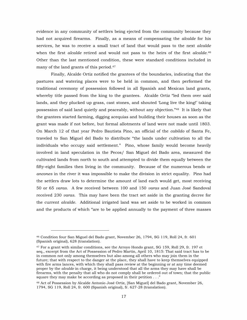
in the 1836 baptisms include: Puertecito [Sena], El Pueblo, El Cerrito, Antón Chico, El
Gusano, Las Mulas, Garambullo, Rio de la Baca, La Entranosa, Pecos, Cañon de Pecos,
Los Trigos.57 The following map shows the location of most of these communities
strung along the Pecos River from El Cerrito on the south to Cañon de Pecos on the
north, well within the Pecos League.
Figure 3. Sena [Puertecito] church.
57 Levine, Our Prayers Are in This Place, 145.
20
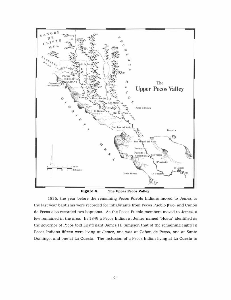
Figure 4. The Upper Pecos Valley.
1836, the year before the remaining Pecos Pueblo Indians moved to Jemez, is
the last year baptisms were recorded for inhabitants from Pecos Pueblo (two) and Cañon
de Pecos also recorded two baptisms. As the Pecos Pueblo members moved to Jemez, a
few remained in the area. In 1849 a Pecos Indian at Jemez named “Hosta” identified as
the governor of Pecos told Lieutenant James H. Simpson that of the remaining eighteen
Pecos Indians fifteen were living at Jemez, one was at Cañon de Pecos, one at Santo
Domingo, and one at La Cuesta. The inclusion of a Pecos Indian living at La Cuesta in
21
1849 shows the diverse nature of the community and probably indicates its
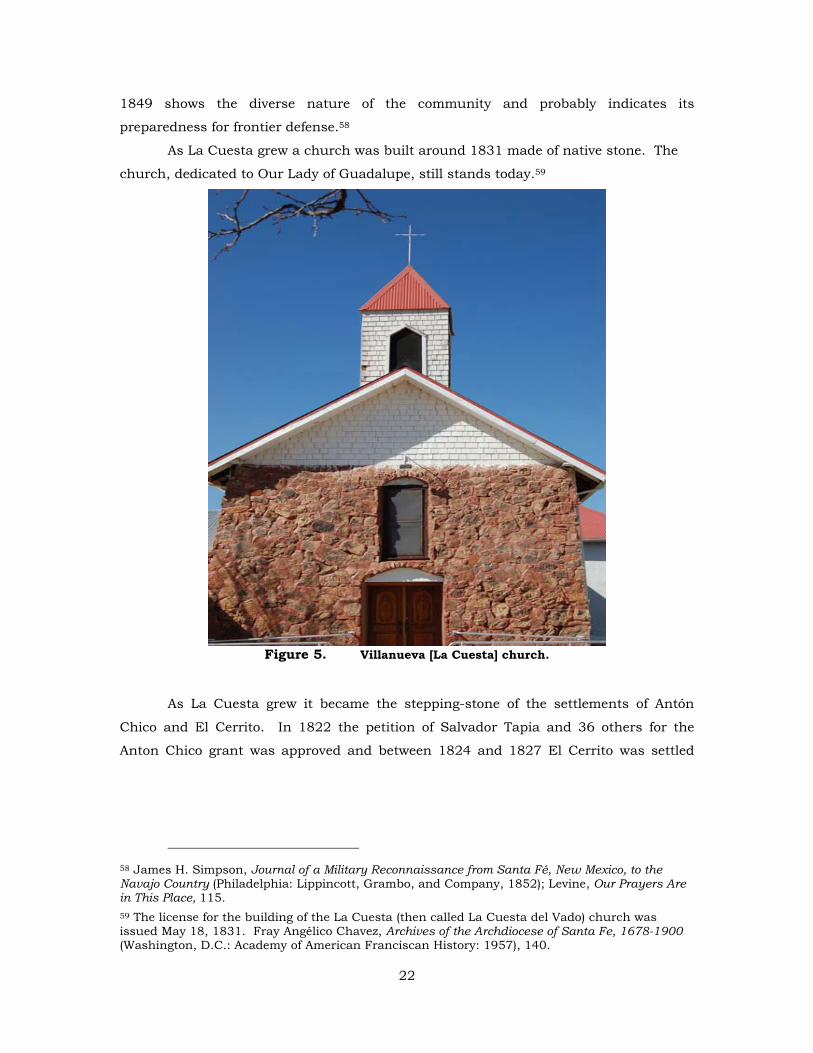
preparedness for frontier defense.58
As La Cuesta grew a church was built around 1831 made of native stone. The
church, dedicated to Our Lady of Guadalupe, still stands today.59
Figure 5. Villanueva [La Cuesta] church.
As La Cuesta grew it became the stepping-stone of the settlements of Antón
Chico and El Cerrito. In 1822 the petition of Salvador Tapia and 36 others for the
Anton Chico grant was approved and between 1824 and 1827 El Cerrito was settled
58 James H. Simpson, Journal of a Military Reconnaissance from Santa Fé, New Mexico, to the Navajo Country (Philadelphia: Lippincott, Grambo, and Company, 1852); Levine, Our Prayers Are in This Place, 115. 59 The license for the building of the La Cuesta (then called La Cuesta del Vado) church was issued May 18, 1831. Fray Angélico Chavez, Archives of the Archdiocese of Santa Fe, 1678-1900 (Washington, D.C.: Academy of American Franciscan History: 1957), 140.
22
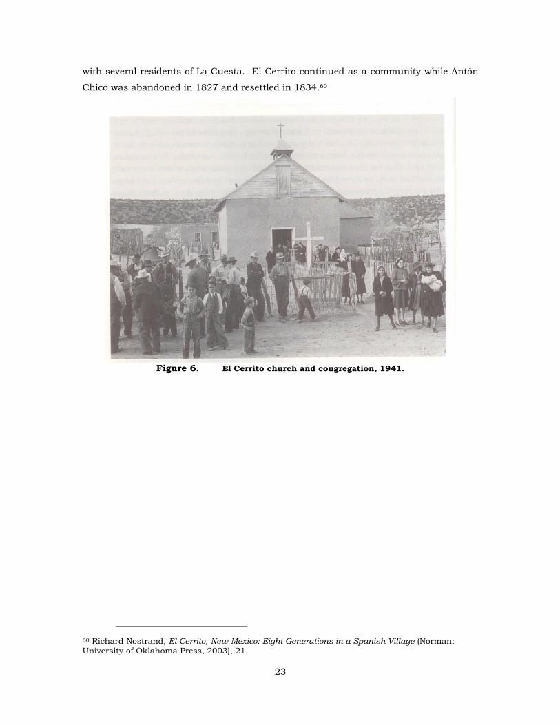
with several residents of La Cuesta. El Cerrito continued as a community while Antón
Chico was abandoned in 1827 and resettled in 1834.60
Figure 6. El Cerrito church and congregation, 1941.
60 Richard Nostrand, El Cerrito, New Mexico: Eight Generations in a Spanish Village (Norman: University of Oklahoma Press, 2003), 21.
23
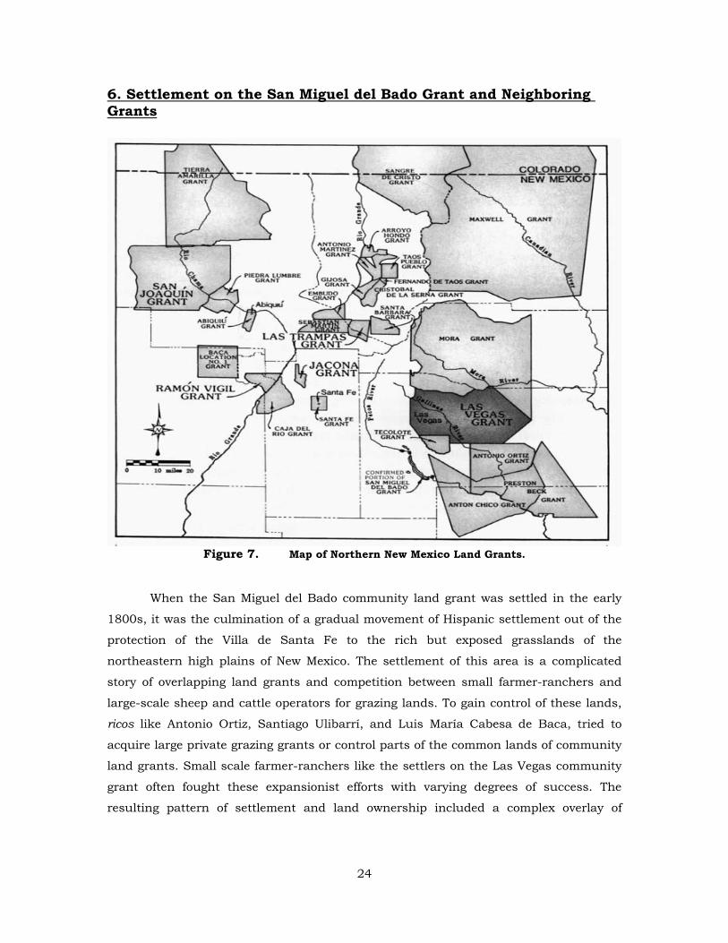
6. Settlement on the San Miguel del Bado Grant and Neighboring Grants
Figure 7. Map of Northern New Mexico Land Grants.
When the San Miguel del Bado community land grant was settled in the early
1800s, it was the culmination of a gradual movement of Hispanic settlement out of the
protection of the Villa de Santa Fe to the rich but exposed grasslands of the
northeastern high plains of New Mexico. The settlement of this area is a complicated
story of overlapping land grants and competition between small farmer-ranchers and
large-scale sheep and cattle operators for grazing lands. To gain control of these lands,
ricos like Antonio Ortiz, Santiago Ulibarrí, and Luis María Cabesa de Baca, tried to
acquire large private grazing grants or control parts of the common lands of community
land grants. Small scale farmer-ranchers like the settlers on the Las Vegas community
grant often fought these expansionist efforts with varying degrees of success. The
resulting pattern of settlement and land ownership included a complex overlay of
24
private and community land grants, several of which are still operating as community
land grants to this day.61
Permanent settlement of the area north and east of the Villa de Santa Fe began
by at least 1794 when the San Miguel del Bado Grant was made by New Mexico
Governor Fernando Chacón to Lorenzo Márquez and fifty-one others, including thirteen
Genízaros (ransomed Plains Indians who lived as Hispanos).62 San Miguel lies twenty
miles downriver from Pecos Pueblo at the place where the trail to the plains, used by
comancheros and ciboleros, crosses the Pecos River. Thus the name San Miguel del
Bado.63 Settlement at San Miguel (then often called simply Bado), took root slowly. It
was not until 1798 that a settler from San Miguel del Bado appeared in the marriage
registers of the Pecos Pueblo parish, and it is likely that settlement on the grant did not
begin until about that time.64 In 1803 formal allotments were made to fifty-eight
families at San Miguel and to forty-seven families at San José, three miles up the Pecos
River.65 By 1811 the San Miguel settlers had finished their church, and in 1812 the
priest at Pecos Pueblo received permission from the diocese in Durángo to move to San
Miguel. By that time San Miguel's population outnumbered that of the once-mighty
Pecos Pueblo which was declining in numbers and complaining about Hispanic
encroachment on their lands. Soon after Mexico's independence from Spain, San Miguel
del Bado elected an ayuntamiento and became the administrative headquarters for the
entire northeastern plains region of New Mexico.66
By 1815 Hispanic settlement had spread beyond the San Miguel del Bado grant,
following the Pecos River north to the Los Trigos grant and to what would become
known as the Alexander Valle grant.67 While this movement up the Pecos was going on,
61 The Las Vegas, Tecolote, and Anton Chico grants are all currently operating as community land grants under the laws of New Mexico. See New Mexico Statutes Annotated (hereinafter N.M.S.A.) Sec. 49-6-1 to 49-6-14 for Las Vegas, Sec. 49-10-1 to 49-10-6 for Tecolote, and Sec. 49-1-11049-1-21 for Anton Chico. 62 For a detailed definition of genízaro, see Steven M. Horvath, “The Genízaros of Eighteenth Century New Mexico: A Reexamination,” Discovery, XII (Fall 1977): 25-40. 63 A vado or bado is a place where one fords a river; a river ford. For the San Miguel del Bado grant see, NMLG-PLC, Roll 35, case 25, frame 664 et seq.; Kessell, Kiva, Cross and Crown; J. J. Bowden, “Private Land Claims in the Southwest,” 6 vols. (LLM thesis, Southern Methodist University, 1969) 3: 734-44; and G. Emlen Hall, “San Miguel del Bado and the Loss of the Common Lands of New Mexico Community Land Grants,” NMHR 66 (October 1991): 413-32. 64 On 28 November 1798, the marriage of Juan de Dios Fernández, a Pecos Indian, to María Armijo, the daughter of grantee Juan Armijo, was recorded in the church records. Kessell, Kiva, Cross and Crown, p. 418. 65 Partition of land by Alcalde Pedro Bautista Pino, San José del Bado, 14 March 1803, SANM I, No. 887. Kessell, Kiva, Cross and Crown, pp. 418–19 and Hall, Four Leagues of Pecos, 5–6. 66 Kessell, Kiva, Cross and Crown, 426–27; Hall, Four Leagues of Pecos, 8. 67 For Los Trigos see NMLG–SG, Roll 13, report 8, frame 310 et seq.; for Alexander Valle see NMLG–SG, Roll 14, report 18, frame 675 et seq. See also, Hall, Four Leagues of Pecos, 17–26.
25
three large grants were being made further east on the high plains, in part to provide
pasture for increasingly large flocks of sheep owned by wealthy ranchers from Santa Fe
and the Rio Abajo region.68 Two of these were private grants and one was a community
grant.
When Santa Fe resident Antonio Ortiz requested a private land grant east of the
San Miguel del Bado Grant in 1818, it appeared as a threat to alcalde Vicente
Villanueva of San Miguel, who objected to the grant because it was contrary to the
interests of the livestock owners of San Miguel del Bado. The alcalde believed that
grazing lands in the area previously available to these ranchers would be closed to them
if the Ortiz grant was made. In spite of this objection Governor Facundo Melgares
granted the land to Antonio Ortiz, who used it to graze his animals.69 Ortiz's sheep
operation was particularly successful; some of his flocks were later herded to California
for sale at a healthy profit in San Francisco and at the gold camps.70
In 1823 Juan Estevan Pino, the son of the famous Pedro Bautista Pino, received
a grant which became known as the Preston Beck grant because of its sale to Beck
twenty years later by Pino's sons and their wives. Pino's grant was bounded on the
north by the Antonio Ortiz grant, and like the Ortiz grant, it had to be abandoned when
Indian raids became too severe.71 Ironically, Navajo depredations in the Rio Abajo area
had been the initial cause of the movement by powerful rancher-merchants to the north
and east in search of greener pastures.72 It is also supremely ironic that fifty years later
Thomas B. Catron acquired the Beck and Ortiz grants once again for their prime
grazing lands.
The Antón Chico community grant thirty miles southeast of San Miguel del Bado
was made to a group of thirty-seven settlers in 1822. Attacks by Comanche and other
Indian tribes caused the abandonment of the grant around 1827, but it was resettled in
1834, and this time the settlement took firm root.73 Since the northern boundary of the
68 John O. Baxter, Las Carneradas: Sheep Trade in New Mexico, 1700–1860 (Albuquerque: University of New Mexico Press, 1987), pp. 92–93 and 125. 69 Antonio Ortiz Grant, NMLG–SG, Roll 17, report 42, frame 407 et seq.; see also Bowden, “Private Land Claims,” 3: 706–10. 70 Baxter, Las Carneradas, 125. 71 Preston Beck Grant, NMLG–SG, Roll 12, report 1, frame 6 et seq.; see also Bowden, “Private Land Claims,” 3: 677–86. Pedro Bautista Pino was New Mexico’s delegate to the Cortes or Spanish parliament held at Cadíz, Spain between 1810 and 1814. For Pino’s report to the Cortes, see H. Bailey Carroll and J. Villasana Haggard, trans. and eds., Three New Mexico Chronicles (Albuquerque: The Quivera Society, 1942). 72 Baxter, Las Carneradas, p. 93. 73 Anton Chico grant, NMLG–SG, Roll 16, report 29, frames 490–et seq.; Bowden, “Private Land Claims,” 3: 689–97; Michael J. Rock, “Anton Chico and Its Patent,” Journal of the West 19 (1980): 86.
26
Antón Chico grant was also the Antonio Ortiz grant, a substantial overlap between the
Beck grant and Antón Chico resulted. This later caused major litigation when both the
grants were confirmed by Congress.74
Another grant made during this period was Tecolote, northeast of San Miguel
and southwest of the later Las Vegas grant. First made in 1824, this community grant
followed the pattern of the earlier San Miguel del Bado and Antón Chico grants, with a
period of partial abandonment after the grant was first made. The 1824 Tecolote grant
was made to six individuals75 but only two of them remained in 1838 when allotments
were made to sixty-nine heads of families at Tecolote and to nineteen at San
Gerónimo.76
The settlement pattern on the Tecolote grant was different than on the two
private grants to Ortiz and Pino, which were grazing grants where sheepherders were
the primary occupants. But Tecolote, as well as San Miguel del Bado and Antón Chico,
were community grants, where groups of settlers established small communities along
the rivers within the grants. These community land grants east of Santa Fe made
settlement on the Las Vegas grant feasible by advancing the settled area closer to those
large grassy meadows — las vegas grandes — so sought after by early land grant
petitioners. One of those early pioneers was Luis Maria Cabesa de Baca, who received
the first grant in the Las Vegas area, a short-lived private grant.
Luis María Cabesa de Baca has been described as one of the most notable men
of his time.77 He lived at Peña Blanca where he owned a ranch purchased from Cochiti
Pueblo. Cochiti's attempt to annul the sale of that land in 1817 involved Cabesa de
Baca in litigation that went all the way up to the Juzgado General de Indios in Mexico
City, before it was decided by the Audiencia de Guadalajara.78 Luis María Cabesa de
Baca was no stranger to litigation. In 1792 he was tried for abusing his position as
74 See Stoneroad v. Beck, 16 N.M. 754, and Stoneroad v. Stoneroad, 158 U.S. 240 (1895). Jones v. St. Louis Land Co., 232 U.S. 355 (1913) deals with the conflict between the Beck and Perea grants and gives priority to the Beck grant. See also, Westphall, Mercedes Reales: Hispanic Land Grants of the Upper Rio Grande Region (Albquerque: University of New Mexico Press, 1983), 222–24. 75 Tecolote grant, NMLG–SG, Roll 13, report 7, frame 6 et seq. 76 SANM, no. 1116. The village of San Gerónimo was actually on the Las Vegas community grant as it was later surveyed in 1899 and 1900. Map of the Las Vegas Grant in San Miguel and Mora Counties, New Mexico as resurveyed by Frank M. Johnson, Bureau of Land Management (BLM), Santa Fe. The earlier 1860 survey of the Las Vegas grant showed even the town of Tecolote to be on the Las Vegas grant, but this overlap between the two grants was later decided in favor of Tecolote. Plat of Las Vegas Grant as finally confirmed, surveyed under contract with the Surveyor General of New Mexico by Pelham and Clements, BLM, Santa Fe. 77 Ralph Emerson Twitchell, The Spanish Archives of New Mexico, 2 vol., (Arthur Clark: Glendale, California, 1914), 1: 376. 78 Charles R. Cutter, The Protector de Indios in Colonial New Mexico, 1659–1821, (Albuquerque: University of New Mexico Press, 1986), pp. 88–93.
27
teniente alcalde of Santo Domingo and mistreating the Indians there.79 In his later
lawsuit with Cochiti Pueblo it was claimed that Cabesa de Baca had used intimidation
and fraud to induce certain members of the pueblo to sell the Peña Blanca land to him.
Santo Domingo was also involved in that litigation, asserting that because their
boundaries had not been measured accurately they were also entitled to some of Baca's
Peña Blanca property. The suit was finally decided in Cochiti's favor in 1819, but
Cabesa de Baca did not vacate the Peña Blanca property when ordered to do so.80
Cabesa de Baca's experience in these cases may have been the impetus for his
seeking a land grant at Las Vegas. His Cochiti lawsuit was consolidated with another
land dispute between Santo Domingo Pueblo and Antonio Ortiz, who received the large
grant south of Las Vegas mentioned earlier. Antonio Ortiz also appears in the records of
Cabesa de Baca's 1792 suit, as alcalde of Santa Fe.81 Cabesa de Baca's acquaintance
with Antonio Ortiz may well have alerted the Peña Blanca ranchero to the availability of
lands north of the Ortiz grant. Moreover, since Cabesa de Baca served for a time as
alcalde of San Miguel del Bado, the Las Vegas area was within his jurisdiction, so he
certainly would have known about the availability of lands there.82
Cabesa de Baca may have pastured his sheep and cattle in the Las Vegas area
for some time before petitioning for a formal land grant. In January 1821 when he
requested a grant of Las Vegas Grandes, he directed the request, not to the governor of
New Mexico as was customary, but to the provincial deputation of Durángo.83 It is not
clear why Cabesa de Baca followed this unusual procedure, but it may have been that
in his travels to Guadalajara to defend the Cochiti litigation he made some connections
in Durángo that assured him favorable action on his petition. Another more telling
reason could be that his position as alcalde of San Miguel del Bado in 1820 posed a
79 In this lawsuit, Luis María Cabesa de Baca was accused of exacting personal service without pay, administering excessive punishment, and interfering with the religious observances of the Santo Domingo Indians. SANM II, No. 1188, Twitchell, Spanish Archives, 2: 342. 80 Cutter, Protector de Indios, pp. 88–92. Cabesa de Baca was assessed with court costs of 192 pesos and 7 reales. Not having the cash to pay these expenses, he was allowed by Governor Facundo Melgares to give the government nine mules valued at 25 pesos each in payment. Melgares to Alejo García Conde, Santa Fe, 18 June 1820, SANM I, no. 1284; Decree of the Real Audiencia de Guadalajara, 18 January 1817, SANM I, no. 1361. 81 SANM I, no. 1362, SANM II, No. 1188. 82 Allotment of land by Alcalde Luis María Cabesa de Baca to Santiago de Jesús Aragón, San Miguel del Bado, 4 October 1820. Stein Collection, document 5, SRCA, Santa Fe. 83 Petition of Luis María Cabesa de Baca, New Mexico, 16 January 1821, NMLG–SG, Roll 14, report 20, frames 1105–o6. It is not clear from this document that it was in fact directed to the Durángo provincial deputation, but the next document in the surveyor general’s file is a purported copy of a grant to Cabesa de Baca by the Provincial Deputation of Durángo.
28
severe conflict of interest, and he sought to avoid the kind of criticism directed at other
large landowners by going to Durángo.84
In any case, Cabesa de Baca chose Durángo as the venue for his solicitations,
submitting at least two petitions to the Durángo provincial deputation, presenting
himself as one of nine petitioners for the grant, all from San Miguel del Bado. The first
grant made by the Durángo authorities was to all nine, but in his second petition
Cabesa de Baca told the diputación that none of his eight former companions had any
interest in the grant, because each had since acquired other lands. Cabesa de Baca
then asked that the grant be reissued to him and his seventeen sons (hijos varones;
actually several were sons-in-law).85 After receiving a favorable report on the petition by
New Mexico governor Facundo Melgares, the provincial deputation acceded to Cabesa
de Baca's second request and revalidated the grant in 1821, with the proviso that if any
of his eight erstwhile co-grantees had incurred any expenses in reliance on the first
grant (such as building houses), he was to reimburse them.86 However, it was not until
1823 when another Baca, New Mexico governor Bartolomé Baca, signed a decree
directing that Cabesa de Baca be placed in possession of the grant by a third Baca, the
alcalde at San Miguel del Bado, Manuel Antonio Baca. The governor's decree quoted the
order of the Durángo provincial deputation verbatim and determined that the provision
about reimbursing the eight companions was not operative because they had not placed
any improvements on the land.87
It does not appear that alcalde Baca actually placed grantee Cabesa de Baca in
possession of the land in 1823, for in February 1825 one of his sons, Juan Antonio,
petitioned the New Mexico territorial deputation asking that a proper document be
issued to his father.88 The same day the diputación agreed to issue the document and
again the alcalde at San Miguel del Bado was directed to place Cabesa de Baca in
84 For an example of criticism of large landowners, see protest against landholdings of Juan Estevan Pino by alcalde Diego Padilla, 17 February 1824, and by Manuel Antonio Baca, 13 March 1824, both from Santa Fe. SANM I, No. 899; for Cabesa de Baca as alcalde see Luis María Cabesa de Baca alcalde, re land of Domingo Benavides, San José del Bado, 24 May 1820. Book 34, pp. 384–85, San Miguel County Deed Records, allotment of land by Alcalde Luis María Cabesa de Baca to Santiago de Jesús Aragón, San Miguel del Bado, 4 October 1820. Stein Collection, document 5, SRCA, Santa Fe. 85 NMLG-SG, Roll 20, report 71, frames 622-24. Proudfit estimated that the grant contained 184,320 acres based on the sketch map submitted by the petitioners. 86 Copy of grant by the provincial deputation of Durángo, 29 May 1821, NMLG–SG, Roll 15, report 20, frames 33–34. 87 Governor Bartolomé Baca to Alcalde Manuel Antonio Baca, Santa Fe, 17 October 1823, NMLG–SG, Roll 15, report 20, frames 33–34. 30. 88 Petition of Juan Antonio Cabesa de Baca to New Mexico territorial deputation, Santa Fe, 15 February 1825. NMLG–SG, Roll 14, report 20, frames 1103–04.
29
possession of the grant.89 But Luis María Cabesa de Baca's quest to possess the land
was to be frustrated for at least two more years. Baca, through his son, stated that on
several occasions he had applied to the alcalde at San Miguel del Bado asking to be put
in possession of his grant at Las Vegas but had been refused.90 In an earlier statement,
alcalde Tomás Sena gave what appears to be a lame excuse for not complying with a
request by two more of Cabesa de Baca's sons, Miguel and Manuel Baca, that the family
be placed in possession. Alcalde Sena said that he had been in the middle of an
election to determine his successor, and to compound things he had become so sick
that he had to send for the priest to hear his confession. He did not explain why he had
not performed his duties either before or after his illness and the election.91 Governor
Narbona's response in 1826 to the Cabesa de Baca appeal forms a terse end to the
documentation of the first grant at Las Vegas: the governor finally ordered Alcalde Sena
to deliver possession of the grant to Cabesa de Baca.92
The reluctance of a series of alcaldes at San Miguel del Bado to place Cabesa de
Baca in possession of his grant seems to arise from the same motive that caused San
Miguel del Bado alcalde Vicente Villanueva to object to the Antonio Ortiz grant. Las
Vegas Grandes, like the Ortiz grant, was probably being used for grazing by the settlers
at San Miguel del Bado who wanted to continue the practice without interference from
the Cabesa de Baca family.
The boundaries of the 1821 grant received by Cabesa de Baca were the Sapello
River on the north, the San Miguel del Bado grant on the south, the Aguaje de la Yegua
and the Antonio Ortiz grant on the east, and the summit of the Pecos mountains (la
cumbre de la sierra de Pecos) on the west.93 These are similar to the boundaries given
for the 1835 Las Vegas community grant. In 1835 the northern and eastern Las Vegas
grant boundaries remained the Sapello River and the Aguaje de la Yegua respectively,
but the southern and western boundaries were different. The Antonio Ortiz grant
became the southern boundary in 1835 instead of one of the eastern boundaries as in
89 Response of New Mexico territorial deputation to petition of Juan Antonio Cabesa de Baca, Santa Fe, 16 February 1825. NMLG–SG, Roll 14, report 20, frame 1109. 90 Juan Antonio Cabesa de Baca to Governor Narbona, Santa Fe, 16 February 1825, NMLG–SG, Roll 15, report 20, frames 30–31, 33. 91 Statement of Tomás Sena, Santa Fe, 13 January 1826, NMLG–SG, Roll 14, report 20, frame 1118. 92 Order of Governor Narbona, Santa Fe, 13 January 1826, NMLG–SG, Roll 14, report 20, frame 1118. 93 Petition of Luis María Cabesa de Baca, 16 January 1821. NMLG–SG, Roll 14, report 20, frames 1105–o6. Cabesa de Baca referred to the Sapello River as the Chapellote River, an earlier variation of the current place name. Chapellote apparently derived from the French–Kiowa proper name Chapalote. T. M. Pearce, ed., New Mexico Place Names: A Geographical Dictionary (Albuquerque: The University of New Mexico Press, 1965), p. 151.
30
1821, and the San Miguel del Bado Grant became the western boundary in 1835
instead of the southern boundary, as it had been in 1821. These changes in the
southern and western boundaries probably meant that the grant to Cabesa de Baca
was larger than the subsequent Las Vegas community grant.94 Thus Luis Maria Cabesa
de Baca had been granted a tract of land probably well in excess of half a million acres
on which to graze his herds of cattle and flocks of sheep.95
Although Cabesa de Baca had indicated his desire to use the grant for farming
as well as cattle-raising, no evidence has been found that he or his sons ever irrigated
any farmland. The only indication of the settlement of the Baca family on the grant is
the testimony of witnesses before the surveyor general and at least one contemporary
account. José Francisco Salas, a shepherd for Luis María Cabesa de Baca, testified that
he had cared for as many as three thousand sheep on the grant. He said that Cabesa de
Baca had built a hut at the Loma Montosa and remained on the grant off and on for ten
years before Pawnee Indians finally drove him off. The Cabesa de Baca family is said to
have retreated several times to settled areas when the Indians took all their horses, but
they returned to the grant when things quieted down. They were forced to abandon the
grant in the end, however, and later claimed to have suffered losses totalling $36,000
when six hundred of their mules and horses were driven off by hostile Indians.96
Historian Charles Cutter says that Cabesa de Baca never left Peña Blanca, because
several letters sent during the Mexican Period were posted by Baca from Peña Blanca.
Cabesa de Baca is said to have died there in 1833. It is likely that the activity on the
grant testified to by Salas was by other members of the Cabesa de Baca family, like the
son, Antonio Baca, not Luis Maria.97
The Cabesa de Baca family apparently still occupied the grant by 1831, for in
that year Santa Fe Trail chronicler Josiah Gregg reported finding a large flock of sheep
grazing near the Gallinas River and "a little hovel at the foot of a cliff [which] showed it
to be a rancho. A swarthy ranchero soon made his appearance, from whom we procured
a treat of goat's milk."98 This was probably Cabesa de Baca's shepherd and his sheep.
94 The Baca heirs stated in their petition to the surveyor general of New Mexico that the two grants covered the same lands. NMLG–SG, Roll 14, report 20, frames 1125–28. House Exec. Doc. No. 14, 36th Cong., 1st Sess., p. 1. 95 The 1860 survey of the Las Vegas grant showed it to contain 496,446.96 acres. Plat of Las Vegas Grant by Deputy Surveyors Pelham and Clements, 8 December 1860, BLM, Santa Fe. Bowden, “Private Land Claims,” 3: 787–88. 96 Affidavit of José Francisco Salas, NMLG–SG, Roll 14, frames 1155–62; House Exec. Doc. No. 14, 36th Cong., 1st Sess., p. 2. 97 Cutter, Protector de Indios, p. 92, note 29. 98 Josiah Gregg, Commerce on the Prairies, pp. 76–77.
31
While the Cabesa de Baca family was being harried by Indian attacks, similar
depredations were occurring south of Las Vegas. In October 1826, three shepherds were
scalped by Indians near Tecolote, though they lived to tell their tale. The authorities in
San Miguel del Bado sent out an eight man scouting party to search for the offenders,
without success.99 By 1829 a detachment of troops from San Miguel del Bado was
patrolling the Las Vegas area, then called "Vegas de las Gallinas." Their commander,
José Caballero, reported that his soldiers were complaining about their lack of wages
and he made a plea to the comandante principal that they be paid forthwith.100 Instead
of being paid, however, this same detachment was called back to San Miguel del Bado
by alcalde Santiago Ulibarrí in June 1829, because there were insufficient troops and
equipment to adequately patrol the area. Although the withdrawal was under orders,
the soldiers were charged with cowardice! They answered by stating that their
thankless task of protecting settlers without adequate pay or even food made them
worse off than the residents themselves, who were herding livestock under military
protection at Las Vegas.101 Thus it appears that some military protection was being
afforded and that settlers (probably the Cabesa de Baca family) were still herding sheep
in the Las Vegas area in 1829.
Undoubtedly the establishment of a more or less permanent detachment of
troops at San Miguel del Bado encouraged the settlement of outlying areas in the years
to follow. The detachment of Santa Fe presidio soldiers at San Miguel was carried out as
a separate company on military records and it assumed major importance beginning in
1827.102 In that year the Bado company (along with Taos) was allotted almost two
thousand pesos and was regularly provided with lances, parts for pistols and carbines,
and trinkets as gifts to placate hostile Plains Indians.103
The mission of the detachment at San Miguel del Bado was not only to protect
settlers against Indian incursions but also to prevent smuggling and import tax evasion
along the Santa Fe Trail. Until 1835, when the customs house was moved from Santa
Fe to San Miguel, it was common practice for Santa Fe residents to meet the incoming
99 Mexican Archives of New Mexico (MANM), Roll 5, frame 560. Cited in Anselmo E. Arellano, “Through Thick and Thin: Evolutionary Transitions of Las Vegas Grandes and its Pobladores (Ph.D. diss., University of New Mexico, 1990), pp. 26–27, note 38. 100 MANM, Roll 9, frame 641, Arellano, “Las Vegas Grandes,” p. 44, note 79. 101 MANM, Roll 9, frames 851–53, Arellano, “Las Vegas Grandes,” p. 44–45, notes 80–81. 102 Although Mexican law provided that New Mexico should have three presidial companies, each with six officers and one hundred men, throughout the Mexican period Santa Fe was the only formal presidio in New Mexico. Law of 21 March 1826, cited in Daniel Tyler, “New Mexico in the 1820’s: The First Administration of Manuel Armijo,” (Ph.D. dissertation, University of New Mexico, 1970), pp. 162–64. 103 Tyler, “New Mexico in the 1820s,” pp. 169, 179 and 181.
32
caravan from the states and purchase goods at lower prices than were charged after the
merchants had paid their custom duties. The traders had many ingenious ways of
reducing these import taxes, which were based on the number of wagons in the
caravan. These devices included repacking their goods on fewer wagons or sending
some of them by a different route before they reached Santa Fe.104 To prevent these
practices, a detachment of troops often escorted the incoming caravans from some
predetermined point to the customs house. In 1837 that point of contact was near Las
Vegas at the Paraje del Puertecito. In June of that year, Vicente Rivera reported that he
had encountered twenty carts and three wagons with three or four more coming from
Las Vegas behind them. Rivera reported that he would escort the wagons until he
handed them over to the governor.105 All this military activity in the area provided more
protection for groups of new settlers, thus encouraging permanent settlement of the Las
Vegas grant.106
The first wave of settlement in the Las Vegas area occurred in the mid 1830s,
brought about not only by increased military presence but also by population pressure
from San Miguel. The need for new settlements was explained to the governor in a
lengthy petition sent by parish priest José Francisco Leyba of San Miguel,
recommending that the Mexican government take specific steps to establish such
communities. Father Leyba was one of a handful of New Mexican priests who were
becoming involved in political issues in the wake of Mexican Independence.107 Father
Leyba's 1831 petition complained about the population increase at San Miguel del Bado
and recommended that lands in the northeastern part of New Mexico be settled by
those in need of farm land. The priest specifically mentioned Las Vegas, Sapello, and
Ocate as places where land was available. He suggested that the government assist
prospective settlers by providing them with oxen and farming tools such as axes and
hoes. Father Leyba argued that settlement of these lands would protect the interior
settlements from Indian attacks by providing a buffer zone, would relieve the population
pressure at San Miguel del Bado, and would provide an outlet for vagrants whose
numbers were increasing there. The San Miguel priest pointed out that a major
inducement for settlement of these northern areas (particularly Las Vegas), was the
104 Tyler, “New Mexico in the 1820s,” pp. 99, 150–51. 105 Vicente Rivera to Governor Albino Perez, Paraje del Puertecito de las Vegas, 27 June 1837, MANM, Roll 23, frames 392–93. 106 MANM, Roll 9, frame 377. 107 Other priests involved in governmental affairs in New Mexico at this time were Antonio José Martínez, José Manuel Gallegos, Francisco Ignacio de Madariaga, and the vicar Juan Felipe Ortiz. Fray Angelico Chávez, Tres Macho–He Said: Padre Gallegos of Albuquerque (Santa Fe: William Gannon, 1985), p. 12.
33
ready availability of water from the Pecos River. Father Leyba contrasted the never-
failing water supply of the Pecos with the inadequate flow of the Rio del Norte (Rio
Grande) and the Rio Puerco. He said that the abundant water would allow agriculture
to flourish and the plentiful pastures would sustain vast flocks of sheep and herds of
cattle.108
In response to Father Leyba's petition a committee was established that
endorsed the priest's proposal, recommending that the governor submit a copy to
Mexico City requesting the necessary funds to carry out the project.109 When no action
was taken by the governor, the ayuntamiento of San Miguel del Bado directed an appeal
to the ayuntamiento of Santa Fe. In language similar to that of Father Leyba's petition,
the San Miguel ayuntamiento extolled the virtues of establishing new settlements at
Vegas, Sapello, Ocate, and other places, emphasizing the abundance of pasture and
water at these spots, and stating somewhat cynically, that it did not expect an answer
from the governor or the diputación. Nevertheless, said the San Miguel ayuntamiento,
the proposed settlements could be established without their help. The Santa Fe
ayuntamiento agreed suggesting that the ayuntamientos themselves make loans to the
settlers and that they cooperate with each other, as well as with the governor and the
territorial deputation, in enforcing the vagrancy law.110
Under the 1828 Ley de Vagos, tribunals were to be established to determine who
was a vagrant and then to give such a person three choices: to be drafted into the
military, to go to prison, or to participate in settling new lands on the frontier.111 The
proposal of the San Miguel ayuntamiento was a means of facilitating the third
alternative. But there appears to have been no response to its appeal, and eventually
the Las Vegas community grant was settled without any government subsidies.112
The San Miguel del Bado ayuntamiento not only promoted the idea of settling
Las Vegas, but some of its members actually joined the settlement there. When the
grant was made in 1835, and additional allotments were distributed in 1841, three
108 José Francisco Leyba to the diputación, San Miguel del Bado, 17 June 1831. MANM, Roll 13, frame 613–19. Arellano, Las Vegas Grandes, pp. 55–61. 109 Report of committee of Abreu, Martínez, and Sandoval to the diputación, Santa Fe, 4 August 1831. MANM, Roll 13, frame 589–90. 110 Ayuntamiento of San Miguel del Bado to the Ayuntamiento of Santa Fe, San Miguel del Bado, 8 February 1832, SANM I, No. 1123. 111 Arellano, Las Vegas Grandes, p. 59–60. 112 An example of a settlement actually subsidized by the Spanish government is San Antonio de Bejar (San Antonio, Texas), settled by a group of families from the Canary Islands. These settlers were furnished with transportation and one year’s subsistence, including food, household goods, horses, mules, oxen, and farming tools. Lota M. Spell, “The Grant and First Survey of the City of San Antonio,” Southwestern Historical Quarterly, 66 (July 1962): 73–89.
34
members of the San Miguel ayuntamiento received allotments.113 This activity by
members of the ayuntamiento is in marked contrast to the alcalde who opposed the
making of the Antonio Ortiz grant in 1819 because it would interfere with the grazing
rights of the sheep and cattle growers of San Miguel del Bado. Several factors could
explain this shift. Once the grant had been made to Cabesa de Baca, the ayuntamiento
knew that someone would use this land if and when the Cabesa de Baca family
abandoned it, and it might as well be the San Miguel del Bado vecinos. Also, the severe
losses suffered by cattle and sheep growers due to Indian depredations would be curbed
if Las Vegas became a permanent settlement with occasional military protection. And
finally, as Father Leyba and the 1832 ayuntamientos had pointed out, population
pressure was an important motive for expansion. Instead of opposing a grant to an
outsider, the ayuntamiento members were becoming part owners of the grant
themselves.114 The Las Vegas grant was made in 1835 and settled in 1838.
7. Adjudication of the San Miguel del Bado Grant
The issue before the U.S. Supreme Court in the 1897 Sandoval case was who
owned the common lands of a community land grant: the community or the
government. The possibility that the government might own the common lands was
raised in the Court of Private Land Claims by Mathew Reynolds in his response to the
petition by Julian Sandoval et al. Reynolds interpreted the grant documents as
conveying title to the allotted lands only and cited come works on Spanish law to that
effect. Because the Sandoval case was so important in changing the way the courts
dealt with common lands of community grants (prior to Sandoval common lands were
confirmed to land grants like Anton Chico, Truchas, and Las Vegas), a discussion on a
different view of common land ownership under Spanish law is provided.
Adjudication of the San Miguel del Bado Grant was complicated by the fact that
several theories of ownership of the grant were put forth during the course of
adjudication. In addition multiple claimants were involved during the period from 1857
when the first petition was filed, until 1897 when U.S. v. Sandoval was decided rejecting
ownership of the 315,300 acres of common lands by the San Miguel del Bado Grant.
Speculators that included Surveyor General Henry Atkinson, held the view that the
entire grant was owned by Lorenzo Marquez and his heirs; thus if someone like Henry
113 Francisco Sena received 200 varas, José Flores, one allotment of 75 varas and another of 100 varas; and José Ulibarrí 125 varas. NMLG–SG, Roll 15, report 20, frames 17–21. 114 Even before Father Leyba’s proposal, Juan Estevan Pino had proposed that a military fort be established on the Canadian River, which would have the effect of protecting his land holdings and the Las Vegas area. MANM, Roll 9, frames 1119–22. Arellano, Las Vegas Grandes, pp. 53–55.
35
Atkinson could get a deed from the heirs of Lorenzo Marquez he would own the entire
grant.115
The second theory was ownership of the entire grant (both private and common
lands), by the inhabitants of the grant. The third theory was ownership of the private
lands by the occupants of the grant and ownership of the common lands by the U.S.
government as successor to the governments of Spain and Mexico.
The first petition in the adjudication asserted the second theory of ownership;
unfortunately the theory was asserted in a claim made to Surveyor General Henry M.
Atkinson who believed in the first theory of ownership because it was in his interest as
a land speculator.116 Faustín Baca y Ortiz, the Justice of the Peace of San Miguel del
Vado, filed the first petition on March 18, 1857, in the name of the inhabitants of the
settlements of La Cuesta, San Miguel, Las Mulas, El Pueblo, Puerticito, San José,
Guzano, and Bernal, seeking the confirmation of the San Miguel del Vado Grant before
the Surveyor General.117 On November 13, 1879, Surveyor General Atkinson made his
report to Congress. He noted that while the grant had been requested by and issued to
Lorenzo Marquez for himself and his fifty-one associates, the names of these associates
were not listed in any of the grant papers. Atkinson contended that the law was clear
that title could vest only in persons who either had been named or so clearly described
as to leave no question as to who they were. Therefore, he recommended that the grant
be confirmed to the heirs, legal representatives and assigns of Lorenzo Marquez.118 A
preliminary survey of this claim was made in November and December, 1879, by
Deputy Surveyor John Shaw, showing the grant to contain 315,300.80 acres. Surveyor
General George W. Julian reinvestigated the claim and in a supplemental report dated
December 6, 1886, recommended the confirmation of the grant to the heirs, legal
representatives and assigns of Lorenzo Marquez for themselves and in trust for the
heirs and legal representatives of the other grantees referred to in the grant papers.119
The Commissioner of the General Land Office advised Secretary of Interior L. Q. C.
115 This is what Atkinson did in 1883 in the case of the Anton Chico grant when he ruled that the grant, made to Manuel Rivera and thirty-six unnamed others was owned solely by Manuel Rivera even as he has purchased the interests of Manuel Rivera. Ownership by one person was the first theory of ownership of the San Miguel del Bado grant. Ebright, Land Grants and Lawsuits, 41-2. 116 The three theories of ownership asserted in the San Miguel del Bado adjudication are similar to the theories set forth in the Las Vegas grant adjudication. Ebright, Land Grants and Lawsuits, 209. 117 Petition of Justice of the Peace Faustín Baca y Ortiz for confirmation of the San Miguel del Bado Grant, March 18, 1857, San Miguel del Bado Grant. SG 119, Roll 24, fr. 618-19. 118 Opinion by Surveyor General Atkinson, San Miguel del Bado grant, November 13, 1879, SG 119, Roll 24, fr. 652-57. For Atkinson’s ownership of the grant see letter from Breedin to George W. Julian, Las Vegas, December 10, 1886. San Miguel del Bado Grant, SG 119, Roll 24, fr. 737. 119 Opinion of Surveyor General Julian, San Miguel del Bado grant, SG 119, Roll 24, fr. 674-79.
36
Lamar on May 13, 1887 that he believed the survey was grossly in excess of the
quantity which originally had been granted. He, therefore, recommended that in the
event Congress confirmed the claim that it be limited to the land actually occupied by
the inhabitants of the grant. Notwithstanding all of these proceedings, no action was
taken by Congress in reference to the grant, either looking towards its confirmation or
rejection.”120
After the Court of Private Land claims was established in 1891, three suits were
filed seeking the recognition of three conflicting claims to the [San Miguel del Bado]
grant. The first was filed on August 2, 1892, by Julian Sandoval, Gregorio Roybal,
Angel Dimas, Catarino Sena, Thomas Gonzales, Juan Gallegos and Ramon Gallegos, on
their own behalf and as agents of the residents and settlers upon the grant for
confirmation of their claim to the lands covered by the grant.121 The second suit was
filed on January 16, 1893, by Levi P. Morton, who claimed to be the owner of the grant
by virtue of conveyances from the heirs of Lorenzo Marquez.122 Morton was
“an enormously successful businessman and an equally successful politician. Morton had been elected to Congress from New York in 1877 and subsequently served as United States ambassador to France from 1881-1885, Vice President of the United States during the Harrison administration (1889-1893), and governor of New York from 1895-1896). . . Morton’s interest in the grant stemmed primarily from the fact that the Atchison, Topeka and Santa Fe Railroad Company . . . was building their main line directly through the grant and Morton’s investment company, Morton, Bliss and Company, had a history of investing in western railroads that dated back to 1870.”123
The third suit was filed on March 2, 1893, by Juan Marquez and Sylvester Marquez for
themselves and the other heirs and legal representatives of Lorenzo Marquez for the
recognition of their claim to the grant. Both Morton and Juan and Sylvester Marquez
claimed that Lorenzo Marquez took title to the entire grant because the other fifty-one
grantees were not named in the testimonio. The three cases were consolidated for
purposes of the trial since all three claims covered the same lands and were based on
120 J. J. Bowden, “Private Land Claims in the Southwest,” 3: 740. 121 Petition of Julian Sandoval, et al, August 2 1893, San Miguel del Bado grant, PLC 2, Roll 35, fr. 656-62; Bowden, “Private Land Claims,” 3: 741-42. 122 Petition by Levi Morton, January 16, 1893, San Miguel del Bado Grant, PLC 60, Roll 40, frames 7-9; Bowden, “Private Land Claims,” 3: 741-42. 123 Mark Schiller, “The Adjudication of the San Miguel del Vado Grant and the Overturning of the Presumption that Title to the Commons Vested in the Settlers,” a chapter in “Adjudicating Empire” unpublished manuscript in possession of the author. For a study of Morton’s investment company see Dolores Breitman Greenberg, Financiers and the Railroads 1869-1889: A Case Study of Morton, Bliss and Co., Masters Thesis, Department of History, Cornell University, 1972 cited by Schiller.
37
the same grant.”124 “The consolidated case came up for trial on April 18, 1894, the
validity of the grant papers was recognized by the government, but it denied that the
grant covered any lands which had not been allocated prior to 1846. A majority of the
court rejected this contention. Next, the court proceeded to resolve the conflicting
claims presented by the plaintiffs by holding that the distribution of the individual
tracts in 1803 rendered certain the identity of the grantees. The court dismissed the
suits filed by Levi Morton and Juan and Sylvester Marquez and confirmed title to the
entire grant in the name of Lorenzo Marquez and his co-petitioners and all other
persons who had settled upon the grant prior to December 30, 1848.125 The
government appealed the decision to the United States Supreme Court which reversed
the Court of Private Land Claims and held that title to the unallocated lands within the
exterior boundaries of the grant passed to the United States under the Treaty of
Guadalupe Hidalgo. The Supreme Court then ordered the Court of Private Land Claims
to determine the extent of the allocated lands and confirm title in the grant only to the
extent of those occupied allocated lands.126
The theory of Matthew Reynolds and of the U.S. Supreme Court upon which the
Sandoval decision was based was that the Spanish — and then the Mexican —
government owned the common lands, so the United States (and not the heirs of the
San Miguel del Bado grant) inherited that ownership as successor sovereign. The
question of the ownership of the common lands has both legal and historical
implications. Because the Supreme Court decided this question without the necessary
historical facts and Spanish legal authority before it, a legal and historical distortion
resulted. Unfortunately, historians like Ralph Emerson Twitchell have perpetuated this
error by quoting these and other similar cases in their writings about Hispanic land
tenure, instead of engaging in independent research on the ownership of the common
lands of a community land grant.127
124 Petition of Juan and Sylvester Marquez, March 2, 1893, San Miguel del Bado Grant, PLC 198, Roll 51, fr. 519-21; Bowden, “Private Land Claims,” 3: 741-42. 125 Bowden, “Private Land Claims,” 3: 741-42; Mark Schiller, “The Adjudication of the San Miguel del Vado Grant and the Overturning of the Presumption that Title to the Commons Vested in the Settlers,” unpublished manuscript, 20-27. 126 U.S. v. Sandoval, 167 US 278 (1897); Bowden, “Private Land Claims,” 3: 741-42. 127 Twitchell’s discussion of the ownership of property in a villa or other settlement in the nature of a community grant paraphrases or quotes at length (without quotation marks) from United States v. Santa Fe, 165 U.S. 675, 683 ff. (1897), which in turn is quoted in United States v. Sandoval, pp. 295-97; Ralph Emerson Twitchell, Old Santa Fe (1925; reprint ed., Chicago: The Rio Grande Press, 1963), pp. 37-38.
38
Such research would have revealed the legal history of the Castilian land-owning
pueblo that took root in New Mexico,128 of which the Supreme Court was not made
aware. The lands owned by the Castilian pueblo were generally distinguished from the
lands owned by the king. Crown lands that had not been granted to individuals or
communities were called tierras realengas or tierras baldías. In sixteenth-century
Castile, the monarchs followed a policy of protecting the lands of the pueblos — the
tierras concegiles. Numerous laws were enacted to safeguard the tierras concegiles from
usurpation by the nobility, by municipal officials, or by ordinary citizens.129
The common lands of a New Mexican community land grant were like the tierras
concegiles in Spain. While both the tierras baldías and the tierras concegiles fell into the
broad classification of public domain, civil law countries like Spain had two classes of
public domain: the public domain proper, which was owned by the sovereign, and the
private domain, which was owned by communities and municipalities. The former was
the tierras baldías and the latter was the tierras concegiles. The importance of this
distinction is that under international law, which the Land Claims Court was supposed
to follow, the public domain passes to a successor state when there is a change of
sovereignty (as when New Mexico was occupied by the United States), but the private
domain is retained by the communities and municipalities just as private property of
individuals is retained by its owners.130 This well-established rule could have disposed
of the question of ownership of the common lands of the San Joaquín and other
community land grants. But it was overlooked, by both the lawyers and the judges
charged with deciding the important question of common land ownership.
Also overlooked were three types of Spanish law germane to this issue: codified
law, commentaries on codified law, and Spanish custom. The foremost Spanish law
code, which was still in effect at the time of the United States invasion of New Mexico,
was Las Siete Partidas. Partida 3, título 28, ley 9, spells out the ownership of pueblo
128 Vassberg, “The Tierras Baldías,” p. 400. The distinction between the tierras baldías and the tierras concegiles was not always clear in practice. Because of this, sixteenth-century Castilian monarchs were sometimes able to exact pay-ment from municipalities for land used by them. Presumably, however, the tierras concegiles that had been granted to a municipality were exempt from such payments. Vassberg, “The Sale of Tierras Baldías in Sixteenth-century Castile,” Journal of Modern History 47 (December 1975); 631-33, 637-38. 129 David E. Vassberg, “The Spanish Background: Problems Concerning Ownership, Usurpations, and Defense of Common Lands in 16th Century Castile,” in Malcolm Ebright, ed., Spanish and Mexican Land Grants and the Law (Manhattan, Kansas: Sunflower University Press, 1989), and Vassberg, “Tierras Baldías,” p. 400. 130 John L. Walker, “The Treatment of Private Property in International Law After State Succession,” pp. 65-68, 74, in “Land, Law and La Raza” (A collection of papers presented for Professor Theodore Parnall’s seminar in comparative law, UNM School of Law, Fall Semester, 1972), and Daniel Patrick O’Connell, State Succession in Municipal Law and International Law, 2 vols. (London: Cambridge University Press, 1967), 1: 200.
39
lands by the community: “[the things which] belong separately to the commons of cities
or towns are . . . the exidos, . . . forests, and pastures, and all other similar places
which have been established and granted for the common use of each city or town.”131
This would appear to negate ownership of the commons by the King.
The Recopilación de Leyes de Reynos de las Indias dealt with the procedural
problems of forming settlements in the Americas but had little to say about the
substantive law concerning ownership of property; these matters were covered in earlier
codes like Las Siete Partidas, which the Recopilación specifically made applicable to the
Americas.132 The Mexican Colonization Law of 1824 and the regulations issued under
that law in 1828 were the first comprehensive legislation regarding New Mexico land
grants. Article 2 of the 1824 law recognized the traditional ownership of the common
lands by the pueblo when it stated: "the object of this law is those lands of the nation,
not being private property nor belonging to any corporation or pueblo, and can [therefore]
be colonized" [emphasis added].133
There were numerous Spanish law codes, but none was truly comprehensive.
Instead of providing that later ones would supersede earlier ones, Spanish officials
allowed them to overlap and duplicate one another. For this reason it was necessary for
legal scholars to synthesize and summarize the authorities on various points of law. The
works of Mariano Galván-Rivera are often cited and he is considered one of the leading
authorities in the field of land and water law. Galván-Rivera's primary work, Tierras y
Aguas, which was attached as an appendix to Escriche's authoritative Diccionario
Razonado de Legislación y Jurisprudencia, aptly summarizes the situation regarding the
ownership of the common lands of a community land grant: “they [the kings] had to
cede to the settlements of America and to their councils . . . a certain portion of lands
which they could use for their subsistence and betterment, making use of the pastures
and farming lands. . . . These lands they immediately named according to their kind,
ownership, and use: concegiles or propios.”134
131 Apartadamente son del comun de cada una Ciudad o Villa. . . ejidos. . . los montes, e las dehesas, e todos los otros lugares semejantes destos, que son establecidos, e otorgados para pro comunal de cada Ciudad, o Villa. Las Siete Partidas del sabio rey don Alfonso el X, glosadas por el lic. Gregorio Lopez, 4 vols. (Madrid: Oficina de d. Leon Amarita, 1829-1831), and Samuel Parsons Scott, trans. Las Siete Partidas (Chicago: Commerce Clearing House, 1931). 132 Recopilación, Libro 2: título 1, ley 2. 133 Son objeto de esta ley aquellos terrenos de la nación, que no siendo de propiedad particular, ni pertenecientes a corporación alguna ó pueblo, pueden ser colonizados. Decreto del 18 de Agosto de 1824, sobre colonization, Manuel Dublán and José María Lozano, Legislación Mexicana, 19 vols. (Mexico: Imprenta del Comercio, 1876-1890) 1: 712, translated in Frederic Hall, The Laws of Mexico (San Francisco: A. L. Bancroft, 1885), p. 148. 134 “. . . tuvieron por bien SS. MM. ceder á las poblaciones de América y á los concejos de ellas, . . . cierta porcion de terrenos, para que acudiesen á su subsistancia y mejoramiento, usufructuándolas
40
The third type of Hispanic law, custom and usage, is the most important for New
Mexico. As we have seen, since there were few law books or lawyers in New Mexico prior
to American occupation, disputes about land ownership were settled in traditional
ways, which were considered binding and accepted by all sides.135 Though falling under
the classification of customary law, this litigation was usually written down and was
characterized by a formality somewhat amazing considering the frontier setting in which
it took place. The parties were often adept at the use of persuasive techniques and legal
procedures generally reserved to trained lawyers.136
After studying all of New Mexico's community land grants, Daniel Tyler came to
the conclusion that: "the ejido (common lands) belonged to the community to which it
was appurtenant." In two of the grants he studied the alcalde promised the settlers a
title to their ejidos, leaving no doubt that these common lands were owned by the
community.137 Moreover, other community land grant documents show that when the
private tracts were transferred to the individual grantees, this land carried with it the
right to use the common lands. Hispanic settlers received title to their house lots and
farm lands as individuals and title to the common lands as a group (de mancomún).138
This connection between the private tracts and the common lands is seen in the
granting decree for the Las Trampas grant where title to the grant was transferred "to
all in common and to each one in particular, in their private lands and the rest which is
attached [to the private tracts]."139 Then when the individual tracts were distributed, the
settlers received their private land together "with corresponding water, pastures, and
watering places."140
en pastos y labores, . . . Estos terrenos se denominaron inmediatamente conforme á sus clases, pertenencia y usos, concejiles ó de propios.” Mariano Galván-Rivera, Ordenanzas de Tierras y Aguas . . . Dictadas Sobre la Materia y Vigentes Hasta el Dia en la Republica Mejicana, published as a supplement to Joaquín Escriche’s Diccionario Razonado de Legislación y Jurisprudencia (Paris: Librería Rosa y Bouret, [1863]), p. 187. 135 Simmons, Spanish Government in New Mexico (Albuquerque: University of New Mexico Press, 1968; 1990), pp. 176-77; see also, chapter 2, Ebright, Land Grants and Lawsuits, “Lawsuits, Litigants, and Custom in Spanish and Mexican Period New Mexico.” 136 For an example of such litigation see chapter 3, Ebright, Land Grants and Lawsuits, “Manuel Martínez’s Ditch Dispute.” 137 Las Huertas Grant, NMLG-SG, Roll 26, report 144, frame 8; Refugio Colony Grant, NMLG-SG, Roll 22, report 90; Daniel Tyler, “Ejido Lands in New Mexico,” in Malcolm Ebright, ed. Spanish and Mexican Land Grants and the Law (Manhattan, Kansas: Sunflower University Press, 1989), pp. 24-35. 138 Tyler, “Ejido Lands in New Mexico,” p. 26. 139 “a todos juntos y en particular en su pertenencia y para lo demas anexo.” NMLG-SG, Roll 16, report 27, frames 259-62. 140 “con sus aguas pastos y abrevaderos.” NMLG-SG, Roll 16, report 27, frames 259-62.
41
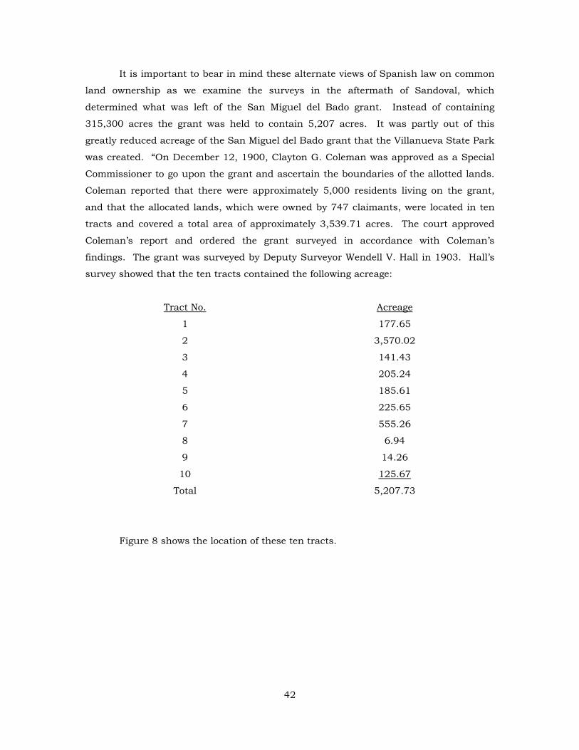
It is important to bear in mind these alternate views of Spanish law on common
land ownership as we examine the surveys in the aftermath of Sandoval, which
determined what was left of the San Miguel del Bado grant. Instead of containing
315,300 acres the grant was held to contain 5,207 acres. It was partly out of this
greatly reduced acreage of the San Miguel del Bado grant that the Villanueva State Park
was created. “On December 12, 1900, Clayton G. Coleman was approved as a Special
Commissioner to go upon the grant and ascertain the boundaries of the allotted lands.
Coleman reported that there were approximately 5,000 residents living on the grant,
and that the allocated lands, which were owned by 747 claimants, were located in ten
tracts and covered a total area of approximately 3,539.71 acres. The court approved
Coleman’s report and ordered the grant surveyed in accordance with Coleman’s
findings. The grant was surveyed by Deputy Surveyor Wendell V. Hall in 1903. Hall’s
survey showed that the ten tracts contained the following acreage:
Tract No. Acreage
1 177.65
2 3,570.02
3 141.43
4 205.24
5 185.61
6 225.65
7 555.26
8 6.94
9 14.26
10 125.67
Total 5,207.73
Figure 8 shows the location of these ten tracts.
42
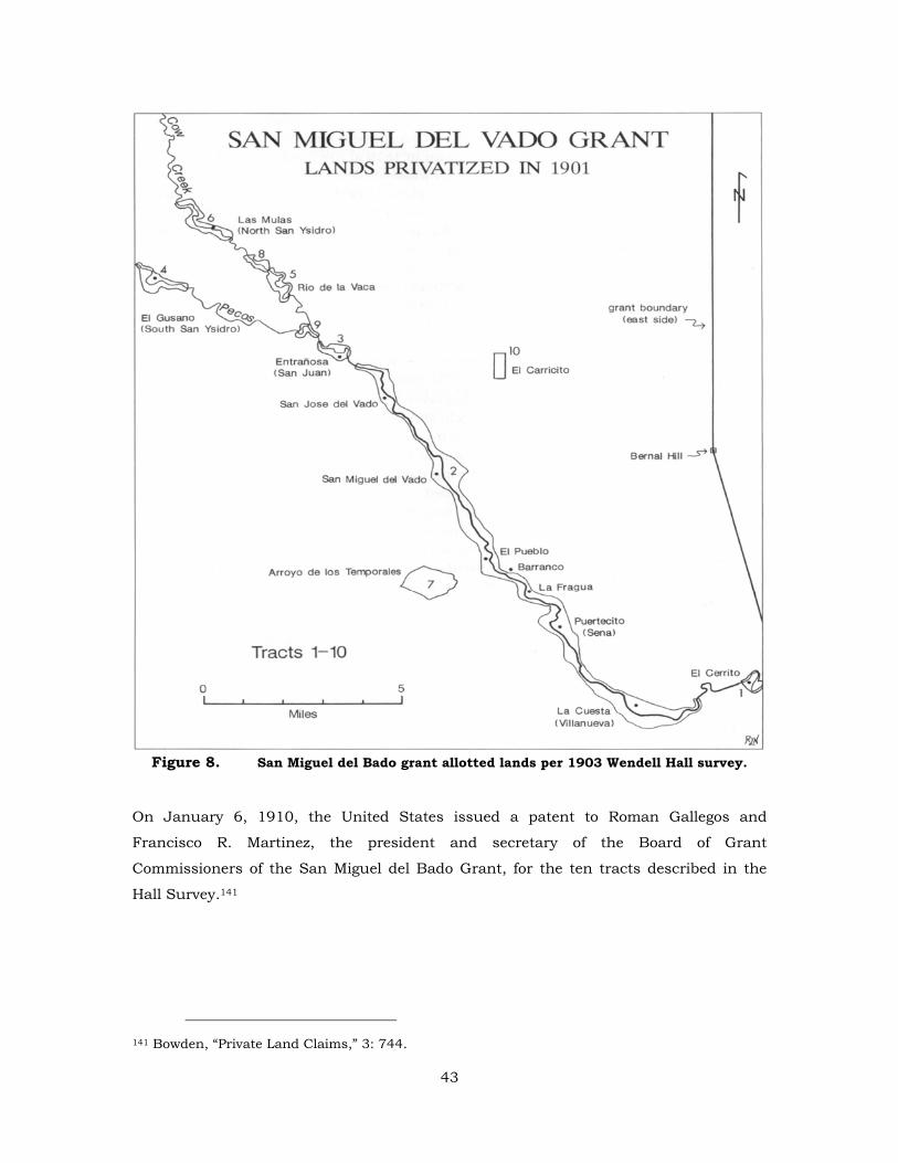
Figure 8. San Miguel del Bado grant allotted lands per 1903 Wendell Hall survey.
On January 6, 1910, the United States issued a patent to Roman Gallegos and
Francisco R. Martinez, the president and secretary of the Board of Grant
Commissioners of the San Miguel del Bado Grant, for the ten tracts described in the
Hall Survey.141
141 Bowden, “Private Land Claims,” 3: 744.
43
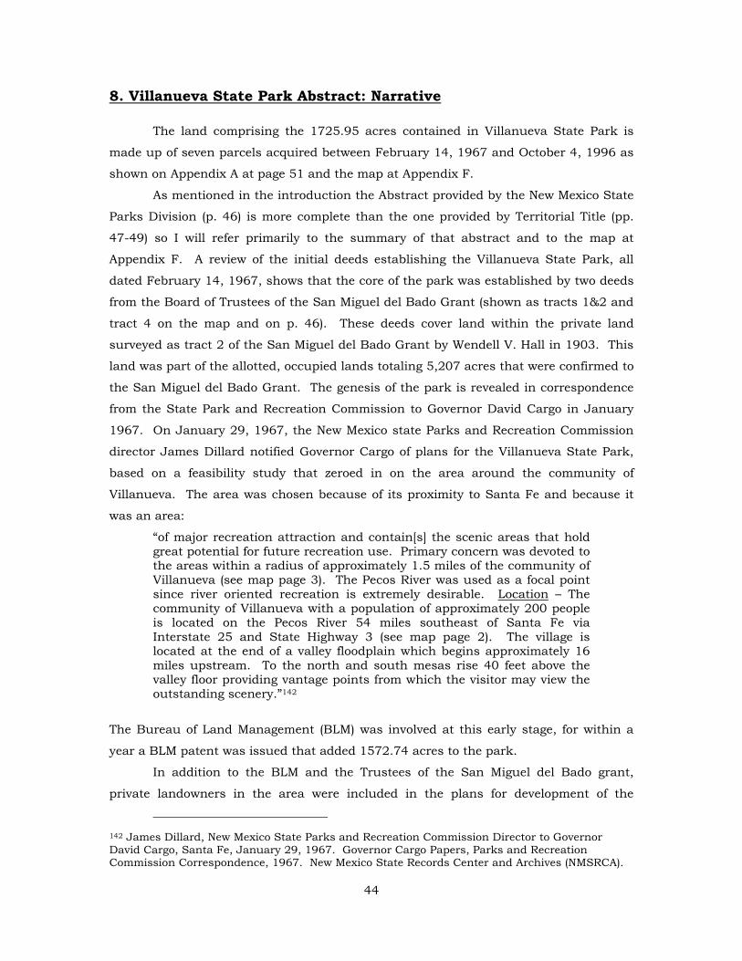
8. Villanueva State Park Abstract: Narrative
The land comprising the 1725.95 acres contained in Villanueva State Park is
made up of seven parcels acquired between February 14, 1967 and October 4, 1996 as
shown on Appendix A at page 51 and the map at Appendix F.
As mentioned in the introduction the Abstract provided by the New Mexico State
Parks Division (p. 46) is more complete than the one provided by Territorial Title (pp.
47-49) so I will refer primarily to the summary of that abstract and to the map at
Appendix F. A review of the initial deeds establishing the Villanueva State Park, all
dated February 14, 1967, shows that the core of the park was established by two deeds
from the Board of Trustees of the San Miguel del Bado Grant (shown as tracts 1&2 and
tract 4 on the map and on p. 46). These deeds cover land within the private land
surveyed as tract 2 of the San Miguel del Bado Grant by Wendell V. Hall in 1903. This
land was part of the allotted, occupied lands totaling 5,207 acres that were confirmed to
the San Miguel del Bado Grant. The genesis of the park is revealed in correspondence
from the State Park and Recreation Commission to Governor David Cargo in January
1967. On January 29, 1967, the New Mexico state Parks and Recreation Commission
director James Dillard notified Governor Cargo of plans for the Villanueva State Park,
based on a feasibility study that zeroed in on the area around the community of
Villanueva. The area was chosen because of its proximity to Santa Fe and because it
was an area:
“of major recreation attraction and contain[s] the scenic areas that hold great potential for future recreation use. Primary concern was devoted to the areas within a radius of approximately 1.5 miles of the community of Villanueva (see map page 3). The Pecos River was used as a focal point since river oriented recreation is extremely desirable. Location – The community of Villanueva with a population of approximately 200 people is located on the Pecos River 54 miles southeast of Santa Fe via Interstate 25 and State Highway 3 (see map page 2). The village is located at the end of a valley floodplain which begins approximately 16 miles upstream. To the north and south mesas rise 40 feet above the valley floor providing vantage points from which the visitor may view the outstanding scenery.”142
The Bureau of Land Management (BLM) was involved at this early stage, for within a
year a BLM patent was issued that added 1572.74 acres to the park.
In addition to the BLM and the Trustees of the San Miguel del Bado grant,
private landowners in the area were included in the plans for development of the
142 James Dillard, New Mexico State Parks and Recreation Commission Director to Governor David Cargo, Santa Fe, January 29, 1967. Governor Cargo Papers, Parks and Recreation Commission Correspondence, 1967. New Mexico State Records Center and Archives (NMSRCA).
44
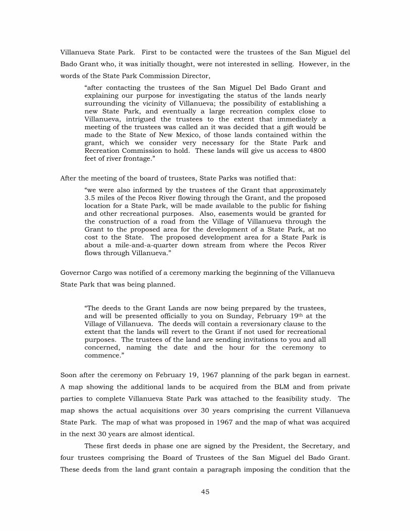
Villanueva State Park. First to be contacted were the trustees of the San Miguel del
Bado Grant who, it was initially thought, were not interested in selling. However, in the
words of the State Park Commission Director,
“after contacting the trustees of the San Miguel Del Bado Grant and explaining our purpose for investigating the status of the lands nearly surrounding the vicinity of Villanueva; the possibility of establishing a new State Park, and eventually a large recreation complex close to Villanueva, intrigued the trustees to the extent that immediately a meeting of the trustees was called an it was decided that a gift would be made to the State of New Mexico, of those lands contained within the grant, which we consider very necessary for the State Park and Recreation Commission to hold. These lands will give us access to 4800 feet of river frontage.”
After the meeting of the board of trustees, State Parks was notified that:
“we were also informed by the trustees of the Grant that approximately 3.5 miles of the Pecos River flowing through the Grant, and the proposed location for a State Park, will be made available to the public for fishing and other recreational purposes. Also, easements would be granted for the construction of a road from the Village of Villanueva through the Grant to the proposed area for the development of a State Park, at no cost to the State. The proposed development area for a State Park is about a mile-and-a-quarter down stream from where the Pecos River flows through Villanueva.”
Governor Cargo was notified of a ceremony marking the beginning of the Villanueva
State Park that was being planned.
“The deeds to the Grant Lands are now being prepared by the trustees, and will be presented officially to you on Sunday, February 19th at the Village of Villanueva. The deeds will contain a reversionary clause to the extent that the lands will revert to the Grant if not used for recreational purposes. The trustees of the land are sending invitations to you and all concerned, naming the date and the hour for the ceremony to commence.”
Soon after the ceremony on February 19, 1967 planning of the park began in earnest.
A map showing the additional lands to be acquired from the BLM and from private
parties to complete Villanueva State Park was attached to the feasibility study. The
map shows the actual acquisitions over 30 years comprising the current Villanueva
State Park. The map of what was proposed in 1967 and the map of what was acquired
in the next 30 years are almost identical.
These first deeds in phase one are signed by the President, the Secretary, and
four trustees comprising the Board of Trustees of the San Miguel del Bado Grant.
These deeds from the land grant contain a paragraph imposing the condition that the
45
land conveyed by the deeds must be used as a state park or “the land shall revert back
to the San Miguel del Bado Grant, Tract 2.” The land covered by these deeds is colored
blue (tract 1 & 2) and magenta (tract 4). Tract 4 is along the southwest bank of the
Pecos River along the western edge of the Park. Until 1968 and phase two of the
acquisition of the park, these two tracts were not connected.
Phase two of the acquisition occurred on April 1, 1968 with a patent from the
BLM to the New Mexico State Park and Recreation commission for a tract of land
comprising 1572.74 acres (tract 5 colored brown). This acquisition almost tied the two
parts of the Villanueva State Park together. It encompassed a large tract of mesa land
along the south and southwest side of the Pecos River.
The third phase of the acquisition of the Villanueva State Park is comprised of
tract 6 (colored red) and tract 7 (colored green) which finally tie together the two initial
tracts which comprised the core area of the park as it was established in February of
1967. Tract 6 (red) was acquired from Crisostomo and Adelaide Vigil in July of 1975
after several months of negotiations for $75 per acres. Chris Vigil received a large tract
of land of which this was a part by patent from the BLM on August 14, 1961. This land
had been part of the common lands of the San Miguel del Bado Grant managed by the
BLM, then patented to Vigil who in turn conveyed the land to the state of New Mexico.
The superintendent of the Villanueva State Park at the time of the Vigil acquisition,
Fortunato Gallegos, was instrumental in bringing this acquisition to a conclusion. In a
memo about this acquisition to the director of the State Park and Recreation
Commission, Superintendent Gallegos was singled out, “for his enthusiastic cooperation
and help in seeing that the meeting went as smoothly as it did. The park was in
excellent order and was exceptionally neat and well kept. It was a pleasure to see the
extra work that Mr. Gallegos has put into keeping his park so attractive.”143
The final acquisition that closed the gap tying all the tracts together was tract 7
(green) acquired from the BLM by patent on April 21, 1997. This tract is on the east
side of the Pecos River where the footbridge is located. Since the tract contains at least
two archaeological sites (LA 115209 and LA 115210), it is described as the ruins and
overlook tract and is subject to special conditions in the patent. The land is protected
from any excavation without the State Historic Preservation Office’s approval and
provides that if there is any violation of the terms of the patent, the land shall revert to
the United States. The map attached as Exhibit F shows the location of LA 115209,
143 Memo from Jack Marashka to Sam Graft, Director State Park and Recreation Commission, January 17, 1975, New Mexico State Park Division files, Santa Fe. It appears that Fortunato Gallegos may have been one of the early land donors that helped establish the Villaneuva State Park. Territorial Title Abstract, pp. 8-12.
46
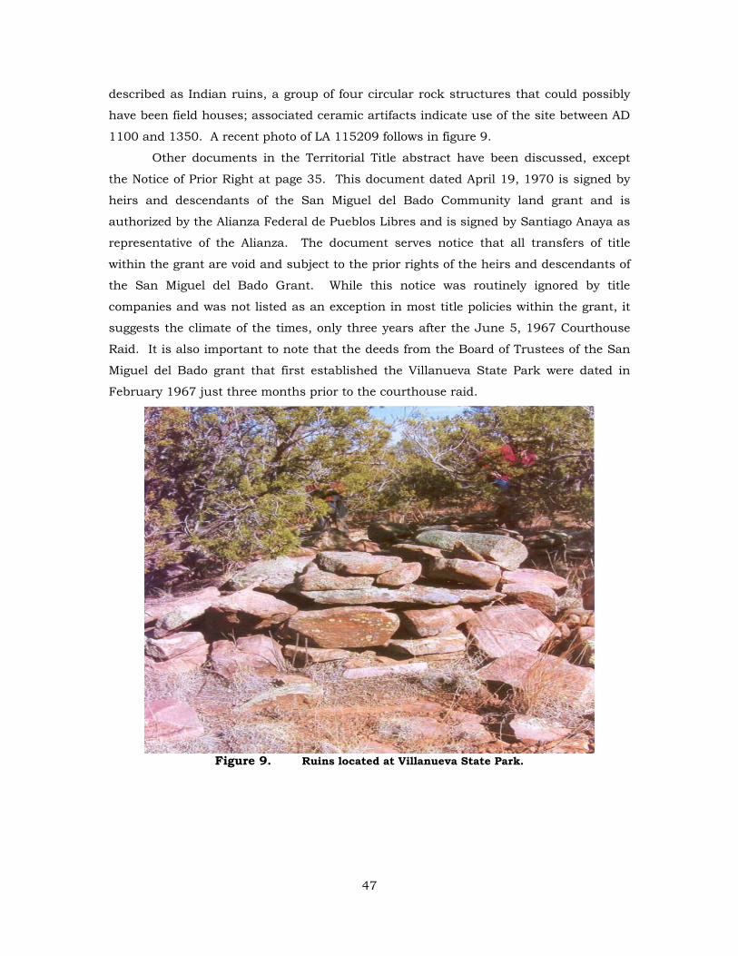
described as Indian ruins, a group of four circular rock structures that could possibly
have been field houses; associated ceramic artifacts indicate use of the site between AD
1100 and 1350. A recent photo of LA 115209 follows in figure 9.
Other documents in the Territorial Title abstract have been discussed, except
the Notice of Prior Right at page 35. This document dated April 19, 1970 is signed by
heirs and descendants of the San Miguel del Bado Community land grant and is
authorized by the Alianza Federal de Pueblos Libres and is signed by Santiago Anaya as
representative of the Alianza. The document serves notice that all transfers of title
within the grant are void and subject to the prior rights of the heirs and descendants of
the San Miguel del Bado Grant. While this notice was routinely ignored by title
companies and was not listed as an exception in most title policies within the grant, it
suggests the climate of the times, only three years after the June 5, 1967 Courthouse
Raid. It is also important to note that the deeds from the Board of Trustees of the San
Miguel del Bado grant that first established the Villanueva State Park were dated in
February 1967 just three months prior to the courthouse raid.
Figure 9. Ruins located at Villanueva State Park.
47
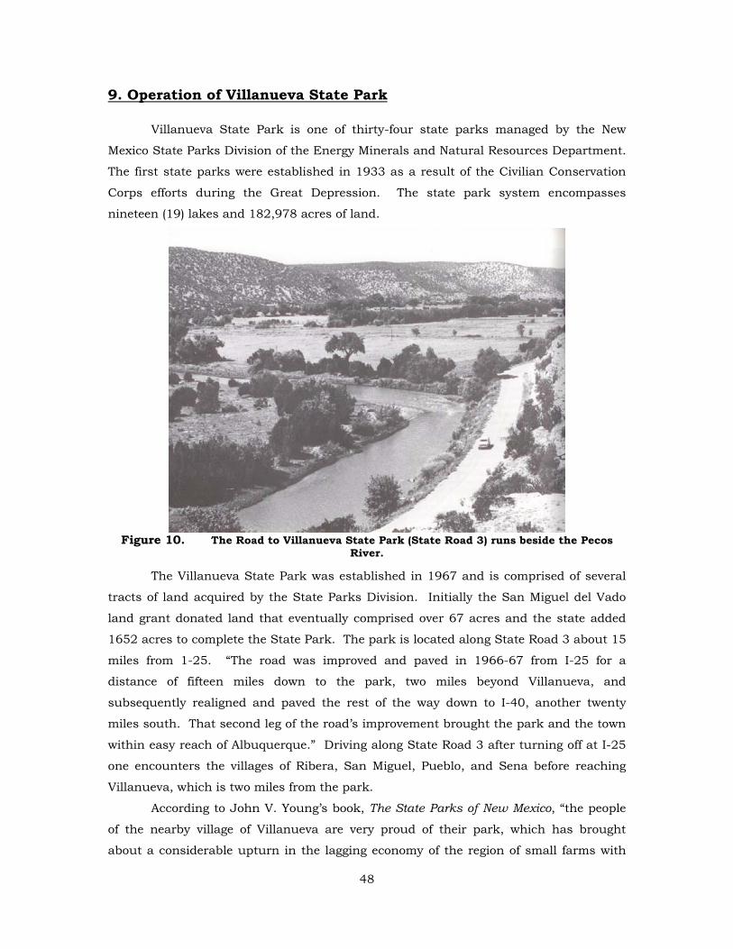
9. Operation of Villanueva State Park
Villanueva State Park is one of thirty-four state parks managed by the New
Mexico State Parks Division of the Energy Minerals and Natural Resources Department.
The first state parks were established in 1933 as a result of the Civilian Conservation
Corps efforts during the Great Depression. The state park system encompasses
nineteen (19) lakes and 182,978 acres of land.
Figure 10. The Road to Villanueva State Park (State Road 3) runs beside the Pecos
River.
The Villanueva State Park was established in 1967 and is comprised of several
tracts of land acquired by the State Parks Division. Initially the San Miguel del Vado
land grant donated land that eventually comprised over 67 acres and the state added
1652 acres to complete the State Park. The park is located along State Road 3 about 15
miles from 1-25. “The road was improved and paved in 1966-67 from I-25 for a
distance of fifteen miles down to the park, two miles beyond Villanueva, and
subsequently realigned and paved the rest of the way down to I-40, another twenty
miles south. That second leg of the road’s improvement brought the park and the town
within easy reach of Albuquerque.” Driving along State Road 3 after turning off at I-25
one encounters the villages of Ribera, San Miguel, Pueblo, and Sena before reaching
Villanueva, which is two miles from the park.
According to John V. Young’s book, The State Parks of New Mexico, “the people
of the nearby village of Villanueva are very proud of their park, which has brought
about a considerable upturn in the lagging economy of the region of small farms with
48
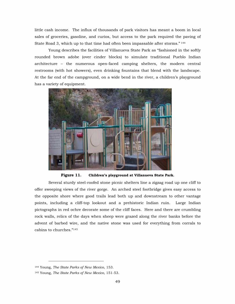
little cash income. The influx of thousands of park visitors has meant a boom in local
sales of groceries, gasoline, and curios, but access to the park required the paving of
State Road 3, which up to that time had often been impassable after storms.” 144
Young describes the facilities of Villanueva State Park as “fashioned in the softly
rounded brown adobe (over cinder blocks) to simulate traditional Pueblo Indian
architecture – the numerous open-faced camping shelters, the modern central
restrooms (with hot showers), even drinking fountains that blend with the landscape.
At the far end of the campground, on a wide bend in the river, a children’s playground
has a variety of equipment.
Figure 11. Children’s playground at Villanueva State Park.
Several sturdy steel-roofed stone picnic shelters line a zigzag road up one cliff to
offer sweeping views of the river gorge. An arched steel footbridge gives easy access to
the opposite shore where good trails lead both up and downstream to other vantage
points, including a cliff-top lookout and a prehistoric Indian ruin. Large Indian
pictographs in red ochre decorate some of the cliff faces. Here and there are crumbling
rock walls, relics of the days when sheep were grazed along the river banks before the
advent of barbed wire, and the native stone was used for everything from corrals to
cabins to churches.”145
144 Young, The State Parks of New Mexico, 153. 145 Young, The State Parks of New Mexico, 151-53.
49
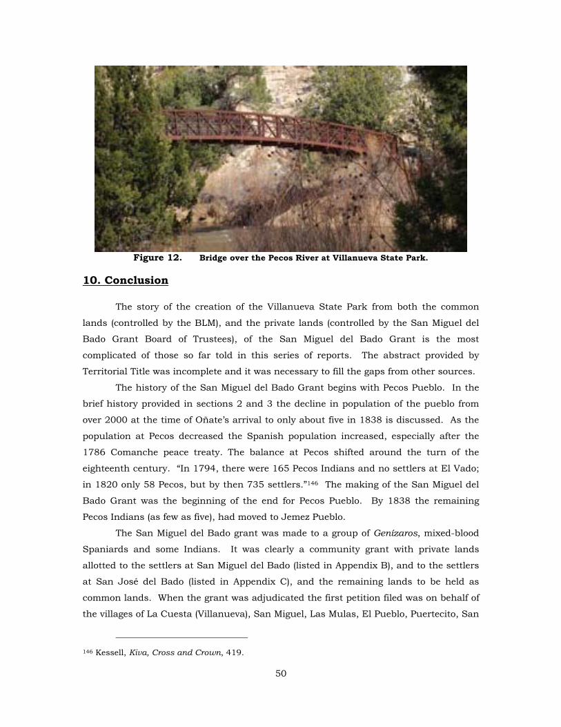
Figure 12. Bridge over the Pecos River at Villanueva State Park.
10. Conclusion
The story of the creation of the Villanueva State Park from both the common
lands (controlled by the BLM), and the private lands (controlled by the San Miguel del
Bado Grant Board of Trustees), of the San Miguel del Bado Grant is the most
complicated of those so far told in this series of reports. The abstract provided by
Territorial Title was incomplete and it was necessary to fill the gaps from other sources.
The history of the San Miguel del Bado Grant begins with Pecos Pueblo. In the
brief history provided in sections 2 and 3 the decline in population of the pueblo from
over 2000 at the time of Oñate’s arrival to only about five in 1838 is discussed. As the
population at Pecos decreased the Spanish population increased, especially after the
1786 Comanche peace treaty. The balance at Pecos shifted around the turn of the
eighteenth century. “In 1794, there were 165 Pecos Indians and no settlers at El Vado;
in 1820 only 58 Pecos, but by then 735 settlers.”146 The making of the San Miguel del
Bado Grant was the beginning of the end for Pecos Pueblo. By 1838 the remaining
Pecos Indians (as few as five), had moved to Jemez Pueblo.
The San Miguel del Bado grant was made to a group of Genízaros, mixed-blood
Spaniards and some Indians. It was clearly a community grant with private lands
allotted to the settlers at San Miguel del Bado (listed in Appendix B), and to the settlers
at San José del Bado (listed in Appendix C), and the remaining lands to be held as
common lands. When the grant was adjudicated the first petition filed was on behalf of
the villages of La Cuesta (Villanueva), San Miguel, Las Mulas, El Pueblo, Puertecito, San
146 Kessell, Kiva, Cross and Crown, 419.
50
José, Guzano, and Bernal for confirmation as a community grant. The Court of Private
Land Claims did confirm the entire San Miguel del Bado grant as a community grant,
but this decision was reversed by the U.S. Supreme Court in the famous Sandoval case.
When the occupied allotted lands were surveyed in 1903 the San Miguel del
Bado grant was reduced to 5,207 acres made up of ten tracts. Tract no. 2 was the
largest and it is from this tract and the BLM lands adjacent to the tract that the
Villanueva State Park was created. This is the only state park I know of initially created
by a land grant board of trustees, and is the only one I know of where the land grant
board, the BLM and adjacent private owners cooperated to create what we know today
as Villanueva State Park. Ironically, after the loss of its common lands, the Board of
Trustees of the San Miguel del Bado grant has helped establish a state park with over
50,000 visitors per year that provides economic benefits to the community of Villanueva
and surrounding communities.
51
Bibliography
Ebright, Malcolm. Land Grants and Lawsuits in Northern New Mexico. Albuquerque: University of New Mexico Press, 1994; Santa Fe: Center for Land Grant Studies Press, 2008.
Flint, Richard, Shirley Flint, and Pedro V. Gallegos. “Una Atarque Duradera”, New Mexico Historical Review, 63 (October 1988), 357-72.
Glasscock, James T. “The Genízaro Outpost of San Miguel del Vado.” Marianne Stoller Project, unpublished manuscripts #14, serial #19168, NMSRCA, Santa Fe.
Hall, G. Emlen. Four Leagues of Pecos: A Legal History of the Pecos Grant, 1800-1933. Albuquerque: University of New Mexico Press, 1984.
______________. “Giant Before the Surveyor-General: The Land Career of Donaciano Vigil,” in John R. and Christine M. Van Ness, eds., Spanish and Mexican Land Grants in Mexico and Colorado.
______________. “San Miguel del Bado and the Loss of the Common Lands of New Mexico Community Land Grants,” New Mexico Historical Review 66 (October 1991): 413-32.
Jones, H. L. Film 11158, “Villanueva, Tecolote, Las Vegas,” 3 1/2 minutes. NMSRCA, Santa Fe.
Levine, Frances. Our Prayers Are in This Place: Pecos Pueblo Identity over the Centuries (Albuquerque: University of New Mexico Press, 1999.
Marquez, Angelina. “San Miguel del Vado: The Marquez Family Tree. Marianne Stoller Project, unpublished manuscripts #30, serial #19185, NMSRCA, Santa Fe.
Nobel, David Grant. Pueblos, Villages &Trails: A Guide to New Mexico’s Past Albuquerque: University of New Mexico Press, 1994.
Nostrand, Richard L. El Cerrito, New Mexico: Eight Generations in a Spanish Village Norman: University of Oklahoma Press, 2003.
Selcraig, Bruce. “Digging Ditches,” Smithsonian, February 1, 2002, 55-62.
Schiller, Mark. “The Adjudication of the San Miguel del Vado Grant and the Overturning of the Presumption that Title to the Commons Vested in the Settlers,” a chapter in “Adjudicating Empire” unpublished manuscript in possession of the author.
52
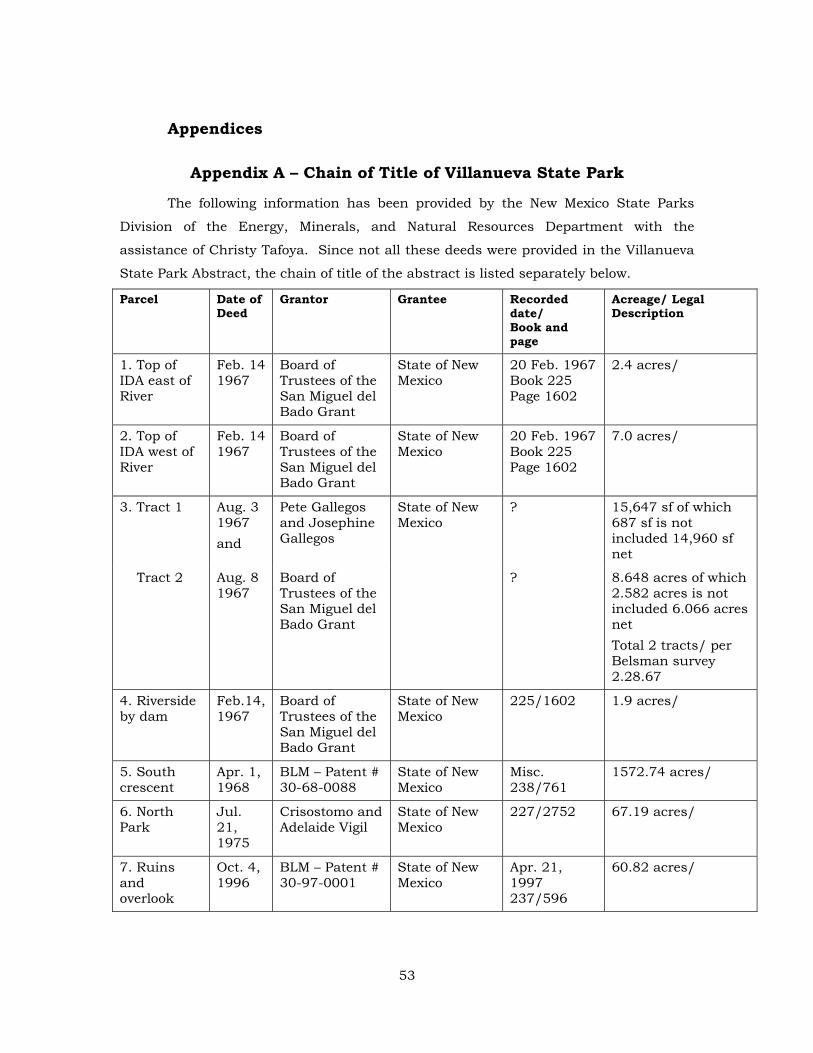
Appendices
Appendix A – Chain of Title of Villanueva State Park
The following information has been provided by the New Mexico State Parks
Division of the Energy, Minerals, and Natural Resources Department with the
assistance of Christy Tafoya. Since not all these deeds were provided in the Villanueva
State Park Abstract, the chain of title of the abstract is listed separately below.
Parcel Date of Deed
Grantor Grantee Recorded date/ Book and page
Acreage/ Legal Description
1. Top of IDA east of River
Feb. 14 1967
Board of Trustees of the San Miguel del Bado Grant
State of New Mexico
20 Feb. 1967 Book 225 Page 1602
2.4 acres/
2. Top of IDA west of River
Feb. 14 1967
Board of Trustees of the San Miguel del Bado Grant
State of New Mexico
20 Feb. 1967 Book 225 Page 1602
7.0 acres/
3. Tract 1 Aug. 3 1967 and
Pete Gallegos and Josephine Gallegos
State of New Mexico
? 15,647 sf of which 687 sf is not included 14,960 sf net
Tract 2 Aug. 8 1967
Board of Trustees of the San Miguel del Bado Grant
? 8.648 acres of which 2.582 acres is not included 6.066 acres net Total 2 tracts/ per Belsman survey 2.28.67
4. Riverside by dam
Feb.14, 1967
Board of Trustees of the San Miguel del Bado Grant
State of New Mexico
225/1602 1.9 acres/
5. South crescent
Apr. 1, 1968
BLM – Patent # 30-68-0088
State of New Mexico
Misc. 238/761
1572.74 acres/
6. North Park
Jul. 21, 1975
Crisostomo and Adelaide Vigil
State of New Mexico
227/2752 67.19 acres/
7. Ruins and overlook
Oct. 4, 1996
BLM – Patent # 30-97-0001
State of New Mexico
Apr. 21, 1997 237/596
60.82 acres/
53
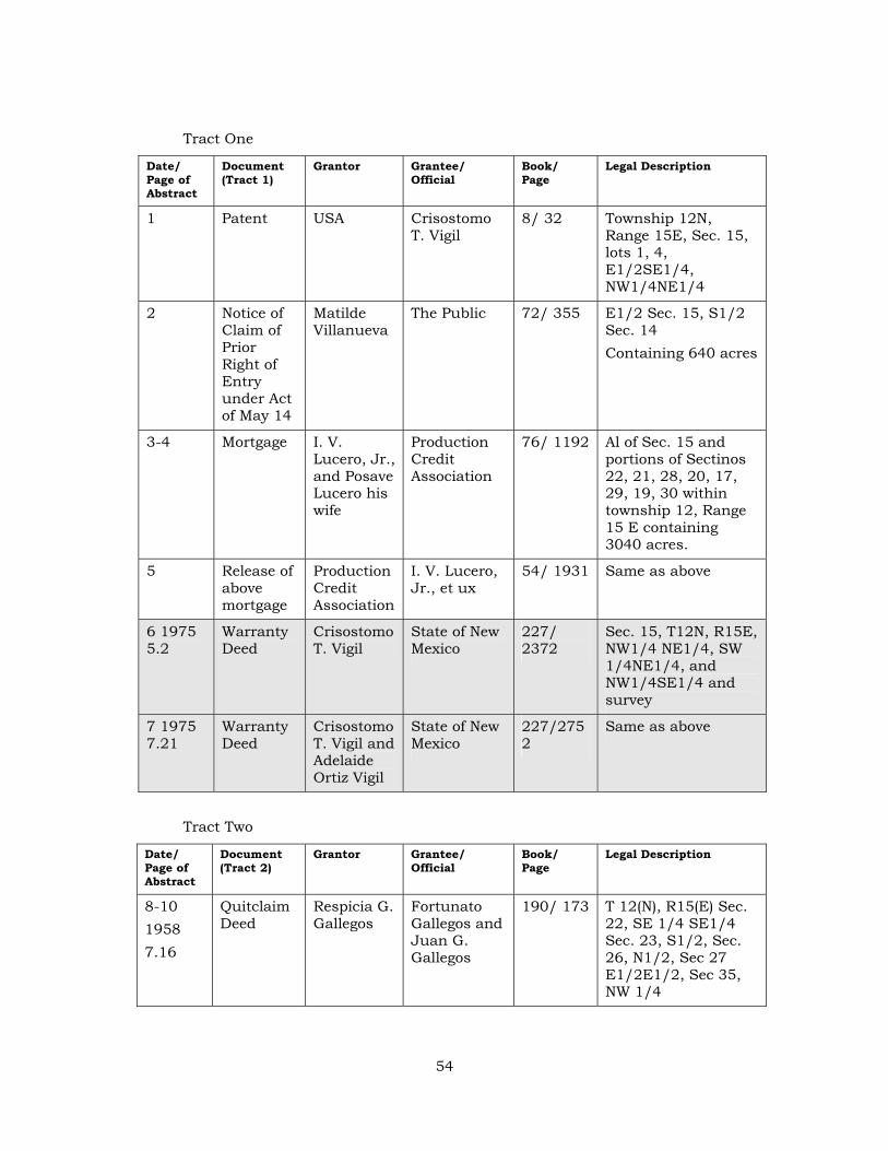
Tract One
Date/ Page of Abstract
Document (Tract 1)
Grantor Grantee/ Official
Book/ Page
Legal Description
1 Patent USA Crisostomo T. Vigil
8/ 32 Township 12N, Range 15E, Sec. 15, lots 1, 4, E1/2SE1/4, NW1/4NE1/4
2 Notice of Claim of Prior Right of Entry under Act of May 14
Matilde Villanueva
The Public 72/ 355 E1/2 Sec. 15, S1/2 Sec. 14 Containing 640 acres
3-4 Mortgage I. V. Lucero, Jr., and Posave Lucero his wife
Production Credit Association
76/ 1192 Al of Sec. 15 and portions of Sectinos 22, 21, 28, 20, 17, 29, 19, 30 within township 12, Range 15 E containing 3040 acres.
5 Release of above mortgage
Production Credit Association
I. V. Lucero, Jr., et ux
54/ 1931 Same as above
6 1975 5.2
Warranty Deed
Crisostomo T. Vigil
State of New Mexico
227/ 2372
Sec. 15, T12N, R15E, NW1/4 NE1/4, SW 1/4NE1/4, and NW1/4SE1/4 and survey
7 1975 7.21
Warranty Deed
Crisostomo T. Vigil and Adelaide Ortiz Vigil
State of New Mexico
227/2752
Same as above
Tract Two
Date/ Page of Abstract
Document (Tract 2)
Grantor Grantee/ Official
Book/ Page
Legal Description
8-10 1958 7.16
Quitclaim Deed
Respicia G. Gallegos
Fortunato Gallegos and Juan G. Gallegos
190/ 173 T 12(N), R15(E) Sec. 22, SE 1/4 SE1/4 Sec. 23, S1/2, Sec. 26, N1/2, Sec 27 E1/2E1/2, Sec 35, NW 1/4
54
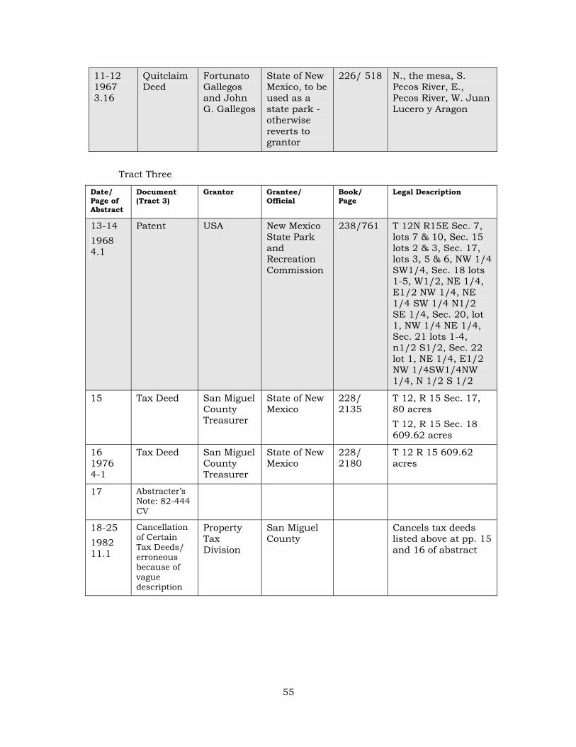
11-12 1967 3.16
Quitclaim Deed
Fortunato Gallegos and John G. Gallegos
State of New Mexico, to be used as a state park -otherwise reverts to grantor
226/ 518 N., the mesa, S. Pecos River, E., Pecos River, W. Juan Lucero y Aragon
Tract Three
Date/ Page of Abstract
Document (Tract 3)
Grantor Grantee/ Official
Book/ Page
Legal Description
13-14 1968 4.1
Patent USA New Mexico State Park and Recreation Commission
238/761 T 12N R15E Sec. 7, lots 7 & 10, Sec. 15 lots 2 & 3, Sec. 17, lots 3, 5 & 6, NW 1/4 SW1/4, Sec. 18 lots 1-5, W1/2, NE 1/4, E1/2 NW 1/4, NE 1/4 SW 1/4 N1/2 SE 1/4, Sec. 20, lot 1, NW 1/4 NE 1/4, Sec. 21 lots 1-4, n1/2 S1/2, Sec. 22 lot 1, NE 1/4, E1/2 NW 1/4SW1/4NW 1/4, N 1/2 S 1/2
15 Tax Deed San Miguel County Treasurer
State of New Mexico
228/ 2135
T 12, R 15 Sec. 17, 80 acres T 12, R 15 Sec. 18 609.62 acres
16 1976 4-1
Tax Deed San Miguel County Treasurer
State of New Mexico
228/ 2180
T 12 R 15 609.62 acres
17 Abstracter’s Note: 82-444 CV
18-25 1982 11.1
Cancellation of Certain Tax Deeds/ erroneous because of vague description
Property Tax Division
San Miguel County
Cancels tax deeds listed above at pp. 15 and 16 of abstract
55
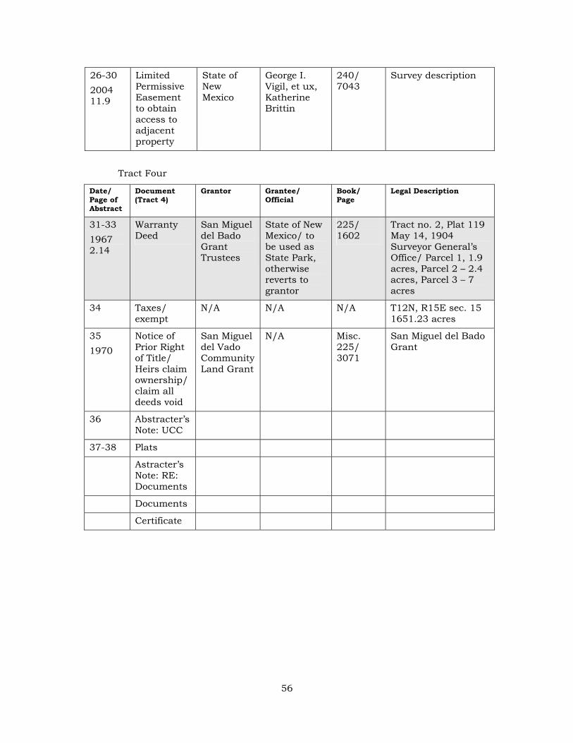
26-30 2004 11.9
Limited Permissive Easement to obtain access to adjacent property
State of New Mexico
George I. Vigil, et ux, Katherine Brittin
240/ 7043
Survey description
Tract Four
Date/ Page of Abstract
Document (Tract 4)
Grantor Grantee/ Official
Book/ Page
Legal Description
31-33 1967 2.14
Warranty Deed
San Miguel del Bado Grant Trustees
State of New Mexico/ to be used as State Park, otherwise reverts to grantor
225/ 1602
Tract no. 2, Plat 119 May 14, 1904 Surveyor General’s Office/ Parcel 1, 1.9 acres, Parcel 2 – 2.4 acres, Parcel 3 – 7 acres
34 Taxes/ exempt
N/A N/A N/A T12N, R15E sec. 15 1651.23 acres
35 1970
Notice of Prior Right of Title/ Heirs claim ownership/ claim all deeds void
San Miguel del Vado Community Land Grant
N/A Misc. 225/ 3071
San Miguel del Bado Grant
36 Abstracter’s Note: UCC
37-38 Plats
Astracter’s Note: RE: Documents
Documents
Certificate
56
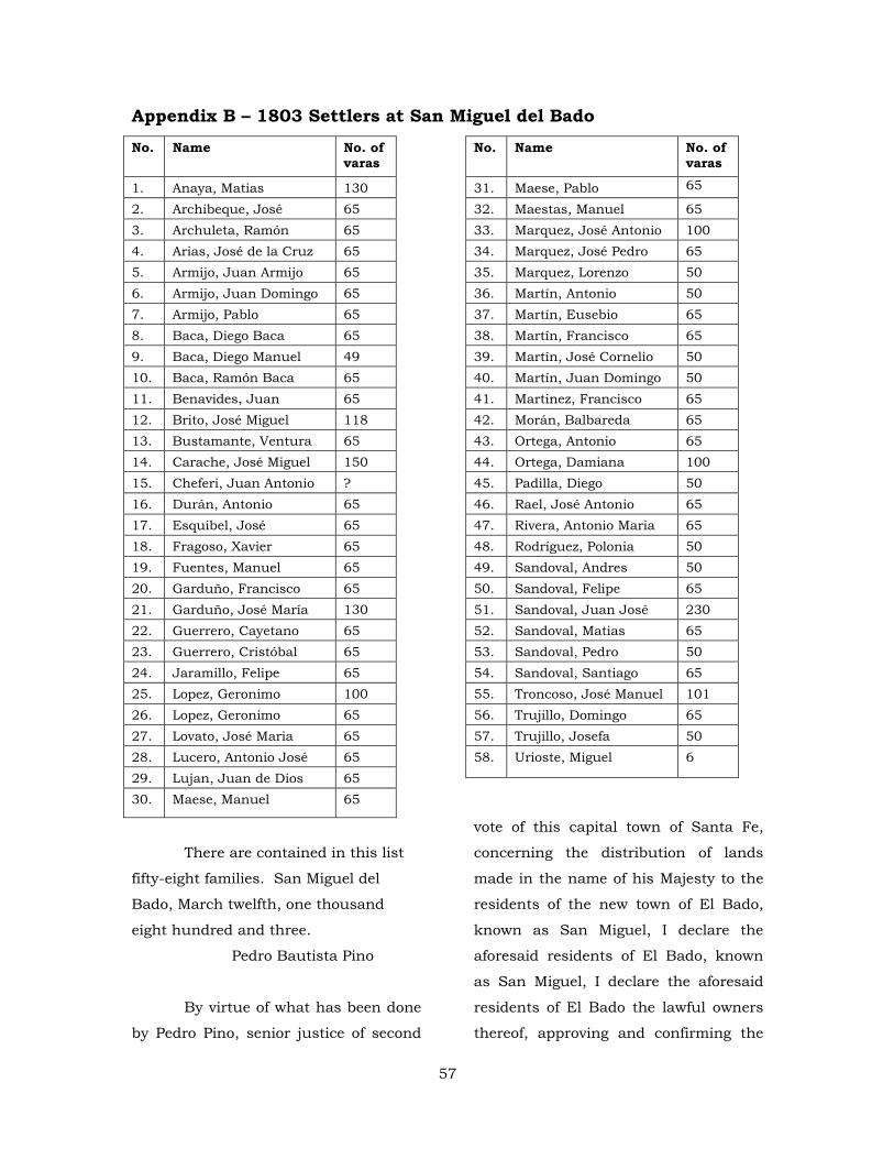
Appendix B – 1803 Settlers at San Miguel del BadoNo. Name No. of
varas
1. Anaya, Matias 130 2. Archibeque, José 65 3. Archuleta, Ramón 65 4. Arias, José de la Cruz 65 5. Armijo, Juan Armijo 65 6. Armijo, Juan Domingo 65 7. Armijo, Pablo 65 8. Baca, Diego Baca 65 9. Baca, Diego Manuel 49 10. Baca, Ramón Baca 65 11. Benavides, Juan 65 12. Brito, José Miguel 118 13. Bustamante, Ventura 65 14. Carache, José Miguel 150 15. Cheferi, Juan Antonio ? 16. Durán, Antonio 65 17. Esquibel, José 65 18. Fragoso, Xavier 65 19. Fuentes, Manuel 65 20. Garduño, Francisco 65 21. Garduño, José María 130 22. Guerrero, Cayetano 65 23. Guerrero, Cristóbal 65 24. Jaramillo, Felipe 65 25. Lopez, Geronimo 100 26. Lopez, Geronimo 65 27. Lovato, José Maria 65 28. Lucero, Antonio José 65 29. Lujan, Juan de Dios 65 30. Maese, Manuel 65
No. Name No. of varas
31. Maese, Pablo 65
32. Maestas, Manuel 65 33. Marquez, José Antonio 100 34. Marquez, José Pedro 65 35. Marquez, Lorenzo 50 36. Martín, Antonio 50 37. Martín, Eusebio 65 38. Martín, Francisco 65 39. Martín, José Cornelio 50 40. Martín, Juan Domingo 50 41. Martinez, Francisco 65 42. Morán, Balbareda 65 43. Ortega, Antonio 65 44. Ortega, Damiana 100 45. Padilla, Diego 50 46. Rael, José Antonio 65 47. Rivera, Antonio Maria 65 48. Rodríguez, Polonia 50 49. Sandoval, Andres 50 50. Sandoval, Felipe 65 51. Sandoval, Juan José 230 52. Sandoval, Matias 65 53. Sandoval, Pedro 50 54. Sandoval, Santiago 65 55. Troncoso, José Manuel 101 56. Trujillo, Domingo 65 57. Trujillo, Josefa 50 58. Urioste, Miguel 6
There are contained in this list
fifty-eight families. San Miguel del
Bado, March twelfth, one thousand
eight hundred and three.
Pedro Bautista Pino
By virtue of what has been done
by Pedro Pino, senior justice of second
vote of this capital town of Santa Fe,
concerning the distribution of lands
made in the name of his Majesty to the
residents of the new town of El Bado,
known as San Miguel, I declare the
aforesaid residents of El Bado, known
as San Miguel, I declare the aforesaid
residents of El Bado the lawful owners
thereof, approving and confirming the
57
possession given by said Senior Justice
Pedro Pino; and in order that it may so
appear in all time, I signed this at Santa
Fe, New Mexico, on the 30th day of
March, 1803.
(signed)
Fernando Chacón
58
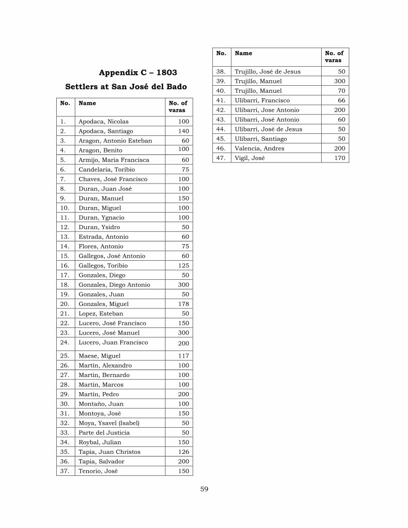
Appendix C – 1803
Settlers at San José del Bado
No. Name No. of varas
1. Apodaca, Nicolas 100 2. Apodaca, Santiago 140 3. Aragon, Antonio Esteban 60 4. Aragon, Benito 100
5. Armijo, Maria Francisca 60 6. Candelaria, Toribio 75 7. Chaves, José Francisco 100 8. Duran, Juan José 100 9. Duran, Manuel 150 10. Duran, Miguel 100 11. Duran, Ygnacio 100 12. Duran, Ysidro 50 13. Estrada, Antonio 60 14. Flores, Antonio 75 15. Gallegos, José Antonio 60 16. Gallegos, Toribio 125 17. Gonzales, Diego 50 18. Gonzales, Diego Antonio 300 19. Gonzales, Juan 50 20. Gonzales, Miguel 178 21. Lopez, Esteban 50 22. Lucero, José Francisco 150 23. Lucero, José Manuel 300 24. Lucero, Juan Francisco 200
25. Maese, Miguel 117 26. Martín, Alexandro 100 27. Martin, Bernardo 100 28. Martín, Marcos 100 29. Martín, Pedro 200 30. Montaño, Juan 100 31. Montoya, José 150 32. Moya, Ysavel (Isabel) 50 33. Parte del Justicia 50 34. Roybal, Julian 150 35. Tapia, Juan Christos 126 36. Tapia, Salvador 200 37. Tenorio, José 150
No. Name No. of varas
38. Trujillo, José de Jesus 50 39. Trujillo, Manuel 300 40. Trujillo, Manuel 70 41. Ulibarri, Francisco 66 42. Ulibarri, Jose Antonio 200 43. Ulibarri, José Antonio 60 44. Ulibarri, José de Jesus 50 45. Ulibarri, Santiago 50 46. Valencia, Andres 200 47. Vigil, José 170
59
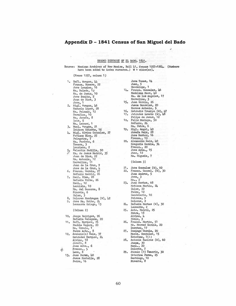
Appendix D – 1841 Census of San Miguel del Bado
60
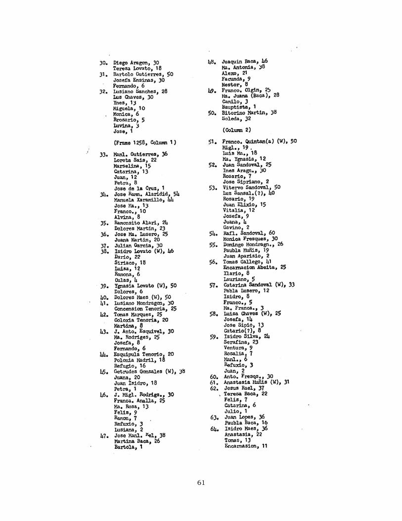
61
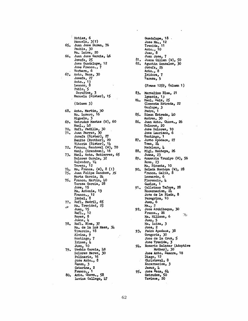
62
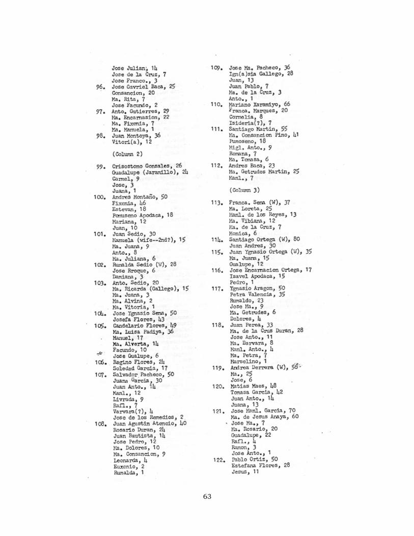
63
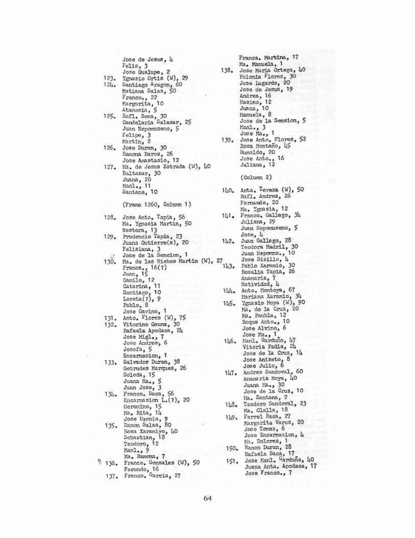
64
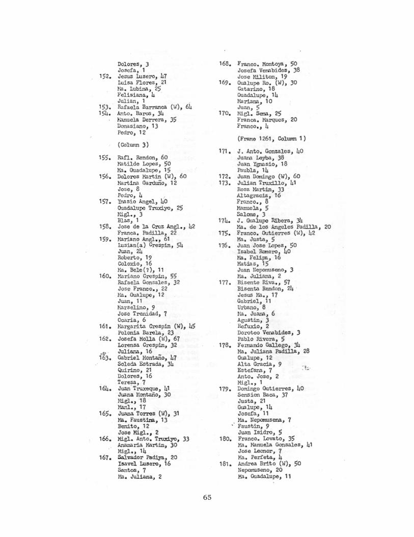
65
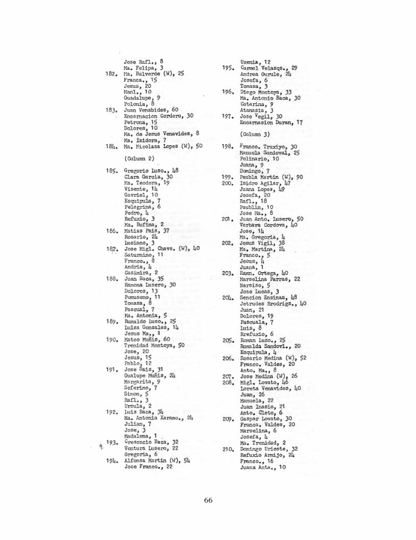
66
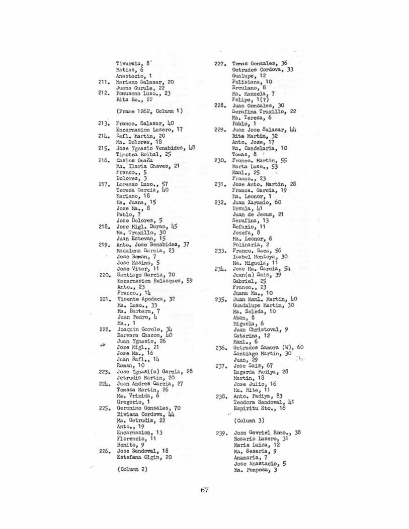
67
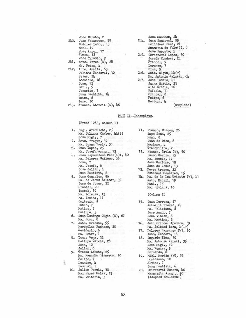
68
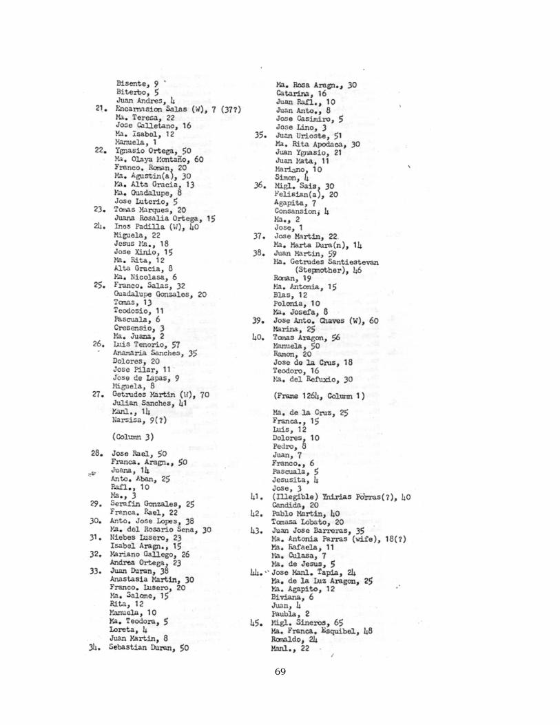
69
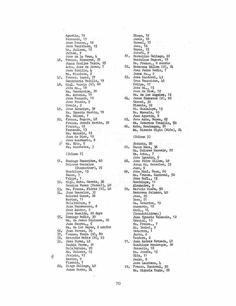
70
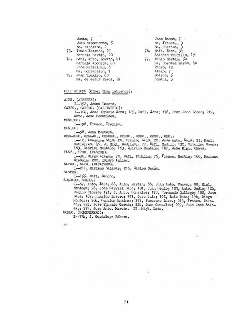
71
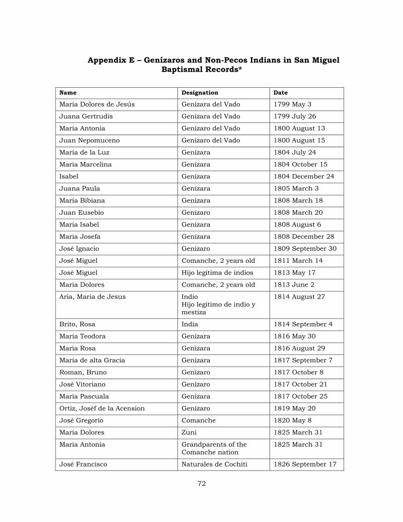
Appendix E – Genízaros and Non-Pecos Indians in San Miguel Baptismal Records*
Name Designation Date
Maria Dolores de Jesús Genízara del Vado 1799 May 3
Juana Gertrudis Genízara del Vado 1799 July 26
Maria Antonia Genízaro del Vado 1800 August 13
Juan Nepomuceno Genízaro del Vado 1800 August 15
Maria de la Luz Genízara 1804 July 24
Maria Marcelina Genízara 1804 October 15
Isabel Genízara 1804 December 24
Juana Paula Genízara 1805 March 3
Maria Bibiana Genízara 1808 March 18
Juan Eusebio Genízaro 1808 March 20
Maria Isabel Genízara 1808 August 6
Maria Josefa Genízara 1808 December 28
José Ignacio Genízaro 1809 September 30
José Miguel Comanche, 2 years old 1811 March 14
José Miguel Hijo legítima de indios 1813 May 17
Maria Dolores Comanche, 2 years old 1813 June 2
Aria, Maria de Jesus Indio Hijo legitimo de indio y mestiza
1814 August 27
Brito, Rosa India 1814 September 4
Maria Teodora Genízara 1816 May 30
Maria Rosa Genízara 1816 August 29
Maria de alta Gracia Genízara 1817 September 7
Roman, Bruno Genízaro 1817 October 8
José Vitoriano Genízaro 1817 October 21
Maria Pascuala Genízara 1817 October 25
Ortiz, Joséf de la Acension Genízaro 1819 May 20
José Gregorio Comanche 1820 May 8
Maria Dolores Zuni 1825 March 31
Maria Antonia Grandparents of the Comanche nation
1825 March 31
José Francisco Naturales de Cochiti 1826 September 17
72
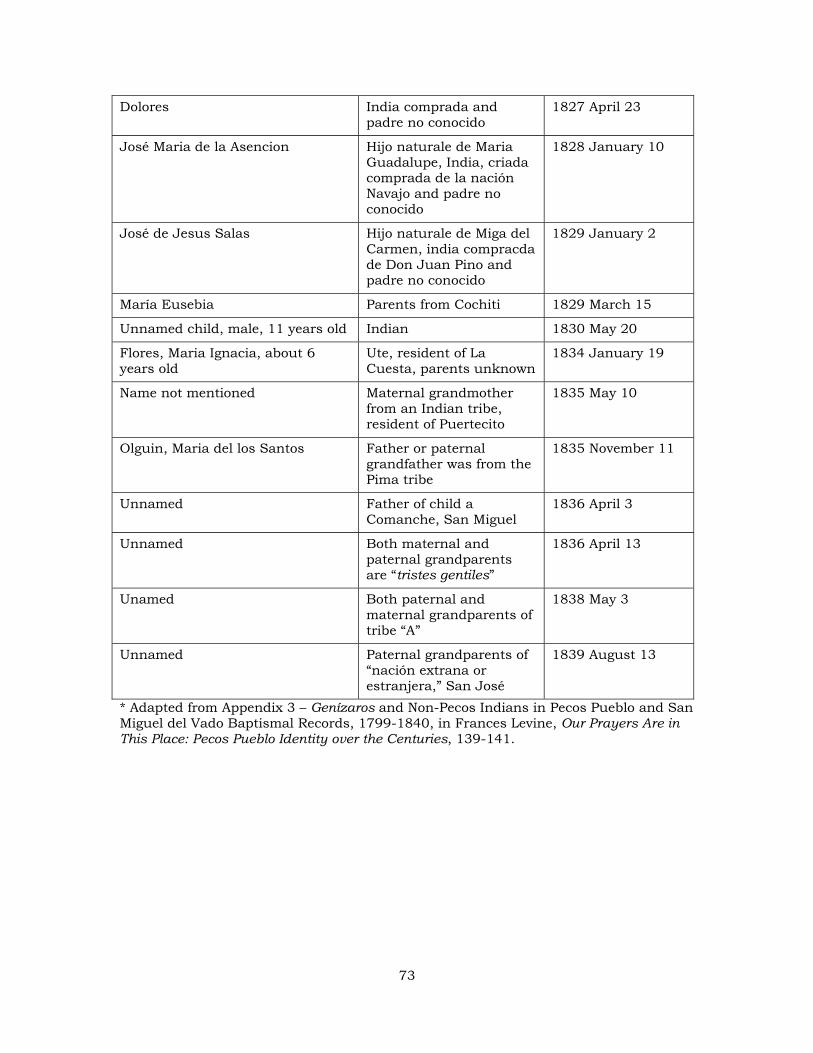
Dolores India comprada and padre no conocido
1827 April 23
José Maria de la Asencion Hijo naturale de Maria Guadalupe, India, criada comprada de la nación Navajo and padre no conocido
1828 January 10
José de Jesus Salas Hijo naturale de Miga del Carmen, india compracda de Don Juan Pino and padre no conocido
1829 January 2
María Eusebia Parents from Cochiti 1829 March 15
Unnamed child, male, 11 years old Indian 1830 May 20
Flores, Maria Ignacia, about 6 years old
Ute, resident of La Cuesta, parents unknown
1834 January 19
Name not mentioned Maternal grandmother from an Indian tribe, resident of Puertecito
1835 May 10
Olguin, Maria del los Santos Father or paternal grandfather was from the Pima tribe
1835 November 11
Unnamed Father of child a Comanche, San Miguel
1836 April 3
Unnamed Both maternal and paternal grandparents are “tristes gentiles”
1836 April 13
Unamed Both paternal and maternal grandparents of tribe “A”
1838 May 3
Unnamed Paternal grandparents of “nación extrana or estranjera,” San José
1839 August 13
* Adapted from Appendix 3 – Genízaros and Non-Pecos Indians in Pecos Pueblo and San Miguel del Vado Baptismal Records, 1799-1840, in Frances Levine, Our Prayers Are in This Place: Pecos Pueblo Identity over the Centuries, 139-141.
73
Appendix F – Map
Oversized document - not included with electronic version of report
74