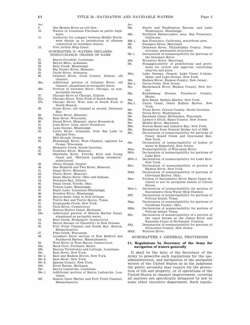
title 33—navigation and navigable waters · chap. sec. 1. navigable waters ... acushnet river...
TRANSCRIPT

Page 1
TITLE 33—NAVIGATION AND NAVIGABLE WATERS
Chap. Sec.
1. Navigable Waters Generally ............. 1 2. International Rules for Navigation
at Sea [Repealed] ............................. 61 3. Navigation Rules for Harbors, Riv-
ers, and Inland Waters Generally 151 4. Navigation Rules for Great Lakes
and Their Connecting and Tribu-tary Waters [Repealed] .................. 241
5. Navigation Rules for Red River of the North and Rivers Emptying Into Gulf of Mexico and Tribu-taries [Repealed] .............................. 301
5A. Exemption of Navy or Coast Guard Vessels From Certain Navigation Rules [Repealed] .............................. 360
6. General Duties of Ship Officers and Owners After Collision or Other Accident [Repealed] ............ 361
7. Regulations for the Suppression of Piracy ................................................. 381
8. Summary Trials for Certain Of-fenses Against Navigation Laws .. 391
9. Protection of Navigable Waters and of Harbor and River Im-provements Generally .................... 401
10. Anchorage Grounds and Harbor Regulations Generally .................... 471
11. Bridges Over Navigable Waters ...... 491 12. River and Harbor Improvements
Generally ........................................... 540 13. Mississippi River Commission ......... 641 14. California Debris Commission ......... 661 15. Flood Control ....................................... 701 16. Lighthouses .......................................... 711 17. National Oceanic and Atmospheric
Administration ................................. 851 18. Longshore and Harbor Workers’
Compensation ................................... 901 19. Saint Lawrence Seaway .................... 981 20. Pollution of the Sea by Oil [Re-
pealed] ................................................ 1001 21. International Regulations for Pre-
venting Collisions at Sea [Re-pealed] ................................................ 1051
22. Sea Grant Colleges and Marine Science Development ..................... 1101
23. Pollution Control of Navigable Wa-ters [Omitted or Transferred] ...... 1151
24. Vessel Bridge-to-Bridge Commu-nication .............................................. 1201
25. Ports and Waterways Safety Pro-gram .................................................... 1221
26. Water Pollution Prevention and Control ............................................... 1251
27. Ocean Dumping ................................... 1401 28. Pollution Casualties on the High
Seas: United States Intervention 1471
Chap. Sec.
29. Deepwater Ports .................................. 1501 30. International Regulations for Pre-
venting Collisions at Sea ............... 1601 31. Ocean Pollution Research and De-
velopment and Monitoring Plan-ning [Repealed] ................................ 1701
32. Inland Waterways Trust Fund ......... 1801 33. Prevention of Pollution From
Ships ................................................... 1901 34. Inland Navigational Rules ................ 2001 35. Artificial Reefs ..................................... 2101 36. Water Resources Development ........ 2201 37. Organotin Antifouling Paint Con-
trol [Repealed] ................................. 2401 38. Dumping of Medical Waste by Pub-
lic Vessels .......................................... 2501 39. Shore Protection from Municipal
or Commercial Waste ..................... 2601 40. Oil Pollution ......................................... 2701 41. National Coastal Monitoring ............ 2801 42. Estuary Restoration ........................... 2901 43. National Oceanic and Atmospheric
Administration Commissioned Officer Corps .................................... 3001
44. Oceans and Human Health ............... 3101 45. Tsunami Warning and Education ... 3201 46. National Levee Safety Program ...... 3301 47. Ocean Exploration .............................. 3401 48. Ocean and Coastal Mapping Inte-
gration ................................................ 3501 49. Integrated Coastal and Ocean Ob-
servation System ............................. 3601 50. Federal Ocean Acidification Re-
search and Monitoring ................... 3701 51. Clean Hulls ........................................... 3801
CHAPTER 1—NAVIGABLE WATERS GENERALLY
SUBCHAPTER I—GENERAL PROVISIONS
Sec.
1. Regulations by Secretary of the Army for navigation of waters generally.
2. Regulations for navigation of South and Southwest Passes of Mississippi River; pen-alties.
3. Regulations to prevent injuries from target practice.
4. Water gauges on Mississippi River and tribu-taries.
5. Abolition of tolls on Government canals, ca-nalized rivers, etc.; expense of operation, re-pairs to and reconstruction of canals, etc.; Panama Canal excepted; levies by non-Fed-eral interest.
6. Free passage to harbor of Michigan City, In-diana.
7. Use of Government iron pier in Delaware Bay. 8. Toll free rivers in Alabama.
Page 2 TITLE 33—NAVIGATION AND NAVIGABLE WATERS § 1
Sec.
9. Des Moines River as toll free. 10. Waters in Louisiana Purchase as public high-
ways. 11. Authority for compact between Middle North-
west States as to jurisdiction of offenses committed on boundary waters.
12. Port Arthur Ship Canal.
SUBCHAPTER II—WATERS DECLARED NONNAVIGABLE: CHANGE OF NAME
21. Bayou Cocodrie, Louisiana. 22. Bayou Meto, Arkansas. 23. Bear Creek, Mississippi. 24. Big Tarkio River, Missouri. 25. Cache River, Arkansas. 26. Calumet River, Cook County, Illinois, old
channel. 26a. Additional portion of Calumet River, old
channel, abandoned as navigable water. 26b. Portion of Calumet River, Chicago, as non-
navigable stream. 27. Chicago River at Chicago, Illinois. 27a. Chicago River, West Fork of South Branch. 27b. Chicago River, West arm of South Fork of
South Branch. 28. Crum River; old channel at mouth, Delaware
Bay. 29. Cuivre River, Missouri. 29a. East River, Wisconsin. 30. Grand River, Missouri, above Brunswick. 31. Iowa River, Iowa, above Toolsboro. 32. Lake George, Mississippi. 33. Little River, Arkansas, from Big Lake to
Marked Tree. 34. Mill Slough, Oregon. 35. Mississippi River, West Channel, opposite La
Crosse, Wisconsin. 36. Mosquito Creek, South Carolina. 37. Nodaway River, Missouri. 38. Oklawaha River, Florida; Kyle and Young
Canal and ‘‘Morrison Landing extension’’ substituted.
39. Ollala Slough, Oregon. 40. One Hundred and Two River, Missouri. 41. Osage River, Missouri. 42. Platte River, Missouri. 43. Saint Marys River, Ohio and Indiana. 44. Sturgeon Bay, Illinois. 45. Swan Creek, Toledo, Ohio. 46. Tchula Lake, Mississippi. 47. Eagle Lake, Louisiana-Mississippi. 48. Noxubee River, Mississippi. 49. Bayou Saint John in New Orleans. 50. Turtle Bay and Turtle Bayou, Texas. 51. Scajaquada Creek, New York. 52. Park River, Connecticut. 53. Benton Harbor Canal, Michigan. 53a. Additional portion of Benton Harbor Canal,
abandoned as navigable water. 54. Burr Creek, Bridgeport, Connecticut. 55. Bayou Savage (or Chantilly) in New Orleans. 56. Fort Point Channel and South Bay, Boston,
Massachusetts. 57. Pike Creek, Wisconsin. 58. Acushnet River section of New Bedford and
Fairhaven Harbor, Massachusetts. 59. West River in West Haven, Connecticut. 59a. Back Cove, Portland, Maine. 59b. Bayous Terrebonne and LeCarpe, Louisiana. 59c. East River, New York. 59c–1. East and Hudson Rivers, New York. 59c–2. East River, New York. 59c–3. Queens County, New York. 59d. River Raisin, Michigan. 59e. Bayou Lafourche, Louisiana. 59e–1. Additional portion of Bayou Lafourche, Lou-
isiana. 59f. Boston Inner Harbor and Fort Point Channel,
Massachusetts.
Sec.
59g. Steele and Washington Bayous, and Lake Washington, Mississippi.
59h. Northern Embarcadero area, San Francisco, California.
59h–1. San Francisco, California, waterfront area. 59i. Patapsco River, Maryland. 59j. Delaware River, Philadelphia County, Penn-
sylvania; permanent structures. 59j–1. Declaration of nonnavigability for portions of
the Delaware River. 59k. Wicomico River, Maryland. 59l. Nonapplicability of prohibitions and provi-
sions for review and approval concerning wharves and piers.
59m. Lake Oswego, Oregon; Lake Coeur d’Alene, Idaho; and Lake George, New York.
59n. Hudson River, Hudson County, New Jersey. 59n–1. Caven Point, New Jersey. 59o. Hackensack River, Hudson County, New Jer-
sey. 59p. Kenduskeag Stream, Penobscot County,
Maine. 59q. Erie Basin, Buffalo Harbor, New York. 59q–1. Union Canal, Outer Buffalo Harbor, New
York. 59r. Trent River, Craven County, North Carolina. 59s. Green River, Washington. 59t. Burnham Canal, Milwaukee, Wisconsin. 59u. Lawyer’s Ditch, Essex County, New Jersey. 59v. Middle River, Maryland. 59w. Norton Basin and Jamaica Bay, New York. 59x. Exemption from General Bridge Act of 1946. 59y. Declaration of nonnavigability for portions of
Coney Island Creek and Gravesend Bay, New York.
59z. Declaration of nonnavigability of bodies of water in Ridgefield, New Jersey.
59aa. Nonnavigability of Wisconsin River. 59bb. Declaration of nonnavigability for portions of
Lake Erie. 59bb–1. Declaration of nonnavigability for Lake Erie,
New York. 59cc. Declaration of nonnavigability of portion of
Hudson River, New York. 59dd. Declaration of nonnavigability of portions of
Cleveland Harbor, Ohio. 59ee. Portion of Sacramento River Barge Canal de-
clared to not be navigable waters of United States.
59ee–1. Declaration of nonnavigability for portion of Sacramento Deep Water Ship Channel.
59ff. Declaration of nonnavigability for portions of Pelican Island, Texas.
59gg. Declaration of nonnavigability for portions of Cuyahoga County, Ohio.
59hh. Declaration of nonnavigability for portion of Pelican Island, Texas.
59ii. Declaration of nonnavigability of a portion of the canal known as the James River and Kanawha Canal in Richmond, Virginia.
59jj. Designation of nonnavigability for portions of Gloucester County, New Jersey.
59kk. Wateree River.
SUBCHAPTER I—GENERAL PROVISIONS
§ 1. Regulations by Secretary of the Army for navigation of waters generally
It shall be the duty of the Secretary of the Army to prescribe such regulations for the use, administration, and navigation of the navigable waters of the United States as in his judgment the public necessity may require for the protec-tion of life and property, or of operations of the United States in channel improvement, covering all matters not specifically delegated by law to some other executive department. Such regula-
Page 3 TITLE 33—NAVIGATION AND NAVIGABLE WATERS § 3
tions shall be posted, in conspicuous and appro-priate places, for the information of the public; and every person and every corporation which shall violate such regulations shall be deemed guilty of a misdemeanor and, on conviction thereof in any district court of the United States within whose territorial jurisdiction such offense may have been committed, shall be pun-ished by a fine not exceeding $500, or by impris-onment (in the case of a natural person) not ex-ceeding six months, in the discretion of the court.
Any regulations prescribed by the Secretary of the Army in pursuance of this section may be enforced as provided in section 413 of this title, the provisions whereof are made applicable to the said regulations.
(Aug. 18, 1894, ch. 299, § 4, 28 Stat. 362; June 13, 1902, ch. 1079, §§ 6, 11, 32 Stat. 374; Aug. 8, 1917, ch. 49, § 7, 40 Stat. 266; July 26, 1947, ch. 343, title II, § 205(a), 61 Stat. 501.)
CODIFICATION
The first paragraph of this section is from section 4 of act Aug. 18, 1894, popularly known as the ‘‘River and Harbor Act of 1894’’, as amended.
As originally enacted, said section 4 made it the duty of the Secretary of War to prescribe rules and regula-tions for the use, administration, and navigation of any or all canals and similar works of navigation owned, operated, or maintained by the United States, and pro-vided for the posting of such regulations and the pun-ishment of violations thereof.
Said section 4 was amended by section 11 of act June 13, 1902, principally by adding to the original section provisions authorizing the Secretary also to prescribe regulations to govern the speed and movement of ves-sels and other water craft in any public navigable chan-nel which had been improved under authority of Con-gress, whenever in his judgment such regulations were necessary to protect such improved channel from in-jury or to prevent interference with the operations of the United States in improving navigable waters or in-jury to any plant that might be employed in such oper-ations.
Section 4 was also amended by section 7 of act Aug. 8, 1917, to read as set forth in the first paragraph here-of.
The last paragraph of this section is from section 6 of act June 13, 1902. Said section 6 is also the source of the last proviso in section 499 of this title.
CHANGE OF NAME
Department of War designated Department of the Army and title of Secretary of War changed to Sec-retary of the Army by section 205(a) of act July 26, 1947, ch. 343, title II, 61 Stat. 501. Section 205(a) of act July 26, 1947, was repealed by section 53 of act Aug. 10, 1956, ch. 1041, 70A Stat. 641. Section 1 of act Aug. 10, 1956, en-acted ‘‘Title 10, Armed Forces’’ which in sections 3010 to 3013 continued Department of the Army under ad-ministrative supervision of Secretary of the Army.
RULES AND REGULATIONS
Administrative provisions covering definitions which the Coast Guard uses to examine waters to determine whether the Coast Guard has jurisdiction on those wa-ters under particular laws of the United States are set out in chapter I, subchapter A, part 2, of Title 33, Navi-gation and Navigable Waters, in the Code of Federal Regulations. Such part 2, consisting of sections 2.01–1 to 2.10–10, sets out definitions of jurisdictional terms and provides for the availability of jurisdictional deci-sions.
§ 2. Regulations for navigation of South and Southwest Passes of Mississippi River; pen-alties
The Secretary of the Army is authorized to make such rules and regulations for the naviga-tion of the South and Southwest Passes of the Mississippi River as to him shall seem necessary or expedient for the purpose of preventing any obstruction to the channels through said South and Southwest Passes and any injury to the works therein constructed. The term ‘‘South and Southwest Passes’’, as employed in this sec-tion, shall be construed as embracing the entire extent of channel in each case, between the upper ends of the works at the head of the pass and the outer or sea ends of the jetties at the en-trance from the Gulf of Mexico; and any willful violation of any rule or regulation made by the Secretary of the Army in pursuance of this sec-tion shall be deemed a misdemeanor, for which the owner or owners, agent or agents, master or pilot of the vessel so offending shall be sepa-rately or collectively responsible, and on convic-tion thereof shall be punished by a fine of not less than $100, nor exceeding $500, or by impris-onment for not exceeding three months, or by both fine and imprisonment, at the discretion of the court.
(Mar. 3, 1909, ch. 264, § 5, 35 Stat. 818; July 26, 1947, ch. 343, title II, § 205(a), 61 Stat. 501.)
CODIFICATION
These provisions were part of section 5 of act Mar. 3, 1909, popularly known as the ‘‘River and Harbor Appro-priation Act of 1909’’.
These provisions superseded previous similar provi-sions relating to the navigation of the South Pass only, contained in act Aug. 11, 1888, ch. 860, § 5, 25 Stat. 424, amended by act Sept. 19, 1890, ch. 907, § 3, 26 Stat. 452.
CHANGE OF NAME
Department of War designated Department of the Army and title of Secretary of War changed to Sec-retary of the Army by section 205(a) of act July 26, 1947, ch. 343, title II, 61 Stat. 501. Section 205(a) of act July 26, 1947, was repealed by section 53 of act Aug. 10, 1956, ch. 1041, 70A Stat. 641. Section 1 of act Aug. 10, 1956, en-acted ‘‘Title 10, Armed Forces’’ which in sections 3010 to 3013 continued Department of the Army under ad-ministrative supervision of Secretary of the Army.
§ 3. Regulations to prevent injuries from target practice
Authority to adopt regulations—In the interest of the national defense, and for the better pro-tection of life and property on the navigable wa-ters of the United States, the Secretary of the Army is authorized and empowered to prescribe such regulations as he may deem best for the use and navigation of any portion or area of the navigable waters of the United States or waters under the jurisdiction of the United States en-dangered or likely to be endangered by Artillery fire in target practice or otherwise, or by the proving operations of the Government ordnance proving grounds at Sandy Hook, New Jersey, or at any Government ordnance proving ground that may be established elsewhere on or near such waters, and of any portion or area of said waters occupied by submarine mines, mine fields, submarine cables, or other material and
Page 4 TITLE 33—NAVIGATION AND NAVIGABLE WATERS § 4
accessories pertaining to seacoast fortifications, or by any plant or facility engaged in the execu-tion of any public project of river and harbor improvement; and the said Secretary shall have like power to regulate the transportation of ex-plosives upon any of said waters: Provided, That the authority conferred shall be so exercised as not unreasonably to interfere with or restrict the food fishing industry, and the regulations prescribed in pursuance hereof shall provide for the use of such waters by food fishermen operat-ing under permits granted by the Department of the Army.
Detail of vessels to enforce regulations—To en-force the regulations prescribed pursuant to this section, the Secretary of the Army, may detail any public vessel in the service of the Depart-ment of the Army, or, upon the request of the Secretary of the Army, the head of any other de-partment may enforce, and the head of any such department is authorized to enforce, such regu-lations by means of any public vessel of such de-partment.
Posting and violation of regulations—The regula-tions made by the Secretary of the Army pursu-ant to this section shall be posted in conspicu-ous and appropriate places, designated by him, for the information of the public; and every per-son who and every corporation which shall will-fully violate any regulations made by the said Secretary pursuant to this section shall be deemed guilty of a misdemeanor, and upon con-viction thereof in any court of competent juris-diction shall be punished by a fine not exceeding $500, or by imprisonment (in the case of a natu-ral person) not exceeding six months, in the dis-cretion of the court.
Venue and jurisdiction of offenses; procedure— Offenses against the provisions of this section, or any regulation made pursuant thereto, com-mitted in any Territory or other place subject to the jurisdiction of the United States where there is no court having general jurisdiction of crimes against the United States, shall be cog-nizable in any court of such place or Territory having original jurisdiction of criminal cases in the place or Territory in which the offense has been committed, with the same right of appeal in all cases as is given in other criminal cases where imprisonment not exceeding six months forms a part of the penalty, and jurisdiction is conferred upon such courts and such courts shall exercise the same for such purposes; and in case any such offense be committed beyond the terri-torial jurisdiction of any court having jurisdic-tion thereof, the offense shall be deemed and held to have been committed within the juris-diction in which the offender may be found or into which he is first brought, and shall be tried by the court having jurisdiction thereof.
(July 9, 1918, ch. 143, subch. XIX, §§ 1–4, 40 Stat. 892, 893; July 26, 1947, ch. 343, title II, § 205(a), 61 Stat. 501.)
CODIFICATION
Undesignated pars. 1 to 4 of this section are from sec-tions 1 to 4, respectively, of act July 9, 1918, popularly known as the ‘‘Army Appropriation Act of 1919’’.
Undesignated pars. 1 and 2 of this section superseded similar provisions of act Aug. 8, 1917, ch. 49, § 8, 40 Stat. 266.
CHANGE OF NAME
Department of War designated Department of the Army and title of Secretary of War changed to Sec-retary of the Army by section 205(a) of act July 26, 1947, ch. 343, title II, 61 Stat. 501. Section 205(a) of act July 26, 1947, was repealed by section 53 of act Aug. 10, 1956, ch. 1041, 70A Stat. 641. Section 1 of act Aug. 10, 1956, en-acted ‘‘Title 10, Armed Forces’’ which in sections 3010 to 3013 continued Department of the Army under ad-ministrative supervision of Secretary of the Army.
Coast Artillery changed to Artillery under authority of section 306(a) of act June 28, 1950, ch. 383, title III, 64 Stat. 269. Section 306(a) of act June 28, 1950 was re-pealed by section 53 of act Aug. 10, 1956, ch. 1041, 70A Stat. 641. Section 1 of act Aug. 10, 1956, enacted ‘‘Title 10, Armed Forces’’ which in section 3063 continued the Artillery as a basic branch of the Army.
TRANSFER OF FUNCTIONS
For transfer of certain functions insofar as they per-tain to Air Force, and to extent that they were not pre-viously transferred to Secretary of the Air Force and Department of the Air Force from Secretary of the Army and Department of the Army, see Secretary of Defense Transfer Order No. 40 [App. A(55)], July 22, 1949.
§ 4. Water gauges on Mississippi River and tribu-taries
The Secretary of the Army is authorized and directed to have water gauges established, and daily observations made of the rise and fall of the Mississippi River and its tributaries.
For the purpose of securing the uninterrupted gauging of the waters of the Mississippi River and its tributaries, as provided for in this sec-tion, upon the application of the Chief of Engi-neers, the Secretary of the Army is authorized to draw his warrant or requisition, from time to time, upon the Secretary of the Treasury for such sums as may be necessary to do such work, not to exceed in the aggregate for each year the sum of $9,600.
(R.S. § 5252; Aug. 11, 1888, ch. 860, § 6, 25 Stat. 424; June 13, 1902, ch. 1079, § 9, 32 Stat. 374; July 26, 1947, ch. 343, title II, § 205(a), 61 Stat. 501; Aug. 30, 1954, ch. 1076, § 1(15), 68 Stat. 967.)
CODIFICATION
R.S. § 5252 derived from Res. Feb. 21, 1871, No. 40, 16 Stat. 598.
The first paragraph of this section is from R.S. § 5252, which, as enacted, authorized and directed the estab-lishment of water gauges and the making of daily ob-servations at or in the vicinity of certain enumerated places, and at such other places as the Secretary of War might deem advisable. It further provided that the ex-penditure should be made from the appropriation for the improvement of rivers and harbors and that the an-nual cost of the observations should not exceed $5,000. These latter provisions were apparently modified by section 6 of act Aug. 11, 1888, as amended by section 9 of act June 13, 1902, which was substantially the second paragraph of this section. As originally enacted, sec-tion 6 of act Aug. 11, 1888, provided for the gauging of the waters of the Lower Mississippi and tributaries, and limited the cost for each year to the amount appro-priated in the act for such purpose.
AMENDMENTS
1954—Act Aug. 30, 1954, repealed proviso requiring that an itemized statement of expenses incurred in gauging waters of the Mississippi River and its tribu-taries, as provided in this section, should accompany the annual report of the Chief of Engineers.
Page 5 TITLE 33—NAVIGATION AND NAVIGABLE WATERS § 5
CHANGE OF NAME
Department of War designated Department of the Army and title of Secretary of War changed to Sec-retary of the Army by section 205(a) of act July 26, 1947, ch. 343, title II, 61 Stat. 501. Section 205(a) of act July 26, 1947, was repealed by section 53 of act Aug. 10, 1956, ch. 1041, 70A Stat. 641. Section 1 of act Aug. 10, 1956, en-acted ‘‘Title 10, Armed Forces’’ which in sections 3010 to 3013 continued Department of the Army under ad-ministrative supervision of Secretary of the Army.
APPROPRIATIONS
Section 2 of act June 26, 1934, ch. 756, 48 Stat. 1225, which was classified to section 725a of former Title 31, Money and Finance, repealed the permanent appropria-tion under the title ‘‘Gauging waters of the Mississippi and its tributaries (fiscal year) (8–961.54)’’ effective July 1, 1935, and provided that such portions of any Acts as make permanent appropriations to be expended under such account are amended so as to authorize, in lieu thereof, annual appropriations from the general fund of the Treasury in identical terms and in such amounts as now provided by the laws providing such permanent appropriations.
§ 5. Abolition of tolls on Government canals, ca-nalized rivers, etc.; expense of operation, re-pairs to and reconstruction of canals, etc.; Panama Canal excepted; levies by non-Fed-eral interest
(a) No tolls or operating charges whatever shall be levied upon or collected from any ves-sel, dredge, or other water craft for passing through any lock, canal, canalized river, or other work for the use and benefit of navigation, now belonging to the United States or that may be hereafter acquired or constructed; and for the purpose of preserving and continuing the use and navigation of said canals and other public works without interruption, the Secretary of the Army, upon the recommendation of the Chief of Engineers, United States Army, is au-thorized to draw his warrant or requisition, from time to time, upon the Secretary of the Treasury to pay the actual expenses of operat-ing, maintaining, and keeping said works in re-pair, which warrants or requisitions shall be paid by the Secretary of the Treasury out of any money in the Treasury not otherwise appro-priated: Provided, That whenever, in the judg-ment of the Secretary of the Army, the condi-tion of any of the aforesaid works is such that its entire reconstruction is absolutely essential to its efficient and economical maintenance and operation as herein provided for, the reconstruc-tion thereof may include such modifications in plan and location as may be necessary to pro-vide adequate facilities for existing navigation: Provided further, That the modifications are nec-essary to make the reconstructed work conform to similar works previously authorized by Con-gress and forming a part of the same improve-ment, and that such modifications shall be con-sidered and approved by the Board of Engineers for Rivers and Harbors and be recommended by the Chief of Engineers before the work of recon-struction is commenced: And provided further, That nothing contained in this section shall be held to apply to the Panama Canal.
(b) No taxes, tolls, operating charges, fees, or any other impositions whatever shall be levied upon or collected from any vessel or other water craft, or from its passengers or crew, by any
non-Federal interest, if the vessel or water craft is operating on any navigable waters subject to the authority of the United States, or under the right to freedom of navigation on those waters, except for—
(1) fees charged under section 2236 of this title;
(2) reasonable fees charged on a fair and equitable basis that—
(A) are used solely to pay the cost of a service to the vessel or water craft;
(B) enhance the safety and efficiency of interstate and foreign commerce; and
(C) do not impose more than a small bur-den on interstate or foreign commerce; or
(3) property taxes on vessels or watercraft, other than vessels or watercraft that are pri-marily engaged in foreign commerce if those taxes are permissible under the United States Constitution.
(July 5, 1884, ch. 229, § 4, 23 Stat. 147; Mar. 3, 1909, ch. 264, § 6, 35 Stat. 818; July 26, 1947, ch. 343, title II, § 205(a), 61 Stat. 501; Aug. 30, 1954, ch. 1076, § 1(15), 68 Stat. 967; Pub. L. 107–295, title IV, § 445, Nov. 25, 2002, 116 Stat. 2133; Pub. L. 108–176, title VIII, § 829(a), Dec. 12, 2003, 117 Stat. 2597.)
CODIFICATION
Section is from act July 5, 1884, popularly known as the ‘‘Rivers and Harbors Appropriation Act of 1884’’.
The section, as originally enacted, was as follows: ‘‘No tolls or operating charges whatsoever shall be
levied or collected upon any vessel or vessels, dredges, or other passing water-craft through any canal or other work for the improvement of navigation belonging to the United States; and for the purpose of preserving and continuing the use and navigation of said canals, rivers, and other public works without interruption, the Secretary of War, upon the application of the chief engineer in charge of said works, is hereby authorized to draw his warrant or requisition from time to time upon the Secretary of the Treasury to pay the actual expenses of operating and keeping said works in repair, which warrants or requisitions shall be paid by the Sec-retary of the Treasury, out of any money in the Treas-ury not otherwise appropriated: Provided, however, That an itemized statement of said expenses shall accom-pany the annual report of the chief of engineers.’’
It was amended by act March 3, 1909, to read substan-tially as set forth above.
AMENDMENTS
2003—Subsec. (b)(3). Pub. L. 108–176 added par. (3). 2002—Pub. L. 107–295 designated existing provisions as
subsec. (a) and added subsec. (b). 1954—Act Aug. 30, 1954, repealed last proviso requiring
that an itemized statement of expenses incurred in op-erating, maintaining, keeping in repair, and recon-structing locks, canals, etc., other than the Panama Canal, as provided in this section, should accompany the annual report of the Chief of Engineers.
CHANGE OF NAME
Department of War designated Department of the Army and title of Secretary of War changed to Sec-retary of the Army by section 205(a) of act July 26, 1947, ch. 343, title II, 61 Stat. 501. Section 205(a) of act July 26, 1947, was repealed by section 53 of act Aug. 10, 1956, ch. 1041, 70A Stat. 641. Section 1 of act Aug. 10, 1956, en-acted ‘‘Title 10, Armed Forces’’ which in sections 3010 to 3013 continued Department of the Army under ad-ministrative supervision of Secretary of the Army.
EFFECTIVE DATE OF 2003 AMENDMENT
Pub. L. 108–176, title VIII, § 829(b), Dec. 12, 2003, 117 Stat. 2597, provided that: ‘‘The amendment made by
Page 6 TITLE 33—NAVIGATION AND NAVIGABLE WATERS § 6
subsection (a) [amending this section] is effective on and after November 25, 2002.’’
TERMINATION OF BOARD OF ENGINEERS FOR RIVERS AND HARBORS AND REASSIGNMENT OF DUTIES AND RESPON-SIBILITIES
For termination of Board of Engineers for Rivers and Harbors 180 days after Oct. 31, 1992, and reassignment of duties and responsibilities by Secretary of Army, see section 223 of Pub. L. 102–580, set out as a note under section 541 of this title.
APPROPRIATIONS
Section 2 of act June 26, 1934, ch. 756, 48 Stat. 1225, which was classified to section 725a of former Title 31, Money and Finance, repealed the permanent appropria-tion under the title ‘‘Operating and care of canals and other works of navigation (8x881)’’ effective July 1, 1935, and provided that such portions of any Acts as make permanent appropriations to be expended under such account are amended so as to authorize, in lieu thereof, annual appropriations from the general fund of the Treasury in identical terms and in such amounts as now provided by the laws providing such permanent ap-propriations.
§ 6. Free passage to harbor of Michigan City, In-diana
The passage of vessels to and from the harbor of Michigan City, in Indiana, shall be free and not subject to toll or charge.
(R.S. § 5247.)
CODIFICATION
R.S. § 5247 derived from acts June 23, 1866, ch. 138, § 1, 14 Stat. 73; Mar. 2, 1867, ch. 144, § 2, 14 Stat. 421.
§ 7. Use of Government iron pier in Delaware Bay
The Government iron pier in Delaware Bay near Lewes, Delaware, shall be open to public use under regulations to be prescribed by the Secretary of the Army.
(July 27, 1916, ch. 260, § 1, 39 Stat. 394; July 26, 1947, ch. 343, title II, § 205(a), 61 Stat. 501.)
CODIFICATION
Section is from act July 27, 1916, popularly known as the ‘‘Rivers and Harbors Appropriation Act of 1916’’.
A further provision of act July 27, 1916, repealed act Mar. 3, 1891, ch. 542, 26 Stat. 969, which authorized a transfer of the iron pier to the Treasury Department.
CHANGE OF NAME
Department of War designated Department of the Army and title of Secretary of War changed to Sec-retary of the Army by section 205(a) of act July 26, 1947, ch. 343, title II, 61 Stat. 501. Section 205(a) of act July 26, 1947, was repealed by section 53 of act Aug. 10, 1956, ch. 1041, 70A Stat. 641. Section 1 of act Aug. 10, 1956, en-acted ‘‘Title 10, Armed Forces’’ which in sections 3010 to 3013 continued Department of the Army under ad-ministrative supervision of Secretary of the Army.
§ 8. Toll free rivers in Alabama
The Tennessee, Coosa, Cahawba, and Black Warrior Rivers, within the State of Alabama, shall be forever free from toll for all property belonging to the United States, and for all per-sons in their service, and for all citizens of the United States, except as to such tolls as may be allowed by Act of Congress.
(R.S. § 5244.)
CODIFICATION
R.S. § 5244 derived from act May 23, 1828, ch. 75, § 7, 4 Stat. 290.
Another R.S. 5244 is classified to section 43 of Title 12, Banks and Banking.
§ 9. Des Moines River as toll free
The Des Moines River shall forever remain free from any toll, or other charge whatever, for any property of the United States, or persons in their service, passing along the same.
(R.S. § 5246.)
CODIFICATION
R.S. § 5246 derived from acts Aug. 8, 1846, ch. 103, § 3, 9 Stat. 78; Jan. 20, 1870, ch. 7, 16 Stat. 61.
§ 10. Waters in Louisiana Purchase as public highways
All the navigable rivers and waters in the former Territories of Orleans and Louisiana shall be and forever remain public highways.
(R.S. § 5251.)
CODIFICATION
R.S. § 5251 derived from act Mar. 3, 1811, ch. 46, § 12, 2 Stat. 606.
§ 11. Authority for compact between Middle Northwest States as to jurisdiction of of-fenses committed on boundary waters
The consent of the Congress is given to the States of North Dakota, South Dakota, Min-nesota, Wisconsin, Iowa, and Nebraska, or any two or more of them, by such agreement or com-pact as they may deem desirable or necessary, or as may be evidenced by legislative acts en-acted by any two or more of said States, not in conflict with the Constitution of the United States or any law thereof, to determine and set-tle the jurisdiction to be exercised by said States, respectively, over offenses arising out of the violation of the laws of any of said States upon any of the waters forming the boundary lines between any two or more of said States, or waters through which such boundary line ex-tends, and that the consent of the Congress be, and the same is, given to the concurrent juris-diction agreed to by the States of Minnesota and South Dakota, as evidenced by the act of the Legislature of the State of Minnesota approved April 20, 1917, and the act of the Legislature of the State of South Dakota approved February 13, 1917.
(Mar. 4, 1921, ch. 176, 41 Stat. 1447.)
CODIFICATION
This section is from a resolution entitled a ‘‘Joint Resolution giving consent of the Congress of the United States to the States of North Dakota, South Dakota, Minnesota, Wisconsin, Iowa, and Nebraska, or any two or more of said States, to agree upon the jurisdiction to be exercised by said States over boundary waters be-tween any two or more of said States’’.
§ 12. Port Arthur Ship Canal
After there shall be conveyed to the United States, free of cost, a valid title to the line of water communication between Taylors Bayou and Sabine Pass, in the State of Texas, known as the Port Arthur Ship Canal, together with a valid title to the turning basin as existing June 19, 1906, and to the artificial slip on which the
Page 7 TITLE 33—NAVIGATION AND NAVIGABLE WATERS § 26
lumber dock of the Port Arthur Canal and Dock Company is built, the said waterways shall thereupon become free public waters of the United States, and be subject to the laws en-acted by Congress for the maintenance, preser-vation, protection, and regulation of navigable waters: Provided, That the company or corpora-tion conveying title to said canal as aforesaid shall also convey to the United States, free of cost, the fee to a strip of land one hundred and fifty feet wide along the westerly margin of the canal, except that where the right of way of the Southern Pacific Railroad Company prevents the transfer of such strip of land along the west-erly margin of said canal there shall be con-veyed such strip on the easterly margin thereof as may be necessary to make up such one hun-dred and fifty feet of width, with the reservation that until Congress shall have authorized and provided for the enlargement and widening of said canal the said company or corporation, its successors or assigns, shall have the right to control, occupy, and use the said strip of land and every part thereof in the same manner and to the same extent as before the execution and delivery of the conveyance, and also the right to transfer, lease, sell, quitclaim, or otherwise dis-pose of said property and every part thereof, subject to the grant made to the United States. The charges for the use of said docks and wharves shall be just and reasonable and shall not be greater than charges for similar services at other ports of the United States on the Gulf of Mexico.
(June 19, 1906, ch. 3436, § 1, 34 Stat. 302.)
CODIFICATION
This section is from a proviso following provisions es-tablishing an additional collection district in the State of Texas to be known as the district of Sabine; the es-tablishment of the said district being conditioned on the making of the conveyance referred to in this sec-tion.
Further provisions of the said proviso authorizing the Secretary of War to accept the said waterways as the property of the United States, and directing that the Act take effect only when the requirements of the sec-tion be fully complied with to the satisfaction of the Secretary of War, have been omitted as executed and obsolete.
SUBCHAPTER II—WATERS DECLARED NONNAVIGABLE: CHANGE OF NAME
§ 21. Bayou Cocodrie, Louisiana
Bayou Cocodrie, from its source to its junc-tion with Bayou Chicot, in the State of Louisi-ana, is declared to be not a navigable water of the United States within the meaning of the laws enacted by the Congress for the preserva-tion and protection of such waters.
The right to alter, amend, or repeal this sec-tion is expressly reserved.
(Feb. 25, 1921, ch. 71, §§ 1, 2, 41 Stat. 1145.)
CODIFICATION
The first sentence hereof is section 1 and the second sentence section 2 of act Feb. 25, 1921, entitled ‘‘An Act to declare Bayou Cocodrie nonnavigable from its source to its junction with Bayou Chicot’’.
§ 22. Bayou Meto, Arkansas
The Bayou Meto, in the State of Arkansas, is declared to be a nonnavigable stream within the meaning of the Constitution and laws of the United States.
(Aug. 8, 1917, ch. 49, § 16, 40 Stat. 268.)
§ 23. Bear Creek, Mississippi
Bear Creek in Humphreys, Leflore, and Sun-flower Counties, in the State of Mississippi, is declared to be a nonnavigable stream within the meaning of the Constitution and the laws of the United States.
The right of Congress to alter, amend, or re-peal this section is expressly reserved.
(Mar. 3, 1923, ch. 229, §§ 1, 2, 42 Stat. 1442.)
CODIFICATION
The first sentence hereof is section 1 and the last sen-tence section 2 of act Mar. 3, 1923, entitled ‘‘An Act de-claring Bear Creek in Humphreys, Leflore, and Sun-flower counties, Mississippi, to be a nonnavigable stream’’.
§ 24. Big Tarkio River, Missouri
The Big Tarkio River, in the counties of Holt and Atchison, in the State of Missouri, is de-clared to be not a navigable water of the United States within the meaning of the laws enacted by Congress for the preservation and protection of such waters.
The right to alter, amend, or repeal this sec-tion is expressly reserved.
(Feb. 15, 1910, ch. 33, §§ 1, 2, 36 Stat. 194.)
CODIFICATION
The first sentence hereof is section 1 and the last sen-tence section 2 of act Feb. 15, 1910, entitled ‘‘An Act to declare Big Tarkio River, in Holt and Atchison coun-ties, Missouri, nonnavigable’’.
§ 25. Cache River, Arkansas
The Cache River in the State of Arkansas is declared to be a nonnavigable stream within the meaning of the Constitution and laws of the United States. This provision shall become void after one year from July 27, 1916, unless within said period the Legislature of Arkansas shall pass an act expressly approving this declaration. The right of the Congress to alter, amend, or re-peal this section is expressly reserved.
(July 27, 1916, ch. 260, § 1, 39 Stat. 399.)
CODIFICATION
Section was a provision of section 1 of act July 27, 1916, popularly known as the ‘‘Rivers and Harbors Ap-propriation Act of 1916’’.
APPROVAL OF DECLARATION
See Arkansas Laws 1917, ch. 2, act 406.
§ 26. Calumet River, Cook County, Illinois, old channel
The portion of the old channel of the Calumet River in the northwest quarter of section thirty, township thirty-seven north, range fifteen east, of the third principal meridian, in Cook County, Illinois, which lies outside of the new channel lines as established by the United States and
Page 8 TITLE 33—NAVIGATION AND NAVIGABLE WATERS § 26a
shown on ‘‘Map of the Calumet River, Illinois, from Lake Michigan to Calumet Lake, to ac-company report of W. G. Ewing, United States attorney to the Attorney-General, respecting cession of right of way for improvement of said river under Act of Congress approved July fifth, eighteen hundred and eighty-four,’’ is hereby abandoned as navigable water from and after the time that a navigable channel shall be cut through said quarter section within the new channel lines of the river as shown on the said map.
The portion of the old channel of the Calumet River in the north quarter of fractional section 7, township 37 north, range 15 east, of the third principal meridian, south of the Indian bound-ary line, in Cook County, Illinois, which lies outside of the new channel lines as established by the United States and shown on ‘‘map of the Calumet River, Illinois, from Lake Michigan to Calumet Lake, to accompany report of W. G. Ewing, United States attorney, to the Attorney General, respecting cession of right of way for improvement of said river, under Act of Con-gress approved July 5, 1884’’, is abandoned as navigable water.
(Apr. 21, 1904, ch. 1409, 33 Stat. 239, 240; Feb. 27, 1915, ch. 68, 38 Stat. 817.)
REFERENCES IN TEXT
Act of Congress approved July 5, 1884, referred to in text, is act July 5, 1884, ch. 229, 23 Stat. 143, which pro-vided in part for the appropriation of $50,000 for the continuing improvement of the Calumet River, pro-vided that no part of such appropriation be expended until the right of way should have been conveyed to the United States, free from expense, and the United States released from liability to adjacent property owners, to the satisfaction of the Secretary of War.
§ 26a. Additional portion of Calumet River, old channel, abandoned as navigable water
The portion of the old channel of the Calumet River in sections eighteen and nineteen, town-ship thirty-seven north, range fifteen east, of the third principal meridian, in Cook County, Il-linois, which lies outside of the new channel lines established by the United States and shown on the map referred to in section 26 of this title, and which lies outside of the exterior limits of the turning basin to be established on said Calumet River in said sections, is aban-doned as navigable water of the United States from and after the time when the United States shall have secured title to the land necessary for the establishment of the turning basin at some point, to be approved by the Chief of Engineers, between One hundred and thirteenth Street and One hundred and seventeenth Street in the city of Chicago.
(Mar. 4, 1913, ch. 144, § 1, 37 Stat. 816.)
§ 26b. Portion of Calumet River, Chicago, as non-navigable stream
The portion of the Calumet River, in the city of Chicago, county of Cook, State of Illinois, lying between the intersections of this river with the two lines described below, is a non-navigable stream within the meaning of the Constitution and laws of the United States:
Beginning at a point on the south line of the north half of section 36, township 37 north, range 14 east, of the third principal meridian, one thousand eight hundred and seventy-three and seven-hundredths feet west of the east line of said section; thence northwesterly on a straight line to a point three thousand two hundred and eighty feet west of the east line and seven hun-dred and eighty-five feet south of the north line of said section; and
Beginning at a point five hundred and eighty- five feet east of the west line and seven hundred and thirty-two feet north of the south line of section 31, township 37 north, range 15 east, of the third principal meridian; thence north forty- six degrees and thirty minutes east along a straight line to the easterly water’s edge of said river.
The right to alter, amend, or repeal this sec-tion is expressly reserved.
(June 14, 1937, ch. 338, §§ 2, 3, 50 Stat. 258, 259.)
§ 27. Chicago River at Chicago, Illinois
All of that portion of the West Fork of the South Branch of the Chicago River in the coun-ty of Cook and State of Illinois, extending west from the west line of the collateral channel of the sanitary district of Chicago, in the north-west quarter of section 36, township 39 north, range 13 east, of the third principal meridian, is declared to be a nonnavigable stream within the meaning of the Constitution and laws of the United States. The right of Congress to alter, amend, or repeal this provision is expressly re-served.
The provisions of sections 401 and 403 of this title shall not apply to that portion of the west arm of the South Fork of the South Branch of the Chicago River, lying between the east line of Ashland Avenue and the north line of Thirty- ninth Street, in the city of Chicago, Illinois, as the same now exists or may hereafter be ex-tended. All rights, authority, or control over that part of the Chicago River possessed or as-sumed by the United States are relinquished and abandoned, and all rights, authority, or control over the same that were possessed by the State of Illinois are fully restored to said State.
As soon as the city of Chicago, or any other governmental agency or any corporation there-unto duly authorized by the Secretary of the Army, shall have constructed, after June 7, 1924, a new channel for the South Branch of the Chi-cago River between West Polk Street and West Nineteenth Street in said city of Chicago, then, and in that event, so much of the channel of the South Branch of the Chicago River as shall be superseded and replaced by said new channel in accordance with the permit of the Secretary of the Army shall be discontinued and abandoned.
(Jan. 24, 1923, ch. 33, §§ 1, 2, 42 Stat. 1171; Feb. 27, 1923, ch. 142, 42 Stat. 1323; June 7, 1924, ch. 337, 43 Stat. 646; July 26, 1947, ch. 343, title II, § 205(a), 61 Stat. 501.)
CODIFICATION
The two sentences comprising the first paragraph of this section are, respectively, sections 1 and 2 of act Jan. 24, 1923.
The second paragraph of this section is from act Feb. 27, 1923.
Page 9 TITLE 33—NAVIGATION AND NAVIGABLE WATERS § 29a
The last paragraph of this section is from act June 7, 1924.
CHANGE OF NAME
Department of War designated Department of the Army and title of Secretary of War changed to Sec-retary of the Army by section 205(a) of act July 26, 1947, ch. 343, title II, 61 Stat. 501. Section 205(a) of act July 26, 1947, was repealed by section 53 of act Aug. 10, 1956, ch. 1041, 70A Stat. 641. Section 1 of act Aug. 10, 1956, en-acted ‘‘Title 10, Armed Forces’’ which in sections 3010 to 3013 continued Department of the Army under ad-ministrative supervision of Secretary of the Army.
§ 27a. Chicago River, West Fork of South Branch
That portion of the West Fork of the South Branch of the Chicago River in Cook County, Il-linois, lying between the west line (produced north) of the Collateral Channel of the Sanitary District of Chicago, in the northwest quarter of section 36, township 39 north, range 13 east, third principal meridian, and a line one thou-sand three hundred feet east of and parallel to the west line of section 30 (section line in South Western Avenue), township 39 north, range 13 east, third principal meridian, in the city of Chi-cago, Illinois, as the same now exists or may hereafter be extended, is declared to be a non-navigable stream within the meaning of the Constitution and laws of the United States.
The right to alter, amend, or repeal this sec-tion is expressly reserved.
(Aug. 30, 1935, ch. 831, § 10, 49 Stat. 1048.)
§ 27b. Chicago River, West arm of South Fork of South Branch
The portion of the west arm of the South Fork of the South Branch of the Chicago River, as es-tablished by the ordinance of the city of Chicago on July 17, 1911, in the southwest quarter of sec-tion 32, township 39 north, range 14 east of the third principal meridian, in the city of Chicago, county of Cook, State of Illinois, lying westerly of a straight line drawn from a point in south dock line of the said west arm 203.94 feet west-erly of the point of intersection of the south dock line of the said west arm with the west dock line of the east arm of the South Fork of the South Branch of the Chicago River as estab-lished by said city of Chicago ordinance of July 17, 1911, measured along the south dock line of said west arm, thence to a point in the north dock line of the said west arm said point being 278 feet westerly of the intersection of the north dock line of the said west arm with the west dock line of the South Fork of the South Branch of the Chicago River as established by said city of Chicago ordinance of July 17, 1911, measured along the north dock line of said west arm of the South Fork of the South Branch of the Chicago River, is declared to be and is on and after Sep-tember 1, 1959 to be regarded as a nonnavigable water of the United States within the meaning of the Constitution and laws of the United States: Provided, That plans for a suitable bulk-head to retain any fill to be placed in the water-way shall be submitted to and approved by the Corps of Engineers, United States Army, prior to the placing of such fill.
(Pub. L. 86–218, Sept. 1, 1959, 73 Stat. 448.)
§ 28. Crum River; old channel at mouth, Dela-ware Bay
After the channel of the Crum River where the same empties into the Delaware River has been changed, diverted, and straightened under the authority given to Alba B. Johnson and Samuel M. Vauclain and the Baldwin Locomotive Works by Act July 27, 1916, chapter 260, the said Crum River, as so straightened, shall be a public navi-gable stream, and the course and channel of the said river, as it existed July 27, 1916, from the right-of-way of the Philadelphia and Reading Railway Company to the low-water line in the Delaware River shall be abandoned and vacated when the above-mentioned new channel shall have been completed to a depth of four feet at mean low water, with a bottom width of sixty- two feet and width of one hundred feet at mean low-water level: Provided, That the Government shall have such right, title, and interest in and to the bed of said new channel as will assure the public the right to the perpetual use of said channel for all the purposes of navigation and commerce.
(July 27, 1916, ch. 260, § 1, 39 Stat. 393.)
REFERENCES IN TEXT
Act July 27, 1916, chapter 260, referred to in text, is act July 27, 1916, ch. 260, 39 Stat. 393, which is classified to sections 7, 25, 28, 38, 424, and 648 to 650 of this title. For complete classification of this Act to the Code, see Tables.
CODIFICATION
Section is from a provision of section 1 of act July 27, 1916, popularly known as the ‘‘Rivers and Harbors Ap-propriation Act of 1916’’.
The portion of that section authorizing the changing, diverting, and straightening of the channel of the river has been omitted as temporary and executed.
§ 29. Cuivre River, Missouri
Cuivre River, in the counties of Lincoln and Saint Charles, in the State of Missouri, being the dividing line, is declared not to be a navi-gable stream, and shall be so treated by the Sec-retary of the Army and all other authorities.
(Mar. 23, 1900, ch. 88, 31 Stat. 50; July 26, 1947, ch. 343, title II, § 205(a), 61 Stat. 501.)
CHANGE OF NAME
Department of War designated Department of the Army and title of Secretary of War changed to Sec-retary of the Army by section 205(a) of act July 26, 1947, ch. 343, title II, 61 Stat. 501. Section 205(a) of act July 26, 1947, was repealed by section 53 of act Aug. 10, 1956, ch. 1041, 70A Stat. 641. Section 1 of act Aug. 10, 1956, en-acted ‘‘Title 10, Armed Forces’’ which in sections 3010 to 3013 continued Department of the Army under ad-ministrative supervision of Secretary of the Army.
§ 29a. East River, Wisconsin
All of that portion of the East River, in the county of Brown, State of Wisconsin, extending from Baird Street, in the city of Green Bay, east and south is declared to be a nonnavigable stream within the meaning of the Constitution and Laws of the United States of America.
The right of Congress to alter, amend or re-peal this section is expressly reserved.
(Aug. 30, 1935, ch. 831, § 9, 49 Stat. 1048.)
Page 10 TITLE 33—NAVIGATION AND NAVIGABLE WATERS § 30
§ 30. Grand River, Missouri, above Brunswick
Grand River in the State of Missouri above the city of Brunswick, in the county of Chariton in said State, is declared to be not a navigable stream and shall be so treated by the Secretary of the Army and by all other authorities.
(Feb. 15, 1905, ch. 574, 33 Stat. 715; July 26, 1947, ch. 343, title II, § 205(a), 61 Stat. 501.)
CHANGE OF NAME
Department of War designated Department of the Army and title of Secretary of War changed to Sec-retary of the Army by section 205(a) of act July 26, 1947, ch. 343, title II, 61 Stat. 501. Section 205(a) of act July 26, 1947, was repealed by section 53 of act Aug. 10, 1956, ch. 1041, 70A Stat. 641. Section 1 of act Aug. 10, 1956, en-acted ‘‘Title 10, Armed Forces’’ which in sections 3010 to 3013 continued Department of the Army under ad-ministrative supervision of Secretary of the Army.
§ 31. Iowa River, Iowa, above Toolsboro
So much of the Iowa River within the State of Iowa, as lies north of the town of Wapello, and so much of the said river within the State of Iowa, as lies between the town of Toolsboro and the town of Wapello, in the county of Louisa, shall not be deemed a navigable river or public highway, but dams and bridges may be con-structed across it.
(R.S. § 5248; Aug. 18, 1894, ch. 299, § 1, 28 Stat. 356.)
CODIFICATION
R.S. § 5248 derived from Res. July 13, 1868, No. 55, 15 Stat. 257; act May 6, 1870, ch. 92, 16 Stat. 121.
The portion of this section relating to the Iowa river north of the town of Wapello is from R.S. § 5248.
The remainder the section, relating to so much of the river as lies between Toolsboro and Wapello, is from act Aug. 18, 1894.
§ 32. Lake George, Mississippi
Lake George, in Yazoo County, in the State of Mississippi, is declared to be not a navigable water of the United States within the meaning of the laws enacted by the Congress for the pres-ervation and protection of such waters.
The right of Congress to alter, amend, or re-peal this section is expressly reserved.
(May 24, 1922, ch. 198, §§ 1, 2, 42 Stat. 552.)
CODIFICATION
The two sentences comprising this section are respec-tively sections 1 and 2 of act May 24, 1922, entitled ‘‘An act declaring Lake George, Yazoo County, Mississippi, to be a nonnavigable stream’’.
§ 33. Little River, Arkansas, from Big Lake to Marked Tree
Little River, from Big Lake in Mississippi County to Marked Tree in Poinsett County, Ar-kansas, is declared to be not a navigable water-way of the United States within the meaning of the laws enacted by Congress for the protection of such waterways.
(Mar. 2, 1919, ch. 95, § 4, 40 Stat. 1287.)
CODIFICATION
Section is from section 4 of act Mar. 2, 1919, popularly known as the ‘‘Rivers and Harbors Appropriation Act of 1919’’.
§ 34. Mill Slough, Oregon
Mill Slough, a tidal tributary of Coos Bay, lying within the limits of the city of Marshfield, State of Oregon, is declared to be not a navi-gable waterway of the United States, within the meaning of the laws enacted by Congress for the preservation and protection of such waterways, and the consent of Congress is given to the fill-ing in of said slough by the said city of Marsh-field.
(Oct. 23, 1913, ch. 33, 38 Stat. 233.)
§ 35. Mississippi River, West Channel, opposite La Crosse, Wisconsin
The branch of the Mississippi River flowing between Grand Island and the mainland opposite the city of La Crosse, State of Wisconsin, and known as the West Channel, is declared un-navigable, and the said city of La Crosse is re-lieved of the necessity of maintaining a draw or pontoon bridge over said West Channel.
(Feb. 23, 1901, ch. 470, 31 Stat. 804.)
§ 36. Mosquito Creek, South Carolina
Mosquito Creek, in Colleton County, South Carolina, is declared to be a nonnavigable stream within the meaning of the Constitution and laws of the United States.
(Aug. 8, 1917, ch. 49, § 15, 40 Stat. 268.)
§ 37. Nodaway River, Missouri
Nodaway River, in the counties of Andrew, Holt, and Nodaway, in the State of Missouri, is declared to be not a navigable water of the United States within the meaning of the laws enacted by Congress for the preservation and protection of such waters.
The right to alter, amend, or repeal this sec-tion is expressly reserved.
(Feb. 15, 1910, ch. 32, §§ 1, 2, 36 Stat. 194.)
§ 38. Oklawaha River, Florida; Kyle and Young Canal and ‘‘Morrison Landing extension’’ substituted
Upon the conveyance to the United States, free of cost, title to the land occupied by what is known as the ‘‘Kyle and Young Canal’’ and the ‘‘Morrison Landing extension’’ of the same, on the Oklawaha River, in the State of Florida, together with title to a strip of land on the east side of said canal of such width as in the judg-ment of the Secretary of the Army may be re-quired for the future widening of said canal and extension by the United States, the said canal and extension shall become a free public water-way of the United States in place of the natural bed of the river.
(July 27, 1916, ch. 260, § 1, 39 Stat. 396; July 26, 1947, ch. 343, title II, § 205(a), 61 Stat. 501.)
CHANGE OF NAME
Department of War designated Department of the Army and title of Secretary of War changed to Sec-retary of the Army by section 205(a) of act July 26, 1947, ch. 343, title II, 61 Stat. 501. Section 205(a) of act July 26, 1947, was repealed by section 53 of act Aug. 10, 1956, ch. 1041, 70A Stat. 641. Section 1 of act Aug. 10, 1956, en-acted ‘‘Title 10, Armed Forces’’ which in sections 3010
Page 11 TITLE 33—NAVIGATION AND NAVIGABLE WATERS § 48
to 3013 continued Department of the Army under ad-ministrative supervision of Secretary of the Army.
§ 39. Ollala Slough, Oregon
All of that portion of Ollala Slough in Lincoln County, Oregon, above a point where a line that is one hundred and twenty rods south and run-ning east and west and parallel with the section line between sections 8 and 17 in township 11 south, range 10 west of the Willamette meridian, crosses said stream, is declared to be a non-navigable stream.
(Feb. 26, 1917, ch. 119, 39 Stat. 937.)
§ 40. One Hundred and Two River, Missouri
One Hundred and Two River south of the north boundary line of Andrew County, Missouri, as now located, is declared to be not a navigable water of the United States within the meaning of the laws enacted by Congress for the preser-vation and protection of such waters.
The right to alter, amend, or repeal this sec-tion is expressly reserved.
(Feb. 15, 1910, ch. 31, §§ 1, 2, 36 Stat. 194.)
§ 41. Osage River, Missouri
The Osage River in the State of Missouri above the point where the south line of sections 15 and 16 in township 40 north, of range 22 west, of the fifth principal meridian, and in the coun-ty of Benton, State of Missouri, crosses said river, is declared not to be a navigable stream, and shall be so treated by the Secretary of the Army and by all other authorities.
(Mar. 4, 1904, ch. 393, 33 Stat. 58; July 26, 1947, ch. 343, title II, § 205(a), 61 Stat. 501.)
CODIFICATION
This section superseded act June 24, 1902, ch. 1154, 32 Stat. 398, which declared that the Osage River above the point where the dividing line between the counties of Benton and Saint Clair crosses the river should not be a navigable stream.
CHANGE OF NAME
Department of War designated Department of the Army and title of Secretary of War changed to Sec-retary of the Army by section 205(a) of act July 26, 1947, ch. 343, title II, 61 Stat. 501. Section 205(a) of act July 26, 1947, was repealed by section 53 of act Aug. 10, 1956, ch. 1041, 70A Stat. 641. Section 1 of act Aug. 10, 1956, en-acted ‘‘Title 10, Armed Forces’’ which in sections 3010 to 3013 continued Department of the Army under ad-ministrative supervision of Secretary of the Army.
§ 42. Platte River, Missouri
The Platte River in the State of Missouri is declared to be a nonnavigable stream within the meaning of the Constitution and laws of the United States, and jurisdiction over said river is declared to be vested in the State of Missouri.
The right of Congress to alter, amend, or re-peal this section is expressly reserved.
(Feb. 16, 1921, ch. 62, §§ 1, 2, 41 Stat. 1105.)
CODIFICATION
The two sentences of this section are, respectively, from sections 1 and 2 of act Feb. 16, 1921, entitled ‘‘An Act declaring the Platte River to be a nonnavigable stream’’.
§ 43. Saint Marys River, Ohio and Indiana
Saint Marys River, Ohio and Indiana, is de-clared to be a nonnavigable stream within the meaning of the Constitution and laws of the United States.
(Aug. 8, 1917, ch. 49, § 17, 40 Stat. 268.)
§ 44. Sturgeon Bay, Illinois
So much of the west fork of Sturgeon Bay within the county of Mercer and State of Illinois as lies west of the line between the east half and the west half of the east half of section 25, in township 14 north, range 6 west of the fourth principal meridian, and so much of the east fork of said Sturgeon Bay as lies north of the north line of section 30, in township 14 north, range 5 west of the fourth principal meridian, shall not be deemed navigable waters of the United States.
(Feb. 7, 1907, No. 13, 34 Stat. 1421.)
§ 45. Swan Creek, Toledo, Ohio
Swan Creek, a stream lying within the limits of the city of Toledo, State of Ohio, is declared to be not a navigable waterway of the United States within the meaning of the laws enacted by Congress for the preservation and protection of such waterways, and the consent of Congress is given for the filling in of said creek by the local authorities.
(Mar. 4, 1915, ch. 142, § 13, 38 Stat. 1055.)
CODIFICATION
Section is from act Mar. 4, 1915, popularly known as the ‘‘Rivers and Harbors Appropriation Act of 1915’’.
§ 46. Tchula Lake, Mississippi
Tchula Lake, in Holmes County, in the State of Mississippi, is declared to be a nonnavigable stream within the meaning of the Constitution and laws of the United States.
The right of Congress to alter, amend, or re-peal this section is expressly reserved.
(July 1, 1922, ch. 266, §§ 1, 2, 42 Stat. 816.)
CODIFICATION
The two sentences comprising this section are, re-spectively, sections 1 and 2 of act July 1, 1922, entitled ‘‘An act declaring Tchula Lake, Holmes County, Mis-sissippi, to be a nonnavigable stream’’.
§ 47. Eagle Lake, Louisiana-Mississippi
Eagle Lake, which lies partly within the lim-its of the State of Mississippi, in Warren Coun-ty, and partly within the limits of the State of Louisiana, in Madison Parish, is declared to be a nonnavigable stream within the meaning of the Constitution and laws of the United States.
The right to alter, amend, or repeal this sec-tion is expressly reserved.
(June 2, 1926, ch. 445, §§ 1, 2, 44 Stat. 681.)
§ 48. Noxubee River, Mississippi
That portion of the Noxubee River in Noxubee County, in the State of Mississippi is declared to be a nonnavigable stream within the meaning of the Constitution and laws of the United States.
Page 12 TITLE 33—NAVIGATION AND NAVIGABLE WATERS § 49
The right of Congress to amend or repeal this section is expressly reserved.
(Feb. 24, 1934, ch. 25, §§ 1, 2, 48 Stat. 356.)
§ 49. Bayou Saint John in New Orleans
Bayou Saint John, in the city of New Orleans, Louisiana, is declared to be not a navigable water of the United States within the meaning of the laws enacted by Congress for the preser-vation and protection of such waters.
The right to alter, amend, or repeal this sec-tion is expressly reserved.
(June 5, 1936, ch. 530, §§ 1, 2, 49 Stat. 1484.)
§ 50. Turtle Bay and Turtle Bayou, Texas
Turtle Bay and Turtle Bayou, in Chambers County, in the State of Texas, are declared to be nonnavigable waterways within the meaning of the Constitution and laws of the United States of America.
The existing project for Turtle Bayou, Texas, authorized by the Rivers and Harbors Act ap-proved June 25, 1910 (Act June 25, 1910, ch. 382, 36 Stat. 630), is abandoned.
The right of Congress to alter, amend, or re-peal this section is expressly reserved.
(Mar. 10, 1937, ch. 36, §§ 1–3, 50 Stat. 28.)
REFERENCES IN TEXT
The Rivers and Harbors Act approved June 25, 1910, referred to in text, is act June 25, 1910, ch. 382, 36 Stat. 630, as amended, which is classified to sections 546, 564, and 643 of this title. For complete classification of this Act to the Code, see Tables.
§ 51. Scajaquada Creek, New York
Scajaquada Creek, Erie County, New York, is declared to be nonnavigable east of a line one hundred and thirty feet west of the west line of Niagara Street, city of Buffalo, county of Erie, New York, within the meaning of the Constitu-tion and laws of the United States.
The right to alter, amend, or repeal this sec-tion is expressly reserved.
(May 14, 1937, ch. 183, §§ 1, 2, 50 Stat. 165.)
§ 52. Park River, Connecticut
The Park River, a minor tributary of the Con-necticut River, located in Hartford County, Con-necticut, is declared to be a nonnavigable water-way within the meaning of the Constitution and laws of the United States of America.
The right of Congress to alter, amend, or re-peal this section is expressly reserved.
(May 24, 1937, ch. 246, §§ 1, 2, 50 Stat. 201.)
§ 53. Benton Harbor Canal, Michigan
The Benton Harbor Canal at and above the west line of Ninth Street, in the city of Benton Harbor and State of Michigan, is declared to be not a navigable water of the United States with-in the meaning of the Constitution and laws of the United States.
The right to alter, amend, or repeal this sec-tion is expressly reserved.
(June 2, 1937, ch. 288, §§ 1–3, 50 Stat. 243.)
§ 53a. Additional portion of Benton Harbor Canal, abandoned as navigable water
The Benton Harbor Canal, from the west line of Ninth Street extended northerly to the west line of Riverview Drive extended northerly in the city of Benton Harbor and State of Michi-gan, be, and the same is hereby, declared to be not a navigable water of the United States with-in the meaning of the Constitution and laws of the United States.
(Pub. L. 88–88, § 1, Aug. 5, 1963, 77 Stat. 118.)
§ 54. Burr Creek, Bridgeport, Connecticut
That portion of Burr Creek in the city of Bridgeport, Connecticut, lying north of a line across the creek beginning at the point of inter-section of the south side of Yacht Street ex-tended and the west harbor line of the harbor lines established by the Secretary of War De-cember 9, 1924, thence south eighty-five degrees forty-six minutes seventeen seconds east to the east harbor line of said creek, is declared to be not a navigable water of the United States with-in the meaning of the Constitution and laws of the United States.
Any project heretofore authorized by any Act of Congress, insofar as such project relates to the above described portion of Burr Creek in the city of Bridgeport, Connecticut, is abandoned.
The right to alter, amend, or repeal this sec-tion is expressly reserved.
(Aug. 12, 1937, ch. 607, 50 Stat. 632; July 26, 1947, ch. 343, title II, § 205(a), 61 Stat. 501.)
CHANGE OF NAME
Department of War designated Department of the Army and title of Secretary of War changed to Sec-retary of the Army by section 205(a) of act July 26, 1947, ch. 343, title II, 61 Stat. 501. Section 205(a) of act July 26, 1947, was repealed by section 53 of act Aug. 10, 1956, ch. 1041, 70A Stat. 641. Section 1 of act Aug. 10, 1956, en-acted ‘‘Title 10, Armed Forces’’ which in sections 3010 to 3013 continued Department of the Army under ad-ministrative supervision of Secretary of the Army.
§ 55. Bayou Savage (or Chantilly) in New Orleans
Bayou Savage, also styled Bayou Chantilly, in the city of New Orleans, Louisiana, is declared to be a nonnavigable waterway within the mean-ing of the Constitution and laws of the United States.
The right to alter, amend, or repeal this sec-tion is expressly reserved.
(Aug. 16, 1937, ch. 650, 50 Stat. 649.)
§ 56. Fort Point Channel and South Bay, Boston, Massachusetts
The portion of the tidewaters in the waterway in which is located Fort Point Channel and South Bay in the city of Boston, Massachusetts, lying above the easterly side of the highway bridge over Fort Point Channel at Dorchester Avenue in the city of Boston is declared to be a nonnavigable water of the United States within the meaning of the Constitution and laws of the United States.
The right to alter, amend, or repeal this sec-tion is expressly reserved.
(May 13, 1955, ch. 37, 69 Stat. 48.)
Page 13 TITLE 33—NAVIGATION AND NAVIGABLE WATERS § 59c–2
§ 57. Pike Creek, Wisconsin
Pike Creek, in the State of Wisconsin, above the easterly side of the highway bridge at Sixth Avenue in the city of Kenosha is declared to be a nonnavigable stream within the meaning of the Constitution and laws of the United States.
The right to alter, amend, or repeal this sec-tion is expressly reserved.
(July 26, 1955, ch. 377, 69 Stat. 373.)
§ 58. Acushnet River section of New Bedford and Fairhaven Harbor, Massachusetts
The portion of the waterway in the city of New Bedford and the towns of Fairhaven and Acushnet lying north of the Coggeshall Street Bridge (north 41 degrees 31 minutes 00 seconds), is declared to be a nonnavigable water of the United States within the meaning of the Con-stitution and laws of the United States. Any project heretofore authorized by any Act of Con-gress, insofar as such project relates to the above-described portions of the Acushnet River section of New Bedford and Fairhaven Harbor, is hereby abandoned.
The right to alter, amend, or repeal this sec-tion is expressly reserved.
(Aug. 3, 1955, ch. 495, 69 Stat. 443.)
§ 59. West River in West Haven, Connecticut
The portion of the waterway in which is lo-cated the West River in the town of West Haven, Connecticut, and the city of New Haven, Con-necticut, lying northerly of a line extending north 85 degrees 54 minutes 43.5 seconds east, from a point (1,158.535 feet from the most west-erly corner of the existing bulkhead and pier line) whose coordinates in the Corps of Engi-neers Harbor Line System are north 4,616.76 and west 9,450.80, is declared to be a nonnavigable water of the United States within the meaning of the Constitution and laws of the United States.
The line hereinbefore described shall be estab-lished as a combined pierhead and bulkhead line of the West River.
Any project heretofore authorized by an Act of Congress, insofar as such project relates to the above-described portion of the West River, is hereby abandoned.
The right to alter, amend, or repeal this sec-tion is expressly reserved.
(Aug. 9, 1955, ch. 649, 69 Stat. 576.)
§ 59a. Back Cove, Portland, Maine
(a) Portion declared nonnavigable
That portion of Back Cove at Portland, Maine, lying southerly of a line across the twelve-foot Federal project channel in Back Cove twenty- five hundred feet upstream from the Tukey Bridge, to the head of Back Cove, is declared to be a nonnavigable water of the United States within the meaning of the Constitution and laws of the United States.
(b) Portion abandoned
That portion of the twelve-foot Federal project channel in Back Cove lying southerly of a line across the channel twenty-five hundred
feet upstream from the Tukey Bridge, to the head of Back Cove, a distance of approximately thirty-five hundred feet, is abandoned.
(c) Preservation of right to alter, amend or re-peal section
The right to alter, amend, or repeal this sec-tion is expressly reserved.
(Pub. L. 85–126, Aug. 13, 1957, 71 Stat. 344.)
§ 59b. Bayous Terrebonne and LeCarpe, Louisi-ana
Bayou Terrebonne west of Barrow Street and Bayou LeCarpe west of the Intracoastal Water-way in the city of Houma, State of Louisiana, are declared to be not navigable waters of the United States within the meaning of the Con-stitution and laws of the United States.
The right to alter, amend, or repeal this sec-tion is expressly reserved.
(Pub. L. 86–226, §§ 2, 3, Sept. 8, 1959, 73 Stat. 455.)
§ 59c. East River, New York
That portion of the East River, in New York County, State of New York, lying between the south line of East Seventeenth Street, extended eastwardly, the United States pierhead line as it existed on July 1, 1965, and the south line of East Thirtieth Street, extended eastwardly, is hereby declared to be not a navigable water of the United States within the meaning of the Constitution and the laws of the United States.
(Pub. L. 89–298, title III, § 307, Oct. 27, 1965, 79 Stat. 1094.)
§ 59c–1. East and Hudson Rivers, New York
Those portions of the East and Hudson Rivers in New York County, State of New York, lying shoreward of a line within the United States Pierhead Line as it exists on August 13, 1968, and bounded on the north by the north side of Spring Street extended westerly and the south side of Robert F. Wagner, Senior Place extended east-wardly, are hereby declared to be nonnavigable waters of the United States within the meaning of the laws of the United States. This declara-tion shall apply only to portions of the above- described area which are bulkheaded and filled. Plans for bulkheading and filling shall be ap-proved by the Secretary of the Army, acting through the Chief of Engineers, on the basis of engineering studies to determine the location and structural stability of the bulkheading and filling in order to preserve and maintain the re-maining navigable waterway. Local interests shall reimburse the Federal Government for any engineering costs incurred under this section.
(Pub. L. 90–483, title I, § 113, Aug. 13, 1968, 82 Stat. 736.)
§ 59c–2. East River, New York
If the Secretary of the Army, acting through the Chief of Engineers, finds that the proposed project to be erected at the location to be de-clared non-navigable under this section is in the public interest, on the basis of engineering stud-ies to determine the location and structural sta-bility of the bulkheading and filling and perma-
Page 14 TITLE 33—NAVIGATION AND NAVIGABLE WATERS § 59c–3
nent pile-supported structures in order to pre-serve and maintain the remaining navigable waterway and on the basis of environmental studies conducted pursuant to the National En-vironmental Policy Act of 1969 [42 U.S.C. 4321 et seq.], then those portions of the East River in New York County, State of New York, bounded and described as follows are hereby declared to be not navigable waters of the United States within the meaning of the laws of the United States, and the consent of Congress is hereby given to the filling in of all or any part thereof or the erection of permanent pile-supported structures thereon: That portion of the East River in New York County, State of New York, lying shoreward of a line with the United States pierhead line as it exists on March 7, 1974, bounded on the north by the south side of Rut-gers Slip extended easterly, and bounded on the south by the southeasterly border of Battery Park at a point adjacent to the westerly end of South Street extended south by southwest, is hereby declared to be non-navigable waters of the United States. This declaration shall apply only to portions of the above-described area which are bulkheaded and filled or occupied by permanent pile-supported structures. Plans for bulkheading and filling and permanent pile-sup-ported structures shall be approved by the Sec-retary of the Army, acting through the Chief of Engineers. Local interests shall reimburse the Federal Government for engineering and all other costs incurred under this section.
(Pub. L. 93–251, title I, § 51, Mar. 7, 1974, 88 Stat. 26.)
REFERENCES IN TEXT
The National Environmental Policy Act of 1969, re-ferred to in text, is Pub. L. 91–190, Jan. 1, 1970, 83 Stat. 852, as amended, which is classified generally to chap-ter 55 (§ 4321 et seq.) of Title 42, The Public Health and Welfare. For complete classification of this Act to the Code, see Short Title note set out under section 4321 of Title 42 and Tables.
§ 59c–3. Queens County, New York
(a) Description of nonnavigable area
Subject to subsections (b) and (c) of this sec-tion, the area of Long Island City, Queens Coun-ty, New York, that—
(1) is not submerged; (2) as of October 12, 1996, lies between the
southerly high water line of Anable Basin (also known as the ‘‘11th Street Basin’’) and the northerly high water line of Newtown Creek; and
(3) extends from the high water line (as of October 12, 1996) of the East River to the origi-nal high water line of the East River;
is declared to be nonnavigable waters of the United States.
(b) Requirement that area be improved
(1) In general
The declaration of nonnavigability under subsection (a) of this section shall apply only to those portions of the area described in sub-section (a) of this section that are, or will be, bulkheaded, filled, or otherwise occupied by permanent structures or other permanent physical improvements (including parkland).
(2) Applicability of Federal law
Improvements described in paragraph (1) shall be subject to applicable Federal laws, in-cluding—
(A) sections 401 and 403 of this title; (B) section 1344 of this title; (C) the National Environmental Policy Act
of 1969 (42 U.S.C. 4321 et seq.).
(c) Expiration date
The declaration of nonnavigability under sub-section (a) of this section shall expire with re-spect to a portion of the area described in sub-section (a) of this section, if the portion—
(1) is not bulkheaded, filled, or otherwise oc-cupied by a permanent structure or other per-manent physical improvement (including parkland) in accordance with subsection (b) of this section by the date that is 20 years after October 12, 1996; or
(2) requires an improvement described in subsection (b)(2) of this section that is subject to a permit under an applicable Federal law, and the improvement is not commenced by the date that is 5 years after the date of issuance of the permit.
(Pub. L. 104–303, title V, § 556, Oct. 12, 1996, 110 Stat. 3782.)
REFERENCES IN TEXT
The National Environmental Policy Act of 1969, re-ferred to in subsec. (b)(2)(C), is Pub. L. 91–190, Jan. 1, 1970, 83 Stat. 852, as amended, which is classified gener-ally to chapter 55 (§ 4321 et seq.) of Title 42, The Public Health and Welfare. For complete classification of this Act to the Code, see Short Title note set out under sec-tion 4321 of Title 42 and Tables.
§ 59d. River Raisin, Michigan
The old channel of the River Raisin in Monroe County, Michigan, lying between the Monroe Harbor range front light and Raisin Point, its entrance into Lake Erie, is declared to be not a navigable stream of the United States within the meaning of the Constitution and the laws of the United States, and the consent of Congress is hereby given for the filling in of the old chan-nel by the riparian owners on such channel.
(Pub. L. 89–298, title III, § 308, Oct. 27, 1965, 79 Stat. 1094.)
§ 59e. Bayou Lafourche, Louisiana
Bayou Lafourche, in the State of Louisiana, between Canal Boulevard, city of Thibodaux, Parish of Lafourche, State of Louisiana, and the head of the bayou at its junction with the Mis-sissippi River levee at the city of Donaldson-ville, Parish of Ascension, State of Louisiana, is hereby declared to be a nonnavigable waterway of the United States within the meaning of the laws of the United States. The existing project for Bayou Lafourche, Louisiana, authorized by the Acts of August 30, 1935 (49 Stat. 1028) and July 14, 1960 (74 Stat. 480) is hereby deauthorized in the reach of Bayou Lafourche herein declared nonnavigable.
The right to alter, amend, or repeal this sec-tion is hereby expressly reserved.
(Pub. L. 90–149, Nov. 22, 1967, 81 Stat. 507.)
Page 15 TITLE 33—NAVIGATION AND NAVIGABLE WATERS § 59h–1
REFERENCES IN TEXT
The provisions of the Acts of August 30, 1935 (49 Stat. 1028) and July 14, 1960 (74 Stat. 480), referred to in text, authorizing the Bayou Lafourche, Louisiana, project, are not classified to the Code.
PORTION OF BAYOU LAFOURCHE DECLARED TO BE NAVIGABLE WATERWAY
Pub. L. 101–595, title III, § 314, Nov. 16, 1990, 104 Stat. 2987, provided that: ‘‘Bayou Lafourche, in the State of Louisiana, between the Percy Brown Road (Hwy 648), city of Thibodaux, parish of Lafourche, and the South-ern Pacific Railroad bridge crossing the bayou, city of Thibodaux, parish of Lafourche, is declared to be navi-gable waterway of the United States under chapter 11 of title 33, United States Code.’’
§ 59e–1. Additional portion of Bayou Lafourche, Louisiana
Bayou Lafourche, in the State of Louisiana, between Canal Boulevard, city of Thibodaux, parish of Lafourche and the Southern Pacific Railroad bridge crossing the bayou, city of Thi-bodaux, parish of Lafourche, is hereby declared to be a nonnavigable waterway of the United States within the meaning of the General Bridge Act of 1946 (33 U.S.C. 525 et seq.).
(Pub. L. 99–307, § 5, May 19, 1986, 100 Stat. 447.)
REFERENCES IN TEXT
The General Bridge Act of 1946, referred to in text, is title V of act Aug. 2, 1946, ch. 753, 60 Stat. 847, as amended, which is classified generally to subchapter III (§ 525 et seq.) of chapter 11 of this title. For complete classification of this Act to the Code, see Short Title note set out under section 525 of this title and Tables.
§ 59f. Boston Inner Harbor and Fort Point Chan-nel, Massachusetts
That portion of Boston Inner Harbor and Fort Point Channel in Suffolk County, Common-wealth of Massachusetts, lying within the fol-lowing described area is hereby declared to be not a navigable water of the United States with-in the meaning of the laws of the United States: Beginning at the intersection of the northeast-erly sideline of Northern Avenue and the west-erly United States Pierhead Line of the Fort Point Channel and running northwesterly by the northwesterly sideline of Northern Avenue to the westerly sideline of Atlantic Avenue: thence turning and running northerly and northwest-erly by the westerly sideline of Atlantic Avenue and of Commercial Street to the southeasterly sideline of Hanover Street; thence turning and running northeasterly by the southeasterly side-line of Hanover Street to the southwesterly property line of the United States Coast Guard Base; thence turning and running southeasterly by the southwesterly property line of the United States Coast Guard Base to the southeasterly property line of the United States Coast Guard Base; thence turning and running northeasterly by the southeasterly property line of the United States Coast Guard Base extended to the United States Pierhead Line; thence turning and run-ning southeasterly, southerly and southwesterly by the United States Pierhead Line, to the point of beginning.
(Pub. L. 90–312, May 18, 1968, 82 Stat. 125.)
§ 59g. Steele and Washington Bayous, and Lake Washington, Mississippi
Steele Bayou, in Warren, Issaquena, Sharkey, and Washington Counties, Mississippi, Washing-ton Bayou, in Issaquena and Washington Coun-ties, Mississippi, and Lake Washington, in Wash-ington County, Mississippi, are hereby declared to be nonnavigable within the meaning of the laws of the United States.
(Pub. L. 90–483, title I, § 108(a), Aug. 13, 1968, 82 Stat. 735.)
§ 59h. Northern Embarcadero area, San Fran-cisco, California
That portion of the Northern Embarcadero area, beginning at the intersection of the north-westerly line of Bryant Street with the south-westerly line of Spear Street, which intersection lies on the line of jurisdiction of the San Fran-cisco Port Authority; following thence westerly and northerly along said line of jurisdiction as described in the State of California Harbor and Navigation Code Section 1770, as amended in 1961, to its intersection with the easterly line of Van Ness Avenue produced northerly; thence northerly along said easterly line of Van Ness Avenue produced to its intersection with the United States Government pier-head line; thence following said pier-head line easterly and southerly to its intersection with the northwest-erly line of Bryant Street produced northeast-erly; thence southwesterly along said northwest-erly line of Bryant Street produced to the point of beginning, is hereby declared to be non-navigable waters within the meaning of the laws of the United States, and the consent of Con-gress is hereby given for the filling in of all or any part of the described area. This declaration shall apply only to portions of the above-de-scribed area which are bulkheaded and filled or are occupied by permanent pile-supported struc-tures. Plans for bulkheading and filling and per-manent pile-supported structures shall be ap-proved by the Secretary of the Army, acting through the Chief of Engineers, on the basis of engineering studies to determine the location and structural stability of the bulkheading and filling and permanent pile-supported structures in order to preserve and maintain the remaining navigable waterway. Local interests shall reim-burse the Federal Government for any engineer-ing costs incurred under this section.
(Pub. L. 90–483, title I, § 114, Aug. 13, 1968, 82 Stat. 736.)
REFERENCES IN TEXT
Section 1770 of the State of California Harbor and Navigation Code was repealed by Cal. Stats. 1970, ch. 385, p. 799, § 2.
§ 59h–1. San Francisco, California, waterfront area
(a) Area to be declared nonnavigable; public in-terest
Unless the Secretary finds, after consultation with local and regional public officials (includ-ing local and regional public planning organiza-tions), that the proposed projects to be under-taken within the boundaries of the portion of

Page 16 TITLE 33—NAVIGATION AND NAVIGABLE WATERS § 59i
the San Francisco, California, waterfront area described in subsection (b) are not in the public interest, such portion is declared to be non-navigable waters of the United States.
(b) Northern embarcadero south of Bryant Street
The portion of the San Francisco, California, waterfront area referred to in subsection (a) is as follows: Beginning at the intersection of the northeasterly prolongation of that portion of the northwesterly line of Bryant Street lying between Beale Street and Main Street with the southwesterly line of Spear Street, which inter-section lies on the line of jurisdiction of the San Francisco Port Commission; following thence southerly along said line of jurisdiction as de-scribed in the State of California Harbor and Navigation Code Section 1770, as amended in 1961, to its intersection with the southeasterly line of Townsend Street; thence northeasterly along said southeasterly line of Townsend Street, to its intersection with a line that is parallel and distant 10 feet southerly from the existing southern boundary of Pier 40 produced; thence easterly along said parallel line, to its point of intersection with the United States Government Pierhead line; thence northerly along said Pierhead line to its intersection with a line parallel with, and distant 10 feet easterly from, the existing easterly boundary line of Pier 30–32; thence northerly along said parallel line and its northerly prolongation, to a point of intersection with a line parallel with, and dis-tant 10 feet northerly from, the existing north-erly boundary of Pier 30–32; thence westerly along last said parallel line to its intersection with the United States Government Pierhead line; thence northerly along said Pierhead line, to its intersection aforementioned northwest-erly line of Bryant Street produced northeast-erly; thence southwesterly along said northwest-erly line of Bryant Street produced to the point of beginning.
(c) Requirement that area be improved
The declaration of nonnavigability under sub-section (a) applies only to those parts of the area described in subsection (b) that are or will be bulkheaded, filled, or otherwise occupied by permanent structures and does not affect the ap-plicability of any Federal statute or regulation applicable to such parts the day before Novem-ber 8, 2007, including sections 401 and 403 of this title, section 1344 of this title, and the National Environmental Policy Act of 1969 (42 U.S.C. 4321 et seq.).
(d) Expiration date
If, 20 years from November 8, 2007, any area or part thereof described in subsection (b) is not bulkheaded or filled or occupied by permanent structures, including marina facilities, in ac-cordance with the requirements set out in sub-section (c), or if work in connection with any ac-tivity permitted in subsection (c) is not com-menced within 5 years after issuance of such permits, then the declaration of nonnavigability for such area or part thereof shall expire.
(Pub. L. 110–114, title V, § 5052, Nov. 8, 2007, 121 Stat. 1211.)
REFERENCES IN TEXT
The National Environmental Policy Act of 1969, re-ferred to in subsec. (c), is Pub. L. 91–190, Jan. 1, 1970, 83 Stat. 852, which is classified generally to chapter 55 (§ 4321 et seq.) of Title 42, The Public Health and Wel-fare. For complete classification of this Act to the Code, see Short Title note set out under section 4321 of Title 42 and Tables.
‘‘SECRETARY’’ DEFINED
Secretary means the Secretary of the Army, see sec-tion 2 of Pub. L. 110–114, set out as a note under section 2201 of this title.
§ 59i. Patapsco River, Maryland
That portion of the Northwest Branch of the Patapsco River located generally south of Pratt Street, east of Light Street, north of Key High-way, in the city of Baltimore, State of Mary-land, and being more particularly described as all of that portion of the Northwest Branch of the Patapsco River lying west of a series of lines beginning at the point formed by the intersec-tion of the south side of Pratt Street, as now laid out, and the west side of Pier 3 and running thence binding on the west side of Pier 3, south 04 degrees 19 minutes 47 seconds east 726.59 feet to the southwest corner of Pier 3; thence cross-ing the Northwest Branch of the Patapsco River, south 23 degrees 01 minutes 15 seconds west 855.36 feet to the point formed by the intersec-tion of the existing pierhead and bulkhead line and the east side of Battery Avenue, last said point of intersection being the end of the first line of the fourth parcel of land conveyed by J. and F. Realty, Incorporated to Allegheny Pepsi- Cola Bottling Company by deed dated December 22, 1965, and recorded among the Land Record of Baltimore City in Liber J. F. C. numbered 2006 folio 345, the location of said pierhead and bulk-head line is based upon the Corps of Engineers, Baltimore District, Baltimore, Maryland, coor-dinate value for station LIV of said pierhead and bulkhead line, the coordinate value as referred to the Lambert grid plane coordinate system for the State of Maryland of said station LIV being east 2,111,161.40, north 527,709.27 and thence bind-ing on the east side of Battery Avenue, south 03 degrees 09 minutes 07 seconds east 568 feet, more or less, to intersect the north side of Key High-way as now laid out and located is hereby de-clared to be not a navigable stream of the United States within the meaning of the laws of the United States, and the consent of Congress is hereby given for the filling in of all or any part of the described area.
(Pub. L. 90–483, title I, § 115, Aug. 13, 1968, 82 Stat. 736.)
§ 59j. Delaware River, Philadelphia County, Pennsylvania; permanent structures
That portion of the Delaware River in Phila-delphia County, Commonwealth of Pennsyl-vania, lying between all that certain lot or piece of ground situate in the second and fifth wards of the city of Philadelphia described as follows:
Beginning at a point on the easterly side of Delaware Avenue (variable width) said side being the bulkhead line of the Delaware River (approved by the Secretary of War on September 10, 1940), at the distance of 1,833.652 feet from an

Page 17 TITLE 33—NAVIGATION AND NAVIGABLE WATERS § 59j–1
angle point on the easterly side of said Delaware Avenue south of Washington Avenue;
thence extending along the easterly side of said Delaware Avenue the following courses and distances, (1) north 0 degree 45 minutes 33.2 seconds west 2,524.698 feet to a point; (2) north 9 degrees 36 minutes 25 seconds east, 2,168.160 feet to a point; (3) north 13 degrees 26 minutes 45.8 seconds east, 2,039.270 feet to a point; (4) north 20 degrees 12 minutes 52.4 sec-onds east, 35.180 feet to an angle point in Dela-ware Avenue; thence continuing north 20 de-grees 12 minutes 52.4 seconds east along the said bulkhead line, the distance of 574.970 feet to a point on the south house line of Callow-hill Street produced;
thence extending along the south house line of Callowhill Street produced south 80 degrees 47 minutes 30.6 seconds east, the distance of 523.908 feet to a point on the pierhead line of the Delaware River (approved by the Sec-retary of War on September 10, 1940);
thence extending along the said pierhead line the following courses and distances, (1) south 17 degrees 52 minutes 48.5 seconds west, 605.262 feet to a point; (2) south 14 degrees 14 minutes 14.7 seconds west, 1,372.530 feet to a point; (3) south 10 degrees 37 minutes 35.3 sec-onds west, 1,252.160 feet to a point; (4) south 8 degrees 23 minutes 50.4 seconds west, 1,450.250 feet to a point; (5) south 2 degrees 22 minutes 45.9 seconds west, 1,221.670 feet to a point; (6) south 1 degree 4 minutes 36 seconds east, 1,468.775 feet to a point on the north house line of Catherine Street extended, thence extend-ing north 76 degrees 56 minutes 29.2 seconds west, the distance of 555.911 feet to the first mentioned point and place of beginning is hereby declared not to be a navigable water of the United States within the meaning of the Constitution and laws of the United States, and the Consent of Congress is hereby given, for the filling or erection of permanent struc-tures in all or any part of the described area.
(Pub. L. 92–605, § 1, Oct. 31, 1972, 86 Stat. 1493.)
CHANGE OF NAME
Department of War designated Department of the Army and title of Secretary of War changed to Sec-retary of the Army by section 205(a) of act July 26, 1947, ch. 343, title II, 61 Stat. 501. Section 205(a) of act July 26, 1947, was repealed by section 53 of act Aug. 10, 1956, ch. 1041, 70A Stat. 641. Section 1 of act Aug. 10, 1956, en-acted ‘‘Title 10, Armed Forces’’ which in sections 3010 to 3013 continued Department of the Army under ad-ministrative supervision of Secretary of the Army.
PERMANENT STRUCTURES IN ABOVE-DESCRIBED AREA; APPROVAL OF PLANS
Section 2 of Pub. L. 92–605 provided that: ‘‘This dec-laration [this section] shall apply only to portions of the above-described area which are filled or occupied by permanent structures. No such filling or erection of structures in the above-described area shall be com-menced until the plans therefor have been approved by the Secretary of the Army who shall, prior to granting such approval, give consideration to all factors affect-ing the general public interest and the impact of the proposed work on the environment.’’
§ 59j–1. Declaration of nonnavigability for por-tions of the Delaware River
(a) Area to be declared non-navigable; public in-terest
Unless the Secretary finds, after consultation with local and regional public officials (includ-ing local and regional public planning organiza-tions), that the proposed projects in Philadel-phia, Pennsylvania, to be undertaken within the boundaries described below, are not in the public interest then, subject to subsections (b) and (c) of this section, those portions of the Delaware River, bounded and described as follows, are de-clared to be non-navigable waters of the United States:
(1) LIBERTY LANDING. [Omitted] (2) MARINA TOWERS AND WORLD TRADE CEN-
TER—PIER 25 NORTH. [Omitted] (3) MARINE TRADE CENTER—PIER 24 NORTH.
[Omitted] (4) NATIONAL SUGAR COMPANY ‘‘SUGAR HOUSE’’.
[Omitted] (5) RIVERCENTER. [Omitted]
(b) Limits on applicability; regulatory require-ments
The declaration under subsection (a) of this section shall apply only to those parts of the areas described in subsection (a) of this section which are or will be bulkheaded and filled or otherwise occupied by permanent structures, in-cluding marina facilities. All such work is sub-ject to all applicable Federal statutes and regu-lations, including, but not necessarily limited to, sections 401 and 403 of this title, section 1344 of this title, and the National Environmental Policy Act of 1969 [42 U.S.C. 4321 et seq.].
(c) Expiration date
If, 20 years from November 17, 1988, any area or part thereof described in subsection (a) (except 30 years from November 17, 1988, in the case of the area or any part thereof described in sub-section (a)(5)) is not bulkheaded or filled or oc-cupied by permanent structures, including ma-rina facilities, in accordance with the require-ments set out in subsection (b) of this section, or if work in connection with any activity per-mitted in subsection (b) of this section is not commenced within 5 years after issuance of such permits, then the declaration of non-navigabil-ity for such area or part thereof shall expire.
(Pub. L. 100–676, § 38, Nov. 17, 1988, 102 Stat. 4032; Pub. L. 110–114, title III, § 3181(g), Nov. 8, 2007, 121 Stat. 1162.)
REFERENCES IN TEXT
The National Environmental Policy Act of 1969, re-ferred to in subsec. (b), is Pub. L. 91–190, Jan. 1, 1970, 83 Stat. 852, as amended, which is classified generally to chapter 55 (§ 4321 et seq.) of Title 42, The Public Health and Welfare. For complete classification of this Act to the Code, see Short Title note set out under section 4321 of Title 42 and Tables.
CODIFICATION
The text of the boundary descriptions contained in pars. (1) to (5) of subsec. (a), which is not set out in the Code, appears at 102 Stat. 4032 to 4038.
AMENDMENTS
2007—Subsec. (c). Pub. L. 110–114 substituted ‘‘sub-section (a) (except 30 years from November 17, 1988, in
Page 18 TITLE 33—NAVIGATION AND NAVIGABLE WATERS § 59k
the case of the area or any part thereof described in subsection (a)(5))’’ for ‘‘subsection (a) of this section’’.
‘‘SECRETARY’’ DEFINED
Secretary means the Secretary of the Army, see sec-tion 2 of Pub. L. 100–676, set out as a note under section 2201 of this title.
§ 59k. Wicomico River, Maryland
(a) If the Secretary of the Army acting through the Chief of Engineers, finds that the proposed project in Salisbury, Maryland, to be undertaken at the locations to be declared non-navigable under this section is in the public in-terest, on the basis of engineering studies to de-termine the location and structural stability of any bulkheading and filling and permanent pile- supported structures, in order to preserve and maintain the remaining navigable waterway and on the basis of environmental studies conducted pursuant to the National Environmental Policy Act of 1969 [42 U.S.C. 4321 et seq.], then those portions of the South Prong of the Wicomico River in Wicomico County, State of Maryland, bounded and described as follows, are declared to be not a navigable water of the United States within the meaning of the laws of the United States, and the consent of Congress is hereby given, consistent with subsection (b) of this sec-tion, to the filling in of a part thereof or the erection of permanent pile-supported structures thereon: That portion of the South Prong of the Wicomico River in Salisbury, Maryland, bound-ed on the east by the west side of United States Route 13; on the west by the west side of the Mill Street Bridge; on the south by a line five feet landward from the present water’s edge at high tide extending the entire length of the South Prong from the east boundary at United States Route 13 to the west boundary at the Mill Street Bridge; and on the north by a line five feet landward from the present water’s edge at high tide extending the entire length of the South Prong from the east boundary at United States Route 13 to the west boundary at the Mill Street Bridge.
(b) This declaration shall apply only to the portions of the areas described in subsection (a) of this section which are bulkheaded and filled or occupied by permanent pile-supported struc-tures. Plans for bulkheading and filling and per-manent pile-supported structures shall be ap-proved by the Secretary of the Army, acting through the Chief of Engineers. Such bulk-headed and filled areas or areas occupied by per-manent pile-supported structures shall not re-duce the existing width of the Wicomico River to less than sixty feet and a minimum depth of five feet shall be maintained within such sixty- foot width of the Wicomico River. Local inter-ests shall reimburse the Federal Government for engineering and all other costs incurred under this section.
(Pub. L. 93–251, title I, § 97, Mar. 7, 1974, 88 Stat. 40.)
REFERENCES IN TEXT
The National Environmental Policy Act of 1969, re-ferred to in text, is Pub. L. 91–190, Jan. 1, 1970, 83 Stat. 852, as amended, which is classified generally to chap-ter 55 (§ 4321 et seq.) of Title 42, The Public Health and
Welfare. For complete classification of this Act to the Code, see Short Title note set out under section 4321 of Title 42 and Tables.
§ 59l. Nonapplicability of prohibitions and provi-sions for review and approval concerning wharves and piers
The prohibitions and provisions for review and approval concerning wharves and piers in waters of the United States as set forth in sections 403 and 565 of this title shall not apply to any body of water located entirely within one State which is, or could be, considered to be a navigable body of water of the United States solely on the basis of historical use in interstate commerce.
(Pub. L. 94–587, § 154, Oct. 22, 1976, 90 Stat. 2932.)
§ 59m. Lake Oswego, Oregon; Lake Coeur d’Alene, Idaho; and Lake George, New York
For the purposes of section 403 of this title the following bodies of water are declared non-navigable: Lake Oswego, Oregon; Lake Coeur d’Alene, Idaho; and Lake George, New York.
(Pub. L. 94–587, § 162, Oct. 22, 1976, 90 Stat. 2934.)
CODIFICATION
‘‘Section 403 of this title’’ substituted in text for ‘‘section 10 of the Act of March 3, 1899 (30 Stat. 1151) (33 U.S.C. 401)’’ as the probable intent of Congress in that section 10 of said act is set out as section 403 of this title while section 401 of this title is based on section 9 of the act of Mar. 3, 1899.
§ 59n. Hudson River, Hudson County, New Jersey
(a) If the Secretary of the Army, acting through the Chief of Engineers, finds that the proposed project to be erected at the location to be declared nonnavigable under this section is in the public interest, on the basis of engineering studies to determine the location and structural stability of any bulkheading and filling and per-manent pile-supported structure, in order to preserve and maintain the remaining navigable waterway and on the basis of environmental studies conducted pursuant to the National En-vironmental Policy Act of 1969 [42 U.S.C. 4321 et seq.], then that portion of the Hudson River in Hudson County, State of New Jersey, bounded and described as follows is hereby declared to be nonnavigable water of the United States within the meaning of the laws of the United States, and the consent of Congress is hereby given to the filling in of all or any part thereof and the erection of permanent pile-supported structures thereon:
Such portion is in the township of North Bergen in the county of Hudson and State of New Jersey, and is more particularly described as follows: At a point in the easterly right-of- way of New Jersey Shore Line Railroad (for-merly New Jersey Junction Railroad) said point being located northerly, measured along said easterly right-of-way, 81.93 feet from Sta-tion 54+42.4 as shown on construction drawing dated May 23, 1931, of River Road, filed in the Office of the Hudson County Engineer, Jersey City, New Jersey:
thence (1) northerly and along said easterly right-of-way on a bearing of north 12 degrees 11 minutes 14 seconds east, a distance of 280 feet to a point;
Page 19 TITLE 33—NAVIGATION AND NAVIGABLE WATERS § 59o
thence (2) south 75 degrees 28 minutes 24 sec-onds east, a distance of 310 feet to a point;
thence (3) south 17 degrees 15 minutes 41 sec-onds east, a distance of 101.70 feet to a point;
thence (4) south 62 degrees 18 minutes 12 sec-onds east a distance of 355.64 feet to a point in the exterior solid fill line of April 7, 1903, and the bulkhead line of April 28, 1904, on the Hud-son River;
thence (5) along said exterior solid fill and bulkhead lines south 28 degrees 55 minutes 51 seconds west, a distance of 523 feet to a point in the northerly line of lands now or formerly of New York State Realty and Terminal Com-pany;
thence (6) north 61 degrees 34 minutes 29 sec-onds west, and along said northerly line of the New York State Realty and Terminal Com-pany, a distance of 590.08 feet to a point in the aforementioned easterly right-of-way of the New Jersey Shore Line Railroad;
thence (7) northerly and along said easterly right-of-way of the New Jersey Shore Line Railroad on a curve to the left a radius of 995.09 feet, an arc length of 170.96 feet to a point therein;
thence (8) northerly, still along the same, on a bearing of north 12 degrees 11 minutes 14 sec-onds east, a distance of 81.93 feet to the point and place of beginning.
Said parcel containing 8 acres being the same more or less.
(b) The declaration in subsection (a) of this section shall apply only to portions of the above-described area which are either bulk-headed and filled or occupied by permanent pile- supported structures. Plans for bulkheading and filling and permanent pile-supported structures shall be approved by the Secretary of the Army, acting through the Chief of Engineers. Local in-terests shall reimburse the Federal Government for engineering and all other costs incurred under this section.
(Pub. L. 94–587, § 178, Oct. 22, 1976, 90 Stat. 2937.)
REFERENCES IN TEXT
The National Environmental Policy Act of 1969, re-ferred to in subsec. (a), is Pub. L. 91–190, Jan. 1, 1970, 83 Stat. 852, as amended, which is classified generally to chapter 55 (§ 4321 et seq.) of Title 42, The Public Health and Welfare. For complete classification of this Act to the Code, see Short Title note set out under section 4321 of Title 42 and Tables.
§ 59n–1. Caven Point, New Jersey
That portion of the Hudson River in the New York Bay consisting of—
(1) all that piece or parcel of land, contain-ing 120.54 acres, situate, lying and being in the city of Jersey City, Hudson County, State of New Jersey, upon or around that certain lot or piece of land known as the Caven Point Area; and
(2) all that piece or parcel of land, contain-ing 18 acres more or less, situate on the north-westerly side of New Jersey State Highway Route 185,
more particularly described in the Congressional Record dated March 11, 1986, pages S2446–2447, is hereby declared to be not a navigable water of
the United States within the meaning of the Constitution and the laws of the United States, except for the purposes of the Federal Water Pollution Control Act [33 U.S.C. 1251 et seq.].
(Pub. L. 99–662, title XI, § 1118, Nov. 17, 1986, 100 Stat. 4237.)
REFERENCES IN TEXT
The Federal Water Pollution Control Act, referred to in text, is act June 30, 1948, ch. 758, as amended gener-ally by Pub. L. 92–500, § 2, Oct. 18, 1972, 86 Stat. 816, which is classified generally to chapter 26 (§ 1251 et seq.) of this title. For complete classification of this Act to the Code, see Short Title note set out under section 1251 of this title and Tables.
§ 59o. Hackensack River, Hudson County, New Jersey
(a) If the Secretary of the Army, acting through the Chief of Engineers finds that the proposed project to be erected at the location to be declared nonnavigable under this section is in the public interest, on the basis of engineering studies to determine the location and structural stability of any bulkheading and filling and per-manent pile-supported structure, in order to preserve and maintain the remaining navigable waterway, and on the basis of environmental studies conducted pursuant to the National En-vironmental Policy Act of 1969 [42 U.S.C. 4321 et seq.], then those portions of the Hackensack River in Hudson County, State of New Jersey, bounded and described as follows are hereby de-clared to be nonnavigable waters of the United States within the meaning of the laws of the United States, and the consent of Congress is hereby given to the filling in of all or any part thereof and the erection of permanent pile-sup-ported structures thereon:
Beginning at a point where the southeast-erly shoreline (mean high water line) of the Hackensack River intersects the easterly line of the Erie Railroad said point property being 2,015.38 feet northerly along said railroad prop-erty from where it intersects the northerly line of the Meadowlands Parkway (100 feet wide) and running from:
thence north 19 degrees 20 minutes 54 sec-onds west 50.00 feet;
thence north 37 degrees 30 minutes 08 sec-onds east 615.38 feet;
thence north 03 degrees 02 minutes 56 sec-onds east, 2,087 feet;
thence north 31 degrees 11 minutes 06 sec-onds east 577 feet;
thence north 74 degrees 29 minutes 18 sec-onds east 541.25 feet;
thence south 62 degrees 01 minutes 31 sec-onds east 400 feet;
thence south 55 degrees 46 minutes 27 sec-onds east 612.52 feet;
thence south 34 degrees 13 minutes 33 sec-onds west 517.79 feet;
thence south 55 degrees 46 minutes 27 sec-onds east 158.81 feet;
thence south 34 degrees 13 minutes 33 sec-onds west 310 feet;
thence north 55 degrees 26 minutes 27 sec-onds north 15 feet;
thence south 34 degrees 13 minutes 33 sec-onds west 592 feet;
Page 20 TITLE 33—NAVIGATION AND NAVIGABLE WATERS § 59p
thence running in a southwesterly direc-tion along the shoreline (mean high water line) of the Hackensack River, a distance of 2,360 feet being the same more or less to the easterly property line of the Erie Railroad and the point or place of beginning.
Said parcel containing 67.6 acres being the same more or less.
(b) The declaration in subsection (a) of this section shall apply only to portions of the de-scribed area which are either bulkheaded and filled or occupied by permanent pile-supported structures. Plans for bulkheading and filling and permanent pile-supported structures shall be ap-proved by the Secretary of the Army, acting through the Chief of Engineers. Local interests shall reimburse the Federal Government for en-gineering and all other costs incurred under this section.
(Pub. L. 94–587, § 179, Oct. 22, 1976, 90 Stat. 2938.)
REFERENCES IN TEXT
The National Environmental Policy Act of 1969, re-ferred to in subsec. (a), is Pub. L. 91–190, Jan. 1, 1970, 83 Stat. 852, as amended, which is classified generally to chapter 55 (§ 4321 et seq.) of Title 42, The Public Health and Welfare. For complete classification of this Act to the Code, see Short Title note set out under section 4321 of Title 42 and Tables.
§ 59p. Kenduskeag Stream, Penobscot County, Maine
The Kenduskeag Stream, a minor tributary of the Penobscot River, located in Penobscot Coun-ty, in the State of Maine, be, and the same is hereby, declared to be a nonnavigable waterway within the meaning of the Constitution and laws of the United States of America.
(July 11, 1947, ch. 236, § 1, 61 Stat. 316.)
§ 59q. Erie Basin, Buffalo Harbor, New York
That portion of the Erie Basin in the Buffalo Harbor lying within the following described area is hereby declared to be not a navigable water of the United States within the meaning of the Constitution and the laws of the United States.
(Pub. L. 96–520, § 1, Dec. 12, 1980, 94 Stat. 3033.)
REFERENCES IN TEXT
The following described area, referred to in text, re-fers to the metes and bounds description of that por-tion of the Erie Basin in the Buffalo Harbor set out in the second paragraph of section 1 of Pub. L. 96–520, Dec. 12, 1980, 94 Stat. 3033–3035, which is not classified to the Code.
§ 59q–1. Union Canal, Outer Buffalo Harbor, New York
The portion of the Union Canal, also known as the Union Ship Canal, an appendage of the Buf-falo Outer Harbor, located in the City of Buffalo, State of New York, is declared to be a non-navigable waterway of the United States within the meaning of the General Bridge Act of 1946 (33 U.S.C. 525, et seq.) from a point two hundred feet west of Fuhrmann Boulevard east to its ter-minus.
(Pub. L. 100–202, § 101(l) [title III, § 332], Dec. 22, 1987, 101 Stat. 1329–358, 1329–384.)
REFERENCES IN TEXT
The General Bridge Act of 1946, referred to in text, is title V of act Aug. 2, 1946, ch. 753, 60 Stat. 847, as amended, which is classified generally to subchapter III (§ 525 et seq.) of chapter 11 of this title. For complete classification of this Act to the Code, see Short Title note set out under section 525 of this title and Tables.
§ 59r. Trent River, Craven County, North Caro-lina
Those portions of the Trent River in the city of New Bern, county of Craven, State of North Carolina, bounded and described in Committee Print 95–56 of the Committee on Public Works and Transportation of the House of Representa-tives are hereby declared to be nonnavigable wa-ters of the United States within the meaning of the laws of the United States.
(Pub. L. 96–520, § 3, Dec. 12, 1980, 94 Stat. 3036.)
CHANGE OF NAME
Committee on Public Works and Transportation of House of Representatives treated as referring to Com-mittee on Transportation and Infrastructure of House of Representatives by section 1(a) of Pub. L. 104–14, set out as a note preceding section 21 of Title 2, The Con-gress.
§ 59s. Green River, Washington
For the purposes of section 401 of this title, the portion of the Green River in the State of Washington lying upstream from that State Highway 516 bridge which is in existence on Oc-tober 26, 1981, is hereby declared to be not a nav-igable waterway.
(Pub. L. 97–68, § 2(b), Oct. 26, 1981, 95 Stat. 1040.)
§ 59t. Burnham Canal, Milwaukee, Wisconsin
The portion of the Burnham Canal, in Milwau-kee, Wisconsin, which is underneath and west of a point one hundred feet east of South Eleventh Street is declared to be not a navigable water of the United States within the meaning of the Constitution and laws of the United States. The right to alter, amend, or repeal this section is hereby expressly reserved.
(Pub. L. 97–468, title V, § 503, Jan. 14, 1983, 96 Stat. 2552.)
§ 59u. Lawyer’s Ditch, Essex County, New Jersey
The body of water known as Lawyer’s Ditch located at block 5,000 in the city of Newark, county of Essex, New Jersey, is declared to be a nonnavigable waterway of the United States within the meaning of the General Bridge Act of 1946 (33 U.S.C. 525 et seq.).
(Pub. L. 99–307, § 3, May 19, 1986, 100 Stat. 446.)
REFERENCES IN TEXT
The General Bridge Act of 1946, referred to in text, is title V of act Aug. 2, 1946, ch. 753, 60 Stat. 847, as amended, which is classified generally to subchapter III (§ 525 et seq.) of chapter 11 of this title. For complete classification of this Act to the Code, see Short Title note set out under section 525 of this title and Tables.
§ 59v. Middle River, Maryland
(a) Description
That portion of the waterway in which is lo-cated Dark Head Creek in the community of
Page 21 TITLE 33—NAVIGATION AND NAVIGABLE WATERS § 59y
Middle River, Baltimore County, Maryland, lying northwest of a line extending south 68 de-grees 37 minutes 56 seconds west from a point (227.50 feet from the northeast corner of the ex-isting bulkhead and pier line) whose coordinates in the Maryland State Coordinate System are north 544967.24 and east 962701.05 (latitude north 39 degrees 19 minutes 42 seconds and longitude west 76 degrees 25 minutes 29.5 seconds) and thence south 44 degrees 48 minutes 20 seconds west, 350.12 feet to a point (at the southwest cor-ner of the existing bulkhead and pier line) whose coordinates in the Maryland State Coordinate System are north 544635.94 and east 962242.46 (latitude north 39 degrees 19 minutes 39 seconds and longitude west 76 degrees 25 minutes 35.4 seconds), is declared to be a nonnavigable water of the United States for purposes of the naviga-tion servitude.
(b) Pierhead and bulkhead line of Dark Head Creek
The line described in subsection (a) of this sec-tion shall be established as a combined pierhead and bulkhead line of Dark Head Creek.
(c) Previously authorized projects
Any project heretofore authorized by any Act of Congress, insofar as such project is within the boundaries of Dark Head Creek as described in subsection (a) of this section, is not authorized after November 17, 1986.
(d) Reservation of rights
The right to alter, amend, or repeal this sec-tion is hereby expressly reserved.
(Pub. L. 99–662, title XI, § 1160, Nov. 17, 1986, 100 Stat. 4257.)
§ 59w. Norton Basin and Jamaica Bay, New York
The two portions of Norton Basin and Jamaica Bay, New York, that are particularly described in Committee Print 99–58 of the Committee on Public Works and Transportation of the House of Representatives are hereby declared to be nonnavigable waters of the United States for purposes of the navigation servitude.
(Pub. L. 99–662, title XI, § 1168, Nov. 17, 1986, 100 Stat. 4259.)
CHANGE OF NAME
Committee on Public Works and Transportation of House of Representatives treated as referring to Com-mittee on Transportation and Infrastructure of House of Representatives by section 1(a) of Pub. L. 104–14, set out as a note preceding section 21 of Title 2, The Con-gress.
§ 59x. Exemption from General Bridge Act of 1946
(a) Waters declared nonnavigable
The waters described in subsection (b) of this section are declared to be nonnavigable waters of the United States for purposes of the General Bridge Act of 1946 (33 U.S.C. 525 et seq.).
(b) Waters described
The waters referred to in subsection (a) of this section are a drainage canal which—
(1) is an unnamed tributary of the creek known as Newton Creek, located at block 641 (formerly designated as block 860) in the city of Camden, New Jersey;
(2) originates at the north bank of Newton Creek approximately 1,200 feet east of the con-fluence of Newton Creek and the Delaware River; and
(3) terminates at drainage culverts on the west side of Interstate Highway 676.
(Pub. L. 100–448, § 16, Sept. 28, 1988, 102 Stat. 1845; Pub. L. 100–457, title III, § 325, Sept. 30, 1988, 102 Stat. 2150.)
REFERENCES IN TEXT
The General Bridge Act of 1946, referred to in subsec. (a), is title V of act Aug. 2, 1946, ch. 753, 60 Stat. 847, as amended, which is classified generally to subchapter III (§ 525 et seq.) of chapter 11 of this title. For complete classification of this Act to the Code, see Short Title note set out under section 525 of this title and Tables.
CODIFICATION
Pub. L. 100–448 and Pub. L. 100–457 enacted identical sections.
§ 59y. Declaration of nonnavigability for portions of Coney Island Creek and Gravesend Bay, New York
(a) Area to be declared non-navigable; public in-terest
Unless the Secretary finds, after consultation with local and regional public officials (includ-ing local and regional public planning organiza-tions), that the proposed projects to be under-taken within the boundaries in the portions of Coney Island Creek and Gravesend Bay, New York, described below, are not in the public in-terest then, subject to subsections (b) and (c) of this section, those portions of such Creek and Bay, bounded and described as follows, are de-clared to be non-navigable waters of the United States:
Beginning at the corner formed by the inter-section of the Westerly Line of Cropsey Ave-nue, and the Northernmost United States Pierhead Line of Coney Island Creek.
Running thence south 12 degrees 41 minutes 03 seconds E and along the westerly line of Cropsey Avenue, 98.72 feet to the northerly channel line as shown on Corps of Engineers Map Numbered F. 150 and on Survey by Rogers and Giollorenzo Numbered 13959 dated October 31, 1986.
Running thence in a westerly direction and along the said northerly channel line the fol-lowing bearings and distances:
South 48 degrees 59 minutes 27 seconds west, 118.77 feet; south 37 degrees 07 minutes 01 sec-onds west, 232.00 feet; south 23 degrees 17 min-utes 10 seconds west, 430.03 feet; south 31 de-grees 25 minutes 46 seconds west, 210.95 feet; south 79 degrees 22 minutes 49 seconds west, 244.18 feet; north 55 degrees 00 minutes 29 sec-onds west, 183.10 feet; north 41 degrees 47 min-utes 04 seconds west, 315.16 feet;
North 41 degrees 17 minutes 43 seconds west, 492.47 feet to the said Pierhead Line; thence north 73 degrees 58 minutes 40 seconds west and along said pierhead line, 2,665.25 feet to the intersection of the United States bulkhead line;
Thence north 0 degree 19 minutes 35 seconds west and along the United States Bulkhead line 1,138.50 feet to the intersection of the
Page 22 TITLE 33—NAVIGATION AND NAVIGABLE WATERS § 59z
westerly prolongation of the center line of 26th Avenue,
Thence north 58 degrees 25 minutes 06 sec-onds east and along the center line of said 26th Avenue, 2,320.85 feet to the westerly line of Cropsey Avenue, then southeasterly and along the southerly line of Cropsey Avenue the fol-lowing bearings and distances:
South 31 degrees 34 minutes 54 seconds east, 4,124.59 feet; and
South 12 degrees 41 minutes 03 seconds east, 710.74 feet to the point or place of beginning.
Coordinates and bearings are in the system as established by the United States Coast and Geo-detic Survey for the Borough of Brooklyn. The Secretary shall make the public interest deter-mination separately for each proposed project, using reasonable discretion, within 150 days after submission of appropriate plans for each proposed project.
(b) Limits on applicability; regulatory require-ments
The declaration under subsection (a) of this section shall apply only to those parts of the areas described in subsection (a) of this section which are or will be bulkheaded and filled or otherwise occupied by permanent structures, in-cluding marina facilities. All such work is sub-ject to all applicable Federal statutes and regu-lations, including, but not necessarily limited to, sections 401 and 403 of this title, section 1344 of this title, and the National Environmental Policy Act of 1969 [42 U.S.C. 4321 et seq.].
(c) Expiration date
If, 20 years from November 17, 1988, any area or part thereof described in subsection (a) of this section is not bulkheaded or filled or occupied by permanent structures, including marina fa-cilities, in accordance with the requirements set out in subsection (b) of this section, or if work in connection with any activity permitted in subsection (b) of this section is not commenced within 5 years after issuance of such permits, then the declaration of non-navigability for such area or part thereof shall expire.
(Pub. L. 100–676, § 39, Nov. 17, 1988, 102 Stat. 4039.)
REFERENCES IN TEXT
The National Environmental Policy Act of 1969, re-ferred to in subsec. (b), is Pub. L. 91–190, Jan. 1, 1970, 83 Stat. 852, as amended, which is classified generally to chapter 55 (§ 4321 et seq.) of Title 42, The Public Health and Welfare. For complete classification of this Act to the Code, see Short Title note set out under section 4321 of Title 42 and Tables.
‘‘SECRETARY’’ DEFINED
Secretary means the Secretary of the Army, see sec-tion 2 of Pub. L. 100–676, set out as a note under section 2201 of this title.
§ 59z. Declaration of nonnavigability of bodies of water in Ridgefield, New Jersey
The three bodies of water located at block 4004, lots 1 and 2, and block 4003, lot 1, in the Borough of Ridgefield, County of Bergen, New Jersey, which have their mouths at the Hacken-sack River at 40 degrees 49 minutes 58 seconds north latitude and 74 degrees 01 minute 46 sec-onds west longitude, 40 degrees 49 minutes 46
seconds north latitude and 74 degrees 01 minute 55 seconds west longitude, and 40 degrees 49 min-utes 35 seconds north latitude and 74 degrees 02 minutes 04 seconds west longitude, respectively, and the body of water located at block 4006, lot 1, in the Borough of Ridgefield, County of Ber-gen, New Jersey, which has its mouth at the Hackensack River at 40 degrees 49 minutes 15 seconds north latitude and 74 degrees 01 minute 52 seconds west longitude, are declared to be nonnavigable waterways of the United States within the meaning of the General Bridge Act of 1946 (33 U.S.C. 525 et seq.) and section 401 of this title.
(Pub. L. 100–676, § 54, Nov. 17, 1988, 102 Stat. 4046.)
REFERENCES IN TEXT
The General Bridge Act of 1946, referred to in text, is title V of act Aug. 2, 1946, ch. 753, 60 Stat. 847, as amended, which is classified generally to subchapter III (§ 525 et seq.) of chapter 11 of this title. For complete classification of this Act to the Code, see Short Title note set out under section 525 of this title and Tables.
§ 59aa. Nonnavigability of Wisconsin River
The portion of the Wisconsin River above the hydroelectric dam at Prairie du Sac, Wisconsin, is hereby declared to be a nonnavigable water-way of the United States for purposes of title 46, including but not limited to the provisions of such title relating to vessel inspection and ves-sel licensure, and the other maritime laws of the United States.
(Pub. L. 101–595, title III, § 318, Nov. 16, 1990, 104 Stat. 2988.)
§ 59bb. Declaration of nonnavigability for por-tions of Lake Erie
(a) Area to be declared nonnavigable; public in-terest
Unless the Secretary finds, after consultation with local and regional public officials (includ-ing local and regional public planning organiza-tions), that the proposed projects to be under-taken within the boundaries of Lake Erie de-scribed in Committee Print 101–48 of the Com-mittee on Public Works and Transportation of the House of Representatives, dated July 1990, are not in the public interest then, subject to subsections (b) and (c) of this section, those por-tions of Lake Erie, bounded and described in such Committee print, are declared to be non-navigable waters of the United States.
(b) Limits on applicability; regulatory require-ments
The declaration under subsection (a) of this section shall apply only to those parts of the areas described in the Committee print referred to in subsection (a) of this section which are or will be bulkheaded and filled or otherwise occu-pied by permanent structures, including marina facilities. All such work is subject to all applica-ble Federal statutes and regulations including, but not limited to, sections 401 and 403 of this title, section 1344 of this title, and the National Environmental Policy Act of 1969 [42 U.S.C. 4321 et seq.].
(c) Expiration date
If, 20 years from November 28, 1990, any area or part thereof described in the Committee print
Page 23 TITLE 33—NAVIGATION AND NAVIGABLE WATERS § 59cc
1 So in original. Probably should be ‘‘permitted’’.
referred to in subsection (a) of this section is not bulkheaded or filled or occupied by perma-nent structures, including marina facilities, in accordance with the requirements set out in subsection (b) of this section, or if work in con-nection with any activity permitting 1 in sub-section (b) of this section is not commenced within 5 years after issuance of such permits, then the declaration of nonnavigability for such area or part thereof shall expire.
(Pub. L. 101–640, title IV, § 408, Nov. 28, 1990, 104 Stat. 4647.)
REFERENCES IN TEXT
The National Environmental Policy Act of 1969, re-ferred to in subsec. (b), is Pub. L. 91–190, Jan. 1, 1970, 83 Stat. 852, as amended, which is classified generally to chapter 55 (§ 4321 et seq.) of Title 42, The Public Health and Welfare. For complete classification of this Act to the Code, see Short Title note set out under section 4321 of Title 42 and Tables.
CHANGE OF NAME
Committee on Public Works and Transportation of House of Representatives treated as referring to Com-mittee on Transportation and Infrastructure of House of Representatives by section 1(a) of Pub. L. 104–14, set out as a note preceding section 21 of Title 2, The Con-gress.
‘‘SECRETARY’’ DEFINED
Secretary means the Secretary of the Army, see sec-tion 2 of Pub. L. 101–640, set out as a note under section 2201 of this title.
§ 59bb–1. Declaration of nonnavigability for Lake Erie, New York
(a) Area to be declared nonnavigable; public in-terest
Unless the Secretary finds, after consultation with local and regional public officials (includ-ing local and regional public planning organiza-tions), that the proposed projects to be under-taken within the boundaries in the portion of Erie County, New York, described in subsection (b) of this section, are not in the public interest then, subject to subsection (c) of this section, those portions of such county that were once part of Lake Erie and are now filled are declared to be nonnavigable waters of the United States.
(b) Boundaries
The portion of Erie County, New York, re-ferred to in subsection (a) of this section is all that tract or parcel of land, situated in the town of Hamburg and the city of Lackawanna, Erie County, New York, being part of Lots 12, 13, 14, 15, 16, 17, 18, 19, 20, 21, 22, 23, 24, and 25 of the Ogden Gore Tract and part of Lots 23, 24, and 36 of the Buffalo Creek Reservation, Township 10, Range 8 of the Holland Land Company’s Survey and more particularly bounded and described as follows:
[Omitted.]
(c) Limits on applicability; regulatory require-ments
The declaration under subsection (a) of this section shall apply to those parts of the areas described in subsection (b) of this section that
are filled portions of Lake Erie. Any work on these filled portions shall be subject to all appli-cable Federal statutes and regulations, includ-ing sections 401 and 403 of this title, section 1344 of this title, and the National Environmental Policy Act of 1969 (42 U.S.C. 4321 et seq.).
(d) Expiration date
If, 20 years from December 11, 2000, any area or part thereof described in subsection (a) of this section is not occupied by permanent structures in accordance with the requirements set out in subsection (c) of this section, or if work in con-nection with any activity permitted in sub-section (c) of this section is not commenced within 5 years after issuance of such permits, then the declaration of nonnavigability for such area or part thereof shall expire.
(Pub. L. 106–541, title III, § 346, Dec. 11, 2000, 114 Stat. 2614.)
REFERENCES IN TEXT
The National Environmental Policy Act of 1969, re-ferred to in subsec. (c), is Pub. L. 91–190, Jan. 1, 1970, 83 Stat. 852, as amended, which is classified generally to chapter 55 (§ 4321 et seq.) of Title 42, The Public Health and Welfare. For complete classification of this Act to the Code, see Short Title note set out under section 4321 of Title 42 and Tables.
CODIFICATION
The provisions of subsec. (b) of this section, which contain the text of the boundary descriptions, have been omitted. Such provisions appear at 114 Stat. 2614 to 2618.
‘‘SECRETARY’’ DEFINED
Secretary means the Secretary of the Army, see sec-tion 2 of Pub. L. 106–541, set out as a note under section 2201 of this title.
§ 59cc. Declaration of nonnavigability of portion of Hudson River, New York
(a) Declaration of nonnavigability
Subject to subsections (c), (d), and (e) of this section, the area described in subsection (b) of this section is declared to be nonnavigable wa-ters of the United States.
(b) Area subject to declaration
The area described in this subsection is the portion of the Hudson River, New York, de-scribed as follows (according to coordinates and bearings in the system used on the Borough Sur-vey, Borough President’s Office, New York, New York):
Beginning at a point in the United States Bulkhead Line approved by the Secretary of War, July 31, 1941, having a coordinate of north 1918.003 west 9806.753;
Running thence easterly, on the arc of a cir-cle curving to the left, whose radial line bears north 3≥–44′–20′′ east, having a radius of 390.00 feet and a central angle of 22≥–05′–50′′ , 150.41 feet to a point of tangency;
Thence north 71≥–38′–30′′ east, 42.70 feet; Thence south 11≥–05′–40′′ east, 33.46 feet; Thence south 78≥–54′–20′′ west, 0.50 feet; Thence south 11≥–05′–40′′ east, 2.50 feet; Thence north 78≥–54′–20′′ east, 0.50 feet; Thence south 11≥–05′–40′′ east, 42.40 feet to a
point of curvature;
Page 24 TITLE 33—NAVIGATION AND NAVIGABLE WATERS § 59dd
1 So in original. The semicolon probably should be a period.
Thence southerly, on the arc of a circle curving to the right, having a radius of 220.00 feet and a central angle of 16≥–37′–40′′ , 63.85 feet to a point of compound curvature;
Thence still southerly, on the arc of a circle curving to the right, having a radius of 150.00 feet and a central angle of 38≥–39′–00′′ , 101.19 feet to another point of compound curvature;
Thence westerly, on the arc of a circle curv-ing to the right, having a radius of 172.05 feet and a central angle of 32≥–32′–03′′ , 97.69 feet to a point of curve intersection;
Thence south 13≥–16′–57′′ east, 50.86 feet to a point of curve intersection;
Thence westerly, on the arc of a circle curv-ing to the left, whose radial bears north 13≥–16′–57′′ west, having a radius of 6.00 feet and a central angle of 180≥–32′–31′′ , 18.91 feet to a point of curve intersection;
Thence southerly, on the arc of a circle curving to the left, whose radial line bears north 75≥–37′–11′′ east, having a radius of 313.40 feet and a central angle of 4≥–55′–26′′ , 26.93 feet to a point of curve intersection;
Thence south 70≥–41′–45′′ west, 36.60 feet; Thence north 13≥–45′–00′′ west, 42.87 feet; Thence south 76≥–15′–00′′ west, 15.00 feet; Thence south 13≥–45′–00′′ east, 44.33 feet; Thence south 70≥–41′–45′′ west, 128.09 feet to a
point in the United States Pierhead Line ap-proved by the Secretary of War, 1936;
Thence north 63≥–08′–48′′ west, along the United States Pierhead Line approved by the Secretary of War, 1936, 114.45 feet to an angle point therein;
Thence north 61≥–08′–00′′ west, still along the United States Pierhead Line approved by the Secretary of War, 1936, 202.53 feet;
The following three courses being along the lines of George Soilan Park as shown on map prepared by The City of New York, adopted by the Board of Estimate, November 13, 1981, Acc. N≥ 30071 and lines of property leased to Battery Park City Authority and B. P. C. Development Corp;
Thence north 77≥–35′–20′′ east, 231.35 feet; Thence north 12≥–24′–40′′ west, 33.92 feet; Thence north 54≥–49′–00′′ east, 171.52 feet to a
point in the United States Bulkhead Line ap-proved by the Secretary of War, July 31, 1941;
Thence north 12≥–24′–40′′ west, along the United States Bulkhead Line approved by the Secretary of War, July 31, 1941, 62.26 feet to the point or place of beginning; 1
(c) Determination of public interest
The declaration made in subsection (a) of this section shall not take effect if the Secretary of the Army (acting through the Chief of Engi-neers), using reasonable discretion, finds that the proposed project is not in the public inter-est—
(1) before the date which is 120 days after the date of the submission to the Secretary of ap-propriate plans for the proposed project; and
(2) after consultation with local and regional public officials (including local and regional public planning organizations).
(d) Limitation on applicability of declaration
(1) Affected area
The declaration made in subsection (a) of this section shall apply only to those portions of the area described in subsection (b) of this section which are or will be occupied by per-manent structures (including docking facili-ties) comprising the proposed project.
(2) Application of other laws
Notwithstanding subsection (a) of this sec-tion, all activities conducted in the area de-scribed in subsection (b) of this section are subject to all Federal laws which apply to such activities, including—
(A) sections 401 and 403 of this title; (B) section 1344 of this title; and (C) the National Environmental Policy Act
of 1969 (42 U.S.C. 4321 et seq.).
(e) Expiration date
The declaration made in subsection (a) of this section shall expire—
(1) on the date which is 6 years after Decem-ber 18, 1991, if work on the proposed project to be performed in the area described in sub-section (b) of this section is not commenced before such date; or
(2) on the date which is 20 years after De-cember 18, 1991, for any portion of the area de-scribed in subsection (b) of this section which on such date is not bulkheaded, filled, or occu-pied by a permanent structure (including docking facilities).
(f) ‘‘Proposed project’’ defined
For the purposes of this section, the term ‘‘proposed project’’ means any project for the re-habilitation and development of—
(1) the structure located in the area de-scribed in subsection (b) of this section, com-monly referred to as Pier A; and
(2) the area surrounding such structure.
(Pub. L. 102–240, title I, § 1078, Dec. 18, 1991, 105 Stat. 2015.)
REFERENCES IN TEXT
The National Environmental Policy Act of 1969, re-ferred to in subsec. (d)(2)(C), is Pub. L. 91–190, Jan. 1, 1970, 83 Stat. 852, as amended, which is classified gener-ally to chapter 55 (§ 4321 et seq.) of Title 42, The Public Health and Welfare. For complete classification of this Act to the Code, see Short Title note set out under sec-tion 4321 of Title 42 and Tables.
§ 59dd. Declaration of nonnavigability of portions of Cleveland Harbor, Ohio
(a) to (c) Omitted
(d) Area to be declared nonnavigable; public in-terest
Unless the Secretary of the Army finds, after consultation with local and regional public offi-cials (including local and regional public plan-ning organizations), that the proposed projects to be undertaken within the boundaries in the portions of Cleveland Harbor, Ohio, described below, are not in the public interest then, sub-ject to subsections (e) and (f) of this section, those portions of such Harbor, bounded and de-scribed as follows, are declared to be nonnaviga-ble waters of the United States:
Page 25 TITLE 33—NAVIGATION AND NAVIGABLE WATERS § 59ee–1
Situated in the City of Cleveland, Cuyahoga County and State of Ohio, T7N, R13W and being more fully described as follows:
Beginning at an iron pin monument at the intersection of the centerline of East 9th Street (99 feet wide) with the centerline of relocated Erieside Avenue, N.E., (70 feet wide) at Cleveland Regional Geodetic Survey Grid System, (CRGS) coordinates N92,679.734, E86,085.955;
Thence south 56≥–06′–52′′ west on the cen-terline of relocated Erieside Avenue, N.E., a distance of 89.50 feet to a drill hole set.
Thence north 33≥–53′–08′′ west a distance of 35.00 feet to a drill hole set on the north- westerly right-of-way line of relocated Erie-side Avenue, N.E., said point being the true place of beginning of the parcel herein de-scribed.
Thence south 56≥–06′–52′′ west on the north-westerly right-of-way line of relocated Erie-side Avenue, N.E., a distance of 23.39 feet to a 5⁄8 inch re-bar set;
Thence southwesterly on the northwest-erly right-of-way line of relocated Erieside Avenue, N.E., along the arc of a curve to the left with a radius of 335.00 feet, and whose chord bears south 42≥–36′–52′′ west 156.41 feet, an arc distance of 157.87 feet to a 5⁄8 inch re- bar set;
Thence south 29≥–06′–52′′ west on the north-westerly right-of-way line of relocated Erie-side Avenue, N.E., a distance of 119.39 feet to a 5⁄8 inch re-bar set;
Thence southwesterly on the northwest-erly right-of-way of relocated Erieside Ave-nue, N.E., along the arc of a curve to the right with a radius of 665.00 feet, and whose chord bears south 32≥–22′–08′′ west 75.50 feet, an arc distance of 75.54 feet to a 5⁄8 inch re- bar set;
Thence north 33≥–53′–08′′ west a distance of 279.31 feet to a drill hole set;
Thence south 56≥–06′–52′′ west a distance of 37.89 feet to a drill hole set;
Thence north 33≥–53′–08′′ west a distance of 127.28 feet to a point;
Thence north 11≥–06′–52′′ east a distance of 225.00 feet to a point;
Thence south 78≥–53′–08′′ east a distance of 150.00 feet to a drill hole set;
Thence north 11≥–06′–52′′ east a distance of 32.99 feet to a drill hole set;
Thence north 33≥–53′–08′′ east a distance of 46.96 feet to a drill hole set;
Thence north 56≥–06′–52′′ east a distance of 140.36 feet to a drill hole set on the south-westerly right-of-way line of East 9th Street;
Thence south 33≥–53′–08′′ east on the south-westerly right-of-way line of East 9th Street a distance of 368.79 feet to a drill hole set;
Thence southwesterly along the arc of a curve to the right with a radius of 40.00 feet, and whose chord bears south 11≥–06′–52′′ west 56.57 feet, an arc distance of 62.83 feet to the true place of beginning containing 174,764 square feet (4.012 acres) more or less.
(e) Limits on applicability; regulatory require-ments
The declaration under subsection (d) of this section shall apply only to those parts of the
areas described in subsection (d) of this section which are or will be bulkheaded and filled or otherwise occupied by permanent structures, in-cluding marina facilities. All such work is sub-ject to all applicable Federal statutes and regu-lations, including sections 401 and 403 of this title, section 1344 of this title, and the National Environmental Policy Act of 1969 [42 U.S.C. 4321 et seq.].
(f) Expiration date
If, 20 years from December 18, 1991, any area or part thereof described in subsection (d) of this section is not bulkheaded or filled or occupied by permanent structures, including marina fa-cilities, in accordance with the requirements set out in subsection (e) of this section, or if work in connection with any activity permitted in subsection (e) of this section is not commenced within 5 years after issuance of such permit, then the declaration of nonnavigability for such area or part thereof shall expire.
(Pub. L. 102–240, title I, § 1079, Dec. 18, 1991, 105 Stat. 2017.)
REFERENCES IN TEXT
The National Environmental Policy Act of 1969, re-ferred to in subsec. (e), is Pub. L. 91–190, Jan. 1, 1970, 83 Stat. 852, as amended, which is classified generally to chapter 55 (§ 4321 et seq.) of Title 42, The Public Health and Welfare. For complete classification of this Act to the Code, see Short Title note set out under section 4321 of Title 42 and Tables.
CODIFICATION
Section is comprised of section 1079 of Pub. L. 102–240. Subsections (a), (b), and (c) of section 1079 of Pub. L. 102–240 provided for deauthorization of a portion of a project for harbor modification of Cleveland Harbor which was authorized by section 202(a) of the Water Re-sources Development Act of 1986, Pub. L. 99–662, title II, Nov. 17, 1986, 100 Stat. 4095, which is not classified to the Code.
§ 59ee. Portion of Sacramento River Barge Canal declared to not be navigable waters of United States
For purposes of bridge administration, the Sacramento River Barge Canal, which connects the Sacramento Deep Water Ship Channel with the Sacramento River in West Sacramento, Yolo County, California, is declared to not be navi-gable waters of the United States for purposes of the General Bridge Act of 1946 (33 U.S.C. 525 et seq.) from the eastern boundary of the Port of Sacramento to a point 1,200 feet east of the Wil-liam G. Stone Lock.
(Pub. L. 102–241, § 34, Dec. 19, 1991, 105 Stat. 2223.)
REFERENCES IN TEXT
The General Bridge Act of 1946, referred to in text, is title V of act Aug. 2, 1946, ch. 753, 60 Stat. 847, as amended, which is classified generally to subchapter III (§ 525 et seq.) of chapter 11 of this title. For complete classification of this Act to the Code, see Short Title note set out under section 525 of this title and Tables.
§ 59ee–1. Declaration of nonnavigability for por-tion of Sacramento Deep Water Ship Channel
All waters within such portion of the project are declared to be nonnavigable waters of the United States solely for the purposes of the Gen-
Page 26 TITLE 33—NAVIGATION AND NAVIGABLE WATERS § 59ff
eral Bridge Act of 1946 (33 U.S.C. 525 et seq.) and section 401 of this title.
(Pub. L. 106–541, title III, § 347(a)(2), Dec. 11, 2000, 114 Stat. 2618.)
REFERENCES IN TEXT
‘‘Such portion of the project’’, referred to in text, means ‘‘The portion of the project for navigation, Sac-ramento Deep Water Ship Channel, California, author-ized by section 202(a) of the Water Resources Develop-ment Act of 1986 (100 Stat. 4092), beginning from the confluence of the Sacramento River and the Barge Canal to a point 3,300 feet west of the William G. Stone Lock western gate (including the William G. Stone Lock and the Bascule Bridge and Barge Canal).’’ See first sentence of section 347(a)(2) of Pub. L. 106–541, Dec. 11, 2000, 114 Stat. 2618.
The General Bridge Act of 1946, referred to in text, is title V of act Aug. 2, 1946, ch. 753, 60 Stat. 847, as amended, which is classified generally to subchapter III (§ 525 et seq.) of chapter 11 of this title. For complete classification of this Act to the Code, see Short Title note set out under section 525 of this title and Tables.
CODIFICATION
Section is comprised of the last sentence of section 347(a)(2) of Pub. L. 106–541.
§ 59ff. Declaration of nonnavigability for portions of Pelican Island, Texas
(a) Descriptions of nonnavigable areas
Subject to the provisions of subsections (b), (c), and (d) of this section, those portions of Pel-ican Island, Texas, which are not submerged and which are within the following property descrip-tions, are declared to be nonnavigable waters of the United States:
(1) to (5) Omitted.
(b) Exceptions
Notwithstanding the declaration under sub-section (a) of this section, the following portions of Pelican Island, Texas, within those lands de-scribed in subsection (a) of this section shall re-main navigable waters of the United States:
(1) to (3) Omitted.
(c) Requirement that areas be improved
The declaration under subsection (a) of this section shall apply only to those parts of the areas described in subsection (a) of this section and not described in subsection (b) of this sec-tion which are or will be bulkheaded and filled or otherwise occupied by permanent structures or other permanent physical improvements, in-cluding marina facilities. All such work is sub-ject to applicable Federal statutes and regula-tions, including sections 401 and 403 of this title, section 1344 of this title and the National Envi-ronmental Policy Act of 1969 [42 U.S.C. 4321 et seq.].
(d) Expiration
If, 20 years from December 19, 1991, any area or part thereof described in subsection (a) of this section and not described in subsection (b) of this section is not bulkheaded or filled or occu-pied by permanent structures or other perma-nent physical improvements, including marina facilities, in accordance with the requirements set out in subsection (c) of this section, or if work is not commenced within five years after issuance of any permits required to be obtained
under subsection (c) of this section, then the declaration of nonnavigability for such area or part thereof shall expire.
(Pub. L. 102–241, § 52, Dec. 19, 1991, 105 Stat. 2228.)
REFERENCES IN TEXT
The National Environmental Policy Act of 1969, re-ferred to in subsec. (c), is Pub. L. 91–190, Jan. 1, 1970, 83 Stat. 852, as amended, which is classified generally to chapter 55 (§ 4321 et seq.) of Title 42, The Public Health and Welfare. For complete classification of this Act to the Code, see Short Title note set out under section 4321 of Title 42 and Tables.
CODIFICATION
The text of the boundary descriptions contained in pars. (1) to (5) of subsec. (a) and pars. (1) to (3) of sub-sec. (b), which is not set out in the Code, appears at 105 Stat. 2228 to 2231.
§ 59gg. Declaration of nonnavigability for por-tions of Cuyahoga County, Ohio
(a) Area to be declared nonnavigable; public in-terest
Unless the Secretary finds, after consultation with local and regional public officials (includ-ing local and regional public planning organiza-tions), that the proposed projects to be under-taken within the boundaries in the portions of the county of Cuyahoga, Ohio, described as fol-lows, are not in the public interest then, subject to subsections (b) and (c) of this section, those portions of such county, bounded and described as follows, are declared to be nonnavigable wa-ters of the United States:
Situated in the city of Cleveland, county of Cuyahoga, and State of Ohio, T7N, R13W, and known as being a part of original two acre lots numbers 16, 17, 18, 19, and 20 and the northerly extensions thereof, and being more fully de-scribed as follows:
Beginning at the intersection of the center-line of East 9th Street (99 feet wide) with the centerline of Relocated Erieside Avenue, N.E. (70 feet wide); thence south 56 degrees 06 min-utes 52 seconds west on the centerline of Relo-cated Erieside Avenue, N.E., a distance of 112.89 feet to a point; thence north 33 degrees 53 minutes 08 seconds west a distance of 35.00 feet to a 5⁄8-inch rebar on the northwesterly right-of-way line of Relocated Erieside Ave-nue, N.E.; thence southwesterly on the north-westerly right-of-way line of Relocated Erie-side Avenue, N.E., along the arc of a curve to the left, with a radius of 335.00 feet and whose chord bears south 42 degrees 36 minutes 52 sec-onds west 156.41 feet, an arc distance of 157.87 feet to a 5⁄8-inch rebar; thence south 29 degrees 06 minutes 52 seconds west on the northwest-erly right-of-way line of Relocated Erieside Avenue, N.E., a distance of 119.39 feet to a 5⁄8- inch rebar; thence southwesterly on the north-westerly right-of-way line of Relocated Erie-side Avenue, N.E., along the arc of a curve to the right, with a radius of 665.00 feet and whose chord bears south 39 degrees, 49 minutes 33 seconds west 247.19 feet, an arc distance of 248.64 feet to a 5⁄8-inch rebar and the true place of beginning of the parcel herein described; thence southwesterly on the northwesterly right-of-way line of Relocated Erieside Ave-
Page 27 TITLE 33—NAVIGATION AND NAVIGABLE WATERS § 59hh
1 So in original. Probably should not be capitalized.
nue, N.E., along the arc of a curve to the right, with a radius of 665.00 feet and whose chord bears south 53 degrees, 17 minutes 33 seconds west 64.05 feet, an arc distance of 64.08 feet to a 5⁄8-rebar set; thence south 56 degrees 03 min-utes 30 seconds west on the northwesterly right-of-way line of Relocated Erieside Ave-nue, N.E., a distance of 248.38 feet to a 5⁄8-rebar set; thence northwesterly on the northeasterly right-of-way line of Relocated Erieside Ave-nue, N.E., along the arc of a curve to the right, with a radius of 265.00 feet and whose chord bears north 79 degrees 02 minutes 42 seconds west 374.09 feet, an arc distance of 415.31 feet to a drill hole set; thence north 34 degrees 08 minutes 55 seconds west on the northeasterly right-of-way line of Relocated Erieside Ave-nue, N.E., a distance of 505.30 feet to a 5⁄8-inch rebar set; thence northwesterly on the north-easterly right-of-way line of Relocated Erie-side Avenue, N.E., along the arc of a curve to the left, with a radius of 112.00 feet and whose chord bears north 40 degrees 32 minutes 41 sec-onds west 24.95 feet, an arc distance of 25.01 feet to a drill hole set on the southerly right- of-way line of former Erieside Avenue, as va-cated by city of Cleveland Ordinance No. 1100–87, passed June 16, 1987; thence northeast-erly on the former right-of-way line along the arc of a curve to the right, with a radius of 515.00 feet and whose chord bears north 75 de-grees 36 minutes 18 seconds east 136.45 feet, an arc distance of 136.85 feet to a 5⁄8-inch rebar set; thence north 86 degrees 13 minutes 04 sec-onds east on said former right-of-way line a distance of 294.57 feet to a 5⁄8-inch rebar set; thence north 52 degrees 57 minutes 23 seconds east on said former right-of-way line a dis-tance of 56.98 feet to a 5⁄8-inch rebar set; thence south 33 degrees 53 minutes 08 seconds east a distance of 244.65 feet to a 5⁄8-inch rebar set; thence south 78 degrees 53 minutes 08 seconds east a distance of 105.04 feet to a 5⁄8-inch rebar set; thence north 56 degrees 06 minutes 52 sec-onds east a distance of 70.75 feet to a 5⁄8-inch rebar set; thence south 33 degrees 53 minutes 08 seconds east a distance of 274.74 feet to the true place of beginning containing 325,706 square feet (7.477 acres) more or less.
(b) Limits on applicability; regulatory require-ments
The declaration under subsection (a) of this section shall apply to those parts of the areas described in subsection (a) of this section which are or will be bulkheaded and filled or otherwise occupied by permanent structures, including marina facilities. All such work is subject to all applicable Federal statutes and regulations, in-cluding sections 401 and 403 of this title, section 1344 of this title, and the National Environ-mental Policy Act of 1969 [42 U.S.C. 4321 et seq.].
(c) Expiration date
If, 20 years from October 31, 1992, any area or part thereof described in subsection (a) of this section is not bulkheaded or filled or occupied by permanent structures, including marina fa-cilities, in accordance with the requirements set forth in subsection (b) of this section, or if work in connection with any activity permitted in subsection (b) of this section is not commenced
within 5 years after issuance of such permits, then the declaration of nonnavigability for such area or part thereof shall expire.
(Pub. L. 102–580, title III, § 335, Oct. 31, 1992, 106 Stat. 4853.)
REFERENCES IN TEXT
The National Environmental Policy Act of 1969, re-ferred to in subsec. (b), is Pub. L. 91–190, Jan. 1, 1970, 83 Stat. 852, as amended, which is classified generally to chapter 55 (§ 4321 et seq.) of Title 42, The Public Health and Welfare. For complete classification of this Act to the Code, see Short Title note set out under section 4321 of Title 42 and Tables.
‘‘SECRETARY’’ DEFINED
Secretary means the Secretary of the Army, see sec-tion 3 of Pub. L. 102–580, set out as a note under section 2201 of this title.
§ 59hh. Declaration of nonnavigability for por-tion of Pelican Island, Texas
(a) In general
The Secretary of the Army is authorized to convey to the City 1 of Galveston, Texas, fee simple absolute title to all or any part of a par-cel of land containing approximately 605 acres known as the San Jacinto Disposal Area located on the east end of Galveston Island, Texas, in the W.A.A. Wallace Survey, A–647 and A–648, City 1 of Galveston, Galveston County, Texas, being part of the old Fort San Jacinto site, at the fair market value of such parcel to be deter-mined in accordance with the provisions of sub-section (d) of this section. Such conveyance shall only be made by the Secretary of the Army upon the agreement of the Secretary and the City 1 as to all compensation due herein.
(b) Compensation for conveyance
(1) In general
Upon receipt of compensation from the city of Galveston, the Secretary shall convey the parcel, or any part of the parcel, as described in subsection (a) of this section.
(2) Full parcel
If the full 605-acre parcel is conveyed, the compensation shall be—
(A) conveyance to the Department of the Army of fee simple absolute title to a parcel of land containing approximately 564 acres on Pelican Island, Texas, in the Eneas Smith Survey, A–190, Pelican Island, city of Gal-veston, Galveston County, Texas, adjacent to property currently owned by the United States, with the fair market value of the parcel being determined in accordance with subsection (d) of this section; and
(B) payment to the United States of an amount equal to the difference between the fair market value of the parcel to be con-veyed under subsection (a) of this section and the fair market value of the parcel to be conveyed under subparagraph (A).
(3) Partial parcel
If the conveyance is 125 acres or less, com-pensation shall be an amount equal to the fair market value of the parcel to be conveyed,
Page 28 TITLE 33—NAVIGATION AND NAVIGABLE WATERS § 59ii
2 So in original.
with the fair market value of the parcel being determined in accordance with subsection (d) of this section.
(c) Disposition of spoil
Costs of maintaining the Galveston Harbor and Channel will continue to be governed by the Local Cooperation Agreement (LCA) between the United States of America and the City 1 of Galveston dated October 18, 1973, as amended. Upon conveyance of the parcel, or any part of the parcel, described in subsection (a) of this section, the Department of the Army shall be compensated directly for the present value of the total costs to the Department for disposal of dredge material and site preparation pursuant to the LCA, if any,,2 in excess of the present value of the total costs that would have been in-curred if this conveyance had not been made.
(d) Determination of fair market value
The fair market value of the land to be con-veyed pursuant to subsections (a) and (b) of this section shall be determined by independent ap-praisers using the market value method.
(e) Navigational servitude
(1) Declaration of nonnavigability; public inter-est
Unless the Secretary finds, after consulta-tion with local and regional public officials (including local and regional public planning organizations), that the proposed projects to be undertaken within the parcel described in subsection (a) of this section are not in the public interest then, subject to paragraphs (2) and (3), such parcel is declared to be non-navigable waters of the United States.
(2) Limits on applicability; regulatory require-ments
The declaration under paragraph (1) shall apply only to those parts of the parcel de-scribed in subsection (a) of this section which are or will be bulkheaded and filled or other-wise occupied by permanent structures, in-cluding marina facilities. All such work is sub-ject to all applicable Federal statutes and reg-ulations including, but not limited to, sections 401 and 403 of this title, section 1344 of this title, and the National Environmental Policy Act of 1969 [42 U.S.C. 4321 et seq.].
(3) Expiration date
If, 20 years after October 28, 1993, any area or part thereof described in subsection (a) of this section is not bulkheaded or filled or occupied by permanent structures, including marina fa-cilities, in accordance with the requirements set out in paragraph (2), or if work in connec-tion with any activity permitted in paragraph (2) is not commenced within 5 years after issu-ance of such permits, then the declaration of nonnavigability for such area or part thereof shall expire.
(f) Survey and study
The 605-acre parcel and the 564-acre parcel shall be surveyed and further legally described prior to conveyance. Not later than 60 days fol-lowing October 28, 1993, if he deems it necessary,
the Secretary of the Army shall complete a re-view of the applicability of section 1344 of this title to the said parcels.
(Pub. L. 103–126, title I, § 108, Oct. 28, 1993, 107 Stat. 1320; Pub. L. 106–53, title V, § 585, Aug. 17, 1999, 113 Stat. 377.)
REFERENCES IN TEXT
The National Environmental Policy Act of 1969, re-ferred to in subsec. (e)(2), is Pub. L. 91–190, Jan. 1, 1970, 83 Stat. 852, as amended, which is classified generally to chapter 55 (§ 4321 et seq.) of Title 42, The Public Health and Welfare. For complete classification of this Act to the Code, see Short Title note set out under sec-tion 4321 of Title 42 and Tables.
AMENDMENTS
1999—Subsec. (a). Pub. L. 106–53, § 585(1), inserted ‘‘all or any part of’’ after ‘‘absolute title to’’ in first sen-tence.
Subsec. (b). Pub. L. 106–53, § 585(2), amended heading and text of subsec. (b) generally. Prior to amendment, text read as follows: ‘‘Upon receipt of compensation from the City of Galveston, the Secretary shall convey the parcel as described in subsection (a) of this section. Such compensation shall include—
‘‘(1) conveyance to the Department of the Army of fee simple absolute title to a parcel of land contain-ing approximately 564 acres on Pelican Island, Texas, in the Eneas Smith Survey, A–190, Pelican Island, City of Galveston, Galveston County, Texas, adjacent to property currently owned by the United States. The fair market value of such parcel will be deter-mined in accordance with the provision of subsection (d) of this section; and
‘‘(2) payment to the United States of an amount equal to the difference of the fair market value of the parcel to be conveyed pursuant to subsection (a) of this section and the fair market value of the parcel to be conveyed pursuant to paragraph (1) of this sub-section.’’ Subsec. (c). Pub. L. 106–53, § 585(3), in second sentence,
inserted ‘‘, or any part of the parcel,’’ after ‘‘parcel’’ and ‘‘, if any,’’ after ‘‘LCA’’.
§ 59ii. Declaration of nonnavigability of a portion of the canal known as the James River and Kanawha Canal in Richmond, Virginia
(a) Canal declared nonnavigable
The portion of the canal known as the James River and Kanawha Canal in Richmond, Vir-ginia, located between the Great Ship Lock on the east and the limits of the City of Richmond on the west is hereby declared to be a non-navigable waterway of the United States for purposes of subtitle II of title 46.
(b) Ensuring public safety
The Secretary of Transportation shall provide such technical advice, information, and assist-ance as the City of Richmond, Virginia, or its designee may request to insure that the vessels operating on the waters declared nonnavigable by subsection (a) of this section are built, main-tained, and operated in a manner consistent with protecting public safety.
(c) Termination of declaration
(1) In general
The Secretary of Transportation may termi-nate the effectiveness of the declaration made by subsection (a) of this section by publishing a determination that vessels operating on the waters declared nonnavigable by subsection
Page 29 TITLE 33—NAVIGATION AND NAVIGABLE WATERS § 59jj
1 So in original. Probably should be preceded by ‘‘this’’. 2 So in original. Probably should be paragraph ‘‘(2)’’. 3 So in original. Probably should be ‘‘aforementioned’’.
(a) of this section have not been built, main-tained, and operated in a manner consistent with protecting public safety.
(2) Public input
Before making a determination under this subsection, the Secretary of Transportation shall—
(A) consult with appropriate State and local government officials regarding whether such a determination is necessary to protect public safety and will serve the public inter-est; and
(B) provide to persons who might be ad-versely affected by the determination the opportunity for comment and a hearing on whether such action is necessary to protect public safety and will serve the public inter-est.
(Pub. L. 106–32, § 2, June 1, 1999, 113 Stat. 115.)
FINDINGS
Pub. L. 106–32, § 1, June 1, 1999, 113 Stat. 115, provided that: ‘‘The Congress finds the following:
‘‘(1) The canal known as the James River and Kanawha Canal played an important part in the eco-nomic development of the Commonwealth of Virginia and the City of Richmond.
‘‘(2) The canal ceased to operate as a functioning waterway in the conduct of commerce in the late 1800s.
‘‘(3) Portions of the canal have been found by a Fed-eral district court to be nonnavigable.
‘‘(4) The restored portion of the canal will be uti-lized to provide entertainment and education to visi-tors and will play an important part in the economic development of downtown Richmond.
‘‘(5) The restored portion of the canal will not be utilized for general public boating, and will be re-stricted to activities similar to those conducted on similar waters in San Antonio, Texas.
‘‘(6) The continued classification of the canal as a navigable waterway based upon historic usage that ceased more than 100 years ago does not serve the public interest and is unnecessary to protect public safety.
‘‘(7) Congressional action is required to clarify that the canal is no longer to be considered a navigable waterway for purposes of subtitle II of title 46, United States Code.’’
§ 59jj. Designation of nonnavigability for por-tions of Gloucester County, New Jersey
(a) Designation
(1) In general
The Secretary of the Army (referred to in section 1 as the ‘‘Secretary’’) shall designate as nonnavigable the areas described in paragraph (3) 2 unless the Secretary, after consultation with local and regional public officials (includ-ing local and regional planning organizations), makes a determination that 1 or more projects proposed to be carried out in 1 or more areas described in paragraph (2) are not in the public interest.
(2) Description of areas
The areas referred to in paragraph (1) are certain parcels of property situated in the West Deptford Township, Gloucester County,
New Jersey, as depicted on Tax Assessment Map #26, Block #328, Lots #1, 1.03, 1.08, and 1.09, more fully described as follows:
(A) Beginning at the point in the easterly line of Church Street (49.50 feet wide), said beginning point being the following 2 courses from the intersection of the center-line of Church Street with the curved north-erly right-of-way line of Pennsylvania-Read-ing Seashore Lines Railroad (66.00 feet wide)—
(i) along said centerline of Church Street N. 11≥28′50′′ E. 38.56 feet; thence
(ii) along the same N. 61≥28′35′′ E. 32.31 feet to the point of beginning.
(B) Said beginning point also being the end of the thirteenth course and from said begin-ning point runs; thence, along the aformentioned 3 Easterly line of Church Street—
(i) N. 11≥28′50′′ E. 1052.14 feet; thence (ii) crossing Church Street, N. 34≥19′51′′
W. 1590.16 feet; thence (iii) N. 27≥56′37′′ W. 3674.36 feet; thence (iv) N. 35≥33′54′′ W. 975.59 feet; thence (v) N. 57≥04′39′′ W. 481.04 feet; thence (vi) N. 36≥22′55′′ W. 870.00 feet to a point in
the Pierhead and Bulkhead Line along the Southeasterly shore of the Delaware River; thence
(vii) along the same line N. 53≥37′05′′ E. 1256.19 feet; thence
(viii) still along the same, N. 86≥10′29′′ E. 1692.61 feet; thence, still along the same the following thirteenth courses
(ix) S. 67≥44′20′′ E. 1090.00 feet to a point in the Pierhead and Bulkhead Line along the Southwesterly shore of Woodbury Creek; thence
(x) S. 39≥44′20′′ E. 507.10 feet; thence (xi) S. 31≥01′38′′ E. 1062.95 feet; thence (xii) S. 34≥34′20′′ E. 475.00 feet; thence (xiii) S. 32≥20′28′′ E. 254.18 feet; thence (xiv) S. 52≥55′49′′ E. 964.95 feet; thence (xv) S. 56≥24′40′′ E. 366.60 feet; thence (xvi) S. 80≥31′50′′ E. 100.51 feet; thence (xvii) N. 75≥30′00′′ E. 120.00 feet; thence (xviii) N. 53≥09′00′′ E. 486.50 feet; thence (xix) N. 81≥18′00′′ E. 132.00 feet; thence (xx) S. 56≥35′00′′ E. 115.11 feet; thence (xxi) S. 42≥00′00′′ E. 271.00 feet; thence (xxii) S. 48≥30′00′′ E. 287.13 feet to a point
in the Northwesterly line of Grove Avenue (59.75 feet wide); thence
(xxiii) S. 23≥09′50′′ W. 4120.49 feet; thence (xxiv) N. 66≥50′10′′ W. 251.78 feet; thence (xxv) S. 36≥05′20′′ E. 228.64 feet; thence (xxvi) S. 58≥53′00′′ W. 1158.36 feet to a
point in the Southwesterly line of said River Lane; thence
(xxvii) S. 41≥31′35′′ E. 113.50 feet; thence (xxviii) S. 61≥28′35′′ W. 863.52 feet to the
point of beginning.
(C)(i) Except as provided in clause (ii), be-ginning at a point in the centerline of Church Street (49.50 feet wide) where the same is intersected by the curved northerly line of Pennsylvania-Reading Seashore Lines

Page 30 TITLE 33—NAVIGATION AND NAVIGABLE WATERS § 59kk
4 So in original. Probably should be ‘‘subsection (a)(2)’’.
Railroad right-of-way (66.00 feet wide), along that Railroad, on a curve to the left, having a radius of 1465.69 feet, an arc distance of 1132.14 feet—
(I) N. 88≥45′47′′ W. 1104.21 feet; thence (II) S. 69≥06′30′′ W. 1758.95 feet; thence (III) N. 23≥04′43′′ W. 600.19 feet; thence (IV) N. 19≥15′32′′ W. 3004.57 feet; thence (V) N. 44≥52′41′′ W. 897.74 feet; thence (VI) N. 32≥26′05′′ W. 2765.99 feet to a point
in the Pierhead and Bulkhead Line along the Southeasterly shore of the Delaware River; thence
(VII) N. 53≥37′05′′ E. 2770.00 feet; thence (VIII) S. 36≥22′55′′ E. 870.00 feet; thence (IX) S. 57≥04′39′′ E. 481.04 feet; thence (X) S. 35≥33′54′′ E. 975.59 feet; thence (XI) S. 27≥56′37′′ E. 3674.36 feet; thence (XII) crossing Church Street, S. 34≥19′51′′
E. 1590.16 feet to a point in the easterly line of Church Street; thence
(XIII) S. 11≥28′50′′ W. 1052.14 feet; thence (XIV) S. 61≥28′35′′ W. 32.31 feet; thence (XV) S. 11≥28′50′′ W. 38.56 feet to the point
of beginning.
(ii) The parcel described in clause (i) does not include the parcel beginning at the point in the centerline of Church Street (49.50 feet wide), that point being N. 11≥28′50′′ E. 796.36 feet, measured along the centerline, from its intersection with the curved northerly right- of-way line of Pennsylvania-Reading Sea-shore Lines Railroad (66.00 feet wide)—
(I) N. 78≥27′40′′ W. 118.47 feet; thence (II) N. 15≥48′40′′ W. 120.51 feet; thence (III) N. 77≥53′00′′ E 189.58 feet to a point in
the centerline of Church Street; thence (IV) S. 11≥28′50′′ W. 183.10 feet to the point
of beginning.
(b) Limits on applicability; regulatory require-ments
(1) In general
The designation under subsection (a)(1) of this section shall apply to those parts of the areas described in subsection (a) of this sec-tion that are or will be bulkheaded and filled or otherwise occupied by permanent struc-tures, including marina facilities.
(2) Applicable law
All activities described in paragraph (1) shall be subject to all applicable Federal law, in-cluding—
(A) the Act of March 3, 1899 (30 Stat. 1121, chapter 425);
(B) section 1344 of this title; and (C) the National Environmental Policy Act
of 1969 (42 U.S.C. 4321 et seq.).
(c) Termination of designation
If, on the date that is 20 years after November 12, 2001, any area or portion of an area described in subsection (a)(3) 4 of this section is not bulk-headed, filled, or otherwise occupied by perma-nent structures (including marina facilities) in accordance with subsection (b) of this section, or if work in connection with any activity au-thorized under subsection (b) of this section is
not commenced by the date that is 5 years after the date on which permits for the work are is-sued, the designation of nonnavigability under subsection (a)(1) of this section for that area or portion of an area shall terminate.
(Pub. L. 107–66, title I, § 107, Nov. 12, 2001, 115 Stat. 494.)
REFERENCES IN TEXT
Act of March 3, 1899, referred to in subsec. (b)(2)(A), is act Mar. 3, 1899, ch. 425, 30 Stat. 1121, as amended, which enacted sections 401, 403, 404, 406, 407, 408, 409, 411 to 416, 418, 502, 549, and 687 of this title and amended section 686 of this title. For complete classification of this Act to the Code, see Tables.
The National Environmental Policy Act of 1969, re-ferred to in subsec. (b)(2)(C), is Pub. L. 91–190, Jan. 1, 1970, 83 Stat. 852, as amended, which is classified gener-ally to chapter 55 (§ 4321 et seq.) of Title 42, The Public Health and Welfare. For complete classification of this Act to the Code, see Short Title note set out under sec-tion 4321 of Title 42 and Tables.
§ 59kk. Wateree River
For purposes of bridge administration, the portion of the Wateree River in the State of South Carolina, from a point 100 feet upstream of the railroad bridge located at approximately mile marker 10.0 to a point 100 feet downstream of such bridge, is declared to not be navigable waters of the United States for purposes of the General Bridge Act of 1946 (33 U.S.C. 525 et seq.).
(Pub. L. 108–293, title VI, § 610, Aug. 9, 2004, 118 Stat. 1058.)
REFERENCES IN TEXT
The General Bridge Act of 1946, referred to in text, is title V of act Aug. 2, 1946, ch. 753, 60 Stat. 847, as amended, which is classified generally to subchapter III (§ 525 et seq.) of chapter 11 of this title. For complete classification of this Act to the Code, see Short Title note set out under section 525 of this title and Tables.
CHAPTER 2—INTERNATIONAL RULES FOR NAVIGATION AT SEA
§§ 61 to 63. Repealed. Oct. 11, 1951, ch. 495, § 5, 65 Stat. 407
Section 61, acts Aug. 19, 1890, ch. 802, § 1, 26 Stat. 320; Feb. 19, 1895, ch. 102, § 1, 28 Stat. 672; June 7, 1897, ch. 4, § 1, 30 Stat. 96, related to adoption of rules for naviga-tion on high seas. See section 1602 of this title.
Section 62, act Aug. 19, 1890, ch. 802, § 1, 26 Stat. 320, 321, defined ‘‘sailing vessel’’, ‘‘steam vessel’’, and ‘‘under way’’. See section 1601 of this title.
Section 63, act Aug. 19, 1890, ch. 802, § 1, 26 Stat. 321, defined ‘‘visible’’.
EFFECTIVE DATE OF REPEAL
Section 5 of act Oct. 11, 1951, provided that the repeal of these sections is effective upon the taking effect of regulations proclaimed under section 1 of act Oct. 11, 1951. Such regulations were proclaimed by Proc. No. 3030 of Aug. 1, 1953, 18 F.R. 4983, and were to be effective Jan. 1, 1954.
§§ 71 to 84. Repealed. Oct. 11, 1951, ch. 495, § 5, 65 Stat. 407
Section 71, act Aug. 19, 1890, ch. 802, § 1, 26 Stat. 321, provided that rules concerning lights be complied with from sunset to sunrise.
Section 72, act Aug. 19, 1890, ch. 802, § 1, 26 Stat. 321, related to lights of steam vessel under way.