town of concord, vermont zoning by-laws … · town of concord, vermont zoning by-laws amended...
TRANSCRIPT

TOWN OF CONCORD, VERMONT ZONING BY-LAWS
AMENDED
ADOPTED NOVEMBER 15, 1973 AMEN DED MARCH 4, 1975 AMENDED OCTOBER 13, 1978 AMEN DED JUNE 1, 1987 AMENDED MARCH 1, 1988 AMENDED MARCH 1, 1994

TOWN OF CONCORD, VERMONT ZONING BY-LAWS
TABLE OF CONTENTS
Page
ARTICLE I ENACTMENT AND INTENT.......................................................1 Section 1 Enactment...................................................................................1 Section 2 Intent...........................................................................................1 ARTICLE II ESTABLISHMENT OF DISTRICTS AND DISTRICT REGULATIONS...1 Section 1 Zoning Map and Districts.............................................................1 Section 2 Copies of Zoning Map..................................................................1 Section 3 District Boundaries.......................................................................1 Section 4 Lots..............................................................................................2 Section 5 District Objectives and Land Use Controls...................................2 Table 5.1 "RL" Rural Lands...... ...................................................................2 Table 5.2 ''LD'' Low Density..........................................................................3 Table 5.3 "MD'' Medium Density..................................................................4 Table 5.4 "HD" High Density.........................................................................4 Table 5.5 "LAKE" Lakeshore........................................................................5 Section 6 Permitted Uses.............................................................................5 Section 7 Conditional Uses...........................................................................6 ARTICLE III GENERAL PROVISIONS.............................................................6 Section 1 Miscellaneous Requirements of Act..............................................6 Section 2 Lots in Two Zoning Districts..........................................................7 Section 3 Temporary Uses and Structures....................................................7 Section 4 Abandonment of Structures...........................................................7 Section 5 Height Regulations.........................................................................7 Section 6 Public Utility Substations................................................................7 Section 7 Off Street Parking - Repealed (see Section 15)............................7 Section 8 Home Occupation..........................................................................8 Section 9 Uses Not Permitted.......................................................................8 Section 10 Agriculture.....................................................................................8 Section 11 Flood Hazard Areas....................................................................8 - 14 Section 12 Burned Buildings..........................................................................14 Section 13 Drive-In Establishments and Agricultural Stand...........................14 Section 14 Travel Trailers.......... ....................................................................14 Section 15 Residential and Commercial Vehicle Parking................................14 ARTICLE IV SPECIAL PROVISIONS.................................................................14 Section 1 Planning Commission - Site Plan Approval.................................14 - 15

ARTICLE V NON-CONFORMING USES................................................................16 Section 1 Construction Approval Prior to Adoption or Amendment to Regulations...16 Section 2 Non-Complying Structure Maintenance.. ...............................................16 ARTICLE VI DEFINITIONS..........................................................................................17 Section 1 Word Definitions......................................................................................17 Section 2 Term Definitions...................................................................................17 - 20 ARTICLE VII ADMINISTRATION AND ENFORCEMENT...........................................20 Section 1 Administrative Officer..............................................................................20 Section 2 Zoning Permit and Certificate of Occupancy...........................................20 Section 3 Conditional Uses.....................................................................................21 Section 4 Penalties............................................................. ....................................21 Section 5 Board of Adjustment................................................................................21 Section 6 Referral to State Agency.........................................................................21 ARTICLE VIII AMENDMENTS, INTERPRETATION, EFFECTIVE DATE....................21 Section 1 Amendments............................................................................................21 Section 2 Interpretation...........................................................................................22 Section 3 Effective Date..........................................................................................22 Section 4 Separability..............................................................................................22 Zoning Map............................................................. ......................................................23

ZONING BY-LAW TOWN OF CONCORD, VERMONT
ARTICLE I ENACTMENT AND INTENT Section 1 Enactment
Within the framework of the Vermont Planning and Development Act hereinafter referred to as the "Act", 24 V.S.A., Chapter 117, Subchapter 6, Section 4401 and Subchapter 9, Section 4491, we hereby establish the Zoning Regulations for the Town of Concord which are set forth in the text and map that constitutes these regulations. These regulations shall be known and cited as the "Town of Concord Zoning Regulations".
Section 2 Intent
These zoning regulations are designed to provide for the orderly development of the Town and to preserve its rural residential-agricultural nature. These regulations further the purposes established in Section 4302 of the Act and as described in the Town's Municipal Plan. ARTICLE II ESTABLISHMENT OF DISTRICTS AND DISTRICT REGULATIONS Section 1 Zoning Map and Districts
The Zoning map officially entitled "Concord Zoning Map", is hereby adopted as part of this bylaw. The Town of Concord Zoning Map shows division of the town into the following districts:
“RL” Rural Lands “LD” Low Density “MD” Medium Density “HD” High Density “LAKE” Lakeshore
Section 2 Copies of Zoning Map
Regardless of the existence of other printed copies of the zoning map, which from time to time
may be made or published, the official zoning map which shall be located in the office of the Town Clerk shall be the final authority as to the current zoning status of the land and water areas, buildings and other structures in the town. Section 3 District Boundaries
District boundaries shown within the lines of roads, streams and transportation rights-of-ways
shall not affect the location of such district boundaries. When the administrative officer cannot definitely determine the location of a district boundary by such center lines, by the scale or dimensions stated on the zoning map, or by the fact that it clearly coincides with a property line, shall refuse action, and the Planning Commission shall interpret the location of the district boundary with reference to the scale of the zoning map and the purposes set forth in all relevant provisions of this bylaw.

2 Section 4 Lots
a. Lots which abut on more then one street shall provide the required frontage along every street. b. All structures, whether attached to the principal structure or not, and, whether open or enclosed, including porches carports, balconies, or platforms shall not project into any minimum front, side or rear yard. c. Any lot in individual and separate and non-affiliated ownership from surrounding properties in existence on the effective date of these regulations may be developed for the purposes permitted in the district in which it is located, even though not conforming to minimum lot size requirements, if such lot is not less then one-eighth acre in area with a minimum width of depth dimensions of forty feet. d. If two or more adjacent lots are in single or affiliated ownership at the time of the passage of this bylaw, and if all or part of the lots do not meet the requirement for a lot width and area as established by the bylaw, the lands involved shall be considered to be an individual parcel for the purpose of this bylaw and no portion of said parcel shall be used or sold which does not meet lot width and area requirements established by this bylaw, nor shall any division of the parcel be made which leaves remaining any lot width or area below the requirements stated in this bylaw.
Section 5 District Objectives and Land Use Controls
No building or land shall hereafter be used or occupied and no structure or part thereof shall be erected, moved or altered unless in conformity with the regulations herein specified for the district in which it is located.
No structure hereafter shall be erected or altered:
1. to exceed the height; 2. to accommodate or house a greater number of families; and/or 3. to have narrower or smaller rear yards, front yards, side yards, then is specified herein for the district in which such structures are located.
No part of a yard or other open space about any structure required for the purpose of
complying with the provisions of this bylaw shall be included as a part of a yard or other open space similarly required for another structure.
TABLE 5.1 "RL" RURAL LAND
Objective
This category includes land generally characterized by poor access, poor soil, steep topographic conditions and remoteness from existing concentrated settlement which would be unduly expensive to serve with public utilities and services. Primary uses in this category should be forestry and other non-intensive uses such as agriculture.
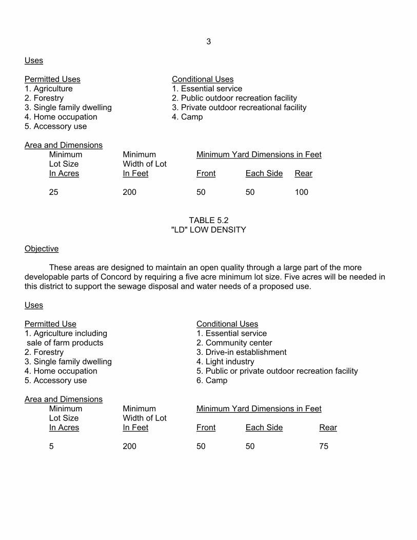
3
Uses Permitted Uses Conditional Uses 1. Agriculture 1. Essential service 2. Forestry 2. Public outdoor recreation facility 3. Single family dwelling 3. Private outdoor recreational facility 4. Home occupation 4. Camp 5. Accessory use Area and Dimensions Minimum Minimum Minimum Yard Dimensions in Feet Lot Size Width of Lot In Acres In Feet Front Each Side Rear
25 200 50 50 100
TABLE 5.2 "LD" LOW DENSITY
Objective
These areas are designed to maintain an open quality through a large part of the more developable parts of Concord by requiring a five acre minimum lot size. Five acres will be needed in this district to support the sewage disposal and water needs of a proposed use. Uses Permitted Use Conditional Uses 1. Agriculture including 1. Essential service sale of farm products 2. Community center 2. Forestry 3. Drive-in establishment 3. Single family dwelling 4. Light industry 4. Home occupation 5. Public or private outdoor recreation facility 5. Accessory use 6. Camp Area and Dimensions
Minimum Minimum Minimum Yard Dimensions in Feet Lot Size Width of Lot In Acres In Feet Front Each Side Rear 5 200 50 50 75

4
TABLE 5.3 "MD" MEDIUM DENSITY
Objective
This district is focused upon the areas of Concord that are in close proximity to existing areas of settlement, which have good road and utility access. Lots in this district may require off-lot water and/or sewage service. Lot requirements are designed to encourage growth in these areas in close proximity to the town's village centers. Uses Permitted Use Conditional Use Permit 1. Forestry 1. Agriculture, including sale of farm products 2. Single family dwelling 2. Private Club 3. Two-family dwelling 3. Industry 4. Home occupation 4. Camp 5. Indoor recreation 6. Religious facilities 7. Public/private school 8. Essential service 9. Accessory use Area and Dimensions Minimum Minimum Minimum Yard Dimensions in Feet Lot Size Width of Lot In Acres In Feet Front Each Side Rear
2 150 25 25 50
TABLE 5.4 "HD" HIGH DENSITY
Objective
These districts represent the town's pre-existing village centers, which are serviced by adequate road and utility services. All pre-existing development in these districts is currently serviced by individually owned water and sewage systems. Future development or redevelopment within these districts shall be limited to the ability of the district's soils and natural water resources to support the proposed development. Uses

5 Permitted Uses Conditional Uses 1. Single family dwelling 9. Retail store 1. Auto service station 2. Two family dwelling 10. Retail Business 2. Car Wash 3. Home occupation 11. Business office 3. Multi-family dwelling 4. Indoor recreation 12. Community Center 4. Industry 5. Religious facility 13. Funeral Home 5. Private Club 6. Public/private school 14. Public Facility 6. Public/private outdoor 7. Essential service recreation facility 8. Accessory use 7. Restaurant 8. Hotel and Motel Area and Dimensions
Minimum Minimum Minimum Yard Dimensions in Feet Lot Size Width of Lot In Sq. Ft. in Feet Front Each Side Rear
40,000 100 25 25 50
TABLE 5.5 "LAKE" LAKESHORE
Objective
This district surrounding Shadow Lake and Miles Pond is designated to provide adequate setback from the seasonal high water mark of the water bodies to protect them from water pollution and help protect the visual qualities of the shoreline. Uses Permitted Uses Conditional Uses 1. Agriculture 1. Home occupation 2. Forestry 2. Outdoor recreation facility 3. Single family dwelling 3. Essential service 4. Accessory use
5. Camp Area and Dimensions
Minimum Minimum Minimum Yard Dimensions in feet Lot size Width of lot In Acres In Feet Front Each Side From Water 2 150 35 35 35
Section 6 Permitted Uses
Permitted uses are those that are allowed, providing the standards established by this bylaw are met. Unless a variance or other special action by the Board of Adjustment and/or the Planning Commission is required, the necessary permit may be issued by the Administrative Officer.

6
Section 7 Conditional Uses
Permitted upon issuance of a conditional use permit are those uses that may be allowed by the Board of Adjustment as provided for in Section 4407 (2) of the Act after public notice and hearing. In order for the permit to be granted the purposed use shall not adversely affect:
1. the capacity of existing or planned community facilities; 2. the character of the area affected; 3. traffic on roads and highways in the vicinity; 4. by-laws in effect with special reference to these zoning regulations; and 5. utilization of renewable energy resources.
In permitting a conditional use, the Board of Adjustment may impose in addition to the
regulations and standards expressly specified by this regulation, other conditions found necessary to protect the best interests of the surrounding property, the neighborhood, or the municipality as a whole. These conditions may include the following:
1. increasing the required lot size or yard dimensions in order to protect adjacent properties; 2. limiting the coverage and/or height of builds because of obstruction to view and reduction of light and air to adjacent property; 3. controlling the location and number of vehicular access points to the property; 4. increasing street width; 5. increasing the number of off street parking or loading spaces required; 6. limiting the number, location and size of signs; 7. requiring suitable landscaping where necessary to reduce noise and glare and to maintain the property in a character in keeping with the surrounding area; 8. specifying a specific time limit for construction, alteration, or enlargement to begin for a structure to house a conditional use; 9. requiring that any future enlargement or alteration of the use be reviewed by the Board of Adjustment to permit the specifying of new conditions;
As a condition of the grant of a conditional use, the Board of Adjustment may attach such
additional reasonable conditions and safeguards as it may deem necessary to implement the purposes of the Act and these zoning regulations.
A change of use, expansion or contraction of land, area, or alteration of structures or uses which are designated as a conditional use within the district in which they are located and are existing therein, prior to the effective date of this regulation, shall conform to all regulations herein pertaining to conditional uses. ARTICLE III GENERAL PROVISIONS
The following provisions shall apply to all districts except where listed: Section 1 Miscellaneous Requirements of Act
a. Required frontage on, or access to, public roads or public waters by a permanent easement or right-of way at least 50 feet in width.

7
b. Protection of home occupation - no regulation herein is intended to infringe upon the right of any resident to use a minor portion of a dwelling for an occupation which is customary in residential areas and which does not change the character thereof.
Section 2 Lots in Two Zoning Districts
Where a district boundary line divides a lot of record at the time such line is adopted, the regulations for the less restricted part of such lot shall extend not more then thirty feet into the more restricted part, provided the lot has frontage on a street in the less restricted district. Section 3 Temporary Uses and Structures
Temporary permits may be issued by the Administrative Officer for a period not exceeding one year, for non-conforming uses incidental to construction projects, provided such permits are conditioned upon agreement by the owner to remove the structure or use upon expiration of the period not exceeding one year. Section 4 Abandonment of Structures
Within nine months after work on an excavation for a building has begun or within nine months after a permanent or temporary building or structure has been destroyed, demolished or abandoned, all structural materials shall be removed from the site, and the excavation remaining shall be covered over or filled to the normal grade, by the owner.
Section 5 Height Regulations
Except for farming purposes, in all districts structures shall not exceed a height of 35 feet above average ground level unless approved be the Zoning Board of Adjustment. The Zoning Board of Adjustment may authorized a variance to the height regulations in any district, providing such an increase will not be disruptive to its surroundings and providing it does not constitute a hazard. Section 6 Public Utility Substations
Public utility substations and similar utility structures, were permitted shall comply with the following:
a. the facility shall be surrounded by a fence set back from the property lines in conformance with the district regulations for front, side, and rear yards; b. a landscaped area at least twenty five feet wide shall be maintained in front, rear and side yards.
Section 7 (Repealed June 1987)

8 Section 8 Home Occupation
Any home occupation such as an art studio, antique shop, dressmaking off-premise commercial service, custom commercial service shop, teaching, or the professional office of a physician, dentist, lawyer, engineer, architect or accountant shall be permitted if it complies with the requirements of this section.
a. The home occupation shall be carried on by members of the family. In addition, three on-premise employees who are not part of the family are permitted. b. A home occupation shall only be carried on within a minor portion of a dwelling or its accessory structure. c. Exterior displays or signs other then those permitted in c. (1) of this Section and/or exterior storage of materials and/or exterior indication of the home industry and/or a variation from the residential character of the principal structure and/or the residential area, shall not be permitted.
(1) No exterior display of the home occupation shall be allowed other then one sign, not exceeding three (3) feet by four (4) feet in size.
d. Objectionable circumstances such as noise, vibration, smoke, dust, electrical disturbance, odors, heat, or glare shall not be produced. e. Parking shall be provided off-street and shall not be located in front lawns.
Section 9 Uses Not Permitted
In all districts the following uses are not permitted: junkyards; machinery wrecking yards; bulk
storage of: fuel oil, butane propane and gasoline; the unenclosed manufacturing or processing of goods or materials and the exterior parking and/or storage of three or more inoperable or unregistered vehicles within site of any town or state road or highway. Section 10 Agriculture
Agriculture uses shall comply with the following requirements: a. farm buildings, other then a dwelling, shall not be erected within two hundred (200) feet of a neighboring property; b. feedlots, fenced runs, pens and similar intensively used facilities for animal raising and care shall not be located within two hundred (200) feet of a neighboring property, excluding pastures.
Section 11 Flood Hazard Areas
1. Lands to Which These Regulations Apply a. These regulations shall apply for development in all areas in the Town of Concord identified as areas of special flood hazard on the current National Flood Insurance Program maps which are hereby adopted by reference and declared to be part of these regulations.

9
2. Conditional Use Permit Required a. All development including fill, excavation, grading, erection or placement structures, substantial improvement of existing structures and storage of equipment and material prescribed by the Town of Concord zoning bylaw are permitted within an area of special flood hazard only upon the granting of a conditional use permit by the Board of Adjustment. b. Prior to issuing a permit for the construction of a new building, the substantial improvement of existing buildings, or for development in the floodway, a copy of the application shall be submitted to the Vermont Department of Water Resources and Environmental Engineering in accordance with 24VSA 4409. A permit may be issued only following receipt of comments from the Department of or the expiration of 30 days from the date the application was mailed to the Department, whichever is sooner. c. Adjacent communities and the Vermont Department of Water Resources and Environmental Engineering shall be notified at least 15 days prior to issuing any permit for the alteration or relocation of a watercourse and copies of such notification shall be submitted to the Administrator of the Federal Insurance Administration. d. Proposed development shall be reviewed to assure that all necessary permits have been received from those governmental agencies from which approval is required by Federal or State law.
3. Base Flood Elevations and Floodway Limits
a. Where available, i.e.; Zones Al-A30, AE, and AH, the base flood elevations and floodway limits provided by the National Flood Insurance Program in the Flood Insurance Study and accompanying maps shall be used to administer the provisions of these regulations. b. In areas where base flood elevations and floodway limits have not been provided by the National Flood Insurance Program, i.e.; Zone A, base flood elevation and floodway information available from State and Federal agencies or other sources, shall be obtained and reasonably utilized to administer the provisions of these regulations.
4. Conditional Use Review Procedures
a. Upon receiving an application for a conditional use permit under these regulations, the Board of Adjustment shall, prior to rendering a decision thereon:
(1) Obtain from the applicant; (a) The elevation (in relation to mean sea level) of the lowest floor, including basement, of new buildings or buildings to be substantially improved; (b) Where flood proofing is proposed, the elevation (in relation to mean sea level) to which the building will be flood proofed;

10
(c) Plans drawn to scale showing the existing and proposed land contours, buildings, structures, streams, roads and other pertinent physical features; (d) Base flood elevation data for subdivisions and other proposed development which contain at least 50 lots or 5 acres (whichever is the smaller). (e) Such other information deemed necessary by the Board of Adjustment for determining the suitability of the site for the proposed development.
(2) Obtain from the Vermont Department of Water Resources of other State or Federal agencies any available base flood elevation data.
b. In reviewing each application, the Board of Adjustment shall consider: (1) the elevation of the Vermont Department of Water Resources; (2) the availability of alternative locations not subject to flooding for the proposed use; (3) the susceptability of the proposed improvement to flood damages; (4) the safety of access to the property in times of flood of ordinary and emergency vehicles; (5) the potential for damage to the property caused by erosion; (6) the danger that materials may be swept onto other lands and cause damage to others; and (7) such other factors as are relevant to the purpose of this bylaw.
c. The Board of Adjustment may grant a conditional use permit for development provided: (1) all necessary permits are obtained from those governmental agencies from which approval is required by State and Federal Law; and (2) the development standards of 11.5 are met or exceeded.
5. Development Standards Within Areas of Special Flood Hazard a. All development and structures shall be:
(1) designed to minimum flood damage to the proposed development and to public facilities and utilities, and; (2) designed to provide adequate drainage to reduce exposure to flood hazards;

(3) designed (or modified) and adequately anchored to prevent flotation, collapse, or lateral movement of the structure during the occurrence of the base flood; (4) constructed with materials resistant to flood damage; (5) constructed by methods and practices that minimize flood damage, and; (6) constructed with electrical, heating, ventilation, plumbing, and air conditioning equipment and other service facilities that are designed and/or located so as to prevent water from entering or accumulating within the components during conditions of flooding.
b. The flood carrying capacity within any altered or relocated portion of a watercourse shall be maintained. c. New and replacement water supply and sanitary sewage systems shall be designed to minimize or eliminate infiltration of flood waters into the systems and discharges from the system into flood waters. d. On-site waste disposal systems shall be located to avoid impairment to them or contamination from them during flooding. e. New and replacement manufactured homes shall be elevated on properly compacted fill such that the top of the fill (the pad) under the entire manufactured home is above the base flood elevation. f. Development within the floodway is prohibited unless a registered professional engineer certifies that the proposed development will result in any increase in flood levels during the occurrence of the base flood. g. The lowest floor, including basement, of all new buildings shall be at or above the base flood elevation. h. Existing buildings to be substantially improved for:
(1) Residential purposes shall be modified or elevated to meet the requirements of 11.5 g.. (2) Non-residential purposes shall either:
(a) meet the requirements of 11.5 g., or (b) be designed to be watertight below the base flood elevation with walls substantially impermeable and with structural components having the capability of resisting hydrostatic and hydrodyamic loads and effects of buoyancy. A permit for a building proposed to be flood-proofed shall not be issued until a registered professional engineer or architect has reviewed the structural design, specifications and plans, and has certified that the design and proposed methods of construction are in accordance with accepted standards of practice for meeting the provisions of this subsection.

12
i. Junkyards and storage facilities for floatable materials, chemicals, explosives, flammable liquids, or other hazardous or toxic materials, are prohibited within the floodway.
6. Duties and Responsibilities of the Administrative Officer
The Administrative Officer shall maintain a record of: a. all permits issued for development in areas of special flood hazard; b. the elevation, in relation to the mean sea level of the lowest floor, including basement, of all new or substantially improved buildings; c. the elevation, in relation to mean sea level, to which buildings have been flood-proofed; d. all flood-proofing certifications required under this regulation; and e. all variance actions, including justification for their issuance.
7. Variances a. Variances shall be granted by the Board of Adjustment only:
(1) in accordance with provisions of 24 VSA Section 4468; (2) upon a determination that during the base flood discharge the variance will not result in increased flood levels; and (3) upon a determination that the structure or other development is protected by methods that minimize flood damages during the base flood and create no additional threats to public safety.
8. Warning of Disclaimer of Liability
a. These regulations do not imply that land outside the area of special flood hazard or land uses permitted within such districts will be free from flooding or flood damages. These regulations shall not create liability on the part of the Town of Concord or any official or employee thereof for any flood damages that result from reliance on this bylaw or any administrative decision lawfully made thereunder.
9. Section 11 Flood Hazard Areas Definitions
Area Of Shallow Flooding - means a designated AO or AH zone on a community's Flood
Insurance Rate Map (FIRM) with a one percent or greater annual chance of flooding to an average depth of one to three feet where a clearly defined channel does not exist, where the path of flooding is unpredictable, and where velocity flow may be evident. Such flooding is characterized by ponding or sheet flow.
Area Of Special Flood Hazard - is the land in the flood plain within a community subject to a
one percent or greater chance of flooding in a given year. The area may be designed as Zone A on the FHBM. After detailed ratemaking has been completed i preparation for publication of the FIRM, Zone A usually is defined into Zones A, AH, Al-A30, AE, or A99.

13
Base Flood - means the flood having a one percent chance of being equaled or exceeded in a given year.
Basement - means any area of the building having its floor subgrade (below ground level) on all sides.
Building - means a wall and roofed building, including a gas or liquid storage tank, that is principally above ground.
Development - means the division of a parcel of land into two or more parcels; the construction, reconstruction, conversion, structural alteration, relocation, or enlargement of any building or other structure; or of any mining, excavation or landfill; and any change in the use of any building or other structure, or land, or extension of use of land.
Flood Hazard Boundry Map (FHBM) - means an official map or maps of a community, issued by the Administrator, where the boundaries of the flood, mud-slide (i.e., mudflow) related erosion areas having special hazards, have been designated as Zones A, M, and/or E.
Flood Insurance Rate Map (FIRM) - means an official map or maps of a community, on which the Administrator has delineated both the special hazard areas and the risk premium applicable to the community.
Flood Insurance Study - means an examination, evaluation, and determination of flood hazards and, if appropriate, corresponding water surface elevations.
Flood Proofing - means any combination of structural and non-structural additions, changes, or
adjustments to structures which reduce or eliminate flood damage to real estate or improved real property, water and sanitary facilities, structures and their contents.
Floodway - means the channel of a river or other watercourse and the adjacent land areas that must be reserved in order to discharge the base flood without cumulatively increasing the water surface elevation more then a designated height.
Lowest Floor - means the lowest floor of the lowest enclosed area including a basement). An unfinished or flood resistant enclosure, usable solely for parking of vehicles, building access or storage in an area other then the basement area is not considered a building's lowest floor; provided that such enclosure is not built so as to render the structure in violation of the applicable non-elevation design requirements of Section 11-3.
Manufactured Home - means a structure, transportable in one or more sections, which is built on a permanent foundation when connected to the required utilities. For flood plain management purposes the term "manufactured home" also includes park trailers, travel trailers, and other similar vehicles placed on a site for greater then 180 consecutive days. For insurance purposes the term "manufactured home', does not include park trailers, travel trailers, and other similar vehicles.

14
Mean Sea Level - means, for the purposes of the National Flood Insurance Program, the National Geodetic Vertical Datum (NGVD) of 1929 or the datum, to which base flood elevations shown on a community Flood Insurance Rate Map are referenced.
Structure - means an assembly of materials for occupancy or use, including, but not limited to,
a building, mobile home or trailer, billboard, sign, wall or fence, except a wall or fence on an operating farm.
Substantial Improvement - means any repair, reconstruction, or improvement of a structure, the cost of which equals or exceeds 50 percent of the market value of the structure either, (a) before the improvement or repair is started, or (b) if the structure has been damaged, and us being restored, before the damage occurred. The term does not, however include either (1) any project for improvement of a structure to comply with existing state or local health, sanitary, or safety code specifications which are solely necessary to assure safe living conditions or (2) any alteration of a structure listed on the National Register of Historic Places or a State Inventory of Historic Sites. Section 12 Burned buildings
No owner or occupant of land in any district shall permit fire or other ruins to be left, but within one year shall remove and fill in basement excavation to ground level or shall repair, rebuild or replace the structure. Section 13 Drive-Inn Establishment and Agricultural Stand
Plan for the erection or structural alteration of any drive-in or agricultural stand shall be submitted to the Planning Commission for approval. Section 14 Travel Trailers
It shall be unlawful for any person to park a camping trailer, travel trailer, pickup coach, or motor home on any public or private property, except in accordance with these regulations as follows: a. A property owner may park his own travel trailer or that of a bonafide visitor, on his property without special approval, provided it is parked no closer then six feet to any lot line. Section 15 Residential and Commercial Vehicle Parking
No more then three unregistered vehicles shall be parked and/or stored on any residential, commercial, and municipal lot or plat, within view of any town, state, and federal road and/or highway; unless said property is the site of an approved/licensed dealer in new and/or used vehicles, and said business conforms with these bylaws. ARTICLE IV SPECIAL PROVISIONS Section 1 Planning Commission - Site Development Plan Approval
No zoning permit shall be issued by the Administrative Officer for any use or structure, except for one family and two family dwellings and agricultural buildings, until the Planning Commission grant Site Plan Approval.

15
a. Submission of Site Development Plan Map and Supporting Data. The property owner shall submit two sets of site plan maps and supporting data to the Planning Commission. The data submitted shall include the following information:
(1) The name and address of person or firm preparing the map(s). Scale of map, north point and date. Name and address of the property owner(s) of record. Name and address of the owner(s) of record of adjoining lands. (2) A Map of the property showing existing features including: map scale, north point indicator, all lot lines and their dimensions, sewage system and water supply locations; existing: contours, structures, tree patterns, streets, utility easements, right-of-ways, and supporting documents which indicate the property's land use and deed restrictions. (3) A Site Plan showing proposed structure locations and land use areas including: proposed change of use if any, sewage and water supply locations or changes proposed for the existing system, driveways, traffic circulation, parking and loading spaces and pedestrian walks; landscape plans including site grading and landscape design and screening.
b. Site Development Review Procedure. The Planning Commission shall conform to the requirements of Section 4407(5) of the Act before acting upon any application. In considering its action the Planning Commission shall consider and may impose appropriate conditions and safeguards only with respect to the adequacy of traffic access/ circulation, parking, landscaping and screening. The Planning Commission shall review the site plan map and supporting data before approval or approval with stated conditions, or disapproval, is given, by taking into consideration the following objectives:
(1) Harmonious relationship between proposed uses and existing adjacent uses. (2) Maximum safety of vehicular circulation between the site and the town's street network. (3) Adequacy of circulation, parking and loading facilities with particular attention to safety. (4) Adequacy of landscaping, screening, and setbacks in regard to achieving maximum compatibility and protection of adjacent property. (5) Freedom from flooding and ponding. (6) Adequacy of water supply and sewage disposal capabilities.

16
ARTICLE V NON-CONFORMING USES Section V Construction Approved Prior to Adoption Amendment to Regulations
Nothing contained in these regulations shall require any change in plans or construction of a non-complying structure for which a building (zoning) permit has been issued, and which has been completed within one year from the effective date of these regulations.
Any non-conforming use of structures or land, except those specified below, may be continued
indefinitely, but: a. shall not be moved, enlarged, altered, extended, reconstructed, or restored (except as provided below), nor shall any external evidence of such use be increased by any means whatsoever; b. shall not be changed to another non-conforming use without approval by the Planning Commission, and then only to a use, in the opinion of the Commission is of the same or of a more restrictive nature; and c. shall not be restored for other then a conforming use after damage from cause, unless the non-conforming use is reinstated within one year of such damage; if the restoration of such structure is not completed within one year, the non-conforming use of such structures shall be deemed to have been discontinued, unless such non-conforming use is carried on without interruption in the undamaged part of the building.
Section 2 NON COMPLYING STRUCTURE MAINTENANCE
Nothing in this section shall be deemed to prevent normal maintenance and repair of a non-complying structure providing that such actions does not increase the degree of non-compliance.

17
ARTICLE VI DEFINITIONS
For the purpose of these regulations, certain terms or words used herein shall be interpreted as follows: Section 1 Word Definitions
The word person includes a firm, association, organization, partnership, trust, company or corporation as well as an individual.
The present tense includes the future tense, the singular number includes the plural, and the plural number includes the singular.
The word shall is mandatory, and the word may is permissive. The words used or occupied include the words intended, designed, or arranged to be used, or
occupied. The word lot includes the words plot or parcel.
Section 2 Term Definitions Accessory Use or Structure - means a use or structure on the same lot with, and of the nature customarily incidental and subordinate to, the principal use or structure. Such use or structure shall not exceed, in area, 50 percent of the principal use or structure. Building - means an assemblage of materials for the support or enclosure of persons, animals, chattel of any kind. Building/Structure Front Line - means a line parallel to the front line transecting that point in the structure face which is closest to the front line. This face includes porches whether enclosed or unenclosed but does not include steps. Building/Structure Height - means the vertical distance measured from the average elevation of the proposed finish grade at the front of the structure to the highest point of the roof for flat and mansard roofs, and to the average height between eaves and ridge for other type roofs. Camp - means a structure to provide temporary shelter and sleeping accommodations during leisure and recreational activities, and which shall not be used or identified as a dwelling. Club, Private - means a structure or use catering exclusively to club members and their guests for recreational purposes, and not operated primarily for profit. Community Center - includes public or private meeting hall, place of assembly, museum, art gallery, library, place of further education, church, not operated for profit. Dwelling, Single Family - means a detached, residential dwelling unit, including a mobile home, designed for and occupied by one family only. Dwelling, Two Family - means a residential building designed for occupancy by no more then two families living independently of each other in individual living units.

18
Dwellings, Multi-Family - means a residential building designed for or occupied by three or more families, with the number of families in residence not exceeding the number of dwelling units provided. Dwelling Unit - means one or more rooms connected together, constituting a separate, independent housekeeping establishment for owner occupancy, rental or lease, and physically separated from any other rooms or dwelling units which may be in the same structure, sharing the dwelling's sewage and water system, but containing independent cooking and sleeping facilities. Family - means one or more persons occupied a single dwelling unit, provided that unless all members are legally related by blood, adoption, or marriage, on such family shall contain over five (5) persons, but further provided that domestic servants and farm workers employed on the premises may be housed on the premises without being counted. Home Occupation - means a accessory use, of a service character, conducted within a minor portion of a dwelling or its accessory structure by the residents thereof and not more then three employees, and which is clearly secondary to the dwelling used for living purposes and does not change the character thereof. Junk Yard - means any lot used to park, store, dismantle, destroy, crush and/or disassemble used: appliances, furniture, construction materials, trailers, mobile homes, and/or more then three unregistered and/or uninspected vehicles or machines at any given time period. Machinery used on active agricultural projects is not included in this definition. Light Industry - means manufacturing, assembly, converting, altering, finishing, cleaning or other processing, handling or storage of products or materials. Loading Space - means an off-street space used for temporary location of one licensed motor vehicle, which is at least twelve (20) feet wide and forty (40) feet long and fourteen (14) feet high, not including access driveway, and having direct access to the street or alley. Lot - means a parcel of land occupied or to be occupied by only one main structure and the accessory structures or uses customarily incidental to it. A lot shall be of sufficient size to meet zoning requirements for use, coverage, and area, and to provide such yards and other spaces as are herein required, Such lots shall have frontage on an approved public street, or other means of access approved by the Planning Commission and may consist of : a single lot of record; a portion of a lot of record; a combination of complete lots of record, or portions of lots of record; or a parcel of land described in metes and bounds; provided that in no case of division or combination shall any residential lot or parcel be created which does not meet the requirements of this bylaw. Lot Measurements - Depth of a lot shall be considered to be the distance between the mid points of straight lines connecting the foremost points of the side lines in front and the rearmost points of the side lot lines in the rear. Width of a lot shall be considered to be the distance between straight lines connecting front and rear lot lines at each side of the lot, measured across the rear of the required front yard, however, that width between the lot lines at their foremost points (where they intersect with the street line) shall not be less then 80 percent of the required lot width except in the case of lots on the turning circle of a cul-de-sac, where the 80 percent requirement shall not apply.

19
Lot of Record - means a lot which is part of a subdivision recorded in the office of the Town Clerk, or a lot or parcel described in metes and bounds, the description of which has been so recorded. Mobile Home - means a structure, transportable in one or more sections, which is built on a permanent chassis and is designed for use with or without a permanent foundation when connected to the required utilities. Neighborhood Commercial Facility - means any commercial facility such as a grocery, general, or drug store or retain service establishment intended principally to serve the area in which it is located. Non-Conforming Use - means a use of land or structure which does not comply with the zoning regulations for the district in which it is located, where such use conformed to all applicable laws and regulations prior to the enactment of these regulations. Non-Conforming Structure - means a structure not complying with the zoning regulations for the district in which it is located, where such structure complied with all applicable laws and regulations prior to enactment of these regulations. Non-Residential Use - means all uses of structures or lands except single family dwellings, two family dwellings, and multi-family dwellings. On-Lot Water and Sewage Disposal - means the providing of water from a source such as a drilled well or spring and the disposal of sewage by such means as a septic tank and leach field located on the same or adjacent lot as the structure for which these utilities are located. Parking Space, Off-Street - means an off-street parking space shall consist of a space adequate for parking an vehicle with room for opening doors on both sides, together with properly related access to a public street or alley and maneuvering room.
For the purpose of rough computation, an off-street parking space and necessary access and maneuvering room may be estimated to be 300 square feet, but off-street parking requirements will be considered to be met only when actual spaces meeting the requirements above are provided and maintained, in a manor appropriate to the circumstances of the case, and in accordance with all bylaws and regulations of the Town. Personal Service - includes barber, hairdresser, beauty parlor, shoe repair, laundry and laundromat, dry cleaner, photographic studio, and businesses providing similar services of a personal nature. Public Assembly Use - includes auditorium, theatre, public hall, school hall meeting hall, and church or temple. Residential Use - includes single family dwelling, mobile home dwelling, two family dwelling and multi-family dwelling. Retail Store - includes enclosed restaurant, cafe, shop and store for sale of retail goods, personal service shop and department store; and shall exclude any drive-in service, free standing retail stand, gasoline service and motor vehicle repair service, new and used car sales and service, trailer and mobile home sales and service. Street Public - means the public way for vehicular traffic which affords the principal means of access to abutting properties.

20 Street Frontage - means the lot lines which abut a public street. Street Line - means the right-of-way line of a street as dedicated by a deed of record. Where the width of the street is not established, the- street line shall be considered to be twenty-five (25) feet from the center line of the street pavement. Structure - means anything constructed or erected with a fixed location on or in the ground including: buildings, mobile and modular homes, sheds, in-ground swimming pools, framed dwellings, septic systems including leach fields, wells, barns, stores, and municipal buildings. Travel Trailer or Trailer - means any vehicle having a width of eight (8) feet or less and/or the length of thirty-five (35) feet or less which is used or so constructed to permit its being used as a conveyance, or be conveyed, on the public street and highways whether licensed or not, and constructed in such a manner as will permit occupancy thereof as a sleeping place for one or more persons. A trailer shall also mean tent trailers, truck campers, camping trailers, and vehicles converted to sleeping facilities other then mobile homes. This definition includes uses to which trailers might be put. Use, Permitted - means a use specifically allowed in a district, excluding illegal uses and non-conforming uses. Yard - means the space on a lot not occupied with a building or structure. Porches, whether enclosed or unenclosed, shall be considered as part of the main structure and shall not project into a required yard. Yard, Front - means the space between the front lot line and the front line of a structure extending to the side lot lines of the lot. The depth of the front yard shall be measured from the street line to the front line of the structure. Yard, Rear - means the space between the rear lot line and rear line of the structure extended to the side lot lines of the lot. The depth of the rear yard shall be measured from the rear lot line to the rear line of the structure. Yard, Side - means the space between the principal structure or accessory structure and a side lot line, and extending through from the front yard to the rear yard. ARTICLE VII ADMINISTRATIVE AND ENFORCEMENT Section 1 Administrative Officer
The administrative Officer shall be appointed to administer the zoning regulations, as provided for in Section 4442 of the Act. Said officer shall literally enforce the provisions of these regulations and in so doing shall inspect developments, maintain records and perform all other necessary tasks to carry out the provisions of these regulations. Section 2 Zoning Permit and Certificate of Occupancy
No land or building development may commence unless or until a zoning permit has been duly issued by the Administrative Officer, as provided for in Section 4443 of the Act. The fee for such zoning permit shall be as established by the Board of Selectmen.

21
The Administrative Officer shall not issue a zoning permit unless or until an application, fee, plot plan, approved site development plan, and any other approvals required by this regulation have been properly submitted. The Administrative Officer shall, within thirty (30) of submission of application, data and approvals, either issue or deny a zoning permit. If denied, the Administrative Officer shall so notify the applicant in writing, stating his or her reasons thereof. If the zoning permit is approved, all activities authorized by its issuance shall be completed within one year of its date of issue, or the zoning permit shall become null and void for all uncompleted activities and re-application to complete these activities shall be required.
No land or structure may be used, extended in any way or occupied unless a certificate of occupancy shall have been duly issued by the Administrative Officer, as provided for in Section 4443 of the Act.
No certificate of occupancy shall be issued by the Administrative Officer unless or until the premises comply with the requirements of the zoning permit, these regulations, state subdivision regulations, the site development plan requirements, and any other applicable local and state regulations. Section 3 Conditional Uses
No zoning permit shall be issued by the Administrative Officer for any use or structure which require conditional use approval in this regulation until the Board of Adjustment grants such approval. In considering its action, the Board of Adjustment shall make findings on general and specific standards, holding hearings and attaching conditions, if any, as provided for in section 4407 (2) of the Act. Section 4 Penalties
Violations of these regulations shall be regulated as prescribed in Sections 4444 and 4445 of the Act. Section 5 Board of Adjustment
There is hereby established a Board of Adjustment whose members shall consist of the members of the Planning Commission, until such time that the Board of Selectmen appoints a separate Zoning Board of Adjustment of five (5) members as provided in the Act. Rules of procedure, nature of appeals, public notice, conditions of variance relief, and all other matters shall be established by Sub-Chapter 8 of the Act. Section 6 Referral to State Agency
In accordance with Section 4409(c) of the Act, no zoning permit for the development of land in certain locations specified in said section shall be issued by the Administrative Officer without first submitting a report to the appropriate state agency, in compliance with the terms of Section 4409(c). ARTICLE VIII AMENDMENTS, INTERPRETATION, EFFECTIVE DATE Section 1 Amendments
These regulations may be amended according to the requirements and procedures established in Sections 4403 and 4404 of the Act.

22
Section 2 Interpretation In their interpretation and application, the provisions of these regulations shall be held to be
minimum requirements adopted for the promotion of the public health, safety, comfort, convenience, and general welfare.
Except for Section 4409(b) of the Act and where, in these regulations, specifically provided to
the contrary, it is not intended by these regulations to repeal, annul, or in any way to impair any regulations or permits previously adopted or issued, provided, however, that where these regulations impose a greater restriction upon the use of a structure or land than are required by any other statute, ordinance, rule, regulation permit, easement, or agreement, the provisions of these regulations shall control and prevail. Section 3 Effective Date This regulation shall take effect in accordance with the voting and other procedures contained in Section 4404 of the Act. Section 4 Separability The invalidity of any article or section of these regulations shall not invalidate any other article or section thereof.