town of melfa - virginia's eastern shore of melfa . chapter 19 | page 4 . retail trade 8 8 7...
TRANSCRIPT

Eastern Shore of Virginia Hazard Mitigation Plan
Chapter 19 | Page 1
TOWN OF MELFA TOWN PROFILE
The Town of Melfa encompasses 165 acres along the south central spine of Accomack County (Figure 1). Melfa developed around a railroad station in 1884. In the early 1900s Melfa was a site of industries, including a canning factory, bottling company, three sawmills, two dairies, a barrel factory, and two hatcheries. Presently, Melfa is largely residential. The town became incorporated in 1951 with the purchase of a fire engine (Town of Melfa Comprehensive Town Plan, 1997).
Figure 1: Melfa Aerial Imagery

Town of Melfa
Chapter 19 | Page 2
SOCIO-ECONOMIC
Part of assessing hazards in relation to their risk is understanding the people affected. Not all people are affected equally. Some are affected by the factors that relating to their ability to understand risks posed by hazards, and some by their ability to remove themselves from harm’s way. Those factors include age, mobility, income and the languages individuals speak and the languages in which individuals are able to access information.
DEMOGRAPHICS
After an initial decline of about 50 people between 2000 and 2010, Melfa is believed to have retained a relatively stable population, according to estimate from the American Community Survey (Table 1). Although the median age seems to be increasing, Town representatives have noticed an increase in the number of children in the Town and believe that the 2013 estimate is most likely too high (Mayor Denise Bendick, personal communication, January 27, 2016). Most, if not all, Melfa residents speak English as their primary language.
Table 1: Melfa Demographic Information 2014* 2013** 2010*** 2000**** Population 411 383 408 450 Median Age 44.9 48.3 43.0 38.0 Disability NA 12 NA NA Income Median Household Income
NA $38,684 $34,097 $37,361
Poverty Level NA 15.4% 29.2% NA Language Only English 100% 100% 96.1% 94.2% Other Spanish 0.0% 0.0% 1.6% 4.4% Other Indo-Euro 0.0% 0.0% 2.3% 1.3%
*Annual Estimates of the Residential Population: 2010 – 2014, ** American Community Survey 2009 – 2013, *** US Census 2010, **** US Census 2000
WORK FORCE
Employment patterns are important to examine for two reasons. They can help to identify concentrations of people for hazard information dissemination or hazard rescue and evacuation. They can also identify where disruptions in employment and income might occur in the aftermath of a disaster.
Melfa is primarily a residential community, where the majority of employed residents commute to work outside of Town.
Table 2: Melfa Local Workforce Industry Civilian Employed Population Industry 2014* 2012* 2010* 2000** Count Percent Count Percent Count Percent Count Percent Agriculture, forestry, fishing/hunting, or mining 25 10.2% 31 12.8% 4 1.8% 3 1.3%

Eastern Shore of Virginia Hazard Mitigation Plan
Chapter 19 | Page 3
Construction 7 2.8% 20 8.2% 15 6.9% 14 6.0% Manufacturing 19 7.7% 12 4.9% 19 8.7% 32 13.7% Wholesale trade 13 5.3% 16 6.6% 0 0.0% 16 6.9% Retail trade 28 11.4% 25 10.3% 43 19.7% 43 18.5% Transportation and warehousing, and utilities 8 3.3% 13 5.3% 18 8.3% 10 4.3%
Information 0 0.0% 0 0.0% 0 0.0% 0 0.0% Finance, insurance, real estate, and rentals 9 3.7% 5 2.1% 17 7.8% 8 3.4%
Professional, scientific, waste management 21 8.5% 5 2.1% 13 6.0% 5 2.1%
Educational and health care services 54 22.0% 69 28.4% 69 31.7% 47 20.2%
Arts, entertainment, recreation, food 22 8.9% 10 4.1% 8 3.7% 17 7.3%
Public Admin 22 8.9% 14 5.8% 10 4.6% 27 11.6% Other 18 7.3% 23 9.5% 2 0.9% 11 4.7% TOTAL CIVILIAN EMPLOYED POPULATION
246 - 243 - 218 - 233 -
Source: *ACS, 2010 – 2014, ** U.S. Census 2000
One of the largest employers of residents of the Town is the manufacturing industry, shown in Table 2, which is most likely dominated by poultry processing positions. These companies often have policies in place to mitigate the economic impact for both the company and the employees, however, long-term closures would have strong negative impacts on the Town. There would be a ‘domino effect’ from such a closure, as employees of in that industry wouldn’t have spending dollars for rent, local shops, nor family necessities, and other dependent agricultural businesses would be at a loss as well.
BUSINESSES
Business data provide basic information used in projecting potential economic losses from business and employment disruption, along with wage losses to employees. They can also serve as an indicator of community recovery resources. Finally, data can help to prioritize restoration of utility and infrastructure functions following a high-intensity hazard.
Table 3 presents business information for the entire zip code (23410) area, not just the incorporated Town. The Town itself only has about 15 business licenses, including Boggs Sewer and a home beauty shop (Mayor Denise Bendick, personal communication, January 27, 2016).
Table 3: Melfa Business Establishment Types Industry Code Description Total Establishments 2014 2012 2010 Construction 4 6 6 Manufacturing 3 3 4 Wholesale Trade 5 5 3

Town of Melfa
Chapter 19 | Page 4
Retail Trade 8 8 7 Real estate and rental and leasing 0 0 1 Transportation and Warehousing 3 4 4 Professional, Scientific, and Technical Services
5 4 5
Administrative and Support and Waste Management Remediation Services
4 3 3
Health Care and Social Assistance 1 1 0 Arts, Entertainment, and Recreation 1 1 2 Accommodation and Food Services 2 2 4 Other Services (Except Public Admin) 5 5 5 Total, All Establishments 41 42 44
Source: Census Zip Code Business Pattern, 2013, 2011, 2009
BUILT INFRASTRUCTURE
Housing units, community facilities, and transportation are all important factors when considering hazard resiliency. They provide the social services necessary during hazardous scenarios, safe cover for those wanting to stay, and a way to evacuate.
HOUSING UNITS
Knowledge of a community’s housing base contributes to hazard and vulnerability analysis by identifying how many homes are at risk. Mayor Denise Bendick indicated that the U.S. Census values for 2010 in Table 4 are still probably the most accurate (personal communication, January 27, 2016).
Table 4: Melfa Housing 2013* 2010** 2000*** Total Housing Units 218 202 205 Occupied 170 179 183 Vacant 48 23 22 Owner-Occupied 143 179 144 Renter-Occupied 27 42 39 Median Housing Value $143,500 NA NA
Source: * ACS, 2009 – 2013, ** U.S. Census 2010, *** U.S. Census 2000
TRANSPORTATION
U.S. Route 13 and Bay Coast Railroad run northeast to southwest through the town, parallel to each other, and are two of the town’s dominant features. Route 13 is designated as part of several essential highway networks, including the national defense Strategic Highway Network (STAHNET), a national system of highways necessary to

Eastern Shore of Virginia Hazard Mitigation Plan
Chapter 19 | Page 5
support emergency mobilization and peacetime movement of equipment to support U.S. military operations1, part of the National Highway System2, and the Eastern Shore’s only hurricane evacuation route.3 Furthermore, the state of Virginia has named U.S. Route 13 a “Corridor of Statewide Significance,” on which the long-distance movement of people and good is emphasized (VDOT).
Average daily traffic in this section of Route 13 was about 20,000 in 2014, with about 92 percent being 2-axle vehicles. Another six percent are tractor trailers, and the rest are a mix of heavy multi-axle trucks, buses, and other vehicle configurations (VDOT).
The measure of vehicles available to households is one indicator of a household’s ability to evacuate when necessary, or obtain necessary supplies to make hazard mitigation preparations. The number of households with no vehicle is relatively low According Census data, most Melfa households have at least one available for travel (Table 5).
Table 5: Melfa resident vehicles Vehicles Available 2014* 2010* 2000** None 2 7 7 One 49 78 78 Two 67 102 102 Three or more 52 28 28
Source: * ACS, 2009 – 2013, ** U.S. Census 2000
Melfa is on Star Transit’s purple and red routes. Although there are not regularly scheduled stops in town, it is part of the deviated route system and drivers will stop at Vance’s Furniture with advance notice.
Although the railroad does not have a stop within Town limits, it poses a potential hazard risk as it transports propane or could serve as an aid in evacuating residents during or following an emergency.
COMMERCIAL AREAS
The traditional center of town is located on the east side of the railroad tracks. Businesses include Vance’s furniture and appliance store, a well and septic service company, Shore Engineering, Eastern Shore Termite, an antique/flea market, a real estate company, Mr. Detail, and a storage company.
As with many small towns on the Shore, as business become more oriented to the highway rather than the railroad, new businesses chose to locate directly on U.S. 13. Since the railroad prevents development directly on the east side of Route 13, Melfa’s highway-oriented development is all on the west side. It includes two gas stations (Doughty’s and Shore Stop), Fosque’s Upholstery, Got Grass, a karate studio, and a tax preparation and book keeping business.
COMMUNITY FACILITIES
1 Strategic Highway Network, USDOT, www.fhwa.dot/policy/ 2004cpr/chap18.htm 2 FHWA, http://www.fhwa.dot.gov/planning/national_highway_system/nhs_maps/virginia/va_virginia.pdf 3 Virginia Department of Emergency Management, http://www.vaemergency.gov/sites/default/files/Final2014hurricaneguide.pdf

Town of Melfa
Chapter 19 | Page 6
Community facilities are facilities required to support the services and functions provided by the Town government or in coordination with other public and private entities. These facilities enhance the overall quality of life for the Town and its citizens. It’s important to note what facilities are available in case of a hazard, and it’s important to make an inventory of facilities that could be affected by a hazard.
PUBLIC SAFETY Police protection is provided by the Accomack County Sheriff’s Department and Virginia State Police. The State Police post for the Eastern Shore is located about one mile northeast of Melfa.
The Melfa Volunteer Fire and Rescue Company was organized in May 1950 in the aftermath of the “Eastern Sunday Fire.” Presently the Company operates a fleet of six apparatus, including tow advanced life support ambulances, two engines, a 2,500 gallon tanker, and a brush truck. Additionally there are three trailers and a support/tow vehicle operated by the hazmat Team, and the Eastern Shore C.E.R.T. Disaster Response trailer are kept on the station property. The station has three bays and was built in 2002. In addition to serving Melfa, the station serves portions of Bobtown, Boston, Hacks Neck, Harborton, Keller, Texacotown, Savageville, and various outlying areas (Melfa V.F.R.C., www.easternshorefire.com/station-10/).
Figure 2 : Melfa Volunteer Fire and Rescue Company building on Hatton Avenue includes 3 bays, a community room, bunk rooms, restrooms, station watch room,
laundry room, offices, & storage areas.
WATER SUPPLY AND WASTEWATER Melfa residents rely on private wells for their water supply and private septic systems for disposal. These residential wells are potentially at risk of contamination from aboveground and underground petroleum storage tanks (AST and UST). Most homes in the Town are heated by oil, which is stored in these tanks. If not properly maintained, ASTs and USTs and gas station storage tanks can pose a significant water quality risk to the Town.
SOLID WASTE DISPOSAL The Town has a trash truck and offers pick up each Monday, which is delivered to the Accomack County landfill. Additionally, residents can take their refuse to a county convenience centers, of which the closest is the Grangeville facility on Wachapreague Road. The Town also offers spring and fall clean up opportunities free of charge within the Town.
PARKS AND RECREATION The Melfa Town Park at the end of Woodland Avenue offers a lit baseball field and picnic area.

Eastern Shore of Virginia Hazard Mitigation Plan
Chapter 19 | Page 7
DRAINAGE DITCHES The Town enlists the services of a private contractor to complete an annual ditch cleaning for litter and brush removal. Maintenance of drainage ditches along roads is a VDOT responsibility, which Town representatives indicated was a five year plan. In the summer of 2015 the Town paid the County to replace the culvert pipe by the Town Hall. This effort has prevented street flooding considerably. Woodland Avenue floods entirely during heavy rain events, particularly by Shore Engineering, as it is also in need of a culvert pipe (Mayor Denise Bendick, personal communication, January 27, 2016).
SCHOOLS Although there are no schools within Town limits, the Eastern Shore Community College is less than a mile south of the Town and there is a day care with a private license on Ridge Avenue.
HISTORIC OR CULTURAL RESOURCES There is a plaque indicating the tallest point on the Eastern Shore within the Town boundaries. The Town Hall is in a historic store building.
NATURAL ENVIRONMENT
Melfa lies within the Chesapeake Bay watershed. The town itself is relatively flat, with most of the town ranging in elevation from 45 to 50 feet above sea level, although the highest point on the Shore is located west of Route 13 and is over 51 feet in elevation. Melfa is not located within the 100-year or 500-year floodplain.
LAND USE LAND COVER
Cultivated Crops, 13.70%
Developed, High1%
Developed, low, 24.50%
Developed, medium,
9.60%
Developed, Open, 35%
Hay/Pasture, 2.90%
Mixed Forest, 0.40%
Shrub/Scrub, 1.40%
Figure 3: Melfa Land Use Land Cover Percentages
Source: USGS, National Land Cover Dataset, 2011

Town of Melfa
Chapter 19 | Page 8
Melfa has a land area of 160 acres. Approximately 60% of the land area is developed (Figure 3), with residential land use being the predominant land use category. As Figure 4 demonstrates, the majority of the developed land use areas surround Route 13 and there is very little in the way of forest or shrub habitats.
Figure 4: Melfa Land Use Land Cover Map

Eastern Shore of Virginia Hazard Mitigation Plan
Chapter 19 | Page 9
HAZARD PREPAREDNESS & COMMUNITY CAPABILITIES
PREVIOUS HAZARD MITIGATION PLANS
Melfa has not previously participated in the hazard mitigation planning process. The Town’s primary risk is associated with storm water flooding.
Table 6 : Town of Melfa Hazard Mitigation Resources
Auth
ority
Build
ing C
ode
Ches
apea
ke B
ay A
ct
SWM
P
Haza
rd M
itiga
tion
Plan
Com
preh
ensiv
e Plan
onin
g &/o
r Sub
divis
ion
Ordi
nanc
e
Stor
m W
ater
Reg
ulat
ions
Tran
spor
tatio
n In
frast
ruct
ure
Inun
datio
n Vu
lner
abilit
y Rep
ort
All H
azar
ds P
repa
redn
ess
Emer
genc
y Ope
ratio
ns P
lans
Mut
ual A
id
Agre
emen
ts/D
ocum
ents
Neigh
borh
ood
Emer
genc
y Help
Vigin
ia Hu
rrica
ne Ev
acua
tion
Oil &
Haz
Mat
Res
pons
e Plan
; Ha
zMat
Com
mod
ity Fl
ow
Grou
nd W
ater
Com
mitt
ee
Navig
able
Wat
erw
ays C
omm
ittee
Clim
age A
dapt
atio
n W
orkin
g Gr
oup
ES D
isast
er P
repa
redn
ess
Coali
tion
Local * *County * *Regional * * * * * * * * * *State * * *Federal *
Ordinances, Plans, & Publications Resources, Committees

Town of Melfa
Chapter 19 | Page 10
NATIONAL FLOODING INSURANCE PROGRAM & HAZARD MITIGATION GRANT PROGRAM
NFIP
Melfa does not participate in the NFIP program.
HMGP
Melfa has not participated in the HMGP
DISASTER ASSISTANCE
Following severe flooding of the Melfa Town Park and the area around the storage unit, FEMA grant allowed for the installation of culvert piping that has improved the stormwater flooding situation.
HAZARDS PROFILE
Stormwater flooding has the greatest and most frequent impact on the Town.
WIND
No parts of Melfa lie in the wind borne debris hazard area. This area extends 1-mile inland from the coast. The Town lies in the 110 – 120 mph design wind zone (Accomack County Building Code).
Most of the residential areas are older and have mature trees in and around the homes. Falling branches or trees may cause damage to structures during a high wind or ice event.
Although there are no records of any tornado damage in the Town, there have been tornadoes in the region, and preparation is important.
COASTAL EROSION
No structures are at immediate risk to coastal erosion.
COASTAL FLOODING
No portions of the Town lie within areas designated by FEMA as flood zones. The threat of coastal flooding within the Town is considered to be minimal.
STORMWATER FLOODING

Eastern Shore of Virginia Hazard Mitigation Plan
Chapter 19 | Page 11
Melfa is underlain by some soils that are unsuitable for drainage and rainwater. Arapahoe mucky loam (very poorly drained) and Nimmo sandy loam (poorly drained) are the dominant soil types, along with Munden sandy loam (moderately well drained) and Bojac sandy loam (well drained). Installation of culvert pipes has lessened the stormwater flooding in the Town, however, Woodland Avenue is still in need of a culvert, as currently the ditch simply drains into the street.
HAZARDS OF LOCAL SIGNIFICANCE
GROUND WATER CONTAMINATION
The Town faces a threat of ground water contamination from failed septic systems within the Town, leaks and spills of petroleum based products from underground storage tanks, and from railroad cars passing through town.
ICE & SNOW STORMS
Ice and snow storms, particularly coupled with strong winds, have caused damages to properties in the past, and have caused power outages.
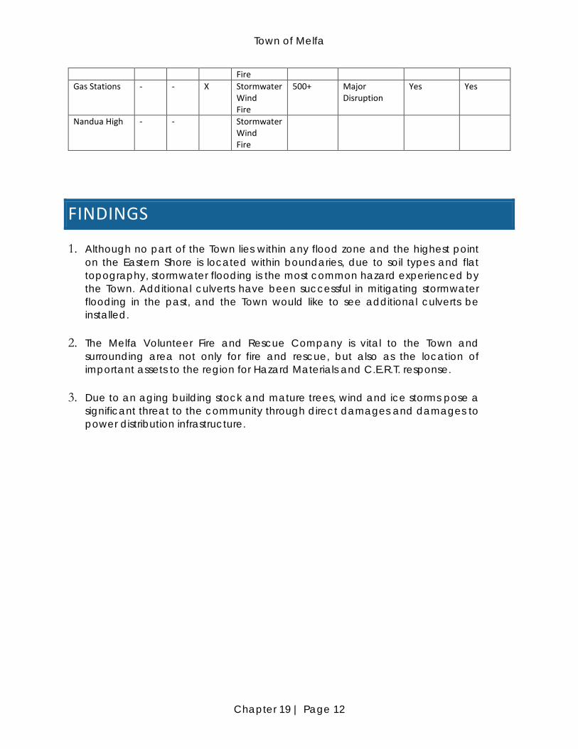
CRITICAL FACILITIES
The following table lists the critical facilities and their relative importance to the Town. Nandua High School, not in the Town, is critical, as it serves as the shelter of last resort for residents. Additionally the State Police Office and the Eastern Shore Community College, although outside of the Town limits, are critical to the Town.
Table 7: Melfa Critical Facilities Facility HMP
2006 HMP 2011
HMP 2016
Hazards No of People Affected
Loss potential Relocation Potential
Retrofit Potential
Town-owned Facilities Melfa Town Office
- - X Stormwater Wind Fire
411 Major Disruption
Yes Yes
Melfa Volunteer Fire and Rescue Company (HazMat/CERT storage)
- - X Stormwater Wind
5,000+ Devastating Yes Yes
Town Park - - X Stormwater Wind Fire
411+ Inconvenience No Yes
Other Facilities Melfa Post Office
- - X Stormwater Wind Fire
500+ Major Disruption
Yes Yes
Internet Towers
- - X Stormwater Wind
411+ Inconvenience Yes Yes
Town of Melfa
Chapter 19 | Page 12
Fire Gas Stations - - X Stormwater
Wind Fire
500+ Major Disruption
Yes Yes
Nandua High - - Stormwater Wind Fire
FINDINGS
1. Although no part of the Town lies within any flood zone and the highest point on the Eastern Shore is located within boundaries, due to soil types and flat topography, stormwater flooding is the most common hazard experienced by the Town. Additional culverts have been successful in mitigating stormwater flooding in the past, and the Town would like to see additional culverts be installed.
2. The Melfa Volunteer Fire and Rescue Company is vital to the Town and surrounding area not only for fire and rescue, but also as the location of important assets to the region for Hazard Materials and C.E.R.T. response.
3. Due to an aging building stock and mature trees, wind and ice storms pose a significant threat to the community through direct damages and damages to power distribution infrastructure.