traffic management plan – final rev · requiring that bc hydro develop a “west pine haul route...
TRANSCRIPT
TRAFFIC MANAGEMENT PLAN – FINAL Rev.0
BC Hydro
Site C Clean Energy Project West Pine Haul Route
April 15, 2019
Reviewed by: Jonathan Ho, P.Eng., PTOE
Traffic Services Division Manager
Prepared by: Jocelyn McLaren, B.A. Senior Traffic Technician
Binnie File No. 17-0122-05
TRAFFIC MANAGEMENT PLAN – FINAL REV.0 BC HYDRO WEST PINE HAUL ROUTE
i
EXECUTIVE SUMMARY
The Environmental Assessment Office (EAO) issued an amendment to Environmental Assessment Certificate #14-02 (EAC) for the Site C Clean Energy Project (the Project) in 2018. The amendment allows The BC Hydro and Power Authority (BC Hydro) to use West Pine Quarry as a source of quarry and excavated material to construct the Project. In issuing the amendment, the EAO required BC Hydro to develop a “West Pine Haul Route Traffic Management Plan (TMP)” in consultation with the Affected Communities and the BC Ministry of Transportation and Infrastructure (BC MOTI). The West Pine Haul Route runs between West Pine Quarry and Hudson’s Hope via Chetwynd.
This TMP sets out to:
a) Identify potential adverse effects related to traffic along the West Pine Haul Route and measures to mitigate those effects, including identification of locations to monitor haul truck traffic counts and the means by which the monitoring for haul truck traffic counts will be conducted;
b) Outline the means by which additional mitigation measures will be considered if the measures referred to in paragraph (a) are not sufficient to mitigate the effects identified in paragraph (a);
c) Describe how monthly updates will be provided to the Affected Communities regarding the use of the West Pine Haul Route;
d) Establish a process for communication and data sharing on a monthly basis with the BC MOTI; and
e) Identify the data referred to in d), which, at a minimum, must include records of the location of traffic accidents, the location of any traffic related fatalities, complaints received from the public, and wildlife mortality attributable to the use of the West Pine Haul Route."
Overall, this report found that the Highway 29 and Highway 97 segments within the West Pine Haul Route have adequate capacities to accommodate the addition of eight haul trucks per hour travelling between the quarry and Project sites. This report found minimal impacts on traffic operations along the haul route. The Contractor should ensure that no trucks are parked on the highways.
In general, collisions on the study highway segments were mainly attributed to weather and driver errors. The percentage of wildlife-related collisions on Highway 29 were higher than on Highway 97, mainly on the approaches to Chetwynd and to Hudson’s Hope.
This TMP noted that BC Hydro will be providing traffic monitoring results in monthly updates to BC MOTI and the Affected Communities. The results will include daily truck counts related to the proposed hauling of materials along the West Pine Haul Route, any collisions or near misses, public complaints, and wildlife encounters. Based on the on-going monitoring results, BC Hydro will assess the traffic management strategies to address the issues and coordinate with the BC MOTI as required.
TRAFFIC MANAGEMENT PLAN – FINAL REV.0 BC HYDRO WEST PINE HAUL ROUTE
ii
TABLE OF CONTENTS
EXECUTIVE SUMMARY .................................................................................... i
1 INTRODUCTION ..................................................................................... 1
2 PROJECT OVERVIEW .............................................................................. 3
2.1 Haul Route Location ......................................................................................................... 3
2.2 Project Schedule ................................................................................................................ 7
2.3 Hours of Work ..................................................................................................................... 7
3 MOBILITY AND SAFETY IMPACTS ......................................................... 8
3.1 Vehicular Traffic ................................................................................................................. 8
3.2 Monitoring Truck Haul Traffic..................................................................................... 11
3.3 West Pine Quarry Access Safety ................................................................................ 11
3.4 West Pine Quarry Haul Route Safety ........................................................................ 12
4 COMMUNITY IMPACTS ........................................................................ 13
4.1 Dust and Debris ............................................................................................................... 13
4.2 Special Events ................................................................................................................... 13
4.3 Chetwynd ........................................................................................................................... 13
4.4 Hudson’s Hope ................................................................................................................. 13
4.5 First Nations Communities .......................................................................................... 13
5 PUBLIC INFORMATION PLAN .............................................................. 15
6 CLOSING ............................................................................................... 16
FIGURES Figure 1-1: West Pine Haul Route Location........................................................................................ 2 Figure 2-1: Collision Histogram of Proposed Highway 97 Haul Segment ............................. 5 Figure 2-2: Highway 97 Haul Segment Collision Types ................................................................ 5 Figure 2-3: Collision Histogram of Proposed Highway 29 Haul Segment ............................. 6 Figure 2-4: Highway 29 Haul Segment Collision Types ................................................................ 6 Figure 3-1: Highway 97 Peak Year Traffic Operation Comparison (Source: Tetra Tech) 10 Figure 3-2: Highway 29 Peak Year Traffic Operation Comparison (Source: Tetra Tech) 11
APPENDIX Appendix A Amendment to EAC #14-02
TRAFFIC MANAGEMENT PLAN – FINAL REV.0 BC HYDRO WEST PINE HAUL ROUTE
1
1 INTRODUCTION
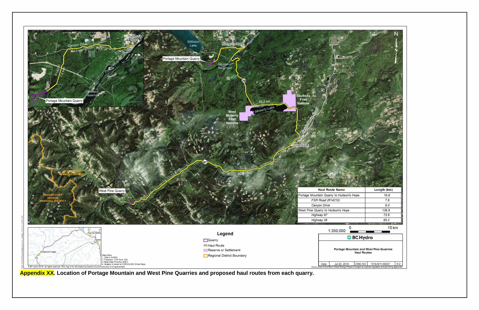
On November 14, 2018, the Environmental Assessment Office (EAO) issued an amendment to Environmental Assessment Certificate #14-02 (EAC) for the Site C Clean Energy Project (the Project). The amendment allows The BC Hydro and Power Authority (BC Hydro) to use West Pine Quarry, in addition to Portage Mountain Quarry, as a source of quarry and excavated material for the construction of the Highway 29 realignment, shoreline protection near Hudson’s Hope, and areas of the reservoir requiring protection during reservoir filling. In issuing the amendment, the EAO added Condition 78 to the EAC, requiring that BC Hydro develop a “West Pine Haul Route Traffic Management Plan” in consultation with Saulteau First Nations, West Moberly First Nations, the District of Hudson’s Hope, the District of Chetwynd, the Peace River Regional District (the “Affected Communities”), and the BC Ministry of Transportation and Infrastructure (BC MOTI). The location and routing of the West Pine Haul Route are shown in Figure 1-1. A copy of the amendment to EAC #14-02 regarding the use of West Pine Quarry is attached in Appendix A.
The purpose of this draft Traffic Management Plan (TMP) is to fulfill the requirements of Condition 78 of the EAC. Specifically, the TMP sets out to:
a) Identify potential adverse effects related to traffic along the West Pine Haul Route and measures to mitigate those effects, including identification of locations to monitor haul truck traffic counts and the means by which the monitoring for haul truck traffic counts will be conducted;
b) Outline the means by which additional mitigation measures will be considered if the measures referred to in paragraph (a) are not sufficient to mitigate the effects identified in paragraph (a);
c) Describe how monthly updates will be provided to the Affected Communities regarding the use of the West Pine Haul Route;
d) Establish a process for communication and data sharing on a monthly basis with the BC MOTI; and
e) Identify the data referred to in d), which, at a minimum, must include records of the location of traffic accidents, the location of any traffic related fatalities, complaints received from the public, and wildlife mortality attributable to the use of the West Pine Haul Route."
R.F. Binnie & Associates Ltd. (Binnie) has developed this TMP on behalf of BC Hydro. The impacts of the haul traffic on West Pine Haul Route and any associated mitigations have been identified and assessed by applying provincial standards as outlined in the following guidelines and standards:
BC MOTI 2015 Interim Traffic Management Manual for Work on Roadways
BC MOTI Manual of Standard Traffic Signs and Pavement Markings
BC MOTI Catalogue of Standard Traffic Signs
Transportation Association of Canada (TAC) Manual of Uniform Traffic Control Devices of Canada (MUTCDC)
TRAFFIC MANAGEMENT PLAN – FINAL REV.0 BC HYDRO WEST PINE HAUL ROUTE
2
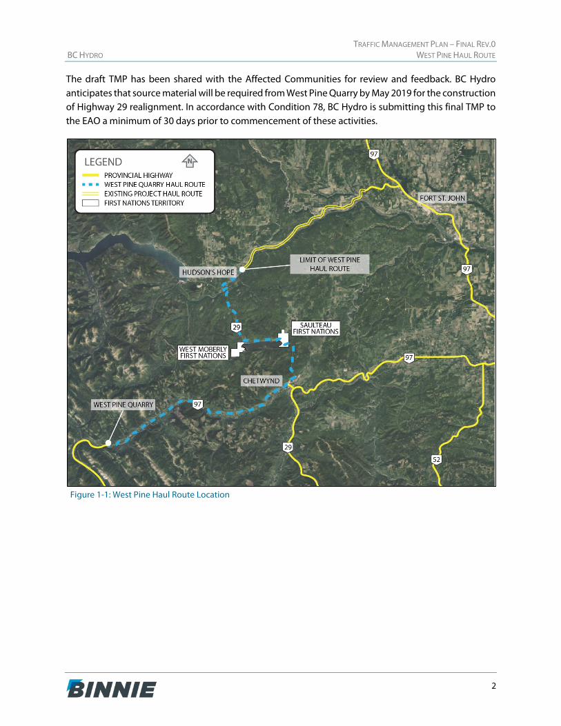
The draft TMP has been shared with the Affected Communities for review and feedback. BC Hydro anticipates that source material will be required from West Pine Quarry by May 2019 for the construction of Highway 29 realignment. In accordance with Condition 78, BC Hydro is submitting this final TMP to the EAO a minimum of 30 days prior to commencement of these activities.
Figure 1-1: West Pine Haul Route Location
TRAFFIC MANAGEMENT PLAN – FINAL REV.0 BC HYDRO WEST PINE HAUL ROUTE
3
2 PROJECT OVERVIEW
This section presents an overview of the proposed truck haul route and the communities it travels through to access the Project location, as well as when it is expected to be in operation.
2.1 Haul Route Location
The West Pine Haul Route will provide permanent riprap and bedding material for Project construction works along Highway 29 between Hudson’s Hope and the City of Fort St. John (Fort St. John). West Pine Quarry is located approximately 75 km southwest of Chetwynd and excavated material will be transported from the quarry to the construction site using highway-rated haul trucks via existing public roads.
The proposed truck haul route runs along Highway 97 between West Pine Quarry and the Highway 29 junction located within Chetwynd. The junction of Highway 97 and Highway 29 is a signalized intersection that has left-turn lanes provided on all approaches. From this junction, the haul route runs along Highway 29 between Highway 97 and the Canyon Drive intersection located within Hudson’s Hope. The intersection of Highway 29 and Canyon Drive is two-way stop-controlled, and the east and south approaches are designated as Highway 29. Trucks will remain on Highway 29 through Hudson’s Hope to the Project site. In total, a one-way haul trip is approximately 195 km from the West Pine Quarry to the Project site.
Overall, the haul route is on a roadway which has substantial operating capacity, reasonable sightlines, and adequate lane widths. Most of the curves are gentle and as such not many curve advisories are in place. Both Highway 97 between Chetwynd and Hudson’s Hope, and Highway 29 between Hudson’s Hope and Fort St. John, have a wide right-of-way and although there are some low shrubs present, the brush is regularly cleared.
2.1.1 Haul Route Segments
The segment of Highway 97 between West Pine Quarry and Chetwynd is a rural, undivided, two-lane highway that is approximately 75 km long and that generally has a posted speed limit of 100 km/h. There are unsignalized intersections along this segment that provide access to small rural subdivisions, residential accesses, rest areas, and industrial land uses. There are existing warning signs in place along the corridor to advise drivers of the presence of wildlife.
Within Chetwynd, the posted speed limit on the highway is reduced to 50 km/h. There is a marked pedestrian crossing with flashing lights located across Highway 97 at the intersection of 53rd Street SW. Additionally, there are pedestrian crosswalks on all four approaches of the Highway 97 and Highway 29 signalized intersection. There are several unsignalized intersections along Highway 97 and Highway 29 within Chetwynd that provide access to parallel frontage roads, the downtown area, and the Canfor Chetwynd sawmill.
The segment of Highway 29 from Chetwynd to Hudson’s Hope is generally a rural, undivided two-lane highway that is approximately 65 km long with a posted speed limit of 90 km/h. There are four
TRAFFIC MANAGEMENT PLAN – FINAL REV.0 BC HYDRO WEST PINE HAUL ROUTE
4
northbound and four southbound passing lanes provided periodically. This segment passes through West Moberly First Nations’ and Saulteau First Nations’ lands, which are located on the west and east ends of Moberly Lake, respectively. Through the First Nations communities, the posted speed limit of the highway is reduced to 70 km/h and there are unsignalized intersections to provide access to residential areas. A marked pedestrian crossing across Highway 29 is located near Lakeview Subdivision.
Within Hudson’s Hope, the highway widens from two lanes to four lanes (two lanes in each direction) and the posted speed limit is reduced to 50 km/h. Hudson’s Hope Elementary Secondary School is located on Highway 29 on the western approach to the town. There are marked pedestrian crossings across Highway 29 at the intersections of Kyllo Street, Dudley Drive, and Fredette Avenue. At Highway 29 and Canyon Drive, marked pedestrian crossings to cross both Beattie Drive and Canyon Drive are provided. There are several unsignalized intersections within Hudson’s Hope that provide access to residential and commercial areas. There are existing warning signs in place along the corridor to advise drivers of the presence of wildlife.
The segment of Highway 29 from Hudson’s Hope to the approximate start of the Project location site is generally a two-lane rural undivided highway with a posted speed limit of 90 km/h that is approximately 55 km in length. There are unsignalized intersections along this section that provide access to the local communities in this area. There are existing warning signs in place along the corridor to advise drivers of the presence of wildlife.
2.1.2 High-Level Safety Review
The high-level safety review performed for the purpose of this TMP was based on the collision data provided by the BC MOTI for the two highway segments below based on the Landmark Kilometre Inventory (LKI) system:
Highway 97: LKI Segment 1161 74.26 km (Pine River structure just to the west of the West Pine Quarry Access) to 148.12 km (Highway 97/29 Junction in Chetwynd)
Highway 29: LKI Segment 1101 0.00 km (Highway 97/29 Junction in Chetwynd) to 65.20 km (Highway 29/Canyon Drive Junction in Hudson’s Hope)
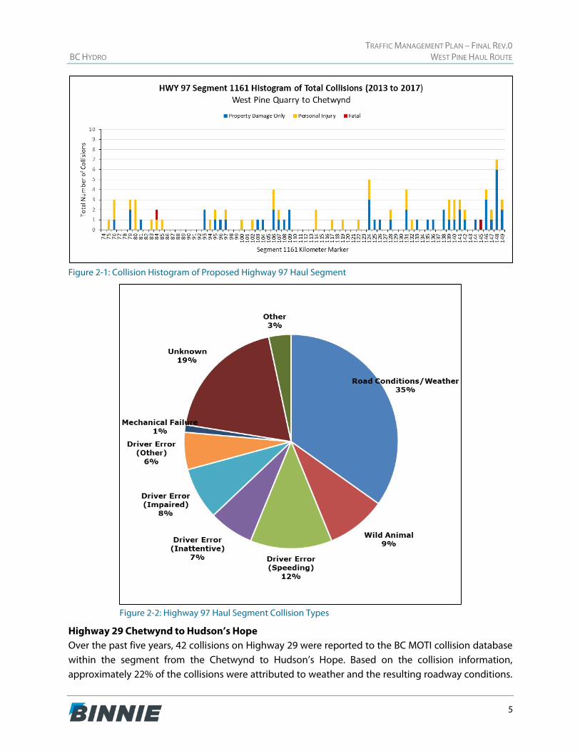
Highway 97 West Pine Quarry Access Road to Chetwynd Over the past five years, 89 collisions on Highway 97 were reported to the BC MOTI collision database within the segment from the West Pine Quarry to Chetwynd. Based on the collision information, approximately 35% of the collisions were attributed to weather and the resulting roadway conditions. Another 33% of the collisions were generally found to be attributed to driver error including impairment, inattentiveness, or speeding. Within this segment, approximately 9% of the collisions were caused by conflicts with wildlife.
TRAFFIC MANAGEMENT PLAN – FINAL REV.0 BC HYDRO WEST PINE HAUL ROUTE
5
Figure 2-1: Collision Histogram of Proposed Highway 97 Haul Segment
Figure 2-2: Highway 97 Haul Segment Collision Types
Highway 29 Chetwynd to Hudson’s Hope Over the past five years, 42 collisions on Highway 29 were reported to the BC MOTI collision database within the segment from the Chetwynd to Hudson’s Hope. Based on the collision information, approximately 22% of the collisions were attributed to weather and the resulting roadway conditions.
TRAFFIC MANAGEMENT PLAN – FINAL REV.0 BC HYDRO WEST PINE HAUL ROUTE
6
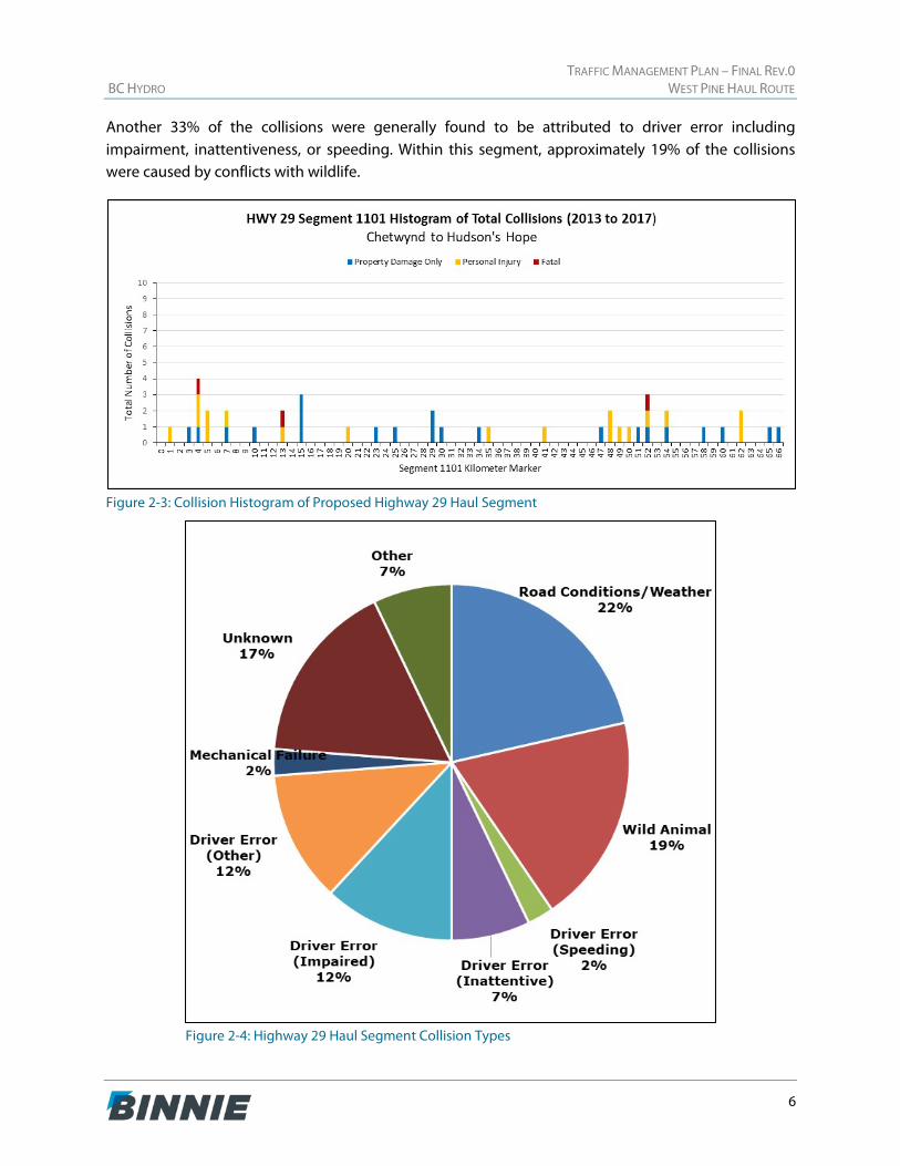
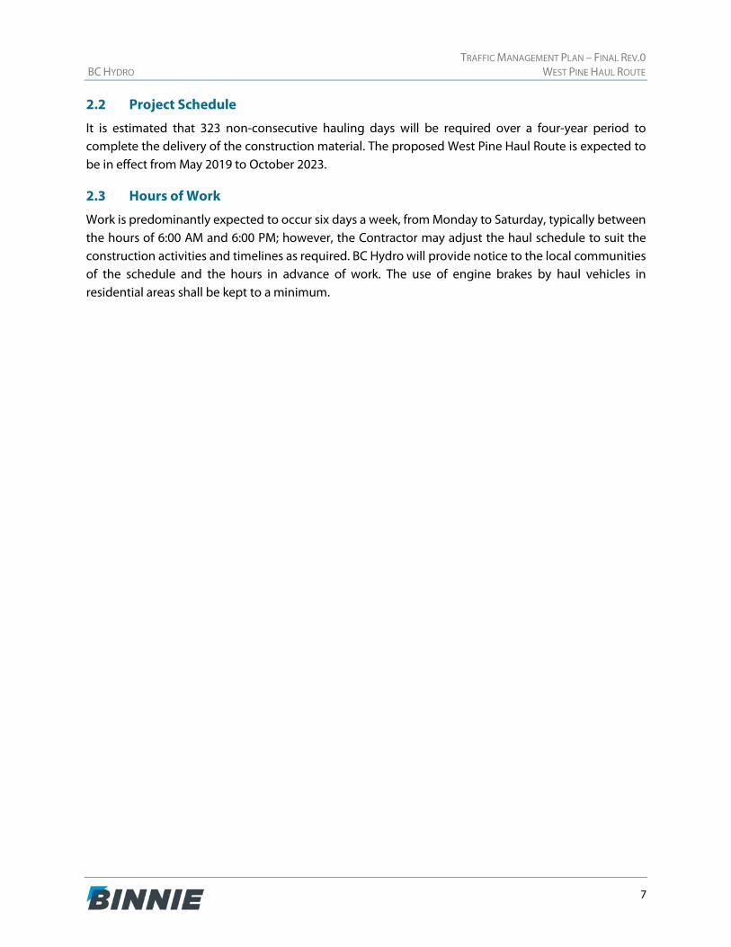
Another 33% of the collisions were generally found to be attributed to driver error including impairment, inattentiveness, or speeding. Within this segment, approximately 19% of the collisions were caused by conflicts with wildlife.
Figure 2-3: Collision Histogram of Proposed Highway 29 Haul Segment
Figure 2-4: Highway 29 Haul Segment Collision Types
TRAFFIC MANAGEMENT PLAN – FINAL REV.0 BC HYDRO WEST PINE HAUL ROUTE
7
2.2 Project Schedule
It is estimated that 323 non-consecutive hauling days will be required over a four-year period to complete the delivery of the construction material. The proposed West Pine Haul Route is expected to be in effect from May 2019 to October 2023.
2.3 Hours of Work
Work is predominantly expected to occur six days a week, from Monday to Saturday, typically between the hours of 6:00 AM and 6:00 PM; however, the Contractor may adjust the haul schedule to suit the construction activities and timelines as required. BC Hydro will provide notice to the local communities of the schedule and the hours in advance of work. The use of engine brakes by haul vehicles in residential areas shall be kept to a minimum.
TRAFFIC MANAGEMENT PLAN – FINAL REV.0 BC HYDRO WEST PINE HAUL ROUTE
8
3 MOBILITY AND SAFETY IMPACTS
The objective of this section is to identify potential adverse effects from the addition of the West Pine Quarry truck traffic to the existing road network and to recommend measures to mitigate those effects. A Tetra Tech Inc. (Tetra Tech) document, titled Site C Energy Project, Project Traffic Analysis Report, Doc EIS-4A-008 [Final] and dated December 2012 (the Tetra Tech report), was previously prepared to describe the overall Project-related changes in traffic, traffic operations, and safety on existing transportation facilities during construction.
3.1 Vehicular Traffic
The Annual Average Daily Traffic (AADT) on Highway 97 and Highway 29 was determined for the 2011 background year in the Tetra Tech report. The forecast background traffic was estimated for each highway by applying an annual growth rate of 1.5% for Highway 97 and 1.4% for Highway 29 to the respective AADTs. The annual forecast Project traffic volume was estimated by aggregating the expected volumes for the various Project activities that occur concurrently along the highway segments each year.
The West Pine Haul Route is expected to be used between May 2019 to October 2023; however, the peak year of Project traffic volume is expected to be 2021. Therefore, the 2021 horizon year was used for this analysis as a conservative measure. The currently estimated two-way AADT volumes and heavy truck percentages for the 2021 horizon year along each segment of the expected haul route are as follows:
Highway 97 within the vicinity of West Pine Quarry: 1,393 background vehicles and 169 Project vehicles, for a total AADT of 1,562 vehicles (29% trucks of which 18% are background and 11% are Project generated). The TAC Design Guide classifies these volumes as those found on a rural collector
Highway 97 between Wild Mare Road and Highway 29 (southwest of Chetwynd): 7,084 background vehicles and 170 Project vehicles, for a total AADT of 7,254 vehicles (23% trucks of which 21% are background and 2% are Project generated). The TAC Design Guide classifies these volumes as those found on a rural arterial
Highway 29 between Highway 97 and Jackfish Lake Road (north of Chetwynd): 8,317 background vehicles and 170 Project vehicles, for a total AADT of 8,487 vehicles (22% trucks of which 20% are background and 2% are Project generated). The TAC Design Guide classifies these volumes as those found on a rural freeway
Highway 29 between Canyon Drive and Dr Greene Street (east of Hudson’s Hope): 1,262 background vehicles and 106 Project vehicles, for a total AADT of 1,368 vehicles (17% trucks of which 12% are background and 5% are Project generated). The TAC Design Guide classifies these volumes as those found on a rural collector
In general, the West Pine Haul Route is not expected to impact the existing operations of Highway 97 and Highway 29 as the volumes of traffic they currently carry are not significant.
TRAFFIC MANAGEMENT PLAN – FINAL REV.0 BC HYDRO WEST PINE HAUL ROUTE
9
3.1.1 West Pine Haul Route Truck Traffic
Hauling material from West Pine Quarry to the Project site will result in approximately 80 new one-way trips, or 40 return trips, per haul day intermittently between May 2019 and October 2023. This is equivalent to approximately eight one-way vehicle trips per hour per direction or one truck every 7.5 minutes in each direction and is likely to have a negligible impact on the existing traffic and safety operations.
3.1.2 Traffic Operation Analysis
A traffic operation analysis was conducted at the three study intersections to determine the effect of the West Pine Quarry truck traffic on the existing road network. The analysis was performed using the Synchro 9 software suite, which is generally based on the Highway Capacity Manual (HCM) methodologies.
Level-of-service (LOS) is a grading system of intersection operation based on the calculated delays experienced by a driver on the approach to the intersection. LOS A represents the best operating conditions from the traveler’s perspective, typically meaning that the intersection experiences little to no delay, whereas LOS F indicates a significant delay is present. LOS D is typically considered the threshold for acceptable intersection operation.
Highway 97 and West Pine Quarry Access Road For this analysis, hourly traffic volumes on Highway 97 were obtained from the BC MOTI permanent count station (P-43-2NS) located approximately 31 km east of the quarry. The 30th highest design hour for 2017 was identified to be on October 6, 2017 between 12:00 PM and 1:00 PM. 87 eastbound vehicles and 98 westbound vehicles were counted along Highway 97 during that time.
The intersection was found to operate at LOS A under existing conditions. With the addition of eight haul trucks per hour entering and exiting the quarry, the intersection operation is expected to remain at LOS A.
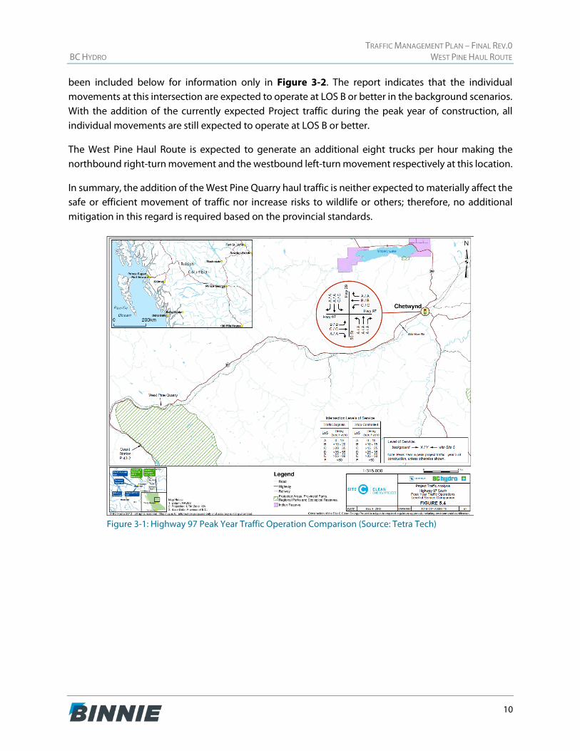
Highway 97 and Highway 29 in Chetwynd A traffic operation analysis was previously undertaken by Tetra Tech at the signalized Highway 97 and Highway 29 intersection, as seen in Figure 5.4 of the Tetra Tech report, which has been in included below for information only in Figure 3-1. The report indicates that the individual movements at this intersection are expected to operate at LOS C or better in the background scenarios. With the addition of the currently expected Project traffic during the peak year of construction, there would be no drop in LOS observed on any individual movement.
The West Pine Haul Route is expected to generate an additional eight trucks per hour making the eastbound left-turn movement and the southbound right-turn movement respectively at this location.
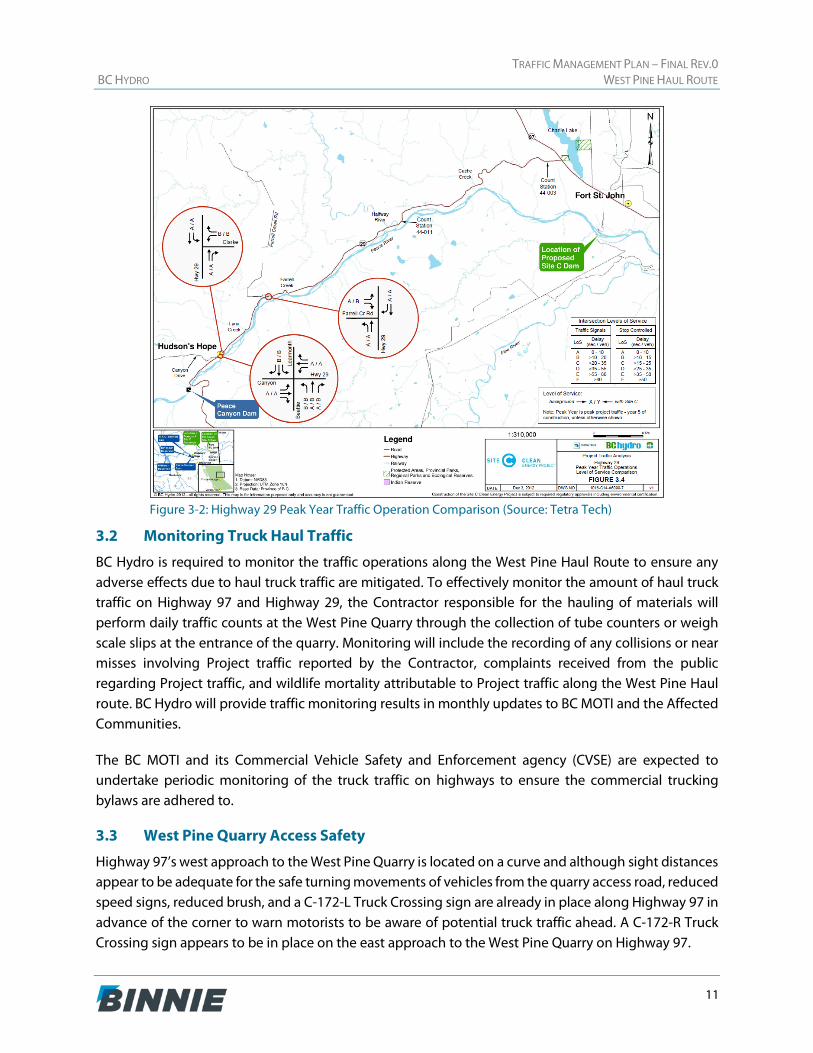
Highway 29 and Canyon Drive in Hudson’s Hope A traffic operation analysis was previously undertaken by Tetra Tech at the two-way stop-controlled Highway 29 and Canyon Drive intersection, as seen in Figure 3.4 of the Tetra Tech report, which has
TRAFFIC MANAGEMENT PLAN – FINAL REV.0 BC HYDRO WEST PINE HAUL ROUTE
10
been included below for information only in Figure 3-2. The report indicates that the individual movements at this intersection are expected to operate at LOS B or better in the background scenarios. With the addition of the currently expected Project traffic during the peak year of construction, all individual movements are still expected to operate at LOS B or better.
The West Pine Haul Route is expected to generate an additional eight trucks per hour making the northbound right-turn movement and the westbound left-turn movement respectively at this location.
In summary, the addition of the West Pine Quarry haul traffic is neither expected to materially affect the safe or efficient movement of traffic nor increase risks to wildlife or others; therefore, no additional mitigation in this regard is required based on the provincial standards.
Figure 3-1: Highway 97 Peak Year Traffic Operation Comparison (Source: Tetra Tech)
TRAFFIC MANAGEMENT PLAN – FINAL REV.0 BC HYDRO WEST PINE HAUL ROUTE
11
Figure 3-2: Highway 29 Peak Year Traffic Operation Comparison (Source: Tetra Tech)
3.2 Monitoring Truck Haul Traffic
BC Hydro is required to monitor the traffic operations along the West Pine Haul Route to ensure any adverse effects due to haul truck traffic are mitigated. To effectively monitor the amount of haul truck traffic on Highway 97 and Highway 29, the Contractor responsible for the hauling of materials will perform daily traffic counts at the West Pine Quarry through the collection of tube counters or weigh scale slips at the entrance of the quarry. Monitoring will include the recording of any collisions or near misses involving Project traffic reported by the Contractor, complaints received from the public regarding Project traffic, and wildlife mortality attributable to Project traffic along the West Pine Haul route. BC Hydro will provide traffic monitoring results in monthly updates to BC MOTI and the Affected Communities.
The BC MOTI and its Commercial Vehicle Safety and Enforcement agency (CVSE) are expected to undertake periodic monitoring of the truck traffic on highways to ensure the commercial trucking bylaws are adhered to.
3.3 West Pine Quarry Access Safety
Highway 97’s west approach to the West Pine Quarry is located on a curve and although sight distances appear to be adequate for the safe turning movements of vehicles from the quarry access road, reduced speed signs, reduced brush, and a C-172-L Truck Crossing sign are already in place along Highway 97 in advance of the corner to warn motorists to be aware of potential truck traffic ahead. A C-172-R Truck Crossing sign appears to be in place on the east approach to the West Pine Quarry on Highway 97.
TRAFFIC MANAGEMENT PLAN – FINAL REV.0 BC HYDRO WEST PINE HAUL ROUTE
12
No stopping will be permitted on the Highway 97 shoulder for trucks, and they will be required to stage within the quarry site to minimize impacts on the highway through traffic.
3.4 West Pine Quarry Haul Route Safety
Based on the safety data reviewed, speeding did not appear to be a leading cause to collisions; however, if truck speeding becomes an issue when the West Pine Haul Route is in operation, speed reader boards may be installed at strategic locations on Highway 29 and Highway 97 to deter excessive operating speed by all traffic. The monitoring reports received by BC Hydro could also include time logs to identify any excessive speeding by comparing the recorded travel time between West Pine Quarry and the Project site with the average travel time when the posted speed limits are adhered to.
The safety data revealed eight collisions within the past five years were attributed to wildlife on the Highway 97 and Highway 29 approaches to Chetwynd; however, most of the collisions occurred in 2016 and they appeared to have subsided recently.
On Highway 29, there were three wildlife-related collisions in the past five years on the segment between kilometre marker 51.8 and 59.8, which is also near the approach to Hudson’s Hope.
TRAFFIC MANAGEMENT PLAN – FINAL REV.0 BC HYDRO WEST PINE HAUL ROUTE
13
4 COMMUNITY IMPACTS
The objective of this section is to review the potential negative impacts that the West Pine Haul Route may incur on the local community and the management strategies to address these impacts.
4.1 Dust and Debris
During hauling activities, the Contractor will be responsible for minimizing the amount of dust and debris affecting the roadways and adjacent properties to the satisfaction of the MOTI. This includes implementing mitigation measures to contain the dust produced and to minimize the potential for debris falling onto the roadways which may be caused by the hauling trucks travelling to and from the site. At the quarry and work site approaches, the pavement must be swept and graveled to reduce dirt being dragged onto the road. The West Pine Quarry has a wheel wash which will be utilized as necessary and dust suppression is required on all gravel roads.
4.2 Special Events
There may be special events in Chetwynd, Hudson’s Hope, the First Nations communities, or the Peace River Regional District that impact the highways when the West Pine Haul Route is operational. These impacts may require the Contractor to temporarily adjust the hauling schedule to accommodate any traffic pattern changes. The Contractor must coordinate with the BC MOTI and the Affected Communities regarding any planned special events that may coincide with the hauling activities.
Currently, Saulteau First Nations have requested that the hauling activities be restricted during the Pemmican Days weekend. Saulteau First Nations will provide BC Hydro with the dates of this event so that appropriate planning and adjustments to the hauling activities could be implemented.
4.3 Chetwynd
Based on the traffic operation analysis conducted by Tetra Tech, the additional trucks from West Pine Quarry to the Project location are expected to have a negligible impact on the operation and safety of the roadways through Chetwynd. Trucks will not be permitted to park along Highway 97, Highway 29, or local roads.
4.4 Hudson’s Hope
Based on the traffic operation analysis conducted by Tetra Tech, the additional trucks from West Pine Quarry to the Project location are expected to have a negligible impact on the operation and safety of the roadways through Hudson’s Hope. Trucks will not be permitted to park along Highway 29 or local roads.
4.5 First Nations Communities
Based on the traffic operation analysis conducted by Tetra Tech, the additional trucks from West Pine Quarry to the Project location are expected to have a negligible impact on the operations and safety of the segment of Highway 29 that passes through West Moberly First Nations’ and Saulteau First Nations’ lands. Trucks will not be permitted to park along Highway 29 or local roads. The highway speed is

TRAFFIC MANAGEMENT PLAN – FINAL REV.0 BC HYDRO WEST PINE HAUL ROUTE
14
reduced from 90 km/h to 70 km/h through part of these First Nation communities. Pedestrians cross the roadway to access the town or lake, where summer camps are held. Truck drivers must pay attention to speed zones and be aware of potential pedestrian activity.
TRAFFIC MANAGEMENT PLAN – FINAL REV.0 BC HYDRO WEST PINE HAUL ROUTE
15
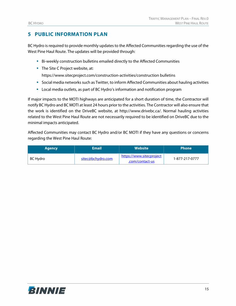
5 PUBLIC INFORMATION PLAN
BC Hydro is required to provide monthly updates to the Affected Communities regarding the use of the West Pine Haul Route. The updates will be provided through:
Bi-weekly construction bulletins emailed directly to the Affected Communities
The Site C Project website, at:
https://www.sitecproject.com/construction-activities/construction bulletins
Social media networks such as Twitter, to inform Affected Communities about hauling activities
Local media outlets, as part of BC Hydro’s information and notification program
If major impacts to the MOTI highways are anticipated for a short duration of time, the Contractor will notify BC Hydro and BC MOTI at least 24 hours prior to the activities. The Contractor will also ensure that the work is identified on the DriveBC website, at http://www.drivebc.ca/. Normal hauling activities related to the West Pine Haul Route are not necessarily required to be identified on DriveBC due to the minimal impacts anticipated.
Affected Communities may contact BC Hydro and/or BC MOTI if they have any questions or concerns regarding the West Pine Haul Route:
Agency Email Website Phone
BC Hydro [email protected] https://www.sitecproject
.com/contact-us 1-877-217-0777
TRAFFIC MANAGEMENT PLAN – FINAL REV.0 BC HYDRO WEST PINE HAUL ROUTE
16
6 CLOSING
We trust you find the above suitable for your needs. Should you have any questions or comments on the information contained herein, please do not hesitate to contact the Project Manager, Jonathan Ho, P.Eng., PTOE, at [email protected].
Prepared by:
Reviewed by:
Jocelyn McLaren, B.A.
Senior Traffic Technician Jonathan Ho, P.Eng., PTOE
Traffic Services Division Manager
APPENDIX A AMENDMENT TO EAC #14-02
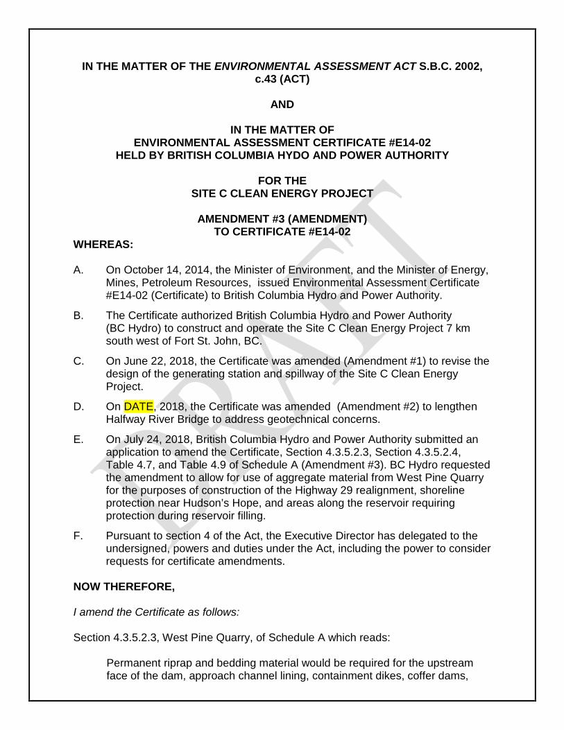
IN THE MATTER OF THE ENVIRONMENTAL ASSESSMENT ACT S.B.C. 2002, c.43 (ACT)
AND
IN THE MATTER OF
ENVIRONMENTAL ASSESSMENT CERTIFICATE #E14-02 HELD BY BRITISH COLUMBIA HYDO AND POWER AUTHORITY
FOR THE
SITE C CLEAN ENERGY PROJECT
AMENDMENT #3 (AMENDMENT) TO CERTIFICATE #E14-02
WHEREAS: A. On October 14, 2014, the Minister of Environment, and the Minister of Energy,
Mines, Petroleum Resources, issued Environmental Assessment Certificate #E14-02 (Certificate) to British Columbia Hydro and Power Authority.
B. The Certificate authorized British Columbia Hydro and Power Authority (BC Hydro) to construct and operate the Site C Clean Energy Project 7 km south west of Fort St. John, BC.
C. On June 22, 2018, the Certificate was amended (Amendment #1) to revise the design of the generating station and spillway of the Site C Clean Energy Project.
D. On DATE, 2018, the Certificate was amended (Amendment #2) to lengthen Halfway River Bridge to address geotechnical concerns.
E. On July 24, 2018, British Columbia Hydro and Power Authority submitted an application to amend the Certificate, Section 4.3.5.2.3, Section 4.3.5.2.4, Table 4.7, and Table 4.9 of Schedule A (Amendment #3). BC Hydro requested the amendment to allow for use of aggregate material from West Pine Quarry for the purposes of construction of the Highway 29 realignment, shoreline protection near Hudson’s Hope, and areas along the reservoir requiring protection during reservoir filling.
F. Pursuant to section 4 of the Act, the Executive Director has delegated to the undersigned, powers and duties under the Act, including the power to consider requests for certificate amendments.
NOW THEREFORE, I amend the Certificate as follows: Section 4.3.5.2.3, West Pine Quarry, of Schedule A which reads:
Permanent riprap and bedding material would be required for the upstream face of the dam, approach channel lining, containment dikes, coffer dams,
some parts of the diversion tunnel inlet and outlet channels, the tailrace, and the discharge channel. The source of this permanent riprap and bedding material is the West Pine Quarry, located on provincial crown land approximately 75 km southwest of Chetwynd along Highway 97 (approximately 160km from the Project Site). There are currently two transportation options under consideration for the permanent riprap and bedding material: 1. Use the existing railway siding at the quarry and haul the material to the
site by rail; one train per day would be required. Riprap and bedding would be unloaded at the Septimus Siding in the dam site area and moved to a stockpile. An extension of the siding may be required within the quarry. Due to breakage during extra handling. More rock would have to be quarried with this option.
2. Haul the material directly to the dam site area using highway-rated haul trucks, using both existing public roads and the Project access road (see Section 4.3.7).
The transportation option would be selected by the contractor(s) using the riprap and bedding. For the purposes of environmental assessment, the trucking option has been assumed, as while it has less quarrying it has the greater footprint.
Is repealed and replaced with:
Permanent riprap and bedding material will be required for the upstream face of the dam, approach channel lining, containment dikes, coffer dams, some parts of the diversion tunnel inlet and outlet channels, the tailrace, the discharge channel, Highway 29 construction, Hudson’s Hope shoreline protection, and for areas along the reservoir requiring protection during reservoir filling. There are currently two transportation options under consideration for the permanent riprap and bedding material: 1. Use the existing railway siding at the Quarry and haul the material to the
site by rail; one train per day will be required. Riprap and bedding will be unloaded at the Septimus Siding in the dam site area and moved to a stockpile. An extension of the siding may be required within the quarry. Due to breakage during extra handling. More rock would will have to be quarried with this option.
2. Haul material directly to the dam site area, Highway 29 realignment segments, Hudson’s Hope Shoreline Protection, and areas of the reservoir requiring protection during reservoir filling using highway-rated haul trucks on existing public roads and Project access roads (See Section 4.3.7).
The transportation option will be selected by the contractor(s) using the riprap and bedding. For the purposes of environmental assessment, the trucking option has been assumed, as while it has less quarrying it has the greater footprint.
Section 4.3.5.2.4 Portage Mountain Quarry of Schedule A which reads:
Permanent riprap and bedding material for the Hudson’s Hope shoreline protection, for areas along the reservoir requiring protection during reservoir filling and for Highway 29 construction would be sourced from Portage Mountain, 16km southwest of Hudson’s Hope. Excavated material would be transported from the quarry to the construction site using highway haul trucks via the access roads described in the development plan and existing public roads.
Is repealed and replaced with:
Permanent riprap and bedding material for the Hudson’s Hope shoreline protection, for areas along the reservoir requiring protection during reservoir filling and for Highway 29 construction will be sourced from Portage Mountain, 16 km southwest of Hudson’s Hope or from West Pine Quarry, 138 km southwest of Hudson’s Hope. Excavated material will be transported from the quarry to the construction site using highway haul trucks via the access roads described in the development plan and existing public roads.
Table 4.7 Approximate Quantities of Materials for Highway 29, Access Roads, and Hudson’s Hope Shoreline Protection, the first sub-column heading is changed to:
“Portage Mountain Quarry or West Pine Quarry”. Table 4.9 Approximate Quantities of Unsuitable and Surplus Materials for Highway 29, Access Roads, and Hudson’s Hope Shoreline Protection the first sub-column heading is changed to:
“Portage Mountain Quarry or West Pine Quarry”. I also amend the Certificate by adding condition #79 to Schedule B as follows: West Pine Haul Route Traffic Management Plan
1. The Holder must develop a West Pine Haul Route Traffic Management Plan (the “Plan”) regarding use of the West Pine Haul Route by the Holder. The West Pine Haul Route comprises Highway 97 to Chetwynd, Highway 29 through Hudson’s Hope to the Highway 29 realignment sites. The Plan must be developed in consultation with Saulteau First Nations, West Moberly First
Nations, the District of Hudson’s Hope, the District of Chetwynd, and the Peace River Regional District (the “Affected Communities”).
2. The Plan must be developed to the satisfaction of the EAO and include at
least the following: a) identify potential adverse effects and measures to mitigate those effects of
West Pine Quarry haul truck traffic on the West Pine Haul Route, including identification of locations to monitor haul truck traffic counts and the means by which the Holder will conduct monitoring for haul truck traffic counts;
b) the means by which the Holder will identify additional mitigation measures if the measures referred to in paragraph (a) are not sufficient to mitigate the effects identified in paragraph (a);
c) the means by which the Holder will provide, at a minimum, monthly updates to the Affected Communities regarding the Holder’s use of the West Pine Haul Route; and
d) a process for communication and data sharing that must occur, at minimum, on a monthly basis with the Ministry of Transportation and Infrastructure
e) data referred to in d), at a minimum, must include records of the location of traffic accidents, the location of any traffic related fatalities, complaints received from the public, and wildlife mortality attributable to the Holder’s use of the West Pine Haul Route.
3. The Holder must provide this Plan to the EAO and to the Affected
Communities a minimum of 30 days prior to the planned commencement of use of the West Pine Haul Route for the purposes of transporting materials from the West Pine Quarry to Highway 29 realignment segments, Shoreline Protection sites in Hudson’s Hope, and areas of the reservoir requiring protection during reservoir filling. The EAO may, within 30 days of receiving the Plan, advise that: a) the Holder may proceed to implement the Plan with or without revisions; or b) a revised Plan, must be provided for approval of the EAO prior to
commencement of use of the West Pine Haul Route for the purposes of transporting materials from the West Pine Quarry to Highway 29 realignment segments, Shoreline Protection sites in Hudson’s Hope, and areas of the reservoir requiring protection during reservoir filling.
If the EAO advises that pursuant to paragraphs 3 (a) or (b) changes are required to the Plan, then the Holder must follow the instructions of the EAO in that regard.
4. At the time of submitting the Plan to the EAO, the Holder must also provide
the EAO a consultation report setting out the following:
a) A list of the invitees and an example of the invitation sent to the Affected Communities to participate and provide their views including the timeframe for providing such views, on the Plan; and
b) how the views and information provided by the Affected Communities to the Holder have been considered and addressed in the Plan; or
c) why such views and information have not been addressed in the Plan.
5. The Holder must: a) maintain a record of the consultation referred to in paragraphs 1 and 3 and
the comments provided by the Affected Communities and the EAO under paragraph 3, above; and
b) provide a copy of the consultation report (required under paragraph 4 of this condition to the EAO, the Affected Communities, or both, within 15 days of the Holder receiving a written request from the EAO or an Affected Community.
The Plan, and any amendments thereto, must be implemented to the satisfaction of the EAO throughout the duration of use of the West Pine Haul Route for the purposes of transporting materials from the West Pine Quarry to Highway 29 realignment segments, Shoreline Protection sites in Hudson’s Hope, and areas of the reservoir requiring protection during reservoir filling.
Scott Bailey Assistant Deputy Minister, Environmental Assessment Operations Environmental Assessment Office Issued this X day of October, 2018
Appendix XX. Location of Portage Mountain and West Pine Quarries and proposed haul routes from each quarry.