transit traverse in missouri - usgs traverse in missouri part 4. ... the eight sections covered by...
TRANSCRIPT
UNITED STATES DEPARTMENT OF THE INTERIOR Harold L. Ickes, Secretary
GEOLOGICAL SURVEY W. C. Mendenhall, Director
Bulletin 916-D
TRANSIT TRAVERSE IN MISSOURI
PART 4. NORTHWESTERN MISSOURI
1911-37
J. G. STAACKChief Topographic Engineer
Prepared in cooperation with the
STATE OF MISSOURIGEOLOGICAL SURVEY AND WATER RESOURCES
H. A. Buehler, Director
UNITED STATES
GOVERNMENT PRINTING OFFICE
WASHINGTON : 1940
For sale by the Superintendent of Documents, Washington, D. C. -------- Price 20 cents
Page
Introduction. ................................ m
Scope of report. ............................. m
Cooperation. ............................... mj
Classification of transit traverse .................... Ill
Adjustments. ............................... IV
Station marks. .............................. IV
Azimuth marks and supplemental points. .'................. VI
Preservation and restoration of station marks. .............. VI
Datum. .................................. VI
Location of the area ........................... VII
Index map. ................................ VII
Diagrams of quadrangles showing routes of transit traverse ........ VII
Personnel. ................................ VIII
Explanation of tabulation of geodetic positions. ............. X
Transit traverse. .............................. )|)|1
Index .................................... XI
ILLUSTRATIONS
Plate 1. Geological Survey station marks. ................. IV
Figure 7. Outline map of Missouri showing the names and relative position of
the eight sections covered by the parts of Bulletin 916, on
transit traverse in the State. ................. VIII
8. Index map of northwestern Missouri showing the quadrangles into
which this section of the State has been divided ........ IX
II
TRANSIT TRAVERSE IN MISSOURI
PART 1;. NORTHWESTERN MISSOURI, 1911-37
J. G. Staack, Chief Topographic Engineer
INTRODUCTION
Scope of report. This bulletin, which for convenience Is to be published in eight£.
parts, contains the results of all transit traverse done In Missouri through 1937 by
the Geological Survey, United States Department of the Interior, including those hereto
fore published. (See page X. ) Each of the parts deals with one of eight sections
Into which the State has been divided for this purpose and which have been designated
northeastern, northwestern, southeastern, southwestern, central, east-central, south-
central, and west-central Missouri. In each part descriptions of the points for which
geodetic positions have been determined are listed according to the quadrangles in
which the points occur. Results of transit traverse other than that done by the Geo
logical Survey have not been included.
Cooperation. The State has contributed financially to the work of transit traverse
In Missouri since 190?, ordinarily cooperating with the United States Geological Sur
vey on a dollar-fbr-dollar basis. The agencies concerned In this cooperation are the
Missouri Geological Survey and Water Resources and, since 1929, the Missouri State High
way Commission. Since 193U> the Missouri Geological Survey and Water Resources, under
allotments from the Federal Emergency Relief Administration and the Works Progress Ad
ministration, has also supplied the funds to pay the personnel working on extensive
projects of horizontal control in the State. For these projects the United States Geo
logical Survey has furnished equipment and supervision as Its share of the cooperation.
Classification of transit traverse. Lines of transit traverse are classified with
respect to the degree of refinement in the instruments and methods used and according
to the magnitude of the closure errors. The lines are run In loops or are connected at
each end to trlangulation or transit traverse of the same or higher order. When started
from and ended upon adjusted positions, lines of transit traverse are required to close
within the ]
as follows:
First-order, 1 part In 25,000Second-order, 1 part in 10,000Third-order, 1 part in 5,000Fourth-order, 1 part In less than 5,000
Fourth-order traverse, employing the use of transit or compass for direction and paced,
taped, or stadia measurements for distance, is utilized by the Geological Survey for
plotting topographic detail in mapping operations only; it Is not used as geodetic con
trol, and the points determined are not marked by standard tablets.
All transit traverse run by the United States Geological Survey In Missouri is of
third-order accuracy unless otherwise stated.
Formerly designated primary traverse.**See "Specifications for horizontal and vertical control," approved by the Board
May 9, 1933.
Ill
IV TRANSIT TRAVERSE IN MISSOURI
# Adjustments . The computing of traverse begins with an adjustment of the azimuths
of courses, as first determined through the measured angles between them, so that they
will be consistent with the azimuths obtained by frequent observations made upon the
sun or Polarls. With azimuths thus adjusted, and with taped distances corrected for
the temperature of the tape, latitudes and departures are computed; these are accumu
lated for sections of the traverse between marked points and are converted into dif
ferences of geodetic latitude and longitude, which are then applied successively, mak
ing it possible to carry computed positions through the line from its initial point.
A line of traverse beginning at one previously established position and closing upon
another usually does not fit exactly between them. The discrepancy thus developed at
the end of the line is called the error of closure, and, if not excessive, it is pro
rated back through the line.
Generally, however, the circumstances of adjustment are not so simple; the lines are
run in complicated nets, with many Junction points that are not already fixed in posi
tion. The adjustment of any one line then depends upon the adjustment of the others in
the net. Such nets of traverse lines are adjusted by a method of least squares, so that
all links in the net may simultaneously exert their influence proportionately in attain-C.
ing the result. The coordinates published in this bulletin, having been based upon or
brought into agreement with the best information available for the fundamental trlangu-
latlon and higher orders of transit traverse, are likely to be changed only slightly by
future adjustments.
For some of the topographic mapping in Missouri, lines of transit traverse run by
the Interstate Commerce Commission for railroad evaluation surveys were used as aux
iliary control. In adapting the surveys to this purpose, for which they were not pri
marily intended, it was necessary to connect independent sections, to tie them to es
tablished geodetic positions, and to observe true azimuths at intervals along their
routes, in order that transcriptions from the field notes could be recomputed to yield
the geodetic positions required.
While the original surveys were undoubtedly well done, the complications involved In
the recovery of stations and in recomputations introduced minor inconsistencies which
often resulted in excessive closure errors. It Is recommended, therefore, that the
positions of points in these lines as published in this bulletin be used-with caution,
particularly where a footnote indicates that an excessive closure was found.
Station marks. The station marks used by the United States Geological Survey (pi. 1)
consist of Iron posts and bronze or aluminum tablets of the same form and design as
those used as principal benchmarks along lines of leveling. They are placed at inter
vals of about three miles at sites selected for accessibility and permanence..
The tablets are circular in shape, measure J-7/8 Inches in diameter, and taper from
a thickness of three-eighths of an inch at the center to about a quarter of an inch
near the rounded edge. During a short period In the years of the earlier surveys the
tablets used were made of aluminum. The softness of this metal, however, made them sus
ceptible to damage, so that aluminum as a material for tablets was soon discarded. The
earliest tablets were made of bronze, and bronze is the material now specified for stand
ard tablets. Each tablet Is cast with a J-lnch shank extending from the center of Its
reverse side, by means of which it is cemented In place, and each bears an inscription
on its face. The inscriptions on the tablets already placed differ In many details, be-
*See Birdseye, C. H., Topographic instructions of the United States Geological Survey; U. S. Geol. Survey Bull. ?88, pp. 112-116, 1918.
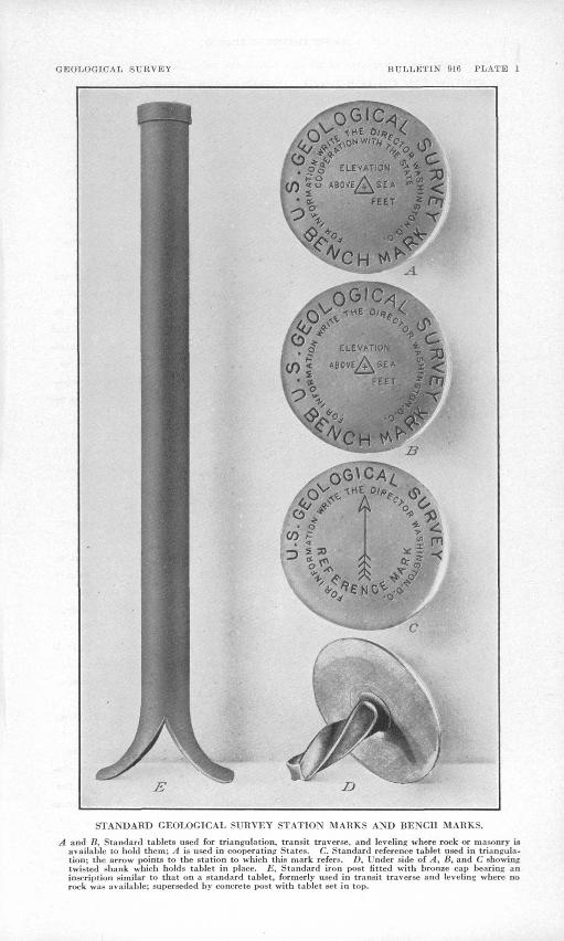
GEOLOGICAL SURVEY BULLETIN 916 PLATE 1
STANDARD GEOLOGICAL SURVEY STATION MARKS AND BENCH MARKS.
A and B, Standard tablets used for triangulation, transit traverse, and leveling where rock or masonry is available to hold them; A is used in cooperatinp States. C, Standard reference tablet used in triangula tion; the arrow points to the station to which this mark refers. D, Under side of A, B, and C showing twisted shank which holds tablet in place. £, Standard iron post fitted with bronze cap bearing an inscription similar to that on a standard tablet, formerly used in transit traverse and leveling where no rock was available; superseded by concrete post with tablet set in top.
PART !(., NORTHWESTERN MISSOURI, 1911-1957 V
cause of changes in design at various times. The face of every tablet, however, is
cast with the words "TJ. S. Geological Survey," a cross at the center which indicates
the fiducial point for position or elevation, and the words "Elevation above sea."
On some tablets the inscription indicates that they were set in connection with a
project in which a State or- other organization cooperated; on some the inscription in
cludes a triangle, which signifies a located point, enclosing the cross at the center.
Tablets bearing a triangle enclosing a cross may be used not only as traverse- or
triangulation-station marks but also as benchmarks. The inscription on most of the,
tablets already set includes the warning "250 dollars fine for disturbing this mark,"
but the latest design omits this phrase and adds the sentence "For information write
the Director, Washington, D. C."
If the tablet is to mark a transit-traverse station, the traverseman stamps it with
letters indicating this use of it, such as "Prim. Trav. Sta., n "P.T.S.," or "T.T.," as
well as his own identifying letter or letters, the aerial number of the station, and
the year, using steel dies. If the tablet is set as a benchmark, the levelman stamps
it with his identifying letter or letters, the serial number, and the year. He may at
the same time stamp upon it with steel dies the figures of elevation to the nearest
foot, or these figures may be added later. Tablets that serve as station marks may
have been set as such or they may have been originally established as benchmarks. Thus
some of them serve a dual purpose, but each has stamped upon it the date and the Iden
tifying designation of only the engineer who established It,
The figures of elevation that appear on a tablet are usually determined by field
computation only. It is sometimes found, therefore, that they do not represent the
latest inforaiation. This has happened either because they refer to some independent
datum temporarily adopted before first-order trunk lines made standard datum available,
or because a later adjustment made in the office has rendered necessary an appreciable
change In the figures as determined in the field. In June 1958 a field party was or
ganized and charged with the responsibility of stamping figures of elevation, to the
nearest foot, on the permanent benchmarks established in the State by the Geological
Survey. Thus, these figures may appear stamped on the tablets in addition to the iden
tifying letters and numbers quoted in the printed descriptions. It is assumed that
engineers and others who require accurate figures of elevation for the marks will use
those printed in Bulletin 898, instead of accepting the stamped figures. If the appro
priate part of the bulletin is not conveniently accessible, a request for the desired
information may be addressed to the Director, Geological Survey, United States Depart
ment of the Interior, Washington, D. C.
The tablets, of whatever style, are cemented into holes drilled in solid rocks or in
the walls of public buildings, bridge abutments, or other masonry structures. Where ma
sonry or rock Is not available, the tablets are set in the tops of reinforced concrete
posts; which may be either precast or mixed and molded at the selected alte. The posts
are about 8 Inches square or 8 inches in diameter at the top and larger at the base.
They vary In length from 36 to'14.8 Inches and are generally set so as to project about
6 Inches above ground
Antedating the concrete posts which are now constructed to hold the tablets, In
places where masonry or rook is not available, are wrought-iron posts, to the tops of
which are riveted bronze caps of similar design to the tablets. These iron posts meas
ure Ij. feet In length and jj- inches In outer diameter and are set about 5 feet in the

VI TRANSIT TRAVERSE IN MISSOURI
ground. The bottom of the poat spreads out to a width of about 10 inches in order to
give it a firm footing in the earth. No iron posts have been set in recent years.
They have proved impracticable, as they are easily disturbed or are often destroyed by
rust at the ground level.
Azimuth marks and supplemental points. When practicable two or more reference points
have been observed in the Immediate vicinity of each station mark from which azimuths
may be found for future use. Such points as church steeples, windmills, water tanks,
or cppper nails within triangles blazed on large trees have been utilized for this pur
pose.
Geodetic coordinates have also been determined for road or highway Junctions and In
tersections, railroad stations and crossings, mileposts, and stream crossings.
Preservation and restoration of station marks. Any person who finds that a station
mark has been damaged, disturbed, or destroyed or that it should be reset or redescrlbed
on account of highway or other improvements will render a public service by communicat
ing the facts to the Director, Geological Survey, United States Department of the Inte
rior, Washington, D. C., before taking any action affecting the location or elevation of
the mark. A proper form, accompanied by a return-addressed, franked envelope, will be
sent for use in reporting the action taken and in recording the revised description of
the mark, if any, and the notes made in obtaining the revised position.
Datum. Horizontal control surveys for the earlier topographic maps made by the
United States Geological Survey were expanded as local projects by small arcs of tri-
angulatlon based upon regional astronomic stations* purposely established to meet such
needs.
Later, additional arcs were expanded from locally adjusted positions referred to the
astronomic datums of these original projects. This process eventually led to difficul
ty when the triangulation based on the datum of one region was connected to that based
on the datum of another region. It was then found that the closing arc was forced to
receive excessive corrections.
Eventually the arcs of first- and second-order triangulation were extended throxigh-
out the country so as to form a comprehensive net of such extent and strength that when
adjusted it provided one consistent general datum. Using this framework, it was then
possible to readjust the earlier local projects on a more uniform and rigid basis. The
adjustment of the first-order net as a whole included and represented the averaged re
sults of all available astronomic observations.
Geodetic coordinates resulting from and affected by this adjustment of the first- and
second-order triangulation were distinguished from the coordinates accepted as the re
sult of previous adjustments by being referred to the BU. S. standard datum." Subse
quently, arcs of triangulation in Canada and in Mexico were adjusted to agree with the
net in the United States, and the designation U. S. standard datum was changed to North
American datum. For stations in the United States no corrections to coordinates were
made as a result of the change In the designation.
*See Woodward, R. S., Latitudes and longitudes of certain points in Missouri, Kansas, and New Mexico: U. S. Geol. Survey Bull. i(.9» P« 10, 1889. See also Triangulation and spirit leveling Missouri: U. S. Geol. Survey l8th Ann. Rept., pt. 1, pp. ll^J-lljl;, 1897.

PART 14., NORTHWESTERN MISSOURI, 1911-1937* VII
In 1927 the United 'States Coast and Geodetic Survey began a complete readjustment
of the entire first-order triangulatlon net, which by that time contained a great many
arcs of triangulation that were done after the first general adjustment waa completed.
The readjustment changed the coordinates of triangulatlon stations throughout the coun
try. The new datum resulting from this change is referred to as the "North American
datum of 1927.'"
Transit traverse was first used by the United States Geological Survey In 1889 to
provide control for a mapping project In northern Missouri. It was adopted as a method
of establishing horizontal control to supplant triangulatlon In wooded or cultivated
regions In which the scant relief in topography rendered the continuation of triangula
tlon for mapping requirements slow, costly, and deficient in the number and distributiai
of stations and useful supplemental points. The regulations of the United States Geo
logical Survey at that time specified that the traverse lines be started and ended
either at an astronomic station or at a triangulatlon station. Thus the changes In
datum made In the triangulatlon net have necessitated corresponding changes in the
transit traverse net.
The published results of transit traverse done by the United States Geological Sur
vey contain coordinates referring to one or another of the datums described here, accord-
Ing to the date of the computation or publication. Many of the earlier lines ware cor
rected from their original astronomic datums to the U.S. standard datum soon after the
basic coordinates referred to the latter became available. Recently much work has been
done to make the coordinates of all transit-traverse stations and supplemental points
refer to the North American datum of 1927, but the correction of the records, probably
will not approach completion for a number of years. The latitude and longitude of all
triangulatlon- and transit-traverse stations, reference marks, and supplemental points
In Missouri published In this bulletin are referred to North American datum of 1927.
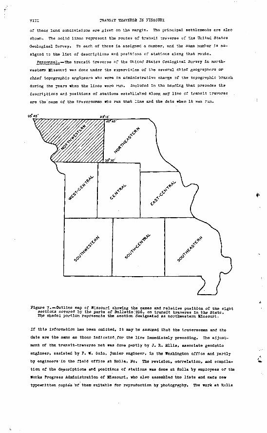
Location of the area. Northwestern Missouri, as the term Is used in this bulletin
and as the subject of part Ij. of the bulletin, Is that section of the State lying north
of latitude 39°30' and west of longitude 93°15' (See fig. 7.)
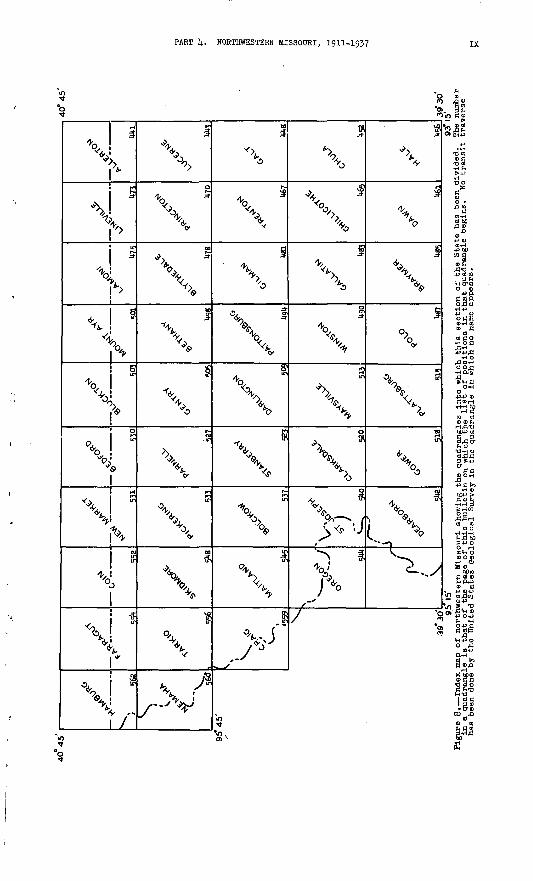
Index mapj, The accompanying Index map of northwestern Missouri (fig. 8) shows the
relative position of the quadrangle areas which make up this section. A quadrangle Is
the unit of topographic survey adopted by the United States Geological Survey for di
viding the area of the United States. All the quadrangles In northwestern Missouri
measure ijj minutes In latitude by 15 minutes In longitude.
Maps of many of the quadrangles In northwestern Missouri may be purchased at 10 cents
each retail or 6 cents each In lots of 50 or more. Prepayment Is required and may be
made by money order, payable to the Director, Geological Survey, United States Depart
ment of the Interior, or In cash the exact amount, at sender's risk. Postage stamps
should not be sent.
Diagrams of quadrangles showing routes of transit traverse; At the beginning of the
list of descriptions and positions of stations for each quadrangle Is a diagram showing
the routes followed by the lines of transit traverse In and immediately adjacent to
that quadrangle. To aid In Identifying these routes, the .boundaries of the townships
and ranges In the quadrangle are Indicated.by light dashed lines, and the designations
VIII TRANSIT TRAVERSE IN MISSOURI
of these land subdivisions are given on the margin. The principal settlements are also
shown. The solid lines represent the routes of transit traverse of the United States
Geological Survey. To each of these is assigned a number, and the same number is as
signed to the list of descriptions and positions of stations along that route.
Personnel. The transit traverse of the United States Geological Survey in north
western Missouri was done under the supervision of the several chief geographers or
chief topographic engineers who were in administrative charge of the topographic branch
during the years when the lines were run. Included In the heading that precedes the
descriptions and positions of stations established along any line of transit traverse
are the name of the traverseman who ran that line and the date when It was run.
9/45' 93? 15'
Figure 7. Outline map of Missouri showing the names and relative position of the eight sections covered by the parts of Bulletin 1916, on transit traverse In the State. The shaded portion represents the section designated as northwestern Missouri.
If this information has been omitted, It may be assumed that the traverseman and the
date are the same as those Indicated.for the line Immediately preceding. The adjust
ment of the transit-traverse net was done partly by J. R. Bills, associate geodetic
engineer, assisted by P. W. Coin, Junior engineer, In the Washington office and partly
by engineers In the field office at Rolla, Mo. The revision, correlation, and compila
tion of the descriptions and positions of stations was done at Rolla by employees of the
Works Progress Administration of Missouri, who also assembled the lists and made new
typewritten copies "of them suitable for reproduction by photography* The work at Rolla
40 45
562 "V
556
95*
45'
V
-
5H8
5U5
531
530
520
505
513
Ugg
40
* 45'
U75
U78
U70
Ugl
U67
U65
U52
3930
X TRANSIT TRAVERSE IN MISSOURI
was sponsored by the Missouri Geological' Survey and Water Resources and was In charge
of W. R. Broaddus, of the United States Geological Survey. The work in the Washing
ton office was under the super-vision of R. M. Wilson, chief^of the section of computing,
under the general direction of J. G. Staack, chief topographic engineer.
Explanation of tabulation of geodetic positions. In the text that follows, the de
scription of each station or supplemental point is followed by its geodetic coordinates
and the straight-line diagonal distance in feet between it and the preceding station or
supplemental point. The latitude and longitude of each standard station mark is given,
with few exceptions, to hundredths of seconds, and the coordinates for supplemental
points such as crossroads and mlleposts are given to tenths of seconds.
For obvious reasons no distance to a preceding station is given with the coordinates
for the actual starting point of a traverse line. However, if an entry In the distance
column appears in parentheses at the beginning of a line, it Indicates that the traverse
is continuous, but that the preceding station Is in an adjoining quadrangle and its de
scription and coordinates may be found in the appropriate list. No descriptions are re
peated. Stations at traverse Junctions are fully described in the'-llne In which they
first appear and are thereafter referred to by their designation followed by-the paren
thetical phrase "(previously described)." The coordinates of the closing station of a
traverse are repeated, and the last diagonal distance is indicated.
TRANSIT TRAVERSE IN MISSOURI PREVIOUSLY PUBLISHED
Triangulatlon and spirit leveling, Missouri: U.S. Geol. Survey, 19th Ann. Kept.., pt. 1, pp. 158-160, 1898.
Results of primary triangulation and primary traverse, fiscal year 1900-1901, Missouri: U.S. Geol. Survey Bull. l8l, pp. 165-170, 1901.
Results of primary triangulation and primary traverse, fiscal year 1901-2, Missouri: U.S. Geol. Survey Bull. 201, pp. 76-78, 1902.
Results of primary triangulation and primary traverse, fiscal year 1902-3, Missouri: U.S. Geol. Survey Bull. 2l6, pp. 1J5-136, 1903.
Results of primary triangulation and primary traverse, fiscal year 1903-lj., Missouri: U.S. Geol. Survey Bull. 214.5, PP- 61-63, 65-71, IgOl)..
Results of primary triangulation and primary traverse, fiscal year 1905-6, Missouri: U.S. Geol. Survey Bull. 310, pp. 58-62, 1907.
Results of triangulation and primary traverse for the years 1906, 1907, and 1908, Mis-, souri: U.S. Geol. Survey Bull. 1^0, pp. 258-259, 379-389, 1910.
Results of triangulation and primary traverse for the years 1909 and 1910, Missouri: U.S. Geol. Survey Bull. 14.96, pp. 205-219, 1912.
Results of triangulation and primary traverse for the years'1911 and 1912, Missouri: U.S. Geol. Survey Bull. 551, pp. 2144-251, igillj..
Triangulation and primary traverse, 1913-15, Missouri: U.S. Oeol. Survey Bull. 61^, PP. 353-590, 1916.
Triangulation and primary traverse, 1916-18, Missouri: U.S. Oeol. Survey Bull. 709, pp. 215-226, 1923.

INDEX
475447550
,543442-
499 553
"504 463 482
Page
Adjustment of transit traverse . . IV Agency .............. 519Akron. .............. 47°Albany ............. 506, 512Allendale. ....... 501, 505, 508Allerton quadrangle. ...... 1)41-443Altamont .......... 491, 492-493Amazonia ............. 5y.lAnderson, j. P., traverse by ... 468,
470-471,, 474, 476-U77,478-479,498,502-503,506, 551,553, 557-558,560-561
Athelstan. ............ 530Azimuth, marks and supplemental
points, establishment of . VI
Banner School. ........Barber Creek .........Bedford quadrangle ......Bee Creek (village). .....Beinlich, J. J., traverse by ... U42-
443, 1(46, LSI, 469-470,474-475, 480, 485, 500
Bermett triangulation sta. .... 5°3Bethany. ......... 478, 499, 500Bethany quadrangle ....... 498-500Big Creek. ..........
West Pork of ........Blarichard. ..........Blockton quadrangle. .....Blue Mound (village) .....Blue Ridge (village) .....Blythedale quadrangle. ..... 478-480Bolckow. ............. 538Bolckow quadrangle ........ 557~539Bradleyville ............ 553Braynier .............. 486Braymer quadrangle ....... 4^5-486Brimson. ......... 468, 469, 470
Cainsville ............ 4?8Cameron. ............ 487, 4"9Cann triangulation sta ...... 539Carlow .............. 4°4Carlow Station .......... 484Carmack. ............ 511, 512Cawood ............. 524,Central Methodist Episcopal Chapel Chillicothe quadrangle ..... 5~7Chula quadrangle ........ 452-455Clarksdale ............. 521Clarksdale quadrangle. ..... 520-522Classification of transit traverse III Clear Creek. ...........Clearmbnt. ........... 552, 553Clyde School ........... 53$Coffey ............Conception ..........Conception Junction. .....Coin quadrangle. ........ 552-553Cooperation. ........... IllCorning. ............. 559Cosby. .............. 521Courtney triaiigulation sta .... 522Craig, C. D., traverse by. ... 460-4§1.>
464, 492-493, 514, 517, 519 Craig. .............. 559Cralg quadrangle ........ 559-560Craig triangulation sta. ..... 55g
539 4"6
516 55"
Ik 525 529
Crooked River. Cunningham Curzon . .
458545
Darlington ............ 510Darlington quadrangle. ..... 509, 512Datum of positions ....... VI-VIIDawn quadrangle......... 461-464Dean Lake (village). ....... 459Dearborn quadrangle. ...... 542-544DeHart .............. 491Diagrams of quadrangles. .... VII-VIII
See also individual quadrangles. Dog Creek. ............ 49°Dunlap .............. 448Dunlap triangulation sta ..... 450
Eagleville. ............East Tarkio Creek ..... 553, 555,Easter triangulation sta. .....Elkhorn Creek ...........Bills, J. R., traverse by .... 515,Elmira. ..............Enyart...............Eversonville. ...........Exodus School ...........
Fairfax ..............Pairfield School. .........Fairview School ..........Fannon triangulation sta.......Farmers City. ...........Parragut quadrangle ....... 554'Federal Board of Surveys and Maps,
limitations prescribed by .Federal Emergency Relief Administra
tion, cooperation with. . .Pillmore. ............ 537,Fisher, C. R., traverse by. ....Ford City .............Fordham ..............Forest City ............Forest City triangulation sta . . .Fortescue .............Frazer. ..............Freeman Park. ...........Pry triangulation sta ...... 445,
Page
480
til
§8488529453560
557517560539 554 555
in
ina511515545544559519521446
Gallatin quadrangle ....... 483-485Gait. ............... 450Gait quadrangle ..'....... 448-451Gentry quadrangle ........ 505"509Gibson triangulation sta. ..... 526Oilman City ........... 48l , 482Oilman quadrangle ........ 481-483Gower ............... 519Cower quadrangle. ........ 518-519Graham. .............. 5,47Grand River ........ 459, 46l, 1)65,
473, 484, 490, 510, 512 East Pork of ......... 505, 512Middle Pork of ........ 505, 511West Fork of .......... 527
Grant City. ............ 505Grindstone Creek. ......... 49uGross, H. W., traverse by ..... 442,
450, 468, 471-472, 474, 477, 479-4-So, 489, 498-500, 502-505, 509, 512, 516-517, 519,551, 553, 554-555, 56l, 562
Hale. ............... 458Hale quadrangle ......... 456-4"!Hale triangulation sta. ...... 460Hall triangulation sta. ...... 543Halls ......'......... 543Hamburg .............. 563Hamburg quadrangle ........ 562-563Hamilton. ............ 4°5, 487Hamilton Church (Gait quadrangle) Hamilton School (Gait quadrangle) Hamilton School (Princeton
quadrangle) .......Harris. .............Harris triangulation sta. ....Harsha, B. D., traverse by. . . .Helena..............Hickory Creek (village) .....High Creek. ...........Honey Creek ...........Hopewell church .........Hopkins .............Humphreys ............Hurricane Churoh. ........
44-9 449
. 446
. 445454, 4-60
521465554
lamo triangulation sta. ..... 442, 563Interstate Commerce Commission, posi
tions from valuation plats 449, 458-459,467-468. 481, 485, 469,491-492,495-456, 510-511, 513-514, 519, 521-522, 523, 540-542, 543-544, 545, 548
transit traverse by. ...... IV

Jameson . Jamesport
Kennedy, W. V., traverse by
Page50lj.
481484
159-460,
Kennedy . . .King City ..........Kings Knob triangulation sta. Knights Creek ........
463-464, 469, 486', 482;489, 496-497, 500, 509, 512 ........ 526........ 523
542, 54-3 476
Lamoni quadrangle ........ 475"477Linden. ............. 560, 561Linden School ........... 46lLineville ......... -442, 474, 475Llneville quadrangle. ...... 473"475Little Creek, West Pork of. .... 499Little Medicine Creek ....... 44-7Little River. ........... 473Location of the area. ....... VII
outline map showing. ...... VIIILucerne quadrangle........ 443-447Lyman ............... 521
Mabel ............... 491McPall. ............. 495, 497McNair, E. L., travel-no by 443, 44-8, 452,
45,6, 461-462, 465-467, 483-
Magee, T. A.
484,485,487, 490, 511, 515- 516, 518, 523-525, 537-558, 540, 542-543, 544, 546-54-8
traverse by526, 529, 536,' 539
Magill. .............. 484Mahaska School. .......... 499Maitland. ............. 54?Maitland quadrangle ....... 545-548Mandeville. .'........... 464Maryville ............ 528, 534Maryville South Base triangula
tion sta. ......... 536Maysville ............. 5l4Maysville quadrangle. ...... 513~5l4Meadville triangulation sta .... 454Mecca ............... 515Medicine Creek. .......... 451Melbourne ............ 48l, 482Mercer. .............. 473Mirabile. ............. 488Missouri, transit traverse in,
earlier publications on . . X Missouri Geological Survey and Water
Resources, cooperation with III, IX Missouri River. .......... 559Missouri State Highway Commission,
cooperation with. ..... IllMound City. ........... 546, 547Mount Ayr quadrangle ....... 501-503Mount Morjah (village). ..... 471, 480Mount Tabor School. ........ 553Mozingo Valley School ....... 535Mud.dy Creek ............ 44l
Napier. ........Napier triangulation sta,Nemaha quadrangle ........ 560-New Hampton ............ L\.y&New Market quadrangle ...... 531-532Newtown ............. 44", 44jNewtown Branch. .......... 44°Nishnabotna River ......... 5«3Nodaway River ....... 54l, 546, 552
Olive triangulation sta ...... 444One Hundred and Two River ..... 533,
536, 537, 540, 542 Oregon............... 544Oregon quad.rangle . . . . . . 544-545Osborn. .............. 5l6
Panther Creek ........... 479Parkerton ............. 4«7Parnell quadrangle. ....... 527-529Pattonsburg ........... 495,, 496Pattonsburg quadrangle. ..... 4$>4~497Personnel ............. VIIIPhelps trjangulation sta. ..... 560Pickering quadrangle. ...... 533-536Platte River. ....... 51°, 521, 524Plattsburg quadrangle Polo quadrangle . . . Positions, datum of ........ VI-VII
tabulation of. ......... X
560545
D-561
,515-517 487-489
PagePosts, use of, to hold tablets . . v Prairie Dale School. ....... )|I|QPrinceton. ...... 444, 44-6, 471, 472Princeton quadrangle ...... 14.70-4.72
Quadrangles in northwestern Mis souri, index map showing . IX
maps of, how to obtain. .... VII See also descriptions and. dia
grams under individual quadrangles.
Quitman. ................. 551
Ravanna. .......... 444-445, 44-7Ravenwood triangulation sta. . . . 529Ridgeway ............. 4j9Rockport ............. 561
St. Benedictine Convent. ..... 529St. Joseph quadrangle. ..... 540-542St. Joseph triangulation sta . . 54o, 54l Saline .............. 4?3Sampsel ............. 4°6Sanrters, J. L., traverse by. . 423, 44l,
14.91, Ii.9lj.-k95, 497, 49 501, 503,505-506, 509-510,512, 513, 516, 520, 527, 533, 547- 548,549-550, 552, 556-557, 560
Santa Rose ............ 14.91Scearces ............ 518, 519Scope of report. ......... mShafter. ............. 454Shoal Creek. ....... 46l, 462, 517Skidmore quadrangle. ...... .Sko-SSlSpickard ............ 468, 4°9Stanberry. ............ 525Stanberry quadrangle ...... 523-526State Highway Department,
traverse by. .... 1446-1(14.7, 451Station marks, classes of. .... IV
forms'of. ........ IV-VI, pi. 1how set ............ IV-VIpreservation and restoration of VI
Stewartsville. .......... 518Stockbridge. ........... 521Sturges. ............ 1),52, 46?Sumner ............. 457, 45°
Taos ............... 514.3Tarkio quadrangle. ....... 556-558Thompson River .......... 4°5,
468, 14.76, 479, 480 Tina ............... 458Tinney Grove (village) ...... 486Transit traverse, adjustment of. . iv
classification of ....... Illin Missouri, earlier publica
tions on ......... XTrenton. ............. 469Trenton quadrangle ....... 467-470Tudor, S. T., traverse by. . . 44-5, 44$>-
450. 502, 503-504, 506- 508, 511-512, 525-526,528- 529, 530, 531-532, 534- 536,538-539, 548, 550,552......... 517Turney . . .
Union Chapel Union Star . Utica. . . .
514
O
Wallace. ............. 543Walsh, 0. E., traverse by. .... 453,
456-457, 462-463 Weatherby. ............ 491Weldon River .......... 472, 4t4West Medicine Cre.ek. ...... 443, 44-7Whaley triangulation sta ..... 449Wheeling ............. 453Whitham. ............. 458, 459Wiedersholt triangulation sta. . . 52° Wildcat Creek. .......... 4?2Williams, C. W., traverse by . . 454~455,
469, U72, 482, 496-497, 512Wilson, J. H., traverse by . . 545,
548, 556, 559-560Winn triangulation sta ...... 519Wiriston. ............. 491Winston quadrangle. ....... .490-493Works Progress Administration,
cooperation with . . . Ill, VIII
Yellow Creek ........... 458

TRANSIT TRAVERSE
ALLERTON QUADRANGLE # (Latitude li.0 0 30'-l;0 0U5' ; longitude 93°15' -93°30' )
Mercer and Putnam Counties
1. PROM. LINEVILLE GUADRANGLE AT SEC. 21, T. 66 N., R. 23 W., EAST TO SEC. 24, T. 66 N., R. 21 W., INCLUDING THAT PART OP THE LINE IK BOYNTON AND SEYMOUR QUADRANGLES (by J. L. Sanders in 1923)
(Continued from Lineville quadrangle; see line 1.)
Station
Rd. at line between sees. 22 and 23, T. 66 N. ,
'T. 66 N. , R. 23 W., quarter cor. between sees. 24 and 25, lj.0 ft. N. and 30 ft. E. from T-rd. E., on high bank, inside fence, in concrete post; standard tablet stamped "Prim Trav Sta No 76
T. 66 N., Rs. 22 and 23 W. , approximate cor.
T. 66 N., R. 22 W. , cor. sees. IS- 20, 29, and 30 T. 66 N., R. 22 W., cor. sees. 20, 21, 28, and
T. 60 N., R. 22 W., cor. sees. 21, 22, 27, and 28, 22 ft. N. and 50 ft. W. from T-rd. W. on Meroer-Putnam county line, in. concrete post; standard. tablet stamped "Prim Trav Sta No 77
(For balance in Lucerne quadrangle
T. 66 N., R. 21 W., cor. sees. 21, 22, 27, and
T. 66 N., R. 21 W. , quarter cor. between sees. 23
T. 66 N., R. 21 W., cor. sees. 23, 2k, 25, and 26, 380 ft. S. of, 21 ft. W. of crossroads, in concrete post; standard tablet stamped "Prim
Latitude
0 | II
ko 30 46.4 ko 30 41.2
ko 30 kz-k ko 30 44.1 ko 30 46.8 40-30 13.5 tj.o 30 12.7
ko 30 06.37kO 30 OS. 2 14.0 30 Oft.. 5
14.0 30 04.1
14.0 30 03.19, see line 2
Ij-O 30 01-54o 29 59.6 ko 29 57.14.14.0 30 01. Ij.
1).0 29 57.38
Longitude
0 1 II
93 29 12.6 93 28 45-8
93 28 11.1 93 27 l;6.o 93 27 20.0 93 27 17.9 93 26 29.2
93 26 28.89
93 25 54.9 93 2k 47-2
93 23 38.6
93 22 30.14.6
)
93 15 37-6 93 14 54-3 93 14 32.6
93 13 55-7
93 13 21.60
Distance
Feet (5,890) 2,134
2,680 1,674 2,1003,37p 3,7614.
6^0
2,625 5,230
5,296
5,266
(5,280)I'M 2,8832,664
The greater part of thin quadrangle lies in Iowa. **It was reported by J. J. Belnllch in 1936 that this monument had been destroyed.
44i

442 TRANSIT TRAVERSE IN MISSOURI
Station Latitude Longitude Distance
o i M o i ii Peet
2. PROM LUCERNE QUADRANGLE AT SEC. 26, T. 66 N. , R. 23 W. , NORTH ALONG ROADS TO SEC. 23, T. 66 N. , R. 23 W. , THENCE WEST ALONG COUNTY ROUTE M INTO LINEVILLE QUADRANGLE (by H. W. Gross in 1935)
(Continued from Lucerne quadrangle; see line 3.)
(Continued in Lineville quadrangle
40 30 13-5ko 30 37440 30 4§-7 40 30 lt-6.5
; see line 3
93 27 17-0 93 27 59.2 93 28 Iik. 8 93 29 11.6
)
(3,625) 4,060 3,646 2,071
3. PROM LINEVILLE QUADRANGLE AT SEC. 28, T. 6? N., R. 23 W. , EAST TO SEC. 35, T. 6? N., R. 21 W., THENCE SOUTH INTO BOYNTON QUADRANGLE AT SEC. 24, T. 66 N., R. 21 W. , INCLUDING THAT PART OF THE LINE IN SEYMOUR QUADRANGLE (by J. J. Beinlich in 1936)
(Continued from Lineville quadrangle; see line 4.)
Lineville, 3.2 mi. E. of, in SW 1/4 SW 1/4 sec. 26, T. 67 N., R. 23 W., 440 ft. W. of T-rd. S., 21 ft. N. and 24 ft. E. from T-rd. N., in concrete post; standard tablet stamped
T. 67 N. , R. 23 W. , quarter cor. between sees. 25
lamo triangulation sta.; U.S.C. & G.S. standard
Junction of rd. S. at fence N. on Iowa-Mo. State
Rd. at fence S. on Mercer-Putnam county line -- T-rd. N. on Iowa-Mo. State line, 97 ft. W. of
T. 67 N., R. 22 W., N. cor. sees. 26 and 27, rd. at right-of-way S., ll4.0 ft. E. of rd. at
T. 67 N., R. 22 W., N. quarter cor. sec. 26, 130 ft. S. of Iowa-Mo. State line, 60 (? 15) ft. S. and 15 (? 20) ft. E. from T-rd. S. , in concrete post; standard tablet designated "T T
Tps. 66 and 67 N., Rs. 21 and 22 W. , approximate cor. of, 24 ft. S. and 25 ft. E. from cross roads, in concrete post; standard tablet
Chicago, Milwaukee, St. Paul and Pacific R.R. at
T. 67 N., R. 21 W. , S. cor. sees. 20 and 21, on Iowa-Mo. State line, 36 ft. N. and 28 ft. W. from T-rd. H. , in concrete post; standard
T-rd. W. , 15 ft. S. of fence E. on Iowa-Mo.
T. 67 N., R. 21 W. , cor. sees.- 27, 28, 33, and
T. 67 N. , R. 21 W., quarter cor. between sees. 34 and 35, 20 ft. N. of rd. corner from S.-W. , In concrete post; standard tablet stamped "T T
Tps. 66 and 67 N., R. 21 W. , approximate quarter cor. between sees. 2 and 35, crossroads -
T. 66 N., R. 21 W. , quarter cor. between sees. 2
T. 66 N. t R. 21 W. , quarter cor. between sees. 11 and ll|., 46 ft. S. and 2k ft. W. from cross roads, in concrete post; standard tablet
T. 66 N., R. 21 W. , center sec. 14, stone at
ko 314. 30.5 4o 34 -26.7 ko 5k 28.6
4o 3!; 28.13
14.0 3)4. 27.64o 34 14.8.114.0 314. 14.8.14. 14.0 314. 14.8.50ko jk 48.7 ko 3k k9-7 ko 3k k9-l
ko 34 49-1
ko 3k k9.5
kO 3k 48.61 ko 3k 2k. j; ko 33 58.4 ko 33 32-4 ko 33 31.4
ko 33 30.88ko 34 25.2ko 34 50.4 ko 3k 50.4
ko 3k 50.6
kO 3k 51.02ko 3k 50.7 ko 3k 50.7
kO 3k 51.0
kO 3k 21. k ko 33 55.2
ko 33 55.33
ko 33 29.2 ko 33 ol»..2
ko 32 38.0 4o 32 25.1
'ko 31 45.29
ko 31 19.7
93 29 5k. 8 93 29 20.7 93 29 03.6
93 28 00.43
93 26 28.3 93 25 18.1 93 2k 43-2
93 2k 15.81
93 23 35-1 93 22 flA.l 93 23 26.9
93 22 12.9
93 21 18.6
93 20 4k. 01 93 20 28.2 93 20 28.2 93 20 28.6 93 19 41-6
93 19 02.66 93 19 02.5 93 19 02.2 93 18 43-9
93 18 12.6
93 17 19.78 93 17 03-2 93 16 45-2
93 15 37-0
93 15 37-8 93 15 20.8
93 Ik 29.65
93 13 55-6 93 13 56.2
93 13 56.0 93 13 55-9
93 13 55-97
93 13 55-5
(5,018) 2,633 1,320
4,873
7,109 5,800
2,69k
2,110
3,138 3,937 1,330
1,079
4, 190
2,670 2,746 2,620 2,630 3,626
3, 'OOS5. '294 2,755 1,14.12
2,418
4,072 1,278 1,390
5,26k
3,0012,950
3,948
3,730 2,532
2,640 1,310
4,0272,585
PART k, NORTHWESTERN MISSOURI, 1911-1937
Station
T. 66 N.3603.
, R. 21 W., quarter cor. between
Latitude
kO 31 19.8
Longitude
93 13 20.9
Distance
Feet
2,672
(Continued in Lucerne quadrangle; see line 8.)
Magnetic declination 5° 59' E.
LUCERNE QUADRANGLE (Latitude kO°15'-kO°30'; longitude 93°15'-93°30')
Grundy, Mercer, Putnam, and Sullivan Counties
1. FROM GALT QUADRANGLE AT SEC. 22, T. 6j N. , R. 23 W., EAST TO SEC. Ik, T. 63 N., R. 21 W., INCLUDING THAT PART OF THE LINE IN BOYNTON QUADRANGLE (by E. L. McNair in 1913)
(Continued from Gait quadrangle; see line 1.)
Station
T. 63 N., R. 23 W., cor. sees. Ik, 15, 22, and
T. 63 N., R. 23 W. , quarter cor. between sees. Ik
T. 63 N., Rs. 22 and 23 W. , cor. sees. 13, 18,
T. 63 N., Rs. 22 and 23 W. , approximate quarter
T. 63 N., R. 22 W., quarter cor. between sees. 17
T. 63 N., R. 22 W. , quarter cor. between sees. l6
West Medicine Greek, center of bridge over -
T. 63 N., R. 22 W., in SW 1/k sec. 10, 15 ft. W. of T-rd. E. ; iron post stamped "Prim Trav StaNo 15 1.913 Mo" ; ~
Chicago, Milwaukee, St. Paul and Pacific R.R. at
T. 63 N., R. 22 W., cor. sees. 11, 12, 13, and Ik T. 63 N., R. 22 W., quarter cor. between sees. 12
T. 63 N., R. 21 W., cor. sees. 7, 8, 17, and 18,
T. 63 N., R. 21 W. , cor. sees. 17, 18, 19, and
T. 63 N., R. 21 W., cor. sees. l6, 17, 20, and
T. 63 N., R. 21 W., quarter cor. between sees. 15
T. 63 N., R. 21 W., eor. sees. Ik, 15, 22, and 23, 20 ft. N. and 23 ft. E. from T-rd. N.; iron post stamped "Prim Trav Sta No 16 1913
Latitude
0 I II
ko 15 02.8
kO 15 03.2
ko 15 03.6
ko 15 29.8
ko 15 30.0
ko 15 31.5 ko 15 LJ+.8 ko 15 k5-U ko 15 k5.7
kO 16 12.25
kO 16 13.6lio 16 01.1kO 16 01.6ko 16 03.1kO 16 03.1
kO 15 10-7
kO 15 12.2
kO 15 13-7
ko 15 13.8k
Longitude
0 | II
93 27 ko.i
93 27 06.1
93 25 23.2
93 25 23.3
93 2k 17.6
93 23 09.7 93 22 38.0 93 22 00.7 93 21 k3.6
93 21 k3-9k
93 20 35.3 93 19 1A-2
93 19 10.0 93 18 19-2
93 17 28.5
93 17 28.3
93 16 19-9
93 Hj. 37-1
93 Ik 02.86
Distance
Feet
(2,669)
2,6kO
7,98k
2,650
5,095
5,267 2,851 2,88k 1,331
2,682
5,325 £,160
2,651 5»9Wr 3,930
5,300
5,308
7,972
2,658

444 TRANSIT TRAVERSE IN MISSOURI
Station
2. PROM ALLERTON QUADRANGLE AT SEC. 27, T. 6 ALLERTON QUADRANGLE AT SEC. 28, T. 66 N in 1923)
(Continued from Allerton quadrar.gl
T. 66 H., R. 22 W., S. sixteenth cor. between sees. 27 and 28, T-rd. E. on Mercer-Putnam
T. 66 N. , R. 22 W., S. sixteenth cor. between
T. 66 N., R. 22 W., S. sixteenth cor. between
T. 66 N., R. 22 W., cor. sees. 25, 26, 55, and
T. 66 H., Rs. 21 and 22 W. , approximate cor.
T. 66 N., R. 21 W., quarter cor. between sees. 50 and 51, 50 ft. N. and k5 ft. E. from cross roads, 56 ft. SW. of schoolhouse, in concrete post; standard tablet stamped "Prim Trav Sta
T. 66 N., R. 21 W., cor. sees. 29, 50, 51, and52 .. . . .
Chicago, Milwaukee, St. Paul and Pacific R.R. at
T. 66 N., R. 21 W., cor. sees. 27, 28, 55, and .
(Continued in Allerton quadrangle;
Latitude
0 1 II
6 N., R. 22 V ., R. 21 W. .
e; see line ".
kO 29 2k. 0
kO 29 25.8
kO 29 25^5
kO 29 10. k
kO 29 09.9
kO 29 10.21
kO 29 09.8
kO 29 08.6 kO 29 09.5
kO 29 09 .k
see line 1.
Longitude
/., EAST INTO by J. L. Sand
.)
93 22 29.7
93 21 21.1
93 20 12.7
93 20 12.5
95 19 Ok.l
95 18 28.50
95 17 55-9
95 17 27.14. 93 15 49-1
95 15 58.2
Distance
Feet
ers
(5,966)
5,298
5,282
1,524
5,28k
2,752 2,5172,206 7,592
845
3. PROM GALT QUADRANGLE AT SEC.*22, T. 65 N. , R. 25 W., NORTH INTO ALLERTON QUADRANGLE AT SEC. 26, T. 66 N., R. 25 W. (by H. W. Gross in 1955)
(Continued from Gait quadrangle; see line 6.)
T. 63 N. , R. 23 W. , cor. sees. lk, 15, 22, and
T. 65 N., R. 25 W. , eor. sees. 10, 11, lk, and 15, T-rd. E. at fence W. on Grundy-Mercer
T. 65 N., R. 25 W., near center sec. 10, 21 ft.N. and 2k6 ft. W. from T-rd. N. , in front of dwelling on N. side of rd., in concrete post;
T. 65 N., R. 23 W., center sec. 9, T-rd. N. at
Olive triangulation sta.; U.S.C. & G.S. standard
T. 65 N., R. 25 W. , N. quarter cor. see. k, T-rd. S.,. 70 ft. E. of T-rd. N. at S. quarter
T. 64 N., R. 25 W., quarter cor. between sees. 28
T. 6k N., R. 25 W., cor. sees. 27, 28, 35, and
T. 64 N., R. 25 W., eor. sees. 21, 22, 27, and 28, 55 ft. N. and 20 ft. W. from crossroads, 2 ft. E. of hedge fence, in concrete post;
Princeton, 5 mi- E. and 2 ml. S. from, approximate eor. sees. 5, k, 9, and 10, T. 6k N., R. 25 W., 52 ft. K. and 20 ft. W. from County Route E at rd. N. , 32 ft. N. and 11 ft. W. from junction of rd. S., in concrete post; standard tablet stamped "lk08 1954" ----
Tpa. 6k and 65 N., R. 23 W. , approximate cor. sees. 3, k, 35, and 34, rd. et fences E. and W.
T. 65 N., R. 25 W., cor. sees. 27, 28, 55, and54., i ru. b. at lence ft.
Easter triangulation sta.; U.S.C. & G.S. standard
State Highway k & t rd. S. and fences E. and W.
Ravanna, at S. limits of, in NE l/k see. 10, T. 65 N., R. 23 W., 150 ft. S. and ko ft. W. from State Highway k at N.-S. crossroad, 52 ft. E. of highway at fence E., in concrete post; standard tablet stamped "lk09 C W A 1954"
kO 15 02.8ko 15 15.9kO 15 42.5
ko 15 554
kO 16 21.68
kO 16 20.9
kO 17 14.05
ko 17 40-7
40 18 33.2
kO 18 55.3 .
ko 19 26.37 ko 19 52-2 ko 20 18.640 20 58.0 kO 21 2k. 3
kO 22 Ok. 19 40 22 23-0
kO 22 56.0
kO 23 kg. 5 ko 23 48-5
kO 2k 52.944o 25 07.1 lj.0 25 07.1kO 25 55-4 kO 26 12.7
kO 26 58.56
95 27 ko.2 95 27 ko.5 95 27 ko.6
95 27 ko.6
95 28 15.85
95 29 22.6
95 29 22.10
95 29-22.8
93 29 23.295 28 48.8
93 28 14.8.38 95 28 14.7.9 95 28 1|.7.8 95 28 47-6 95 28 14.7.5
95 28 47.47 95 28 k7.0
95 28 47-1
95 28 47.2 95 29 ok.k
95 28 46.60 95 29 05.8 95 29 26.2 95 29 05.9 95 28 52.6
95 27 55-61;
(2,666) 1,532 2,667
1,551
3,815
5,176
5,575
2,700
5,317
2,670
5,567 2,618 2,669 5,986 2,66k
4,0541,900
5,5465,510 1,527
6,665 1,960 1,750 5,167 4,651
5,438

PART k, NORTHWESTERN MISSOURI, 1911-1937 145
Station
Ravanna, at intersection of State Highway k and
Ravanna, Main Street at intersection of street S. T. 65 N., R. 23 W., N. cor. sees. 2 and 3,
T-rd. S., 15 ft. E. of T-rd. N. at S.- quarter
T. 66 H., R. 23 W., center sec. 26, 2.8 mi. N. of Ravanna, 36 ft. N. and 30 ft. E. from rd. corner from S--E., k8 ft. S. and 57 ft. E. from dwelling of Charles Little, in concrete post;
Latitude
ko 27 31. S
ko 28 21.5
Longitude
0 | II
93 27 51-1 93 27 50.9
93 2? 37-5 93 27 37-3
Distance
Feet
2,0'631.355
5.1325,29k-
2,75k
(Continued in Allerton quadrangle; see line 2.)
k. PROM PRINCETON QUADRANGLE EAST ALONG COUNTY ROUTE E TO SEC. 9, T. 614. N. , R. 23 W. (by H. W. Gross in 1935)
(Continued from Princeton quadrangle; see line k.)
T. 6k H., R. 23 V,'., cor. sees. k, 5, 6, and 9,kO 22 03.1i ko 22 03.6 ko 22 Of).. 1°
93 29 56.3 93 29 21.8 93 28 k7.k7
(5,360)2,6702,657
5. PROM SEC. 8, T. 63 N., R. 21 W. , NORTHEAST TO SEC. 15, T. 65 N. , R. 21 W. , INCLUDING THAT PART OP THE LIME IN BOYNTON QUADRANGLE (by S. T. Tudor in 1935)
Harris triangulation sta.; U.S.C. & G.S.
T. 63 N., R. 21 W. , cor. sees, k, 5, 8, and 9,
Tps. 63 and 6k N., R. 21 W. , approximate eor. sees. k, 5, 32, and 33, rd. at fence W. and
T. 61; N., R. 21 W., 185 ft. E. of E.- sixteenth cor. between sees. 21 and 28, 30 ft. N. and 28 ft. W. from T-rd. K. , in SE. corner of sohoolyard, in concrete post; standard tablet
T. 6k N., R. 21 W., cor. sees. 15, 16, 21, and
T. 6k N. , R. 21 W. , quarter cor. between sees, lk
T. 6k N. , R. 21 W. , approximate quarter cor. between sees. 10 and 11, 36 ft. S. and 20 ft. E. from crossroads, in concrete post; standard tablet stamped "T T Sta No 15614. E' R A 1935"
T. 6k N., R. 21 W., cor. sees. 2, 3, 10, and 11,
T. 614. N., R. 21 W., N. cor. sees. 2 and 3, T-rd.C
T. 65 N., R. 21 W., cor. sees. 26, 27, 314., and
T. 65 N., R. 21 W., cor. sees. 22, 23, 26, and2V T rd. E
T. 65 N., R. 21 W., cor. sees. lk, 15, 22, and
Pry triangulation sta.; U.S.C. & G.S. standard
ko 16 27.90 ko 16 56.114.0 16 57.1
kO 17 k9-l kO 18 15.3lj.0 18 15.9kO 18 14.24
ko 19 35.37 lie 20 01.6kO 20 27.9 li.0 20 5k. 2
kO 20 55.6
kO 21 k7-77
kO 22 Ik. 6
kO 23 06.0
ko 23 57.8kO 2k 50.8
ko 25 k3.2
kO 26 23.20
93 17 00.02 93 16 5k-2
93 16 20.0
93 16 194. 93 16 19-2 93 15 k§-2 93 15 28.0
93 15 25-95 93 15 11 4.
93 15 ll-5 93 15 11 4
93 lk 02.6
93 lk 02.12
93 lk 02.2
93 lk 02.0
93 lk 01.1
93 lk 00.7
93 lk 00.2
93 lk 10.58
2,887 2,650
5,259 2,650 2,6332,997
5,357 2,887
2,660 2,660
5,333
5,277
2,709
5,2.10
5,2^0
5,360
5,300
k,125
6. PROM SEC. 8, T. 63 N., R. 21 W., SOUTHEAST TO SEC. lk, T. 63 N., R. 21 W., INCLUDING THAT PART OF THE LINE IN BOYNTON QUADRANGLE (by S. T. Tudor in 1935)
Harris triangulation sta. (previously described)-
T. 63 N., R. 21 W. , cor. sees. 16, 17, 20, and
T. 63 N., R. 21 W. , cor. sees. 15, 16, 21, and
T. 63 N. , R. 21 VI. , quarter cor. between sees. 15
Prim Trav Sta Ho 16 1913 Mo (previously
kO 16 27.90
kO 15 3§4
kO 15 12.1ko 15 12.6ko 15 13.7
ko 15 13.914.
93 17 00.02 93 16 5k- 1
93 16 19-993 15 14-5-7
93 15 H-5
93 4- 37-2
2480
2,6k8
2,665O £CT
2,653
2,662
215149 O (0 2
kk6 TRANSIT TRAVERSE IN MISSOURI
Station
7. FROM SEC. 3, T. 6k N., R. 23 W. , EASf TO INCLUDING THAT PART OP THE LINE IN BOYN in 1936)
T. 6k N., R. 23 W., cor. sees. 1, 2, 11, and 12,
T. 64 N., Rs. 22 and 23 W., cor. sees. 1, 6, 7, and 12, 10 mi . S. and E. of Princeton, 19 ft. S. and 82 ft. E. from T-rd. S., in concrete post; standard tablet stamped "T T 4? J J 1936"
Rd. at fence N. on Mercer-Sullivan county line -- Newtown, 1-5 ml. W. of, quarter cor. between
sees. 3 and 10, T. 64 N. , R. 22 'W., 20 ft. N. and 33 ft. E. from T-rd. S. and private entrance N., in concrete post; standard tablet
Chicago, Milwaukee, St. Paul and Pae.ific R.R.
T. 64 N. , R. 21 W. , quarter eor. between sees. 5 and 6, 25 ft. E. of T-rd. W. , in concrete post;
T T Sta No 156k ERA 1935 (previously described
Latitude
SEC. 10, T. i TON QUADRANGI
40 22 Ok. 19 40 22 Ok.O 40 22 04-0 4Q 22 Ok.l
kO 22 Ok. 2 40 22 04.6
40 22 Ok. 834o 21 59.1kO 21 57.1 40 22 06.2
kO 22 07.01 40 22 07.4 40 22 34-7
kO 22 3k. V 40 22 34 -'6
.lj.0 22 35.1
40 22 36.204o 21 57.040 21 kk-k ko 21 4o.3 ko 21 46.8
4o 21 47.77
Longitude Distance
0 ' " Feet
>4 N., R. 21 W., .E (by J. J. Beinlich
93 28 47-47 93 '27 55-3 93 27 38.3 93 27 03.9
93 26 29.6 93 25 55.3
93 25 20.2093 24 17-8 93 22 59.4 93 22 00.7
93 21 25.87 93 20 51.8 93 20 05.8
93 19> 51.8 93 18' 57-6 93 16 35-1
93 17 26.51 93 17 28.8 93 16 54-6 93 15 28.6 93 15 ii-4
93 14 02.12
4,034 1,320 2,660
2,660 2,650
2,716 4,863 6,075 4,632
2,697 2,638 4,506
1,083 4,196 1,735
5,157 3,966 2,934 6,654 1,331
5,367
8. PROM SEYMOUR QUADRANGLE AT SEC. 24, T. 66 N. , R. 21 W. , SOUTH TO SEC. 15, T. 65 N., R. 21 W. (actually in Boynton quadrangle) (by J. J. Beinllch in 1936)
(Continued from Allerton quadrangle; see line 3.)
T. 66 N., R. 21 W., cor. sees. 23, 2k, 25, and 26, 48 ft. S. and 18 ft. W. from crossroads, in concrete post; standard tablet stamped
T. 66 N., R. 21 W., cor. sees. 25, 26, 35, and
Pry triangulatlon sta. (previously described) -
ko 29 57-12
ko 29 09.2 4o 29 09.340 28 19.9 40 27 27.6 .kO 26 35.34o 26 23.20
93 13 21.25
93 13 21.0 93 13 55-4 93 13 59-2 93 13 59-6 93 13 59-8 93 14 10.58
(6,364)
4,85,0 2,654 5,013 5,269 5.510 1,482
9. FROM GALT QUADRANGLE NORTH ALONG STATE HIGHWAY 139 TO SEC. 1, T. 65 N., R. 22 W. (fourth-order traverse by State Highway Department in 1934)
(Continued from Gait quadrangle;, see line 6.)
T. 63 N., R. 22 W., cor. sees. Ik, 15, 22, and 23, highway at fence W. and fence E. along N.
Prim Trav Sta No 15 1913 Mo (previously
Tps. 63 and 6k N., R. 22 W. , approximate cor. sees. 2, 3, 3k, and 35, 442 ft. E. of highway
T. 6k N., R. 22 W. , cor. sees. 26, 27, jk, and35 __ _ _ -________ __ _ __ __
Highway at fence along N. side of farm entrance - Highway at fence W. on line between sees. 11 and
Newtown Branch, S. end of bridge over -- -_--
4o 15 07.6 40 15 33-8
40 16 12.20
4o 17 45-o.40 16 09.7ko 18 21.4kO 18 36. k4o 19 03.1 40 19 30-3 4o 20 49.2kO 21 13.24o 21 ko.o40 22 01.3
93 20 52.1 93 20 52.3
93 21 43'- 93
93 20 53.2 93 20 57.5 93 20 55.9
93 20 52.593 20 44-8 93 20 38.6 93 20 20.8
93 20 15.3 93 20 09.2 93 20 o4.6
(2,019-) 2,652
5,562
10,178 2,528 1,191
2| 769 2,800 8,100
2,470 2,7562,182
This monument is approximately 27 ft. S. and 9 ft. E. from Prim Trav Sta No 79 L S 1923 Mo which has been destroyed.

PART k, NORTHWESTERN MISSOURI, .1911-1937
Station
Newtown, street intersection (previously
Old rd. on .Putnam-Sullivan county line, k5 ft.
Highway on line between sees.. 25 and 36,
T. 65 N., R. 22 W., approximate cor. sees. 23,
Crossroad on line between sees. 23 and 2k,
Highway at. fences E 1. and W. on line between
Highway at line through center sec. 12, T. 65 N. ,
Latitude
kO 22 Jk. 7
kO 23 00. 8ko 23 22.5 ko 23 53.1kO 2k 19.2
ko 2k k5-3 ko 25 11.5
ko 25 254kO 25 37.8ko 26 Ok-l kO 26 30.3
ko 26 56.7 lio 27 09.6kO 27 50.5
Longitude
93 20 05.8
93 20 09-7 93 19 51-5
93 19 22.9 93 19 27.7
93 19 {t-3-1 93 19 14-9-5
93 19 k3.0
93 19 36.8 93 19 17-7 93 19 31-14.
93 19 53-7 93 19 27.0 .93 19 31-7
Distance
Feet
3,378
2,663 2,609
3,805 2,665
2,899 2,696
1,1*92
I, 5k6 3,037 2,858
2,67k I,k06lt.,151
10. PROM SEC. 21, T. 65 N., R. 23 W. , EAST ALONG STATE HIGHWAY k TO SEC. 1, T. 65 N. , R. 22 W. (fourth-order traverse by State Highway Department in 193k)
Highway at approximate line between sees. 15 and
T. 65 N., R. 23 W., approximate cor. sees. 2, 3, 10, and 11, center of old rd. N. and W. of
Little Medicine Creek, W. end of bridge over ---- T. 65 N., R. 23 W., cor. sees. 1, 2, 11, and 12,
T. 65 N., R. 23 V/., quarter cor. between sees. 1
T. 65 N., Rs. 22 and 23 W. , approximate cor.
Highway at hedge fence S. on line between sees.
T. 65 N., R.'22 W. , center see. k, crossroad ---- Highway at Mercer-Putnam county line, 719 ft. N.
of approximate quarter cor. between sees. 3
Junction of State Highway 139 (previously
kO 25 07.1 kO 25 33. k
ko 25 53.3kO 26 12-7 lj-0 26 52.3 ko 27 05.0
kO 27 16.6 lio 27 18.8lio 27 19.0kO 27 19.1
ko 27 19.3kO 27 17.8lio 27 ii.6 lio 27 31.9 ko 27 kk'&ko 27 k7.k ko 27 14.7.5
ko 27 514-7 ko 27 55.5kO 27 58.0 lio 28 00.7
ko 27 50.5
93 29 26.2 93 29 03.9
93 28 k8.l 93 28 32.7 93 28 01.3 93 27 51-2
95 27 38.1 93 27 03.8 93 26 k2.7
93 26 29.8
93 25 55-5
93 25 21.3 93 2k 51-7 93 2k 12.7 93 23 14.3.3
93 23 09.1 93 22 35-0
93 22 00.5 93 21 33.7 93 20 57.6 93 20 17.6
93 19 31-7
3,169 2,3522,300 U,688 l,l;97
1,713 2,651 1,627
1,000
2,6532,6k8 2,310 3488 2,62k
2,6532,61a
2,760 2,079 2,796 3,106
3,693Magnetic declination 6° 59' E.

GALT QUADRANGLE (Latitude l4.0°00' -lj.0°15!; longitude 93°15'-95°30')
Grundy, Linn, and Sullivan Counties
R22W R2IW
I
1. PROM CHULA QUADRANGLE AT SEC. 21, T. 60 N. , R. 23 W. , NORTH INTO LUCERNE QUADRANGLE AT SEC. 22 r T. 63 N. , R. 2J W. (by E. L. McNair in 1913)
Station
Prim Trav Sta No 12 191? Mo 785 (In Chula
T. 60 N. , R. 2J W. , cor. sees. 15, l6, 21, and
T-rd. V. -- - - T. 6l N., R. 23 W. , S. cor. sees. 33 and 3lv,
T. 61 N., R. 23 W., car. seoa. 27, 28, 33, and
T. 6l N., R. 23 W., quarter cor. between sees. 15
T. 61 N. , R. 23 W., cor. sees. 3, k, 9. and 10,
Dunlap, 14.75 ft. E. of Quincy, Omaha & Kansas City R.R. sta., 54 ft. N. of track, 27 ft. E. of rd. ; iron post stamped "Prim Trav Sta No 13
T. bl N., R. 23 W., N. cor. sees; 3 and Ij., T-rd. S.
T. 62 N., R. 23 W., E. sixteenth cor. between
T. 62 N., R. 23 W., quarter cor. between sees. 22
T. 62 N., R. 23 W., N. sixteenth cor. between
T. 62 N., R. 23 W., quarter cor. between sees. 15
T. 62 N. , R. 23 W., eor. socs. 9, 10, 15, and
T. 62 N., R. 23 W. eor. sees. 3, 1;, 9, and 10 T. 63 N. , R. 23 W. S. cor. sees. 33 and 314., '
T. 63 N., R. 23 W. cor. sees. 27, 28, 33, and J,k T. 63 N., R. 23 W. near center sec. 22, 900 ft.
S. of crossroads on E. side of rd. in front .of dwelling of James Batsonj iron post stamped
T. 63 N., R. 23 W., quarter cor. between sees. 22
(Continued in Lucerne quadrangle;
Latitude
39 59 14.0.30
14.0 oo 32.9 ko 01 12.714.0 01 56.J;
14.0 02 1)B.9 14.0 03 514.. 6
14.0 05 00-5
14.0 06 19.2
14.0 06 3lt.-75
14.0 07 lO.i;
1*0 08 03.1
ko 09 21.8
14.0 09 34-8
14.0 10 ik'k
ko 10 40.7 14.0 11 33-2
kO 12 21).. 6 ko 13 17- If.
ij.0 111. 27.lt.l
Uo 114. 364see line 1.)
Longitude
0 | II
93 28 59-3293 28 59-6 93 28 fo-O
93 28 U7-6
93 28 14.7.8 93 28 31-2
93 28 1).8.1
93 28 U8.1
93 28 14.8.00
93 28 lt.8.14.
95 27 574
93 27 ko.o
93 28 14.8.5
93 28 14.8.3
93 28 k8.3 93 28 liS.l
93 28 14.8.8 93 28 14.8.3
93 28 13-80
93 27 ko.2
Distance
Feet
5,321*. 4,223
UA36
5,320 6,767
6,799
7,963
1,602
3,571*.
6,61t4
8,072
5,476
k,ooo
2,660 5,320
5,200 5,3W
7,568 2,761
PART I;, NORTHWESTERN MISSOURI, 1911-1937
Station Latitude Longitude
2. PROM DUNLAP WEST ALONG QUINCY, OMAHA & KANSAS CITY RAILROAD INTO TR QUADRANGLE (compiled from valuation plats of Interstate Commerce Commission)
Prim Trav Sta No 13 1913 Mo (previously
R.R. at rd. crossing on line between sees. k and
R.R. at rd. crossing on line between sees. 8 and9 m ATM T3 OZW
(Continued in Trenton quadrangle;
1^.0 06 3U-75
14.0 06 19.2
(4.0 06 07.7
see line 1.)
93 28 kS.ob
93 29 07.9
93 29 57-0
Distance
Feet
ENTON
2,215
3,987
3. PROM LUCERNE QUADRANGLE AT SEC. 21, T. 63 N., R. 21 W. , SOUTH INTO CHULA QUADRANGLE AT SEC. 28, T. 60 N. , R. 21 W. (by S. T. Tudor In 19314.)
Crossroads (In Lucerne quadrangle; see line 6.) -
T. 63 N., R. 21 W., cor. sees. 20, 21, 28, and 29, 210 ft. S. and 300 ft. E. from crossroads, in yard of Prairie Dale School, in concrete . post; standard tablet stamped "769 C W A 193k"-
T. 63 N., R. 21 W. , quarter cor. between sees. 28
T. 62 N., R. 21 W., about 0.1 mi. E. of N. sixteenth cor. sec. 1)., kOO ft. NW. of dwelling of R. S. Bartlmus, 5 ft. N. and 25 ft. W. from rd. at fences E. and W. , in concrete post;
T. 62 N., R. 21 W., quarter cor. between sees. 9
T. 62 N. , R. 21 W. , quarter- cor. between sees. 16 and 21, L(45 ft. S. and 23 ft. E. from rd. at fences E. and W., 35 ft. E. of rd. , in concrete post; standard tablet stamped "771 C W A 193k"-
T. 62 N. , R. 21 W., quarter eor. between sees. 21 and 28, abandoned rd. at fences E. and W. ---
T. 62 N., R. 21 W., quarter cor. between sees. 28
T. 62 N., R. 21 W., 8 ft. N. and 23 ft. E. from center sec. 33, 250 ft. S. of State Highway 6 at crossroad, on E. side of rd. , in concrete post; standard tablet stamped "772 C W A 193k"-
Tps. 6l and 62 N. , R. 21 W. , approximate quarter cor. between sees. k and 33, r<3-- at fence E. --
T. 6l N. , R. 21 W. , quarter cor. between sees. k
T. 6l N., R. 21 W. , cor. sees. k, 5, 8, and 9,
Whaley trlangulatlon sta.; U.S.C. & G.S. standard
T. 6l N., R. 21 W. , cor. sees. 7, 8, 17, and 18,
T Wl W
T. 6l N. , R. 21 W. , cor. sees. l6, 17, 20, and
T. 6l N., R. 21 W. , quarter cor. between sees. 20 and 21, 290 ft. S. and 23 ft. E. from, 0.5 mi. S. of crossroads at Hamilton School, 23 ft. E. of rd., in concrete post; standard tablet
T. 6l N. , R. 21 W., cor. sees. 20, 21, 28, and
T. 6l N., R. 21 W., cor. sees. 28, 29, 32, and
T. 6l N., R. 21 W., W. sixteenth cor. on S. line
kO 15 12.1lio ik 14.6.1
14.0 H; 17.1(.8ko 14 19.914.0 13 53.7
l*o 13 27.7li.0 I? 01.2 lio 12 39.1
14.0 12 23.31 lio 12 10.1 li-O 11 17.14.
14-0 10 51.1 [(.0 10 21^9
ko 09 53.96 lio 09 32.1kO 09 05.7 ko 08 39.3
(4.0 08 13.0
ko 07 14.6.76 14.0 07 20.3 [4.0 06 27.8 14.0 06 27.350 06 26.8
14.0 05 59.96 ko 05 33.7lio 05 21.1li.o 05 21.7 lio 05 08.5kO Ok k2.2lio oli Ii2.6
kO Ok 12-97
ko 03 k9.5 lio 03 23.2kO 02 56.9 liO 02 57.2 lio 02 31.0
Jif) n? nli A
93 16 19.9 93 16 19-8
93 16 16.03 93 15 US -7 93 15 lt-5-8
93 15 U5-9 93 15 M.9 93 15 U6.0
93 15 38.27 93 15 37.5 93 15 W-O
93 15 U7-0 93 15 1;7.1
93 15 (;7-08 93 15 lt-7-3
93 15 J4-7-3 93 15 14.7.2
93 15 U7-5-
93 15 kl- U3 93 15 U8.0
93 15 lj.7-3
93 16 21.0- 93 16 55-7
93 17 27.67
93 17 28.5 93 16 5U-5 93 16 20.6 93 16 20. k
93 16 20.1 93 16 23.3
93 16 19 .kk
93 16 19-2 93 16 19-2
93 16 18.9 93 16 01.9 93 16 01.6
ox ~\(, m Ji
2,630
2,908 2,3652,6k5
2,650 2,680 2,2k5
1,7014. l,3kO5,3802,660 2,650
3,133 2,21)4.
2,668 2,669
2,668
2,650
2,679
5,3132,615 2,700
3,679
2,658 2,939 2,630 1,336
2,66k 252
3,009
2,380 2,660
2,668 1,32k 2,6k73 (s?r\

TRANSIT TRAVERSE IN MISSOURI
Station
T. 60 N., R. 21 W., N. quarter cor. sec. 9, 29 ft. S. and 18 ft. W. from T-rd. S . , in concrete post; standard tablet stamped "77k
T. 60 N., R. 21 W. , cor. sees. 27, 28, 33, and 31)., 30 ft. S. and 35 ft. E. from crossroads; iron post stamped "Prim Trav Sta No 51 S 1921 Mo" {In Linneus quadrangle; see line 3 in
Latitude
0 | II
14.0 02 ok. 65 ij.0 01 ko.3lj.0 01 ,llj..O ko oo 1)7.8 iio 00 21.2
39 59 02.13
Longitude
93 15 fe-SO 93 15 27-7 93 15 27.5 93 15 27.5 93 15 27.1
93 li*. 51-93
Distance
Feet
1,260 2,812 2,66k 2,650 2,690
1;. FROM SEC. 33, T. 62 N., R. 21 W., EAST ALONG STATE HIGHWAY 6 INTO MILAN QUADRANGLE (by S. T. Tudor in 1931).)
Highway at fences N. and S (in Milan quadrangle)
kokokO
0707 07
4652 52
nd.'I 9
9393 93
15
$
47,4313.639-3
2,69ll2,670
FROM SEC. 33, T. 62 N., R. 21 W., WEST ALONG STATE HIGHWAY 6 TO SEC. 1, T. 6l N., R. 23 W., THENCE WEST ALONG ROADS TO DDNLAP (by S. T. Tudor in 1934)
Highway at fence S. on line between sees. 3! and
Humphreys, in SE 1/1). SW 1/1; sec. 36, T. 62 N., R. 22 W. , 50 ft-. S. and ikO ft. W. from State Highway 6 at crossroad, in concrete post;
Junction of rd. N. on line between sees. 35 and
Gait, 0.8 mi. E. of, E. sixteenth cor. sec. 33, T. 62 N. , R. 22 W., 1,190 ft.- W. of State Highway 6- at crossroad, in concrete post;
Tps. 6l and 62 N. , Rs. 22 and 23 W. , 740 ft. N. and 6lO ft. E. from cor., on State Highway 6, 510 ft. W. of junction of rd. S., 38 ft. N. of highway, in concrete post; standard tablet
Dunlap triangulation sta.; U.S.C. & O.S. standard
T. 6l N., R. 23 W., cor. sees. 1, 2, 11, and 12,
T. 6l N., R. 23 W., cor. sees. 2, 3, 10, and 11,
Prim Trav Sta No 13 1913 Mo (previously
kO 07 1;6.76Iio 07 £6.2kO 07 £5-8ko 07 $9-6£o 07 31.8
ko 07 31.3
4o 07 14.5.5Iio 08 01.6
kO 07 kk.76
ko 07 53-740 07 51-5
kO 07 17.14.3
ko 06 08.57ko 06 19.2
kO 06 19.1
Iio 06 19.2ko 0.6 3k. 75
93 15 1*74393 16 21.9
93 IS Ok. 5
93 18 35.3
93 19 15-80
93 19 kj.693 20 56.8
93 22 17-7393 22 35.193 23 09.193 23 £3.6 93 4 35.2
93 25 15.8593 25 58.0
93 26 31.31oz oA zn o
92 27 kO.k93 28 Ik. 293 28 kg.i
2 /Q-1
2,735 2,769
2,391
3,150
2,550 6,0ok
6,^66
2,693 2,6904,952
3,207 £,639
4,500
1,0812,659
2,663
2,630
1,573
6. FROM TRENTON QUADRANGLE AT SEC. 20, T. 63 N., R. 23 W., EAST AND NORTHINTO LUCERNE QUADRANGLE AT SEC. 22, T. 63 N., R. 23 W. (by H. W. Gross in 1935)
(Continued from Trenton quadrangle; see line 3.)
kO Ik 35.8
kO Ik 36.2
kO Ik 27.41ko 14 36.14.
(Continued in Lucerne quadrangle; see line 3.)
Rd. at lane S. and fence N. - T. 63 N., R. 23 -W., quarter cor. between sees. 21
and 22, crossroads ---- --- - -- - Prim Trav Sta No Ik 1913 Mo (previouslydescribed) - - ------------
T-rd. W. and private rd. E. __--__--_____--_
93 29 39-6
93 28 48-4
93 28 13.8093 27 40.2
(2,714.0)
3,969
2,8272,761
PART k, NORTHWESTERN MISSOURI, 1911-1937
Station
7. FROM DUNLAP WEST ALONG QUINCY, OMAHA & KA TRENTON QUADRANGLE (by J. J. Beinlloh 1
Prim Trav Sta Ho 13 1913 Mo (previously
U.S.C. & G.S. standard disk stamped "T 17 1933"-
( Continued in Trenton quadrangle;
Latitude
O t H
NSAS CITY RA] n 1936)
ko 06 3l4-75 ko 06 33.35 ko 06 07.7
see line 6.)
Longitude
0 | II
[LROAD INTO
93 28 kS.OO 93 28 50.38 93 29 57.0
Distance
Feet
23^ 5,790
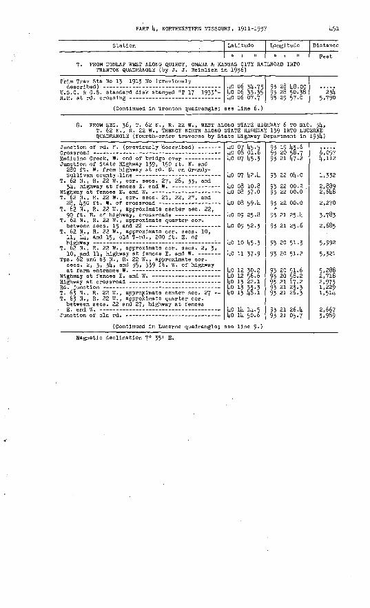
8. FROM SEC. 36, T. 62 H., R. 22 W. , WEST ALONG STATE HIGHWAY 6 TO SEC. jk, T. 62 H., R. 22 W., THENCE NORTH ALONG STATE HIGHWAY 139 INTO LUCERNE QUADRANGLE (fourth-order traverse by State Highway Department in 1931).)
Junction of rd. K. (previously 'described) - ----
Junction of State Highway 139, 150 ft. N. and 280 ft. W. from highway at rd. N. on Grundy-
T. 62 N., R. 22 W. , cor. sees. 27, 28, 33, and
T. 62 N., R. 22 W. , cor. sees, 21, 22, 27, and
T. 62 N., R. 22 W., approximate center sec. 22,
T. 62 N., R. 22 W. , approximate quarter cor.
T. 62 N., R. 22 W., approximate cor. sees. 10, 11, Ik, and 15, old T-rd., 200 ft. E. of
T. 62 N., R. 22 W., approximate cor. sees. 2, 3,
Tps. 62 and 63 N. , R. 22 W., approximate cor. sees. 2, 3, J>k, and 35, 339 ft. W. of highway
T. 63 N. , R. 22 W., approximate center sec. 27 T. 63 N., R. 22 W., approximate quarter cor. between sees. 22 and 27, highway at fences
(Continued in Lucerne quadrangle;
kO 07 14.5.5 lj.0 08 01.6 ko 07 14.5.3
kO 07 k2.k
kO 08 10.8 ko 08 37-0
kO 08 594
ko 09 25.8
kO 09 52.3
ko 10 14.5.3
kO 11 37-9
kO 12 30.2 1+0 12 56.6 kO 13 22.1L° 1J 72' 5 kO 13 [j.8.1
ko ik Ik.*kO llj. 50.6
see line 9-)
93 19 lt-5-6 93 20 S8.7 93 21 147-2
93 22 Ok.O
93 22 00.2 93 22 00.0
93 22 00.0
93 21 25. k
93 21 25.6
93 20 51.3
93 20 51.2
95 20 51.6 93 20 58.2 93 21 17.2 93 21 23.3 93 21 26.3
93 21 26.k 93 21 05.7
6,057k,112
1,332
2,889 2,6k8
2,270
3,783
2,685
5,992
5,321
5,288 2,718 2,9751,2291,54
2,667 3,989
Magnetic declination 7° 35' E.
TRANSIT TRAVERSE IN MISSOURI
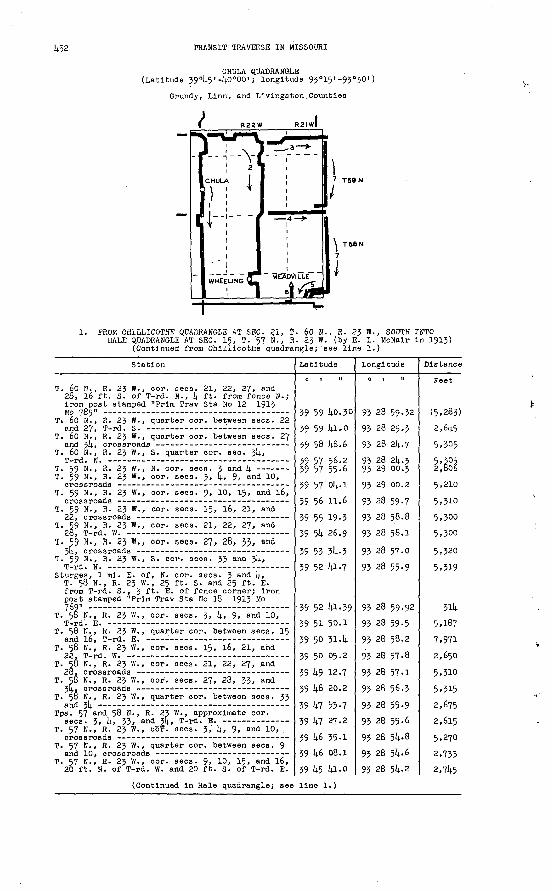
CHULA QUADRANGLE (Latitude 39°l).5'-l4.0 000 I ; longitude 93°15' -93°30')
Grundy, Linn, and Livingston .Counties
I R22W R2iwl
II _ _
MEADVILLE
7 T59N
\ T58N
7
J
1. PROM GHILLICOTHE QUADRANGLE AT SEC. 21, T. 60 N., R. 23 W., SOUTH INTOHALE QUADRANGLE AT SEC. 15, T. 57 N.', R. 23 W. (by E. L. McNalr in 1913)
(Continued from Chillicothe quadrangle;'see line 1.)
Station
T. 60 H., R. 23 W. , cor. sees. 21, 22, 27, and 28, 16 ft. S. of T-rd. N., Ij. ft. from fence H.; iron post stamped "Prim Trav Sta Ho 12 1913
T» 60 N., R. 23 W., quarter cor. between sees. 22
T. 60 N., R. 23 W. , quarter cor. between sees. 27
T. 60 H. , R. 23 W., S. quarter cor. sec. 31+,
T. 59 N., R. 23 W., cor. sees. 3, l\., 9, and 10,
T. 59 N., R. 23 W., cor. sees. 9, 10, 15, and l6,
T. 59 N., R. 23 ff., cor. sees. 15, 16, 21, and
T. 59 N., R. 23 W., cor. sees. 21, 22, 27, and
T. ^9 N., R. 23 W., cor. sees. 27, 28, 53, and
T. 59 N., R. 23 W., S. cor. sees. 33 and 3)4.,
Sturges, 1 ml. E. of, N. cor. sees. 3 and [4., T. 58 N., R. 23 W. , 25 ft. S. and 25 ft. E. from T-rd. S., J *"* E. of fence corner; iron post stamped "Prim Trav Sta Ho 18 1913 Mo 76Q" - - -
T. 50 N. , R. 23 W., cor. sees. 3, k, 9. and 10,
T. 58 N., R. 23 W. , quarter cor. between sees. 15
T. 58 N., R. 23 W., cor. sees. 15, l6, 21, and
T. 58 N., R. 23 W., cor. sees. 21, 22, 27, and
T. 5§ N., R. 23 W. , cor. sees. 27, 28, 33, and
T. 50 N. , R. 23 W. , quarter cor. between seca. 33
Tps. 57 and 58 N. , R. 23 W., approximate cor.
T. 57 N., R. 23 W., cor.' sees. 3, If., 9, and 10,
T. 57 N. , R. 23 W., quarter cor. between sees. 9
T. 57 N., R. 23 W., cor. aecs. 9, 10, 15, and 16, 20 ft. N. of T-rd. W. and 20 ft. S. of T-rd. E.
Latitude
0 | tl
39 59 Uo.30
39 59 lA-o
39 58 U8.6
39 57 56-239 57 55-6 39 57' ol;. l
39 56 11.6
39 55 19-3
39 5k 26.9
39 53 5i(..339 52 111 -7
39 52 lA-39
39 51 50.1
39 50 51.14.
39 50 05.2
39 14.9 12.7
39 14.8 20.2
39 kl 53-7
39 kl 27.2
39 14-6 35-1
39 14.6 08.1
39 45 Ui-o
Longitude
93 28 59-32
93 28 25.3
93 28 2(4.7
93 28 2(4.393 29 00.3
93 28 59-7
93 28 58.1
93 28 55-9
93 28 59.92
93 28 59-5
93 28 55-9
93 28 5M
93 28 5^-6
93 28 5l;.2
Distance
Feet
2,6(4.5
5.305
5,3052 firi2
5,210
5,310
5,300
5,300
5,320
5,319
3114.
7,971
5,310
5,315
5,270
2,733
2,745
(Continued In Hale quadrangle; see line 1.)

PART 4, NORTHWESTERN MISSOURI, 1911-1937 453
Station Latitude
o i n
2. FROM SEC. 21, T. 60 N. , R. 2J W. , EAST TO SEC. 21, T. THENCE SOUTH INTO HALE QUADRANGLE AT SEC. 16, T. 57 (by 0. B. Walsh in 1921)
Prim Trav Sta No 12 1913 Mo 785 (previously
T. 60 N., R. 23 W., quarter cor. between aeca. 22
T. 60 N., R. 23 W., cor. sees. 23, 2k, 25, and 26, 15 (? 18} ft. S. and 60 (? 75) ft. W. from T-rd. N. ; iron post stamped "Prim Trav Sta No 1
T. 60 N., R. 22 W., cor. sees. 19, 20, 29, and
T. 60 N., R. 22 W., cor. sees. 20, 21, 28, and
T. 60 N., R. 22 W., W. sixteenth cor. between
T. 60 N., R. 22 w'. , cor. sees. 27, 28, 33, and 34, 24 ft. S. and 12 ft. W. from crossroads on Grundy-Linn county line; iron post stamped
T. 60 N., R. 22 W., S. cor. sees. 53 and $4, T-rd. N., 196 ft. W. of N. cor. sees. 3 and 4,
T. 59 N.,.R. 22 W. , N. quarter cor. sec. 4,T rd. S _ -
T. 59 N., R. 22 W., quarter cor. between sees, k
T. 59 N., R. 22 W. , cor. sees. 3, 4, 9, and 10, 10 ft. S. and 15 ft. W. from T-rd. S. on Linn-Livings ton county line; iron post stamped
T. 59 N., R. 22 W., cor. sees. 9, 10, 15, and 16,
T. 59 N., R. 22 W., cor. sees. 15, 16, 21, and
T. 59 N., R. 22 W., cor. sees. 21, 22, 27, and 20, 'at Everaonville, 50 ft. S. and 2k ft. E. from crossroads on Linn-Livings ton county line; iron post stamped "Prim Trav Sta No k W 1921
T. 59 N., R. 22 W. , eor. sees. 27, 28, 33, and
T. 59 N., R. 22 W., S. cor. sees. 33 and $4,
T. 58 N. , R. 22 W. , cor. sees. 3, k, 9, and 10, 18 ft. S. and 20 ft. W. from crossroads on Linn-Livings ton county line; iron post stamped
T. 58 N., R. 22 W., cor. sees. 9, 10, 15, and
T. 58 N., R. 22 W., quarter cor. between sees. 15
T. 58 N., R. 22 W., cor. sees. 15, 16, 21, and
T. 58 N. , R. 22 W., cor. sees. 21, 22, 27, and 20, 90 ft. S. and 20 ft. W. from crossroads on Linn-Livingston county line, inside fence; iron post stamped "Prim Trav Sta No 6 W 1921 Mo" :
T. 58 N. , R. 22 W., quarter eor. between sees. 27
T. 58 N., R. 22 W., eor. sees. 27, 28, .33, and 3k, T-rd. E. -
Tps. 57 and 58 N.,.. R. 22 W. , approximate eor.
Tps. 57 and 58 N. , R. 22 W. , approximate cor.
Wheeling, 60 ft. W. of SE. corner of park, 6 ft. SW. of town pump and fire-alarm tower; iron post stamped "Prim Trav Sta No 7 W 1920 ' 749" -
Chicago, Burlington & Quincy R.R. at rd. crossing on line between sees, k and 5, T. 57 N., R P2 W
T. 57 N., R. 22 W. , cor. sees, k, '5, 8, and 9,
T. 57 N. , R. 22 W. , cor. sees. 3, I;, 9, and 10,
T. 57 N., R. 22 W., cor. see's. 9, 10, 15, and l6,
(Continued in Hale quadrangle; see
39 59 40.30
39 59 14.1.1 39 59 394
39 59 42.42 39 59 16.5 39 59 06.9 39 59 45-6
39 59 45-7 39 59 47-2
39 58 514-9
39 58 55-63
39 58 03. k
39 58 02.8
39 57 09.6
39 57 10.05
39 56 18.0
39 55 25-7
39 54 32.81;
39 53 40.539 52 48.6 39 52 48.6
39 51 53-62
39 51 oi-5
.39 50 35-2
39 50 08.9
39 14.9 15-614.
39 14.8 50.1).
39 48 24-1
39 47 31.8
39. 47 31.4
39 47 13-79
39 1*7 07.9
39 14.6 37.lv
39 l)-6 37-6
39 14-5 14.3.1
line 2.)
Longi'tude
60 N., R,- 22 N., R. 22 W.
93 28 59-32
93 28 2S.k 93 27 3ft.. 6
93 26 43.53 93 26 26.5 93 25 184 93 4 42.793 23 58.2
93 22 49.8
93 22 32.8
93 21*41-87
93 21 42.2
93 22 13.9
93 22 13.9
93 21 4°. 12
93 21 39-9
93 21 4o.O
93 21 39-79
93 21 40.2
93 21 40.3 93 21 47-1
93 21 47-86
93 21 48.0
93 21 48.2
93 21 48.4
93 21 49.17
93 21 48-9
93. 21 49.0
93 21 49-5
93 22 59-5
93 23 09.76
93 22 59.3
93 22 58.9
93 21 49-9
93 21 50.6
Distance
Feet W.,
2,640 3,970
3,966 2,943 5,3§2 4,807
3,470
5,330
5,451
3,968
5,288
2,470
5,379
2,637
5,268
5,293
5,343
5,298
5,249 530
5,56l
5,274
2,659
2,660
5,389
2,558
2,660
5,290
5,46o
1,957
1,015
3,080
5,389
5,516

1+51+ TRANSIT TRAVERSE IN MISSOURI
Station Latitude
0 , .1
Longitude
0 ,
Distanc
Feet
3. PROM SEC. 27, T. 60 N., R. 22 W., EAST TO SEC. 33, T. 60 N., R. 21 W.,INCLUDING THAT PART OP THE LINE IN LINNEUS QUADRANGLE (by J. L. Sanders in 1921)**
Prim Trav Sta No 2 W 1921 Mo (previously
T. 60 II., R. 22 W., cor. sees. 26, 27, 3!)., and
T. 60 N., R. 22 W., cor. sees. 25, 26, 35, and
T. 60 N., Rs. 21 and 22 W. , cor. sees. 25, 30, 31, and 36, 20 ft. S. and 50 ft. E. from T-rd. S-; iron post stamped "Prim Trav Sta No 5° S
Shafter, T-rd. N. , cor. sees. 29, 30, 31, and
T. 60 N., R. 21 W., cor. sees. 28, 29, 32, and
T. 60 N., R. 21 W., cor. sees. 27, 28, 33, and 314., 30 ft. S. and 35 ft. E. from crossroads; iron post stamped "Prim Trav Sta No 51 S 1921
39 58 55-63
39 58 56.8
39 58 58.5 39 58 59-8
39 59 00.32
39 59 Ol.l
39 59 01.6
39 59 02.13
93 21 kl.37
93 20 33.9
93 19 25.6 93 18 34-5
93 18 17.38
93 17 08.5
93 16 29.2
93 11+ 51.- 93
5,298
5,327 3,980
1,338
5,370
3,058
7,576
PROM SEC. 3!)., T. 59 N., R. 22 W., EAST INTO LINNEUS QUADRANGLE AT SEC. 33, T. 59 N., R. 21 W., INCLUDING THAT PART OP THE LINE IN LINNEUS QUADRANGLE (by J. L. Sanders in 1921)**.
Prim Trav Sta No 5 W 1921 Mo (previously
Tps. 58 and 59 N. , R. 22 W., approximate cor.
Tps. 58 and 59 N. , R. 22 W. , approximate eor.
Tps. 58 and 59 N., Rs. 21 and 22 W. , cor. of, 30 ft. S. and 30 ft. E. from crossroads; iron post stamped "Prim Trav Sta No lj.8 S 1921 Mo"*
Tps. 58 and 59 N., R. 21 W., approximate cor.
Tps. 58 and 59 N., R. 21 W. , approximate cor.
Tps. 58 and 59 N., R. 21 W. , cor. sees. 3, k> 33, and 3!)., 15 ft. S. of stone.; iron post stamped
39 51 53-62 39 52 L8.5 39 52 1+8.9 39 52 ltf-8
39 52 50-2
39 52 51-8 39 52 52.0
39 52 52-99
39 52 52.9
39 52 52-6
39 52 53 40
93 21 1+7.86 93 21 U6.9 93 21 £o.l 93 20 k9-k
93 20 37.2
93 19 26.7 93 19 2l±. 8
93 18 16.71
93 17 07.7
93 15 59-5
93 14 50.87
5,539 54o
3,966
960.
5,512 160
5,322
5,390
5,331
5,362
PROM SEC. 15, T. 57 N., R. 21 W., WEST AND SOUTH INTO HALE QUADRANGLE AT SEC. 16, T. 57 N., R. 21 W. (by C. R. Fisher in 192lj.)
T. 57 N., R. 21 W., cor. sees. 10, 11. 14, and
T. 57 N. , R. 21 W. , cor. sees. 8, 9, 16, and 17,
Prim Trav Sta No 19 W 1921 Mo (In Hale
39 j+5 45-139 45 lj5-3
39 1+5 1+5 -7
39 Itli 52.91+
93 13 52.0 93 i4 59-393 16 08.5
93 16 08.76
5! ',26k
5,390
5,336
6. PROM SEC. 7, T. 57 N., R. 21 W., SOUTH INTO HALE QUADRANGLE AT SEC. 17, T. 57 N., R. 21 W. (by B. D. Harsha in 1931).)
Meadville triangulation sta.; U.S.C. & G.S.standard disk stamped "Meadville" ------ -----
T. 57 N., R. 21 W., cor. sees. 7, 8, 17, and 18,crossroads - -- ---- ____ _
Center of base of airway beacon tower 8 --
39 U6 38.87
39 45 1+6.1 39 1+5 39.8
(Continued in Hale quadrangle; see line 11.)
93 17 21.69
93 17 13-5 93 17 12.7
5,3.83,
7. PROM SEC.'33, T. 60 N., R. 21 W., SOUTH INTO HALE QUADRANGLE AT SEC. 16, T. 57 N., R. 21 W., INCLUDING THAT PART OF THE LINE IN LINNEUS QUADRANGLE (by C. W. Williams in 1936)
Prim Trav Sta No 51 S .1921 Mo (previously
T. 59 N., R. 21 W., cor. sees. 3, 4, 9, and 10,
392Q
39 39
55
55
<
JU7
1650
o5
1+0 .
9393
9393
^ 11+
4 14
5153
5352
yy.2
.1 9
5
5
,297
,kOO
* In 1939 this post was reset 25 ft. S. and 19 ft. E. from this location. The coordi nates given refer to the new position.**Due to an excessive closure, this line ia not of third-order accuracy*

PART 4, NORTHWESTERN MISSOURI, 1911-1937 455
Station
T. 59 N. , R. 21 W., 380 ft. N. of quarter cor. between sees. 15 and l6, 25 ft. E. of rd. in line with S. side of dwelling; standard tablet
T. 59 N., R. 21 W., cor. sees. 35, l6, 21, and
T. 59 N., R. 21 W. , eor. sees. 21, 22, 27, and
T. 59 N., R. 21 W., eor. sees. 27, 2.8, 53, and
T. 59 N., R. 21 W. , quarter cor. between sees. 28
T..59 N., R. 21 W., S. eor. sees. 32 and 33,
T. 59 N., R. 21 W., S. cor. sees. 31 and 32,
Prim Trav Sta No [4.8 S 1921 Mo (pi-evlously
Prim Trav Sta No 49 S 1921 Mo (previously
T. 58 N., R. 21 W. , quarter cor. between sees. 3
T. 58 N., R. 21 W., cor. sees. 3, 4, 9, and 10,
T. 58 N., R. 21 W., cor. sees. 9, 10, 15, and 16,
T. 58 N., R. 21 W., cor. sees. 15, l6, 21, and 22, 30 ft. N. and 3 ft. E. from T-rd. S., in concrete post; standard tablet stamped "T T 2
T. 58 N., R. 21 W. , cor. sees. 23, 22, 27, and
T. 58" N., R. 21 W., cor. sees. 27, 28, 33, and
T. 57 N., R. 21 W. , N. cor. sees. 3 and 4, 33 ft. S. and 48 ft. W. from T-rd. S., in concrete post; standard tablet stamped "T T 3 W 1936"
Chicago, Burlington & Quincy R.R. at rd. crossing T. 57 N., R. 21 W., cor. sees. 3, 4, 9, and 10,
T. 57 N., R. 21 W., cor. sees. 9, 10, 15, and l6,
T. 57 N., R. 21 W., cor. sees. 8, 9, 16, and 17,
Prim Trav Sta No 19 W 1921 Mo (In Hale
Latitude
0 I II
39 56 01.20
39 55 31.2
59 54 38.8
39 53 46-1
39 53 45-5 59 53 33-6
39 52 52.4
39 52 .52-8
39 52 52-99 39 52 52.4
39 52 53-40
39, 52 25.0
59 51 59-4 39 51 33-0
39 51 06.7
59 50 15-46
59 49 19-8
39 48 26.2
59 47 32.61 39 46 50.3
39 46 39.6
39 45 45-3
39 45 45-6
59 44 52.94
Longitude
95 14 52.16
93 14 52-2
93 14 51-8
9: 14 51-393 15 25.3 93 15 59-4
93 15 59-1
93 17 07.2
93 18 16.71 93 15 59-1
93 14 50.87
95 14 S2.4
95 14 53-8 93 11+ 55-3
93 14 56.7
93 14 57-44
95 14 57-8
93 14 58-4
93 14 56.52 93 14 56.7
93 14.57-0
93 14 59-3
93 16 08.1
93 16 08.76
Distance
Peet
4,936
5,301
5,330
2,646 2,914
4,3.63
5,322
5,424
5,326
2,872
2,^96 2,675
2,661
5,381
5,451
5,419
5,422 4,281,
1,072
5,502
5,378
5,326
Magnetic declination in 1921, 7° 30' E.
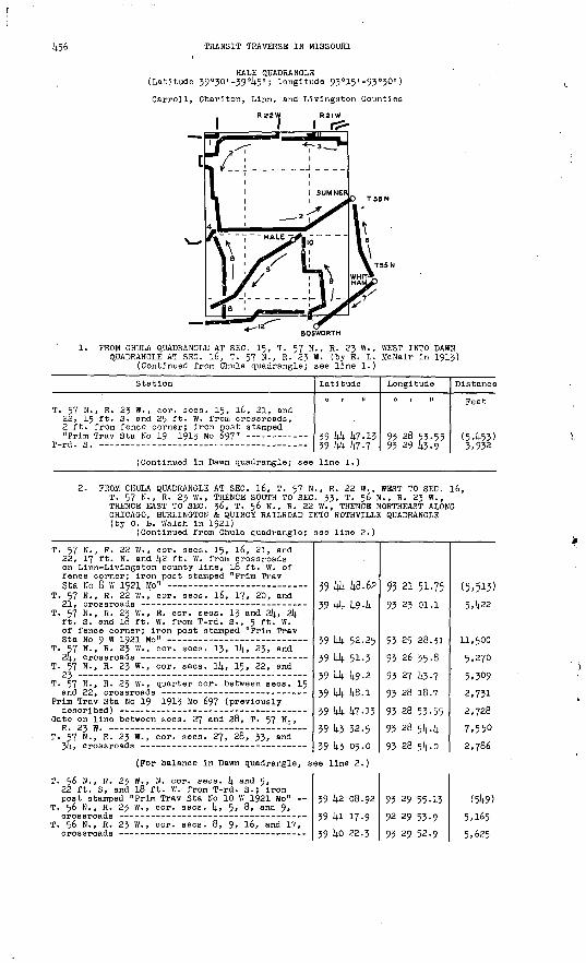
456 TRANSIT TRAVERSE IN MISSOURI
HALE QUADRANGLE (Latitude 39°50' -39°45' ; longitude 93°15'-93°30')
Carroll, Chariton, Linn, end Livingston Counties
1. PROM CHULA QUADRANGLE AT SEC. 15, T. 57 N., R. 23 W., WEST INTO DAWN QUADRANGLE AT SEC. l6, T. 57 N., R. 23 W. (by E. L. McNair in 1913)
(Continued from Chula quadrangle; see line 1.)
Station
T. 57 N., R. 23 W., cor. sees. 15, 16, 21, and 22, 15 ft. S. and 25 ft. W. from crossroads, 2 ft. from fence corner; iron post stamped
T-rA. .9. -_--- ... .
Latitude
39 104- 1;7.13*Q 1,1, 1,7 t
Longitude
0 | II
93 28 53.55Q* ?Q I,* o
Distance
Feet
(5,453)X Q*P
(Continued in Dawn quadrangle; see line 1.)
2. PROM CHULA QUADRANGLE AT SEC. 16, T. 57 N., R. 22 W., WEST TO SEC. l6, T. 57 N., R. 23 W., THENCE SOUTH TO SEC. 33, T. 56 N., R. 23 W., THENCE EAST TO SEC. 36, T. 56 N., R. 22 W., THENCE NORTHEAST ALONG CHICAGO, BURLINGTON & QUINCY RAILROAD INTO ROTHVILLE QUADRANGLE (by 0. E. Walsh in 1921)
(Continued from Chula quadrangle; see line 2.)
T. 57 N., R. 22 W., cor. sees. 15, l6, 21, and 22, 17 ft. N. and lj.2 ft. W. from crossroads on Linn-Livings ton county line, 18 ft. W. of fence corner; iron post stamped "Prim TravQfa Fn A W TG9T Mn"
T. 57 N., R. 22 W.,' cor. sees. l6, 17, 20, and
T. 57 N., R. 23 W., E. cor. sees. 13 and 24, 2k ft. S. and 18 ft. W. from T-rd. S., 5 ft. W. of fence corner; iron post stamped "Prim Trav
T. 57 N., R. 23 W. , cor. sees. 13, 14, 23, and
T. 57 N., R. 23 W., eor. sees. 14, 15, 22, and
T. 57 H., R. 23 W. , quarter eor. between sees. 15
Prim Trav Sta No 19 1913 Mo 697 (previously
Gate on line between sees. 27 and 28, T. 57 N. , R. 23 W. -
T. 57 N., R. 23 W. , cor. sees. 27, 28, 33, and
59 1*4 48.62
39 1+4 49-4
39 1*4 52.25
39 44 51-3 39 1A 49-2
39 kk 48.1
39 44 47-13
39 43 32.5*Q ),x nc n
95 21 51-75
93 23 oi.l
93 25 28.31
93 26 35.8
93 27 43-7 93 28 18.7
93 28 53-55
93 28 5lj..lj.O* Pfl cl, n
(5,513)5,422
11,500
5,270 5,3092,731
2,728
7,5503 -7fl£
(For balance in Dawn quadrangle, see line 2.)
T. 56 N., R. 23 W., N. cor. sees, 4 and 5, 22 ft. S, and 18 ft. W. from T-rd. S.; iron post stamped "Prim Trav Sta No 10 W 1921 Mo"
T. 56 N., R. 23 W., cor. sees. 4, 5, 8, and 9,
T. 56 N., R. 23 W., cor. sees. 8, 9, 16, and 17,
39 42 08.92
39 la 17-9
*a lifi P?.*
93 29 55-13
92 29 53-9
a* pa ciP.o
(549)
5,165C (.?£.

PART 14., NORTHVIESTERN MISSOURI, 1911-1937 457
Station
T. 56 N., R. 2J W., cor. sees. 16, 17, 20, and 21, 30 ft. N. and 15 ft. E. from crossroads; iron post stamped "Prim Trav Sta Ho 11 W 1921
T. 56 N., R. 23 W., cor. sees. 15, 16, 21, and
T. 56 N., R. 23 W., cor. sees. 21, 22, 27, and
T. S6 N., R. 23 W. , cor. sees. 27, 28, 33, and
T. 56 N., R. 23 W., S. cor. sees. 33 and 3!).,
T. 56 N., R. 23 W., S. cor. sees. 34 and 35,
T. 55 N., R. 23 W., N. cor. sees. .2 and 3,
T. 56 N., R. 23 W. , S. cor. sees. 35 and 36, 15 ft. N. and 36 ft. W. from T-rd. N. on Carroll-Livlngston county line; iron post
Tps. 55 and 56 N. , Rs. 22 and 23 W. , cor. of,
Tps. 55 and 56 N., R. 22 W., approximate cor.
T. 56 N., R. 22 W., S. cor. sees. 32 and 33, 20 ft. N. and 20 ft. E. from T-rd. N. on Carroll-Livingston county line; iron post
Tps. 55 and 56 N., R. 22 W., approximate cor.
T. 56 N., R. 22 W., S. cor. sees. 34 and 35,
Tps. 55 an(i 56 N. , R. 22 W. , approximate cor.
T. 56 N., R. 2.2 W. , near S. quarter cor. see. 36, 18 ft. S. and 135 ft. W. from Chicago, Burlington & Quincy R.R. at rd. crossing on Carroll-Livingston county line; Iron post
R.R. at rd. crossing on line between sees. 31 an(i
T. 56 N., R. 21 W., in E 1/2 sec. 29, on Chicago, Burlington & Quincy R.R., 12 ft. E. of track, 15 ft. N. of E.-W. rd.; iron post stamped
Sumher, crossing of Wabash Ry. (in Eothville
Latitude
0 1 II
39 39 31.21
39 39 32.3
39 38 38.5
39 37 45-0
39 36 51-6
39 36 52.3
39 36 52-3
39 36 53.13
39 36 53.6
39 36 54-0
39 36 54-77 39 36 54-8
39 36 55-2 39 36 55-2
39 36 55-6
39 36 55-52
39 37 09-9 39 37 4l-9 39 38 06.5
39 38 15-95 39 38 51-6
39 39 25.9
Longitude
93 29 51-60
93 28 44-1
93 28 43.1
93 28 42.2
93 28 41.1
93 27 34-0
93 27 32.1
93 26 27.22
93 25 19.5
93 24 12.2
93 23 05.13
93 21 58-4
93 20 51.3 93 20 48-8
93 19 44-4
93 19 15.90
93 18 35-5 93 17 26.8 93 16 51.8
93 16 37-53 93 15 38-3
93 14 45-5
Diatanoe
Feet
5.176
5.277 5.U41
5.14-22
5.14.36
5.250
150
5,o8i
5.298
5.270
5.250.
5.219
5.250 200
5.038
2,250
3.1+-83 6,272 5.701
1,466 5. §75
5.395
J. FROM ROTHVILLE QUADRANGLE AT SEC. 27, T. 57 N. , R. 21 W. , NORTH AND WEST TO SEC. 16, T. 57 N., R. 22 W. (by 0. E. Walsh in 1921)
T. 57 N. , R. 21 W. , cor. sees. 26, 27, 34, and
T. 57 N. , R. 21 W., cor. sees. 27, 28, 33, and
T. 57 N., R. 21 W., quarter cor. between sees. 27
T. 57 N. , R. 21 W. , quarter cor. between sees. 28
T. 57 N. , R. 21 W. , cor. sees. 16, 17, 20, and 21, 40 ft. N. and 15 ft. E. from crossroads; iron post stamped "Prim Trav Sta No 19 W
T. 57 N. , R. 21 W. , cor. sees. 17, 18, 19, and
T. 57 N., Rs. 21 and 22 W. , cor. sees. 13, 18, 19, and 2k, 18 ft. N. and 36 ft. W. from crossroads; iron post stamped "Prim Trav Sta
T. 57 N., R. 22 W., cor. sees. 13, 14, 23, and
T-rd. S. Prim Trav Sta No 8 W 1921 Mo (previously
39 43 06.8
39 43 06.4
39 43 32.8
39 43 32.9
39 44 52.91J.
39 44 52-9
39 44 52.95
39 {*4 51.0 39 44 49-639 44 46.62
93 13 55-14-
93 15 02.9
93 15 02.6
93 16 09.8
93 16 08.76
93 17 15^0
93 18 19.09
93 19 30.7 93 20 23.5
93 21 51.75
5.275
2,670
5.251
8,095
5.171
5,009
&
6,897
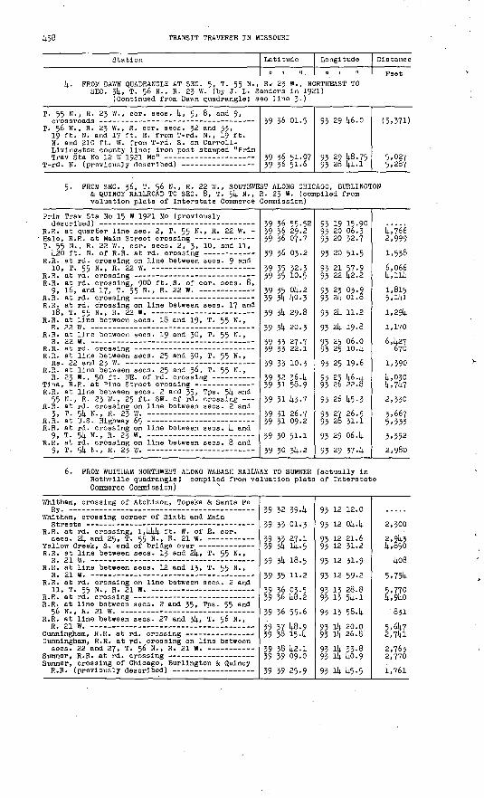
458 TRANSIT TRAVERSE IN MISSOURI
Station
Latitude
01 II
Longitude
0 1 II
Distance
Feet4. FROM DAWN QUADRANGLE AT SEC. 5, T. 55 N., R.' 23 W., NORTHEAST TO
SEC. 34, T. 56 N., R. 23 W. (by J. L- Sander's in 1921) (Continued from Dawn quadrangle; see line 3.)
T. 55 N., R. 23 W., cor. sees, 4, 5> 6, and 9,
T. 56 N., R. 23 W., S. cor. sees. 32 and 33, 19 ft. N. and 1? ft. E. from T-rd. N. , 19 ft. N. and 210 ft. W. from T-rd. S. on Carroll- Llvingston. county line; iron post stamped "Prim
39 36 01.5
39 36 51-07 39 36 51-6
93 29 46.0
93 29 48.75 93 28 14.1.1
(5.37D
5,02? 5,287
5. FROM SEC. 36, T.. 56 N., R. 22 W. , SOUTHWEST ALONG CHICAGO, BURLINGTON & QUINCY RAILROAD TO SEC. 8, T. 514. N. , R. 23 W. (compiled from valuation plats of Interstate Commerce Commission)
Prim Trav S'ta No 15 W 1921 Mo (previously
R.R. at quarter line sec. 2, T. 55 N. , R. 22 W. -
T. 55 N., R. 22 W., cor. sees. 2, 3, 10, and 11,
R.R. at rd. crossing on line between sees. 9 ant^
R.R. at rd. crossing, 9°0 ft. S. of cor. sees. 8,
R.R. at rd. crossing on line between sees. 17 and
R.R. at line between sees. 18 and 19, T. 55 N.,
R.R. at line between sees. 19 and 30, T. 55 N. ,
R.R. at line between sees. 25 and 30, T. 55 N. ,
R.R. at line between sees. 25 and 36, T. 55 N.,
R.R. at line between sees. 2 and 35, Tps. 54- an(i 55 N., R. 23 W., 25 ft. SW. of rd. crossing
R.R. at rd. crossing on line between sees. 2 and
R.R. at rd. crossing on line between sees. 4 and
R.R. at rd. crossing on line between sees. 8 and
39 36 55-52 39 36 29.2 39 36 07.7
39 36 03.2
39 35 52.3 39 35 10.5
39 35 Ol;'. 2 39 34 14-0.3
39 34 29.8
39 34 20.3
39 33 27.7 39 33 22.1
59 33 10.3
39 32 36.4 39 33 58.9
39 31 43-7
39 31 26.7 39 31 09.2
39 30 51-1
39 30 34-2
93 19 15-90 93 20 06.3 93 20.32.7
93 20 51.5
93 21 57-9 93 22 42.2
93 23 03.9 93 24 01.8
93 24 11.2
93 24 19-8
93 25 06.0 93 25 10.4
93 25 19.6
93 25 46.4 93 26 22.8
93 26 45-3
93 27 26.5 93 28 31-1
93 29 06.4
93 29 37-4
4,766 2,999
1,538
6,066 4,ii4
1,8155,i4i
1,294
1,170
6,427 670
1,390
4,030 4,747
2,330
3,667 5,333
3,352
2,980
6. FROM WHITHAM NORTHWEST ALONG WABASH RAILWAY TO SUMHER (actually in Rothville quadrangle; compiled from valuation plats of Interstate Commerce Commission) N
Whltham, crossing of Atehison, Topeka & Santa FeT3, T
Whitham, crossing corner of Sixth and Main
R.R. at rd. crossing, 1,444 ft. W. of E. cor.
R.R. at line between sees. 13 and 214., T. 55 N., Rn-t t«
R.R. at line between sees. 12 and 13, T. 55 N. ,R pl 1W
R.R. at rd. crossing on line between sees. 2 and
R.R. at line between sees. 2 and 35, Tps. 55 and
R.R. at line between sees. 27 and 314., T. 56 N.,
Cunnlngham, R.R. at rd. crossing on line between
Sumner, crossing of Chicago, Burlington & Quincy
39 32 39-4
39 33 01.3
39 33 27.1 39 34 14-5
39 3U 18.5
39 35 n.2
39 36 03.5 39 36 48.2
39 36 55-6
39 37 48.9 39 38 154
39 38 42.1 39 39 09.0
39 39 25.9
93 12 12.0
93 12 04.4
93 12 21.6 93 12 31-2
93 12 31-9
93 12 59-2
93 13 28.8 93 13 54-1
93 13 58.4
93 Ik 20.0 93 14 26.8
93 14 33-8 93 14 40.9
93 14 45-5
2,300
2,943 4,850
408
5,754
5,770 4,940'831
5,647 2,74i
2,763 2,770
1,761

PART k> NORTHWESTERN MISSOURI, 1911-193?
Station
7-
Latitude Longitude Distance
o i ii o , ii peet
FROM WHITHAM SOUTHWEST ALONG ATCHISOH, TOPEKA & SANTA PE RAILWAY TO SEC. 18, T. 5)4. N., R. 21 W., INCLUDING THAT PART OP THE LINE IN CARROLLTOH AND ROTHVILLE QUADRANGLES (compiled from valuation plats of Interstate Commerce Commission)
Whithara, crossing of Wabash Ry. (previously
R.R. at rd. crossing, 1,116 ft. N. of S. cor.
R.R. at rd. crossing, 350 ft. S. of milepost 367- Dean Lake, R.R. at rd. crossing, 800 ft. S. of
R.R. at line between sees. 16 and 17, T. 5^ N.,
R.R. at rd. crossing on line between sees. 17 and 18, T. 5!+. N., R. 21- W., 8l).0 ft. ME. of milepost5?2 .__. -__. .
39 32 394
39 31 5l4- 7 59 31 14.5-9
39 31 03.0 39 30 134
39 29 5l4.« 5
39 29 22.8
93 12 12.0
93 13 15.2 93 13 28.1
93 34 214.. 0 93 15 59-9
93 16 Ul.6
93 17 50.6
6,593 1,607
6,0l|.0 9,028
3,800
6,278
8. FROM CARROLLTON QUADRANGLE, NORTH ALONG U.S. HIGHWAY 65 TO SEC. jlj., T. 56 N., R. 23 W., THENCE WEST ALONG ROADS TO SEC. 32, T. 56 N. , R. 23 W. (by W. V. Kennedy in 193)4.)
T. 514. N., R. 23 W., cor. sees. 9, 10, 15, and
T. 5o. N., R. 23 W. , quarter cor. between sees. 9
T. 51; N., R. 23 W., eor. sees. 3, k, 9, and 10,
Crossing of Chicago, Burlington & Quincy R.R.
T. 55 N., R. 23 W., S. cor. sees. 33 and 314., 52 ft. N. and 31 ft. E. from U.S. Highway 65 at E.-W. crossroad, 23 ft. N. and 2 ft. E. from fence corner, in concrete post; standard tablet
T. 55 N., R. 23 W., quarter cor. between sees. 33
T. 55 N., R. 23 W. , eor. sees. 27, 28, 33, and
T. 55 N., R. 23 W. , quarter cor. between sees. 27
T. 55 N., R. 23 W., cor. sees. 21, 22, 27, and
T. 55 N. , R. 23 W., quarter cor. between sees. 21
T. 55 N., R. 23 W., cor. sees. 15, 16, 21, and
T. 55 N., R. 23 W., in NW lA SW lA sec. 15, 8f ft. S. and 185 ft. W. from SW. corner of farmhouse of S. W. Scott, 38 ft. E. of U.S. Highway 65, 10 ft. S. and 3 ft. W. from fence corner, in concrete post; standard tablet
T. 55 N., R.' 23 W., cor. sees. 9, 10, 15, and 16,
T. 55 N., R. 23 W., probable cor. sees. 3, [4., 9,
T. 56 N. , R. 23 W., S. cor. sees. 33 and 3!)., crossroad on Carroll-Livingston county line, 257 ft. W. of N. cor. sees. 3 and 1;, T. 55 N. ,
T. 56 N., R. 23 W. , S. quarter cor. see. 33, rd.
Prim Trav Sta No 12 W 1921 Mo (previously
39 29 58.7
39 30 21*. 6
39 30 51-0
39 31 09.2
39 31 W4.-39
39 32 09.6
39 32 35-5
59 35 01.3
39 35 27-3
39 35 55-0
39 3^4. 18.8
39 3U 58.32
59 55 10.5 59 55 55.9
39 36 014.. 7 39 36 39-8
39 36 51-5
39 36 51-5
39 36 51-07
93 28 31-1
93 28 30.9
93 28 30.5
93 28 31-1
95 26 35-55
93 28 36.0
95 28 36.3
93 28 36/6
93 28 36.8
93 28 37.0
95 28 37.2
93 28 36.80
93 28 374 93 28 37-5
93 28 37-7 93 28 £0.1
93 28 Ul.l
93 29 4.6
93 29 14.8.75
2,626 2,667l,8l|.0
5,559
2.57U
2,620
2,610
2,630
2,600
2,610
1,9763,2602,3663,111 3,565
1,187
2,619
2, 6614.
9. PROM CARROLLTON QUADRANGLE AT SEC. 13, T. 5!). N., R. 22 W. , NORTH TO SEC. 12, T. 55 N., R. 22 W. (by W. V. Kennedy in 19314.)
T. 5l(. N., R. 22 W., E. quarter cor. sec. 13, rd. at fence W., 250 ft. S. of W. quarter cor. sec. 18, T. 5!; N. , R. 21 W. (in
T. 514. N., R. 22 W., E. cor. sees. 12 and 13, 18 ft. S. and 19 ft. W. from T-rd. W. , 356 ft. S. and 19 ft. W. from T-rd. E. at W. eor. sees. 7 and l8, T. 5!; N., R. 21 W. ; iron frost stamped
39 29 354
39 30 01.12 *o zn nli .5
93 18 35-1
93 18 3546OX iR fY7 A
2,6075 onz

14.60 TRANSIT TRAVERSE IN MISSOURI
Station
T. 54 N., R. 21 W. , cor. sees. 7, 8, 1?, and
T. 5l|. N. , R. 21 W. , quarter cor. between gees. 7
T. 5!; N., R. 21 W. , cor. sees. 5, 6, 7, and 8,
T. 54 N. , R. 21 W. , quarter cor. between sees. 5
T. 55 N., R. 21 W., S. cor. sees. Jl and 32, 20 ft. S. and llj. ft. E. from T-rd. N. , 20 ft. S. and 102 ft. E. from T-rd. S. at N. cor. sees. 5 and 6, T. 54 N., R. 21 W. , in concrete post;
T. 55 N., R. 21 W. , quarter cor. between sees. Jl
T. 55 N., R. 21 W. , cor. sees. 29, 30, 31, and
T. 55 N., R. 21 W., quarter cor. between sees. 29
T. 55 N., R. 21 W., cor. sees. 19, 20, 29, and
T. 55 N., R. 21 W., in NW 1/4 NW 1/4 sec. 30, 28 ft. W. of W. corner of Hurricane Church, 34 ft. SE. of rd., In concrete post; standard
T. 55 N. , R. 22 W. , E. quarter cor. sec. 24, rd. corner from W.-N. , 270 ft. S. of rd. at fence E. at W. quarter cor. sec. 19, T. 55 N. , R 21 W
T- 55 N., R. 22 W. , E. cor. sees. 13 and 21}., T-rd. W., 180 ft. S. of T-rd. E. at W. cor.
T. 55 N., R. 22 W. , E, quarter cor. sec. 13,
T. 55 N., R. 22 W., E. cor. sees. 12 and 13, T-rd. W., 120 ft. S. of T-rd. E. at W. cor.
T. 55 N., R. 22 W. , quarter cor. between sees. 12
Reference mark 2; U.S.C. & G.S. standard disk
Hale triangulation sta.; tl.S.C. & G.S. standard
Latitude
39 30 04.0
39 30 30.2
39 30 57-1
39 31 23.1
39 31 144-72
39 32 ll.l
39 32 374
39 33 03.14.
39 33 294 39 33 30.?
39 33 30-99 39 33 28.2
39 33 54-1
39 34 19-9
39 314. 14.6.0
39 35 12.0
39 35 12.3
39 35 25.36
39 35 38.17
Longitude
o ! ri
93 17 50.0
93.17 49-6
93 17 494
93 17 50.8
93 17 50.58
93 17 49-6
93 17 48.6
93 17 474
93 17 46.2 93 18 17.3
93 18 30.55 93 18 4l 4
93 18 36.1
93 18 36.1
93 18 36.0
93 18 36.1
93 19 09-8
93 19 09.87
93 19 11.01
Distance
Feet
1,387
2*657
2,720
2,630
2,189
2,670
2,660
2,637
2,6292,447
1,035 894
2,657
2,613
2,640
2,632
2,638
1,325
1,299
10. FROM SEC. 12, T. 55 N., R. 22 W., NORTH TO SEC. 36, T. 56 N., R. 22 W. (by B. D. Harsha in 1934)
Hale triangulation sta. (previously described) T. 55 N., R. 22 W. , quarter cor. between sees. 1
Prim Trav Sta No 15 W 1921 Mo (previously
39 35 38.17
39 36 04.1;
39 36 55-52
93 19 11.01
93 19 10.0
93 19 15-90
2,653
5,195
11. FROM CHULA QUADRANGLE AT SEC. 17, T. 57 N., R. 21 W., SOUTH AND WEST TO SEC. 24, T. 57 N., R. 22 W. (by B. D. Harsha in 1934)
(Continued from Chula quadrangle; see line 6.)
T. 57 N., R.
Prim Trav Sta
21 W.,
No 20
cor. sees.
W 1921 Mo
17, 18, 19, and
(previously39
39
4444
CO Q
52.9593
93
17T D
1419
-9
09
(4,756)
12. FROM SEC. 13, T. 54 N., R. 22 W., WEST INTO NORBORHE QUADRANGLE AT SEC; 17, T. 54 N., R. 23 W., INCLUDING THAT PART OF THE LINE IN CARROLLTON QUADRANGLE (by C. D. Craig in 1936)
Prim Trav Sta No 58 S 1921 (previously described) T. 54 N., R. 22 W., cor. sees. 11, 12, 13, and
T. 54 N., R. 22 W., cor. sees. 10, 11, 14, and
T. 54 N. , R. 22 W., cor. sees. 9, 10, 15, and 16, 21 ft. N. and 18 ft. E. from stone at cross roads; iron post stamped "Prim Trav Sta No 57S I Q3T Mr»"
T. 54 N. , R. 22 W., cor. sees. 8, 9, 16, and 17,
39 30 01.12
39 30 01.2 39 30 00.8
39 30 00.9
39 30 03-44
39 30 03-6 39 30 034
93 18 35.46
93 19 4l-9 93 20 19.1
93 20 47-6
93 21 53.27
93 23 01.6 93 23 35-4
5,209 2,913
2,240
5,151
5,353 2,652

PART !(., NORTHWESTERN MISSOURI, 1911-193?
S-tation
T. 514. N., R. 22 W. , near center sec. 8, in concrete well platform in yard of Linden School; standard tablet stamped "T T 5! C 1936"
T. 5k N., R. 22 W. , cor. sees. 7, 8, 1?, and 18,
T. <yk N., R. 22 W., W. cor. sees. 7 and 18, T-rd. E. , 210 ft. N. of T-rd. W. at E. cor.
T. <jl). N., R. 2J W.., cor. sees. 11, 12, 13, and 14, 15 ft. S. and 30 ft. E. from crossroads; iron post stamped "Prim Trav Sta No 56 S 1921
T. 5)4. N., R. 23 W. , cor. sees. 10, 11, 34, and
T. 51; N., R. 23 W., cor. sees. 8, 9, 16, and 17, 19 ft. N. and 25 ft. E. from crossroads, k ft. S. and 5 ft« E. from fence corner; iron post
T. 514. N., R. 23 W., cor. sees. l6, 17, 20, and
(Continued in Dawn quadrangle; see
Latitude
Of I'
39 30 2943 39 30 32.5
39 30 03.1
39 30 02.7 39 30 00.2
39 29 59.58
39 29 52-2 39 29 58-7
39 29 59-11
39 29 06.6
line 6.)
Longitude
0 | II
93 23 3U-3l|- 93 24 09.2
93 2k 09.1
93 25 15.5 93 25 [4.6.6
93 26 20.20
93 27 26.5 93 28 31.1
93 29 37-39
93 29 38.2
Distance
Feet
2,637 2,752
2,97U
5,207 2450
2,6365,195 5,069
5>193
5,308
Magnetic declination 7° 36' E.DAWN QUADRANGLE
(Latitude 39 030'-39 0l4.5' ; longitude 93°30' -93°l4.5' )
Carroll and Livingston Counties
1. PROM HALE QUADRANGLE AT SEC. l6, T. 57 N., R. 23 W., WEST INTO BRAYMER QUADRANGLE AT SEC. 19, T. 57 N., R. 25 W. (by E. L. McNair In 1913)
(Continued from Hale quadrangle; aee line 1.)
Station
T. 57 N. , R. 23 "., quarter cor. between sees.
T. 57 N., R. 23 W. , cor. sees. 17, 18, 19, and
T-rd. E. - - Brand River, center of middle span of bridge over T. 57 N., R. 214. W., cor. sees. 23, 21)., 25, and
26, T-rd. E.
Chicago, Milwaukee, St. Paul and Pacific R.R. at
Chicago, Milwaukee, St. Paul and Pacific R.R.
T. 57 N., R. 21). W. , quarter eor. between sees. 21
T. 57 N., R. 214. W. , quarter cor. between sees. 20
T. 57 N., R. 24 W., center see. 20, crossroads
Latitude
0 | II
39 104. W.3
39 {4 {4-9 39 Mi. M+-7 39 144 29.2
39 10 50-5 39 U3 58.8
39 14 50.8
39 li-3 53-8
39 Ml- 13.8
39 kk 13-3 39 14 12-8
Longitude
0 t II
93 30 35-5
93 31 10.1 93 31 57.2 93 32 03.14.
93 33 19-3 93 33 1.94
93 33 20.8
93 314. 14-5-9
93 35 14.0.3
93 36 U7-5 93 37 21.6
Distance
Feet
4,033)
2,701). 3,680 1.6M*
7,103814.0
5,269 8,803 lj.,7105,250 2,666
215H9O (0 3
StaUm
QptimEy B-B. ate-, 1m HE l/t sec- 19, IT. 57 ST., B- 24 W. , 115 fftt. W. &7 0" 56" IS- naff id. erawa- Imig, llj!D) fflt. X. off id., 2 fftfc- S. off ffenmco
T. 57 DI-, B- 25 W., E. cor. sees. 13 Bund 24, 213 fftt. S- off TO. cor. sees. IS amd 19,
?. 57 M., B. 25 V., conr. sees. 1%, 15, 22, and 2^ IF id W T- . - ^
IT. 57 DI., B. 25 If., qramrter cor. teatwaem sees. 15
T. 57 DI., B- 25 W., cor. cecs. 16, 17, 20, and
T. .57 ST., B. 25 W., cor. sees. 17, lE, 19, amd 20, 25 fft. S. and 20 fflt. W. ffromi crossroads,
"Prfim Traw Sta fflo 21 1§15 IBnm*t
IrtLtade
59 * 21-1
39 «k 56-2 39 %%. 20.5
39 4% 32.539 I* 33.0 39 14 55-2
39 |4 35.5
59 |4 35.51
see lime 1.)
ItasdLtato
n n
93 3® «%.%
93 5® 52.1k 95 59 58-6
93 41 05.6
95 41 59-6 93 42 50-5
93 45 20.1
93 % 28.01
matee
IPteett;
3,%5
5,gffik5,4m.
5,575
2,655 5.9753,880
5,2*
2. ft*5iSiIMMl KffAOE QpSUffll&BKGSLffil AT? SEBC. 28, I3P. 57 ®- , ®- 23 W. , StOHU/JHiS HB73PO M&KJE qpafflgABMB &T SBC. 52, T. 57 ST., B. 23 W. (toy O. B. ffialste la 1921}
(CoanitljnntDed ffirosni Hale qfinasdramgle; see TUtim** 2. 5
T. 57 M., B- 23 W., cor. sees. 28, 29, 52, and
T. 57 DI., E. 23 W., S. cor. sees. 52 and 55,
({ComltJjnnined &ni Male mnffiBdramigle; see1 59 45 03-5 95 50 03.1 (5,594)
59 42 09.2 | 93 50 02.1 | 5,5t%
line 2.)
5- FffiOffl SHE. 19, T. 57 Dl., E. 25 B., SOUHH TO SEC. 31, T. 56 W., H. 25 B. , 'ItMiHBdS BflSTF JLJBWO MmTJI JJjfMiDSS&ffiEILiB AT SK. 5. ^* 55 "" » S- 25 B. (toy O. E. Walsto amfl J. t. Senders 1m 1921)
Prim Traw Sta Ho 21 1915 I*0 ( prau lomsly-
T. 57 H-, H- 25 B-, cor. sees. 19, 2O, 29, and
T. 57 W., B. 25 W-, cor. sees. 29, 50, 31, and
T. 56 H. , B. 25 W., B. cor. sees. 5 and 6, 2O (? 30) ft. S. and 25 ft. (? 30) ft. W. from T-rd. S. ; Iron post sttajajned "Prim TFrev Sta Bo
T. 56 B., B. 25 W-, cor. sees. 5, 6, 7, amd 8,
f. 56 H., B. 25 B., cor. sees. 7, 8, 17, and 16,
T. 56 H., B. 25 W., cor. sees. 17, 18, 19, and 20, 18 ft. S. and 12 ft. W. from T-wfl. S.; Iron post stanaped "Prim Trav Sta So 25 B 1921Mt
T. 56 B., R. 25 B., cor. sees. 19, 20, 29, amd
Steal Creek, B. atontsent of Chicago, Milwaukee,
T. 56 B., R. 25 W. , quarter cor. between sees. 31 and 32, 24 ft. S. and 6 ft. B. from crossroads,In B. wing wall of concrete culvert; standard tablet stamped "Prim Trav Sta So 24 B 1921 Bto"-
T. 5^ H-» R- 25 B. , quarter cor. between sees. 32
T. 56 B., R. 25 B. , quarter cor. between sees. 35
T. 56 H., R. 25 B., E. sixteenth cor. sec. 34,
T. 56 B., R. 25 B. , quarter cor. between sees. 26 and 35, 24 ft. S. and 15 ft. E. from rd. corner from S.-B. ; Iron post stamped "Prim Trav Sta
T. S6 R., R. 25 B., cor. sees. 25, 26, 35, and
T. 56 H., R. 25 B., E. cor. sees. 25 and 36,
T. 56 H., R. 24 B., quarter cor. between sees. 30
T. 56 B., R. 24 W. , cor. sees. 28, 29, 32, and 33, 21 ft. S. and 18 ft. E. (10 ft. SB. by
O levelnan) from T-rd. S., In concrete ledge: standard tablet stamped "Prim Trav Sta No 22S -| Qyt Urtn
T. 55 H., R. 24 B., H. cor. sees. 2 and 3,
* In 1939 this post was reset 53 ft. S. and 40 ft. nates given refer to the new position.
59 44 55-51
39 45 40.5
39 42 47-1
59 4i 54-01
39 41 02.9
39 40 10.6
59 59 iB-55
59 58 26.0
39 38 28.6
39 37 06.76
59 37 07.2
39 37 07.0
39 57 07-0
59 57 55-54
39 57 54-7
59 57 55-5
59 57 57-2
59 57 59-04
39 56 48-0
E. from this
93 44 28.01
95 44 28.6
95 44 28.1
95 44 25.45
93 44 22.1
93 44 22.3
93 44 22.76
93 44 22.2
95 43 40.7
93 44 22.44
93 45 15-1
95 42 07.7
95 4i 17-2
95 40 28.00
95 59 55-0
95 58 47-5
95 58 14-9
95 56 35-75
93 54 17-2
location. The
5,556
5,588
5.575
5.177
5.290
5,290
5.500
5.257
8,905
5.269
5.279
5.950
4.696
2.585
5.283
2.554
7,924 11,865
coordl-

PART 14-, NORTHWESTERN MISSOURI, 1911-1937
Station
Blue Hound, E. sixteenth cor. between sees. 26 and 35, T. 56 N., R. 2k «?-, 25 ft. N. and 60 ft. E. from crossroad, In SST. corner of concrete porch; standard tablet stamped "Prim
T. 5^ H-» R8 - 23 and 2k W-, approximate cor.
T. 56 N., Ra. 23 and 2k W. , S. cor. sees. 31 and
T. 55 H., R. 2J W. , cor. sees. 5, 6, 7, and 8
Latitude
39 37 kl-51
39 37 k2-3
39 36 U9.8 39 36 50.3 39 36 00.°
Longitude
93 33 29.23
93 32 Ok. 5
93 32 03.2 93 30 564 93 30 5k- 5
Distance
Feet
6,589
6,627
5.310 5,2265,ook
(Continued In Hale quadrangle; see line
k- PROM NORBORNE QUADRANGLE AT SEC. 7, T. 5!; N. , R. 25 W. , NORTH TO SEC. 31, T. 56 N., R. 25 W. (by J. L. Sanders In 1921)
T. 5k N. , R. 25 W., cor. sees. 7, 8, 17, and IS, IS (? 15) ft. S. and 18 (? 30) ft. W. from crossroads; Iron post stamped "Prim Trav Sta
T. 5k N., R. 25 W., cor. sees. 5, 6, 7, and 8,
Tps. 5k and 55 N., R. 25 W., approximate cor.
Tpa. 5k and 55 N., R. 25 W., approximate quarter
T. 55 N. , R. 25 W. , quarter cor. between sees. 29 and 30, 30 ft. S. and .20 ft. W. from T-rd. S., In concrete post; standard tablet stamped
T. 55 N., R. 25 W. , cor. sees. 19, 20, 29, and
T. 55 N., R. 25 W., quarter cor. between sees. 20
T. 55 N., R. 25 W., cor. sees. 20, 21, 28, and
T. 55 N., R. 25 W., cor. sees. D.6, 17, 20, and
T. 55 N., R. 25 W., cor. sees. 8, 9, l6, and 17, kO ft. N. and 30 ft. E. from crossroads, In concrete post; standard tablet stamped "Prim
T. 55 N. , R. 25 W. , cor. sees. 5, 6, 7, and 8
Prim Trav Sta Ho 2k W 1921 Mo (previously
39 29 U3.76
39 30 36.2
39 31 28.7
39 31 28.8 39 32 U6.6
39 32 U6.26
39 33 12-5
39 33 12.6
39 33 12.8
39 3k ok. 8
39 3k. 57,32 39 35 3k- 9 39 35 k8-6
39 36 Ik- 8
39 37 06.76
93 kk 21.89
93 kk 21.9
93 kk 22.k
93 kk 57-1 93 kk 57-9
93 kk 23.85
93 kk 23.6
93 k3 k9-7
93 k3 Ik- 8
93 k3 15-1
93 k3 15-06 93 k3 15-2 93 kk 23. k
93 kk 23.1
93 kk 22. kk
5.3055,320
2,711 7,870
2,665
2,661
2,65k
2,739
5,269
5,310 3,800 5,511
2,655
5.257
5. FROM NORBORNE QUADRANGLE AT SEC. 8, T. 5k N., R. 2k W. , NORTH TO SEC. 32, T. 56 H., R. 2k W. (by W. V. Kennedy In 193!).)
T. 5k N., R. 2k W. , cor. sees. 8, 9, l6, and 17, rd. at fences U. and S. (In Norborne quad-
T. 5k N., R. 2k W., W. sixteenth cor. sec. 9, stone at center of rd. at fences E. and W.
T. 5^ N-, R. 2k W. , quarter cor. between sees, k
T. 5k N., R. 2k W-, center sec. k, T-rd. W. T. 5U N-» R. 2k W. , N. quarter cor. sec. k. rd-
corner from S.-E., 50 ft. W. of rd. corner from N.-E. at S. quarter cor. sec. 33,
T. 55 N., R. 2k W., center sec. 33, rd. at fences
T. 55 N., R. 2k W-. N. sixteenth cor.. sec. 33, 6 ft. N. and 20 ft. W. from T-rd. E., 2 ft. from fence, In concrete post; standard tablet
T. 55 N., R. 21). W., cor. sees. 27, 28, 33, and 3k, rd. at fence W. , 270 ft. S. of T-rd. E.
T. 55 N., R. 2k W. , quarter cor. between sees. 27
T. 55 N., R. 21). W., cor. sees. 21, 22, 27, and
T. 55 N'» R. 2k W. , quarter cor. between sees. 21
T. 55 N., R. 2k W., cor. sees. 15, 16, 21, and 22, 21 ft. S. and 23 ft. E. from crossroads, 5 ft. S. and 2 ft. E. from triple elm tree In fence corner, In concrete post; standard tablet
T. 55 H-» R- 2k W. , quarter cor. between sees. 15
39 29 k8-2
39 30 ik- 9
39 30 ki-6 39 31 07. k
39 31 33-9
39 32 00.3
39 32 13-15
39 32 27.6
39 32 53-6
39 33 19-7
39 35 k6.l
39 3k 11-52
XO xli X"7.fl
93 36 2k-k
93 36 08.1
93 35 52.2 93 35 52-5
93 35 52-9
93 35 52.7
93 35 52.99
93 35 19 -k
93 35 19.6
93 35 19-9
93 35 20.k
93 35 20.kk
OX 1C ?~\ 1
2,986
2,9712,610
2,687 2,667
i,30k
3,011
2,635
2,6kO
2,670
2,57k 3 d(.n

464 TRANSIT TRAVERSE IN MISSOURI
Station
T. 55 N., R. 24 W. , N. sixteenth cor. seo. 15.
T. 55 N., R. 24 W., quarter cor. between sees. 10
T. 55 N., R. 2l<. W., center sec. 10, rd. at
T. 55 N., R. 24 W. , quarter cor. between sees. 3
T. 55 N., R. 24 W., center sec. 3, 8 ft. S. and 19 ft. W. from T-rd. E. , 0-5 ml. S. of Carr.oll-Livingston county line, 2 ft. S. and 2 ft. W. Trom fence corner, in concrete post;
Rd. at fences N. and S. on line between sees. 3
Rd. at fence N. on Carroll-Livlngston county line T-rd. N., 50 ft. N. of S. cor. sees. 32 and 33,
T. 56 N., R. 2k W. T. 5^ N., R. 214. W., quarter cor. between sees. 32
Prim Trav Sta Ho 22 W 1921 Mo (previously
Latitude
0 1 II
39 34 50.6
39 34 52-5 39 35 05.6
39 35 31-6
39 35 57-7
39 36 23.63
39 36 5k. l 39 36 46.1
39 36 46.0
39 37 12-4
39 37 39-04
Longitude
0 | II
93 35 21.4
93 34 47-8
93 34 47-9
93 34 48-4
93 34 49-2
93 34 50.62
93 35 23-4 93 36 07-5
93 36 32,3
93 36 33.1
93 36 35-75
Distance
Feet 1,300
2,640
1,320
2,640
2,640
2,624
2,780 5,679
1,920
2,670
2,695
6. PROM CARROLLTON QUADRANGLE AT SEC. 17, T. 54 N. , R. 23 W. , WEST TO SEC. 8, T. 54 N., R. 25 W. , INCLUDING THAT PART' OP THE LINE IN NORBORNE QUADRANGLE (by C. D. Craig in 1936)
(Continued from Hale quadrangle; see' line 12.)
Chicago, Burlington & Quincy R.R. at rd. crossing T. 5!+. N., R. 23 W., cor. sees. 17, 18, 19, and
or\ fp v«rl 1?
T. 5)4. N., R. 23 W., 0.2 ml. E. of W. cor. sees. 18 and 19, 12 ft. S. and 20 ft. E. .from cross roads, 2 ft. S. and 3 ft. E. from fence corner, In concrete post; standard tablet stamped "T T
T. 54 N., R. 21; W. , S. sixteenth cor. between sees. 11 and 12, 15 ft. S. and 230 (? 192) ft. E. from T-rd. N. , 15 ft. 8. and 15 ft. E. from rd. corner; iron post stamped "Prim Trav Sta
T. 54 N. , R. 21). W. , quarter cor. between sees. ll|
T. 514. N., R. 21). W., center sec. 15, T-rd. N. - Mandeville, 1-5 mi- E. and 0.5 ml. S. from,
center sec. l6, T. 514. N., R. 21; W. , 18 ft. S. and 21 ft. W. from T-rd. E. , 2 ft. S. and 2 ft. W. from fence corner, in concrete post;
Rd. fork S.. Mandeville, in NW lA see. 17, T. 54 N.,
R. 21). W. , in SW. corner of concrete porch of Christian Church; standard tablet stamped
T. 5l<. N., R. 2^ W., cor. sees. 7, 8, 17, and 18,
T T»H Q _ «
T. 54 N., Rs. 24 and 25 VI., approximate cor. sees. 7, 12, 13, and 18, rd. corner from E.-N.-
T. 54 N., R. 25 W. , cor. sees. 11, 12, 13, and
T. 54 N., R. 25 W., cor. sees. 10, 11, 14, and 15, 15 ft- N. and [4.0 ft. W. from crossroads; iron post stamped "Prim Trav Sta No 52 S 1921
T. 54 N., R. 25 W., cor. sees. 9, 10, 15, and 16,
T. 54 N., R. 25 W. , eor. sees. 8, 9, l6, and 17,
Prim Trav Sta No 43 S 1921 Mo (previously
39 29 06.6
39 29 06.6
39 29 05.92 39 29 47-3 39 29 k4-3 39 29 43-4
39 30 09.11 39 30 07-5
39 29 28.6 39 29 27-2
39 29 23.63 39 29 49-2
39 29 48.04
39 29 47.2 39 29 47:8
39 29 48.8
39 29 44-7
39 29 44-26
39 29 44-3
39 29 144-2
39 29 43.76
93 30 37.0
93 30 45-2
93 31 55.63 93 31 35-6 93 32 10.8 93 32 58.4
93 32 58-94 93 34 09-6
93 34 08.8 93 34 42-4
93 35 50.78 93 35 52-7
93 37 16.28
93 37 29.9 93 38 21.8
93 38 40.6
93 39 49-3
93 40 57.89
93 42 03.8
95 43 13-1
93 1*4 21.89
(4,610)
655
3,958 4,185 2,780 3,729
2,602 5.5393,940 2,643
5,369 2,591
6,557
1,071 4,065
1,485
5,397
5.377 5,165
5,432
5,395Magnetic declination 7° 4l'
PART k, NORTHWESTERN MISSOURI, 1911-193? k65
CHILLICOTHE QUADRANGLE (Latitude 59°k5' -kO°00'; longitude 95°30' -
Grundy and Llvingston Counties
CHILLICOTHE O .
1. PROM GALLATIN QUADRANGLE AT SEC. 19, T. 60 N;, R. 25 W., EAST INTO CHULA QUADRANGLE AT SEC. 21, T. 60 N., R. 2} W. (by E. L. McNalr In 191J)
(Continued from Gallatln quadrangle; see line 1.)
Station
T. 60 N. , R. 25 W. , quarter cor. between sees. 19 and 20, 10 ft, N. of T-rd. S., k ft. S. of fence, In ditch; Iron post stamped "Prim Trav
T. 60 N., R. 25 W., quarter cor. between sees. 20
Center of Chicago, Rock Island & Pacific Ry.
Chicago, Rock Island & Pacific Ry. at rd.
Hickory Creek, Chicago, Rock Island & Pacific Ry.
Chicago, Rock Island & Pacific Ry. at rd.
T. 60 N., R. 21). W. , quarter cor. between sees. 19
T. 60 N., R. 24 W., in SE lA sec. 21, 1J ft. S. and 7 ft. E. from T-rd. N. , 3 ft. N. and 10 ft. E. from gatepost, 1 ft. from fence; Iron post
T. 60 N., R. 2k W. , cor. sees. 22, 23, 26, and
T. 60 N., R. 21). W. , cor. sees. 23, 2k, 25, and i-*t
T. 60 N., R. 2l4. W., E. eor. sees. 2k and 25, T-rd. W., 90 ft. S. of W. cor. sees. 19 and
T. 60 N., R. 23 W. , cor. sees. 20, 21, 28, and
(Continued in Chula quadrangle; se
Latitude
0 | II
39 59 k5.k3
39 59 1;6.6
39 59 kl.9
59 59 514.-1
39 59 58.7
39 59 51-7
39 59 55-9 39 59 fe.o
39 59 Itf.k?
39 59 3U-2
39 59 35-9
39 59 36.8
39 59 39-U e line 1.)
Longitude
01 M
93 kk 1(.0.76
95 14.3 314--3
93 14.2 56.7
93 kl 514--5
93 ko 00.1
95 58 14.5.5
95 58 ll.k 95 36 k7.3
93 36 10.68
93 5k k5.2
95 35 37-5
93 32 29.0
93 30 07.2
Distance
Feet
(k,920)
5» 17k
2,965
5,012
8,899
5.8k7
2,688 6,593
2,890
6,7k6
5,275
5,528
ll,0kk
2. PROM DAWN QUADRANGLE AT SEC. 17, T. 57 N., R. 25 W. , NORTH- TO SEC. 19, T. 60 N., R. 25 Wv (by E. L. McNalr In 1913)
Prim Trav Sta No 21 1913 Mo (In Dawn
T. 57 N., R. 25 W. , eor. sees. 7, 8, 17, and 18 - T-rd. W., 5 ft. S. and 20 ft. E. from stone at
quarter cor. between sees. 8 and 17, T. 57 N>»
T. 57 N,, R. 25 W., quarter cor. between sees. 5
T. 57 N., R. 25 W., eor. sees. k, 5. 8, and 9,
39 kk 35-60 39 1^5 27.1
39 to 26.5
39 W 18.7
39 k6 18. k 39 k6 36.8
93 kk 28;ko 93 14 28.2
93 14.3 53.8
95 14-5 53-7
95 k3 10.9 93 U2 kB.l
5^12
2,686
5,28k
2,6kO 3,105

14.66 TRANSIT TRAVERSE IN MISSOURI
Station
f. 58 N., R. 25 W. , S. cor. sees. 33 and 3k,
Samps el, point 600 ft. E. of Wabaah Ry. sta. at, 1,510 ft. N. of T-rd. E. at quarter cor. between sees. 27 and 28, T. 58 H., R. 25 W.
T. S8 N., R. 25 W., cor. sees. 21, 22, 27, and 28, T-rd. E.
T. 58 N., R. 25 W., cor. sees. 15, 16, 21, and 22 T. 58 N. ; R. 25 W. , quarter cor. between sees. 15
T. 58 N., R. 25 W. , quarter cor. between sees. l6
T. 38 N., R. 25 W. , cor. sees. 8, 9, l6, and 17,
T. 58 N. , R. 25 W. , quarter cor. between sees. 8
T. 58 N. , R. 25 W. , cor. sees. 14., 5, 8, and 9,
Tps. 58 and 59 N., R. 25 W. , approximate cor.
Tps. 58 and 59 N., R. 25 W. , approximate cor.
T. 59 N., R. 25 W., cor. sees. 28, 29, 32, and 33 T. 59 N., R. 25 W. , quarter cor. between sees. 28
T. 59 N., R. 25 W., cor. sees. 20, 21, 28, andpQ <p yyj g
T. 59 N., R. 25 W., cor. sees. 16, 17, 20, and 21 T. 59 N., R. 25 W. , cor. sees. 8, 9, 16, and 17,
T. 59 N., R. 25 W., quarter cor. between sees. 8
T. 59 N., R. 25 W. , cor. sees, 4, 5, 8, and 9,
T. 59 N. , R. 2S W., W. sixteenth cor. between
T. 59 N., R. 25 W., W. sixteenth cor. on N. line sec. 5, T-rd. S. on Orundy-Llvlngston county
T. 60 N. , R. 25 W. , S. cor. sees. 31 and 32, T-rd. N. on .Orundy-Llvlngston county line -----
T. 60 N., R. 25 W. , quarter cor. between sees. 3!
T. 60 N. , R. 25 W. , cor. sees. 29, 30, 31, and
Chicago, Rock Island & Pacific Ry. at rd.
T. 60 N., R. 25 W., cor. sees. 19, 20, 29, and
Prim Trav Sta No 10 1913 Mo 942 (previously
Latitude
39 14.7 10.3
39 k8 48.2
39 48 59-5 39 k9 45-3 39 49 51-739 50 17-8
39 50 18.0
39 50 44-0
39 51 10.2
39 51 36.1
39 52 22.9
39 52 21. k 39 53 15-6
39 53 41.3
39 5k 07 -7 39 55 00.5
39 55 52.14.
39 56 18.7
39 56 44-9 39 56 43-6
39 57 35-2
39 57 35-0
39 58 00.8
39 58 26.9
39 58 58.6
39 59 19.1
39 59 45-43
Longitude
ot n
. 93 k2 20.8
93 42 19-3
93 42 19-3 93 k2 18.9 93 42 184
93 k2 18.8
93 k3 26.6
93 43 26.2
93 k3 26.0
93 43 25.8
93 43 25.793 kk 35.8 93 43 25.9
93 43 25.9
93 {4.3 25.9 93 43 26.2
93 43 27.0
93 43 27.6
93 43 28.1
93 Itk 18.6
93 44 19-2
93 44 40-4
93 44 40.4
93 44 40.3 93 U4 4o.6
93 kk 4o.8
93 44 4o.76
Distance
iPeet
4,000
9,910
1.1354,640
6502,640 5,290 2,6342,647 2,625 4,7305,452 7,7282,6102,670 5,3405,251
2,661
2,650
3,935
5.230
1,650
2,613
2,637
3,213
2,073
2,665
3- PROM SEO. 4, T. 58 N. , R. 25 W. , EAST INTO CHULA QUADRANGLE AT SBC. 4, T. 58 N., R. 23 W. (by E. L. McNair In 1913)
Tpsi 58 an^ 59 N. , R. 25 W. , approximate cor. sees. 4, 5, 32, and 33 (previously described) -
Tps. 58 and 59 N., R. 25 W. , 300 ft. B. of cor. sees. 4, 5, 32, and 33, 80 ft. NE. of NE. corner of Central Methodist Episcopal Chapel,' 20 ft. S. of rd. , at end of N.-S. fence} Iron post stamped "Prim Trav Sta No 21). 1913 Mo 925"
T-rd. S.
T. 58 N., R. 25 W., N. cor. sees. 2 and 3, 30 ft. W. of S. cor. sees. 314. and 35, T. 59 N. rR. 25 W.
T-rd. S., U20 ft. N. of cor. Tps. 58 and 59 N.,
T. 59 N. , R. 24 W. , S. quarter cor. sec. 32,
T. 58 N., R. 2l4. W. , N. quarter cor. sec. 14.,
T. 59 N. , R. 21; W. , S. cor. sees. 33 and 314., T-rd. N. -
T. 58 N., R. 21). W., N. cor. sees. 3 and 4, 20 ft. S. and 20 ft. E. from T-rd. S., 2 ft. from fence corner;. Iron post stamped "Prim TravSta No Pt; TO/I* Mn 7m"
39 52 22.9
39 52 22.8k 39 52 11.5 39 52 14-7
39 52 25-8 39 52 38.1 39 52 40.8
39 52 33-2
39 52 31.8 39 52 33-2
39 52 33-6
39 52 34-4
*Q SP lli-PP
93 43 25.7
93 43 21.64 93 42 34.7 93 41 44.4
93 4i 10.6 93 4o 19.1 93 39 28.3
93 38 54-2
95 57 33-4 93 36 36.1
93 36 22.4
93 35 51-8
OX T.d \lt.1\l
320 3,838 3,935
4'l98 3,969
2,773
6,300 4,4691,065
2,385
Z1O
Vi
f
V
V
-

k68 TRANSIT TRAVERSE IN MISSOURI
Station
T. 62 N. , R. 25 W. , quarter cor. between sees. 28 and 29, k§6 ft. S. of R.R. at rd. crossing -
Brlmson, R.R. at rd. crossing, 300 ft. E. of sta. R.R. at line between sees. 29 and 30, T. 62 N. ,
Latitude
ko kol,n
i n
08 2k. 808 31.6
nfl *3.i
Longitude
0 | II
93 14-5 3k. k 93 14 Ik. 9
03 IJi lii.n
Distance
Peet
6,298 3,218
? iftt;
(Continued In Oilman quadrangle; see line 2.)
2. FROM SEC. 5, T. 62 N., R. 25 W., NORTH INTO PRINCETOH QUADRANGLE AT SEC. 16, T. 63 N., R. 25 W. (by J. P. Anderson In 193k)
Tps. 62 and 63 N. , R. 25 W. , cor. sees. 5, 6, 31, and 32, 90- ft. E. of steel bridge over Cat Creek, 27 ft. N. of dwelling of 0. S. Whitt, 57 ft. W. of well, In concrete
T. 63 N., R. 25 W., cor., sees. 20, 21, 28, and 29, 30 ft. S- and 18 ft. W. from crossroads, In concrete post; standard tablet stamped "889 193k" .........................................
kO 13 37.6
ko 14 30.6kO Ik 57.0
93 kk kk.eo
95 k3 35.693 k3 35-0
93 k} 3k. 7893 ^3 33-9 93 k3 334
5.2365,335 2,650
2,710
(Continued In Prlnceton quadrangle; see line 2.)
PROM PRINCETON QUADRANGLE AT SEC. 15, T. 63 N., R. 25 W., SOUTH TO SEC, 22, T. 63 N., R. 25 W., THENCE EAST ALONG COUNTY ROUTE C TO SPICKARD, THENCE EAST ALONG ROADS INTO GALT QUADRANGLE AT SEC. 20, T. 63 N., R. 23 W..(by H. W. Gross In 1935)
(Continued from Prlnceton quadrangle; see line 3.)
T. 63 N., R. 25 W., cor. sees. 15, 16, 21, and 22, 27 ft. S. and 2k ft. W. from County Route C at crossroad, 2 ft. N. of fence, In concrete post; standard tablet stamped "llj.011935" -'--
Splckard, 3.5 ml. W. of, along County Route C, about 310 ft. W. of center sec. 2k, T. 63 N., R. 25 W. , 60 ft. N. of highway, 30 ft. S. of rd. E., about 150 ft. SW. of farmhouse owned by Wlrt Welch, In concrete post; standard
T. 63 N., R. 2k W. , S. sixteenth cor. between
Splckard, 0.6 ml. SW. of, along County Route C, about 1JO ft. N. of S. sixteenth cor. see. 21, T. 63 N., R. 2k W. , 60 ft. S. and 25 ft. W. from crossroad, In concrete post; standard
(For balance In Prlnceton quadrang
Splckard, 2 ml. E. of, In NE lA sec. 23, T. 63 N., R. 2k W., at top of hill, 20 ft. S. of rd. , In front of farmhouse of W. D. Wyatt, In concrete post; standard tablet
Spickard, 5 ml. E. of, In NE 1A NW lA sec. 20, T. 63 N., R. 23 W. , 21 ft. N. and 10 ft. E. from T-rd. S., In front of farmhouse of Gilbert Howe, In concrete post; standard
T -nA Q
(Continued in Gait quadrangle; see
ko ik 57.3kko ik 56.8ko ik 57.2 ko ik 31.2
ko ik 31.50lj.0 Ik 20.1
ko ik 20.5 ko ik 21.3
kO Ik 22. k8ko ik 38.0le, see line
kO Ik k8.08£o ik £8.5kO Ik k8.5 kO Ik k9-l
kO Ik k9.21ko ik 35.8line 6.)
93 k2 27.38 93 kl 21.2 93 ko.kS.l 93 ko 31-3
93 39 k5-08 93 38 51-7
93 38 OO.l 93 37 07.8
93 36 16.12 93 35 14.3.6
3-)
93 33 {4.6.82 93 32 kq.l 93 32 4.5 93 31 394
93 30 3,6-39 93 30 lk.9
(3,990) 5,135 2,565 2,9ki
5,583 k,295k,oo6k,05k
k,010 2,968
(3,73Dk.kl? 2,684 2,722
k,885 2,151

PART 4, NORTHWESTERN MISSOURI, 1-911-1937 469
Station
' k. PROM OILMAN QUADRANGLE AT SEC T. 62 N., R. 25 W. (by W. V
(Continued from Oilman
19, T. 62 Kennedy an
quadrangle ;
Latitude
N., R. 25 W.a C. W. Will: see line 3-
Longitude
0 1 II
NORTH TO SEC ams in 1936)
Distance
Feet
5,
T. 62 N., R. 25 W.,. cor. sees. 19, 20, 29, and
Brlmson, 1.2 ml. N. of, W. sixteenth cor. between sees. 17 and 20, T. 62 N., R. 25 W., 33 ft. N. and 20 ft. W. from crossroads, In concrete
T; 62 N., R. 25 W. , cor. sees. 5, 6, 7, and 8,
ko 08 50.5
kO 10 10.7
kO 11 27-3
93 kk 42.9
93 kk 20'. 5793 kk 27-593 kk 41-4
93 kk 14.0.893 kk 44.80
(5,215)
Jc£Q
,1632,299
k,k065,351
5- PROM POINT NEAR SPICKARD SOUTH ALONG CHICAGO, ROCK ISLAND & PACIFIC RAILWAY TO TRENTON (by J. J. Beinlich in 1936)
U.S.C. & G.S. standard disk stamped "B 82 1935"- R.R. at fence E. , 10 ft. N. of R.R. at private
U.S.C. & G.S. standard disk stamped "C 82 1935"-
U.S.C. & G.S. standard disk stamped "D 82 1935"- T. 62 N., R. 2k W., approximate quarter cor.
U.S.C. & G.S. standard disk stamped "E 82 1935"- U.S.C. & G.S. standard disk stamped "P 82 1935"-
R.R. at fences E. and W. on line between sees. 29
uis.C. & G.S. standard disk stamped "G 82 1935"- U.S.C. & G.S. standard disk stamped "Y 17 1933"- Trenton, smokestack of Chicago, Rock Island &
U.S.C. & G.S. standard disk stamped "B 18 1933"- U.S.C. & G.S. standard disk stamped "A 18 1933"- Trenton, flagpole on cupola tower of courthouse -
kO Ik 22. k.8lio i4 38.61kO 13 5S.1kO 13 3k. 56
kO 12 22,6.ko 11 31.31kO 10 38.5kO 09 %.33 ko 09 06.30
kO 07 21.3, kO Ob k2-56ko 05 55.01
ko ok 25.89 ko ok j,k. ki ko o4 25.27
93 36 16.1293 35 lt-7-64
93 35 14.8.093 35 52.13 93 36 09.993 36 12.293 36 17-12
93 36 17. 9 Q 93 36 3k. 58 93 36 43-81 93 36 53-6
93 36 56.3
93 37 ok. 27 93 37 ok. 93
93 36 42.2793 37 07.29 93 37 06.90 93 37 06.55
2,747
k,3992,105 4,8252,6655.198
5»5k55,628 3,9125,3351,350 4,0553,919 4,810
8,1752,200
864 935
6. FROM GALT QUADRANGLE WEST ALONG QUINCY, OMAHA & KANSAS CITY RAILROAD TO BRIMSON, THENCE NORTH ALONG ROADS TO SEC. 17, T. 62 N., R. 25 W. (by J. J. Beinlich in 1936)
(Continued from Gait quadrangle; see line 7.)
U.S.C. & G.S. standard disk stamped "U 17 1933"- R.R. at rd. crossing on line between sees. 7 and
U.S.C. & G.S. standard disk stamped "V 17 1935"-
U.S.C. & G.S. standard disk ste-nped "X 17 1933"-
U.S.C. & G.S. standard disk stamped "Z 17 1933"-
R.R. at fences N. and S. on line between sees. 35 and 36, T. 62 N., R. 25 W.
U.S.C. & G.S. standard disk stamped "C l6 1933"-
U.S.C. & G.S. standard disk stamped "D 18 1933"-
U.S.C. & O.S. standard disk stamped "E 18 1933"-
40 05 49.15
ko 05 25.73 4o 05 11.36 40 o4 49.0 40 04 50.3 40 05 07.53 4o 05 55.01 4o 06 07.4 4o 06 16.2 40 07 07.44 40 07 39.440 07 38.540 07 37.694o 07 44-8kO 07 50.54o 08 11.52 4o 08 11.9 4o 08 29.2 4o 08 31.72 4o 08 50.6 4o 09 42.85
93 30 49-3593 32 09-01 93 33 29.44 93 35 21.5 93 36 01.0 93 56 36.09 93 37 04-93 93 37 21.3 93 37 32.8 93 38 39-31 93 39 37-393 40 ll.l 93 4o 49-20 93 42 06.8 93 k2 26.8 93 42 57-41 93 42 43.7 93 ^3 34.4, 93 44 24-54 93 44 20.0 93 44 20.57
(4,479)
6,626 6,415 8,995 3,070 3,239 5,300 1,783 1,261 7,319 5,545
2,625 2,959 6,069 1,651 3,192 1,070 4,310 3,903 1*939 5,289
7. PROM BRIMSON SOUTH ALONG COUNTY ROUTE H AND STATE HIGHWAY 6 TO SEC. 20, T. 6l N., R. 25 W., THENCE SOUTH AND WEST ALONG ROADS INTO OILMAN
QUADRANGLE AT SEC. 31, T. 6l N., R. 25 W. (by J. J. Beinlich in 1936)
T. 62 N., R. 25 W. , W. sixteenth cor. on S. line see. 33, 32 ft. N. and 21 ft. W. from Junction of rd. N., In concrete post; standard tablet
40 08 31.724o 07 32.2 4o 07 16.9
40 07 06.46
93 44 24.54 93 44 20.6 93 43 59-4
93 43 18.00
6io3k 2,258
5,382

v&iree^'
«« a

PART k, NORTHWESTERN MISSOURI, 1911-1937 U71
Station
T. 66 N., R. 25 W., cor. sees. 28, 29, 32, and
T. 66 N., R. 25 W. , center of HE lA sec- 28, 27 ft. S. and l\2 ft. W. from County Route B at rd. E., In concrete post; standard tabletnf-.nmnnrl "fiVT IQ^Ii" -
Latitude
o i n
kO 29 00.3
ko 29 15.14. ko 29 ko.o
)iO ?q 12.7fl
Longitude
o t n
93 kk 11.1
93 kk 11-5 93 kk ll4
Q^ )L* 20. 6q
Distance
Feet 5,260
1,320 2,700
k.130
(Continued In Llnevllle quadrangle; see line 2.)
2. PROM TRENTON QUADRANGLE AT SEC. l6, T. 63 N., R. 25 W., NORTH AND WEST TO SEC: 7, T. 63 N., R. 25 W. (by 3. P. Anderson In 19314-)
(Continued from Trenton quadrangle; see line 2.)
T-rd. S. - T. 63 N., R, 25 W., cor. sees. 8, 9, l6, and 17,
T-rd. N. - Rd. at fences N. and S. T. 63 N., R. 25 W., cor. sees. 7, 8, 17, and 18,
35 ft. N. and 25 ft. W. from T-rd. N., Inconcrete post; standard tablet stamped "8614.193L" -
ko 15 234ko 15 k9-7 lj.o 15 50.0
ko 15 5».ki
93 10 32.8
93 {4.3 32.393 kk 15-7
93 kk kO.22
(2,670)2,6653,365
1,900
5- PROM SEC. 7, T. 63 N., R. 25 W., EAST INTO TRENTON QUADRANGLE AT SEC. 23, T. 63 N., R. 2k W. (by H. W. Gross In 1935)
T-TA. K. - -- _______
ko 15 50. kikO 15 fo.7 ko 15 k9.8 )iO m -*,f,.R
93 kk kO.22 93 U3 32-5 93 k2 L3.1 Q* i? ?(,.R
5,271 3,807 l.RlO
(For balance In Trenton quadrangle, see. line 3-)
T. 65 N. , R. 2k W. , cor. sees
(Continued In
Ik, 15,
Trenton
22, _
and
quadrangle ;
kosee
15 01.2
15 oi.kline 3.)
93
93
35
3U
06
31
3
7
(3,725)
2,685
k. FROM SEC. 18, T. 6k N., R. 25 W., NORTHEAST ALONG STATE HIGHWAY k TO PRIHCETON, THENCE SOUTH ALONG U.S. HIGHWAY 65 TO SEC. 2, T. 6k N., R. 2k W., THENCE EAST ALONG COUNTY ROUTE E INTO LUCERNE QUADRANGLE (by H. W. Gross In 1935)
T. 6k N. , R. 25 W., In SE lA sec. 18, 2-5 ml. E. of Mount Morlah, along State Highway k, ftoo ft. N. of farmhouse, 60 ft. S. and 50 ft. W. from Junction of rd. S., In concrete post;
T. 6k N., R. 25 W., cor. aeca. 7, 8, 17, and 18, stone (computed point may be highway at fences
T. 614. N., R. 25 W., center sec. 14., 17 ft. S. and 307 ft. E. from corner stone, 5 ml. NE. of Mount Morlah, along State 'Highway k, {4.5 ft. S. of highway, In front yard of farmhouse of John Runyan, In concrete post; standard .tablet
Highway at fences N. and S., k62 ft. S. of N.
T. 65 N., R. 25 W. , quarter cor. between sees. 35
Prlnceton, about k.5 ml. W. of, along State Highway U, In SW lA NW lA sec. 36, T. 65 N. , R. 25 W. , 87 ft. S. and 33 ft. W. from cross road, In concrete post; standard tablet stamped
T. 65 N. , R. 2k W. , W. cor. sees. 30 and 51,
Prlnceton, 1 ml. W. of, along State Highway \\, In SB lA sec. 28, T. 65 N., R. 2k W. , 50 ft. N. and 150 ft. E. from E.-W. crossroad, 150 ft. SW. of dwelling In cedar grove, In concrete post; standard tablet stamped "il|il| C W A 19314."
kO 20 25.89
kO 21 03.5 kO 21 k2.1 kO 22 13.14.
kO 22 22.09 kO 22 33.0 kO 22 311.7
kO 22 (4.5.1 kO 22 57.7
kO 23 16.3
ko 23 21.914.
kO 23 U2.2 kO 23 l4k.l lj.0 2k 00.14. kO 2k 05.9
ko 23 55.26
93 kk 14.6.55
93 kk ko.^ 93 kk 15-8 93 14-3 21.8
93 k3 00.1793 k2.21.093 lA 55-6
93 Ui 21.14. 93 ko 14.7.2
93 ko 12.9
93 39 56.36
93 39 05.1 93 39 10-5 93 38 21.6 93 37 5l4- 0
93 36 3U-2U
&,5,2k2
1,891 3,227 1,970
2,851 2.9U2
3,250
I,k02
k,k66. U59k,128 2,191
6,2k^

14-72 TRANSIT TRAVERSE IN MISSOURI
Station
Chicago, Rock Island & Pacific Ry. crossing - -- Prlneeton, street Intersection on E. side of
Princeton, in SE. part of, 150 ft. S. and 35 ft. W. from Intersection of U.S. Highway 65 and Main Street, k ft. E. of fence, in concrete post; standard tablet stamped "lkl5 C W A 193V
Princeton, 2-3 mi. S. of, along U.S. Highway 65, thence 1.1 mi. E. along County Route E, in NE 1/k SE 1/k sec. 1, T. 6k N. , R. 2k W. , 170 ft. N. and 100 ft. W. from highway at fences N. and S., 50 ft. S. of farmhouse, 3 ft. S. of 20-ln. sycamore tree, in concrete post;
Highway at hedge fence N. , 17 ft. N. of cor. sees. 5, 6, 7, and 8, T. 6k N. , R. 23 W.
(Continued in Lucerne quadrangle;
Latitude
ko 23 56.7^0 2k 02.6
kO 2k 01-7 kO 23 37-6
kO 23 kk.2klio 23 26.9 lio 23 07.1liO 22 14.5.0 lio 22 15.7 liO 22 20.6
kO 22 17-05 lio 22 03.2
kO 22 O3.k
see line k. )
Longitude
93 36 10.7 93 55 37-5
93 35 06.2 93 3t 55-7
93 & 28.78 93 Ik 26.5 93 33 la-3 93 33 26.9 93 33 2k.k 93 32 k5.g
93 32 13.1|2 93 31 l8.9
93 31 05.5
Distance
Feet 1,828 2,638
2,kl8 2,569
2,190 1,767k,03i 2,5012,973 3,024
2,532k.kkl1,039
5. FROM SEC. 31, T. 65 N., R. 25 W., SOUTH TO SEC. 18, T. 6k N., R. 25 W. (by H. W. Gross in 1935)
kO 22 k8.35
kO 20 25.89
93 kk k8.6993 kk 52-1
. 93 kk £6.3-93 kk k6.55
k,6787,120
6. FROM SEC. 7, T. 63 N., R. 25 W., NORTH TO SEC. 18, T. 6k N., R. 25 W. (by C. W. Williams in 1936)
T. 63 N., R. 25 W., cor. sees. 5, 6, 7, and 8,
T. 6k N., R. 25 W., S. cor. sees. 3! and 32, rd.
T. 6k N. , R. 25 W., in NW 1/k NW 1/k sec. 32, 106 ft. W. of Hamilton School, 50 ft. E. of rd., in concrete post; standard tablet stamped "865 193V
T. 6k N., R. 25 W., cor. sees. 19, 20, 29, and
ko 15 50. krkO 16 k2.7
ko 17 33.8
ko 16 2345 £o 18 52.1
kO 19 18. k kO 20 25.89
93 kk ko.22
93 kk 38.9 93 kk k7.7
93 kk k6.k9 93 kk lt-6.7
93 kk k6.5 93 kk k6.55
5,289
5,211
5,029
2,895
2,66k 6,827
Magnetic declination 5° lj.5 1 E.

PART k, NORTHWESTERN MISSOURI., 1911-193?
LINEVILLE QUADRANGLE * (Latitude kO°30' -kO°k5' ; longitude 93°30' -9
Mercer County
R25W R24W
PROM LAMONI QUADRANGLE AT SEC. 1?, T..66 N., R. 25 W., EAST INTOALLERTON QUADRANGLE AT SEC. 21, T. 66 N., R. 23 W. (by J. L. Sanders in 1923)
(Continued from Lamoni quadrangle; aee line !. )
Station
Saline, Chicago, Burlington & Quincy R.R. at rd.
T. 66 N., R. 25 W., 189 ft. E. of cor. sees. 15, 16, 21, and 22, kl ft. W. of T-rd. E. , in concrete post; standard tablet stamped "Prim
T. 66 N., R. 25 W. , approximate cor. sees. Ik,
T. 66 N., R. 25 W. , S. quarter cor. sec. Ik,
T. 66 N., Rs. 2k and 25 W. , approximate cor.
T. 66 N., R. 2k W., 1,000 ft. W. of E. sixteenth cor. sees. 18 and 19, 18 ft. S. of rd., in concrete post; standard tablet stamped '"Prim
T. 66 N., R. 2k W., cor. seoa. Ik, 15, 22, and 23, 22 ft. N. and 15 ft. E. from T-rd. S., 36 ft. SE. of dwelling of J. D. Mclntosh, In concrete post; standard tablet stamped "Prim
Mercer, Chicago, Rock Island & Pacific Ry. at rd.
Mercer, street intersection In center of -
Mercer, 1.2 ml. E. of, along County Route M, N. sixteenth cor. between sees. 20 and 21, T. 66 N., R. 23 W., 28 ft. N. and 18 ft. W. from old crossroad, in concrete post; standard tablet stamped ?Prlm Trav Sta No 75 L S 1923Vo" -- - -
Latitude
O 1 II
ko 31 23.7
kO 31 2k. 1 kO 31 37-9
ko 30 58.70kO 30 58.8
ko 30 59-0 ko 30 59.6
ko 30 58.59 ko 30 59.2kO 31 05.9 ko 31 054 )±Q 31 00.5
kO 31 00.76lio 31 02.3 ko 30 55-5 kO 30 22.1
kO 30 kl.2ko 30 Ui.i ko 30 ko.6 ko 30 ltf.8
kO 30 k7.kO
Longitude
0 1 II
93 kk 36.2
93 43 kQ.7 93 43 03.3
93 k3 00.21
93 kl 5U-7
93 kl 20.3
93 39 394
93 38 58.95 93 38 12.1 93 37 22.1 93 36 kl.3 93 35 28.8
93 35 02.97 93 3k k6 -p 93 3k 12.14. ,93 32 38.2
93 31 5.84 93 31 5U4 93 31 32.6 93 31 02.3
ox xo 28.80
Distance
Feet (1,930)
k,286 3,210
3,971
5,071
2,660
7,792
3,128 3,620 3,922 3,150 5,625
1,99)4. 1,320 2,750 7,9ii.2
5,635 305
1,690 2450
2.^88
(Continued In Allerton quadrangle; see line 1.)
# The greater part of this quadrangle lies in Iowa.*tt It was reported by J. J. Crane, Aug. 27, 1937, that this monument was destroyed. Monument 3 0 C 1937 was se* ln vicinity.

474 TRANSIT TRAVERSE IN MISSOURI
Station Latitude Longitude Distance
o i ii o i H Feet
2^ FROM PRINCETON QUADRANGLE AT SEC. 28, T. 66 N. , R. 25 W. , NORTHWEST INTO LAMONI QUADRANGLE AT SEC. 32, T. 67 N., R. 25 W. (by J. P. Anderaon in 1934)
(Continued from Prlnceton quadrangle; see line 1.)
Prim Trav Sta No 72 J S 1923 Mo (previously
T. 66 N., R. 25 W., cor. sees. 9, 10, 15, and 16,
Chicago, Burlington & Qulncy R.R. at rd. crossingT w4 TP
T. 67 N., R. 25 W. , In SB 1/4 SE 1/4 sec. 32, 32 ft. E. of T-rd. W., 10 ft. E. of Chicago, Burlington & Quincy R.R., In concrete post;
(Continued In Lamonl quadrangle; s
40 30 is|. 440 30 58.704o 31 24.240 31 50.8 4o 32 17.0 40 32 16.7 40 32 16.5 ko 32 17.0 40 32 42-4 kO 32 55-4 4o 33 10.6
40 35 34.76
ee line 2.)
93 43 14.2
95 43 00.21 95 43 05.5
95 45 02.9 95 45 02.7 95 45 57-5 95 43 50.5 93 44 12.1 93 44 21.* 93 44 28.6 95 44 28.4
95 44 28.09
(2,740)
4,125 2,590
2,700 2,650 2,6§0
lAi 2,670 1,425 i,54o
2,445-
FROM ALLERTON QUADRANGLE WEST ALONG COUNTY ROUTE M ABOUT 0^5 MILE, THENCE NORTH ALONG ROADS TO SEC. 7, T. 66 N., R. 25 W. (by H. W. Gross In 1955)
(Continued from Allerton quadrangle; see line 2.)
Prim Trav Sta No 75 L S 1923 Mo (previously
U.S. Highway 65 under Chicago, Rock Island &
Llnevllle, 3 ml. S. of, In SE lA HE lA sec. 7, T. 66 N., R. 23 W. , 11 ft. S. and 16 ft. W. from rd. at gate to cemetery, in concrete post; standard tablet stamped n ll4.11 1934" -
40 30 47.40 40 31 26.3 ko 31 39.4 ko 51 ?9-7 40 31 40.7
40 31 54-3
40 52 28.97
93 30 28.80 95 30 28.2 93 50 28.0 95 30 45-5 93 31 51-3
93 31 51-6
93 31 36.07
(5,961) 3.939 1,321
1,378
3,707
4- PROM SEC. 32, T. 67 N., R. 25 W., EAST INTO ALLERTON QUADRANGLE AT SEC. 28, T. 67 N., R. 23 W. (by J. J. Belnllch In 1936)
T. 67 N., R. 25 W. , quarter cor. between sees. 35
T rd E T. 67 N., R. 25 W., cor. sees. 26, 27, 34, and
35, 125 ft. N. and 105 ft - " from, 30 ft. S. and 105 ft. W. from T-rd. s., in concrete poat; standard tablet stamped "T T 45 J J 1936" -----
T. 67 N., R. 24 W., In SE 1/4 sec. 50, on Iowa-Mo. State line, 150 ft. E. of T-rd. N. , 22 ft. N. and 56 ft. W. from rd. from W.-3., In concrete post; standard tablet stamped "T T
Tps. 66 and 67 N. , R. 24 W. , approximate cor. sees. 4, 5, 52, and 55, Junction of rd. S.
Llnevllle, 6.4 ml. W. of, In SE 1/k SW lA sec. 33, T. 67 ». , R. 24 W., 0-5 ml. W. of Weldon River, 22 ft. N. of rd. , 47 ft. S. and 12 ft. W. from dwelling of Albert Cox, In concrete post; standard tablet stamped "T T47 j j 1936"
Linevllle, 3.! mi. W. of, along Iowa-Mo. State line rd., In SW 1/4 sec. 26, T. 67 N. , R. 24 W., 25 ft. S. and 13 ft. W. from Junction of private entrance S., In concrete post; standard tablet stamped "T T 48 J J 1936"
40 55 54-764o 34 00.8 40 34 00.540 34 00.5 4o 54 14.5
40 314. 28.66 40 34 40.4 ko 34 ki.2 ko 34 41.5 40 34 4i-9
ko 34 42.46 ko 53 36.6 4o 33 36.8
40 33 28.8
ko 33 k5.83 ko 33 144.6 ko 33 52-0 40 34 18.0 40 34 46.0
4o 34 47-04
93 44 28.09 93 44 51.9 95 45 21.4
95 45 06.8 95 41 58.7
95 1+2 00.17 95 41 24.8 93 40 35-3 93 40 08.1 93 39 21-5
93 38 47-08 95 58 51.7 95 37 44.6
95 37 23.9
93 36 58.12 93 36 29.6 93 35 32.6 93 35 58-5 95 35 49.6
93 34 51.33
2'ft7 5,4451,120 5,438
1,459 2,971
1,94.9 3,589
2,659 6,772 3,631
1,790
2,633 2,2064,46p 2,674 2,952
4,495

, MossasssfsmM BOSSOTBI, 1911-1937
Station
Junction of rd.. S., 100 ft. W. of id. at fence H. on line between Decetw amd Bayne Counties,
Llnevllle, In SW- comer of park, 37 ft. EL amd 35 ft. B. frosa U.S. Hl^may 65 at state line rd., 65 ft. EL of Iowa-Bio. State line. In concrete post; standard tablet stacked "f T 49
Latitude
01 <*
feo 54 50.3240 34 49-5
Longltafle
01
ox *!)« yn o.
93 33 29-095 33 16-493 31 57-3
93 31 27-25QZ -zn cjTi fi[
Dlatance
Feet 2.349
f 978 6,115
Z XjEC
(Gontlmted In Allerton qpaidrangle; see lime 3.)
5. mom SBC. 29, i. 67 EL, R.(toy J. J. Belnllcb. 1m 1'
V., SOOTH TO SBC. 7, T- 66 EL, B. 23 V.
T. 66 EL, R. 2J W-, cor. sees. 5, 6, 7, ami 8,
bo 3% 50-32 l|0 34 05-6 bO 33 26.3
4o 32 4&-5 bo 32 28.37
93 31 27-25 93 31 37-193 31 35-1
93 31 35-7 93 31 36.07
4,507 3,979
4,054 1,771
Kagnetic declination 6° 59' S.
LftKCHI (Latitude bO°30«-40°]!j5«; lomgltrade 93°45'-
Harrloon and Btercer Counties
T27H T28N
1. FROM mOOm1 AYR QOADKAHGLE AT SBC. 19, T. 66 H., R. 2? «., BAST IHTOLIBBVILLB QOADRANGLB AT SEC. 17, T. 66 H., R. 25 H. (by J. L. Sanders In 1923)
(Continued from Mount Ayr quadrangle; see line 1.)
Station
T. 66 N-, R. 27 w-t quarter cor. between sees. 19 and 30, 32 ft. S. and 36 ft. B. from cross roads. In HB. corner of yard of Banner School (scboolhouse destroyed),: In concrete post; standard tablet stamped "Prim Trav Sta Ho 67J o 1 OOX Mft° __
T. 66 H., R. 27 W-, cor. sees. 19, 20, 29, andxn _ _______
Latitude
Uo 30 01.30dn zn m A
Longitude
o i a
95 59 35-22
ax co m 1.
Distance
Feet
(2,760)
3 AT7
(For balance In KLytbedale quadrangle, see line 1.)
T-rd. E. T. 66 H., R. 27 H., E. sixteenth cor. between
sees. 22 and 27, 9 ft. S. of T-rd. H., In concrete post: standard tablet stamped "Prim Trav Sta Ho 66 J S 1923 Mo"
30 01.6
30 01.52
93 56 27.0
93 55 52-U6 2,668
* The greater part of this quadrangle lies In Iowa.
476 TRANSIT TRAVERSE IN MISSOURI
Station
Chicago, Burlington & Quincy R.R. at rd.
T. 66 N., R. 27 W., S. sixteenth cor. on E. line
T. 66 N., R. 26 W., S. sixteenth cor. on W. line
T. 66 N., R. 26 W., 720 ft. W. of S. sixteenth cor. between sees. 19 and 20, 80 (? 62) ft. HE.
. of ME. corner of porch to dwelling of E. T. Gusewell, 20 ft. S. of rd. , in concrete post; standard tablet stamped "Prim Trav Sta
T. 66 N. , R. 26 W. , S. sixteenth cor. between
T. 66 N., R. 26 W. , cor. sees. 17, 18, 19, and
T. 66 N., R. 26 W., cor. sees. 16, 17, 20, and 21
Akron, S. limits of, in SE 1/fj. sec. 15, T. 66 N., R. 26 W., 390 ft. N. of T-rd.. W. , in concrete walk to door of Methodist Church; standard tablet stamped "Prim Trav Sta No 70 J S 192?
T. 66 N., R. 26 W. , cor. sees. 10, 11, 114., and 15
T. 66 N., R. 26 W. , S. sixteenth cor. between
T. 66 N., R. 26 W. , E. -sixteenth cor. between sees. 13 and 24, 60 ft. S. and 20 ft. E. from T-rd. E., 75 ft. W. of dwelling of John S. George, in concrete post; standard tablet
T. 66 N. , Rs. 25 and 26 W. , approximate cor. sees. IJ, 18, 19, and 2l\., T-rd. ' N. on
T. 66 N. , R. 25,' W., cor. sees. 17, 18, 19, and
(Continued in Lineviile quadrangle
Latitude
0 1 II
1;0 30 01.7
14.0 30 114.. 6
14.0 30 Ik. 6
14:0 30 15.14.
l).o 30 15.24 ko 30 15.4
4o 30 54-7 4o 30 55-2 4o 30 55-5
4o 31 00.87 14.0 31 49-6 4o 31 50.1 ko 31 51-5 4o 31 56.3
14.0 31 10.2
40 30 56.29
40 30 57-540 30 57-4 ko 31 23-5
; see line 1.
Longitude
0 | II
93 55 20.0
93 54 15-0
93 53 18-8
93 53 18-7
93 52 18.07
93 52 14-5
93 52 08.8 93 51 01.4 93 50 28.1
93 49 °3'34 93 kQ 03.3 93 48 46.3 93 k8 2k.2 93 47 36.6
93 47 36.8
93 46 45-06
93 46 27.7
93 45 19.8 93 45 01.2
)
Distance
Feet 2,510
5,183
4,345
130
4,685
276
I;, 010 5,212
2,570
6,568 4,9361,310 1,715 3,706k,66o
4,237
1,3455,242 3,005
2. PROM LINEVILLE QUADRANGLE AT SEC. 32, T. 67 N., R. 25 W. , WEST INTO MOUNT AYR QUADRANGLE AT SEC. 31, T. 67 N. , R. 27 W. (by J. P. Anderson in 1934)
(Continued from Lineviile quadrangle; see line 2.)
T-rd. W. -- - - -- - T. 67 N., R. 26 W., in NE V4 sec. 36, 55 ft. S.
of dwelling of J. H. Robbins, 36 ft. N. of rd., in concrete post; standard tablet stamped"873 1934" - -
T-rd N ___ -- _ -- __ _____ _ _ _ _ _Tps. 66 and 67 N.,'R. 26 W. , approximate cor.
T-rd. S.
T. 66 N., R. 26 W. , in SW 1/4 sec. 3, 60 ft. SE. of dwelling on property of Prank Jones, 30 ft. W. of rd., 14.0 ft. E. of well, 10 ft. S. of li|.-ln. black-walnut tree, in concrete post;
Tps. 66 and 67 N. , R. 26 W., 0.2 ml. E. of cor. sees. 5, 6, 31, and 32, -2.f ft. N. and 18 ft. W. from T-rd. W.. in concrete post; standard
Tps. 66 and 67 N., R. 26 W. , approximate cor.
Tps. 66 and 67 N. , Rs. 26 and 27 W., cor. of,
Chicago, Burlington & Quincy R.R. at rd. cross- Ing, 30 ft. S. and 165 ft. E. from SE. corner
Tps. 66 and 67 N. , R. 27 W. , approximate cor.
T. 67 N. , R. 27 W., S. quarter cor. sec. 35, 25 ft. N. and 25 ft. E. from T-rd. N., in concrete post; standard tablet stamped "876 iqxli"
ko'33 3k.k40 34 00.3
40 34 00.24 40 33 59.940 33 33-7 40 33 33-4 4o 33 05-9
4o 32 54.60 40 33 04.9 4o 33 06.6 40 33 05-9
40 33 32.14
40 33 31.8 40 33 31-4
40 33 31-3
40 33 31.2
40 33 31.2
lifl XX XT Jili
93 45 06.6 93 45 10.1
93 46 30.85 93 46. 59.8
93 47 35-9 93 48 10.8 93 48 ll.o
93 49 45-56 93 49 45.3 93 50 28.9 93 50 58.4
93 51 51-91
93 52 08. k 93 52 56.5
93 53 19-3
93 53 59.9
93 54 28.0
ox KK n:> xn
(2,510) 2,720
6,2*5 2,240
3,84o 2,700 2,785
7,3901,045 3,3702,275
4,9151,280 3,7301,740
.3,135 2,170
> Acn
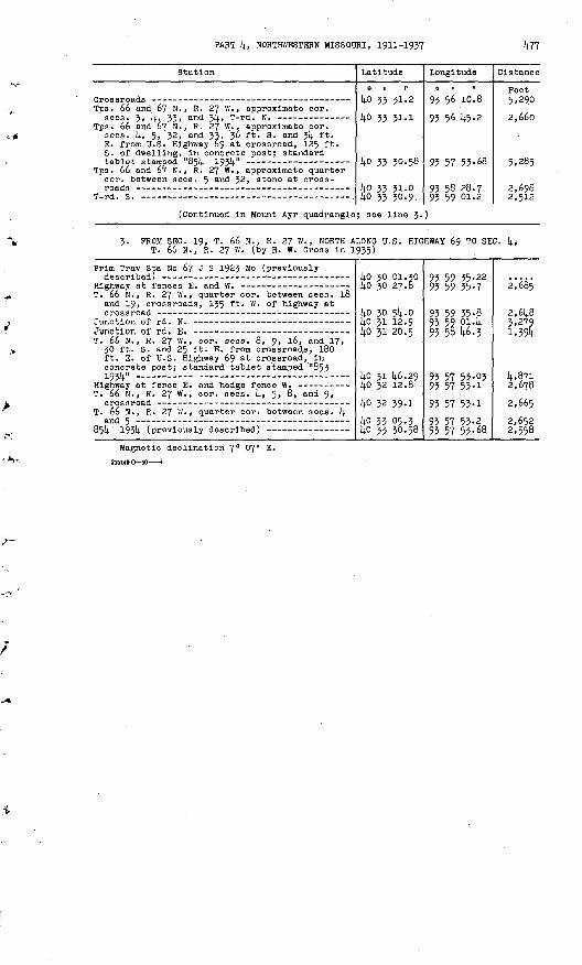
PART k, NORTHWESTERN MISSOURI, 1911-1957
Station
Tps. 66 and 67 N. , R. 27 W. , approximate cor.
Tps. 66 and 67 N. , R. 27 W. , approximate cor. sees. k, 5, 32, and 33, 36 ft. S. and 3k ft. E. from U.S. Highway 69 at crossroad, 125 ft. S. of dwelling, in concrete post; standard
Tps. 66 and 67 N. , R. 27 W. , approximate quarter cor. between sees. 5 and 52, stone at cross-
T_Wt. S. _ - - _ ----- -- __
Latitude
0 1 II
ko 35 51-2
14-0 55 51-1
(4.0 33 30.58
ko 33 31.0 in xx xn.o
Longitude
0 | II
93 56 10.8
95 56 k5.2
93 57 55-68
95 58 28.7 ax RQ m .P
Distance
Peet 5,290
2,660
5,285
2,698? SI -J
(Continued in Mount Ayr quadrangle; see line J.)
3. PROM SEC. 19, T. 66 N., R. 27 W., NORTH ALONG U.S. HIGHWAY 69 TO SEC. k, T. 66 N., R. 27 W. (by H. W. Gross in 1935)
Prim Trav Sta No 67 J S 1923 Mo (previously
T. 66 N., R. 27 W., quarter cor. between sees. 18 and 19, crossroads, 135 ft. W. of highway at
T. 66 N., R. 27 W. , cor. sees. 8, 9, 16, and 17, 30 ft. S. and 25 ft. E. from crossroads, 180 ft. E. of U.S. Highway 69 at crossroad,' In concrete post; standard tablet stamped "853 195V -
T. 66 N. , R. 27 W., cor. sees, k, 5, 8, and 9,
T. 66 N., R. 27 ' '/., quarter cor. between sees, k
kO 30 01.30
ko 30 5k. olj.o 31 12.9ko 31 20.5
ko 31 k6.29
ko 32 39.1ko 55 05.3ko 33 30.58
95 59 55-2295 59 55-7
95 59 55-895 59 014 93 58 1*6.3
95 57 55.0395 57 55-1
95 57 55-1OX f7 CZ Q
95 57 55-68
2 /Qr
2,6k85.279 1,39k
k,87io ^^Q
2 // c
Magnetic declination 7° 07" E.
215HCC

k?8
BLYTHEDALE QHADSA1IGLE (Latitude kO°15«-kO°30'; longitude 93°k5«-S!j.0G01 )
Grundy, Harrlson, and Kercer Counties
BLYTHEDALE O I
[ CAINSVILLE
1. FROM LAHOHI QUADRANGLE AT SEC. 29, T. 66 H., R. 2? W., EAST IHTO LAKOBI QUADRANGLE AT SEC. 27, T. 66 H., R. 2? W. (by J. L. Sanders in 1923)
(Continued from Lamoni quadrangle; see line 1.)
Station
T. 66 H. , R. 27 W. , K. sixteenth cor. between
T WI V _ 1 ___ __ __ __ ~ _
Latitude
ko 29 k8.3kO 29 3k.kl,n PQ fift-li
Longitude
Of 0
93 57 52-893 57 53-2o* «; ? ift-Q
Distance
Feet
(5A62)
*_nn«;
(Continued In Lamoni quadrangle; see line 1.)
2. FROM PRMCETOM QUADRAEGLE AT SEC. 19, T. 65 H. , R. 25 W., KORTB IHTOPRINCETOH QUADRAHGLE AT SEC. 7, T. 65 H., R. 25 B. (by J. P. Andersen in 193U)
(Continued from Prlnceton quadrangle; see line 1.)
Calnsvllle, 1.2 ml. S. of, In SB lA see. 19, T. 65 H., R. 25 ff., 120 ft. H. of dwelling of A. J. Graham, In front yard, In concrete post; standard tablet stamped "668 193k "
T. 65 N., Rs. 25 and 26 W. , approximate cor. sees. 13, 18, 19, and 2k, on Harrlson-Bercer
T. 65 N>, R. 27 W. , approximate quarter cor. between sees. 13 and 2k, rd. corner from E.-E.-
Calnsvllle, School Street at B.-W. cross street - T. 65 H. , R. 26 W. , center sec. 12, Ii5 ft. N. and
30 ft. W. from Iron pin, 30 ft. H. and 30 ft. W. from T-rd. W. , kO ft. S. of Chicago, Burlington & Qulncy R.R., In concrete post;
T -wa u
T-WI- R-
kO 2k 53.32
ko 25 26.5kO 2S 2S-5 li.0 26 18.1
kO 26 kk.k2ko 26 56.9 kO 26 57-7 kO 27 07.3 liO yj n .n
93 k5 17-63
95 45 50.6
93 U6 2k.8 93 Ij.6 26.0
93 k6 26 .kO 93 U6 26.1 93 U5 51-7 93 {tf 21.6 Qj; lit; fip.7
(k,130)
k,220
2,6k5 5.330
2,665 1,270 2,6602,525 i _«;in
(Continued In Prlnceton quadrangle; see line 1.)
PROM POIHT 3 MILES EAST OP BETHANY, EAST ALONG STATE HIGHWAY k TO SEC. 12, T. 63 H., R. 27 W., THENCE EAST ALONG ROADS 1KTO PRINCETON QUADRANGLE AT SEC. 18, T. 63 N., R. 25 W. (by J. P. Anderson In 193k)
Bethany, 3 ml. E. of, along State Highway k, In NE 1/k sec. 18, T. 63 N., R. 27 B. f kO ft. N. of dwelling of W. H. Rice, k2 ft. S. of highway. In concrete post; standard tablet
T. 63 N., R. 27 W., cor. sees. 7, 8, 17, and l8,
T. 63 H., R. 27 W., cor. sees. 8, 9, 16, and 17,
T. 63 N., R. 27 W., 0.2 mi.' E. of cor. sees. 9, 10, 15, and 16. 36 ft. 3. and 27 ft. W. from State Highway ^ at rd. S., In concrete post; standard tablet ntanmad "flfiO lQ*)i n - -
ko 15 52.56kO 15 52-9
kO 15 52.2ko 15 52.0
lifi m «;i .?*.
93 58 k7.kl
93 58 23.6
93 57 W.2 93 5& 40.8
Q^ tili l.o.-lA
1,8505,3002,670
li _nn<;

PART 4, NORTHWESTERN MISSOURI, 1911-1937
Station
T. 63 H. , R. 27 W., cor. sees. 10, 11, l4» and
T. 63 N., R; 27 W., cor. sees. 11, 12, 13, and
T. 63 H., R. 26 W. , W. quarter cor. aec. 18, 30 ft. N. and 23 ft. E. from T-rd. E., In concrete
T. 63 N., R. 26 W., quarter cor. between sees. 17
T. 63 N. , R. 26 W. , quarter cor. between sees. 16
T. 63 N. , R. 26 W. , quarter cor. between sees. 15 and 16, 24 ft. H. and 24 ft. W. from T-rd. H. , on property of Prank Neff , 10 ft. NE. of l6-ln. water-oak tree, in concrete post; standard
T. 63 N. , R. 26 W. , quarter cor. between sees. It).
T. 63 N. , R. 26 W. , cor. sees. 10, 11, 14, and15, T-rd. E. ---
T. 63 N. , R.. 26 W. , cor. sees. 11, 12, 13, and l4» 36 ft. S. and 18. ft. W. from crossroads, in concrete post; standard tablet stamped "863 19514."
Thompson River drainage ditch, center of bridge
861). 1934 (In Princeton quadrangle; see line 2.)-
Latitude
40 15 51.2
40 15 51.0 40 15 51.0 40 15 24.8
4o 15 24.87 40 15 24.740 15 24.8 40 15 25.04o 15 25.1 40 15 25.0 4o 15 25.0
40 15 24.88 40 15 24.5
40 15 24,2
40 15 50.4 40 15 50-4
40 15 49-97 4o 15 49.5
40 15 49.2 40 15 50.4 40 15 50.41
Longitude
93 54 59-6
93 53 51-4 93 53 17-2 93 52 17-0
93 52 42.46 93 52 19-0
93 51 30-5 93 50 56.2
93 50 22.6 93 50 05.3 93 49 47-4
93 49 14-26 93 48 40.1
93 48 05.6
93 Itf 05.8 93 47 30.3
93 46 56-66 93 46 21.8
93 46 04-3 93 45 14-2 93 44 40.22
Distance
Peet
3,845
5,290 2,655 2,640
2,675 1,820
3,760 2,660
2,610 1,340 1,390
2,570 2,650
2,675
2,650 2,750
2, '6lO 2,700
1,360 3,885 2,640
4- PROM EETHAMY QUADRANGLE AT SEC. 36, T. 65 H. , R. 28 W. , EAST INTO PRIUCETOH QUADRANGLE AT SEC. 6, T. 61). N. , R. 25 W. (by H. W. Gross in 1935)
(Continued from Bethany quadrangle; see line 4«)
T. 65 N., R. 27 W., quarter cor. between sees. 31 and 32, stone in rd. at fence S. of W. end of
Rldgeway, 0-5 ml. N. , thence 1.3 mi. W. from, in NW lA SE lA sec. 32, T. 65 N. , R. 27 W. , 32 ft. S. and 29 ft. E. from T-rd. S., in concrete
Rd. at E. entrance to Ridge Cemetery, 93 ft. W.
Tps. 64 and 65 N., R. 27 W. , approximate cor. sees. 2, 3. 34, and 35, T-rd. S. and fence N.
Rldgeway, 1.4 ml. E. of, near N. quarter cor. sec. 2, T. 64 N., R. 2? W. , 50 ft. N. of farm house on property of Harlan Johnson, 30 ft. S. of rd., in concrete post; standard tablet
T. 64 N., R. 27 W., N. cor. sees. 1 and 2, T-rd. S., 6? ft. W. of T-rd. N. at S. cor. sees. 35
Panther Creek, center of bridge over T. 65 N. , R. 26 W., S. cor. sees. 3! and 32,
T-rd. H., -149 ft. E. of rd. at fence S. at N.
Rldgeway, 4.5 mi. E. of, in SW lA SW lA sec. 32, T. 65 N. , R. 26 W., 28 ft. N. and 275 ft. E. from T-rd. S., 54 ft. S. and 15 ft. E. from dwelling of Ella Bridges, in concrete post;
T. 61). N., R. 26- W. , N. cor. sees. 4 and 5, T-rd. S., 145 ft. W. of T-rd. N. at S. cor.
T __J Q
T. 64 N., R. 26 W. , H. cor. sees. 2 and 3, stone
40 23 20.0
4o 23 19-3
40 23 18.55
4o 23 18.3 40 23 17.840 22 43.32
40 22 51.2
40 22 50.63
40 22 50.5 40 22 49.9 40 22 48.9
40 22 48.9
40 22 49.18
40 22 49-7 40 22 35-6 40 22 35.8
lift yy l.fl 1,
93 59 05.7
93 58 20.3
93 57 39-4U
93 56 49-1 93 56 13-6 93 56 05.55
93 55 04-1
93 54 33-00
93 53 56.2 93 53 21.0 93 52 35-6
93 51 32.2
93 51 17.75
93 50 25.6
93 48 4l-6
ox liR rv? A
(5,870)
3,516
3,162
3,897
m4,819
2,411
2,852 2,720 3,5iU
4,910
1,117
4,035 3,0025,328 3 ol.n

14.80 TRANSIT TRAVERSE IN MISSOURI
Station
Mount Moriah, 3.5 mi. N. of, along County Route B, S. quarter cor. sec. 35, T. 65 N. , R. 26 W. , 27 ft. N. and 75 ft. W. from highway produced at E.-VV. crossroad, k ft. N. and 2 ft. W. from fence corner, in concrete post;
Thompson River, center of main span of bridge
867 193k (In Princeton quadrangle; see line 1.)-
Latitude
0 | II
kO 22 14.8.58 J4.0 22 Ii8. 2
kO 22 k8.2 1+0 22 liS.k kO 22 k8.35
Longitude
93 kj 33-57 93 k6 59.5
93 k6 06.6 93 k-5 19-9 93 k£ k§.69
Distance
Feet
2,633 2,637
k, °9° 3.617 2,1*16
5. PROM BETHANY QUADRANGLE NORTH ALONG U.S. HIGHWAY 69 INTO LAMONI QUADRANGLE (by J. J. Belnllch In 1936)
(Continued from Bethany quadrangle; see line 7;)
T. 65 N., R. 28 W., in SE 1/1}. sec. 13, 30 ft. E. of U.S. Highway 69, 75 ft. SW. of corner of dwelling of W. E. Hendven, in concrete post;
Eagleville, 30 ft. N. and 2k ft. W. from U.S. Highway 69 at cross street one block N. of business district, in concrete post; standard
T. 65 N., Rs. 27 and 28 W. , N. cor. sees. 1 and
Prim Trav Sta No 67 J S 1923 Mo (In Lamoni
ko 25 05.1
14.0 25 14.1.08 £o 26 23.8 kO 26 5k. 5 kO 27 16.6
kO 28 15.09
kO 28 JO.l lio 28 56.2
kO 30 01.30
93 59 58.5
93 59 itf.23 93 59 30.2 93 59 30.1 93 59 30-k
93 59 19-37
93 59 19-0 93 59 35-3
93 59 35-22
(5,339)
3,739 4,515 3,110 2,2kO
5,978
1,520 2,927
6,583
6. PROM BETHANY QUADRANGLE EAST ALONG STATE HIGHWAY k TO SEC. l8, T. 63 N. , R. 27 W., THENCE 'SOUTH ALONG ROADS INTO OILMAN QUADRANGLE AT SEC. 19, T. 63 N. , R. 27 W. (by W. V. Kennedy in 1936)
(Continued from Bethany quadrangle; see line 5.)
T. 63 N. , R. 27 W., cor. sees. 17, 18, 19, and
(Continued in Oilman quadrangle; s
ko 15 5k.2 ko 15 52.56kO 15 00.7
ee line k. )
93 59 53-2 93 58 kl-ki
93 58 23.6
(2,658)5,iok
5,56i
Magnetic declination 6° 39' E.

PART 14., NORTHWESTERN MISSOURI, 1911-1937 14.81
GILMAN QUADRANGLE (Latitude I4.0°00'-l4.0°15'; longitude 95°l4.5' -9l4.°00')
Daviess, Grundy, and Harrlson Counties
R37W R26W
\
1. FROM GALLATIH QUADRANGLE NORTHWEST ALONG Y/ABASH RAILWAY INTO PATTONSBURG QUADRANGLE (ojomplled from valuation plats of Interstate Commerce Commission)
(Continued from Gallatin quadrangle; see line i)..) .
Station
James on, R.R.157
Jameson, R.R. T. 60 N., R
at milepost marked "St L 257 Oma
at line between sees. 1J and l8> i. 27 and 28 W., about 650 ft. W.
Latitude
14.0 00 12.1
l.n nn 17.1
Longitude
95 58 56. k
Q* t;Q T7.P
Distance
Feet
(5.159)
1 . f,Qf,
(Continued in Pattonstmrg quadrangle; see line 14..)
2. FROM TRENTON QUADRANGLE WEST ALONG QUINCY, OMAHA & KANSAS CITY RAILROAD INTO PATTONSBURG QUADRANGLE (compiled from valuation plats of Interstate Commerce Commission)
(Continued from Trenton quadrangle; see line 1.)
R.R. at rd. crossing on line between sees. 25 and JO, T. 62 N. , Rs. 25 and 26 W. , on
R.R. at line between sees. 25 and 26, T. 62 N. ,
T. 62 N., R. 26 W., cor. sees. 26, 27, J>k> and
R.R. at line between sees. 27 and 28, T. 62 N. , R. 26 W., 330 ft. E. of R.R. at private rd.
T. 62 N., R. 26 W., cor. sees. 19, 20, 29, and
R.R. at rd. crossing on line between sees. 25
R.R. at rd. crossing on line between sees. 25
R.R. at rd. crossing on line between sees. 26OTM-T 0*7 'P f*3 W R 97 W
R.R. at rd. crossing on line between sees. 27
R.R. at private rd. crossing, 14.72 ft. SW. of
R.R. at rd. crossing on line between sees. 31
R.R. at line between sees. 6 and 51, Tps. 6l and 62 N., R. 27 W. , In line with rd. E. , 80 ft.
R.R. at line between sees. 1 and 6, T. 6l N. ,
(Continued in Pattonsburg quadrang
l(.0 08 31.1
14.0 08 22.0ko 08 17.3lj.0 08 12.2
[4.0 07 59.6
kO 08 17.0 £o 08 3l|..6
[4.0 08 52.7 ko 08 39-7
14.0 08 38.8
14.0 08 39.6
[4.0 08 40.5
14.0 08 U.It.
14.0 08 20.3 £o 08 01.1
lj.o 07 25.2
Itfl 07 09.2 ijo 06 5L(..l
14.0 06 Itf.S
le; see line
95 Itf 50.2
95 {4.6 58.6 95 kl 15.6 95 Itf 3&. k
93 W 06.5
95 U9 12.7 95 50 17.8
95 51 29-2 95 52 21-5
95 52 59-9
95 55 U8.2
95 5U 56.1
95 56 05.0
93 56 57.0 95 57 32.8
93 58 21.0
95 58 14*.-b 95 59 15-6
93 59 2U-3
5.)
(5.223)
5.597 l,£oo 1.550
2,795
5, toll. 5,3595,814.0 H.,270
1A33
5,501
5,269
5,51+U
It., 572 3,5855,225
2,452 2,81^8
800
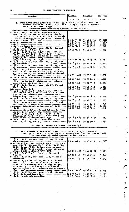
482 TRAMSIT TRAVERSE IN MISSOURI
Station Latitude Longitude Distance
01" o i n Feet
3. PROM PATTOHSBURG QUADRANGLE AT SEC. 2k, T. 62 N. , R. 28 W., BAST INTO TREBTON QUADRANGLE AT SEC. 19, T. 62 N. , R. 25 W. (by W. V. Kennedy and C. W. Williams In 1936)
(Continued from Pattonsburg quadrangle; see line 6.)
T. 62 H., Rs. 27 and 28 B., approxin^te cor. sees. 19, 24, 25, and 30, at jog In'rd., kO ft. H. of rd. E. , 7 ft. Hr of rd. W. produced, 7 ft. E. of fence. In concrete post; standard
T. 62 K., R. 27 W., cor. sees. 20, 21, 28, and
T. 62 H. , R. 27 B., approximate cor. sees. 21, 22, 27, and 28, 36 ft. ». and 30 ft. B. from crossroads, 42 ft. S. and k2 ft. E. from frame dwelling, in concrete post; standard tablet
T. 62 H., H. 27 B., cor. sees'. 22, 23, 26, and
T. 62 H., R. 27 B., cor. sees. 23, 24, 25,- and
T. 62 IF., Rs. 26 and 27 B., approximate cor. sees. 19, 24, 25, and 30, 50 ft. E. of T-rd. B., in concrete post; standard tablet stamped
Gilnan City, Qulncy, Ooaha & Kansas City R.R. at
T. 62 H., R. 26 B. , H. sixteenth cor. between
T. 62 H-, H. 26 W., cor. sees. 19, 20, 29* and
T. 62 K., R. 26 B. , N. sixteenth cor. between sees. 27 and 28, 4O ft. S. and 21 ft. H. from S?-rd. B. , In concrete post; standard tablet
T. 62 H., R. 26 B., cor. sees. 21, 22, 27, and
T. 62 H., R. 26 B., cor. sees. 22, 23, 26, and
Melbourne, Kaln Street at junction of rd. E. T-rd. E. Melbourne, about 0.5 ml. E. and 0.2 ml. N. from,
668 ft. B. of quarter cor. between sees. 24 and 25, T. 62 P., R. 26 B., 100 ft. S. of dwelling, 25 ft. H. of rd.. In concrete post;
T. 62 B., Rs. 25 and 26 B. , approximate cor.
(Continued In Trenton quadrangle;
40 08 55.03 40 08 56.4 40 08 56.1 40 08 54.3
40 08 54.1
40 08 54.23
40 08 53.7
40 06 53.6
40 08 53.17
40 08 39-7
40 08 39-5
40 08 52.4 40 08 38.9
4o 08 38.25
40 08 51.6
40 08 51.6 4o 08 25.0 40 08 39'. 2
40 08 50.87
40 08 50.5
see line 4- )
93 59 23-51 93 58 38.0 93 58 21.3 93 57 29-993 57 12.9
93 56 05.26
93 54 56.0
93 53 48-4
93 52 39-81
93 52 21.5
93 51 39-2
93 51 39-2 93 50 21.4
93 49 14-00
93 49 13-593 48 06.0 93 47 15-3 93 46 58.4
93 46 15-42
93 45 50.0
(5,381) 3,555. 1,296 3,993l,32l*
5,250
5,375
5,253
5,321
1,966
4,058
1,310 5.433
5,237
1,355
5,246 4,768 1,951
3,537
1,970
k. PHCM HLYfflKD&LB QUADRANGLE AT SEC. 19, T. 6j H., H. 2? W., SOOTH TOSBC. 19, T. 62 H., R. 27 W. (by B. V. Kennedy and C. W. Williams In 1936)
(Continued from Blythedale quadrangle; see line 6.)
T. 63 H., R. 27 W., cor. sees. 19, 20, 29, and
Blue Ridge, 2 ol. W. , thence 2 ml. H. from, cor. sees. 29, 30, 31, and 32, T. 63 H., H. 27 B., 30 ft. S. and 20 ft. B. from stone at cross roads, 90 ft. 0. of school, In concrete post;
T. 63 B., R. 27 B., S. cor. sees. 31 and 32,
T. 62 H., R. 27 W., cor. sees. 5, 6, 7, and 8,
GilEan City, 7.5 nil. HB. of, 85 ft. S. of cor. sees. 7, 8, 17, and 18, T. 62 H., R. 27 B., 50 ft. W. of duelling of T. B. Hlgglns, 30 ft. B. of rd., 5 ft. S- and 15 ft. K. from mail' box, in concrete post; standard tablet stamped 891 193V -
T. 62 H., H. 27 W., cor. sees. 17, 18, 19, and
40 14 08-4
40 13 15-7340 12 23.8
kO 11 31-3
40 10 38.16kO 09 46.740 08 56.4
93 56 23.6
93 58 22.98
93 58 23.1
93 58 21.9
93 58 21.23
93 58 21.2 93 58 38.0
(5,296)
5.325 5,252
5,317
5,3745,208 5,255

PART If, MOR3EH1KSTEBN MISSOURI, 1911-1957 483
Station Longitude Distance
FeetPROM TKBSS01 QinflBSAEGLB &S SBC. 51, T. 6l W., R. 25 W., SOWS IHTOGAHATHI QBanSflEISLE AT SBC. 19, T. 60 1., R. 25 W. (by J. J. Belnllcb in 1936)
(Continued frosn'Trenton quadrangle; see line 7-)
T. 6l S., R. 25 B., in B 1/2 sec. 51, 19 ft. S..ana 50 ft. B. from T-pd- S. , 8. ft. IB. of fencecomer, 1 ft. ffl. of fence, lit concrete; Iron
f. 60 S. , R. 25 W., quarter cor. between sees. 7 and l8, 28 ft. M. and 57 ft. B. fron cross roads, in concrete base of fence post; standard
Prim *ww Sta Bo 10 1913 Ho Sl»2 (In CblllleotbB
40 02 18.59 40 01 52.6
kO 01 Ql|..1340 oo 11.5
59 59 45-43
93 45 02.50 93 45 14-2
93 45 if -29 93 45 14-8
95 44 ̂ 0.76
(4,251) 2,789
4,904 5,321
5,739Magnetic declination 7° 20« S.
QUUUSDB (latitude 59045«-4o°e0'; longitaide f -9Jn.°00« )
Caldwell, Bswiess, Grnmdy, ami ULvinoston. Counties
R27V R26M
H^
SBC. 301, T. M1 SBC. 19,
SEE. 15, T. 59 M-, R. 28 TO., EOIBFH TO. , B- 27 W., mtBHOE BAST IffiMJ CHJUULICOraE 0 HL, B. 25 W. (Iby B. L. JfcMalr in 1913) fnum mnstora jjuLEjflreragJe; see line 1.)
Station
Crossroads on lino between sees. 1 mmrB 12,IP ffT^Tt 1KT Iff "3>8? W
T. 59 "-» B3 - 27 ami 26 W. , appnnndtamte qumrter cor. between sees. 1 ami 6
IPms. 59 ami 6dJ M., Bs. 27 ami 28 W. , cor. off.
T. to H. , E. 27 W., jpnarter cor. between sees. 30
T. to W.', B. 27 W., 1m H 1/2 sec. 30, 35 ft. S. off Junction. ..off rd. SB., 15 ft. 28.' off HI.-S. rd., 2 ft. V. off fence; iron post stamped " Prlan Traiir Sta Hto 8 1913 Bto 901"
ISabasm By. at rd. crossing
T. 6® W. , B. 27 W. , qmarter cor. between sees. 27
V. 6O B., B. 27 W., cor. sees. 25, 26, 55, ami
T. to W., B. 26 0., 5 ft. B. ami 15 ft. W. from W. cor. sees. 30 ami 51, W. off T-xd. S., 50 ft. S. of Irora bridge, in Hime wltSi rd. E. , in fence comer; iron post stamped ""Prim 'iQrav Sta
IT. 60 QU, B- 26 V., cor. sees. 29, 30, 31, and 52 IT rd. S. - __________________ - _______
latitude
39
59
59
59
59
59 59 5959
59 59
59
59
59
i <* 55 25.8
5644-2
57 10-9
5757-0
58 29.5
52 01-85
5845-5 58 22.1
5832-0 58 52-5
5®32.9
5852.77
5853.0
-Longitude
at
93 59 27-6
93 59 29.2
95 59 12.5
95 59 13-2
93 58 31-8
93 58 52.79 95 57 2k.6 95 57 06.1 93 56 15-9
95 55 08.0 95 54 16.7
93 53 25-6
93 52 17-60
95 51 22.3
Distance
Feet(4,005) 7,94o
2,995 2,658 6,217
5,2705,3244'457
5.581 3,991
5,976
5.296
4,308
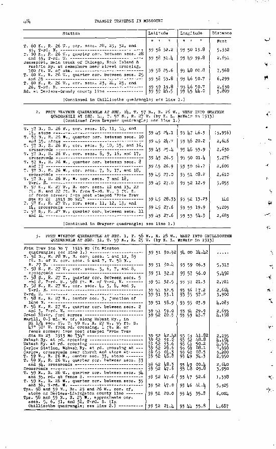
484 TRANSIT TRAVERSE IN MISSOURI
Station
T. 60 N., R. 26 W., cor. sees. 28, 29, 52, and
T. 06 H. , R. 26 W. , quarter cor. between sees. 28
Jamesport, main track of Chicago, Rock Island & Pacific Ry. at semaphore near street crossing,
T. 60 N. , R. 26 W. , quarter cor. between sees. 25
T. 60 N. , R. 26 W. , cor. sees. 25, 24, 25, and
(Continued In Chillicothe quadrang
Latitude
0 1 IT
59 58 32.2
39 58 31.1;
39 58 25.6
39 58 53-8
39 59 19.8 39 59 45-5
le; see line
Longitude
93 50 13-8
93 49 39-8
93 14.8 02.8
93 46 50-7
93 46 5p.7 93 1;5 44-0
l.)
Distance
Peet
5,332
2,651
7,568
6,299
2,630 5,809
2. FROM BRAYMER QUADRANGLE AT SEC. 14, T. 57 N. , R. 26 W. , WEST INTO BRAYMER QUADRANGLE AT SEC. l4, T. 57' N., R. 27 W. (by E. L. McNair In 1915)
(Continued from Braymer quadrangle; see line 1.)
T. 57 N., R. 26 W., cor. sees. 10, 11, 14, and
T. 57 N., R. 26 W., quarter cor. between sees. 10
T. 57 N., R. 26 W., cor. sees. 9, 10, 15, and l6,
T. 57 N., R. 26 W., cor. sees. 8, 9, l6, and 17,
T. 57 N., R. 26 W. , quarter cor. between sees. 8
T. 57 N., R. 26 W. , cor. sees. 7, 8, 17, and 18,
T. 57 N., R. 26 W. , W. eor. sees. 7 and 18,
T. 57 N., R. 27 W., E. cor. sees. 12 and 13, 22 ft. N. and 22 ft. W. from T-rd. W., 1 ft. S. of fence corner; Iron post stamped "Prim Trav
T. 57 N., R. 27 W. , cor. sees. 11, 12, 13, and
T. 57 N., R..27 W. , quarter cor. between sees. 11
(Continued In Braymer quadrangle;
39 45 214.. 1
39 45 2l;.7
39 45 25.1;
39 45 26.5
39 45 26.9
39 45 27.0
39 45 27.0
39 45 28.33
39 45 27.6
39 45 27.6
see line 1.)
93 47 46-3
93 48 20.2
93 48 53-9
93 50 01.4
93 50 34.7
93 51 08.2
93 52 12-9
93 52 13.25
93 53 19.9
93 53 54-3
(3,956) 2,646
2,630
5,276
2,600
2,610
5,055
140 5,205 2,685
3. PROM WINSTON QUADRANGLE AT SEC. 1, T. 58 N. , R. 28 W. , EAST INTO CHILLICOTHE QUADRANGLE AT SEC. 31, T. 59 N. , R. 25 W. (by E; L. McNair In 1913)
Prim Trav Sta No 7 1913 Mo (In Wins ton
T. 58 N., R. 28 W. , E. cor. sees. 1 and 12, 85 ft. S. of W. cor. sees. 6 and 7, T. 58 N. ,
T. 58 N., R. 27 W., cor. sees. 5, 6, 7, and 8,
T. 58 N. , R. 27 W., quarter cor. between sees. 5
T. 58 N., R. 27 W., cor. sees. 1;, 5, 8, and 9,
T-rd. W. - T. 58 N., R. 27 W., center sec. 5, junction of
T. 58 N., R. 27 W., quarter cor. between sees. 2
Magill, 0-3 mi. W. of, along Wabash Ry. , in SE lA sec- 35 > T. 59 N., R. 27 W. , 55 ft. S. 14.7° 50' W. from rd. crossing, 1 ft. E. of fence corner; iron post stamped "Prim Trav
Carlow Station, Wabash Ry. at rd. crossing at Carlow, crossroads near church and store at' --- T. 59 N., R. 26 W., center sec. 35, stone T. 59 N., R. 26 W., quarter cor. between sees. 33
T. 59 N. , R. 26 W. , quarter eor. between sees. 54
T. 59 N. , R. 26 W. , quarter cor. between sees. 35
Tps. 58 and 59 N. , Rs. 25 and 26 W., cor. of, stone on Daviess-Llvlngston county line -
Tps. 58 and 59 N. , R. 25 W. , approximate cor. sees. 5, 6, 31, and 32, T-rd. S. (In
39 51 30.32
39 51 30.4
59 51 52.2
39 51 32.5
39 51 32.5 39 51 33.1
39 51 58-9
39 51 59-0 39 52 20.3
39 52 42.42 39 52 39-0 39 52 35-6 39 52 29.6 39 53 pl.3 39 52 48.8
39 52 48.3 39 52 47-6
39 52 47-6
59 52 47-0
59 52 20.0
39 52 21.4
94 oo 14.42
95 59 06.5
95 57 56.0
93 57 21.3
93 56 47-2 93 55 57-2
93 55 03.9
93 54 29.9 93 53 43-7
93 53 41-82 93 52 48.8 93 51 50.2 93 50 08.1 93 50 08.5 93 49 34-3
95 49 00.4 93 48 09.8
93 47 52.6
93 46 444
93 45 35-8
93 44 35.8
5,313 5,492 2,7012,664 3,900
4,083
2,655 4,198
2,2354,154 4,575 7,9903,2002,9502,6403,950 1,338 5,325 6,004
4,687

PART k, NORTHWESTERN MISSOURI, 1911-1937 1+85
Station. Latitude
0 I II
Longitude
0 , II
Distance
Peet
k- PROM SEC. 29, T. 60 N., R. 27 W., NORTHWEST ALONG WABASH RAILWAY INTO OILMAN QUADRANGLE (compiled from valuation plats of Interstate Commerce Commission)
R.R.
at
atrd.milespost marked "St L
(Continued in
256 Omaha 158"
39 5839 59 39 59
Oilman quadrangle; see lin
0^.3
fci9393 93
1 1.)
57 06
58 oo0k 2,970
i+,558
5. FROM WINSTON QUADRANGLE AT SEC. 21)., T. 60 N., R. 28 W., SOUTH TO SEC. JO, T. 60 N., R. 27 W. (by J. L, Sanders in 1921)
(Continued from Winston quadrangle; see line 2.)
Prim Trav Sta No 8 1913 Mo 901 (previously
39 59 52.5,39 59 1+7-6
39 59 01.83
93 59 17.093 58 55-3 93 58 32.79
(5.821)1,756
l+,959Magnetic declination in 1920, 8° E.
BRAYMER QUADRANGLE(Latitude 39°30 I -39°1).5 I ; longitude SJ 0!^ 1 -9lf°00')
Caldwell, Carroll, Livingston, and Ray Counties
R27W R20W
T57N
1. FROM DAWN QUADRANGLE AT SEC. 19, T. 57 N., R. 25 W., WEST INTO POLO QUADRANGLE AT HAMILTON (by E. L. McNair in 1913)
(Continued from Dawn quadrangle; see line 1.)
Station
T. 57 N., R. 25 W., W. cor. sees. 18 and 19,T J T?
T. 57 N., R. 26 W., E. cor. sees. 13 and 2k,
T. 57 N., R. 26 W. , cor. sees. 13, ll)., 23, and
Stone at T-rd. E. on line between sees. ll). and 15, T. 57 N., R. 26 W.
(For balance in Gallatln quadrangl
Latitude
0 1 II
39 1*14. 33.0
39 kk 29-3
39 144 30.8
39 144- 1+5-0
e, see line 2
Longitude
93 14-5 31-8
93 1+5 31.8
93 W 38.3
93 1+7 1+6.1
.)
Distance
Feet
(1+.91+5)
370
5,195
5,W7
T. 57 N., R. 27 W. , quarter cor. between sees. ll).
T. 57 N., R. 27 W., cor. sees, ll)., 15, 22, and
T. 57 N. , R. 27 W. , cor. sees. 15, 16, 21, and
T. 57 N.,. R. 27 W. , cor. s;ecs. l6, 17, 20, and 21 T rd. S
T. 57 N., R. 27 W. , cor. sees. 17, 18, 19, and
T. 57 N., R. 28 W. , E. cor. sees. 13 and 2k, 1+0 ft. N. of W. cor. sees. 18 and 19, T. 57 N. ,
Prim Trav Sta No 6 1913 Mo (In Polo quadrangle;
39 W+ 35-6
39 1+1+ 35-8
39.1*4 31+-8
39 kk 31+-2
39 1+1+ 33.14.
39 lA 33-0
39 kk 31-76
93 53 53-3
93 54 27-0
93 55 35-3
93 56 1^.2
93 57 50.2
93 59 oi.l,.
9!). oo 07.60
(5,272)
2,635
5,330
5,230
5.311
5,559 5,172
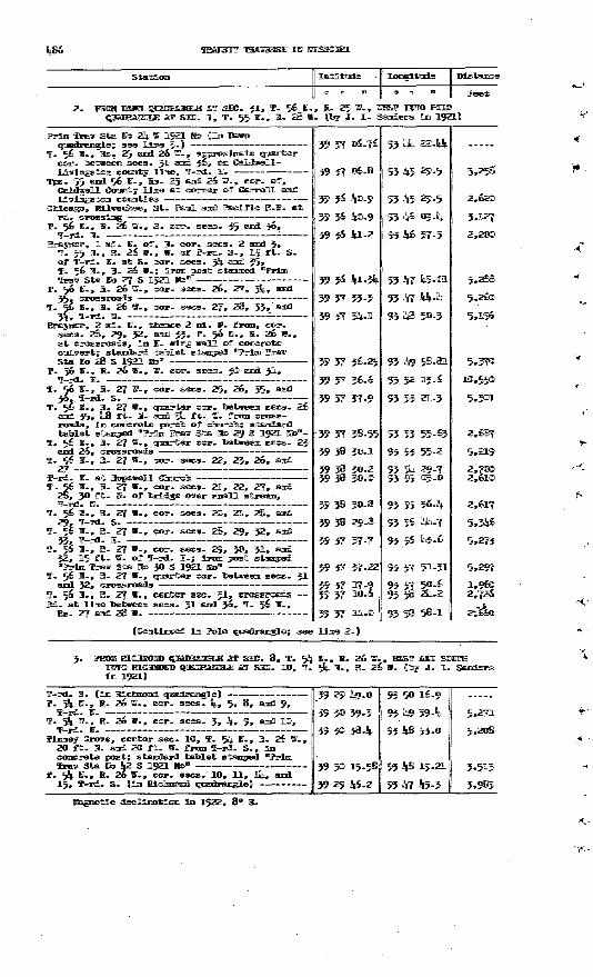
Itetittimffle
:. i, T- 55a. 25
JT. ]L- Samders 1m 1921J
fraiy Sta Bto 23j. W 1521 Kto Jim BBJRB qnjsidraiigl©; see lime 3-J
T- 56 W-, Rs. 25 amd 26 W., approzlmatt® cor. toeteneem sees- 31 amd 36, om Calj EJUdLmgstoin commity lime, T-Bdl- B-
Tps. 55 amd 56 W-, Ba- 25 ami 26 W-, cor. off,Coramty lime at conner tuff Cam-oil amffl
Urfiigstom counties Ctaicaeo, MlliwaiutoEe, St. Parnl sand Fteclffic B-B- at
IF- 56 SF-, B. 26 W-, S- cor- sees. 35 amd 36,
_ _r, 1 mi. IB. off, BJ. cor. sees. 2 amd 3» P. 55 EU, B. 26 W., W. off T-rd. S-, 15 fft. S. off T nfi. W. at S. cor. sees. 5% amd 35» T. 56 M., B. 26 W.; irmm post stomped "Prim TraTsr Sta Efo 27 S 1921 Bto 1"
T- 56 ffl., B. 26 W., cor. sees. 26, 27, 3%, amd
T. 56 BU, B. 26 BT-, cor. sees. 27, 28, 53,' amd
r, 2 ml. M., ttemce 2 ml. W. ffnnm, cor. sees. 28, 29, 32, amd 33, T- 56 HI-, B. 26 W-,
Sta E<n> 28 S 1921 Sto" T. 56 W-, B. 26 W., W. cor. sees. 30 amd 31,
T-nd. E. : T. 56 M-, B. 27 W-, cor. sees. 25, 26, 35, amd
f. 56 IB-, B- 27 W., qiQartar cor. Ssetweem sees. 26 amd 35, Hj8 fft. ffi- amd 5% t- '- ffnnm cross-
tablet stamped "Prim IPraisr Sta Iffio 2§ S 1921 ms>a[-1F. 56 E., B. 27 W., opattrter cor. toetareem sees. 23
amd 26, crossroads T. 56 M-, B. 27 W., cor. sees. 22, 23, 26, amd
3F-rd. ffl. atT. 56 M-, B. 27 -, cor. sees. 21, 22, 27, amd
2®, 50 fft. B5. off bridge o^er SBITPSH "P streaon, TF-rd. H.
T. 56 10., E. 27 V., cor. sees. 20, 21, 2@, amd
IF. 5& W-, E. 27 W-, cor. sees. 2®, 29, 32, amdZ3: IF Wfl W __.^______.___._ ____ .______ ______ __ JJf Jt JTTUI- Ja-
T. 56 K-, B- 27 W., cor. sees. 29, 30, 31, amd32, 15 fft. W. off T rd. B-; Irom post stamped."Prim TPra^r Sta Sto 30 S 1921 Hto"
T. 56 ffl., B. 27 W., qmarter cor. toettweem sees. 31amd 32, crossroads
f. 56 I., K. 27 W., center sec. 51, Bd. at lime betveera sees. 31 and j6, T.
Og^ 27 ffimirfl 2® W. _____________________
37 53
37 54
39 37 38.55
39 38 30.1
39 38 30.239 38 30.0
39 3? 57-7
57 37-22
37 17.57 10.
37 UL.
(Comtinmed im Polo qmadramgle; see ]Himm 2.J
22.1(1
29.5
29.5
IA-% 50.3
93 57 51-51
95 5Js 2%.2
95 « 58-1
5,25®
2,200
2 ^ *((Zi"&
5-
im 1921)
SEE. 8, T. 5% ST., E. 26 W-, I MF SHE. 1O, T. 5% ffl., B- 26 W.
3T AffiUJ ([tor JT. 1L.
T rd. S. (1m BJLcImmmiLlLT. 5|. W., B. 26 W., cor. sees. %., 5, 8, amd 9,
. _______ _
9, amd KB,T. 54 BT-, B. 26 W., cor. sees. 3, T rd. M.
Tlemey Grove, center sec. 10, T. 5% BT., E. 26 2O fft. H. amffl 20 fft. W. from T-rd. S., 1m concrete post; standard tablet stomped! "Prim Trav Sta Eo Jj2 S .1921 Bo*
T. 584. HL, B. 26 W., cor. sees. 10, 11, 1%, « a 15, T rd. S. (In Blcnnsimil
39 30 3®.
39 351 15.
39 29 l|}6.
19.21
Jte-5
5.271
3,5133,983
decllmatlom In 1922, 8° E.

PART Ip., NCHTHBBSTBMI OTSSOBSI, 1911-1957
POLO QH&DRAHGIfi (Latitude 39°30« -39°45« ; longitude
Caldvell, Clinton, DeKalb, and Ray Counties
sf R29W R28W
1. PROM PLATTSBURG QUADRANGLE AT CAMSIOU EAST TO HAMILTOH {by B. i- in 1915)
(Continued from Plattsburg quadrangle; see line 2.)
Station
Cameron, opposite NW. corner of park, 25 ft. E. of Chicago, Rock Island & Pacific Ry., 1? ft. B. of bell signal post, 3 ft. S. of sidewalk; iron post stamped "Prim Trav Sta Ho 4 1913 Mto"
T I'd S T. 57 H., R. 29 W., W. cor. sees. 18 and 19,
approximate corner of Caldvell, Clinton, and
T. 57 H., R. 29 W., cor. sees. 17, 18, 19, and
T. 57 H., R. 29 W., cor. sees. l6, 17, 20, and21, T-rd.
T. 57 N., R. 29 W., cor. sees. 15, l6, 21, and 22 T. 57 B., R. 29 H., cor. sees. ifc, 15, 22, and 23 T. 57 H., R. 29 B., cor. sees. 1J, l4, 23, and
24, 28 ft. S. and 24 ft. 3. from crossroads; iron post stamped "Prim Trav Sta Ho 5 Ho 1913"-
T. 57 H., R. 29 W., B. cor. sees. 13 and 24, 100 ft. H. of W. cor. sees. 18 and 19, T *i7 N R 28 W
T. 57 H., R. 28 W., cor. sees. 17, 18, 19, and
T. 57 H., R. 28 W., cor. sees. l6, 17, 20, and
T. 57 H. , R. 28 V., quarter cor. between sees. 16
T. 57 H-, R. 28 W., cor. sees. 14, 15, 22, and
Hamilton, in W. part of, on W. mil Street, 2 ft. S. and 1 ft. W. from HW. comer of brick school building; Iron post stamped "Prim Trav
Latitude
at a
39 44 32.97 39 44 32.6
39 44 43-7
39 44 42-9
39 44 4o.2 39 44 38.5 3944 37-8 39 44 34-8
39 44 32.90
39 44 33-0
39 44 32.2
39 44 32.1
39 44 31-9
39 44 31-5
39 44 31-76
Longitude
a i
94 14 22.10 94 13 37-3
94 12 20.5 94 11 09.994 10 03-694 09 11-7 <& OS 54-394 07 46-4
94 06 40-55
94 05 34-5
94 04 36-2
94 03 28.9
94 02 56-1
94 01 16.2
94 oo 07.60
instance
Feet
(6,437)3,50<J
6,101
5,511
5.1854,057 1.359 5,309
5,070
5.235
4,554
5,255 2,560 7,806
5.356
PROM BRAYKER QUADRANGLE AT SBC. 1, T. 55 0., R. 28 V., WEST IETO PLAffSBORQ QUADRANGLE AT SBC. 34, T. 56 H-, R. 30 H. (by J. L. Saraiers In 1921)
(Continued from Braymer quadrangle; see line 2.)
Tps. 55 and 56 N. , R. 28 W., near cor. sees. 1, 2, 35, and 36, 10 ft. H. and 25^ft. B. from T-rd. H., In concrete post; standard tablet
Tps . 55 an(i 56 H. , R. 28 V. , approximate cor.
Crossroads near approximate cor. sees. 3, 4, 33,
Sta. 558 + 83 of survey for proposed highway
39 36 44-08
39 36 43-7
39 36 43-7
39 36 39-95
94 00 04-95
94 01 12.6
94 02 20.0
94 02 19-85
(5.903)5,293
5,280
382
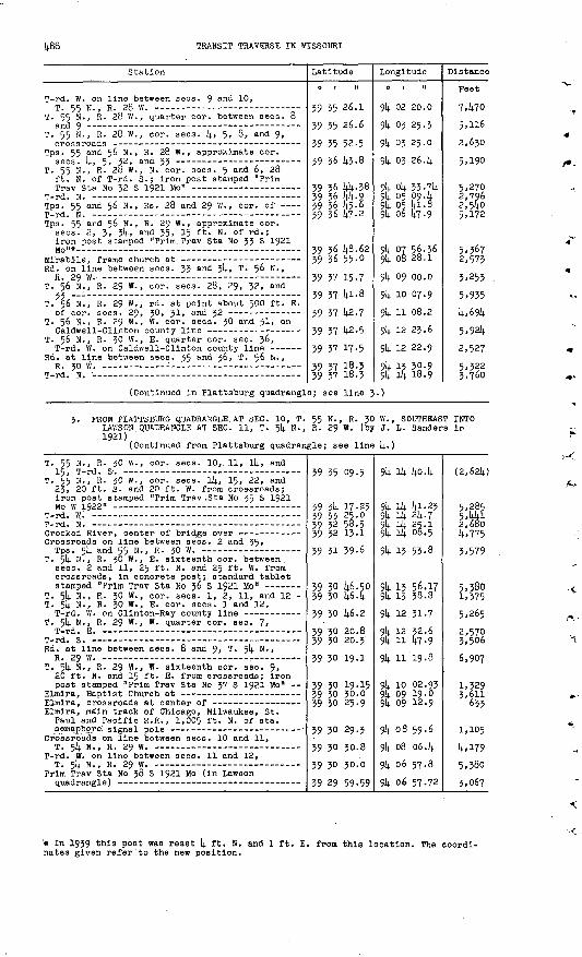
TRANSIT TRAVERSE IN MISSOURI
Station
T-rd. W. on line between sees. 9 an<^ 10,
T. 55 N., R. 28 W., quarter cor. between sees. 8
T. 55 N., R. 28 W., cor. sees. k> 5, 8, and 9,
Tps. 55 and 56 N., R. 28 W. , approximate eor.
T. 55 N., R. 28 W., N. cor. sees. 5 and 6, 28 ft. N. of T-rd. S.; Iron post stamped "Prim
Tps. 55 and 56 N. , Rs. 28 and 29 W. , cor. of
Tps. 55 and 56 N., R. 29 W. , approximate cor. sees. 2, 3, Jl)., and 35, 15 ft. N. of rd.; iron post stamped "Prim.Trav Sta No 33 S 1921
Rd. on line between sees. 33 and $k> T. 56 N. ,
T. 56 N., R. 29 W. , cor. sees. 28, 29, 32, and
T. 56 N., R. 29 W., rd. at point about 500 ft. E.
T. 56 N., R. 29 W., W. cor. sees. 30 and 31, on
T. 56 N. , R. 30 W. , E. quarter cor. sec. J>6,
Rd. at line between sees. 35 and 36, T. 56 N. ,
T-T-rt. W. -- _ _-_-_ _-- ____- ____-_- _ __
Latitude
0 t 11
39 35 26.1
39 35 26.6
39 35 52-5
39 36 k3-8
39 36 kk-38
39 36 {4.5.6 39 36 k7-2
39 36 14.8.6239 36 55-0
39 37 15-7 39 37 14.1.8
39 37 142.7
39 37 1*2.5
39 37 17-5
39 37 i§.5510 V7 18.1
Longitude
9k 03 25.3
9)4. 03 25.0
914. 03 26. k
9k Ok 35 .7k
9k 05 la- 8 9k .06 147-9
94 07 56.369!,. 08 28.1
9k 10 07.9
914. 11 08.2
914. 12 23.6
914. 12 22.9
9k 13 30-9Ql, if, 18. <5
Distance
Feet
T.kYO
2,630
5.190
5,2702,7962,5405.172
2,573
3,253
5.935k,(>9k
5,92k
2,527
5.322 *.76r>
(Continued in Plattsburg quadrangle; see line 5.)
J. PROM PLATTSBURG QUADRANGLE AT SEC. 10, T. 55 N. , R. JO W. , SOUTHEAST INTO LAWSON QUADRANGLE AT SEC. 11, T. 5*4. N., R. 29 W. (by J. L. Sanders IP 1921)
(Continued from Plattsburg quadrangle; see line I;.)
T. 55 N., R. JO W., cor. sees. 10,. 11, li)., and
T. 55 N., R. 30 W., eor. sees, ik, 15, 22, and 23, 20 ft. S. and 20 ft. W. from crossroads; iron post stamped "Prim Trav ,Sta No 35 S 1921
Crooked River, center of bridge over ------- - Crossroads on line between sees. 2 and 35,
T. 514- H -» R - 3° w - , E - sixteenth eor. between sees. 2 and 11, 25 ft. N. and 25 ft. W. from crossroads^ in concrete post; standard tablet
T. 5i4. N. , R. 30 W. , cor. sees. 1, 2, 11, and 12 - T. 5k N., R. 30 W. , E. cor. sees. 1 and 12,
T. 5k N., R. 29 W. , W. quarter cor. sec. 7,
Rd. at line between sees. 8 and 9, T. 5k N., R 29 W - -"
T. 5k N., R. 29 W., W. sixteenth eor. see. 9, 20 ft. N. and 15 ft. E. from crossroads; iron post stamped "Prim Trav Sta No 37 S 1921 Mo"
Elmlra, main track of Chicago, Milwaukee, St. Paul and Pacifle R.R., 1,005 ft- N. of sta.
Crossroads on line between sees. 10 and 11,
T-rd. W. on line between sees. 11 and 12,T cli W R ?Q OT
Prim Trav Sta No 38 S 1921 Mo (in Lawson
39 35 09.5
39 314. 17.25 39 33 2S.O 39 32 58.5 39 32 13-1
39 31 39-6
39 30 W.50 39 30 k6-k
39 30 U6.2
39 30 20.8 39 30 20.3
39 30 19-1
39 30 19.15 39 30 30.0 39 30 25.9
39 30 29.3
39 30 30.8
39 30 30.0
39 29 59-59
94 ik ko.k
9k ik kl-23 9k ik 214.. 7 9k ik 25.1 9k ik 08.5
9k 13 53-8
9k 13 56.17 9k 13 38. 8
9k 12 31-7
9ll 12 32.6 9k 11 k7-9
914. 11 '19- 8
9k 10 02.93 94 09 19-0 9U 09 12.9
9k 08 59.6
9k 08 06.14.
9k 06 57.8
914. 06 57-72
(2,62k)
5,285 5,kkl 2,680k,775
3,579
5,380 1,375
5.265
2,570 3,506
6,907
1,329 3,611
633
1,105
k,l79 5,380
3,067
'* In 1939 this post waa reset 1; ft. N. and 1 ft. E. from this location. The coordi nates given refer'to the new position.
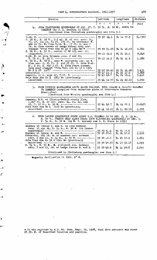
PART 4, NORTHWESTERN MISSOURI, 1911-1937 1*89
Station Latitude
0 ( II
4. PROM PLATTSBURQ QUADRANGLE AT SEC. 27, T. 56 N., R. JC CAMERON (by J. L. Sanders in 1921)
(Continued from Plattsburg quadrangle; see line
T. 56 N., R. 30 W., 0.2 ml. E. of cor. seca. 14, 15, 22, and 23, 63 ft. (35 ft. by 'levelman) N. and 20 ft. W. from T-rd. W. , 17' ft. N. and 2 ft. E. from corner of hedge fence; iron post
T. 56 N., R. 30 W., center of NW 1/4 sec. 11,
T-rd. E. on line between sees. 2 and 11, Tcf w p zo w
T. 56 N., R. 30 W. , near W. sixteenth cor. on N. line sec. 2, 25 ft. S. and 25 ft. W. from T-rd. S., 2 ft. S. and- 2 ft. E. from fence corner; iron post stamped "Prim Trav Sta No 1+7 S 1921
Prim Trav Sta No 14 1913 Mo (previously
39 38 24.1
39 39 31-28
39 41 02.6
39 la 16.2
39 42 09.90 39 42 49-3 39 43 42.7
.39 44 32-97
Longitude
W., NORTH TC
3-)
91; lit. 17-5
91*. iU 16.78
9k 14 15-5
94 14 15-6
91* 14 14-98 94 14 17.9 9k 14 19-4
94 14 22.10
Distance
Feet
(4,130)
6,801
9,240
1,380
5.431 3,989 5.410
5,090
5- FROM WINSTON QUADRANGLE SOUTH ALONG CHICAGO, ROCK ISLAND & PACIFIC RAILWAY TO CAMERON (compiled from valuation plats of Interstate Commerce Commission)
(Continued from Winston quadrangle; see line 4«)
Cameron, R.R. at Clinton-DeKalb county line, 1,147 ft. E. of cor. sees. 14, 15, 22, and?X T1 C.7 W T? XH W
Prim Trav Sta No Lj. 19^3 Mo (previously39 44
39 44
46.7
32.97
94 14 22.1
94 14 .22.10
(2,640)
1,393
6. FROM LAWSON QUADRANGLE NORTH ALONG U.S. HIGHWAY 69 TO SEC. 2, T. 54 N. R. 30 W., THENCE WEST ALONG ROADS INTO PLATTSBURG QUADRANGLE AT SEC. T. 54 N., R. 30 W. (by W. V. Kennedy and H. W. Gross in 1935)
3,
Highway at fences E. and W. on line betweensees. 11 and 14, T. 54 N., R. 30 W. (in Lawson
Crossroad, 205 ft. E. of quarter cor. between
Prim Trav Sta No 36 S 1921 Mo (previously
T. 54 N., R. 30 W. , W. sixteenth cor. betweensees. 2 and 11, rd. at hedge fences N. and S. -
zo
39
39
39
39
2930
30
30
30
(Continued in Plattsburg quadrangle; see
54
46
46
46
i.6
.50
9
9494
94
94
94
^ 14
14
13
i4
10
56
29
.0
.6
.2
17
.8
2,
2,
2,
630
653
099
637
line 5.)
Magnetic declination in 1922, 9° E.
* It was reported by A.J. St. John, Sept. 13, 1928, that this monument was reset 28 fff. N'. of described location and position.
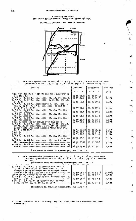
1*90 TRANSIT TRAVERSE IB MISSOURI
BIBSTOB QBADRAEGLE (Latitude 39°45«-^0°OO'; longitude ^k"OO'-$k
Caldwell, Baviess, and DeKalb Counties
1. PROM POLO QDADHAKGLE AT SEC. 14, T. 57 H., R. 28 W., NORTH INTO OALLATIN QUADRAHGLE AT SEC. 13, :T."59 H., R. 28 W. (by E. L. UcNalr in 1913)
Station
Prim Trav Sta Ho 6 1913 Mo (In Polo quadrangle;
T. 57 H., R. 28 W., cor. sees. 11, 12, 13, and 14 T. 57 S. , R. 28 W., cor. sees. 1, 2, 11, and 12,
T. 57 H., R- 28 W. , approximate K. cor. sees. 1 and 2, 85 ft. W. of S. cor. sees. 35 and 36,
T. 58 N. , R. 28 W., cor. sees. 25, 26, 35, and
T. 58 H., R. 28 W., cor. sees. 23, 24, 2$, and
T. SO H., R. 28 W. , cor. sees. 13, 14, 23, and
T. 58 B-, R. 28 W., cor. sees. 1, 2, 11, and 12, 20 ft. S. of crossroads, 2 ft. SW-. of corner fence post; iron post stamped "Prim Trav Sta
T. 59 N., R. 28 W., cor. sees. 23, 24, 25, and
T. 59 N., R. 28 W., cor. sees. 13, l4, 23, and
T. 59 B., R. 28 W., quarter cor. between sees. 13
(Continued in Gallatln quadrangle;
Latitude
o i n
39 44 31.7639 45 24-2
39 46 16.4
39 47 09.2
39 48 01.5
39 48 53-7
39 49 46.039 50 38.3
39 51 30-32
39 53 16.8
39 54 06.5
39 54 58.8
39 55 25.0
see line 1.
Longitude
94 oo 09.7
94 oo 10.394 oo 11.2
94 00 12.2
94 oo 15.494 oo 33-0
94 oo 17-5 94 00-18.6.
Distance
Feet
5,304
5,345
5,291
5,2915,291
3,9836,954
5,174j ><-?*+
2. FROM PATTONSBURO QUADRANGLE AT SEC. 21, T. 60 N., R. 28 W., EAST INTO GALLATIN QUADRANGLE AT SEC. 24, T. 60 N., R. 28 W. (by J. L. Sanders in 1921)
(Continued from Pattonsburg quadrangle; see line 1.)
T. 60 H., R. 28 W., E. sixteenth cor. sec. 21, 21 ft. N. and 20 ft. E; from T-rd. K., in concrete post; standard tablet stamped "Prim
T. 60 N., R. 28 W. , quarter cor. between sees. 22
T-rd. S., 700 ft. W. of quarter cor. between
(Continued in Gallatin quadrangle;
39 59 U6.SO 39 59 494
39 59 46.6
39 59 47-2
see line 5*1
94 02 54.08 94 01 52.294 01 30.394.00 31.5
(2,928) 4,825
1,726
4.581
» It was reported by C. D. Cralg, May 10, 1937, that this monument had been destroyed.
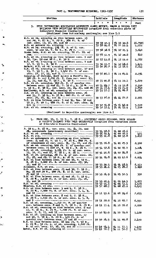
jmuar %, mumatummuuiaam mjiiawwiii., JL^UL-JL.^}/ ufyjL
Statltm 1 ILatltade | jtomgHtuile | Distance
[ o « u 1 o i B
5- VSXM PAUPINBfSBIIIBIIS QffiAffiEMSGlE SOOTMEESI1 &LJOT5 {JU1MC2, {OTM& a KflfflS&S H&HLKOfiB JUBWffl MffiSSWUB HJUWBSlMiGlIiSi! {compiled! ffroan valrastlom plats
H.B. at rd. crossing ora lime between sees. 19 aznd 20, T. 6® m., H. 29 W., 78® ft. B. of
H.E. at private rd. crosslmg H.B. at rd. crossing, 71% ft. E. of W. cor.
Santa Rosa, B-R- at rd. crossing, 80 ft. MB. of
B.R. at rd. crossing on line between sees. 1 and
H.R. at rd. crossing on line between sees. 1 and
B.B. at rd. crossing on line between sees. 12 and 13, 5. 59 ST., R. 30 W., I,k80 ft. E. of cor.
Crossing of Cblcago, Rock Island & Pacific By. , 3OO ft. S. and 1,200 ft. B. from cor. sees. 13,
R.B. at rd. crossing, 989 ft. "S. of quarter cor. between sees. 23 aiad 24, T. 59 H-, S. 30 W.
T. 59 HI., B. JO W., cor. sees. 23, 2k, 25, amd 26
R.B. at rd. crossing on line between sees. 26 amfl 35, T. 59 H., R. 30 W. , 600 ft. E. of cor.
R.R. at line between sees. -3 and 3k, Tos- 58 and 59 B-, R. 30 W., 980 ft. W. of S. cor. sees. 3k
(Continued in Maysvilie quadrangle
39 59 57.339 59 ok-6
39 58 38-8
39 58 31-9
39 57 47-8
39 56 55-7 39 56 29.2
39 56 03.1
39 55 07.8
39 54 %7 39 5k 18.4 39 55 52-7
39 53 26.9
39 52 34-8 59 52 22.4
; see line 2.
9k 11 10.89k 11 45-4
94 12 05-5
94 12 10.8
94 12 33-0
9k 12 48.6 9k 12 56.5
9k 13 O5.k
9k 13 10.1
9k 13 12.8 94 13 25-9 9k l4 09.2
94 i4 27.2
94 i4 48-0 9k ik 52.9
| Feet GIT? of
(6,790) 4,273
3,040
810
4,782
5.415 2,7k5
2,754
5,609
2,350 2,850 4,265
2,965
5,510 1,310
k- FROM SBC. 13, 5P. 59 H., R. 28 W. , SOOTHffiEST ALOSG CHICAGO, ROCK ISMiSD & PACIFIC RAILWAY I5TPO POLO QOADRAHGLE (compiled from valuation plats of Interstate Coimerce Commission)
T. 59 H., R. 28 W., cor. sees. 13, Ik, 23, and
R.R. at undergrade rd. crossing on line between sees. Ik and 15, * 59 US-, 8. 28 B., 800 ft. H. of crossroads at cor. sees, lit, 15, 22, and 23-
R.R. at rd. crossing, 1».60 ft. W. of quarter cor. between sees. 15 and 22. T. 59 H-, R. 28 TO.
R.R. at rd. crossing, I,l6k ft- S. of cor. sees.
R.R. at rd. crossing, 20 ft. B. of cor. sees. 20, 21, 28, and 29, T. 59 H., R.' 28 W.
R.R. at line between sees. 29 and 30, T. 59 H. , R. 28 B-, 1,6OO ft. H. of cor. sees. 29, 30, 31, and 32
R.R. at line between sees. 25 and 30, T. 59 B. , Rs. 28 and 29 B., 900 ft. H. of B. cor. sees. 25 and" 36
R.R. at line between sees. 35 and 36, T. 59 H., R. 29 »., I,k50 ft. S. of cor. sees. 25, 26, 35, and 36
R.R. at line between sees. 3 and k, T - 58 H>, R. 29 H., 1,900 ft. N. of cor. sees. 3, k, 9,
R.R. at line between sees. 8 and 9, T- 58 H., R. 29 W., 1,630 ft. S. of cor. sees. 4, 5. 8,
R.R. at rd. crossing, 1,750 ft. W. of quarter cor. between sees. 8 and 9, T. 58 H., R. 29 W--
R.R. at rd. crossing on line between sees. 8 and 17, T. 58 H., R. 29 B., 1,200 ft. E. of cor.
R.R. at rd. crossing on line between sees. 17 and 18, T. 58 H. f R. 29 H., k70 ft. N. of
R.R. at line between sees. 18 and 19, T. S8 N., R. 29 W., 50 ft. S. of rd. crossing, 1,600 ft.
39 54 58-8 39 55 03.4 39 55 04-8
39 55 06.8
39 54 57-8
39 54 45-8
39 54 04-8
39 53 29.5 39 53 24-4
39 53 2k-9
39 53 03-4 39 52 55-1 39 52 08.7
39 51 53-6
39 51 20.0
39 51 H-4
39 50 45-9
39 50 24-5
39 49 54-4 39 49 16.7
9k 00 18.6 9k 00 18.7 9k oo 57-8
9k 01 27.3 9k 02 07.1 9k 02 3k-8 9k 03 ki-6
94 ok 48-k 9k 05 28.2
94 05 32.5
9k 06 ko.3 9k 06 57-4 94 08 27.1
94 08 54-6
94 10 03.1
9k 10 26.2
9k 10 5k- 6
9k 11 09.8
9k 11 31-1 9k 11 50-7
465 3,050
2,300
3,22k
2,k70
6,654
6,313 3,140
330
5,677 1,570 6.427
2.635
6,351
2,000
5,400
2,470
3.470 4,110

492 TRANSIT TRAVERSE IN MISSOURI
Station
R.R. at Daviess-DeKalb county line, 400 ft. N. of W. cor. sees. 30 and 31, T. 58 N., R. 29 W.-
R.R. at rd. crossing, 800 ft. E. of center
R.R. at rd. crossing on line between sees. 1 and
R.R. at line between sees. 1 and 2, T. 57 N. , R. 30 \V. , 1,850 ft. S. of N. cor. sees. 1
R.R. at rd. crossing, 650 ft. N. of center
R.R. at fences E. and VI. on line between sees. 11
Latitude
0 1 II
39 48 17.1
39 47 46-8
39 47 20.9
39 47 02.8
39 46 11-3
39 45 38.8*o lit; IP. 7
Longitude
94 12 19.8
94 12 43-6
94 13 10.2
94 15 28.9
94 14 02.8
94 14 19-5Oli ill PI .li
Distance
Feet
6,451
3,592
3,340
2,350
5,839
(Continued in Polo quadrangle; see line 5-)
5. PROM ALTAMONT NORTHWEST ALONG CHICAGO, ROCK ISLAND & PACIFIC RAILWAY TO POINT 1 MILE EAST OF WEATHERBY (compiled from valuation plats of Interstate Commerce Commission)
Altamont, R.R. at sta. (previously described) R.R. at line between sees. 25 and 26, T. 59 N. ,
R. 29 W., 1,560 ft. S. of cor. sees. 23, 24,
R.R. at undergrade rd. crossing, 300 ft. S. and 1,550 ft. E. from quarter cor. between sees. 23
T. 59 N., R. 29 W. , quarter eor. between sees. 22 and 23, 377 ft. S. of R.R. at rd. crossing -
R.R. at rd. crossing on line between sees. 15 and 16, T. 59 N., R. 29 W. , 636 ft. N. of cor.
R.R. at rd. crossing, 660 ft. N. of center
R.R. at Daviess-DeKalb county line, 431 ft. S. of W. cor. sees. 18 and 19, T. 59 N. , R. 29 W.
Crossing of Quincy, Omaha & Kansas City R.R.
39 53 24-4
39 53 53-8
39 54 07-0
39 54 35-1 39 55 09-9
39 55 10.2 39 55 04-739 54 48.1 39 54 50.0
39 55 03.8
39 55-07-8
91; 05 28.2
94 06 39-9
94 06 59.8
94 07 14.7.5 94 08 21.3
94 08 55.3 94 09 10.3
94 10 37-394 11 28.0
914. 12 17.6
914. 13 10.1
6,339
2,014.6
4,680 4,405
2,646 1,300
6,989 3,9534,ii4
4,no
6. FROM MAYSVILLE QUADRANGLE AT SEC. 3, T. 58 N., R. 30 W. , EAST TO SEC. 26, T. 59 N., R. 28 W., THENCE SOUTH 2 MILES (by C. D. Craig in 1937)
(Continued from Maysvllle quadrangle; see line 4>)
Qulncy, Ome.ha & Kansas City R.R. at rd. crosslrig- Quincy,' Omaha & Kansas City R.R. at hedge fences
T. 59 N., R. 30 W., S. cor. sees; 314. and 35,
T. 59 N., R. 30 W. , S. cor. sees. 35 and 36, rd. corner from N.-E. , 45 ft. E. of rd. corner from S.-E. at N. eor. sees. 1 and 2, T. 58 N.,
Tps. 58 and 59 N. , Rs. 29 and 30 W., approximate cor. of, fence corner, 15 ft. N. and 10 ft. E.
T. 58 N. , R. 29 W., N. quarter cor. sec. 6, rd. corner from S.-E. and abandoned rd. W., 115 ft. E. of rd. N. at S. quarter cor. see. 31,T en TJ R PQ W
T. 58 N., R. 29 W., in HW lA sec. 5, 2 ft. S. and 16 ft. W. from fence corner at NW. corner of cemetery, in concrete post; standard tablet
T. 58 N., R. 29 W. , center sec. 4, crossroads Fence corner, 15 ft. S. and 15 ft. E. from rd.
U.S.C. & G.S. standard disk stamped "C 76 1935"- Chlcago, Rook Island & Pacific Ry. at rd.
Chicago, Rock Island & Pacific Ry. at rd.
Chicago, Rock Island & Pacific Ry. at fences N. and S. on line between sees. 35 an(i 36,T. 59 N., R. 29 W.
U.S.C. & G.S. standard disk stamped "D 76 1933"- Altamont, Chicago, Rock Island & Pacific Ry. main
39 -52 22. U
39 52 34-8
39 52 34-6 39 52 37-7
39 52 55-7
39 52 33-5
39 52 32-4
39 52 23:69 39 52 02.8 39 52 01.3
39 52 00.1 39 52 08.29
39 52 24.4
39 52 54-9
39 53 03-4 39 53 07.71
39 53 24.4
94 i4 52.9 94 14 48.o 94 14 35-094 14 02.2
94 13 26.8
94 12 '18.7
94 11 43-8
94 10 53-48 94 10 08.2 94 09 28.6
94 08 54-4 94 08 25.20
94 07 58.5
94 06 56.8
94 06 39.5 94 06 31-28
94 05 28.2
(1,257)
1,305
1,009 2,578
2,787
5,312
2,720
4,020 4,118 3,087
2,673 2,4172,642
5,716
1,600 773
5,196

PART k, NORTHWESTERN MISSOURI, 1911-1937 14.93
Station
Altamont, in SE. part of, 150 ft. E. of high school, 28 ft. S. and 18 ft. E. from cross roads, in concrete; iron post stamped "6 R S1922" -
T. 59 N. , R. 28 W., approximate cor. sees. 29, JO, 31, and 32, rd. at hedge fence N. and wire
Altamont, 2 ml. E. of, cor. sees. 28, 29, 32, and 33, T. 59 N., R. 28 W. , 29 ft. S. and 2 ft. W. from T-rd. N. , 10 ft. S. and 2 ft. W. from fence corner, in concrete post; standard tablet
T. 59 N., R. 28 W., cor. sees. 27, 28, 33, and
T. 59 N. , R. 28 W., S. sixteenth cor. between
T. 59 N., R. 28 W. , center of SE 1/lj. sec. 26, 18 ft. N. and 30 ft. W. from T-rd. S., 2 ft. S. and 3 ft. W. from fence corner, in concrete post; standard tablet stamped "T T 21 C 1937" -
Tps. 58 and 59 N. , R. 28 W. , approximate E. sixteenth cor. between sees. 2 and 35, T-rd. N.
T-rd. S. - T. 58 N., R. 28 W., quarter cor. between sees. 1
T. 58 N., R. 28 W., cor. sees. 1, 2, 11, and 12, k5 ft. N. and 25 ft. E. from crossroads; iron .
T. 58 N., R. 28 W., cor. sees. 1, 2, 11, and 12; about 20 ft. SE. of crossroads, k, ft. N\:. of
Latitude
0 I II
39 53 12.2
39 53 12.28
39 53 12.7
39 53 I2.l£ 39 53 13-9
39 53 13-p 39 53 13-1+
39 53 26.8
39 53 27.32 39 52 k7.8
39 52 21.9 39 52 09-7
39 51 56.6
39 51 31.03
39 51 30-3
Longitude
0 | II
9k 05 32.0
91; 05 ok. 30
9lj. ol* 14.7.6
9k 03 39.89 9k 03 05.9
9U 02 32.1 9k 01 5k. o
9(4. 01 2k. 6
914. oo 33-69 9k oo 32.79k oo 31-29k oo 15. It. 914. oo 15-1
91). oo ik. 33
91; 00 Ik.k
Distance
Feet 1,260
2,162
1,301
5,281 2,6k9
2,635 2,975
2,659
5,970 3,998
2,623 1,801
1,32k
2,593
72
Magnetic declination in 1921, 9° 58' E.
* According to landowner this point is former location of Prim Trav Sta No 7 1913 Mo.

494 TRANSIT TRAVERSE IN MISSOURI
PATTONSBURG QUADRANGLE (Latitude 40°00'-40°15'; longitude 94°00'-94°15')
Daviess, DeKalb, Gentry, and Harrison Counties
__R29W RZ
T63N
1. FROM DARLINGTON QUADRANGLE AT SEC. 22, T. WINSTON QUADRANGLE AT SEC. 21, T. 60 N. in 1921)
(Continued from Darlington quadrangle; see line 1.)
60 N., R. 30 W., EAST INTO , R. 28 W. (by J. L. Sanders
Station
T. 60 N. , R. 30 W., cor. sees, 14, 15, 22, and 23, 20 ft. N. and 30 ft. W. from crossroads, 5 ft. W. of 12-in. aah tree, in concrete post; standard tablet stamped "Prim Trav Sta No 7° S1921 Mo 1? R S 1922"
T. 60 N., R. 30 W., cor. sees. 13, 14, 23, and
T. 60 N., R. 30 W., S. sixteenth cor. on W. line
T. 60 N. , R. 29 W. , S. sixteenth cor. -between sees. 17 and 18, 20 ft. S. and 25 ft. W. from T-rd. S., 2 ft. N. and 5 ft. W. from corner of hedge fence, in concrete post; standard tablet stamped "Prim Trav Sta No 71 S 1921 Mo 18 R S
Qulncy, Omaha & Kansas City R.R. at rd. crossing, 276 ft. S. of milepost 172 -
Grindstone Creek, center of bridge over - -------
T. 60 N., R. 29 W., E. sixteenth cor. between
T. 60 N., R. 29 W., cor. sees, 14, 15, 22, and 23 T. 60 N., R. 29 VY. , quarter cor. between sees. llj.
T. 60 N., R. 29 W. , cor. sees. 13, 14,' 23, and 24 T. 60 N., R. 29 W., quarter cor. between sees. 13
and 24, 15 ft. S. and 29 ft. E. from cross roads, 2 ft. N. of fence, in concrete post; standard tablet stamped "Prim Trav Sta No 72 S
T. 60 N., R&. 28 and 29 W., cor. sees. 13, 18,
T. 60 N., R. 28 W. , quarter cor. between sees. 17
T. 60 N. , R. 28 W., W. sixteenth cor. between
T. 60 N. , R. 28 W. , quarter cor. between sees. 16
(Continued in Wlnston quadrangle;
Latitude
40 00 28.22
40 oo 27.940 00 38.6
40 oo 37.2
40 oo 36. 3U 40 00 35-3
40 00 34-. 040 00 20.2 40 00 18.0
40 00 16.8 40 oo 16.140 oo 15.1 40 oo 14.1
14.0 oo 12.9240 00 12.1
40 00 12.0
k° 00 12.2
40 00 12-3
see line 2.)
Longitude
01 II
94 114. 30.90
9k 13 21.8 94 12 30.1
9k 12 13.0
9k 11 10.5694 10 36.2
9k 09 S7.39k 08 lj.6.1 94 08 37-5
94 08 03.9 94 07 47.0
94 07 13.2 94 06 39.2
94 06 05.40 94 05 31.8 94 04 18.9 94 03 27.7 94 03 i].o
Distance
Feet
(5.364)
5,380 4,1971,338
4,861 2,679
3,027 5,715
7092,621 1,3202,630 2,650
2,636 2,621 5,670
3,985 1,305
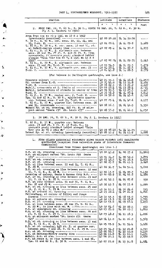
PART k, NORTHWESTERN MISSOURI, 1911-1957 14-95
Station Latitude
0 1 II
Longitude
0 1 II
Distance
Feet2, PROM SEC. 22, T. 60 N., R. JO W., NORTH TO SEC. 26, T. 62 N., R. JO W.
(by J. L. Sanders in 1921)
Prim Trav Sta No 70 S 1921 Mo 17 R S 1922
T. 60 N., R. JO W., cor. sees. 10, 11, ik, and
T. 60 N., R. 30 W., N. cor. sees. 10 and 11, rd.
T. 6l N., R. JO W. , E. sixteenth cor. between sees. 26 and 35, 27 ft. N. and 21 ft. E. from, crossroads, In concrete post; standard tablet stamped "Prim Trav Sta No 7k S 1921 Mo k5 R S1922"
T. 61 N., R. 30 W., E. sixteenth cor. between
T. 61 N., R. 30 W., E. sixteenth cor. sec. 23 T_W1_ VI. - - _ - ____ ________________
kO 00 28.22
14.0 01 20.1).
Ip 02 094
kO 03 02.1k
ko 03 5k. 3liO Ok 20. k lif) nli lit; A
9k Ik 30.90
9k Ik 29.9
9k ik 30.2
9k ik 29.71
9k ik 23.3 9U ll). 28.5QI 1)1 ?fl t;
5,289
U. 955
. 5.314-3
5.279 2,6kl y S7Q
(For balance In Darlington quadrangle, see line 2.)
T J IT _ _
McFall, Intersection of streets In center of town T-rd. N. T. 6l N., R. 30 W., center sec. 2, T-rd. N. - Tps. 6l and 62 N, , R. 30 W., approximate quarter
T. 62 N., R. 30 W., quarter cor. between sees. 26
Wabash Ry. at rd. crossing, 9k8 ft. E. of mile-
kC 05 33-114-0 05 kk-0lj.0 06 02.1
ko 06 39.5lio 06 56.2ko 06 58.0
ko 07 23. k
ko 08 16.1ko 08 57-9
9k ik 26.89k 13 3k. 89U 13 21.29k 13 28. k9k 13 27.? 91; ifi 08. h.9k ik 14.3.6
9k ik k2.6
9k ll; kl.g
91; 11+ Ui-9
(k,257)14-.1932,122
1,1273 /-i o
2,736
2,577
5.330
14-. 232
3. IN SEC. 26, T. 62 N., R. 30 W. (by J. L. Sanders in 1921)
T. 62 N., R. 30 W., quarter cor. between sees. 23 and 26, 6 ft. N. of T-rd. W. , in concrete post; standard tablet stamped "Prim
Wabash Ry. at rd. crossing (previously described)kO 09 08. k3ko 08 57.9
9k Ik kl.75 9k ik kl.g i'o68
k. FROM OILMAN QUADRANGLE NORTHWEST ALONG WABASH RAILWAY INTO DARLINGTON QUADRANGLE (compiled from valuation plats of Interstate Commerce Commission)
(Continued from Oilman quadrangle; see line 1.)
R.R. at milepost marked "St. Louis 259 Omaha 155 » ......... ... ._.
R.R. at line between sees. 33 and 3k, T. 6l N.,
R.R. at rd. crossing on line between sees. 32 and
Crossing of Quincy, Omaha & Kansas City R.R. - R.R. at rd. crossing on line between sees. 29 and
R.R. at line between sees. 31 and 36, T. 6l N.,
R.R. at rd. crossing on line between sees. 25 and
Pattonsburg, at corner of Dilley and Poage
R.R. at line between se.es. 28 and 33» T. 6l N.,
R.R. at rd. crossing on line between sees. 20 and
R.R. at milepost marked "St. Louis 271 Omaha Ik3"
R.R. at rd. crossing on line between sees. 17 and 18, T. 6l N., R. 29 W. -
R.R. at rd. crossing, k20 ft. E. of quarter cor. between sees. 7 and 18, T. 6l N., R. 29 W. -
R.R. at fence E. on line between sees. 1 and 36,
kO 00 k7.2
kO 01 Ok. 7 kO 01 1+6.3 14.0 02 07.7
14-0 02 3k. 7
kO 02 k3-7 liO 02 50.9
kO 02 52.5
kO 02 1|.9.3
kO 02 51.1 kO 03 10. k
kO 02 53-3 kO 02 {4.3.3 kO 02 53.0
kO 02 5k. 6lio 03 21.9kO 03 k8.2
kO Ok kl.O
kO 05 03.9
kO 05 3k. 2lio 06 00.7 lio 06 13.0 lio '06 37.1kO 07 21.0
9U 00 07-6
9k 00 52.09li 01 16.3 914- 01 k5.5
9k 02 51.U
9k Ok 00.2 9k Ok 55.8
9k 05 07.8
9k 06 15.6
9k 06 2k. 6 9k 07 21.9
9k 08 33-0 9k 09 18.8 9k 09 58. k
91) 10 02. k9U 10 39.79k 11 18.3
9k 11 26.2.
9k ll 5U.li.
9k 12 21.89li 12 50.0 9li 13 oo.i9k 13 19-8
9k 13 3l4-- 8
(k,966)
3,879 4,619 3,lkO
5,810
5.14.30 11,380
950
5,280
723 k,866
5.793 3,703 3.230
, 350k,013
k,006
5,3833,186
3.737 3,^57 l.Ufi 2,880
1;,581).
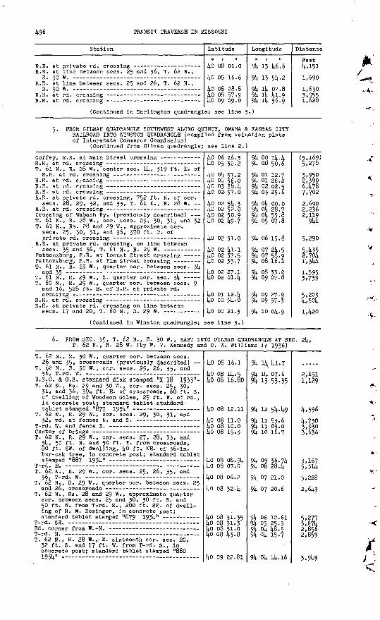
TRANSIT TRAVERSE IN MISSOURI
Station
R.R. at line between sees. 25 and 36, T. 62 N., Rzn w
R.R. at line between sees. 25 and 26, T. 62 N. ,
(Continued in Darlington quadrang]
Latitude
0 | II
kO 08 01.0
kO 08 16.6
kO 08 28.8ko 08 57-9kO 09 09.0
e; see line I
Longitude
0 1 II
9U 13 k6.6
9k 13 51; -2
91; Ik 07.8 9k ik la. 9 9k ik 56.9
.)
Distance
Feet k,151
1,690
1,630 3,9551,620
5. PROM OILMAN QUADRANGLE SOUTHWEST ALONG QUINCY, OMAHA & KANSAS CITY RAILROAD INTO WINSTON QUADRANGLE (compiled from valuation plats of Interstate Commerce Commission)
(Continued from Oilman quadrangle; see line 2.)
T. 6l N. , R. 28 W., center sec. ik, 319 ft. E. of
R.R. at private rd. crossing, 752 ft. K. of cor. sees. 28, 29, 32, and 33, T. 6l N., R. 28 W.
Crossing of Wabash Ry. (previously described) T. 6l N., R. 28 W., cor. sees. 29, 30, 31, and 32 T. 6l N., Rs. 28 and 29 W. , approximate cor.
sees. 25, 30, 31, and 36, 370 ft. K. of
R.R. at private rd. crossing, on line between
Pattonsburg, R.R. at Locust Street crossing - --
T. 6l N., R. 29 W., quarter cor. between sees. 3k
T. 6l N., R. 29 W. , S. quarter cor. see. 3k T. 60 N., R. 29 W. , quarter cor. between sees. 9
and 16, 528 ft. E. of R.R. at private rd.
R.R. at private rd. crossing on line between
(Continued in Winston quadrangle;
kO 06 16.3 kO 05 32.2
k.0 Ok 57.. 2 liO- Ok 36.0ko 03 38. k ko 02-57.0kO 02 5k. 3 kO 02 52.0lio 02 50.9kO 02 49.7
kO 02 51.0
kO 02 kl.l kO 02 37-5 kO 02 35-7
ko 02 27.1kO 02 01. k
kO 01 12. kko oo 314.. okO 00 21.3
see line 3.)
9k op ik.k 9k oo 50.6
9k 01 12.7 9k 01 26.2 9k 02 02.5 9k 03 25.6
9k Ok 00.0 9li Ok 28.79k ok 55.89k 05 07.8
9k 06 15.8
9k 07 2k. 5 9k 07 58.9 9k 08 16.1
9k 08 35.2sk 09 07-8
9k 09 27.9 9k 09 57.3
9k 10 Ok. 9
(5.169) 5,2703,950 2,390 6478 7,702
2,690 2,236 2,119
9kl
5,290
5,k35 2,70k l,3kk
1,595 3,759
5,203 faokI,k20
6. FROM SEC. 35, T. 62 N., R. 30 W. , EAST INTO OILMAN QUADRANGLE AT SEC. 2k, T. 62 N., R. 28 W. (by W. V. Kennedy and C. W. Williams in 1936)
T. 62 N. , R. 30 W., quarter eor. between sees. 26 and 35, crossroads (previously described) --
T. 62 N., R. 30 W. , cor. sees. 25, 26, 35, and
D.S.C. & G.S. standard disk stamped "X 18 1933"- T. 62 N., Rs. 29 and 30 W., cor. sees. 25, 30,
31, and 36, 39k ft. E. of crossroads, 60 ft. S. of dwelling of Woodson Giles, 25 ft. N. of rd. , In concrete post; standard tablet standard
T. 62 N., R. 29 W. , cor. sees. 29, 30, 31, and
T. 62 N., R. 29 W., cor. sees. 27, 28, 33, and jk, 50 ft. N. and 50 ft. E. from crossroads, 80 ft. SW. of dwelling, kO ft. NE. of 36-in. bur-oak tree, In concrete post; standard tablet
T. 62: N., R. 29 W. , eor. sees. 25, 26, 35, and
T. 62 N. , R. 29 W., quarter cor. between sees. 25
T. 62 N., Rs. 28 and 29 W., approximate quarter cor. between sees. 25 and 30, 30 ft. S. and 50 ft. W. from T-rd. S., 200 ft. SE. of dwell ing of H. M. Kesinger, in concrete post;
T. 62 N., R. 28 W. , E. sixteenth cor. see. 20, 32 ft. S. and 17 ft. W. from T-rd. S., in
. concrete post; standard tablet stamped "880 193k'-
kO 08 16.1
kO 08 Ik. 5 kO 08 16.80
kO 08 12.11
kO 08 11.0lio 08 10.0 lio 08 15.3
ko 08 08. 9k lio 08 07.0
kO 08 06.2
kO 08 32. k
ko 08 31-35 lio 08 31-3 lio 08 31.0 ko 08 43-8
kO 09 22.81
9U Il4i kl.7
9k ik 07.6 9k 15 53-35
9k 12 5k.k9
9{; 11 53-6 9k 11 03.0 9k 10 16.7
9k 09 36.7^ 9li 08 284
9k 07 21.0
9k 07 20.6
9k 06 12.619k os 25.3 9k ok k8.5 9k ok 15.7
9k ok ik. 16
2,651 1,129
k,596
k,730 3,930 3,636
3,167 5,3lk
5,228
2,6k5
5,277 3,67k 2,856 2,859
3,9k9
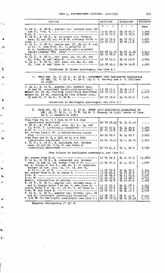
PART 'k, NORTHWESTERN MISSOURI, 1911-1937 14-97
Station
T. 62 N., R. 28 W., quarter cor. between sees. 20
T. 62 N. , R. 28 W., E. sixteenth cor. between sees. 21 and 28, rd. at E.-W. drainage ditch --
T. 62 M., R. 28 W. , center see. 27, 2k ft. N. and 33 ft. W. from T-rd. W. , on property of W. S. Vandervort. in concrete post; standard
T. 62 N., R. 28 W., cor. sees. 22, 23, 26, and
T. 62 N. , R. 28 W. , cor. sees. 23, 2k, 25, and
(Continued in Oilman quadrangle; s
Latitude
kO 09 22.9 kO 09 22.8
kO 08 56. klio 08 30.]
ko 08 29.76kO 09 08.9
kO 08 55-2
ko 08 55.5
ee line 3.)
Longitude
0 | II
9k 03 56.79k 03 05.3
9k 03 p5.s 9k 02 14.7.8
9k 02 15.02 9li 02 14.2
9k 01 kO.O
9k 00 32.8
Distance
Poet
1,556 5,987
2,670 3,003
2,514.5 5,961
2,995
FROM SEC. 35, T. 62 N., R. 30 W., NORTHWEST INTO DARLINGTON QUADRANGLE AT SEC. 23, T. 62 N., R. 30 W. (by W. V. Kennedy and C. W. Williams in 1936)
T. 62 N.,
Wabash Ry Wabash Ry
y. nnrl
R.
55,. at . ato£
30 w
rd. rd.
T. A
., quarter cor. between sees.
crossing (previously described) crossing on line between sees.
? N- R. *n w _ ________ ____
kokol,n
08 1608 57
no. no
9
.n
9k9kol,
iklit- iii
kl.75l.6C,f,-£>
k i
,228
£ 1),
(Continued in Darlington quadrangle; see line 9-)
PROM SEC. 22, T. 60 N., R. 30 W., NORTH INTO SEC. 26, T. 62 N., R. 30 W. (by W. V. Kenm by J. L. Sanders in 1921)
DARLINGTON QUADRANGLE idy in 1956) (rerun of
AT line
Prim Trav Sta No 70 S 1921 Mo 17 R S 1922
T. 60 N., R. 30 W. , cor. sees. 10, 11, Ik, and
Rd. corner from S.-W. on DeKalb-Gentry county
Prim Trav Sta No 7k S 1921 Mo (4.5 R S 1922
T. 6l N., R. 30 W. , E. sixteenth cor. between sees. 23 and 26, T-rd. W. and fence E.
(For balance in Darlington quadran
kO 00 28.22
kO 01 20.Sko 01 33.8kO 02 09.6
kO 03 02.1k
kO 03 5k. 2
gle, see line
9k ik 30.90
9k Ik 29.9 9k Ik 29.8
9k Ik 29.3
9k Ik 29.71
9k Ik 29.5
8.)
5,290 1,340
3,623
5,312
5,259
T. 6l N., R. 30 W. , E. sixteenth cor; between sees. 11 and Ik, rd. corner from S.-E. - --
Rd. at fences N. and S., 200' ft. N. of sandstone boulder at cor. sees. 11, 12, 13, and Ik,
Rd. corner from W.-N. at fence S. - ---
T. 6l N., R. 30 VI.,. quarter cor. between sees. 1 and 2, County Route T at rd. N. and fence S.
County Route T at rd. N. , 33 ft. E. of fence S. -
T. 62 N., R. 30 W. , quarter cor. between sees. 26 and 35, crossroads (previously described) -----
B 1923 Mo (In Darlington quadrangle; see line 7.)
ko 05 19.3 ko 05 37.9
ko 05 39.8 lj.o 05 [4.3.8Ij-O 06 02.0 kO 06 28. kko 06 39.8kO 06 56.3ko 06 58.0kO 07 23-5
kO 08 16.1lio 08 18.25
9k Ik 27.5
9k Ik 26.7
9k Ik 09-5 9k 13 35-p 9k 15 21. k 9k 13 28.3 9k 13 27.6
9k Ik 08.09k ^ kH9k il,. k2.6
9k Ik 14.1-99k 15 3k49
(5,287)
1,676
1,5514. 2,711 2,127 2,713 1,158
5,551 2,758 2,579
5,521 4,109
Magnetic declination 7° 21' E.

498 TRANSIT TRAVERSE IN MISSOURI
BETIIANY QUADRANGLE (Latitude kO°15'-kO°30'; longitude 9k°00'-94°15')
Gentry, Harrison, and Worth Counties
R29W R26W
41. PROM MOUHT AYR QUADRANGLE AT-SEC. 27, T. 66 N., R. 28 W., EAST INTO
MOUNT AYR QUADRANGLE AT SEC. 26, T. 66 N., R. 28 W. (by J. L. Sanders in 1923)
(Continued from Mount Ayr quadrangle; see line 1.)
Station
T_-nH W- _________________ ________ ______ __
Latitude
ko 29 48.5l.n 90 l.fl fi
Longitude.
9k 02 46.0oli m sit f.
Distance
Feet (4,200)
Z Q'jf,
(Continued in Mount Ayr quadrangle; see line 1.)
2. PROM GENTRY QUADRANGLE AT SEC. 35, T. 6k N., R. JO W., NORTH INTOMOUNT AYR QUADRANGLE AT SEC. 2k, T. 66 N., R. 30 W. (by J. P. Anderson in 193k)
(Continued from Gentry quadrangle; see line 6.)
at lences
W. - koko4o
T fi
1919
35 3.0
9k ik9k ik9k 14
O3.kZ"7 (.
(6,835)
4,730
(For balance in Gentry quadrangle, see line 6.)
._._ _ ___________ | 40 25 43.6 9k ik 55.0 (5,375)
(For balance in Gentry quadrangle, see line 6.)
Crossroads - ----- ___ ______ ________ ___ Rd. at fences E. and W. on Harrison-Worth county
line
kO 29 11.7
kO 29 22.k
9k 14 27-7
94 13 53-5
(2,685)
2,855
(Continued in Mount Ayr quadrangle; see line 2.)
3. PROM GENTRY QUADRANGLE EAST ALONG STATE HIGHWAY 4 TO SEC. 18, T. 63 N., R. 28 W., THENCE EAST ALONG ROADS TO BETHANY (by H. W. Gross in 1935)
(Continued from Gentry quadrangle; see line 7.)
Highway at fences H. and S. on Gentry-Harrison
New Hampton, 2k ft. S. and 33 ft. E. from State Highway 4 at Vine Street, 14 ft. N. of side walk, in parkway, in concrete post; standard
New Hampton, 3 ml. E. of, along State Highway 4, 27 ft. N. and 20 ft. W. from junction of rd. H., l4l ft. E. of bridge over White Oak Creek, in concrete post; standard tablet stamped
40 15 54.2 40 15 52.7
k° *5 k2'5 ko 15 48-3
40 15 46.23 ko 15 38.7 40 15 22.0 40 15 13-3
40 15 07.75
94 i4 40.2 94 i4 05.39k 12 57-2 94 12 24.0
94 11 46-30 94 11 15-6 94 10 06.9 94 09 32.9
94 08 26.81
(2,630)2,7075,290 2,576
2,929 2,499 5,59p 2,774
5,157

PART 1;, NORTHWESTERN MISSOURI, 1911-1937 14.99
Station
T. 63 N., R. 29 W. , cor. sees. 13, Ik, 23, and
Highway at fences N. and S., 12 ft. S. of E. cor.
Bethany, about k-3 mi. W. of, along State Highway k, 5k ft. N. and 27 ft. W. from farm house of George Jestia, 35 ft- S. of highway, in concrete post; standard tablet stamped»8k5 1931+"
T. 63 N., R. 28 W., cor. sees. 17, 18, 19, and
Bethany, in SW. part of, 18 ft. S. and 18 ft. W. from intersection of tangents of State Highway k at curve from S.-E., 18 ft. S. of street, on property of William Poster, in concrete post;
Bethany, corner of U.S. Highway 69 from W.-N. atrPu/AT ̂ 1-V\ Q4-T»«»4-
Bethany, Chicago, Burlington & Quincy R.R. at
Bethany, in SW. corner of courthouse yard, 6 ft. N. and 35 ft. E. from property line, in concrete post; standard tablet stamped "61;7 193V - - --
Latitude
ko 15 06.91;0 15 06.6 l;0 15 06.1
lt.o 15 05-7
kO 15 00.00
kO 15 05.0 kO 15 OL.lt kO 15 kk.k
kO 15 28.22
ko 15 27.9
ko 15 k7.6
l;0 16 07.76
Longitude
9k 07 16.7 9k 06 59.5 9k 06 254
9k 06 08.0
9k 05 12.38
9k 05 02.1 9k 03 36.5 9k 01 58.5
9k 02 k5.02
9k 02 17.5
9k 02 07. k
91; 02 06.25
Distance
Peet
5,M*0 1,330 2,6^1
l,35tt.
L,352
, $* 6,6358,612
3,960
2,137
2,lk2
2,0l;2
k. PROM GENTRY QUADRANGLE AT SEC. 2, T. 61). N., R. 30 W., EAST INTO BLYTHEDALE QUADRANGLE AT SEC. 36, T. 65 N. , R. 28 W. (by H. W. Grossin 1935)
837 19314. (In Gentry quadrangle; see line 3.) T. 61). N., R. 30 W. , cor. sees. 1, 2, 11, and 12,
T J T?
T. 6k N., R. 29 W., W. cor. sees. 6 and 7, on Harr is on-Worth county line, iron pin at rd.
T. 61; N., R. 29 W., cor. sees. 5, 6, 7, and 8, 30 ft. N. and 30 ft. W. from crossroads, 33 ft. S. and 5 ft.- W. from windmill on property of G. W. Starmer, in concrete post; standard
T. 6k N., R. 29 W., cor. sees. ' k, 5, 8, and 9,
T. 61; N., R. 29 W., cor. sees. 3, 1;, 9, and 10,
T. 61; N. , R. 29 W., near quarter cor. between sees. 2 and 11, 15 ft. N. and 31 ft. W. from farmhouse of Simmie Smith, 21 ft. S. and 330 ft. W. from rd. at fence S., in concrete post;
West Pork of Little Creek, center of bridge over-
T. 61; N., R. 28 W., in sec. 8, 21 ft. S. and 85 ft. E. from T-rd. N., 69 ft. N. and 21 ft. E. from NE. corner of Mahaska School, in concrete
T. 61; N., R. 28 W. , quarter cor. between 'sees. 8
T. 61; N. , R. 28 W. , quarter cor. between sees. 9
West Fork of Big Creek, center of bridge over - T. 61; N. , R. 28 W. , near quarter cor. between
sees. 10 and 11, 23 ft. N. and 23!; ft. E. from rd. at fence S. and hedge fence N. , 63 ft. S. and 12 ft. E. from farmhouse of Eldon Landls, in concrete post; standard tablet stamped "895 19514." .. . .. ..... . . .. __. .
Tps. 61; and 65 N. , R. 28 W., cor. sees. 1, 2, 35, and 36, 36 ft. N. and k2 ft. W.. from U.S. Highway 69 at rd. W. , 2 ft. E. of fence-, in concrete post; standard tablet stamped "650'
kO 22 Ik. 29
kO 22 12.3 kO 22 11.6 lj.0 21 58.!;
kO 22 09.9 1;0 22 09.7
kO 22 09.15 5.0 22 08. k
kO 22 07.9
kO 22 07.8 1;0 22 07.1
kO 22 05.51 lj.0 22 07.7 kO 22 Ol;.7 lj.0 22 Ok. 6
kO 21 38.12
kO 21 38.2 ko 21 37-9
kO 21 37.7 kO 21 37-3
VkO 21 36.79 kO 21 36.0 1;0 22 02.3 1J.O 22 28.2
kO 22 5k. 72
9k 15 25.70
9k Ik 00. k 9k 13 25. I 9k 13 25.9
9k 12 51.0 9k 12 3U-7
9k il-k3.98 9U 11 09.3
9k 10 35-3
9k 09 26.9 9k 08 52.5
9k 07 k8.k79k 07 12-79k 06 17. k 9k 05 k9.k
9k ok 22.85
9k 03 k9.k 9k 03 14.9
9k 02 kO.? 91; 02 06. Ij.
9k 01 28.009k oo 38.9yl; 00 38.6 91; 00 21.1
9k oo 21.79
6,603 2,696 1,329
2,933 l,26l
3,929 2,682
2,637 5,2902,662
k,96i 2,780 U,29i 2,165
7,213
2,586 2,673
2,680 2,620
2,976 3,803, 2,658 2,957
2,680
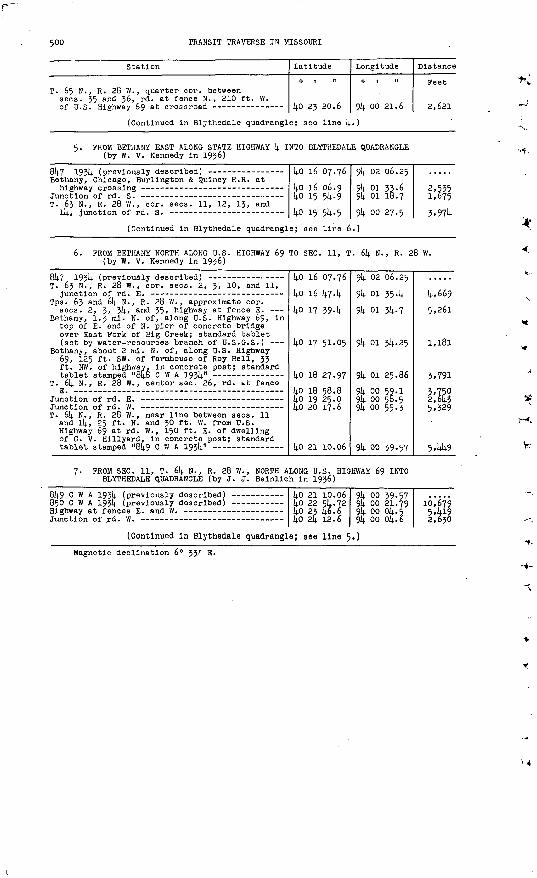
500 TRANSIT TRAVERSE IN MISSOURI
Station
T. 65 N., R. 28 W., quarter cor. between sees. 35 and 36, rd. at fence N. , 210 ft. W.
Latitude
lin p* ?n.A
Longitude
0 1 "
oil nn PI -6
Distance
Feet
P API
(Continued in Blythedale quadrangle; see line k.)
5. FROM BETHANY EAST ALONG STATE HIGHWAY k INTO BLYTHEDALE QUADRANGLE (by W. V. Kennedy In 1936)
8k7 1931; (previously described) - Bethany, Chicago, Burlington & Quincy R.R. athighway crossing - -- -- - --- -----
Junction of rd. S. -- --- ----- .._- T. 63 N., R. 28 W., cor. sees. 11, 12, 13, and
Ik, junction of rd. S. --- ------
kO 16 07.76
kO 16 06.9ko 15 5k.9 ko 15 5k.5
9k 02 06.259k 01 3J.69li 01 18.7
914. oo 27.5(Continued In Blythedale quadrangle; see line 6.)
2,5351,675
6. FROM BETHANY NORTH ALONG U.S. HIGHWAY 69 TO SEC. 11, T. 6k N., R. 28 W. (by W. V. Kennedy In 19j6)
T. 63 N., R. 28 W. , cor. sees. 2, 3, 10, and 11,
Tps. 63 and 6k N. , R. 28 W. , approximate cor. sees. 2, 3, 3!)., and 35, highway at fence E. -
Bethany, 1.3 ml. N. of, along U.S. Highway 69, In top of E. end of N. pier of concrete bridge over East Fork of Big Creek; standard tablet (set by water-resources branch of U.S.G.S.)
Bethany, about 2 ml. N. of, along U.S. Highway 69, 125 ft. SW. of farmhouse of Roy Bell, 33 ft. NW. of highway. In concrete post; standard
T. 6k N. , R. 28 W. , center sec. 26, rd. t-t fence
T. 6k N., R. 28 W. , near line between sees. 11 and Ik, 25 ft. N. and 30 ft. W. from U.S. Highway 69 at rd. W. , 150 ft. E. of dwelling of G. V. Hlllyard, In concrete post; standard
ko 16 07.76kO 16 lj.7. k
ko 17 39. k
kO 17 51-05
kO 18 27-97
ko 18 58.8 ko 19 25.0kO 20 17.6
kO 21 10.06
°k 02 06.25
9k 01 354 9k 01 3k. 7
91; 01 31). 25
914. 01 25.86
9k oo 59.1 9k oo 58.5 91; oo 55.3
914. oo 39.57
k,669 5,261
1,181
3,7913,750 2,643 5,329
5,144-9
PROM SEC. 11, T. 614. N., R. 28 W., NORTH ALONG U.S. HIGHWAY 69 INTO BLYTHEDALE QUADRANGLE (by J. J. Belnllch In 1936)
8k9 C W A 19314. (previously 850 C W A 193k (previously Highway at fences E. and W.
kO 21 10.06 kO 22 5k. 72 li.0 25 (4.6.6 kO 2k 12.6
9k oo 39.57 9!; oo 21.79 9li oo ok. 5 9li oo oli. 6
16^679 2,630
(Continued In Blythedale quadrangle; see line 5.)
Magnetic declination 6° 33;' E.
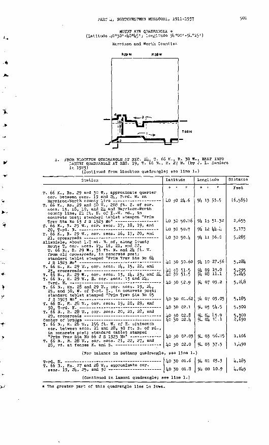
PART k, NORTHWESTERN MISSOURI, 1911-1937 501
MOUNT AYR QUADRANGLE » (Latitude kO°50> -kO°k5' ; longitude 9k°00' -9k°15")
Harrlson and Worth Counties
R29W R28W
1. FROM BLOCKTON QUADRANGLE AT SEC. 2k, T. 66 N., R. JO W., EAST INTOLAMONI QUADRANGLE AT SEC. 19, T. 66 N., R. 27 W. (by 3. L. Sanders in 192J)
(Continued from Blockton quadrangle; see line 1.)
Station
T. 66 N., Rs. 29 and JO VI. , approximate quarter cor. between sees. 19 and 21)., T-rd. W. on
T. 66 N., Rs. 29 and JO W. , 208 ft. E. of cor. sees. 15, 18, 19, and 2k and Harrison-Worth county line, 21 ft. N. of E.-W. rd. , in concrete post; standard tablet stamped "Prim
T. 66 N., R. 29 W. , cor. sees. 17, 18, 19, and
T. 66 N., R. 29 W., cor. sees. l6, 17, 20, and
Allendale, about 1.7 ml. N. of, along County Route T, cor. sees. 15, 16, 21, and 22, T. 66 N., R. 29 W., J6 ft. N. and 2k ft. W. from old crossroads, in concrete post; standard tablet stamped "Prim Trav Sta No 6k
T. 66 N., R. 29 W. , cor. sees, Ik, 15, 22, and
T. 66 N., R. 29 W. , cor. sees. 1J, Ik, 2J, and 214. T. 66 N., R. 29 W., E. cor. sees. 1J and 2k,
T. 66 N., Rs. 28 and 29 \V. , cor. sees. 19, 2k, 25, and JO, W. of T-rd. E. , in concrete post; standard tablet stamped "Prim Trav Sta No 65
T. 66 N., R. 28 W., cor. sees. 19, 20, 29, and
T. 66 N., R. 28 W., cor. sees. 20, 21, 28, and
T. 66 N., R. 28 W. , 155 ft. W. of E. sixteenth cor. between sees. 21 and 28, JO ft. S. of rd., in concrete post; standard tablet stamped
T. 66 N., R. 28 W. , cor. sees. 21, 22, 27, and
Latitude
14.0 JO 2k- 6
ko jo 50.76 ko jo 50.7 14.0 jo 50.14.
14.0 jo 50.60ko jo 51-5 ko jo 51.5¥> JO 52.9
kO JO 01.62
kO JO 02.1
kO JO 02.8 lj.0 JO 02.lv
ko jo 02.05kO JO 02.0
Longitxide
0 1 II
9k 15 55-5
9k 1J 51-52
9k 12 kk.k
9k 11 56.0
9k 10-27.56
9k 09 19.0 9k 08 11.1
9k 07 05. 2
9U 07 oj.05
914. 05 5^-5
914. Ok k5-9 9k Ok 11.1
9k oj 56.75
9k 05 57-5
Distance
Feet
(6,585)
2,655
5,175
5,285
5,281;
5,295 5,2455,2k8
5,185
5,500
5,300 2,690
1,106
1,14.90
(For balance in Bethany quadrangle, see line 1
kO JO 01.6
kO JO 01.8
(Continued In Lamonl quadrangle; see line 1.)
T-rd. N. ' T. 66 N., Rs. 27 and 28 W., approximate cor
sees. 19, 2k, 25, and JO
914. 01 05.3
94 00 10.9
It., 185
It., 014.5
* The greater part of this quadrangle lies in Iowa.

502 TRANSIT TRAVERSE IN MISSOURI
Station Latitude Longitude
2. PROM BETHANY QUADRANGLE AT SEC. 2k, T. 66 N., R. 30 W. , NORTH TO SEC. 18, T. 66 N., R. 29 W. (by J. P. Anderson in 193k)'
(Continued from Bethany quadrangle; see line 2.)
Prim Trav Sta No 63 J S 1923 Mo (previouslykO 30 2k- 7
ko 30 50.769k 15 55 -k
9k 13 51.32
Distance
Feet
(6,300)
2,650
3. PROM LAMONI QUADRANGLE AT SEC. 31, T. 6? N. , R. 27 W. , WEST TO SEC. 31, T. 67 N., R. 29 W. (by J. P. Anderson in 193k)
(Continued from Lamonl quadrangle; see line 2.)
Tps. 66 and 67 N. , Rs. 27 and 28 W. , cor. of,
T. 66 N., R. 28 W., near N. cor. sees. 1 and 2, 20 ft. N. of T-rd. S., 75 ft. SE. of SE. corner of dwelling owned by W. A. Gruenwolf, in concrete post; standard tablet stamped "855 195k" - - -
T. 67 N., R. 28 W. , S. cor. sees. 3k and 35,
T. 66 N., R. 28 W., N. cor. sees. 3 and k,
T. 66 N., R. 28 W., 0.2 mi. W. of N. cor. sees, k and 5, 60 ft. SW. of dwelling of P. J. Kinder, kO ft. N. of rd.. in concrete post; standard
Tps. 66 and 67 N. , Rs. 28 and 29 W. , cor. of,
T. 66 N., R. 29 W., N. cor. sees. 1 and 2, 33 ft. N. and kkO ft. E. from T-rd. S., 110 ft. S. of dwelling of P. Butler, 36 ft. S. of gate, in concrete post; standard tablet stamped "857
T. 66 H., R. 29 W. ', cor. sees. 1, 2, 11, and 12,
T. 66 N., R. 29 W., cor. sees. 2, 3, 10, and 11,T rd E --. -.
T. 66 N./R. 29 W., 0.2 mi. S. of N. cor. sees. 2 and 3, 50 ft. N. of rd. corner from S.-NW. , 100 ft. NE. of dwelling of Walter Mathis, In concrete post; standard tablet stamped "858 195k" - - -
Tps. 66 and 67 N. , R. 29 W. , approximate cor.
T. 67 N. , R. 29 W., N: cor. sees. 31 and 32, 3 ft. S. and 17 (? 25) ft. E. from rd. at former fence line E. on Iowa-Mo. State line, on top of prominent hill, In concrete post; standard
ko 35 51.0 kO 33 31.1
kO 33 31. k7 kO 35 51.0
ko 33 30.6 ko 33 30.6
kO 35 50.7 kO 35 50-7
ko 33 30.81 ko 35 50.5 ko. 55 50.k ko 35 50.2
ko 33 29.9 kO 33 29.8
ko 33 30.01 ko 33 02.6
kO'32 36.0 ko 32 36.1
ko 32 35-9
kO 33 16.85 kO 33 29-k kO 33 28.9 ko 33 28.5
kO 33 28.3
ko 3k 19.56
9k oo 11.3 9k oo k6-5
9k 01 22.27 9k 01 5k. 9
9k 02 28. k 9k 03 05.2
9k 03 39.9 9k ok Ik. 5
9k 05 11 -7k 9k 05 20.3 9k 05 57.2 9k 06 27.8
9k 07 ok. 2 9k 07 38.5
9k 08 05. k6 9k 08 ll.l
9k 08 11.2 9k 08 k6-3
9k 09 16.6
9k 09 18.91 9k 10 13.3 9k 11 Ok. 5 9k li 53-8
9k 12 k7-7
9k 12 k6.69
(5,kio)2,710
2,760 2,520
2,585 2,8kO
2,675 2,670
k,k!5 £65
2,850 2,360
2,810 2,630
2,095 2,810
2,685 2,7052,3kO
k,150
3*950 3,800
k,l6o
5,160
PROM BLOCKTON QUADRANGLE AT SEC. 36, -T. 67 N., R. 30 W., EAST TO SEC. 31, T. 67 N., R. 29 W. (by S. T. Tudor In 193k)
(Continued from Blockton quadrangle; see line 3.)
T. 67 N. , Rs. 29 and 30 W., approximate quarterkokoko
55
553k
50
53 "
6
5, 56
9k
9k9k
Ik 2
15 5
9-5c Q
6.69
(2
5
,662)/ OT
,957
5. PROM SEC. 18, T. 66 N., R. 29 W., NORTH TO SEC. 31, T. 67 N., R. 29 W. (by H. W. Gross in 193k and 1935)
Prim Trav Sta No 63 J S 1923 Mo (previously
T. 66 N., R. 29 W., cor. sees. 17, 18, 19, andkO 30 50-7ko 31 16.7
9k 13 51-32
9k 12 kk.J9k 12 kk-5 2,63k

PART k, NORTHWESTERN MISSOURI, 1911-1937 503
Station
T. 66 N., R. 29 W., cor. sees. 5, 6, 7, and 8, 20 ft. N. and 15 ft. W. from stone at cross roads, 18 ft. S. and 2k ft. E. f rom. Hermix Store, In concrete post; standard tablet
T. 66 N., R. 29 W. , N. cor. sees. 5 and 6, stone
Latitude
0 I II
ko 32 3k- 5k kO 33 00.0
ko 33 28.2 kO 3k 19.36
Longitude
9k 12 kk-77 9k 12 kk-6
9k 12 k5-2 9k 12 k&.69
Distance
Feet
7,87k 2,581
2,855 5,176
Magnetic declination 7° 1?' E.
BLOCKTON QUADRANGLE * (Latitude kO°3°'-k°°k5'! longitude 9k°15' -9k°30')
Worth County
R 31 W R30W
T66N
I
1. FROM GENTRY QUADRANGLE AT SEC. 23, T. 66 N., R. 30 W., EAST AND NORTH INTO MOUNT AYR QUADRANGLE AT SEC. 2k, T. 66 N., R. 30 W. (by J. L. Sanders In 1923)
(Continued from Gentry quadrangle; see line 1.)
Station
(Continued In Mount Ayr quadrangle
Latitude
0 1 It
kO 3° 2k- 7
; see line 1.
Longitude
0 1 It
9k 15 18-7
)
Distance
Feet (3.28k)
2. FROM GENTRY QUADRANGLE AT SEC. 23, T. 66 N., R. 32 W. , NORTH INTO BEDFORD QUADRANGLE AT SEC. 35, T. 67 N. , R. 32 W. (by S. T. Tudor In 193k)
(Continued from Gentry quadrangle; see line 1)..)
T-rd. S. near cor. sees. 13, Ik, 23, and 2k,
T. 66 N., R. 32 W., In SE lA sec. 11, 19 ft. N. and 200 ft. E. from rd. corner from E.-S., in concrete post; standard tablet stamped "760
T. 66 N., R. 32 W., cor. sees. 1, 2, 11, and 12,
T. 66 N., R. 32 W., N. cor. sees. 1 and 2, rd.
T. 67 N., R. 32 W., S. quarter cor. sec. 35,
T. 67 N., R. 32 W., near N. quarter cor. sec. 35, 35 ft. S. and 28 ft. W. from T-rd. S. on Iowa-Mo. State line, in concrete post; standard
T. 67 N., R. 32 W. , N. cor. sees. 3!). and 35,
(Continued In Bedford quadrangle; see
ko 30 25414.0 30 52.0ko 31 17-7 ko 31 k3-8
kO 31 56.25ko 32 09.9kO 32 35.6 kO 33 01.8
ko 33 304
kO 33 30.7 ko 33 56.6
ko 3k 15-17
ko 3k 15 -k
line 1.)
9k 28 k6.l
9k 28 k6-l 9k 29 03-0 9k 29 03.0
9k 29 oo. 38 9k 28 k5-«
9k 28 k5.6 9k 28 k&-9
9k 28 k5-5
9k 29 19-8 9k 29 20.2
9k 29 20.25
9k 29 5k- 2
(2,6kO)
2,6852,910 2,6ko
1,280 1,780
2,6102,6k5
2,895
2,650 2,625
1,875
2,620
* The greater part of this quadrangle lies in Iowa.

50k TRANSIT TRAVERSE IN MISSOURI
Station
_3. PROM SEC. 35, T. 67 N., R. 32 W., EAST IN
SEC. 36, T. 67 N., R. 30 W. (by S. T. T
T. 67 H., R. 32 W., N. eor. sees. 35 and 36,
Rd. corner from W.-N. on lov/a-Mo. State line near N. cor. sees. 31 and 36, T. 67 N., Rs. 31 and
T. 67 N., R. 31 W., N. cor. sees. 31 and 32, rd.
Irena, 1.5 ml. N. , thence 1.2 ml. W. from, 0.3 ml. W. of N. cor. sees. 32 and 33, T. 67 N. , R. 31 W., 18 ft. S. of rd. on Iowa-Mo. State line, In concrete post; standard tablet stamped
T. 67 N., R. 31 W., N. eor. sees. 32 and 33, rd.
Chicago, Burlington & Qulncy R.R. at rd. crossing T. 67 N., R. 31 W. , N. cor. sees. 33 and 3^,
Irena, 0.5 mi. N. of, along U.S. Highway 169, near S. quarter eor. sec. 3k, T. 67 N., R. 31 W., 26 ft. N. and 36 ft. W. from cross road, In concrete post; standard tablet stamped
T. 67 N., R. 31 W., S. cor. sees. 3k and 35, T-rd N -- - - -
T. 67 N., R. 31 W., S. cor. sees. 35 and 36,
Tps. 66 and 67 N. , Rs. JO and Jl W. , cor. of,
Tps. 66 and 67 N., R. 30 W. , approximate cor.
Irena, 0.5 ml. N. , thence 3.8 ml. E. from, near W. sixteenth cor. on N. line sec. 5, T. 66 N., R. 30 W., 22 ft. S. and 580 ft. E. from T-rd. S., in concrete post; standard tablet stamped
Tps. 66 and 67 N., R. 30 W. , approximate cor.
Tps. 66 and 67 N. , R. 30 W., approximate cor.
(Continued in Mount Ayr quadrangle
Latitude
0 | II
TO MOUNT AYR udor in 193!).;
kO 3k 15-17
ko 3k 15.5kO 3k 15-7
ko 3k 15-8 ko 3k 15.9
kO 3k 16.1
kO 3k 16. kO
kO 3k 16.6ko 3li 16.6
kO 3k 16.8 kO 3k 17-0 M) 33 55-3
ko 33 29-35
kO 33 29.2 ko 33 29.0
kO 33 29.0 ko 33 28.9
ko 33 28.7 kO 33 28.7
ko 33 28.7
ko 33 28.28
ko 33 28.5
kO 33 28.0 ko 33 5k. 2 ko 33 5k. o ko 33 53.6ko 33 53-3 ko 33 53.3
see line k.
Longitude
0 | II
QUADRANGLE AT
9k 29 20.25
9k 28 k5-99k 28 11.8
9k 27 3k. 7 9k 27 03.1
9k 26 28.1
9k 25 kk-65
9k 25 23.3 9k 2k k6.5
9k 2k 11.29k 23 36.2 9k 23 37-2
9k 23 37.8k
9k 23 03.29k 22 28.9
9k 21 5k.k 9k 21 20.3
9k 20 k6.0 9k 20 10.8
9k 19 36-2
9k 19 11.16
9k 18 26. k
9k 17 21.0 9k 17 20; 7 9k 16 1).6.1| 9k 16 12.0 9k 15 37-9 9k 15 03-8
)
Distance
Feet
2,650 2,635
2,860 2,k56
2,700
3,3541,650 2 t 8kO
2,720 2,700 2,195
2,625
2,676 2,61*7
2,660 2,630
2,650 2,720
2,670
1,928
5,055 2,6k7
2*635 2,629
Magnetic declination 8° 03' E.

PART 4, NORTHWESTERN MISSOURI, 1911-1937 505
GENTRY QUADRANGLE (Latitude 40°15'-40°30'; longitude 94°15' -94°30')
Gentry and Worth Counties
) T65N
1. PROM PARNELL QUADRANGLE AT SEC. 34, T. 66 BLOCKTON QUADRANGLE AT SEC. 2$, T. 66 N, in 1923)
(Continued from Parnell quadrangle;
N., R. 32 W., EAST INTO, R. 30 W. (by J. L. Sanders
see line 1.)
Station
T. 66 N., Ri 32 W. , E. sixteenth cor. between sees. 26 and 35, 60 ft. NE. of dwelling of I. W. Paubion, 18 ft. S. of rd., in concrete post; standard tablet stamped "Prim Trav Sta
T. 66 N., R. 32 W., cor. sees. 25, 26, 35, and
T. 66 N., Rs. 31 and 32 W. , approximate cor.
T. 66 N., R. 31 W. , cor. sees. 29, 30, 31, and
Grant City, intersecblon of Fourth and High
Grant City, 100 ft. NE. of public school, 30 ft. N. of N. rail of Chicago, Burlington & Quincy 'R.R., in concrete post; standard tablet stamped
Grant City, Chicago, Burlington & Quincy R.R. at
Middle Fork of Grand River, center of bridge over
T. 66 N., R. 31 W., quarter cor. between sees. 25 and 36, 31 ft. N. and 72 ft. E. from cross roads, 75 ft. S. of dwelling of J. E. Wyman, in concrete post; standard tablet stamped "Prim
Grant City, about 3.2 ml. E. of, along State Highway 4&> 30 ft. N. and 15. ft. E. from cross road, in E. head wall of concrete culvert; standard tablet stamped "1 H 1936"**
T. 66 N., Rs. 30 and 31 W. , approximate cor.
East Fork of Grand River, center of bridge over - T. 66 N., R. 30 W. , N. sixteenth cor. between
Allendale, 0-5 ml. N. of, near cor. sees. 21, 22, 27, and 28, T. 66 N., R. 30 W., 2k ft. N. and 32 ft. W. from T-rd. S., 60 ft. S. of dwelling of James Miller, in concrete post; standard tablet stamped "Prim Trav Sta 62 J S 1923 Mo" -
Latitude
0 I II
40 29 07.39
14.0 29 07.4 40 29 074
40 29 07.3 40 29 06.740 29 06.2
40 29 07.9
l(.0 29 07.614.
ko 29 19.7 4o 29 06.5 4o 29 06.340 29 06.2
1).0 29 06.85
lt.0 29 06.7[4.0 28 514..!40 28 53-54o 29 12.3
4o 29 32.51
Longitude
0 1 II
9k 29 00.87
9k 28 45-894 28 20. 4
9k 27 3749k 26 28.2 9k 25 19.8
9k 2k 47-3
9U 2k 44.63
9k 2k 45.0 9k 23 55.2 94 23 12.3 94 22 11 4
9k 21 18.55
9k 20 14.5.79k 19 OS. 4
9k 18 27.7 9k 17 21. k
9k 17 05.94
Distance
Feet
(5,310)
1,159 1,970
3,320
5,347 5,290
2,512
21k
1,2204,071 5.320 4,70u
4,157
2,458 7,785
2,986 5,474
2,367
* It was reported by Chas. E. Hunter, July 29, 1936, that this monument had been destroyed.
** This monument was established by Chas. E. Hunter, July 29, 1936, 57 ft. W. of former location of Prim Trav Sta No 6l J S 1923 Mo.
506 TRANSIT TRAVERSE IN MISSOURI
Station
Rd. at line between aecs/26 and 27, T. 66 H.,R Tf\ nj
Latitude
ko 29 k5-9
ko 29 14-5-914-0 29 54. 8
Longitude
91; 16 10;. 7
91; 16 10.091; 15 35-1*.
Distance
Feet
o £.C-z
(Continued in Blockton quadrangle; see line 1.)
2. PROM DARLINGTON QUADRANGLE EAST ALONG STATE HIGHWAY 1; TO SEC. 15, T. 63 N-, R. 30 W. (by S. T. Tudor in 193!;)
(Continued from Darlington quadrangle; see line 6.)
Junction of State Highway 85 and County Route C - Albany, 0.2 ml. N., thence 0.3 mi. E. from, along
State Highway 1;, JO ft. S. and 2kO ft. E. from junction of rd. S., in concrete post; standard
T. 63 N., R. 30 W. , cor. sees. 17, 16, 19, and
T. 63 N., R. 30 W., cor. sees. 16, 17, 20, and
T. 63 N., R. 30 W., near quarter cor. between sees. 15 and 16, kO ft. S. and 27 ft. W. from State Highway 1; at rd. S., 33 ft. N. of Chicago, Burlington & Quincy R.R., in concrete
it-o 15 23.7
ko 15 23.6940 15 23.6
ko 15 22.5kO 15 21.9
kO 15 20.7 kO 15 31-7
kO 15 k2.26
9k 19 53-2
9k 19 28.06 9k 19 13-2
91; 18 39- p 9k 18 Ok-k
9k 17 30.1; 9!; 16 56.2
9k 16 22.16
(2,582)
1,952 1,49
2,660 2,678
2,6392,879
2,8k3
PROM PARNELL QUADRANGLE AT SEC. k, T. 6k N., R. 32 W., EAST TO SEC. 3, T. 6k N., R. 30 W. (by S. T. Tudor in 193k)
735 C W A 193!; (In Parnell quadrangle; see
T. 61; N. , R. 32 W., S. sixteenth cor. between
T. 61; H., R. 32 W. , S. sixteenth cor. between
T. 6k N., R. 32 W., S. sixteenth cor. between
T. 6k N., R. 32 W., 385 ft. W. of S. sixteenth cor. sec. 1, 2k ft. N. of rd., in concrete post; standard tablet stamped "T T 752 C W A 193V -- -
T. 61; N., Rs. 31 and 32 W. , approximate S. sixteenth cor. between sees. 1 and 6, T-rd. S.-
T. 6k N., R. 31 W., cor. sees, k, 5, 8, and 9, 30 ft. S. and 30 ft. W. from crossroads, in concrete post; standard tablet stamped "T T753 C w A 19314." - - -
T. 6k N., R. 31 W. , cor. sees. 8, 9, 16, and 17,
T. 6k N., R. 31 W. , quarter cor. between sees. 9
T. 6k N. , R. 31 W., cor. sees. 9, 10, 15, and 16,
T rd S T. 61; N., R. 31 W., cor. sees. 10, 11, Ik, and
15, 22 ft. S. and 70 ft. W. from T-rd. N., in concrete post; standard tablet stamped "T T 75k
T. 6k N., R. 31 W., cor. sees. 2, 3, 10, and 11,
T. 6k N., R. 31 W. , E. sixteenth cor. between
T. 6k N., R. 30 W., in liW \/k sec. 7, 20 ft. S. of rd., in concrete post; standard tablet
m -,,3 T?
T. 6k N., R. 30 W., cor. sees. 5, 6, 7, and 8,
kO 22 13.27
kO 22 32.8 kO 22 3J.O
kO 22 33.0 kO 22 32.9
kO 22 32.9
kO 22 32. kl;
kO 22 31.5 lj.0 22 20. k i;0 22 21.8
1|0 22 21.5I; kO 21 55.7
kO 21 29. k
kO 21 29.6
kO 21 29.8 1;0 21 30.2
kO 21 30.93 kO 21 57.1
kO 22 23.2 lj.0 22 22.8 kO 22 22.6ko 21 56.8 lio 21 30.9 ko 21 30.5kO 21 30.1
kO 22 07.77 £0 22 20.7
kO 22 20.1ko 22 18.8
9k 30 12.55
9k 29 5l4-6 9k 29 20. k
9k 28 k3-2 9k 28 13.2
9k 27 37-9
9k 27 08.92
9k 26 29.8 91; 26 00.2 9k 2k 51. k
91; 21; 16.73 9k 2k 17-0
9k 2k 17-9
9k 23 k3-8
9k 23 OS,. 7 9k 22 35.6
9k 22 02.5891; 22 00.9
9k 22 00.19k 21 25.8 9k 21 08.9 9k 21 09.591; 21 10.29k 20 36.0
9k 20 02.0
9k 19 3k- 50 9k 19 08.0
9k 18 33-7 9k 17 59-7
2,kl2 2,650
2,880 2,320
2,730
2,21+k
3,026 2,556 5,329
2,679 2,6ll;
2,660
2,6ko
2,6kO 2,6ljl
2,559 2,650
2,6k3. 2,658 1,310 2,616 2,6232,6542,630
k,369 2,k352,652 2,637

PART k, NORTHWESTERN. MISSOURI, 1911-1937 507
Station
T. 6k N., R. 30 W., cor. sees, k, 5, 8, and 9, 33 ft. S. and 36 ft. W. from crossroads, In concrete post; standard tablet stamped "T T
T. 6k N., R. 30 W. , cor. sees. 3, k, 9, and 10,
T. 6k N. , R. 30 W., near E. sixteenth cor. between sees. 3 and 10, 30 ft. S. and 100 ft. E. from rd. corner from S.-E., In concrete post; standard tablet stamped "837 C W A 193k"-
Latitude
kO 22 17. k5
kO 22 Ik. 29
Longitude
3k 17 26.88<)k 16 52.1
9k 15 kk-2
9k 15 25.70
Distance
Peet
2,5U2,693
2,6202,639
I,k32
k. PROM SEC. 3, T. 6k N., R. 32 W., NORTH INTO BLOCKTON QUADRANGLE AT SEC. 23, T. 66 N., R. 32 W. (by S. T. Tudor In 193k)
Tps. 6k and 65 N., R. 32 W. , approximate cor. sees. 3, k, 33, and 3k, rd. at fences E. and W.
T. 65 N., R. 32 W. , cor. sees. 27, 28, 33, and
T. 65 N., R. 32 W., E. sixteenth cor. between sees. 27 and 3k, 0.2 ml. W. of crossroads, 20 ft. N. of rd., In concrete post; standard
T. 65 N., R. 32 W., cor. sees. 22, 23, 26, and
T. 65 N., R. 32 W., cor. sees. Ik, 15, 22, and
T. 65 N., R. 32 W., cor. sees. 15, 16, 21, and 22, k ft. S. and 33 ft. W. from T-rd. E. , In concrete post; standard tablet stamped "758
(For balance In Parnell quadrangle
T. 65 N., R. 32 W. , cor. sees. 3, k» 9, and 10,
T. 65 N., R. 32 W. , In S 1/2 sec. 3, 25 ft. S. and 6 ft. W. from rd. at fences N. and S., In concrete post; standard tablet stamped "759
T. 65 N., R. 32 W., N. cor. sees. 2 and 3,
Prim Trav Sta No 59 J S 192J Mo (previously
T. 66 N., R. 32 W., eor. sees. 23, 2k, 25, and
(Continued In Blockton quadrangle;
kO 22 32.8 kO 22 fc.7
kO 23 12. kko 23 38.8kO 2k 05.1ko 2k ok. 8
kO 2k Ok- 80 kO 2k 30-5
kO 2k 56.6ko 25 22.9ko 25 k9.l ko 25 k9.6
kO 25 k9.76 kO 26 16.0
, see line 5.
kO 27 08.0
kO 27 3k. 1
kO 27 k6-58 ko 27 59-7
ko 28 15.7 ko 28 ki.5
kO 29 07-39 ko 29 33-5
ko 29 594
see line 2.)
9k 29 5k- 6 9k 29 5k- 3
9k 29 53-6 9k 29 53-6
9k 29 53-6 9k 29 19-5
9k 29 00.10 9k 28 k5-2
9k 28 ks.i 9k 28 kk.O
9k 28 kk.3 9k 29 15-9
9k 29 53-65 9k 29 53.0
)
9k 29 52-8
9k 29 52- k
9k 29 18.26 9k 28 kk.O
9k 28 kk.O 9k 28 k6.o
9k 29 00.87 9k 28 k6.o
9k 28 k6.l
1,308
2,701 2,670
2,665 2,6k2
1,5002,8k7
2,6kO 2,660
2,650 2,670
2,690 2,655
(1,330)
2,635
2,925 2,960
1,.620 2,620
2,§55 2,875
2,620
5. PROM PARNELL QUADRANGLE AT SEC. 16, T. 6k H., R. 32 W. , SOOTH INTO DARLINGTON QUADRANGLE AT SEC. 22, T. 63 N., R. 32 W. (by S. T. Tudorin 193k)
(Continued from Parnell quadrangle; see line 3.)
T. 6k N., R. 32 W., cor. sees. 15, l6, 21, and
T. 6k N., R. 32 W., cor. sees. 21, 22, 27, and 28, 25 ft. N. and 25 ft. W. from T-rd. N., In concrete post; standard tablet stamped "T T
T. 6k N., R. 32 W., eor. sees. 22, 23, 26, and
T-rd. E. T. 6k N., R. 32 W. , near center sec. .35, 80 ft.
S. and 25 ft. W. from rd. at f ence"W. , In. concrete post; standard tablet stamped "T'T7X7 n W A IQXli" - _____ __ ____
kO 20 3k. 8 liO' 20 08. k
kO 19 k2.k2ko 19 lj.2.2ko 19 k2.s ko 19 k2.6kO 19 16.5ko ^8 50.3
l.n ifl px.n
9k 29 57.8 9k 2§ 57-9
9k 29 58.69, 9U 29 2k. 5
9k 28 50.7 9k 28 16.7. 9k 28 17.0 9k 28 17.5
Qli PR ifi-ST
(2,9kO) 2,670
2,630 2,650
2,610 2,635 2,650 2,650
> 7cn

508 TRANSIT TRAVERSE IN MISSOURI
Station
Tps. 63 and 6k N. , R. 32 W., approximate quarter cor. between sees. 2. and 35, T-rd. E. -
T. 63 N. , R. 32 W. , quarter cor. between sees. 2
T. 63 N., R. 32 W., cor. sees. 2, 3, 10, and 11,
T. 63 N. , R. 32 W., cor. sees. 10, 11, lk, and
T. 63 N. , R. 32 W., 910 ft. S. of rd. at fence E. at cor. sees. 10, 11, lk, and 15, 25 ft. E. of rd. , in concrete post; standard tablet
T. 63 N., R. 32 W. , eor. sees, lk, 15, 22, and
(Continued in Darlington quadrangl
Latitude
0 | II
ko 17 57.8kO 17 31.3
ko 17 05.4
40 16 39-5
40 16 13.8
40 16 04.8640 15 47-8
40 15 21.8
e; see line 5
Longitude
94 28 19.6
9k 28 53.994 28 53.9
94 28 53.9
94 28 53.2394 28 53.2
94 28 53.0
.)
Distance
Feet
2,555
2 f on
2,570
1,725 2,630
6. PROM SEC. 15, T. 63 N., R. 30 W., NORTH .INTO BETHANY QUADRANGLE AT SEC. 25, T. 66 N., R. 30 W. (by J. P. Anderson in 193k)
T. 63 N.,'R. 30 W. , cor. sees. 10, 11, Ik, and
T. 63 N. , R. 30 W., cor. sees. 2, 3, 10, and 11,
T. 63- K., R, 30 W., in NE 1/4 sec. 3, 8k ft. N. and 20 ft. E. from rd. at fences, in concrete post; standard tablet stamped "T T 835 C W A 195k" - - -
kO 15 42.26
ko 17 33.83
9k 16 22.16
9k 15 13.4
9k 15 13-1
9k 15 12.759k 15 13.0
5,920
5,350
3,3801,814.0
(For balance in Bethany quadrangle, see line 2.)
T. 64 N., R. 30 W., in SW 1/4 sec. 26, 75 ft. S. of dwelling of James Stineman, 36 ft. H. of rd. , 430 ft. E. of fence, in concrete post; standard tablet stamped "T T 836 C W A 1934"
T. 64 N., R. 30 W., cor. sees. 14, 15, 22, and
T. 64 N., R. 30 W., N. cor. sees. 2 and 3, rd. at fences E. and W. , on Gentry-Worth county
T. 65 N., R. 30 W., cor. sees. 26, 27, 34, and
T. 65 N., R. 50 W., quarter cor. between sees. 26
T. 65 N., R. 30 W., cor. sees. 22, 23, 26, and 27, 25 ft. E. of fence corner, in concrete
40 19 10.^7
40 19 37.2
40 23 59-0
40 24 36.3
4o 24 51-32
94 15 07.il 9k 15 18.7
94 15 11.6
94 15 11-394 15 28.094 15 27.694 15 25.70
94 15 08.0 94 15 07.2
94 15 07.2
94 15 07.494 15 07-5
94 15 07.42
(2,490)
2,7852,950i ££c
2,9802,6305,300
2,625
2,660
1,325
1,325
(For balance in Bethany quadrangle, see line 2.
T. 65 N., R. 30 W., cor. sees. 14, 15, 22, and23, rd. corner from E.-N.
Rd. at fences E. and W. _______ __T. 65 N., R. 30 W., cor. sees. 10, 11, 14, and
15, T-rd. E. T-rd. W. T. 65 N., R. 30 W., eor. sees. 2, 3, 10, and 11,40 ft. S. and 25 ft. W. from rd. at fence, inconcrete post; standard tablet stamped "8391934" - -
T-rd. E. T-rd. N. on line between sees. 3 and 35, Tps. 65
and 66 N., R. 30 W. T-rd. S. T-rd. W. Allendale, about 1.5 ml« E. of, along State
Highway 46, 35 ft. S. and 20 ft. W. from crossroad, in concrete post; standard tablet stamped "640 1934"
T. 66 N., R. 30 W., cor. sees. 25, 26, 35, and 36, State Highway 46 at fences N. and S.
40 29 06.07
4o 29 06.4(Continued in Bethany quadrangle; see line 2.)
kO 25 44.0 40 26 10.1
kO 26 36.1 kO 26 49-3
ko 27 28.17kO 27 52.6
kO 28 lk.2 kO 28 kO.l lio 28 40.2
9k 15 07.7 9k 15 07.7
9k 15 07.8 9k 15 08.0
9k 15 08.06 9k 15 07.6
9k 15 19.1 9k 15 19.0 9k 15 36.2
9k 15 36.11
9k 15 01.7
(990) 2,645
2,6351,335
3,9402,475
2,3602,6301,325
2,615
2,660

PART 1;, NORTHWESTERN MISSOURI, 1911-1957 509
Station Latitude
0 | Tl
Longitude
0 1 II
Distance
Feet
7. FROM SEC. 15, T. .63 N., R. 30 W., EAST ALONG STATE HIGHWAY 1; INTO BETHANY QUADRANGLE (by H. W. Gross in 1935)
15 1;2.26 15 1;9.8
(Continued in Bethany quadrangle;'see line 3-)
83!; 19314- (previously described) Junction of rd. N. --
91; 16 22.1691; 15 13.6 5,370
8. FROM DARLINGTON QUADRANGLE AT SEC. 21, T. 63 N., R. 30 W., NORTH TO SE6. 15, T. 63 N., R. 30 W. (by W. V. Kennedy in 1936)
(Continued from Darlington quadrangle; see line 9«)
T. 63 N.,
83!; 193U
R. 30 W., cor. sees. 15, 16, 21, andkoko
1515
T Q 'I
1;2.26 9k1616
22 116
Magnetic declination 8° I 1 E.
DARLINGTON QUADRANGLE (Latitude 1;0°00'-1;0°15'; longitude 9l;°15' -9l;°30')
DeKalb and Gentry Counties
R3IW R30W^c=ALBANY
1. PROM STAKBERRY QUADRANGLE AT SEC. l6, T. 60 N., R. 32 W., EAST INTOPATTONSBURG QUADRANGLE AT SEC. 22, T. 60 N., R. 30 W. (by J. L. Sanders in 1921)
(Continued from Stanberry quadrangle; see line 1.)
Station
T. 60 N., R. 32 W. , cor. sees. 15, 16, 21, and 22 T-rd ° _ - --
T. 60 N., R. 32 W. , quarter eor. between sees. 15
T. 60 N., R. 32 W. , cor. sees. ll;, 15, 22, and
T. 60 N., R. 32 W. , quarter cor. between sees. ll;
T. 60 H., R. 32 W., quarter cor. between sees. 13
T. 60 N., R. 31 W., W. cor. sees. 18 and 19, 90 ft. N. of T-rd. E., 20 ft. E. of T-rd. W. at E. cor. sees. 13 and 21;, T. 60 N., R. 32 W. , 1; ft. W. of fence, in concrete post; standard tablet stamped "Prim Trav Sta No 67 S 1921 Mo"-
T. 60 N., R. 31 W. , cor. sees. 17, 18, 19, and 20, T-rd. W. _._ _ _ _
T. 60 N., R. 31 W. , N. sixteenth eor. between
T. 60 N., R. 31 W. , N. sixteenth eor. sec. 20,
T. 60 N., R. 31 W. , N. sixteenth cor. between sees 20 and 21 T rd W*
Latitude
0 | 11
1;0 00 36.2
l<.o oo 36.!;kO 00 36.8
1;0 oo 37.1 lj.o oo 37.614.0 oo 37.8
l;0 oo 37.96 ko oo 37.1l;0 00 37-2
14.0 00 214..1
14.0 oo 23.814.0 00 23.1;
Longitude
0 1 II
91; 29 25.7
91; 28 51.1;
91; 28 17.8
91; 27 U3-8 9k 27 09.7
9^ 26 35-5
9k 26 01.22 9k 25 36.8
9U 2l;l;5.8
9k 21U5-8
9k 2k n.l;
9k 23 37-1
Distance
Feet
(5,280)
2,669
2,620
2,6kO 2,660
2,660
2,670 1,905
3,970 1,320 2,680 2,670
215148 O to- 6

5io TRANSIT TRAVERSE IN MISSOURI
Station
T. 60 N., R. 31 W., cor. sees. 16, 17, 20, and
T. 60 N., R. 31 W., cor. sees. 14, 15, 22, and 23, 20 ft. S- and 25 ft. W. from crossroads, in concrete post; standard tablet stamped "Prim
T. 60 N., R. 31 W., quarter cor. between sees. l4
T. 60 N., R. 31 W., cor. sees. 13, 14, 23, and
T. 60 N., Rs. 30 and 31 W. , approximate cor.
T. 60 N., R. 30 W. , eor. sees. 17, 18, 19, and 20 -
T. 60 N., R. 30 W., quarter cor. between sees. 17 and 20, 24 ft. N. and 50 ft. W. from cross roads, in concrete post; standard tablet
T. 60 N., R. 30 W., eor. sees. 16, 17, 20, and 21 T. 60 N., R. 30 W., cor. sees. 15, 16, 21, and
(Continued in Pattonsburg quadrang
Latitude
40 oo 36.7 4o oo 36.3
40 oo 35.05 40 oo 34.8 40 oo 34.3 40 oo 33.1 40 oo 32.2
40 oo 31.82 4o oo 30.940 oo 29.4le; see line
Longitude
94 23 36.994 22 41-8
94 21 20.00
94 20 45-6
94 20 10.7
94 19 01.8
94 17 56.4
94 17 22.32 94 16 48.0
94 15 39-8
i.)
Distance
Feet
1,350 lj.,290
6,369
2,679
2,720
5,360
5,094
2,652 2,670
5,310
v-*-'
PROM PATTONSBURG QUADRANGLE AT SEC. 14, T. 6l N., R. 30 W., NORTH INTO PATTONSBURG QUADRANGLE AT SEC. l4, T. 6l N., R. 30 W. (by J. L. Sanders in 1921)
(Continued from Pattonsburg'quadrangle; see line 2.)
T. 6l N., R. 30 W., in SVV 1/4 sec. 14, 15 ft.S. of T-rd. N., in concrete post; standardtablet stamped "Prim Trav Sta No 75 S 1921
(Continued in Pattonsburg quadrang
kole;
05
see line
94 15 02.572.)
(3,073)
FROM PATTONSBURG QUADRANGLE NORTHWEST ALONG WABASH RAILWAY TO DARLINGTON, THENCE SOUTHWEST ALONG CHICAGO, BURLINGTON & QUINCY RAILROAD INTO STANBERRY QUADRANGLE (compiled from valuation plats of Interstate Commerce Commission)
(Continued from Pattonsburg quadrangle; see line 4')
R.R. at rd. crossing on line between sees. 22
R.R. at rd. crossing on line between sees. 15
T. 62 N., R. 30 W. , quarter cor. between sees. 15
R.R. at sec. line in S 1/2 sec. 8, T. 62 N.,R. 30 W. -
R.R. at milepost marked "St. Louis 882 Omaha- 1 32" - - - -_-
R.R. at line between sees. 7 and 12, T. 62 N.,
R.R. at fence on line through center sec. 12,
R.R. at H.-S. line through center see. 10,
Darlington, crossing of Chicago, Burlington
T. 62 N., R. 31 W. , approximate W. cor. sees. 30 and 31, 170 ft. N. of E. cor. sees. 25 and 36 -
R.R. at line between sees. 1 and 36, Tps. 6l and
T. 6l N., R. 32 W., cor. sees. 1, 2, 11, and 12,
4o 09 23.7
4o 10 45.04o 10 49-6
40 11 l^.O
40 11 34.0
40 11 45-9
40 11 42.04o 11 43 -940 11 44-4
40 11 49-3
40 12 00.240 11 48-040 11 27.84o 11 16.64o 11 01.740 09 43-44o 08 52.740 08 27-3
40 07 33-44o 07 20.0
94 15 15-894 15 52.2
94 16 46-494 16 58.294 17 W-O
94 18 06.2 94 18 53-6
94 19- 06.3
94 19 5U-5
94 20 27.794 21 18.494 21 33-6
94 22 43-8
94 23 34-2.94 24 09.194 24 52.094 25 00.494 25 09.1 94 25 32.694 25 4f.i94 25 56-0 94 26 19-8
94 26 42.7
94 26 59.894 27 07.7
94 27 52-394 27 52.5
(2,087)
4,926
1,029
2,0663,793
1,414
3,931
3,940 1,180r 1 £Q
4,0712,9823,903
6,340
3,121
3,129
5,6161,490
1,491
I

PART k, NORTHWESTERN MISSOURI, 1911-195?
Station
R.R.R.B.
atnt-.
mil* r-r\.
spost
Latitude
kQ Im
06 15f)R )|Q
27
Longitude
914- 28 Q)i ?Q ?7.fl
Distance
Feet It-,232 li.Plfi
(Continued in Stanberry quadrangle; see line 2.)
k. FROM PATTONSBURG QUADRANGLE AT SEC. 26, T. 62 N., R. JO W. , WEST INTO STANBERRY QUADRANGLE AT SEC. 10, T. 61 N. , R. J2 W. (by E. L. McNair in 1923)
T. 62 N., R. JO W. , quarter cor. between sees. 26 and 35, crossroads (In Pattonsburg
T-rd. W. near center sec. 33, T. 62 N. , R. 30 W.- T. 62 N., R. 30 W., near center sec. 32, kO ft.
S. and 20 ft. W. from T-rd. S., in field, 5 ft. from fence corner, in concrete post; standard tablet stamped "Prim Trav Sta No 15 Mac 1923" -
T. 62 H., R. 30 v;., quarter cor. between sees. 31
Middle Fork of Grand River,, center of bridge over T. 6l N., R. 31 W. , E. sixteenth cor. between
T. 61' N., R. 31 W., cor. sees. 2, 3, 10, and 11,
T. 6l N., R. 31 W., about 875 ft. W. of cor. sees. 2, 3, 10, and 11, 50 ft. S. and 50 ft. W. from dwelling of E. N. Clark, 20 ft. N. of rd. , 3 ft. from fence, in concrete post; standard tablet stamped "Prim Trav Sta No 16
T. 6l N., R. 31 W. , cor. sees. 3, k, 9. and 10,T rd. S
T. 61 N., R. 31 W., cor. sees. k, 5» 8, and 9,
T. 6l N., R. Jl W., in SE 1/k SW 1/1; sec. 5, 55 ft. N. and kO ft. E. from dwelling of C. M. Evans, 27 ft. S. of rd., k ft. N. of fence, In concrete post; standard tablet
T. 6l N., R. 31 W., S. quarter cor. sec. 6 T. 6l N., Rs. 31 and 32 W. , approximate cor.
Ford City, W. track of Chicago, Burlington & Quincy R.R., 100 ft. S. of sta., 10 ft. S. of
T. 6l N., R. 32 W., cor. sees. 2, 3, 10, and 11, 13 ft. S. and 28 ft. E. from crossroads,- 12 ft. E. of fence corner, 3 ft. N. of fence, in concrete post; standard tablet stamped "Prim
(Continued In Stanberry quadrangle
kO 08 16.1 ko 08 18.0 ko 07 55-0
ko 07 57.0814.0 07 5 8. -5 kO 08 00.2ko 07 56.3kO 07 5U-8
kO 06 1;3.0
kO 06 k2-k
1;0 06 l42.1;9
kQ 06 142.2
14.0 06 1(1.7
ko 06 5k. 31 ko 06 sU.s14.0 06 4i.ukO 06 kO-9
kO 06 1(2. k
kO 06 1(1.2?
; see line }
9k Ik kl.9 9k 15 33-9 9k 16 59-2
9k 18 08. k7
9k 18 k2-5 9k 19 53-7 91; 20 28.1 9k 20 59-6
9k 21 19-7
9k 22 10.6
9k 22 21.QO
91*- 23 18. k
9k 2k 26.5
9k 25 10.17 9k 25 51-5 9k 26 08.2
9k 26 k2.9
9k 27 k6.0
9k 28 58.88
)
k,oi3 7,011
5,366
2,6kk5,532 2,6922.1*55
7A36
3,956
873
1^,390
5,290
3,626 3,209 1,859
2,693
U.898
5,665
5. FROM GENTRY QUADRANGLE AT SEC. 22, T. -63 N. , R. 32 W. , SOUTH ALONG ROADS TO SEC. 27, T. 63 N., R. 32 W., THENCE WEST ALONG STATE HIGHWAY k INTO STANBERRY QUADRANGLE (by S- T. Tudor in 1931;)
(Continued from G'entrj quadrangle; see line 5.)
T. 63 N., R. 32 W., cor. sees. 22, 23, 26, and
T. 63 N., R. 32 W. , quarter cor. between sees. 22
Carmack, 3.9 ml. W. of, along U.S. Highway 169, k2 ft. S. and 100 ft. E. from crossroad, in concrete post; standard tablet stamped "T T 739 c w A 193V
(Continued in Stanberry quadrangle
ko ik 29.5kO Ik 30.1
kO Ik 30.1k
; see line 5-
9k 28 53-1
9k 29 27.2
9k 29 59-21;
)
(5,290)
2,6kO
2,k90
6. FROM SEC. 23, T. 63 N., R. 32 W. , EAST ALONG STATE HIGHWAY k INTO GENTRY QUADRANGLE (by S. T. Tudor In 193!).)
T. 63 N., R. 32 W., cor. sees. 23, 21;, 25, and
T. 63 N., Rs. 31 and 32 W., approximate cor.
kO Ik 29.5 lj.0 llj. 29-6
kO Ik 29.6ko ik 29.5kO Ik 29.k
9k 28 53.1 9k 28 19-3
9k 27 k5.7 9k 27 11. k
9k 26 36.6
2, ',620
2,610 2,660
2,690

512 TRANSIT TRAVERSE IN MISSOURI
Station
Carmack, 22 ft. S. and 105 ft. W. from junction of U.S. Highway 169, State Highway 4, and rd. S., In concrete post; standard tablet stamped
T. 63 H. , R. 31 W., cor. sees. 20, 'ai, 28, and
Albany, about 2 ml. W. of, along State Highway k, 35 ft. S. and kO ft. W. from junction of rd. S., In concrete post; standard tablet stamped
East Pork of Grand River, center of bridge over - T. 63 N. , R. 31 W. , quarter cor. between sees. 23
Latitude
0 1 "
kO Ik 27.484o 14 26.8 ko ik 26.5kO Ili. 26.9ko ik 53.7
kO Ik 53.80 kO Ik 55.1
kO Ik 55.8ko ik 56.3kO Ik 58.9
Longitude
0 1 II
9k 25 36.57 9k 25 01.1
9k 2k 25.9 9k 23 524 9k 23 02.1
9k 22 13.139k 21 36. k
9k 21 03.0 9k 20 27-9 9k 20 01.0
Distance
Feet
4,663. 2,746
2,730 2,600 4,747
3,799 2,848
2,590 2,723 2,107
(Continued In Gentry quadrangle; see line 2.)
7- PROM SEC. 32, T. 62 N., R. 30 W., EAST TO SEC. 27, T. 62 N., R. 30 W. (by H. W. Gross in 1935)
Prim Trav Sta No 15 Mac 1923 (previously
T. 62 N. , R. 30 W. , approximate center sec. 33, T-rd. W.
T. 6l N. , R. 30 W. , approximate N. cor. sees. 2
T. 62 N., R. JO W. , 500 ft. E. of quarter cor. between sees. 27 and 34, 15 ft. N. and 15 ft. W. from rd. at lane N., In concrete post?
kO 07 57-08
kO 07 55-1 40 07 29.1 kO 07 27.9
;kO 07 25.0
ko 08 18.25
9k 18 08.47
9k 16 59-4 9k 16 59-7 9k 16 25. k
9k 15 17-1
9k 15 34.49
5,365 2,627 2,670
5,314
5,577
8. PROM PATTONSBURG QUADRANGLE AT SEC. 23, T. 6l N., R. 30 W., NORTH AND EAST INTO PATTONSBURG QUADRANGLE AT SEC. Ik, T. 6l N., R. 30 W. (by W. V. Kennedy In 1936) (rerun of line by J. L. Sanders In 1921)
(Continued from Pattonsburg quadrangle; see line 8.)
T. 6l N., R. 30 W. , cor. sees
Prim Trav Sta No 75 S 1921 Mo
22,
44R
23
S
, 26, and
1922
ko 03
40 05
5637
5
23
949494
151515
iQ
02
5
57
(3,976)4,0972,731
(Continued In Pattonsburg quadrangle; see line 8.;)
PROM PATTONSBURG QUADRANGLE AT SEC. 23, T. 62 N., R. 30 W., NORTH INTO GENTRY QUADRANGLE AT SEC. 21, T. 6j N., R. 30 W. (by W. V. Kennedy and C. W. Williams In 1956)
(Continued from Pattonsburg quadrangle; see line 7.)
Wabash Ry. at rd. crossing on line between
U.S.C. & G.S. standard disk stamped "Y 18 1933"-
T. 62 N. , R. 30 W., quarter cor. between sees. 10
T. 62 N., R. 30 W., near quarter cor. between sees. 3 and 10, 10 ft. S. and 25 ft. E. from rd. at fence E., In concrete post; standard
T. 63 N., R. 30 W. , cor. sees. 27, 28, 33, and
T. 63 N. , R. 30 w - , near quarter cor. between sees. 27 and 28, 105 ft - s - and 19 ( ? 25) ft. E. from T-rd. W., 2 ft. N. of NW. corner of private garage on property of Dr. J. W. Chenoweth, In concrete post; standard tablet
ko 09 23.7 ko 10 0^.99 ko 10 144.3ko 10 55.740 11 22.0
4o 11 48.03 40 12 4o.640 13 07.9
40 13 34.1
40 15 59.0040 l4 39.240 14 38-4
94 15 15.6 9k 15 52.74 94 16 23.2
94 15 49.1 94 15 48-9
94 15 48.53 94 15 49-4 94 16 23.6
94 16 23.4
94 16 22.74 94 16 22.7 94 16 05.6
(2,092) 4,999 4,710
2,886 2,654
2,638 5,325 3,8352,650
2,520 4,063 1,331
(Continued In Gentry quadrangle; see line 8.)
Magnetic declination 6° 29" E.

PART k> NORTHWESTERN MISSOURI, 1911-193? 515
MAYSVILLE QUADRANGLE (Latitude 39°1;5 I 4o°00' . longitude 9^
DeKalb County
R3IW R30W
1. PROM CLARKSDALE QUADRANGLE AT STEWARTSVILLE NORTH INTO CLARKSDALEQUADRANGLE AT SEC. k, T. 58 N., R. J2 W. (by J. L. Sanders in 1921)
Station
Prim Trav Sta quadrangle;
T-rd. S. -
No 2 1913 see line 2
Mo 958 (In Gower
Latitude
0 1 II
39 kk 58.57 39 14.5 18.0
Longitude
0 ! II
914- 30 OJ. 814.9k 29 14.9-2
Distance
Feet
2,279
(For balance in Clarksdale quadran
T. 58 N. , R. 32 W. , quarter cor. between sees. 21
T. 58 N., R. 32 W- , quarter cor. between sees, 16
T. 58 N., R. 32 W., cor. sees. 15, l6, 21, and
T. 58 N., R. 32 W., cor. sees. 9, 10, 15, and l6, 2l\. ft. N. and 18 ft. E. from crossroads, 5 ft. NE. of fence corner; iron post stamped "Prim
T. 58 N. , R. 32 W., cor. sees. 3, k> 9, and 10,
Chicago, Rock Island & Pacific Ry. at rd. crossing - r
Tps. 58 and 59 N. , R. 32 W. , approximate cor.
(Continued in Clarksdale quadrangl
gle, see line
59 1*9 15-U
39 50 06.2
39 50 06.3
39 50 59-11
59 51 51-9
59 52 10.0
59 52 143-2
B; see line 1
1.)
914- 29 58.9
914. 29 59-7
91+ 29 25.8
9U 29 26.57
914. 29 27.6
914. 29 28.0
9k 29 29.14.
.)
(2,218)
5.355
2,614.5
5.314.6
5.3^1
1.8&
3,367
2. FROM WINSTON QUADRANGLE SOUTHWEST ALONG QUINCY, OMAHA & KANSAS CITY RAILROAD INTO PLATTSBURG QUADRANGLE (compiled from valuation plats of Interstate Commerce Commission)
(Continued from Wlnston quadrangle; see line 5.)
R.R. at rd. crossing on line between sees. 9 and 10, T. 58 N. , R. 30 W. , 14.20 ft. S. of quarter
T. 58 N., R. 30 W., quarter cor. between sees. 16
R.R. at rd. crossing on line between sees. 28 and 33, T. 58 N., R. 30 W. , l,0l(.0 ft. E. of cor.
R.R. at private rd. crossing, 280 ft. E. of quarter cor, between seca. 32 and 33, T. 58 N.,R zfi m
R.R. at line between sees* 5 and 32, Tps. 57- andr-O *f n 7t(\ «/
39 51 50.8
59 51 154 39 50 25.8
39 U9 59-739 14-9 U6.839 k9 2li-.lt.59 k9 10.1
39 1*8 15.9
59 kl 50.0
39 U7 21*. 1
914. 15 23.7
914. 15 l»2.1*9k 16 Ol;. 2
914. 16 15.89k 16 11.69k 16 15-991* 16 22.4
91; 16 27-7
9U 16 14.6.5
(5,739)
2,2805,103
2,7814.1.3U9-
1,527
5,14.97
»°55
TRANSIT TRAVERSE IN MISSOURI
Station
R.R. on line between sees. 5 and 8, T. 57 N., R. 30 W., 250 ft. SW. of private rd. crossing -
R.R. at private rd. crossing on line between
R.R. at rd. crossing on line between sees. 13
T. 57 N., R. 31 W., cor. sees. lk> 15, 22, and 23 (In Plattsburg quadrangle; see line 2.) -
Latitude
39 ti-6 53-3
39 [4.6 3^.p 39 U6 I6.k 39 1;5 5M-
39 U5 Uo.8
39 k5 28.3 39 14-5 15-1
39 lik U9-8
Longitude
914. 17 17.6
9k 17 te-2 9k IB 06.5 9k 19 08.5
9U 20 03.2
9*4. 20 16.1 914. 20 29.7
9l<. 21 2J.2
Distance
Feet 3.362
2,795 2,538 5.327
Jf,l»B3
1,620 1,700
It., 898
FROM SEC. 3, T. 58 N., R. 35 W., SOUTHWEST ALONG CHICAGO, ROCK ISLAND & PACIFIC RAILWAY INTO CLARKSDALE QUADRANGLE (compiled from valuation plats of Interstate Commerce Commission)
R.R. at rd. crossing on line between sees. k and9, T. 58 N., R. 32 W. --___ __-- _
(Continued in Clarksdale quadrangl
39 52 10.0
39 51 51-8
3; see line 3
9i4. 29 28.0
9U 29 ltf-5
.)
2,392
k- FROM SEC. 10, T. 58 N., R. J2 W. , EAST INTO WINSTON QUADRANGLE AT SEC. 3, T. 58 N., R. 30 W. (by C. D. Craig in 1937)
Prim Trav Sta No 63 S 1921 Mo (previously
T. 58 N., R. 32 W., cor. sees. 3, 1)., 9, and 10,
Chicago, Rook Island & Pacific Ry. at rd.
T. 58 N., R. 32 W., N. cor. sees. 3 and ki T-rd. S. produced, 17 ft. W. of bridge over branch
T. 59 N.; R. 32 W. , S. quarter cor. sec. 35, 26 ft. N. and 160 ft. W. from T-rd. N., 26 ft. N. of T-rd. S. at N. quarter cor. sec. 2, T. 58 N., R. 32 W., 2 ft. S. and 23 ft. W. from yard gate, in concrete post; standard
Tps. 58 and 59 N. , Rs. 31 and 32 W. , cor. of,
T. 58 N., R. 31 W., N. cor. sees, k and 5, 2 ft. S. and 100 ft. E. from, 2 ft. S. and [4.0 ft. E. from S. cor. sees. 32 and 33, T. 59 N. , R. 31 W., 2 ft. S. and 63 ft. E. from T-rd. W. , 2 ft. S. and 15 ft. E. from fence corner, in concrete post; standard tablet stamped "T T 16C 1937"
T. 59 N. , R. 31 W. , S. sixteenth cor. between
Maysvllle, in SE. corner of courthouse yard, 65 ft. N. and 65 ft. W. from intersection of Main and Polk Streets, in concrete post;
Chicago, Rock Island & Pacific Ry. at rd.
Tps. 58 and 59 N.,.Rs. 30 and 31 W., T-rd. E. Tps. 58 and 59 N. , R. 30 W. , approximate quarter
cor. between sees. 6 and 31, 1.6 ml. W. of Union Chapel, 25 ft. S. and 136 ft. W. from rd. at fences N. and S., 1 ft. S. of fence, in concrete post; standard tablet stamped "T T 18C 1937" -
Tps. 58 and 59 N. , R. 30 W., approximate cor.
T. 58 N., R. 30 W., N. sixteenth cor. sec. J, J2 ft. N. and 37 ft. W. from T-rd. N., In concrete post; standard tablet stamped
(Continued in. Wlnston quadrangle;
39 50 59.11 39 51 25.14
39 51 51-9
39 52 10.0
39 52 14.3-2
39 52 10.80 39 52 U3-739 52 lA-5 39 52 kk-O
39 52 1*3.6.7 39 52 56.6
39 52 56.5 39 52 56.1
39 53 22. Bk 39 53 16.0 39 53 12-7
39 53 07-f 39 52 39.6
39 52 38.91 39 52 38.6
39 52 37. k 39 52 36.3
39 52 22.81
see line 6.)
91; 29 26.57 9k 29 27.1
91; 29 27.5
9k 29 27.9 91; 29 28.7
9k 27 U7-03 914- 27 12-7
9U 26 01.7 9k 2k 52.0
9l| 23 14-3.029k 23 08.5
9k 22 3U-9 9k 21 kk-5
9k 21 3l(.-§5 9U 21 21.8 9k 20 lt-0.0
9U 19 kk-& 9k 19 °9-0
9k 18 3l|.66 914. 17 59.0
9k 16 5L1 9k 15 59-2
91; 15 09.06
2,658 2,6781,833 3,366
7,927 2,676
5.532 543k
5.378 2,992
2,619 3,929
2,822 1,178 3,277
lt.,352 3.939
2,68l 2,779
5,290 C.051
14., 114-0
Magnetic declination in 1923, 5° 30' E.
^Description and position as reset by C. F. Brulnback in 19?6.

PART 4, NORTHWESTERN MISSOURI, 1911-195? 515
PLATTSBURG QUADRANGLE (Latitude 59°50' -39°45' 5 longitude 94°15' -94°50')'
Clinton and DeKalb Counties
R3IW R30W
1. PROM KEARNEY QUADRANGLE AT SEC. 15, T. 54 N., R. J2 W., WEST INTO GOWER QUADRANGLE AT SEC. 9, T. 514. N., R. J2 W. (by J. R. Bills in 1911)
Station
T. 54 N., R. 32 W., cor. sees. 9, 10, 15, and Ib, -15 ft. E. of T-rd. N. (in Kearney
Mecca, 2 mi. N. and 2 ml. E. from, at NE. corner of farm of M. H. High, 20 ft. N. and 15 ft. E. from SW. corner of T-rd. W. ; iron post stamped"P-nlm fr.n-17 <5t-o Wn ^ 1011 Mn"# _____ _--___
Latitude
39 29 56.5
*;q *n no.)r7
Longitude
9k 29 26.7
Qli ?Q P7.";?
Distance
Feet
1 . *> *,?
(Continued in Gower quadrangle; see line 1.)
2. PROM SEC. 9, T. 54 N., R. 32 W., NORTH TO SEC. 16, T. 57 N., R. 32 W. THENCE EAST INTO POLO QUADRANGLE AT SEC. 22, T. 57 N., R. 30 W. (by E. L. McNair 3n 1915)
Prim Trav Sta No 5
T. 54 N., R. 32 W.
T. 55 N. , R. 32 W.
T. 55 N., R. 32 W.
1911
, cor.
, cor.
, eor.
Mo (previously
sees. 3, 4> 9, an£i 10,
sees. 27, 28, 33, and
sees. 21, 22, 27, and 28
ZQ
3939
3939
30
3031
3233
no
4857
3629
47
4
50
949494
9494
29
2929
2929
27
25
25
32
9
7
3,94l6,954
3,9965,315
T-rd. N. T-rd. S.
and 22 T. 65 N.
(For balance in Gower quadrangle, see line 2.)
39 35 53-1 39 36 58.7
(For balance in Gower quadrangle, see line 2.)
39 38 17-9
39 38 42.8
39 39 09.0
Rd. fork N. T. 56 N., R. 32 W., cor. sees. 21, 22, 27, and
T. 5" N. R. 32 W., quarter cor. between sees. 21
22, crossroads
stone at crossroadsR. 32 W., cor. sees. 15, 16, 21, and
R. 32 W., cor. sees. 9, 10, 1$, and 16- R. 32 W., quarter cor. between sees. 9
T. 56 N. T. 56 N.
and 10 - T. 56 N., R. 32 W., cor. sees. 3, 4» 9. and 10,
T-rd. E. and lane W. - -- T-rd. S.
39 39 35-1 39 40 27.6
53-7
20.959.2
T-rd. N. T
(For balance In Gower quadrangle; see line 2.)
39 44 51-7
39 44 51-7
39 44 50.9
. 57 N., R. 32 W., cor. sees. 13, 14, 23, and 24, E.-W. rd. on Cllnton-DeKalb county line
Crossroads near cor. sees. 13, 18, 19, and 24, T. 57 N., Rs. 31 and 32 W.
# This post has been reported destroyed.
94 29 38.9 94 29 57-0
9!). 29 20.8
94 29 20.8
94 29 20.8
94 29 20.894 29 20.9
94 29 20.9
94 29 20.894 29 29.4
94 28 29.8
94 27 05-0
94 25 56.6
^,827) ',789
(5,297) 2,524
2,643
2,650 5,3ii
2,640
2,6494,039
(7,384)
6,625

516 TRANSIT TRAVERSE IN MISSOURI
Station
T. 57 N., R. 31 W., cor. sees. 16, 17, 20, and
T. 57 N., R. 31 W., cor. sees. 15, l6, 21, and
Osborn, 1,000 ft. W. of Chicago, Burlington & Quincy R.R. sta., 60 ft. S. and 25 ft. E. from rd. crossing, 5 ft. S. and 2 ft. W. from fence corner; iron post stamped "Prim Trav Sta No 3
T. 57 N. R. 31 W., cor. sees, ik, 15, 22, and 23 T. 57 N. R. 31 W. , quarter cor. between sees. it).
T. 57 N. R. 31 W. , cor. sees. 13, Ik, 23, and
T. 57 N. R. 30 W., W. cor. sees. 18 and 19 T. 57 N. R. 30 W., cor. sees. 17, IB, 19, and
T. 57 N., R. 30 W. , cor. sees. 16, 17, 20, and
T-rd. N. on line between sees. 21 and 22,
(Continued in Polo quadrangle; see
Latitude
39 4k 50.0
39 44 50.6
39 44 51-72 39 44 49-8
39 44 50.0
39 44 49-6 39 44 51.039 44 50.2
39 44 48-9
39 44 34-2
line 1.)
Longitude
94 23 36.6 94 22 28.7
94 21 38.4694 21 23.2
94 20 49.394 20 15.7 94 19 07.694 18 00.3 94 16 52.5 94 15 UJ--5
Distance
Peet
10,935
5,300
3,927 1>205
2,648
2,62k 5,323
5,262
5,296
5,5H
3. PROM POLO QUADRANGLE AT SEC. 3k, T. 56 N. , R. 30 W. , NORTHEAST INTO POLO QUADRANGLE AT SEC. 27, T. 56 N. , R. 30 W. (by J. L. Sanders in 1921)
(Continued from Polo quadrangle; see line 2.)
T. 56 N., R. 30 W., center sec. 3k, 15 ft. N. and 22 ft. W. from crossroads, in concrete post; standard tablet stamped "Prim Trav Sta
T. 56 N., R. 30 W. , quarter cor. between sees. 27
(Continued, in Polo quadrangle; see
39 37 19-08
39 37 45-1 39 38 11.2
line 4.)
94 15 08.4694 15 07.8 94 15 07.4
(3,380)
2,635 2,639
k. PROM SEC. 3k, T. 56 N., R. 30 W., SOUTH INTO POLO QUADRANGLE AT SEC. 10, T. 55 N., R. 30 W. (by J. L. Sanders in 1921)
Prim Trav Sta No 3k S 1921 Mo 22 R S 1922
T. 56 N.j R. 30 W. , quarter cor. between sees. 3
T-rd. N. on line between sees. 10 and 15,T c c W p TA m
(Continued in Polo quadrangle; see
39 37 19.08
39 36.01.7
39 35 09.5
line 3.)
94 15 08.46 94 15 13-2 94 15 16.4
7,837
5,260
5- PROM POLO QUADRANGLE AT SEC. 3, T. 5k N. , R. 30 W. , WEST INTO GOWER QUADRANGLE AT SEC. 9, T. 5k N. , R. 32 W. (by H. W. Gross in 1935)*
(Continued from Polo quadrangle; see line 6.)
T. 5k N., R. 30 W. , cor. sees. 3, k, 9, and 10,
U.S.C. & G.S. standard disk stamped "W 73 1935"- T. 5k N., R. 30 W. , E. sixteenth cor. between
sees. 5 and 8, 15 ft. N. and 20 ft. W. from rd. corner from E.-H., 35 ft. N. of Atchlson, Topeka & Santa Pe Ry.; iron post stamped "Prim
Atchlson, Topeka & Santa Pe Ry. at rd. crossing -
Chicago, Burlington & Quincy R.R. at rd. crossing
T. 5k N., R. 31 W. , E. sixteenth cor. between sees. 1 and 12, County Route B at fence W. --
T. 5k N., R. 31 W., quarter cor. between sees. 11
Clear Creek, center of concrete bridge over
T. 5k N. , R. 31 W. , quarter cor. between sees. 10
T. 5k N., R. 31 W. , in sec. 10, 19 ft. S. and 30 ft. W. from T-rd. S.; iron post stamped
T. 54 N. , R. 31 ". , quarter cor. between sees. 9
T. 54 N., R. 31 W. , quarter cor. between sees. 8
39 30 47-3 39 30 kS .-3 39 30 48-48
39 30 48.60 39 31 02.0 39 31 02.3 39 31 15-9 39 31 15-8
39 30 50.0 39 30 17-3
39 30 23.3 39 30 23.7 39 30 22.4
39 30 22.5
39 30 22.24
39 30 22.7
39 30 23.2
94 15 56.1 94 16 46.5 94 17 20.19
94 17 20.58 94 17 36.1 94 18 10.8 94 19 17-2 94 19 28.594 19 28.8 94 19 29.694 20 19.8 94 21 oo.o 94 21 10.794 21 27.6
94 21 49-73 94 22 36.1
94 23 43-5
(6,762)
!:$
l,8ll2,722 5,382882
2,618 3,310
3,979' as1,328
1,732
3,635
5,28l
* First running by J. L. Sanders in 1921; excessive closure.

PART 4, NORTHWESTERN MISSOURI, 1911-1937 517
Station
T. 54 N., R. 31 W., center sec. 7, 21 ft. W. of T-rd. E., 3 ft. N. and 2 ft. E. from fence corner; iron post stamped "Prim Trav Sta No 6l
T. 54 N. , R. 31 W., quarter cor. between sees. 7 and 18, rd. at hedge fence E. (in Kearney
T. 54 N., R. J2 W. , cor. sees. 9, 10, 15, and l6,
Latitude
39 30 23-34
39 29 57-0
39 29 56.1 39 30 09.4
Longitude
94 25 25.63
94 25 26.0
94 29 36.8 94 29 27.0
Distance
Feet
8,008
2,660
3,907 1,346
(Continued in Gower quadrangle; see line 5.)
6. PROM SEC. 34, T. 56 N., R. 30 W. , WEST INTO GOWER QUADRANGLE AT SEC. 28, T. 56 N., R. 32 W. (by C. D. Cralg in 1937)
Prim Trav Sta No 34 S 1921 Mo 22 R S 1922
T. 56 N., R. 30 W. , near quarter cor. between
Rd. fork S., 160 ft. E. of bridge over Shoal
T. 56 N., R. 30 W., quarter cor. between sees. 31 and 52, 20 ft. N, and 17 ft. E. from rd. at fences N. and S., 1 ft. S. and 5 ft. W. from telephone pole, in concrete post; standard
T. 56 N. , R. 30 W. , approximate W. quarter cor.
Turney, near S. limits of, Chicago, Burlington
Turney> about 0.5 mi. S., thence 1 ml. W. from, 18 ft. N. and 33 ft. W. from rd. corner from E.-S. at cor. sees. 25, 26, 35, and 36, T. 56 N., R. 31 W. , in concrete post; standard
Tps. 55 an<l 56 N. , R. 31 W. , approximate cor. sees. 1, 2, 35, and 36, T-rd. W. and fence E. -
T. 55 N., R. 31 W., N. cor. sees. 3 and 4, 34 ft. S. and 87 ft.. W. from T-rd. S., 34 ft. S. and 10 ft. W. from rd. at fence N. at S. cor. sees. 33 and 34, T. 56 N. , R. 31 W. , 12 ft. S. of fence, in concrete post; standard tablet
T. 55 N. , R. 31 W., approximate N. quarter cor. sec. 5, State Highway 33 at rd. E. and hedge
T. 56 N., R. 51 W-> quarter cor. between sees. 29 and 32, 27 ft. N. and 104 ft. E. :from State Highway 35 at crosaroad, in SW. corner of yard of Fall-field School, 3 ft. N. and 22 ft. E. from large gate, In concrete post; standard
Rd. at hedge fence S. along E. -edge of private
T. 56 N., Ra. 31 and 32 W., eor. sees. 25, 30, 31, and 36, T-rd. N. and hedge fence S. along
U.S.C. & G.S. standard disk stamped "P 75 1935"-
T. 56 N., R. 32 W., eor. sees. 26, 27, 34, and
T. 56 N. , R. 32 W., quarter cor. between sees. 27
(Continued in Sower quadrangle; se
39 57 19.08
39 37 194 39 37 19-8 39 37 20.0
39 37 18.2
39 37 20.63 39 37 21.0
39 37 21.5
39 37 [t.8.2 39 37 W.l
39 37 14.9.57 39 37 22.1
39 36 55-5 39 36 55-6 39 36 55-7 39 36 56.0
39 36 55. 9k 39 36 56.3 39 36 56.6
39 36 57-0 39 37 23.2
39 37 14.9.78
39 37 lt.9- 9 39 37 lt-9-9
39 37 50.2 39 37 50.3 39 37 50.66 39 37 50.4
39 37 50.6 39 38 16.9
39 38 17.6 39 38 16.8
a line 6.)
94 15 08.46
94 IS 41.8 94 16 24.6 94 16 50.0
94 17 06.8
94 17 57-31 94 18 31-1
94 19 04.8
94 19 07.9 94 19 39-6
94 20 13-13 94 20 13.8
94 20 13.7 94 20 47.7 94 21 25.2 94 21 56.2
94 22 30.23 94 23 02.9 94 23 37-2
94 24 11.6 94 24 11.2
94 24 09.51
94 24 46-5 94 25 18.9
9k 25 57-14. 9k 25 31-3 94 27 06.52 94 27 22.0
94 28 13-2 94 28 29.9
94 29 21.1 94 29 5U-6
2,608 3,352 1,989
1,323
3,96l 2,643
2,64l
2,718 2,480
2,628 2,782
2,686 2,665 2,935 2,424
2,663;
2^665
2,687 2,656
2,690
2,895 2,535
3,010 2,652 2,758 1,209
4,010 2,95914., 003 2,622
Magnetic declination in 1923, 8? 45' E.
# In August 1938 this post was reset 7 ft. W. of ita former location, given are those of its present position.
The coordinates

5i8 TRANSIT TRAVERSE IN MISSOURI
GOWER QUADRANGLE (Latitude 39°50' -39°k5' '', longitude 9k°30' -9k°k5' )
Buchanan, Clinton, DeKalb, and Platte Counties
R34W / R33W________m*"T57N
1. PROM PLATTSBURG QUADRANGLE AT SEC. 9, T. 5!; N. , R. 52 W., WEST AND SOUTH INTO SMITHVILLE QUADRANGLE AT SEC. 12, T. 5k N., R. 33 W. (by J. R. Ellls in 1911)
(Continued from Plattsburg quadrangle; see line 1.)
Station
Qulncy, Omaha & Kansas City R.R. at rd. crossing-
T-rd. W. , 710 ft. E. of bridge over Linn Branch
Latitude
39 30 23.1 39 30 50.0
39 29 59 -k
Longitude
91). 31 01. k 9k 31 51.6
9k 32 kk-l
Distance
Feet (7,511) k,789
6,570
2. PROM PLATTSBURG QUADRANGLE AT SEC. 21, T. 55 N. ,PLATTSBURG QUADRANGLE AT STBVARTSVILLE (by E.
(Continued from Plattsburg quadrangle; s<
R. 32 W., NORTH INTO L. McNair in 1913) ie line 2.)
T. 55 N. , R. 32 W., cor. sees. 20, 21, 28, and29, T-rd. N. - ----
T. 55 N., R. 32 W. , cor. sees. 16, 17, 20, and 21Scearces, Atchison, Topeka & Santa Pe Ry. at rd.
T. 55 N., R. 32 W., S. sixteenth cor. betweensees. 8 and 9, T-rd. S. - - - --
39 39
39
39
(For balance in Plattsburg quadrangle
T. 56 N., R. 32 W., cor. sees. 28, 29, 32, and33, 19 ft. N. and 17 ft. W. from T-rd. V/. ,41 ft. W. of fence corner, 19 ft. E. of 20-in.maple tree, lk 'ft. SE. of l8-in. maple tree;iron post stamped "Prim Trav Sta No 1 1913 Mo"
T. 56 N., R. 32 W., quarter cor. between sees. 28and 29, T-rd. S.
(For balance in Plattsburg quadran
T. 57 N., R. 32 W., S. cor. sees. 32 and 33,T-rd. N.
T. 57 N., R. 32 W. , cor. sees. 28, 29, 32, and33, T-rd. S. -
Stewartsvllle, 0.2 mi. VI. of Chicago, Burlington& Quincy R.R. sta., 65 ft. SW. of rd. crossing,k5 ft. S. of track, 2 ft. from fence corner;iron post stamped "Prim Trav Sta No 2 1913 Mo 958" -- ---
(Continued in Plattsburg quadrangl
39
39
gle
39
3939
11
3k3'5
, s
37 zQ38
, S(
k3
i.i.39 ,,,,
e; see
2921
5327
36
50
16
12
0530
5^ -j(
.0
.2
7
.1
9k9k
9k
9k
line 2.
91
9
line
k
h
c.n
line 2
9k
9k2.
9k
9k9k
9k
30 30
30
30
30
30
30
3030
30
3231
31
30
oQ2o
oQdo
26
P7<- f10
03
Q
§
36
(55
3
3
66
5
2
37
8k
(5
2
(k
5
iC. TL ^,263) ,291
'
,381
8'
,629)
'III'
,920
PART 4, NORTHWESTERK MISSOURI, 1911-1937 519
Station Latitude
0 , .1
Longitude
0 ,
Distance
Peet
3. PROM CLARKSDALE QUADRANGLE SOUTHWEST AND NORTHWEST ALONG CHICAGO, ROCK ISLAND & PACIFIC RAILWAY INTO DEARBORN QUADRANGLE (compiled from valuation plats of Interstate Commerce Commission)
(Continued from Clarksdale quadrangle; see line 3.)
T. 57 N., R. 34 W. , quarter cor. between sees. 23
T. 57 N., R. 3k " » quarter cor. between sees. 26
R.R. at line between sees. 27 and 28, T. 57 N.,
39 44 26.1
39 43 59-3
39 43 32.6
39 43 3k-239 k3 50.639 43 57-9
94 41 34.494 42 19.0
94 42 42-59k 43 29.794 k3 50-9
(4,638)
3,8343,6413,496i,84o4,0501,820
(Continued in Dearborn quadrangle; see line I)..)
4. PROM SEC. 16, T. 55 N., R. 32 W., NORTHWEST ALONG ATCHISON, TOPEKA & SANTA PE RAILWAY INTO DEARBORN QUADRANGLE (compiled from valuation plats of Interstate Commerce Commission; excessive closure error 2.9" latitude and 2-5" longitude)
Scearees, R.R. at.rd. crossing (previously
T. 55 N., R. 32 W., cor. sees. 7, 8, 17, and 18 - T. 55 N. , R. 32 W., quarter cor. between sees. 7
T. 55 N., R. 32 W., W. quarter cor. sec. 7
T. 55 N., R. 33 W. , cor. sees. 1, 2, 11, and 12 - T. 55 N., R. 33 W., quarter cor. between sees. 2
R.R. at line between sees, h and 5. T. 55 N., R. 33 w. ... ... ... ........ ... ... .
R.R. at rd. crossing on line between sees. 6 and
T. 56 N. , Rs; 33 and 34 w >» approximate quarter
T. 56 N., R. 34 W., cor. sees. 25, 26, 35, and 36 T. 56 N., R. 34 W; , quarter cor. between sees. 26
R.R. at private rd. crossing on line between
T. 56 N., R. 34 W., cor. sees. 20, 21, 28, and 29
39 34 53-739 35 00.839 35 14-1 39 35 lit- 539 35 40.5 39 35 10-839 36 05.0
39 36 29.339 36 32.439 36 42.2
39 36 21.239 36 39-9
39 36 59-2ZO X'V OC O
39 37 42.639 37 51-1
39 38 20.2
39 38 46-339 38 54- p 39 39 05.1;
9k 30 31-39k 30 55-29k 31 37-8
9k 32 ll.lt.9k 32 40.2 9k 33 32. U9k 33 49-5 94 34 56.59k 35 13-294 35 58-3
94 37 09.4914- 37 55-5'
9k 39 17-3
9k 39 23.594 4o o4-79U 4o 29. 8
9k 41 38.4
9k 42 k5-o 914. 4? 51-3 9U 44 25.594 104- 4i-4
2,0153,600
2 / ,Q
3.471 4,1052,532
5.7951.353
5,9604,072
6,702
2,68ki (.it.
2,154
6,119
5l6n 2,7961,696
(Continued in Dearborn quadrangle; see line 5.)
5. FROM PLATTSBURG QUADRANGLE AT SEC. 9, T. 5k N., R. 32 W., WEST TO SEC. 11, T. 5k H-» R. 33 W. (by H. W. Gross in 1935)
(Continued from Plattsburg quadrangle; see line 5.)
Qulncy, Omaha & Kansas City R.R. at. rd. crossing-
T. 54 N. , R. 32 W. , quarter cor. between sees. 6 and 7, stone at rd. corner from E.-S. - - ---
T. 54 N. , R. 33 W. , approximate E. cor. secs_. 12 and 13, T-rd. W., 727 ft. E. of bridge over
Wlnn trlangulation sta.; U.S.C. & G.S. standard
39 30 22.8 39 30 22.9 39 30 14.5-9
39 30 48.6
39 29 59-3 39 29 45-0
39 30 31-02
94 30 oi.o 914. 31 01.3 91; 31 45-2
94 32 16.6
94 32 144-p 9k 3k 09.4
94 33 59-24
(2,992) 4,721
4,155
2,U76
5.104 5.367
4,724
6. PROM PLATTSBURG QUADRANGLE AT SEC. 28, T. 56 N., R. 32 W., WEST TO SEC. 29, T. 56 .N., R. 32 W. (by C. D. Cralg in 1937)
(Continued from Plattsburg quadrangle; see line 6.)
T. 56 11., R. 32 W.,
Prim Trav Sta No 1
quarter
-1913 Mo
cor
(pr<
between sees. 28
sviously39
39
Z.Q
37
16
509 94
94
30
30
oQ L (2,660)
2^630
Magnetic declination In 1923, 8° 14.5' E.

r~
520 .TRANSIT TRAVERSE IN MISSOURI
CLARKSDALE QUADRANGLE (Latitude 39°45' -i|.0 000< ; longitude 94°30' -94°45' )
Andrew, Buohanan, and DeKalb Counties
R34W R33W
1. PROM MAYSVILLE QUADRANGLE AT SEC. 9, T. 57 N., R. 32 W., NORTH INTOSTANBERRY QUADRANGLE AT SEC. 21, T. 60 N., R. 32 W. (by J. L. Sanders in 1921)
(Continued from Maysville quadrangle; see line 1.)
Station
T. 57 N. , R. 32 W. , quarter cor. between sees.
T. 57 N., R. J2 W., cor. sees. 8, 9, 16, and 17,T Y./J mi / o\ _
T. 57 N. , R. J2 W. , quarter cor. between sees. 1;
Tps. 57 and 58 N. , R. 32 W. , approximate cor.
T. 57 N. , R. 32 W. , W. sixteenth cor. on N. line see. 4, S. of T-rd, N.; Iron post stamped "Print
T. 58 N., R. 32 W., W. sixteenth cor. between
T-T-rt- W. - _ . - i.
Latitude
39 45 18-3
39 47 03.5
39 14.7 28.9
,39 k7 27.9639 56 15-3
39 48 20.83iQ llR RR.fi
Longitude
94 30 28.2
94 30 30.1
94 3° 30.6
94 30 13. 1094 30 14.294 30 14-4Q)I *n IR.I
Distance
Peet
(3,046)
7,982
2,471
1,370 4,792
7.RP1
Tps. 58 and 59 N., R. J2 W., approximate cor. sees. 4," 5, 32, and 33, crossroads -
T. 59 N., R. 32 W., cor. sees. 28, 29, 32, and33, 50 ft. S. and 25 ft. E. from crossroads, inconcrete post; standard tablet stamped "PrimTrav Sta No 64 S 1921 Mo" ^ __
T. 59 N., R. 32 W., cor. sees. 20, 21, 28, and 29 T. 59 N., R. 32 W., W. sixteenth cor. between
sees. l6 and 21, T-rd. N. - ____ T. 59 N., R. J2 W., W. sixteenth cor. between
sees. 9 and l6, T-rd. S. - T. 59 N., R. 32 W., cor. sees. 8, 9, 16, and 17,
(T-rd. W.?) > _ _ ___ ._. T. 59 N., R. .32 W., cor; sees. 4, 5, 8, and 9,
30 ft.. N. and JO ft. E. from crossroads, 6 ft.NE. off fence corner, In concrete post; standardtablet.stamped "Prim Tray Sta No 65 S 1921 Mo"-
Tps. 59 and 60 N., R. 32 W., approximate cor.sees. 4, 5, 32, and 33, crossroads
T. 60 N., R. 32 W., eor. sees. 28, 29, 32, and35, crossroads _______
T. 60 N., R. 32 W., cor. sees. 20, 21, 28, and29, T-rd. E.
(Continued in Stanberry quadrangle; see line 1.)
le, see line
39 52 45-0
39 53 35-19 39 54 28.1
39 55 20.5
39 56 12.9
39 56 12.8
39 57 05.45
39 57 58.6
39 58 50.9
39 59 43-4
i.)
94 30 36.1
94 30 35-86 94 30 35-8
94 30 19-3
94 30 19.4
94 30 36.4
94 30 36.52
94 30 36.8
94 30 35-5
94 30 34-7
(5,208)
5,279 5,360
5,4535,310
1,320
5,330
5,3785,302
5,311

PART k, NORTHWESTERN MISSOURI, .1911-1937 521
Station Latitude
0 , tl
Longitude
0 | II
Distance
Feet
2. PROM STANBERRY QUADRANGLE SOUTHWEST ALONG CHICAGO, BURLINGTON & QUINCY RAILROAD INTO ST. JOSEPH QUADRANGLE (compiled from valuation plats of Interstate Commerce Commission)
(Continued from Stanberry quadrangle; see line 2.)
T. 59 N., R. 33 W., approximate cor. sees. 5, 6,
R.R. at line between sees. 7 and 16, T. 59 N., Rzzw « _.__..
R.R. at rd. crossing on line between sees. 1 and
R.R. at rd. crossing on line between sees. 15 and 22, T. 58 N., R. 3k W. __
R.R. at rd. crossing on Andrew-Buchanan county line
R.R. at line between sees. 27 and 28, T. 58 N. ,R xli W
R.R. at line between sees.1 k and 33, Tps. 57 and
T. 57 N., R. 3k ". , quarter cor. between sees. 8and 9
39 59 kk.i39 5§ k8.739 58 25.?
39 57 02.3 39 56 36.2
39 56 10.139 55 17-9 39 5k kl-O39 55 59-839 53 33-7
39 52 kl-9
39 51 50. k
39 50 k6-7
39 50 06.5
39 k9 Ik- 5
39 kg Itf.i 39 k8 22. k
39 k7 30. k
39 k6 11-6*o lit; H7.fi
9k 35 03.89k 35 36.29k 35 k2.09k 36 17.19k 36 56.9
9k 38 06.59k 38 35-5
9k 38 39-89k 38 k3-89k 38 53-9
9k 39 28.8
9k 39 58.1
9k ko 5k-99k ki 20.?9k ki 35 -k
9k kl 57-8
9k k2 23. k
9k k2 37-09k k2 k9.29k k3 lk. 89k k3 2?. 99k k3 36.1
9k k3 50.2Q i ifi in -f>
(3,797)6,1482,kl2?'%Z k,168
3,k77
2,6535,293
k,58o2,76k
5,7213,007
k!k02
k,k265,6302,970
5,6303,050x £2oli .?m
(Continued In St. Joseph quadrangle; see line 2.)
PROM MAYSVILLE QUADRANGLE SOUTHWEST ALONG CHICAGO, ROCK ISLAND & PACIFIC RAILWAY INTO GOWER QUADRANGLE (compiled from vacation plats of Interstate Commerce Commission)
(Continued fi'om Maysvllle quadrangle} see line 3.)
R.R. at rd. crossing on line between sees, 9 and
R.R. at rd. crossing on line between sees. l6 and
R.R. at rd. crossing on line between sees. 17 and
R.R. at rd. crossing on line between sees. 19 and
T. 58 N., R. 32 W. , W. quarter cor. sec. 30
T. 57 N., R. 33 W., cor. sees. 5, 6, 7, and 8
T. 57 N. , Rs. 33 and 3k W. , approximate cor.
(Continued in Oower quadrangle; se
39 51 22.7
39 50 58.6
39 50 k5-0
39 50 06.2
39 k9 13.3 39 k8 k6.k 39 k8 39.6 39 k8 18.7 39 k8 06.9 39 k7 57-0 39 k7 27.1 39 k7 pi. 0 39 k6 k9-8 39 k6 k3-5 39 k6 3k-8 39 k6 21.3
39 k5 46-5 39 k5 29.9 39 k5 06.6
e line 3.)
9k 30 00.8
9k 30 18.5
9k 30 3k- 5 9k 31 25.9
9k 32 05.3 9k 32 k3-0 9k 32 k§. 9 9k 33 28.0 9k 33 k9-6 9k 3k 07.6 9k 3k 53-5 9k 35 33-2 9k 36 09.3 9k 37 Ok.o 9k 38 10.2 9k 38 26.6
9k 39 17-p 9k 39 3k. k 9k 39 58.7
(3,H5) 2,807
1,850
5,617
6,170 k.oio
872 3,650 2,070 1,725 k,687 k,070 3,0k6 k,320 5,2k3 1,876
5,282 2,160 3,020
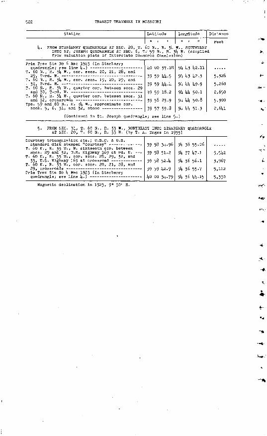
522 TRANSIT TRAVERSE IN MISSOURI
Station
1+. PROM STANBERRY QUADRANGLE AT SEC. 20, T. INTO ST. JOSEPH QUADRANGLE AT SEC. 6, T from valuation plats of Interstate Comm
Prim Trav Sta No 6 Mac 1923 (In Stanberry
T. 60 N., R. 3l+ W. , cor. sees. 20, 21, 28, and
T. 60 N., R. 3!+ W. , cor. sees. 19, 20, 29, and
T. 66 N. , R. 3!+ w -> quarter cor. between sees. 29 and 30 T-rd W --- - - -
T. 60 N., R. 3!+ w - » quarter cor. between sees. 31
Tps. 59 and 60 N. , R. 3!+ W. , approximate eor.
(Continued in St. Joseph quadrangl
Latitude
60 N., R. 3l+ 59 N., R. I erce Commissi
l+o oo 37.18
39 59 1+1+-5
39 59 1+1+.1+
39 59 18.2
39 58 25.9
39 57 59-8
e; see line 5
Longitude
0| II
W. , SOUTHWEST 1+ W. (compile on)
9l4- 1+3 1+2.11
9k 1+3 1+2.3
9k kk 1+9-9
91+ 1+1+ 50.1
91+ 1+1+ 50.8
91+ 1+1+ 51.3
.)
Distance
Feet
d
5,?28
5,260
2,650
5,300
2,61+1
5. PROM SEC. 31, T. 60 N., R. 33 W. , NORTHEAST INTO STANBERRY QUADRANGLE AT SEC. 20, T. 60 N. , R. 33 W. (by T. A. Magee In 1935)
Courtney triangulation sta.; U.S.C. & G.S.
T. 60 N., R. 33 W., W. sixteenth cor. between s;eos. 29 and 32, U.S. Highway 169 at rd. N. -
T. 60 N., R. 33 W., cor. sees. 28, 29, 32, and
T. 60 N., R. 33 W., cor. sees. 20, 21, 28, and
Prim Trav Sta No 1+ Mae 1923 (In Stanberry
39 58 314-- 96
39 58 51-2
39 58 524
39 59 1+2-9
1+0 00 31+ -79
91+ 38 55.06
91+ 37 1+7-1
91+ 36 56-1
91+ 36 55-7
91+ 36 1+1+-15
5.51+2
3,967
5,112
5,330Magnetic declination in 1923, 9° 30' E.
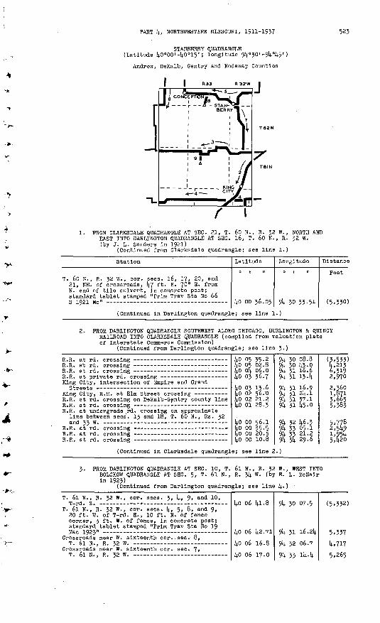
PART k, NORTHWESTERN MISSOURI, 1911-1957 523
STAHBERRY QUADRANGLE (Latitude kO°00' -(4.0°15' ; longitude 9k°30' -9k°k5' )
Andrew, DeKalb, Gentry and Nodaway Counties
1. PROM CLARKSDALE QUADRANGLE AT SEC. 21, T. 60 N., R. J2 W., NORTH AND EAST INTO DARLINGTON QUADRANGLE AT SEC. 16, T. 60 N., R. J2 W. (by J. L. Sanders In 1921)
(Continued from Clarksdale quadrangle; aee line 1.)
Station
T. 60 N., R. 32 W., cor. sees. l6, 1?, 20, and 21, NE. of crossroads, kl ft. N. 70° E. from N. end of tile culvert, in concrete post; standard tablet stamped "Prim Trav Sta No 66
Latitude
14.0 oo 36.03
Longitude
9^ 30 33-51
Distance
Feet
(5.3301
(Continued in Darlington quadrangle; see line 1.)
2. PROM DARLINGTON QUADRANGLE SOUTHWEST ALONG CHICAGO, BURLINGTON & QUINCY RAILROAD INTO CLARKSDALE QUADRANGLE (compiled from valuation plats of Interstate Commerce Commission)
(Continued from Darlington quadrangle; see line 3.)
King City, intersection of Empire and Grand
R.R. at rd. crossing on DeKalb-Gentry county line
R.R. at undergrade rd. crossing on approximate line between sees'. 13 and 18, T. 60 N., Rs. 32
ko 05 35-2
ko 03 36.7
kO 03 13-6
kO 02 21.2 kO 01 28.3
kO 00 56.1ko oo 35-5
liO nn in. 8
9k 30 08.89k 30 k3.09k 31 16.691). 31 13- U
9k 31 16.99k 31 2k. l9k 31 37.1 9k 31 fo.o
91). 32 U6.J9k 33 05-1
Qli *fi ?Q.6
(5,533)k, 2136,3192,970
3,665
2,5^91,95ks.fi?n
(Continued In Clarksdale quadrangle; see lire 2.)
3- PROM DARLINGTON QUADRANGLE AT SEC. 10, T. 6l N., R. 32 W., WEST INTO BOLCKOW QUADRANGLE AT SEC. 5, T. 6l N., R. 3k W. (by E. L. McNalr in 1923)
(Continued from Darlington quadrangle; see line 4..)
T. 6l N., R. 32 W., cor. sees. 3, k, 9, and 10, T-rd. S. - -
T. 6l N., R. 32 W., cor. sees, k, 5, 8, and 9, 20 ft. W. of T-rd. E.., 10 ft. N. of fence corner, 3 ft. W. of fence, in concrete post; standard tablet stamped "Prim Trav Sta No 19 Mac 1923" -
Crossroads near W. sixteenth cor..sec. 8,T. 6l N., R. 32 W. -
Crossroads near W. sixteenth cor. sec. 7,T. 6l N., R. 32 W. -
kO 06 kl.8
kO 06 k2.71
kO 06 16.8
kO 06 17.0
9k 30 07.5
9k 31 16.2k
9k 32 06.7
9k 33 *k-k
(5,332)
5,337 lj-,717
5,265

52k TRANSIT TRAVERSE IN MISSOURI
Station
T. 6l N., R. 32 W. , W. quarter cor. sec. 6, stone T. 6l N. , R. 35 W. , center sec. 1, crossroads - T. 6l N., R. 33 W., E. sixteenth cor. sec. 2,
56 ft. W. of T-rd. E., 1+ ft. from fence corner, in concrete post; standard tablet stamped "Prim
T. 6l N., R. 53 W. , S. sixteenth cor. between
T. 6l N. , R. 33 w - > quarter cor. between sees. 9
T. 6l N., R. 33 W., E. sixteenth cor. sec. 8, 25 ft. ,W. of T-rd. E., in concrete post; standard tablet stamped "Prim Trav Sta No 21
T. 6l N., R. 33 W. , cor. sees. 5, 6, 7, and 8, T rd N
T. 6l N., Rs. 33 and 34 W. , approximate cor.
T. 6l N., R. Jli. W., cor. sees. 1, 2, 11, and 12,T*-F(1 S
T. 61 N., R. 3(4. W. , cor. sees. 2, 3, 10, and 11, about 290 ft. E. of crossroads, 20 ft. N. of rd., 3 ft. S. of hedge fence, in concrete post; standard tablet stamped "Prim Trav Sta No 22
T. 6l N. , R. 3^ W. , quarter cor. between sees. 3
Platte River, center of old bridge over _____ T. 6l N., R. 314. W. , quarter cor. between sees. 14.
Cawood, Chicago Great Western R.R. at rd.
(Continued in Bolckow quadrangle;
Latitude
(4.0 07 09.144o 07 09.2 4o 07 08.7
40 07 08.9114.0 06 55-9 14.0 06 55-9
14.0 06 16.7
40 06 16.53 lio 06 142.6
40 06 14.2.6
14.0 06 Itf-i
14.0 06 44.1.
14.0 06 44- 38
14.0 06 44-4 4o 06 li^. 7
14.0 06 144.8
14.0 06 44-9
see line 2. ).
Longitude
0 t 1!
9k 33 13-3 9^ 33 3p.k914. 34 04.6
9k 3k 56.314.
914. 35 47-0 9k 36 2l.o
9k 36 55-0
914. 38 1940 9k 38 19-0
9k 39 09-6
94 1;0 16.9
94 41 2k. 9
914. 14.2 28.914.
9J4.43 05.6 9k 43 37-0
94 44 14-9 94 44 56.1;
Distance
Feet 5,300 1,328 2,6148
4,023
4,lW 2,640
4,778
6,550 2,640
3,930
5,230
5,282
4,9762,850 2,433
2,9443,224
4- PROM SEC. 16, T. 60 N., R. 32 W., WEST INTO BOLCKOW QUADRANGLE AT SEC. 19, T. 60 N. , R. 314. W. (by E. L. McNair In 1923)
Prim Trav Sta No 66 S 1921 Mo (previously
T. 60 N., R. 32 W., cor. sees. 17, 18, 19, and
T. 60 N., R. 32 W., W. cor. sees. 18 and 19, 14.0 ft. N. of E. cor. sees. 13 and 21;, T. 60 N.,
Chicago, Burlington & Qulncy R.R. at rd. crossing T. 60 N., R. 33 W., cor. sees. 13, 14, 23, and
2i|., 20 ft. W. of rd. corner from E.-S., in line with rd. E., in concrete post; standard tablet stamped "Prim Trav Sta No 3 Mac 1923"
T. 60 N., R. 33 W., probable cor. sees. 114., 15,
T. 60 N., R. 35 W., probable cor. sees. 15, 16,
T. 60 N., R. 33 W., quarter cor. between sees. l6
T. 60 N., R. 33 W., cor. sees. 16, 17, 20, and 21, 870 ft. E. of crossroads, 15 ft. S. of rd., in concrete post; standard tablet stamped "Prim
T. 60 N., R. 35 W., cor. sees. 16, 17, 20, and
T. 60 N., R. 33 W., cor. sees. 17, 18, 19, and
T. 60 N. , R. 33 W., quarter cor. between sees. 18
T. 60 N., Rs. 35 and 34 W. , approximate cor.
T. 60 N., R. 314. W., S. sixteenth cor. between sees. 13 and 114., 16 ft. N. and 25 ft. W. from T-rd. W., in top of N. head wall of concrete culvert; standard tablet stamped "Prim Trav
T. 60 N., R. 314. W., cor. sees, 14, 15, 22, and
T. 60 N. , R. 3!; W., cor. sees. 16, 17, 20, and 21, 20 ft. W. of T-rd. E. , 3 ft. from fence, in concrete post; standard tablet stamped "Prim
14.0 oo 36.0314.0 00 35-5
4o oo 55-7 14.0 oo 35-5
14.0 oo 55.53 40 oo 35.814.0 oo 35.7l+o oo 35.6 14.0 oo 35.514.0 oo 314.. 9
Uo 00 34.78 14.0 oo 35.0 14.0 oo 55.8
14.0 oo 36.314.0 00 36.14.
14.0 oo 14.9.3614.0 oo 36.9 lio oo 37.1
14.0 oo 37.18
94 30 33-51
9k 31 1*2-5
914. 32 46-7 9k 33 05-1
9U 33 55-50
9jl 35 03.1). 9k 35 54-99k 36 11.8 914. 36 18.9
9k 36 20.7
9k 36 44-17
9k 36 55-3
94 3& 02.7
9k 38 56.5
9k 39 10.1
9U 14.0 18.30
9k {4.1 25.9 9U 142 32.1
914- 10 l42.ll
5,370
4,998 1,436
3,922
5,284 4,0151,320
555155
1,826
868
5,243
2,631
2,619
5,1*63
5,^10 5,152
5,1*46

PART k, NORTHWESTERN MISSOURI, 1911-1937 525
Station
T. 60 and
T. 60
N., 21, N., pn
R. 3k T-rd. R. 314.T-r-ri.
w.,w.w.,<?-
quarter eor. between sees.
quarter cor. between sees.
20
19
Latitude
kO 00
JiO on
11.
in
0
7
Longitude
0 | II
914 1*3 U2.1
Q)L Mi liQ.li
Distance
Feet
2,660
^.PHO
(Continued in Bolckow quadrangle; see line 1.)
5. FROM DARLINGTON QUADRANGLE SOUTHWEST ALONG U.S. HIGHWAY 169 AND STATE HIGHWAY k TO STANBERRY, THENCE NORTHWEST ALONG STATE HIGHWAY k INTO PARNELL QUADRANGLE (by S. T. Tudor in 193k)
(Continued from Darlington quadrangle; see line 5-)
T. 63 N., R. 32 W., cor. sees. 20, 21, 28, and
T. 63 N., R. 32 W., cor. sees. 29, 30, 31, and
Stanberry, municipal water tank at SE. corner of intersection of Sixth and Alanthus Streets
U.S.C. & G.S. standard disk stamped "J 19 1933"- Crossroad near approximate quarter cor. between
sees. 31 and 36, T. 63 N. , Rs. 32 and 33 W. Junction of rd. S. near quarter cor. between
sees. 35 and 36, T. 63 N. , R. 33 W. Stanberry, 2.6 mi. NW. of, along State Highway k,
near center of N 1/2 sec. 35, T. 63 N., R. 33 W., 35 ft. S. and 370 ft. W. from Junction of rd. N., in concrete post; standard
T. 63 N., R. 33 W., cor. sees. 26, 27, 314., and
T. 63 N., R. 33 W., N. sixteenth cor. between sees. 26 and 27, highway at fences E. and W.
T. 63 N., R. 33 W., quarter cor. between sees. 22
T. 63 N. , R. 33 W., cor. sees. 21, 22, 27, and
Conception, about 34 mi. E. of, along State Highway k, 5.8 mi. NW. of Stanberry, 35 ft. S. and 570 ft. W. from Junction of rd. S., in concrete post; standard tablet stamped "714-1
T. 63 N., R. 33 W., cor. sees. 20, 21, 28, and
T. 63 N., R. 33 W., cor. sees. 19, 20, 29, and
T. 63 N., Rs. 33 and 3k W. , approximate cor. sees. 19, 2l4_, 25, and 30, Junction of rd'. S.
Conception, about 0.2 ml. E. of, along State Highway k, 360 ft. N. and klO ft. E. from crossroad, 4.5 ft. s> °f highway at curve from E.-N., in concrete post; standard tablet atamp-
T. 63 N., R. 3^ W. , quarter cor. between sees. 23
(Continued in Parnell quadrangle;
14.0 114. 30.8
kO lit. 30.9 lid ll(. 31-1 14.0 Ik 05.1;
14.0 13 39.14.
ko 13 09.0kO 12 14.749
14.0 13 074
(4.0 13 13.6
(4.0 13 17-27
(4.0 13 14.0.2
14.0 il|. 194.
14.0 ik 324
(4.0 ik 32.2
14.0 ilj. 31-68
14.0 Ik 32.1 ko 114. 32-3
ko ik 32.14. 14.0 lU 32.3
14.0 114. 31-7
UO 114. 35-90
14.0 114. 58.9
see line 14.. )
9k 30 3k. 7
9k 31 08.9 9U 31 42.9 91; 32 17-1
9k 32 17.2
914. 32 lk. 9 9k 32 3U-90
9k 33 23.lt
Sk & 31.2
9k 35 10.08
914. 35 38-9
9k 35 384 9k 36 12.6
914. 36 k6.8
9k 37 28.75
9k 37 55-1 9k 38 29.0
9l4- 39 03.3, 9k 39 37.8
9lj. Uo 06.8
9k ko 53.08
91; Ui 13-2
(2,750)
2,650 2,61+0 3,7152,630
3,075 2,675
14,275
5,290
3,oko
3,220
3,970
2,955
2,650
3,255
2,0k52,6302,660 2,670
2,250
3,615 6,215
6. PROM PARNELL QUADRANGLE AT SEC. 20, T. 63 N., R. & W. , SOUTH AND WEST INTO BOLCKOW QUADRANGLE AT SEC. 5, T. 62 N., R. 3k W. (by S. T. Tudor in 193M
(Continued from Parnell quadrangle; see line 1;.
T. 63 N. , RV 3^4 "., quarter cor. between
T. 63 N. , R. 314. W. , cor. sees. 20, 21, 28, and 29, kO ft. S. and 25 ft. E. from crossroads, in concrete post; standard tablet stamped
T. 63 N., R. 3U W., cor. sees. 28, 29, 32, and
Tps. 62 and 63 N., R. 3)4. W., approximate cor.
(Continued in Bolckow quadrangle;
kO Ik 59-5
kO Ik 33.0kko ik 074kO 13 kl.3ko 13 15.1kO 12 k9.1
see line 14. )
9i4. 14 37-1
9k 14 37. k8 91^ 14 38.6
9k 14 39-2 9k 14 39.7
914. 14 ko.3
(2,6k2)
2,6782,5992,6kO 2,650
2,625

526 TRANSIT TRAVERSE IN MISSOURI
Station
7. PROM STANBERRY SOUTHEAST ALONG U.S. HIGHW R. 32 W. (by S. T. Tudor and W. V. Kenn
T. 62 N., R. J2 W., quarter cor. between sees. 5
T. 62 N., R. 32 W., approximate cor. sees. 8, 9, 16, and 17, 650 ft. S. and 150 ft. W. from, 52 ft. NE. of U.S. Highway 169 a t curve from NW.-S., in concrete post; standard tablet
T. 62 N., R. J2 W., cor. sees. 20, 21, 28, and
T. 62 N., R. 32 W. , cor. sees. 28, 29, 32, and
T. 62 N., R. 32 V/. , N. sixteenth cor. between sees. 32 and 33, 35 ft. N. and 30 ft. W. from, in concrete post; standard tablet stamped "T T
Crossroad, 65 ft. W. of S. cor. sees. 32 'and 33,
T. 6l N., R. 32 W., quarter cor. between sees. k
Prim Trav Sta No 19 Mac 1923 (previously
Latitude
0 1 II
AY 169 TO SEC edy in 193)4. s
kO 12 k7-k9 kO 12 1|6.6 14-0 12 25.3
kO 11 5k.k (O 11 28.6 kO 11 02.1
kO 10 55-22 kO 10 11.5 kO 09 10.8
kO 09 17.5 kO 0§ Oi|..6 ko 08 51.5
kO 08 25 .k
kO 08 12.61 li.0 07 k6.6
ko 07 33-3
kO 07 08.2
kO 06 k2.71
Longitude
. 8, T. 6l N. nd 1936)
9k 32 3k- 90 9*4, 31 524 9k 31 kk-7
9k 31 45-2 9k 31 kk.6 9k 31 20.6
9U 31 13-36 9k 31 11.8 9k 31 12.2
9k 31 12.5 9k 31 12.7 9k 31 12.9
9k 31 13.1
9k 31 13.50 9k 31 13-6
9k 31 14-5
9k 31 15 -k
9k 31 16.214.
Distance
Feet
3,299 2,23lj.
3,130 2, 601 3,269
892k ' k22 2,808
2,653 1,310 1,320
2,6kO
1,296 2,630
1,351
2,5^1
2,577
8. PROM SEC. 33, T. 63 N., R. JJ W. , NORTH TO STATE HIGHWAY k AT POINT ABOUT J.Ij. MILES EAST OF CONCEPTION (by T. A. Magee In 1935)
Wledersholt triangulatlon sta. ; U.S.C. & G.S.
T. 63 N., R. 33 W., cor. sees. 28, 29, 32, andko 13 16-37
kO 13 39.8ko 14 31.68
9k 37 k3-23
9k 37 55-6 9k 37 28.75
2,559 5,6k6
9. PROM SEC. 17, T. 61 N. , R. 33 W. , NORTH ALONG ROAD ABOUT 0.5 MILE (by T. A. Magee in 1935)
Gibson trlangulation sta.; U.S.C. & G.S.
Prim Trav Sta No 21 Mac 1923 (previouslyko 05 50.26 ko 06 16.53
9k 38 20.08
9k 38 19- Uo 2,658
Magnetic declination 8° 5V

PART k, NORTHWESTERN MISSOURI, 1911-1937
PARNELL QUADRANGLE (Latitude kO°15'-kO°30'; longitude 9k°30'-9l;°k5')
Gentry, Nodaway, and Worth Counties
R33W R32W
527
1. PROM PICKERING QUADRANGLE AT SEC. 28, T. 66 N., R. 3k W., EAST INTO GENTRY QUADRANGLE AT SEC. 3k, T. 66 N., R. 32 W. (by J. L. Sanders in 1923)
(Continued from Pickering quadrangle; see line 1.)
Station
T. 66 N., R. 3k W., cor. sees. 27, 28, 33, and
T. 66 N., R. 3k W. , cor. sees. 26, 27, 3k, and 35, 18 ft. N. and 195 ft. W. from crossroads, In concrete post; standard tablet stamped "Prim
T. 66 N., R. -)k W., cor. sees. 25, 26, 35, 'and
T. 66 N., R. 3t(. W., E. cor. sees. 25 ahd 36, T-rd. W., 70 ft. S. of T-rd. E. at W. cor.
T. 66 N., R. 33 W., cor. sees. 29, 30, 3!, and 32, 21 (? 31) ft. S. and 27 ft. W. from T-rd. S., in concrete post; standard tablet stamped
T. 66 N., R. 33 W., cor. sees. 28, 29, 32, and
T. 66 N. , R. 33 W., cor. sees. 27, 28, 33, and
T. 66 N., R. 33 W. , E. sixteenth eor. between sees. 27 and 3k, kk2 ft. W. of Chicago, Burlington & Quincy R.R., 15 ft. S. and 37 ft. W. from crossroads, in concrete post; standard tablet stamped "Prim Trav Sta No 57 J S 1923
Chicago Great Western R.R. at rd. crossing,
T. 66 N., Rs. 32 and 33 W. , cor. sees. 25, 30,
T. 66 N., R. 32 W., quarter cor. between sees. 29 and 32, 2k ft. S. and 18 ft. E. from T-rd. S., in concrete post; standard tablet stamped
West Fork of Grand River, center of bridge over - T. 66 N., R. 32 W., cor. sees. 2?, 28, 33, and
3k, T-rd. S.
Latitude
kO 29 17.2
kO 29 16. 8k
ko 29 15-9
kO 29 15.6
kO 29 Ik.k8ko 29 lli.6
kO 29 Ik.k
kO 29 lk<l
ko 29 13.59
ko 29 1.3.5 ko 29 13.0
kO 29 12.0
kO 29 10.1kko 29 08.0kO 29 09.0 liO ?Q OH.P
Longitude
0 1 II
9k kk U2.8
9k k3 57-52
9k k2 26.5
9k kl 18. k
9k kO 10.26 9k 59 U9-5
9k 39 01.8
9k 37 5U-0
9k 37 03 .k6
9k 56 57-8 9k 55 5U-29k 3k 28. k
9k 32 {4.5.16 9k 31 k8.7
9k 31 02.8Qi *n 00. f,
Distance
Feet
(5.3U2)
5.255
5,266 1,619
5.67U
5.2k5
5.90k
kk2k,9io
6,636
7,982
5.5U5fi . 1 ?0
(Continued in Gentry quadrangle; see line 1.)

526 TRANSIT TRAVERSE IN MISSOURI
Station Latitude
0 , 11
Longitude
0 | II
Distance
Feet?. PROM PICKERING QUADRANGLE AT SEC. 5, T. 65 N. , R. 34 W., SOUTH INTO
PICKERING QUADRANGLE QUADRANGLE AT SEC. 29, T. 64 N., R. 34 W. (by S. T. Tudor in 1934)
(Continued from Pickering quadrangle; see line 4-), Q
T. 65 N., R. 34 W., cor. sees, k, 5, 8, and 9,
T. 65 N., R. 34 W., cor. sees. 8, 9, l6, and 17,
T. 65 N., R. 54 W. , cor. sees. 16, 17, 20, and 21, 33 ft. N. and 33 ft. W. from crossroads, in concrete post; standard tablet stamped "719
T. 65 N. , R. 34 W. , cor. sees. 20, 21, 28, and
T. 65 N., R. 34 W. , cor. sees. 28, 29, 32, and
T. 65 N., R. 34 W. , S. cor. sees. 32 and 33, 32 (? 28) ft. N. and 26 (? 24) ft. W. from T-rd. N. , 7 ft . N. and 4 ft- " ' from corner fence post, in concrete post; standard tablet
T. 64 N., R. 34 W-» cor. sees, k, 5, 8, and 9,
T. 64 N., R. 34 W., cor. sees. 8, 9, 16, and 17,
Maryvllle, 6 mi. E. of, along State Highway k, 35 ft. N. and 68 ft. W. from Junction of rd. N. , in concrete post; standard tablet stamped
T. 61). N., R. 34 W., cor. sees. 15, l6, 21, and
T. 64 N. , R. 34 W., cor. sees. 21, 22, 27, and
T. 6k N., R. 34 W. , eor. sees. 27, 28, 33, and 34, 40 ft. N. and 25 ft. W. from T-rd. N. , in concrete post; standard tablet stamped "722
T. 64 N., R. 34 W., cor. sees. 28, 29, 32, and
(Continued in Pickerlng quadrangle
ko 27 35. .5
40 27 35-140 27 08.9
40 26 42.740 26 16.5
40 25 50.7640 25 24.340 2k 58.340 24 32.3
kO 24 06.3
4o 21 57.840 21 31.6
40 20 38.0
ko 19 45-44o 19 18.9
4o 18 53.214o 18 53.340 18 53.7
; see line 4
9k 44 58.0
9k kk 23.994 44 24.0
9k kk 2k. i
.94 kk 25.169k kk 25.1
91). 44 25 .-59k kk 26.0
9k 44 26.29k kk 26.5
9k kk 27.269k itk 24.4
-'rr T+TT H- +9k kk 25.3
'9k 44 26.29k kk 27.0
9k 44 29.0694 43 54-3
94 43 20.194 43 21.1
94 43 22.294 43 23.2
94 43 24.6494 43 58-294 44 32.1
)
(2,710)2,6402,645
2,6302,630
2,6302,5902,4802,050
2,6952,6452,655
3. PROM SEC. 32, T. 65 N., R. jk W., EAST INTO GENTRY QUADRANGLE AT SEC. 16, T. 6k N. , R. 32 W. (by S. T. Tudor in 1934)
T. 65 N., R. 34 W., S^ cor. sees. 33 and 34,
T. 64 N., R. 34 W., N. cor. sees. 2 and 3, T-rd.
Tps. 64 and 65 N. , R. 34 W., cor. sees. 1, 2, 35, and 36, 22 ft. S. and 48 ft. E. from cross roads, in concrete post; standard tablet stamped "73! C W A 1934" --
T-rd. S. on line between sees. 1 and 36,
Tps. 64 and 65 N. , R. 33 W. , approximate cor. sees. 5, .6, 31, and 32, State Highway 4° at
T. 64 N., R. 33 W. , cor. sees. 5, 6, 7, and 8,
T. 64 N., R. 33 W., N. sixteenth cor. between sees. 7 and 0, 90 ft. N. and 46 ft. E. from, in concrete post; standard tablet stamped "732
T-Wl . W. - _______ _____
40 23 14.0140 23 13.240 23 12.9 4o 23 12.440 23 12.046 23 11.8
40 23 11.39 4o 23 11.540 23 12.04o 23 11.9
40 23 12.04o 22 47-440 22 21.4
40 22 09.18lift 31 1,3 1,
9k kk.27l.26 94 43 52.9
94 43 18.8 94 42 44-794 42 09.6 94 4i ?6.6
94 4i 01.32 9k ko 27.7
94 4o 01.1 94 39 19.8
94 3§ 47-4 94 38 48.2
94 38 49.2
94 38 49.07ol, zfl ,o f.
z',660
2,6402,6402,710 2,560
2,7302,600
2,060 3,200
2,500 2,490
2,640
1,235 3 Tin
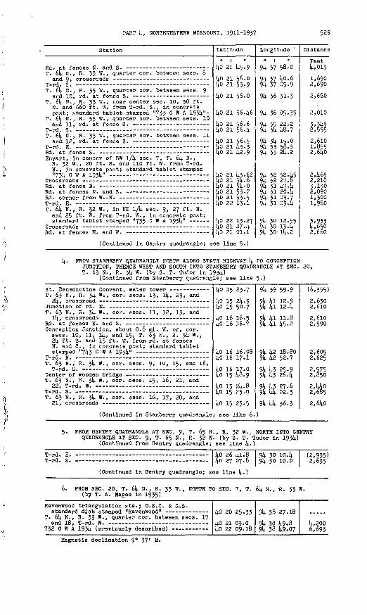
PART k, NORTHWESTERN MISSOURI, 1911-1937 529
Station
T. 6k N., R. 33 W. , quarter cor.
T. 6k N., R. 33 W. , quarter cor.
T. 6k N., R. 33 W. , near center : N. and 660 ft. W. from T-rd. S post; standard tablet stamped
T. 6k N. , R. 33 W. , quarter cor.
T. 6k N., R. 33 W., quarter cor.
Enyart, in center of SW 1/U sec. R. 32 W., 20 ft. S. and 110 ft N. , In concrete post; standard "73k c w A 193)4." -
m _, J p
T. 6k N., R. J2 W., In NE lA sec and 25 ft. W. from T-rd. W. , ii standard tablet stamped "735 0
between sees. 8
between sees. 9
sec. 10, 30 ft. , in concrete '733 C w A 19314."- between sees. 10
between sees. 11
7, T. 6k N., W. from T-rd. tablet stamped
,. 9, 27 ft. N.i concrete post;" A J-754
Latitude
kO 21 (4.5.9
kO 21 56.0 kO 21 55-9
kO 21 56.0
kO 21 56.k6
kO 21 56.6 kO 21 56.k
kO 21 56.5 kO 21 14-3-3 1^0 21 lj.2.9
kO 21 k3.62 kO 21 5k. 6ko 21 5ij..okO 21 53-7 kO 21 53-5 1+0 22 13.1
kO 22 13.27 li.0 21 27-k kO 21 01.1
Longitude
a 1 ii
9k 37 58.0
9k 37 U0.6 9k 37 05.9
91; 36 31-3
9k 36 05.39
9k 35 22.2 9k & k8.7
9k 3k 15.0 9k 33 5,8.3 9k 33 2k. 2
9k 32 5245 9k 32 27.8 9k 31 14.7-14. 9k 31 204 9k 31 03.7 9k 31 034
9k 30 12.55 9k 30 134 9k 30 4-2
Distance
Feet k,015
1,690 2,690
2,680
2,010
3.3U5 2,5952,610 1,855 2,6ko
2465 2,210 3,130 2,090 1,300 1,980
3,935 4,650 2,660
(Continued in Gentry quadrangle; see line 5-)
k. FROM STANBERRY QUADRANGLE NORTH ALONG STATE HIGHWAY k TO CONCEPTIONJUNCTION, THENCE WEST AND SOUTH INTO STANBERRY QUADRANGLE AT SEC. 20, T. 63 N., R. 3k W. (by S. T. Tudor in 193k)
(Continued from Stanberry quadrangle; see line 5.)
T. 63 N., R. 3k W., cor. sees. 13, Ik, 23, and
T. 63 N., R. 3k W. , cor. sees. 11, 12, 13, and
Conception Junction, about 0.8 mi. W. of, cor. sees. 10, 11, Ik, and 15, T. 63 N. , R. 3k W., 2k ft. S. and 15 ft. W. from rd. at fences N. and S., in concrete post; standard tablet
T. 63 N. , R. 3k W. , cor. sees. 9, 10, 15, and 16,
T. 63 N., R. 3k W., cor. sees. 15, 16, 21, and09 m ~»J m
T. 63 N., R. 3k W. , cor. sees. 16, 17, 20, and
(Continued in Stanberry quadrangle
ko 15 23.7
ko 15 24.9 ko 15 50.7
kO 16 16.5i+o 16 16.7
kO 16 16.98lj.o 16 17.1kO 16 17.0ko 15 14.6.9
kO 15 2k. 8 llo 15 25-0
ko 15 25.5; see llhe '6.
94 39 59-99k ki 12.9 9k kl 124
9k kl 11.8 9k ki 14.5.2
9k k2 18.80 9k k2 52.7
9k U3 25.9 9k 14.3 264
9{4. k? 27.6 9k kk 02.3
91*- 14 36.3 )
(6,355)
2,630 2,6lO
2,6lO 2,590
2,605 2,625
2,575 2,850
2,kkO 2,685
2,6k;o
FROM GENTRY QUADRANGLE AT SEC. 9, T. 65 N., R. 32 W., NORTH INTO GENTRY QUADRANGLE AT SEC. 9, T. 65 N., R. 32 W. (by S. T. Tudor in 193)4.)
(Continued from Gentry quadrangle; see line k.)
E. _ _ -_ kO 26 kl.8 9k 30 104 (2,935)
(Continued in Gentry quadrangle; see line k.)
6. FROM SEC. 20, T. 6k N., R. 33 W., NORTH TO SEC. 7, T. 6k N., R. 33 W. (by T. A. Magee in 1935)
Ravenwood trlangulatlon sta.; U.S.C. & G.S.
T. 6k N., R. 33 W., quarter cor. between sees. 17kO 20 25-33
kO 21 03.0 kO 22 09.18
9k 38 27.18
94 3§ {4.9.89k 38 14.9.07
k.,200 6,693
Magnetic declination 9° 37' E.

530 TRANSIT TRAVERSE IN MISSOURI
BEDFORD QUADRANGLE * (Latitude kO°30'-kO°k5'; longitude 9k°30'-9k°k5")
Nodaway and Worth Counties
1\
1. FROM BLOCKTOH QUADRANGLE AT SEC. 35, T. 67 N., R. 32 W., WEST INTO NEW MARKET QUADRANGLE AT SEC. 33, T. 67 N., R. 3k W. (by S. T. Tudor in
(Continued from Blockton quadrangle; see line 2.)
Station
T. 67 N., R. 32 W. , N. cor. sees. 33 and 3k,
Athelstan, 33 ft. S. and 10 ft. W. from T-rd. N. on Iowa-Mo. State line, in concrete post;
T. 67 N., Rs. 32 and 33 W. , N. cor. sees. 31 and
T. 67 N., R. 33 W., near N. cor. sees. 35 and 36, 22 ft. S. and 590 ft. E. from T-rd. S. on Iowa-Mo. State line, in concrete post; standard tablet stamped "763 C W A 193k" -
T. 67 N., R. 33 W. , near N. cor. sees. 32 and 33, 880 ft. E. of T-rd. S., 18 ft. .S. of rd. on Iowa-Mo. State line, in concrete post;
T. 67 N., Rs. 33 and 3k 'Wi, N. cor. sees. 31 and
T. 67 N., R. 3k W., N. cor. sees. 35 and 36, 20 ft. S. and 230 ft. W. from T-rd. S. on Iowa -Mo. State line, in concrete post; standard tablet
7l6 C W A 193k (In Nev/ Market quadrangle; see
Latitude
kO 3k 15.3
ko 3k 15.2 kO 3k 15.0
ko 3k ik. 67 ko 3k 28.2 lio 3k 28. k ko 3k 28.6 ko 3k 28.6
ko }k 15. k ko 3k 15.5
ko 5k 1548 kO Jk 16.0 ko 3k 16.2 ko 3k 16.6 ko 3k 16.8 ko 3li 17.2
ko 3k 17.19 ko 3k 17.8 ko 3!+ 18.3 l+o 3k 18.8
ko 3k 19.2 ko 3k 19.6
ko 3k 19.95 ko 3k 20.5 ko 3k 21.0 ko 3k 214 ko 3k 21.9
ko 3^ 21.92
Longitude
0 I II
9k 30 28.7
91+ 31 02.6 9l<. 31 37-1
9k 32 2k. 20 9k 32 k9-6 9k 33 23.5 9k 33 57-6 9U 3k 14-79k 314- 29.7 9k 35 03.2
9k 35 29.75 9l|. 36 114 9k 36 k5-5 9k 37 19-7 9k 37 55-0 914. 38 284
9k 38 51- 2U 9k 39 35-3 9k ko 07.7 9k ko kk.6
9k kl 17.1- 9k kl 51.2
914. k2 28.389k k5 °,1 - 2 9k k3 314.4 9k kk 09.2 9k kk k24
9k 14.5 16.99
Distance
Feet(2,660)
2,620 2,660
3,6352,395 2,615 2,630 1,320
1,770 2,590
2,0k5 3,220 2,630 2,6ko 2,720 2,580
1,760 34oo 2,500 2,6k6
2,510 2>630
2,870 2,530 2,570 2,680 2,560
2,672
Magnetic declination 9° 33' E.
* The greater part of this quadrangle lies in Iowa.
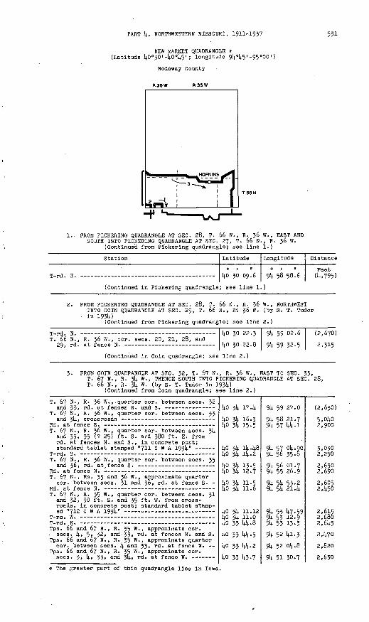
PART k, NORTHWESTERN MISSOURI, 1911-1937 531
NEW MARKET QUADRANGLE * (Latitude kO°30'-I+O 0^'; longitude 9k°k5' -95°00')
Nodaway County
R36W R35W
1.. PROM PICKERINO QUADRANGLE AT SEC. 28, T. 66 N., R. 36 W., EAST AND SOUTH INTO PICKERING QUADRANGLE AT SEC. 27, T. 66 N., R. 36 W.
(Continued from Bickering quadrangle; see line 1.)
Station Latitude
0 1 II
ko 30 09.6
Longitude
0 1 tt
9k 58 58.6
Distance
Peet (k,795)
(Continued in Pickering quadrangle; see line 1.]
2. PROM PICKERINO QUADRANGLE AT SEC. 28, T. 66 N., R. ?6 W., NORTHWESTINTO COIN QUADRANGLE AT SEC. 29, T. 66 N., R'. 36 W. (by S. T. Tudor
in 19314.)'(Continued from Pickering quadrangle; see line 2.)
T. 6629,
N., R. 36 W.at lence
, cor. sees. 20, 21, 28, andko 30ko 30
22.3
on D
9k 59
9k 59
02.6 (2,670)2,315
(Continued in Coin quadrangle; see line 2.)
3. FROM COIN QUADRANGLE AT SEC. 32, T. 67' N., R. 36 W., EAST TO SEC. 33, T. 6? N., R. 3k W., THENCE SOUTH INTO PICKERING QUADRANGLE AT SEC. 28, T. 66 N., R. 3k W. (by S. T. Tudor in 193U)
(Continued from Coin quadrangle; see line 2.)
T. 67 N., R. 36 W.,. quarter cor. between sees. 32
T. 67 N., R. 36 W., quarter cor. between sees. 33
T. 67 N., R. 36 W., quarter cor. between sees. 3!). and 35, 35 (? 25) ft. S. and 380 ft. E. from rd. at fences N. and S., in concrete post;
T. 67 N., R. 36 W. , quarter cor. between sees. 35
T. 67 N. , Rs. 35 ant* 3^ W., approximate quarter cor. between sees. 31 and 36, rd. at fence S. -
T. 67 N., R. 35 W., quarter cor. between sees. 3! and 32, 30 ft. S. and 35 ft. W. from cross roads, in concrete post; standard tablet stamp-
Tps. 66 and 67 N., R. 35 W., approximate cor. . sees, k, 5, 32, and 33, rd. at fences N. and S. Tps. 66 and 67 N., R. 35 W. , approximate quarter
cor. between sees. k and 33, rd. at fence N. Tps. 66 and 67 N. , R. 35 W., approximate cor.
ko 314. 17.14.ko 3k 16.3 ko 314. 15.5
ko 3k ik.k8 ko 3k ik. 2
ko 3k 13.5kO 3!). 12.7
ko 3k 11.5 lj.o 3k 11.6
ko 3)4. 11.12 14.0 $k 11.0 ko 33 kk-Q
ko 33 144.5
ko 33' kk-2
ko 33 14.3.7
9k 59 27.0
9k 58 21.7 9k 57 kk.i
9lj. 5? 014.90 9k 5& 35-8
9k 56 01.7 9k 55 26.9
9k 5k 53-2 9k 5k 21. k
9k 53 k7-59 9k 53 12-9 9k 53 13-39k 52 ki.3
914. 52 ok. 8
9k 51 30.7
(2,630)
5,oko 2,900
3,050 2,250
2,630 2,690
2,6052, k50
2,615 2,680 2,6k5
2,k70
2,820
2,630
* The greater part of this quadrangle lies in Iowa.
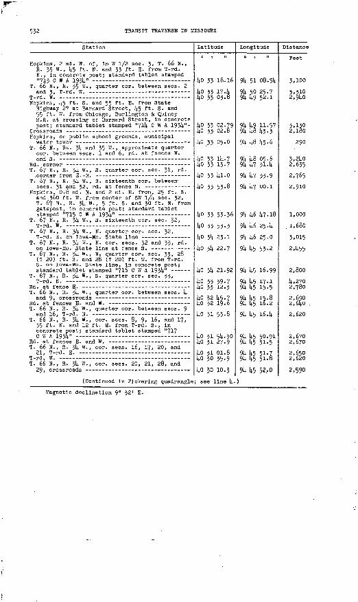
532 TRANSIT TRAVERSE IN MISSOURI
Station
Hopklns, 2 mi. W. of, In W 1/2 sec. 3, T. 66 N., R. 35 W., k5 ft. N. and 33 ft. E. from T-rd. N., in concrete post; standard tablet stamped
T. 66 N., R. 35 W. , quarter cor. between sees. 2
Hopkina, k5 ft. S. and 55 ft. E. from State Highway 27 at Barnard Street, [(.5 ft. S. and 55 ft. W. from Chicago, Burlington & Quincy R.R. at crossing of Barnard Street, in concrete post; standard tablet stamped "7ll(. C W A 193k"-
Hopkins, on public school grounds, municipal
T. 66 N., Rs. 3!). and 35 VI. , approximate quarter cor. between sees. 1 and 6, rd. at fences N.
T. 67 N., R. 3k W., S. quarter cor. sec. 31, rd.
T. 67 N., R. 314. W., S. sixteenth cor. between
Hopkins, 0.8 mi. N. and 2 mi. E. from, 25 ft. S. and 360 ft. W. from center of SW I/k sec. 32, T. 67 N., R. 314. W., 5 ft. S. and 30 ft. E. from gatepost, in concrete post; standard tablet
T. 67 N., R. 314. W., S. sixteenth cor. sec. 32,
T. 67 N., R. 3!; VI., N. quarter cor. sec. 32,
T. 67 N., R. 314. W., N. cor. sees. 32 and 33, rd.
T. 67 N., R. $k W., N. quarter cor. sec. 33, 28 (? 20) ft. S. and 28 (? 20) ft. W. from T-rd. S. on Iowa-Mo. State line, in concrete post;
T. 67 N., R. 314. W., S. quarter cor. sec. 33,
T. 66 N. , R. 3^4- w -» quarter cor. between sees. 1).
T. 66 N. , R. 3!). W., quarter cor. between sees. 9
T. 66 N., R. 31). W., cor. sees. 8, 9, 16, and 17, 35 ft. N. and 12 ft. E. from T-rd. S., in concrete post; standard tablet stamped "717
T. 66 N. , R. 3!). W. , cor. sees. 16, 17, 20, and
T. 66 N., R. 314. W., cor. sees. 20, 21, 28, and
(Continued in Pickering quadrangle
Latitude
0 1 II
kO 33 18.16
14.0 33 174 14.0 33 03.8
ko 33 02.79 ko 33 02.8
ko 33 05.0
ko 33 lU-7 14.0 33 13.7
14.0 33 lt-1.0
14.0 33 53-8
ko 33 53-36
ko 33 53-3
ko 314. 23.1
ko 3!)- 22.7
14.0 3(4. 21.92
lj-0 33 39-7 14.0 33 12.3
ko 32 1*5.7 ko 32 19.6ko 31 53.8
ko 31 5k. 30kO 31 27-9
ko 31 01.8 ko 30 35-9
kO JO 10.3
; see line k.
Longitude
0 1 II
9k 51 08.514.
9k 50 25.7 9k k9 52-1
9k k9 11-57 9k k8 k3.3
9^ k8 k5.6
9k k8 05.6 9U k7 314
9k k7 33-9
914. k7 OO.l
9k k6 k7.l8
9k k6 25. k
9lj. k6 25.0
91; k5 53.2
9k k5 16.99
9k k5 17.1 9k k5 15.5
9k k5 15-8 9k k5 16.2
9k k5 16.14.
9lj. k5 50.91 9tj- k5 51.5
9k k5 51.7 91*. k5 51.8
ft k5 52,0
)
Distance
Feet
3,100
3,310 2,9ll-0
3,130 2,180
290
3,214.0 2,635
2,765
2,910
1,000
. 1,680
3,015
2,^55
2,800
k,270 2,780
2,690 2,6Ij.O .
2,620
2,670 2,670
2,650 2,620
2,590
Magnetic declination 9° 32' E.

PART 14., NORTHWESTERN MISSOURI, 1911-1937 533
PICKERING QUADRANGLE (Latitude 40°15'-40°30<; longitude 94°45'-95°00")
Nodaway County
R36W R 35W I
1. FROM SKIDMORE QUADRANGLE AT SEC. 29, T. 66 N., R. 36 W., EAST INTOPARNELL QUADRANGLE AT SEC. 28, T. 66 N., R. 34 W. (by J. L. Sanders in 1923)
(Continued from Skldmore quadrangle; see line 2.)
Station
T. 66 N., R. 36 W., cor. sees. 28, 29, 32, and 33, 20 ft. S. and 1).0 ft. W. from T-rd. S., In concrete post; standard tablet stamped "Prim
(For balance in New Market quadran
Latitude
ko 29 30.36
gle, see line
Longitude
9k 59 33-37
1.)
Distance
Feet
(5.273)
T. 66 N., R. 36 W., in E 1/2 sec. 27, 55 ft. S. of front door of dwelling of C. L. Clouse, 20 ft. N. of rd., in concrete post; standard tablet stamped "Prim Trav Sta No 51 L S 1923
T. 66 N. , R. 36 W., quarter cor. between sees. 26
T. 66 N.! R. 36 W., cor. sees. 25, 26, 35, and
T. 66 N., Rs. 35 and 36 W. , approximate cor.
T. 66 N., R. 35 W.' cor. sees. 29, 30, 31, and 32, 30 ft. S. and 30 ft. E. from crossroads, 55 ft. N. and 200 ft. W. from Clyde School, in NW. corner of schoolyard, in concrete post; standard tablet stamped "Prim Trav Sta No 52
T. 66 N., R. 35 W., cor. sees. 28, 29, 32, and
T. 66 N., R. 35 W., cor. sees. 27, 26, 33, and
T. 66 N., R. 35 W., in NE VU sec. }!»., 10 ft. N. and 205 ft. W. from steel bridge over One Hundred and Two River, 30 ft. N. of rd. forks, in concrete post; standard tablet stamped "Prim
Chicago, Burlington & Quincy R.R. at point
T. 66 N. , R. 35 W. , approximate quarter cor.
T. 66 N. , Rs. 314. and 35 W. , approximate cor.
T. 66 N., R. 34 W. , cor. sees. 29, JO, 31, and 32, 25 ft. S. and 65 ft. E. from rd. at fences N. and S., at deep cut on top of hill, in concrete post; standard tablet stamped "Prim
T. 66 N. , R. JlJ. W., cor. sees. 28, 29, 32, and
(Continued in Parnell quadrangle;
40 29 54-46
ko 29 53.8
1;0 29 26.5
ko 29 21,.. 7
40 29 23.62
4o 29 23.3
[4.0 29 23.0
ko 29 08.59 4o 29 09.04o 29 09.2lj.0 29 02.1
40 28 55-0 14.0 28 54-3
14.0 29 19-7
14.0 29 18.7.8 40 29 18.8
40 29 18.3see line 1.)
914. 57 52.08
914. 57 15-2
9lj. 56 07.!;
94 514. 58.8'
9k 53 50.6o
9k 52 42.4
9k 51 34-1
& 50 42.58 9k 50 38.9
91; 50 15-2 914. 49 34-5
9k 49 17-2 914. 14.8 25.8
91). 48 08. k
9k 46 59.29 9k 46 kk-9
9k k^> 51-9
(6,858)
1,303
5,930
5,300
5,272
5,267
5,280
4,2kO 288
1,8313,220
1,513 3,970
2,907
5, 340 1,110
4,100

534 TRANSIT TRAVERSE IN MISSOURI
Station Latitude Longitude Distance
o i M o i il peet
2. FROM SKIDMORE QUADRANGLE AT SEC. 50, T. 64 N. , R. 36 W., NORTH INTO NEW MARKET QUADRANGLE AT SEC. 28, T. 66 N., R. 36 W. (by S. T. Tudorin 1934)
(Continued from Skidmore quadrangle; see line 4-)
T. 64 N., R. 36 W., eor. sees. 29, 30, }1, and 32, 63 ft. N. and 40 ft. W. from crossroads, In concrete post; standard tablet stamped "702
T _J o
T. 64 N. , R. 36 W. , E. sixteenth cor. between
T -nH T? ~
T. 64 N., R. 36 W. , E. sixteenth cor. between
T. 64 N. , R. 36 W., near quarter cor. between sees. 18 and 19, 32 ft. N. and 35 ft. W. from T-rd. N. , in concrete post; standard tablet
T. 64 N., R. 36 W., quarter cor. between sees. 7
(For balance in Skidmore quadrangl
T. 65 N., R. 36 W. , quarter cor. between sees. 6
T. 66 N., R. 36 W. , S. cor. sees. 32 and 33,
Prim Trav Sta No 50 L S 1923 Mo (previously
T. 66 N. , R. 36 W. , quarter cor. between sees. 28
(Continued in New Market quadrangl
40 19 06.1
40 19 06.34 40 19 31-9
40 19 58.34o 20 24.540 20 50.6
40 20 51.124o 21 19.640 21 43.2
e, see line 4
40 27 46.9 40 28 12.8
40 28 38.2 40 29 04-3
40 29 30.36
40 29 30.04o 29 56.1
e; see line 2
94 59 51-5
94 59 18.05 94 59 16.7
94 59 33-0 94 59 32.1
94 59 31.3
94 59 48.87 94 59 47-5
94 59 46-5
94 59 la. 9 94 59 24.6
94 59 33.4 94 59 32-9
94 59 33-3794 58 58-7 94 58 58.6\
(3,040)
2,5902,590
2,955 2,650
2,650
1,360 2,880
2,395
(2,840)2,9502,660 2,6402,640
2,680 2,640
3- FROM SKIDMORE QUADRANGLE AT SEC. 6, T. 64 N., R. 36 W. , EAST INTO PARNELL QUADRANGLE AT SEC. 5, T. 64 N. , R. 34 W. (by S. T. Tudor in 1934)
704 0 W A 1934 (In Skidmore quadrangle; see line
T. 64 N. , R. 36 W., quarter cor. between sees. 6
T. 64 N., R. 36 W., eor. sees. 5, 6, 7, and 8,
T. 64 N., R. 36 W. , cor. sees. 4, 5, 8, and 9,
T. 64 N.. R. 36 W., W. sixteenth cor. between sees. 4 and 9, 24 ft. S. of rd. , 3 ft. S. and 3 ft. E. from fence corner,, in concrete post;
T. 64 N. , R. 36 W. , cor. sees. 3, 4, 9, and 10,
T. 64 N., R. 36 W., cor. sees. 2, 3, 10, and 11,T J Q
T. 64 N., R. 36 W. , W. sixteenth cor. on N. line sec. 2, 48 ft. S. and 25 ft. W. from U.S. Highway 71 at rd. S., in concrete post;
Tps. 64 and 65 N. , R. $6 W., approximate cor. sees. 1, 2, 35, and 36, U.S. Highway 71 at
Tps. 64 and 65 N. , Ra. 35 and 36 W., eor. of,
Maryville, municipal water tower near inter-
Maryvllle, 2.2 mi. N. of, along U.S. Highway 71, approximate cor. sees. 5» 6» 31, and 32, Tps. 64 and 65 N., R. 35 W., 33 ft. S. and 45 ft. W. from Junction of State Highways 4 and 27, in concrete post; standard tablet stamped
Tps. 64 and 65 N. , R. 35 w -» approximate cor. sees. 4, 5» 32, and 33, State Highway 27 at
40 22 34-39
40 22 35-4
40 22 34-9
40 22 33.5
40 22 52.91
kO 22 32.3 40 22 32.1
40 22 32.1 40 22 32.0 40 22 57.9
40 23 21.87 40 23 22.0
40 23 21-44o 23 20.840 23 20.3 40 23 19.9
40 21 13.2
40 23 19.19 40 23 19.2
lif) vi. lA.A
95 oo 24.96
94 59 50.8
94 59 10.5
94 58 03.6
94 56 55-0 94 56 20.7
94 55 k6.2 9k 55 29.3 9k 55 28.2
9k 55 27.62 94 55 10.0
94 5k 35-9 94 54 01.8
94 53 27.7 94 52 53-0
94 52 32.2
94 52 19.64 94 51 45-9
Oli CT 11 A
2,650
3,120
5,181
1,5483,9602,6502,670 1,310 2,620
2,430 1,360
2,6402,640
2,640 2,69012,910
12,775 2,610
3 £l,n

PART 4, NORTHWESTERN MISSOURI, 1911-1957 535
Station
Tps. 64 and. 65 N., R. 35 W. , approximate cor.
Tps. 64 and 65 N., R. 35 w -» approximate cor.
Tps. 61; and 65 N. , R. 35 W. , approximate cor. sees. 2, 3, 314., and 35, 25 ft. S. and 380 ft. E. from, in concrete post; standard tablet
Tps. 64 and 65 N. , R. 35 W. , approximate cor.
Tps. 61; and 65 N., Rs. 3!). and 35 W. , cor. of, T rd S
T. 65 N., R. 3!). W., S. cor. sees. 31 and 32,
720 C W A 1931; (In Parnell quadrangle; see
Latitude
40 23 18.0
ko 23 17.940 23 174kO 23 17.0
40 23. 16.14.
kO 23 15-9
ko 23 15.1kO 23 4.7
ko 23 14.54o 23 ik.i
Longitude
0 1 II
9k 50 58.9
9k 50 05.39k 49 27.8
914- kB 51-6
94 48 46-7294 46 21.0
94 47 46-494 47 12.5
9k 46 38.19k 46 Ok. 5
9k U5 35-29k 45 Ol.l
9k 44 27.26
Distance
Feet2,550
2,7502,750
3801,990
2,6802,61+0
2,645
4- PROM NEW MARKET QUADRANGLE AT SEC. 28, T. 66 N. , R. 34 W. , SOUTH AND WEST INTO BOLCKOW QUADRANGLE AT SEC. 19, T. 63 N., R. 35 W. (by-S. T. Tudor in 1934)
(Continued from New Market quadrangle; see line 5-)
T. 66 11., R. 54 W., cor. sees. 28, 29, 52, and
Prim Trav Sta No 54 L S 1925 Mo (previously des-
T. 66 N., R. 54 W., S. cor. sees. 52 and 33, T-
T. 65 N,, R. 34 W., N. cor. sees. 5 and 6,
T. 65 N., R. 54 W., cor. sees. 5, 6, 7, and 8, 50 ft. S- and 33 ft. W. from crossroads, in NE. corner of yard of Mozlngo Valley School, in concrete post; standard tablet stamped "718
(For balance in Parnell quadrangle
T. 64 N., R. 34 W., cor. sees. 29, 50, 51, and
T. 64 H. , R. 54 "., quarter cor. between sees.
T. 64 N., R. 54 W., center of SE V4 sec. 51, 42 ft. S. and 25 ft. E. from rd. at fences E. and W., 5 ft. W. of hedge fence, in concrete post;
T. 65 N., R. 54 W., N. quarter cor. sec. 6,
T. 65 N., R. 54 W. , quarter cor. between sees.
T. 65 N., R. 34 W., quarter cor. between sees. 7
T. 63 N., R. 54 W., near eor. sees. 7, 8, 17, and 18, 55 ft. N. and 52 ft. E. from T-rd. H., in concrete postj1 standard tablet stamped "T T724 c w A 1954"
T. 65 N-, R. 34 W. , quarter cor. between sees.
T. 63 N., R. 34 W., W. sixteenth cor. between
T. 63 N., R. 54 W., cor. sees. 17, 18, 19, and
T. 65 N. , Rs. 34 and 35 W. , approximate cor.
40 29 44-2
40 29 18.34o 29 18.740 29 18.78 4o 29 18.3 4o 28 52.240 28 26.1 40 28 25.940 26 02.2
40 27 35-75
, see line 2.
40 18 54.240 18 54-7
40 16 28.0
40 18 16.07
40 18 02-34o 17 36.140 17 36.0 40 17 12.2
40 16 43.8
40 16 18.29
40 16 17.8 40 15 51-7
40 15 25.6
i+o 15 25.5 40 15 25.7
4o 15 26.3
94 4b 52-3
94 45 51-9 94 46 26.0
94 46 59.29 94 45 51-9 94 45 52-1
94 45 52-594 45 30.7 94 45 51-8
94 45 33-06
94 45 05-7
94 45 40.4
94 45 4i-4
94 45 58.02
94 46 14-4 94 46 15-0
94 45 41-4 94 45 41-9
94 45 42.7
94 45 42.88
94 45 09. 2 94 45 09-994 45 27.52
94 45 44-6 94 46 18.7
94 46 53-8
(2,640)
2,620 2,640
2,570
2,640
2,640
1,670 2,395
2,675
(2,600)
2,685 2,695
1,770
1,885 2-, 6 50
2,610 2,4052,880
2,576
2,610 2,640
2,980
1,330 2,640
2,725

TRANSIT TRAVERSE IN MISSOURI
Station
T. 6j N., R. 35 W., cor. sees. 13, Ik, 23, and 2k, 50 (?35) ft. S. and 55 ft. E. from cross roads, in concrete post; standard tablet
T. 63 N., R. 35 W., cor. sees. -Ik, 15, 22, and
Chicago, Burlington & Quincy E.R. at rd. cross-
T. 63 N., R. 35 W., cor. sees. 15, 16, 21, and
T. 63 N., R. 35 W., cor. sees, lo, 17, 20, and 21, 30 ft. S. and 195 ft- w - from, in concrete post; standard tablet stamped "726 -C W A 193k"
T. 63 N., R. 35 W., eor. sees. 17, 18, 19, and
T. 63 N., Rs . 35 and 36 W-> approximate quarter cor. between sees. 19 and 2y., rd. corner fromE C
(Continued in Bolckow quadrangle;
Latitude
kO 15 27.72 14-0 15 28.6
ko 15 29-5 ko 15 30.1ko 15 30.9 ij.o 15 30.6
ko 15 29.8kO 15 30.k
kO 15 30-9 ko 15 31.6
lj.0 15 06.0
see line 3-)
Longitude
0 1 II
91). 14.8 01.83 9U W 36-^
9^ Iv9 10-5
91). 14.9 te-o
9k 50 19.2 9k 50 52.1
9k 51 29.9 9k 52 00.7
9k 52 5^-9 9k 53 C38.8
9k 53 ^3 -2
Distance
Feet
5.275 2,685
2,6kO
2,625
2,810 2,55°
2,930 2,390
2,650 2,630
3,715
5- PROM SEC. k, T. 6k N., R. 35 W., EAST TO SEC. 2, T. 6k N., R. 35 W. (by T. A. Magee in 1935)
Maryvllle South Base triangulation sta.; U.S.C. & 6.S. standard disk stamped "Maryville South
One Hundred and Two River, center of bridge overko 23 17.50kO 23 17.7 kO 23 16.62
9k 50 20.0k9k k9 35-6 9U k8 C6.72
3,1^353,790
Magnetic declination 9° 37" E.

PART 1;, NORTHWESTERN MISSOURI, 1911-1937 557
BOLCKOW QUADRANGLE (Latitude kO°00' -kO°15'; longitude 9[j.°k5' -95°00')
Andrew and Nodaway Counties
I R 36 N R 33 N
1. FROM STANBERRY QUADRANGLE AT SEC. 19, T. 60 N., R. 3/4. W. , WEST INTO MA1TLAND QUADRANGLE AT SEC. 12, T. 60 N. , R. 37 W. (by E. L. MoNair in 1923)
(Continued from Stanberry quadrangle; see line k.)
Station
T. 60 N., R. 35 W., E. quarter cor. sec. 2k, stone, 60 ft. S- of W. quarter cor. sec. 19,
T. 60 N., R. 35 W., quarter cor. between sees. 13
T. 60 N., R. 35 W., E. sixteenth cor. between sees. Ik and 23, 35 ft. NE. of T-rd. NE., in concrete post; standard tablet stamped "Prim
One Hundred and Two River, center of bridge over T. 60 N., R. 35 "., quarter cor. between sees.
Chicago Great Western R.R. at rd. crossing -- T. 60 N. , R. 35 W., cor. sees. 15, 16, 21, and
Chicago, Burlington & Quiney R.R. at rd. crossing T. 60 N., R. 35 W., quarter eor. between sees.
17 and 20, 30 ft. SW. of crossroads, in con crete post; standard tablet stamped' "Prim Trav
T. 60 N., R. 35 W., W. cor. sees. 18 and 19,
T. 60 N. , R. 36 W., E. quarter cor. sec. 13,
T. 60 N., R. 36 W., quarter cor. between sees.
T. 60 N., R. 36 W., center sec. Ik, 12 ft. W. of T-rd. E., in W. wall of concrete culvert; standard tablet stamped "Prim Trav Sta No 9
T. 60 N., R. 36 W., quarter cor. between sees.
T. 60'N., R. 36 W., cor. sees. 9, 10, 15, and l6,
T. 60 N., R. 36 W., 290 ft. W. of eor. sees. 8, 9, 16, and 17, opposite farmhouse at top of hill, 30 ft. N.. of rd., in concrete post; standard tablet stamped "Prim Trav Sta No 10
Plllmore, crossroads at cor. sees. 7, 8, 17, and
T. 60 N., Rs. 36 and 37 W., approximate cor.
(Continued in Maitland quadrangle;
Latitude
kO 00 10.9
kO 00 10.7
UO 00 36.8
ko oo 36.75 ko oo 36.914.0 00 10. k kO 00 36.6
kO 00 37.1 kO 00 37-0
kO 00 37.0k
1*0 00 37.7
kO 01 02.9
kO 01 02.6
kO 01 02.57
kO 01 28-7ko 01 28.9kO 01 29.3 kO 01 29.6
kO 01 30.17
kO 01 30.5
kO 01 31.0
see line 2.
Longitude
9k k5 28.0
9k 1*5 52.2
9k k6 26.1
9k k7 17.29 9k k? kl.2
9k k8 08. k 9k U8 kl.l
9k k9 16.8 9k k9 kQ-Q
9U 50 59-56
9k 52 k5.6
9k 52 14.5.1
9k 53 52.2
9k 5(4. 26.36
9U 51* 25-5 9k 55 16.7
9k 56 08. k 9k 56 U2.3
91* 57 20.86
91* 58 2k. 8
9k 59 28.2
Distance
Feet (3,758)
1,886
3,728
3,987 1,863
5,kl2 3,680
2,779 2,1428
5,570
8,257
2,555
5,22k
2,657
2,6k9 5,985
k,020 2,679
2,960
U.970
U.935

558
Station
2. PROM STANBEPm QUADRANGLE AT SEC. 5, T. 6 MAITLAND QUADRANOLE AT SEC. 6, T. 6l N. McNair in 1923)
(Continued from Stanberry quadrang
T. 6l N., R. 3k W., quarter cor. between sees. 5
T. 62 N., R. 314. W., S. quarter cor. sec. J2, 27 ft. N. and 25 ft. W. from T-rd. W., in con crete post; standard tablet stamped "Prim Trav
Tps. 6l and 62 N., Rs. jk and 35 W., cor. of,
r t- f h irtT. 61 N., R. 35 W., E. sixteenth cor. on N. line
Bolckow, 0.5 mi. N. of N. limits of, N. cor. sees. 2 and 3, T. 6l N., R. 35 W., 15 ft. N. of T-rd. S. on Andrew-Nodaway county line, 310 ft. E. of Chicago, Burlington & Quincy R.R. at rd. crossing, in concrete post; standard tablet
Chicago, Burlington & Quincy R.R. at rd. crossing
T. 61 N., R. 35 W., E. sixteenth cor. on N. line
T r^r* ^ -
Tps. 6l and 62 N., Rs. 35 and 36 W., cor. of, 20 ft. S. and ko ft. W. from T-rd. N. on Andrew-Nodaway county line, 70 ft. NE. of dwelling, 3 ft. from fence, in concrete post; standard tablet stamped "Prim Trav Sta No 25
T. 6l N. , R. 36 W., N. quarter cor. aec. 1, T rd S
T. 61 N., R. 36 W., N. cor. sees. 1 and 2, T-rd.
T. 6l N., R. 36 W. , N. cor. sees. 2 and 3, cross-
T. 61 N., R. 36 W., N. cor. sees. 3 and k, 2k ft. NE. of T-rd. S., k2 ft. NE. of T-rd. N. on Andrew-Nodaway county line, 36 ft. SW. of SW. corner of church, in concrete post; standard tablet stamped "Prim Trav Sta No 26 Mac 1923
T. 61 N., R. 36 W., N. cor. sees. k and 5, T-rd.
T. 6l N., R. 36 W. , quarter cor. between sees.
T. 61 N., R. 36 W., cor. sees. 5, 6, 7, and 8,
(Continued in Maitland quadrangle;
Latitude Longitude
IN., R. 3k W., WEST INTO , R. 36 W. (by E. L. '
le; see line 3.)
kO 06 k5.0
ko 07 35-77 ko 07 37-0
ko 07 37-2 1|0 07 37-3
ko 07 38.1 ko 07 38-5
ko 07 -38.93 ko 07 38.814.0 07 39-9 ko 07 ki.i ko 07 ill. 5
ko 07 14.2.38
14.0 07 te-o ko 07 lj.3.5 ko 07 kk.3
ko 07 14.5-62 14.0 07 k6.oko 07 20.3 ko 07 06.14.
ko 06 5lj..l).see line 3.]
91; k5 22.5
9k ks 21.32 Jk kt, 12.6
9k k7 05.0 9k k7 16.5
91; k8 29.89)4. 14.9 03.8
91). i;9 21.05
9)4. 14.9 25.0
9k 50 te-891; 52 00.69k 52 27-7
9t(. 53 53-71
9k 5k 27.2
9k 55 01.1
9k 56 09.1
9k 57 16.61;
9k 58 2k. 6
9k 5§ 2k. 9 914. 58 k3.6
& 59 3^-2
Distance
Feet
(2,036)
5,lkl 3.985
k,070 900
5,690 2,614.0
l,3kk
312
6,278 5,810 2,110
6,682
2,599
2,6kO
5,280
5,250
5,281
2,605 2,030
Iv,ii3
3. PROM PICKER1NG QUADRANGLE AT SEC. 19, T. 63 N., R. 35 W., WEST INTO MAITLAND QUADRANGLE AT SEC. 30, T. 63 N., R. 36 W. (by S. T. Tudor in 193!;)
(Continued from Plckering quadrangle; see line !(..)
T. 63 N., Rs. 35 and 36 W., cor. sees. 19, 2k, 25, and 30, 25 ft. S. of T-rd. N., in con crete post; standard tablet stamped "727
T. 63 N., R. 36 W., cor. sees. 23, 21)., 25, and
T. 63 N., R. 36 W., cor. sees. 22, 23, 26, and
T. 63 N., R. 36 W., sees. 21, 22, 27, and 28, 33 ft. N. and 6k3 ft. W. from eor. of, In con crete post; standard tablet stamped "728C m A T Q/c)i tl _
T. 63 N., R. 36 W., cor. sees. 20, 21, 28, and
T. 63 N., R. 36 W., quarter eor. between sees. 20
T. 63 N., R. 36 W., N. sixteenth cor. between
Prim Trav Sta No 33 Mac 1923 Mo (in Maitland
ko ik 39-57 kO Ik 39.8
ko ik 79.7 lio ilj. [4.0.6ko ik 14.1.14.kO Ik 42.0
kO Ik k2.97ko ik 14.3.0 ko 14 14.3.14. ko i^ 14:3.9kO lU 31.1
ko 114. 32.14.5
914. 53 kl-9k 9k 5k IB. 5
9k 5U 52.2 91; 55 26.2
9k 56 oo.i 9k 56 33-5
9)4. 57 16. ki 9U 57 k2.3
9k 58 16.3
9k 58 50-3
91; 59 2k.k
95 oo ko.35.
(2,680) 2,680
2,620 2,635
2,630 2,595
3,325 2,005
2,6^0
2,635
2,950
5,890
* For new position of this tablet, see line k.

PART k, NORTHWESTERN MISSOURI, 1911-1937 539
Station
k- FROM STANBERRY QUADRANGLE AT SEC. 5, T. 6 SEC. 32, T. 62 N. , R. 3k W. (by S. T. T
(Continued from Stanberry quadrang
Tps. 62 and 65 N., R. 3k W., approximate quarter cor. between sees. 5 arld 32 > rd - at fences
Tps. 62 and 63 N., R. 3k W. , cor. sees. 5, 6, Jl, and >2, (4.80 ft. S. and 18 ft. E. from cross roads, in concrete post; standard tablet
T. 62 N., R. 3k W., cor. sees. 5, 6, 7, and 8,
T. 62 N. , R. 3k W. , quarter cor. between sees. 7
T. 62 N., R. 3k W., cor. sees. 7, 8, 17, and 18,
T. 62 N., R. 3^ W., cor. sees. 17, 18, 19, and 20, 35 ft. N. and 25 ft. W. from County Route M at crossroad, in concrete post; standard
T. 62 N., R. 3k w -» quarter cor. between sees. 17
T. 62 N., R. 3k W., quarter cor. between sees. 20
Prim Trav Sta No 23 Mac 1923 Mo (previously de-
Latitude Longitude
2 N., R. 3k W., SOUTH TO udor in 193k) le; see line 6.)
ko 12 k9-3 s
kO 12 111).. 70 kO 12 2k. 2
ko 11 58.3 ko 11 32.2ko 11 06.1 ko 10 39.9
ko 10 ik- 01 ko 10 13.5ko 09 21.5 ko 08 55.5ko 08 03.2
ko 07 37.07
9k k5 15-2
9k k5 k8.67 9k k5 k9-3
9k k5 U9-9 9k k5 50.6
9k k5 51-3 9k k5 51-5
9k k5 52.19
9^ Itf 18-1
9k k5 19- k 9k k5 19-9 9k k5 20.8
9k k5 21.67
Distance
Feet
(2,700)
2,6kl 2,050
2,620
2,6kl
2,6kO 2,650
2,619
2,6k65,26k 2,630 5,290
2,6k5
5- FROM SEC. 36, T. 63 N., R. 35 W., SOUTH AND EAST TO SEC. 5, T. 62 N.-, R. 311. W. (by T. A. Magee in 1935)
Fannon triangulatlon sta.; U.S.C. & G.S. stan-
Tps . 62 and 63 N. , R. 35 W. , approximate quarter
Tps. 62 and 63 N. , Rs . 3!). and 35 W., eor. of,
kO 13 16.20
kO 12 50.2
ko 12 k9-9kO 12 kk-70
9k k7 k7-i8
9k k7 32.6
9k k6 58.8 9k k5 k8.67
2,867
2,630 5,k60
6. FROM SEC. 18, T. 6l N., R. 3k W., EAST INTO STANBERHY QUADRANGLE AT SEC. 5, T. 6l N., R. 3k W. (by T. A. Magee in 1935)
Cann triangulation sta.; U.S.C. & G.S. standard
T. 6l N., R. 3k W., quarter cor. between sees. 8
Cawood, Chicago Great Western R.R. at rd. cross ing about 300 ft. from sta. (In Stanberry quad-
ko 05 k5-20 ko 05 52.9
ko 06 kk-9
9k k6 3k -ko
9k k5 23.8
9k kk 56. k
5,5k2
5,682
Magnetic declination 9° 11' E.

5ko TRANSIT TRAVERSE IN MISSOURI
ST. JOSEPH QUADRANGLE (Latitude 39°1*5' -1*0°00'; longitude 9k°k5'-95 000')
Andrew and Buchanan Counties
1. FROM SEC. JO, T. 58 N., R. 35 W., SOUTHEAST INTO DEARBORN QUADRANGLE AT SEC. Ik, T. 57 N., R. 35 W. (by E. L. McNair in 1923)
Station
M.R.C. triangulation sta. designated "St Joseph"**
T. 58 N., R. 35 VI., cor. sees. 29, 30, 31, and
Chicago Great Western R.R. at crossing of
T. 58 N., R. 35 W., cor. sees. 2?, 28, 33, and
T. 58 N., R. 35 W., cor. sees. 26, 27, 3!*, and
T. 58 N., R. 35 w> , quarter cor. between sees. 26
T-rd. W. near center sec. 35, T. 58 N., R. 35 W. T. 58 N., R. 35 W., S. quarter cor. sec. 35,
T. 57 N., R. 35 W., N. quarter cor. sec. 2,
St. Joseph, 0.5 mi. N. of intersection of Fortieth Street and Frederick Avenue, on E. outskirts of town, in top of west headwall of concrete culvert; standard tablet stamped "Prim
T. 57 N. , R. 35 ". , center sec. 11, crossroads -- T. 57 «., R. 35 W., quarter cor. between sees. 11
Chicago, Burlington & Quincy R.R. at rd. crossing T. 57 N., R. 35 W., cor. sees. 11, 12, 13, and
(Continued in Dearborn quadrangle;
Latitude
O | II
39 1*8 33.37 39 1*8 23.3
39 1*6 23.3 39 1*8 234
39 1*8 2k. 1*
39 kg 23.7 39 kg 2^.9 39 14.8 24.0
39 k8 2k. 0 39 k8 2k. l
39 k8 2k. 3 39 hi 57-9
39 1*7 31-7
39 1*7 31-7 39 14.7 ok. 3
39 k6 56.72 39 1*6 37-1 39 1*6 ll.l
39 |*5 45.0 39 1*5 114.6
39 45 45-1 39 1*5 19.0
see line 1.)
Longitude
0 ( II
9k 52 09.8791* 52 01.1
9k 51 kk.l 91* 50 58-1*
9k 50 21.5
91* k9 28.0 9l* 1*9 02.2 91* kS 37-0
9k k8 20.1* 9k 1*8 02.9
9(* 1*7 k5.7 91* 1*7 45.5
9k k7 1*5-1*
9k kl 1*7-5 9k k7 1*7-3
91*14.7 k7.26 9k 1*7 U7-3 91* 1*7 1*7-2
9k k7 1*7-1 91* 1*7 1*5.8
9{* 1*7 13.3 9k 1*7 134
Distance
Feet
1,237
1,330 3,565
2,880
k,l82 2,010 1,970
1,300 1,360
1,31*5 2,670
2,650
160 2,770
770 1,990 2,630
2,61*5 104
2,51*0 2,61*5
FROM CLARKSDALE QUADRANGLE WEST ALONG CHICAGO, BURLINGTON & QUINCY RAILROAD TO SEC. 7, T. 57 N., R. 3!* W., THENCE SOUTH ALONG ROADS INTO DEARBORN QUADRANGLE AT SEC. 16, T. 57 N., R. 3!* W. (compiled from valuation plats of Interstate Commerce Commission)
(Continued from Clarksdale quadrangle; see line 2.)
One
R.R. 12
Hundred and Two River, W. end of
at rd. crossing on line between
steel
sees. 7 and39
39
1*6
1*5
03-3
57-1*
91*
91*
1*5
1*63503
,1
7
(1*, 270)
315
*Part of this quadrangle lies in Kansas. **Mlssourl River Coimnlaslon.
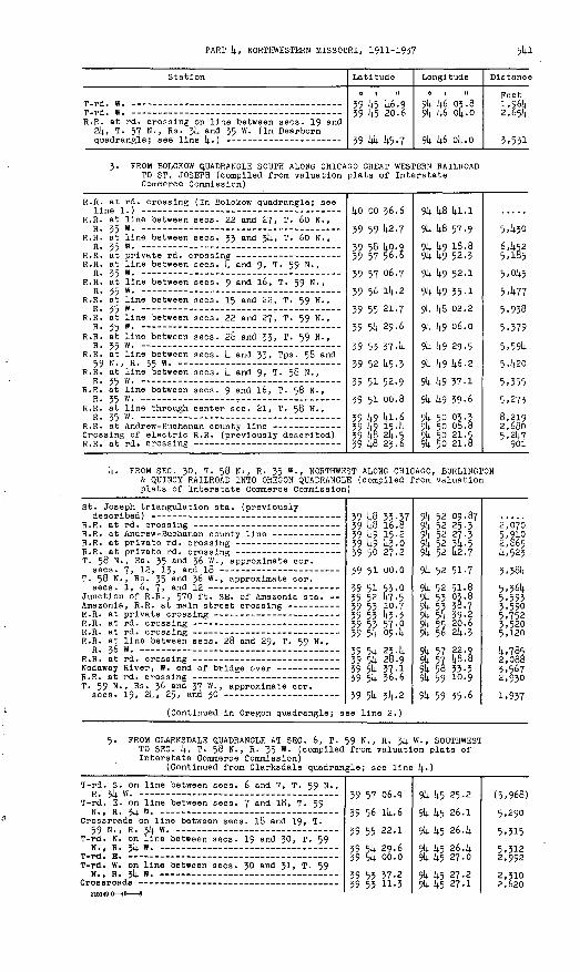
PART 4, NORTHWESTERN MISSOURI, 1911-1937 541
Station
R.R. at rd. 24, T. 57 quadrangle
crossing on line between sees. 19 and N., Rs. 34 and 35 W. (In Dearborn, s ne i±. )
Latitude
0 | 1!
39 45 46.9 39 45 20.6
39 44 45-7
Longitude
0 1 II
94 46 03.8 94 46 04.0
94 46 04.0
Distano
Feeti,964 2,654
5,551
FROM BOLCKOW QUADRANGLE SOUTH ALONG CHICAGO GREAT WESTERN RAILROAD TO ST. JOSEPH (compiled from valuation plats of Interstate Commerce Commission)
R.R. at rd. crossing (In Bolckow quadrangle; see
R.R. at line between sees. 22 and 27, T. 60 N.,R. 35 W . _..--_ _-____._______._______ ______
R.R. at line between sees. 33 and 34, T. 60 N.,
R.R. at line between sees. 4 and 9, T. 59 N.,
R.R. at line between sees. 9 and 16, T. 59 N. ,
R.R. at line between sees. 15 and 22, T. 59 N., R. 35 W . - - _-. r ______ ...
R.R. at line between sees. 22 and 27, T. 59 N.,R. 35 W . ____-_____ _-_ __________._
R.R. at line between sees. 2b and 33, T. 59 N.,
R.R. at line between sees. 4 and 35, TPS 5& and 59 N., R. 35 W.
R.R. at line between sees. 4 and 9, T. 58 N. ,
R.R. at line between sees. 9 and 16, T. 58 N., R. 35 W . _-____-_. __________ _ _
R.R. at line through center sec. 21, T. 58 N. ,R TC m
Crossing of electric R.R. (previously described)
40 oo 36.6
39 59 42.759 58 40.9 59 57 56.6
39 57 06.7
39 56 14-2
39 55 21-7
39 54 29.6
39 53 37-4
59 52 45-5 59 51 52.9
39 51 00.8
39 49 41-6 39 49 15-4 39 4§ 24.5 39 48 23.6
94 48 41-1
94 48 57-994 49 18.8 94 49 52.394 49 52.1
94 49 55-1
94 48 02.2
94 49 06.0
94 49 29.5
94 49 46-2
94 49 57-1
94 49 39-6
94 50 03.3 94 50 08.8 94 50 21. 5 94 50 21.8
5,430
6,452 5,185
5,045
5,477
5,938
5,379
5,594 5,420
5,355
5,273
8,219 2,680 5,247
901
4- FROM SEC. 30, T. 58 Ni, R. 35 W., NORTHWEST ALONG CHICAGO, BURLINGTON & QUINCY RAILROAD INTO OREGON QUADRANGLE (compiled from valuation plats of Interstate Commerce Commission)
St. Joseph triangulation sta. (previously
T. 58 N., Rs. 35 and 36 W., approximate cor.
T. 58 N., Rs. 35 and 36 W., approximate cor.
Junction of R.R., 570 ft. SE. of Amazonia sta. --
R.R. at line between sees. 28 and 29, T. 59 N.,
T. 59 N., Rs. 36 and 37 W. , approximate cor. sees. 19, 24, 25, and 30
(Continued in Oregon quadrangle; s
39 48 35-37 39 48 16.8 59 49 15-2 59 49 43-0 39 50 27.2
39 51 00.0
59 51 53-0 39 52 47-5 39 55 10-7 59 55 43-3 39 53 57-p 39 54 09.4
39 54 23-4 39 54 28.9 59 54 57.1 59 54 36.6
39 54 34.2
ee line 2.)
94 52 09.87 94 52 25.3 94 52 27.3 94 52 54-5 94 52 42.7
94 52 51-7
94 52 51-8 94 55 03.8 94 53 38.7 94 54 39-2 94 55 2p.6 94 56 24.3
94 57 22-2 §4 57 W.B 94 58 35-5 94 59 10.9
94 59 35-6
2,070 5,9102,865 4,5233,584
5,564 5,593 3,590 5,752 5,520 5,120
4,785 2,088 5,567 2,950
1,937
5. FROM CLARKSDALE QUADRANGLE AT SEC . 6, T. 59 N., R. 34 W., SOUTHWEST TO SEC. 4, T. 58 N., R. 35 W. (compiled from valuation plats of Interstate Commerce Commission)
(Continued from Clarksdale quadrangle; see line 4-)
T-rd. S. on line between sees. 6 and 7, T. 59 N., R. 34 W.
T-rd. E. on line between sees. 7 and 18, T. 59
Crossroads on line between sees. 18 and 19, T. 59 N., R. 34 W. -_-__ _
T-rd. N. on line between sees. 19 and 30, T. 59
T-rd. W. on line between sees. 30 and 31, T. 59
39 57 06.9
39 56 14-6
39 55 22.1
39 54 29.6 39 54 oo.o
39 53 57-2 59 53 11-3
94 45 25-2
94 45 26.1
94 45 26.4
94 45 26.4 94 45 27.0
94 45 27.2 94 45 27.1
(5,968)
5,290
5,315
5,312 2,992
2,310 2,620

TRANSIT TRAVERSE IN MISSOURI
Station
Rd. at line between sees. 6 and 31, Tps . 58 and
One Hundred and Two River, center of bridge over
T. 58 N-, R. 35 W., cor. sees. 1, 2, 11, and 12,
T. 58 N., R. 35 W., cor. sees. 2, 3, 10, and 11,
Chicaeo Great Western R.R. at line between sees. k and 9, T. 58 N., R. 35 W. (previously
Latitude
0 1 "
39 52 U5.2 39 51 k7-3 39 51 U5-2 39 51 54-0
39 51 55.0
39 51 5U-3 39 51 5k. 2
39 51 52.9
Longitude
01 II
9k k5 25.89k k5 25.9 9k k5 k6.7 9k k6 18.7
9k kl 10.8
9k k8 20.3 9k It-8 30-U
9k k9 37-1
Distance
Peet
2,650 5,802 I,6k3 2,6k6
k,o66
5,ki7 790
5,200
Magnetic declination in 192k, 8° 30' E.
DEARBORN QUADRANGLE * (Latitude 39°30'-39°k5'; longitude 9k°k5'-95°00')
Buchanan and Platte Counties
R36W R 35W I \
1. FROM ST. JOSEPH QUADRANGLE AT SEC. ik, T. 57 N., R. 35 W., SOUTH TOSEC. 26, T. 57 N., R. 35 W., THENCE WEST TO SEC. 32, T. 57 N.,
. R. 35 W. (by E. L. McNair in 1923)(Continued from St. Joseph quadrangle; see line 1.)
Station
Center of bridge over Chicago, Rock Island &
T. 57 N., R. 35 W. , cor. sees. 23, 2k, 25, and
Chicago, Burlington & Quincy R.R. at rd. crossing Chicago, Burlington & Quincy R.R. at rd. crossing Chicago, Burlington & Quincy R.R. at rd. crossing T. 57 N., R. 35 W., near center sec. 27, 550 ft.
S. of Chicago, Burlington & Quincy R.R., on top of wing wall of highway bridge; standard tab let stamped "Prim Trav Sta No 2 Mac 1923"
Atchison, Topeka (c Santa Pe Ry. at rd. crossing -
Kansas City, Clay County and St. Joseph Electric
M.R.C. trlangulatlon sta. designated "Kings Knob"
Latitude
39 kk 51-8 39 kk 26.9
39 kk 00.9 39 k3 56.5 39 k3 k.9-5 39 k3 kk-2
39 k3 38.7k 39 k3 07.8 39 k2 k3-9 39 k2 52.7
39 k2 52.7 39 k2 52.7 39 U3 09.1 39 lj-3 09. k 39 k3 08.95
Longitude
9k kl 13-2 3k kl 12-9
9k kl 12-8 9k kl 12.3 9k kS 32.8 9k k8 53.6
9k k8 53.96 9k kg 53.2 9k k8 5k. 5 9k k9 kk-3.
9k k9 51-2 9k 50 01.3 94 50 35-1 9k 51 11.6 91; 51 33-96
Distance
Peet
(2,752) 2,520
2,630 2,k72 6,k27 1,712
3*980 550
3,120 2,850
2. FROM LEAVENWORTH QUADRANGLE AT SEC. 7, T. 5k N. , R. 35 W. , NORTH TO SEC. 28, T. 57 N., R. 35 W. (by E. L. McNair in 1923)
Prim Trav Sta No 1 1906 ( in Leavenworth39 29 51. ko 39 30 21.1
9k 52 51.17 9k 52 51-5 3:6-66
* A small part of this quadrangle lies in Kansas.

PART k, NORTHWESTERN MISSOURI, 1911-1937 543
Station
Buchanan-Platte county line at metal gate W. of
T. 55 N. , R. 35 W., quarter cor. between sees. 29
Wallace, Chicago, Rock Island & Pacific Ry. at
T. 55 N., R. 35 W., quarter cor. between sees. 16
T. 55 N., R. 35 W., center sec. 9, T-rd. E. -----
T. 56 N., R. 35 W., center sec. 33, T-rd. W. -
T. 56 N., R. 35 W., quarter eor. between sees. 21
T. 56 N. , R. 35 W., quarter cor. between sees. l6
T. 56 N. , R. 35 W., quarter cor. between sees. 9
T. 56 N., R. 35 W., quarter cor. between sees, k
T-rd. E., 300 ft. W. of Kansas City, Clay County
T-rd. E. -- -- --
Kansas City, Clay County and St. Joseph Electric R.R. at rd. crossing (previously described) -
Latitude
39 31 10-5
39 31 53-8
39 32 54-2 39 32 54-5
39 33 17-9 39 33 46-6
39 34 39-0 39 34 39-5 39 35 31-4 39 36 23-9 39 37 29.4 39 37 57-4
39 38 Itf -4
39 39 39-6
39 40 31-7
39 41 24.6
39 41 49-1 39 42 17-1 39 42 43.0
39 42 52.7
Longitude
0 | II
94 51 54-9 94 51 45-2
94 51 44-7 94 50 54-794 50 51-9 94-50 54-6
94 50 37-5 94 50 o4.o 94 50 03.8 94 50 03.8 94 49 59-3 94 49 58.6
94 49 58.2
94 49 57-3
94 49 56.7 94 49 56.0
94 49 56.2 94 50 01.2 94 50 01.3
94 49 5i-2
Distance
Feet 6,683
4,458
6,108 3,920
2,300 3,005
5,480 2,631 5,255 5,310 6,647 2,632
5,o6l
5,291
5,271
5,291
2,550 2,§55 2,630
1,257
PROM SEC. 6, T. 55 N., R. 36 W., NORTH TO SEC. Jl, T. 56 N., R. 36 W., THENCE NORTHEAST ALONG CHICAGO, BURLINGTON & QUINCY RAILROAD TO SEC. 32, T. 57 N., R. 35 W. (compiled from valuation plats of Interstate Commerce Commission)
Kings Knob triangulation sta . (previously
39 36 57.1739 37 4o.O39 37 58.239 38 16.0
39 39 45-139 40 33-839 41 25.339 42 36.9
ZQ ),Z OR QC
9k 59 16.6494 58 57-494 58 23.294 57 49-994 56 42.594 55 15-894 54 30.294 53 41-994 52 3.5-0
94 51 33-96
4,5983,170 6,4308,6436,090 S'^o 8,9405,760
4- FROM GOWER QUADRANGLE WEST ALONG CHICAGO, ROCK ISLAND & PACIFICRAILWAY TO SEC. 21, T. 57 N., R. 35 W. (compiled from valuation plats of Interstate Commerce Commission)
(Continued from Cower quadrangle; see line 3.)
T. 57 N., R. 3!; W., quarter cor. between sees.
R.R. at rd. crossing on line between sees. 19 and
Center of bridge over R.R. (previously described)
Crossing of Chicago, Burlington & Quincy R.R. - Crossing of Atchison, Topeka & Santa Fe Ry.
39 44 28.8
39 44 45-7 39 44 48-9 39 44 51-8 39 44 37-0 39 44 23.9 39 44 15-6 39 44 15-6
94 45 00.6
94 46 04-0 94 46 4o.l 94 47 13-2 94 48 20.6 94 49 27.9 94 50 2^.6 94 50 24.5
(6,273)
5,247 2,837 2,596 5,473 5,405 4,425
60
5- FROM GOWER QUADRANGLE NORTHWEST ALONG ATCUISON, TOPEKA & SANTA FE RAILWAY TO SEC. 20, T. 57 N., R. 35 W. (compiled from valuation plats of Interstate Commerce Commission)
(Continued from Gower quadrangle; see line 40
T. 56 N., R. 34 W-, quarter cor. between sees. 18 and 19 --
R.R. at line between sees. 13 and 18, T. 56 N., Rs. 34 and 35 W.
T. 56 N., R. 35 W., eor. sees. 13, 14, 23, and 24 Bee Creek, R.R. at rd. crossing at Bee Creek, Junction of Chicago Great Western R.R. T. 56 N., R. 35 W., quarter cor. between sees.
11 and 14, T-rd. W. Center of bridge over R.R. ----------------------R.R. at rd. crossing T. 56 N., R. 35 W., quarter cor. between sees. 2
and 3 - - -- T. 56 N., R. 35 W., N. quarter eor. see. 3 - -----T. 57 N., R. 35 W., center sec. 34
39 39 39-7
39 3939 3939 3939 39
39 40 39 40 39 4l 2
w. s38.0 45-7
la'.l
49-6 17.2 43-3
94 45 31.0
94 46 o4-994 47 10.694 47 25.594 47 34-4
94 47 43.4 94 47 50.8 94 47 53-2
94 48 16.194 48 50.094 48 54-5
(5,199)
2,8185,2241,1571,063
4,6931,9473,964
2^672
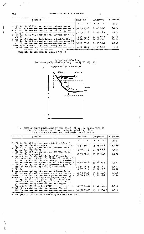
544 TRANSIT. TRAVERSE IN MISSOURI
Station
T. 57 N. , R. 35 W., quarter cor. between sees.
R.R. at line between sees. 27 and 28, T. 57 N.,
T. 57 N., R. 55 W., quarter cor. between sees. 21
Crossing of Chicago, Rock Island & Pacific Ry. -- T. 57 N., R. 55 W., quarter cor. between sees. 20
Crossing of Kansas City, Clay County and St.
Latitude
0 1 N
59 45 09.2
59 43 42.8
39 U4 01.5 39 1+4 15.6
59 44 27.5 59 44 28.7
Longitude
0 | It
94 48 55-5 914. 49 28.0
94 50 01.9 94 50 24.5
94 50 35-6
94 50 47.2
Distance
Feet
2,624
4,254
5,265 2,280
1,467
917
Magnetic declination In 1924, 8° 50'' E.
OREGON QUADRANGLE * (Latitude 59°45'-4o°00'; longitude 95°00'-95°15')
Andrew and Holt Counties
R37W
T59N
1. FROM MAITLAND QUADRANGLE AT SEC. 21, T. 60 N., R. 37 W., WEST TO SEC. 32, T. 60 N., R. 58 W. (by E. L. McNalr In 1925)
(Continued from Maltland quadrangle; see line 2.)
Station i
T. 60 N., "R. 37 W., cor. seca. 20 \ 21, 28, and
T. 60 N., R. 57 W., quarter cor. between sees.
T. 60 N., R. 57 W., quarter cor. between sees.
Oregon, 2 ml. E. of, 0.2 mi. E. of W. quarter eor. sec. 50, T. 60 N. , R. 57 W., 20 ft. N. of rd. at top of hill, in concrete post; standard tablet stamped "Prim Trav Sta No 13 Mae 1925" -
T. 60 N., Rs. 57 and- 58 W. , approximate quarter cor. between sees. 25 and 50, crossroads --
Oregon, intersection of streets, 1 block W. of
Oregon, 1.5 mi. W. of, on line between sees. 28 and 33, T. 60 N., R. 38 W., 25 ft. E. of en trance to Hinatt dwelling, lj.0 ft. N. of rd., in concrete post; standard tablet stamped
M.R.C. trlangulation sta. designated "Forest
Latitude
39 59 50.0
59 59 23 ..9 59 59 24.8
59 59 25.61
59 59 25.5 39 59 25.6
59 59 13-9 39 59 00.5
59 59 01.72
59 58 29.93
Longitude
0 | II
95 03 57-8
95 05 58.4
95 05. 06.4
95 06 04.51
95 06 18.1 95 07 58.0
95 08 44-9 95 09 45-4
95 10 36.13
95 10 52.22
Distance.
Feet
(5,289)
2,641
5,292
4,530
1,060 6,222
5,34p 4,904
3,953
3,453
* The greater part of this quadrangle lies in Kansas.

PART k, NORTHWESTERN MISSOURI, 1911-1937 51*5
Station Latitude
0 1 II
Longitude
0 1 H
Distance
Feet
FROM ST. JOSEPH QUADRANGLE NORTHWEST ALOUG CHICAGO, BURLINGTON & QUINCY RAILROAD INTO MAITLAND QUADRANGLE (compiled from valuation plats of Interstate Commerce Commission)
(Continued from St. Joseph quadrangle; see line k.)
T. 59 N., R. 57 W., cor. sees. 25, 2k, 25, and 26 T. 59 N., R. 57 W., cor. sees. 22, 25, 26, and 27
R.R. at line between sees. 25 and 50, T. 59 N.,
T. 59 N. , R. 58 W., quarter eor. between sees.
R.R. at line between sees, Ik and 23, T. 59 N. ,
R.R. at line between sees. Ik and 15, T. 59 N. ,
T. 59 N > » R * 38 w -» quarter cor. between sees. 9
R.R. at line between sees. 5 and J2, Tps. 59 and 60 N., R. 38 W.
Forest City, R.R. at Nodaway Street crossing -- Forest City, R.R. at Collins Street crossing
39 5k 35-7 39 5k 56.1 39 5li 30.039 5k 26.839 5k 01.939 5k 09.339 5k 24.2
39 5k 33-7
39 55 °5 It-
39 55 31-9
39 55 U9-339 56 21.8
59 56 51-039 57 25.1
39 58 09-239 58 Id. 8 59 59 16.8
95 00 k5.o 95 01 50.6 95 02 28.2
95 0^4. 11*495 ok 57-795 05 52-6
95 06 2k. k
95 07 29.3
95 06 36-6
95 09 U3-995 10 15.6
95 10 52.795 11 304 95 12 02.9
(5,253) 5.271 2,9981,761*
34581*,532
2,660
5,986
I*, 228
2,6kl*i*,295
£,43
5,3105,050 3,725
(Continued in Maitland quadrangle; see line 6.)
Magnetic declination in 192k, 9° 00' E.
MAITLAND QUADRANGLE (Latitude kO°00'-kO°15'; longitude 95°00'-95°15')
Andrew, Holt, and Hodaway Counties
| R38W| R37W I
1. FROM CRAIG QUADRANGLE AT SEC. 36, T. 6l N., R. 39 W., NORTH INTO SKIDMORE QUADRANGLE AT SEC. 2k, T. 63 N., R. 39 W. (by J. H. Wilson in 1916)
(Continued from Craig quadrangle; see line 2.)
Station Latitude Longitude
M.R.C. triangulation sta. designated "Napier" - T-rd. W. T. 6l N., R. 59 W., center sec.'36, T-rd. N. T. 6l N., R. 39 W., quarter cor. between sees. 25
and 36, rd. at fence E. - -T. 6l N., R. 39 W., quarter cor. between sees. 2k
and 25, crossroads T. 6l N., R. 39 W., quarter cor. between sees. 13and 2k, rd. at fences E. and W. --
T. 6l N., R. 39 W., quarter cor. between sees. 12and 13, T-rd. W.
T. 6l N., R. 39 W., quarter cor. between sees. 1and 12, rd. at' fence E. - - --------
kO 02 k7.36 li-0 02 53.8ko 03 07.1
1*0 03 33.1
ko ok 254
ko 05 17.7
kO 06 10.2
kO 07 02.k
95 11* 35.1*295 1U. Uk.695 H* 55-2
95 H* 55-2
95 11* 55-2
95 H* 5l*-8
95 H* 5l*.2
95 ll* 53-7
Feet (2,783)
1,580
2,635
5,290
5,295
5,320
5,280

5k6 TRANSIT TRAVERSE IN MISSOURI
Station
Chicago, Burlington & Quincy R.R. at rd.
Mound City, 1 ml. W. of, along Bigelow-Mound City rd. ( ? State Highway 1-C), in N& sec. 1, T. 6l N., R. 39 W., kO ft. N. of junction of rd. S.; iron post stamped "Prim Trav Sta No 3 1916" -
Mound City, intersection of State and Seventh
T. 62 N., R. 39 W., E. cor. sees. 2k and 25, T-rd. W., 50 ft. N. of W. cor. sees. 19 and 30,
T.'62 N., R. 39 W., E. cor. sees. 13 and 2k, T-rd. W., 30 ft. N. of T-rd. E. at W. cor.
T. 62 N. , R. 39 W., E. eor. sees. 12 and 13, T-rd. W., 100 ft. N. of W. cor. sees. 7 and 18,
T. 62 N., R. 39 W., E. cor. sees. 1 and 12, T-rd. W., 50 ft. N. of T-rd. E. at W. cor. sees. 6
T.. 63 N., Rs. 38 and 39 W., approximate cor.
T. 63 N., R. 39 W., E. cor. sees. 2k and 25, T-rd. W., 50 ft. S. of T-rd. E. at W. cor.
(Continued in Skidmore quadrangle
2. FROM BOLCKOW QUADRANGLE AT SEC. 12, T. 60 INTO OREGON QUADRANGLE AT SEC. 21, T. 6
Latitude
kO 07 22.0
kO 07 37-51+
l+o 08 30.2
kO 10 31-3
kO 12 16. kli.o 13 09.0
; see line 1
N., R. 37 Wo N., R. 37 v
Longitude
0 I II
95 11+ 53-2
95 ik 52.93
95 13 57-p 95 Ik 18. k95 l5 18.1
95 lk 18.1
95 ik 18.2
95' ik 18.095 11+ 17-5
95 11+ 16.3
95 ll+ 15-1
, SOUTHWEST Y. (by E. L.
Distance
Feet
1,980
1,578
k,732
1,62k
5,329
5,305
5,31+0
5,3005,325
5,306
5,2kk
McNalr in 1925)(Continued from Bolckow quadrangle; see line 1.
Nodaway River, center of bridge over ---- - Fillmore, 2-5 mi. W. of, on line between sees. 11
and Ik, T. 60 N., R. 37 W. , at rd. corner from N.-W., 3 ft. from fence, in concrete post; standard tablet stamped "Prim Trav Sta No 11
T. 60 N., R. 37 W., cor. sees. 9, 10, 15, and 16,
T. 60 N., R. 37 W., cor. sees. 6, 9, 16, and 17,
T. 60 N., R. 37 W., cor. sees. 16, 17, 20, and 21, 35 ft. NW. of crossroads, in concrete post; standard tablet stamped "Prim Trav Sta No 12
(Continued in Oregon quadrangle;
kO 01 51.8
kO 01 31.73ko 01 32.0kO 01 33-2
kO 01 3k. 1
ko oo 1+2.214.see line 1.)
95 oo 31.6
95 01 03.214. 95 01 58.0
95 02 k8.1
95 03 55-6
95 03 56.91
(5,35D
3,1954,260
3,902
5,251
5,251
FROM BOLCKOW QUADRANGLE AT SEC. 6, T. 6l N., R. 36 W., WEST TO SEC. T. 6l N., R. 39 W. (by E. L. McNair in 1923)
(Continued from Bolckow quadrangle; see line 2.)
1,
T. 6l N., R. 36 W., approximate quarter cor. be tween sees. 6 and 7, 20 ft. N. and l60 ft. W. from crossroads, 200 ft. W. of Parkes Store, 2 ft. from fence, in concrete post; standard tablet stamped "Prim Trav Sta No 27 Mac 1923^
T. 6l N., Rs. 36 and 37 W., approximate cor. sees. 1, 6, 7, and 12, rd. at fences N. and S.-
T. 61 N., R. 37 W., quarter cor. between sees. 1
T. 6l N., R. 37 W., N. quarter eor. see. 1,
T. 6l N., R. 37 W., N. cor. sees. 1 and 2, rd.
Nodaway River, center of bridge over -- Nodaway River, center of bridge over new channel- T. 62 N., R. 37 W., S. cor. sees. 33 and 3k,
15 ft. S. and 90 ft. W. from T-rd. N. , 115 ft. H. of dwelling of R. G. Cowan, in concrete post; standard tablet stamped "Prim Trav Sta
T. 6l N., R. 37 W., N. cor. sees, k and 5, T-rd.S
Tps. 6l and 62 N., Rs . 37 and 38 W., eor. of,
14.0 06 55.06
ko 06 55.1
14.0 06 56.0
14.0 07 1+7-8
ko 07 k8.l li.0 07 58.14. ko 07 14.84
ko 07 14.8.18 Uo 07 14.8.3
ko 07 k8.3 lio 07 k.B.2l.n n-7 lifl 3
95 oo 10.12
95 oo 1+5.9
95 01 20.14.
95 01 19-5
95 01 5k. 0 95 02 33-5 95 03 ol|.. 2
95 ok 10.81 95 ok k6.0
95 05 19.8 95 06 27.0
QC (T7 X3 f,
(2,790
2,780
2,680
5,250
2,680 3,070 2,380
5,176 2,730
2,630 5,220
c non
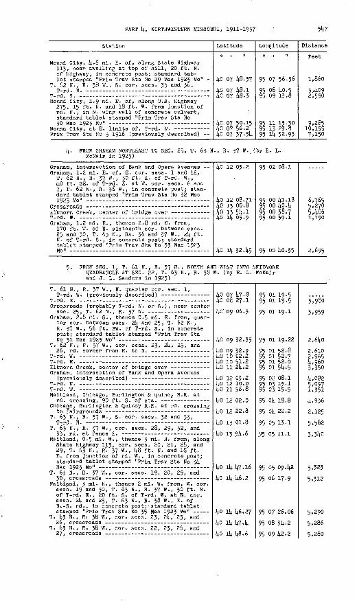
PART 14., NORTHWESTERN MISSOURI, 1911-193?
Station
Mound City, U-8 mi. E. of, along State Highway 113, near dwelling at top of hill, 20 ft. N. of highway, in concrete post; standard tab let stamped "Prim Trav Sta No 29 Mac 1923 Mo" -
T. 62 N. , R. 38 W., S. cor. sees. 35 and 36,
Mound City, 1.9 mi. E. of, along U.S. Highway 275, 15 ft. N. and 18 ft. W. from junction of rd. N., in N. wing wall of concrete culvert, standard tablet stamped "Prim Trav Sta No
Prim Trav Sta No 3 1916 (previously described)
Latitude
UO 07 U8-37
Uo 07 U8.1 Uo 07 -U8.3
Uo 07 50.15 Uo 07 56.2 ko 07 37 -5U
Longitude
0 1 II
95 07 56.56
95 06 14.0.5 95 09 13.8
95 11 13-30 95 13 23.8 95 lU 52.93
Distance
Peet
1,860
3,^092,590
9,285 10,155 7,150
k- FROM GRAHAM NORTHEAST TO SEC. 25, T. 63 N., R. 37 W. (by E. L. McNair in 1923)
Graham, intersection of Bank and Opera Avenues -- Graham, 1.2 mi. E. of, E. cor. sees. 1 and 12,
T. 62 N., R. 37 W., 30 ft. E. of T-rd. W., UO ft. SE. of T-rd. E. at W. cor. sees. 6 ana 7, T. 62 N., R. 36 W., in concrete post; stan dard tablet stamped "Prim Trav Sta No 32 Mac
Elkhorn Creek, center of bridge over ----------
Graham, 1.2 mi. E. , thence 2.8 ml. H. from, 170 ft. W. of N. sixteenth cor. between sees. 25 and 30, T. 63 N., Rs . 36 and 37 W., 2U ft. N. of T-rd. S., in concrete post; standard tablet stamped "Prim Trav Sta No 33 Mac 1923
14-0 12 03.2
kO 12 08.71 kO IJ 00.8 ko 13 5U-1 ko 4 05.9
14.0 iu 32.14.5
95 02 08.1
95 oo ki.18 95 oo k°-k 95 00 38.7 95 oo 39-1
95 00 14.0.35
6,765 5.2705, Itf6 1,190
2,695
5. FROM SEC. 1, T. 6l N., R. 37 W. , NORTH AND WEST INTO SKIDMORE QUADRANGLE AT SEC. 22, T. 63 N., R. 38 W. (by E. L. YcNair and J. L. Sanders in 1923)
T. 6l N., R. 37 W., N. quarter cor. sec. 1,
Crossroads (probably T-rd. N. or S.), near center
Graham, 2.8 ml. S., thence 0.5 ml. E. from, quar ter cor. between sees. 2k and 25, T. 62 N. , R. 37 W., 56 ft. SW. of T-rd. S., in concrete post; standard tablet stamped "Prim Trav Sta
T. 62 N., R. 37 W., cor. sees. 23, 2l4, 25, and
Elkhorn Creek, center of bridge over ------------ Graham, intersection of Bank and Opera Avenues
Maitland, Chicago, Burlington & i^uincy R.R. at
Chicago, Burlington & Quin&y R.R. at rd. crossing
T. 63 N., R. 37 W., S. eor. sees. 32 and 33,
T. 63 N., R. 37 W., cor. sees. 26, 29, 32, and
Maitland, 0.5 ml. W., thence 3 mi. N. from, along State Highway 1JLJ, cor. sees. 20, 21, 26, and 29, T. 63 N., R. 37 W., U8 ft. N. and 18 ft. E. from junction of rd. W. , in concrete post; standard tablet stamped "Prim Trav Sta No 314.
T. 63 N., R. 37 W., cor. sees. 19, 20, 29, and
Waitland, 3 ml. N., thence 2 ml. W. from, W. cor. sees. 19 and 30, T. 63 N., R. 37 W., 30 ft. N. of T-rd. E., 20 ft. S. of T-rd. W. at E. cor. sees. 214. and 25, T. 63 N., R. 38 W. , E. of N.-S. rd. , in concrete post; standard tablet stamped "Prim Trav Sta Ho 35 Mac 1923 Mo"
T. 63 N., R; 38 W., cor. sees. 23, 2k, 25, and
T. 63 H., R. 36 W., cor. sees. 22, 23, 26, and
kO 07 47-8Uo ob 27.1 ko' 09 06.3
Uo 09 32.35 ko 09 32.9Uo 10 02.2ko 10 51-2kO 11 21;. 2
UO 12 03.2 Uo 12 10.0Uo 11 56.8UO 12 02.0
UO 12 22.8
Uo 13 01.8 Uo 13 5U.6
Uo iU 14.7.16 Uo iU U6.2
Uo iU U6.27 Uo iU kl-k),n il, liR.£
95 01 19-5 95 01 19-5
95 01 19.1
95 01 19.22
95 01 52.8 95 01 52.7 95 01 52.0 95 01 5U-5
95 02 08.1 95 03 13-1 95 03 15-5
95 OU 18.8
95 oU 22.2
95 05 13-1
.95 05 11.1
95 05 09. U2
95 06 17.9
95 07 26.06
95 08 3U-2
oc no Ii9 y
Ji&O
3,959
2.6UO
2,6lO 2,965 U,96o 3,350U,o82 5,097 1,351
U.936
2,125
5,582
5,3Uo
5,323
5,312
5,290
5,286

5U8 TRANSIT TRAVERSE IN MISSOURI
Station
T. 63 N., R. 38 W., cor. sees. 21, 22, 2?, and 28, 1;5 ft. S. and 20 ft. E. from crossroads, in concrete post; standard tablet stamped
Latitude
0 | It
ko Ik ltf-73
Longitude
0 1 II
95 10 1^9.92
Distance-
Feet
5,256
(Continued in Skidmore quadrangle; see line 2.)
6. PROW OREGON QUADRANGLE NORTHWEST ALONG CHICAGO, BURLINGTON & QUINCY RAILROAD INTO CRAIG QUADRANGLE (compiled from valuation plats of Interstate Commerce Commission)
(Continued from Oregon quadrangle; see line 2.)
R.R. at line between sees. 19 and 21;, T. 60
R.R. at line between sees. 13 and 21;, T. 60
R.R. at line between sees. 11 and 12, T. 60R. 39 w. _ - _______-____ ._
R.R. at rd. crossing (In Craig quadrangle;
N.,
N.,
N.,
see
l+okokokoko
08
27
U8
ko31
.6
.0
5 .4
95
95
95
95
95
13
13
ik
15
U6
03
20
nd
ok
2
2
6
2,360
2 MO
6,51!;
7-
Frim Trav describ
Rd. at fe
FROM AT
Sta
noes
SEC. 25, T. 63 N SEC. 2k, T- 63 N
., R.
., R.37 w 37 w
No 33 Mac 1923 Mo (previou
(Continued In Skldmore q
. , NORTH INTO SK1PMORE QUADRANGLE
. (by S. T. Tudor in 1931;)
sly
;adrangle;
kO Ik 32-l;5ko ik 58.3see line 1;. ]
95 95
00 00
37 -6''2,625
Magnetic declination 9° 28' E.
SKIDMORE QUADRANGLE (Latitude l;0°15'-l;0 0 30'; longitude 95°00' -95°15 ' )
Atchison, Holt, and Nodaway Counties
R36W R37W
1. FROM MAITLAND QUADRANGLE AT SEC. 21;, T. 63 N., R. 39 W., NORTHAND WEST INTO TARKIO QUADRANGLE AT SEC. 13, T. 63 N., R. 39 W. (by J. H. Wilson in 1916)
(Continued from Maitland quadrangle; see line 1.)
Station
T. 63 N., R. 39 W., k5 ft- N. and 18 ft. E. from E. cor. sees. 13 and 2k, 15 ft. N. and 18 ft. E. from W. cor. sees. 18 and 19, T. 63 N., R. 38 W., NE. of crossroads, on Atchison-Holt county line; Iron post stamped
Latitude
0 | II
Longitude
95 il; 13.87
Distance
Feet
(5,361;).
(Continued in Tarklo quadrangle; see line 1.)

PART 14., NORTHWESTERN MISSOURI, 1911-1937 5U9
Station Latitude Longitude Distance
o i n o , it peet
2. FROM MAITLAND QUADRANGLE AT SEC. 22, T. 63 N., R. 38 W., NORTH TO SEC. 31, T. 66 N., R. 38 W., THENCE EAST INTO PICKERING QUADRANGLE AT SEC. 29, T. 66 N., R. 36 W. (by 1. L. Sanders in 1923)
(Continued from Maitland quadrangle; see line 5-)
T. 63 N., R. 38 W., cor. sees. 15, 16, 21, and 22, crossroads on Atchison-Holt county line -
T. 63 N., R. 38 W., cor. sees. 16, 17, 20, and 21, crossroads on Atchison-Holt county line ---
T. 63 N., R. 38 W., cor. sees. 17, 18, 19, and
Prim Trav Sta No [4 1916 (previously described) - T. 63 N., Rs. 38 and 39 W., approximate cor.
T. 63 N., Rs. 38 and 39 W., approximate cor. sees. 1, 6, 7, 6nd 12, crossroads -------------
Tps. 63 and 6I+. N., Rs. 38 and 39 W. , cor. of, 20 ft. S. and 20 ft. W. of crossroads, in con crete post; standard tablet stamped "Prim Trav
T. 61; N., Rs. 38 and 39 W., approximate cor.
T. 614. N., Rs. 38 and 39 W., cor. sees. 13, 18, 19, and 2l|_, 1^0 ft. N. and 20 ft. W. from cross roads, in concrete post; standard tablet
T. 6U N., Rs. 38 and 39 W. , approximate cor.
T. 61; N., Rs. 38 and 39 W., approximate cor.
Tps. 61; and 65 N. , Rs . 38 and 39 W., 20 ft. S. and 20 ft. W. from cor. of, at NE. corner of yard of 1. W. Hannon, in concrete post; stan dard tablet stamped "Prim Trav Sta No 39 J S 1923" .- _____ _
T. 65 N., R. 38 W., W. cor. sees. 30 and 31, T-rd. E.
T. 65 N., R. 39 W., E. cor. sees. 25 and 36,
T. 65 N., R. 36 W., W. cor. sees. 19 and 30,
T. 65 N., R. 39 W., E. cor. sees. 21; and 25,
T. 65 N., R. 39 W., near E. cor. sees. 13 and 21;, [4.5 ft. H. and 29 ft. E. from State Highway 1; at crossroad, in fence corner, in concrete post; standard tablet stamped "Prim Trav Sta
T. 65 N., R. 38 W., W. cor. sees. 7 and 16,
T. 65 N., R. 39 W., E. cor. sees. 12 and 13,
T. 65 N., R. 39 W., E. cor. sees. 1 and 12,
T. 65 N., Rs. 38 and 39 W. , 615 ft. W. of N. cor. aecs. 1 and 6, 100 ft. SE. of SE. corner of farmhouse, 25 ft. N. of E.-W. rd., in con crete post; standard tablet stamped "Prim Trav
T. 66 N., R. 38 W., S. cor. sees. 32 and 33,
T. 65 N., R. 38 W., N. cor. sees. 5 and 6,T rd S --
T. 65 N., R. 38 W., N. cor. sees. 1; and 5, T-rd S -- --
T. 65 N., R. 36 W., N. cor. sees. 3 and I;, rd. at
T. 66 N., R. 38 W«> near quarter cor. between sees. 26 and 35, 15 ft. S. and 18 ft. E. from crossroads, 3 ft. N. of fence corner, in con crete post; standard, tablet stamped "Prim Trav
T. 66 N., R. 38 W., cor. sees. 25, 26, 35, and
T. 66 N., R. 37 W., eor. sees. 29, 30, 31, and
T. 66 N., R. 37 W., 0.2 mi. E. of cor. sees. 29, 30, 31, and 32, 50 (? 30) ft. E. of T-rd. S., 20 ft. N. of E.-W. rd., about 235 ft. W. of iron bridge, 1 ft. S. of fence, in concrete post; standard tablet stamped "Prim Trav Sta
Wabash Ry. at rd. crossing, 1,232 ft. S. of mlle-
T. 66 N., R. 37 W., cor. sees. 28, 29, 32, and
140 15 l42.1|
li.0 15 Itf.?
LO 15 14-5-2ko 15 146.1914.0 16 38.1
140 17 30.14.
140 18 22.28 [40 19 ll4-3
140 20 06.7
140 20 59.29
140 21 51.2
140 22 U3-3
140 23 35-11
14.0 2U 26.3
140 214 27.9
Uo 25 19.3
140 25 20.1;
14.0 26 13.09
14.0 27 OJ.l;
140 27 05.14
140 27 57-5
14.0 28 146.31
140 28 U5-6
UO 28 145-3
Uo 28 1414-6
140 28 [414. 1
140 29 36.08ko 2935-9 Uo 29 22.6
140 29 31;. 3
Uo 29 35-30
UO 29 3l;-8
UO 29 3U-6
95 10 U8.9
95 11 57-2
95 13 ol;.9 95 4 13-87
95 lU 13-2
95 lU 12.1
95 lU 11.514 95 lU 10. k
95 lit- 09.5
95 lU 08.814
95 lU 07-6
95 lU 06 . 6
95 11; 05.93
95 lit- 05.1
95 lit- 05.0
95 lit- oU-14
95 11; oU. I;
95 il; 03.95
95 lU 03.8
95 lit- 03.8
95 lit- 03.3
95 lit- 10.78
95 13 15-1
95 12 53-5
95 11 14.6-7
95 10 38.9
95 1023.143
95 09)4.9.5 95 06 14.0.7
95 0732.5
95 07 15.05
95 0659-0
95 0623.9
(5,330)
5,301;
5,250 5,35U
5,250
5,296
5,253 5,266
5,300
5,328
5,250
5,275
5,250
5,180
160
5,210
110
5,332
5,119
200
5,270
U,975 l4-,30l;
1,670
5,160
5,2UO
5,3972,6205,U87
5.1U3
1,350
l,2l;0
2,710
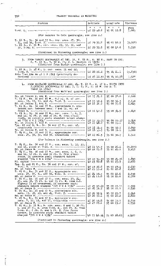
550 TRANSIT TRAVERSE IN MISSOUBI
Station
T-rd.
T. 66
T. 3 6^ 32,
N., Rs. and 36, N., R. T-rd. S
(For balance in Coin quadrangle, s
36 and 37 W., cor. sees. 25, 30,
36 W. , cor. sees
(Continued in
. 29, 30, 31, and
Pickering quadrangle
Latitude
40 29 40.6
ee line 1.)
40 29 31.7
4o 29 31.3
; see line 1.
Longitude
95 05 11.8
95 01 50.3
95 oo 41-6
Distance
Feet 5,605
(3,967)
5,310
3. PROM TARKIO QUADRANGLE AT SEC. Jl, T. 66 N., R. 38 W., EAST TO SEC. 6, T. 65 N., R. 38 W. (by J. L. Sanders in 1923)
(Continued from Tarkio quadrangle; see line 2.
T. 66 N. , R.
Prim Trav Sta
38 w.,
No 46
S- cor. s
L S 1923
ecs 31 and
(previously
32,
de-40 28
40 28
46.2
46.3195
95
14
14
24.1
10.78
(3,650)
1,027
4. PROM MAITLAND QUADRANGLE AT SEC. 2k, T. 63 N., R. 37 W. , NORTH INTO PICKERING QUADRANGLE AT SEC. 7, T. 65 N., R. 36 W. (by S. T. Tudor in 193!;)
(Continued from Maitland quadrangle; see line 7-)
Rd. at fences E. and W. - ---__-__-_-.__-__-__-__ T. 63 N., Rs. 36 and 37 W., 0.2 mi. N. of cor.
sees. 13, 18, 19, and 24, T-rd. E. Rd. at fences E. and W. _.__.._ T. 65 N., Rs. 36 and 37 W., approximate S. six
teenth cor. between sees. 7 and 12, rd. at fence W. -
T. 63 N., Rs. 36 and 37 W., cor. sees. 1, 6, 7,' and 12, 36 ft. S. and 36 ft. E. from cross roads, in concrete post; standard tablet stamp ed "701 C W A 1934"
Rd. at fences E. and W. - --- -- Tps. 63 and 64 N., Rs. 36 and 37 W., cor. of,
crossroads - --- --------_-----._--_-_-.-__-_Rd. at fences E. and w. - T. 64 N., Rs. 36 and 37 W., approximate cor.
sees. 25, 30, 31, flnd 36, crossroads ---- ----
40 15 2i;.6
40 15 50.64o 16 16.7
16 42.8
1;0 17 21.7040 17 48.0
40 18 14.21;0 18 53-3
40 19 06.3
(For balance in Pickering quadrangle, see line
T. 64 N., Rs. 36 and 37 W., eor. sees. 7, 12, 13, and 10, stone at T-rd. N. - ----- -----_--_-_
Rd. at fence W. --T. 64 N., Rs. 36 and 37 W., cor. sees. 1, 6, 7,
and 12, 50 ft. S. and 30 ft. W. from cross roads, in concrete post; standard tablet stamped "704 C W A 1934"
Rd. corner - - Tps. 64 and 65 N., Rs. 3° an<l 37 W., cor. of,
T-rd. N. --- Rd. at fence W. T. 65 N., Rs. 36 and 37 W., approximate cor.
sees. 25, 30, 31, and 36, T-rd. W. Rd. ot fence W. T. 65 N., Rs. 36 and 37 W., cor. sees. 19, 24,
25, and 30, 55 ft. S. and 35 ft. W. from U.S. Highway 71 Q t crossroad, in concrete post; standard tablet stamped "707 C W A 1934"
Rd. at fence E. -- : T. 65 N., Rs. 36 and 37 W., approximate cor.
sees. 13, 18, 19, and 24, T-rd. E. Rd. at fence W. T. 65 N., Rs. 36 and 37 W., approximate cor.
sees. 7, 12, 13, and 18, crossroads __----_ Rd. at fence W. -- -- --: T. 65 N., R. 36 W., W. cor. sees. 6 and 7, 30 ft.
S. and 27 ft. E. from T-rd. E., 220 ft. S. from T-rd. W., 6 ft. S. and 4 ft. E. from fence corner, in concrete post; standard tablet stamped "708 C W A 1934" --------------------
40 21 43.7 kO 22 15.7
kO 22 34-39 40 23 00.8
40 2J 26.8 kO 23 55-2
UO 21; 19.3 i;0 21; 46.0
4o 25 10.69 4o 25 36.3
40 26 02.1; 40 26 30.1
40 26'55.8 lj.0 27 22.6
40 27 46.54
(Continued in Pickering quadrangle; see line 2.
95 00 37.0
95 oo 36.595 oo 35-5
95 00 34.9
95 oo 33-37 95 00 33.1
95 oo 32.3 95 oo 31.1
95 oo 30.7
2.)
95 oo 26.2 95 oo 25.1
95 00 21;. 9695 00 23.9
95 oo 23.1 95 00 22.8
95 00 22.695 00 22.0
95 oo 22.il 95 oo 21.1
95 oo 20.795 00 20.2
95 oo 19.7 95 oo 19.2
95 oo 18.60
2,660
2,6302,645
2,640
3,9402,665
2,6503,960
1,310
(3,070)3,21;0
1,8902,680
2,6302,660
2,6502,700
2,5002,590
2,61;0 2,800
2,6102,710
2,420

PART k, NORTHWESTERN MISSOURI, 1911-1937 551
Station
5. FROM TARKIO QUADRANGLE AT SEC. 36, T. 65 1, T. 6k N., R. 37 W. (by J. P. Anderso
(Continued from Tarklo quadrangle;
Tps. 6k and 65. H., R. 39 W., quarter cor. be-
Prim Trav Sta No 39 J S 1923 (previously de-
T. 61; N., Rs. 38 and 39 W., approximate quarter cor. between sees. 1 and 6, rd. at fences E.
T. 61+ N., Rs . 38 and 39 W., approximate cor. sees. 1, 6, 7, and 12, rd. at fences E. and W.
T. 6)4. N., Rs . 3o and 39 W., approximate quarter cor. between sees. 7 an<i 12, rd. at fences E.
T. 61+ N., Rs. 38 and 39 W., approximate cor.
T. 6k N. , R. 38 W., quarter cor. between sees.
T. 61+. N., R. 38 VJ., cor. sees. 7, 8, 17, and 18, 30 ft. N. and 360 ft. W. from T-rd. S., 75 ft. SE. of corner of dwelling of Orel Raines, in concrete post; standard tablet stamped "823
T. 61+ N., R. 38 W., cor. sees. 8, 9, 16, and 17,
T. 61). N., R. 36 W., cor. sees. 9, 10, 15, and 16,
T. 61; N., R.. 38 W., about 650 ft. W. of cor. sees. 10, 11, Ik, and 15, about 60 ft. S. of dwelling of D. C. Lundeen, 30 (? 22) ft. N. of rd., in yard, in concrete post; standard tab-
T. 61; N., R. 36 W., cor. sees. 11, 12, 13, and lli T rd S
T. 64. N., Rs. 37 and 38 W., approximate cor.
T. 61; N., R. 37 W., cor. sees. 7, 8, 17, and 18, 3 ft. N. and 2k ft. E. from N.-S. rd. at rd. W., 21 ft. N. of rd. E., in concrete post;
Chicago, Burlington & Quincy R.R. at rd. crossing
T. 61; N., R. 37y.W., cor. sees. 3, 1;, 9, and 10, 50 ft. N. and'25 ft. W. from T-rd. N. , 21 ft. N. and 6 ft. W. from W. head wall of concrete* culvert, in concrete post; standard tablet
T. 61; N., R. 37 W., cor. sees. 2, 3, 10, and 11,
T. 61; N., R. 37 W., cor. sees. 1, 2,. 11, and 12,
Latitude
0 1 II
N., R. 39 w. n in 193W see line 1;.
ko 23 35.6 ko 23 35-11
kO 23 09.1
kO 22 k3.2
kO 22 17. L;
kO 21 51.1
kO 21 50.6
kO 21 50.23
1;0 21 k8.8
kO 21 ky.6
kO 21 k6.71 14.0 21 k5.5
kO 21 kk.8
kO 21 k2.8
kO 21 10.29 lj.0 22 09-7 kO 22 08.8 l;0 22 09.6 1;0 22 26.7
kO 22 36.57 lj.0 22 36.3
kO 22 36.0
kO 22 35-5 kO 22 35-2 kO 22 3!;. 39
Longitude
0 1 II
EAST TO SEC.
95 ik l)-0.i 95 lU 05.93
95 ik 06.2
95 ik 06.7
95 Hi- 07.2
95 lU 07-8
95 13 30.6
95 13 01.11
95 11 lt-8.3
95 10 39-7
95 09 ko.k5 95 08 57-995 08 23.8
95 07 15-7
95 06 08.06 95 06 07.5 95 05 01.3 95 0)4. 38.2 95 01; 38.0
95 03 50.78 95 03 16.2
95 02 k2.l
95 01 33.2 95 00 58.8 95 oo 2k. 96
Distance
Feet
(2,6k5)
2,6k5
2,635
2,615
2,610
2,665
2,880
2,280
:,61;0
5,310
k, 590 3,300
2,655
5,285
5,235 2,670 5,130 1.790 1,725
3,785 2,680
2,635
5,335 2,660 2,625
6. PROM COIN QUADRANGLE AT SEC. 30, T. 66 N., R. 38 W. , SOUTH TO SEC. 6, T. 65 N., R. 38 W. (by H. W. Gross in 1.535)
(Continued from Coin quadrangle; see line I;.)
T. 66 N., R. 38 W.,- cor. sees. 29, 30, 31, and
T. 66* N., R. 38 W., S. cor. sees. 31 and 32,
Prim Trav Sta No I+.6 L S 1923 (previously des-
ko 29 38.7
kO 28 k6.3
kO 26 k6.Jl
95 Hi- 23-8
95 ik 2k. o
95 14 10.78
(2,655)
5,30k
1,02k
Magnetic declination 9° 11' E.

552 TRANSIT TRAVERSE IN MISSOURI
COIN QUADRANGLE # (Latitude kO°30'-l+0°k5' ; longitude 95°00'-95°15')
Atchison and Nodaway Counties
"1BLANCHARD
PROM SKIDMORE QUADRANGLE AT SEC. 28, T. 66 N., R. 37 W., EAST AND SOUTH INTO'SKIDMORE QUADRANGLE AT SEC. 30, T. 66 N., R. j6 W. (by J. L. Sanders in 192J)
(Continued, from Skidmore quadrangle; see line 2.)
Station
T. 66 N., R. 57 W., cor. sees. 21, 22, 2?, andDP T »i-l Q
Nodaway River, center of bridge over -- -- --- T. 66 N., R. J? W., center of SE 'lA sec. 25,
k2 ft. N. and k8 ft. E. from County Route C at rd. S. and lane N., 5 ft. N. .'and 5 ft. E. from corner fence post, in concrete post; standard tablet stamped "Prim Trav Sta No kg L S 1925
Clearmont, Chicago, Burlington & Qulncy R.R. at
Latitude
(4.0 50 26.5ko 50 58.8
ko 30 38.76ko 30 37-6 lin *n in.Q
Longitude
0 1 II'
95 OS 15-5 95 oil. 02.8
95 05 15-llj-
95 02 06.3QR 01 50.2
Distance
Feet
(k,656)5,751;
3,684
5.522 P.QV;
(Continued in Skidmore quadrangle; see line 2.)
2. FROM NEW MARKET QUADRANGLE AT SEC. 29, T. 66 N., R. 56 W., NORTH AND EAST INTO NEW MARKET QUADRANGLE AT SEC. J2, T. 67 N., R. j6 W. (by S. T. Tudor in l'93lj.}
(Continued from New Market quadrangle; see line 2.)
T. 66 N. , R. 36 W. , quarter cor. between sees.
T. 66 N., R. 36 W., cor. sees. 19, 20, 29, and
Clearmont, 0.7 mi. N. and 1 mi. E. from, cor. sees. 17, 18, 19, and 20, T. 66 N. , R. 36 W., 60 (? 65) ft. N. and 25 ft. E. from T-rd. E. , in concrete post; standard tablet stamped "769
T. 66 N., R. 36 W., cor. sees. 7, 8, 17, and 18,
T. 66 N., R. 36 W., cor. sees. 5, 6, 7, and 8,
T. 67 N., R. 36 W., S. cor. sees. 3! and 52,
T. 67 N., R. 36 W., near quarter eor. between sees. 31 and 32, 15 ft. S. and 55 ft. W. from T-rd. E., 5 ft. S. and 6 ft. W. from corner fence post, in concrete post; standard tablet
T. 67 N. , R. 36 W., center sec. 32, crossroads
ko 31 16.35kO 31 k2-k
ko 52 5^-0
ko 35 26. k
ko 53 52.1;
ko 3U 18.39li.o 5U 18.0
95 00 ko.5
95 oo ko.5
95 oo 55.6
95 oo 01.1
(2,650)
2,6U5
2,7102,6kO
2,570
2,660
2,700(Continued in New Market quadrangle; see line 5.)
* The greater part of this quadrangle lies in Iowa.
PART 4, NORTHWESTERN MISSOURI, 1911-1937 555
Station
3. FROM. PARRAGUT QUADRANGLE AT SEC. Jl, T. 6 SEC. Jl, T. 67 N., R. 36 W. (by J. P. A
810 C W A 193L|. (In Farragut quadrangle; see
East Tarkio Creek, center of bridge over --- ---
T. 67 N., R. 38 W., on line between sees. 32 and 33, 0.2 mi. S. of Iowa-Mo. State line, 7 ft. N. and 20 ft. E. from Wabash Ry. at rd. crossing, 14 ft. N. of track, in concrete post; standard
T. 67 N., R. 38 W., S. cor. sees. 32 and 33,
T. 66 N., R. 38 W., N. quarter cor. sec. 4 ------
T. 66 N., R. 38 W., N. quarter cor. sec. 3, rd.
Tps. 66 and 67 N. , R. 36 W. , cor. sees. 2, 3, 3!)., and 35, 25 ft. N. of T-rd. S., on property of Chester Honan, in concrete post; standard tab-
Tps. 66 and 67 N., R. 38 W., approximate cor.
Tps. 66 and 67 N. , Rs . 37 and 38 W., cor. of, rd.
Tps. 66 and 67 N., R. 37 W., approximate cor.
Tps. 66 and 67 N., R. 37 W. , near W. sixteenth cor. between sees. 5 anci 32, 35 ft - N - anci 36 -ft. E. from crossroads, in yard of Mount Tabor School, in concrete post; standard tab-
Tps. 66 and 67 N., R. 37 W., approximate cor.
T. 66 N., R. 37 W., N. quarter cor. sec. 1;, T-rd.
Tps. 66 and 67 N., R. 37 W. , approximate cor.
Tps. 66 and 67 N., R. 37 W. , cor. sees. 2, 3, 3!;, and 35, 30 ft. S. and 33 (? 30) ft. W. from crossroads, 85 ft. N. and 60 ft. E. from NE. corner of farmhouse, in concrete post; stan-
Tps. 66 and 67 N., R. 37 W., approximate cor.
Clearmont, 3.8 ml. N. of, along U.S. Highway 71, cor. Tps. 66 and 67 N., Rs. 36 and 37 W., 33 ft. E. of junction of rd. W., in concrete
Bradleyvllle, U.S. Highway 71 at Iowa-Mo. State
Latitude
0 1 II
7 N., R. 38 W nderson in 15
4o 34 01.14.6 4o 34 01.2 40 314. 14.2.714.0 3U 55-2 ko 31; 53-0
14.0 3(4.' 31. 1140 34 00.8 lio 3(4. oo.U 40 314. oo.o
ko 33 59-7
ko 33 59-61 ko 33 59-0
ko 33 58.6 ko 33 58.0
ko 33 57.8 ko 33 57 -k
ko 33 57-2
ko 33 57-39
ko 33 56.5
ko 33 56.0
J4-0 33 55-7 ko 33 55-14-
UO 33 5U-76 ko 33 5k. 6
ko 33 5i4-2 14-0 33 53-7
ko 33 53.60 ko 34 19.6
Uo 3U 34-8 ko 314. 18.39
Longitude
0 1 II
., EAST TO31)-)
95 15 30.6k 95 14 24-3 95 13 57-9 95 13 26.6 95 13 16.0
95 13 15.79
95 13 16.0 95 12 44-4 95 12 o4-0
95 11 33-2
95 10 57-77 95 10 24-1
95 09 49-6 95 09 15.2
95 06 40.8 95 06 06.3
95 07 32-4
95 07 14-87
95 06 '24. 4
95 05 50-3
95 05 15-14- 95 04 41-0
95 04 07.28 95 03 32.4
95 02 58.k 95'02 06.6
95 01 48.94 95 01 49-3
95 01 49.3 95 oo 36.02
Distance
Feet
5.115 4,6652,640
820
2,220
3,0702,4403,120
2,380
2,730 2,600
2,660 2,655
2,655 2,670
2,615
1,355
3,900
2,630
2,695 2,655
2,605 2,695
2,625 3,995
1,368 2, §35
1,535 5,895
4. FROM FARRAGUT QUADRANGLE AT SEC. 7, T. 66 N., R. 38 W. , SOUTH INTO SK1DMORE QUADRANGLE AT SEC. 30, T. 66 N., R. 38 ff. (by H. W. Gross in 1935)
(Continued from Farragut quadrangle; see line 1.)
T. 66 N., R. 38 W., cor. sees. 7, 8, 17, and 18,
T. 66 N., R. 38 W., cor. sees. 17, 18, 19, and 20, 180 ft. S. and 30 (? 27) ft. W. from T-rd. E., 9 ft. S. and 2 ft. E. from fence corner, in concrete post; standard tablet stamped "8ll
T. 66 N., R. 38 W., cor. sees. 19, 20, 29, and
(Continued in Skidmore quadrangle;
ko 32 15.6 ko 31 14.9.6
ko 31 2l.5k ko 30 57.2
ko 30 30.9 lio 30 05.0
see line 6.
95 1U 23-6 95 Hi- 23.8
95 14 24.06 95 ik 23-8
95 lit- 23-7 95 lit- 23-8
(4,361) 2,633
2,835 2,457
2,667 2,623
Magnetic declination 8° 52' E.
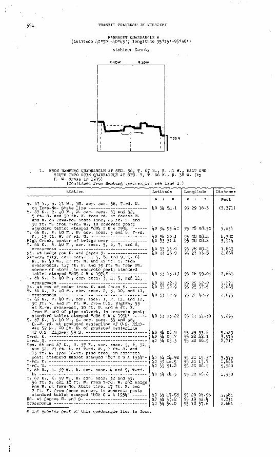
TRANSIT TRAVERSE IN MISSOURI
FARRAGUT QUADRANGLE * (Latitude kO°30'-kO°k5< ', longitude 95°15'-95°30')
Atchlson County
R40W R39W
1. PROM HAMBURG QUADRANGLE AT SEC. 36, T. 67 N., R. kl W., EAST AND SOUTH INTO COIN QUADRANGLE AT SEC. 7, T. 66 N., R. 38 W. (by H. W. Gross in 1935)
(Continued from Hamburg quadrangle; see line 1.)
Station
T. 67 N., R. l|l VI., NE. cor. sec. 36, T-rd. W.
T. 67 N., R. ko W., N. cor. sees. 31 and 32, 5 ft. S. and 30 ft. W. from rd. at fences E. and W. on Iowa-Mo. State line, 25 ft. S. and 30 ft. W. from T-rd. W. , in concrete post; standard tablet stamped "80k C W A 193)1 "
T. 66 N., R. kO W., N. cor. sees. 5 and 6, T-rd.
T. 66 N., R. ko W., cor. sees. 5, 6, 7, and 8,
Farmers City, cor. sees, k., 5, 8, and 9, T. 66 N., R. kO W., 27 ft. N. and 27 ft. E. from crossroads, 117 ft. N. and 39 ft. W. from NW. corner of store, in concrete post; standard
T. 66 N., R. I|.o W., cor. sees, j, 1;, 9, and 10,
Rd. at row of cedar trees N. and fence S. ---- - T. 66 N., R. .kO W., cor. sees. 2, 3, 10, and 11,
T. 6.6 N., R. UO W., cor. sees. 1, 2, 11, and 12, 30 ft. N. and 21 ft. W. from U.S. Highway 59 at E.-W. crossroad, 10 ft. N. and 6 ft. E. from N. end of pipe culvert, in concrete post;
T. 67 N., R. kO W., S. cor. sees. 35 and 36,^ E.-W. rd. at produced centerline of U.S. High way 59 N., 60 ft. E. of produced centerline
Tps. 66 and 67 N., R. 39 W., cor. sees. 5, 6, Jl, and 32, 27 ft. E. of T-rd. W. , 7 ft. S. and 13 ft. W. from 16-in. pine tree, in concrete raost; standard tablet stamped "807 C W A ijjk"-
T. 66 N., R. 39 W., N. cor. sees. k and 5, T-rd.
T. 67 N., R. 39 W., N. eor. sees. 32 and 33, 56 ft. S. and 18 ft. W.. from T-rd. W. and hedge row E. on Iowa-Mo. State line, 17 ft. S. and 2 ft. E. from fence -corner, in concrete post;
Latitude
kO 31). 5U-1
14.0 314. 53. kl
1+0 3U 10.1 kO 33 31. l|
14.0 33 13.0 ko 33 13.0
ko 33 13.17
ho 33 12-9 ko 33 12.9
ko 33 12-9
ko 33 13-22
ko 3l| 06.9 ko 3U 05.7 !|0 314. 05.3
ko jk ok. 92 ko 33 U6-5 ko 33 51-2
ko 3L(. ok. 3
UO 3k k?.58 ko 3k 56.2 ' ko 3k 56.0
Longitude
95 29 16-3
95 28 06.50
95 28 08. k 95 28 08.2
95 28 08.2 95 27 33-8
95 26 59.03
95 25 52.0 95 25 17-5
95 2k k2-9
95 23 3l4-30
95 23 33-6 95 22 [j.2.195 22 06.9
95 21 15.37 95 21 15-7 95 20 06.6
95 20 06.6
95 20 06.98 95 19 32.k 95 18 57-6
Distance
Feet
(5,37D
5,23U
k,380 3,9lk
1,8632,660
2,6835,171 2,665
2,675
5,295
5.U29 3,976 2,717
m5,3601,330k,38l 2,Bll2,681
* The greater part of this quadrangle lies in Iowa.

PART k., NORTHWESTERN MISSOURI, 1911-1937 555
Station v
Tps. 66 and 67 N., R. 39 w - » approximate cor.
Chicago, Burlington & Quincy R.R. at rd. crossing Tps. 66 and 67 N., R. 39 W., cor. sees. 2, 3, 3k,
and 35, 21 ft. S. and 298 ft. E. from cross roads, 2 ft. S. of fence, in concrete post;
Tps. 66 and 67 N., R. 39 w> , approximate cor.
Tps. 66 and 67 N., Rs. 38 and 39 W., cor. of, 37 ft. S. and 37 ft. E. from, 10 ft. S. and 2 ft. E. from fence corner, in concrete post;
T. 66 N., R. 39 W., E. cor. sees. 1 and 12,
T. 66 N., R. 39 W., approximate E. cor. sees. 12
Latitude
0 1 II
14.0 J>k 29.7
ko 3k 03.6 kO 3k 03. k
ko jk 02.68
kO 3k 02.2
kO 3k 01. k6 ko 33 35.6
ko 33 O9.k
kO 32 16.9 l.n T,y T? _n
Longitude
95 18 57-7
95 18 57-8 95 18 32.0
95 17 k5-0k
95 16 ko.2
95 15 30.6k 95 15 Jl-2
95 15 31-2
95 15 314 ac n c on i
Distance
Feet 2,655
2,6k5 1,997
3,622
5,009
5,365 2,613
2,655
5,308H-7Q
(Continued in Coin quadrangle; see line k.)
Magnetic declination 7° 55" E.

556 TRANSIT TRAVERSE IN MISSOURI
TARKIO QUADRANGLE * (Latitude kO°15'-kO°30' ; longitude 95°15'-95°30')
Atohison and Holt Counties
1. FROM SK.IDMORE QUADRANGLE AT SEC. 13, T. 63 N., R. 39 W. , WEST AND SOUTH INTO CRAIG QUADRANGLE AT SEC. 2J, T. 63 N., R. lj.0 W. (by J. H. Wilson in 1916)
(Continued from Skidmore quadrangle; see line 1.)
Station
T. 63 N., R. 39 W., cor. sees. 13, Ik, 23, and
T. 63 N., R. 39 W., cor. sees, Ik, 15, 22, and
T. 63 N., R. 39 W., cor. sees. 15, 16, 21, and
T. 63 N., R. 39 W., cor. sees. 16, 17, 20, and
T. 63 N., R. 39 W., cor. sees. 17, 18, 19, and
T. 63 N., Rs. 39 and kO W. , cor. sees. 13, 18,
T. 63 N., Rs. 39 and kO W., approximate quarter cor. between sees. 19 and 24, T-rd. W. and
T. 63 N., R. kO W., quarter cor. between sees. 23 and 2l+, 10 ft. S. and 5 ft. W. from, S. of E.-W. rd. at T-rd. N.; iron post stamped "Prim
T. 63 N., R. 14.0 W., quarter cor. between sees. 22nnrt ?X. .nt.onfi at. T-r>d. R. -----------_____ _-_
Latitude
ko 15 14.5-9
kO 15 14.5-7
ko 15 U5-8
ko 15 U5-8
ko 15 k6.3
kO 15 20.2
ko 15 20.75)in i^ ?i .n
Longitude
95 15 22. k
95 16 31.0
95 17 39-5
95 18 14.8.2
95 19 53.1
95 21 02.7
95 21 03.0
95 22 10.85QC. ?*, ?n.i
Distance
Feet
(5,311)
5,320
5,310
5,325
5.U25
5,005
5,26l
i;.*7n
(Continued in Craig quadrangle; see line 1.)
2. FROM NEMAHA QUADRANGLE AT SEC. 36, T. 66 N., R. kl W., EAST INTO SKIDMORE QUADRANGLE AT SEC. Jl, T. 66 N., R. 36 W. (by J. L. Sanders in 1923)
(Continued from Nemaha quadrangle; see line 1.)
T. 66 N., Rs. kO and kl W., S. cor. sees. 31 and
T. 66 N., R. kO W., 300 ft. N. and 500 ft. E. from S. cor. sees. 31 and 32, 120 ft. N. of center of bridge, 12 ft. N. of E.-W. rd., in concrete post; standard tablet stamped "Prim
T. 65 N., R. kO W., N. cor. sees. 5 and 6, T-rd.
T. 66 N., R. kO W., 500 ft. E. of S. quarter cor. sec. 3k, 15 ft. S. of E.-W. rd., in concrete post; standard tablet stamped "Prim Trav Sta
T. 65 N., R. kO W., N. cor. sees. 3 and k, T-rd.
T. 65 N., R. kO W., cor. sees. 3, U, 9, and 10,
kO 26 53.1
Uo 28 55.02
kO 28 51.68
ko 28 51.6lin 2fl OO.R
95 28 00.85
95 26 39-7
95 25 10. Jl).
95 2l|. 2k. 8
Q<; ?)i 2)i.Q
(3,610)
5,810
6,281
6,901).
3,521*
^.17Q
* A small part of this quadrangle IJes in Nebraska.

PART k, NORTHWESTERN MISSOURI, 1911-193? 557
Station
T. 65 N., R. kO W., cor. sees. 2, 3, 10, and
T. 66 N., Rs. 39 and kO W. , S. cor. sees. 31 and
Chicago, Burlington & Quincy R.R. at rd. crossing T. 66 N., R. 39 W., near W. sixteenth cor. on S.
line sec. 32, 20 ft. N. and 105 ft. E. from T-rd. N., in line with T-rd. S., in concrete post; standard tablet stamped "Prim Trav Sta
T. 66 N., R. 39 W., S. cor. sees. 32 and 33,
East Tarkio Creek, center of bridge over --- - T. 65 N., R. 39 W., 660 ft. W. of N. cor. sees.
3 and k, 12 ft. N. of E.-W. rd. , 260 ft. E. of dwelling of Mrs. Elizabeth Glenn, in concrete post; standard tablet stamped "Prim Trav Sta
T. 65 N., R. 39 W., N. cor. sees. 3 and k, hedge
T. 66 N., R. 39 W., S. cor. sees. 35 and 36,
T. 66 N., Rs. 38 and 39 W. , S. cor. sees. 31 and36, T-rd. N.
T. 65 N., Rs. 38 and 39 W. , N. cor. sees. 1 and 6 T-rd S
(Continued in Skidmore quadrangle;
Latitude
ko 27 59. kkO 28 50.9 ko 28 50.7
kO 28 51-12
ko 28 [4.9.9 ko 28 [4.9.5 ko 28 U.8.7 ko 28 [48.9
kO 28 k8.6k
kO 28 [4.8.5
kO 28 14.7.8
kO 28 Itf.l
ko 28 [4.6.9
see line 3.'
Longitude
95 23 16.0
95 22 2k. 2 95 21 53.0
95 20 57-03
95 20 07.2 95 19 39- U 95 18 29.8 95 18 16. k
95 -17 37-59 95 17 29.1
95 16 ko.7
95 15 32-5
95 15 11-3
Distance
Feet
5,330
6,569
3,850 2,153 5,380 1,032
3,002
660
3,7lt-0
5,270
1,614.0
3- FROM REMAHA QUADRANGLE SOUTHEAST ALONG CHICAGO, BURLINGTON & QUINCY RAILROAD INTO CRA1G QUADRANGLE (by J. P. Anderson in 193k)
(Continued from Nemaha quadrangle; see line 2.)
T. 63 N., R. kl W., in S. part sec. 13, 35 ft. W. of rd., 25 ft. E. of Chicago, Burlington & Quincy R.R. tracks, in concrete post; standard
Prim Trav Sta No 6 1916 (In Craig quadrangle;
kO 16 k3.0
ko 15 55.38kO Ik 57.89
95 29 21.9
95 28 27.73
95 27 23.98
(9,320)
6,390
7,635
k. FROM NEMAHA QUADRANGLE AT SEC. 11, T. 614. N., R. kl W. , EAST INTO SKIDMORE QUADRANGLE AT SEC. 36, T. 65 N., R. 39 W. (by J. P. Anderson in 1931).)
(Continued from Nemaha quadrangle; see line 3.)
Rd. corner at driveway to dwelling of Joe Gaines- T. 6k N-, R. kl W., W. quarter cor. sec. 12,
T. 6k N., R. kl W., near center sec. 12, 25 ft. S. and 190 ft. E. from T-rd. N., 75 ft. NE. of dwelling owned by W. G. Oswald, in concrete cost; standard tablet stamped "8l8 C W A 193k"-
T.~6k N., R. kO W., W. quarter cor. sec. 7,
T. 6k N. , R. kO W. , quarter cor. between sees. 7
T. 6k N., R. kO W., cor. sees. 7, 8, 17, and 18,
T. 6k N., R. kO W., cor. sees. 8, 9, 16, and 17, 30 ft. S. and 30 ft. W. from crossroads, in concrete post; standard tablet stamped "819 C W A 193k" ----- -- -
Fairfax, 1.1; ml. N. of, along U.S. Highways 59 and 275, quarter cor. between sees. 10 and 15, T. 6k N., R. kO W., k60 ft. S. of junction of rd. E., 18 ft. S. and 27 ft. W. from junction of rd. W., in front of dwelling of Albert Volger, In concrete post; standard tablet
T. 6k N., R. kO W., cor. sees. 10, 11, Ik, and
T rd E -- -T. 6k N., R. kO W., cor. sees. 2, 3, 10, and 11,
T. 6k N., R. kO W. , quarter eor. between sees.
T. 6k N., R. kO W., cor. sees. 1, 2, 11, and 12,
kO 22 50.1 l;0 22 30.5
kO 22 22.8
kO 22 22.28
kO 22 22.3 1;0 22 22.2
kO 21 56.0
kO 21 55.6 14.0 21 55.5
kO 21 5k. 85ko 21 5k. 6
kO 21 51.62
kO 21 53.5 kO 22 19.6
kO 22 k5-9
ko 22 k5-7
kO 22 k5-6
95 29 [4.5.6 95 29 29. k
95 28 55-6
95 28 18.67
95 27 k7.k 95 27 13.?
95 27 13.9
95 26 ko.7 95 26 05.5
95 25 31.96 95 4 33-8
95 23 k8.92
95 23 1U-3 95 23 13-8
95 23 l3-[4-
95 22 39.6
95 22 05.9
2)350
2,725
2,860
2 ',620
2,650
2,575 2,720
2,600k,500
2,685 2,6502,6552,620
2,605 ^15140 O 10 0

558 TRANSIT TRAVERSE IN MISSOURI
Station
T. 61| N., R. i(.0 W., quarter cor. between sees.
T. 61; N., Rs. 39 and 1^.0 W., cor. sees. 1, 6, 7, and 12, 775 ft. W. of crossroads, 200 ft. S. of dwelling owned by W. N. Martin, 20 ft. S. of rd. , in concrete cost; standard tablet stamped
T. 61; N., R. 39 W., cor. sees. 5, 6, 7, and 8,
T. 61; N., R. 39 W., cor. sees, k, 5, S, and 9,
T. 61; N., R. 39 W., cor. sees. 3, k, 9, and 10,
T. 6U N., R. 39 W., about 0-3 mi. E. of cor. sees. 3, k> 9, and 10, 75 ft. S. of dwelling owned by E. V. Roberts, 25 ft. N. of rd. , in concrete post; standard tablet stamped "622
T. 61; N., R. 39 W., cor. sees. 2, 3, 10, and 11,
T. 61; N., R. 39 W., cor. sees. 1, 2, 11, and 12,
Tps. 61; and 65 N. , R. 39 W. , approximate cor.
(Continued in Skidmore quadrangle;
Latitude
0 | II
lj.0 22 1;5 -3lj-
UO 22 l^.SUO 22 l£.8
lt.0 22 14;- 5kO 22 14;. 8
lj.0 22 lj.5.57
UO 22 US. 5kO 22 14-9
UO 22 14;. 2ko 23 10. U
see line 5"
Longitude
95 21 31-9
95 21 07.93
95 19 kS-k95 19 4.9
95 18 Uo.795 18 06.6
95 17 33-1
95 17 1345
95 15 U9-6
95 15 15-295 15 14-7 '95 15 1^-2
Distance
Feet
2,635
1,855
6,075
2,635
2,595
3,8302,660
2,6602,6502 r Qr
Magnetic declination 8° 1;9' E.

PART 4, NORTHWESTERN MISSOURI, 1911-1937 559
CRAIG QUADRANGLE * (Latitude 1|0°00' -1|0°15' ; longitude 95°15' -95°30')
Holt County
R40W / R39W
CORNING ^V / ACRA1G _____
CRAIG
IIIFORTESCUE^m*2~
\
PROM TARKIO QUADRANGLE AT SEC. 23, T. 6j N., R. l(.0 W., WEST TO CORNING, THENCE SOUTHEAST ALONG CHICAGO, BURLINGTON & QUINCY RAILROAD TO CRAIG, THENCE NORTH ALONG ROADS TO SEC. 2, T. 62 N. , R. 40 W. (by J. H. Wilson in 1916)
(Continued from Tarklo quadrangle; see line 1.)
Station
T. 63 N., R. 40 W., cor. sees. 22, 23, 26, and
Rd. at fences N. and S. on line between sees. 27
T. 63 N., R. 40 W., cor. sees. 20, 21, 28, and 29, -rd. at fence S., 1,300 ft. W. of bridge
T. 63 N.; R. 40 W., cor. sees. 19, 20, 29, and
Corning, 900 ft.. NW. of sta., 15 ft. N. and 75 ft- W. from R.R. at rd. crossing; iron post
R.R. at rd, crossing on line between sees. 29
R.R. at rd. crossing on line between sees. 3 and
R.R. at rd. crossing on line between sees. 10 and
Cralg, main track of "R.R. at rd. crossing N. of
T. 62 N., R. 40 W. , cor. sees. 1, 2, 11, and 12, .
M.R.C. trlangulation sta. designated "Craig"
Latitude
0 1 II
4o ilv 5U-9
40 11+ U2.2
40 14-56.6
40 14 57-5
40 14 57-89
40 14 04.6
40 12 59.8
40 12 10-9
40 11 30.740 12 17.5 40 13 02.24
Longitude
0 1 11
95 23 20.0
95 24 28.2
95 25 38.2
95 26 46.7
95 27 23.98
95 26 07.9
95 24 35-6
95 23 26.0
95 22 28.8
95 22 15-3 95 22 41-25
Distance
Feet
(2,651)
5,W+o
5,6265.311
2,891
7,989
9,705
7,324
6,021
4,848 l+,958
2. FROM MISSOURI RIVER EAST ALONG CHICAGO, BURLINGTON. & QUINCY RAILROAD TO PORTESCUE, THENCE SOUTHEAST AND NORTHEAST ALONG ROADS INTO MAITLAND QUADRANGLE AT SEC. 36, T. 6l N. , R. 39 W. (by J. H. Wilson in 1916)
R.R. at rd. crossdng on line between sees. 26 and
R.R. at rd. crossing on line between sees. 35 and
Center of trestle 5-19 ln line with fence N.
R.R. at rd« crossing on line between sees. 31 andZ3 T1 AT W P ZO W
Fortescue, R.R. at rd. crossing, 300 ft. W. ofn 4- n
Rd. at fence E. on line between sees. 6 and 32,
T. 60 N., R. 39 W., quarter cor. between sees.
T. 60 N., R. 39 W., cor. sees. 5> 6, 7, and 8,
40 03 19.1
40 03 39-8
40 03 19.840 03 12.0
40 03 11.6
40 03 10.9
40 03 10.4
40 02 43-8
4o 02 33 -It-
40 02 33.0
95 24 58.5
95 23 29.8
95 22 22.2 95 21 47-7
95 21 11.5
95 20 00.6
95 19 08.5
95 19 ll.S
95 19 12.0
95 18 38.0
7,215
5,6.34 2,791+
2,830
5,505 4,050
2,708
1,050
2,640
Part of this quadrangle lies in Nebraska.

56o TRANSIT TRAVERSE IK MISSOURI
Station
Telegraph pole at rd. corner on line between
T. 60 N., R. 59 W., quarter cor. between sees. 16
T. 60 N. , R. 59 w -> quarter cor. between sees. 15 and 22, rd. at fence E. , 980 ft. 3. of Exodus
T. 60 N., R. 59 W., quarter cor. between sees. 5.
Napier, 0-5 mi. SE. of, Chicago, Burlington &
Latitude
l+O 01 23.0 lj.0 00 1^8.1
1+0 00 IjB.O
kO 00 k^-0
kO 02 52.1
lid 0? 31 .f,
Longitude
95 18 39-p 95 17 55-k
95 16 58.2
95 15 50.8
95 15 k9-9 cm 1 1; o)i.7
Distance
Peet
7,080 U,893
U.^52
6,570
10,525^.RT;
(Continued in Maitland quadrangle; see line 1.)
'Magnetic declination in 1916, 9° JO" E.
NEMAHA QUADRANGLE * (Latitude l4.0 0 15'-U0°50'; longitude 95°30' -95°l4.5')
Atchison County
\
\
1. PROM SEC. 18, T. 65 N., R. i|l VI., NORTHEAST INTO TARKIO QUADRANGLE SEC. 56, T. 66 N., R. ia W. (by J. L. Sanders in 1923)
Station
M.R.C. triangulation sta. designated "Phelps" --- Rd . at line between sees. 7 and 18, T. 65 N., R.
T. 65 N., R. l(.l W., cor. sees. 5, 6, 7, and 8,
T. 65 N., R. 1^1 W., cor. sees. k> 5, 8, and 9
Linden, about 1 mi. SE. of, near quarter cor. be tween sees. 5 and k> 25 ft. N. and 50 ft. W. from rd. corner from N.-W., in concrete post; standard tablet stamped "Prim Trav Sta No I|.l
T. 66 N., R. 1;1 w -> S. quarter cor. sec. 55,
T. 65 N., R. l|J W., N. cor. sees. 2. and 5,
(Continued in Tarkio quadrangle; s
Latitude
ko 26 59.95 l^o 27 15.14. ko 28 07.61+0 28 06.6 l+o 28 06.5
kO 28 32.20
kO 28 5lj..l
ko 28 53- k
ee line 2.)
Longitude
o i ir
95 5!; 05.50-
95 33 38.2
95 33 26.9 95 52 18.2 95 31 51.2
95 31 11-85
95 30 58.6
95 30 02.7
Distance
Peet
2,623
5,3525,310 2,089
U.002
2,kk2
U.326
2. FROM SEC. k, T. 65 N., R. lj.1 W. , SOUTHEAST ALONG U.S. HIGHWAY 275 TO ROCKPORT, THENCE SOUTH ALONG COUNTY ROUTE E TO SEC. 9, T. 61). N., R. Ul W., THENCE SOUTHEAST ALONG ROADS TO SEC. 3, T. 63 N., R. 1+1 W. THENCE SOUTHEAST ALONG CHICAGO, BURLINGTON & QUINCY RAILROAD INTO TARKIO QUADRANGLE (by J. P. Anderson in 193!).)
Prim Trav Sta No described) ----
J S 1925 Mo (previously28 32.20 95 31 11.85
» Part of this quadrangle lies in Nebraska.

FART k, NORTHWESTERN MISSOURI, 1911-1937 56l
Station
Linden, about 0.7 mi. S. of, along U.S. High way 275, center sec. k, T. 65 N., R. kl W., 25 ft. S. and 55 ft. E. from E.-W. crossroad, in concrete post; standard tablet stamped "T T
Highway at fences E. and W. on line between sees.
Crossroad on line between sees. 9 and 16, T. 65
Crossroad on line between sees. 17 and 20, T. 65
Rockport, about 1.5 mi. NW. of, along U.S. High way 275, in E| sec. 20, T. 65 N., R. kl W., 21 ft. N. and 59 ft. E. from E.-W. crossroad, 150 ft. HE. of dwelling, in concrete post; standard tablet stamped "T T 812 C W A 193k" --
Highway at line between sees. 21 and 28, T. 65
Rockport, 2k ft. .S. and 56 ft. W. from' U.S. High way 275 an(i State Highway k at main street, 50 ft. NE. of filling sta., in concrete post;
Rockport, flagpole near center of town - -----
Roekport, l.k ml. S. of, along Rockport, Langdon & Northern Ry., in iy£ sec. 5, T. 6k N. , R. kl W., 155 ft. S. and 52 ft. E. from crossroads, 25 ft. W. of track, in concrete post; stan-
T. 6k N., R. kl W., cor. sees. 15, 16, 21, and
T. 6k N., R. kl * » 0.5 mi. S. of cor. sees. 15, 16, 21, and 22, in front yard of dwelling of William A Luhr, 20 ft. W. of rd. , in concrete post; standard tablet stamped "815 C W A 195k"-
T. 6k N., R. kl W., cor. sees. 21, 22, 2?, and
T. 6k N.,- R. klW., cor. sees. 27, 28, 53, and
T. 6l|. N., R. kl W. , quarter cor. between sees. 35
T. 65 N., R. kl W., 8 ft. S. and 8 ft. W. from N. quarter cor. sec. J> 75 ft- NE. of dwelling, in concrete post; standard tablet stamped "816 C W A 195k"
(Continued In Tarkio quadrangle;' s
Latitude
kO 28 32.00
kO 28 06-3ko 27 ko.i
kO 27 lk.0
ko 26 21.7
kO 25 55.78
ko 25 29.2 ko 25 15.0
ko 25 00.52 ko 2k k2.o ko 23 59-5
kO 23 16. k8ko 22 5k- 5 ko 22 11. k
kO 21 06.2
ko 20 50.82
ko 20 13.7
ko 19 21.0
ko 18 5k- 8 ko 18 5k-9
ko 18 28.1 l+o 18 01.9
ee line 3.)
Longitude
95 51 kO-56
95 31 58.1 95 32 07.6
95 32 07.2
95 32 23 -k
95 32 22.8k
95 32 ik-0 95 32 01.9
95 30 52.57 95 30 52. k 95 30 k3-7
95 30 59.90 95 31 lk-3 95 31 58.0
95 31 13-2
95 31 13-57
95 31 lU-l
95 31 15-0
95 31 Ik- 7 95 30 k3-6
95 30 k2.l 95 30 23.9
Distance
Peet
2,219
2,930 2,7602,6kO
5 MO
2,625
2,775 1,720
5,5551,870k,366
k,530 2,k90 k,730
6,875
1,560
3,760
5,3302,655 2,klO
2,710 3,005
3. PROM SEC: 3, T. 61^ N., R. kl VV., EAST INTO TARKIO QUADRANGLE AT SEC. 11, T. 6k N., R. kl W. (by J. P. Anderson in 193k)
(Continued in Tarkio quadrangle; s
ko 23 16. k8 lio 25 18.7
ee line k. )
95 30 59-90 95 30 kk-9 1,180
k. PROM SEC. k, T. 65 N., R. kl W., NORTH ALONG U.S. HIGHWAY 275 INTO HAMBURG QUADRANGLE (by H. W. Gross in 1955)
T. 66 N., R. kl W., approximate cor. sees. 26, 27, 3k> ar>d 35» junction of County Route A -
(Continued in Hamburg quadrangle;
ko 28 52.00 ko 29 21.0
kO 29 k7-5
see line 1.)
95 31 kO-56 95 31 33-2
95 31 33-1
' k,'992
2,660
Magnetic declination 7° 50" E.
-* It was reported that this monument was destroyed by the State Highway Department in Dec. 1937-
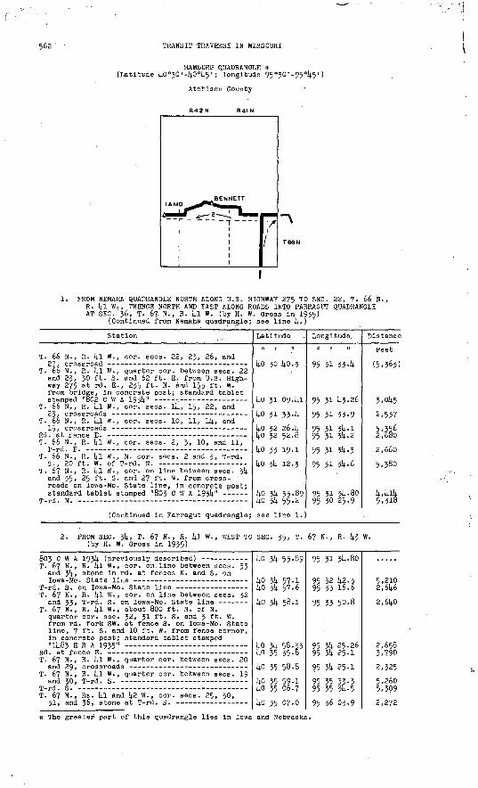
562 TRANSIT TRAVERSE IN MISSOURI
HAMBURG QUADRANGLE * (Latitude kO°30'-kO°k5'; longitude 95°30'-95°k5')
Atchison County
R42N R4I N
1. PROM NEMAHA QUADRANGLE NORTH ALONG U.S. HIGHWAY 275 TO SEC. 22, T. 66 N., R. kl W., THENCE NORTH AND EAST ALONG ROADS INTO -FARRAGUT QUADRANGLE AT SEC. 36, T. 67 N., R. kl W. (by H. W. Gross'in 1935)
(Continued from Nemaha quadrangle; see line k.) '
Station
T. 66 N., R. 14.1 W., cor. sees. 22, 23, 26, and
T. 66 N., R. kl W., quarter cor. between sees. 22 and 23, 30 ft. S. and 62 ft. E. from U.S. High way 275 at rd. E., 235 ft. N. and 153 ft. W. from bridge, in concrete post; standard tablet
T. 66 N., R. kl W., cor. sees. Ik, 15, 22, and
T. 66 N., R. kl W., cor. sees. 10, 11, ll|, and
T. 66 N., R. Ip. W., cor. sees. 2, 3, 10, and 11,
T. 66 N., R. kl W., N. cor. sees. 2 and 3, T-rd.
T. 67 N., R. kl W., cor. on line between sees. 3k and 35, 25 ft. S. and 27 ft. W. from cross roads on Iowa-Mo, state line, In concrete post;
(Continued in-Parragut quadrangle;
Latitude
0 1 11
kO 30 kO-3
ko 31 0941
ko 31 334
ko 32 26.k ko 32 52.2
14-0 33 19.1
14-0 3U 12.3
ko 3k 55.89 ko 3k 55.2
see line 1.
Longitude
0 1 II
95 31 354
95 31 1+3-26
95 31 33-9
95 31 3ft.- 1 95 31 314.. 2
95 31 3U -3
95 31 3l)-6
95 31 3^ -80 95 30 25.9
Dis.tance
Feet
(5,363)
3,0k.5
2,537
5,356 ' 2,680
2,660
5,380
k,kik5,318
2. PROM SEC. 3k, T. 67 N., R. kl W., WEST TO (by H. W. Gross in 1935)
SEC. 35, T. 67 N., R. k3 W.
T. 67 N., R. 4! W. , cor. on. line between sees. 33 and 3k, stone in rd. at fences N. and S. on
T. 67 N. , R. kl W., cor. on line between sees; 32
T. 67 N., R. kl W., about 800 ft. S. of N. quarter cor. sec. 32, 31 ft. S. and 3 ft. W. from rd. fork SW. at fence S. on Iowa-Mo. State line, 7 ft. S. and 10 ft. W. from fence corner, in concrete post; standard tablet stamped
T. 67 N., R. kl W., quarter cor. between sees. 20
T. 67 N., R. kl W., quarter cor. between sees. 19
T. 67 N., Rs. kl and k2 W., cor. sees. 25, 30,
kO 3U 55-89
ko 3k 57.1 kO 3k 57.6
ko 3k 58.1
ko 31; 56.33 ko 35 35.8ko 35 58-8
ko 35 59-1 ko 35 06.7
ko 35 07-0
95 31 3U-80
95 32 k2.3 95 33 16-6
95 33 50-8
95 3k 25.26 95 3U 25-1
95 314. 25-1
95 35 33-3 95 35 3k-5
95 36 03.9
5,210 2,6k6
2,6kO
2,658 3,790
2,325
5,260 5,399
2,272
* The greater part of this quadrangle lies in Iowa and Nebraska.
PART k, NORTHWESTERN MISSOURI, 1911-1937 563
Station
T. 67 N., Rs. kl and k2 W. , about 1,000 ft. S. of N. cor. sees. 3! and 36, 298 ft. S. of Iowa-Mo. State line, 16 ft. S. and 19 ft. W. from junction of lane W., on property of Andrew Speiael, in concrete post;- standard
T. 67 N., Rs. kl and k2 W., cor. sees. 19, 2k,
T. 67 N., R. k2 W., cor. sees. 23, 2k, 25, and
Junction of U.S. Highway 275 an^ Iowa Golden Rod
Bennett triangulation sta.; U.S.C. & G.S. stan-
Junction of highways (previously described) -- - Nishnabotna River, center of bridge over -------- Hamburg, intersection of Washington and E Streets Hamburg, Chicago, Burlington & Quincy R.R. at
T. 67 N., R. k2 W., approximate center sec. 29.
Hamburg, 1.6 ml. W. and 0.6 ml. S. from Chicago, Burlington & Quincy R.R. sta., 700 ft. S. of approximate quarter cor. between sees. 29 and 32, T. 67 N., R. k2 W., k5 ft. S. and 9 ft. W. from rd. corner from N.-W. on Iowa-Mo. State line, 3 ft. S. and 3 f fc . E. from fence corner, in concrete post; standard tablet stamped
T-rd. S. on Iowa-Mo. State line on line between
lamo triangulation sta.; U.S.C. & G.S. standard
Latitude
ko 3U 57-05 ko 35 59-1
ko 35 59-4 ko 35 59-7
kO 36 00.0
kO 36 00.5 ko 35 19-2
ko 35 01.27kO 36 00-5 kO 36 07.6ko 36 13-7ko 35 3k. 2 ko 35 36.1
ko 35 36.6
ko 35 03.26 ko 35 ok-k ko 35 05.1
ko 35 05.6 ko 35 05.9
ko 35 06.02
Longitude
95 36 ok. 31 95 35 53-3
95 36 03.8 95 36 384
95 37 13-0
95 38 21.2 95 38 15.0
95 37 49-90 95 38 21.2 95 38 kl-k 95 39 17-2
95 39 40.6 95 40 21.5
95 41 134
95 41 13-53 95 41 48-3 95 42 57-5
95 k3 31.6 95 kk 06.7
95 kk 36.73
Distance
Feet
1,002
2,350 2,675
2,665
5,263 4,201
2,6531,854 2,6754,388 3,155
4,005
5'5Z8 2,6835,339
2,631 2,705
2,317
Magnetic declination 7° 19" E.