tropical cyclone programme report no. tcp … objective i-1 ... attachment 7a pro -forma for cyclone...
TRANSCRIPT
2014 Edition
W O R L D M E T E O R O L O G I C A L O R G A N I Z A T I O N
T E C H N I C A L D O C U M E N T
WMO-TD N° 292
TROPICAL CYCLONE PROGRAMME
Report No. TCP-24
TROPICAL CYCLONE OPERATIONAL PLAN
FOR THE SOUTH PACIFIC AND
SOUTH-EAST INDIAN OCEAN
2014 Edition
SECRETARIAT OF THE WORLD METEOROLOGICAL ORGANIZATION GENEVA - SWITZERLAND

2014 Edition
© World Meteorological Organization, 2014
The right of publication in print, electronic and any other form and in any language is reserved by
WMO. Short extracts from WMO publications may be reproduced without authorization, provided that
the complete source is clearly indicated. Editorial correspondence and requests to publish,
reproduce or translate this publication in part or in whole should be addressed to:
Chairperson, Publications Board World Meteorological Organization (WMO) 7 bis, avenue de la Paix Tel.: +41 (0) 22 730 84 03 P.O. Box 2300 Fax: +41 (0) 22 730 80 40 CH-1211 Geneva 2, Switzerland E-mail: [email protected] NOTE The designations employed in WMO publications and the presentation of material in this publication do not imply the expression of any opinion whatsoever on the part of WMO concerning the legal status of any country, territory, city or area, or of its authorities, or concerning the delimitation of its frontiers or boundaries. The mention of specific companies or products does not imply that they are endorsed or recommended by WMO in preference to others of a similar nature which are not mentioned or advertised. The findings, interpretations and conclusions expressed in WMO publications with named authors are those of the authors alone and do not necessarily reflect those of WMO or its Members. This publication has been issued without formal editing.

2014 Edition
CONTENTS
CHAPTER 1 - GENERAL Page
1.1 Objective I-1
1.2 Status of the document I-1
1.3 Scope I-1
1.4 Structure of the document I-1
1.4.1 Text I-1
1.4.2 Attachments I-2
1.5 Arrangements for updating I-2
1.6 Operational terminology used in the South Pacific I-2
1.6.1 Equivalent terms I-2
1.6.1.1 Weather disturbance classification I-2
1.6.1.2 Cyclone related terms I-2
1.6.1.3 Warning system related terms I-3
1.6.1.4 Warnings related terms I-3
1.6.2 Meanings of terms used for regional exchange I-4
1.7 Units and indicators used for regional exchange I-6
1.7.1 Marine I-6
1.7.2 Non-marine I-6
1.8 Identification of tropical cyclones I-7
CHAPTER 2 - RESPONSIBILITIES OF MEMBERS
2.1 Area of responsibility II-1
2.1.1 Forecasts and warnings for the general population II-1
2.1.1.1 Special Advisories for National Meteorological Centres II-1
2.1.2 Forecasts and warnings for the open sea II-2
2.1.2.1 One comprehensive marine warning per cyclone II-2
2.1.3 Warnings and advisories for aviation II-2
2.2 Procedural responsibility II-3
2.2.1 Responsibilities of tropical cyclone warning centres II-3
2.2.1.1 Naming tropical cyclones II-5
2.2.1.2 Warnings near common boundaries II-8
2.2.1.3 Transfer of warning responsibilities II-8
2.2.1.4 Contingency arrangements II-8
2.2.1.5 Non-operational responsibilities II-8
2.2.2 Responsibilities of all Members II-9
2.2.2.1 Internal dissemination of warnings II-9
2.2.2.2 Provision of observational data II-9
2.2.2.3 Collection and exchange of other observational data II-9
2.2.2.4 Communications II-9
Attachment 2A Stations and observational programmes comprising the
basic synoptic network for tropical cyclone forecasting in the
South-East Indian Ocean and the South Pacific 2A-1
Attachment 2B List of Tropical Cyclone names withdrawn from use due to 2B-1
cyclone's negative impact on one or more countries
CHAPTER 3 - TROPICAL CYCLONE INFORMATION AVAILABLE IN
THE REGION
3.1 Introduction III-1
3.2 Forecast information provided by Meteorological
Centres within the region III-1
3.2.1 RSMC Nadi III-1

2014 Edition
Ii
Page
3.2.1.1 Special weather bulletins III-1 3.2.1.2 Tropical cyclone alert III-3 3.2.1.3 Tropical cyclone warnings III-5 3.2.1.4 Tropical disturbance summaries III-7 3.2.1.5 Tropical disturbance advisory III-7 3.2.1.6 Marine gale, storm and hurricane warnings III-9 3.2.1.7 Tropical cyclone advisories for aviation III-10 3.2.1.8 Tropical Cyclone Outlook III-11 3.2.2 Brisbane TCWC III-12 3.2.2.1 Special Advisories for Solomon Islands III-12 3.2.2.2 Tropical Cyclone Bulletin Eastern Region III-12 3.2.2.3 Satellite Analysis Bulletin III-13 3.2.2.4 Ocean gale, storm and hurricane warnings III-14 3.2.2.5 Tropical Cyclone 3-Day Outlook, Eastern Region III-14 3.2.3 Darwin TCWC III-15 3.2.3.1 Special Advisories for Indonesia III-15 3.2.3.2 Cyclone bulletin III-15 3.2.3.3 Ocean gale, storm and hurricane warnings III-16 3.2.3.4 Tropical cyclone advisories for aviation III-16 3.2.3.5 Tropical Cyclone 3-Day Outlook, Northern Region III-16 3.2.4 Perth TCWC III-17 3.2.4.1 Special Advisories for Indonesia III-17 3.2.4.2 Satellite bulletin III-17 3.2.4.3 Ocean gale, storm and hurricane warnings III-17 3.2.4.4 Tropical Cyclone Technical Bulletin Western Region III-17 3.2.4.5 Tropical Cyclone 3-Day Outlook, Western Region III-17 3.2.5 Port Moresby TCWC III-18 3.2.5.1 Ocean gale and storm warnings III-18 3.2.6 Wellington TCWC III-18 3.2.6.1 Ocean gale, storm and hurricane warnings III-18 3.2.7 Jakarta TCWC III-18 3.2.7.1 Ocean gale and storm warnings III-18 3.2.8 New Caledonia Meteorological Service, Nouméa III-19 3.2.9 French Polynesia Meteorological Service, Tahiti III-19
Attachment 3A Format and content of ocean waters gale, storm and hurricane warnings issued to shipping and aviation by
tropical cyclone warning centres in the region 3A-1
Attachment 3B Forecast information provided by Meteorological Centres outside the region 3B-1
Attachment 3C Tropical Cyclone Advisory Headings 3C-1
CHAPTER 4 - BROADCASTING OF TROPICAL CYCLONE INFORMATION TO THE PUBLIC
4.1 Introduction IV-1 4.2 Broadcasts IV-1 4.2.1 Radio New Zealand International and Radio Australia IV-1 4.2.2 Radio Samoa IV-1 4.2.3 Radio broadcasts for individual country, if necessary IV-1
Attachment 4A Shortwave frequency schedules for radio New Zealand International and Radio Australia 4A-1
CHAPTER 5 - COMMUNICATIONS
5.1 General V-1 5.2 Contacts in National Meteorological Services V-1 5.3 RSMC-Nadi Communication Centre outage V-1

2014 Edition
iii
Page
Attachment 5A AFTN/GTS telecommunication links serving the area covered by the plan 5A-1
Attachment 5B Operational addresses 5B-1
CHAPTER 6 - CONTINGENCY PLANS
6.1 Introduction VI-1 6.2 Review of plans VI-1 6.3 Contingency arrangements VI-1 6.3.1 Failure or partial failure of RSMC Nadi VI-1 6.3.2 Failure or partial failure of Brisbane TCWC VI-1 6.3.3 Failure or partial failure of Darwin TCWC VI-1 6.3.4 Failure or partial failure of Perth TCWC VI-1 6.3.5 Failure or partial failure of Port Moresby TCWC VI-1 6.3.6 Failure or partial failure of Wellington TCWC VI-1 6.3.7 Failure or partial failure of Samoa Weather Forecasting Office VI-1 6.3.8 Failure or partial failure of Vanuatu Meteorology and Geohazard Department’s Forecasting Centre VI-2 6.3.9 Failure of Jakarta TCWC VI-2 6.3.10 Failure or partial failure of American Samoa VI-2 6.3.11 Failure or partial failure of Vanuatu Tropical Cyclone Centre VI-2 6.4 Responsibility of TCWCs with respect to contingency plans VI-2
Attachment 6A Fiji/New Zealand contingency arrangements 6A-1
CHAPTER 7 - END OF SEASON PROCEDURES
7.1 Introduction VII-1 7.2 Archival and documentation of information VII-1 7.3 Verification of Warnings and Operational Tracks VII-1 7.4 C.D.A.R. and review of the Plan VII-2
Attachment 7A Pro-forma for cyclone assessment report 7A-1
CHAPTER 8 - ARCHIVAL OF DATA
8.1 Necessity for data archival VIII-1 8.2 Tropical cyclone data set VIII-1 8.3 Post-cyclone public survey VIII-1 8.4 Retrieval of tropical cyclone data VIII-1
Attachment 8A Global tropical cyclone track and intensity data set - Report format 8A-1
Attachment 8B Post-cyclone public survey form to monitor the performance 8B-1 of the Tropical Cyclone Warning System
____________________

2014 Edition
I-1
CHAPTER 1 GENERAL 1.1 Objective
The objective of this Plan is to provide for effective co-ordination and cooperative efforts amongst Members* in the South Pacific and South-East Indian Ocean in order to improve the warning systems for the protection of lives and the reduction of human suffering and property damage caused by tropical cyclones and associated storm surges, floods and landslides. 1.2 Status of the document
The Plan was formulated by the RA V Tropical Cyclone Committee for the South Pacific (RA V/TCC) at the request of the WMO Regional Association V (South-West Pacific) (RA V), within the framework of the Tropical Cyclone Programme of WMO.
The Plan was adopted under Resolution 10 (X-RA V) by Regional Association V at its tenth session (Singapore, November 1989), which was kept in force by Resolution 4.5 (XIV-RA V) adopted in 2010. It is in compliance with the spirit of Resolution 23 (Cg-XVI) - Tropical Cyclone Programme, Resolution 36 (Cg-XVI) - WMO Strategic Plan (2012-2015) and in the context of the International Strategy for Disaster Reduction (ISDR). 1.3 Scope
The Plan describes the existing internationally coordinated systems and arrangements agreed upon by the RA V/TCC with a view to making the best use of the existing resources and facilities towards providing the most effective tropical cyclone warning system for the Region. It describes the warning systems and defines the international tropical cyclone forecasting and warning responsibilities of all Members concerned. It also sets out agreed arrangements for: (a) units and terminology (b) exchange of information and advisories (c) operational procedures
The Plan also describes existing arrangements in the Region for: (a) the provision of observational data; and (b) telecommunications for the exchange of data and processed information on tropical
cyclones.
It describes national practices and procedures which are of international and regional significance. The Plan also serves as a source of information for the operational services. 1.4 Structure of the document
The document is divided into text and attachments to the text. 1.4.1 Text
The text contains information on regionally agreed upon obligations and practices of Members regarding sharing of warning responsibilities, standardization of regional operational procedures and the efficient exchange of information and advices, including terminology. Changes to these will be subject to the consideration of the RA V/TCC. __________________________ * In this Plan the term Members refers to those Members of Regional Association V invited by Resolution 7
(XV-RA V) to nominate members of the RA V Tropical Cyclone Committee for the South Pacific and South-East Indian Ocean and to those countries and territories in the Region invited by the Resolution to participate in the work of the Committee.

2014 Edition
I-2 1.4.2 Attachments
The attachments contain additional reference information on various aspects of the Tropical Cyclone Programme in the South Pacific and Southeast Indian Ocean. 1.5 Arrangements for updating
The Operational Plan is implicitly evolutionary in nature. It will be updated from time to time to accommodate changed circumstances.
The RA V/TCC shall review the Plan at each of its sessions and amendments to the text of the plan are subject to the approval of the President of RA V. Amendments to the Attachments to the Plan are to be notified to WMO through the Chairman of the Committee. WMO issues new editions when appropriate. 1.6 Operational terminology used in the South Pacific 1.6.1 Equivalent terms 1.6.1.1 Weather disturbance classification English French
Classification of weather Classification des perturbations Disturbances météorologiques
Tropical depression < 34 knots Dépression tropicale faible
34 knots < Tropical cyclone (gale) < 48 knots Dépression tropicale modérée
48 knots < Tropical cyclone (storm) < 64 knots Dépression tropicale forte
64 knots < Tropical cyclone (hurricane) Cyclone tropical Severe tropical cyclone Cyclone tropical intense
+
1.6.1.2 Cyclone related terms English French
Cyclone characteristics Caractéristiques d'un cyclone
(a) Eye Oeil
(b) Centre Centre
(c) Centre fix Position du centre
(d) Confidence in the centre position Confiance sur la position du centre
(e) Direction of movement Direction du déplacement
(f) Average wind speed Vitesse du vent moyen/ Vitesse moyenne du vent
(g) Maximum wind speed in a Vitesse maximale du vent dans tropical depression une dépression tropicale
(h) Maximum wind speed in a Vitesse maximale du vent dans tropical cyclone un cyclone + In French Polynesia, ≥ 96 knots

2014 Edition
I-3
(i) Gust Rafales
(j) Storm surge Onde de tempête
(k) Storm tide Marée de tempête 1.6.1.3 Warning system related terms English French
(a) Tropical cyclone season Saison cyclonique
(b) Tropical cyclone advisory Bulletin météorologique pour un phénomène tropical (dépression ou cyclone) (c) Tropical cyclone alert* (d) Tropical disturbance advisory* (e) Tropical disturbance summary*
(f) Tropical cyclone watch** (g) Special advisory+ (h) Special weather bulletin (i) Weather bulletin* (j) Tropical disturbance bulletin*** 1.6.1.4 Warnings related terms English French
(a) Warnings Avis (b) Gale Warning Avis de coup de vent (c) Storm Warning Avis de tempête (d) Hurricane warning Avis de cyclone tropicale (e) Tropical cyclone warning
________________ * Used by Fiji ** Used by Australia, Papua New Guinea, American Samoa, and Samoa + Used by Australia and Fiji *** Used by Australia

2014 Edition
I-4 1.6.2 Meanings of terms used for regional exchange Advice: See Tropical cyclone advice. Alert: See Tropical cyclone alert. Average wind speed: Speed of the wind averaged over the previous 1**** or 10 minutes. Central pressure: Pressure at the centre of the tropical cyclone as measured or estimated. Centre of the tropical cyclone: The estimated position of the surface centre. Confidence in the centre position: Degree of confidence in the centre position of a tropical cyclone expressed as the radius of the smallest circle within which the centre may be located by the analysts. "Position good" implies a radius of less than 30 nautical miles (55 kilometres), "Position fair", a radius of 30 to 60 nautical miles (55 to 110 km) and "Position poor", a radius of greater than 60 nautical miles (110 km). Convergence zone (or zone of convergence): A zone where air streams of different directions or speeds merge. Cyclone: See Tropical cyclone.
Cyclone Category: Category of cyclones based on the Saffir-Simpson category will be included in all the SWB bulletins and other bulletins where appropriate. Tropical cyclone season: The typical period of the year with tropical cyclone occurrences. In the South Pacific and South-East Indian Ocean, it is the period from 1 November to 30 April. (Note: cyclones occasionally occur outside of this period.) Tropical cyclone year: 1 July to 30 June. Depression: A synoptic low pressure area with extra-tropical characteristics where the average wind speed may exceed 33 knots (63 km per hour) or Beaufort Force 7. Direction of movement of the tropical cyclone: The direction towards which the centre of the tropical cyclone is moving. Eye of the tropical cyclone: The relatively clear and calm area inside the circular, convective wall clouds. Gale force wind: Average surface wind speed of 34 to 47 knots (63 to 87 km per hour or wind force of 8 or 9 in the Beaufort Scale). Gale warning: Meteorological message intended to warn those concerned of the occurrence or expected occurrence of gale force winds. Gust: Sudden, brief increase of the wind speed over its average value. Hurricane or severe tropical cyclone: A tropical cyclone with hurricane force winds. Hurricane force wind: Average surface wind of 64 knots (118 km per hour, Beaufort Force 12) or more. Hurricane warning: Meteorological message intended to warn those concerned of the impact of a tropical cyclone with hurricane force winds. ______________________ **** Used by FSM and USA (American Samoa)

2014 Edition
I-5 Intertropical Convergence Zone (ITCZ): A relatively narrow zone where the trade winds from both the Northern Hemisphere and the Southern Hemisphere merge. Mean wind speed: See Average wind speed.
Monsoon depression = monsoon low: A tropical depression (or tropical low) embedded in the monsoon trough. Monsoon low = monsoon depression. Monsoon trough: A shear zone with westerly monsoon winds on the equatorial side and easterly trade winds on the poleward side. Naming a Tropical Cyclone: A non-frontal low pressure system of synoptic scale developing over warm waters will be named whenever observations and/or Dvorak intensity analysis indicate the presence of gale force or stronger winds near the centre which are likely to continue.
Numbering a Tropical Disturbance/Depression: System has a potential to develop into a tropical cyclone or persist to cause significant impact to life and property in RSMC Nadi AOR and persistently analyzed on the MSL charts for the last consecutive 24 hours. South Pacific Convergence Zone (SPCZ): A semi-permanent convergence zone found in the tropical
South Pacific marked by the boundary between the usually cooler and stronger southeast trade wind flow
and warmer and lighter east or northeast winds, or northwesterly winds when the SPCZ is active. Special Advisory: A message to a National Meteorological Centre giving information on a tropical disturbance or a tropical cyclone. Special Weather Bulletin: Bulletins issued, whenever the need arises, to put the community on alert, to give progress reports on developments or to give specific warnings of tropical cyclones or other disturbances. Speed of movement of the cyclone: Speed of movement of the centre of the tropical cyclone. Storm force wind: Average surface wind of 48 to 63 knots (88 to 117 kilometres per hour or Beaufort Force 10 or 11). Storm surge: The difference between the actual sea level under the influence of a weather disturbance (storm tide) and the normal astronomical tide. Storm tide: The actual sea level as influenced by a weather disturbance. The storm tide consists of the normal astronomical tide, storm surge and wave setup. Storm warning*: Meteorological message intended to warn those concerned of the impact of storm force winds. Sustained wind speed: See Average wind speed. Tropical cyclone: A non-frontal low pressure system of synoptic scale developing over warm waters and having a definite organized wind circulation with a maximum 10-minute average wind speed of 34 knots (63 km per hour, i.e. gale force) or greater near the centre. Tropical cyclone advice: A tropical cyclone watch and/or a tropical cyclone warning. Tropical cyclone alert: A special weather bulletin providing information on the progress of a cyclone still some distance away and with a significant probability of giving gales or stronger winds to a community in the next 24 to 48 hours. Tropical cyclone warning: A warning of gales or stronger winds associated with a tropical cyclone expected to occur within 24 hours.

2014 Edition
_______________ * Storm warning: Papua New Guinea uses the term for all events with storm force or stronger winds.

2014 Edition
I-6 Tropical cyclone watch: A forecast message of gales or stronger winds associated with a tropical cyclone occurring after 24 hours and before 48 hours. Tropical depression = tropical low: A tropical disturbance with a clearly defined cyclonic wind
circulation in which the central position can be estimated, and the maximum 10-minute average wind
speed is less than 34 knots (63 km per hour i.e. gale force) near the centre. There may be gale force
or stronger winds in one or more quadrants but not near the centre.
Tropical disturbance: A non-frontal system of synoptic scale originating over the tropics with persistent enhanced convection and/or some indications of cyclonic wind circulation. Tropical Disturbance Advisory/Bulletin/Summary: A message for exchanging information, internationally, on a range of disturbances including tropical depressions and tropical cyclones. Tropical low = tropical depression Tropical storm: A tropical cyclone with gale or storm force winds. Trough or trough of low pressure: An elongated zone of low pressure, V-shaped in the easterlies in the Southern Hemisphere and an inverted V-shape in the westerlies. The axis of a trough is known as the trough line. Watch: See Tropical Cyclone Watch. Wave setup: Localised increase in the still-water sea level produced by breaking waves close to the shore. Weather Bulletin: A bulletin issued at regular times to give weather information and forecasts to the general public or marine interests. 1.7 Units and indicators used for regional exchange 1.7.1 Marine
The following units/indicators are used for marine purposes: (a) Distance in nautical miles, the unit (nm) being stated; (b) Location (position) by degrees and where possible tenths of degrees of latitude
and longitude preferably expressed in words, or repeated if expressed in figures;
e.g. "TWELVE DECIMAL TWO SOUTH, ONE SIXTY EIGHT DECIMAL FOUR EAST"
or "12.2 SOUTH, 168.4 EAST, REPEAT 12.2 SOUTH 168.4 EAST"
2014 Edition
I-7 (c) Direction of motion to the nearest sixteen points of the compass or in degrees to the
nearest ten, given in figures;
e.g. "SOUTHSOUTHEAST" or "160 DEGREES"
(d) Speed (wind speed and direction of movement of tropical cyclones) in knots, the unit (kt) being stated;
(e) Pressure in hectopascals (hPa), the unit being stated; (f) Confidence in the centre position expressed as "GOOD", "FAIR" or "POOR";
(g) Time in Universal Time Co-ordinated (UTC), the unit being stated. 1.7.2 Non-marine
The following units/indicators are used in non-coded segments of exchanges, other than marine bulletins: (a) Distance in nautical miles (nm) or kilometres (km), the units being stated; (b) Direction in sixteen points of compass given in words e.g. SOUTHEAST;
(c) Location (position) in latitude and longitude by degrees and tenths of degrees (in figures) and/or bearing on the sixteen point compass and distances from well-known places;
(d) Speed (wind speed and speed of movement of system) in knots (kt) or kilometres per
hour (km per hour) the unit being stated; (e) Confidence in the centre position in kilometres (km) or nautical miles (nm); (f) Time in UTC or local time, the unit being stated. 1.8 Identification of tropical cyclones
For unambiguous identification of tropical cyclones, each tropical cyclone within the region covered by this plan is given a name (Chapter 2, Section 2.2.1.1, provides further information on the naming system).
______________________

2014 Edition
II-1
CHAPTER 2
RESPONSIBILITIES OF MEMBERS 2.1 Area of responsibility 2.1.1 Forecasts and warnings for the general population
In the southern hemisphere portion of RA V, the responsibilities for preparing and issuing warnings on tropical cyclones and related hazardous weather phenomena for the general population are as follows: Australia The coastal waters and land areas of Australia including Christmas Island
(Indian Ocean), Cocos Island, Lord Howe Island and Norfolk Island. Fiji The coastal waters and land areas of Cook Islands, Fiji, Kiribati, Nauru,
Niue, Tokelau, Tonga and Tuvalu. French Polynesia The coastal waters and land areas of French Polynesia and Pitcairn Islands. Indonesia The coastal waters and land areas of Indonesia. New Caledonia The coastal waters and land areas of New Caledonia and Wallis and Futuna. New Zealand The coastal waters and land areas of New Zealand. Papua New Guinea The coastal waters and land areas of Papua New Guinea. Samoa The coastal waters and land areas of the Independent State of Samoa. Solomon Islands The coastal waters and land areas of Solomon Islands. Timor Leste The coastal waters and land areas of Timor Leste. USA (American Samoa) The coastal waters and land areas of American Samoa. Vanuatu The coastal waters and land areas of Vanuatu. 2.1.1.1 Special Advisories for National Meteorological Centres
Brisbane Tropical Cyclone Warning Centre (TCWC) is responsible for providing special advisory messages for use by National Meteorological Centre in Solomon Islands in the preparation of warnings and advisories.

2014 Edition
II-2 2.1.2 Forecasts and warnings for the open sea
In accordance with Annex VI of WMO Technical Regulations (WMO Manual on Marine Meteorological Services), the responsibility for the preparation of marine tropical cyclone forecasts and warnings in the South Pacific and South-east Indian Ocean is shared amongst Members as follows: Warning centre with prime responsibility Boundary of area
Brisbane TCWC 05S 160E, 08S 155E, 12S 155E, 12S 147E, 09S 144E, 10S 141E, 14S 138E, 32S 138E, 32S 160E, 05S 160E.
Darwin TCWC 15S 125E, 15S 129E, 32S 129E, 32S 138E, 14S 138E, 10S 141E, 09S 141E, 09S 128E, 11S 128E, 11S 125E, 15S 125E.
RSMC Nadi 25S 160E, 25S 120W, EQ 120W, EQ 60E, 25S 160E.
Perth TCWC 10S 090E, 36S 090E, 36S 129E, 15S 129E, 15S 125E, 10S 125E, 10S 090E.
Port Moresby TCWC EQ 141E, 10S 141E, 09S 144E, 12S 147E, 12S 155E, 08S 155E, 05S 160E, EQ 160E, EQ 141E.
Wellington TCWC 25S 160E, 25S 120W, 40S 120W, 40S 160E, 25S 160E.
Jakarta TCWC EQ 090ºE, 10S 090ºE, 10S 120ºE, 11S 1 20ºE, 11S 128ºE, 09S 128ºE, 09S 141ºE, EQ 141ºE.
TCWC = Tropical Cyclone Warning Centre The areas of responsibility for warnings for the open seas are shown in the map in Figure 1. 2.1.2.1 One comprehensive marine warning per cyclone
Warning centres without prime responsibility but affected by a tropical cyclone are requested to consult with the primary tropical cyclone warning centre one hour or more before the next warning issue time whenever a tropical cyclone is likely to have a greater influence than the current warning would suggest so that all the relevant information pertaining to that tropical cyclone is incorporated into one bulletin. This should alleviate the need for the centre without prime responsibility to add on a separate zone of gale force or stronger winds when issuing a copy of the tropical cyclone warning. 2.1.3 Warnings and advisories for aviation
In accordance with the International Civil Aviation Organization (ICAO) Annex 3 - Meteorological Service for International Air Navigation/ WMO Technical Regulations [C.3.1], tropical cyclone warnings, required for the international air navigation, are issued by designated
meteorological watch offices (MWO) as SIGMET messages*, including an outlook, giving information
for up to 24 hours ahead concerning the expected positions of the centre of the tropical cyclone. Each MWO provides information for one or more specified flight information regions (FIRs) or upper information regions (UIRs). The boundaries of the FIRs/UIRs are defined in ICAO Air Navigation Plan (ANP) for the Asia and Pacific Regions.
*
SIGMETs for tropical cyclones are only issued for those tropical cyclones having a 10-minute mean surface wind speed of 63 km/h (34 kt) or more.

2014 Edition
II-3
The content and order of elements in a SIGMET message for tropical cyclone shall be in accordance with WMO Technical Regulations [C.3.1]. The data type designator to be included in the
WMO abbreviated header of such messages shall be T1T2 = WC (WMO-No. 386, Manual on GTS refers).
The designated Tropical Cyclone Advisory Centres (TCAC) Darwin and Nadi shall monitor the development of tropical cyclones in their areas of responsibility, as determined in the ICAO ANP for the Asia and Pacific Regions and issue advisory information concerning the position of the cyclone centre, its direction and speed of movement, central pressure and maximum surface wind near the centre. These advisories will be made available in text and graphical format (TCAC Darwin only as Nadi is still working on making graphical format available). These advisories shall be disseminated to the MWOs by TCAC Darwin and TCAC Nadi in their respective areas of responsibility, to be used in the preparation of the outlook, to be appended to SIGMET messages for tropical cyclones. In addition, the tropical cyclone advisories shall be disseminated to the other TCACs, whose areas of responsibility may be affected, to the world area forecast centers (WAFC) London and Washington and international OPMET data banks, and centres operating the satellite distribution systems (SADIS and ISCS).
The format of the tropical cyclone advisories shall be in accordance with the Technical Regulations [C.3.1]. The data type designator to be included in the WMO abbreviated header of such
messages shall be T1T2 = FK (WMO-No. 386, Manual on GTS, refers).
TCAC Darwin and TCAC Nadi shall issue updated advisory information in their area of responsibility, for each tropical cyclone, as necessary, but at least every six hours. 2.2 Procedural responsibility 2.2.1 Responsibilities of tropical cyclone warning centres Within the South Pacific and South-east Indian Ocean areas covered by this plan, there are seven specially equipped warning centres (RSMC Nadi, and TCWCs Brisbane, Darwin, Perth, Jakarta, Port Moresby, and Wellington) which are responsible for the continuous monitoring of tropical cyclones.
The area of prime responsibility for each of these centres is indicated in 2.1.2 above and shown in Figure 1.
Each tropical cyclone warning centre issues and ensures prompt dissemination of all tropical cyclone forecasts, warnings, advisories and bulletins to the general population and for international marine and aviation requirements according to the area responsibilities defined in Sections 2.1.1, 2.1.2 and 2.1.3. Details of the forecast information provided by the warning centres in the region are provided in Chapter 3.
Tropical cyclone warning centres maintain close liaison with each other and provide mutual support where necessary. Whenever a centre has observational data that conflict with the warning issued by another centre, that data is sent immediately to the warning centre which issued the warning.

2014 Edition
II-4
Figure 1. Tropical cyclone warning centres’ areas of prime oceanic responsibility south of the equator. TCWC Jakarta extended its area of responsibility as from 2010/2011 season.
2014 Edition
II-5 2.2.1.1 Naming tropical cyclones
For unambiguous identification of tropical cyclones, a system of naming has been adopted by the RA V Tropical Cyclone Committee.
A tropical depression will be named as a tropical cyclone whenever observations and/or Dvorak intensity analysis indicate the presence of gale force winds near the centre that are likely to continue. It can include systems that satisfy these criteria but have a non-classical appearance in the satellite imagery and/or originate further south than the normal formation areas. The name is taken from a list allocated to that warning centre as set out in Table 1.
If a tropical depression becomes a tropical cyclone in the Wellington TCWC area of responsibility, Wellington TCWC in consultation with RSMC Nadi, will name the cyclone by using the next name from RSMC Nadi's list.
The name selected follows that used for the most recent cyclone named by the warning centre. When the list is exhausted the sequence is repeated.
Once named, a tropical cyclone retains the same name for its entire lifetime.
Declassifying a Tropical Cyclone: A tropical cyclone will be declassified whenever observations and/or Dvorak intensity analysis indicate that the system has less than gale force winds near the centre or the system has transformed into an extra-tropical cyclone structure. Reference to the cyclone’s name is usually dropped a short while after declassification.
Retiring a cyclone name: If the impact of a cyclone on a country or territory causes loss of life and/or significant damage and disruption to the way of life of a community then the name assigned to that cyclone is retired from the list. However, in regard to Port Moresby, once a name is used, it is retired from the list. Refer to Attachment 2B for a list of retired names. The Committee will replace a retired name with another name starting with the same letter.
2014 Edition
II-6
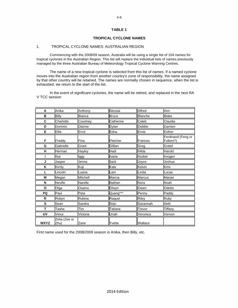
TABLE 1
TROPICAL CYCLONE NAMES 1. TROPICAL CYCLONE NAMES: AUSTRALIAN REGION
Commencing with the 2008/09 season, Australia will be using a single list of 104 names for
tropical cyclones in the Australian Region. This list will replace the individual lists of names previously
managed by the three Australian Bureau of Meteorology Tropical Cyclone Warning Centres.
The name of a new tropical cyclone is selected from this list of names. If a named cyclone moves into the Australian region from another country's zone of responsibility, the name assigned by that other country will be retained. The names are normally chosen in sequence, when the list is exhausted, we return to the start of the list.
In the event of significant cyclones, the name will be retired, and replaced in the next RA V TCC session
A Anika Anthony Alessia Alfred Ann
B Billy Bianca Bruce Blanche Blake
C Charlotte Courtney Catherine Caleb Claudia
D Dominic Dianne Dylan Debbie Damien
E Ellie Errol Edna Ernie Esther
F Freddy Fina Fletcher Frances Ferdinand (Feng or Folkert?)
G Gabrielle Grant Gillian Greg Gretel
H Herman Hayley Hadi Hilda Harold
I Ilsa Iggy Ivana IIsobel Imogen
J Jasper Jenna Jack Joyce Joshua
K Kirrily Koji Kate Kelvin Kimi
L Lincoln Luana Lam Linda Lucas
M Megan Mitchell Marcia Marcus Marian
N Neville Narelle Nathan Nora Noah
O Olga Osamu Olwyn Owen Odette
PQ Paul Peta Quang*** Penny Paddy
R Robyn Rubina Raquel Riley Ruby
S Sean Sandra Stan Savannah Seth
T Tasha Tim Tatiana Trevor Tiffany
UV Vince Victoria Uriah Veronica Vernon
WXYZ Zelia (Zee or Zhu) Zane Yvette Wallace
First name used for the 2008/2009 season is Anika, then Billy, etc.

2014 Edition
II-7 TABLE 1 (Cont'd) 2. RSMC NADI’S AREA OF RESPONSIBILITY
The name of a new cyclone is determined by sequentially cycling through lists A, B, C and D,
then starting list A again. Names from the standby list E are used as replacements when necessary. LIST A LIST B LIST C LIST D LIST E
(Standby) ------------------------------------------------------------------------------------------------------------------------------- Ana Arthur Alvin Amos Aru Bina Becky Bune Bart Bela Cody Chip Cyril Colin Cook Dovi Denia Daphne Donna Dean Eva Elisa Eden Ella Fili Fotu Florin Frank Gina Glen Garry Gita Garth Hagar Hettie Haley Hali Hart Irene Innis Isa Iris Judy Joni June Jo Julie Kerry Ken Kofi Kala Kevin Lola Lin Louise Leo Mal Mick Mike Mona Moses Nat Nisha Nute***Niko Neil Olo Oli Odile***Opeti Oma Pita Pearl Pam Pami Pearl Rae Rene Reuben Rita Rex Sheila Sarah Solo Sarai Suki Tam Tomas Tuni Tino Troy Urmil Ula
Vaianu Vanessa Victor Vicky Velma Wati Wano Winston Wiki Wanita Xavier Yvonne Yalo Yolanda Yates Yani Zaka Zena Zazu Zidane Zita
3. PORT MORESBY’S AREA OF RESPONSIBILITY
The name of a new cyclone is determined by sequentially cycling through list A. Standby list B is used to replace retired names in List A and any replacement name will be added to the bottom of list A to maintain the alphabetical order. LIST A LIST B
(Standby) --------------------------------------------- Alu Nou Buri Obaha Dodo Paia Emau Ranu Fere Sabi Hibu Tau Ila Ume Kama Vali Lobu Wau Maila Auram
2014 Edition
II-8
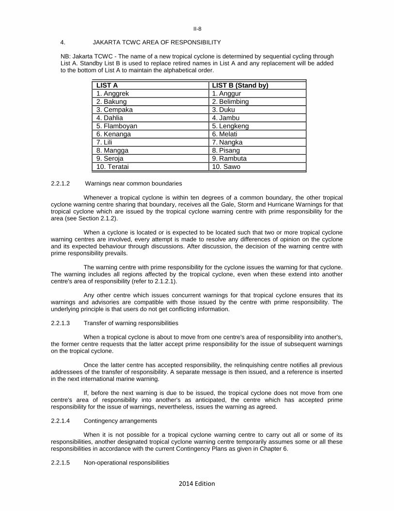
4. JAKARTA TCWC AREA OF RESPONSIBILITY
NB: Jakarta TCWC - The name of a new tropical cyclone is determined by sequential cycling through List A. Standby List B is used to replace retired names in List A and any replacement will be added to the bottom of List A to maintain the alphabetical order.
LIST A LIST B (Stand by) 1. Anggrek 1. Anggur 2. Bakung 2. Belimbing 3. Cempaka 3. Duku 4. Dahlia 4. Jambu 5. Flamboyan 5. Lengkeng 6. Kenanga 6. Melati 7. Lili 7. Nangka 8. Mangga 8. Pisang 9. Seroja 9. Rambuta 10. Teratai 10. Sawo
2.2.1.2 Warnings near common boundaries
Whenever a tropical cyclone is within ten degrees of a common boundary, the other tropical cyclone warning centre sharing that boundary, receives all the Gale, Storm and Hurricane Warnings for that tropical cyclone which are issued by the tropical cyclone warning centre with prime responsibility for the area (see Section 2.1.2).
When a cyclone is located or is expected to be located such that two or more tropical cyclone warning centres are involved, every attempt is made to resolve any differences of opinion on the cyclone and its expected behaviour through discussions. After discussion, the decision of the warning centre with prime responsibility prevails.
The warning centre with prime responsibility for the cyclone issues the warning for that cyclone. The warning includes all regions affected by the tropical cyclone, even when these extend into another centre's area of responsibility (refer to 2.1.2.1).
Any other centre which issues concurrent warnings for that tropical cyclone ensures that its warnings and advisories are compatible with those issued by the centre with prime responsibility. The underlying principle is that users do not get conflicting information. 2.2.1.3 Transfer of warning responsibilities
When a tropical cyclone is about to move from one centre's area of responsibility into another's, the former centre requests that the latter accept prime responsibility for the issue of subsequent warnings on the tropical cyclone.
Once the latter centre has accepted responsibility, the relinquishing centre notifies all previous addressees of the transfer of responsibility. A separate message is then issued, and a reference is inserted in the next international marine warning.
If, before the next warning is due to be issued, the tropical cyclone does not move from one centre's area of responsibility into another's as anticipated, the centre which has accepted prime responsibility for the issue of warnings, nevertheless, issues the warning as agreed. 2.2.1.4 Contingency arrangements
When it is not possible for a tropical cyclone warning centre to carry out all or some of its responsibilities, another designated tropical cyclone warning centre temporarily assumes some or all these responsibilities in accordance with the current Contingency Plans as given in Chapter 6. 2.2.1.5 Non-operational responsibilities

2014 Edition
II-9 Tropical cyclone warning centres serve as regional information centres for tropical cyclones in
their area of prime responsibility (see Section 2.1.2), preparing reports on tropical cyclones as soon as possible after the event and maintaining forecast performance statistics (see Chapter 7). 2.2.2 Responsibilities of all Members 2.2.2.1 Internal dissemination of warnings
The dissemination of tropical cyclone warnings in each country or territory is the responsibility of the country or territory concerned. 2.2.2.2 Provision of observational data
For the stations and observing schedules comprising the regional basic synoptic network (RBSN) in the regular programme of the WWW Plan for the area of RA V covered by this Operational Plan, refer to Attachment 2A. (a) Surface observations
In addition to routine observations in the regular programme of the WWW Plan, during the cyclone season, Members provide additional surface observations from manually operated stations normally when a cyclone is within 200 km of a station or upon request by the responsible RSMC or TCWC. (b) Upper-air observations
During the cyclone season Members provide, as far as is possible, additional upper-air observations on request by the responsible tropical cyclone warning centre, normally whenever a cyclone is within 500 km of a station. (c) Reports from voluntary observing stations
Members make every effort to provide to the responsible tropical cyclone warning centre, observations made by voluntary observing stations as soon as possible, if necessary as plain language reports, using normal communication channels. Such reports include, preferably, the coordinates of the observing station or other accurate measure of location. (d) Radar observations
Members make every effort to collect and distribute speedily and, as far as possible in a standard format, radar observations of tropical cyclones, particularly eye fixes. 2.2.2.3 Collection and exchange of other observational data (a) Ships weather reports
Members operating Coastal Radio Stations make prompt arrangements for specific requests for ship reports from any area of current cyclone activity and for the speedy collection and dissemination of such reports, even if some of these are to be transmitted in plain language. (b) Aircraft weather reports
Members collect and disseminate all aircraft observational reports received from within their respective areas of responsibility under the ICAO Air Navigation Plan. 2.2.2.4 Communications
Members disseminate forecasts, warnings and observations in accordance with Aeronautical Fixed Telecommunications Network (AFTN) procedures and/or with Global Telecommunications System (GTS) procedures as appropriate (see Chapter 5).
2014 Edition
2A-I
ATTACHMENT 2A
STATIONS AND OBSERVATIONAL PROGRAMMES COMPRISING THE BASIC SYNOPTIC NETWORK FOR TROPICAL CYCLONE FORECASTING
IN THE SOUTH-EAST INDIAN OCEAN AND THE SOUTH PACIFIC
Refer to WMO-No. 9 (Volume A – Observing Stations) for an up-to-date list of stations and observational programmes. The WMO RA V Tropical Cyclone Committee (September, 2000) decided it is better to find the latest data in the original documents than to rely on outdated listings which were previously included in this Plan.
2014 Edition
2B-I
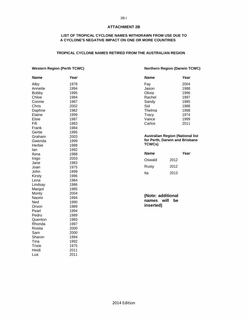
ATTACHMENT 2B
LIST OF TROPICAL CYCLONE NAMES WITHDRAWN FROM USE DUE TO
A CYCLONE'S NEGATIVE IMPACT ON ONE OR MORE COUNTRIES TROPICAL CYCLONE NAMES RETIRED FROM THE AUSTRALIAN REGION
Western Region (Perth TCWC) Name Year
Alby 1978 Annette 1994 Bobby 1995 Chloe 1984 Connie 1987 Chris 2002 Daphne 1982 Elaine 1999 Elsie 1987 Fifi 1983 Frank 1984 Gertie 1995 Graham 2003 Gwenda 1999 Herbie 1988 Ian 1992 Ilona 1988 Inigo 2003 Jane 1983 Joan 1975 John 1999 Kirsty 1996 Lena 1984 Lindsay 1986 Margot 1985 Monty 2004 Naomi 1994 Ned 1990 Orson 1989 Pearl 1994 Pedro 1989 Quenton 1983 Rhonda 1997 Rosita 2000 Sam 2000 Sharon 1994 Tina 1992 Trixie 1975 Heidi 2011 Lua 2011
Northern Region (Darwin TCWC) Name Year
Fay 2004 Jason 1988 Olivia 1996 Rachel 1997 Sandy 1985 Sid 1988 Thelma 1998 Tracy 1974 Vance 1999 Carlos 2011 Australian Region (National list for Perth, Darwin and Brisbane TCWCs) Name Year
Oswald 2012
Rusty 2012
Ita 2013
(Note: additional names will be inserted)
2014 Edition
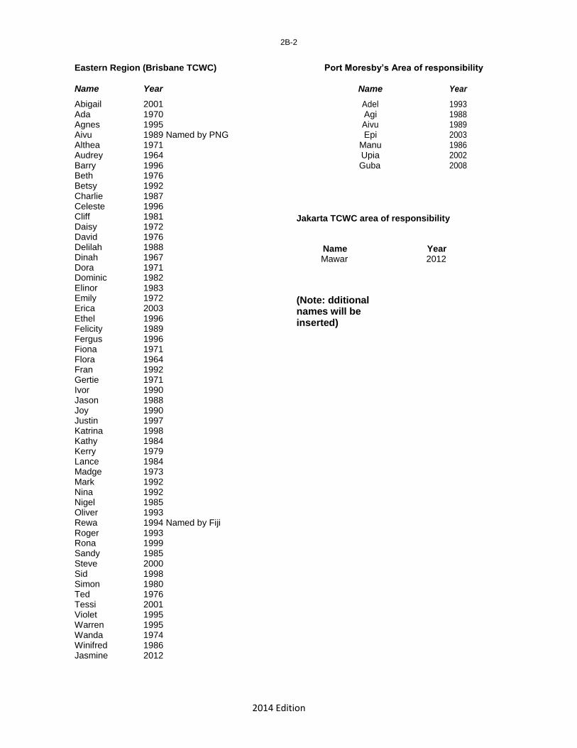
Eastern Region (Brisbane TCWC) Name Year
Abigail 2001 Ada 1970 Agnes 1995 Aivu 1989 Named by PNG Althea 1971 Audrey 1964 Barry 1996 Beth 1976 Betsy 1992 Charlie 1987 Celeste 1996 Cliff 1981 Daisy 1972 David 1976 Delilah 1988 Dinah 1967 Dora 1971 Dominic 1982 Elinor 1983 Emily 1972 Erica 2003 Ethel 1996 Felicity 1989 Fergus 1996 Fiona 1971 Flora 1964 Fran 1992 Gertie 1971 Ivor 1990 Jason 1988 Joy 1990 Justin 1997 Katrina 1998 Kathy 1984 Kerry 1979 Lance 1984 Madge 1973 Mark 1992 Nina 1992 Nigel 1985 Oliver 1993 Rewa 1994 Named by Fiji Roger 1993 Rona 1999 Sandy 1985 Steve 2000 Sid 1998 Simon 1980 Ted 1976 Tessi 2001 Violet 1995 Warren 1995 Wanda 1974 Winifred 1986 Jasmine 2012
2B-2
Port Moresby’s Area of responsibility
Name Year
Adel 1993 Agi 1988 Aivu 1989 Epi 2003
Manu 1986 Upia 2002 Guba 2008
Jakarta TCWC area of responsibility
Name Year Mawar 2012
(Note: dditional names will be inserted)

2014 Edition
2B-3
RSMC Nadi’s responsibility RSMC Nadi’s responsibility (cont’d)
Name Year Name Year
Agatha 1971/72 Mark 1982/83 Alison 1974/75 Martin 1997/98 Ami 2002/03 Meli 1978/79 Anne 1987/88 Meena 2004/05 Bebe 1972/73 Mick 2009/10 Beni 2002/03 Namu 1985/86 Beti 1995/96 Nancy 2004/05 Betsy 1991/92 Nigel 1984/85 Bob 1977/78 Nina 1992/93 Bola 1987/88 Ofa 1989/90 Carlotta 1971/72 Olaf 2004/05 Charles 1977/78 Oli 2009/10 Cilla 2002/03 Oscar 1982/83 Cliff 2006/07 Osea 1997/98 Cora 1998/99 Paula 2000/01 Daman 2007/08 Pat 2009/10 Dani 1998/99 Pate 2009/10 Diana 1977/78 Peni 1989/90 Drena 1996/97 Percy 2004/05 Eddie 1980/81 Polly 1992/93 Elsa 1975/76 Prema 1992/93 Eric 1984/85 Raja 1986/87 Erica 2002/03 Rewa 1993/94 Esau 1991/92 Robert 1976/77 Fay 1978/79 Ron 1997/98 Flora 1974/75 Rosie 1970/71 Fran 1991/92 Sally 1986/87 Frank 1998/99 Sina 1990/91 Funa 2007/08 Sose 2000/01 Gavin 1996/97 Susan 1997/98 Gordon 1978/79 Tahmar 1980/81 Gene 2007/08 Theodore 1993/94 Gyan 1981/82 Tia 1991/92 Hal 1977/78 Tina 1973/74 Harry 1988/89 Tomas 2009/10 Helene currently on Darwin list Trina 2001/02 Heta 2003/04 Tui 1997/98 Hina 1996/97 Tusi 1997/98 Ima 1985/86 Ului 2009/10 Isaac 1981/82 Uma 1986/87 Ivy 2003/04 Ursula 1997/98 Joni 1992/93 Val 1991/92 Joti 1982/83 Veena 1982/83 Juliette Veli 1997/98 Keli 1996/97 Vivienne 1971/72 Kim 1999/2000 Waka 2001/02 Kina 1992/93 Wally 1979/80 Koko Wasa 1991/92 Lili 1988/89 Watorea 1975/76 Lisa 1982/83 Wendy 1971/72 Lottie 1973/74 William 1994/95 Marion 1976/77 Zoe 2002/03
2014 Edition
2B-4
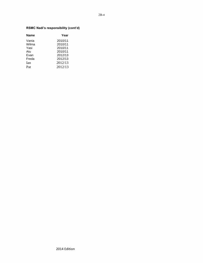
RSMC Nadi’s responsibility (cont’d) Name Year
Vania 2010/11 Wilma 2010/11 Yasi 2010/11 Atu 2010/11 Evan 2012/13 Freda 2012/13
Ian 2012/13
Pat 2012/13

2014 Edition
III-1
CHAPTER 3
TROPICAL CYCLONE INFORMATION AVAILABLE IN THE REGION 3.1 Introduction
This chapter describes and documents the forecasts, warnings and observational data that are available to Members in the Region. It includes warning criteria and formats, frequencies and times of issue and current international addressees. 3.2 Forecast information provided by Meteorological Centres within the region
Since RSMC Nadi provides forecasts and warnings to the general population of Banaba, Kiribati, Niue, Tolelau, Tonga, Tuvalu and Cook Islands including Fiji, the tropical cyclone forecast and warning information provided by RSMC Nadi is covered in more detail than for the other seven tropical cyclone warning centres given below. 3.2.1 RSMC Nadi 3.2.1.1 Special weather bulletins (a) Purpose
Special weather bulletins are intended to:
(1) alert a community to the developing threat of a tropical cyclone, or (2) provide warnings of tropical cyclones or other disturbances, or (3) cancel “Alert” or “Warning”
(b) Overview
Special Weather Bulletins either contain or cancel a TROPICAL CYCLONE ALERT or a TROPICAL CYCLONE WARNING (GALE, STORM or HURRICANE WARNING). Details of TROPICAL CYCLONE ALERT BULLETINS are provided in Section 3.2.1.2 below and of GALE, STORM and HURRICANE WARNINGS are provided in Section 3.2.1.3 below.
The importance of providing the population with adequate prior warning is the highest priority, even though, at times, this may result in false alarms and the need to issue subsequent intermediate bulletins based on more precise information.
All intermediate bulletins will be prefixed by the word FLASH. (c) Criteria for first issue
These depend on the type of Special Weather Bulletin and are detailed below in the description of the specific bulletin. (d) Frequency and times of subsequent issues
These vary with the type of Special Weather Bulletin and are detailed below in the description of the specific bulletin. (e) Review All Special Weather Bulletins are kept under constant review but due to the periodic nature of synoptic data, substantial review is only possible at three hourly intervals. (f) Amendment criteria
When new information indicates a significant change in the situation and invalidating the current Special Weather Bulletin, an intermediate bulletin is issued as soon as possible to advise

2014 Edition
III-2 recipients of the new situation. Such a Special Weather Bulletin is brief and issued without delay. It includes essential information on the position and movement of the cyclone, the new areas expected to be affected and the time, and it states that a full bulletin will follow as soon as possible. Intermediate bulletins are included in the numbered sequence of Special Weather Bulletins. (g) Recipients
Special Weather Bulletins are issued to the following islands or groups of islands:
Cook Islands Fiji Kiribati Nauru Niue Tokelau Tuvalu Note: i. Tonga Meteorological Service will be responsible for the issuance of SWBs for Tonga
commencing from 2015/16 TC Season.
ii. Copies of all Special Weather Bulletins are sent to Wellington TCWC. (h) Format
Special Weather Bulletins are self-contained to the extent that they do not refer to information in other advisories or bulletins.
Special Weather Bulletins are written in simple, unambiguous English that can be translated into local languages with a minimum of risk of misinterpretation. Sentences are short and as far as possible technical terms are avoided.
A continuous sequence of Special Weather Bulletins for a particular island group is numbered sequentially from BULLETIN NO.1 for the first issue.
If a Special Weather Bulletin sequence ends for a time and is then resumed for the same cyclone and for the same island group, the Bulletin number sequence resumes.
The Bulletin identification includes the Bulletin sequence number, the appropriate ALERT or WARNING designation, the originating office and time and date of issue (UTC). Example:
"SPECIAL WEATHER BULLETIN NUMBER SIX FOR TONGA ON TROPICAL CYCLONE YALO ISSUED FROM RSMC NADI AT 0800 UTC ON 8 DECEMBER 1987.
TROPICAL CYCLONE ALERT/ WARNING......
A HURRICANE WARNING IS IN FORCE........
A STORM WARNING IS IN FORCE........... .
2014 Edition
III-3
A GALE WARNING IS IN FORCE............
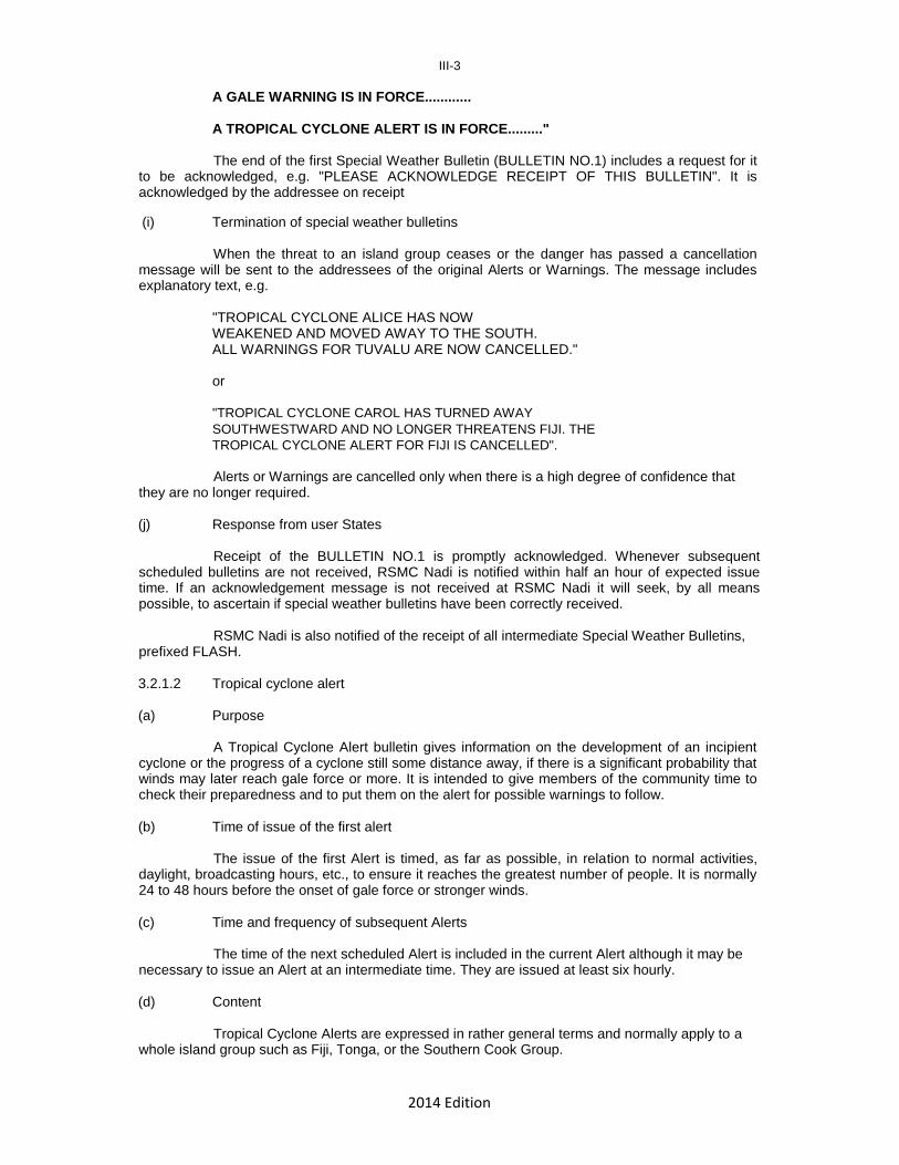
A TROPICAL CYCLONE ALERT IS IN FORCE........." The end of the first Special Weather Bulletin (BULLETIN NO.1) includes a request for it
to be acknowledged, e.g. "PLEASE ACKNOWLEDGE RECEIPT OF THIS BULLETIN". It is acknowledged by the addressee on receipt (i) Termination of special weather bulletins
When the threat to an island group ceases or the danger has passed a cancellation message will be sent to the addressees of the original Alerts or Warnings. The message includes explanatory text, e.g.
"TROPICAL CYCLONE ALICE HAS NOW WEAKENED AND MOVED AWAY TO THE SOUTH. ALL WARNINGS FOR TUVALU ARE NOW CANCELLED."
or
"TROPICAL CYCLONE CAROL HAS TURNED AWAY
SOUTHWESTWARD AND NO LONGER THREATENS FIJI. THE
TROPICAL CYCLONE ALERT FOR FIJI IS CANCELLED".
Alerts or Warnings are cancelled only when there is a high degree of confidence that they are no longer required. (j) Response from user States
Receipt of the BULLETIN NO.1 is promptly acknowledged. Whenever subsequent scheduled bulletins are not received, RSMC Nadi is notified within half an hour of expected issue time. If an acknowledgement message is not received at RSMC Nadi it will seek, by all means possible, to ascertain if special weather bulletins have been correctly received.
RSMC Nadi is also notified of the receipt of all intermediate Special Weather Bulletins, prefixed FLASH. 3.2.1.2 Tropical cyclone alert (a) Purpose
A Tropical Cyclone Alert bulletin gives information on the development of an incipient cyclone or the progress of a cyclone still some distance away, if there is a significant probability that winds may later reach gale force or more. It is intended to give members of the community time to check their preparedness and to put them on the alert for possible warnings to follow. (b) Time of issue of the first alert
The issue of the first Alert is timed, as far as possible, in relation to normal activities, daylight, broadcasting hours, etc., to ensure it reaches the greatest number of people. It is normally 24 to 48 hours before the onset of gale force or stronger winds. (c) Time and frequency of subsequent Alerts
The time of the next scheduled Alert is included in the current Alert although it may be necessary to issue an Alert at an intermediate time. They are issued at least six hourly. (d) Content
Tropical Cyclone Alerts are expressed in rather general terms and normally apply to a whole island group such as Fiji, Tonga, or the Southern Cook Group.

2014 Edition
III-4 Examples of TROPICAL CYCLONE ALERTS Example 1.
"SPECIAL WEATHER BULLETIN NUMBER ONE FOR THE SOUTHERN COOKS ON TROPICAL CYCLONE PAM ISSUED FROM RSMC NADI AT 1700 UTC ON 6 DECEMBER
TROPICAL CYCLONE ALERT
A TROPICAL CYCLONE ALERT IS NOW IN FORCE FOR SOUTHERN COOKS.
TROPICAL CYCLONE PAM (995hPa) WAS LOCATED NEAR 11.9 DEGREES SOUTH 162.6 DEGREES WEST OR ABOUT 360 NAUTICAL MILES NORTH OF PALMERSTON ISLAND AT 061500 UTC. PAM IS INTENSIFYING AND CURRENTLY SLOW-MOVING BUT IS EXPECTED TO MOVE SOUTHWARDS LATER.
ON THIS FORECAST TRACK, THE CYCLONE MAY BRING GALE FORCE WINDS OVER PALMERSTON ISLAND AND OTHER NORTHERN PARTS OF THE SOUTHERN COOKS IN THE NEXT 24 TO 48 HOURS.
FOR PALMERSTON ISLAND: SOUTHEAST WINDS 25 KNOTS WITH GUSTS TO 35 KNOTS. CLOUDY WITH OCCASIONAL RAIN DEVELOPING. SEAS ROUGH WITH A MODERATE TO HEAVY SWELL.
FOR THE REMAINING ISLANDS OF THE SOUTHERN COOKS:STRONG AND GUSTY SOUTHEAST WINDS. CLOUDY, WITH SHOWERS BECOMING MORE FREQUENT LATER TODAY. SEAS ROUGH WITH A MODERATE SWELL.
THE NEXT SPECIAL WEATHER BULLETIN FOR THE SOUTHERN COOKS WILL BE ISSUED AROUND 062300 UTC OR EARLIER.
PLEASE ACKNOWLEDGE RECEIPT OF THIS BULLETIN."
Example 2.
"SPECIAL WEATHER BULLETIN NUMBER THREE FOR NIUE ISSUED FROM RSMC NADI AT 0200 UTC ON 6 JANUARY.
TROPICAL CYCLONE ALERT
A TROPICAL CYCLONE ALERT IS IN FORCE FOR NIUE.
THE WEATHER IS DISTURBED IN THE AREA BETWEEN NORTHERN PARTS OF TONGA AND NIUE AND THERE IS A CHANCE THAT A TROPICAL CYCLONE MAY DEVELOP CLOSE TO NIUE DURING THE NEXT 24 TO 36 HOURS. IF IT DOES SO,
GALE FORCE WINDS MAY BE EXPERIENCED OVER NIUE LATE TOMORROW. FORECAST FOR NIUE UNTIL 071200 UTC: EXPECT EASTERLY WINDS 20 TO 25 KNOTS POSSIBLY RISING TO 35 KNOTS LATE TOMMORROW. RAIN AT TIMES. SEA POSSIBLY BECOMING VERY ROUGH, WITH A MODERATE TO HEAVY EASTERLY SWELL.
THE NEXT BULLETIN WILL BE ISSUED AT 060800 UTC."

2014 Edition
III-5 Example 3.
"SPECIAL WEATHER BULLETIN NUMBER SEVEN FOR TUVALU ON TROPICAL CYCLONE PAM ISSUED FROM RSMC NADI AT 1600 UTC ON 22 DECEMBER UTC
A TROPICAL CYCLONE ALERT PREVIOUSLY IN FORCE FOR TUVALU IS NOW CANCELLED.
TROPICAL CYCLONE PAM WAS LOCATED ABOUT 250 NAUTICAL MILES SOUTHEAST OF NIULAKITA AT 061500 UTC AND IS NOW MOVING STEADILY SOUTHEASTWARDS. AS A RESULT, GALE FORCE WINDS ARE NO LONGER EXPECTED OVER TUVALU.
FORECAST FOR TUVALU UNTIL 231200 UTC: WESTERLY WINDS 20 TO 25 KNOTS AND SQUALLY IN A FEW HEAVY SHOWERS AND THUNDERSTORMS. ROUGH SEAS WITH A MODERATE NORTHWEST SWELL.
THIS WILL BE THE FINAL SPECIAL WEATHER BULLETIN FOR TUVALU UNLESS THE SITUATION CHANGES. THE NEXT BULLETIN WILL BE THE ROUTINE ISSUE AT 230230 UTC."
3.2.1.3 Tropical cyclone warnings (a) Criteria for first issue
Tropical cyclone warnings for a population are issued in Special Weather Bulletins as soon as it is apparent that gale, storm or hurricane force winds respectively are expected within 24 hours. (b) Time of first issue
As far as possible, warnings are issued to reach the public in time to allow several hours of daylight in which action will be taken such as to dock boats safely and to take other protective measures against severe conditions.
To achieve this, every effort is made to issue warnings:
(a) approximately 24 hours ahead of dangerous conditions
(b) at times when the warnings can most readily reach the greatest proportion of the community, e.g. early in the working day or during the normal hours of the local broadcasting station.
(c) Frequency of issue of subsequent warnings
Subsequent warnings are normally issued at three-hour intervals unless it is necessary to issue a revised warning in an intermediate Special Weather Bulletin. (d) Format
Special Weather Bulletins relating to tropical cyclones issued as Warnings follow the general WMO format for marine warnings. However, as far as possible they are expressed in non-technical language and normally include:
(i) Identification of disturbance e.g. TROPICAL CYCLONE HELEN.
(ii) Location of disturbance with reference to well known landmarks, with bearing expressed in compass points and distances in nautical miles, e.g. "TROPICAL CYCLONE SUSAN WAS CENTRED ABOUT 100 NAUTICAL MILES WEST OF NADI OR NEAR 18 SOUTH 176 EAST AT 6AM".
2014 Edition
III-6 (iii) Intensity expressed in terms of wind force with an indication of the potential for damage.
It is desirable, especially when very strong winds are expected, to supplement the
descriptive term with the average wind speed in knots, together with an estimate of the highest gusts, e.g. "WITHIN 30 NAUTICAL MILES OF ITS CENTRE TROPICAL CYCLONE VICTOR HAS WINDS OF DESTRUCTIVE STORM FORCE UP TO ABOUT 55 KNOTS WITH GUSTS TO ABOUT 80 KNOTS ..."
or
"..... WITH VERY DESTRUCTIVE HURRICANE FORCE WINDS NEAR THE CENTRE PROBABLY REACHING ABOUT 70 KNOTS WITH GUSTS TO ABOUT 100 KNOTS ...."
or
".... WITH GALES UP TO ABOUT 45 KNOTS AND GUSTS TO ABOUT 65 KNOTS ...."
(iv) Expected movement, with speed in knots. (v) Forecast position, at some convenient time, expressed with reference to well
known landmarks, e.g.
"THE CYCLONE IS EXPECTED TO MOVE SOUTHEASTWARD ACROSS VANUA LEVU TONIGHT AND BE CLOSE TO TAVEUNU AROUND 6 AM TOMORROW MORNING".
(vi) Specific islands or districts likely to experience hurricane force winds or storm force
winds. Most listeners are unable to identify the expected path immediately on a map but listen for mention of damaging winds in their own island or district, e.g.
"....DESTRUCTIVE STORM FORCE WINDS WITH AVERAGE SPEEDS UP TO 60 KNOTS AND GUSTS TO 80 KNOTS ARE EXPECTED OVER NAMENA, KORO, CICIA, NAYAU, VANUA MASI, MOALA, KABARA, FULAGA, AND NEARBY SMALLER ISLANDS FOR A BRIEF TIME TONIGHT OR EARLY IN THE MORNING".
It is not always possible to be so specific, e.g.
".....REACHING STORM FORCE OVER THE YASAWA AND MAMANUCA GROUPS AND THE WESTERN HALF OF VITI LEVU".
(vii) Indication of rainfall intensity, given in qualitative terms with a general indication of
the chances of flooding, e.g. "THE CYCLONE IS VERY SLOW MOVING AND RAINFALL IS EXPECTED TO BE VERY HEAVY AND PROLONGED OVER ----- AND MAJOR FLOODING IS LIKELY."
(viii) Likelihood of storm surge, given in qualitative terms and non-technical language,
e.g.:
"MODERATE (OR SEVERE) RAPID FLOODING FROM THE SEA POSSIBLE IN NORTHERN COASTAL AREAS OF VITI LEVU A FEW HOURS BEFORE THE CENTRE PASSES BY."
(ix) Indications of damaging swell and waves in coastal areas, e.g."HIGHLY
DAMAGING SWELL AND HIGH WAVES ARE EXPECTED IN THE NORTHERN COASTAL AREAS."
2014 Edition
III-7
(x) Supplementary Information for Domestic Marine Interests.
(i) extent of area affected, usually expressed as radius to which hurricane, storm, or gale force winds are expected to extend, and
(ii) the sea conditions, e.g.
"..... EXPECT WINDS OF STORM FORCE WITH VERY HIGH SEAS WITHIN ABOUT 50 NAUTICAL MILES OF CENTRE AND GALE FORCE WITH VERY ROUGH TO HIGH SEAS OUT TO ABOUT 150 NAUTICAL MILES ......"
or
".... WITH GALES AND VERY ROUGH TO HIGH SEAS OUT TO ABOUT 200 NAUTICAL MILES ...."
3.2.1.4 Tropical disturbance summaries (a) Purpose
Tropical disturbance summaries are designed to give advance information of the possibility of a tropical cyclone forming out of an existing tropical disturbance.
(b) General description
The summaries describe each significant tropical disturbance and the potential for development into a tropical cyclone in the area Equator to 25°S, 160°E to 120°W.
(c) Time and frequency of issue
The summaries are issued daily at 2300 UTC and reviewed at 0900 UTC. Bulletins may also be issued outside period 1 November to 30 April in the event of a tropical disturbance showing signs of possible development into a tropical cyclone.
(d) Contents
The message contains the following as essential information:
(i) bulletin heading WWPS21 NFFN YYGGgg;
(ii) identification of the message-issuing office (Nadi), date and time of issue (UTC);
(iiii) the analysis and the nature of the data it is based on;
(iv) the potential for development of the disturbance into a tropical cyclone (LOW, MODERATE, HIGH) during the next ... hours;
(v) SIGNIFICANT TROPICAL DISTURBANCES ANALYSED OR FORECAST IN THE
AREA".
3.2.1.5 Tropical disturbance advisory (a) Purpose
The information is provided as guidance for use in:
(i) the preparation of forecasts, warnings and SIGMET messages where necessary;
(ii) situation interpretations to national organizations dealing with cyclone emergencies;
(iii) background briefing material.

2014 Edition
III-8 (b) General description
This Advisory describes each significant tropical disturbance in the area EQUATOR to 25S, 160E to 120W. Separate distinctly identifiable messages are disseminated on each disturbance if more than one exist at any one time. (c) Criterion for first issue
The first message is issued immediately there is reasonable evidence of a tropical disturbance or a depression developing into a tropical cyclone within the next 48 hours. (d) Time and frequency of subsequent advisories
Subsequent issues are made six hourly close to 0200, 0800, 1400 and 2000 UTC. However, if any rapid or unexpected changes occur in movement or development, intermediate advisories are issued. (e) Contents
The message contains information regarding:
(i) identification of the message (disturbance serial number, issuing office (NADI), date/time (UTC));
(ii) the analysis and the nature of the data it is based on;
(iii) the confidence in the analysis;
(iv) the prognosis of location and intensity from 12 to 48 hours.
(v) time of next issue.
A separate Tropical Disturbance Advisory is issued for each tropical disturbance and carries a serial number preceded by an alphabetical letter "A" for the first disturbance, "B" for the second, etc. (the letter being retained through the entire life of the disturbance). Example 1. "TROPICAL DISTURBANCE ADVISORY NO A2 ISSUED BY RSMC NADI AT 170750 UTC DECEMBER 1986. SHALLOW TROPICAL DEPRESSION CENTRE POORLY DEFINED ESTIMATED WITHIN 100 NAUTICAL MILES OF 12S 165W AT 170600 UTC. WINDS UP TO 25 KNOTS, STRONGEST IN THE SOUTHERN SEMICIRCLE. ANALYSIS BASED ON POOR SATELLITE PICTURES AND PERIPHERAL SURFACE OBSERVATIONS. A GRADUAL WESTSOUTHWEST DRIFT EXPECTED WITH MODERATELY RAPID DEEPENING IN THE NEXT 24 TO 36 HOURS. WEAK VERTICAL WIND SHEAR ABOVE SYSTEM AND A REASONABLE SOUTHEASTERLY EQUATORWARD OUTFLOW SUGGESTS STEADY DEEPENING. TREND OF PAST MOVEMENT NOT WELL KNOWN DUE TO LACK OF RELIABLE PAST ANALYSIS AND DEFINITION. SYSTEM EXPECTED TO BE STEERED MAINLY BY THE LOWER TROPOSPHERIC EASTERLIES NORTH OF THE SUBTROPICAL RIDGE. THE SYSTEM POSES AN IMMEDIATE THREAT TO AMERICAN SAMOA AND INDEPENDENT SAMOA AND LATER TO NORTHERN TONGA AND WALLIS/FUTUNA ISLANDS. THE NEXT ADVISORY ON THIS DISTURBANCE WILL BE ISSUED AT 171945 UTC.

2014 Edition
III-9 Example 2. TROPICAL DISTURBANCE ADVISORY NO B3 ISSUED BY RSMC NADI AT 290745 UTC JANUARY 1986. HURRICANE ZENA CENTRED WITHIN 60 NAUTICAL MILES OF 11S 162E AT 290600 UTC. MAXIMUM SUSTAINED WIND SPEED ABOUT 65 KNOTS. ANALYSIS BASED ON PERIPHERAL SURFACE OBSERVATIONS AND INTENSITY ESTIMATED USING DVORAK TECHNIQUE. CONFIDENCE IN POSITION OF CENTRE FAIR BASED ON CLEAR EYE VISIBLE IN SATPIX. SYSTEM EXPECTED TO MOVE SOUTHEAST AT 12 KNOTS AT FIRST BUT ACCELERATING TEMPORARILY LATER TO ABOUT 17 KNOTS AFTER 12 HOURS. APPEARS TO BE STEERED LARGELY BY NORTHWESTERLY STEERING FIELD ABOVE SYSTEM. VERTICAL SHEAR ABOVE SYSTEM EXPECTED TO INCREASE SLOWLY AND FURTHER INTENSIFICATION UNLIKELY. THE NEXT ADVISORY ON THIS DISTURBANCE WILL BE ISSUED AT 291945 UTC. Example 3. TROPICAL DISTURBANCE ADVISORY NO C2 ISSUED BY RSMC NADI AT 030745 UTC FEBRUARY 1986. TROPICAL CYCLONE AMI HAS DEVELOPED NEAR 10S 178E. MAXIMUM SUSTAINED WINDS ESTIMATED AT 40 KNOTS AT 030600Z. CIRCULATION WELL DEFINED BASED ON GOOD SURFACE DATA AND HIGH RESOLUTION SATELLITE DATA. POSITION ACCURATE WITHIN 60 NAUTICAL MILES. THE LOW LATITUDE LOCATION OF THE SYSTEM, SMALL VERTICAL SHEAR AND STRONG UPPER TROPOSPHERIC OUTFLOW SUGGEST GOOD PROSPECTS FOR EXPLOSIVE DEVELOPMENT. MAXIMUM SUSTAINED WINDS EXPECTED TO INCREASE TO 65 KNOTS AFTER 12 HOURS. FUTURE MOVEMENT BASED MAINLY ON EXTRAPOLATION AND CLIMATOLOGY EXPECTED TO BE 8 KNOTS WESTWARDS TURNING SOUTHWESTWARDS AFTER 24 HOURS. THE NEXT ADVISORY ON THIS DISTURBANCE WILL BE ISSUED AT 031945 UTC. 3.2.1.6 Marine gale, storm and hurricane warnings (a) Criterion for first issue
The first of a series of warnings is issued as soon as gale, storm or hurricane force winds are expected in the area of responsibility within 24 hours.
(b) Frequency of subsequent issues
Subsequent issues are six hourly unless a major amendment is necessary at an intermediate time.
(c) Format and content of warnings
The form and content of Marine Weather Bulletins (including Gale, Storm and Hurricane Warnings) are governed by international agreement. Details concerning these based on WMO Manual on Marine Meteorological Services (Annex VI of WMO Technical Regulations) and as applied by RSMC Nadi are given in Attachment 3A.
3.2.1.7 Tropical cyclone advisories for aviation in accordance with para. 2.1.3. (a) Purpose
The Advisories are required for the issuance of SIGMET messages by designated meteorological watch offices (MWO) for the purpose of international air navigation in the
2014 Edition
III-10
RSMC Nadi Tropical Cyclone Advisory area of responsibility from Equator to 40°S, 160°E to 120°W.
(b) General description
The Advisories describe the current locations, intensities (central pressure and maximum surface winds), speed and direction of movement of a tropical cyclone as well as its 6-hourly forecast positions and intensities out to 24 hours.
(c) Time and frequency of issue
The Advisories are issued every 6 hours for as long as a system remains a tropical cyclone.
(c) Contents
The message contains the following as essential information:
(i) bulletin heading FKPS01 NFFN YYGGgg;
(ii) identification of the message, date and time of issue in UTC time, issuing office (TCAC Nadi);
(iii) name of cyclone;
(iv) number of advisory;
(v) position of cyclone centre in degrees and minutes;
(vi) direction and speed of movement;
(vii) central pressure in hPa;
(viii) maximum 10-minute average surface wind;
(ix) forecast positions together with maximum 10-minute surface winds at 6-hourly
intervals out to 24 hours;
(x) plain language remarks;
(xi) next issue time in YYYYMMDD/GGggZ.
Example 1.
TC ADVISORY DTG: 20100315/1200Z TCAC: NFFN TC: TOMAS NR: 14 PSN: S1642 W17936 MOV: S 06KT C: 930HPA MAX WIND: 95KT FCST PSN +6 HR: 15/1800Z S1718 W17936 FCST MAX WIND +6 HR: 100KT FCST PSN +12 HR: 16/0000Z S1800 W17948 FCST MAX WIND +12 HR: 100KT FCST PSN +18 HR: 16/0600Z S1854 W17948 FCST MAX WIND +18 HR: 105KT FCST PSN +24 HR: 16/1200Z S1954 E17942 FCST MAX WIND +24 HR: 105KT RMK: NIL
2014 Edition
III-11
NXT MSG: 20100315/1800Z 3.2.1.8 Tropical Cyclone Outlook (a) Purpose
3-day TC Outlooks are designed to give advance information of existing tropical cyclones and the potential of a tropical cyclone forming out of an existing tropical disturbance as well as the genesis of a totally new cyclone inside the area Equator to 25°S, 160°E to 120°W in the next 3 days.
(b) General description
The Outlooks describe the existence of a tropical cyclone and the potential of each existing significant tropical disturbance developing into a tropical cyclone as well as the genesis of a totally new cyclone in the area Equator to 25°S, 160°E to 120°W in the next 3 days.
(c) Time and frequency of issue
The Outlooks are issued daily at 0400 UTC during the tropical cyclone season. Bulletins may also be issued outside period 1 November to 30 April in the event of a tropical disturbance showing signs of possible development into a tropical cyclone.
(d) Contents
The message contains the following as essential information:
(i) bulletin heading FKPS20 NFFN YYGGgg;
(ii) identification of the message-issuing office (Nadi), date and time of issue (UTC);
(iii) existing tropical cyclones
(iv) the potential (LOW, MODERATE, HIGH) for formation of a tropical cyclone from an existing tropical disturbance in the next 3 days;
(v) the potential (LOW,MODERATE, HIGH) for genesis of a new tropical cyclone in the
next 3 days;
(vi) the next issue time.
Example 1.
FKPS20 NFFN 270400 UTC TROPICAL CYCLONE 3-DAY OUTLOOK FOR AREA : EQUATOR TO 25S BETWEEN 160E AND 120W ISSUED BY RSMC NADI AT 0400UTC 27TH APRIL 2010.
EXISTING TROPICAL CYCLONE: NIL.
POTENTIAL FOR NEW TROPICAL CYCLONE FORMATION TO 1200 UTC FRIDAY 30TH APRIL 2010:
WEDNESDAY 28/04 – LOW THURSDAY 29/04 - LOW FRIDAY 30/04 – LOW
THE NEXT BULLETIN WILL BE ISSUED BY 0400 UTC WEDNESDAY 28TH APRIL 2010.

2014 Edition
III-12 3.2.2 Brisbane TCWC 3.2.2.1 Special Advisories for Solomon Islands (a) Purpose
Special Advisories are prepared for the specific use of the National Meteorological Centre of the Solomon Islands.
(b) Recipients
Special Advisories are issued for Solomon Islands. (d) Criterion for first issue
The first Special Advisory of a series is issued as soon as there appears a significant possibility that winds associated with a tropical disturbance or tropical cyclone may reach gale force or stronger within the next 36 hours in the island community concerned.
(d) Frequency of subsequent issues
Subsequent Special Advisories are issued at least every six hours, at 0200, 0800, 1400 and 2000 UTC. The frequency may be increased to three-hourly on request, whenever a tropical cyclone is considered likely to cause gales on the coast or at island communities within the Solomon Islands within 24 hours.
(e) Contents The message contains the following essential information:
(i) bulletin header;
(ii) issuing office, time and date of issue, sequential message number;
(iii) disturbance type and name of system, if applicable;
(iv) time of analysis;
(v) position in degrees Latitude and Longitude at analysis time;
(vi) direction and speed of movement;
(vii) central pressure, maximum 10-minute wind speed and maximum wind gust;
(viii) expected intensity trend;
(ix) radii of 34 and 48-knot winds in four sectors and radius of 64-knot winds
(x) summary of areas which can expect gales within the next 24 to 48 hours;
(xi) summary of expected developments; an assessment of accuracy of current fix and explanation. Reference is made to the type of threat and the geography of the country/territory concerned. General comments on the expectation of storm surge, wind/swell waves and heavy rainfall, causing flooding and landslides may also be added.
(xii) 12-hour forecast position;
(xiii) remarks describing analysis details and forecast policy;
(xiv) next issue time.
2014 Edition
III-13
3.2.2.2 Tropical Cyclone Technical Bulletin Eastern Region (a) Purpose
The Tropical Cyclone Technical Bulletin provides analysis details and forecast position, uncertainty and intensity forecasts at six-hour intervals to +120 hours for tropical cyclones and developing tropical depressions in the Brisbane TCWC area of responsibility (see Chapter 2, Section 2.1.2).
(b) Criterion for first issue
The first issue is prepared whenever a tropical cyclone is in the area of responsibility, or whenever a tropical disturbance reaches a Dvorak T-number of 2.0 or greater.
(c) Frequency and time of subsequent issues
Tropical Cyclone Technical Bulletins are issued by Brisbane TCWC at 0100, 0700, 1300 and 1900 UTC.
(d) Distribution
International distribution is: North of 20 South Port Moresby North of 15 South, East of 150 East Honiara North of 25 South, East of 155 East RSMC Nadi
(e) Content
The message contains the following essential information:
i. bulletin header;
ii. issuing office, time and date of issue;
iii. name of system and Australian identifier code;
iv. time of analysis;
v. position in degrees Latitude and Longitude at analysis time and position uncertainty in nautical miles and kilometers;
vi. direction and speed of movement;
vii. maximum 10-minute wind and central pressure;
viii. radii of 34 and 48-knot winds in four sectors and radius of 64-knot winds;
ix. forecast position, accuracy, maximum wind speed and central pressure at 12-hour intervals to +120 hours;
x. remarks describing analysis details and forecast policy;
xi. next issue time.
See example of Tropical Cyclone Technical Bulletin issued by Darwin TCWC in Section 3.2.3.2 (d). 3.2.2.3 Satellite Analysis Bulletin (a) Purpose

2014 Edition
III-14
The Satellite Analysis Bulletin provides information on tropical cyclones and tropical disturbances in the South Pacific Ocean east of the Brisbane area of responsibility, using available satellite data such as GMS and GOES. It includes name of cyclone, data and time of satellite image (UTC) satellite name and image type, latitude error detection sum, longitude error detection sum, direction and speed of movement, Dvorak intensity code, date time of the next advice to be issued and remarks relating to past movement, intensity, supporting data etc.
The satellite bulletin is not a forecast and does not include forecast information.
(b) Criterion for first issue
The first issue is prepared whenever a tropical cyclone is located in the area or whenever a tropical disturbance reaches a Dvorak T-number of 2.0 or greater, or when a disturbance with a Dvorak T-number of 1.5 is expected to continue developing.
(c) Frequency of issue
Satellite Analysis Bulletins are issued at 0030 and 0630 UTC, but may be increased to six-hourly upon activation of Brisbane TCWC for a system with the potential to move into the Eastern Region and/or initiate Special Advisories for the Solomon Islands.
3.2.2.4 Ocean gale, storm and hurricane warnings
These are issued in accordance with standard international procedures and WMO format for marine warnings (see Attachment 3A).
(a) Criterion for first issue
The first of a series is issued as soon as winds of at least gale force or storm force winds are expected in the area of responsibility within 24 hours.
(b) Frequency and time of subsequent issues
Subsequent issues are six-hourly at 0100, 0700, 1300 and 1900 UTC unless a major amendment is necessary at an intermediate time.
3.2.2.5 Tropical Cyclone Outlook, Eastern Region (a) Purpose
Tropical Cyclone Outlooks for the Eastern Region provide a probability forecast for potential tropical cyclone development during the next 7 days for the Coral Sea west of 160E.
(b) General description
The outlooks describe the existence of a tropical cyclone and the probability of each existing tropical disturbance developing into a tropical cyclone in the Eastern Region during the next three days. Additional text may be added to describe in general terms the risk of a cyclone developing or moving into the region during the 4-7 day forecast period.
(c) Time and frequency of issue
The outlooks are issued daily around 0400 UTC during the tropical cyclone season, between 1 November and 30 April, and at other times if a tropical disturbance shows signs of development into a tropical cyclone.
(d) Contents
The message contains the following essential information:

2014 Edition
III-15
(i) bulletin header;
(ii) issuing office, the time, day and date of issue and validity period;
(iii) details of existing tropical cyclones;
(iv) the likelihood (Low, Moderate or High) of each existing tropical disturbance developing into a tropical cyclone during the next 3 days or a statement that no tropical cyclones are expected to develop during the period;
(v) a statement describing in general terms the risk of a tropical cyclone developing
or moving into the region during the 4-7 day period. (vi) definitions of probability ranges and area of validity.
3.2.3 Darwin TCWC 3.2.3.1 Special Advisories for Indonesia and Timor-Leste
Darwin TCWC provides Special Advisories for Indonesia and Timor-Leste for the specific use of the Indonesian BMKG and the Timor-Leste meteorological department to warn the Indonesian and Timor-Leste public. Special Advisories are issued whenever a tropical cyclone threat exists within eastern parts of the Jakarta AoR or within adjacent parts of the Darwin AoR.
Special Advisories for Indonesia and Timor-Leste contain the same information as the Tropical Cyclone Technical Bulletin for the Northern Region (see 3.2.3.2 (d)), with additional descriptions of the potential threat to Indonesia and Timor-Leste.
3.2.3.2 Tropical Cyclone Technical Bulletin Northern Region (a) Purpose
Same as Brisbane TCWC (see Section 3.2.2.2 (a), except for the area of responsibility of Darwin TCWC).
(b) Criterion for first issue
Same as Brisbane TCWC (see Section 3.2.2.2 (b)). (c) Frequency and time of subsequent issues
Tropical Cyclone Technical Bulletins for the Northern Region are issued at 0130, 0730, 1330 and 1930 UTC.
(d) Contents
Same as Brisbane TCWC (see Section 3.2.2.2 (e)).
Example: IDD20021 TROPICAL CYCLONE TECHNICAL BULLETIN: AUSTRALIA - NORTHERN REGION Issued by DARWIN TROPICAL CYCLONE WARNING CENTRE at: 1936 UTC 14/03/2014 Name: Tropical Cyclone Gillian Identifier: 14U Data At: 1800 UTC Latitude: 12.8S Longitude: 139.7E Location Accuracy: within 35 nm [65 km]

2014 Edition
III-16 Movement Towards: north northwest [327 deg] Speed of Movement: 4 knots [7 km/h] Maximum 10-Minute Wind: 35 knots [65 km/h] Maximum 3-Second Wind Gust: 50 knots [95 km/h] Central Pressure: 999 hPa Radius of 34-knot winds NE quadrant: 50 nm [95 km] Radius of 34-knot winds SE quadrant: 50 nm [95 km] Radius of 34-knot winds SW quadrant: 50 nm [95 km] Radius of 34-knot winds NW quadrant: 50 nm [95 km] Radius of 48-knot winds NE quadrant: Radius of 48-knot winds SE quadrant: Radius of 48-knot winds SW quadrant: Radius of 48-knot winds NW quadrant: Radius of 64-knot winds: Radius of Maximum Winds: 20 nm [35 km] Dvorak Intensity Code: T2.5/3.0/D0.5/24HRS Pressure of outermost isobar: 1008 hPa Radius of outermost closed isobar: 90 nm [165 km] FORECAST DATA Date/Time : Location : Loc. Accuracy: Max Wind : Central Pressure [UTC] : degrees : nm [km]: knots[km/h]: hPa +06: 15/0000: 12.5S 139.4E: 045 [085]: 040 [075]: 997 +12: 15/0600: 12.2S 138.9E: 060 [110]: 040 [075]: 997 +18: 15/1200: 12.1S 138.4E: 070 [135]: 040 [075]: 997 +24: 15/1800: 11.7S 137.8E: 085 [155]: 040 [075]: 998 +36: 16/0600: 11.2S 136.8E: 105 [195]: 040 [075]: 998 +48: 16/1800: 10.9S 134.9E: 125 [230]: 040 [075]: 998 +60: 17/0600: 10.7S 132.7E: 145 [265]: 040 [075]: 999 +72: 17/1800: 10.4S 129.7E: 160 [300]: 045 [085]: 997 +96: 18/1800: 10.7S 122.7E: 205 [380]: 040 [075]: 1000 +120: 19/1800: 11.1S 114.9E: 295 [545]: 050 [095]: 994 REMARKS: Position is based on 1617Z AMSU-B microwave image. TC Gillian remains located beneath the upper level ridge allowing outflow both poleward and equatorward outflow. CIMSS wind shear analysis at 1200Z indicated 10-15 knot SE wind shear. Following a period of rapid intensification about 24 hours ago, convection appears to have lost some of its organisation in the last 6-12 hours. Dvorak analysis with curved band of 0.3 to 0.4 wrap gives a DT to 2.0. MET is 2.5, but pattern is adjusted to 3.0. FT is based on PT. ADT is indicating a CI of 3.1.
The low level centre has been slowly moving NNE over the last 12 hours in response to the mid/upper trough moving just south of the system, but is expected to turn to the NW during Saturday as a short wave trough moves across SE Australia and allows the mid level ridge becomes the dominant steering mechanism. The system may intensify slightly over the next 6-12 hours as we enter the diurnal maximum, but further development will be restricted as the system moves gradually north of the upper level ridge, by increasing S/SE wind shear and mid level dry air entrainment due to the building ridge to the south and west. In the longer term, the system is expected to move into the Timor Sea but continued shear is expected to significantly slow further intensification.

2014 Edition
III-17
Most models are in agreement with the cyclone tracking west along the north coast of the Top End, NT. However there is significant variation in model intensity guidance. Copyright Commonwealth of Australia == The next bulletin for this system will be issued by: 15/0130 UTC by Darwin TCWC.
3.2.3.3 Ocean gale, storm and hurricane warnings
These are issued in accordance with standard international procedures and WMO format for marine warnings (see Attachment 3A). (a) Criterion for first issue
Same as Brisbane TCWC (see Section 3.2.2.2(a)). (b) Time and frequency of subsequent issues
Same as Brisbane TCWC (see Section 3.2.2.2(b)).
3.2.3.4 Tropical cyclone advisories for aviation
In accordance with para. 2.1.3.
3.2.3.5 Tropical Cyclone Outlook, Northern Region (a) Purpose
Same as Brisbane TCWC (see Section 3.2.2.5 (a), except for the area of responsibility of Darwin TCWC).
(b) Criterion for first issue
Same as Brisbane TCWC (see Section 3.2.2.5 (b)). (c) Frequency and time of subsequent issues
Same as Brisbane TCWC (see Section 3.2.2.5 (c)). (d) Contents
Same as Brisbane TCWC (see Section 3.2.2.5 (d)).
Example: IDD10610 Australian Government Bureau of Meteorology Northern Territory Darwin Regional Forecasting Centre Tropical Cyclone Outlook for Northern Region, including the Gulf of Carpentaria Issued by the BUREAU OF METEOROLOGY, DARWIN at 2:15 pm CST Sunday 11 March 2012 Valid until the end of Wednesday. Existing Cyclones in the Northern Region and Gulf of Carpentaria: Nil. Potential Cyclones:
2014 Edition
III-18 A weak tropical low is located in the Arafura Sea north of Cobourg Peninsula. The low is expected to slowly deepen as it moves west or southwest towards the Timor Sea, and may take a more southerly track from Tuesday. There is a moderate risk of a tropical cyclone forming in the Timor Sea around the middle of the week. Likelihood of a tropical cyclone being in the Northern Region on: Monday: Low. Tuesday: Moderate. Wednesday: Moderate. NOTE: The likelihood is an estimate of the chance of each system being a tropical cyclone in the Region for each day... Very low: less than 5%, Low: 5% to 20%, Moderate: 20% to 50%, High: Over 50%. The area of coverage for this outlook is the Ocean area south of 9S, between 125E and 142E, including the Gulf of Carpentaria, but excluding the area around Timor [northwest of 11S 125E, 11S 128E, 9S 128E].
Further information on Tropical Cyclones is available at: http://www.bom.gov.au/cyclone DARWIN Regional Forecasting Centre.
3.2.4 Perth TCWC 3.2.4.1 Special Advisories for Indonesia
Perth TCWC provides Special Advisories for Indonesia for the specific use of the Indonesia BMKG to warn the Indonesian public, whenever a tropical cyclone threat exists within the Perth area of responsibility affecting Indonesia as shown in figure 1. Special Advisories for Indonesia contain the same information as the Tropical Cyclone Technical Bulletin for the Northern Region (see 3.2.3.2 (e)), with additional descriptions of the potential threat to Indonesia.
3.2.4.2 Satellite bulletin (a) Purpose
The Perth satellite bulletin covers the area within 80° to 90°E and 10°to 30°S and provides name of cyclone, date and time of satellite image (UTC), satellite name and image type, latitude/error detection sum, longitude/error detection sum, direction and speed of movement of the cyclone, Dvorak intensity code, date time of the next advice to be issued and remarks relating to past movement, intensity, supporting data etc.
(b) Criterion for first issue
The first issue is prepared whenever a tropical disturbance or tropical cyclone is first located in the area.
(c) Frequency and time of subsequent issues
They are prepared every six hours (or as data are available). 3.2.4.3 Ocean gale, storm and hurricane warnings
These are issued in accordance with standard international procedures and WMO format for marine warnings (see Attachment 3A).
Subsequent issues are six hourly (at 0500, 1100, 1700 and 2300 UTC) unless a major amendment is necessary at an intermediate time.
3.2.4.4 Tropical Cyclone Technical Bulletin Western Region
2014 Edition
III-19
(a) Purpose
Same as Brisbane TCWC (see Section 3.2.2.2 (a), except for the area of responsibility of Perth TCWC).
(b) Criterion for first issue
Same as Brisbane TCWC (see Section 3.2.2.2 (b)). (c) Frequency and time of subsequent issues
Tropical Cyclone Technical Bulletins for the Western Region are issued at 0130, 0730, 1330 and 1930 UTC.
(d) Contents
Same as Brisbane TCWC (see Section 3.2.2.2 (e)). 3.2.4.5 Tropical Cyclone Outlook, Western Region (a) Purpose
Same as Brisbane TCWC (see Section 3.2.2.5 (a), except for the area of responsibility of Perth TCWC).
(b) Criterion for first issue
Same as Brisbane TCWC (see Section 3.2.2.5 (b)). (c) Frequency and time of subsequent issues
The outlooks are issued daily around 0400 UTC throughout the year. (d) Contents
Same as Brisbane TCWC (see Section 3.2.2.5 (d)). 3.2.5 Port Moresby TCWC 3.2.5.1 Ocean gale, storm and hurricane warnings
These are issued in accordance with standard international procedures and WMO format for marine warnings (see Attachment 3A). (a) Criterion for first issue
The first of a series is issued as soon as gale force or storm force winds are expected in the area of responsibility within 24 hours.
(b) Time and frequency of subsequent issues
Subsequent issues are six hourly (at 0130, 0730, 1330 and 1930 UTC) unless a major amendment is necessary at an intermediate time.
3.2.6 Wellington TCWC 3.2.6.1 Ocean gale, storm and hurricane warnings
These are numbered sequentially and issued in accordance with standard international procedures and WMO format for marine warnings (see Attachment 3A).
2014 Edition
III-20
(a) Criterion for first issue
The first of a series is issued as soon as gale force, storm force winds or hurricane force winds are expected in the area of responsibility within 24 hours.
(b) Time and frequency of subsequent issues
Subsequent issues are six hourly (at approximately 0130, 0730, 1330 and 1930 UTC) unless a major amendment is necessary at an intermediate time.
3.2.6.2 Whenever there is a Tropical Cyclone south of 25S and between 160E and 120W, the input for the Aviation tropical cyclone advisory issued by RSMC-Nadi under 3.2.1.7 is provided by Wellington. 3.2.7 Jakarta TCWC
3.2.7.1 Ocean Gale and Storm Warning
These are issued in accordance with standard international procedures and WMO format for marine warnings (see Attachment 3A).
(a) Criterion for first issue
The first of a series is issued as soon as gale force or storm force winds are expected in the area of responsibility with 24 hours
(b) Time and frequency of subsequent issues are six hourly (at 0130, 0730, 1330 and 1930 UTC) unless a major amendment is necessary at an intermediate time.
3.2.8 New Caledonia Meteorological Service, Nouméa
(i) Avis de coup de vent (Gale warning)
(ii) Avis de Tempête (Storm Warning)
(iii) Avis de cyclone tropical (Hurricane Warning)
Purpose
To warn the population and shipping local to New Caledonia of gale, storm and hurricane force winds respectively.
3.2.9 French Polynesia Meteorological Service, Tahiti
(i) Avis de coup de vent (Gale warning)
(ii) Avis de Tempête (Storm Warning)
(iii) Avis de cyclone tropical (Hurricane Warning)
Purpose
To warn the population and shipping local to French Polynesia and Pitcairn Islands???to be confirmed of gale, storm and hurricane force winds respectively.
____________________

2014 Edition
3A-1
ATTACHMENT 3A
FORMAT AND CONTENT OF OCEAN WATERS GALE, STORM AND HURRICANE WARNINGS ISSUED TO SHIPPING BY
TROPICAL CYCLONE WARNING CENTRES IN THE REGION 3.A.1 Format and Content
The format and content of these warnings as issued by RSMC Nadi is given here. The minor variations that occur in corresponding warnings issued by the other tropical cyclone warning centres in the Region is indicated. The RSMC Nadi warning format is:
(i) Bulletin heading and identification code (e.g. pan pan)
(ii) Type of warning (GALE, STORM, HURRICANE)
(iii) Numbering of Warnings
(iv) Office issuing warning (NADI) (v) Date and time of reference (UTC)
(vi) Type of disturbance (TROPICAL CYCLONE) and any name
(vii) Central pressure
(viii) Location of disturbance (latitude and longitude) (ix) Location confidence estimate (GOOD/FAIR/POOR)
(x) Forecast direction (in compass points) and speed of movement in knots of the
tropical cyclone (xi) Intensity (maximum 10-minute average winds) (xii) (Expected location at 12 and 24 hours hence (xiii) Extent of affected area (xiv) Wind speed (knots) in various sections of affected area (xv) Sea and Swell conditions in the area affected (xvi) Further intensity changes if any (xvii) Request to shipping for three hourly weather and Radar rain reports (xviii) Office issuing the next warning if handing over responsibility. (xix) Cancellation
3.A.2 Regional Variations
The following regional variations to the above format occur: - In (ii) above
(i) Port Moresby does not issue HURRICANE warnings unless the situation arises. - In (vi) above Australia and Port Moresby:
(i) use the term SEVERE TROPICAL CYCLONE in lieu of HURRICANE;
(ii) indicate estimated central pressure (hPa) - Australia and Port Moresby warnings present (vii) and (viii) above in the reverse order to
RSMC Nadi. Australia includes 12 and 24 hour forecast positions in (xvi) above. - In (ix) above
____________________

2014 Edition
3B-1
ATTACHMENT 3B
FORECAST INFORMATION PROVIDED BY METEOROLOGICAL CENTRES OUTSIDE THE REGION*
3.B.1 RSMC Honolulu - Hurricane Centre 3.B.1.1 Tropical Cyclone Warnings
These sequentially numbered warnings for gales, sotrms and hurricanes are issued 6 hourly at 0300, 0900, 1500 and 2100 UTC for the area covered by the Central North Pacific from 140W - 180 degrees longitude. 3.B.2 NWS Honolulu 3.B.2.1 Southern Hemisphere Tropical Cyclone Summary more information needed…examples
These summaries are issued for the area covered by the Operational Plan that is east of 160 East. They contain:
(a) analysed position and expected movement; (b) analysed maximum winds; (c) description of cyclone and expected changes.
_____________________
* It should be noted that the definition of some terms used in this attachment may differ from those of the
South Pacific and South-East Indian Ocean regions.
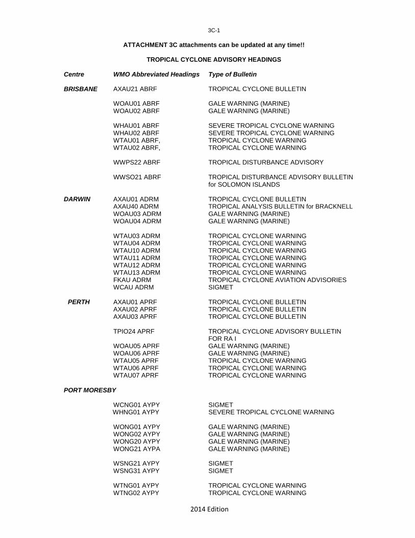
2014 Edition
3C-1
ATTACHMENT 3C attachments can be updated at any time!!
TROPICAL CYCLONE ADVISORY HEADINGS
Centre WMO Abbreviated Headings Type of Bulletin
BRISBANE AXAU21 ABRF TROPICAL CYCLONE BULLETIN
WOAU01 ABRF GALE WARNING (MARINE) WOAU02 ABRF GALE WARNING (MARINE)
WHAU01 ABRF SEVERE TROPICAL CYCLONE WARNING WHAU02 ABRF SEVERE TROPICAL CYCLONE WARNING WTAU01 ABRF, TROPICAL CYCLONE WARNING WTAU02 ABRF, TROPICAL CYCLONE WARNING
WWPS22 ABRF TROPICAL DISTURBANCE ADVISORY
WWSO21 ABRF TROPICAL DISTURBANCE ADVISORY BULLETIN for SOLOMON ISLANDS
DARWIN AXAU01 ADRM TROPICAL CYCLONE BULLETIN AXAU40 ADRM TROPICAL ANALYSIS BULLETIN for BRACKNELL WOAU03 ADRM GALE WARNING (MARINE) WOAU04 ADRM GALE WARNING (MARINE)
WTAU03 ADRM TROPICAL CYCLONE WARNING WTAU04 ADRM TROPICAL CYCLONE WARNING WTAU10 ADRM TROPICAL CYCLONE WARNING WTAU11 ADRM TROPICAL CYCLONE WARNING WTAU12 ADRM TROPICAL CYCLONE WARNING WTAU13 ADRM TROPICAL CYCLONE WARNING FKAU ADRM TROPICAL CYCLONE AVIATION ADVISORIES WCAU ADRM SIGMET
PERTH AXAU01 APRF TROPICAL CYCLONE BULLETIN AXAU02 APRF TROPICAL CYCLONE BULLETIN AXAU03 APRF TROPICAL CYCLONE BULLETIN
TPIO24 APRF TROPICAL CYCLONE ADVISORY BULLETIN FOR RA I WOAU05 APRF GALE WARNING (MARINE) WOAU06 APRF GALE WARNING (MARINE) WTAU05 APRF TROPICAL CYCLONE WARNING WTAU06 APRF TROPICAL CYCLONE WARNING WTAU07 APRF TROPICAL CYCLONE WARNING
PORT MORESBY
WCNG01 AYPY SIGMET WHNG01 AYPY SEVERE TROPICAL CYCLONE WARNING
WONG01 AYPY GALE WARNING (MARINE) WONG02 AYPY GALE WARNING (MARINE) WONG20 AYPY GALE WARNING (MARINE) WONG21 AYPA GALE WARNING (MARINE)
WSNG21 AYPY SIGMET WSNG31 AYPY SIGMET
WTNG01 AYPY TROPICAL CYCLONE WARNING WTNG02 AYPY TROPICAL CYCLONE WARNING

2014 Edition
3C-2
Centre WMO Abbreviated Headings Type of Bulletin
NADI WOPS01 NFFN NIL WARNING or NON-TROPICAL
CYCLONE WARNING Add headers for new products
WTPS01 NFFN MARINE GALE/STORM WARNING WHPS01 NFFN MARINE HURRICANE WARNING
WWFJ40 NFFN SPECIAL WEATHER BULLETIN for FIJI WWFJ41 NFFN SPECIAL WEATHER BULLETIN for FIJI WWKU40 NFFN SPECIAL WEATHER BULLETIN for COOK ISLANDS WWKU41 NFFN SPECIAL WEATHER BULLETIN for COOK ISLANDS WWKB40 NFFN SPECIAL WEATHER BULLETIN for KIRIBATI WWNE40 NFFN SPECIAL WEATHER BULLETIN for NIUE WWTK40 NFFN SPECIAL WEATHER BULLETIN for TOKELAU WWTO40 NFFN SPECIAL WEATHER BULLETIN for TONGA WWTV40 NFFN SPECIAL WEATHER BULLETIN for TUVALU
WCFJ01 NFFN SIGMET
WWPS21 NFFN TROPICAL DISTURBANCE SUMMARY WTPS11 NFFN TROPICAL DISTURBANCE ADVISORY
FKPS01-03 NFFN TROPICAL CYCLONE AVIATION ADVISORIES
Jakarta TCWC
WTID01 WIIX Ocean Gale and Storm Warning WTID02 WIIX Ocean Gale and Storm Warning WCID01 WIIX SIGMET WCID02 WIIX SIGMET
SAMOA WWZM40 NSAP SPECIAL WEATHER BULLETIN (based on ADVISORY from FIJI
NEW CALEDONIA
WWNC01 NWBB SPECIAL MARINE BULLETIN GALE WARNING IN FRENCH WWNC02 NWBB SPECIAL MARINE BULLETIN GALE WARNING IN ENGLISH WTNC01 NWBB SPECIAL MARINE BULLETIN STORM WARNING IN FRENCH WTNC02 NWBB SPECIAL MARINE BULLETIN STORM WARNING IN ENGLISH WHNC01 NWBB SPECIAL MARINE BULLETIN HURRICANE WARNING IN FRENCH WHNC02 NWBB SPECIAL MARINE BULLETIN HURRICANE WARNING IN ENGLISH
WONC01 NWBB SPECIAL PUBLIC BULLETIN IN FRENCH

2014 Edition
3C-3
Centre WMO Abbreviated Headings Type of Bulletin
TAHITI WCPF20 NTAA SIGMET DE CYCLONE TROPICAL WOPF01 NTAA AVIS DE COUP DE VENT: Gale warning WOPF20 NTAA BULLETIN METEOROLOGIQUE SPECIAL MARINE WTPF01 NTAA AVIS DE TEMPETE: Storm warning WHPF01 NTAA AVIS DE CYCLONE: Hurricane warning
RSMC/WFO HONOLULU
FZPS40 PHFO HIGH SEAS FORECAST SOUTH PACIFIC
WHPS50 PHFO AMENDED HIGH SEAS FORECAST SOUTH PACIFIC
TXPS40 PHFO TROPICAL CYCLONE FIXES SOUTH PACIFIC aka SOUTHERN HEMISPHERE TROPICAL CYCLONE SUMMARY

2014 Edition
3C-4
PRODUCTS ISSUED BY JTWC FOR USA MILITARY AND USA NATIONAL INTERESTS IN THE SOUTH-EAST INDIAN OCEAN Centre WMO Abbreviated Headings Type of Bulletin
ABIO10 PGTW SIGNIFICANT TROPICAL WEATHER ADVISORY FOR THE INDIAN OCEAN (NORTH AND SOUTH OF THE EQUATOR AND WEST OF 135 E)
WTXS21-25 PGTW TROPICAL CYCLONE FORMATION ALERT FOR THE SOUTH INDIAN OCEAN (WEST OF 135 E TO THE COAST OF AFRICA)
WTXS31-35 PGTW SOUTH INDIAN OCEAN TROPICAL CYCLONE WARNINGS (WEST OF 135 E TO THE COAST OF AFRICA)
TPXS10 XXXX SOUTH INDIAN OCEAN TROPICAL CYCLONE POSITION REPORTS BASED ON METEOROLOGICAL SATELLITE DATA.
Centre WMO Abbreviated Headings Type of Bulletin
XXXX = PGTW = 17TH OPERATIONAL WEATHER SQUADRON (OWS), SATELLITE OPERATIONS (CO-LOCATED WITH THE JTWC). FJDG = U. S. NAVY DIEGO GARCIA SITE.
PRODUCTS ISSUED BY JTWC FOR USA MILITARY AND USA NATIONAL INTERESTS IN THE SOUTH PACIFIC
ABPW10 PGTW SIGNIFICANT TROPICAL WEATHER ADVISORY FOR THE WESTERN PACIFIC OCEAN BETWEEN 135 E AND 180 E.
WTPS21-25 PHNC WTPS31-35 PHNC WTPS21-25 PGTW WTPS31-35 PGTW TPPS10 XXXX XXXX =
TROPICAL CYCLONE FORMATION ALERT FOR
THE SOUTHEAST PACIFIC (EAST OF 180) TROPICAL CYCLONE WARNINGS FOR THE SOUTHEAST PACIFIC (EAST OF 180) TROPICAL CYCLONE FORMATION ALERT FOR THE SOUTHWEST PACIFIC (WEST OF 180 AND EAST OF 135E) TROPICAL CYCLONE WARNING FOR THE SOUTHWEST PACIFIC (WEST OF 180 AND EAST OF 135E) SOUTH PACIFIC OCEAN TROPICAL CYCLONE POSITION REPORTS BASED ON METEOROLOGICAL SATELLITE DATA PGTW or KGWC
2014 Edition
3C-5 NOAA/NESDIS PRODUCTS FOR THE SOUTH PACIFIC AND SOUTHEAST INDIAN OCEAN
TCIO10 KWBC INDIAN OCEAN TROPICAL CYCLONE POSITION REPORT BASED ON METEOROLOGICAL SATELLITE DATA
DATA ISSUED THE BY THE US NESDIS, SUITLAND, MD.
WWPS10 KWBC SOUTH PACIFIC TROPICAL CYCLONE POSITION
REPORT BASED ON METEOROLOGICAL SATELLITE DATA ISSUED THE BY THE US NESDIS, SUITLAND, MD.
WELLINGTON
WTNZ41 NZKL GALE / STORM WARNING (MARINE) WHNZ41 NZKL HURRICANE WARNING (MARINE)
(EMWIN LISTING TO BE INSERTED)

2014 Edition
IV-1
CHAPTER 4
BROADCASTING OF TROPICAL CYCLONE INFORMATION TO THE PUBLIC 4.1 Introduction
This chapter provides details of the route by which tropical cyclone forecasts and warnings are relayed to the public after they have been issued by RSMC Nadi, a TCWC or an NMC. Wellington and Melbourne receive Special Weather Bulletins prepared by RSMC Nadi for relaying to Radio New Zealand International (RNZI) and Radio Australia. Other Members responsible for preparing their own tropical cyclone bulletins disseminate them in a more direct way to Radio Australia and RNZI.
Details are given in the Attachment 4A about broadcast frequencies (only if it is appropriate), the regularity of broadcasts upon receipt of an alert or warning and the hours of transmission of any radio and television stations during the passage of a tropical cyclone. 4.2 Broadcasts 4.2.1 Radio New Zealand International and Radio Australia
Radio New Zealand International (RNZI) and Radio Australia are able to broadcast, upon receipt and at regular intervals, forecasts and warnings for South Pacific countries. Forecasts and warnings to be broadcast by Radio Australia are sent via GTS to Melbourne where they are transferred from the Bureau of Meteorology to the Radio Australia BASYS communication system. The same products are also sent to Wellington on the GTS for relay from Meteorological Service of New Zealand ("MetService") to RNZI by e-mail. The unique WMO Abbreviated Heading in each bulletin automatically triggers the transfer to Radio Australia and RNZI.
Copies of the warnings are also relayed to the New Zealand Ministry of Foreign Affairs and Trade (MFAT) and the Ministry of Defence. MFAT (co-ordinator of New Zealand's cyclone relief programme in the South Pacific) keeps a close watch on tropical cyclone activity in the South Pacific to enable it to launch a speedy response if required.
Both Radio Australia and RNZI remain continuously on air. Normally the office and studio of RNZI are only staffed during the following hours: 1700-2400/0001-1000 UTC Monday to Friday and 1700-
2300 UTC Saturday, except Easter Monday, Queen’s birthday (1st
Monday in June), Labour day (4th
Monday in October) and from Christmas Day to the Sunday after January 2nd
inclusive). Note that there is nobody in the office or studio on Sunday and much of Saturday (NZST/NZDT).
MetService will contact RNZI by telephone upon receipt of every first Special Weather Bulletin issued by RSMC Nadi. If other Members require RNZI to broadcast their tropical cyclone bulletins outside the above hours, either send the first bulletin via GTS or fax to Wellington TCWC with the comment "Attention: LEAD FORECASTER, PLEASE CONTACT RNZI", or contact Wellington TCWC by telephone. MetService will contact the standby person in RNZI. 4.2.2 Radio Samoa
Radio Samoa broadcasts Special Weather Bulletins for Tokelau in local languages. 4.2.3 Radio broadcasts for individual country, if necessary.
________________

2014 Edition
4A-1
ATTACHMENT 4A
SHORTWAVE FREQUENCY SCHEDULES FOR RADIO NEW ZEALAND INTERNATIONAL (RNZI)
AND RADIO AUSTRALIA
RADIO NEW ZEALAND INTERNATIONAL FREQUENCY SCHEDULE
All broadcasts done from a 100kW transmitter. Check the latest RNZI frequency schedule on website http://www.rnzi.com.
RADIO AUSTRALIA FREQUENCY SCHEDULE FOR SOUTH-WEST AND SOUTH-CENTRAL PACIFIC OCEAN
All broadcasts are done from a 100kW transmitter. Check the latest Radio Australia
frequency schedule on website http://www.abc.net.au/ra/hear/shortwave.htm.
SHORTWAVE FREQUENCY SCHEDULES FOR PAPUA NEW GUINEA AND SOLOMON ISLANDS
Check the latest Radio Australia frequency schedule for broadcasts in English and in
Tok Pisin (Pidgin) on website http://www.abc.net.au/ra/hear/shortwave.htm.
RADIO FAX FROM AUSTRALIA BUREAU OF METEOROLOGY AND RADIO VOICE BROADCASTS FROM US NOAA NWS HONOLULU RSMC/WFO
2014 Edition
V-1
CHAPTER 5
COMMUNICATIONS 5.1 General
The Aeronautical Fixed Telecommunications Network (AFTN) and the Global Telecommunications System (GTS) are used for the interchange of forecasts, warnings and observations. Fax, the Emergency Managers Weather Information Network (EMWIN) and the Internet (Homepages and E-mail) are other means of disseminating forecasts and warnings and other tropical cyclone information between TCWCs/NMCs and users. AFTN/GTS links in the Regions are shown in Attachment 5A. 5.2 Contacts in National Meteorological Services**
A list containing the postal addresses, AFTN addresses, telephone, fax, Internet (E-mail + Homepage) of key officials of National Meteorological Services is given in Attachment 5B to facilitate correspondence, exchange of messages and discussions. Changes to these addresses are relayed to RSMC Nadi and TCWCs by 30 September each year or immediately if they occur during a cyclone season. 5.3 RSMC-Nadi Communication Centre outage
When the RSMC Nadi is not able to operate through communication equipment failure, storm damage, or any other reason, Members who normally pass weather observations to Nadi are to pass those observations on to Wellington TCWC by any means available (e.g. telephone +64-4- 4700-700, Fax +64-4-471 2078 or E-mail: [email protected], use the following format shown in the example below from Niue: SUBJECT: PASSAFTN
RELAY TO AFTN GG METEX SAPS31 NIUE 302000 METAR NIUE 30200Z 05008KT 50KM SCT018 SCT030 BKN110 26/24 Q1011=
_____________________ ________________ ** See Attachment 5B.

2014 Edition
5A-1
ATTACHMENT 5A
AFTN/GTS TELECOMMUNICATION LINKS SERVING THE AREA COVERED BY THE PLAN
Refer to WMO-No. 386 - Manual on the Global Telecommunication System, Volume II - Regional Aspects, Region V - South-West Pacific, Part I, Figure 2 (see next page) for an up-to date list of these links. The WMO RA V Tropical Cyclone Committee (September, 2000) decided it is better to find the latest data in the original documents than to rely on outdated listings which were previously included in this Plan.

2014 Edition
5A-2
Figure 2
Beijing
Internet
Tokyo
IMTN-MDCN
FR 1.5 M Washington
Exeter CIR<32/768>
FR 192
Bangkok
CIR<16>
IMTN-MDCN 2M MPLS
Moscow
FR 256
FR 64
FR 64 CIR<32>
CIR<16>
CIR<16> Manila
RSMC
FR 64
Honolulu
New Delhi CIR<16> IMTN-MDCN 128
Kuala
FR 256
TCP/IP
IMTN-MDCN Lumpur FR 64 CIR<32> Internet
Guam
CIR<32>
FR 256
CIR<64> 9.6 X.25 Brunei
Internet ASMC Micronesia
Internet Singapore AFTN+GTS
9.6 X.25
Internet
FR 64 Port
Apia AFTN+GTS Pago-Pago
Moresby 9.6 X.25
CIR<8/4>
FR 256
CIR<8> Honiara
Internet
Jakarta
NO 9.6 TCP/IP
FR 64 RSMC
CIR<8>
Darwin
RTH in Region V Port Vila
NMC in Region V FR 2M
Internet
Centre in other region CIR<384>
Noumea
9.6 TCP/IP
MTN circuit
Regional circuit Melbourne Internet
Interregional circuit
/Brisbane
Additional circuit
NO Not operational Wellington
Non-IP link
IP link
FR Frame Relay
CIR Committed Information Rate
Regional Meteorological Telecommunication Network Plans for Region V (South-West
Pacific) point-to-point circuits implementation (transmission speed in kbit/s)
AFTN +GTS
4.8 TCP/IP
RSMC Nadi
Papeete
FR 128 CIR<32>
Via Toulouse
E-mail gateway to: Cooks Islands Vanuatu Niue Samoa Tonga Funafuti Kiribati
IX.2006
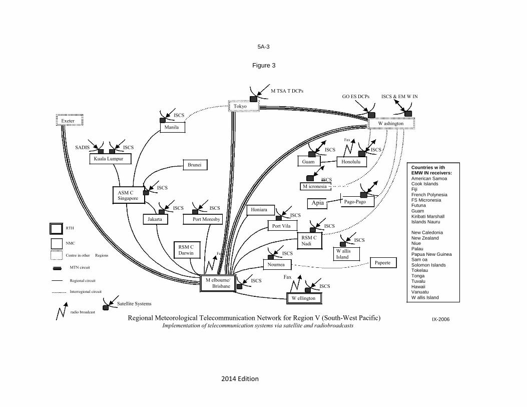
2014 Edition
5A-3
Figure 3
M TSA T DCPs
ISCS & EM W IN
GO ES DCPs
Tokyo
ISCS
Exeter W ashington
Manila
SADIS ISCS
Kuala Lumpur
Brunei
ISCS
ASM C
Singapore
ISCS ISCS
Jakarta Port Moresby
RTH
NMC RSM C
Centre in other Regions Darwin Fax
MTN circuit
Regional circuit M elbourne/
Brisbane
Interregional circuit
Satellite Systems
radio broadcast
Fax
ISCS ISCS
Guam Honolulu
ISCS M icronesia
Apia Pago-Pago Honiara
ISCS
Port Vila ISCS
RSM C ISCS
Nadi
ISCS W allis
Island
Noumea Papeete
ISCS
Fax
ISCS
W ellington
Countries w ith EMW IN receivers: American Samoa Cook Islands Fiji French Polynesia FS Micronesia Futuna Guam Kiribati Marshall Islands Nauru New Caledonia New Zealand Niue Palau Papua New Guinea Sam oa Solomon Islands Tokelau Tonga Tuvalu Hawaii Vanuatu W allis Island
Regional Meteorological Telecommunication Network for Region V (South-West Pacific) IX-2006
Implementation of telecommunication systems via satellite and radiobroadcasts

2014 Edition
5B-1
ATTACHMENT 5B OPERATIONAL ADDRESSES
(Limited Distribution)

2014 Edition
VI-1
CHAPTER 6
CONTINGENCY PLANS 6.1 Introduction
This Chapter specifies the operational procedures that are introduced to maintain tropical cyclone surveillance and issue of warnings whenever one of the Tropical Cyclone Warning Centres is, for any reason, unable to meet its responsibility.
The term full responsibility in this Chapter means responsibility for the issue of warnings to the general population, shipping and aviation. 6.2 Review of plans
Contingency plans are reviewed annually and Members concerned are advised of changes by 30 September. 6.3 Contingency arrangements
The following contingency arrangements are in place: 6.3.1 Failure or partial failure of RSMC Nadi
Wellington TCWC assumes full responsibility temporarily for the TCWC functions of RSMC Nadi-TCC. These arrangements are briefly referred to in Attachment 6A. 6.3.2 Failure or partial failure of Brisbane TCWC (a) Darwin TCWC assumes full responsibility for tropical cyclones in the Eastern Region,
except for special advisories for Solomon Islands. However, in special circumstances Perth TCWC may do so.
(b) RSMC Nadi assumes responsibility for provision of special advisories for Solomon Islands. 6.3.3 Failure or partial failure of Darwin TCWC
Brisbane TCWC assumes full responsibility. However, in special circumstances Perth TCWC may do so. 6.3.4 Failure or partial failure of Perth TCWC
Darwin TCWC assumes full responsibility. However, in special circumstances Brisbane TCWC may do so. 6.3.5 Failure or partial failure of Port Moresby TCWC
Brisbane TCWC assumes full responsibility. However, in special circumstances Darwin TCWC may do so. 6.3.6 Failure or partial failure of Wellington TCWC
Brisbane TCWC assumes full responsibility. 6.3.7 Failure or partial failure of Samoa Weather Forecasting Office.
RSMC Nadi assumes full responsibility. If RSMC Nadi is unable to then RSMC Honolulu.

2014 Edition
VI-2
6.3.8 Failure or partial failure of Vanuatu Meteorology and Geohazard Department’s
Forecasting Centre
RSMC Nadi assumes full responsibility. Failure or partial failure of Tonga Meteorological Service; RSMC-Nadi assumes full responsibility.
6.3.9 Failure of Jakarta TCWC
Perth TCWC assumes full responsibility. However, in special circumstances Darwin TCWC may do so.
6.3.10 Failure or partial failure of American Samoa
RSMC Honolulu assumes full responsibility.
6.3.11 Failure or partial failure of Vanuatu Tropical Cyclone Warning
Centre RSMC Nadi assumes full responsibility.
6.4 Responsibility of TCWCs with respect to contingency plans
TCWCs provide their back-up TCWCs with all warnings and bulletins covering the area for which back-up may be required.
TCWCs provide their back up TCWCs with the necessary current bulletin and warning address lists by 30 September each year and immediately advise of subsequent changes.
_______________________
2014 Edition
6A-1
ATTACHMENT 6A
FIJI/NEW ZEALAND CONTINGENCY ARRANGEMENTS Wellington TCWC will assume temporary responsibility for TCWC functions in RSMC Nadi's area of responsibility, as outlined below, whenever RSMC Nadi is temporarily unable to carry out this role through
i) Communication failure, or ii) storm damage, or iii) planned shutdown of facilities for routine maintenance
For the purpose of this arrangement, these functions are:
Special Weather Bulletin for Cook Islands, Fiji, Kiribati, Nauru, Niue, Tokelau and
Tuvalu.
Tropical Disturbance Advisories
SIGMETs for the Nadi FIR
Aviation advisory information as required by an ICAO designated Tropical Cyclone Advisory Centre as documented in Annex 3 to the Convention on International Civil Aviation.
In addition to RSMC Nadi’s TCWC responsibilities, Wellington TCWC will also provide temporary backup, under conditions stated above, for high seas forecasts and warnings for MetArea XIV and MetArea X for which RSMC Nadi has agreed to act as a “Preparation Service” and as documented in the WMO Manual of Marine Meteorological Services (No. 558)
___________________

2014 Edition
VII-1
CHAPTER 7
END OF SEASON PROCEDURES 7.1 Introduction
This Chapter describes: (a) the arrangements for archival and documentation of information on tropical cyclones that
have occurred in the region in the preceding season and (b) the arrangements for verification of tropical cyclone forecasts and accuracy of operational
tracks compared to post analyzed best tracks. 7.2 Archival and documentation of information
Countries affected by tropical cyclones provide the TCWC responsible for their area with a Damage Report as soon as possible and not later than 31 May. The damage report includes:
o estimated and observed winds (sustained and maximum gusts) and central pressure o rainfall totals (24 hours or less) and intensities o storm surges/wave run-up or still water) o flooding and landslides o damage and casualties.
RSMC Nadi and Tropical Cyclone Warning Centres (TCWCs) maintain a tropical cyclone
case history on each tropical cyclone in their areas of responsibility. Nadi RSMC will produce a seasonal cyclone summary for its area of responsibility and distribute to Members with a copy to WMO. A copy is also sent to Australia to be incorporated into a Regional Tropical Cyclone Summary for the South Pacific and South-East Indian Ocean.
Brisbane, Darwin and Perth TCWCs will contribute to the Regional Tropical Cyclone Summary for publication by the National Climate Centre.. 7.3 Verification of Warnings and Operational Tracks
Tropical Cyclone Warning Centres maintain a data base of tropical cyclone operational position forecasts and post-analysed best tracks. This data base contains the following items where appropriate:
Cyclone name Date time (UTC) Best track centre (Lat,Lon,Press) Operational centre (Lat,Lon,Press)
12 hour forecast made then (Lat,Lon,Press) 24 hour forecast made then (Lat,Lon,Press) 36 hour forecast made then (Lat,Lon,Press) 48 hour forecast made then (Lat,Lon,Press)
A similar data base may be maintained for objective forecasting techniques and for
forecasts provided by centres outside the region.
To ensure a common format for the data base, RSMC Nadi and TCWCs enter the data using the Australian Bureau of Meteorology tropical cyclone verification software format.
Using the verification package, RSMC Nadi and each TCWC maintains its own verification statistics.

2014 Edition
VII-2
A copy of the database for the previous season is to be made available to the International Best Tracks Archive for Climate Stewardship (IBTrACS) team at the World Data Center for Meteorology. This data should be in a consistent format from year-to-year in either CSV or text format. This should be either sent via e-mail directly to the program at <[email protected]>, and/or made available on a web or FTP site that the IBTrACS team can easily access By 30 / September each year. RSMC Nadi and the Australian TCWCs (Brisbane, Darwin and Perth) will put verification statistics on their homepages. 7.4 C.D.A.R. and Review of the Plan
At the end of each tropical cyclone season, each Member is to provide RSMC Nadi or the TCWC responsible for their area with a Cyclone Damage Assessment Report using the format in Attachment 7A, not later than 30 June.
With a view to obtaining their impression of how the Tropical Cyclone Operational Plan worked during the season, the Report should be a critical assessment of:
Timeliness and clarity warnings Communications difficulties (external and internal) Suggestions for improvement.
___________________

2014 Edition
7A-1
ATTACHMENT 7A PRO-FORMA FOR CYCLONE DAMAGE ASSESSMENT REPORT

2014 Edition
VIII-1
CHAPTER 8
ARCHIVAL OF DATA 8.1 Necessity for data archival Members will exchange information on a non-real-time basis as required for the establishment of
tropical cyclone data files and information services nationally. The information will include available
annual charts of cyclone tracks in the appropriate area, with the intensity of the cyclone at each
position marked in accordance with WMO regulations and recommended practices. Also to be
included are available classifications of cyclones by month, intensity and movement, as well as
groupings over periods of years made in accordance with the standard periods stated in WMO
regulations and recommended climatological practices. . In addition, best track data is to be
made available to the IBTrACS team as delineated in section 7.3. IBTrACS is officially
endorsed by the WMO TC Programme and serves as the global archive of all TC best
tracks data from all RSMCs and TCWCs; see http://www.ncdc.noaa.gov/ibtracs/ to
access IBTrACS data.
8.2 Tropical cyclone data set
The Australian Bureau of Meteorology, the Meteorological Service of New Zealand Ltd. and the RSMC Nadi, Fiji will archive information on cyclone tracks and intensities in accordance with the format given in Attachment 8-A and make it available electronically to the IBTrACS program at the World Data Center for Meteorology as delineated in section 7.3 as soon as the finalized track data become available, or no later than 30
th September following the completion of the past TC
season ending on 30th April.
8.3 Post-cyclone public survey
The National Meteorological Services and RSMC Nadi will make every effort to carry out the post-cyclone public survey in accordance with the format given in Attachment 8-B and mail it to the Chairman of the Committee. 8.4 Retrieval of tropical cyclone data
The Australian Bureau of Meteorology, the Meteorological Service of New Zealand Ltd and the RSMC Nadi, will make available the data from their databases free of charge to NMSs, upon request. All TC best tracks data are available from the IBTrACS website at http://www.ncdc.noaa.gov/ibtracs/.
___________________
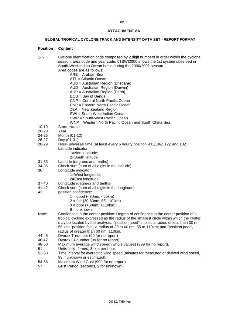
2014 Edition
8A-1
ATTACHMENT 8A
GLOBAL TROPICAL CYCLONE TRACK AND INTENSITY DATA SET - REPORT FORMAT
Position Content
1- 9 Cyclone identification code composed by 2 digit numbers in order within the cyclone season, area code and year code. 01SWI2000 shows the 1st system observed in South-West Indian Ocean basin during the 2000/2001 season. Area codes are as follows: ARB = Arabian Sea ATL = Atlantic Ocean AUB = Australian Region (Brisbane) AUD = Australian Region (Darwin) AUP = Australian Region (Perth) BOB = Bay of Bengal CNP = Central North Pacific Ocean ENP = Eastern North Pacific Ocean ZEA = New Zealand Region SWI = South-West Indian Ocean SWP = South-West Pacific Ocean WNP = Western North Pacific Ocean and South China Sea 10-19 Storm Name 20-23 Year 24-25 Month (01-12) 26-27 Day (01-31) 28-29 Hour- universal time (at least every 6 hourly position -00Z,06Z,12Z and 18Z) Latitude indicator: 1=North latitude; 2=South latitude 31-33 Latitude (degrees and tenths) 34-35 Check sum (sum of all digits in the latitude) 36 Longitude indicator: 1=West longitude; 2=East longitude 37-40 Longitude (degrees and tenths) 41-42 Check sum (sum of all digits in the longitude) 43 position confidence* 1 = good (<30nm; <55km) 2 = fair (30-60nm; 55-110 km) 3 = poor (>60nm; >110km) 9 = unknown Note* Confidence in the center position: Degree of confidence in the center position of a tropical cyclone expressed as the radius of the smallest circle within which the center may be located by the analysis. "position good" implies a radius of less than 30 nm, 55 km; "position fair", a radius of 30 to 60 nm, 55 to 110km; and "position poor", radius of greater than 60 nm, 110km. 44-45 Dvorak T-number (99 for no report) 46-47 Dvorak CI-number (99 for no report) 48-50 Maximum average wind speed (whole values) (999 for no report). 51 Units 1=kt, 2=m/s, 3=km per hour. 52-53 Time interval for averaging wind speed (minutes for measured or derived wind speed, 99 if unknown or estimated). 54-56 Maximum Wind Gust (999 for no report) 57 Gust Period (seconds, 9 for unknown)

2014 Edition
8A-2
58 Quality code for wind reports: 1=Aircraft or Dropsonde observation 2=Over water observation (e.g. buoy) 3=Over land observation 4=Dvorak estimate 5=Other 59-62 Central pressure (nearest hectopascal) (9999 if unknown or unavailable) 63 Quality code for pressure report (same code as for winds) 64 Units of length: 1=nm, 2=km 65-67 Radius of maximum winds (999 for no report) 68 Quality code for RMW: 1=Aircraft observation 2=Radar with well-defined eye 3=Satellite with well-defined eye 4=Radar or satellite, poorly-defined eye 5=Other estimate 69-71 Threshold value for wind speed (gale force preferred, 999 for no report) 72-75 Radius in Sector 1: 315
o-45
o
76-79 Radius in Sector 2: 45o-135
o
80-83 Radius in Sector 3: 135o-225
o
84-87 Radius in Sector 4: 225o-315
o
88 Quality code for wind threshold 1=Aircraft observations 2=Surface observations 3=Estimate from outer closed isobar 4=Other estimate 89-91 Second threshold value for wind speed (999 for no report) 92-95 Radius in Sector 1: 315
o-45
o
96-99 Radius in Sector 2: 45o-135
o
100-103 Radius in Sector 3: 135o-225
o
104-107 Radius in Sector 4: 225o-315
o
108 Quality code for wind threshold (code as for row 88) 109-110 Cyclone type: 01= tropics; disturbance ( no closed isobars) 02= <34 knot winds, <17m/s winds and at least one closed isobar 03= 34-63 knots, 17-32m/s 04= >63 knots, >32m/s 05= extratropical 06= dissipating 07= subtropical cyclone (nonfrontal, low pressure system that comprises initially baroclinic circulation developing over subtropical water) 08= overland 09= unknown 111-112 Source code (2 - digit code to represent the country or organization that provided the data to NCDC USA. WMO Secretariat is authorized to assign number to additional participating centers, organizations) 01 RSMC Miami-Hurricane Center 02 RSMC Tokyo-Typhoon Center 03 RSMC-tropical cyclones New Delhi 04 RSMC La Reunion-Tropical Cyclone Centre 05 Australian Bureau of Meteorology 06 Meteorological Service of New Zealand Ltd. 07 RSMC Nadi-Tropical Cyclone Centre 08** Joint Typhoon Warning Center, Honolulu 09** Madagascar Meteorological Service 10** Mauritius Meteorological Service 11** Meteorological Service, New Caledonia 12 Central Pacific Hurricane Center, Honolulu Note** no longer used

2014 Edition
8A-3
Headings 1-19 Cyclone identification code and name; 20-29 Date time group; 30-43 Best track positions; 44-110 Intensity, Size and Type; 111-112 Source code.

2014 Edition
8B-1
ATTACHMENT 8B
POST-CYCLONE PUBLIC SURVEY FORM TO MONITOR THE
PERFORMANCE OF THE TROPICAL CYCLONE WARNING SYSTEM
(Useful for Pacific Island Countries providing feedback to RSMC Nadi)
Thank you for spending a few minutes of your time to fill in this survey. Your answers will help RSMC Nadi to check on the performance of the Tropical Cyclone Warning System and decide whether any changes need to be made. Question 1. What was the name of the tropical cyclone? Question 2. Where were you during the cyclone? Give name of village and island and, if appropriate, name of actual town or city. Question 3. Did you hear any information about the tropical cyclone during its passage?
If no, state why?
If yes, by what means:
Local radio station [ ] Radio New Zealand International (shortwave) [ ] Radio France Outre-mer [ ] Other (e.g. friend, neighbour, work-mate, family member) [ ]
Question 4. If you listened to a radio, in what language did you hear the information?
English [ ] French [ ] Native tongue [ ]
Question 5. Do you think the information about the tropical cyclone was
Very easy to understand [ ] Easy to understand [ ] Difficult to understand [ ] Very difficult to understand [ ]
If you ticked 'difficult to understand' or 'very difficult to understand', please state why it was difficult for you, e.g. message too long, too much detail, language too technical. Question 6. Did the information about the tropical cyclone (e.g. its position and movement, the strength of the wind, flooding due to rain or sea, very heavy surf) give you all the information you wanted to know [yes/no]?
If 'no', what information was missing Question 7. What action did you take in response to the information?

2014 Edition
8B-2
Waited for later information [ ] Decided there was no need for any action [ ] Did all I could to reduce the effects of the cyclone [ ]
Question 8. Overall, do you think the warning service given by RSMC Nadi or the Tropical Cyclone Warning Centre, was:
very good [ ] good [ ] fair [ ] poor [ ] very poor [ ]
If you answered 'fair', 'poor' or 'very poor' please explain why. Question 9 (if applicable). In general, bulletins issued by warning centres DO NOT contain Preparedness Action Statements (e.g. take precautions, make preparations, seek shelter). Instead, such statements are made in separate radio messages.
Please tick your preference:
I am happy with this arrangement [ ]
I would like to see preparedness action statements included in tropical cyclone bulletins [ ]
Question 10. Answer these questions about the WIND if you can.
What time did the strongest winds occur?
What direction (e.g. off the sea, off the land, northwest,
southeast, etc.) did the strongest winds come from?
How strong (gale, storm or hurricane) do you think the wind got? Did the winds suddenly become light during the cyclone before becoming strong again from another direction? [yes/no]
If 'yes', about what time did the winds go light and how long did they stay light?
Question 11. During the fury of the tropical cyclone, did you experience a very high tide like you have never experienced before? [yes/no]
If 'yes', please say how high the tide was or how far inland the sea came Question 12. Do you think the effect of this cyclone on your island was: (tick one only)
LESS than you expected from the information received [ ]
MORE than you expected from the information received [ ]
ABOUT WHAT you expected from the information received [ ]