university of toronto (main campus) · development on the main campus of the university of toronto...
TRANSCRIPT

Development on the main campus of the Universityof Toronto will be consistent with the followingurban design guidelines. The guidelines correspondto Secondary Plan #20 in Chapter 6 of the OfficialPlan. The guidelines are to be read in conjunctionwith the urban design policies of the Official Plan.
LOCATIONUniversity of Toronto lands generally bounded byBloor Street West, College Street, Spadina Avenueand Bay Street.
GUIDELINESThese detailed design guidelines are for those sitesfor which site-specific development rights are givenin Zoning By-law 438-86, Section 12 (2) amendments,as required in Implementation Section 6 of theUniversity of Toronto Secondary Plan. Theseguidelines will be referred to for Site Plan Review.
The site specific development guidelines are basedon a detailed study of the “Structure Plan” set outin Section 3 of the Secondary Plan. The followingsection summarizes certain urban design values andprinciples derived from the Official Plan and TheUniversity of Toronto Secondary Plan, Section 3,which were used to formulate the recommendeddevelopment guidelines. The Design Principles will,in the same manner, be the basis for appraisal offuture applications for other development sites.
Design guidelines for additional sites may be addedto this plan as part of a rezoning process.
The first 28 sites for which development rights andguidelines were adopted by City Council (June 1997)are shown on the Key Map, Maps 1 to 28 and Maps1 to 28 of Section 12(2)407of Zoning By-law 438-86.
IntentThe intent throughout the guidelines is to continuethe traditional campus patterns such as low–scalebuildings enclosing open spaces, and the rhythm ofvarious building types along St. George Street. Theguidelines ensure that new buildings relate harmoniouslyto adjacent spaces and buildings in siting, height,massing and architectural details. They also help tocreate a comfortable micro-environment. Distinctivedesign of buildings located at street terminals, ormajor entrances to the University Area, is encouragedto enhance views and create orientation points.
URBAN DESIGN GUIDELINES
UNIVERSITY OF TORONTO (MAIN CAMPUS)
TORONTOJune 2004

June 2004
� High quality and usable open spaces which continuethe pattern of university open space types andare physically and visually linked to the streets,parks and mid-block pedestrain routes, will beprovided in conjunction with new development.
� High quality co-ordinated landscape improvementswill be provided in a manner which will promoteaccess, orientation, and confidence of personalsafety and enhance the structure, amenity andnotable special characteristics of the district.
� Buildings, streets and the publicly accessible openspace and pedestrian network will be designed tosupport personal safety and to permit convenientaccess by the elderly, infirm and people withdisabilities.
URBAN DESIGN GUIDELINESTORONTO
UNIVERSITY OF TORONTO (MAIN CAMPUS)
To further support the intimate interactive environmentof a University campus, and to ensure safety andaccessibility, new developments are encouraged tolocate public uses, access points and windows atgrade. New usable open spaces and midblockconnections will be included in new developments,to continue the pedestrian path and open spacenetwork throughout the campus, including links tothe city. Landscape design will consider physicalaccessibility, personal security and orientation byproviding appropriate amenities such as ramps,lighting, direction and information signs to orientusers and visitors, hard and soft landscaping, seatingand other furnishings for pedestrians.
Design PrinciplesParticular attention will be given to the followingprinciples.
� New buildings will be sited in a manner thatclearly defines and gives form to the edges ofstreets, open spaces and mid-block pedestrianroutes.
� The height and mass of new buildings willachieve the appropriate relationship to the scaleof adjacent streets and open spaces ensuringaccess to sunlight and sky view and shelter fromprevailing winds.
� New buildings will achieve a harmoniousrelationship to their built form context throughconsideration of such matters as, but not limitedto, the building massing and set backs roof lineand profile, scale, texture, architectural detail andexpression, including fenestration and materials.
� Special attention will be given to the relationshipbetween the lower level of buildings and thepedestrian realm by.
i) Ensuring that building organization and usespromote the publicness of the streets, openspaces and pedestrian routes
ii) Encouraging the design and location ofvehicular service and parking uses whichminimize pedestrian/vehicle conflicts.

June 2004URBAN DESIGN GUIDELINES
UNIVERSITY OF TORONTO (MAIN CAMPUS)
TORONTO
1
3
4
8
6
59b
10
1617a
18
11
22
7
12 2123
28
24
26
13
14
2
9a
b
20
19
15
25
3
59b
18
26
20 PA
RK
CR
ES
CE
NT
HOSKIN AVENUE
QU
EE
N’S
CR
ES
CE
NT
QU
EE
N’S
CRESCENTSPADINA
WA
LME
R
EA
ST
WE
ST
PA
RK
QU
EE
N’S
PA
RK
SP
AD
INA
AV
EN
UE
WELLESLEY STREET
371 Bloor Street West50 Sussex Avenue369 Huron Street, ES100 St. George Street1 Spadina Crescent22 Russell Street50 St. George Street47—55 St. George Street91—97 St. George Street100 Devonshire Place77 Charles Street West88—112 College Street
124678
9a1011121314
631—651 Spadina Avenue 575—581 Spadina Avenue70 St. George Street40 St. George Street20 Queen’s Park Crescent West321 Bloor Street West
35
9b182026
Development sites (approximate locations for information only) Under construction or completed as of September 2002
8 Taddle Creek Road200 College Street5 King’s College Road170 College Street14 Queen’s Park Crescent West299 Bloor Street West73 St. George Street90 Queen’s Park90 Queen’s Park 6 Hoskins Avenue74-90 Wellesley Street100 Queen’s Park273 Bloor Street West
1516
17a17b
192122
23a23b
24252728
CHARLES STREET
KIN
G’S
CO
LLE
GE
RO
AD
STREETRUSSELL
DE
VO
NS
HIR
EP
LAC
E
HARBORD STREET
HU
RO
NS
TR
EE
T
BLOOR WESTSTREET
BA
YS
TR
EE
T
ST
. GE
OR
GE
ST
RE
ET
STREETCOLLEGE
27
Key Map Potential SitesUniversity of Toronto
City of Toronto 2002
H

June 2004 URBAN DESIGN GUIDELINESTORONTO
UNIVERSITY OF TORONTO (MAIN CAMPUS)

June 2004URBAN DESIGN GUIDELINES
UNIVERSITY OF TORONTO (MAIN CAMPUS)
TORONTO
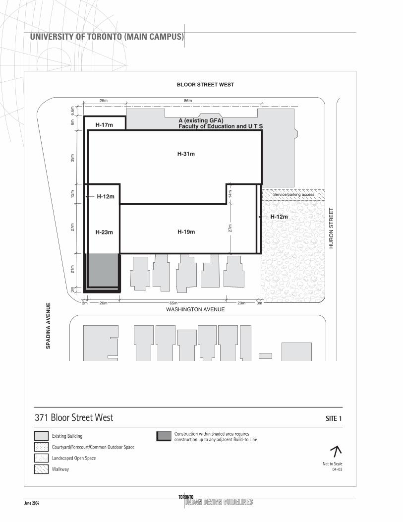
SITE 1 371 BLOOR STREET WEST
CONTEXT
LocationUTS (University of Toronto School) and the Facultyof Education are located at the northwest corner ofthe University campus. The site occupies land on thesouth side of Bloor Street from Spadina Avenue eastto Huron Street and south to Washington Avenue. Itis well serviced by two major subway lines and theSpadina LRT terminus, at Bloor and Spadina.
Heritage IssuesNew construction will be compatible with theexisting structure at 371 Bloor Street West in thefollowing ways: scale, building location andorganization, height and setback of structures;relationship of the structure to the open spacebetween it and neighbouring structures; exteriorfeatures, such as window sills or header lines, theproportion of window or door openings to theoverall facade, and the horizontal or verticalemphasis of the major building elements; andbuilding materials, when relevant and material, willbe important in the City’s review of the project.
Open SpaceSouth-east of the property is a small park at thecorner of Huron and Washington Streets. This site isis to be maintained as an accessible open space.
DESIGN GUIDELINES
General Site Plan IssuesTo the south of the site is the Huron–SussexNeighbourhood which is a low density residentialarea within the boundary of the University area. Theopportunity to preserve and restore the existinghouses within the context of new development willbe pursued.
Setbacks, Alignments and Build-To Line The highest portion of the building envelope is 31m,situated over top of the existing UTS building andwill have an 8m setback from the main northbuilding wall, a 3m setback from the west buildingwall and a 20m setback from the east building wall.
The west building will align with the existingbuilding footprint to the north. The north-west
June 2004 URBAN DESIGN GUIDELINESTORONTO
UNIVERSITY OF TORONTO (MAIN CAMPUS)
H-19m

June 2004URBAN DESIGN GUIDELINES
UNIVERSITY OF TORONTO (MAIN CAMPUS)
TORONTO
corner can be reconstructed up to a height of 17mequal to the existing building. The south portionwhich includes the existing houses will have a heightnot exceeding 12m for 24m from WashingtonAvenue then rising to a maximum height of 19m.Directly adjacent to Washington Avenue and theHuron-Washington open space, the maximum heightwill not exceed 12m, then step up to a maximumheight of 19m. All set backs subject to survey.
Open SpaceThe northern edge of the Huron–Washingtonpublicly accessible open space will require decorativelandscape treatment along the proposed access lanefrom Huron Street to the proposed development.The landscaping will be integrated into the existinglandscaping of the park.
Pedestrian RoutesPublic access may be provided through the siteconnecting Spadina Avenue to Huron Street.
Address and Grade-Related UsesAn entrance to the higher portion of this developmentwill be through the existing UTS/Faculty of EducationBuilding. An entrance can also be located on SpadinaAvenue depending on the building use. On theWashington Avenue face of the development,pedestrian entrances, spaced at frequent intervalsalong the sidewalk will contribute to the variety andintensity of the street.
Streetscape and Existing Houseform BuildingImprovements to sidewalks on Spadina Avenue,Bloor Street, Huron and Washington Streets will beconsistent with any integrated landscape plan forthe University.
Every effort will be made to retain the houseformbuildings at 2 to 20 Washington Avenue inclusive.
ServicingAccess to servicing and parking is to be by a newpublic lane from Huron Street on the north side ofthe existing park. It will require a protective barrierto the park. The existing City-owned lanes will needto be terminated and the land transferred to theUniversity as part of a land exchange between theUniversity and City.

URBAN DESIGN GUIDELINESTORONTO
UNIVERSITY OF TORONTO (MAIN CAMPUS)
June 2004

June 2004URBAN DESIGN GUIDELINES
UNIVERSITY OF TORONTO (MAIN CAMPUS)
TORONTO
SITE 2 50 SUSSEX AVENUE, 675-689SPADINA AVENUE
CONTEXT
LocationThis site is located in the Huron–SussexNeighbourhood on the western edge of the Campusand fronts onto Spadina Avenue two blocks southof the Bloor–Spadina intersection.
DESIGN GUIDELINES
General Site Plan IssuesThe “Chiller Plant“ for the University, is setback fromthe line of existing houses and located on theeasterly edge of the site creating a void facing ontoSpadina Avenue. Development on this site is envisionedto correct this void and complete the residentialstreet facade that exists surrounding the site.
SetbacksThe proposed building will be built to the propertyline on the Spadina Avenue frontage and allow forresidential architectural detailing in keeping with thesurrounding neighbourhood. A 2m projection zonewill be allowed on Sussex Avenue to allow forresidential type detailing such as porches, baywindows and steps. All setbacks subject to survey.
Open SpaceA residential open space will be provided at the rearof the lot.
Pedestrian RoutesThe lane system will be completed by connectingwith the public lane running east-west andproviding the south link in this block. Part of thissite includes a narrower lot at 46 Sussex Avenuewhich will be used for the creation of a laneway/walkway. It is to be maintained and enhanced withoverlook from this development. Pedestrianamenities such as lighting and landscaping areencouraged.
Address and Grade-Related UsesThe main building entrance(s) will front ontoSpadina Avenue, with secondary residential typeaccess from Sussex Avenue. Both entrances will haveintegrated access for the disabled.

June 2004 URBAN DESIGN GUIDELINESTORONTO
UNIVERSITY OF TORONTO (MAIN CAMPUS)
40m

June 2004URBAN DESIGN GUIDELINES
UNIVERSITY OF TORONTO (MAIN CAMPUS)
TORONTO
StreetscapeImprovements to sidewalks on Spadina Avenue willbe consistent with any existing integrated landscapeplan for the university.
Height and MassingA height limit of 12m with a 3m setback up to amaximum height of 23m is compatible with SpadinaAvenue. The height of 12m on Sussex Avenue iscompatible with the surrounding houseformbuildings.
ServicingServicing for the new building will be from SussexAvenue.
URBAN DESIGN GUIDELINESTORONTO
UNIVERSITY OF TORONTO (MAIN CAMPUS)
June 2004

June 2004URBAN DESIGN GUIDELINES
UNIVERSITY OF TORONTO (MAIN CAMPUS)
TORONTO
SITE 4 369 HURON STREET (W PART OFROBARTS LIBRARY BLOCK)
CONTEXT
Location This site is located on the west side of the RobartsLibrary block, on the east side of Huron Streetbetween Sussex Avenue and Harbord Street. It isadjacent to the residential neighbourhood ofHuron–Sussex which stretches to the north and west.
Heritage Issues21 Sussex Avenue (“Sussex Court”) across from thesite, is included in the City of Toronto Inventory ofHeritage Properties.
Open SpaceTo the east of the site, both north and south sidesof the main Robarts block, are open spaces that areto be retained.
DESIGN GUIDELINES
General Site IssuesA housing development is encouraged on this site tocomplement the residential character and scale ofthe neighbourhood to the west and to achieve atransition of scale from the bulk of the library. Anarrow linear residential or institutional building intwo sections, and low to moderate in scale, wouldreinforce the residential character of this portion ofHuron Street. The central section of a building inthis location has the potential to enhance the viewof the termination Glen Morris Street.
Setbacks and Projection Zone The main building wall is to be setback 3m from thefront property lines on Huron Street and Sussex Avenue,to ensure residential privacy, and to provide sufficientroom for tree planting. The setback area will be grassedand treated as a front lawn, with residential stairs,porches, walks, entries, etc., and supporting landscapeamenities such as lights and bicycle parking (similar toexisting setbacks for residential across the street).
Architectural articulation of the facade consisting ofminor elements such as porches, bay windows etc.may project up to 2m in front of the main buildingwall for not more than a total of 40% of the facadelength.

June 2004 URBAN DESIGN GUIDELINESTORONTO
UNIVERSITY OF TORONTO (MAIN CAMPUS)

June 2004URBAN DESIGN GUIDELINES
UNIVERSITY OF TORONTO (MAIN CAMPUS)
TORONTO
StreetscapeImprovements to sidewalks on Huron Street will beconsistent with any existing integrated landscapeplan for the University.
Height and Massing The massing on this site is composed of a low–risenorth block with a maximum height of 15m, withmultiple entrances and an articulated front facadeto develop an appropriate scale compatible with theHuron–Sussex houseform residential area.
Buildings will clearly display a residential charactertypical of houseform architecture in the area.
Facing Glen Morris Street, any building block will becentred on Glen Morris Street to provide a terminationof the view corridor and be articulated as a separateelement from the north wing of the project.
ServicingUtilize the existing service court to provide serviceaccess to this project. Relocate new service doors tothe street frontage on Huron Street and incorporatethe existing security kiosk, if necessary.
The rear setback will be a minimum of 12m fromthe west face of the Robarts Library to provideuseable outdoor space between the new buildingand the library building. Given the restricted frontand rear yard dimensions, both front and rearelevations will be carefully designed to ensureadequate privacy for the residents or users fromboth Huron Street and Robarts Library.
Open SpaceThe two open spaces (defined as gardens) at thenorth and south ends of the Robarts Librarybuilding are to be maintained as open spaces.Outdoor recreation spaces adjacent to the newbuilding will relate directly to internal uses and bedefined as separate spaces from the open spaceassociated with the Robarts Library. These areas willcontain a mix of hard and soft landscaped areas; beinviting and accessible; include amenities such aslights, benches and planting.
The rear yard between the Robarts Library and theproposed development will be private outdoor space.
The service area could be decked over, creating thepotential for a rooftop outdoor recreation area,unless the higher central residential block is built.
Pedestrian RoutesReconfiguration of the existing pathway, which cutsdiagonally from St. George Street to Sussex Avenuethrough the north garden area is required.
Address and Grade-Related Uses Multiple entrances from Huron Street, with walks,steps, porches, etc are acceptable.
A central block may deck over the existing servicecourt area, allowing one principal pedestrianentrance between the two existing service accesspoints for Robarts library.
On the Sussex Avenue portion, a front facade isrequired to address the street with at least oneentrance on Sussex Avenue. Also on Sussex Avenue,consideration will be given to semi-public orcommon uses facing and opening onto the adjacentoutdoor recreation area and to the street to promotethe safe use and informal overlook of these areas.The building uses will help define the project openspace and relate to the adjacent Robarts gardens. Allsetbacks subject to survey.

June 2004 URBAN DESIGN GUIDELINESTORONTO
UNIVERSITY OF TORONTO (MAIN CAMPUS)
June 2004URBAN DESIGN GUIDELINES
UNIVERSITY OF TORONTO (MAIN CAMPUS)
TORONTO
SITE 6 100 ST. GEORGE STREET (SIDNEYSMITH ACADEMIC BUILDING, 2NDTOWER)
CONTEXT
LocationThe site is located on the west side of St. GeorgeStreet between Harbord and Willcocks Streets.
Open SpaceThere is a pattern of front yard setbacks for themodern buildings on the west side of St. GeorgeStreet of approximately 9m.
DESIGN GUIDELINES
General Site Plan IssuesThis area is composed of mid-rise “slab” typebuildings perpendicular to St. George Street, (e.g.,the Ramsey Wright Building 110 St. George Street,the Lash Miller Building 70 St. George Street andthe Sidney Smith Building.)
The potential exists on the south part of this site toadd another slab building following the pattern onthe west side of St. George Street. Any buildingproposed for this site will be similar in height andmassing to the existing Sidney Smith and other slabbuildings to the north and south (average height30m).
As part of the development of this site the entryarea and terrace can be enclosed and built to aheight of 12m and will be integrated into the St.George Street Streetscape Plan.
SetbackAt the south end of the site, an additional towercan be added to the existing base. The new southtower will follow the setbacks of the north tower,(i.e., 9m setback from the St. George Street propertyline, 9m on Huron Street and a setback of 6m fromWillcocks Street.) On the Willcocks Street frontage,an entry pavilion up to two storeys in height may bebuilt to the property line.
Open SpaceThe forecourt area for the existing academic hallentry will be fully integrated with the proposedlandscaping and streetscaping for the St. George

June 2004 URBAN DESIGN GUIDELINESTORONTO
UNIVERSITY OF TORONTO (MAIN CAMPUS)

June 2004URBAN DESIGN GUIDELINES
UNIVERSITY OF TORONTO (MAIN CAMPUS)
TORONTO
Street frontage including supporting landscapeamenities such as lights, benches and bicycleparking.
The main entrance and existing midblock route fromSt. George Street through the site to Huron Streetwill be upgraded and integrated more fully with theexisting building and streetscape plan. Theutilization of the terrace as part of this mainpedestrian and entrance area will provide a moreaccessible public area.
On Willcocks Street, the setback from the propertyline will be landscaped and integrated into the openspace plan in accordance with the U of T openspace initiative, which proposes the closure ofWillcocks Street.
Pedestrian RoutesA pedestrian midblock route exists through thebuilding connecting Huron Street to St. GeorgeStreet. If a second tower is added this route will beenhanced both internally and externally.
Address and Grade-Related UsesThe existing entrance fronting onto St. GeorgeStreet will remain as the main entrance whetheradditional floors are added or not. A secondaryentrance off Willcocks Street will also beincorporated into the building circulation. Fullyintegrated access for the disabled is to be providedat both entrances.
In any new tower, semi-public and common useswill be located on the ground floor, facing andopening onto the adjacent pedestrian areas topromote the safe use and informal overlook of allthese areas.
Streetscape As part of integrated landscape plans for theUniversity and streetscape plans for Willcocks Street,streetscape improvements including pedestrianlighting, street trees, and decorative paving, shall beprovided on the Huron and Willcocks Street frontages.
Height and MassingThe height of the existing slab type building atSidney Smith Academic Hall is 30.5m. The proposedtower will have the same height, matching theexisting floor–to–floor heights and have a similarfloor plate and similar massing. The renovation andadditional floors added to the terrace area will notexceed 12m in height.
The architectural treatment will be compatible withthe existing Sidney Smith Building.

June 2004 URBAN DESIGN GUIDELINESTORONTO
UNIVERSITY OF TORONTO (MAIN CAMPUS)

June 2004URBAN DESIGN GUIDELINES
UNIVERSITY OF TORONTO (MAIN CAMPUS)
TORONTO
SITE 7 1 SPADINA CRESCENT (SPADINACIRCLE/CONNAUGHT BUILDING)
CONTEXT
LocationThis site is located within Spadina Circle, andincludes the Connaught Building (originally OldKnox College). There is development potential onthe north side of the site which is currently aparking lot.
Heritage IssuesThe Old Knox College or Connaught Building at 1Spadina Circle is designated under the OntarioHeritage Act. The south, east and west facades willnot be altered. To the east of the site, the BordenBuilding at 563 Spadina Crescent East and to thewest several houses 544-560 Spadina Crescent, 568and 570 Spadina Avenue as well as Lord LansdownePublic School (33 Robert Street) are included in theCity of Toronto Inventory of Heritage Properties.
New construction in this area will not detract fromor obscure the importance of the existing facades orroofscapes.
DESIGN GUIDELINES
General Site Plan IssuesSpadina Circle is unique in Toronto; a circular blockvisually centred on four streets. The main entranceof the Connaught Building faces south towards LakeOntario. The block terminates views east and westalong Russell Street, and north and south alongSpadina Avenue.
Any new building addition will provide a newprincipal facade and entrance facing north andenhance the termination of the view south fromBloor Street.
Setbacks, Connection Zone and Build-to LineThe north facade will be perpendicular to SpadinaAvenue, with an 11m setback from the mostnortherly point of the property line. This northfacade will also have a “build-to line” centred onthe south tower axis with a width of 10m.
A 5m landscaped setback is required on the sides ofSpadina Circle. The east and west facades of theaddition will be perpendicular to Russell Street.

June 2004 URBAN DESIGN GUIDELINESTORONTO
UNIVERSITY OF TORONTO (MAIN CAMPUS)
Connaught BuildingD
Connection / Open Space Zone

June 2004URBAN DESIGN GUIDELINES
UNIVERSITY OF TORONTO (MAIN CAMPUS)
TORONTO
Any building addition will appear to be visuallyseparated from the historic building. The link(connection zone) between the existing andproposed building must leave the side walls of theChapel on the east side and residence on the westside exposed to view. It could include an open orenclosed glazed central courtyard to complete thehalf courtyard at the back of the existing building,or a north–south and east–west pedestrian arcade.
The connection will occur within a space created bya 10m setback from the north facade of the existingbuilding. All setbacks subject to survey.
Open SpaceIf an open courtyard is proposed instead of theglazed connection zone, access at grade forpedestrians and service vehicles is permitted. Thisopen courtyard will be appropriately landscaped.
Pedestrian RoutesThe predominant pedestrian route is from the eastleading into the connection zone. Upon completionof any building on this site, a crosswalk north orsouth of the Russell Street corner is desirable forpedestrian safety.
Address and Grade-Related UsesPedestrian entrances will relate to Bancroft andRussell Streets to the north and east faces of thebuilding. A formal entrance will be located on thenorth face of the building centrally located toaddress the view south from Bloor Street.
Streetscape No sidewalks or sidewalk improvements are requiredaround the perimeter of Spadina Circle. A 5mlandscaped setback is required with trees, shrubs andground cover. At the rear north entrance, a hardsurfaced entry court with decorative paving,appropriate planting, and lighting is required.Similar treatment is also required at the new eastentrance to the “connection” zone.
Height and MassingThe north facade of the new building will formallyterminate the view from the north, down SpadinaAvenue to the spire of the building. This can beaccomplished by either an open or transparent arcade,as indicated on the envelope map, allowing the vista tobe terminated at the spire of the landmark structure.
On the north facade of the heritage building exists astairwell with a spire roof. Consideration will begiven to enhance this view either from the expandedcourtyard separating the new structure from thehistoric building or to incorporating this terminatingfeature into the design of the new structure.
The base height of 12m corresponds to the cornicelines of the existing heritage building (Old KnoxCollege) and the heights of the heritage housesacross the street on the west side.
The central portion of the massing has a maximumheight of 18m. Mechanical equipment will also beintegrated within this height limit.
The side wings when constructed will besymmetrical.
ServicingServicing and vehicle access will be located in thenorth area of the site.

June 2004 URBAN DESIGN GUIDELINESTORONTO
UNIVERSITY OF TORONTO (MAIN CAMPUS)

June 2004URBAN DESIGN GUIDELINES
UNIVERSITY OF TORONTO (MAIN CAMPUS)
TORONTO
SITE 8 22 RUSSELL STREET
CONTEXT
LocationThe site is located on the north side of Russell Streetbetween Spadina Avenue and Huron Street. Directlyto the north and east is the Earth Sciences Centreand research courtyard. To the west is an existingservice lane and the South Borden Building.
Heritage IssuesThe South Borden Building , 563 Spadina Ave. –listed
DESIGN GUIDELINES
General Site Plan IssuesDevelopment of this site provides the opportunity tocomplete both the streetwall on Russell Street andthe inside perimeter of the Earth Sciences Courtyard,by directly connecting to the Earth Sciences Centre,to the east and north.
It is assumed that the new addition will sharefacilities in the existing Earth Sciences Centre.
Any new building will acknowledge the existingbuildings through the use of similar materials andarchitectural details.
Setbacks The buildings on either side of this site are notaligned, but are each very close to their respectivefront property lines. No front yard setback isrequired for this site.
Any new building will directly abut the EarthSciences Building to the east and north, connectingall floor levels. The upper storeys may abut theBorden Building to the west.
Any new facade will provide articulation to thenorth side of Russell Street and mediate between thedifferent front yard setback conditions. By providinggenerous “reveals” on either side of a central facadea separate identity could be created for thisbuilding.
This “reveal” on both sides of the central facade willbe about 1m deep x 6m wide. The 6m dimension isrelated to the width of the existing service lane atgrade.

June 2004 URBAN DESIGN GUIDELINESTORONTO
UNIVERSITY OF TORONTO (MAIN CAMPUS)

June 2004URBAN DESIGN GUIDELINES
UNIVERSITY OF TORONTO (MAIN CAMPUS)
TORONTO
Open SpaceAccess will be provided from the main lobby throughto the Earth Sciences Courtyard.
Address and Grade-Related Uses The central portion of the facade will accommodatea generous ground level entrance facing onto RussellStreet. Disabled access may be provided via theexisting entrance at the north-west corner of Russelland Huron Streets.
StreetscapeAs part of an integrated landscape plan for theUniversity, sidewalk improvements are required onRussell Street to include pedestrian lighting, streettrees and decorative paving.
Height and MassingThe overall height of the new development will becompatible with the Earth Sciences Centre (17.5m).
The mechanical penthouse roof elements will beintegrated with the building massing.
ServiceDevelopment on this site may utilize existingservices of the Earth Sciences Centre such as access,loading, servicing and fire exits.
The existing service lane adjacent to the BordenBuilding is to be maintained as a vehicular andalternative pedestrian route.

URBAN DESIGN GUIDELINESTORONTO
UNIVERSITY OF TORONTO (MAIN CAMPUS)
June 2004

June 2004URBAN DESIGN GUIDELINES
UNIVERSITY OF TORONTO (MAIN CAMPUS)
TORONTO
SITE 9 (A)50, (B)70 ST. GEORGE STREET
CONTEXT
LocationThe site is located at the northwest corner of St.George and Russell Streets. It is part of the “WestCampus” area, which is comprised of large postwar,single purpose buildings. To the north is the LashMiller Building (Chemistry Lab); to the west theMcLennan Lab tower (Physics) at 65m; to the souththe Steam Plant. On the east side of St. GeorgeStreet there are heritage buildings and DevelopmentSite #10.
Heritage Issues To the south; 44 St. George Street – listed
To the east across St. George Street; Knox College59 St. George Street – designated
The Forestry Building 45 St. George Street – listed
Note: the view of Convocation Hall from RussellStreet is important to maintain.
Open SpaceOn the west side of St. George Street, there is ahistorical pattern of grassed front yard setbacks ofapproximately 10m.
To the north of the site there is a well establishedeast–west pedestrian route connecting the WestCampus to King’s College Circle across St. GeorgeStreet. The walkway leads into a plaza located infront of the McLennan Physics Building.
DESIGN GUIDELINES
GeneralDevelopment on Site A will be built directly adjacentto and, possibly integrated with the existingMcLennan Physics Building to its west on RussellStreet. It may be constructed over the existingservice ramp. The north wall of the new buildingwill be aligned with the main entrance to theMcLennan Building at 60 St. George Street.

June 2004 URBAN DESIGN GUIDELINESTORONTO
UNIVERSITY OF TORONTO (MAIN CAMPUS)
B*Completed**Completed*
L

June 2004URBAN DESIGN GUIDELINES
UNIVERSITY OF TORONTO (MAIN CAMPUS)
TORONTO
Setbacks Development on Site A will maintain a 10m frontyard setback similar to the existing setbacks to thenorth and south of the site. The west end of thesouth building wall is to be aligned with theMcLennan Building at 16 Russell Street (which is setback 2m from the property line), and be set back anadditional 6.6m north at a point directly alignedwith the east end of the University Steam Plantopposite. This additional setback preserves theexisting trees on Russell Street and creates a moregenerous public space at the intersection of St.George and Russell Street. A similar widening will beretained on the south west corner of these twostreets to enhance the Russell Street view corridor tothe dome of Convocation Hall. All setbacks subjectto survey.
Open SpaceThe plaza in the centre of this block will continue tobe an important spatial element in this area. Newdevelopment on Site A will form the southern edgeof the plaza. The walkway will be upgraded toinclude decorative paving, lights, benches andplanting etc., to increase the useability of the plaza,as proposed in the U of T Master Plan.
Pedestrian RoutesThe east–west pedestrian route will have a minimumwidth of 10m and be integrated into the plazadirectly north of the site. Landscape treatment isrequired and consideration will be given to gatewayelements at the St. George Street edge.
Address and Grade-Related UsesThe building entrance for Site A will front onto St.George Street with secondary entrances facing ontothe plaza and Russell Street.
The north building elevation of Site A will be relatedto the walkway and plaza. Semi-public and commonuses will be located on the ground floor, facing andopening onto the adjacent pedestrian areas topromote the safe use and informal overlook of allthese areas.
Streetscape Improvements to sidewalks on the site and St.George Street and Huron Street will be consistentwith any integrated landscape plan for theuniversity.
Height and MassingThe overall height limit for this site is 23m, with abase height not to exceed 19m. The 19m height iscompatible with the Design Guidelines prepared forthe development site (#10) on the east side of St.George Street. These heights apply to newdevelopment on both 50 St George Street and theLash Miller Chemical Lab.
An additional setback of 10m from the 19m baseheight is required on the east elevation to maintainthe lower scale along St.George Street and to followthe pattern of setbacks with the slab type buildings(e.g. the Lash Miller Building to the north).
ServicingUtilize the existing McLennan Building ramp forservicing below grade. New construction can bebuilt over this area.

June 2004 URBAN DESIGN GUIDELINESTORONTO
UNIVERSITY OF TORONTO (MAIN CAMPUS)

June 2004URBAN DESIGN GUIDELINES
UNIVERSITY OF TORONTO (MAIN CAMPUS)
TORONTO
SITE 10 47-55 ST. GEORGE STREET(PARKING LOT)
CONTEXT
LocationThe site is located on the east side of St. GeorgeStreet, south of Knox College, north of the academicbuilding at 45 St. George Street and west of SimcoeHall, on the western edge of the Heritage Core ofthe University of Toronto. The existing house at 49St. George Street may be removed, or incorporatedin the development.
The existing context of the east side of St. GeorgeStreet establishes the overall built form pattern of 3to 4 storey residential and institutional buildings.The site is the termination of Russell Street. Thedome of Simcoe Hall is on axis with Russell Street.
Heritage IssuesThe site is situated among three heritage buildings:
Simcoe Hall, 150 College Street – listed
Forestry Building, 45 St. George Street – listed
Knox College, 59 St. George Street – designated
Open SpaceThere is a pattern of front yard setbacks ofapproximately 6 m on the east side of St. GeorgeStreet. There is also an east-west walkway south ofKnox College at the north end of the developmentsite. There is a view along Russell Street to theConvocation Hall Dome.
DESIGN GUIDELINES
Setback and Projection Zone and Build-toLineThe development of this site will respect the 6 msetback along St George Street. Architecturalarticulation of the facade consisting of minorelements such as porches, bay windows etc, whichmay project up to 2m in front of the main buildingwall, for not more than 40% of the facade length, isencouraged.
The development will be setback 16m from thebuilding at 45 St. George Street in order to maintainthe view down Russell Street to Convocation Hall.

June 2004 URBAN DESIGN GUIDELINESTORONTO
UNIVERSITY OF TORONTO (MAIN CAMPUS)
H- 15m

June 2004URBAN DESIGN GUIDELINES
UNIVERSITY OF TORONTO (MAIN CAMPUS)
TORONTO
This will also provide a setting for the north facadeof the heritage building.
The north side of the development will be setback10m from Knox College in order to provide an east–west pedestrian walkway and maintain a view of thesouth facade of the heritage building. The northbuilding elevations and windows will be designed tomaintain adequate privacy for the residents of KnoxCollege.
The development will also be setback a minimum of10m from the major windows of the west facade ofSimcoe Hall.
The “build-to line” for this site is located on thesouth, west and north facade, to ensure that thebuilding continues the street edge and forms thesouth wall of the walkway and the north wall of theview corridor to the dome of Convocation Hall. Allsetbacks subject to survey.
Open SpaceThe St. George Street setback area will be grassedand treated as a building forecourt or garden withsupporting landscape amenities such as lights,benches and bicycle parking.
A publicly accessible landscaped area is proposed atthe rear of the site to enhance views of the heritagefacades and light to the windows of Simcoe Hall.The landscaped area will be defined by the newdevelopment, and the facades of Simcoe Hall andthe Forestry buildings. It will continue the pattern ofenclosed open spaces characteristic of the Universityparticularly the Heritage Core Area.
The major access points to the courtyard will befrom St. George Street (west) and Galbraith Road(south). Additional access to the east-westpedestrian walkway is desirable, but the newbuilding could directly connect to Simcoe Hall at thenorth end of the facade, if desired.
The landscaped area will contain a mix of soft andhard surface landscaped areas; be inviting andaccessible; and include amenities such as lights,benches and planting.
Pedestrian RoutesAn important east–west pedestrian route is locatedon the north side of the site. A minimum walkwaywidth of 10m, including landscaping will be
maintained between the two buildings. Landscapetreatment is required and consideration will be givento gateway elements at either end of the walkway.
Address and Grade-Related UsesAny building entrance will front onto St. GeorgeStreet with consideration to a symmetricalplacement of the entrance(s) in the west buildingelevation (similar to adjacent buildings). Integratedaccess for the disabled is to be located at the mainentrance.
Semi-public and common uses will be located onthe ground floor, facing and opening onto theadjacent pedestrian routes to promote the safe useand informal overlook of these areas.
Height and MassingThe overall building height will not exceed 23m onBuilding A and 15m on Building B. This isconsistent with the heights of the adjacent heritagebuildings and respects the view of the ConvocationHall dome as a dominant feature. The mechanicalpenthouse roof elements will be integrated with thebuilding mass.
The massing will be compatible with and reflect thearticulation, roof profiles, strong cornice lines, andfenestration of the adjacent heritage buildings, andnot exceed the height of those heritage buildings.
ServicingServicing access will be taken via Galbraith Road.Consolidation and coordination of services for thevarious buildings in the area (Simcoe Hall, Forestryetc.) will be considered as part of the developmentof this site.
Parking ramps, loading and storage areas will beincorporated into the building mass and minimizeimpact on the open spaces of the site. These serviceactivities will be screened from the heritagebuildings.

June 2004 URBAN DESIGN GUIDELINESTORONTO
UNIVERSITY OF TORONTO (MAIN CAMPUS)

June 2004URBAN DESIGN GUIDELINES
UNIVERSITY OF TORONTO (MAIN CAMPUS)
TORONTO
SITE 11 91-97 ST. GEORGE STREET (ATHOSKIN AVENUE)
CONTEXT
LocationThis is an infill site located on the east side of St.George Street within the Heritage Core of theUniversity. The Faculty of Management StudiesBuilding is directly north of the site and the InnisCollege Residence north of that. To the south is theNewman Centre. To the east is St. Thomas AquinasCatholic Church and Massey College.
Heritage IssuesThe site incorporates two heritage buildings locatedat 91 and 97 St. George Street (both listed) whichform part of a historic residential building patternalong the east side of St. George Street, and isadjacent to:
50 Hoskin Avenue – listed (St. Thomas AquinasCatholic Church)
89 St. George Street – designated (Newman Centre)
4 Devonshire Place – designated (Massey College)
A portion of the existing heritage houses located at91 and 97 St. George Street will be retained andincorporated into any development project on thissite, as shown on the site plan diagram.
Open SpaceThe open space pattern along the east side of St.George Street consisting of 6m front yard setbackswill be maintained.
DESIGN GUIDELINES
General Site Plan IssuesDevelopment on this site will acknowledge itshistoric context, and pattern of 3 storey houses onthis block. The heritage buildings located at 91 & 97St. George Street may be incorporated into futuredevelopment. If 91 St. George Street is not directlyincorporated in the project, a side yard setback of3m will be required from its north wall.
Setbacks and Build–To LineConsistent with the existing buildings along St.George Street, the front wall of new development is

June 2004 URBAN DESIGN GUIDELINESTORONTO
UNIVERSITY OF TORONTO (MAIN CAMPUS)
L

June 2004URBAN DESIGN GUIDELINES
UNIVERSITY OF TORONTO (MAIN CAMPUS)
TORONTO
to be setback 6m from the front property line. Thissetback area will be grassed, with supportinglandscaping. Architectural articulation of the facade,consistent with the houseform buildings nearby, isencouraged.
The main entry will be setback an additional 5m(i.e., 11m from the front property line) from St.George Street via a building forecourt with a mix ofhard and soft surfaces, supporting landscaping,benches, bicycle parking, etc. This forecourt is tohave a minimum area of 25 square metres and bephysically defined by 91 St. George and the newbuilding as shown on the map.
The north and south side-yard setback is 2m fromthe property line. A 10m setback from MasseyCollege and the Church is required. Two build-tolines are required to complete the houseform patternthat exists along St. George Street, as well as toensure that each forecourt is enclosed and providesthe building with 2 major entrances.
Open SpaceA courtyard is required at the rear of the site to bedefined by the walls of the new building and thewest face of Massey College. This location will alsocomplement the required setback of 10m from thehistorical facades of the Church and the NewmanCentre.
The major access to the courtyard will be from St.George Street or Hoskin Avenue, and it will connectto the walkways to the north and east.
The courtyard will contain a mix of landscaped areasand hard surface areas; be inviting and accessible;and include amenities such as lights, benches andplanting. Landscaping will be used to help definethe perimeter of the courtyard.
Pedestrian RoutesA private east-west and north-south servicelane/pedestrian route is located north of the site. Onthe east side of the site, the required minimumsetback of 10m from the heritage facade of MasseyCollege, will allow for continuation of the lane forservicing as well as a pedestrian access to the westentrance of Massey College. The portion of thepedestrian walkway which continues south to HoskinAvenue will also be improved.
Consistent landscape treatment for thislane/walkway and decorative paving is requiredsimilar to the landscaping of the laneway to thenorth.
Address and Grade-Related UsesThe main building entrance will front onto St.George Street and be entered via a buildingforecourt. Integrated access for the disabled is to belocated at the main entrance.
Semi-public and common uses will be located onthe ground floor, facing and opening onto the rearcourtyard and where feasible, also onto the adjacentpedestrian routes to promote the safe use andinformal overlook of these areas.
Height and MassingAlong St. George Street, the building base heightwill be 12m, which is compatible with the houseformscale of the street. The base massing will reflect thearticulation, roof profiles, strong cornice lines andfenestration etc. of adjacent buildings. A “build-toline” is located in the north 5m and south 5m toensure that the houseform rhythm is continued.
A height of 23m can be accommodated in theinterior of the site. This is compatible with theheights of the nearby buildings, provided the tallerportion is stepped back 6m on the east face and 3mon the south building face and 4m on the northbuilding face.
ServicingAccess to servicing for this site will be from St.George Street, using the proposed extension of theprivate north-south lane at the rear of the sitelinked to the existing east-west lane from St. GeorgeStreet.

June 2004 URBAN DESIGN GUIDELINESTORONTO
UNIVERSITY OF TORONTO (MAIN CAMPUS)
June 2004URBAN DESIGN GUIDELINES
UNIVERSITY OF TORONTO (MAIN CAMPUS)
TORONTO
SITE 12 100 DEVONSHIRE PLACE AND 315BLOOR ST. WEST
CONTEXT
LocationThe site is located on the west side of DevonshirePlace, south of the Admissions Building (formerObservatory) which fronts onto Bloor Street. To thewest is Woodsworth College. To the south of thesite are the tennis courts belonging to TrinityCollege.
Heritage IssuesThis area is part of the Heritage Core of theUniversity.
To the north and west of the site are:
Admissions Building (former Observatory) at 315Bloor Street West – listed
Woodsworth College, Drill Hall and the mansions at117, 121 and 123 St. George Street – all includedin the City of Toronto Inventory of Heritageproperty.
This proposal assumes a connection to theAdmissions Building. This connection will be astransparent as possible to ensure that the rearfacade is visible and the connection sympathetic tothe building’s architectural materials, detailing etc.
Open SpaceThere is a pattern of front yard setbacks ofapproximately 6m on the west side of DevonshirePlace. South of the site there are two tennis courts,an east-west walkway and a garden for St. Hilda’sCollege.
To the north of the site is the Admissions Buildingyard.

June 2004 URBAN DESIGN GUIDELINESTORONTO
UNIVERSITY OF TORONTO (MAIN CAMPUS)
Innis College Residence
H-28m
Ser
vice
lane

June 2004URBAN DESIGN GUIDELINES
UNIVERSITY OF TORONTO (MAIN CAMPUS)
TORONTO
DESIGN GUIDELINES
General Site Plan IssuesThis site backs onto the Woodsworth Collegeaddition, which is built to the rear property line withminor windows and a rear entrance to the college.The existing north-south lane (between St. HiIda’sand Innis College) will be extended
A pedestrian access from this site through toWoodsworth College, across the proposed lane, willbe considered.
Setbacks and Build-To LineConsistent with the setbacks that exist on the westside of Devonshire Place, the main building wall ofthe new building will be set back 6m from the frontproperty line. At the north and south portion of thesite, the build-to lines are required to ensure thatthe new building will align with the historic buildingto the north located at 315 Bloor Street West and tocreate a street edge to the west side of the street inanticipation of the development of the Varsity site.
The frontyard setback area will be a mix of hard andsoft landscaping and treated as a building forecourtor garden with supporting landscape amenities suchas lights, benches and bicycle parking.
A 6m setback at the west property line is required toallow for a north-south service lane/pedestrianroute, and to provide access to the exit andwindows of Woodsworth College. Setbacks subjectto survey
Open SpaceOn the Devonshire Place frontage an entry forecourtis required with a minimum area of 300 squaremetres (exclusive of the front yard setback). Theforecourt will contain a mix of landscaped areas;hard surfaced areas; be inviting and accessible; andinclude amenities such as pedestrian lights, benchesand planting.
Pedestrian RoutesConsideration will be given to improving the east-west pedestrian route located south of the tenniscourts, (in collaboration with Trinity College) in thesame manner as the north-south laneway withpedestrian lighting and decorative paving.
Consideration will also be given to extending apedestrian route through the building to align withthe existing rear entrance of Woodsworth College.
Address and Grade-Related UsesThe main building entrance on Devonshire Place willbe entered through a forecourt and provideintegrated access for the disabled.
Semi-public and common uses will be located onthe ground floor, facing and opening onto theadjacent pedestrian routes, the forecourt area andthe open space (tennis courts) to the south topromote the safe use and informal overlook of allthese areas.
StreetscapeImprovements to sidewalks on Bloor Street andDevonshire Place will be consistent with anyintegrated landscape plan for the university.
Height and MassingThe base building height on the north property linewill not exceed a 10m height with a 6m stepback tothe 25m height and then a 3m stepback to theoverall height of 28m to allow for a suitabletransition in height to the Admissions Building. Onthe east and west sides, there is a 3m stepback tothe 28m height. On the south property line a 12mheight is appropriate for a depth of 6m along thewalkway then a stepback of 25m for a length of 8mto the overall height of 28m. The height of 12mrelates to the lower heights of nearby buildingsincluding Woodsworth College to the west (9m), andSt. Hilda’s College to the south (12m).
A “build-to line” is required in two locations: onefor 23m at the northerly edge facing ontoDevonshire Place but not connecting into thehistoric Admissions Building and at the south end ofthe site the “build-to line” is for a length of 14m toestablish the street edge but still allow for thephased construction of two separate buildings.
Servicing Servicing for this site can be accessed either from St.George Street via the existing service lane in the rearor from Devonshire Road.

June 2004 URBAN DESIGN GUIDELINESTORONTO
UNIVERSITY OF TORONTO (MAIN CAMPUS)

June 2004URBAN DESIGN GUIDELINES
UNIVERSITY OF TORONTO (MAIN CAMPUS)
TORONTO
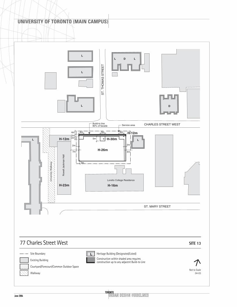
SITE 13 77 CHARLES STREET WEST(CENTRE FOR CHRISTIAN STUDIES)
CONTEXT
LocationThe site is located on the south side of CharlesStreet West, one block east of Queen’s Park Crescentand one block west of Bay Street. To the west ofthe site is the Victoria College Campus and to thesouth the St. Michael’s Campus.
The site terminates the view south from Bloor Streetalong St. Thomas Street.
Heritage IssuesThe site is located on Charles Street West nearseveral historic buildings:
Burwash Hall of Victoria College (to the west) 73Queen’s Park Cr. – listed
Two houseform buildings (to the east) 63 and 65Charles Street West – listed
Several houseform buildings (north side of CharlesStreet West) from 76 to 80 – designated and 100 — 108 Charles Street West – listed
100 — 108 Charles Street west are included in anapproved site specific development.
Open SpaceTo the south and west of the site there are twosignificant open spaces known as the VictoriaCollege Quad and St. Michael’s Campus.
DESIGN GUIDELINES
General Site Plan IssuesDevelopment on this site provides the opportunityto enhance the view south from Bloor Street, andwill complement adjacent buildings such as BurwashHall and Rowell Jackman Hall.
Setback and Build To Line On this site a 4m front yard setback is required,consistent with setbacks on the south side ofCharles Street West, west of Bay Street.
A 2m side yard setback from the west property lineis all that is required due to the location of theJackman Hall Residence. A 4m side yard setback
June 2004 URBAN DESIGN GUIDELINESTORONTO
UNIVERSITY OF TORONTO (MAIN CAMPUS)
L
H-12m

June 2004URBAN DESIGN GUIDELINES
UNIVERSITY OF TORONTO (MAIN CAMPUS)
TORONTO
from the east property line is required to meet LightView and Privacy requirements. The setback at therear of the lot (south property line) is 3m.
Pedestrian RoutesOn the west side of Jackman Hall is an establishedpedestrian route.
Address and Grade-Related UsesAny building entrance will be centred on the north-south axis of St. Thomas Street. Integrated accessfor the disabled is required.
Semi-public and common uses will be located onthe ground floor, facing and opening onto CharlesStreet and the rear portion of the site to promotethe safe use and informal overlook of these areas.
Streetscape Improvements to sidewalks on Charles Street will beconsistent with any integrated landscape plan forthe university.
Height and MassingThe base building height of the proposeddevelopment will be compatible with the existinghouses to the east which range in height from 10mto 12m. The overall building height in the centre ofthis site is not to exceed 26m, which is compatiblewith Burwash Hall.
The base condition will have a maximum height of12m with a 2m stepback on the north face. At theeast and west corners of the north face an additionalstepback of 2m is required to respect the houseformbuildings across the street and to the east of thesite. On the west side no setback is required abovethe 12m height. A higher building height as a towerelement 5m x 5m (up to a height of 30m) isappropriate if centred on the St. Thomas Street axis.
Articulation of the facade similar to Burwash Hall isencouraged.
ServicingServicing on this site will be combined with theunderground parking if possible. As an alternative,shared services with Loretto College could beconsidered.

URBAN DESIGN GUIDELINESTORONTO
UNIVERSITY OF TORONTO (MAIN CAMPUS)
June 2004

SITE 14 88-112 COLLEGE STREET(BANTING & BEST INSTITUTES)
Note:The guidelines assume that the buildings located at100 and 112 College Street (Banting & Best Institutes)will be demolished; 88 College Street is to be retainedand upgraded as part of this development.
CONTEXT
LocationThe site is located on the north side of CollegeStreet between Queen’s Park Crescent and ElizabethStreet, between the government and hospital areas.To the north of the site, are several buildingshousing offices for the Government of Ontario,Surrey Place (a private clinic) and Women’s CollegeHospital. The north wing of the Toronto GeneralHospital is on the south side of College Street.
Heritage IssuesThe north wing of the Toronto General Hospitalwhich directly faces this site and 88 College Street,formerly the Zion Church, are included in the City ofToronto Inventory of Heritage Properties .
Preservation of 88 College Street will be secured bya heritage easement agreement, particularly if the100 College Street property is developed as aseparate project.
Open SpaceTo the west of the site is a park area (located onboth sides of Queen’s Park Crescent), which acts as amajor gateway to the area, contains a subwayconnection point, and allows a broad vista of theLegislative Assembly Building to be seen north upUniversity Avenue.
DESIGN GUIDELINES
General Site Plan IssuesThis site is composed of five lots, which can betreated as one site or two separate sites. As part ofthe development agreement for the eastern lot, thelisted heritage church located at 88 College Street willbe preserved and upgraded. The surrounding area,particularly the lot municipally known as 90 CollegeStreet, will be integrated with the new developmentand be publicly accessible as an open space.
URBAN DESIGN GUIDELINES
UNIVERSITY OF TORONTO (MAIN CAMPUS)
TORONTOJune 2004

June 2004 URBAN DESIGN GUIDELINESTORONTO
UNIVERSITY OF TORONTO (MAIN CAMPUS)
H-23m

adjacent open space areas including the west parkarea, to promote the safe use and informal overlookof these areas.
StreetscapeImprovements to the sidewalk on College Street willbe consistent with any integrated landscape plan forthe area.
The College Street sidewalk improvements willinclude pedestrian lighting, street trees, bicycleparking and decorative sidewalks.
Height and MassingThe overall height limit for this site is 33m, with abase height of 23m, the latter is compatible with theToronto General Hospital heritage facades acrossCollege Street.
If developed as one site, the 23m base height maybe continuous with a central separation of 12mbetween higher building elements (above the 23mheight). If developed as two separate buildings andsites, a 6m side yard setback will be required oneither side the central dividing property line.
Because of the lower heights of the existing heritagechurch and the Toronto General Hospital building tothe south, a 6m setback for towers above the 23mbase height will be required on the east, west andsouth sides to mediate between these variousconditions.
A 2m projection zone has been applied to the frontfacade facing onto College Street to break the visualeffect of the long facade.
If residential uses are proposed, “Light, View, andPrivacy Standards” will be adhered to.
ServicingAccess to parking and servicing will be taken fromCollege Street. If developed as two separate sites,the servicing will be shared between both propertiesin a central location. In either case, the entrance tothe parking and servicing will be integrated into theCollege Street facade, close to the property line.
All required parking is to be underground.
URBAN DESIGN GUIDELINES
UNIVERSITY OF TORONTO (MAIN CAMPUS)
TORONTOJune 2004
Setbacks and Projection Zone A consistent 6m front yard setback from theproperty line to the main building wall exists on thenorth side of College Street from Elizabeth Streetwest to St. George Street and will be maintained onthis site. This setback area will be grassed andtreated as a building forecourt or garden withsupporting landscape amenities such as lights,benches and bicycle parking.
Architectural articulation of the facade, consisting ofminor elements such as symmetrically placedbuilding projections, may project 2m in front of themain building wall not to exceed more than 40% ofthe facade length.
Open SpaceThe park area adjacent to the west building facade,at the corner of College Street and Queen’s ParkCrescent, plays an important spatial role for boththe University and the Ontario Legislature Buildings.A prominent west face for the building will addressthe park.
Given the size and length of the site, building-related open spaces or forecourts will be included asmajor spatial elements. The forecourts will be notless than 250 square metres in size in total. Threelocations will be provided along the front facade topermit a variety of uses and activities.
A publicly accessible forecourt is proposed betweenthe new development and the Zion Church. Theopen space(s) including the west side yard of theZion Church at 88 College Street will contain a mixof landscaped areas, hard surfaced areas, be invitingand accessible and include amenities such as lights,benches and planting.
Pedestrian RoutesWith the redevelopment of this site, a pedestrianroute will be established from College Street northto Surrey Place.
Address and Grade-Related UsesBuilding entrances will front onto College Street,with two or more symmetrically placed entrances inthe building facade elevation. A secondary entrancefrom Surrey Place could also be provided.
Semi-public and common space uses will be locatedon the ground floor, facing and opening onto the

URBAN DESIGN GUIDELINESTORONTO
UNIVERSITY OF TORONTO (MAIN CAMPUS)
June 2004

SITE 15 8 TADDLE CREEK ROAD (MEDICALSCIENCE ADDITION)
CONTEXT
LocationThe site is located near the northwest corner ofQueen’s Park Crescent and College Street. A portionof the proposed building is on top of and in frontof the Medical Science Building, north of theMining Building. The building will occupy part ofTaddle Creek Road south of the Medical ScienceBuilding and east of the Roseburgh Building west ofthe Fitzgerald Building.
A second site is located south of the Tanz Building,east of the Fitzgerald Building (facing onto Queen’sPark Crescent and College Street).
Heritage IssuesThis site is surrounded by Heritage buildings. Theyinclude the Mining Building (designated) at 170College Street and the Roseburgh, Fitzgerald andTanz Neuroscience Buildings.
Open SpaceTaddle Creek Road is a University-owned road whichhas potential to be an open space for public use.
There are many mature trees which are to beretained.
To the east of the site is a large open space, part ofthe Legislative Assembly park setting.
DESIGN GUIDELINES
General Site Plan IssuesThis site marks the corner of the University precinct.
The space associated with Taddle Creek Road is partof a road system that once serviced the universityfrom College Street north to Bloor Street. This areaon the site is to be redesigned as a largeforecourt/entrance area to provide a greenpedestrian area for all the buildings fronting ontothis space.
Setbacks, Projection Zone and Build-to Line The College Street facade of the Queen’sPark–College addition will align with the MiningBuilding to the west at 170 College Street shown as
URBAN DESIGN GUIDELINES
UNIVERSITY OF TORONTO (MAIN CAMPUS)
TORONTOJune 2004

June 2004 URBAN DESIGN GUIDELINESTORONTO
UNIVERSITY OF TORONTO (MAIN CAMPUS)
L

June 2004
Pedestrian RoutesThe proposed forecourt is to be used predominantlyfor pedestrians and to incorporate a pedestrian routethrough this part of the campus. Existing pedestrianroutes are to be maintained either as open surfaceroutes or direct and accessible public routes throughthe buildings. The existing routes, east-west from thesubway stop as well as the north-south route alongTaddle Creek Road will lead to the entrances of thenew facility.
Address and Grade-Related UsesThe main building entrance of both buildings will faceonto College Street. The new south facing entrance toMedical Science will have a forecourt in the tradition ofthe south facing public buildings. The Tanz additioncould have an additional entrance facing onto the parkarea to the east. The service for this complex ofbuildings will be accessed from a service lane north ofthe Mechanical Engineering Building to the west of thesite. All servicing will be internal to the building.
Semi-public and common space uses will be locatedon the ground floor, facing and opening onto theadjacent open space areas including the east park.
StreetscapeThe College Street face shall continue the existingpattern of street related facades and setbackforecourts. Sidewalk improvements will include streettrees, bicycle parking, and decorative sidewalks andwhere appropriate, pedestrian lighting. The designfor the proposed building will attempt toaccommodate the existing vegetation includingseveral mature trees.
Height and MassingThe overall height limit for the addition to theMedical Science Building is 49m occurring in frontof and above the existing Medical Science facility,with a base height not to exceed 18m in theentrance pavilion area, fronting onto the courtyardfacing onto College Street. The east portion of thedevelopment site located south of the Tanz Centrewill not exceed a base height of 19m with aninterior height of 25m.
ServicingAccess to parking and servicing will be taken fromKing’s College Road. All required servicing andparking is to be internalized.
URBAN DESIGN GUIDELINES
UNIVERSITY OF TORONTO (MAIN CAMPUS)
TORONTO
a build-to line. The east facade will align with theeast wall of the Tanz Building. A consistent 6mfrontyard setback from the property line to the mainbuilding wall exists on the north side of CollegeStreet from Elizabeth Street west to St. GeorgeStreet and will be maintained on this site. Thissetback area will be grassed and treated as abuilding forecourt or garden with supportinglandscape amenities such as lights, benches andbicycle parking.
The addition located in the Taddle Creek Road areawill become the main entrance to the MedicalScience Complex. The main building wall will be setback to the north, 63m from the south propertyline. Efforts will be made to avoid having the southportion of the addition obstruct the facade of theFitzgerald Building and the Roseburgh Building. Theeast and west walls of the addition will maintain asetback of 3.25m and 7.5m respectively in this area.
New construction will be compatible with theexisting heritage structures in the immediate area inthe following ways: size, height, and setback ofstructures, exterior features, such as window sill orheader lines, the proportion of window and dooropenings to the overall facade, and the horizontal orvertical emphasis of major building elements andbuilding materials.
Architectural articulation of the facade, consisting ofminor elements such as symmetrically placed buildingprojections etc. may project 2m in front of the mainbuilding wall in total for not more than 40 % of thefacade length. Setbacks are subject to survey.
Open SpaceThe park area adjacent to the east building facade,at the corner of College Street and Queen’s ParkCrescent, plays an important spatial role for boththe University and the Ontario Legislature Buildings.
The proposed Taddle Creek Road courtyard/forecourtmay also function as the main entrance for the newfacility and the Fitzgerald and Roseburgh Buildings.
A 6m setback is required at the southeast corner ofthe site, to create a forecourt or garden area in frontof the Fitzgerald Building similar to what exists tothe west along College Street. This area is to belandscaped with the appropriate pedestrianamenities.

June 2004 URBAN DESIGN GUIDELINESTORONTO
UNIVERSITY OF TORONTO (MAIN CAMPUS)

June 2004URBAN DESIGN GUIDELINES
UNIVERSITY OF TORONTO (MAIN CAMPUS)
TORONTO
SITE 16 200 COLLEGE STREET(ENGINEERING ANNEX AND PARTOF THE WALLBERG BUILDING)
CONTEXT
LocationThe site is located in the interior of the block,south of the Sandford Fleming Building 10 King’sCollege Road and north of the Wallberg Building at184 and 200 College Street. The site sits at the rearof Cumberland House in the middle of a service areaand truck loading zone for the Engineering Complex.
Heritage IssuesThe Sandford Fleming Building to the north isdesignated and to the west Cumberland House at 33St. George Street is included in the City of TorontoInventory of Heritage Buildings.
Compatibility with nearby heritage buildings interms of height, massing, and architectural detailswill be important in the Toronto Historical Boardreview.
DESIGN GUIDELINES
General Site Plan IssuesDevelopment on this site will be restricted to thearea identified as the footprint of the proposedbuilding which includes the demolition of theEngineering Annex and development behind and ontop of the Wallberg Building.
SetbacksThe development will be not less than 10m from thesouth wall of the Cumberland House. There is nosetback required from the rear of the Pratt Building.Setbacks subject to survey.
Pedestrian RoutesAn informal pedestrian route exists between St. George Street and King’s College Road. Thiswalkway will be improved and integrated into the St. George Street Revitalization Strategy.
Address and Grade-Related UsesThe main building entrance will front onto CollegeStreet with an additional entrance facing onto theeast–west pedestrian walkway.

June 2004 URBAN DESIGN GUIDELINESTORONTO
UNIVERSITY OF TORONTO (MAIN CAMPUS)
L

June 2004URBAN DESIGN GUIDELINES
UNIVERSITY OF TORONTO (MAIN CAMPUS)
TORONTO
New development at grade will provide for semi-public and common space uses facing and openingonto the adjacent open space areas to promote thesafe use and informal overlook of these areas.
Height and MassingThe overall height limit for this site is 23m occurringabove and behind the Wallberg Building. The 23mheight is in the interior of the block and will beobscured from view by pedestrians along King’sCollege Road or St. George Street by the existingbuildings that range in height from 16 to 21 metres.
The portion that is above the Wallberg Building willbe set back 11m from the existing west buildingwall, 8m from the south building wall and 16mfrom the east building wall.
ServicingThe existing service/pedestrian route from King’sCollege Road will be maintained and internalizedwithin the new building structure.

June 2004 URBAN DESIGN GUIDELINESTORONTO
UNIVERSITY OF TORONTO (MAIN CAMPUS)

June 2004URBAN DESIGN GUIDELINES
UNIVERSITY OF TORONTO (MAIN CAMPUS)
TORONTO
SITE 17A 5 KING’S COLLEGE ROAD(MECHANICAL ENGINEERING)
CONTEXT
LocationThe site is located above the existing MechanicalEngineering Building (A) on the east side of King’sCollege Road and the existing Haultain Building (B).It is situated just west of the proposed new MedicalScience Complex.
Heritage IssuesThe Mechanical Engineering Building is included inthe City of Toronto Inventory of Heritage Properties.
DESIGN GUIDELINES
General Site Plan IssuesDevelopment on this site will be restricted to thearea identified as the footprint on the attached plan.
SetbacksThe rooftop addition will be setback 3m from theperimeter parapets of the existing building toobscure the view of the additions. Setbacks aresubject to survey.
Height and MassingThe overall height limit for this site is 23m occurringabove the Mechanical Engineering building. The23m height is set back and will be obscured frompedestrians on King’s College Road.
ServicingThe existing service/ pedestrian route from King’sCollege Road will be maintained.

URBAN DESIGN GUIDELINESTORONTO
UNIVERSITY OF TORONTO (MAIN CAMPUS)
June 2004
D
L
H-17

June 2004URBAN DESIGN GUIDELINES
UNIVERSITY OF TORONTO (MAIN CAMPUS)
TORONTO
SITE 17B (THE HAULTAIN BUILDING)
CONTEXT
LocationThis site is located in a service court to the rear ofthe Mining Building at 170 College Street, east ofthe Mechanical Engineering Building at 5 King’sCollege Road and south and west of the RoseburghBuilding at 4 Taddle Creek Road.
Heritage IssuesThe Mining Building has been designated under theOntario Heritage Act.
DESIGN GUIDELINES
General Site Plan IssuesThe Haultain Building is located in a service courtsurrounded by laboratory buildings varying in heightfrom 12 m to 30 m and has an above-grade linkwith the Mining Building.
SetbacksThe proposed floor plate will be set back 6m fromthe north wall of the Mining Building to allowaccess for service vehicles.
Height and MassingThe overall height limit for this site is 23m The viewof the proposed building will be entirely obscured bythe existing peripheral buildings.
ServicingThe existing service/ pedestrian route from King’sCollege Road will be maintained.

June 2004 URBAN DESIGN GUIDELINESTORONTO
UNIVERSITY OF TORONTO (MAIN CAMPUS)

June 2004URBAN DESIGN GUIDELINES
UNIVERSITY OF TORONTO (MAIN CAMPUS)
TORONTO
SITE 18 40 ST. GEORGE STREET (KOFFLERBLOCK INTERIOR INCLUDINGFRONTAGES ON ST. GEORGE,RUSSELL AND HURON STREETS)
CONTEXT
LocationThe site is located at the southwest corner of St.George and Russell Streets through the interior ofthe block west to Huron Street. It is part of the“West Campus” area, which is comprised of largepost-war, single-purpose university buildings. To thenorth is the Steam Plant. On the east side of St.George Street are heritage buildings and Site #10.
Heritage Issues The north east corner of the site includes the homeat 44 St. George Street which is listed and whichwill be restored and included as part of thedevelopment. The Koffler Centre directly to thesouth of the site is designated under the OntarioHeritage Act.
Open SpaceOn the west side of St. George Street, there is apattern of grassed frontyard setbacks ofapproximately 10 metres.
DESIGN GUIDELINES
Setbacks and Build To Line Development on the site fronting onto St. GeorgeStreet will maintain a frontyard setback similar tothe existing setbacks to the north and south of thesite. The north wall of the proposed developmentconnecting into the houseform building (parallel toRussell Street) will be aligned with the Steam Plantdirectly to the west of the site.
On both the Huron and St. George Street frontages,a build–to line is required to complete the streetedge and align with the existing buildings.
Open SpaceThe informal courtyard that exists in the centre ofthis block will continue to be an important spatialelement in this area. New development on the sitewill form the northern edge of the courtyard withthe existing buildings to the east, west and southforming the other edges. The walkway and courtyard

June 2004 URBAN DESIGN GUIDELINESTORONTO
UNIVERSITY OF TORONTO (MAIN CAMPUS)

June 2004URBAN DESIGN GUIDELINES
UNIVERSITY OF TORONTO (MAIN CAMPUS)
TORONTO
will be upgraded to include decorative paving, lights,benches and planting etc. The parking that presentlyexists in the courtyard is to be removed.
Pedestrian RoutesThe existing north–south pedestrian/service routefrom College Street will be maintained providingaccess and servicing. A connection through to St.George Street is also recommended. Landscapetreatment is required and will be integrated with andextend the character of the St. George StreetRevitalization Project.
Address and Grade-Related UsesThe building entrance for the development site willfront onto St. George Street and Huron Street withsecondary entrances facing onto the courtyard.Integrated access for the disabled is to be located atminimum in at least one of the entrances.
The north building elevation will be related toRussell Street as well as St. George Street. Semi-public and common uses will be located on theground floor, facing and opening onto the adjacentpedestrian areas to promote the safe use andinformal overlook of all these areas.
Streetscape Sidewalk improvements are required; street trees,decorative pavement and where appropriate,pedestrian lighting.
Height and MassingOn the Huron Street frontage and interior of theblock the building can rise to a height of 32m atthe street edge given the surrounding context.
ServicingServicing to the Koffler Building will be retainedfrom College Street, with additional servicing fromHuron Street.

June 2004 URBAN DESIGN GUIDELINESTORONTO
UNIVERSITY OF TORONTO (MAIN CAMPUS)

June 2004URBAN DESIGN GUIDELINES
UNIVERSITY OF TORONTO (MAIN CAMPUS)
TORONTO
SITE 19 14 QUEEN’S PARK CRESCENT WEST(MCMURRICH BUILDING ADDITION)
CONTEXT
LocationThe site is located on the west side of Queen’s ParkCrescent. It is a small addition to the existingMcMurrich building north of the Medical ScienceComplex.
Heritage IssuesThe relationship between buildings fronting Queen’sPark Crescent and the Ontario Legislature Building isextremely important. New buildings will not projectabove the grade line at the roadway. The designtreatment of the roof will be focused on minimizingits obtrusiveness.
Open SpaceTo the east of the site across Queen’s Park Crescentis the large lawn in front of the Ontario LegislatureBuilding. To the south is a grassed area with maturetrees.
DESIGN GUIDELINES
General Site Plan IssuesIt is anticipated that development on this site willnot be seen as one travels south–bound by car onQueen’s Park Crescent.
Setbacks and AlignmentsThe addition will be set back 10m from the eastproperty line and set back 43m from the south wallof the McMurrich Building. Setbacks subject tosurvey.
Open SpaceIt is desirable that the roof of any addition belandscaped and allow for a pedestrian ramp or stairfrom the northern edge to connect into the TaddleCreek path and the Philosophers’ Walk extension. Tothe south, the path will connect into the existingpath system.
Pedestrian RoutesA pedestrian route (part of the Taddle Creek pathand extension of Philosophers’ Walk) exists to thesouth of the site and connects into the McMurrich

URBAN DESIGN GUIDELINESTORONTO
UNIVERSITY OF TORONTO (MAIN CAMPUS)
June 2004

June 2004URBAN DESIGN GUIDELINES
UNIVERSITY OF TORONTO (MAIN CAMPUS)
TORONTO
Building and into and through the Medical ScienceFacility. It will be maintained.
Height and MassingThe overall height limit for this site is 4m occurringat the existing grade of the parking lot. The northend of any proposed building will not projectbeyond point A as shown on the map.
ServicingThe existing service/ pedestrian route from King’sCollege Road will be maintained.

URBAN DESIGN GUIDELINESTORONTO
UNIVERSITY OF TORONTO (MAIN CAMPUS)
June 2004

June 2004URBAN DESIGN GUIDELINES
UNIVERSITY OF TORONTO (MAIN CAMPUS)
TORONTO
SITE 21 299 AND R273 BLOOR STREETWEST (VARSITY STADIUM)
CONTEXT
LocationThe site is located on the south side of Bloor Streetsituated between the Royal Ontario Museum to theeast and St. George Street to the west. To the northBedford Road “T’s” into this site with an exit fromthe St. George Subway Station. To the south of thesite are university buildings many with historicdesignations.
Heritage IssuesIncluded in the City of Toronto Inventory ofHeritage Properties are the following buildings; theAdmissions Building The Royal Conservatory ofMusic (RCM) and the Royal Ontario Museum. To thesouth there are the buildings of Trinity College,Massey College and the Newman Centre alldesignated under the Ontario Heritage Act.
Open SpaceThe playing field and ice rink will be incorporatedinto any new development on this site.
To the east of the site is Philosophers' Walk a parkarea which acts as a major pedestrian gateway tothe University.
DESIGN GUIDELINES
General Site Plan IssuesA new stadium playing field will be integrated with anynew development on this site as an open space for theuniversity. Bedford Road terminates at Bloor Streetdirectly to the north of this site and might beacknowledged in the form of a forecourt and terminus.The generous setback along the south side of BloorStreet will be continued on this site. The setbacks willalso be acknowledged along Devonshire Place.
The parking lane on the east side of DevonshirePlace may be removed to provide a more generousboulevard and accommodate a regulation runningtrack.
Coordination with adjacent landowners regardingdevelopment is important in terms of massing,servicing and pedestrian circulation. Trinity Collegeis the major land owner to the south of the site and
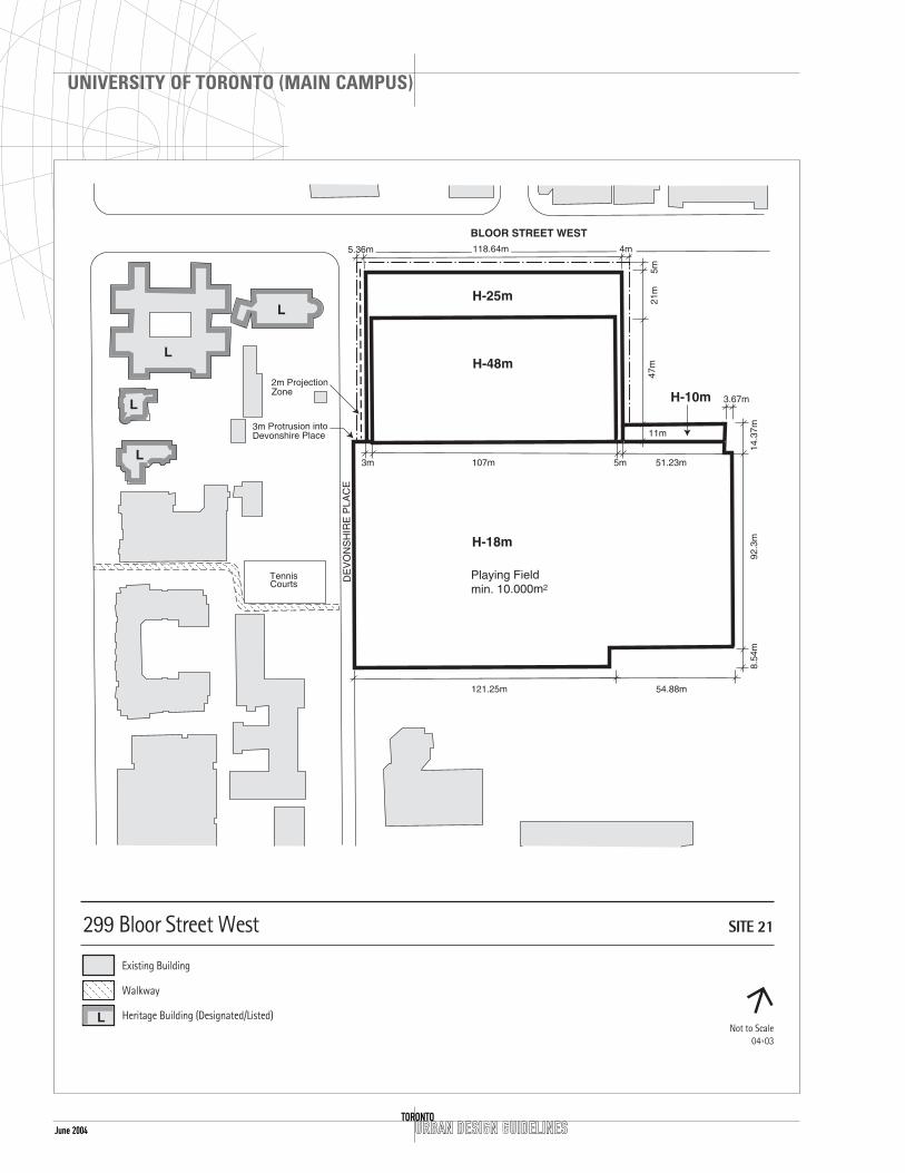
June 2004 URBAN DESIGN GUIDELINESTORONTO
UNIVERSITY OF TORONTO (MAIN CAMPUS)
H-18m
H-10m

June 2004URBAN DESIGN GUIDELINES
UNIVERSITY OF TORONTO (MAIN CAMPUS)
TORONTO
the Royal Conservatory of Music is the adjacent landowner to the east on Bloor Street.
Setbacks and Projection Zone A consistent 5m frontyard setback from the propertyline to the main building wall is typical along BloorStreet and will be maintained on this site. Thissetback area may be treated as a building forecourtwith supporting landscape amenities such as lights,benches and bicycle parking.
On the east side of Devonshire Place, a 5.36m setbackfrom the property line is required to continue thepattern of the existing frontyard setback of TrinityCollege. The east–west playing field configuration isexcluded from this requirement and can project intothe 5.36m setback on the east side of DevonshirePlace and 3m into the Devonshire Place road allowance.
Along the east side of Devonshire Place a projectionzone is allowed for architectural articulation of thefacade which may allow projections of up to 2m infront of the main building wall for not more than40% of the facade length.
Open SpaceA forecourt(s) is recommended on the north–southaxis of Bedford Road. The axis and orientation ofBedford Road will be terminated in the built form.The goal of a symbolic gateway to the university isto be incorporated into the architectural design ofthe built form. A forecourt or forecourts willacknowledge the pattern of forecourts that exist onBloor Street West between Avenue Road andSpadina Avenue.
An open area specified as the “Playing Field” is tobe shown with an associated open space area of10,000 m2 to accommodate construction of aregulation-size sports field and associated seating.
Pedestrian RoutesConsideration must be given to all open spaces,especially Philosophers’ Walk to provide overlook.Any built edge will be of an appropriate scale andall environmental conditions will be respected. Anyrequired improvements to Philosophers’ Walkresulting from the construction of the playing fieldand related athletic facilities will respond to theUniversity’s open space initiatives.
An allowance for a pedestrian walkway will be creatednorth–south near the easterly property line in
conjunction with Royal Conservatory of Music with allthe amenities associated with pedestrian spaces. Anadditional east–west walkway is also encouraged alongthe south property line. Both can potentially connectto Philosophers’ Walk and the new athletic field.
Address and Grade-Related UsesThe primary building entrances will front onto BloorStreet and Devonshire Place.
Semi-public and common space uses will be locatedon the ground floor, facing and opening onto theadjacent open space areas to promote the safe useand informal overlook of these areas.
StreetscapeStreetscaping and landscape improvements for bothDevonshire Place and Bloor Street, as well aslandscaping of the setbacks, forecourts and theproposed pedestrian walkways, will be required. Theywill include appropriate landscaping, pedestrianlighting, street trees and decorative paving.
Height and MassingA Bloor Street setback of not less than 5m from thenorth property line is required, similar to the existingsetback of the Royal Conservatory of Music and theMuseum to the east, and to the Admission Buildingand the Senator Croll Building at 341 Bloor Street Westto the west. A height of 25m is allowed with anotherstepback of 21m and then up to a height of 48m.
The 48m height envelope is to be set back 3m on thewestern edge and a 5m setback is required along theeasterly portion beside the Royal Conservatory of Music.
A feature that will terminate Bedford Road andprovide a symbolic entrance to the university will beplaced on the centre axis of Bedford Road.
ServicingVehicular entrance to the underground parking andservicing will be provided from Devonshire Place orBloor Street.
In particular, coordination with RCM regardingparking access and servicing is to be considered inorder to minimize the necessary curb cuts and toenhance and protect the pedestrian realm alongBloor Street. The building envelope is set back 4mfrom the easterly property line adjacent to the RCMto facilitate such joint access, as well as pedestrianroutes to the Athletic Field and Philosophers’ Walk.

URBAN DESIGN GUIDELINESTORONTO
UNIVERSITY OF TORONTO (MAIN CAMPUS)
June 2004
SITE 22 73 ST. GEORGE STREET (PARKINGLOT TO THE NORTH OF THE DANIELWILSON RESIDENCE)
CONTEXT
LocationThe site is located on the east side of St. GeorgeStreet, south of Union Hall and the Whitney HallStudent Residence and west of the Back Campusopen space, on the western edge of the HeritageCore of the University of Toronto.
The existing context of the east side of St. GeorgeStreet establishes the overall built form pattern of a3 to 4 storey residential and institutionalstreetscape.
Heritage IssuesThe site is included in the City of Toronto Inventoryof Heritage Properties and is situated between twoheritage buildings:
Whitney Hall, 85 College Street – listed
The houseform building to the south at 65 St.George Street – listed
Open SpaceThere is a pattern of front yard setbacks ofapproximately 6m from the property line on the eastside of St. George Street. There is also an east-westwalkway at the north end of the development site.To the east of the site is a major open space calledthe Back Campus.
DESIGN GUIDELINES
General Site Plan IssuesThis site is situated in the Heritage Core of theUniversity and surrounded by buildings that are listedor designated. It backs onto one of the largest openspaces on the campus. Therefore the design of anybuilding will fit into the context surrounding it andcarefully form an edge to the adjacent open spaces.
Setback and Build To lineThe development of this site will respect the 6.11msetback along St George Street. Architecturalarticulation of the facade consisting of minorelements such as porches, bay windows etc. isencouraged.
URBAN DESIGN GUIDELINES
UNIVERSITY OF TORONTO (MAIN CAMPUS)
TORONTOJune 2004
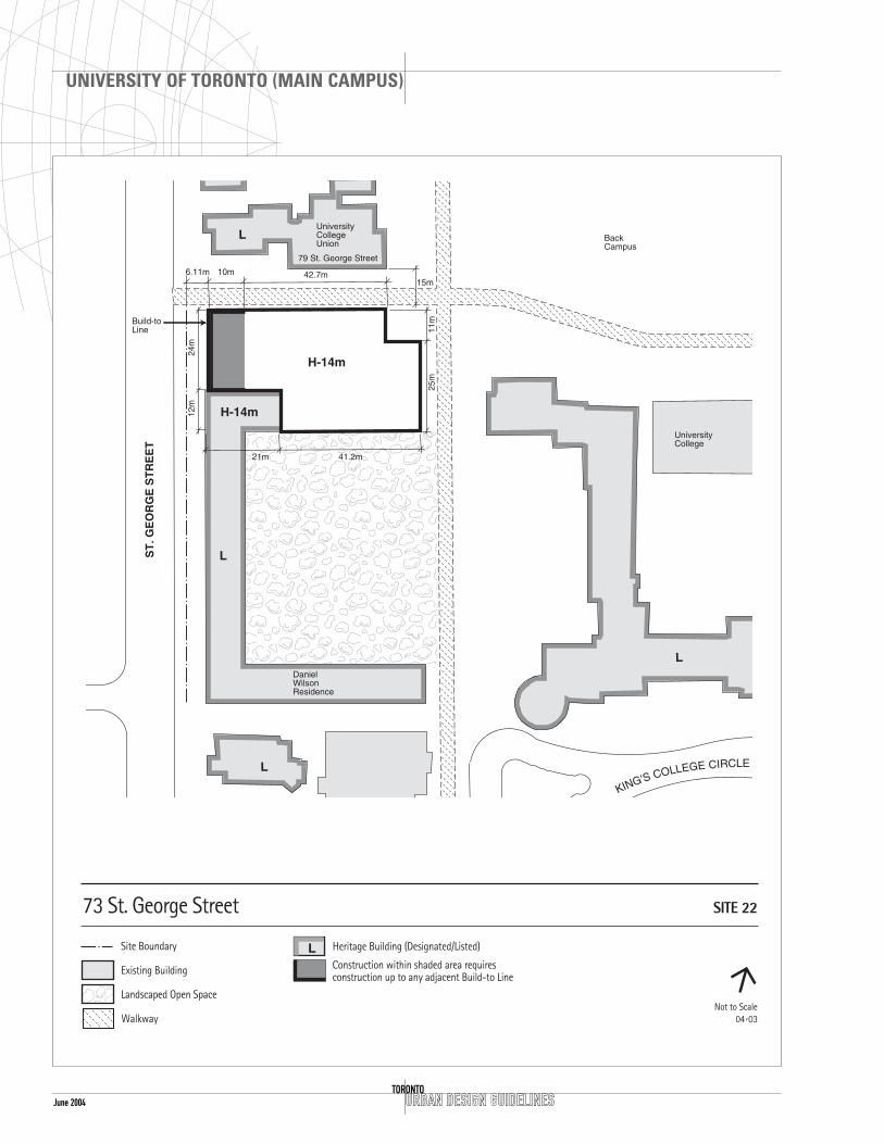
June 2004 URBAN DESIGN GUIDELINESTORONTO
UNIVERSITY OF TORONTO (MAIN CAMPUS)
L

Height and MassingThe overall building height will not exceed 14m.This is consistent with the height of the adjacentheritage buildings.
The massing will be compatible with and reflect thearticulation, roof profiles, strong cornice lines, andfenestration of the adjacent heritage buildings.
ServicingServicing will be from St. George Street. Parkingramps, loading and storage areas will beincorporated into the building mass and minimizeimpact on the open spaces of the site. Theseactivities will be screened from the heritagebuildings.
URBAN DESIGN GUIDELINES
UNIVERSITY OF TORONTO (MAIN CAMPUS)
TORONTOJune 2004
The setback area will be grassed with supportinglandscaping including walls, gates and trees,compatible and consistent with the buildings southof Hoskin Avenue.
The north side of the development will be set back15m from 79 St. George Street, respecting the rosegarden and existing pedestrian route along thesouth side of 79 St. George Street.
A build-to line is required to ensure continuity ofthe street edge and the facade of the existingbuilding. Setbacks subject to survey.
Open SpaceThe St. George Street setback area will be grassedand treated as a building forecourt or garden withsupporting landscape amenities such as fences, wallstrees, lights, benches and bicycle parking.
Pedestrian RoutesAn important east-west pedestrian route is locatedon the north side of the site. The existing walkwaywill be retained between the two buildings.Landscape treatment is required and considerationwill be given to gateway elements from St. GeorgeStreet providing access to the Back Campus.
Address and Grade-Related UsesAny building entrance will front onto St. GeorgeStreet with consideration given to a symmetricalplacement of the entrance(s) in the west buildingelevation (similar to adjacent buildings). Integratedaccess for the disabled is to be located at the mainentrance.
Semi-public and common uses will be located onthe ground floor, facing and opening onto theadjacent pedestrian routes to promote the safe useand informal overlook of these areas.
StreetscapeAs part of the overall development, presentstreetscape improvements for St. George Street willbe maintained.

June 2004 URBAN DESIGN GUIDELINESTORONTO
UNIVERSITY OF TORONTO (MAIN CAMPUS)

June 2004URBAN DESIGN GUIDELINES
UNIVERSITY OF TORONTO (MAIN CAMPUS)
TORONTO
SITE 23A & B 90 QUEEN’S PARK (THE PLANETARIUM)
CONTEXT
LocationThe site is located on the west side of Queen’s Parkjust south of the Royal Ontario Museum (ROM). ThePlanetarium, is east of the Edward Johnson MusicBuilding and north of Falconer Hall.
Heritage IssuesFalconer Hall and the Royal Ontario Museum areboth included in the City of Toronto Inventory ofHeritage Properties.
Under either scenario visibility of the southernmostwall of the Royal Ontario Museum is to bemaintained to the maximum practical extent.
Open SpaceDirectly to the west of the site is a large open spacecalled Philosophers’ Walk with mature trees. To thesouth is Queen’s Park, a large open space at thenorth end of the Ontario Legislature Building.
DESIGN GUIDELINES
General Site Plan IssuesOn this site two scenarios are plausible; one keepingthe existing Planetarium and adding to the buildingto provide additional usable space and to improveaccess and circulation.
The second option is to demolish the building andconstruct an entirely new facility with associateduses.
Setbacks and AlignmentsAny addition will be setback 13m from the eastproperty line to align with the main wall of themuseum. A minimum setback of 8m will be requiredfrom the south property line if a new structure isbuilt, an additional stepback of 3m after the 11mheight will be required.
Open SpaceTo the west of the site is Philosophers Walk a largeopen space /path system that connects Bloor Streetsouth to Hoskin Avenue.

URBAN DESIGN GUIDELINESTORONTO
UNIVERSITY OF TORONTO (MAIN CAMPUS)
June 2004
H-27.7m

URBAN DESIGN GUIDELINES
UNIVERSITY OF TORONTO (MAIN CAMPUS)
TORONTOJune 2004
June 2004
Pedestrian RoutesAn east-west pedestrian connection is requiredlinking Queen’s Park to Philosophers’ Walk. This can be accomplished through an open walkway or a walkway through the building.
Address and Grade-Related UsesAny new addition will function as a second mainentrance to the museum for group tours and will bewelcoming and very public in its nature.
Height and MassingThe overall height limit for this site is 23m to relateto the height of the ROM and allow connectionsinto the museum space.
ServicingThe existing service/pedestrian route at the rear ofthe site will be maintained.
URBAN DESIGN GUIDELINESTORONTO
UNIVERSITY OF TORONTO (MAIN CAMPUS)

June 2004URBAN DESIGN GUIDELINES
UNIVERSITY OF TORONTO (MAIN CAMPUS)
TORONTO
SITE 24 5 DEVONSHIRE PLACE (TRINITY COLLEGE ADDITION)
CONTEXT
LocationThis site is located to the north of Trinity Collegeand to the east of the Gerald Larkin Building. Theeastern edge faces onto Philosophers’ Walk.
Heritage IssuesThe site incorporates two heritage buildings locatedat 6 Hoskin Avenue (designated) and 3 DevonshirePlace (listed).
Open SpaceThe courtyard and quadrangle configuration typicalof the historic part of the campus will bemaintained and continued.
DESIGN GUIDELINES
General Site Plan IssuesDevelopment on this site will acknowledge its historiccontext, and continue or maintain the existingpattern of front yard setbacks and open spaces.
SetbacksA 6m setback is required along Devonshire Place toalign with the existing buildings to the south andthe proposed development to the north. A projectionzone of 2m is allowed along this facade. Thissetback area will be grassed, with supporting fences,gates, walls, trees and landscaping. Architecturalarticulation of the facade, consistent with theexisting architecture nearby, is encouraged.
Open SpaceA courtyard is required in the centre of the site. Anadditional open space is to be created opening ontoPhilosophers’ Walk.
The major access to the courtyard will be fromDevonshire Place and Hoskin Avenue, and it willconnect into Philosophers’ Walk to the east.
The courtyard will contain a mix of landscaped areasand hard surface areas; be inviting and accessible;and include amenities such as lights, benches andplanting. Landscaping will be used to help definethe perimeter of the courtyard.

URBAN DESIGN GUIDELINESTORONTO
UNIVERSITY OF TORONTO (MAIN CAMPUS)
June 2004
20m

June 2004URBAN DESIGN GUIDELINES
UNIVERSITY OF TORONTO (MAIN CAMPUS)
TORONTO
Pedestrian RoutesAn east-west and north-south service lane–pedestrian route is to be located on the site. Thepedestrian walkway which continues south to HoskinAvenue in the centre of the site will be improvedand integrated into the existing pedestrian system.
Consistent landscape treatment for this lane/walkwayand decorative paving is required similar to thelandscaping of the laneway to the north.
Address and Grade-Related UsesThe main building entrance will front ontoDevonshire Place. Integrated access for the disabledis to be located at the main entrance.
Semi-public and common uses will be located onthe ground floor, facing and opening onto the rearcourtyard and where feasible, also onto the adjacentpedestrian routes to promote the safe use andinformal overlook of these areas.
StreetscapeAs part of an integrated landscape plan for theuniversity campus, streetscape improvements are toinclude pedestrian lighting, street trees, decorativepaving and bicycle parking.
Height and MassingAlong Devonshire Place, the building height will be20m, which is compatible with the existing buildingheights. However, along the south wall of theproposed development, (closest to the DevonshirePlace Residences which has a height of 14m and apeak height of 19m) the base height will not exceed14m for a depth of 3m and then up to the heightof 20m. The base massing will reflect thearticulation, roof profiles, strong cornice lines andfenestration etc. of adjacent buildings.
An overall height of 20m can be accommodated andis compatible with the heights of the nearbybuildings. The mechanical penthouse roof elementswill be integrated with the building mass.
ServicingAccess to servicing for this site will be fromDevonshire Place, using the proposed extension ofthe private east-west lane at the north of the site.

June 2004 URBAN DESIGN GUIDELINESTORONTO
UNIVERSITY OF TORONTO (MAIN CAMPUS)

June 2004URBAN DESIGN GUIDELINES
UNIVERSITY OF TORONTO (MAIN CAMPUS)
TORONTO
SITE 25 74-90 WELLESLEY STREET (THE SISTERS OF ST. JOSEPH)
CONTEXT
LocationThe site is located on the north side of WellesleyStreet between Queen’s Park Crescent and BayStreet. It is composed of 2 sites; 74 Wellesley StreetWest (the High School) and 90 Wellesley Street West(New St. Joseph’s College, including Mary Hall).
Heritage IssuesThe relationship between the historic buildingsfronting on Queen’s Park Crescent and the buildingson Bay Street requires a transition zone. To thenorth of the site are several houseform buildingsand directly attached to this site is Old St. Joseph’sCollege which is included in the City of TorontoInventory of Heritage Properties.
Open SpaceTo the north of the site is a small open space whichcan be upgraded to a courtyard space bydemolishing the concrete block garage. A pedestrianwalkway will be created to provide a midblock routeto connect St. Joseph Street through to WellesleyStreet.
DESIGN GUIDELINES
General Site Plan IssuesThis site is situated in between very tall buildingslocated on Bay Street and the condominium at 62Wellesley Street which is 52m in height. To the westof the site are the historic houseform buildingsranging in height from 8.2m to 9.1m. These twosites located in the middle will act as a transitionzone between the two different scales and buildingtypes.
Setbacks and Build To LineThe new buildings will be setback 8m from thesouth property line to align with the condominiumto the east.
The 14m height zone is also a build-to line, toensure the alignment of the proposed developmentwith the existing buildings.

June 2004 URBAN DESIGN GUIDELINESTORONTO
UNIVERSITY OF TORONTO (MAIN CAMPUS)

June 2004URBAN DESIGN GUIDELINES
UNIVERSITY OF TORONTO (MAIN CAMPUS)
TORONTO
Open SpaceTo the rear of the site is a space which can bedesigned to create a semi-public open space withpedestrian connections. There is a garage which willhave to be demolished. The Marshall McLuhanCentre needs to be renovated.
Pedestrian RoutesA pedestrian route will be created to connectSt.Joseph Street to Wellesley Street. The proposedextension of the path system will be provided andimproved for pedestrian use with amenities such aspedestrian lighting, benches and landscaping.
Address and Grade-Related UsesThe main building entrance will front onto WellesleyStreet. Semi-public and common uses will be locatedon the ground floor, facing and opening onto therear courtyard and, where feasible, also onto theadjacent pedestrian routes to promote the safe useand informal overlook of these areas.
StreetscapeAs part of an integrated landscape plan, streetscapeimprovements are to include pedestrian lighting,street trees, decorative paving and bicycle parking.
Height and MassingThe overall height limit for 74 Wellesley is 36m witha base building height of 14m. The building heightfor 90 Wellesley is a 14m base height with a setbackof 13.5m and an overall height of 23m to provide atransition zone to the lower scale buildings frontingonto Queen’s Park Crescent.
ServicingThe existing service from Wellesley Street will bemaintained.

URBAN DESIGN GUIDELINESTORONTO
UNIVERSITY OF TORONTO (MAIN CAMPUS)
June 2004

SITE 27 100 QUEENS PARK (ADDITION TO THE NORTH FACADE OF THEROYAL ONTARIO MUSEUM)
CONTEXT
LocationThe Royal Ontario Museum (ROM) is located on thesouth west corner of Bloor Street West and Queen’sPark. The ROM forms the north eastern edge of theUniversity of Toronto Area of Special Identity. Thisbuilding along with the Lillian Massey Building onthe opposite corner of Bloor Street and Queen’sPark, functions as the northern gateway to Queen’sPark and frames views of the Ontario LegislatureBuildings and to the University itself.
The Bloor Street edge presently exists as a privategarden with the building setback approximately 23mfrom the curb.
The building envelope proposed for this site is anaddition located on the northern portion of theMuseum facing onto Bloor Street.
Heritage IssuesThe Royal Ontario Museum is included in the City ofToronto’s Inventory of Heritage Properties. On thissite views will be maintained to the existing facadesof the north heritage wings. New construction inthis area will not detract or obscure the importanceof these facades.
The westernmost pavilion addition will betransparent and light in character so that theheritage wing to the south is kept visible.
The additions will not compete visually with theheritage building in their design treatment.
Open SpaceThe western portion of this site will overlookPhilosophers’ Walk, which is noted in the OfficialPlan as a “significant open space” and zoned as aUniversity Open Space.
URBAN DESIGN GUIDELINES
UNIVERSITY OF TORONTO (MAIN CAMPUS)
TORONTOJune 2004

June 2004 URBAN DESIGN GUIDELINESTORONTO
UNIVERSITY OF TORONTO (MAIN CAMPUS)
L

StreetscapeAs part of the overall development, streetscapeimprovements for the Bloor Street and Queen’s Parkfrontages will be required. The streetscapeimprovements will include a double row of streettrees, pedestrian lighting and decorative paving.
Additional landscaping is necessary to enhance thesetting for the pavilion on the west side of the site
Height and MassingThe central portion facing onto Bloor Street will notexceed 12m in height. The links connecting theexisting building to the new building will not exceed4m in height. On the western edge of the site apavilion-like structure is located which will notexceed 9m in height.
The massing will be compatible with, and reflect thearticulation of the adjacent heritage buildings.
ServicingServicing access will be taken via the existingservicing behind the McLaughlin Planetarium.
URBAN DESIGN GUIDELINES
UNIVERSITY OF TORONTO (MAIN CAMPUS)
TORONTOJune 2004
DESIGN GUIDELINES
General Site Plan IssuesThe building envelope will be attached to therelatively new north addition situated in betweenthe historic east and west wings of the RoyalOntario Museum. The museum is recommended tobe designated in the future.
Setback Development will only occur between the twohistoric wings of the ROM. No building developmentwill be placed in front of the north face of thenorth east wing, however, a low–scale glass pavilioncould be constructed at the west side overlookingPhilosophers’ Walk. The building will be alignedwith the existing west wing of the museum.
The development of this site will be setback 9mfrom the existing curb or 4m from the property line.All setbacks subject to survey
Open SpaceTo the west of the site is one of the major openspaces on the university lands, known asPhilosophers’ Walk. This open space is heavily usedby the public as a shortcut to the centre of, orthrough the campus.
Pedestrian RoutesAdjacent to the property line on the western edge ofthe site, as noted above, an important north-southpedestrian route is located through the open spaceknown as Philosophers Walk.
The Bloor Street frontage will maintain a setbackarea with a combination of hard and softlandscaping and be treated as a building forecourtor garden with supporting amenities such as lightsand benches, necessary to encourage and supportpedestrian traffic.
Address and Grade-Related UsesAny proposed building entrance will front ontoBloor Street combining the functions of the museumretail outlet, pedestrian entrance and gallery spaceto enliven this area of Bloor Street. Integrated accessfor the disabled is to be located at the main entrance.Vehicular or bus drop-offs will not be permitted onthe Bloor Street frontage and will be maintained intheir present location on Queen’s Park.

URBAN DESIGN GUIDELINESTORONTO
UNIVERSITY OF TORONTO (MAIN CAMPUS)
June 2004

SITE 28 273 BLOOR STREET WEST (THEROYAL CONSERVATORY OF MUSIC,ADDITION TO THE WEST ANDSOUTH OF MCMASTER HALL)
CONTEXT
LocationThe Royal Conservatory of Music (RCM) is locatedon the south side of Bloor Street West withPhilosophers’ Walk to the east and the VarsityStadium development site to the west. The RCMforms part of the north–eastern edge of theUniversity of Toronto Area of Special Identity.
The Bloor Street edge is a grassed front yard andparking lot with the building setback approximately16m from the curb.
The building envelope proposed for this site is anaddition located west of McMaster Hall frontingonto Bloor Street and in the rear portion of the site.
Heritage IssuesOn this site, views will be maintained to the facadeof McMaster Hall and Memorial Hall (designatedunder the Ontario Heritage Act). New constructionin this area will not detract from or obscure theimportance of their facades or roofscapes.
Open SpaceThe eastern portion of this site will overlookPhilosophers’ Walk, which is noted in the OfficialPlan as a “significant open space” and zoned asUniversity Open Space.
DESIGN GUIDELINES
General Site Plan IssuesThe bulk of the building envelope will be located atthe rear of the site facing south and east. The RCMis designated under the Ontario Heritage Act.
Setback The westerly portion of the envelope fronting ontoBloor Street will be setback 5m from the propertyline. All setbacks subject to survey
URBAN DESIGN GUIDELINES
UNIVERSITY OF TORONTO (MAIN CAMPUS)
TORONTOJune 2004

June 2004 URBAN DESIGN GUIDELINESTORONTO
UNIVERSITY OF TORONTO (MAIN CAMPUS)
L

25m (which is the height of the ROM acrossPhilosopher’s Walk from the site).
Massing will be compatible with and reflect thearticulation, of the adjacent heritage buildings. Inparticular, all new roofs will be pitched. The pitcheswill relate as far as may be practical to the existingpitches.
The junctions of the additions to McMaster Hall,particularly on the west and south, are to maximizethe visibility and exposure of the facades ofMcMaster Hall through articulation or other means.
The setbacks of additions from the south pavilionwill be enlarged to the maximum practical extent.
ServicingServicing access will be taken from Bloor Street. Ifpossible, servicing for this site will be shared withthe Varsity development.
URBAN DESIGN GUIDELINES
UNIVERSITY OF TORONTO (MAIN CAMPUS)
TORONTOJune 2004
Open SpaceTo the east of the site is one of the major “openspaces” on the university lands, known asPhilosophers’ Walk. This open space is heavily usedby the public as a pedestrian route to the centre of,or through the campus. On the west side of the sitethe north-south access route will provide analternative pedestrian route to Philosophers’ Walk.
Pedestrian RoutesA north-south pedestrian/vehicular route is locatedadjacent to the property line on the western edge ofthe site.
The Bloor Street frontage will maintain a setbackarea with a combination of hard and softlandscaping and be treated as a building forecourtor garden with supporting amenities such as lightsand benches, necessary to encourage and supportpedestrian traffic.
Address and Grade-Related UsesAny proposed building entrance will front ontoBloor Street combining the functions of the RCMretail outlet and pedestrian entrances as a way toenliven this area of Bloor Street. Integrated accessfor the disabled is to be located at the mainentrance. Vehicular or bus drop offs will not bepermitted on the Bloor Street frontage and will bemaintained in their present location on Queen’sPark.
StreetscapeAs part of the overall development, streetscapeimprovements for the Bloor Street frontage will berequired. The streetscape improvements will includea double row of street trees, pedestrian lighting anddecorative paving.
Height and MassingThe west portion facing onto Bloor Street will havea massing of similar character to Memorial Hallwhich has a height of 10.3m at the eave and a peakheight of 15m. That portion of the envelope in thesouth-west of the site which is to be located southof the east-west peak line of the existing McMasterHall will not exceed a height of 42m. The 42mheight was established as a transition heightbetween the height of the Varsity site at 48m andthe height of the ROM at 23m. The massing on thesouth–eastern portion of the site will not exceed

June 2004 URBAN DESIGN GUIDELINESTORONTO