unley central precinct plan
TRANSCRIPT
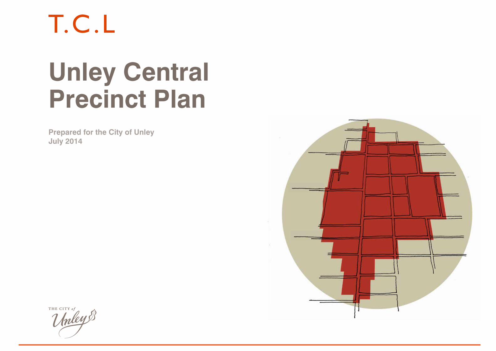
Unley Central Precinct PlanPrepared for the City of UnleyJuly 2014
2
Unley Central Precinct Plan
Client:The City of Unley
Team:Taylor Cullity LethleanTeam CoordinationLandscape Architecture/Urban Design
AureconPlanning
Richard HanslipMovement Planning
Property & AdvisoryProperty Advisor
RLBCost Planning
Acknowledgments:
The consultant team wish to acknowledge the contribution of the following in undertaking the Unley Central Precinct Plan:
City of Unley Elected Members
Members of the Unley Road Traders Association
Key Stakeholders including Property Owners
General Manager, Economic Development and Planning, City of UnleyDavid Litchfield
Manager Urban Design, City of UnleyKeith Davis
Unley Central Precinct PlanUnley Central Precinct Plan
Revision Description Date By Checked Approved
P1 Draft 18.11.13 TCL RK DS
P2 Draft 24.04.14 TCL RK DS
P3 Final Draft 08.07.14 TCL RK DS
P4 Client Edit 24.07.14 COU KD DS

3
Unley Central Precinct Plan
24
25
26
27
27
29
30
32
33
34
35
36
37
38
39
42
43
44
44
CONTENTS
1.0 Executive Summary
2.0 Introduction
3.0 Response to Vision
4.0 Strategic Context
5.0 Background Reports
5.1 Themes from Unley 4 Year Plan
5.2 Recommendations from Previous Reports
6.0 Stakeholders Consultation
7.0 Existing Conditions & Context
7.1 Existing Character
7.2 Existing Land Use
7.3 Existing Building Heights
7.4 Planning Policy and Zoning
7.5 Land Ownership and Development Opportunities
7.6 Community Facilities/Recreation/Open Space
7.7 Transport and Parking
7.8 Streetscapes
7.9 Place Activation
8.0 Urban Design Framework
8.1 What Makes a Great Precinct
8.2 Guiding Principles
8.3 Organising Urban Design Elements
8.4 Rezoning & Development Opportunities
8.5 Development Opportunities
8.6 Potential Built Heights
8.7 Mixed Use Development
8.8 Open Space & Community Connections
8.9 Transport Connections
8.9.1 Unley Road Streetscape - Area 1 (Central Hub)
8.9.2 Unley Road Streetscape - Area 2 (Beyond Central Hub)
8.9.3 Unley Road Streetscape - Area 3 (Edge of Unley Central Precinct)
8.9.4 Side Streets - Area 4 (Oxford Tce, Frederick St & Edmund Ave)
8.10 Traffic Calming / Shared Zone / Car Park - Precedents
8.11 Perspectives
8.12 Activation Priorities
8.13 Sustainability
9.0 Management & Marketing
10.0 Next Steps - Implementation Strategies
4
7
8
9
11
12
14
15
16
17
18
19
20
21
22
23
4
Unley Central Precinct Plan
1.0 EXECUTIVE SUMMARY
INTRODUCTION
The Unley Central Precinct Plan objective is to provide innovative and practical responses to achieve the following vision for the city by the year 2033.
‘Our City is recognised for its vibrant community spirit, quality lifestyle choices, diversity, business strength and innovative leadership’
The structure of the report presents the context and existing conditions of the Precinct, as well as a summary of consultation with key stakeholders and councillors. This is followed by a detailed description of the proposed framework and Precinct Plan, along with precedents from other precincts, and finally recommends next steps and initiatives.
It is intended that the Precinct Plan will form the basis for more detailed investigations of the various components.
EXISTING CHARACTER
The existing character of the precinct can be summarised in eight statements which encapsulate its relationship to the city and the community:
Village CharacterAuthentic village character with heritage buildings, laneways, plazas, pockets of open space, and mature trees. Some recent development has diminished this important character.
A Number of Shopping ClustersA number of zones exist within the Precinct divided by the busy main street, making it difficult to cross Unley Rd in an east–west direction.
Views Within and Beyond Pleasant views to the hills occur to the east along the residential streets and to the south along Unley Rd reinforcing the location of the Precinct on the Adelaide Plains.
• Provide a diversity of pedestrian connections with inviting plazas, streets, laneways and walkways.
Create high quality, socially engaging, human scale public realm with activated and connected edges • Create a hierarchy of urban open places
that respond to diverse needs, contexts and activities. Program these spaces to respond to a variety of needs and the time of year.
• Provide a ‘lattice’ of open space and ‘pocket parks’ particularly in mixed-use developments and along Unley Road.
Create vibrant high quality, medium to high density mixed use / mixed age developments• Provide a balance of contemporary uses that
establish mixed use residential, commercial and employment precincts.
• Establish a subdivision-block plan layout to maximise permeability
• Provide a hierarchy of activities throughout the precinct, particularly at street level to create a legible and interesting urban environment.
• Encourage ‘age in place’ by providing age appropriate residential development and community facilities.
Create high quality and enlivened streetscapes that connect to adjacent activities and uses• Buildings should create ‘human scaled’
streetscapes with modulated and vibrant active frontages and elements such as canopies and verandas with well-designed development above.
• Architectural expression should be contemporary and befitting Unley’s character without mimicking historic building types.
• Provide weather protection along frontages.
Dissected Village AtmosphereUnley Road is noisy and difficult to traverse, diluting the village atmosphere of the precinct.
Maze of Car ParksCarparks dominate the Precinct and create conflicts between pedestrians and cars. Some carparks lack any design or shade from trees.
Varying Street ActivitySide streets are an interesting mix of residential and community facilities which reinforce the social and cultural vitality of the community. Unley Road presents as a busy and economically active zone.
Internalised Community FacilitiesThe Council building, Library, Oval buildings, Community Centre and larger shopping centres present blank walls to the street and do not encourage transparency, openness and a transition to outside.
Lack of Night Time Activity The Precinct lacks night life with the majority of restaurants and other night time facilities being outside the precinct.
THE VISION FOR THE UNLEY CENTRAL PRECINCT
The Vision for the Unley Central Precinct is to create an integrated, sustainable and highly liveable and economically viable urban centre. A precinct that has well serviced retail and other commercial & community facilities, activated streets, and spaces offering a vibrant and safe environment.
GUIDING PRINCIPLES
The following seven Guiding Principles will drive the development of the Precinct:
Create a pedestrian dominant precinct • Establish a pedestrian friendly environment
with a permeable street network that is well- connected to surrounding activities and building types.
5
Unley Central Precinct Plan
Integrate sustainability principles into urban design • Promote renewable energy and minimise
resource use.
• Create productive landscapes.
• Address the impact of development on the existing stormwater system.
• Adopt ecological processes and systems development framework with an urban, rather than suburban character.
Prioritise Active Public Transport and Alternatives to Cars• Encourage the use of public transport and
create well-designed urbane stops and shelters.
• Encourage the investigation of a future tram system.
• Provide a direct, well connected and clearly articulated cycling network.
Quieten Traffic• Narrow roads, reduce speed limits, treat
roadways with surfaces and other elements that encourage a reduction of speed and remove cars where appropriate to maximise quality of the pedestrian and cycling experience.
• Quieten Unley Rd to allow for greater and safer connection east-west.
REZONING & DEVELOPMENT OPPORTUNITIES
Rezoning of District CentreThe zoning of land within the Unley Central Precinct is logical and will facilitate many of the desired future plans for the Precinct. There are however a few opportunities worthy of review and potentially fine-tuning in relation to zoning and planning policies.
Opportunity 1: Review the objective and principles of development control within the District Centre Zone.
public housing site in Thomas St, perhaps to achieve a medium to high density mixed use development integrated with the Soldiers Memorial Gardens, Unley Shopping Centre, existing heritage building and with potential shared use of adjacent car parking areas.
• Negotiate enhanced pedestrian laneway links between back of house carparks and Unley Road.
• Unley Shopping Centre to encourage consolidation of other community facilities, pool as part of gym, medical centres (including existing) etc. on second level.
• Explore opportunities for City of Unley (CoU)owned properties, institution owned properties ( e.g. Anglican properties) including ‘the Village Green’ with a transparent ground plane encouraging links between all buildings and elements as well as to Unley Oval.
• Redevelopment of CoU offices and Council Chambers could occur either on the present site with mixed use development, or relocate part or all (including the Unley Library) to another site to free up valuable land for mixed use development.
• Provide building entry forecourts to buildings on Unley Road to create a serrated edge.
• Redevelopment of the Unley Community Centre site and adjoining former St John’s Ambulance site.
• Redevelopment of the Sturt Football Club site (corner Oxford Terrace and Trimmer Terrace) potentially for 1-2 storey residential.
Traditionally the planning philosophy has been to exclude residential from a District Centre so as not to limit the development of the Centre for core district centre related activities. It is recommended to change planning policy to proactively encourage residential development above shop and office development as part of a mixed use development, particularly given the zone has no specified height limit.
The interface between adjacent zone boundaries also need planning policy review, possibly to be made consistent with the Urban Corridors Zone. Areas of the precinct within the Urban Corridor Zone are appropriately zoned.
Opportunity 2: Review zone boundaries to determine if the District Centre Zone should be expanded. For example the public housing in Thomas St and Soldiers’ Memorial Gardens could be better placed within the District Centre Zone, rather than the Residential Streetscape (Built Form) Zone they currently are located within.
The public housing site on Thomas offers a significant redevelopment opportunity for residential development and the Soldiers’ Memorial Gardens clearly has a cultural, community and recreational function more consistent with the District Centre Zone.
Development Opportunities
The following development opportunities exist within the precinct.
• Explore development opportunities to create a more vibrant Unley Shopping Centre, better connected east west and to urban open space, with parking below and/or behind (but not in front or adjacent Unley Road), offering mixed use development opportunities including shopping, restaurants, civic functions, offices, consulting rooms, entertainment and residential uses.
• Explore development opportunities for a more integrated mixed use development of the land north and south of the Unley Shopping Centre.
• Explore development opportunities for the
6
Unley Central Precinct Plan
POTENTIAL BUILT HEIGHTS
The proposed ultimate buildings heights have been suggested in line with the current Development Plan guidelines.
A tiered approach to built form should be adopted both along the Urban Corridor and within the District Centre Zone.
Potential future development needs to be mindful of adjacent residential zones and heritage places.
Within the Urban Corridor Zone along Unley Road building height can range from two storeys up to five storeys.
MANAGEMENT & MARKETING
ManagementForm a steering committee made up of equal partners to oversee key development sites. This could include key stakeholders with one being from UCC and chaired by an independent experienced person without a vested interest.
InitiativesReduce rates for developers where development achieves the long term vision for the Precinct.
Council to champion the achievement of the vision by demonstrating and being part of a redevelopment of its own land. For example the redevelopment of the current Civic Centre site for mixed use development.
Council acting as a catalyst for mixed use redevelopment of a key site by becoming a tenant with new civic offices.
Major developers of land adjacent Unley Road could receive adjacent urban upgrades of public realm funded by Council.
Council to strongly support State Government tram initiatives and recommend a first stage to be from the City to the Unley Central Hub area. This support could involve a partnership of funding between Local, State and Federal Government.
Council or a committee of nominated representatives could be established to encourage
the integration of off-street carparks located to the rear of shops. The committee could assist with awareness raising, identification of and communication with landholders and tenants of key sites, development of concepts to show the integration opportunity and the exploration of incentives such as rate reduction and adjacent street and precinct upgrades.
Communication and MarketingDevelop key messages and a communication strategy to explain and demonstrate the benefits of the Unley Central Precinct Plan to the local community and in particular residents.
Communicate and market the following:
• The ability to continue living in the Unley Central Precinct - ‘age in place’
• The opportunity for children and grandchildren to afford to live and buy in Unley and by so doing achieve generational sustainability
• Create an age friendly Precinct, a Precinct designed to suit all ages – children, youth, young people, couples, families, retirees, elderly, etc.
7
Unley Central Precinct Plan
2.0 INTRODUCTIONThe Unley Central Precinct Plan objective is to provide innovative and practical responses to achieve the following vision for the city by the year 2033.
‘Our City is recognised for its vibrant community spirit, quality lifestyle choices, diversity, business strength and innovative leadership’
This vision is reinforced by the following aspirations.
• In the next decade the City of Unley will be recognised for its community spirit, desirable character and business success in a sustainable and safe environment.
• New people and investment growth will bring vibrancy to the City of Unley‘s tapestry of local communities that support our environment and each other
• The City of Unley will be recognised for its social and economic innovations. Our citizens will be proud of their environment, their successes and their strength of community wellbeing.
The Unley Central Precinct Plan builds on the significant studies commissioned by various State Government departments and the Unley City Council. These include the SA Strategic Plan and the 30 Year Plan for Greater Adelaide.
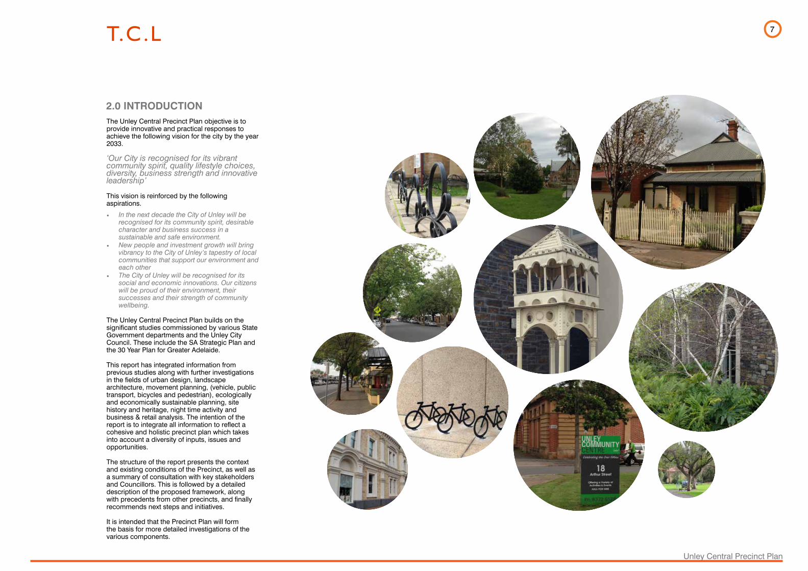
This report has integrated information from previous studies along with further investigations in the fields of urban design, landscape architecture, movement planning, (vehicle, public transport, bicycles and pedestrian), ecologically and economically sustainable planning, site history and heritage, night time activity and business & retail analysis. The intention of the report is to integrate all information to reflect a cohesive and holistic precinct plan which takes into account a diversity of inputs, issues and opportunities.
The structure of the report presents the context and existing conditions of the Precinct, as well as a summary of consultation with key stakeholders and Councillors. This is followed by a detailed description of the proposed framework, along with precedents from other precincts, and finally recommends next steps and initiatives.
It is intended that the Precinct Plan will form the basis for more detailed investigations of the various components.
8
Unley Central Precinct Plan
The following statements extend the City of Unley’s vision, aspirations and strategic context information and act as a starting point for the Precinct Plan process.
3.0 RESPONSE TO VISION
Urban Mixed Use Development Appropriate and affordable mixed use urban densification and increase of building heights where appropriate to meet the population target of the State’s 30 Year Plan.
Age Diversity and Age Friendly Create environments and facilities that encourage the aging population to stay, while providing for families as well and younger people to invigorate the community.
Village CharacterProtect and enhance the village character while allowing for targeted growth and development.
Vibrant Urban and Cultural SpacesCreate people friendly and culturally vibrant public spaces that encourage community participation.
Sustainable Economic Activity Attract innovative economic growth linked to key social and transport infrastructure.
Rationalise Traffic Create calmer/ slower traffic and safe and attractive roads and parking facilities that have a distinctive urbane character.
Alternative Modes of TransportPromote cycling and walking and increase the use of public transport to 10% of weekday passenger vehicle kilometres travelled by 2018 for Unley residents.
Pedestrian Linkages Create active edges and strong pedestrian connections making the urban environment accessible for all.
Heritage and Historic ExpressionCelebrate and reinforce Unley’s heritage elements while providing layers of meaning that draws the historic elements into a contemporary consciousness.
Ecologically and Socially Sustainable Create an adaptive and flexible environment that meets energy efficiency and sustainability objectives including CPTED (Crime Prevention Through Environmental Design) principles and Kyoto greenhouse gas emission reduction targets.
9
Unley Central Precinct Plan
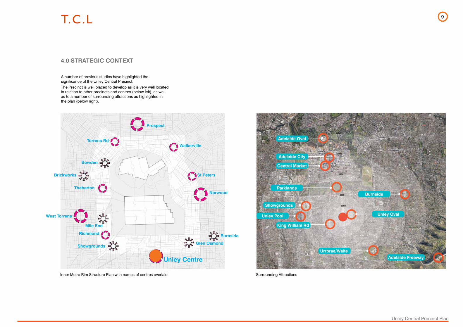
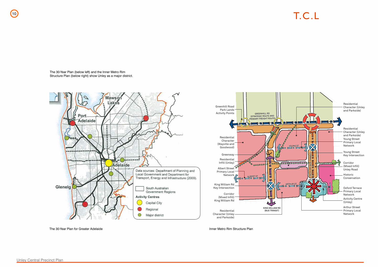
A number of previous studies have highlighted the significance of the Unley Central Precinct. The Precinct is well placed to develop as it is very well located in relation to other precincts and centres (below left), as well as to a number of surrounding attractions as highlighted in the plan (below right).
4.0 STRATEGIC CONTEXT
Inner Metro Rim Structure Plan with names of centres overlaid Surrounding Attractions
Urrbrae/Waite
Unley Oval
Adelaide Freeway
Parklands
Showgrounds
Unley Pool
Central Market
Adelaide City
Adelaide Oval
Burnside
King William Rd
Prospect
Walkerville
Norwood
Burnside
St Peters
Glen OsmondShowgrounds
Richmond
West Torrens
Brickworks
Thebarton
Bowden
Torrens Rd
Mile End
Unley Centre
10
Unley Central Precinct Plan
0 200 400 800mINNER METRO RIM_ SECTOR 08 PLAN V3.7
GREENHILL RD(STRATEGIC ROUTE AND
PRIMARY FREIGHT ROUTE)
GREENHILL RD(STRATEGIC ROUTE AND
PRIMARY FREIGHT ROUTE)
YOUNG STYOUNG ST
UN
LEY
RD
(BU
S T
RA
NS
IT)
UN
LEY
RD
(BU
S T
RA
NS
IT)
ALBERT STALBERT ST
ARTHUR STARTHUR ST
KING WILLIAM RD (BUS TRANSIT)
KING WILLIAM RD (BUS TRANSIT)
Greenhill RoadPark Lands
Activity Points
Corridor(Mixed Infill)
King William Rd
ResidentialCharacter
(Wayville andGoodwood)
Greenway
Corridor(Mixed Infill)Unley Road
Young StreetPrimary LocalNetwork
ResidentialCharacter (Unleyand Parkside)
ResidentialCharacter (Unley and Parkside)
HistoricConservation
ResidentialCharacter (Unley
and Parkside)
Arthur Street Primary LocalNetwork
King William RdKey Intersection
Albert StreetPrimary Local
Network
Young StreetKey Intersection
Oxford TerracePrimary LocalNetwork
ResidentialInfill (Unley)
Activity Centre(Unley)
Sector Plan 08_George Street – Hardy Street
0 800m200 400
44
Inner Metro Rim Structure Plan
Inner Metro Rim Structure PlanThe 30-Year Plan for Greater Adelaide
The 30-Year Plan (below left) and the Inner Metro Rim Structure Plan (below right) show Unley as a major district.
11
Unley Central Precinct Plan
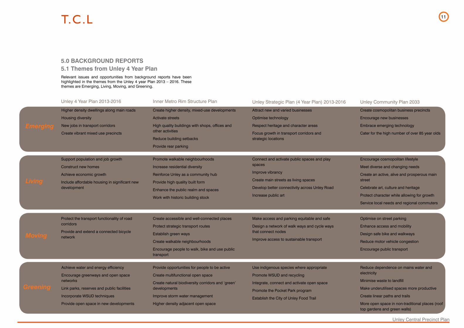
Relevant issues and opportunities from background reports have been highlighted in the themes from the Unley 4 year Plan 2013 – 2016. These themes are Emerging, Living, Moving, and Greening.
5.0 BACKGROUND REPORTS5.1 Themes from Unley 4 Year Plan
Emerging
Higher density dwellings along main roads
Housing diversity
New jobs in transport corridors
Create vibrant mixed use precincts
Unley 4 Year Plan 2013-2016
Create higher density, mixed-use developments
Activate streets
High quality buildings with shops, offices and other activities
Reduce building setbacks
Provide rear parking
Inner Metro Rim Structure Plan
Attract new and varied businesses
Optimise technology
Respect heritage and character areas
Focus growth in transport corridors and strategic locations
Create cosmopolitan business precincts
Encourage new businesses
Embrace emerging technology
Cater for the high number of over 85 year olds
Unley Strategic Plan (4 Year Plan) 2013-2016 Unley Community Plan 2033
Living
Moving
Greening
Support population and job growth
Construct new homes
Achieve economic growth
Include affordable housing in significant new development
Encourage cosmopolitan lifestyle
Meet diverse and changing needs
Create an active, alive and prosperous main street
Celebrate art, culture and heritage
Protect character while allowing for growth
Service local needs and regional commuters
Connect and activate public spaces and play spaces
Improve vibrancy
Create main streets as living spaces
Develop better connectivity across Unley Road
Increase public art
Promote walkable neighbourhoods
Increase residential diversity
Reinforce Unley as a community hub
Provide high quality built form
Enhance the public realm and spaces
Work with historic building stock
Protect the transport functionality of road corridors
Provide and extend a connected bicycle network
Create accessible and well-connected places
Protect strategic transport routes
Establish green ways
Create walkable neighbourhoods
Encourage people to walk, bike and use public transport
Make access and parking equitable and safe
Design a network of walk ways and cycle ways that connect nodes
Improve access to sustainable transport
Optimise on street parking
Enhance access and mobility
Design safe bike and walkways
Reduce motor vehicle congestion
Encourage public transport
Achieve water and energy efficiency
Encourage greenways and open space networks
Link parks, reserves and public facilities
Incorporate WSUD techniques
Provide open space in new developments
Reduce dependence on mains water and electricity
Minimise waste to landfill
Make underutilised spaces more productive
Create linear paths and trails
More open space in non-traditional places (roof top gardens and green walls)
Use indigenous species where appropriate
Promote WSUD and recycling
Integrate, connect and activate open space
Promote the Pocket Park program
Establish the City of Unley Food Trail
Provide opportunities for people to be active
Create multifunctional open space
Create natural biodiversity corridors and ‘green’ developments
Improve storm water management
Higher density adjacent open space
12
Unley Central Precinct Plan
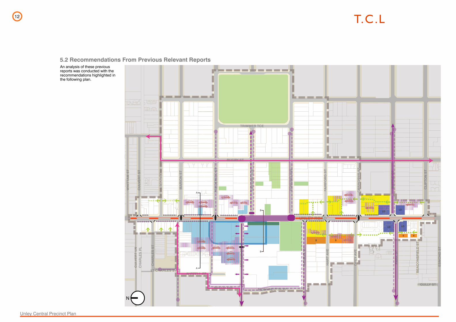
5.2 Recommendations From Previous Relevant Reports
LD
LDLD
LD
B B
BB
A
A
B
B
Section B-BFrom Jensen Planning + DesignMain Road Corridors Future Directions
Section A-AFrom Jensen Planning + DesignMain Road Corridors Future Directions
Implement Unley Oval Masterplan
UNLEY ROADUNLEY ROAAD
RUGBY STRUGBY ST
DU
NK
S S
T
WH
ITTA
MS
TW
HIT
TAM
ST
WH
ITTA
MS
TW
HIT
WH
ITWW
TTA
TTA
ST
ST
AM
A
M
CU
LVE
RT
ST
CU
LVE
RT
ST
MA
UD
ST
MA
UD
SM
AU
DS
TMMMMMM
AU
D
AU
D
AU
DA
UD
AU
DA
UD
ST
ST
ST
ST
ST
ST
MA
RIO
N S
T
FRE
DE
RIC
K S
TFR
ED
ER
ICK
ST
FRE
DE
RIC
KS
T
OX
FOR
D T
CE
OX
FOR
DTC
EO
XFO
RD
TCE
OX
FOR
D T
CE
ED
MU
ND
AV
EE
DM
UN
DA
VE
ED
MU
ND
AV
EE
DM
UN
DA
VE
ED
MU
ND
AV
E
FAIR
FOR
D S
TFA
IRFO
RD
ST
CR
EM
OR
NE
ST
CCR
EM
OR
EM
OR
NE
RN
E S
TS
T
WA
TTL
E S
TW
AT
TLE
ST
WA
TTL
ES
TW
AT
TLE
ST
CLI
FTO
N S
T
ETO
N S
T
HU
GH
ES
ST
CU
LVE
RT
LNC
ULV
ER
TLN
CU
LVE
RT
LNC
ULV
ER
TC
ULV
ER
TC
ULV
ER
T LN
CU
LVE
RT
LNLNLN
CH
AR
LES
ST
CH
AR
LES
ST
MA
RY
ST
MA
RY
ST
MA
RY
ST
MA
RY
ST
MA
RY
ST
MSS
YYS
MMAAA
RY
AR
YA
RY
AR
YTTTT
ST
ST
ST
ST
MA
RY
ST
AR
THU
R S
TA
RTH
UR
ST
US
THO
MA
SS
TS
TS
TTH
OM
AS
ST
THO
MA
SS
TTH
OM
AS
ST
HA
RT
AV
EH
AR
TA
VE
OP
EY
AV
EA
VE
OOP
OP
OO PA
RK
ST
PA
RK
ST
PA
RK
ST
BE
AC
ON
SFI
ELD
ST
AC
ON
SFI
ELD
ST
BE
AC
ON
SFI
ELD
ST
BE
BEE
AE
AC
EA
CCO
NC
ONN
SF
NS
FFIE
FIE
LD
LD S
TS
TTTTS
TS
TLDLD
FIE
FIE
NS
FN
SF
ACC
OON
ES
MO
ND
ST
FAS
HO
DA
ST
MORNINGTON RDMORNNINGTON RDTON RDTON RDNGTNGTGTGTGTGTON RON RON RON RON RON RMORNINGTON RDMORMORMOR
AUSTELL STELLELL USTUSTAA STSTAUSTELL STAUSTELL STAUSTELL ST
EECH AVEEECH AEECH AAVEAVEAAAAECHECHECHECHECHECHBEBEBEBEBEBEBEECH AVEBEECH AVEBEECH AVE
RAMAGE STAGE STE STE STRAMAGE ST
TTLT CHARLES STLT CHARLES STCHARLES STCHARLES STLL TTTTARLES STTTTTHAHA
N LNN LNN LNNNNNN LNN LNN LNN LNNNIRWI
BURY STSALIS
RSTON STPALMER
ERSTON PLERSTON PLERSTON PLERSTON PLERSTON PLPALME
CH
AR
LES
PL
CH
AR
LES
CH
AR
LES
CH
AR
LESSS
PL
GULLY STGULLY STGULLY STGULLY STG
NALPA STNALPA STS
TRIMMER TCETRIMMER TCE
Main Road Corridors Future Directions- Jensen Planning & Design (2010)
Multi-storey mixed use development
Pedestrian retail circuit
Street focused on forming link to other villages - all modes
Unley Villages Parking & Accessibility Study& Unley Integrated Transport Strategy - QED (2002)
Street focused on forming pedestrian and bicycle links
Bicycle boulevard
Pedestrian route
Consolidate carparks
Calm road with 4 lanes/median or 3 lanes/alternating third lane
Widen Arthur Street
Activate Frontage
Bicycle Transit Routes
New traffic signals
Development Plan Amendment (2013)
Introduce median strip pedestrian refuge and protected right turn
Develop concepts for better pedestrian connectivity across Unley Road
Develop principals for the Pocket Park program & redevelop major parks and reserves
Lot boundry adjustments to accomodate greater development depth
Protruberances/ Kerb extensions to side streets
Buildings set back from property line to increase footpath
Creating Landmark Developments
Unley Road Upgrade - Haliburton KBR (2002)
Unley 4 Year Plan - City of Unley (2013)
Pedestrian & Bicycle Plan - QED (2005)
B
LD
Consolidate & Develop sites
Proposed vehicle link
An analysis of these previous reports was conducted with the recommendations highlighted in the following plan.
N
13
Unley Central Precinct Plan
LD
LDLD
LD
B B
BB
A
A
B
B
Section B-BFrom Jensen Planning + DesignMain Road Corridors Future Directions
Section A-AFrom Jensen Planning + DesignMain Road Corridors Future Directions
Implement Unley Oval Masterplan
UNLEY ROADUNLEY ROAAD
RUGBY STRUGBY ST
DU
NK
S S
T
WH
ITTA
MS
TW
HIT
TA
MS
TW
HIT
TA
MS
TW
HIT
WH
ITWW
TTA
TTA
ST
ST
AM
A
M
CU
LVE
RT
ST
CU
LVE
RT
ST
MA
UD
ST
MA
UD
SM
AU
DS
TMMMMMM
AU
D
AU
D
AU
DA
UD
AU
DA
UD
ST
ST
ST
ST
ST
ST
MA
RIO
N S
T
FR
ED
ER
ICK
ST
FR
ED
ER
ICK
ST
FR
ED
ER
ICK
ST
OX
FO
RD
TC
EO
XF
OR
DT
CE
OX
FO
RD
TC
EO
XF
OR
D T
CE
ED
MU
ND
AV
EE
DM
UN
DA
VE
ED
MU
ND
AV
EE
DM
UN
DA
VE
ED
MU
ND
AV
E
FA
IRF
OR
D S
TFA
IRF
OR
DS
T
CR
EM
OR
NE
ST
CCR
EM
OR
EM
OR
NE
RN
E S
TS
T
WA
TT
LE
ST
WA
TT
LE
ST
WA
TT
LE
ST
WA
TT
LE
ST
CL
IFT
ON
ST
ET
ON
ST
HU
GH
ES
ST
CU
LVE
RT
LN
CU
LVE
RT
LN
CU
LVE
RT
LN
CU
LVE
RT
CU
LVE
RT
CU
LVE
RT
LN
CU
LVE
RT
LN
LN
LN
CH
AR
LE
S S
TC
HA
RL
ES
ST
MA
RY
ST
MA
RY
ST
MA
RY
ST
MA
RY
ST
MA
RY
ST
MSS
YYS
MMAAA
RY
AR
YA
RY
AR
YTTTT
ST
ST
ST
ST
MA
RY
ST
AR
TH
UR
ST
AR
TH
UR
ST
US
TH
OM
AS
ST
ST
ST
TH
OM
AS
ST
TH
OM
AS
ST
TH
OM
AS
ST
HA
RT
AV
EH
AR
TA
VE
OP
EY
AV
EA
VE
OOP
OP
OO PA
RK
ST
PA
RK
ST
PA
RK
ST
BE
AC
ON
SF
IEL
DS
TA
CO
NS
FIE
LD
ST
BE
AC
ON
SF
IEL
DS
TB
EB
EEA
EA
CE
ACC
ON
CO
NNS
FN
SFF
IEF
IEL
D
LD
ST
STTTT
ST
ST
LD
LD
FIE
FIE
NS
FN
SF
ACC
OON
ES
MO
ND
ST
FA
SH
OD
A S
T
MORNINGTON RDMORNNINGTON RDTON RDTON RDNGTNGTGTGTGTGTON RON RON RON RON RON RMORNINGTON RDMORMORMOR
AUSTELL STELLELL USTUSTAA STSTAUSTELL STAUSTELL STAUSTELL ST
EECH AVEEECH AEECH AAVEAVEAAAAECHECHECHECHECHECHBEBEBEBEBEBEBEECH AVEBEECH AVEBEECH AVE
RAMAGE STAGE STE STE STRAMAGE ST
TTLT CHARLES STLT CHARLES STCHARLES STCHARLES STLL TTTTARLES STTTTTHAHA
N LNN LNN LNNNNNN LNN LNN LNN LNNNIRWI
BURY STSALIS
RSTON STPALMER
ERSTON PLERSTON PLERSTON PLERSTON PLERSTON PLPALME
CH
AR
LE
SP
LC
HA
RL
ES
CH
AR
LE
SC
HA
RL
ESSS
PL
GULLY STGULLY STGULLY STGULLY STG
NALPA STNALPA STS
TRIMMER TCETRIMMER TCE
Main Road Corridors Future Directions- Jensen Planning & Design (2010)
Multi-storey mixed use development
Pedestrian retail circuit
Street focused on forming link to other villages - all modes
Unley Villages Parking & Accessibility Study& Unley Integrated Transport Strategy - QED (2002)
Street focused on forming pedestrian and bicycle links
Bicycle boulevard
Pedestrian route
Consolidate carparks
Calm road with 4 lanes/median or 3 lanes/alternating third lane
Widen Arthur Street
Activate Frontage
Bicycle Transit Routes
New traffic signals
Development Plan Amendment (2013)
Introduce median strip pedestrian refuge and protected right turn
Develop concepts for better pedestrian connectivity across Unley Road
Develop principals for the Pocket Park program & redevelop major parks and reserves
Lot boundry adjustments to accomodate greater development depth
Protruberances/ Kerb extensions to side streets
Buildings set back from property line to increase footpath
Creating Landmark Developments
Unley Road Upgrade - Haliburton KBR (2002)
Unley 4 Year Plan - City of Unley (2013)
Pedestrian & Bicycle Plan - QED (2005)
B
LD
Consolidate & Develop sites
Proposed vehicle link
LD
LDLD
LD
B B
BB
A
A
B
B
Section B-BFrom Jensen Planning + DesignMain Road Corridors Future Directions
Section A-AFrom Jensen Planning + DesignMain Road Corridors Future Directions
Implement Unley Oval Masterplan
UNLEY ROADUNLEY ROAAD
RUGBY STRUGBY ST
DU
NK
S S
T
WH
ITTA
MS
TW
HIT
TA
MS
TW
HIT
TA
MS
TW
HIT
WH
ITWW
TTA
TTA
ST
ST
AM
A
M
CU
LVE
RT
ST
CU
LVE
RT
ST
MA
UD
ST
MA
UD
SM
AU
DS
TMMMMMM
AU
D
AU
D
AU
DA
UD
AU
DA
UD
ST
ST
ST
ST
ST
ST
MA
RIO
N S
T
FR
ED
ER
ICK
ST
FR
ED
ER
ICK
ST
FR
ED
ER
ICK
ST
OX
FO
RD
TC
EO
XF
OR
DT
CE
OX
FO
RD
TC
EO
XF
OR
D T
CE
ED
MU
ND
AV
EE
DM
UN
DA
VE
ED
MU
ND
AV
EE
DM
UN
DA
VE
ED
MU
ND
AV
E
FA
IRF
OR
D S
TFA
IRF
OR
DS
T
CR
EM
OR
NE
ST
CCR
EM
OR
EM
OR
NE
RN
E S
TS
T
WA
TT
LE
ST
WA
TT
LE
ST
WA
TT
LE
ST
WA
TT
LE
ST
CL
IFT
ON
ST
ET
ON
ST
HU
GH
ES
ST
CU
LVE
RT
LN
CU
LVE
RT
LN
CU
LVE
RT
LN
CU
LVE
RT
CU
LVE
RT
CU
LVE
RT
LN
CU
LVE
RT
LN
LN
LN
CH
AR
LE
S S
TC
HA
RL
ES
ST
MA
RY
ST
MA
RY
ST
MA
RY
ST
MA
RY
ST
MA
RY
ST
MSS
YYS
MMAAA
RY
AR
YA
RY
AR
YTTTT
ST
ST
ST
ST
MA
RY
ST
AR
TH
UR
ST
AR
TH
UR
ST
US
TH
OM
AS
ST
ST
ST
TH
OM
AS
ST
TH
OM
AS
ST
TH
OM
AS
ST
HA
RT
AV
EH
AR
TA
VE
OP
EY
AV
EA
VE
OOP
OP
OO PA
RK
ST
PA
RK
ST
PA
RK
ST
BE
AC
ON
SF
IEL
DS
TA
CO
NS
FIE
LD
ST
BE
AC
ON
SF
IEL
DS
TB
EB
EEA
EA
CE
ACC
ON
CO
NNS
FN
SFF
IEF
IEL
D
LD
ST
STTTT
ST
ST
LD
LD
FIE
FIE
NS
FN
SF
ACC
OON
ES
MO
ND
ST
FA
SH
OD
A S
T
MORNINGTON RDMORNNINGTON RDTON RDTON RDNGTNGTGTGTGTGTON RON RON RON RON RON RMORNINGTON RDMORMORMOR
AUSTELL STELLELL USTUSTAA STSTAUSTELL STAUSTELL STAUSTELL ST
EECH AVEEECH AEECH AAVEAVEAAAAECHECHECHECHECHECHBEBEBEBEBEBEBEECH AVEBEECH AVEBEECH AVE
RAMAGE STAGE STE STE STRAMAGE ST
TTLT CHARLES STLT CHARLES STCHARLES STCHARLES STLL TTTTARLES STTTTTHAHA
N LNN LNN LNNNNNN LNN LNN LNN LNNNIRWI
BURY STSALIS
RSTON STPALMER
ERSTON PLERSTON PLERSTON PLERSTON PLERSTON PLPALME
CH
AR
LE
SP
LC
HA
RL
ES
CH
AR
LE
SC
HA
RL
ESSS
PL
GULLY STGULLY STGULLY STGULLY STG
NALPA STNALPA STS
TRIMMER TCETRIMMER TCE
Main Road Corridors Future Directions- Jensen Planning & Design (2010)
Multi-storey mixed use development
Pedestrian retail circuit
Street focused on forming link to other villages - all modes
Unley Villages Parking & Accessibility Study& Unley Integrated Transport Strategy - QED (2002)
Street focused on forming pedestrian and bicycle links
Bicycle boulevard
Pedestrian route
Consolidate carparks
Calm road with 4 lanes/median or 3 lanes/alternating third lane
Widen Arthur Street
Activate Frontage
Bicycle Transit Routes
New traffic signals
Development Plan Amendment (2013)
Introduce median strip pedestrian refuge and protected right turn
Develop concepts for better pedestrian connectivity across Unley Road
Develop principals for the Pocket Park program & redevelop major parks and reserves
Lot boundry adjustments to accomodate greater development depth
Protruberances/ Kerb extensions to side streets
Buildings set back from property line to increase footpath
Creating Landmark Developments
Unley Road Upgrade - Haliburton KBR (2002)
Unley 4 Year Plan - City of Unley (2013)
Pedestrian & Bicycle Plan - QED (2005)
B
LD
Consolidate & Develop sites
Proposed vehicle link

14
Unley Central Precinct Plan
6.0 STAKEHOLDERS CONSULTATION
A series of interviews and presentations were conducted with key stakeholders, including the City of Unley Elected Members, Unley Road Traders Association and representatives of the three largest private land owners in the precinct.
Major Outcome of Consultation:
• Stakeholders are supportive of future, large scale development through formation of partnerships with Council to resolve key issues
The following represents a summary of responses given by the stakeholders:
Attitudes Towards Development
• Council must lead by example as a catalyst, to bring landholders together and act as a development partner
• Get the community to share and buy into the vision
• General support of future, large scale mixed-use development through formation of partnerships with Council to resolve key issues
• Low number of owners in the precinct is helpful for development
• Consider the real estate market when planning for the sale of apartment living in Unley
• Plan for an ageing community
• Heritage is a critical factor to Unley’s character and the desire to live there
Parking & Side Streets
• Parking is a major issue in need of resolution precinct wide
• General support of laneways and amalgamation of private carparks
• Convert Oxford St to one-way for extra parking and improved atmosphere
• Potential for introducing paid parking
• There is poor vehicle connectivity through the rear of blocks due to disaggregation of land ownership
• Perception that commuter parking is occuring, i.e Park and ride
Retail Activity & Preferences
• Retain the relaxed informality of the Unley Central Precinct
• Desire to further integrate & improve community based development/facilities, e.g. health & medical
• Activation required to Oxford St
• Activation required to Unley Shopping Centre frontage (Unley Road side)
• Night activation required and wanted
• Desire for quality, diverse retail tenants
Unley Road
• A variety of transport options are required
• Unley Road is a significant barrier between places of interest
• There is positive support of reduced traffic speeds to Unley Road
• On street parking is preferred by traders
• Need to keep motorists on full length of Unley Road – restrict detouring via side streets
Public Spaces
• Provide a public realm environment to the front of the Unley Shopping Centre
• A walkable, pedestrian focused neighbourhood is required
• Provide tangible connections between cultural attractors - museum, civic centre, library, gardens
• Memorial Gardens requires rejuvenation & connection with an improved program of events
• St Augustine’s is in support of development and the use of the Church grounds for the public realm
• Council has a role in creating places and space, atmosphere and destinations
15
Unley Central Precinct Plan
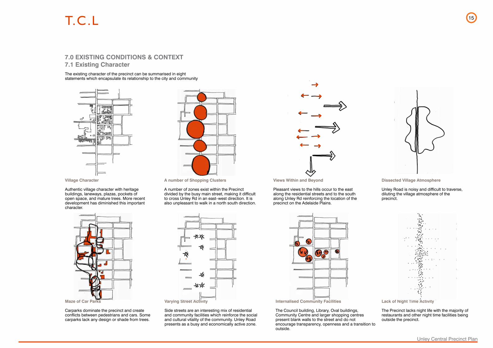
7.1 Existing Character7.0 EXISTING CONDITIONS & CONTEXT
The existing character of the precinct can be summarised in eight statements which encapsulate its relationship to the city and community
Village Character
Authentic village character with heritage buildings, laneways, plazas, pockets of open space, and mature trees. More recent development has diminished this important character.
Dissected Village Atmosphere
Unley Road is noisy and difficult to traverse, diluting the village atmosphere of the precinct.
Maze of Car Parks
Carparks dominate the precinct and create conflicts between pedestrians and cars. Some carparks lack any design or shade from trees.
A number of Shopping Clusters
A number of zones exist within the Precinct divided by the busy main street, making it difficult to cross Unley Rd in an east–west direction. It is also unpleasant to walk in a north south direction.
Views Within and Beyond
Pleasant views to the hills occur to the east along the residential streets and to the south along Unley Rd reinforcing the location of the precinct on the Adelaide Plains.
Varying Street Activity
Side streets are an interesting mix of residential and community facilities which reinforce the social and cultural vitality of the community. Unley Road presents as a busy and economically active zone.
Lack of Night Time Activity
The Precinct lacks night life with the majority of restaurants and other night time facilities being outside the precinct.
Internalised Community Facilities
The Council building, Library, Oval buildings, Community Centre and larger shopping centres present blank walls to the street and do not encourage transparency, openness and a transition to outside.
16
Unley Central Precinct Plan
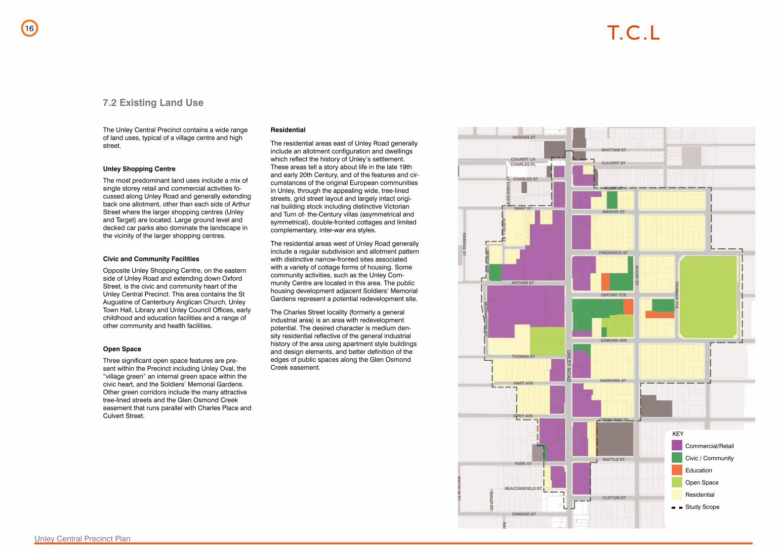
The Unley Central Precinct contains a wide range of land uses, typical of a village centre and high street.
Unley Shopping Centre
The most predominant land uses include a mix of single storey retail and commercial activities fo-cussed along Unley Road and generally extending back one allotment, other than each side of Arthur Street where the larger shopping centres (Unley and Target) are located. Large ground level and decked car parks also dominate the landscape in the vicinity of the larger shopping centres.
Civic and Community Facilities
Opposite Unley Shopping Centre, on the eastern side of Unley Road and extending down Oxford Street, is the civic and community heart of the Unley Central Precinct. This area contains the St Augustine of Canterbury Anglican Church, Unley Town Hall, Library and Unley Council Offices, early childhood and education facilities and a range of other community and health facilities.
Open Space
Three significant open space features are pre-sent within the Precinct including Unley Oval, the “village green” an internal green space within the civic heart, and the Soldiers’ Memorial Gardens. Other green corridors include the many attractive tree-lined streets and the Glen Osmond Creek easement that runs parallel with Charles Place and Culvert Street.
7.2 Existing Land Use
Residential
The residential areas east of Unley Road generally include an allotment configuration and dwellings which reflect the history of Unley’s settlement. These areas tell a story about life in the late 19th and early 20th Century, and of the features and cir-cumstances of the original European communities in Unley, through the appealing wide, tree-lined streets, grid street layout and largely intact origi-nal building stock including distinctive Victorian and Turn of- the-Century villas (asymmetrical and symmetrical), double-fronted cottages and limited complementary, inter-war era styles.
The residential areas west of Unley Road generally include a regular subdivision and allotment pattern with distinctive narrow-fronted sites associated with a variety of cottage forms of housing. Some community activities, such as the Unley Com-munity Centre are located in this area. The public housing development adjacent Soldiers’ Memorial Gardens represent a potential redevelopment site.
The Charles Street locality (formerly a general industrial area) is an area with redevelopment potential. The desired character is medium den-sity residential reflective of the general industrial history of the area using apartment style buildings and design elements, and better definition of the edges of public spaces along the Glen Osmond Creek easement.
KEY
Commercial/Retail
Civic / Community
Education
Open Space
Residential
Study Scope

17
Unley Central Precinct Plan
The building heights are currently mostly single storey with approximately one third two storey.
The only structure that reaches three storey height is the St Augustine’s Church spire.
This low building height indicates that the precinct has a high level of unrealised development potential
7.3 Existing Building Heights
KEY
1 Story
2 Stories
3 Stories
18
Unley Central Precinct Plan
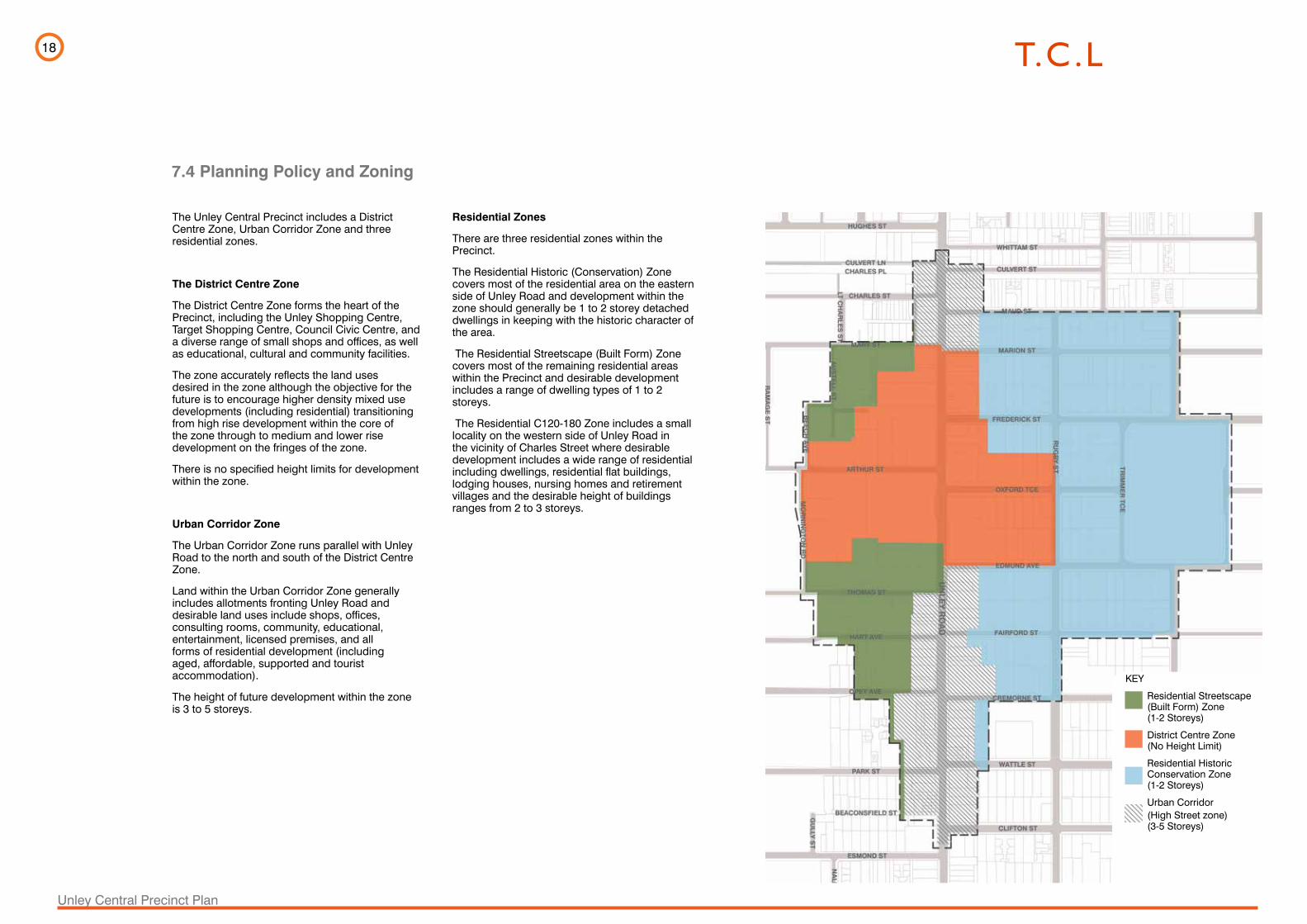
The Unley Central Precinct includes a District Centre Zone, Urban Corridor Zone and three residential zones.
The District Centre Zone
The District Centre Zone forms the heart of the Precinct, including the Unley Shopping Centre, Target Shopping Centre, Council Civic Centre, and a diverse range of small shops and offices, as well as educational, cultural and community facilities.
The zone accurately reflects the land uses desired in the zone although the objective for the future is to encourage higher density mixed use developments (including residential) transitioning from high rise development within the core of the zone through to medium and lower rise development on the fringes of the zone.
There is no specified height limits for development within the zone.
Urban Corridor Zone
The Urban Corridor Zone runs parallel with Unley Road to the north and south of the District Centre Zone.
Land within the Urban Corridor Zone generally includes allotments fronting Unley Road and desirable land uses include shops, offices, consulting rooms, community, educational, entertainment, licensed premises, and all forms of residential development (including aged, affordable, supported and tourist accommodation).
The height of future development within the zone is 3 to 5 storeys.
7.4 Planning Policy and Zoning
Residential Zones
There are three residential zones within the Precinct.
The Residential Historic (Conservation) Zone covers most of the residential area on the eastern side of Unley Road and development within the zone should generally be 1 to 2 storey detached dwellings in keeping with the historic character of the area.
The Residential Streetscape (Built Form) Zone covers most of the remaining residential areas within the Precinct and desirable development includes a range of dwelling types of 1 to 2 storeys.
The Residential C120-180 Zone includes a small locality on the western side of Unley Road in the vicinity of Charles Street where desirable development includes a wide range of residential including dwellings, residential flat buildings, lodging houses, nursing homes and retirement villages and the desirable height of buildings ranges from 2 to 3 storeys.
KEY
Residential Streetscape (Built Form) Zone (1-2 Storeys)
District Centre Zone (No Height Limit)
Residential Historic Conservation Zone (1-2 Storeys)
Urban Corridor (High Street zone) (3-5 Storeys)

19
Unley Central Precinct Plan
There is a limited number of land ownerships in some parts of the precinct particularly on the western side between Mary St to the Unley Shopping Centre where there are only four owners.
The Unley Shopping Centre is owned by the Duke Group. The holding here includes the carpark on Unley Rd and one of the decked car parks on Arthur St, which is separated by a fence from the adjoining decked car park and the former St John Ambulance Station on Arthur St, adjacent to the Unley Community Centre.
Optage Pty Ltd owns the former Rossiters property which incorporates the Target store and the decked car park behind (but excludes the property on the very corner of Arthur St). Optage Pty Ltd has been contemplating the future of the property and there have been discussions with Council administration on the subject.
The Haddad family control a collection of properties north from the appliance shop and including all of the open lot parking behind. The properties have been in the current ownership for an extended period with little change.
St John property on Edmund Ave provides premises with significant floor space as well as a portion of the site being local heritage listed. This space may soon become vacant offering an opportunity for adaptive re-use in the context of precinct renewal.
Council owns the following:
• Bazaar property on Unley Rd and the adjoining Memorial Carpark, which both lie between the Optage and Haddad properties,
• The Unley Community Centre at the corner of Arthur St and Beech Ave.
• The Civic Centre on Unley Rd/Oxford Tce
7.5 Land Ownership
• Unley Oval property at the eastern end of Oxford Tce
• One vacant block on Oxford Tce used by the adjoining school Kirinari Community School.
• The Sturt Football Club administration is located at Oxford Tce with the Club’s poker machines at the Bazaar premises.
• Most of the residential properties between Oxford Tce and Edmund Ave and a number that house community facilities including Unley Museum and a kindergarten.
• Property at the eastern end of Oxford Tce, including a vacant block.
Land Ownership
KEY
Single Block Owners
Council Owned Properties
Duke Owned Properties
Optage Pty Ltd Owned Properties
Haddad Owned Properties
Metro Property Investments
Anglican Church
Salvation Army Property Trust
Housing SA
Church of England
St John Ambulance
20
Unley Central Precinct Plan
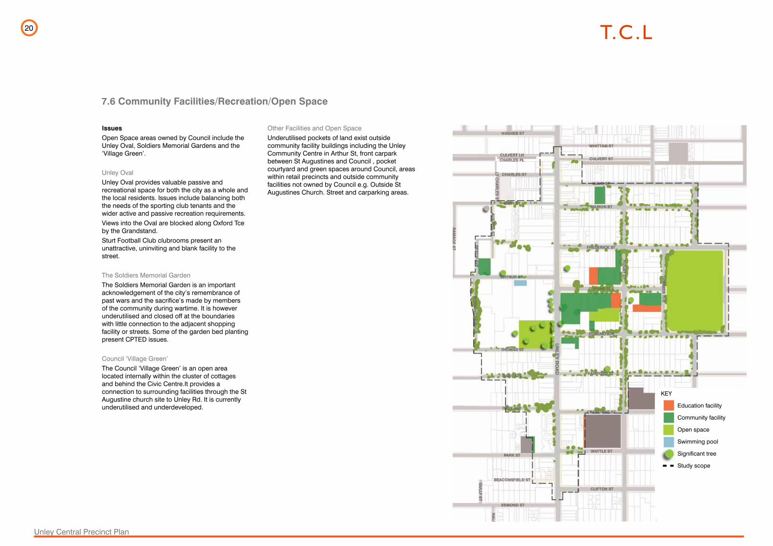
IssuesOpen Space areas owned by Council include the Unley Oval, Soldiers Memorial Gardens and the ‘Village Green’.
Unley OvalUnley Oval provides valuable passive and recreational space for both the city as a whole and the local residents. Issues include balancing both the needs of the sporting club tenants and the wider active and passive recreation requirements. Views into the Oval are blocked along Oxford Tce by the Grandstand. Sturt Football Club clubrooms present an unattractive, uninviting and blank facility to the street.
The Soldiers Memorial GardenThe Soldiers Memorial Garden is an important acknowledgement of the city’s remembrance of past wars and the sacrifice’s made by members of the community during wartime. It is however underutilised and closed off at the boundaries with little connection to the adjacent shopping facility or streets. Some of the garden bed planting present CPTED issues.
Council ‘Village Green’The Council ‘Village Green’ is an open area located internally within the cluster of cottages and behind the Civic Centre.It provides a connection to surrounding facilities through the St Augustine church site to Unley Rd. It is currently underutilised and underdeveloped.
7.6 Community Facilities/Recreation/Open Space
Other Facilities and Open SpaceUnderutilised pockets of land exist outside community facility buildings including the Unley Community Centre in Arthur St, front carpark between St Augustines and Council , pocket courtyard and green spaces around Council, areas within retail precincts and outside community facilities not owned by Council e.g. Outside St Augustines Church. Street and carparking areas.
KEY
Education facility
Community facility
Open space
Swimming pool
Significant tree
Study scope

21
Unley Central Precinct Plan
Issues
As a designated arterial route Unley Road is busy at most times and crossing the road is difficult with little pedestrian priority. There is a lack of balance between traffic and pedestrian accessibility.
There are a number of large carparks with motorists seeking out parking adjacent or within about a minute’s walk of their destination. The above ground carpark upper level on Arthur St is underutilised while many people complain about lack of parking.
The Unley Shopping Centre and the St Augustine carparks are located along Unley Road. The large frontage of the Shopping Centre car park to Unley Rd presents a potential development opportunity, including creating public space.
A number of carparks are in close proximity but are not joined. There is a potential to amalgamate these carparks.
There are connections east –west between major roads such as King William Road, Unley Road and Duthy St. The network allows most turning movements including right turns and through traffic (except Mornington Rd which is closed at Thomas St ). Arthur Street however gets congested due to its narrow width and there is conflict between delivery trucks, cars turning into and out of carparks, pedestrians and through traffic.
Arthur Street ends at Unley Road and the junction with Oxford Street creates a staggered T intersection which is inefficient from a traffic flow perspective.
There are a number of traffic lights in close succession especially between Mary and Edmond Ave. While this slows traffic, the number of lights
7.7 Transport and Parking
could be reduced to allow better flow.
Congestion at Unley Rd can mean secondary streets can be used as bypass streets. This has to some extent been alleviated in recent times by making the roads beyond the major roads in Unley 40kms.
Rugby Street works as a cycling route north - south as it is long and straight but there is scope for further enhancement and elsewhere in the cycle network.
There are no black spots or any other unsafe conditions on Unley Road which would increase traffic accidents.
See also Unley Central Precinct Plan Aimsun Modelling Report (Tonkin Consulting, May 2014)
KEY
Off Street Parking
On Street Parking
Traffic Light
Crossing
Bus Zone
Potential to amalgamate car parks
Two storey car park
Study Scope
Cycling
Road closure

22
Unley Central Precinct Plan
Issues
There is little opportunity for street trees on Unley Rd. The exception is adjacent the Metro Centre (Jacarandas) and the Unley Shopping Centre (Spotted Gums).
A number of side streets have mature avenues of trees that create a pleasant green and shaded environment. eg. Oxford Tce, Edmund Ave, Opey St.
There is no consistency of street tree selection to help delineate a hierarchy of the streetscape. Species include a mix of Plane (Platanus sp), Bottlebrush (Callistemon sp ), Pear (Pyrus sp), Peppermint (Agonis sp), Jacaranda (Jacaranda mimosifolia), Ash ( Acer sp), and Golden Rain Tree ( Koelreutaria sp.)
Some street trees are in decline and in need of replacement.
The side streets vary in width with the eastern side streets having generally wider streets than the western side.
Street furniture is looking tired and not befitting an urbane central precinct.
There are a number of significant trees within the precinct. The most spectacular of these are the remnant River Red Gum adjacent Unley Rd and Council Chambers.
7.8 Streetscapes
KEY
DPTI Operated Road
Road Reserve >20m
Street with width 15-20m
Street with width <15m
On street Parking
Bike lane
Bus stop
Street Trees
Traffic Light
Crossing
Significant Trees
23
Unley Central Precinct Plan
Issues
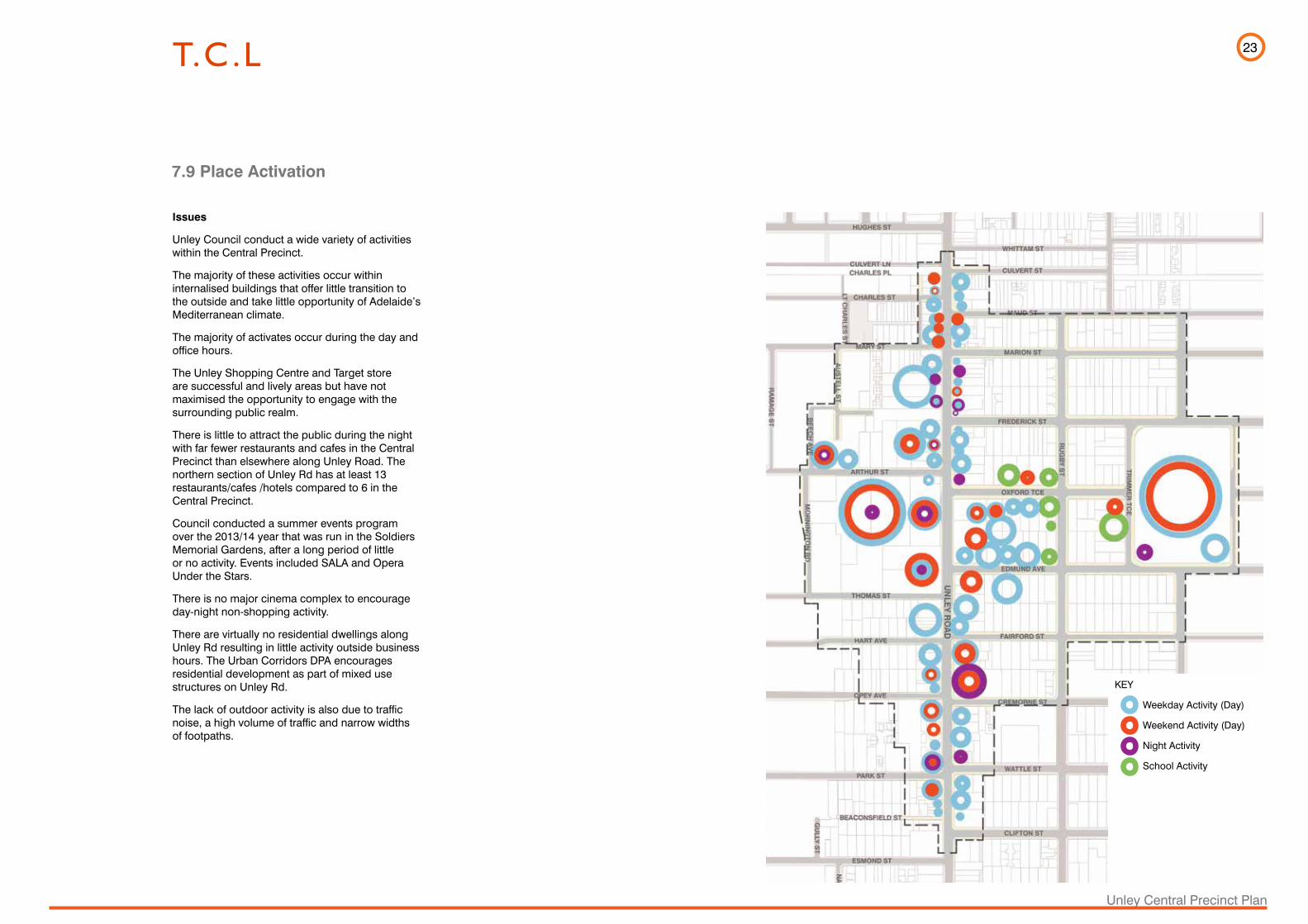
Unley Council conduct a wide variety of activities within the Central Precinct.
The majority of these activities occur within internalised buildings that offer little transition to the outside and take little opportunity of Adelaide’s Mediterranean climate.
The majority of activates occur during the day and office hours.
The Unley Shopping Centre and Target store are successful and lively areas but have not maximised the opportunity to engage with the surrounding public realm.
There is little to attract the public during the night with far fewer restaurants and cafes in the Central Precinct than elsewhere along Unley Road. The northern section of Unley Rd has at least 13 restaurants/cafes /hotels compared to 6 in the Central Precinct.
Council conducted a summer events program over the 2013/14 year that was run in the Soldiers Memorial Gardens, after a long period of little or no activity. Events included SALA and Opera Under the Stars.
There is no major cinema complex to encourage day-night non-shopping activity.
There are virtually no residential dwellings along Unley Rd resulting in little activity outside business hours. The Urban Corridors DPA encourages residential development as part of mixed use structures on Unley Rd.
The lack of outdoor activity is also due to traffic noise, a high volume of traffic and narrow widths of footpaths.
7.9 Place Activation
KEY
Weekday Activity (Day)
Weekend Activity (Day)
Night Activity
School Activity

24
Unley Central Precinct Plan
8.1 What Makes a Great Precinct?
8.0 URBAN DESIGN FRAMEWORK
Memorable precincts have common features. They are places for people and are designed with them in mind. Typically a good urban precinct features:
Lighting for people
Active street frontages and articulated faca
des
Variety of open space - big and small
Shade and trees
Generous footpaths & safe pedestrian
are
as
Human scale and community prid
e
Artworks and cultural markers
Calmed streets
An effective public transportatio
n sy
stem
Adaptive heritage reuse
Mixed use developments
S
treet furniture and amenities
Character and visual appeal for all ages
Night time activity
Range of housing types and prices
A perception of safety
Consolidated car parks

25
Unley Central Precinct Plan
Mixed Use
Public Housing
Activate Edges
Encourage Pedestrian & Cycle
Activity
Adaptive Heritage Reuse
Residential Coexists
with Mixed Use
Encourage Street Activity
Permeable Pedestrian
Laneways & Connections
Central Hub
Connect
Quieten
Pocket Park
Redevelop and Activate
Memorial Gardens
Unley
Ro
ad
Precinct Entry
The Vision for the Unley Central Precinct is to create an integrated, sustainable and highly liveable and economically viable urban centre. A precinct that has well serviced retail and other commercial & community facilities, activated streets, quality residential offerings and spaces offering a vibrant and safe environment.
The following Guiding Principles will drive the development of the Central Precinct:
1. Create a pedestrian dominant precinct
-Establish a pedestrian friendly environment with a permeable street network that is well- connected to surrounding activities and building types.
-Provide a diversity of pedestrian connections with inviting plazas, streets, laneways and walkways.
2. Create high quality, socially engaging, human scale public realm with activated and connected edges
-Create a hierarchy of urban open places that respond to diverse needs, contexts and activities. Program these spaces to respond to a variety of needs and the time of year.
-Provide a ‘lattice’ of open space and ‘pocket parks’ particularly in mixed-use developments and along Unley Road.
3. Create vibrant high quality, medium to high density mixed use / mixed age developments
-Provide a balance of contemporary uses that establish mixed use residential, commercial and employment precincts.
-Establish a subdivision-block plan layout to maximise permeability
-Provide a hierarchy of activities throughout the precinct, particularly at street level to create a legible and interesting urban environment.
-Encourage ‘age in place’ by providing age appropriate residential development and community facilities.
8.2 Guiding Principles
4. Create high quality and enlivened streetscapes that connect to adjacent activities and uses
-Buildings should create ‘human scaled’ streetscapes with modulated and vibrant active frontages and elements such as canopies and verandas with well-designed development above.
- Architectural expression should be contemporary and befitting Unley’s character without mimicking historic building types.
-Provide weather protection along frontages.
5. Integrate sustainability principles into urban design
- Promote renewable energy and minimise resource use.
-Create productive landscapes.
-Address the impact of development on the existing stormwater system.
-Adopt ecological processes and systems with an urban, rather than suburban character.
6. Prioritise active public transport and alternatives to cars
- Provide a direct, well connected and clearly articulated cycling network.
- Encourage the use of public transport and create well-designed urbane stops and shelters.
- Encourage the investigation of a future tram system.
7. Calm traffic
Calm Unley Rd to allow for greater and safer connection east-west.
-Narrow roads, reduce speed limits, treat roadways with surfaces and other elements that encourage a reduction of speed and remove cars where appropriate to maximise quality of the pedestrian and cycling experience.
Human scale and community prid
e
26
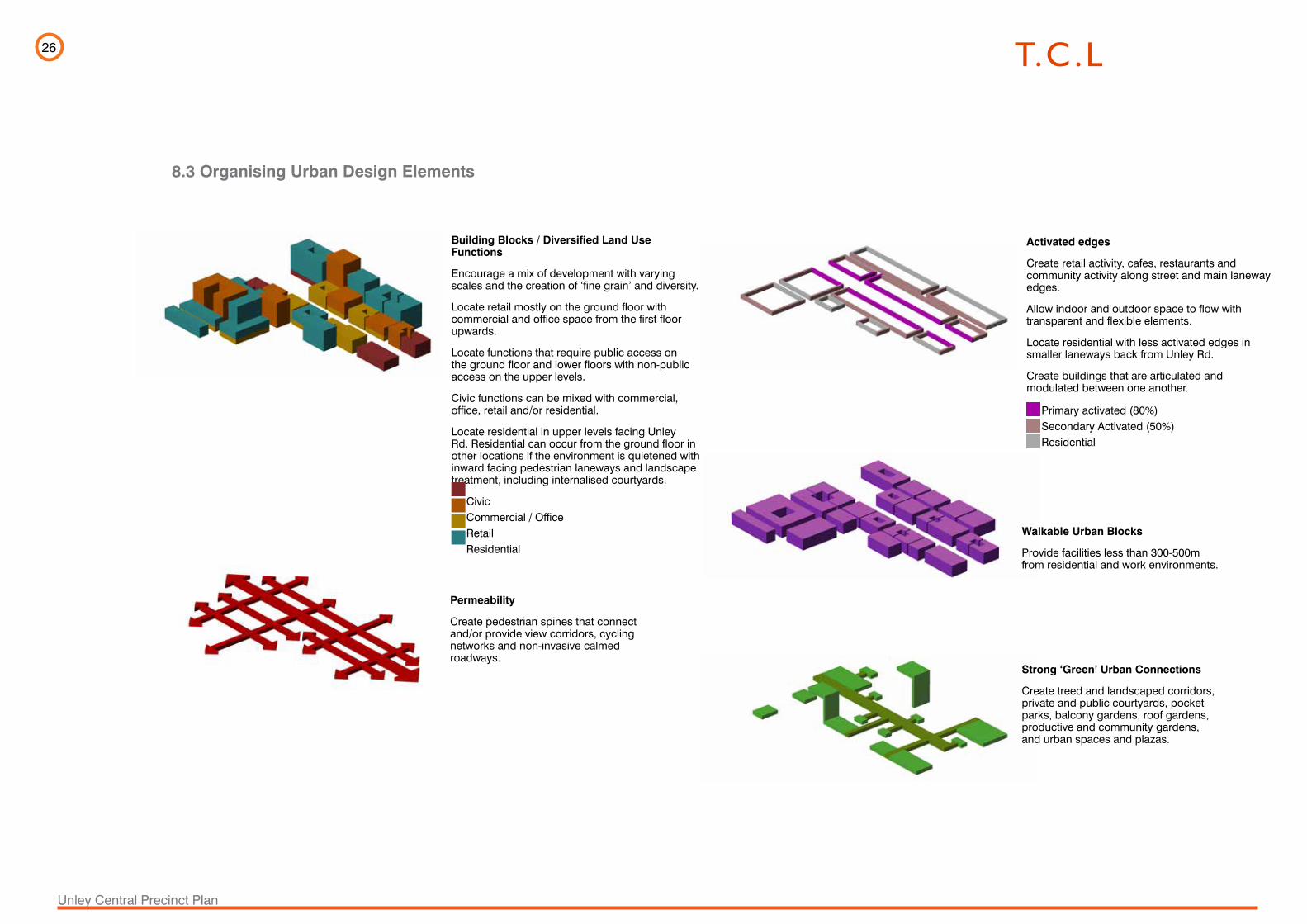
Unley Central Precinct Plan
Building Blocks / Diversified Land Use Functions
Encourage a mix of development with varying scales and the creation of ‘fine grain’ and diversity.
Locate retail mostly on the ground floor with commercial and office space from the first floor upwards.
Locate functions that require public access on the ground floor and lower floors with non-public access on the upper levels.
Civic functions can be mixed with commercial, office, retail and/or residential.
Locate residential in upper levels facing Unley Rd. Residential can occur from the ground floor in other locations if the environment is quietened with inward facing pedestrian laneways and landscape treatment, including internalised courtyards.
Civic Commercial / Office Retail Residential
Permeability
Create pedestrian spines that connect and/or provide view corridors, cycling networks and non-invasive calmed roadways.
Activated edges
Create retail activity, cafes, restaurants and community activity along street and main laneway edges.
Allow indoor and outdoor space to flow with transparent and flexible elements.
Locate residential with less activated edges in smaller laneways back from Unley Rd.
Create buildings that are articulated and modulated between one another.
Primary activated (80%) Secondary Activated (50%) Residential
Walkable Urban Blocks
Provide facilities less than 300-500m from residential and work environments.
Strong ‘Green’ Urban Connections
Create treed and landscaped corridors, private and public courtyards, pocket parks, balcony gardens, roof gardens, productive and community gardens, and urban spaces and plazas.
8.3 Organising Urban Design Elements
27
Unley Central Precinct Plan
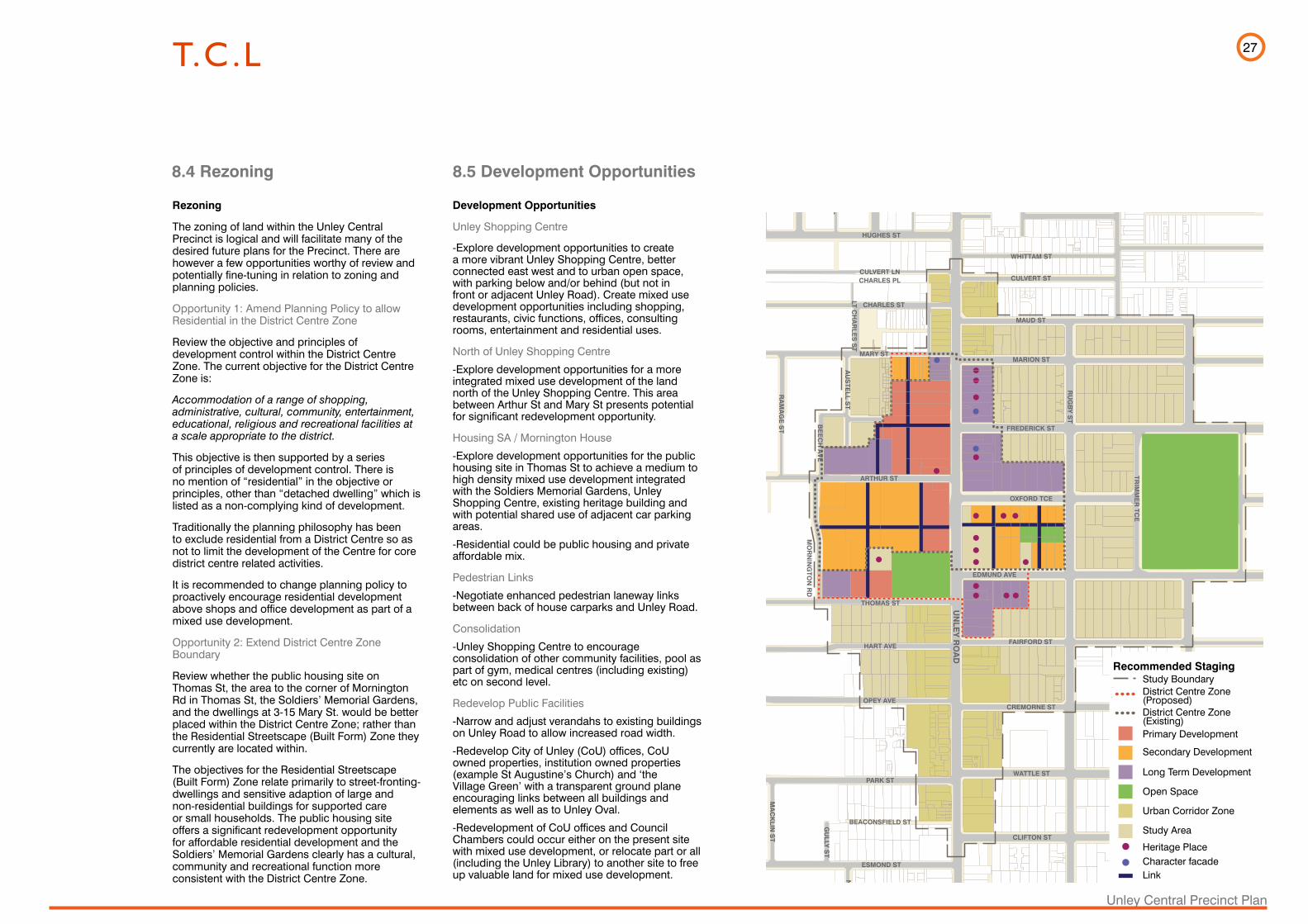
8.4 Rezoning 8.5 Development Opportunities
UN
LEY
RO
AD
RU
GB
Y S
T
DUNKS ST
WHITTAM ST
CULVERT ST
MAUD ST
MARION ST
FREDERICK ST
OXFORD TCE
EDMUND AVE
FAIRFORD ST
CREMORNE ST
WATTLE ST
CLIFTON ST
ETON ST
HUGHES ST
CULVERT LN
CHARLES ST
MARY ST
ARTHUR ST
THOMAS ST
HART AVE
OPEY AVE
PARK ST
BEACONSFIELD ST
ESMOND ST
FASHODA ST
MO
RN
ING
TON
RD
AU
STE
LL ST
BE
EC
H A
VE
RA
MA
GE
ST
AS
H A
VE
OA
K A
VE
MIZ
PA
H A
VE
BA
RR
OW
ST
BO
OTH
BY
CT
CA
ITHN
ES
S S
T
LT CH
AR
LES
ST
IRW
IN LN
SA
LISB
UR
Y S
T
PA
LME
RS
TON
ST
RO
BE
RTS
ST
PA
LME
RS
TON
PL
HU
GH
ES
PL
HUGHES LN
CHARLES PL
MA
CK
LIN S
T
EN
TER
PR
ISE
ST
GU
LLY S
T
NA
LPA
ST
CH
AR
RA
ST
TRIM
ME
R TC
E
Rezoning
The zoning of land within the Unley Central Precinct is logical and will facilitate many of the desired future plans for the Precinct. There are however a few opportunities worthy of review and potentially fine-tuning in relation to zoning and planning policies.
Opportunity 1: Amend Planning Policy to allow Residential in the District Centre Zone
Review the objective and principles of development control within the District Centre Zone. The current objective for the District Centre Zone is:
Accommodation of a range of shopping, administrative, cultural, community, entertainment, educational, religious and recreational facilities at a scale appropriate to the district.
This objective is then supported by a series of principles of development control. There is no mention of “residential” in the objective or principles, other than “detached dwelling” which is listed as a non-complying kind of development.
Traditionally the planning philosophy has been to exclude residential from a District Centre so as not to limit the development of the Centre for core district centre related activities.
It is recommended to change planning policy to proactively encourage residential development above shops and office development as part of a mixed use development.
Opportunity 2: Extend District Centre Zone Boundary
Review whether the public housing site on Thomas St, the area to the corner of Mornington Rd in Thomas St, the Soldiers’ Memorial Gardens, and the dwellings at 3-15 Mary St. would be better placed within the District Centre Zone; rather than the Residential Streetscape (Built Form) Zone they currently are located within.
The objectives for the Residential Streetscape (Built Form) Zone relate primarily to street-fronting-dwellings and sensitive adaption of large and non-residential buildings for supported care or small households. The public housing site offers a significant redevelopment opportunity for affordable residential development and the Soldiers’ Memorial Gardens clearly has a cultural, community and recreational function more consistent with the District Centre Zone.
Development Opportunities
Unley Shopping Centre
-Explore development opportunities to create a more vibrant Unley Shopping Centre, better connected east west and to urban open space, with parking below and/or behind (but not in front or adjacent Unley Road). Create mixed use development opportunities including shopping, restaurants, civic functions, offices, consulting rooms, entertainment and residential uses.
North of Unley Shopping Centre
-Explore development opportunities for a more integrated mixed use development of the land north of the Unley Shopping Centre. This area between Arthur St and Mary St presents potential for significant redevelopment opportunity.
Housing SA / Mornington House
-Explore development opportunities for the public housing site in Thomas St to achieve a medium to high density mixed use development integrated with the Soldiers Memorial Gardens, Unley Shopping Centre, existing heritage building and with potential shared use of adjacent car parking areas.
-Residential could be public housing and private affordable mix.
Pedestrian Links
-Negotiate enhanced pedestrian laneway links between back of house carparks and Unley Road.
Consolidation
-Unley Shopping Centre to encourage consolidation of other community facilities, pool as part of gym, medical centres (including existing)etc on second level.
Redevelop Public Facilities
-Narrow and adjust verandahs to existing buildings on Unley Road to allow increased road width.
-Redevelop City of Unley (CoU) offices, CoU owned properties, institution owned properties (example St Augustine’s Church) and ‘the Village Green’ with a transparent ground plane encouraging links between all buildings and elements as well as to Unley Oval.
-Redevelopment of CoU offices and Council Chambers could occur either on the present site with mixed use development, or relocate part or all (including the Unley Library) to another site to free up valuable land for mixed use development.
Recommended Staging
UNLEY ROAD
RUGBY ST
DU
NK
S S
T
WH
ITTA
M S
T
CU
LVE
RT
ST
MA
UD
ST
MA
RIO
N S
T
FRE
DE
RIC
K S
T
OX
FOR
D T
CE
ED
MU
ND
AV
E FAIR
FOR
D S
T
CR
EM
OR
NE
ST
WA
TTL
E S
T
CLI
FTO
N S
T
ETO
N S
T
HU
GH
ES
ST
CU
LVE
RT
LN
CH
AR
LES
ST
MA
RY
ST
AR
THU
R S
T
THO
MA
S S
T
HA
RT
AV
E
OP
EY
AV
E
PA
RK
ST
BE
AC
ON
SFI
ELD
ST
ES
MO
ND
ST
FAS
HO
DA
ST
MORNINGTON RD
AUSTELL ST
BEECH AVE
RAMAGE ST
ASH AVE
OAK AVE
MIZPAH AVEBARROW ST
BOOTHBY CT
CAITHNESS ST
LT CHARLES ST
IRWIN LN
SALISBURY ST
PALMERSTON ST
ROBERTS ST
PALMERSTON PL
HUGHES PL
HU
GH
ES
LN
CH
AR
LES
PL
MACKLIN ST
ENTERPRISE ST
GULLY ST
NALPA ST
CHARRA ST
TRIMMER TCE
Study BoundaryDistrict Centre Zone (Proposed)District Centre Zone(Existing)Primary Development
Secondary Development
Long Term Development
Open Space
Urban Corridor Zone
Study Area
Heritage PlaceCharacter facadeLink
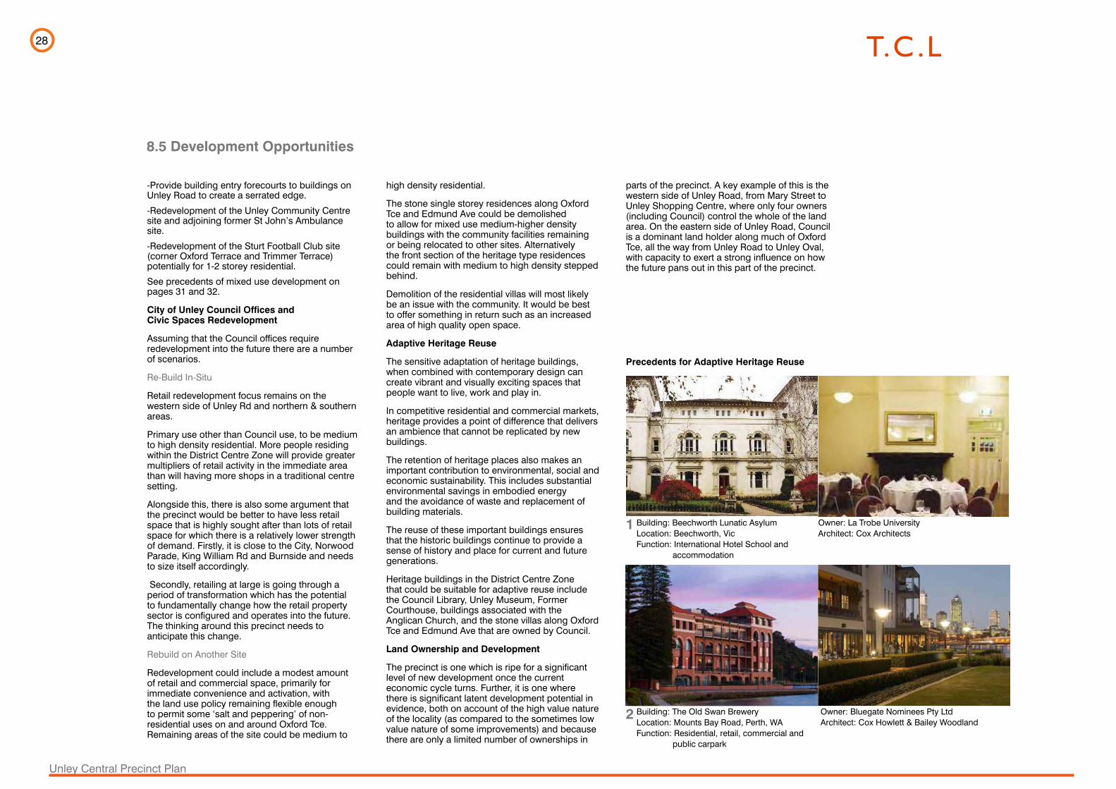
28
Unley Central Precinct Plan
VIC Case StudyBuilding: Beechworth Lunatic Asylum, May Day Hills HospitalLocation: Beechworth VICFunction: International Hotel School and accommodationOwner: La Trobe UniversityArchitect: Cox Architects (formerly Cox Sanderson)
May Day Hills Hospital/ La Trobe University Campus
The conversion of a disused hospital for the mentally ill into a university campus has saved an important heritage site and provided space for specialist international hospitality training.
Once known as the Beechworth Lunatic Asylum, May Day Hills Hospital was built between 1864 and 1867 and used in caring for the mentally ill until its closure in 1992. The institution comprised 54 buildings on 106 hectares of land, 11 hectares of which are gardens of signifi cance, all in a park-like setting at the top end of Albert Road, Beechworth. The early buildings are thought to be the design of the Public Works Department architect JJ Clark, who also designed the Victorian Treasury Building.
While the complex held historical signifi cance to the state, the need for its original purpose diminished over time.
Much work was needed before La Trobe University could reuse the buildings. The team working on the project removed ailing trees, re-established services and carried out extensive sympathetic alterations for adaptive reuse as the University’s professional development and conference venue.
Today, around half of the buildings in the complex are still in use, albeit for quite different purposes. A major feature of the campus is the International Hotel School, where students study the fi ner points of the hospitality industry. La Trobe at Beechworth also provides accommodation to visitors both domestic and international.
The hospital has gained a new lease of life as it adapted to the changing needs of society.
12
8.5 Development Opportunities
1
2
-Provide building entry forecourts to buildings on Unley Road to create a serrated edge.
-Redevelopment of the Unley Community Centre site and adjoining former St John’s Ambulance site.
-Redevelopment of the Sturt Football Club site (corner Oxford Terrace and Trimmer Terrace) potentially for 1-2 storey residential.
See precedents of mixed use development on pages 31 and 32.
City of Unley Council Offices and Civic Spaces Redevelopment
Assuming that the Council offices require redevelopment into the future there are a number of scenarios.
Re-Build In-Situ
Retail redevelopment focus remains on the western side of Unley Rd and northern & southern areas.
Primary use other than Council use, to be medium to high density residential. More people residing within the District Centre Zone will provide greater multipliers of retail activity in the immediate area than will having more shops in a traditional centre setting.
Alongside this, there is also some argument that the precinct would be better to have less retail space that is highly sought after than lots of retail space for which there is a relatively lower strength of demand. Firstly, it is close to the City, Norwood Parade, King William Rd and Burnside and needs to size itself accordingly.
Secondly, retailing at large is going through a period of transformation which has the potential to fundamentally change how the retail property sector is configured and operates into the future. The thinking around this precinct needs to anticipate this change.
Rebuild on Another Site
Redevelopment could include a modest amount of retail and commercial space, primarily for immediate convenience and activation, with the land use policy remaining flexible enough to permit some ‘salt and peppering’ of non-residential uses on and around Oxford Tce. Remaining areas of the site could be medium to
Building: Beechworth Lunatic AsylumLocation: Beechworth, VicFunction: International Hotel School and accommodation
Precedents for Adaptive Heritage Reuse
Building: The Old Swan Brewery Location: Mounts Bay Road, Perth, WAFunction: Residential, retail, commercial and public carpark
Owner: La Trobe UniversityArchitect: Cox Architects
Owner: Bluegate Nominees Pty LtdArchitect: Cox Howlett & Bailey Woodland
high density residential.
The stone single storey residences along Oxford Tce and Edmund Ave could be demolished to allow for mixed use medium-higher density buildings with the community facilities remaining or being relocated to other sites. Alternatively the front section of the heritage type residences could remain with medium to high density stepped behind.
Demolition of the residential villas will most likely be an issue with the community. It would be best to offer something in return such as an increased area of high quality open space.
Adaptive Heritage Reuse
The sensitive adaptation of heritage buildings, when combined with contemporary design can create vibrant and visually exciting spaces that people want to live, work and play in.
In competitive residential and commercial markets, heritage provides a point of difference that delivers an ambience that cannot be replicated by new buildings.
The retention of heritage places also makes an important contribution to environmental, social and economic sustainability. This includes substantial environmental savings in embodied energy and the avoidance of waste and replacement of building materials.
The reuse of these important buildings ensures that the historic buildings continue to provide a sense of history and place for current and future generations.
Heritage buildings in the District Centre Zone that could be suitable for adaptive reuse include the Council Library, Unley Museum, Former Courthouse, buildings associated with the Anglican Church, and the stone villas along Oxford Tce and Edmund Ave that are owned by Council.
Land Ownership and Development
The precinct is one which is ripe for a significant level of new development once the current economic cycle turns. Further, it is one where there is significant latent development potential in evidence, both on account of the high value nature of the locality (as compared to the sometimes low value nature of some improvements) and because there are only a limited number of ownerships in
parts of the precinct. A key example of this is the western side of Unley Road, from Mary Street to Unley Shopping Centre, where only four owners (including Council) control the whole of the land area. On the eastern side of Unley Road, Council is a dominant land holder along much of Oxford Tce, all the way from Unley Road to Unley Oval, with capacity to exert a strong influence on how the future pans out in this part of the precinct.
VIC Case StudyBuilding: Beechworth Lunatic Asylum, May Day Hills HospitalLocation: Beechworth VICFunction: International Hotel School and accommodationOwner: La Trobe UniversityArchitect: Cox Architects (formerly Cox Sanderson)
May Day Hills Hospital/ La Trobe University Campus
The conversion of a disused hospital for the mentally ill into a university campus has saved an important heritage site and provided space for specialist international hospitality training.
Once known as the Beechworth Lunatic Asylum, May Day Hills Hospital was built between 1864 and 1867 and used in caring for the mentally ill until its closure in 1992. The institution comprised 54 buildings on 106 hectares of land, 11 hectares of which are gardens of signifi cance, all in a park-like setting at the top end of Albert Road, Beechworth. The early buildings are thought to be the design of the Public Works Department architect JJ Clark, who also designed the Victorian Treasury Building.
While the complex held historical signifi cance to the state, the need for its original purpose diminished over time.
Much work was needed before La Trobe University could reuse the buildings. The team working on the project removed ailing trees, re-established services and carried out extensive sympathetic alterations for adaptive reuse as the University’s professional development and conference venue.
Today, around half of the buildings in the complex are still in use, albeit for quite different purposes. A major feature of the campus is the International Hotel School, where students study the fi ner points of the hospitality industry. La Trobe at Beechworth also provides accommodation to visitors both domestic and international.
The hospital has gained a new lease of life as it adapted to the changing needs of society.
12

29
Unley Central Precinct Plan
8.6 Potential Built Heights
UN
LEY
RO
AD
RU
GB
Y S
T
DUNKS ST
WHITTAM ST
CULVERT ST
MAUD ST
MARION ST
FREDERICK ST
OXFORD TCE
EDMUND AVE
FAIRFORD ST
CREMORNE ST
WATTLE ST
CLIFTON ST
ETON ST
HUGHES ST
CULVERT LN
CHARLES ST
MARY ST
ARTHUR ST
THOMAS ST
HART AVE
OPEY AVE
PARK ST
BEACONSFIELD ST
ESMOND ST
FASHODA ST
MO
RN
ING
TON
RD
AU
STE
LL ST
BE
EC
H A
VE
RA
MA
GE
ST
AS
H A
VE
OA
K A
VE
MIZ
PA
H A
VE
BA
RR
OW
ST
BO
OTH
BY
CT
CA
ITHN
ES
S S
T
LT CH
AR
LES
ST
IRW
IN LN
SA
LISB
UR
Y S
T
PA
LME
RS
TON
ST
RO
BE
RTS
ST
PA
LME
RS
TON
PL
HU
GH
ES
PL
HUGHES LN
CHARLES PL
MA
CK
LIN S
T
EN
TER
PR
ISE
ST
GU
LLY S
T
NA
LPA
ST
CH
AR
RA
ST
TRIM
ME
R TC
E
The proposed ultimate buildings heights have been suggested in line with the current Development Plan guidelines.
A tiered approach to built form should be adopted both along the Urban Corridor and within the District Centre Zone.
Potential future development needs to be mindful of adjacent residential zones and heritage places.
Within the Unley Rd portion, the Urban Corridor Zone building height can range from two storeys up to five storeys.
The built form must provide a transition in scale and form at the zone boundary to maintain the amenity of adjoining residential zones.
Built form must take into account the potential issues of overshadowing and privacy for adjacent residential properties. Building designs should take these issues into consideration and minimise adverse impacts on adjoining residential zones.
Within the District Centre Zone, building development may potentially range from two storeys to seven storeys and above in some instances. Where building heights are considerable, a tiered approach to building design should be adopted with lower built from around the perimeter of the zone, stepping up to higher built form towards the centre. The scale and form of development should be considerate of neighbouring properties, particularly heritage places.
UNLEY ROAD
RUGBY ST
DU
NK
S S
T
WH
ITTA
M S
T
CU
LVE
RT
ST
MA
UD
ST
MA
RIO
N S
T
FRE
DE
RIC
K S
T
OX
FOR
D T
CE
ED
MU
ND
AV
E FAIR
FOR
D S
T
CR
EM
OR
NE
ST
WA
TTL
E S
T
CLI
FTO
N S
T
ETO
N S
T
HU
GH
ES
ST
CU
LVE
RT
LN
CH
AR
LES
ST
MA
RY
ST
AR
THU
R S
T
THO
MA
S S
T
HA
RT
AV
E
OP
EY
AV
E
PA
RK
ST
BE
AC
ON
SFI
ELD
ST
ES
MO
ND
ST
FAS
HO
DA
ST
MORNINGTON RD
AUSTELL ST
BEECH AVE
RAMAGE ST
ASH AVE
OAK AVE
MIZPAH AVEBARROW ST
BOOTHBY CT
CAITHNESS ST
LT CHARLES ST
IRWIN LN
SALISBURY ST
PALMERSTON ST
ROBERTS ST
PALMERSTON PL
HUGHES PL
HU
GH
ES
LN
CH
AR
LES
PL
MACKLIN ST
ENTERPRISE ST
GULLY ST
NALPA ST
CHARRA ST
TRIMMER TCE
Recommended StagingStudy BoundaryDistrict Centre Zone (Proposed)District Centre Zone(Existing)Up to 7-11 Storey
Up to 5 Storey
Up to 3 Storey
Open Space
Urban Corridor Zone
Study Area
Building interface (30 degree)Link
UNLEY ROAD
RUGBY ST
DU
NK
S S
T
WH
ITTA
M S
T
CU
LVE
RT
ST
MA
UD
ST
MA
RIO
N S
T
FRE
DE
RIC
K S
T
OX
FOR
D T
CE
ED
MU
ND
AV
E FAIR
FOR
D S
T
CR
EM
OR
NE
ST
WA
TTL
E S
T
CLI
FTO
N S
T
ETO
N S
T
HU
GH
ES
ST
CU
LVE
RT
LN
CH
AR
LES
ST
MA
RY
ST
AR
THU
R S
T
THO
MA
S S
T
HA
RT
AV
E
OP
EY
AV
E
PA
RK
ST
BE
AC
ON
SFI
ELD
ST
ES
MO
ND
ST
FAS
HO
DA
ST
MORNINGTON RD
AUSTELL ST
BEECH AVE
RAMAGE ST
ASH AVE
OAK AVE
MIZPAH AVEBARROW ST
BOOTHBY CT
CAITHNESS ST
LT CHARLES ST
IRWIN LN
SALISBURY ST
PALMERSTON ST
ROBERTS ST
PALMERSTON PL
HUGHES PL
HU
GH
ES
LN
CH
AR
LES
PL
MACKLIN ST
ENTERPRISE ST
GULLY ST
NALPA ST
CHARRA ST
TRIMMER TCE

30
Unley Central Precinct Plan
8.7 Mixed Use Development
The following precedent examples indicate types of mixed use development that would be suitable in the Unley Central Precinct.
Balgowlah Village, Balgowlah, N.S.W.
The award winning Balgowlah Village is a redevelopment of the former Totem Shopping Centre. It is a mixed use development in the City of Manly comprising a shopping centre of 16,000m2, including Coles, a basement carpark with a central plaza, flanked by retail and commercial businesses and 234 residential apartments ranging from 2 – 8 storeys. Other facilities include a Masonic club and gym.
Kelvin Grove Urban Village, Brisbane , QLD.
A mixed use precinct 3 kms from the CBD of Brisbane. The precinct includes the Queensland University of Technology, The La Boite Theatre (Brisbane’s 2nd largest theatre), retail shops at ground floor including Woolworths and student apartments. The urban village embodies best practice environmental sustainability ratings.
The site is 7,067m2, 213 apartments with one car space per dwelling , public transport within 360m and building heights between 6 and 8 storeys.
The Village - Balgowlah, NSW
Kelvin Grove Urban Village, Brisbane, QLD

31
Unley Central Precinct Plan
Rouse Hill Town Centre, NSW
St Margarets Development - Surry Hills, NSW
Rouse Hill Town Centre, Windsor Rd, Rouse Hill, N.S.W.
A recently developed town centre in the hills district on the outskirts of Sydney. The award winning mixed use centre consists of a range of residential apartments, a town centre square and internal spaces for residents, a range of commercial and retail businesses and a library.
The Town Centre site is 100,000m2 with parking for 3,000 cars and a total retail area of 72,716 m2. Height range is 2 – 8 storeys.
St Margaret’s ‘Urban Village’ Development , Surry Hill, N.S.W.
Located in inner Sydney on a former hospital site. Completed in 2002 a mixed use development with and open public space of 15,000m2 at ground level with 214 apartments, retail including cafes, restaurants, boutiques, a government funded gallery and other commercial businesses. Heights of buildings are up to 11 storeys.
The architectural heritage of the former public hospital and the chapel have been retained and reused, and the three new buildings enliven the space with playful architectural forms by SJB Architects. The original street network of Surry Hills has been re-established and has re-joined the site to the suburb which includes cycle paths.
The development served as a catalyst for urban regeneration of Bourke St.
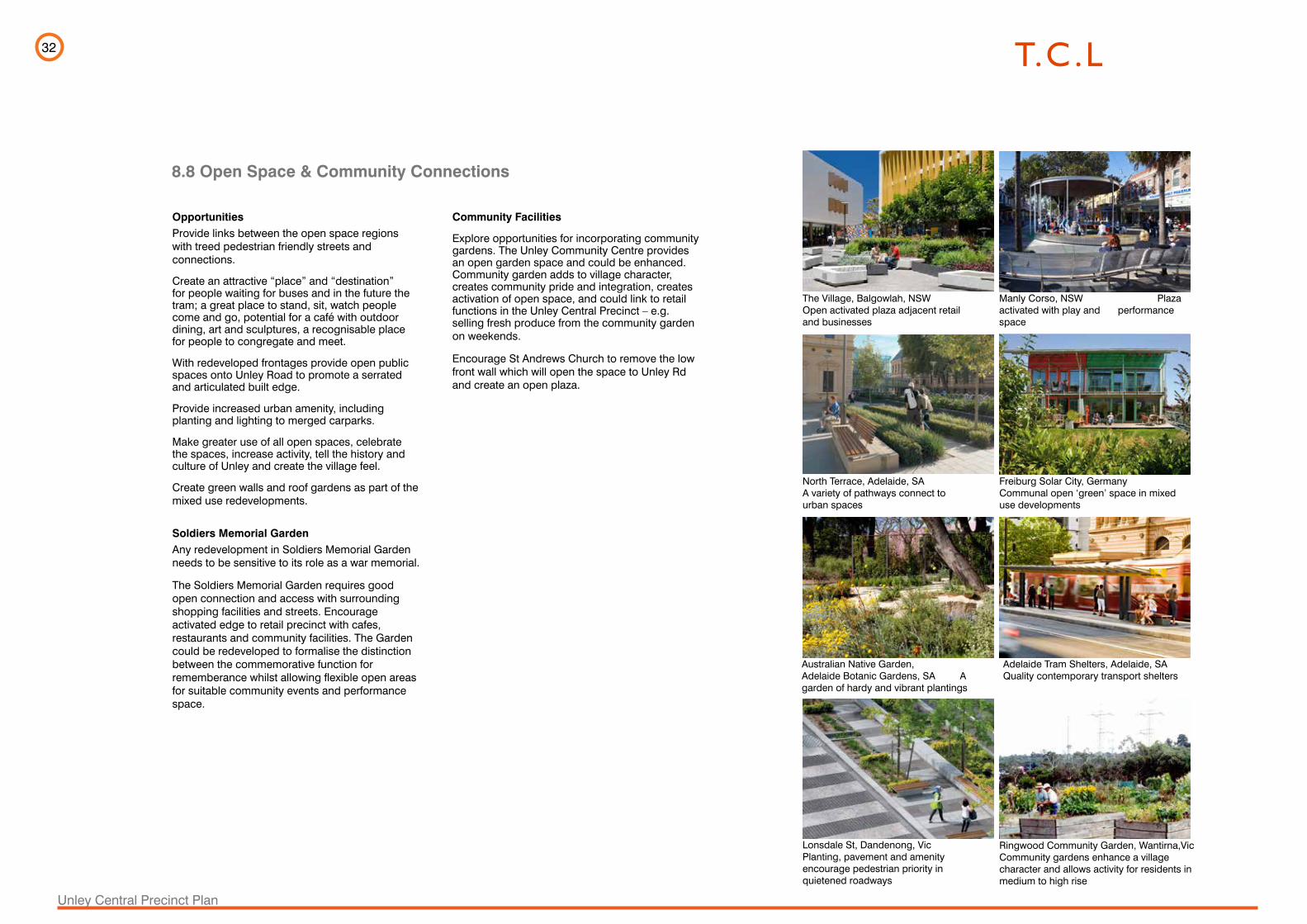
32
Unley Central Precinct Plan
8.8 Open Space & Community Connections
OpportunitiesProvide links between the open space regions with treed pedestrian friendly streets and connections.
Create an attractive “place” and “destination” for people waiting for buses and in the future the tram; a great place to stand, sit, watch people come and go, potential for a café with outdoor dining, art and sculptures, a recognisable place for people to congregate and meet.
With redeveloped frontages provide open public spaces onto Unley Road to promote a serrated and articulated built edge.
Provide increased urban amenity, including planting and lighting to merged carparks.
Make greater use of all open spaces, celebrate the spaces, increase activity, tell the history and culture of Unley and create the village feel.
Create green walls and roof gardens as part of the mixed use redevelopments.
Soldiers Memorial Garden Any redevelopment in Soldiers Memorial Garden needs to be sensitive to its role as a war memorial.
The Soldiers Memorial Garden requires good open connection and access with surrounding shopping facilities and streets. Encourage activated edge to retail precinct with cafes, restaurants and community facilities. The Garden could be redeveloped to formalise the distinction between the commemorative function for rememberance whilst allowing flexible open areas for suitable community events and performance space.
Community Facilities
Explore opportunities for incorporating community gardens. The Unley Community Centre provides an open garden space and could be enhanced. Community garden adds to village character, creates community pride and integration, creates activation of open space, and could link to retail functions in the Unley Central Precinct – e.g. selling fresh produce from the community garden on weekends.
Encourage St Andrews Church to remove the low front wall which will open the space to Unley Rd and create an open plaza.
The Village, Balgowlah, NSW Open activated plaza adjacent retail and businesses
North Terrace, Adelaide, SA A variety of pathways connect to urban spaces
Manly Corso, NSW Plaza activated with play and performance space
Ringwood Community Garden, Wantirna,Vic Community gardens enhance a village character and allows activity for residents in medium to high rise
Australian Native Garden, Adelaide Botanic Gardens, SA A garden of hardy and vibrant plantings
Freiburg Solar City, Germany Communal open ‘green’ space in mixed use developments
Adelaide Tram Shelters, Adelaide, SA Quality contemporary transport shelters
Lonsdale St, Dandenong, Vic Planting, pavement and amenity encourage pedestrian priority in quietened roadways
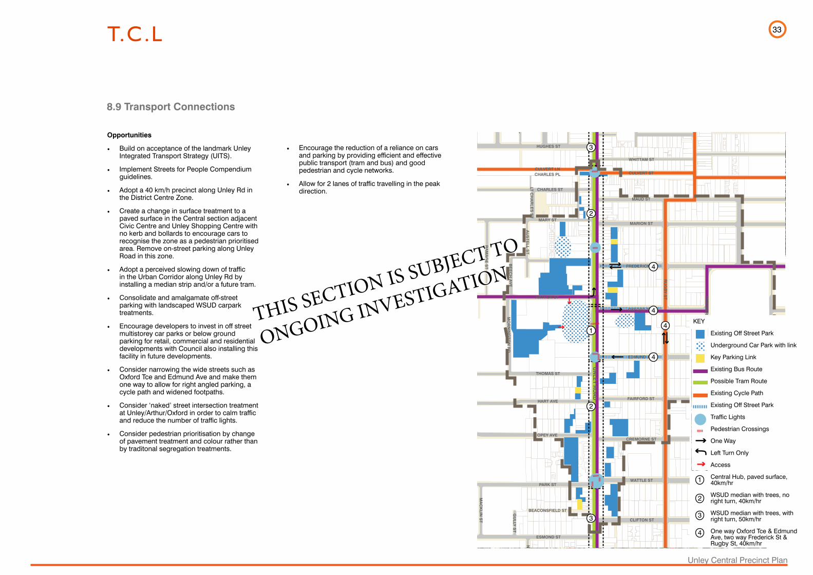
33
Unley Central Precinct Plan
• Encourage the reduction of a reliance on cars and parking by providing efficient and effective public transport (tram and bus) and good pedestrian and cycle networks.
• Allow for 2 lanes of traffic travelling in the peak direction.
8.9 Transport Connections
UN
LEY
RO
AD
RU
GB
Y S
T
DUNKS ST
WHITTAM ST
CULVERT ST
MAUD ST
MARION ST
FREDERICK ST
OXFORD TCE
EDMUND AVE
FAIRFORD ST
CREMORNE ST
WATTLE ST
CLIFTON ST
ETON ST
HUGHES ST
CULVERT LN
CHARLES ST
MARY ST
ARTHUR ST
THOMAS ST
HART AVE
OPEY AVE
PARK ST
BEACONSFIELD ST
ESMOND ST
FASHODA ST
MO
RN
ING
TON
RD
AU
STE
LL ST
BE
EC
H A
VE
RA
MA
GE
ST
AS
H A
VE
OA
K A
VE
MIZ
PA
H A
VE
BA
RR
OW
ST
BO
OTH
BY
CT
CA
ITHN
ES
S S
T
LT CH
AR
LES
ST
IRW
IN LN
SA
LISB
UR
Y S
T
PA
LME
RS
TON
ST
RO
BE
RTS
ST
PA
LME
RS
TON
PL
HU
GH
ES
PL
HUGHES LN
CHARLES PL
MA
CK
LIN S
T
EN
TER
PR
ISE
ST
GU
LLY S
T
NA
LPA
ST
CH
AR
RA
ST
TRIM
ME
R TC
E
Opportunities
• Build on acceptance of the landmark Unley Integrated Transport Strategy (UITS).
• Implement Streets for People Compendium guidelines.
• Adopt a 40 km/h precinct along Unley Rd in the District Centre Zone.
• Create a change in surface treatment to a paved surface in the Central section adjacent Civic Centre and Unley Shopping Centre with no kerb and bollards to encourage cars to recognise the zone as a pedestrian prioritised area. Remove on-street parking along Unley Road in this zone.
• Adopt a perceived slowing down of traffic in the Urban Corridor along Unley Rd by installing a median strip and/or a future tram.
• Consolidate and amalgamate off-street parking with landscaped WSUD carpark treatments.
• Encourage developers to invest in off street multistorey car parks or below ground parking for retail, commercial and residential developments with Council also installing this facility in future developments.
• Consider narrowing the wide streets such as Oxford Tce and Edmund Ave and make them one way to allow for right angled parking, a cycle path and widened footpaths.
• Consider ‘naked’ street intersection treatment at Unley/Arthur/Oxford in order to calm traffic and reduce the number of traffic lights.
• Consider pedestrian prioritisation by change of pavement treatment and colour rather than by traditonal segregation treatments.
KEY
Existing Off Street Park
Underground Car Park with link
Key Parking Link
Existing Bus Route
Possible Tram Route
Existing Cycle Path
Existing Off Street Park
Traffic Lights
Pedestrian Crossings
One Way
Left Turn Only
Access
Central Hub, paved surface, 40km/hr
WSUD median with trees, no right turn, 40km/hr
WSUD median with trees, with right turn, 50km/hr
One way Oxford Tce & Edmund Ave, two way Frederick St & Rugby St, 40km/hr
UNLEY ROAD
RUGBY ST
DU
NK
S S
T
WH
ITTA
M S
T
CU
LVE
RT
ST
MA
UD
ST
MA
RIO
N S
T
FRE
DE
RIC
K S
T
OX
FOR
D T
CE
ED
MU
ND
AV
E
FAIR
FOR
D S
T
CR
EM
OR
NE
ST
WA
TTL
E S
T
CLI
FTO
N S
T
ETO
N S
T
HU
GH
ES
ST
CU
LVE
RT
LN
CH
AR
LES
ST
MA
RY
ST
AR
THU
R S
T
THO
MA
S S
T
HA
RT
AV
E
OP
EY
AV
E
PA
RK
ST
BE
AC
ON
SFI
ELD
ST
ES
MO
ND
ST
FAS
HO
DA
ST
MORNINGTON RD
AUSTELL ST
BEECH AVE
RAMAGE ST
ASH AVE
OAK AVE
MIZPAH AVEBARROW ST
BOOTHBY CT
CAITHNESS ST
LT CHARLES ST
IRWIN LN
SALISBURY ST
PALMERSTON ST
ROBERTS ST
PALMERSTON PL
HUGHES PL
HU
GH
ES
LN
CH
AR
LES
PL
MACKLIN ST
ENTERPRISE ST
GULLY ST
NALPA ST
CHARRA ST
TRIMMER TCE
1
1
2
4
4
4
4
2
2
3 3
4
3
THIS SECTION IS SUBJECT TO
ONGOING INVESTIGATION

34
Unley Central Precinct Plan
Poynton UK - ‘Naked’ Intersection and Informal Roundabout. Different pavement treatments indicates roundabouts, street edges and pedestrian crossings.
Bank Street, Adelaide, SA - A shared one way street with bike lane, parklets and road graphic. These elements calm traffic and are suitable for low volume local streets.
New Road, Brighton UK - Shared with little traffic. Pavement, lack of kerb and associated furniture encourage calmed traffic
Albert Street, Brisbane - Artistic car park facade Bowden Urban Village, SA - Central planting, surface treatments and water sensitive urban design encourage quieter shared roadways.
8.10 Traffic Calming / Shared Zone / Car Park - PrecedentsExamples of Traffic Calming:
- Pedestrian friendly where pedestrians take implied priority

35
Unley Central Precinct PlanPerspective. District Centre Zone. Looking east across Unley Rd.
8.11 Perspectives
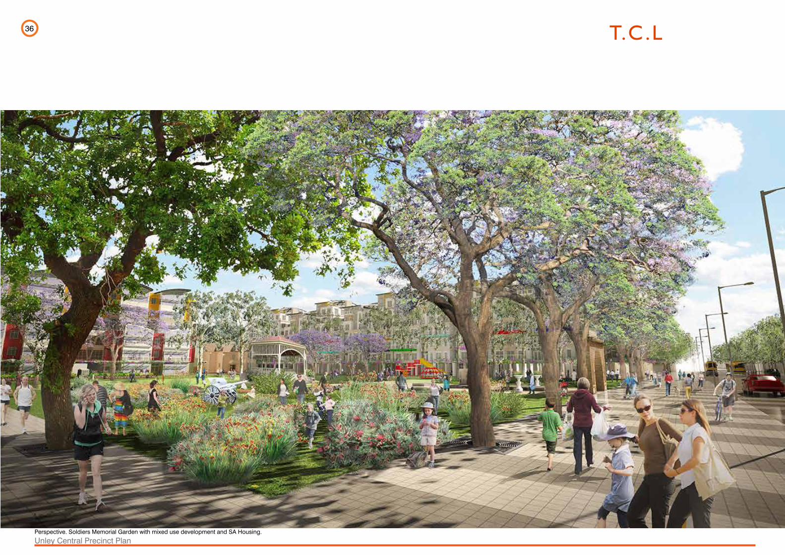
36
Unley Central Precinct PlanPerspective. Soldiers Memorial Garden with mixed use development and SA Housing.

37
Unley Central Precinct PlanPerspective. Oxford Tce looking east.
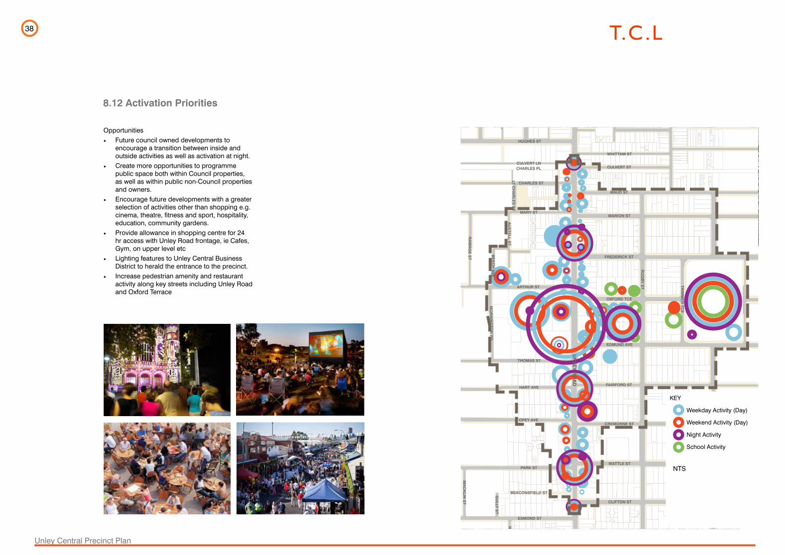
38
Unley Central Precinct Plan
8.12 Activation Priorities
UN
LEY
RO
AD
RU
GB
Y S
T
DUNKS ST
WHITTAM ST
CULVERT ST
MAUD ST
MARION ST
FREDERICK ST
OXFORD TCE
EDMUND AVE
FAIRFORD ST
CREMORNE ST
WATTLE ST
CLIFTON ST
ETON ST
HUGHES ST
CULVERT LN
CHARLES ST
MARY ST
ARTHUR ST
THOMAS ST
HART AVE
OPEY AVE
PARK ST
BEACONSFIELD ST
ESMOND ST
FASHODA ST
MO
RN
ING
TON
RD
AU
STE
LL ST
BE
EC
H A
VE
RA
MA
GE
ST
AS
H A
VE
OA
K A
VE
MIZ
PA
H A
VE
BA
RR
OW
ST
BO
OTH
BY
CT
CA
ITHN
ES
S S
T
LT CH
AR
LES
ST
IRW
IN LN
SA
LISB
UR
Y S
T
PA
LME
RS
TON
ST
RO
BE
RTS
ST
PA
LME
RS
TON
PL
HU
GH
ES
PL
HUGHES LN
CHARLES PL
MA
CK
LIN S
T
EN
TER
PR
ISE
ST
GU
LLY S
T
NA
LPA
ST
CH
AR
RA
ST
TRIM
ME
R TC
E
Opportunities• Future council owned developments to
encourage a transition between inside and outside activities as well as activation at night.
• Create more opportunities to programme public space both within Council properties, as well as within public non-Council properties and owners.
• Encourage future developments with a greater selection of activities other than shopping e.g. cinema, theatre, fitness and sport, hospitality, education, community gardens.
• Provide allowance in shopping centre for 24 hr access with Unley Road frontage, ie Cafes, Gym, on upper level etc
• Lighting features to Unley Central Business District to herald the entrance to the precinct.
• Increase pedestrian amenity and restaurant activity along key streets including Unley Road and Oxford Terrace
KEY
Weekday Activity (Day)
Weekend Activity (Day)
Night Activity
School Activity
NTS

39
Unley Central Precinct Plan
8.13 Sustainability
Any new developments in the Unley Central Precinct should embody principles of sustainable design.
This includes the following:
Flora
Retain and protect significant trees, both indigenous and introduced. If existing vegetation is to be removed, ensure future development reinstates new habitat with a mix of indigenous and hardy introduced species as per the Unley Council guidelines.
Plantings of trees and other vegetation should respect existing successful plantings and provide shade, amenity and seasonal interest.
Water Sensitive Urban Design
Adelaide has experienced severe water restrictions during drought years and any development should incorporate WSUD in order to protect against future drought and dry conditions and to reduce reliance on mains water. The design of streets and paths should include bio-retention, pervious materials where possible and stormwater management. The use of GAP water should be investigated.
Brown Hill Keswick Creek Stormwater Project is being planned to address flooding issues in the precinct and beyond.
Climate Responsive Design
Streets and pathways should be designed to respond to local climate and provide shelter from rain, wind and sun. Their design and orientation should avoid the creation of undesirable micro-climates such as overshadowing and intense heat reflection, conditions often produced from higher storey buildings.
Ensure buildings are orientated to capture desirable natural light, particularly winter sun in the living areas, while avoiding hot and uncomfortable western summer sun.
Locate and orientate private and public open spaces to allow for northerly winter sun.
Maximise opportunities for urban gardens including balconies, roof gardens, living walls, community and productive gardens and pocket parks.
Maximise natural ventilation through and across buildings by considering building, massing, materials and scale.
Buildings should achieve a high star rating of at least 4 and preferably 5.
Lonsdale St with WSUD and deciduous trees to allow for summer shade and winter sun.
Courtyard within Nova Apartments, Sydney
Roof Garden
Remnant Eucalypt tree outside UCC
Sydney University, wetland purifies water for reuse in irrigation.
SA Museum Forecourt, lawn and garden irrigated by captured and stored water
Strand Square, Mawson Lakes, pocket park with North facing housing
Community garden
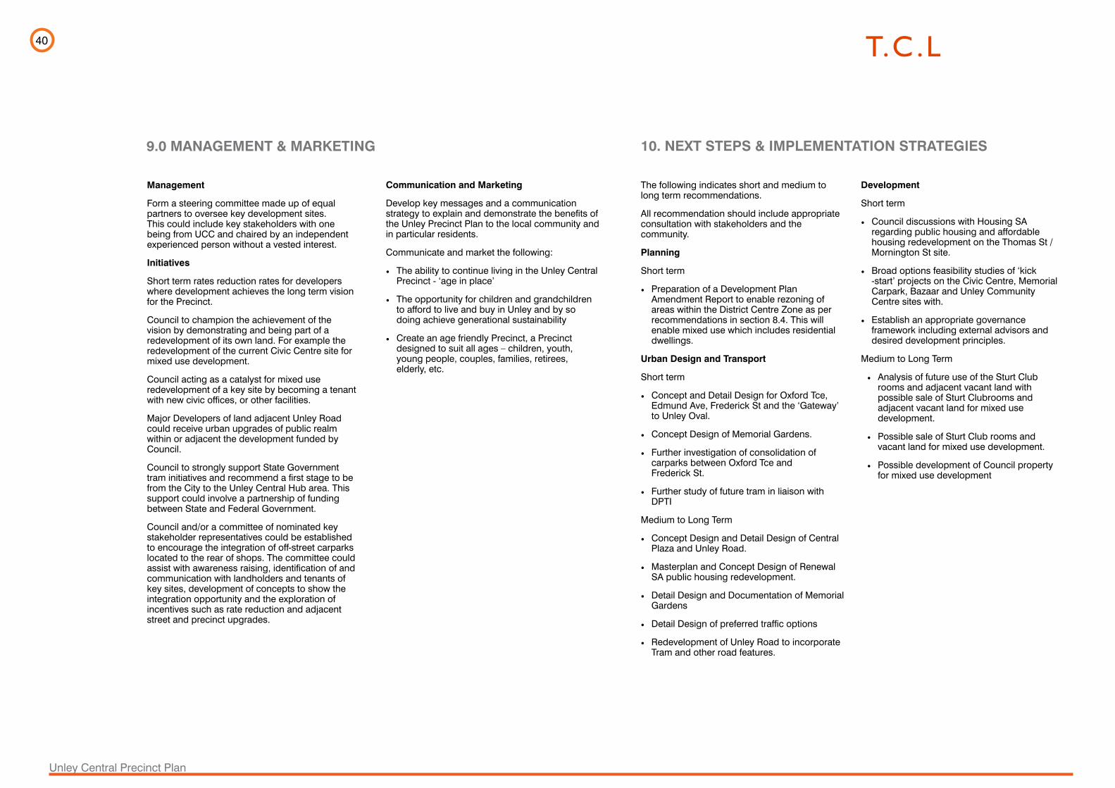
40
Unley Central Precinct Plan
9.0 MANAGEMENT & MARKETING
Management
Form a steering committee made up of equal partners to oversee key development sites. This could include key stakeholders with one being from UCC and chaired by an independent experienced person without a vested interest.
Initiatives
Short term rates reduction rates for developers where development achieves the long term vision for the Precinct.
Council to champion the achievement of the vision by demonstrating and being part of a redevelopment of its own land. For example the redevelopment of the current Civic Centre site for mixed use development.
Council acting as a catalyst for mixed use redevelopment of a key site by becoming a tenant with new civic offices, or other facilities.
Major Developers of land adjacent Unley Road could receive urban upgrades of public realm within or adjacent the development funded by Council.
Council to strongly support State Government tram initiatives and recommend a first stage to be from the City to the Unley Central Hub area. This support could involve a partnership of funding between State and Federal Government.
Council and/or a committee of nominated key stakeholder representatives could be established to encourage the integration of off-street carparks located to the rear of shops. The committee could assist with awareness raising, identification of and communication with landholders and tenants of key sites, development of concepts to show the integration opportunity and the exploration of incentives such as rate reduction and adjacent street and precinct upgrades.
The following indicates short and medium to long term recommendations.
All recommendation should include appropriate consultation with stakeholders and the community.
Planning
Short term
• Preparation of a Development Plan Amendment Report to enable rezoning of areas within the District Centre Zone as per recommendations in section 8.4. This will enable mixed use which includes residential dwellings.
Urban Design and Transport
Short term
• Concept and Detail Design for Oxford Tce, Edmund Ave, Frederick St and the ‘Gateway’ to Unley Oval.
• Concept Design of Memorial Gardens.
• Further investigation of consolidation of carparks between Oxford Tce and Frederick St.
• Further study of future tram in liaison with DPTI
Medium to Long Term
• Concept Design and Detail Design of Central Plaza and Unley Road.
• Masterplan and Concept Design of Renewal SA public housing redevelopment.
• Detail Design and Documentation of Memorial Gardens
• Detail Design of preferred traffic options
• Redevelopment of Unley Road to incorporate Tram and other road features.
Development
Short term
• Council discussions with Housing SA regarding public housing and affordable housing redevelopment on the Thomas St / Mornington St site.
• Broad options feasibility studies of ‘kick -start’ projects on the Civic Centre, Memorial Carpark, Bazaar and Unley Community Centre sites with.
• Establish an appropriate governance framework including external advisors and desired development principles.
Medium to Long Term
• Analysis of future use of the Sturt Club rooms and adjacent vacant land with possible sale of Sturt Clubrooms and adjacent vacant land for mixed use development.
• Possible sale of Sturt Club rooms and vacant land for mixed use development.
• Possible development of Council property for mixed use development
Communication and Marketing
Develop key messages and a communication strategy to explain and demonstrate the benefits of the Unley Precinct Plan to the local community and in particular residents.
Communicate and market the following:
• The ability to continue living in the Unley Central Precinct - ‘age in place’
• The opportunity for children and grandchildren to afford to live and buy in Unley and by so doing achieve generational sustainability
• Create an age friendly Precinct, a Precinct designed to suit all ages – children, youth, young people, couples, families, retirees, elderly, etc.
10. NEXT STEPS & IMPLEMENTATION STRATEGIES