update on gcoos valuation project valuation exercise (or even a few of them)? measuring the...
TRANSCRIPT

Update on GCOOS Valuation Project
Rex Caffey (PI, LSU)Matt Fannin (Co-PI, LSU)
Dan Petrolia (Co-PI, MSU)
GCOOS-RA MeetingOctober 12, 2017 - Mobile

The Economic Benefits of the Gulf of Mexico Coastal Ocean Observing System (GCOOS)
Cooperative Agreement M13AC00014 between BOEM and the Coastal Marine Institute at LSU
Period of performance: Sept 2013 – Feb 2018MSU subaward

Valuation Strategy BOEM Cooperative Agreement Update Survey Update Overview of results from pilot Vessel survey Way Forward
WARNING: THE STORY YOU ARE ABOUT TO HEAR IS ANTI-CLIMACTIC
Outline

Economic Value has meaning only when evaluating a well-defined change from a well-defined base.
What is the change to consider in this case? GCOOS Buildout
Valuation Strategy

Conceptual Diagram of GCOOS Uses and Users
Observational Instruments (e.g., mounted on buoys, satellites)
Observational Data
End-user products (beach conditions monitoring website, coastal-marine forecast, hurricane forecast)
Users of Raw Data (e.g., researchers)
Users of Final Products (e.g., households, vessels)
f(D,K,L)
GCOOS Buildout: More and better of these
Outcome: More and better of these

Shares characteristics with Ecosystem Service Valuation Lots of important background stuff (data, instruments
akin to ecosystem functions)o Most not relevant to public
Only the “final goods/services” (forecasts, advisories akin to ecosystem services)o Relevant to public: this is the point of valuation
GCOOS has lots of moving parts How much can we reasonably expect to capture in a
single valuation exercise (or even a few of them)?
Measuring the benefits: So what, exactly, is to be valued?

Select set of “key” final products relevant to general public explicit or implicit in buildout Expanded beach conditions monitoring system Improved coastal-marine forecast Improved hurricane forecast
Use survey-based valuation methods to estimate incremental value of each component No data exist to pursue Revealed Preference Methods Literature is sparse
Sum up selected estimates to yield lower bound on full value of buildout
Our Proposed Approach

Populations of Interest
Expanded Gulf-wide Beach Conditions Monitoring Program Gulf Coast HHs that have visited Gulf beach in past 12
monthso GfK Knowledge Panel (estimated 35-50% incidence)
Improved Coastal-Marine Forecast Gulf Coast coastal-marine vessel owners/operators
o via state vessel registration lists
Improved Hurricane Forecast Apply Jeff Lazo’s (NCAR) ongoing work (survey of Houston
& Miami HHs)

Survey must go through OMB clearance Must be cleared by sponsoring agency (BOEM)
2015-2016: due to BOEM personnel turnover, very little happened Permanent replacement named mid-summer 2016 (Anna Atkinson)
Mid-summer 2016: process began in earnest Supporting Statements A & B, 60-day Fed Register Notice, etc., submitted 60-Day Notice published in Fed Register on Dec. 19, 2016 30-Day Notice drafted in Jan. 2017, but then languished… BOEM comments received end of March & April 2017
o Responses & revisions sent back April 11 Beginning of May...still waiting on 30-Day Notice approval End of June…publication of 30-Day Notice targeted for August…but never happened Aug 28…informed that BOEM will not be moving survey – or any other information
collections--forward Sept 5: BOEM informs us that either we close out the project or redirect funds to
another topic. But anything related to GCOOS off the table.
OMB Clearance / BOEM Coop Agreement

As surveys appeared to be making way through the process…We got everything in place to launch them
Including setting up a $33K contract with GfK Custom Research (a highly-respected online sample firm) for the beach monitoring system survey
As well as having them program the survey to administer it
And my master’s student, Ruth Quainoo, adopted the GCOOS Beach monitoring system valuation survey as her thesis topic… (project partially funded her stipend, tuition, etc.) Defended thesis proposal in June 2017 Targeted final thesis defense and graduation of May 2018
In the meantime, however…

There is some outside chance that LSU AgCenter would fund beach survey internally Waiting since early September…
Ongoing…

Rex Caffey’s master’s student, Cody Plummer (who received no BOEM funding), chose to pursue a parallel version of the Coastal-Marine Vessel survey for his master’s thesis
Mitch Roffer agreed to let him survey his ROFFS Fishy Times Newsletter subscribers Some of you may have received it…
He conducted a pilot version of the survey on this sample in September 2016 Defended thesis and graduated in Summer 2017
Also in the meantime…

Coastal Marine Vessel Pilot Survey
• Effort led by Cody Plummer, LSU master’s student• Opportunity to engage a targeted population of avid users of
networks similar to GCOOS Data repackaging services
• Population provided by Mitchell Roffer Ph.D., proprietor of Roffers Offshore Fishing Forecast Service (ROFFS)

Valuation Scenario
• Under current funding, there are 321 stations and sensors monitoring coastal-marine conditions throughout the U.S. Gulf of Mexico. There is a proposal to expand this network by an additional 129 stations, a 40% expansion, for a total 450 stations and sensors Gulf-wide
• While specific benefits of this build-out will vary by location and user need, the expansion has the overall potential for:
– improved accuracy of real-time weather and sea-state observations– improved accuracy of coastal marine forecasts– more advanced notification of hazardous weather– expanded monitoring of atmospheric and water data
• This expansion of the network would not be free. It would require additional funds, at taxpayer expense, to purchase the needed monitoring equipment, to hire additional personnel, and maintain the system
• Suppose a vote were held today on whether to expand the network of coastal-marine monitoring stations at a one-time cost of $X per taxpaying household

Vessel CharacteristicsCombined Atlantic Gulf
Count Percentage Count Percentage Count PercentageOwner of BoatYes 298 73.9% 212 77.1% 58 63.1%
Length of Boat
< 25 ft. (1) 74 18.3% 53 19.3% 15 17.4%26-40 ft. (2) 234 57.8% 166 60.4% 48 52.2%> 41 ft. (3) 97 23.9% 56 20.3% 28 30.4%
Purpose of BoatingRecreational fishing
327 81.1% 229 83.3% 70 76.1%
Charter fishing 31 7.7% 21 7.6% 8 8.7%Commercial fishing
9 2.2% 3 1.1% 5 5.4%
Sailing 2 0.5% 2 0.7% 0 0%Tourism 9 2.2% 5 1.8% 0 0%Maritime T&C 1 0.2% 0 0% 1 1.1%Oil & Gas Service 2 0.5% 1 0.4% 1 1.1%Research 15 3.7% 10 3.6% 4 4.4%Other 7 1.7% 4 1.4% 3 3.3%
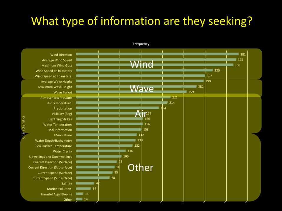
Wind DirectionAverage Wind SpeedMaximum Wind Gust
Wind Speed at 10 metersWind Speed at 20 meters
Average Wave HeightMaximum Wave Height
Wave PeriodAtmospheric Pressure
Air TemperaturePrecipitation
Visibility (Fog)Lightning Strikes
Water TemperatureTidal Information
Moon PhaseWater Depth/BathymetrySea Surface Temperature
Water ClarityUpwellings and Downwellings
Current Direction (Surface)Current Direction (Subsurface)
Current Speed (Surface)Current Speed (Subsurface)
SalinityMarine Pollution
Harmful Algal BloomsOther
381375
368320
302299
282259
221214
194159
156156
153142
139132
116106
9590
8578
4234
1614
Frequency
Char
acte
ristic
s
Wind
Wave
Air
Other
What type of information are they seeking?

Raw Vote Responses
Bids for expanding the network
WTPAggregate $1 $2 $4 $6 $10 Total
Yes 77 (92%) 58 (83%) 61 (84%) 64 (81%) 70 (73%) 330 (82%)
WTPAtlantic $1 $2 $4 $6 $10 Total
Yes 56 (25%) 39 (17%) 36 (16%) 47 (21%) 49 (21%) 227 (81%)
WTPGulf $1 $2 $4 $6 $10 Total
Yes 16 (21%) 11 (14%) 17 (22%) 17 (22%) 16 (21%) 77 (83%)

Estimated Value of Expansion
• Mean WTP estimated at $18.41 per person (one-time payment) for the proposed 40% expansion in the number of GOM stations.
• 95% Confidence Intervals by region:• Aggregate: $7.22 - $29.59• Atlantic: $10.02 - $32.38• Gulf: $10.24 - $32.61

Things to Keep in Mind• Results are from a pilot survey
– Goal was to test survey instrument and provide student data for thesis
• Population of interest is Vessel owner/operators in the Gulf• But sample is not likely representative of this population
– Dominated by Atlantic region respondents (227, only 77 from Gulf)– Appears dominated by high-intensity data users: high income, college-educated,
white males, fishing vessels (26-40’), 32-40 trips per year, 25-45 miles offshore trips, tend to pay for additional services
– Exact number of individuals reached unknown• Email list, so some may be outdated, ignored, sent to junk mail, etc.
– Estimated response rate pretty low (assuming estimated number of contacts is right)
• Because of all of the above, aggregation of welfare estimates to a population of interest is not recommended.

Expanded Beach Conditions Program Survey
• Would be administered to representative sample of 1,100 beachgoing Gulf HHs.
• via GfK Custom Research– Owner of the only probability-
based online sample in U.S.• both online and offline populations• NOT an opt-in or convenience
sample
• Would provide estimate of the value to the public of GCOOS-proposed expansion of current Mote beach monitoring systems to all 5 Gulf states

Expanded Beach Conditions Program Scenario
• VALUATION SCENARIO LANGUAGE:• There is a proposal to expand this website to public beaches across all 5 Gulf Coast states.
• With the beach conditions monitoring service in place, the conditions at any of the 28 currently-monitored beaches in Florida plus the 48 additional beaches in Alabama, Florida, Louisiana, Mississippi, and Texas would be accessible from a website on your computer, smart-phone, or other device, just like the example shown earlier.
• There would be a subscription fee to access the service. The fee would be $X per month.
• The fee would be paid online, to the provider of the service, just like you would pay for any other subscription to an online service. Access would require a log-in name and password, provided to you after paying the subscription.
• The subscription would be month-to-month. So you could subscribe to as few or as many months as needed.
• So, based on what we've told you about the beach conditions monitoring service, if it were available, do you think you would pay the $X per-month fee to access it during at least one month out of a typical year?

• If we can find funding to complete the work anyway, we’ll do so.– We are invested in it; student is depending on it
• If not:– Ruth needs to throw it in reverse, scramble for
new topic, etc.– Although Cody’s results are informative, they are
not appropriate for putting value on GCOOS benefits
– Overall project and objectives will need to be abandoned
The Way Forward?