uphill-only dinosaur tracks? a talking rocks 2017 ... dinosaur tracks? ... animals were presumably...
TRANSCRIPT
1
Uphill-only Dinosaur Tracks? A Talking Rocks 2017 Participant Seeks Answers
Robert T. Johnston
Talking Rocks 2017 was a geology tour organized by Adventist pastor John McLarty and guided by
Gerald Bryant, an Adventist geology professor at Dixie State University (St. George, UT) and an expert
in the sedimentary geology of the area—in particular, the extensive sandstone outcrops of the geologic
unit formally known as the Navajo Sandstone.
I had the pleasure of participating in the first Talking Rocks tour last year and enjoyed the experience so
much that I went again this year! Two other participants from 2016 also repeated. New participants
included a mix of men and women of varied backgrounds and points of view on the age of the earth and
“Flood geology”, and two children. Besides Bryant, none of us had formal geology backgrounds, but we
were eager to learn more about geology and the intersection of faith and science.
We converged on St. George, Utah, from where we traveled to various sites in Utah and northern
Arizona. Places not visited last year included the Pine Valley Mountains, new sites in Snow Canyon, and
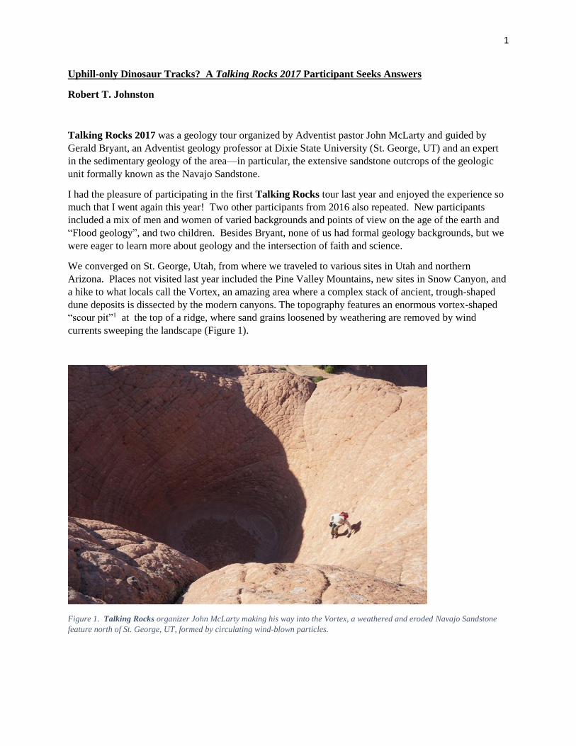
a hike to what locals call the Vortex, an amazing area where a complex stack of ancient, trough-shaped
dune deposits is dissected by the modern canyons. The topography features an enormous vortex-shaped
“scour pit”1 at the top of a ridge, where sand grains loosened by weathering are removed by wind
currents sweeping the landscape (Figure 1).
Figure 1. Talking Rocks organizer John McLarty making his way into the Vortex, a weathered and eroded Navajo Sandstone
feature north of St. George, UT, formed by circulating wind-blown particles.

2
In last year’s report,1 I described geological features we visited and how those features were difficult to
reconcile with Young Earth (YEC) or Young Life Creationism (YLC) and “Flood geology”
interpretations. Among posted responses, creationist2/Flood geology proponent Sean Pitman said he
thought the evidence presented was inconclusive. He cited reports of various phenomena that he believed
supported a Flood interpretation of the Navajo Sandstone, and posed several questions that he considered
crucial to the investigation of Navajo deposition.
Since I am not a geology expert, I suggested that Pitman should participate in the 2017 tour and ask his
questions where they could be discussed in the context of real-time field observations. Unfortunately,
Pitman was unable to come. Thus, in this article, rather than giving a full trip report as I did last year, I
will focus on one (that will take long enough!) of the issues Pitman raised, reviewing related literature and
discussing our field observations at one site, the Moccasin Mountain tracksite near Coral Pink Sand
Dunes in southern Utah. In the process, I will share some of what I have learned about the Navajo
Sandstone, its deposition, and its history. In doing so, I reaffirm what I have already stated: I am not a
geologist, though I had the privilege to learn from one and from the geology literature. So, I encourage
readers to do their own investigations and to consider participating in Talking Rocks 2018. It is one
thing to discuss these matters in the abstract, quite another to address the evidence in the field.
The Question: Do Trackways Only Go Uphill? I am happy to respond to Pitman because he is arguably one of the most influential lay apologists for
young life creationism in the Adventist church today. A practicing physician, author of “Turtles All the
Way Down: Questions on Origins,” prolific contributor to his heavily visited3 website,
DetectingDesign.com, and webmaster and frequent contributor at EducateTruth.com, Pitman is a busy
man. EducateTruth led criticism of LaSierra University and its biology department beginning in 2009,4
and it continues to push for closer alignment of all denominational educational institutions with
creationist ideology.5 EducateTruth’s aggressive tactics offended many within the academic community.
On one occasion, EducateTruth posted the lecture of a Pacific Union College biology professor, without
seeking permission for this publication or providing context to the classroom dynamics that occasioned
the controversial remarks. Their subsequent apology, with a request for more details on the way evolution
and chronological information was being presented at PUC, appeared devoid of genuine contrition.6
In fairness to Pitman, I need to emphasize that he is promoting views that are widely accepted in the SDA
Church. In fact, young life (YLC) or young earth creationism (YEC) is championed by the General
Conference (GC) president, the Biblical Research Institute, the GC Faith & Science Council, the
Geoscience Research Institute, many conservative Adventist scholars, and a majority of its members and
their representatives (as evidenced by a strong GC vote in 2015 for a more rigidly fundamentalist form of
Adventist doctrines on creation and Noah’s Flood). However, as an apologist, Pitman has taken upon
himself the difficult task of providing convincing evidence and a plausible rationale to back up creationist
claims. To his credit, Pitman has written engaging articles on a broad range of creation and flood-related
topics. However, though his arguments may reinforce the beliefs of creationists already invested in his
sectarian ideology, they are not persuasive to a broader, geologically literate audience.7
The question Pitman posed that will be considered here is:
“What about the fact that the trackways within these ‘eolian’ dunes universally go in an
uphill-only direction (not to mention the very fine detail of the prints that suggest very wet
if not underwater conditions)?”8
3
Pitman’s question reflects an article9 he posted at EducateTruth.com, where in a section entitled “Uphill
Only”, he wrote:
“First off, consider that the animals that created trackways within the Coconino, Navajo and other
sandstone layers in this region all had a very strong tendency to walk only uphill. This is true for all the
various animal types that created trackways within these [sic] sand (i.e., lizards, salamanders,
arthropods, dinosaurs, synapsids, etc.). This sort of uphill-only walking isn’t seen anywhere in any modern
desert. According to Lockley (2016), to this day, ‘No one really knows why this is.’ Evidently the
lizards/amphibians, arthropods, spiders and other creatures living in ancient deserts did not like going
downhill much at all.”9
Pitman summarized the section by referring to “the almost complete absence of downhill tracks…” I will
give him the benefit of the doubt and allow that his article, unlike his question to me, recognizes a minor
number of downhill tracks, but he obviously believes that the vast majority of tracks, from all animals, go
uphill.
An insinuation of Pitman’s question and article is that animals going only uphill is evidence that they
were escaping Noah’s Flood. As creationist geologist John Whitmore wrote in describing this
characteristic and others, “Climbing to escape rising floodwater would explain these features.”10 (Other
creationists have also claimed that dinosaur swim tracks are evidence of their fleeing Noah’s Flood11).
Another insinuation is that the Coconino and Navajo Sandstones were formed by lithification of
subaqueous (underwater) dunes formed quickly by water currents during Noah’s Flood rather than from
wind-driven (eolian) dunes formed over eons on (mostly) dry land, as understood by mainstream
geologists. (This disagreement is why Pitman chose to enclose ‘eolian’ in quotation marks; he doesn’t
believe they were eolian). Pitman and many other creationists12 argue that a large, contiguous block of
the geologic column was deposited under water in a short time, without intervening eolian deposits.
Presenters at a recent conference organized to “affirm the doctrine of creation as officially taught by the
Adventist denomination” asserted that everything between the Pre-Cambrian and Cretaceous (Figure 2)
was deposited by the Flood.13 Inclusion of eolian deposits in the “Flood” deposits is hugely problematic,
which is why creationists vigorously oppose it. It is a BIG DEAL.
It is inherently contradictory to argue that all animal trackways on ancient dune surfaces go (almost) only
uphill while arguing that those dunes formed underwater. The alleged combination of subaqueous dune
formation and animal escape from water requires a complex timeline to integrate the development of the
dune with the production of the tracks, since tracks are often found far below the dune crests to which the
animals were presumably climbing to escape the water that allegedly created those crests. (Which
climbed first, the dinosaur or the dune?!). Nevertheless, this is the position of many creationists, some of
whom argue for intermittent flooding to allow time for dune formation and uphill track formation, with
other anomalies (nests, burrows, etc.) formed during dry spells. Such interludes would add greatly to the
amount of time required to deposit the enormous volume of sand incorporated into the Navajo Sandstone.
This sand was not dumped in a large mass (as the sedimentology of the deposit, including the presence of
multiple track layers, clearly indicates), so there was already an extended period of time (bracketed on the
low end by the maximum settling velocity of individual sand grains, supplied sequentially) required to
produce the observed accumulation.
This, however, is not the least plausible aspect of proposed Flood scenarios. The presence of a mile-thick
sedimentary succession below the Navajo, also purported to have formed in the Flood, means that all of
these land animals somehow managed to survive flash flooding far beyond the scope of any modern
analog, and still have the grit to claw their way toward an imagined haven of rest! We might be tempted

4
to invoke divine intervention to explain such a miraculous escape were it not for the fact that these
creatures must have been immediately buried beneath a succession of sedimentary layers equally thick to
the one they had just eluded.
Figure 2. Geologic column in the southwestern United States (courtesy USGS). The Navajo Sandstone spans the end of the
Triassic and beginning of the Jurassic period.
Navajo Sandstone and Eolian Dunes Moccasin Mountain Tracksite is located in the Navajo Sandstone, a formation-level unit in the lower part
of the Jurassic System. With correlative units, such as the Aztec Sandstone of Nevada, it extends over
much of the Colorado Plateau. This “well-sorted, fine- to medium-grained sandstone”14 is the eroded
remains of a massive sand sea (“erg”)15 covering much of Utah and parts of surrounding states, a region
of about 350,000 km2.62 This dune field is interpreted by mainstream geologists as having formed by
eolian processes, using sand (mostly quartz) originally transported to the region from several locations,
including from the Appalachians (probably carried by a trans-continental river of Amazon scale).16 By
contrast, some creationists (in particular, “Flood geologists”) believe that the Navajo and most other
sedimentary layers within the geologic column were formed by the Noachian Flood, with the dunes being
formed by subaqueous (underwater) processes.

5
It is beyond the scope of this article to provide a thorough explanation of eolian dune formation,
migration, structure, and sandstone lithology; several helpful internet sites explain the basics.17 However,
some background is necessary to understand what we observed at Moccasin Mountain.
Sand transport by wind produces ripples and dunes that assume different shapes and dimensions in
response to various wind regimes, substrate and moisture conditions, and sand supply. In the Navajo erg,
crescent-shaped barchan and transverse dunes appear to have predominated, along with other forms. The
prevailing upwind side of a dune is referred to as the windward or “stoss” side (Figure 3), while
downwind is the “lee” side. The slope of a dune is relatively gradual on the stoss side, while it is
relatively steep on the lee side. The steep downhill part of the leeward surface is referred to as the
“slipface”. The high point on the dune is called the “crest”, and not far downwind from the crest is the
“brink”, where the slope steepens to form the slipface. A gradually sloped “apron” may develop at the
base of the slipface, meeting the slipface at the “toe”.
Figure 3. Idealized cartoon of a simple crossbedded dune. Tabular crossbeds shown, but crossbeds may be convex curved, and
may have wedges at the bottom of foreset (cross-strata) boundaries, thinning towards the top, due to preserved apron deposits
and climbing wind ripple deposits on the slipface.
Particle transport through dunefields by both wind and water currents takes place in three different
modes: (1) “suspension” (fine particles are carried within the moving fluid); (2) “saltation” (currents
moving across the dune surface lift individual grains of sand via the Bernoulli Effect and carry them a
short distance before dropping them back to the surface; thus, the particles skip along the surface in short
hops), and (3) “traction” (particles, especially the larger ones, roll or slide along the surface as they are
impacted by saltating grains; sometimes more highly specified as “creep” or “reptation”).18 Suspension
transport is more efficient than saltation, sweeping the fine material away from the sand-sized particles,
which also travel downstream more rapidly than the coarser, traction population. In wind-dominated
transport systems, especially, these transport dynamics result in well-sorted deposits.
As particles move up an eolian dune’s stoss surface via saltation and creep, they eventually reach the
crest. Saltating grains travel over the crest and reach the brink. Somewhere between the crest and the
brink, the wind flow detaches from the dune surface, after which the saltating grains fall downwind as
“grainfall”. (Saltating grains may be accompanied by creeping grains, which may become part of
grainfall).32 In certain shaped areas of a dune, the lee slope may be less than the angle of repose; in these
areas, grainfall may collect as grainfall laminae,19 thin, discontinuous sand layers draped over surface

6
contours. Or, especially at lower wind velocities,20 grainfall may collect below the brink to form a
“cornice”, a bulge in the slope supported by a wind eddy that circulates below the crest and creates an
updraft along the upper part of the slipface. When the angle of this accumulation exceeds the “angle of
yield” (a few degrees higher than the “angle of repose”, which is 34° for fine dry sand), “grainflow” (a
non-coherent avalanche) ensues, and the cornice drains down along the slipface until the accumulated
sand reaches the angle of repose and stops moving. Grainflows may also be triggered by a perturbation
downslope (such as animal movement), which undermines the sand above it, leading to “scarp recession”
as the area contributing to the flow widens and works its way uphill. A small dune superimposed on a
large dune may travel up the stoss of the larger dune, over the crest, and then form grainflow deposits on
the lee side of the larger dune. Each of the above grainflows forms cross-strata visible when the dune (or
sandstone) is viewed in cross-section. Grainflow deposits are loosely packed, and therefore, are very
porous and permeable. Thin lamina comprised of fine particles (fine sand and coarse silt) may
accumulate at the basal shear plane of grainflows, and form visible “pinstripes”.62 If the sand on the
surface of the slipface has cohesion (due to moisture), it may slide downward as a sheet, in a “slump”.
Because grainfall laminae are derived primarily from saltation grains, they tend to have average particle
sizes slightly smaller than grainflow deposits, which include the larger particles from creep. Re-working
of these lee-slope deposits into wind ripples, a very common process near the base of a dune, alters these
relationships and results in tighter packing of the deposits.29 Because these various layers are deposited
on the slipface, they lie at an angle, crossing the area between the top surface of the dune and the base on
which it lies; therefore, they are called “cross-strata” or “foresets”.
Dunes migrate in the prevailing wind direction as the current erodes sand from the stoss side and
transports it over the crest to be deposited as described above, adding cross-strata to the lee slope. If the
supply of sand is not replenished faster than the dune migration rate, the wind will progressively scour
away every vestige of that dune, and the next dune will migrate over the same (or lower) surface as the
first one. If, however, the supply of sand exceeds the rate of dune migration, i.e., if there is net
deposition, then the next dune to come along will climb over remnants of the first one, producing an
accumulation and raising the interdune surface. As accumulation proceeds, a body of sand is produced,
from the lower levels of many dunes, stacked in complex geometries representing the dynamic balance
between deposition and erosion, and the specific morphologies of the various dunes that contributed
deposits.
The reworking of lee-side deposits into “wind ripples” provides an important tool for discriminating
between subaqueous and subaerial (wind-blown) mechanisms. Under most circumstances, sand
transported by saltation will form ripples, migrating ridges of sand that extend perpendicular to the wind
direction. Wind ripples are relatively shallow with long wavelengths (distance between crests of the
ripples) corresponding to the average saltation distance of the transported sand grains. The “ripple index”
(wavelength divided by ripple height) of wind ripples (and also beach washing waves—“swash”—though
these are distinguishable by their ripple symmetry and entrained sediment) is typically 17 or more
(compared to 15 or less for ripples of water wave or water current origin).21 Because the heights of wind
ripples are generally only a few millimeters, deposition on the lee slope of the ripple itself and
crossbedded strata within the ripple itself are not observed (exceptions do occur in situations where large
grain size or other factors produce tall ripples); instead, wind ripple deposits appear in the form of thin
laminae parallel to the surface on which the ripples climbed. In contrast, the greater ripple heights in
subaqueous environments contribute to the common production of distinct ripple cross-stratification.

7
Climbing ripple deposits (“climbing translatent strata” in some literature) require a net depositional
environment to form. Ripple deposits on the dune stoss “are almost never preserved”29 because the stoss
slope is continually eroded during normal dune migration.
Besides ripple formation on the stoss surface, crosswinds across the lee face may form ripples with crests
parallel to the lee slope, while upslope or downslope winds on the lee face may create ripples that are
perpendicular to the slope direction.32 Ripples high on the lee face are unlikely to persist, especially on
large dunes, due to grainflows destroying those surfaces. Even more persistent ripples, formed on
shallower slopes, such as between the crest and the brink, or away from the slipface and towards the horns
of a Barchan dune, are seldom found preserved in the ancient record because those upper surfaces of a
dune are only very rarely preserved. Below the slipface, crosswinds or reverse winds often build up an
extended apron, composed primarily of wind ripples, and this lowest part of the dune is most often
preserved. These wind-ripple deposits typically interfinger with upslope grainflow deposits, and changes
in the relative abundance of these two types of fine stratification record seasonal changes of prevailing
wind direction (see discussion below). Wind ripple deposits, built up grain by grain, have lower porosity
and lower permeability than grainflow (avalanche) deposits, providing a more stable surface for
locomotion.
Unlike water, wind cannot transport large rocks. Furthermore, dust (silt and smaller particles) is
efficiently removed from dunefields by transport in suspension. Therefore, all eolian dunes are composed
of saltation populations of sand-sized particles (approximately 0.2 mm diameter, on average, in the
Navajo66). Nevertheless, there remains a small spectrum of particle sizes in every dune, which undergoes
further sorting within individual grainfalls, grainflows, and wind ripples. Because of the differences in
particle response to saltation and creep, with small particles being ejected farther than large particles
when hit, large particles collect closer to ripple crests, while small particles collect in the troughs.22
Perhaps this can be understood as creep having the Sisyphean task of pushing the large particles up the
hill to the crest, while saltation allows small particles to easily hop over the crest to the next trough; the
result is size-based sorting of particles onto crests and troughs. (An alternative but related explanation is
that the small particles are easily saltated from ripple crests, but find shelter in the troughs).20 As a result,
wind ripple deposits are “inverse graded”, meaning that they have large particles on the upper part of a
stratum and smaller particles at the bottom part of the stratum (where a trough once was before the next
ripple climbed over it).
Wind ripple surfaces (as distinct from their deposits) are generally eroded during deposition of the next
ripple. However, if the supply of new sediment to a ripple is greater than the rate of transport of sediment
from the stoss side of the ripple to the lee side of the ripple, i.e., if net deposition occurs on the ripple,
then the ripple will climb at an angle greater than the slope of the stoss side of the ripple, and under those
conditions, the underlying ripple surface will be preserved.20 This condition, called “supercritical
climbing”32 or “stoss depositional climbing”28 by Hunter, is much less common than “subcritical
climbing” (or “stoss erosional climbing”), where the angle of ripple climb is less than the slope of the
ripple stoss, and the ripple surface is eroded. These dynamics of bedform climb, and the associated
terminology, also apply to dunes, not just to the smaller bedforms.28
Each migrating dune creates its own layer, or “set”, separated from the set beneath it by a “bounding
surface”, the line marking where the top of the previous dune was blown off and the next dune was
built.23 Groupings of two or more sets (as is typically seen in the Navajo) are called “co-sets”. Cross-
strata (foresets) built on the lee slope of a dune are slanted relative to the bounding surface and horizon.
Periods of low dune migration may be accompanied by changes in slope angle and orientation, surface
compaction, deposition of suspended fine particles, etc. on the lee slope. This may create a visible

8
boundary between one foreset and the next. Ancient foresets are sloped at less than the original
depositional surface angle due to compaction by the weight of overlying layers (19% compaction reduces
a 32-34° dip angle to 27°).14 Less steep portions of cross-strata that may be visible near the top and
bottom of a bed are called the “topset” and “bottomset”, respectively, and may contribute a sigmoidal
shape to the cross-strata. Once lithified and eroded, multiple layers of these “crossbedded” sets are
visible at places like Zion National Park (Figure 4) and throughout the Colorado Plateau.
The Navajo Sandstone is up to 700 m (over 2000 feet) thick in southwestern Utah and southern Nevada,
with sets as thick as 33 m.66 Rubin and Hunter28 showed that original dune heights were multiples of the
thickness of the crossbeds they left behind, and can be estimated under certain conditions. They
calculated that the lower limit estimate of the height of dunes in the Navajo was 16-40 m, and “[a]ctual
heights may have been considerably higher.” Using different assumptions for the downwind extent of
deposition, they estimated mean heights in the range of 270-450 m, and concluded that mean dune height
was “probably as much as several hundred meters.” Thus, the Navajo dunes were huge, but only a small
fraction of their height was preserved in the crossbeds left behind, because subcritical climbing at low
climb angles eroded most of each dune away before deposition by the next one.
Figure 4. Crossbedded Navajo Sandstone cliffs viewed from the Canyon Overlook Trail in Zion National Park. Notice the
diagonally sloped cross-strata (sloping downward from left to right) between bounding surfaces, most evident in the crossbed
marked with an arrow.

9
The rate of dune migration depends on many factors, including wind regime, local geography, moisture,
sand characteristics, etc. All else being equal, the taller the dune, the slower it migrates, since more sand
must be moved. The dunes that made up the Navajo are believed to have migrated approximately 1 m/yr
on average.24
Seasonal opposing or shifting winds and rain may slow or even reverse dune migration. Reverse winds or
crosswinds (including movement of smaller dunes across the lee face of a larger dune), may cause erosion
of the lee slope. Even if dune migration doesn’t cease, it may slow with wind changes, and rainy weather
may halt dune migration altogether (wet sand is too cohesive for wind to erode). Under these
circumstances, the lee slope is exposed for a longer time than when the dune is actively migrating in the
prevailing direction. Surfaces formed under these conditions are distinctive, either by their own unusual
properties or by their location between crossbeds with slightly different orientations, and are known as
“reactivation surfaces”. These surfaces do not appear to be distributed with any sort of regularity within
the Navajo Sandstone, so it is difficult to estimate how long a hiatus each may represent; however,
chronological significance has been attributed to other, more cyclic changes. The alternations between
grainflow and climbing ripple deposits within cross-strata at several Navajo sites, coupled with minimum
time estimates for the migration of tall dunes, has led to the interpretation of annual cycles of dune
advance on the order of 1 m/year.24
The paleoclimatic conditions driving these alternations between grainflow/grainfall deposits and climbing
wind ripple deposits on the lee slope and apron have been a topic of considerable interest within the
Navajo research community. Chan and Archer25 attributed the grainfall/grainflow to the dry season,
which they associated with dry summer winds, while the secondary deposits on the lee face/apron were
thought “perhaps dominant in winter.” Loope,62 however, argued that winter was the dry season, with
rain in summer, based on the 10° N latitude26 of the Navajo at the time of its formation, the prevailing
winds at that location, and the arid climate in northern Pangea. During the dry season, northwesterlies
blew across the dunes, as evidenced by the predominant southeasterly dip direction of slipfaces (as
preserved in cross-strata) at Loope’s study site. During rainy seasons (summer), no fresh grainflows
(avalanches) were deposited and the dunes did not migrate; opposing winds caused wind ripple deposits
to pile up at the base of slipfaces. These were preserved in cross-strata, marking annual seasonal cycle
boundaries.
We visited the study site used by Chan and Archer (Figure 5 and Figure 6; this site was originally studied
by Hunter and Rubin). They25 reported no significant reactivations on this exhumed dune surface. In a
65 m long exposure, they measured 297 continuous cyclic cross-strata representing 297 annual (summer-
winter) cycles, averaging 22 cm each but varying between approximately 2 and 80 cm. Spectral analysis
of the variations in foreset thickness found periods of 30, 55-60, and 120 years, possibly due to solar
variability or decadal scale climate changes (as observed in modern drought cycles). As you may have
deduced, the implications of this for the timescale involved for creation of dunes over the entire erg, and
multiple crossbeds of them, are significant.

10
Figure 5. Exposed dune surface displaying cyclic grainfall and wind ripple deposits. Location is 1.5 miles west of the east
entrance station of Zion National Park.
Figure 6. Gerald Bryant discussing the cyclically deposited foresets exposed on the exhumed top of the dune shown in Figure 5.
Dune migration was towards the camera. Boundaries of one cycle are indicated by the two arrows.

11
As dunes migrate, so necessarily does the area between them, called the “interdune”. If no net deposition
takes place in the interdune during this migration, then that area will be represented in the accumulation
only by an erosional surface separating successive crossbed sets. During rainy periods, high water tables
and surface runoff produce streams and ponds, or maybe just dampen the surface in topographic lows.
This surface moisture traps fine particles that would otherwise escape the dunefield in suspension, and
produces horizontally stratified interdune deposits with textures and compositions that differ markedly
from surrounding dune deposits. In cross-section, they appear as discontinuous (almost always less than
1 km in extent and, more typically, about 500 m) deposits perched atop bounding surfaces separating sets
of crossbeds. Thus, Kocurek27 wrote (summarizing McKee & Moiola): “[C]ross-strata, planar bounding
surfaces and overlying horizontal strata result from the downwind migration of successive dunes and
interdune areas across the dune field. A bounding surface that truncates dune cross-strata, therefore,
marks the passage of the interdune area over the dune deposits left as net sedimentation. Horizontal strata
might then accumulate on the bounding surface within the interdune basin.” Even if dunes are too close
together to accommodate an extensive interdune, the trough between the dunes defines a new bounding
surface as it migrates downwind.28 Preserved interdune strata may be seen at multiple levels in the face of
massive cliffs within Zion National Park.
Controversy Over Eolian Origin Many features of eolian dunes are also found in subaqueous dunes, and for this reason, there was for a
time disagreement in the literature on the genesis of the Navajo and Coconino Sandstone formations.
Most geologists interpreted these formations as eolian deposits, but from 1969-1977 a few papers29 were
published that favored a subaqueous depositional environment, arguing that a large subaqueous dune or
sand wave could have similar structural characteristics as eolian dunes, including cross-bedded structures,
ripples, and similar dune forms. Freeman and Visher,30 for example, pointed out that some features long
considered diagnostic for eolian deposits—such as frosted and pitted sand grains—were not unique to
eolian deposits.
Soon after Freeman and Visher’s 1975 paper was published, several scientists responded critically.
Among these, Picard31 noted that no marine fossils had been found in the Navajo (even though they are
common in formations above and below). He and others also refuted several lines of evidence that Visher
and Freeman interpreted as supporting their subaqueous hypothesis, including a strong criticism of their
reliance on comparisons of log-probability plots of grain size distribution, based on inadequate data sets,
and their failure to account properly for changes in the mineral content that occurred after deposition.
While the subaqueous hypothesis was ultimately rejected by the geology community, Kocurek and Dott29
described the controversy as “justified”, since the debate led to development and refinement of robust
criteria for distinguishing between eolian and subaqueous depositional environments. One of the most
important publications from of that effort was a 1977 paper32 by Ralph Hunter of the USGS. Hunter
identified and classified fine eolian strata according to the mechanisms by which each was formed. He
found diagnostic characteristics that were unique to eolian environments and that could be observed at the
scale of well-bore samples, as well as in outcrops, thus enabling the widespread discrimination of sub-
aerial and subaqueous deposits (even in deep water). These sedimentological criteria have proven to be
very compatible, not only with subsequent observations in modern environments, but with larger-scale
stratigraphic evidence pointing to transitions between subaerial and subaqueous conditions in ancient
environments.

12
The most useful sedimentological criteria for distinguishing between eolian and subaqueous ripples are:
(1) Ripple indices (as described previously), at those locations where ripples appear on bedding planes.14
(2) Climbing ripple stratification, where strata are exposed in cross-section. Sub-aqueous ripple deposits
are thicker, typically display ripple cross-stratification (which is almost entirely absent in eolian strata),
and record rapid depositional episodes in super-critical climbing geometries that preserve the stoss side of
the ripples. Climbing wind ripple deposits, on the other hand, are composed of a succession of fine (mm-
scale), distinct, extensive laminae that are devoid of internal structure, apart from inverse grading.33 (3)
Sorting. Grain size variation in subaqueous deposits is greater than that of eolian dunes, except when the
source material only produces a small size range, as in fluvial recycling of eolian sand, for instance.
Subaqueous dunes typically contain material both coarser (gravel clasts) and finer (mud drapes) than is
found in eolian saltation populations. 34 (4) Typical distributions and associations of features. For
example, Loope62 argued that since both dry and water-saturated sand readily generate grainflows, the
abundance of wind-ripple deposits closely associated with grainflows “is the best single line of evidence
against a subaqueous origin for the cross-strata of the Navajo Sandstone.”
Although the matter is considered settled within the mainstream geology community, some creationists
continue to cite the arguments of Freeman, Visher and others from the early 1970s to support their
interpretation that sandstones such as the Coconino and Navajo derived from subaqueous dunes produced
during the Flood. In doing so, they ignore or reject the work by Hunter and others that firmly established
the eolian nature of these sediments.
Thus, for example, in response35 to a 1998 critical review of his book providing a creationist
interpretation of the geology of the Grand Canyon,36 creationist Steve Austin accused the reviewer, UC
Riverside geology professor W.A. Elders, of not having responded to the sedimentological argument for
water developed by Visher, even though by then Visher’s work was 23 years old and his hypothesis had
long been discredited by subsequent research.
In 2016, Sean Pitman9 cited the same body of work from the early 1970s (noting also Leonard Brand’s
citation67 of that work). To his credit, Pitman acknowledged Hunter’s 1977 paper (as well as later work
by Kocurek). However, he seemed to miss its significance, including its application to underwater well
bore samples, and quickly glossed over it. He went on to cite two references in support of his argument
that Hunter’s inverse-graded ripple deposits could also be found in subaqueous deposits. However, the
first reference he provided was a link to an abstract by A.W. Archer,37 from which he quoted,
“Heterolithic facies are typically laminated and contain pinstripe laminations, starved ripples, and well-
developed tidal cycles (cyclical tidal rhythmites).” Pitman interpreted the presence of pinstripe
laminations in subaqueous as well as eolian deposits as support for the subaqueous interpretation of the
Navajo Sandstone; but his was a highly selective application of that report. “Pinstripes” are not specific
to a single genetic mechanism. In fact, Fryberger and Schenk38 proposed pinstripes as a useful criterion
for recognizing eolian deposits precisely because they are commonly produced from all three fine
stratification processes in eolian dunes (grainfall; grainflow; and climbing ripple migration), whereas they
are not commonly associated with other types of unidirectional current. The pinstripes in the Navajo are
not the same as the pinstripes in Archer’s work, and can readily be distinguished on the basis of textural
differences and the presence of bi-directional flow indicators. If Pitman wishes to invoke the production
of “tidal rhythmites” as an explanation for Navajo pinstripes, then he should also deal with the time
implications of such cyclic deposits. Ironically, the larger context of Archer’s study raises even more
difficult challenges to a short-chronology interpretation: a valley incised in putative Flood deposits whose
base was filled with conglomerate containing “clasts and fossils eroded from older units exposed within
the paleovalley.”37

13
Pitman also referenced a Wikipedia article on “Ripple Marks,”39 arguing that particles in “wave-formed
ripples” are also inverse graded and thus indistinguishable from eolian wind ripple deposits. Examination
of the article shows that it was referring to streambeds, easily distinguished from cross-bedded dune
structures. A linked article on “Wave-formed ripples” notes that formation is in shallow water (wave
oscillation extends below the water only to half its wavelength) with no or low current. Both articles
emphasize that due to the ripple formation mechanism under wave oscillation, wave-formed ripples are
generally symmetrical. This contrasts with eolian climbing ripples, which are asymmetrical, with a
shallow stoss angle and steeper lee angle (Figure 7). Oscillation wave ripples also create different
sedimentary structures than current (wind or flowing water) ripples do, unless there is a flow
component.20,40 Asymmetrical ripples can form on beaches due to lapping wave action, but Hunter
discussed these in his 1977 paper, noting that these are rarely so uniform as eolian climbing ripple
deposits. Beach deposits also typically have marine detritus and other larger particles embedded in the
sand.
Figure 7. Plan view of climbing wind ripples preserved in the Navajo Sandstone at Snow Canyon, St. George, UT.
Finally, Pitman argued that “ripples within the Navajo are rare.” Although exposed “plan view” ripple
surfaces are relatively rare, they are not extremely so (we saw distinct examples at several locations). As
McKee noted,66
“Selective preservation of lee-slope deposits is a second controlling factor in the protection of surface
features in dunes. Mostly, the gentle windward slopes of dunes are continually eroded, but downwind sides
are constantly being buried by avalanching sand and protected. Thus, ripple marks and other structures
upwind are seldom preserved, yet the relatively rare ripple marks on the slip faces and the tracks of animals
on such slopes have, if buried promptly, a good chance of permanent preservation.”

14
But, even if ripple surfaces are relatively rare, climbing ripple deposits most definitely are not; Kocurek
and Dott29 noted their “abundance”, and according to Rubin and Hunter,14 “Deposits formed by the
climbing of wind ripples are common in most outcrops of the Navajo....” It was specific characteristics of
climbing ripple deposits, not exposed ripple surfaces, that Hunter considered to be most usefully
diagnostic.
Interdune deposits in the Navajo Sandstone speak to its eolian origin, as well as to periodic rain or
flooding in the paleoenvironment. The carbonates and evaporite pseudomorphs often included in these
interdune successions, especially in their intimate association with clastic dune deposits, are particularly
difficult to explain as Flood products, since they indicate deposition by chemical rather than mechanical
processes. Siltstones are even more common, and indicate an abrupt change in transport energy from the
adjacent dunes. These often contain mud cracks, reinforcing the evaporite evidence supporting episodic
dessication, a dynamic difficult to reconcile with short-chronology Flood interpretations, given the
number of interdune layers preserved vertically in the Navajo stratigraphy.42 Animal tracks are much
more common in interdune deposits than in dune deposits.41 A limited number of animal fossils have also
been located in interdunes, including dinosaurs and crocodilomorphs. Also found have been root casts,
horsetail fossils and permineralized wood, indicating that plants grew there.42 It is significant that these
are not found within undeformed dune deposits themselves.43 It is difficult to conceive of a Noachian
Flood model—even with periodic advances and retreats as some creationists propose—that would
account for the thickness of the sandstone deposits and the multiple, vertically spaced interdune layers
within the Navajo, with time for these plants to grow and mature during Noachian Flood intervals.
Parrish and Falcon-Lang44 described fossilized stands of large coniferous trees in the Navajo Sandstone
near Moab, Utah, estimated to have been a minimum of 45 years old at the time of death, based on their
size. These were interpreted as having grown in the interdune areas, with carbonate beds deposited
around them. The only vegetation found outside such interdune settings were displaced fragments
encased in mass flow deposits. Pitman9 claimed that these coniferous fossils are evidence of the
Noachian Flood, arguing that upright stumps and trees were deposited by sinking upright from flood
waters just as trees were in Yellowstone fossil forests (as interpreted by some creationists). However,
Pitman failed to mention at least ten observations from this study that are difficult to reconcile with a
Noachian Flood interpretation: (1) A “conifer shoot with helically arranged, broad-based leaves” was
found at the site. (2) The large coniferous trees were only found in wet interdune areas in a small region
where springs enabled their growth (if Flood-deposited, one would expect them to be distributed widely
throughout the formation, and not limited to interdune areas and mass flow areas of dunes). (3) There
were associated tufa (carbonate spring) mounds, up to 2 m high and 6 m diameter, made of multiple
accretionary carbonate layers with brecciated interiors, suggesting predominantly sub-aerial development.
(Building up that large a mound through calcite precipitation from spring water takes time). (4) Interdune
beds with sandstone and siltstone lamina interleaved with carbonate lamina. (5) Interdune beds with
“desiccation cracks with upturned edges”, indicating that the interdune lakes periodically dried out. (6)
Interdune “crack-fills containing red siltstone and sandstone”. (7) “[E]nterolithic texture at one locality;
this feature forms by the repeated dehydration and hydration of massive gypsum”. (8) The “massive
[non-eolian] sandstone units, up to 17 m thick” that for several reasons were interpreted as mass flow
deposits, possibly triggered by earthquakes, contained “common, metre-sized intraclasts of laminated
carbonate”. (9) Upright stumps were found in the carbonate beds “that are almost certainly in growth
position” as evidenced in part by rhizoturbation in the underlying sandstone from which the trees
apparently grew, and carbonate accretions around the trunk where it penetrated the carbonate bed. (10)
Tree trunks associated with mass flow deposits were aligned with those mass flows, and the two mass
flows were almost perpendicular to one another despite being located in the same region.

15
Recently Parrish collaborated with Hasiotis and Chan to extend this study to several other sites in SE
Utah and northern Arizona (including a site they acknowledged Gerald Bryant for leading them to).45
Tufa mounds were found at all the surveyed sites, again with brecciated laminated interiors. At Navajo
Canyon, a carbonate mound draped by a younger carbonate bed, in the midst of large-scale cross beds,
provides a particularly graphic illustration of the complex depositional histories recorded in the Navajo.
In some locations, carbonate mounds encase fallen trees.
The carbonate mounds are associated with extended layers of carbonate (limestone and dolostone)
ranging from a few cm to 2 m in thickness; these are interpreted as interdune lakebed deposits. Some
areas had 2-4 carbonate layers separated by eolian sandstone and siltstone (a Flood interpretation would
need to account for multiple depositions in some areas and only one in others, within relatively close
proximity regionally). At several sites, sand fluidization beneath the carbonate beds produced brecciated
carbonate within sandstone (the carbonate beds must have been hard at the time of the fluidization event).
The carbonate lenses/lakebeds thinned out at their margins (this suggests a gradual depositional process in
a local topographical depression; if they were formed by a onetime deposition of Noachian Flood
suspended particles, one would expect broad drapes of a uniform thickness).
Many stumps were found. All of them were embedded in the interdune carbonate units as at the 2007
study site, with root systems in underlying sandstone. In some cases, Parrish et al. noted, “Accumulations
around standing trees have stromatolitic flanks that slope away from the fossilized trees”. In a personal
communication,46 Parrish confirmed that the carbonate accretions around tree stumps were built out as a
series of concentric rings, not as horizontal lamina. Carbonate accretions extended slightly—up to
6 cm—above the bed of surrounding carbonate units. These observations suggest gradual build-up of
carbonate layers while the trunk was in place (already drowned and rotting), not sediment vertically
deposited on a waterlogged stump that sank upright from Flood waters.
In multiple instances, logs were found lying in the underlying sandstone beneath interdune/lakebed
carbonate layers. In a location with logs buried in the sandstone under a carbonate unit, a therapod track
was found on the upper surface of the carbonate (dinosaur tracks are frequently found in
interdune/carbonate areas, but these are hard to reconcile with logs under the same carbonate layers, if
those logs were Noachian Flood-waterlogged trees that eventually sank to the bottom, as Pitman
proposed). A fossilized root mat was found atop a carbonate unit at one site, where an interdune lake
dried enough for plants to grow on the lakebed. Other biota from these sites, besides logs and stumps,
includes leaves, stems, cones, stromatolites, burrows, and riparian assemblages of palynomorphs and
microfossils.
According to Bryant, “The observed array of diverse materials and complex bedding geometries in the
Navajo Sandstone provides definite indications of specific processes at work in its genesis. The consistent
distributions of tracks, traces, and fossilized remains provide further definition to that sedimentary record.
The fossil record is integrated with the sedimentary succession in a way that seems to require the
continuation of natural life cycles, at every scale, concurrent with accumulation of the sediments. In this
respect, Navajo strata are but a simple microcosm of the geologic column as a whole. The most basic task
of a scientifically competitive Flood model is to provide a plausible alternative explanation for this
orderly arrangement. Systematic denial of well-established sedimentary dynamics lays a very weak
foundation for this initiative.”

16
Color Transformation in the Navajo Sandstone One of the reasons people travel to Utah from all over the world to see the Navajo Sandstone is because
of the variety of warm, vivid colors displayed in the majestic cliffs it forms. Color changes in the Navajo
often do not follow depositional boundaries, so they must be due to diagenetic (post-depositional) fluid
flow and chemical reactions. These processes are also responsible for cementing the sand grains together
to form rock.
The Navajo Sandstone is commonly reddish in color, but color ranges from red to orange to yellow to
white, with patches of green and black appearing at some locations. Beitler et al.47 analyzed Navajo
Sandstone samples collected at several locations throughout Utah and found that primary sand particles
constitute 48-68% (by volume) of the composition, with the balance being secondary/diagenetic minerals
(which act as cement) and empty volume (porosity). The primary particles were quartz, with a little
potassium feldspar, and minor amounts of other minerals. The most common cementing minerals are
calcite, quartz, and various iron-bearing minerals—hematite (iron(III) oxide), goethite (iron(III)
oxyhydroxide), and limonite (hydrated iron(III) oxyhydroxide), which are responsible for most of the
coloration. Iron mineral volumes range from 0% in bleached sandstone to 9% in red to 37% in yellow-
orange sandstone and even higher in iron concretions. Porosity was 0.6% in the red sandstone but 17.6%
in the bleached. Microscopic analysis revealed that unaltered red sandstone had a very thin hematite layer
coating every quartz grain, whereas in the yellow-orange sandstone the higher iron oxide content was
present in the form of hematite crystal aggregates and goethite, along with other minerals and increased
porosity, contributing to a less reddish color. The bleached sandstone had no visible hematite coating on
quartz particles, no iron oxide crystalline aggregates, and high diagenetic porosity.
The authors47 concluded from observed spacial relationships that the thin hematite layer removed from
bleached rock was apparently the source of iron oxide for crystalline aggregates in the yellow-orange
rock, formed later in the diagenetic history, and for iron rich concretions (such as “moki marbles”50).
These concretions were hypothesized to form when Fe2+ in reducing fluids is transported to a region of
oxygenated water, which leads to Fe3+ oxide precipitation as hard balls, cylinders, clusters, etc. There is
also a growing body of evidence that bacteria play a role in forming iron concretions.48,50
The overall picture of mineralization and color formation is complex, but it appears that the original color
of the sandstone was orange-pink, due to breakdown of iron-containing clay minerals in thin films of dust
clinging to individual quartz grains in the depositional environment, as evidenced by hematite coatings
between grain contacts. Infiltrating rainwater and high groundwater tables, in conjunction with the high
porosity of the uncompacted sand (38-47%), facilitated this process. In the Navajo, “The red pigment is
pervasive and suggests a lack of primary organic matter and the presence of oxidizing conditions early in
the diagenetic history.”47
Bleaching appears to have involved removal of the early formed iron oxide coatings by exposure to a
reducing fluid. Reduction makes the iron soluble, whereas oxidation causes it to precipitate. According
to Beitler et al., “Bleaching is a result of interaction with hydrocarbons, methane, or organic acids that
produce CO2 as a by-product. The CO2 makes pore fluids more acidic and encourages feldspar weathering
and carbonate dissolution. These reactions could increase porosity and permeability, which could
facilitate precipitation of later cements (including carbonate).” Again, it should be emphasized that
bleaching does not necessarily correlate with stratigraphy, but it does correlate in many cases with faults
or other disruptions that facilitate fluid transport through the rock, pointing to the diagenetic nature of
these color-transforming chemical processes.

17
Bleached rock generally overlies red rock, suggesting a buoyant reducing fluid (e.g., hydrocarbon). We
observed this directly in Snow Canyon near St. George (Figure 8). Beitler et al. found evidence for
multiple cycles of oxidation/reduction requiring transport of reducing fluids through the rock over a
distance of up to several kilometers. Based on actualistic fluid-flow and chemical reaction rates, the
diagenetic processes are estimated to have taken several million years to complete.
Figure 8. Bleached Navajo Sandstone atop red Navajo Sandstone in Snow Canyon, St. George, UT.
Whether or not one wishes to accept this specific interpretation, any viable scientific model must account
for the complex geochemistry involved, including deposition of the sand dunes without widespread
inclusion of organic material (a requirement that seems difficult to reconcile with the subaqueous dune
formation interpretation of some creationists, since they also argue that a massive amount of organic
material was buried by Flood waters to create coal, oil and gas), formation of the iron coatings around
each quartz grain in an oxidizing environment (free of organic material), compaction, lithification of the
rock, permeation by hydrocarbon (which itself was formed over an extended period), transport of reduced
iron to a region of oxidizing fluid and formation of crystalline iron oxide aggregates and iron concretions,
erosion to the modern topography49 (and in Snow Canyon, multiple sequentially formed canyons and
inverted valleys after volcanic lava flows capped exposed sandstone surfaces), followed in places by
coating with desert varnish. And, as noted in last year’s report, some of this colored and lithified
sandstone is found in lithified conglomerate formed from later supposed “Flood” deposits, with this
conglomerate itself being found within outcrops that have been extensively eroded and coated with desert
varnish. It is a lot to compress into 4500 years, especially if you want to leave time for the archeological
record on top of all this geological transformation!
Add to these time considerations the problem of moki marbles and their accumulation on the surface of
sandstone outcrops. As noted above, concretions form as a result of an extended geochemical process,

18
with moki marbles themselves estimated to have formed within the last 25 million years.50 These
concretions are formed within the rock. Yet, today they may be found in collections on rock surfaces, due
to erosion of the rock around the erosion-resistant concretions (see images in Ref. 50). However, the
massive erosion of the Navajo Sandstone is attributed by some creationists to catastrophic flooding
associated with Noah’s Flood (including shortly afterwards). Pitman argued that the Grand Canyon was
formed by such flooding and resultant erosion before the sediment was yet lithified.51 With the Navajo
lying higher in the geologic column than the Grand Canyon, it must have been eroded at or before the
time the Grand Canyon was eroded, if the erosion occurred after all sediment layers were deposited. Yet,
if moki marbles are the products of an extended geochemical process, how could they have even existed
when the erosion that exposed them allegedly occurred?
Beitler et al.47 noted, “Locally, preserved red areas are associated with stratigraphic or structural baffles
that have restricted the influx of bleaching fluids... Baffles include deformation bands, interdune
limestone–chert layers, and fine-grained to muddy wind ripple laminations or fluvial deposits.” We
observed that even on a fine scale, such as the individual layers in cross-strata, color variation was
apparent (Figure 9). Thus, the diagenetic process of color transformation in sandstone is affected by the
porosity, composition, and permeability of localized regions within the rock. As we will discuss below,
such factors appear to have affected the color of some track prints at Moccasin Mountain.
Figure 9. Fine scale color variation between laminae within foresets of Navajo Sandstone.
Moccasin Mountain Tracksite Although we saw more than one tracksite on this trip (including at the excellent museum at Johnson Farm
in St. George), for this discussion the field location is the Moccasin Mountain tracksite in northern
Arizona. This site was so interesting last year that all repeat participants urged the organizers to revisit it
in 2017, and they did.

19
Figure 10. Satellite view of Moccasin Mountain Tracksite (Image: Google Maps 7-27-2017). Parking lot indicated by arrow.
The tracksite follows the wash west-southwest of the parking lot.
Figure 11. Interpretive signage showing the layout of the Moccasin Mountain tracksite and approximate track locations.
Moccasin Mountain tracksite (Figure 10) lies on BLM land near Coral Pink Sand Dunes State Park, UT.52
Its small parking area and deep, sandy, four-wheel drive access road limit the number of visitors, but our
group of 15 was ideally sized for visiting sites like this. When we arrived at the site, we viewed the
20
interpretive signs, which date the dinosaur tracks to the early Jurassic, or between 180 and 190 million
years ago. The site is suggested to have then been an oasis, where dinosaurs came to drink. One of the
signs showed the approximate layout of the site (Figure 11).
Dinosaur tracks are an example of a “trace fossil”—the remains not of the creature itself, but of a trace it
left behind. Other types of trace fossils found in southwestern Utah include tail drag marks and coprolite
(fossilized feces). The study of trace fossils is called ichnology. Ichnologists give tracks Latin names
different than the name of the species that made them since it isn’t usually possible to tell the specific
species of maker from the track. Tracks at this site include Grallator (small, three-toed prints believed to
have been made by a species of bipedal theropod dinosaur53), Kayentapus54 (“relatively large tridactyl
tracks of a bipedal theropod dinosaur”55), Otozoum (“made by heavy, bipedal animals—probably
dinosaurs—with a short stride that walked on four toes directed forward”,56 though some scientists
attribute them to a crocodylomorph), Batrachopus (made by a small tetrapod crocodylimorph,57 attributed
by Bryant43 at this site to the crocodylimorph family protosuchidae) and Brasilichnium (“footprints of
small mammal-like reptiles”58).
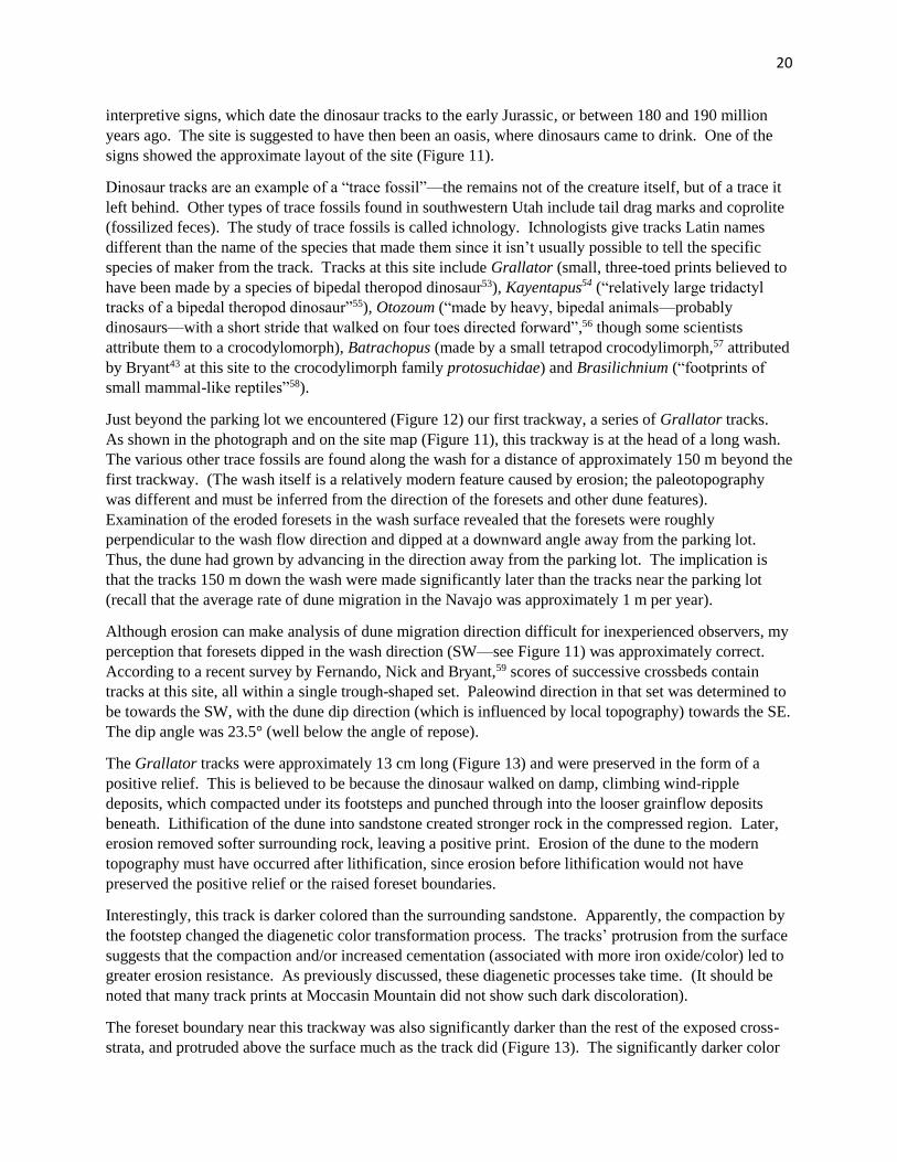
Just beyond the parking lot we encountered (Figure 12) our first trackway, a series of Grallator tracks.
As shown in the photograph and on the site map (Figure 11), this trackway is at the head of a long wash.
The various other trace fossils are found along the wash for a distance of approximately 150 m beyond the
first trackway. (The wash itself is a relatively modern feature caused by erosion; the paleotopography
was different and must be inferred from the direction of the foresets and other dune features).
Examination of the eroded foresets in the wash surface revealed that the foresets were roughly
perpendicular to the wash flow direction and dipped at a downward angle away from the parking lot.
Thus, the dune had grown by advancing in the direction away from the parking lot. The implication is
that the tracks 150 m down the wash were made significantly later than the tracks near the parking lot
(recall that the average rate of dune migration in the Navajo was approximately 1 m per year).
Although erosion can make analysis of dune migration direction difficult for inexperienced observers, my
perception that foresets dipped in the wash direction (SW—see Figure 11) was approximately correct.
According to a recent survey by Fernando, Nick and Bryant,59 scores of successive crossbeds contain
tracks at this site, all within a single trough-shaped set. Paleowind direction in that set was determined to
be towards the SW, with the dune dip direction (which is influenced by local topography) towards the SE.
The dip angle was 23.5° (well below the angle of repose).
The Grallator tracks were approximately 13 cm long (Figure 13) and were preserved in the form of a
positive relief. This is believed to be because the dinosaur walked on damp, climbing wind-ripple
deposits, which compacted under its footsteps and punched through into the looser grainflow deposits
beneath. Lithification of the dune into sandstone created stronger rock in the compressed region. Later,
erosion removed softer surrounding rock, leaving a positive print. Erosion of the dune to the modern
topography must have occurred after lithification, since erosion before lithification would not have
preserved the positive relief or the raised foreset boundaries.
Interestingly, this track is darker colored than the surrounding sandstone. Apparently, the compaction by
the footstep changed the diagenetic color transformation process. The tracks’ protrusion from the surface
suggests that the compaction and/or increased cementation (associated with more iron oxide/color) led to
greater erosion resistance. As previously discussed, these diagenetic processes take time. (It should be
noted that many track prints at Moccasin Mountain did not show such dark discoloration).
The foreset boundary near this trackway was also significantly darker than the rest of the exposed cross-
strata, and protruded above the surface much as the track did (Figure 13). The significantly darker color

21
and greater erosion resistance at the foreset boundaries suggests a different porosity or grain size or both.
This might have been caused by a periodic change in grainfall vs. grainflow, or pinstripes from wind
ripple deposits, or compaction by wind and rain exposure.
These first tracks we encountered were equally spaced, facing the same direction, and placed along one
foreset (Figure 14). This indicates that this is a trackway, created by a single dinosaur traveling across the
lee face of the dune at an oblique angle. (Had the dinosaur been travelling on the windward rather than
lee side of the dune, its tracks would have been destroyed as the dune advanced). None of the trackways
observed climb stratigraphically through multiple foresets; they always were located within a single
foreset, as shown in this photo. This is because each foreset represents a discrete period of time, followed
sequentially by that of successive foresets. Unless dinosaurs had mastered time travel, it is not possible
for them to have trampled multiple foresets except as noted in the next paragraph. Figure 15 shows a
partially uncovered Grallator track. Though it appears to span the boundary between two crossbeds, it is
actually contained within a single foreset that has been almost entirely eroded back into the outcrop,
except where protected by the more durably cemented track.
Figure 12. Examining Grallator tracks just past the parking lot, with the lay of the Moccasin Mountain tracksite in the
background.
Loope62 studied Grallator tracks of a single animal in the Navajo and observed them moving across, not
down, the dune face. In a remarkable cross-sectional view (his Fig. 2B), dinosaur claws were observed to
have created a grainflow (avalanche) that covered two earlier tracks but was stepped in when the animal
created a third track. Thus, because of the avalanche the animal induced, it started walking on one
slipface surface and part way through was walking on a new slipface surface created by the avalanche. In
that limited sense, it walked on two foresets in one walk, without resorting to time travel. (Incidentally,
there was no preferred orientation of the tracks on the exposed surfaces in Loope’s study area).

22
Figure 13. Grallator track near the parking lot at Moccasin Mountain tracksite.
Figure 14. Equally spaced Grallator tracks within a single foreset. Arrows indicate direction of travel.
23
Figure 15. A partially uncovered Grallator track.
In summary, the layout of the Moccasin Mountain site and the track locations in relation to the foresets
strongly support an interpretation of many years of eolian deposition and repeated episodes of animal
movement. Even if one chooses to reject the sedimentological evidence and argue that the dunes were
created by a Noachian Flood, there still remains the undeniable implication that the animals walked across
the dune at different times (since even subaqueously deposited foresets are deposited sequentially over
time). Therefore, either there were multiple episodic flooding events followed by water retreat, or at least
some of the animals walked underwater. And, when constructing a Flood timeline, all of this would have
to be squeezed into an extremely short time since there were many strata above and below that also
needed time to form their structures and fossils.
Additional interpretive constraints accompany the specific disposition of the various tracks. There were
only a few of the relatively large Otozoum tracks (Figure 16), but they were impressive in size. More
dangerous-looking, however, were the 3-clawed feet that made the large Kayentapus tracks (Figure 17).
Tracks were spaced approximately 1 m apart (Figure 18), implying a stride of approximately 2 m. Two of
the Kayentapus trackways appeared to lie in adjoining foresets (Figure 19), so must have been made
relatively close together in time. Both trackways followed a similar path along an approximately E-W
orientation, or oblique to the dune’s lee face. However, the two trackways pointed in opposite directions.
This example clearly shows that not all dinosaur tracks go uphill. To the extent one track angled uphill,
the other obviously was angling downhill. The two parallel tracks in opposite directions oblique to the
lee face suggest animals following customary terrain features, not frantically escaping rising water.
Not pictured60 is an area of Batrachopus and Brasilichnium tracks near the wash drop-off—the end of the
tracksite (Figure 11) and the track-bearing crossbeds’ lower bounding surface. Since the dunes migrated
in that direction, these were among the last exposed tracks to be imprinted at the site. These were small
animals. Had the foresets on which these tracks were made been deposited subaqueously, with no

24
subsequent water recession, these animals would have been underwater. Given that dune height would
have been several times the crossbed thickness, even the Kayentapus trackmaker must have been
underwater, probably tens of meters of it. The only way these dune foresets could have been deposited
subaqueously without the trackmakers being underwater would be if the area underwent repeated cycles
of flooding and retreat, with animals surviving each flooding event and making tracks during the dryer
cycles. However, that scenario would produce distinctive sedimentary structures, such as strand lines, lag
deposits, oscillation ripples, erosional ravinement and undercutting of slopes, and current ripples in the
dune corridors—none of which are observed.
Bryant61 noted that the trackways visible here are subject to preservational and/or exposure bias. It seems
likely that tracks in other directions may have existed at one time but were destroyed by subsequent
sedimentation processes or were not exposed by the erosion that created the current topography.
Pathways in direct uphill and downhill directions would have been avoided by large animals (much as
they are avoided by mature dune-trampling humans) and the substrate collapse and avalanching
accompanying forays in these directions would preferentially obscure the adventurous animal’s prints.
Figure 16. A young participant records the shape of an Otozoum print in her notebook. Arrow points to track.

25
Figure 17. Kayentapus track (Eubrontes in some literature).
Figure 18. Track spacing in a Kayentapus trackway.

26
Figure 19. Note the Kayentapus trackway on the left moving away from the camera, and the one on the right, along a different
foreset, moving towards the camera. (Arrows are next to individual footprints).
Reactivation surfaces, as explained earlier, were exposed for a longer period of time than a typical foreset
before being buried. At Moccasin Mountain, these surfaces are heavily trampled, especially near the
lower bounding surface (Figure 20). Last year I wrote:
“The most heavily traveled layers appeared to be reactivation surfaces (layers that often represent a change
in climate or other control factors that may cause a shift in the direction of dune growth). Surrounding
layers seemed to be devoid of tracks. Bryant explained that these surfaces had the right moisture to
preserve the tracks, and in any case, animals generally preferred to walk through the lowlands or near
water, rather than climb over a dune. Prints went in both directions along the busiest tracks. It is difficult
to interpret these tracks as those of dinosaurs crawling to the top of dunes to escape Noah’s flood; more
likely, they were looking for a drink or a meal.”

27
Pitman’s question suggests that he may have missed this comment, for he seems to think that the
mainstream interpretation is that the Navajo dunefields were universally dry and devoid of moisture, but
that isn’t the case (for all areas and time periods). The Moccasin Mountain tracks are interpreted to have
been made in damp sand.
Figure 20. Heavily trampled reactivation surface at Moccasin Mountain Tracksite (2016).
But, even if the tracks had not been made on a moist surface, they still could have been preserved under
certain circumstances. Loope62 found that large animals (>100 g) left tracks in dry sand. When these
animals moved across dry sand slopes, they triggered avalanches. They then stepped on these
uncompacted, freshly avalanched surfaces and sank in deeply enough that clear footprints were preserved
in the underlayers even though the footprint itself quickly filled with more avalanched sand. In fact,
cross-sectional views (his Figs. 2B and 8) of tracks, avalanched sand, then tracks on the avalanched sand,
repeated, constitute strong evidence for the dry-sand origin of these tracks. At a Coyote Buttes study site,
Loope observed numerous tracks in the Navajo that he concluded “most likely were made by small
theropod dinosaurs and tritylodont therapsids that moved up, down, and across angle-of-repose slopes on
the lee sides of large dunes.” Tracks in this area are also “better protected from wind erosion than those
made on any other dune surface” because the slipface lies in an area protected from the high winds
coming over the crest of the dune. Loope argued that the very act of traveling across the face of the dune
and triggering more frequent avalanches may explain the thinner grainflows observed in those areas
where tracks were found. Loope concluded that several lines of evidence support “a dry-sand origin for
most, if not all, the abundant, well-formed tracks preserved in grainflows of the Lower Jurassic Navajo
Sandstone of the southwestern USA.” (Note that these conclusions were specific to grainflow areas; there
are other track locations in the Navajo, such as interdunes, where significant moisture was clearly
present).

28
Figure 21. Area of dinoturbation at Moccasin Mountain tracksite.
Figure 22. Dinoturbation layer, including cross-section of a dinosaur claw impression (arrow).
The sand at Moccasin Mountain at the time and areas of track formation has been considered to have been
damp, but not dry or underwater. A picture of another heavily trampled surface is shown in Figure 21.

29
These are not the regularly spaced prints of a single trackway, but rather, due to one or more animals
walking multiple times. There are several such areas at Moccasin Mountain. Yet another example of a
disturbed layer is shown in Figure 22; it retains evidence of a dinosaur claw impression. As in these
photographs, the trampled areas were always within a given foreset, with trampled foresets separated
from each other by other foresets with no visible tracks. This suggests a possibly seasonal periodicity for
the reactivation surfaces and track-making (or at least track preservation), perhaps tied to precipitation
cycles. In any case, this periodic spacing challenges Flood interpretations.
Whether trackways aligned oblique to the dune face, or trackways moving in opposite directions, or
heavily trampled surfaces with tracks pointing in more than one direction—the evidence from Moccasin
Mountain is that vertebrates were not universally going uphill. Rather, over an extended time, they went
in various directions. During periods of prolonged exposure, reactivation zones were heavily trampled,
before dune migration resumed and covered them up, until revealed by subsequent erosion. These
findings are consistent with those from several other published Navajo Sandstone tracksite studies, where
reported tracks pointed in various directions, especially in interdune areas.
Besides tracks, there were other interesting features at the Moccasin Mountain tracksite. Figure 23 shows
where a layer of sand had slipped downward over an underlying layer. Because of sorting mechanisms in
eolian dune formation, it is rare to see drag marks as observed here. Apparently, some small inclusions of
organic matter or perhaps sand aggregates from irregular moisture cohesion were dragged across the
underlying sand surface, creating the grooves that run downslope. For an entire layer to slide as a unit
like this, it must have cohesion. This suggests that this foreset layer was neither dry nor saturated with
water, but was sufficiently moist for cohesion without slumping or disintegrating.
Figure 23. Rarely seen grooves made on a dune slipface when a cohered layer of sand slid downward. The grooves were
created by a small inclusion or sand aggregate being dragged downward across the face of the underlying layer.

30
Figure 24. Gerald Bryant explains a small cylindrical fluid escape feature at Moccasin Mountain.
Figure 25. Fluid escape feature at Moccasin Mountain. Collapse of the cylinder after water ejection lowered the column of sand
within the cylinder, so that the thick white line corresponding to a higher sand layer fell to the level of its downslope matching
line. (Imagine sand layers, including the layer that became a white layer, extending up and out of the plane of the photo).

31
Indicative of dune subsurface moisture was the presence of small fluid escape features. Figure 24 shows
the location of a fluid escape pipe. When wet sand is cyclically stressed, such as by an earthquake, the
grains of loosely packed sand become packed more tightly, so that the bed of sand collapses (volume
reduction on the order of 10% or more63). Water displaced from the sand bed is ejected upwards under
pressure, fluidizing sand above it. Once the water has ejected, the column of sand through which the
water escaped collapses, ultimately ending up at a lower elevation than it was originally. As the column
collapses, sand compositional and morphological features may be preserved, so that characteristics of
higher foresets are now at the level of matching downslope layers (Figure 25). Once again, this suggests
a dune with groundwater nearby, but not fully saturated with water either (there was cohesion in the
surrounding sand).
Creationist arguments against eolian interpretations because certain features require water are misplaced.
Mainstream geological research encompasses considerable evidence for groundwater and even surface
water-related features in eolian dunes. Gerald Bryant has extensively documented fluid escape features
preserved in the Navajo, along with interdune deposits where moisture played a role in trapping fine
particles and forming dense interdune layers. Thus, there is no contradiction between preservation of
dinosaur tracks in moist sand and the view that these were eolian dunes.
Figure 26 shows a small slump in a foreset preserved in the sandstone at Moccasin Mountain. The
preserved laminar morphology within the slumped layers indicates cohesion, suggesting that some
moisture was present, but this wasn’t a saturated underwater environment at the time. It is possible that
this slump was caused by animal movement above it.
Figure 26. A small slump in a foreset preserved at Moccasin Mountain tracksite.

32
Another interesting feature found in an area beyond the farthest tracks was a preserved dune apex (Figure
27). I was unable to determine if this was at the very top of a dune or merely the peak of a smaller
subpart of a complex dune structure. The preserved ridge extending beyond the lower right of the
photograph resembles dune features in a large active Barchan dune in nearby Coral Pink Sand Dunes
(Figure 28).
As an aside, it is interesting to compare this photograph (from 2016) with one taken in 2017 from the
same location (Figure 29). Although the stability of the general shape and location of the dune is
obvious, careful examination (it is helpful to sight to cliff features in the background) shows that the crest
of the dune has migrated to the left slightly, and the foreground wing (horn) of the dune has been
extended to the left and heightened. This kind of slow, seasonal migration of dunes, and thus dune
slipfaces, is responsible for the foresets observed in Navajo Sandstone crossbeds.
Figure 27. Apex of a dune preserved at Moccasin Mountain.

33
Figure 28. A Barchan type sand dune at Coral Pink Sand Dunes State Park (Utah) on May 12, 2016.
Figure 29. The same Barchan dune at Coral Pink Sand Dunes on May 30, 2017. (Photo was taken from approximately the same
location, a viewing stand in the state park).

34
Where did Pitman get this “uphill-only” idea? We have seen clear evidence at Moccasin Mountain for dinosaurs and other animals traveling in various
directions, not all of which could have been uphill. So, where did Pitman (and many other creationists)
get this idea of trackways only going uphill in the Navajo (or Coconino) sandstone?
In the “Uphill Only” section of his article,9 Pitman cited four references and linked to a previous article of
his.64 The first reference was a 2016 article65 by Lockley. However, examination of Lockley’s article
reveals a mainstream geological interpretation of Utah’s dinosaur sites and stratigraphy, accompanied by
several photographs from different tracksites and sedimentary levels showing dinosaur tracks pointing in
many different directions. Furthermore, the sentence Pitman quoted is revealing in context:
“It appears that while theropods and prosauropods roamed the intermittently dry water courses in interdune
and small oasis areas where one might expect to find tracks, tracks of small rodent- and cat-sized
protomammals (or synapsids), named Brasilichnium, are common on the downwind, or lee, side of the
ancient dunes. Their tracks also almost always point uphill, heading nose into the wind. No one really
knows why this is.”65
It appears that Pitman lifted Lockley’s statement about Brasilichnium out of context and applied it to all
animals including dinosaurs, regardless of what surface they were on—in direct contradiction to the
photographic evidence and written descriptions of dinosaur behavior that Lockley provided in the same
article!
The second reference in Pitman’s discussion of uphill-only tracks is a 1944 paper by McKee entitled,
“Tracks that go uphill”, the title of which Pitman drew attention to. I was unable to obtain a copy of this
paper, but in a 1979 review of that work,66 McKee noted that in hundreds of trackways in the Coconino
Sandstone, he had found only 3 exceptions to the observation that they went uphill. All the vertebrate
tracks were formed by quadrupeds; a photograph shows small 3 cm long footprints going uphill on a 30°
dip slope of crossbedded Coconino Sandstone. McKee studied chuckwalla lizard track formation in the
laboratory on sand derived from the Coconino Sandstone, on a 25-28° slope, studying tracks formed on
dry sand, damp sand with a crust, and wet sand. “Only in dry sand, uphill, could footprints be formed
similar in size and clarity to those of the Coconino. Damp and wet sands gave very different results, and
tracks made downhill were consistently destroyed by avalanching.”
Pitman criticized these conclusions, observing that in modern deserts trackways “go every which way”
and questioning “why the animals would slide downhill when they were doing do [sic] fine going uphill
without the sliding problem.” Of course, modern tracks going “every which way” aren’t necessarily
climbing a steep dune slipface, in contrast to preserved track fossils, where lee side tracks are
preferentially preserved while windward side tracks are generally erased. Furthermore, each animal
would have different characteristics, and sand composition and moisture content vary—all potentially
answering Pitman’s objections. As for McKee’s observations of uphill trackways from small animals in
the Coconino Sandstone, they seem similar to Lockley’s observation of Brasilichnium tracks. Thus,
McKee’s observations of small quadruped tracks should not be extrapolated to all animals any more than
Lockley’s should be.
The last two references Pitman cited were publications by Loma Linda University professor Leonard
Brand describing experiments with amphibians in sand beds, and comparison to Coconino trackways.
The first paper,67 published in 1978, followed the earlier work of McKee in general aspect, except that
Brand included underwater sand and several species in his study. He studied small animal tracks in
Navajo type sand in the laboratory, using dry, moist, wet, and underwater sand, in sand beds with 25°
35
slopes (a few experiments at 15° and 20°), and using 5 species of salamander and 3 species of lizard
covering a range of size and weight. Brand reported generally similar uphill results to McKee for dry,
damp and wet sand, but found the closest match to Coconino tracks to be tracks produced underwater. He
concluded that this was not proof that Coconino Sandstone was water-deposited, but that it suggested
further study of that hypothesis.
Curiously, Brand’s study failed to replicate McKee’s downhill results: McKee reported consistent
avalanching and track obscuration under dry, damp and wet sand conditions, whereas Brand reported
recognizable trackways under all sand conditions with some species and travel speed limits on dry sand.
This difference in experimental results was not discussed, but suggests that there were significant
differences in experimental conditions or procedures between the two studies.
Brand suggested that “perhaps they [the Coconino trackmakers] tended to swim when going with the
water current but to drop down and walk on the bottom when moving against the current”, thus explaining
the absence of downhill tracks in the Coconino Sandstone. (This suggestion seems to have been ignored
by creationists describing uphill-only travel as motivated by escape from a Noachian Flood).
The last of Pitman’s four references was to a 1991 publication by Brand and Tang,68 describing an
extension of Brand’s 1978 study. They studied salamander locomotion in a tank with flowing water, and
compared results with trackways in Coconino Sandstone, where trackways were observed to start and end
abruptly in the same bedding plane—an effect the authors attributed to a transition from walking to
swimming (or being swept away by the current, due to buoyancy of the animal). They also found that
when walking on sand underwater, the salamanders in their laboratory experiments used their feet to
counter the current, so that their toes pointed in a different direction than their direction of travel; this,
too, matched features of several Coconino trackways. Brand and Tang concluded that the Coconino
trackways were made underwater, not sub-aerially, and that this argued against an eolian deposition
environment for at least part of the Coconino Sandstone.
Brand and Tang’s paper included only 5 Coconino trackways that appeared in both their Fig. 2
(photographic images) and Fig. 4 (interpretation). Of these, Fig. 2B/4G shows two trackways within 10
cm of each other that Brand and Tang interpreted to have had current flows moving in nearly opposite
directions. Since tracks on the same crossbed surface must have been made at close to the same time
(especially according to a Flood interpretation that these dunes were rapidly formed), this interpretation
requires rapidly reversing current flows. Brand and Tang discussed Fig. 2B/4G and said that this
trackway suggested “shifting or intermittent lateral currents to account for the sudden changes in direction
of movement.”69 Fig. 4B, for which no corresponding images were provided in Fig. 2, shows a pair of
trackways approximately 20 cm apart where the current flows were similarly inferred to be in opposite
directions.
In their Fig. 2F (diagrammed in their Fig. 1), two trackways crossed at nearly right angles. The uphill
trackway had the normal relation of footprints and travel direction, while the perpendicular trackway
(traversing the dune face) did not, according to Brand and Tang. Since this set was not included in Fig. 4,
no interpretation of current direction was given. However, based on how they interpreted similar
trackways, the two trackways would seem to require mutually exclusive current flows, yet in this case the
tracks cross, implying different currents at the exact same location (implying different times).
Their Fig. 2A depicts a long uphill trackway, crossed by multiple approximately cross-slope trackways
along its length and approximately perpendicular to it. Because of the length of this track, the photograph
in Brand and Tang’s paper is at low magnification; even with magnification of the printed photograph, I
could not see the footprints of these trackways in sufficient detail to attempt an interpretation according to

36
Brand’s hypothesis, nor did the authors discuss this figure. However, some of the traversing trackways
appear to contain normal, regularly spaced footprints, while the middle one appears to be irregular,
somewhat like the trackway in Fig. 4H. If this observation is accurate, then once again Brand and Tang’s
interpretation requires intermittent changes in current flow direction, perhaps accompanied by quiescent
periods (to explain the “normal” cross-tracks). (Loope68 interpreted the several oblique trackways on this
photograph to be due to one animal walking zig-zag up the slope, and that may be the correct
interpretation. Either way, the rapidity of underwater current change required by Brand’s hypothesis is
difficult to explain within a rapid depositional Flood environment).
The geology community was quick to respond to Brand and Tang’s paper. Noted ichnologist Martin
Lockley68 commented that reinterpretation of the Navajo as a subaqueous deposition by several authors
during the 1970s did not withstand scrutiny, as the “presence of tracks, fossil wood, and root zones was
subsequently used to argue convincingly for the original interpretation of an eolian origin”,70 implying
that reinterpretation of the Coconino should be approached cautiously. He then pointed out that the same
kinds of trackways Brand studied in the Coconino are found in several eolian deposits, and that the
makers are not considered to be amphibians, but synapsids (mammal-like reptiles), and therefore he
questioned whether newts made a good analog for studying synapsid behavior. Finally, he questioned
Brand and Tang’s attribution of toe pointing vs. travel direction to current flow, arguing that unusual or
nonwalking gaits could explain the observed prints. “Perhaps, quite simply, the Laoporus track maker, a
habitual dunefield visitor or dweller, was adept at walking sideways or sidling across dune faces with
variable gaits.” He suggested that the animals may have had to adjust their gaits or jump sideways as they
moved across the slipface, perhaps to avoid avalanches.
According to David Loope,68 “Locomotion by tetrapods requires a rigidly ordered sequence of precise
movements.” This includes a fixed stride, which is exhibited in the Coconino trackways studied by Brand
and Tang. Loope argued that this would not be expected for animals adrift in fluid flows, and interpreted
the paired tracks in terms of couplets of front and rear feet (manus-ped). He postulated that some of the
tracks were partially eroded, especially on the upslope side since impressions would be lighter due to
body weight shifting to the downslope feet. Regarding the footprint-travel direction divergence, he
suggested (like Lockley) that it was due to the animals moving across the steeply sloping sand surfaces.
Brand’s response68 to Lockley and Loope included the following points: (1) that recent research of his on
the effects of substrates showed that tracks made on crossbeds are not reliable for identifying the track
makers, and he was not convinced that we know what type of animal made Laoporus tracks; (2) that the
suggestion of an alternate gait or that animals placed their toes pointing uphill because of the slope would
require compatible locomotion mechanics, but he didn’t believe the evidence supported such unusual
mechanics, especially in a trotting or hopping animal, whereas no unusual locomotion was required by his
water hypothesis; (3) novel locomotion mechanics would require consideration of anatomical differences
as well; (4) he admitted that Loope’s point about the consistency of the stride length and footprint pattern
in transverse trackways was one of the more challenging aspects of his hypothesis, but he believed that
with moderate, consistent current flows, a consistent stride could be achieved, as demonstrated by
laboratory studies; (5) he disputed Loope’s suggestion that a change in foot placement in a previous study
by Sarjeant would result in a match to a pattern in Brand’s study; (6) he disputed Loope’s argument that
upslope footprints were fainter or absent because they were shallower and removed by erosion, arguing
that in that case, ridges pushed up behind many tracks would have eroded as well; (7) he noted that
neither Lockley nor Loope had suggested an explanation for the suddenly appearing or disappearing
tracks, which he attributed to walking-swimming transitions. Brand argued that the burden of proof was
on the other side to demonstrate that their hypothesis of alternative locomotion was realistic. He

37
concluded by saying that the tracks seemed best explained by a subaqueous interpretation, but that other
sedimentologists are convinced of an eolian environment, so more work was needed on both sides.
Ralph Hunter71 later commented that the inverse laminations in Coconino Sandstone—fine sand at the
bottom and coarse sand at the top—is very diagnostic of wind ripple deposits. He suggested that despite
their eolian origin, the dunefields could have had a small stream running through it, analogous to
intermittent streams that form in the Namibian desert today, and that some of the tracks recorded by
Brand and Tang might have been formed in such a stream or pond environment.
In 1995, Lockley and Hunt72 discussed Brand’s hypothesis of underwater trackways further. They
reported that they had observed modern lizards running transversely across dune faces and leaving
footprints that pointed uphill. They summarized calculations that purported to support the hypothesis that
unusual trackways were formed under running or unusual gait conditions. They noted that a subaqueous
origin was ascribed to some invertebrate trackways (that are sometimes on the same slab as Laoporus
tracks such as those studied by Brand) that are attributable to scorpions or tarantula-like spiders, which do
not make underwater tracks. Citing work in the Lyons Sandstone, a Permian twin of the Coconino with
similar age and trackways, they described a slab with an uphill trackway crossed obliquely by another
trackway, both with sand dimples behind the tracks, with the oblique trackway having a similar
appearance to several described as “unusual” in the Coconino (i.e., features interpreted by Brand as due to
buoyancy and current). They concluded that the unusual appearance was not from swimming, but from
the animals’ gait, since the swimming interpretation would require that the Lyons sandstone must have
been deposited, at least in part, under water. However, in the area where the trackways were found,
“geologists have identified sand avalanche features and rain drop impressions, both of which show that
the ancient sand dunes were exposed to the atmosphere and not submerged beneath bodies of water.”
They acknowledged that modern trackway studies like Brand’s are useful, but inconclusive relative to
fossil trackways unless all alternative explanations have been considered, especially when a proposed
interpretation runs counter to other lines of evidence.
Brand73 published further salamander track studies in 1996, this time examining the effect of different
substrates. Studying upslope trackways on a 25° slope, he found that the number of toes preserved in a
track was highly dependent on the substrate. Tracks on freshly wetted sand (via a spraybottle) were of
poor quality, but tracks made on wetted sand that was dried overnight provided excellent tracks. Dry
sand did not preserve the number of toes, and subaqueous sand was not very reliable either. Brand
concluded that it is difficult to reliably determine the number of toes of an animal from trackways, unless
conditions were optimal at the time they were made. Comparing his laboratory results with fossil
trackways, he concluded that the Coconino trackways most closely resembled those made in subaqueous
sand or subaerial damp sand, suggesting one of those substrates. On the other hand, he acknowledged
that his study subject, the western newt, might differ in important ways from the Permian trackmaker.
Thus, while this study addressed an interpretive aspect of trackway studies in the Coconino Sandstone, it
did not address the key concerns of other scientists regarding the subaqueous hypothesis raised in his
1991 paper.
In another 1996 paper, Brand and Kramer74 examined “underprints” (deformed sand beneath surface
prints) of vertebrate and invertebrate trackways in the Coconino Sandstone. Examination of an arthropod
trackway, including microscopic examination of vertical cross-sectional slices through tracks, led them to
conclude that: (a) the trackways exposed on the slab surfaces were underprints, not true surface prints;
(b) in pure, fine sandy conditions, underprints may be preserved better, with sharper definition, than true
surface prints, which may be filled in by sand or eroded. They acknowledged that this finding
contradicted Brand and Tang’s 1991 conclusion68 that the tracks studied in that paper were not

38
underprints. This conclusion apparently undermines Brand’s 1978 argument67 for a subaqueous
environment based on the observation that surface tracks obtained in laboratory studies only matched the
sharpness and definition of those on Coconino slabs when the laboratory tracks were made under
subaqueous conditions (expanded in Brand’s 1996 study73 to include subaerial damp sand). If the
Coconino tracks are mostly underprints, and if underprints in fine sand are better preserved than surface
prints, then a comparison of laboratory surface prints to Coconino prints must be inconclusive.
There is a further aspect of Brand and Kramer’s work that they did not discuss but is important to note.
Their conclusion about the underprint nature of one of the trackways was based on microscopic
examination of a track’s vertical cross-section. They observed that a layer of larger particles was on the
surface where the arthropod walked, and these larger particles were pushed down into the underlying finer
lamina as the arthropod’s leg penetrated the sand surface. The larger particles remained there when the
arthropod removed its leg from the hole it had made (see Figures 2A and 3 of their paper). This
microscopic evidence demonstrates that particles were inversely graded, with larger particles on the
surface. Inverse grading is a characteristic of wind ripple deposits, not subaqueous depositions.
In 2008 Milan, Loope and Bromley75 published a description of a sauropodomorph dinosaur climbing a
dune face first at an oblique angle, then changing direction to proceed directly up the slope. The tracks
for this animal were approximately 20 cm long—much larger than the animals studied by Brand in the
Coconino or in his laboratory. There is no evidence that the animal was forced by a water current to
move in the directions it chose, but its feet faced uphill when traversing the dune, much as Loope had
explained in his 1992 response to Brand and Tang68 that animals would do when crossing a steep slope.
A recent study76 of a Coconino Sandstone slab containing multiple trackways included 3 Chelichnus
(synonym and newer nomenclature for Laoporus) trackways. One climbed the slope of the dune face,
while the other two crossed that trackway at approximately 45° angles. Due to the maximal steepness of
the slope, all trackways had footprints with slippage/sand crescents, and the two traversing trackways had
downslope footprints facing uphill in a manner similar to what Brand and Tang observed. Citton et al.
wrote, “During the short portion of its odyssey that is preserved on the slab, the trackmaker had to oppose
the force of gravity while simultaneously displacing itself forward on a dynamic, constantly changing
substrate…..During its march, the trackmaker continuously slid, if only slightly, down the inclined
surface, and, at each step, all its feet had to be displaced upward to balance downslope slippage and to
maintain forward progression. This accounts for the anomalous positions of the manus [hands/forefeet],
which are displaced upslope relative to their respective pedes [feet/rear feet].” As the sand slid, the hind
foot had to be maximally extended and the foot rotated. “Thus, the inward position of the digits in the left
footprints does not record the position of foot at the touch-down phase, but only the last position held by
the foot just before the takeoff phase.” The authors’ biomechanical analysis supported an eolian
interpretation of the Coconino Sandstone and the Chelichnus trackways.
In May 2017, Engelmann and Chure77 published a paper on downhill tracks that provides a current
summary of the situation in the Nugget (and correlative Navajo) Sandstone. A few examples of
downslope tracks on foresets do exist, but they are rare. They reviewed examples of downslope
Brasilichnium tracks and noted the differences in track appearance compared to uphill tracks. They noted
that “Those [vertebrate tracks] on dune foreset beds are virtually all made by animals walking up slope.
Gilmore (1927, p. 3) noted that of the hundreds of Coconino Sandstone tracks he had examined only three
that were not upslope tracks. A similar pattern is present in the Nugget, Navajo, and Aztec sandstones,”
and a similar pattern was found for dune foreset tracks of a Pleistocene goat in Mallorca. The authors
noted that McKee’s 1944 explanation of destruction of downhill trackways doesn’t account for the fact
that if there were many downhill trackways that erased themselves, they should have erased portions of

39
uphill trackways they intersected or were close to, but that is not observed even on surfaces with many
uphill trackways. Another hypothesis is that animals may have preferred descending by a different route,
via the stoss side or along the more gently descending crests; however, no modern behavioral analogs are
known. In summary, “Although various biological and environmental explanations for this pattern have
been proposed…no consensus has appeared.” It must be emphasized that this paper reviewed the
trackways of Brasilichnium and was restricted to studying trackways on dune faces.
Rowland and Mercadante78 recently reported 12 subparallel Brasilichnium trackways on a single foreset
bedding plane due to wind ripple deposits. They hypothesized that Brasilichnium were dune-dwellers,
responsible for burrowing extensive “prairie-dog–town–like colonies” that have been found in the Navajo
Sandstone. Perhaps animals climbing to burrows may explain trackways up the dune face (with a primary
dip of 25° in this instance, so less prone to avalanches), but it doesn’t explain why so few downslope
trackways have been found for these animals. Thus, while suggestions have been offered for why
Brasilichnium trackways are associated with dunes, a conclusive explanation for the relative scarcity of
downslope tracks for certain small animals remains to be found. Regardless of Brasilichnium behavior,
there are other tracks in the Navajo Sandstone where there was not a directional preference.
Brand79 recently acknowledged that his study was inconclusive: “At present, it is not clear what the
ultimate conclusion from this research [on Coconino trackways] will be. The trackways have features that
seem virtually impossible to explain unless they were made with the animals completely underwater,
while the sedimentary evidence, as interpreted by sedimentologists, seems to point to wind-blown sand.”
He therefore believed still more study was needed. He also emphasized that his research does not show if
the tracks were made in Noah’s Flood, but it does point to an underwater origin of the trackways.
Despite those caveats (and the dismissal of his critics’ alternative explanations implied by “virtually
impossible”), Brand and others continue to promote his Coconino trackway studies in various lectures and
online in a context that can only be understood as intended to support a Flood interpretation.80,81,82 He has
argued that his interpretation of cross-slope trackways has not been adequately refuted, and that nobody
has attempted to explain the sudden appearance or disappearance of tracks on a smooth slab.80,83 That
tracks are found only in a minor fraction of Coconino strata, despite all layers of that formation indicating
the same environment, he considers to be further evidence supporting a Flood interpretation80
(mainstream geologists associate track-containing strata with favorable paleoenvironments62).
Brand was mistaken in thinking that nobody had attempted to explain the sudden starts and stops that he
interpreted as walking-swimming transitions. In 2006, Loope62 provided convincing evidence of the
extensive preservation of tracks in dry sand and the role of grainflows (avalanches) in their preservation.
The paper included photographic evidence of animal footprints penetrating sloped sand surfaces before
and after avalanches. On p. 141 of his paper, he discussed his results in relation to Brand’s observations.
He noted that if a small animal walked over a grainflow, and its tracks were shallow compared to the
thickness of the grainflow, its tracks would leave one bedding plane and enter another, leaving no more
marks on the first. Later, when the lithified rock was split along the bedding plane that the first tracks
were in, the trackway would have the appearance of disappearing suddenly. Thus, a plausible eolian
interpretation of Brand’s observations has been offered.84
Where does that leave us? The geology community has not accepted Brand’s interpretation because (a) it
contradicts other evidence pointing to an eolian origin of the Coconino Sandstone, and (b) they believe
the Coconino tracks Brand studied could be produced sub-aerially, supported by evidence including that
found on the very slabs Brand studied. Contrary to claims by Pitman and others, there is no ongoing
debate in the geology community about the eolian origins of the Navajo or Coconino Sandstones. The
40
controversy in the early 1970s over whether the Navajo was eolian or not was resolved by additional
work by Hunter and others, as discussed previously, and the subaqueous hypothesis has been rejected. So
long as there is a plausible explanation of the tracks that does not require deep water—and most
geologists seem to believe that there is—then that is the interpretation the community will support. Brand
has not been successful in disproving alternative hypotheses or raising enough doubt about other eolian
evidence to motivate geologists and ichnologists to take his subaqueous Coconino trackway hypothesis
more seriously. Thus far, those who have, have rejected his interpretation. Brand attributes this to their
“naturalistic assumptions” and refusal to acknowledge the possibility of Noah’s Flood.80 Yet, neither he
nor others of similar persuasion have been able to demonstrate the value of their subaqueous hypothesis
for organizing the full suite of sedimentological, paleontological, and stratigraphic evidence available
from these ancient dune deposits. Perhaps that is why these ideas flourish only in the scientific
backwaters of creationist apologetics.
Even some within the creationist community have rejected Brand’s interpretation of the Coconino
Sandstone and its tracks. In a Creation Ministries International publication, Robinson85 argued that the
Flood is recorded only in early strata of the geologic column (pre-Permian). All the fossil record was
attributed to post-Flood geological activity and living animals within that setting, including recolonized
animals from Noah’s ark, survivors on floating mats of vegetation, and marine creatures. He criticized
the Flood geology interpretation of Brand, Morris, Austin, Coffin, Snelling and others who attribute most
of the fossil record to the Flood, with the Flood/post-Flood boundary placed after the Cretaceous.
Robinson noted the many challenges posed by interpreting Coconino trace fossils as subaqueously
imprinted, including the depth of water the creatures would have been under, and the massive layers of
fossil-bearing sediment beneath. He acknowledged an eolian genesis for parts of the post-Permian
geologic column. Robinson argued that his pre-Permian interpretation better aligned with the Genesis
account, for example, Gen. 6:13; 7:4; 7:21-23; 9:11. Robinson’s critique certainly can’t be attributed to
“naturalistic assumptions”, yet he pointed to several of the same problems with the post-Cretaceous
interpretation that mainstream geologists have noted. (The pre-Permian Flood geology interpretation has
its own conflicts with mainstream science; my point here is to show that eolian interpretations cannot be
simply dismissed as due to naturalistic assumptions or anti-biblical bias).
So, what about Sean Pitman’s question?
It is true that trackways found on foresets from a variety of animals seem to be predominantly uphill.
However, downhill examples do exist. And, many examples of traversing trackways exist, including in
Brand’s own work, and Kayentapus tracks at Moccasin Mountain traveling in both directions oblique to
the lee face. These do not seem to fit the storyline of desperate animals climbing to higher ground to
escape floodwaters. Neither do Brand’s hypothesized vertebrate trackmakers—competent swimmers—fit
that motif.
More importantly, animals did not walk only on dune slipfaces! In fact, tracks on crossbeds are relatively
rare. References cited by Pitman, including Brand, acknowledge that animals, including dinosaurs and
crocodilians, left numerous tracks on horizontal surfaces, including interdune areas, in the Navajo. These
tracks point in many directions. (This doesn’t count the tracks that may have been deposited on stoss
surfaces but erased from the fossil record). There is considerable evidence of these animals walking on
moist and dry sand (even Brand acknowledges this; he suggests that the Flood periodically retreated to
allow it,79 but without explaining how the animals survived to this or later stratigraphic levels).
Furthermore, animals appeared to heavily trample (in a variety of track directions) sand at reactivation
surfaces, as seen at Moccasin Mountain, and at interdune areas, as reported from other sites.

41
Thus, it is simply not true that animals in the Navajo only walked uphill. That appears to be a creationist
myth due to careless use of early references, including quotations taken out of context, and inappropriate
extrapolation from a few ichnogenera walking on slipfaces to all animals everywhere.
Conclusions from Moccasin Mountain The Moccasin Mountain tracksite is a spectacular site in a beautiful location. The tracks here provide an
answer to the question posed by Pitman. There is no need to explain why all animal tracks go uphill in
the Navajo Sandstone because they do not. Rather, different animals ranging from small rodent-sized
creatures to larger dinosaurs appeared to use this area for routine travel over an extended period of time.
The time required for dune migration, the tracks from small creatures in multiple foresets (different
times), the depth of water required to form the dunes in this area if they were formed subaqueously, the
presence of small animal tracks near the bounding surface (base) of the most recently deposited foresets,
together with general arguments for the eolian genesis of the Navajo Sandstone, all argue against a
Noachian Flood interpretation of the dunes at this site, and for the presence and movement of animals on
and around them.
Moisture was present in the area during at least some of the time of dune migration, as indicated by the
nature of track preservation and various dune features including slip grooves, cohered layers in
avalanches/slumps, and small fluid escape features. Nearby surface water may explain why animals were
here in the first place.
The diagenetic processes that transformed white sand into reddish sandstone and then to various shades of
orange or white, along with formation of iron concretions, are complex but evident all around. Even at a
microscale, variations in chemical environment and permeability to diagenetic fluids caused color
variations between layers, as well as between some compressed footprints and surrounding material.
These processes themselves defy short chronologies, and add to the compelling evidence from Moccasin
Mountain that the Navajo Sandstone was formed from eolian dune deposits over an extended time,
inhabited by dinosaurs and other now-extinct species for eons, and then transformed into rock of various
beautiful colors for us to enjoy.
The idea that dinosaur trackways only go uphill is a myth, refuted even in the publications of some
creationist scientists. It seems to be based on misinterpretation and extrapolation from the literature.
The mainstream scientific interpretation of the Navajo Sandstone as eolian in origin rests on a wide base
of evidence. The evidence from Moccasin Mountain is consistent with this interpretation.
The Navajo Sandstone and other exposed strata in the Colorado Plateau testify to an old planet and the
presence of life upon it for an exceedingly long time. Even if one accepts a relatively short chronology,
there isn’t enough time for post-Flood geological processes and the subsequent history revealed in the
archaeological record to fit within the 4500 year post-Flood timeline many biblical literalists insist the
Bible describes.
Alleged Scientific Benefits of a “Biblical Worldview” An argument advanced by some creationist scientists today is that creationist research is good for science
because it approaches science with a different worldview, producing results that science might otherwise
miss.79,86,87 Thus, for example, Brand83 has argued that a worldview provides a philosophical framework,

42
inspiration for research, ideas for study, suggests hypotheses, and makes predictions, and that therefore a
different worldview essentially facilitates outside-the-box thinking, and that this is good for science.
There is some validity to this argument: new perspectives are a known spark for creativity and
innovation, which is one reason that scientists who change disciplines during their careers sometimes
quickly make major contributions to their new field, contrary to what one might expect from someone
with a limited background in that field. According to Standler,88 “One of the principal ways to be creative
is to look for alternative ways to view a phenomena [sic] or for alternative ways to ask a question.”
That a new perspective elicits new hypotheses does not, however, imply that the new perspective is more
realistic or “correct” than another, or more fruitful. Conventional science (“naturalistic science” in
creationist parlance) has managed numerous leaps in understanding based on new paradigms without
having to abandon its “naturalistic worldview”. Even some of the examples cited by creationists to
support their argument (for the value of new perspectives offered by their worldview) resulted from
hypotheses and work by conventional scientists (e.g., utility of “junk” DNA; epigenetics).83 In other
cases, the claimed scientific breakthroughs resulting from a “biblical worldview” are not yet recognized
by the wider scientific community (e.g., subaqueous origin of the Coconino Sandstone) and it is too early
to claim success. In any event, multiple “biblical worldviews” can be envisioned. All of them derive
from a book written in a prescientific age for a prescientific audience, so unless one believes in a strong
form of biblical inspiration (i.e., God verbally inspired men to write God’s scientifically and historically
accurate account), a “biblical worldview” does not seem a rational basis for scientific interpretation.
When (whether openly acknowledged or not) the research goal is to provide evidence in support of a
religious ideology rather than seeking truth without a pre-established framework of acceptable
interpretive outcomes, then any benefits of a worldview’s new perspective may be outweighed by the loss
in perspective imposed by one’s ideological blinders. Applying new perspectives and challenging the
status quo are regularly demonstrated in conventional science without scientists having to constrain
outcomes in the way creationists do. Thus, conventional scientists accept evidence of catastrophes (on an
episodic frequency and generally local scale) to explain phenomena previously interpreted differently, but
creationists never seem to accept evidence of time-consuming processes.
If, for a creationist scientist, there is never an endpoint where a Flood interpretation would be considered
disproved, then it is difficult to understand how what they are doing qualifies as a search for objective
truth. Thus, for example, Brand83 seems to think the only reason scientists reject his interpretation of the
Coconino trackways is because of their naturalistic worldview, when the real reason is that they don’t
view these trackways in isolation from the many other lines of evidence supporting an eolian origin of the
Coconino Sandstone, and therefore consider a wider range of possible explanations for the observations
Brand made. Brand’s worldview, on the other hand, may cause him to overlook counter-evidence found
within his own work, as even his most recent presentations to creationist audiences suggests.
Creationists argue that given enough time, science will change its views and agree with their
interpretation. They often highlight a few examples they interpret as mainstream science moving in their
direction. It is true that science is conservative, and many major breakthroughs occurred only after years
or decades of lonely study, publication and rejection.89 However, there comes a point where enough
evidence accumulates that a hypothesis is matured and generally accepted or rejected.
Creationists sometimes identify small mysteries (e.g., Brand’s Coconino trackways or Gentry’s polonium
radiohalos90) and claim that these overturn established paradigms, but because they haven’t successfully
explained all the other evidence supporting the existing paradigm, their views are rejected. An isolated
mystery cannot successfully overturn a paradigm supported by a wide range of evidence.

43
Faced with the extensive breadth and depth of evidence supporting a long chronology for life on Earth,
most scientists find YLC, let alone YEC, untenable. Asserting that new scientific breakthroughs will
eventually support the YLC view is analogous to asserting that given enough time, scientists will realize
that Earth is flat after all.
A Modest Proposal for the Seventh-day Adventist Church Despite decades of unsuccessful efforts to disprove a long chronology for life on Earth, the Seventh-day
Adventist church has chosen to double-down on YEC/YLC. Not only is the church turning a deaf ear to
the larger scientific community, it is silencing the voices of those who offer an alternative view within the
church. Whereas in the early 2000’s, Faith & Science conferences in Utah and Colorado featured
presentations and open discussion of both short and long age views of life on Earth, current
denominational leadership has hosted conferences in 2014 and 2017 that exclusively featured YLC/YEC
presenters. Following up on a 2010 motion by GC President Ted Wilson, the denomination tightened its
fundamental belief statements on Creation and the Noachian Flood at the 2015 GC session. And, through
ITMBE, it is pressuring employees to sign statements of belief in YLC/YEC creation.91
These official efforts are augmented by the efforts of conservative bloggers (including Pitman) who seek
to silence those like Larry Geraty or Fritz Guy92 who have offered alternative interpretations of the
Genesis account. Yet, one can hardly fault bloggers when denominational leaders like Ted Wilson and
Michigan Conference president Jay Gallimore are just as inflammatory. Bloggers and leaders alike
question the integrity of employees who are not “loyal to God’s Biblical truth [of a recent creation]”93 yet
don’t resign.94
This is a shame! Instead of discouraging innovative theological reflection, the Adventist church should
be actively supporting it. There is no question that the consensus views of the scientific community pose
theological challenges to the Adventist Church. Our present official response is to conclude that therefore
the scientific consensus is wrong. But, that is giving up without a fight! How can we know the
theological problems are insurmountable unless we take time to seriously explore theological
alternatives? If theology can improve science, as creationists claim, then why can’t fresh perspectives
from science improve theology? Perhaps a new understanding can be found that enriches Christian faith
while not denying physical realities.
Instead of obscurantism, the Adventist church should take a portion of the budget it currently uses for
defending traditional creationism and use it to fund a “research project” whereby a few of our brightest
theologians are tasked with exploring potential Adventist theological responses based on the assumption
that the scientific community is correct about the age of life on earth. This seems like a reasonable way to
advance “present truth”—or at least test the waters. A natural environment for conducting such a
research project would be within our universities. The current climate of punishing professors and even
entire universities95 who depart from conservative orthodoxy makes this difficult.
Organizations like Reasons to Believe and BioLogos are seeking to provide old life perspectives for
Christians, but the Seventh-day Adventist Church insists that if it were to accept such views, there would
be no reason to keep the seventh-day Sabbath—or for Christ to have died, even! Before accepting such a
dire conclusion, shouldn’t we invest resources to explore, with other Christians, how to accept the
scientific consensus and find meaning in our Christian faith? And, by investing resources, can we do so
in a way that will preserve a meaningful place for Adventism within the wider Christian community? I
believe not only that we can, but we must!

44
Personal Reflections and 2018 McLarty has announced that Talking Rocks will return to Utah in 2018.96 For those who wish to engage
the evidence in nature directly, there is nothing like spending a week in a geology haven like
southwestern Utah under the guidance of an expert like Bryant. And regardless of your views regarding
creation and the Flood, what’s not to like about being shown spectacular sights, hiking with new friends,
and enjoying good food and conversation? (Figure 30).
Figure 30. Gerald Bryant, John McLarty and Kevin Lilly relax in the shade at Moccasin Mountain tracksite.
Our experience this year was further enhanced by insightful Sabbath meditations by McLarty. He
observed that we may feel insignificant in a place like the Utah desert, facing the vastness of time and
space. But, while a grain of sand may seem insignificant, it is important to the cliff: the beauty of Zion
National Park could not exist without sand grains. We may feel insignificant, but in God’s sight we are
important.
As I reflect on that now, I think about my relation to my church and its campaign to marginalize
mainstream scientists. It is easy at times like this to feel that I am insignificant—that the church doesn’t
need (or even seem to want) me. However, McLarty’s words remind me that we all count in God’s eyes.
It is God’s world, including the Adventist church. Ted Wilson, Edward Zinke, and Sean Pitman do not
own it. But, neither do I. We are all building blocks—or sand grains—that God can use for His glory. If
we come together, and interact with one another, great things can happen!
Sean Pitman’s response to last year’s Talking Rocks report also asked if we had questioned Gerald
Bryant about “new evidence (2015) of numerous large parabolic recumbent folds” in area sandstones.
Presumably he was referring to a paper by John Whitmore et al.97 in the Answers Research Journal
(published by Answers in Genesis, a prominent YEC organization). Needless to say, there isn’t space in

45
this article to investigate another question! However, Pitman is in luck. It just so happens that one of the
world experts on soft sediment deformation in sandstone—in fact, an author of one of the early papers
that Whitmore cited—is none other than Gerald Bryant!
So…Sean, how about it? See you at Talking Rocks 2018? Seriously. You owe it to yourself—and
especially to your many readers—to take the time to grapple with the evidence in the field, in the
presence of an expert who can help you with interpretation and answer questions you have. Even if you
don’t change your views on Flood geology, you’ll at least be better able to accurately present the views of
mainstream geology.
For the rest of you, it isn’t too early to start making plans for Talking Rocks 2018! Contact John
McLarty ([email protected]) before the limited number of spaces are spoken for, or keep an eye
on his blog at https://johnmclarty.com/.
Acknowledgements I wish to thank Gerald Bryant and John McLarty not only for a great trip and learning experience, but also
for generously sharing their time to review this publication. Their suggestions and corrections greatly
improved this report, but the final account and any errors it contains are my own.
Robert T. Johnston is a retired industrial chemist living in Lake Jackson, Texas, where he and his wife
Kathy attend the Brazosport SDA Church when they aren’t traveling the world in search of adventure.
He makes no claims of geological expertise, but seeks understanding from those who have it.
© 2017, Robert T. Johnston
1 R.T. Johnston, “Adventists Study the Geology of Nevada and Utah–Part 2,” Adventist Today, July 1, 2016.
Accessed 7/15/2017, https://atoday.org/adventists-study-the-geology-of-nevada-and-utah-pt-2/.
2 I use the term “creationist” to refer to believers in a recent 6-day creation that accounts for all life forms. The
fossil record and geologic column are primarily explained by the activity of Noah’s Flood (“Flood geology”),
though some creationists attribute some of the features to creation with the appearance of age.
3 The counter at DetectingDesign.com’s homepage registered 1.9 million visitors as of 7/16/2017. That doesn’t
count readers at sites that have reposted Pitman’s work, such as the Korea Assoc. for Creation Research,
http://www.creation.or.kr/LIBRARY/itemview.asp?no=928, nor the many visitors to EducateTruth.com.
4 Jared Wright, “Educate Truth Group To Force LSU Action,” Spectrum online, Nov. 11, 2009. Accessed
7/21/2017, http://spectrummagazine.org/article/jared-wright/2009/11/11/educate-truth-group-force-lsu-action.
5 “About,” Educatetruth. Accessed 7/21/2017, http://www.educatetruth.com/about/. According to this page,
objectives include: “(1) Transparency. (2) Church employees support and represent the fundamental beliefs of the
Seventh-day Adventist Church in the classroom. (3) See a fair, supportive and encouraging environment for students
who believe in the church’s position on creation. (4) That the Bible and true science are taught as being in harmony,
shedding light on one another.” (Although #4 sounds supportive of science, in practice it is not, because the Bible is
assumed to be the supreme authority and arbiter of truth (as interpreted by fundamentalists), so science is allowed to
shed light on the Bible only to the extent it doesn’t contradict a “plain” or “literal” reading of the text).

46
6 Shane Hilde, “An apology to PUC,” EducateTruth, Nov. 9, 2010. Accessed 7/23/2017,
http://www.educatetruth.com/news/an-apology-to-puc/.
7 Many of Pitman’s articles are heavily based on the writings of various creationist authors, without presentation of
the mainstream scientific assessment of those claims, nor consideration of the affiliation or credentials of the
authors. Perhaps an extreme example of a questionable source is Pitman’s most cited expert for denial of
mainstream scientific views on plate tectonics and paleomagnetism (in Ref. 51), David Pratt. An examination of
Pratt’s website, http://www.davidpratt.info/homepage.htm, suggests that he has no scientific expertise in plate
tectonics or the many subjects he writes about, but rather, that he is a proponent of theosophy, with an interpretation
of earth history based on Hindu writings, concepts such as planet recycling, astronomy, reincarnation, the occult,
and many other perspectives that are neither scientific nor biblical.
This article cannot examine all of Pitman’s arguments, but most of them are not original, being rather a
compilation of claims made by other creationists. Even a superficial online search will uncover many of these
claims and responses to them by the scientific community, educators, or Christians dismayed by creationist claims.
Some useful sites to visit in this regard include: http://talkorigins.org/indexcc/list.html,
http://www.oldearth.org/youngministry.htm, http://www.lpl.arizona.edu/~matthewt/yeclaimsbeta.html,
http://biologos.org/, http://paleo.cc/ce/tracefos.htm.
8 S. Pitman, response to Ref. 1 , posted on Adventist Today online forum, July 16, 2016 at 6:47 am.
9 S. Pitman, “Massive Deserts Dunes – During a Worldwide Flood?” EducateTruth, July 11, 2016. Accessed
7/15/2017, http://www.educatetruth.com/featured/massive-deserts-dunes-during-a-worldwide-flood/.
10 J. Whitmore, “Coconino Sandstone—The Most Powerful Argument Against the Flood?” Answers, Nov. 1, 2015,
30.
11 T. Walker, “Geology documents dinosaurs fleeing Noah’s Flood,” Feb. 19, 2015. Accessed 7/21/2017,
http://creation.com/geology-documents-dinosaurs-fleeing-noahs-flood.
12 For example, a frequently quoted creationist article that espouses a subaqueous interpretation for sandstones in the
Colorado Plateau is: A.A. Snelling, S. Austin, “Startling Evidence for Noah’s Flood: Footprints and Sand ‘Dunes’
in a Grand Canyon Sandstone!” Creation, 15(1992), 46. Accessed 7/21/2017,
https://answersingenesis.org/geology/grand-canyon-facts/startling-evidence-for-noahs-flood/.
13 J. McLarty, “Affirming Creation: a Summer Conference for Adventist Educators,” Adventist Today, July 23,
2017. Accessed 7/28/2017, https://atoday.org/affirming-creation-a-summer-conference-for-adventist-educators/.
14 D.M. Rubin, R.E. Hunter, “Field Guide to Sedimentary Structures in the Navajo and Entrada Sandstones in
Southern Utah and Northern Arizona,” Arizona Bureau of Geology and Mineral Technology Special Paper 5, 1987,
126.
15 There is no modern desert quite like the Navajo erg, but for a sense of what a dune desert of similar scale looks
like, examine satellite imagery of the Taklamakan Desert in China: http://tinyurl.com/y848fgko.
16 W.R. Dickinson, G.E. Gehrels, “U-Pb ages of detrital zircons from Permian and Jurassic eolian sandstones of the
Colorado Plateau, USA: paleographic implications,” Sedimentary Geology, 163 (2003), 29.
17 J. Elder, “Aeolian Dunes and Sandstone: Overview,” Dec. 2006. Accessed 7/21/2017,
http://web.ncf.ca/aa456/sand/overview/index.html; “Dune”, “Saltation (Geology)”, “Cross-bedding”,
Wikipedia.com, accessed 7/21/2017; USGS, “Bedform Sedimentology Site—ripples, dunes, and cross-bedding.”
Accessed 7/21/2017, https://walrus.wr.usgs.gov/seds/index.html. For basic sedimentary geology principles, see
SEPM STRATA, a website of the Society for Sedimentary Geology,
http://www.sepmstrata.org/page.aspx?&pageid=1&1.
18 Sometimes a picture is worth a thousand words! See
https://www.youtube.com/watch?v=oSHx_IIfaxg&feature=youtu.be to watch suspension;
https://www.youtube.com/watch?v=BX7AZTUxwcA to watch saltation and creep;
https://www.youtube.com/watch?v=41KcXVgmn0E&feature=youtu.be to watch dune slipface advancement;

47
https://www.youtube.com/watch?v=XK_oEQOlsKY to see a sand avalanche advance up a dune face;
https://www.youtube.com/watch?v=-NXqD_JmE_Y to watch a 4x4 on a Navajo-scale slipface in Namibia.
19 By convention, a stratum (pl. strata) that is less than 1 cm thick is called a “lamina” (pl. laminae); if thicker than 1
cm it is called a “bed”. Cross-stratification may be referred to as “cross-bedding” when the cross-strata are greater
than 1 cm in thickness, or “cross-lamination” when less than 1 cm thick. (See Ref. 20)
20 J. Southard, Introduction to Fluid Motions, Sediment Transport, and Current-Generated Sedimentary Structures,
MIT Course 12.090, Course Textbook, Chs. 12, 16. Accessed 7/25/2017, https://ocw.mit.edu/courses/earth-
atmospheric-and-planetary-sciences/12-090-introduction-to-fluid-motions-sediment-transport-and-current-
generated-sedimentary-structures-fall-2006/course-textbook/.
21 W.F. Tanner, “Ripple Mark Indices and Their Use,” Sedimentology, 9 (1967), 89.
22 H.A. Make, “Grain segregation mechanism in aeolian sand ripples,” Eur. Phys. J. E, 1 (2000), 127.
23 For animated simulations of crossbed formation under various conditions, see D.M. Rubins and C.L. Carter,
“Bedforms and Cross-Bedding in Animation,” USGS, https://walrus.wr.usgs.gov/seds/bedforms/animation.html.
24 R.E. Hunter, D.M. Rubin, “Interpreting cyclic cross bedding, with an example from the Navajo Sandstone,” in
Brookfield, M.E., and Ahlbrandt, T.S., editors, Eolian sediments and processes: International Association of
Sedimentologists Developments in Sedimentology, v. 38, (New York, Elsevier, 1983), 429.
25 M.A. Chan, A.W. Archer, “Cyclic Eolian Stratification on the Jurassic Navajo Sandstone, Zion National Park:
Periodicities and Implications for Paleoclimate,” D.A. Sprinkel, T.C. Chidsey, Jr., and P.B. Anderson, eds., Geology
of Utah’s Parks and Monuments, Utah Geological Assn. Publication 28, (2000), 1.
26 This paleontology-latitude estimate was based on un-decompacted paleomagnetic data that have since been
revised, yielding a paleolatitudinal estimate several degrees higher.
27 G. Kocurek, “Significance of interdune deposits and bounding surfaces in aeolian dune sands,” Sedimentology, 28
(1981), 753.
28 D.M. Rubin, R.E. Hunter, “Bedform climbing in theory and nature,” Sedimentology, 29 (1982), 121.
29 G. Kocurek, R.H. Dott, Jr., “Distinctions and Uses of Stratification Types in the Interpretation of Eolian Sand,” J.
Sedimentary Petrology, 51 (1981), 579. See introduction for a list of papers favoring a subaqueous deposition
interpretation of some cross-stratified units previously thought to be eolian in origin.
30 W.E. Freeman, G.S. Visher, “Stratigraphic Analysis of the Navajo Sandstone,” J. Sedimentary Petrology, 45
(1975), 651.
31 M.D. Picard, “Stratigraphical Analysis of the Navajo Sandstone: A Discussion,” J. Sedimentary Petrology, 47
(1977), 475.
32 R.E. Hunter, “Basic types of stratification in small eolian dunes,” Sedimentology, 24 (1977), 361.
33 See also “Aeolian Processes,” Wikipedia. “Wind blowing on a sand surface ripples the surface into crests and
troughs whose long axes are perpendicular to the wind direction. The average length of jumps during saltation
corresponds to the wavelength, or distance between adjacent crests, of the ripples. In ripples, the coarsest materials
collect at the crests causing inverse grading. This distinguishes small ripples from dunes, where the coarsest
materials are generally in the troughs. This is also a distinguishing feature between water laid ripples and aeolian
ripples.” Accessed 7/13/201, https://en.wikipedia.org/wiki/Aeolian_processes.
34 D.M. Rubin, “Comparison of Morphology, Dynamics, and Stratification of Eolian and Subaqueous Dunes,” Fifth
Intl. Planetary Workshop 2017, St. George, UT.
35 S.A. Austin, “Trivializing Creationist Research,” Reports of the National Center for Science Education, 19:2
(Mar/Apr 1999), 11. Accessed 7/24/2017, https://ncse.com/library-resource/trivializing-creationist-scholarship.
36 S.A. Austin (ed.), Grand Canyon: Monument to Catastrophe, (Santee, CA, Institute for Creation Research, 1994).

48
37 http://www-personal.ksu.edu/~aarcher/abs94.htm, accessed 7/24/2017. This is an abstract to: A.W. Archer, W.P.
Lanier, H.R. Feldman, 1994. “Stratigraphy and depositional history within incised-paleovalley fills and related
facies, Douglas Group (Missourian/Virgilian; Upper Carboniferous) of Kansas, U.S.A.”, in R. Boyd, R. Dalrymple,
and B. Zaitlin, eds., Incised Valley Fill Systems, SEPM Special Paper 51, (1994), 175. Full abstract accessed
7/24/2017, http://sp.sepmonline.org/content/sepspinc/1/SEC11.abstract.
38 S.G. Fryberger and S. Schenk, “Pinstripe lamination: a distinctive feature of modern and ancient eolian
sediments,” Sediment. Geol., 55 (1988), 1.
39 “Ripple Marks,” Wikipedia. Accessed 7/24/2017, https://en.wikipedia.org/wiki/Ripple_marks. Also, “Wave-
formed ripple,” accessed same date.
40 C.G. St.C. Kendall, D. Barbeau, “Sedimentary Facies, Elements, Hierarchy & Architecture,” Society of
Sedimentary Geology. Accessed 7/25/2017, http://www.sepmstrata.org/CMS_Files/553_lecture1_introduction.pptx.
41 Winston M. Seiler and Marjorie A. Chan, “A Wet Interdune Dinosaur Trampled Surface in the Jurassic Navajo
Sandstone, Coyote Buttes, Arizona: Rare Preservation of Multiple Track Types and Tail Traces,” PALAIOS, 23
(2008), 700.
42 R.B. Irmis, “A Review of the Vertebrate Fauna of the Lower Jurassic Navajo Sandstone in Arizona,” McCord,
R.D., ed., Vertebrate Paleontology of Arizona, Mesa Southwest Museum Bulletin Number 11 (2005), 55.
43 Gerald Bryant, e-mail to R.T. Johnston, 7/21/2017.
44 J.T. Parrish, H.J.F.-Lang, “Coniferous Trees Associated with Interdune Deposits in the Jurassic Navajo Sandstone
Formation, Utah, U.S.A.,” Palaeontology, 50 (2007), 829.
45 J.T. Parrish, S.T. Hasiotis, M.A. Chan, “Carbonate Deposits In the Lower Jurassic Navajo Sandstone, Southern
Utah and Northern Arizona, U.S.A.,” J. Sedimentary Res., 87 (2017), 740.
46 J.T. Parrish, e-mail to R.T. Johnston, 7/29/2017.
47 B. Beitler, W.T. Parry, M.A. Chan, “Fingerprints of Fluid Flow: Chemical Diagenetic History of the Jurassic
Navajo Sandstone, Southern Utah, U.S.A.,” J. Sedimentary Res., 75 (2005), 547. For a less technical version of the
same information, see M.A. Chan, W.T. Parry, B. Beitler, “The Navajo Sandstone Color Palette and Marvelous
Marbles,” accessed 7/14/2017, http://archive.li.suu.edu/docs/ms130/AR/chan1.pdf.
48 D.B. Loope, R.M. Kettler, K.A. Weber, “Morphologic Clues to the Origins of Iron Oxide–Cemented Spheroids,
Boxworks, and Pipelike Concretions, Navajo Sandstone of SouthCentral Utah, U.S.A.,” J. Geology, 119 (2011),
505.
49 Many canyons in the Navajo Sandstone are formed by very slow “sapping” processes, forming valleys of
relatively uniform width in contrast to the dendritic drainages with tapered valley heads typical of surface runoff
erosion. Groundwater seepage at crossbed bounding surfaces, dissolution of cementitious minerals, formation of
arches and overhangs (such as Seeping Rock at Zion N.P.), and eventual collapse, repeated many times, leads to
formation of a “theatre-headed” valley whose features are not explained by other erosion processes (and have been
observed on Mars, incidentally). Similar processes off the main canyon form side canyons. Theatre-headed valley
networks such as Iceberg Canyon are remarkably different in satellite views than the tapered terminations of
canyons formed predominantly by overland water flow. This pronounced difference doesn’t seem to have been
considered by creationists who interpret the canyons of the Southwest as products of catastrophic water flows over
nonlithified sediment. See J.E. Laity, M.C. Malin, “Sapping processes and the development of theatre-headed
valley networks on the Colorado Plateau,” Geol. Soc. America Bull., 96 (1985), 203.
50 Becky Oskin, “Mars on Earth: How Utah's Fantastical Moqui Marbles Formed,” LiveScience, Sept. 22, 2014.
Accessed 7/15/2015, https://www.livescience.com/47936-how-moqui-marbles-form.html.
51 S. Pitman, “The Geologic Column,” 2005 (updated Mar. 2010). DetectingDesign, Accessed 7/15/2017,
http://detectingdesign.com/geologiccolumn.html.

49
52 An introductory BLM video to the Moccasin Mountain site is available: “Moccasin Mountain Dinosaur
Tracksite,” Accessed 7/20/2017, https://www.youtube.com/watch?v=Vbhr5XRNAqQ.
53 “Grallator,” WikiPedia. Accessed 7/11/2017, https://en.wikipedia.org/wiki/Grallator.
54 Some scientists consider Kayentapus and Eubrontes to be synonyms, but Kayentapus is more slender (Ref.55).
This may why Krapovickas et al. (Ref. 60) labeled as Eubrontes the tracks that the Moccasin Mountain sign
identified as Kayentapus.
55 M.G. Lockley, S.G. Lucas, G.D. Gierlinski, “Kayentapus revisited: Notes on the type material and the importance
of this theropod footprint ichnogenus,” Sullivan et al., eds., 2011, Fossil Record 3. New Mexico Museum of Natural
History and Science, Bulletin 53.
56 “Otozoum,” WikiPedia. Accessed 7/11/2017, https://en.wikipedia.org/wiki/Otozoum.
57 M.G. Lockley, J. Kirkland, A.C. Milner, “Probable Relationships between the Lower Jurassic Crocodilomorph
Trackways Batrachopus and Selenichnus: Evidence and Implications Based on New Finds from the St. George
Area Southwestern Utah,” Ichnos, 11 (2004), 1.
58 A. Hamblin, J.R. Foster, “Ancient Animal Footprints and Traces in the Grand Staircase-Escalante National
Monument, South-Central Utah,” in D.A. Sprinkel, T.C. Chidsey, Jr., and P.B. Anderson, eds., Geology of Utah’s
Parks and Monuments, Utah Geological Association Publication 28, (2000).
59 H.S.R. Fernando, K. Nick, G. Bryant, “Characterizing elements of dune architecture in the Navajo Sandstone,
Mocassin [sic] Mountain, Kanab, Utah,” Conference Paper, 112th Annual GSA Cordilleran Section Meeting, Jan.
2016.
60 Photographs of Batrachopus tracks at Moccasin Mountain, as well as Kayentapus (labeled Eubrontes) tracks, may
be found in Fig. 8c-f of V. Krapovickas, M.G. Mangano, L.A. Buatois, C.A. Marsicano, “Integrated Ichnofacies
models for deserts: Recurrent patterns and megatrends,” Earth-Science Reviews, 157 (2016), 61.
61 G. Bryant, e-mail to R.T. Johnston, 7/19/2017.
62 D.B. Loope, “Dry-Season Tracks in Dinosaur-Triggered Grainflows,” PALAIOS, 21 (2006), 132. See also poster
available from http://eas2.unl.edu/~dloope/Poster.pdf.
63 G. Bryant, “All Features Great and Small,” presentation, San Diego Adventist Forum, Feb. 9, 2013.
64 S. Pitman, “The Coconino Sand Dune Trace Fossils,” in “The Fossil Record,” DetectingDesign, May, 2001
(Updated Oct. 2015). Accessed 7/16/2017,
http://www.detectingdesign.com/fossilrecord.html#Coconino_Trace_Fossils.
65 M. Lockley, “Making tracks through the Dinosaur Diamond,” Earth, April 18, 2016. Accessed 7/16/2017,
https://www.earthmagazine.org/article/making-tracks-through-dinosaur-diamond.
66 E.D. McKee, “Ancient sandstones considered to be eolian,” in E.D. McKee, ed., A Study of Global Sand Seas,
Paper 1052, USGS, 1979, pp. 202-4.
67 L.R. Brand, “Footprints in the Grand Canyon,” Origins, (1978), 64. This study was also published in revised
form as: L. Brand, “Field and Laboratory Studies on the Coconino Sandstone (Permian) Vertebrate Footprints and
their Paleoecological Implications,” Palaeogeography, Palaeoclimatology, Palaeoecology, 28 (1979), 25.
68 L.R. Brand, T. Tang, “Fossil vertebrate footprints in the Coconino Sandstone (Permian) of northern Arizona:
Evidence for underwater origin,” Geology, 19 (1991), 1201. Separate comments from M.G. Lockley and D.B.
Loope, along with a reply from L.R. Brand, were published in Geology, 20 (1992), 666.
69 In a 2014 lecture at Loma Linda University, Brand observed that wind or current doesn’t simply flow up and over
a dune, but that there are lateral currents as well (see Ref. 80).
70 In an addendum posted in 2001 at http://www.oocities.org/earthhistory/grandb.htm, the discovery of root traces in
the Cutler Formation—correlated with the Coconino—was noted: ”These roots cross-cut the bedding and therefore
grew after the cross-bedded sands were deposited.” The following quotation was included:

50
"The roots occur as casts, molds, and traces staining the surrounding host rock. Most roots are an average
of 2.5 to 5 centimeters thick and roughly 30 centimeters long. Several roots were discovered to be over 3
meters in length and exhibit a branching or radiating pattern which suggest connecting either to each other
or to a centralized point like a tree trunk. The sandstone within the Cedar Mesa Member is primarily white,
however, most localities in which the roots occur display strong pink and brown mottled patterns
suggesting a paleosol . . . Taken as a whole, the random orientation, definite spacing, and the cutting across
of bedding planes along with the association of mottled patterns strongly suggest that we are dealing with
an insitu origin for the roots. This in turn supports the interpretation that the Cedar Mesa Member of the
Cutler Formation represents a series of terrestrial dunes containing islands of vegetation similar to today's
coastal sabkhas." (Shawn Duffy, “Permian Root Traces From Natural Bridges National Monument,” NPS
Technical Report NPS/NRGRD/GRDTR-98/01).
71 R. Monastersky, “Wading newts may explain enigmatic tracks,” Science News, 141 (1992), 5.
72 M.G. Lockley, A.P. Hunt, Dinosaur Tracks: And Other Fossil Footprints of the Western United States, (New
York, Columbian Univ. Press, 1999), pp. 39-47. (These pages are available for free preview at Google Books).
73 L.R. Brand, “Variations in Salamander Trackways Resulting from Substrate Differences,” J. Paleont., 70 (1996),
1004.
74 L.R. Brand, J. Kramer, “Underprints of vertebrate and invertebrate trackways in the Permian Coconino Sandstone
in Arizona,” Ichnos, 4 (1996), 225.
75 J. Milan, D.B. Loope, R.G. Bromley, “Crouching theropod and Navahopus sauropodomorph tracks from the Early
Jurassic Navajo Sandstone of USA,” Acta Paleontol. Pol., 53 (2008), 197.
76 P. Citton, E. Sacchi, U. Nicosia, “Sometimes They Come Back: Recovery and Reinterpretation of a Trackway
Slab from the Permian Coconino Sandstone of the Southwestern United States,” Ichnos, 19 (2012), 165. In an email
communication to this author on 7/22/2017, Citton confirmed that the uphill direction in Fig. 7 is mislabeled and the
label on the corresponding drawing (Fig. 2) is the correct orientation; likewise, the p. 169 text statement that the
tracks were at 20° is incorrect. This labeling error did not alter any of the paper’s conclusions.
77 G.F. Engelmann, D.J. Chure, “Morphology and sediment deformation of downslope Brasilichnium trackways on a
dune slip face in the Nugget Sandstone of northeastern Utah, USA,” Palaeontologia Electronica, (May 2017),
20.2.22A: 1-21. Accessed 7/19/2017, http://palaeo-electronica.org/content/2017/1845-downslope-trackways.
78 S.M. Rowland, J.M. Mercadante, “Trackways of a Gregarious, Dunefield-dwelling, Early Jurassic Therapsid in
the Aztec Sandstone of Southern Nevada,” PALAIOS, 29 (2014), 539.
79 L. Brand, A. Chadwick, Faith, Reason, & Earth History, 3rd Ed., (Berrien Springs, MI, Andrews Univ. Press,
2016), Ch. 19.
80 L. Brand, “Leonard Brand on What Every Adventist Scientist Should Know: The Coconino Sandstone 5-31-
2014,” Loma Linda, CA, May 31, 2014. Accessed 7/19/2017, https://archive.org/details/SLS20140531.
81 L. Brand, “2017-07-11 Leonard Brand - Faith and Science : Affirming Creation Conference part 2,” NAD Faith &
Science Conference, July 11, 2017. Accessed 7/19/2017, https://www.youtube.com/watch?v=4PqDquRCYq0.
82 L. Brand, in “Dry Bones and Fossil Trackways - Geology Research from a Biblical Perspective,” a video
produced by Adventist Learning Communities, published May 24, 2016, beginning at approximately 12:40 minutes.
Accessed 7/20/2017, https://www.adventistlearningcommunity.com/media_resources/12302. Surprisingly, in this
video he recounts his earliest work as evidence that the tracks must have been formed underwater, without
mentioning his 1996 study that found that good tracks could also be produced on damp sand dried overnight. He
also summarizes his findings and interpretation of traversing trackways and the sudden appearance and
disappearance of tracks.
83 L. Brand, “Creationist Worldview as a Basis for Scientific Research,” Mortensen Hall Sabbath School lecture,
Loma Linda University, Loma Linda, CA, Nov. 21, 2015. Accessed 8/6/2017,
https://www.youtube.com/watch?v=Yn2c5O9-E7w. Brand said regarding his finding of trackways in the Coconino
Sandstone that suddenly start and/or stop (at 28:26): “Those who don’t like the idea of this Coconino being

51
underwater, they try to explain these sideways tracks; none of them have ever attempted to explain these [trackways
that suddenly start and end]; they just don’t say anything about it, I think because there is no other explanation,
except that they are underwater.”
84 If an appropriate slab (with matching facing slab) exists that can be sacrificed, perhaps this hypothesis could be
tested by sectioning the slab at different laminae to see if in fact the tracks continue on a higher or lower bedding
plane.
85 S.J. Robinson, “Can Flood Geology Explain the Fossil Record?” Creation ex nihilo Technical J., 10 (1996), 32.
86 L. Brand, “Can the Bible improve our science? Fossil footprints in the Coconino Sandstone,” “Affirming
Creation” Faith & Science Conference, St. George, UT, July 6-14, 2017.
87 B.W. Smith, “Why young-age creationism is good for science,” Journal of Creation, 22 (2008), 121.
88 R.B. Standler, “Creativity in Science and Engineering,” 1998. Accessed, 8/6/2017,
http://www.rbs0.com/create.htm.
89 For some examples, see: http://www.medscape.com/features/slideshow/medical-breakthroughs#page=1,
https://www.quora.com/What-important-ideas-were-initially-ridiculed-or-rejected-by-experts,
https://www.quora.com/What-are-examples-of-scientific-breakthroughs-that-were-originally-rejected-as-crackpot-
ideas-by-other-scientists-but-later-vindicated-and-accepted, http://www.lifehack.org/articles/lifestyle/6-world-
changing-ideas-that-were-originally-rejected.html.
90 See R. Gentry, “Fingerprints of Creation,” Earth Science Associates. Accessed 8/8/2017, http://www.halos.com/.
For arguments against Gentry’s interpretation, see e.g., http://paleo.cc/ce/halos.htm;
http://www.talkorigins.org/faqs/po-halos/gentry.html; http://www.csun.edu/~vcgeo005/gentry/tiny.htm; L.G.
Collins, B.J. Collins, “Origin of Polonium Halos,” NCSE Reports, 30 (2010), 11; T.A. Baillieul, “’Polonium Halos’
Refuted,” NCSE Reports, 30 (2010), 17.
91 A. Williams, “Delimitation of Academic Freedom at Seventh-day Adventist Theological Seminary,” Spectrum
online, Apr. 10, 2017. Accessed 7/31/2017, http://spectrummagazine.org/article/2017/04/10/delimitation-academic-
freedom-seventh-day-adventist-theological-seminary.
92 S. Pitman, “Lawrence Geraty, Fritz Guy, and the Framing of Fundamental Belief #6,” EducateTruth, Dec. 15,
2011. Accessed 7/31/2017, http://www.educatetruth.com/featured/lawrence-geraty-fritz-guy-and-the-framing-of-
fundamental-beleif-6/.
93 Ted N.C. Wilson, “God’s Authoritative Voice,” International Conference on the Bible and Science, Las Vegas,
NV, Aug. 15, 2014. Accessed 8/6/2017, http://www.adventistreview.org/affirming-
creation/%E2%80%98god%E2%80%99s-authoritative-voice%E2%80%99. See also Andrew McChesney, “Wilson:
No Room for Evolutionists in Adventist Schools,” Adventist Review online, Aug. 15, 2014. Accessed 8/6/2017,
http://www.adventistreview.org/affirming-creation/pan-american-health-organization-urges-adventists-to-share-
health-expertise. McChesney wrote, “World church President Ted N.C. Wilson forcefully asserted that life has
existed on the Earth for only a few thousand years, not millions of years, as he opened an educators conference in
Utah on Friday, and he said teachers who believe otherwise should not call themselves Seventh-day Adventists or
work in church-operated schools.”
94 J. Gallimore, (Michigan Memo, Aug. 2009), as republished in “Evolution in Education?” EducateTruth. Accessed
8/6/2017, http://www.educatetruth.com/la-sierra-evidence/evolution-in-education-by-jay-gillimore/. Gallimore
wrote of “those who believe Genesis is not true” that “one would have thought that evolutionary professors among
us would have had the integrity and intellectual honesty to resign from Adventist schools.”
95 T.J. Willey, “The Accreditation of La Sierra University: Creationism Goes Extreme,” Spectrum online, Jan. 9,
2013. Accessed 8/9/2017, https://spectrummagazine.org/article/news/2013/01/09/accreditation-la-sierra-university-
creationism-goes-extreme.
96 John McLarty, “Talking Rocks Tours 2018,” Oct. 31, 2017. Accessed 11/9/2017,
https://johnmclarty.com/2017/10/31/talking-rocks-tours-2018/.
97 J.H. Whitmore, G. Forsythe, P.A. Garner, “Intraformational Parabolic Recumbent Folds in the Coconino
Sandstone (Permian) and Two Other Formations in Sedona, Arizona (USA),” Answers Research J., 8 (2015), 21.