urban design precedents
DESCRIPTION
A study of precedent projects for West Bottoms Urban Vision Plan.TRANSCRIPT

P R E C E D E N T SWEST BOTTOMS.2010
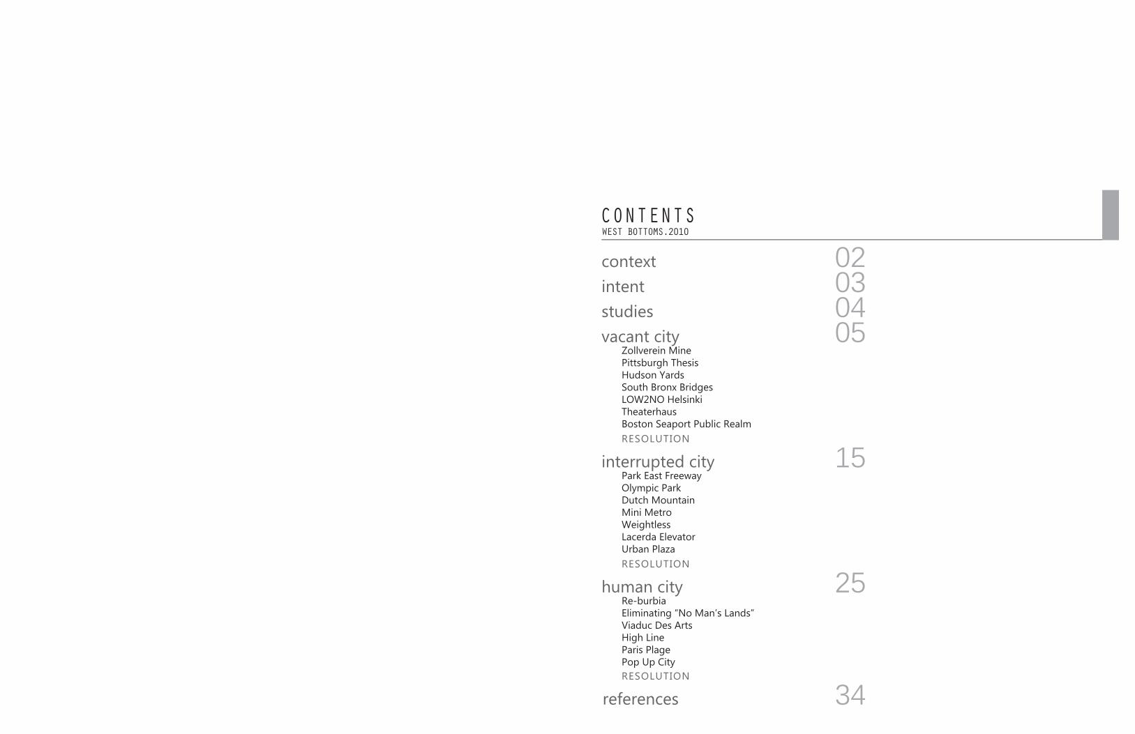
WEST BOTTOMS.2010CONTENTS
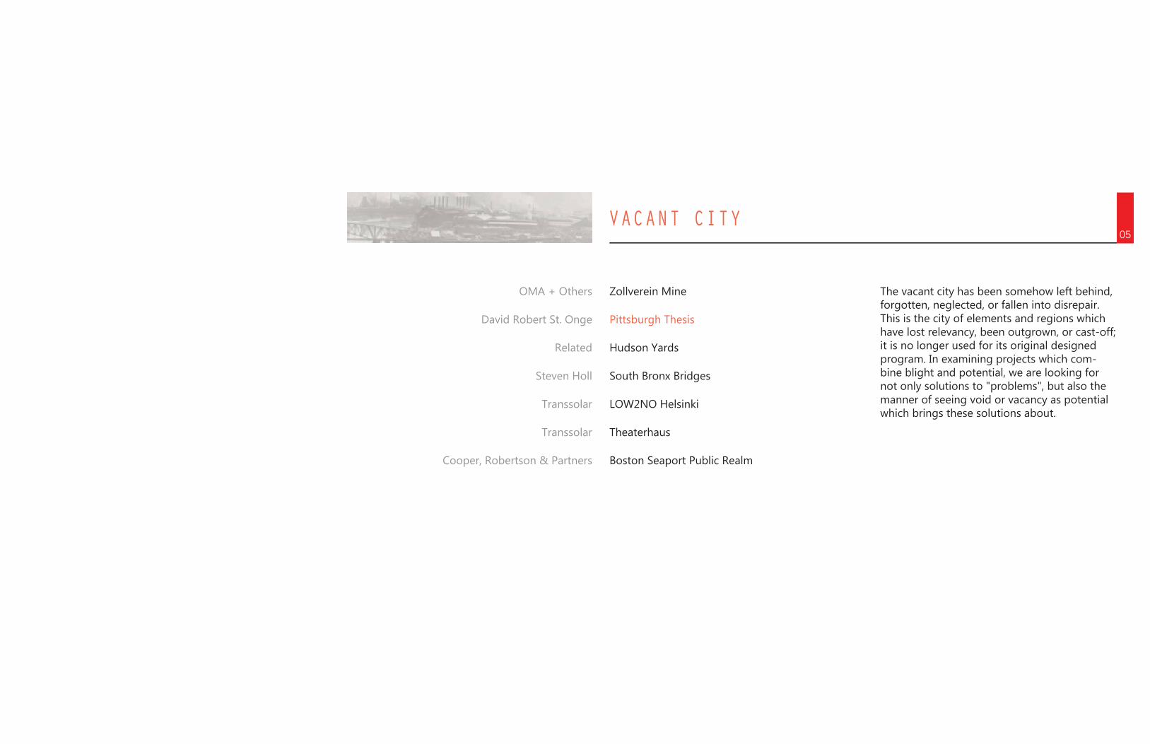
Zollverein Mine Pittsburgh ThesisHudson Yards South Bronx BridgesLOW2NO HelsinkiTheaterhausBoston Seaport Public Realm
vacant city
RESOLUTION
RESOLUTION
RESOLUTION
contextintentstudies
interrupted city
human city
references
Park East FreewayOlympic ParkDutch MountainMini MetroWeightlessLacerda ElevatorUrban Plaza
Re-burbiaEliminating “No Man’s Lands”Viaduc Des ArtsHigh LineParis PlagePop Up City
15
05
25
34
040302
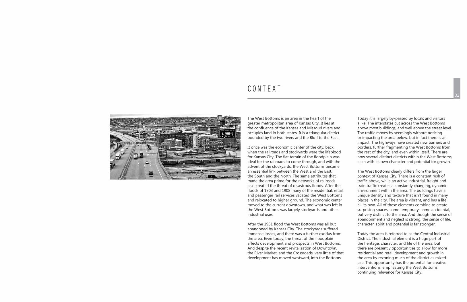
CONTEXT
The West Bottoms is an area in the heart of the greater metropolitan area of Kansas City. It lies at the confluence of the Kansas and Missouri rivers and occupies land in both states. It is a triangular district bounded by the two rivers and the Bluff to the East.
It once was the economic center of the city, back when the railroads and stockyards were the lifeblood for Kansas City. The flat terrain of the floodplain was ideal for the railroads to come through, and with the advent of the stockyards, the West Bottoms became an essential link between the West and the East, the South and the North. The same attributes that made the area prime for the networks of railroads also created the threat of disastrous floods. After the floods of 1903 and 1908 many of the residential, retail, and passenger rail services vacated the West Bottoms and relocated to higher ground. The economic center moved to the current downtown, and what was left in the West Bottoms was largely stockyards and other industrial uses.
After the 1951 flood the West Bottoms was all but abandoned by Kansas City. The stockyards suffered immense losses, and there was a further exodus from the area. Even today, the threat of the floodplain affects development and prospects in West Bottoms. And despite the recent revitalization of Downtown, the River Market, and the Crossroads, very little of that development has moved westward, into the Bottoms.
Today it is largely by-passed by locals and visitors alike. The interstates cut across the West Bottoms above most buildings, and well above the street level. The traffic moves by seemingly without noticing or impacting the area below. but in fact there is an impact. The highways have created new barriers and borders, further fragmenting the West Bottoms from the rest of the city, and even within itself. There are now several distinct districts within the West Bottoms, each with its own character and potential for growth.
The West Bottoms clearly differs from the larger context of Kansas City. There is a constant rush of traffic above, while an active industrial, freight and train traffic creates a constantly changing, dynamic environment within the area. The buildings have a unique density and texture that isn’t found in many places in the city. The area is vibrant, and has a life all its own. All of these elements combine to create surprising spaces, some temporary, some accidental, but very distinct to the area. And though the sense of abandonment and neglect is strong, the sense of life, character, spirit and potential is far stronger.
Today the area is referred to as the Central Industrial District. The industrial element is a huge part of the heritage, character, and life of the area, but there are presently opportunities to allow for more residential and retail development and growth in the area by rezoning much of the district as mixed-use. This opportunity has the potential for creative interventions, emphasizing the West Bottoms’ continuing relevance for Kansas City.
02
References to case and precedent studies play an important role in both the analysis and programming of a site. Ideally, they become a working catalog of intents and strategies which run parallel to the foreseen and unseen potential of the site. This catalog is intended to function in an organic way, forming the base skeletal structure for the evolving inclusion of relevant projects. By referencing and cross referencing the themes in these projects, we can better understand the context of the West Bottoms as previously described.
This parallel structure of built and theoretical work by others struggling with similar issues can show us methodologies, analyses, potentials, and end results which are a product of both a specific understanding of site and a general understanding of the broader range of attitudes and approaches.Repurposing vacant sites, the utilization of residual space, and urban reclamation are all important design issues addressed in relation to West Bottoms. Not all of the included projects are “created equal”. In identifying their shortcomings, we can see the disconnect between theory and realization, between implementation and impact, between analysis and response.
When we have gained a literacy, we are no longer stuck on one strategy or approach, but rather, free to pull fluidly from our growing catalog, understanding both the binding themes and loose interpretations.
INTENT03
STUDIES04
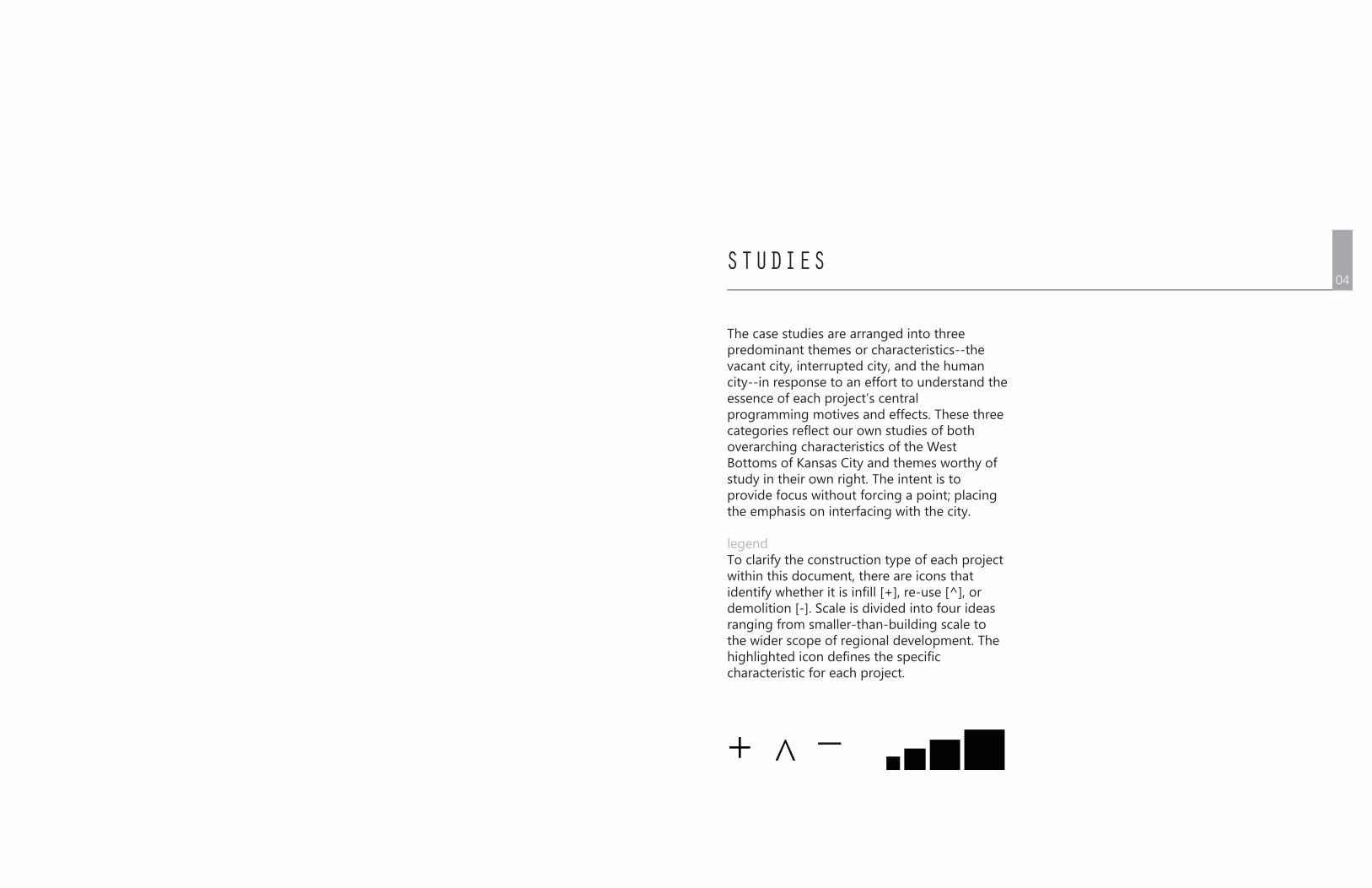
The case studies are arranged into three predominant themes or characteristics--the vacant city, interrupted city, and the human city--in response to an effort to understand the essence of each project’s central programming motives and effects. These three categories reflect our own studies of both overarching characteristics of the West Bottoms of Kansas City and themes worthy of study in their own right. The intent is to provide focus without forcing a point; placing the emphasis on interfacing with the city.
legendTo clarify the construction type of each project within this document, there are icons that identify whether it is infill [+], re-use [^], or demolition [-]. Scale is divided into four ideas ranging from smaller-than-building scale to the wider scope of regional development. The highlighted icon defines the specific characteristic for each project.
+ ^ _
VACANT CITY05
Zollverein Mine
Pittsburgh Thesis
Hudson Yards
South Bronx Bridges
LOW2NO Helsinki
Theaterhaus
Boston Seaport Public Realm
OMA + Others
David Robert St. Onge
Related
Steven Holl
Transsolar
Transsolar
Cooper, Robertson & Partners
The vacant city has been somehow left behind, forgotten, neglected, or fallen into disrepair. This is the city of elements and regions which have lost relevancy, been outgrown, or cast-off; it is no longer used for its original designed program. In examining projects which com-bine blight and potential, we are looking for not only solutions to "problems", but also the manner of seeing void or vacancy as potential which brings these solutions about.
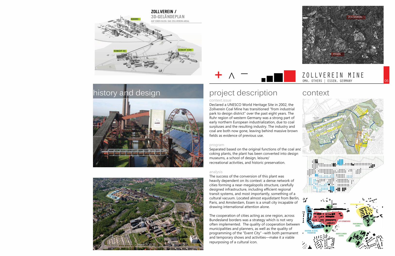
OMA, OTHERS | ESSEN, GERMANYZOLLVEREIN MINE
context.issueDeclared a UNESCO World Heritage Site in 2002, the Zollverein Coal Mine has transitioned “from industrial park to design district” over the past eight years. The Ruhr region of western Germany was a strong part of early northern European industrialization, due to coal surpluses and the resulting industry. The industry and coal are both now gone, leaving behind massive brown fields as evidence of previous use.
programSeparated based on the original functions of the coal and coking plants, the plant has been converted into design museums, a school of design, leisure/recreational activities, and historic preservation.
analysisThe success of the conversion of this plant was heavily dependent on its context: a dense network of cities forming a near-megalopolis structure, carefully designed infrastructure, including efficient regional transit systems, and most importantly, something of a cultural vacuum. Located almost equidistant from Berlin, Paris, and Amsterdam, Essen is a small city incapable of drawing international attention alone.
The cooperation of cities acting as one region, across Bundesland borders was a strategy which is not very often implemented. The quality of cooperation between municipalities and planners, as well as the quality of programming of the “Event City” –with both permanent and temporary shows and activities—make it a viable repurposing of a cultural icon.
contextproject descriptionhistory and design06
ESSEN
ZOLLVEREIN
+ ^ _

DAVID ROBERT ST. ONGE | PITTSBURGH, PAPITTSBURGH THESIS
context.issueThis thesis approaches the condition of riverfronts by examining their historical roles as well as adjacent buildings that were once connected via railways. Since the 1960s Pittsburgh has emerged from an industrial culture. As the regional economy shifted away from a river-dependent industry, much of Pittsburgh’s riverfronts were left abandoned, underused, environmentally compromised, and dominated by heavy industrial buildings instead of public spaces. Pittsburgh has become one of many cities determined to transform its neglected waterfront from minor uses into the mainstream of public activity.
programThe land is comprised of irregularly shaped tracts of land and extreme changes in topography. Because of the drastic topography, the riverfront is very visible from many viewpoints. Linked over ten miles of riverfront is a continuous, accessible park system which includes varieties of & opportunities for recreation & leisure, cultural events, venues & tourist attractions, public transportation, landscaping, and walkways along the river.
analysisThese spaces are intended to provide the community with much needed open space, serve as a regional attraction for visitors, establish new connections to the river, and create a new image associated with Pittsburgh’s post-industrial riverfront.
site contextproject descriptionwaterfront objective07
+ ^ _
DAVID ROBERT ST. ONGE | PITTSBURGH, PAPITTSBURGH THESIS
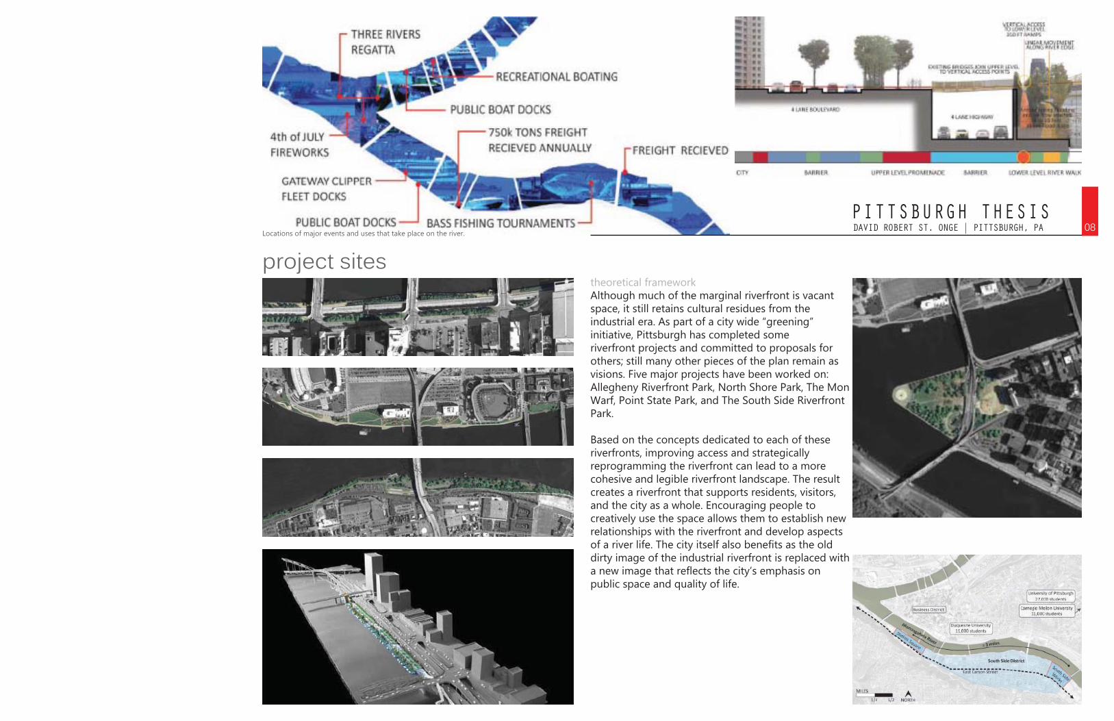
theoretical frameworkAlthough much of the marginal riverfront is vacant space, it still retains cultural residues from the industrial era. As part of a city wide “greening” initiative, Pittsburgh has completed some riverfront projects and committed to proposals for others; still many other pieces of the plan remain as visions. Five major projects have been worked on: Allegheny Riverfront Park, North Shore Park, The Mon Warf, Point State Park, and The South Side Riverfront Park.
Based on the concepts dedicated to each of these riverfronts, improving access and strategically reprogramming the riverfront can lead to a more cohesive and legible riverfront landscape. The result creates a riverfront that supports residents, visitors, and the city as a whole. Encouraging people to creatively use the space allows them to establish new relationships with the riverfront and develop aspects of a river life. The city itself also benefits as the old dirty image of the industrial riverfront is replaced with a new image that reflects the city’s emphasis on public space and quality of life.
project sites08
Locations of major events and uses that take place on the river.
+ ^ _RELATED | NEW YORK, NYHUDSON YARDS
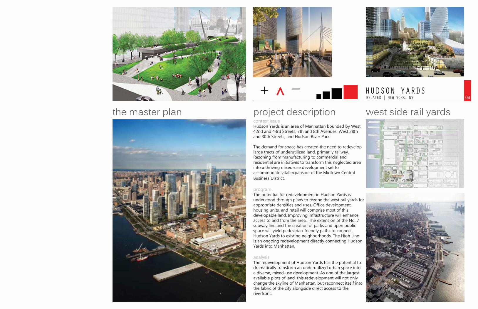
context.issueHudson Yards is an area of Manhattan bounded by West 42nd and 43rd Streets, 7th and 8th Avenues, West 28th and 30th Streets, and Hudson River Park.
The demand for space has created the need to redevelop large tracts of underutilized land, primarily railway. Rezoning from manufacturing to commercial and residential are initiatives to transform this neglected area into a thriving mixed-use development set to accommodate vital expansion of the Midtown Central Business District.
programThe potential for redevelopment in Hudson Yards is understood through plans to rezone the west rail yards for appropriate densities and uses. Office development, housing units, and retail will comprise most of this developable land. Improving infrastructure will enhance access to and from the area. The extension of the No. 7 subway line and the creation of parks and open public space will yield pedestrian-friendly paths to connect Hudson Yards to existing neighborhoods. The High Line is an ongoing redevelopment directly connecting Hudson Yards into Manhattan.
analysisThe redevelopment of Hudson Yards has the potential to dramatically transform an underutilized urban space into a diverse, mixed-use development. As one of the largest available plots of land, this redevelopment will not only change the skyline of Manhattan, but reconnect itself into the fabric of the city alongside direct access to the riverfront.
west side rail yardsproject descriptionthe master plan09

SOUTH BRONX BRIDGES
context rail yardsproject descriptionre-establishing urban orderSTEVEN HOLL | NEW YORK
+ ^ _10
context.issueThe South Bronx, at the time of publication (1971) was in a relatively destitute condition. This rail yard cut the South Bronx off from Manhattan to the south, while a newly built freeway formed a barrier to the North.
programHoll’s proposal for the removal of buildings and re-establishing the visual rigidity of the grid by laying out their ashes into a continuation of city blocks would allow for future infill in a manner which is beneficial to the surrounding area. A major tiered pedestrian bridge would act as community center and connection to the park just across the water.
analysisHoll overlays a grid which at once clarifies the existing topographical context (in reuniting it with the surrounding gridded urban fabric) and adds a level of complexity and potential to its further use. Holls’ overall redevelopment with the checkerboard ash acts on a long-term rehabilitation of the land, and the bridge, the critical intervention, would act as a long-term rehabilitation of the population. The connection to the water and the air come in insightful visual patterns which would allow for those unfamiliar with the neighborhood to come into contact with its circumstance. The proposal, however, doesn’t answer the implied question of whether people are more important than infrastructure when it no longer services them immediately. It simply spans the infrastructure and takes it as a given, a permanent barrier. The lingering question of how thoroughfares which benefit some communities while disrupting others become justifiable resources remains. It is answered only by an additional piece of infrastructure on the human scale. But it is in these co-existing layers of infrastructure that the project seems to gain its power in answering post-industrial problems.
+ ^ _TRANSSOLAR | HELSINKI, FINLANDLOW2NO HELSINKI
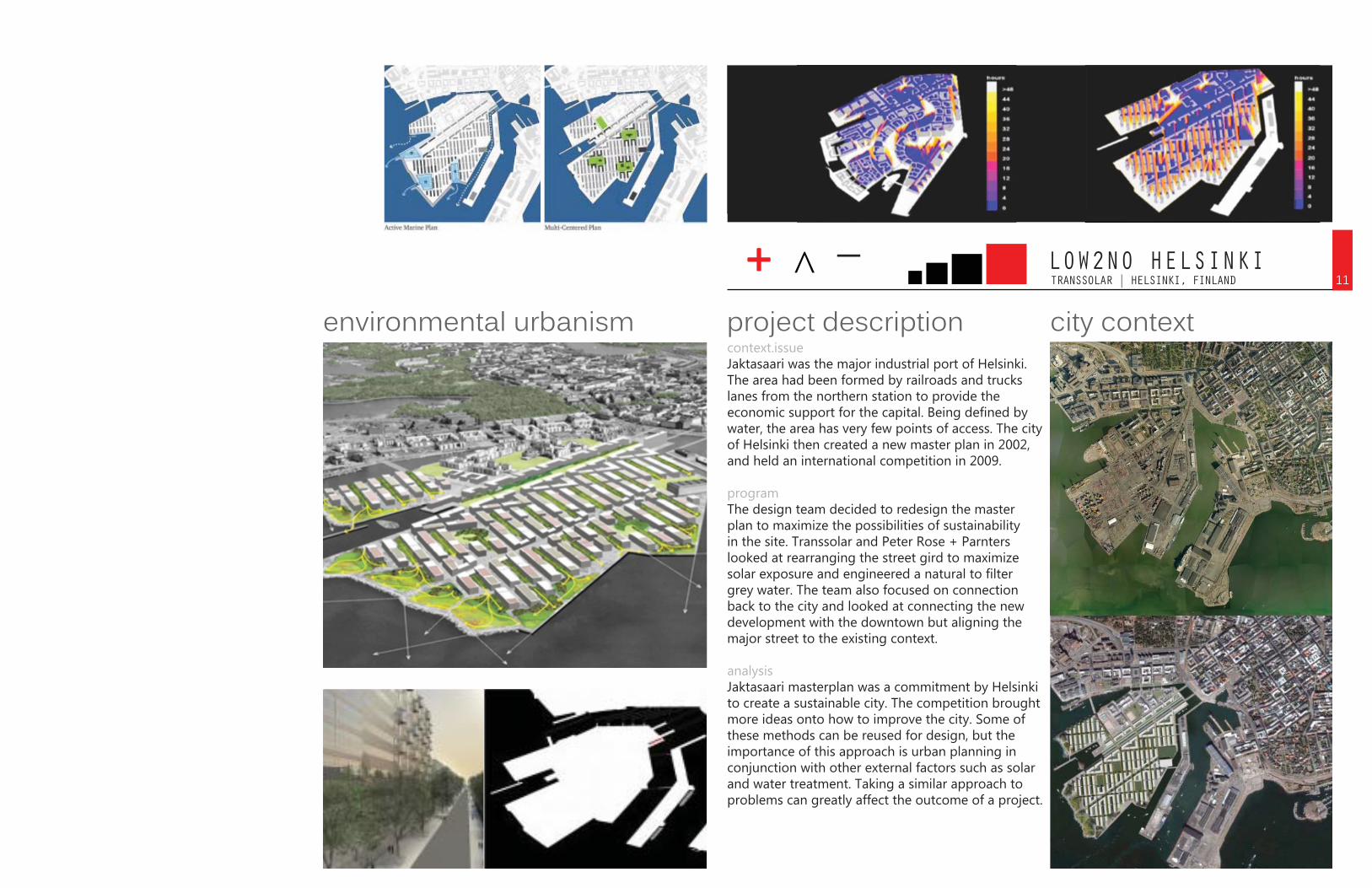
context.issueJaktasaari was the major industrial port of Helsinki. The area had been formed by railroads and trucks lanes from the northern station to provide the economic support for the capital. Being defined by water, the area has very few points of access. The city of Helsinki then created a new master plan in 2002, and held an international competition in 2009.
programThe design team decided to redesign the master plan to maximize the possibilities of sustainability in the site. Transsolar and Peter Rose + Parnters looked at rearranging the street gird to maximize solar exposure and engineered a natural to filter grey water. The team also focused on connection back to the city and looked at connecting the new development with the downtown but aligning the major street to the existing context.
analysisJaktasaari masterplan was a commitment by Helsinki to create a sustainable city. The competition brought more ideas onto how to improve the city. Some of these methods can be reused for design, but the importance of this approach is urban planning in conjunction with other external factors such as solar and water treatment. Taking a similar approach to problems can greatly affect the outcome of a project.
city contextproject descriptionenvironmental urbanism11
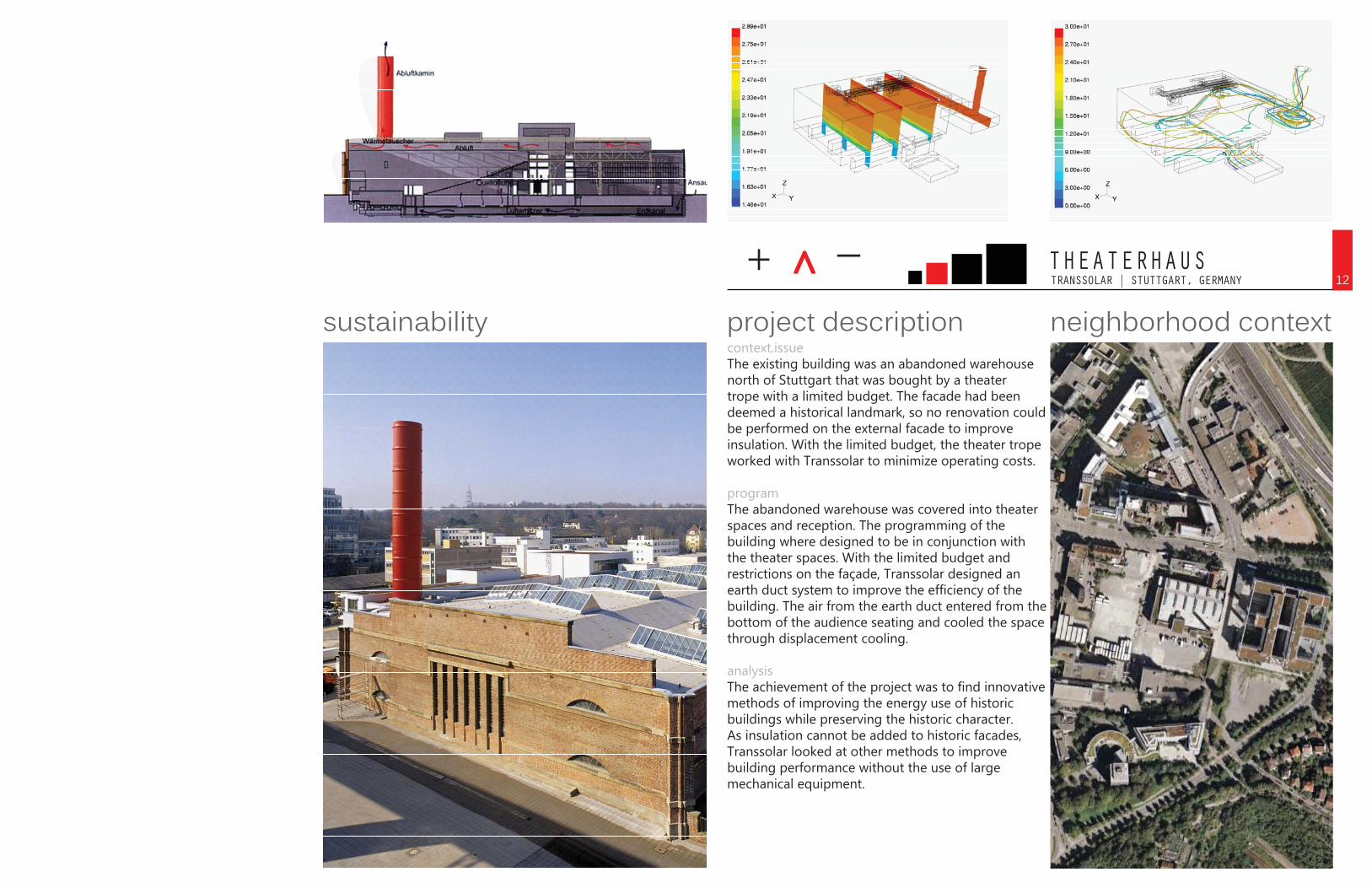
+ ^ _TRANSSOLAR | STUTTGART, GERMANYTHEATERHAUS
context.issueThe existing building was an abandoned warehouse north of Stuttgart that was bought by a theater trope with a limited budget. The facade had been deemed a historical landmark, so no renovation could be performed on the external facade to improve insulation. With the limited budget, the theater trope worked with Transsolar to minimize operating costs.
programThe abandoned warehouse was covered into theater spaces and reception. The programming of the building where designed to be in conjunction with the theater spaces. With the limited budget and restrictions on the façade, Transsolar designed an earth duct system to improve the efficiency of the building. The air from the earth duct entered from the bottom of the audience seating and cooled the space through displacement cooling.
analysisThe achievement of the project was to find innovative methods of improving the energy use of historic buildings while preserving the historic character. As insulation cannot be added to historic facades, Transsolar looked at other methods to improve building performance without the use of large mechanical equipment.
neighborhood contextproject descriptionsustainability12
+ ^ _COOPER, ROBERTSON & PARTNERS | BOSTON, MA
BOSTON SEAPORT PUBLIC REALM
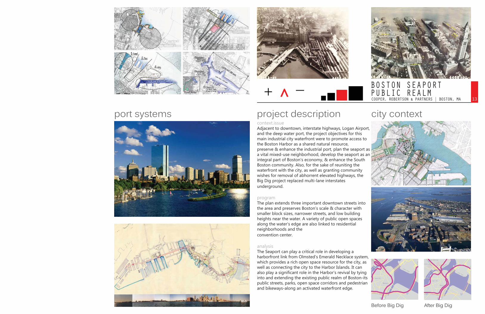
context.issueAdjacent to downtown, interstate highways, Logan Airport, and the deep water port, the project objectives for this main industrial city waterfront were to promote access to the Boston Harbor as a shared natural resource, preserve & enhance the industrial port, plan the seaport as a vital mixed-use neighborhood, develop the seaport as an integral part of Boston’s economy, & enhance the South Boston community. Also, for the sake of reuniting the waterfront with the city, as well as granting community wishes for removal of abhorrent elevated highways, the Big Dig project replaced multi-lane interstates underground.
programThe plan extends three important downtown streets into the area and preserves Boston’s scale & character with smaller block sizes, narrower streets, and low building heights near the water. A variety of public open spaces along the water’s edge are also linked to residential neighborhoods and the convention center.
analysisThe Seaport can play a critical role in developing a harborfront link from Olmsted’s Emerald Necklace system, which provides a rich open space resource for the city, as well as connecting the city to the Harbor Islands. It can also play a significant role in the Harbor’s revival by tying into and extending the existing public realm of Boston-its public streets, parks, open space corridors and pedestrian and bikeways-along an activated waterfront edge.
city contextproject descriptionport systems
Before Big Dig After Big Dig
13
14VACANT CITYRESOLUTION
The selected projects in Vacant Cities all address a former industrial area or building within a city that once exuded prominence. They all relate to the West Bottoms district in a number of ways. Topographical and waterfront features, previous railway correlations, and orientation to current important city attractions define the parameters we are working with. The contexts of these selected projects express the need to revitalize areas and integrate urban design systems within abandoned regions. The Pittsburgh Thesis project corresponds with Kansas City and its regions as a great metropolis; therefore, it is particularly significant because of the similarity to the specific issues that face West Bottoms.
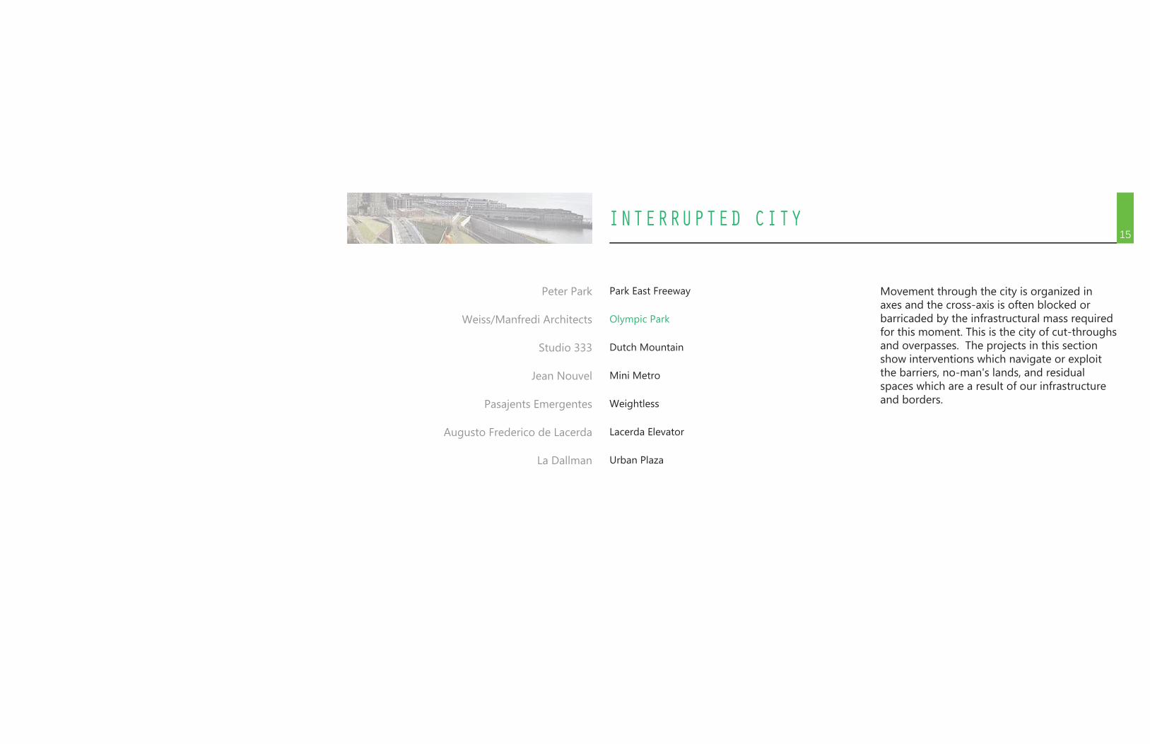
INTERRUPTED CITY15
Park East Freeway
Olympic Park
Dutch Mountain
Mini Metro
Weightless
Lacerda Elevator
Urban Plaza
Peter Park
Weiss/Manfredi Architects
Studio 333
Jean Nouvel
Pasajents Emergentes
Augusto Frederico de Lacerda
La Dallman
Movement through the city is organized in axes and the cross-axis is often blocked or barricaded by the infrastructural mass required for this moment. This is the city of cut-throughs and overpasses. The projects in this section show interventions which navigate or exploit the barriers, no-man's lands, and residual spaces which are a result of our infrastructure and borders.
+ ^ _PETER PARK | MILWAUKEE, WIPARK EAST FREEWAY
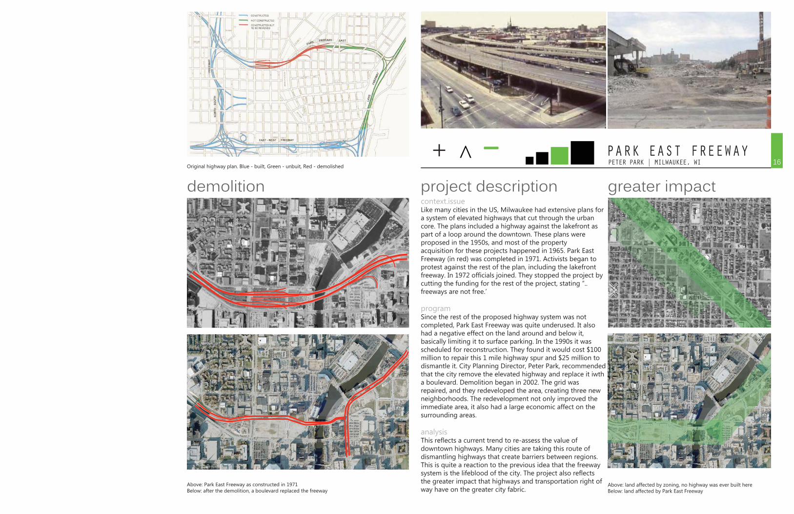
context.issueLike many cities in the US, Milwaukee had extensive plans for a system of elevated highways that cut through the urban core. The plans included a highway against the lakefront as part of a loop around the downtown. These plans were proposed in the 1950s, and most of the property acquisition for these projects happened in 1965. Park East Freeway (in red) was completed in 1971. Activists began to protest against the rest of the plan, including the lakefront freeway. In 1972 officials joined. They stopped the project by cutting the funding for the rest of the project, stating “..freeways are not free.’
programSince the rest of the proposed highway system was not completed, Park East Freeway was quite underused. It also had a negative effect on the land around and below it, basically limiting it to surface parking. In the 1990s it was scheduled for reconstruction. They found it would cost $100 million to repair this 1 mile highway spur and $25 million to dismantle it. City Planning Director, Peter Park, recommended that the city remove the elevated highway and replace it iwth a boulevard. Demolition began in 2002. The grid was repaired, and they redeveloped the area, creating three new neighborhoods. The redevelopment not only improved the immediate area, it also had a large economic affect on the surrounding areas.
analysisThis reflects a current trend to re-assess the value of downtown highways. Many cities are taking this route of dismantling highways that create barriers between regions. This is quite a reaction to the previous idea that the freeway system is the lifeblood of the city. The project also reflects the greater impact that highways and transportation right of way have on the greater city fabric.
Above: Park East Freeway as constructed in 1971Below: after the demolition, a boulevard replaced the freeway
Above: land affected by zoning, no highway was ever built here Below: land affected by Park East Freeway
greater impactproject descriptiondemolitionOriginal highway plan. Blue - built, Green - unbuit, Red - demolished
16
+ ^ _WEISS/MANFREDI ARCHITECTS | SEATTLE, WAOLYMPIC PARK
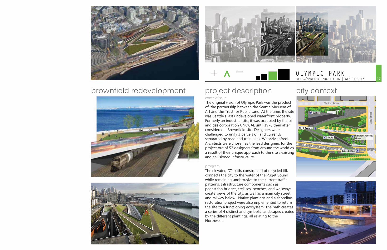
context.issueThe original vision of Olympic Park was the product of the partnership between the Seattle Musuem of Art and the Trust for Public Land. At the time, the site was Seattle’s last undeveloped waterfront property. Formerly an industrial site, it was occupied by the oil and gas corporation UNOCAL until 1970 then after considered a Brownfield site. Designers were challenged to unify 3 parcels of land currently separated by road and train lines. Weiss/Manfredi Architects were chosen as the lead designers for the project out of 52 designers from around the world as a result of their unique approach to the site’s existing and envisioned infrastructure.
programThe elevated “Z” path, constructed of recycled fill, connects the city to the water of the Puget Sound while remaining unobtrusive to the current traffic patterns. Infrastructure components such as pedestrian bridges, trellises, benches, and walkways create views of the city, as well as a main city street and railway below. Native plantings and a shoreline restoration project were also implemented to return the site to a functioning ecosystem. The path creates a series of 4 distinct and symbolic landscapes created by the different plantings, all relating to the Northwest.
city contextproject descriptionbrownfield redevelopment17
WEISS/MANFREDI ARCHITECTS | SEATTLE, WAOLYMPIC PARK
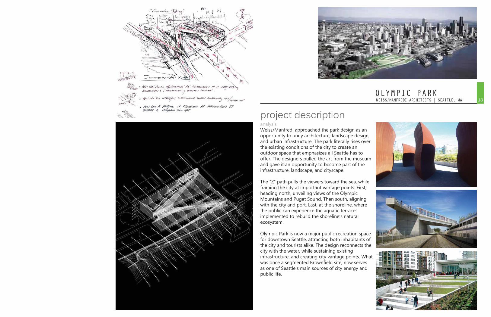
analysisWeiss/Manfredi approached the park design as an opportunity to unify architecture, landscape design, and urban infrastructure. The park literally rises over the existing conditions of the city to create an outdoor space that emphasizes all Seattle has to offer. The designers pulled the art from the museum and gave it an opportunity to become part of the infrastructure, landscape, and cityscape.
The “Z” path pulls the viewers toward the sea, while framing the city at important vantage points. First, heading north, unveiling views of the Olympic Mountains and Puget Sound. Then south, aligning with the city and port. Last, at the shoreline, where the public can experience the aquatic terraces implemented to rebuild the shoreline’s natural ecosystem.
Olympic Park is now a major public recreation space for downtown Seattle, attracting both inhabitants of the city and tourists alike. The design reconnects the city with the water, while sustaining existing infrastructure, and creating city vantage points. What was once a segmented Brownfield site, now serves as one of Seattle’s main sources of city energy and public life.
project description18
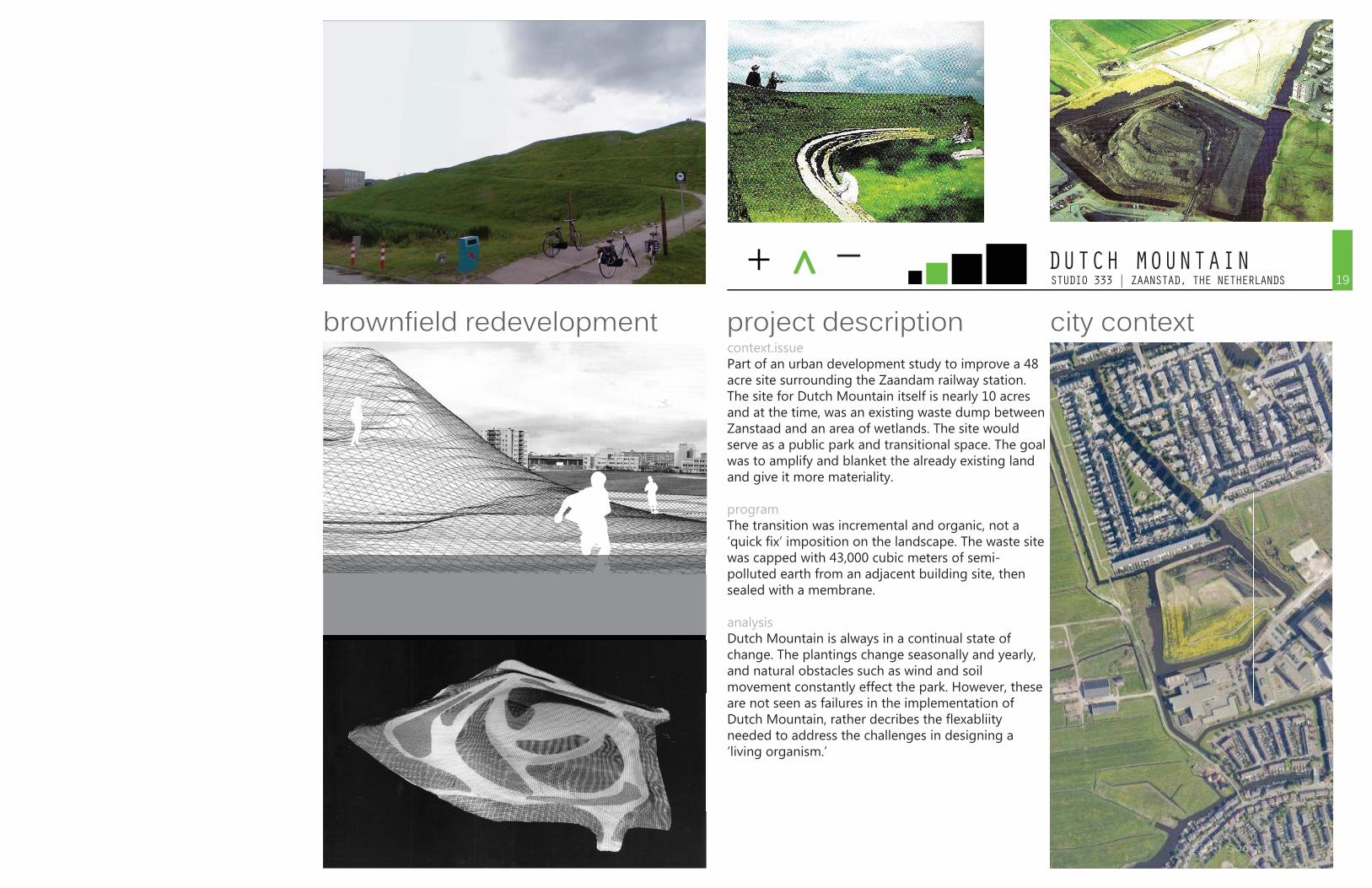
+ ^ _STUDIO 333 | ZAANSTAD, THE NETHERLANDSDUTCH MOUNTAIN
context.issuePart of an urban development study to improve a 48 acre site surrounding the Zaandam railway station. The site for Dutch Mountain itself is nearly 10 acres and at the time, was an existing waste dump between Zanstaad and an area of wetlands. The site would serve as a public park and transitional space. The goal was to amplify and blanket the already existing land and give it more materiality.
programThe transition was incremental and organic, not a ‘quick fix’ imposition on the landscape. The waste site was capped with 43,000 cubic meters of semi-polluted earth from an adjacent building site, then sealed with a membrane.
analysisDutch Mountain is always in a continual state of change. The plantings change seasonally and yearly, and natural obstacles such as wind and soil movement constantly effect the park. However, these are not seen as failures in the implementation of Dutch Mountain, rather decribes the flexabliity needed to address the challenges in designing a ‘living organism.’
city contextproject descriptionbrownfield redevelopment19
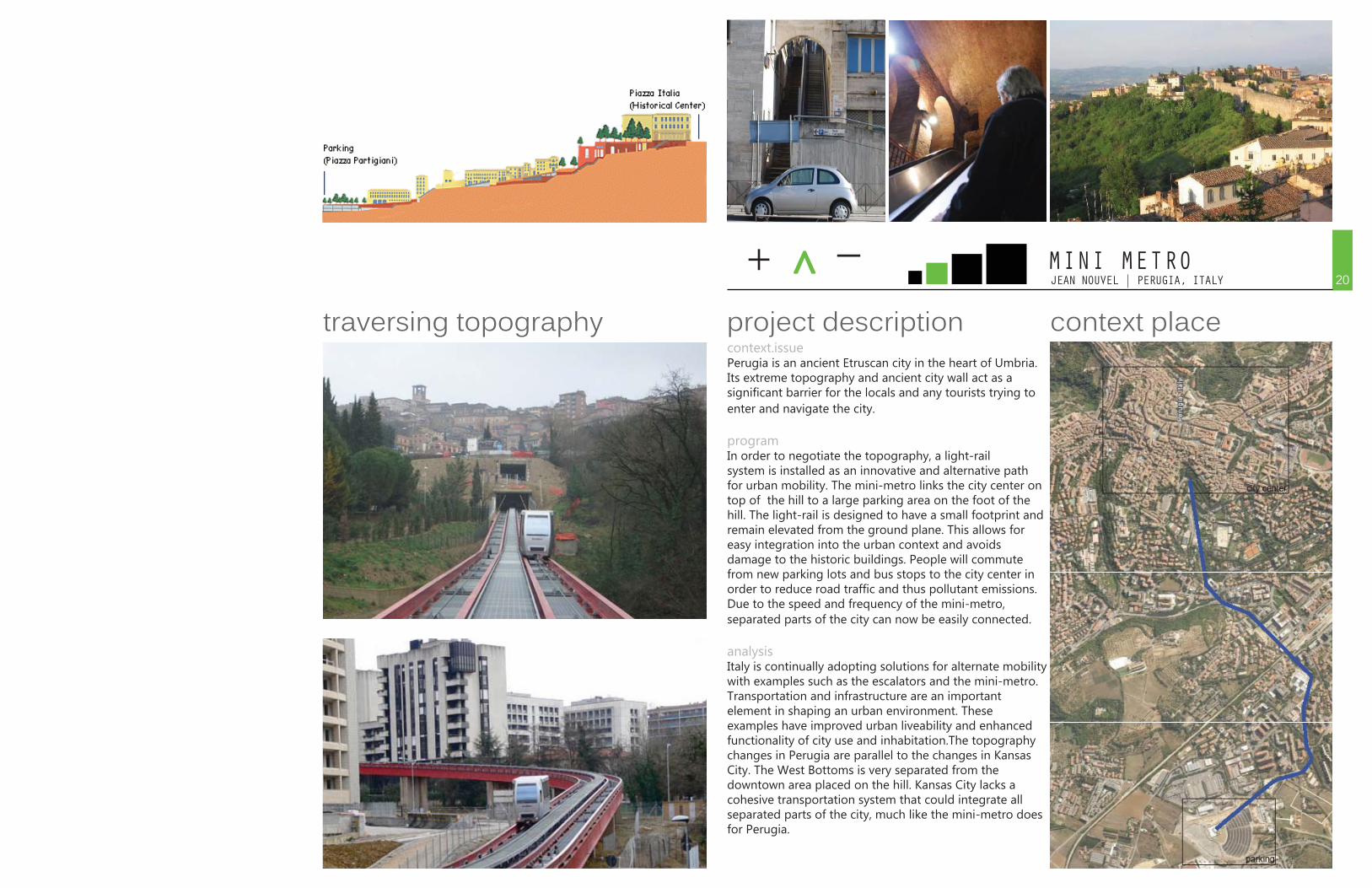
+ ^ _JEAN NOUVEL | PERUGIA, ITALYMINI METRO
context.issuePerugia is an ancient Etruscan city in the heart of Umbria. Its extreme topography and ancient city wall act as a significant barrier for the locals and any tourists trying to enter and navigate the city.
programIn order to negotiate the topography, a light-rail system is installed as an innovative and alternative path for urban mobility. The mini-metro links the city center on top of the hill to a large parking area on the foot of the hill. The light-rail is designed to have a small footprint and remain elevated from the ground plane. This allows for easy integration into the urban context and avoids damage to the historic buildings. People will commute from new parking lots and bus stops to the city center in order to reduce road traffic and thus pollutant emissions. Due to the speed and frequency of the mini-metro, separated parts of the city can now be easily connected.
analysisItaly is continually adopting solutions for alternate mobility with examples such as the escalators and the mini-metro. Transportation and infrastructure are an important element in shaping an urban environment. These examples have improved urban liveability and enhanced functionality of city use and inhabitation.The topography changes in Perugia are parallel to the changes in Kansas City. The West Bottoms is very separated from the downtown area placed on the hill. Kansas City lacks a cohesive transportation system that could integrate all separated parts of the city, much like the mini-metro does for Perugia.
context placeproject descriptiontraversing topography20
PASAJENTS EMERGENTES | LONDON, ENGLANDWEIGHTLESS
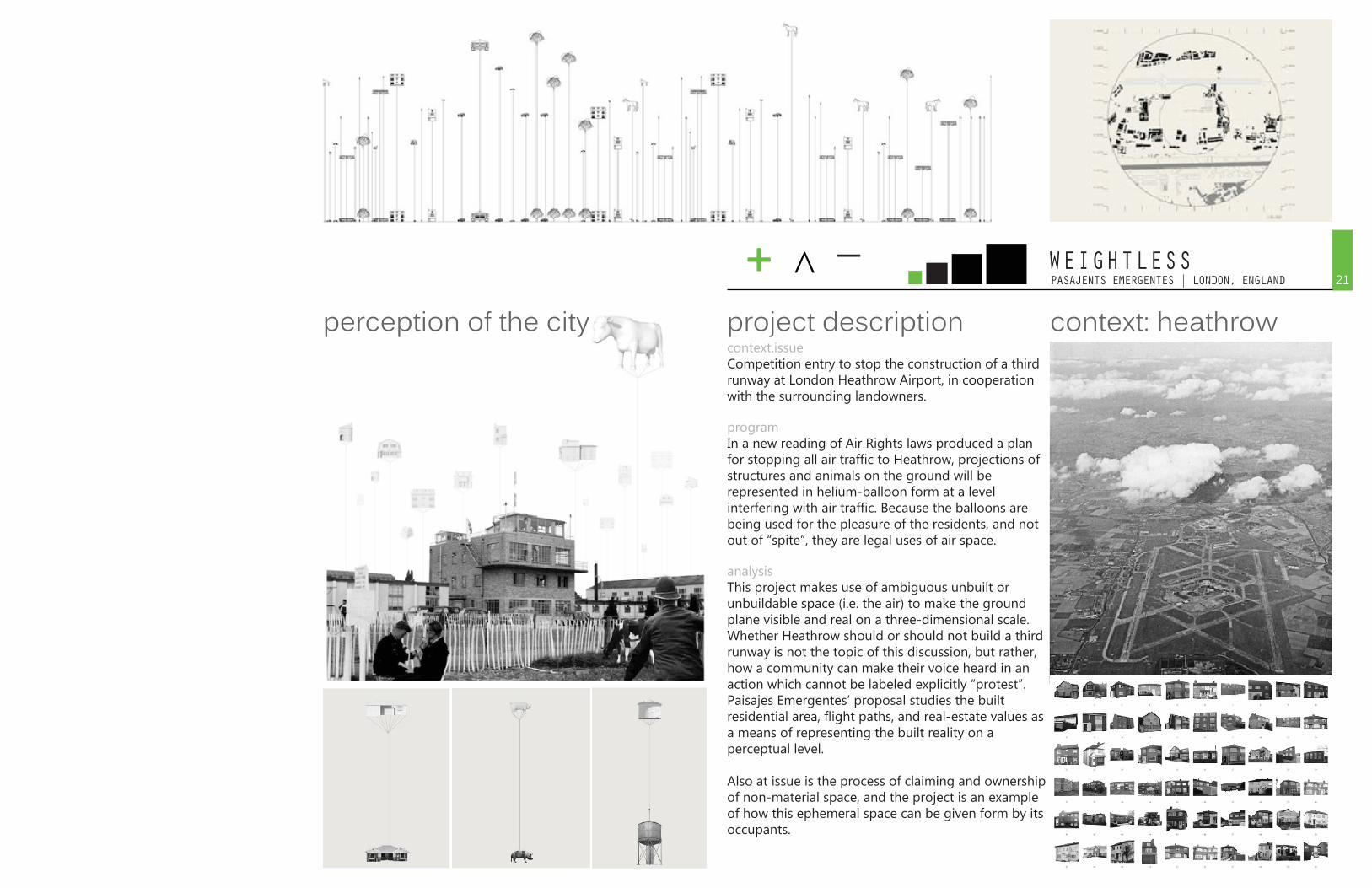
context.issueCompetition entry to stop the construction of a third runway at London Heathrow Airport, in cooperation with the surrounding landowners.
programIn a new reading of Air Rights laws produced a plan for stopping all air traffic to Heathrow, projections of structures and animals on the ground will be represented in helium-balloon form at a level interfering with air traffic. Because the balloons are being used for the pleasure of the residents, and not out of “spite”, they are legal uses of air space.
analysisThis project makes use of ambiguous unbuilt or unbuildable space (i.e. the air) to make the ground plane visible and real on a three-dimensional scale. Whether Heathrow should or should not build a third runway is not the topic of this discussion, but rather, how a community can make their voice heard in an action which cannot be labeled explicitly “protest”. Paisajes Emergentes’ proposal studies the built residential area, flight paths, and real-estate values as a means of representing the built reality on a perceptual level.
Also at issue is the process of claiming and ownership of non-material space, and the project is an example of how this ephemeral space can be given form by its occupants.
context: heathrowproject descriptionperception of the city
+ ^ _21
+ ^ _AUGUSTO FREDERICO DE LACERDA | SALVADOR, BRAZILLACERDA ELEVATOR
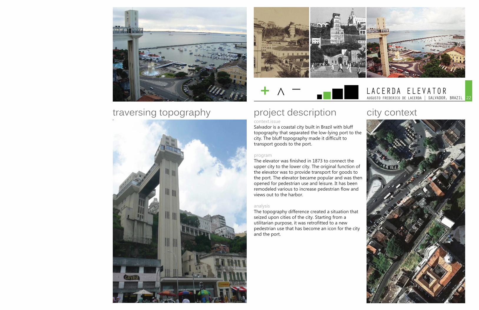
context.issueSalvador is a coastal city built in Brazil with bluff topography that separated the low-lying port to the city. The bluff topography made it difficult to transport goods to the port.
programThe elevator was finished in 1873 to connect the upper city to the lower city. The original function of the elevator was to provide transport for goods to the port. The elevator became popular and was then opened for pedestrian use and leisure. It has been remodeled various to increase pedestrian flow and views out to the harbor.
analysisThe topography difference created a situation that seized upon cities of the city. Starting from a utilitarian purpose, it was retrofitted to a newpedestrian use that has become an icon for the city and the port.
city contextproject descriptiontraversing topography22
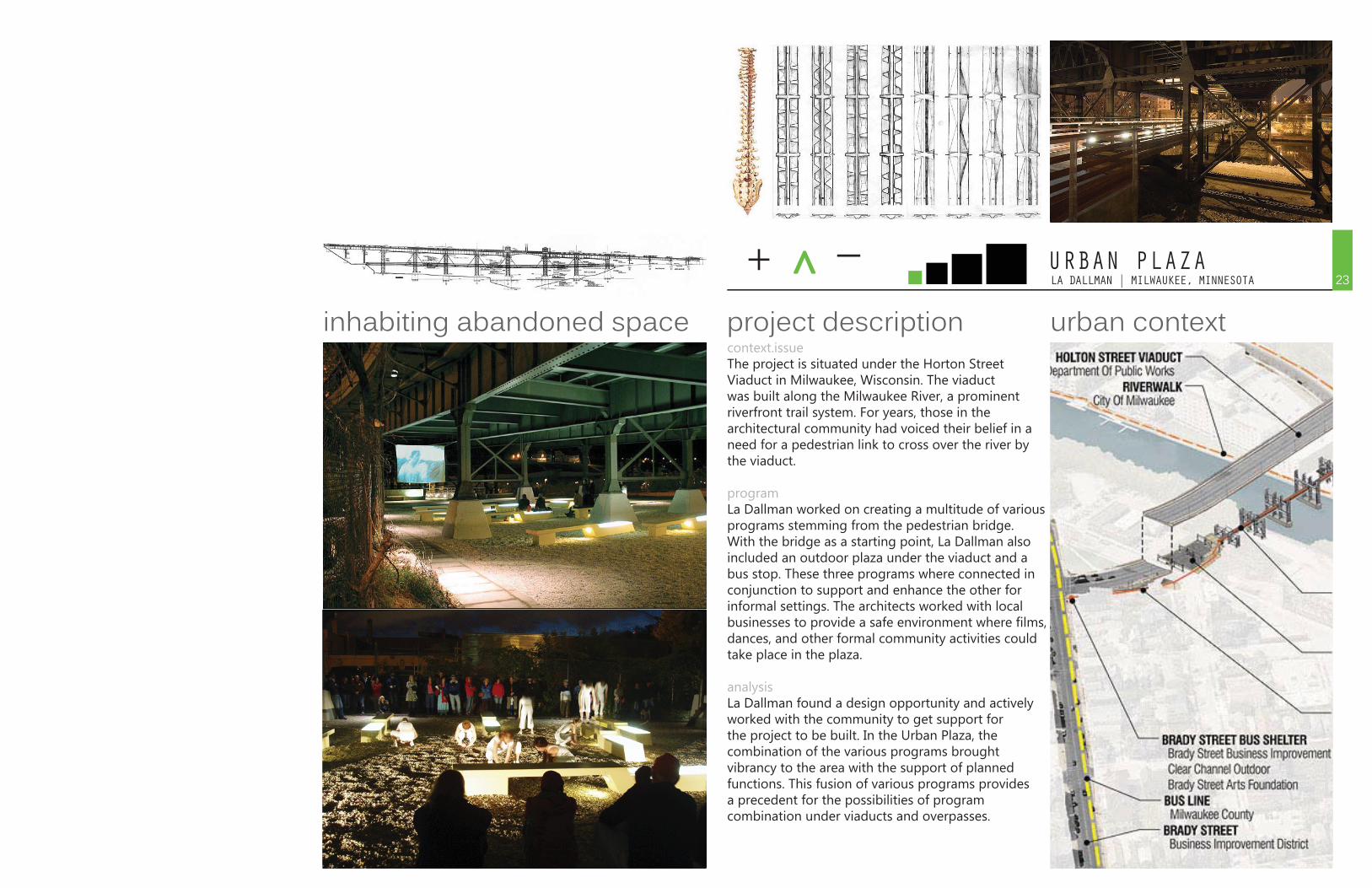
+ ^ _LA DALLMAN | MILWAUKEE, MINNESOTAURBAN PLAZA
context.issueThe project is situated under the Horton Street Viaduct in Milwaukee, Wisconsin. The viaduct was built along the Milwaukee River, a prominent riverfront trail system. For years, those in the architectural community had voiced their belief in a need for a pedestrian link to cross over the river by the viaduct.
programLa Dallman worked on creating a multitude of various programs stemming from the pedestrian bridge. With the bridge as a starting point, La Dallman also included an outdoor plaza under the viaduct and a bus stop. These three programs where connected in conjunction to support and enhance the other for informal settings. The architects worked with local businesses to provide a safe environment where films, dances, and other formal community activities could take place in the plaza.
analysisLa Dallman found a design opportunity and actively worked with the community to get support for the project to be built. In the Urban Plaza, the combination of the various programs brought vibrancy to the area with the support of planned functions. This fusion of various programs provides a precedent for the possibilities of program combination under viaducts and overpasses.
urban contextproject descriptioninhabiting abandoned space23
24INTERRUPTED CITYRESOLUTION
The second part of our study revolves around interruptions in the city, emphasizing barriers in the city: elevated roads, rail yards, blighted lots, large topographical changes, and even residual land affected by the barriers themselves. All of these are barriers are present in the West Bottoms. The bluff to the east, the river, the elevated roadways and the rail tracks and yards, all pose unique problems in the continuity, accessibility, and visibility of West Bottoms.
The interesting aspect is that each project within this category addresses barriers in completely different ways: tearing it down, bridging over, covering it up, adding transportation through it, inhabiting it, or denying it altogether. The Olympic Park project is particularly important because it has been truly successful in reclaiming a fringe area and bridging a huge interruption with public space. The composite study of all of these projects together creates a catalogue of ways to solve each different problem or interruption that might exist, each employs a few dramatic moves that create simple solutions to the previously insurmountable problem.
HUMAN CITY25
Re-burbia
Eliminating “No Man’s Land”
Viaduc Des Arts
High Line
Paris Plage
Pop Up City
Jesse Zeien
Residual Space of the Highway Intersection
Phillipe Mathieux
James Corner Field Operations & Diller Scofidio + Renfro
Jean Christophe Chobelet
Cleveland Urban Design Collaborative
A city is not only made up of buildings, its vitality requires civic involvement of an active community. Without the series of events, actions, and interventions created by and for its inhabitants, the city would lose its purpose and dynamism. The citizens have an impact on their built environment whether they are aware of it or not. The projects here show people who have acknowledged their ability to impact and program the built environment.
+ ^ _JESSE ZEIEN | HIGHWAY OVERPASS
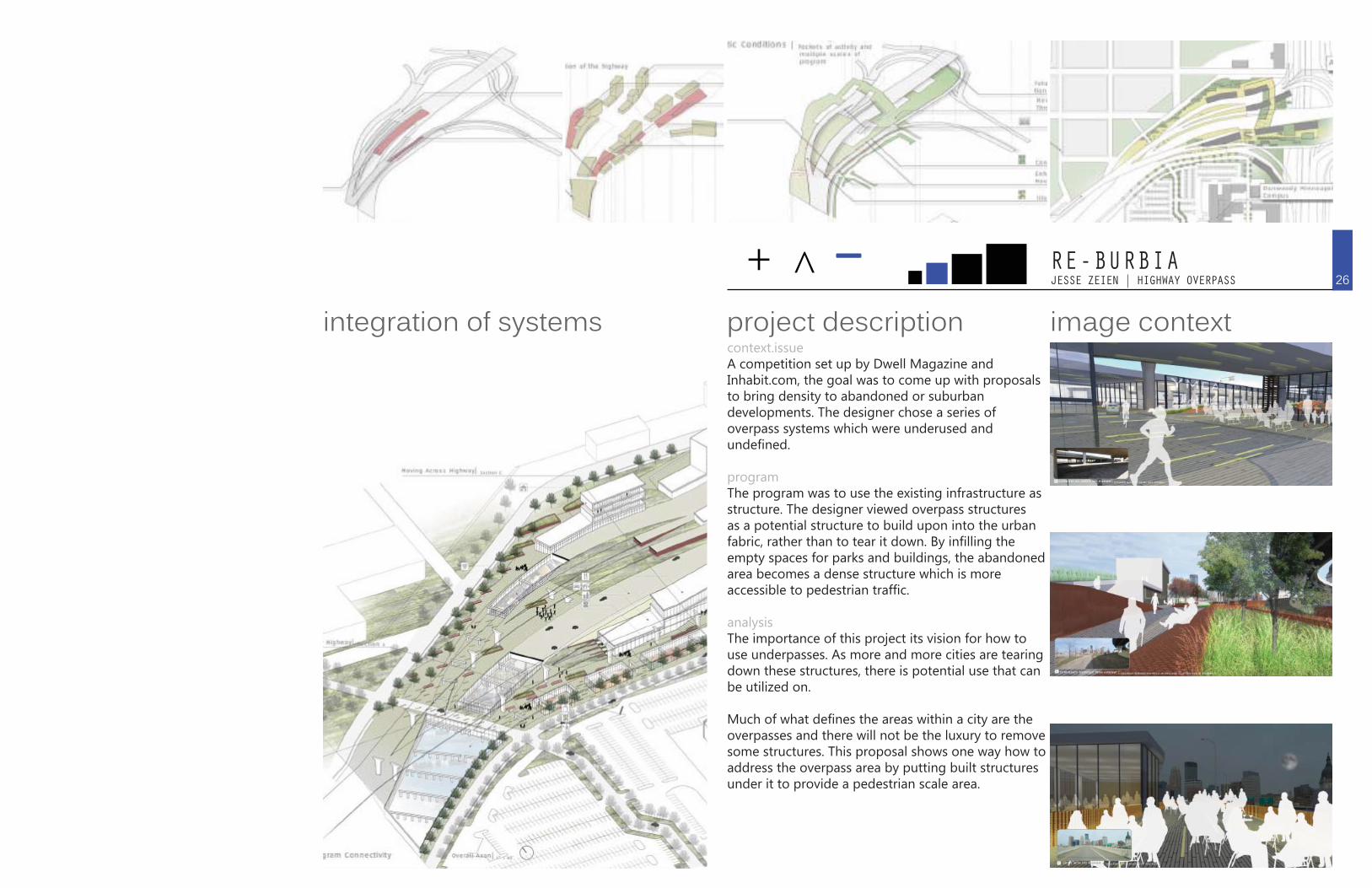
context.issueA competition set up by Dwell Magazine and Inhabit.com, the goal was to come up with proposals to bring density to abandoned or suburban developments. The designer chose a series of overpass systems which were underused and undefined.
programThe program was to use the existing infrastructure as structure. The designer viewed overpass structures as a potential structure to build upon into the urban fabric, rather than to tear it down. By infilling the empty spaces for parks and buildings, the abandoned area becomes a dense structure which is more accessible to pedestrian traffic.
analysisThe importance of this project its vision for how to use underpasses. As more and more cities are tearing down these structures, there is potential use that can be utilized on.
Much of what defines the areas within a city are the overpasses and there will not be the luxury to remove some structures. This proposal shows one way how to address the overpass area by putting built structures under it to provide a pedestrian scale area.
image contextproject descriptionintegration of systems26
RE-BURBIA
+ ^ _RESIDUAL SPACE OF THE HIGHWAY INTERSECTION
context.issueHighways shape and define the landscape and dictate its development. Highway intersections create unique spaces that are the convergence of movement and people. However, these spaces represent an important place in the city that is largely neglected. The effects of the intersection create a challenge to the unity of the city. The intersection creates voids where the city disappears and reappears of the other side. The residual space created by the highway’s intricate patterns of circulation has the potential to become space that is integrated with the urban fabric of the city.
programThe goals of these projects are to weave the city over and under the highway so as to eliminate this unique separating situation. They look at the relationship of the highway intersections to its surrounding areas. It is a study of designinterventions that will yield a usable space that will better the life and fabric of the city.
analysisThe importance of this project its vision for how to use underpasses. Many cities are tearing down these structures, but here are four examples of cities placing potential on these spaces. Many of these conditions exist in the West Bottoms, and these projects are showing all that can be done to ehance this space so often called “No Man’s Land.”
context placeproject descriptioninhabiting abandoned space
SEATTLE’S I-5 COLONNADE MOUNTAIN BIKE PARK: This mountain bike park houses 1.5 miles of mountain bike training trails. The park was constructed by the Evergreen Mountain Bike Alliance, the Seattle Neighborhoods Matching Fund and many volunteers and private donations.
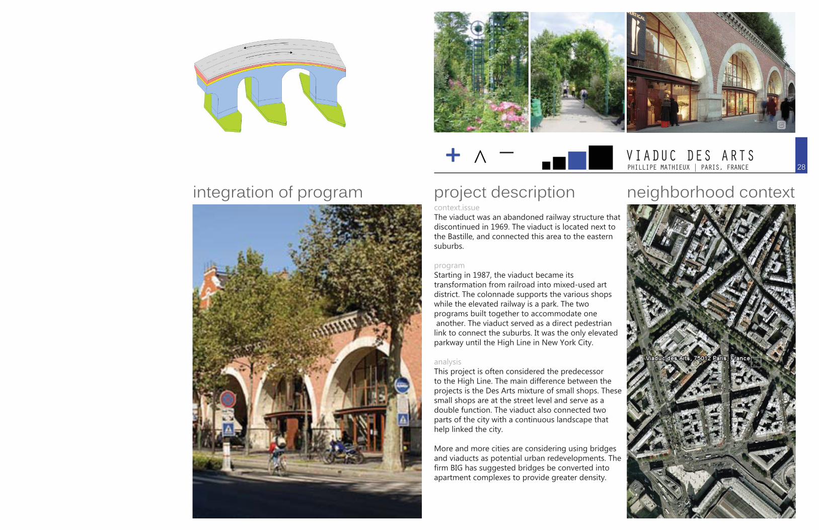
QUEBEC’S 440 AUTOROUTE: The highway’s columns change and en-hance the driving experience.
LONDON’S WESTWAY A40: There you can find retail, community activities and sports facilities while the underpasses are illuminated in very contemporary and fun ways to make the driving experience different and safer.
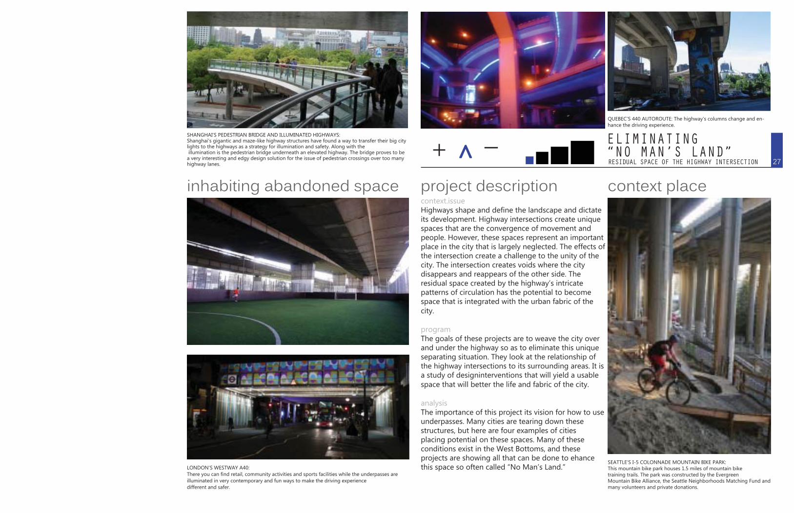
SHANGHAI’S PEDESTRIAN BRIDGE AND ILLUMINATED HIGHWAYS: Shanghai’s gigantic and maze-like highway structures have found a way to transfer their big city lights to the highways as a strategy for illumination and safety. Along with the illumination is the pedestrian bridge underneath an elevated highway. The bridge proves to be a very interesting and edgy design solution for the issue of pedestrian crossings over too many highway lanes. 27
ELIMINATING“NO MAN’S LAND”
+ ^ _PHILLIPE MATHIEUX | PARIS, FRANCEVIADUC DES ARTS
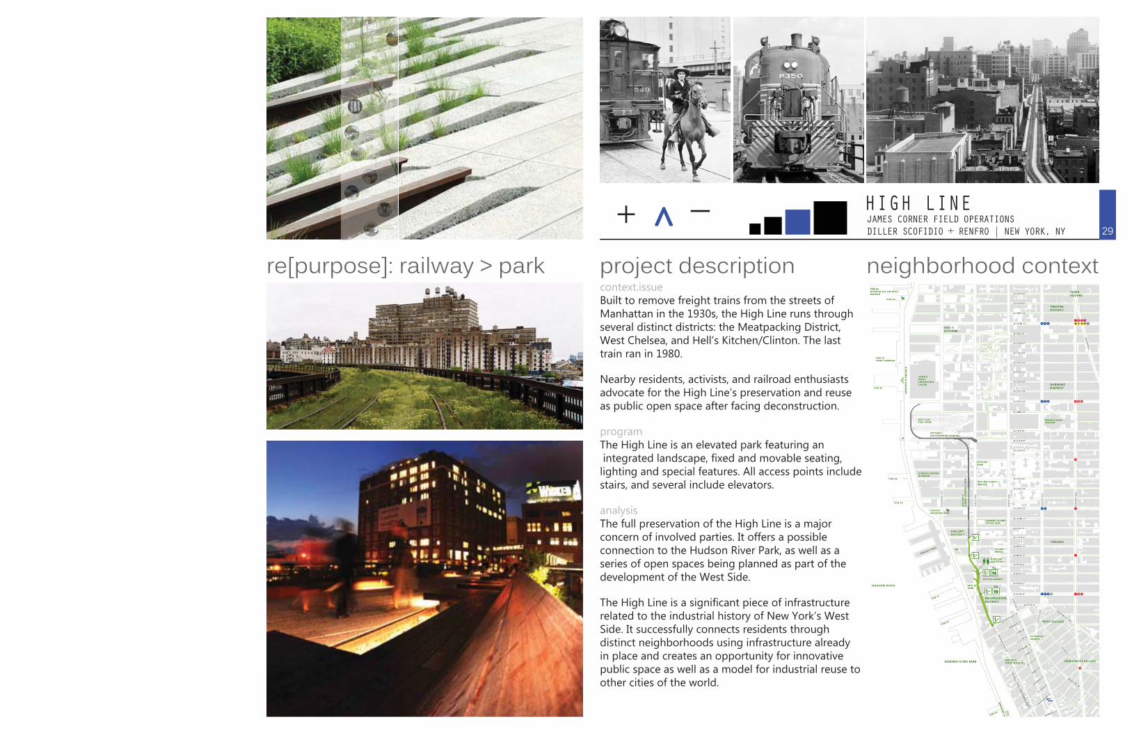
context.issueThe viaduct was an abandoned railway structure that discontinued in 1969. The viaduct is located next to the Bastille, and connected this area to the eastern suburbs.
programStarting in 1987, the viaduct became its transformation from railroad into mixed-used art district. The colonnade supports the various shops while the elevated railway is a park. The two programs built together to accommodate one another. The viaduct served as a direct pedestrian link to connect the suburbs. It was the only elevated parkway until the High Line in New York City.
analysisThis project is often considered the predecessor to the High Line. The main difference between the projects is the Des Arts mixture of small shops. These small shops are at the street level and serve as a double function. The viaduct also connected two parts of the city with a continuous landscape that help linked the city.
More and more cities are considering using bridges and viaducts as potential urban redevelopments. The firm BIG has suggested bridges be converted into apartment complexes to provide greater density.
neighborhood contextproject descriptionintegration of program28
+ ^̂ _ JAMES CORNER FIELD OPERATIONS DILLER SCOFIDIO + RENFRO | NEW YORK, NY
HIGH LINE
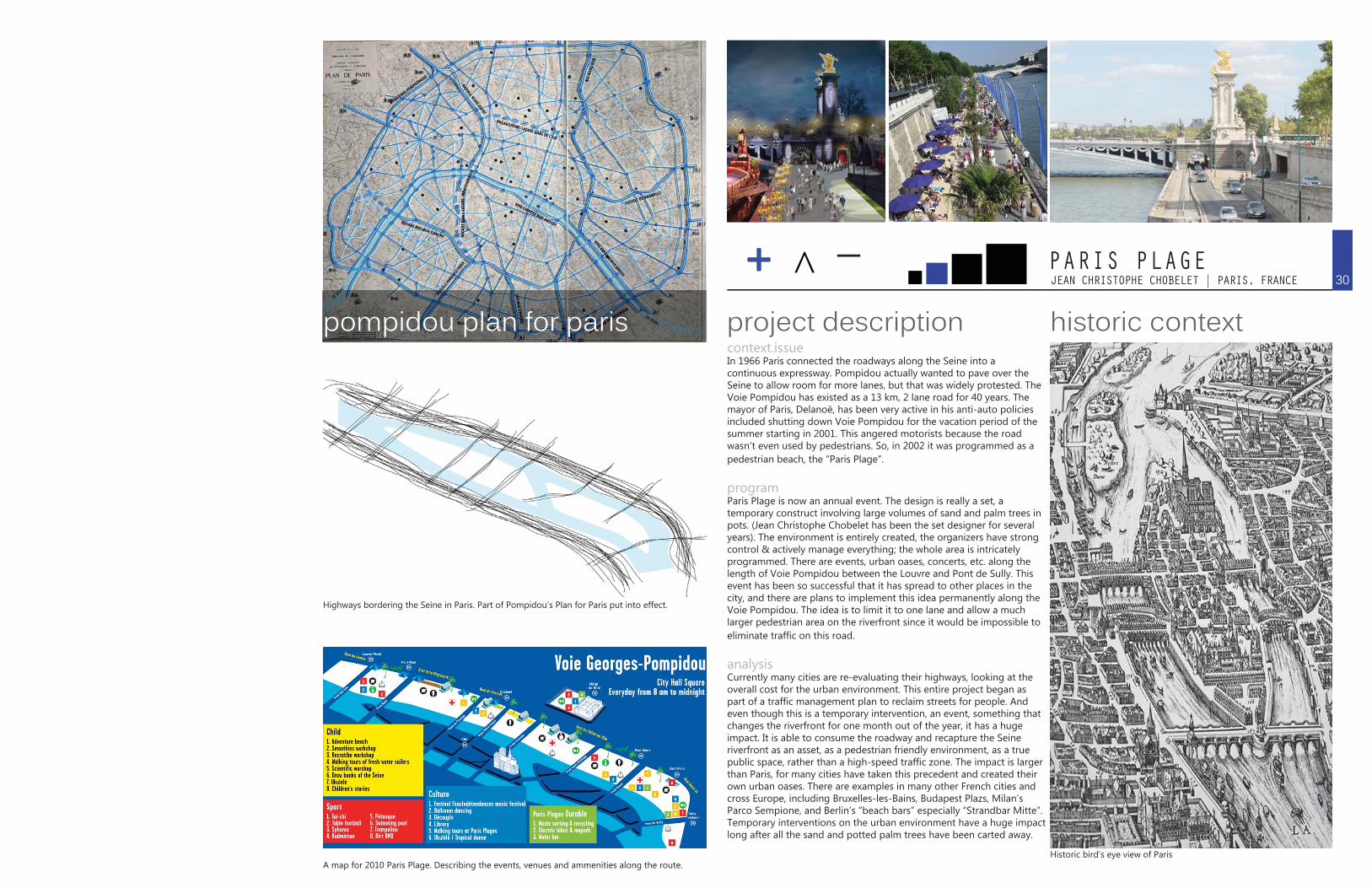
context.issueBuilt to remove freight trains from the streets of Manhattan in the 1930s, the High Line runs through several distinct districts: the Meatpacking District, West Chelsea, and Hell’s Kitchen/Clinton. The last train ran in 1980.
Nearby residents, activists, and railroad enthusiasts advocate for the High Line’s preservation and reuse as public open space after facing deconstruction.
programThe High Line is an elevated park featuring an integrated landscape, fixed and movable seating, lighting and special features. All access points include stairs, and several include elevators.
analysisThe full preservation of the High Line is a major concern of involved parties. It offers a possible connection to the Hudson River Park, as well as a series of open spaces being planned as part of the development of the West Side.
The High Line is a significant piece of infrastructure related to the industrial history of New York’s West Side. It successfully connects residents through distinct neighborhoods using infrastructure already in place and creates an opportunity for innovative public space as well as a model for industrial reuse to other cities of the world.
neighborhood contextproject descriptionre[purpose]: railway > park29
++ ^ _JEAN CHRISTOPHE CHOBELET | PARIS, FRANCEPARIS PLAGE
context.issueIn 1966 Paris connected the roadways along the Seine into a continuous expressway. Pompidou actually wanted to pave over the Seine to allow room for more lanes, but that was widely protested. The Voie Pompidou has existed as a 13 km, 2 lane road for 40 years. The mayor of Paris, Delanoë, has been very active in his anti-auto policies included shutting down Voie Pompidou for the vacation period of the summer starting in 2001. This angered motorists because the road wasn’t even used by pedestrians. So, in 2002 it was programmed as a pedestrian beach, the “Paris Plage”.
programParis Plage is now an annual event. The design is really a set, a temporary construct involving large volumes of sand and palm trees in pots. (Jean Christophe Chobelet has been the set designer for several years). The environment is entirely created, the organizers have strong control & actively manage everything; the whole area is intricately programmed. There are events, urban oases, concerts, etc. along the length of Voie Pompidou between the Louvre and Pont de Sully. This event has been so successful that it has spread to other places in the city, and there are plans to implement this idea permanently along the Voie Pompidou. The idea is to limit it to one lane and allow a much larger pedestrian area on the riverfront since it would be impossible to eliminate traffic on this road.
analysisCurrently many cities are re-evaluating their highways, looking at the overall cost for the urban environment. This entire project began as part of a traffic management plan to reclaim streets for people. And even though this is a temporary intervention, an event, something that changes the riverfront for one month out of the year, it has a huge impact. It is able to consume the roadway and recapture the Seine riverfront as an asset, as a pedestrian friendly environment, as a true public space, rather than a high-speed traffic zone. The impact is larger than Paris, for many cities have taken this precedent and created their own urban oases. There are examples in many other French cities and cross Europe, including Bruxelles-les-Bains, Budapest Plazs, Milan’s Parco Sempione, and Berlin’s “beach bars” especially “Strandbar Mitte”. Temporary interventions on the urban environment have a huge impact long after all the sand and potted palm trees have been carted away.
historic contextproject descriptionpompidou plan for paris
Highways bordering the Seine in Paris. Part of Pompidou’s Plan for Paris put into effect.
A map for 2010 Paris Plage. Describing the events, venues and ammenities along the route.Historic bird’s eye view of Paris
30
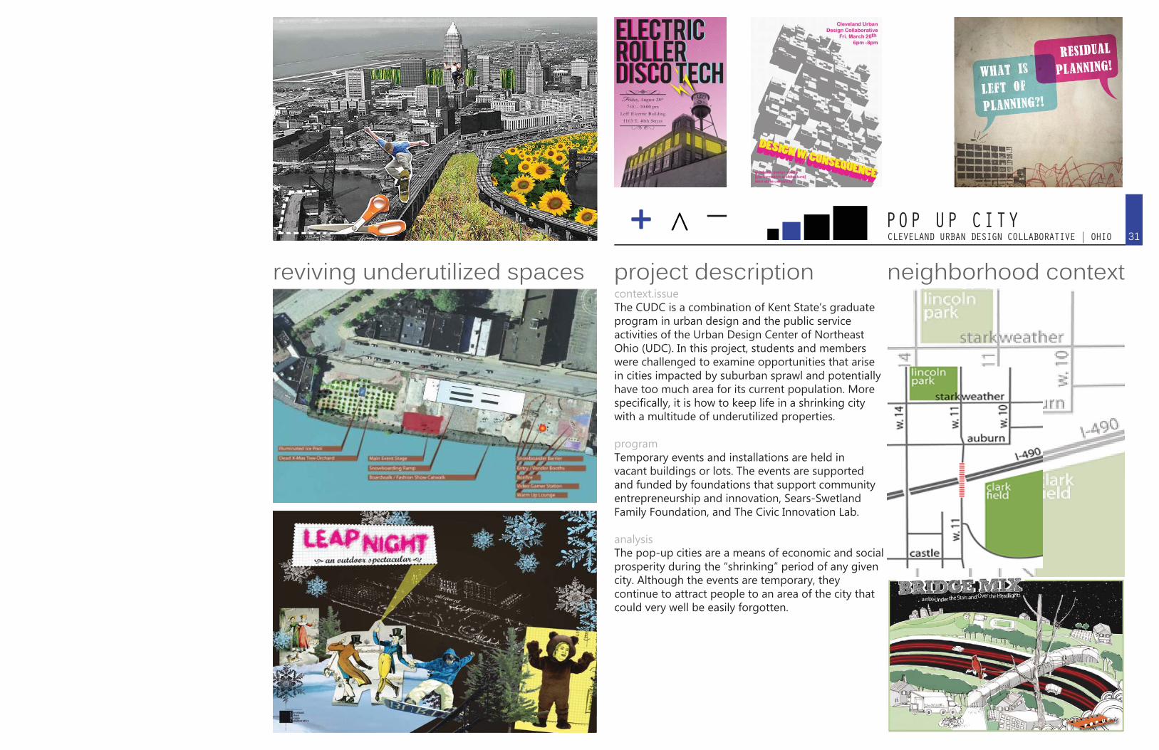
+ ^ _CLEVELAND URBAN DESIGN COLLABORATIVE | OHIOPOP UP CITY
neighborhood contextproject descriptionreviving underutilized spaces31
context.issueThe CUDC is a combination of Kent State’s graduate program in urban design and the public service activities of the Urban Design Center of Northeast Ohio (UDC). In this project, students and members were challenged to examine opportunities that arise in cities impacted by suburban sprawl and potentially have too much area for its current population. More specifically, it is how to keep life in a shrinking city with a multitude of underutilized properties.
programTemporary events and installations are held in vacant buildings or lots. The events are supported and funded by foundations that support community entrepreneurship and innovation, Sears-Swetland Family Foundation, and The Civic Innovation Lab.
analysisThe pop-up cities are a means of economic and social prosperity during the “shrinking” period of any given city. Although the events are temporary, they continue to attract people to an area of the city that could very well be easily forgotten.

CLEVELAND URBAN DESIGN COLLABORATIVE | OHIOPOP UP CITY
activating clevelandThe installations and exhibits range in size from one level of an abandoned building to a temporary park or lot transformation.
Leap Night, shown to the left, was a vacant lot transformed into a winter wonderland for a single night. Leap Night featured everything from a snow and ice installation, to a winter forest complete with costume bears, and music, bonfires, and performances from a multi-media performing arts group. The site offered activities including an ice skating rink, a snowboard ramp and rail jam competition, and food and drink vendors.
A pop up dog park, shown above, was held in a small park area. This event offered group walks, information tables, a live DJ, snacks and a raffle. All of the proceeds benefited the PETCO Foundation.
The Bridge Mix was a one night celebration held on the 11th street pedestrian bridge. The bridge was closed off from its regular foot traffic and flooded with festivities. The night included music, food, drink, and a place to lounge under the stars with the rest of the community. Admission was free, as it is to most pop-up city events.
where’s it happening?32
33HUMAN CITYRESOLUTION
A city can be defined by a series of architectural objects that people inhabit to perform their daily functions. The projects selected in “Human City” look at a different definition of city: something defined by human action and activities which lead to physical form. Projects such as the High Line or Pop-Up City are defined by the innovative thinking on how people can use the space. In the West Bottoms, there is such potential with the multitude of open spaces within the area. A few projects in this section have looked at the use of space under overpasses, something quite prominent in the West Bottoms that could be utilized. Beginning the redevelopment of West Bottoms might not be an immediately built infill, but a temporal city which human activity can be nurtured and flourish into community-made spaces.
34REFERENCES
ZOLLVEREINhttp://www.worldheritagesite.org/sites/zollverein.htmlhttp://www.astoc.de/index.php?lan=en&s=2&id=86&img=4http://www.industriedenkmal-stiftung.de/res/pop. php?id=1984&group=21http://www.zollverein.de/index.htmlhttp://www.dysturb.net/2008/area-with-development-potential- zollverein-coking-plant/
PITTSBURGH THESIShttp://www.ideals.illinois.edu/bitstream/handle/2142/16497/2_ StOnge_David.pdf?sequence=3
HUDSON YARDShttp://www.hydc.org/html/home/home.shtmlhttp://www.related.com//ourcompany/properties/146/ West-Side-Yards/http://www.nyc.gov/html/dcp/html/hyards/hymain.shtml
SOUTH BRONX BRIDGESHoll, Steven. Phamplet Architecture 1-10. Princeton Architectural Press, Princeton. Mar. 1 1998.
LOW2NO HELSINKIhttp://www.archdaily.com/37282/low2no-competition-helsinkis- sustainable-future/http://vimeo.com/6604633
THEATERHAUSMeyer, Helmut. “Sustainability in Architecture”. Lecture, May 21, 2010.
BOSTON SEAPORT PUBLIC REALMhttp://www.cooperrobertson.com/http://www.bostonredevelopmentauthority.org/planning/ PlanningInitsIndividual.asp?action=ViewInit&InitID=3
PARK EAST FREEWAYhttp://www.preservenet.com/freeways/FreewaysParkEast.htmlhttp://www.wisconsinhighways.org/milwaukee/park.html
OLYMPIC PARKhttp://www.seattleartmuseum.orghttp://www.arcspace.com/architects/Weiss_Manfredi/sculpture/http://www.artnet.com
DUTCH MOUNTAINBritish Built: UK Architecture’s Rising GenerationBreathing Cities: The Architecture of Movement
MINI METROwww.minimetrospa.itwww.urbanrail.net/eu/per/perugia.htm
WEIGHTLESShttp://www.paisajesemergentes.com
LACERDA ELEVATORhttp://pt.wikipedia.org/wiki/Elevador_Lacerdahttp://www.7maravilhasbrasil.com.br/08elevador.htm
URBAN PLAZALa, Grace and James Dallman. “Fabricated Landscapes”. University of Wisconsin, Milwaukee School of Architecture & Urban Design and La Dallman Architects, 2009.
RE-BURBIAhttp://www.re-burbia.com/2009/07/28/re-engaging-a-lost-land- living-amongst-the-highway/
ELIMINATING “NO MAN’S LAND”http://www.highwayspace.wordpress.com
VIADUC DE ARTShttp://www.architonic.com/ntsht/viaducts-new-urban- encounters/7000516
HIGHLINEhttp://www.thehighline.org/
PARIS PLAGEhttp://www.paris-plages.fr/http://www.streetsblog.org/2010/05/07/picturing-a-car-free-seine- the-new-vision-for-the-paris-waterfront/http://www.preservenet.com/freeways/FreewaysPompidou.htmlhttp://forum.skyscraperpage.com/showpost. php?p=4897499&postcount=8
POP UP CITYhttp://www.cudc.kent.edu/http://www.facebook.com/pages/Cleveland-OH/ POP-UP-CITY/26640197309
vacant city interrupted city human city