urban disaster resilience through risk assessment and
TRANSCRIPT

1
Urban Disaster Resilience through Risk Assessment and
Sustainable Planning
Dr. Rainer Malmberg, Elke Krätzschmar IABG mbH
Land and Poverty Conference 2017, World Bank
March 20-24,
2017Washington, DC
AUTOMOTIVE DIGITAL ASSURANCE MOBILITY, ENERGY &
ENVIRONMENT
AERONAUTICS SPACE DEFENCE & SECURITY

2
Agenda
Understanding Risk following the IPCC 5th Assessment Report
Changing Environment – Climate change – Challenge for urban planning
Stakeholder Engagement – Risks and driver if Vulnerability
Geospatial Data Infrastructure – From data to information
Urban Development in Monastir
Remote sensing for monitoring processes – EU Satellite programs
Conclusion

The potential occurrence of a natural or human-induced physical
event that may cause loss of life, injury, or other health impacts, as
well as damage & loss to property, infrastructure, livelihoods,
ecosystems, etc.
Understanding disaster risk: Hazards
Source: IPCC 5th Assessment Report Working Group II
Hazards

The presence of people, livelihoods, ecosystems, infrastructure,
or economic, social, or cultural assets in places that could be
affected by a hazard
Exposure
Understanding disaster risk: Exposure
Source: IPCC 5th Assessment Report Working Group II

Vulnerability = the predisposition to be negatively affected by a
hazard. Vulnerability is a result of susceptibility to harm and lack of
capacity to cope (short-term) and lack of capacity to adapt (long-
term).
Vulnerability
Source: IPCC 5th Assessment Report Working Group II
Understanding disaster risk: Vulnerability

6
Climate change – Challenge for urban planning
There is an increasing measurable trend of
natural Disasters affecting North Africa &
Middle East since 1980.
There is a significant change in the magnitude
of heavy rain due to climate change effects.
It is verified, that there is an expected
increasing frequency and magnitude of such
natural hazard events
In 2003 Tunis took in about five times the
volume of rain as typical fell in the entire
month within 24-hours.
Am
ount o
f natu
ral d
isaste
r

7
Climate change – Challenge for urban planning
Projections for the 21st century
carry uncertainty, but even at the
low end of range, sea level rise
will compound current risks for
North African coastal cities
Record of Tunis source: regional study 2011 World Bank
With climate change extreme
episodes as occurred in 2003 are
expected to become more
frequent, requiring a fresh look at
the city‘s level of preparedness

8
To enhance urban multi-hazard disaster prevention and resilience in
Tunisia, using the city of Monastir as a pilot study
To analyze & monitor urban development and disaster risk trends &
mainstream the derived information into urban planning / DRR strategies
Identify main drivers of urban disaster risk (relevant hazards & vulnerability
indicators)
Evaluate available and needed (geospatial) data, fill gaps & develop a
standardized GIS database
Conduct a multi-hazard risk assessment and identify risk hotspots in the city
(past trends, present conditions, future scenarios)
Support capacity building activities
Project Objectives

9
Stakeholder interviews – identification of Risks
Flash floods (20)
Coastal erosion (17)
Seismic activity / earthquakes (15)
Storms (11)
Drought (8)
Heat waves (8)
Sea level rise (7)
River floods (6)
Air pollution / smoke (5)
Sea water pollution (3)
Water stagnation (2)
Fires (1)
Subsidence (1)
Main Risks – Result of stakeholder Interviews

10
Stakeholder interviews – Challenge for urban development
Illegal settlements & poor housing (15)
Poverty (9)
Lack of governance / planning / transparency (9)
Lack of information, maps, risk analyze (9)
Lack of insurance (8)
Lack of coordination (5)
Lack of emergency response & equipment (5)
Behavior of citizens (5)
Waste & waste water disposal (5)
Poor respect for legality (3)
Immigration / rapid urbanization (3)
Law enforcement (3)
Lack of infrastructure maintenance (3)
Lack of law enforcement (2)
Lack of prevention (2)
Lack of protection systems (2)
Insufficient hospital capacity (1)
Lack of training (1)
Factors increasing vulnerability

11
Urban Planning from paper maps to an intelligent
Geodata Infrastructure
Documentation of Risk zones with text markers Using Remote sensing and GIS for urban mapping

A Tunisian case study – Monastir - 1998
Evaluation of the urban sprawl
with a multi- temporal analysis
1998-2015
Using Copernicus Urban Atlas
standard nomenclature and
classification for the urban
mapping.
Mapping of transport
infrastructure and condition
Creating a terrain model for
flood simulation
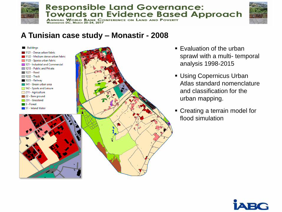
A Tunisian case study – Monastir - 2008
Evaluation of the urban
sprawl with a multi- temporal
analysis 1998-2015
Using Copernicus Urban
Atlas standard nomenclature
and classification for the
urban mapping.
Creating a terrain model for
flood simulation

A Tunisian case study – Monastir - 2015
Densification leads to increasing
imperviousness
Urbanisation through densification
Loosing agriculture and natural
land
Sprawl into potential risk zones

1998 2008 2015
Change
1998/2008
Change
2008/2015
A Tunisian case study – Monastir - comparison

A Tunisian case study – Monastir Analyse

A Tunisian case study – Monastir Analyse – housing development

Using free Sentinel1 for mapping flood areas

Terrain analysis
(flooding [m])
A Tunisian case study – Monastir Terrain Analyse Flood Risk Area
Sentinel-1A VV, 13/09/2016, Acquisition time: 17:12,
Recording before Flooding and at a flood event

Radar Interferometrie for monitoring of ground movements
20
-20mm/Jahr
-5 mm/Jahr
-24 mm/Jahr
Using coherence measurement of different Sentinel Radar scenes for larger
areas and monitoring of buildings and critical infrastructure.

21
AUTOMOTIVE INFOKOM MOBILITÄT, ENERGIE &
UMWELT
LUFTFAHRT RAUMFAHRT VERTEIDIGUNG &
SICHERHEIT
Summary
There is an increasing risk for natural disaster caused by climate change
effects that should be considered for a sustainable urban planning
To manage the urban area an intelligent consistent and up to date
database is mandatory
Various satellites and remote sensing information give us important
information of the exposure and vulnerability of an area
Free and open Sentinel Satellites open new opportunities for a long
term monitoring of changes
Stakeholder engagement and capacity building is important for a
successful implementation of new technology and processes

22
Dr. Rainer Malmberg
Key Account Manager
Business Development
International cooperation
Geospatial data / Geoinformatics
Einsteinstraße 20
D-85503 Ottobrunn
Germany
Tel +49 89 6088 2823
Fax +49 89 6088 2355
E-Mail [email protected]
Web www.iabg.de
Your contact :
Elke Krätzschmar
Remote Sensing Expert
Geospatial data / Geoinformatics
Hermann-Reichelt-Str. 3
01109 Dresden
Germany
Tel +49 351 8923 145
Fax +49 351 8923 133
E-Mail krä[email protected]
Web www.iabg.de