urbanization dilemmas in delta cities. interdependencies
TRANSCRIPT
City and territory in the Globalization Age Conference proceedings
2017, Universitat Politècnica de València
Urbanization dilemmas in Delta Cities. Interdependencies between formal and informal urbanization processes in
Barranquilla, Beira and Ho Chi Minh City
Like BijlsmaNetherlands Environmental Assessment Agency. The Hague, The Netherlands
E-mail: [email protected]
Introduction
Global challenges will most heavily impact those areas where the world’s population is concentrated; in urban regions. These challenges are further concentrated in urbanizing deltas, where both natural and socio-economic pressures on the city are often emphasized by, on the one hand a high economic value, and on the other increased vulnerability from water-related consequences of climate change. It is clear that urbanizing deltas, regions in which people are, for their quality of life, strongly dependent on the assets as well as the risks of the natural ecosystem, are most vulnerable (Ligtvoet et al, 2014). Starting point for the research is the fact that in Delta Cities there is a struggle between urban growth and water issues. Due to the natural condition, there is strong correlation between local and systemic issues in urbanization. (Meyer & Nijhuis, 2013) Planning practice is dealing with this issues most often in rational and technocratic ways. But there is a huge
gap between what could be called a rational, integral planning approach based on risk assessment and what is feasible in the day-to-day urban reality. Cities are poorly understood. Different urbanization processes interfere with each other in sometimes not so predictive ways. Morphological research can outline the character of the spatial problems cities are facing. It can structure these problems and can identify driving forces of urbanization processes. The gathered knowledge can be used to make improvements in local projects and planning strategies. The Netherlands Environmental Assessment Agency carried out a morphological case study research in three delta cities: Ho Chi Minh City in Vietnam, Barranquilla in Colombia and Beira in Mozambique (Bijlsma et al, 2017, to be published). Their common denominator is their position in deltas or river basins, but these cities are quite different in various other aspects. Recent urbanization processes were analyzed with the aim of finding local and systemic leverage points for inclusive and green growth.
Abstract. Research Delta Cities in developing countries face problems of water risks while also dealing with enormous population growth. Recent urbanization is increasingly taking place in high risk areas. When looking into these recent urbanization processes, we can discern two different dynamics, formal and informal ones. They relate in different ways to green, grey and blue infrastructures, and have their own formal and informal institutional drivers. Modern technocratic planning methods do not positively interfere with informal city growth. On the contrary, often water problems are shifted to the lower and informal parts of the city. Inclusive green planning should take into account local urbanization practice.
Keywords: Informal urbanization, green infrastructures, delta cities, developing countries, inclusive green growth
http://dx.doi.org/10.4995/ISUF2017.2017.6231
24th ISUF International Conference 27th-29th September 2017 VALENCIA
1581

24th ISUF International Conference 27th-29th September 2017 VALENCIA
2017, Universitat Politècnica de València
Methodology
Of particular interest is that growth in these cities takes place in a very different way from that of the top down planned delta of the Netherlands. The dynamics of water and city are traditionally aligned in the Netherlands with the discipline of the planning and drives on cooperation from a number of essential institutions, including water boards, state waterways and municipalities. Current urbanization trends in emerging economies take place in a less organized way. The city is growing through planned and unplanned urbanization.
To analyze the spatial dynamics in these delta cities we use the Dutch layer approach. This approach has proven its services in the adaptive planning of the Dutch Delta (Meyer et al., 2015). In order to cope with the informal urbanization in developing countries, a further conceptual distinction has been made between the formal planning of hard infrastructure and building tissues on the one hand and the soft, natural infrastructure and informal tissues on the other. In addition, a relationship has been established with the (local) economy, leading to the 6 vertices of the conceptual hexagon model. By adding the upper vertice it becomes clear to what extent morphology is related to a locally rooted lifestyle of the inhabitants. (Fig 1)
The hexagon model is helpful in constructing a story about local urbanization that explicitly addresses the (mutual) relationship (s) that soil, infrastructure and formal and informal urban developments can have with one another and with the local economy. By connecting the elements of the hexagon model based on the insights from the morphological analysis, a first qualitative impression of the dominant relationships occurs within formal and informal urbanization. The hexagon can be applied for analyzing spatial as well as institutional relationships within different urbanization processes. “Drawing lines in the hexagons” creates an image of the cohesion and (possible) interrelated mechanisms that play a part in restoring the resilience of the delta. The three cities are analyzed through the scales: with the hexagon as a guidance the scale of the neighbourhood is related to the different city systems.
The delta system: the struggle for space between city and water in three cases
All deltas in the world face a growing population which is increasingly occupying vulnerable grounds, because of population growth and urban pressure in central areas. This is also the case for our three study areas. The natural condition of the delta is roughly defined by altitude in relation to the sea level. In our three case studies, we see large differences in altitude. It defines if the urban water problem comes from the sea, river or sky. Ho Chi Minh City has developed on the higher sides of the river beds. The city of Beira sits in a swamp, protected by dunes parallel to the coast, and Barranquilla has developed itself on steep slopes.
The delta issue is further defined by the urban growth. Also urban density, which has impact on petrification and subsidience of soils, is important. These aspects differ for our three cities. Ho Chi Minh City is our biggest city, has a steep growth rate and high densities. The city of Beira is small, but has grown substantially in the last decades. At the same time the density is still relatively low, with a lot of farm plots in the city. Barranquilla has the highest density
Figure 1. The hexagon model: the Dutch ‘layer approach’ with a formal and informal side
1582
City and territory in the Globalization Age Conference proceedings
2017, Universitat Politècnica de València
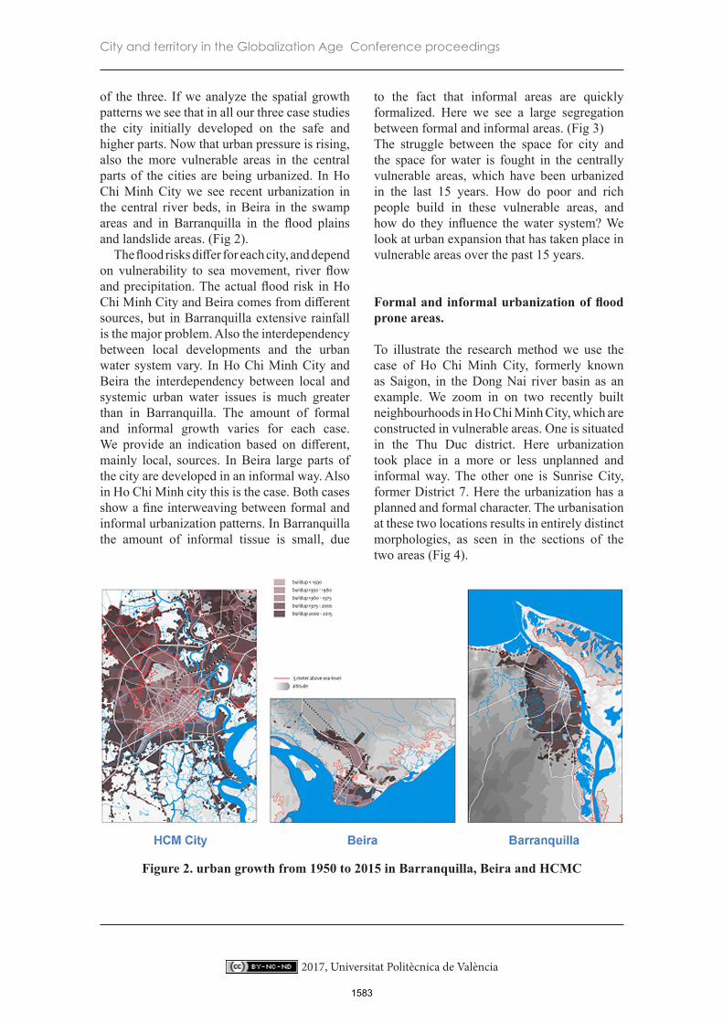
of the three. If we analyze the spatial growth patterns we see that in all our three case studies the city initially developed on the safe and higher parts. Now that urban pressure is rising, also the more vulnerable areas in the central parts of the cities are being urbanized. In Ho Chi Minh City we see recent urbanization in the central river beds, in Beira in the swamp areas and in Barranquilla in the flood plains and landslide areas. (Fig 2).
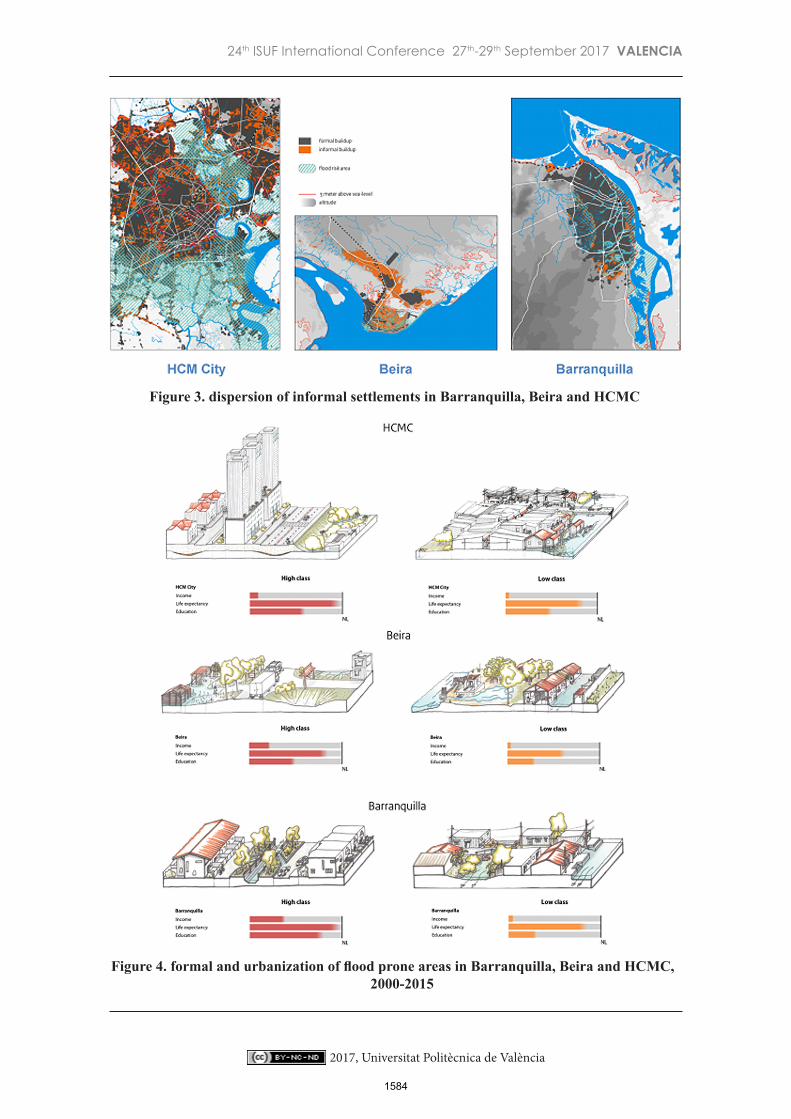
The flood risks differ for each city, and depend on vulnerability to sea movement, river flow and precipitation. The actual flood risk in Ho Chi Minh City and Beira comes from different sources, but in Barranquilla extensive rainfall is the major problem. Also the interdependency between local developments and the urban water system vary. In Ho Chi Minh City and Beira the interdependency between local and systemic urban water issues is much greater than in Barranquilla. The amount of formal and informal growth varies for each case. We provide an indication based on different, mainly local, sources. In Beira large parts of the city are developed in an informal way. Also in Ho Chi Minh city this is the case. Both cases show a fine interweaving between formal and informal urbanization patterns. In Barranquilla the amount of informal tissue is small, due
to the fact that informal areas are quickly formalized. Here we see a large segregation between formal and informal areas. (Fig 3) The struggle between the space for city and the space for water is fought in the centrally vulnerable areas, which have been urbanized in the last 15 years. How do poor and rich people build in these vulnerable areas, and how do they influence the water system? We look at urban expansion that has taken place in vulnerable areas over the past 15 years.
Formal and informal urbanization of flood prone areas.
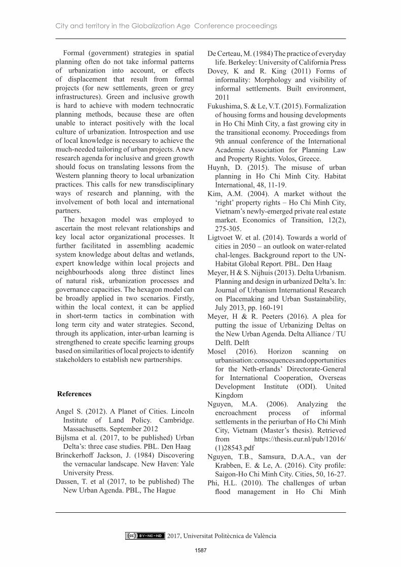
To illustrate the research method we use the case of Ho Chi Minh City, formerly known as Saigon, in the Dong Nai river basin as an example. We zoom in on two recently built neighbourhoods in Ho Chi Minh City, which are constructed in vulnerable areas. One is situated in the Thu Duc district. Here urbanization took place in a more or less unplanned and informal way. The other one is Sunrise City, former District 7. Here the urbanization has a planned and formal character. The urbanisation at these two locations results in entirely distinct morphologies, as seen in the sections of the two areas (Fig 4).
Figure 2. urban growth from 1950 to 2015 in Barranquilla, Beira and HCMC
1583
24th ISUF International Conference 27th-29th September 2017 VALENCIA
2017, Universitat Politècnica de València
Figure 3. dispersion of informal settlements in Barranquilla, Beira and HCMC
Figure 4. formal and urbanization of flood prone areas in Barranquilla, Beira and HCMC, 2000-2015
1584

City and territory in the Globalization Age Conference proceedings
2017, Universitat Politècnica de València
Taking the morphological relationships in the hexagon as a starting point, it’s possible to identify the most important participants for the established urbanization process in this area. Informal urbanization is mostly realized by local capital. Local investors and commerce is putting efforts in building houses, roads and local economy. Local roads and watercourses are maintained by public authorities. There is also some foreign investment, mostly related to new highways and sluice gates. Local authorities, like the district wards, have a mediating role between informal and formal institutions, the formal and informal side of the hexagon.
The formal district of Sunrise City was also built in the flood plains in the last 15 yeards. It is a large commercial residential development. In the layout of the area, different types of plots and buildings were included:Along the main road we see large highrises and commercial facilities like shopping malls, and indoor recreation.
Within the district along the connecting roads we find individual plots with apartment houses and small commerces, like beauty saloons and coffee shops.
3. Inside the building blocks we find individual residential villas, single family houses, around collective gardens and a pond.Project developers in large-scale residential expansion districts in South Saigon are creating different growth patterns. New city structures are not attuned to the old river beds; canals are drained and entire city structures are built onto a thick foundation of sand, with not much room for water storage. Thus, a new artificial city system is imposed to the former natural system. The two systems are poorly interconnected, each with their own water system and infrastructure. – this might enlarge water risks but also might lead to segregation between rich and poor areas, replacing the earlier mix of the two along the old roads.
The neighbourhood is constructed in one go. It has a rational lay out and new types of public and collective space emerge here, like motorways, gardens and ponds. Although the project mainly consists of dwellings, also different types of commerces emerge along the connecting roads. The informal economy is
not so big as in Thu Duc. There is also a large formal economy here.
If we describe the spatial relations of the Sunrise city growth pattern we see that the most important physical relationships are between formal occupation patterns and formal infrastructures, like roads and artificial water infrastructures. Also local economy is related to both aspects, in new building forms like indoor malls, but also within new interpretations of the traditional shophouse. The development is detached from vernacular infrastructures and the natural system, but also relates to it in the sense that it has reduced the original floodplains.
If we identify the most important participants for this local urbanization process in this area we see that the urbanization is mostly realized by participants and investors from outside the area, and is facilitated by local authorities for the construction and connection of the roads and watercourses. The existing vernacular urban pattern is at some points connected to the new constructed urban layout, but not at all points. The main participants of this particular urbanization process are all on the formal side of the hexagon, and there is little connection with the informal side.
In Ho Chi Minh City these different urbanisation processes of flood prone areas occur simultaneously. If we relate these urbanization patterns to the urban system at the level of the city or the region, we see some trade off between formal and informal processes. How do these processes affect to the urban water and infrastructure system, what are the interdependencies between the different layers? In this case we see that new connecting roads trigger local economy and formal urbanization. And we see that both formal and informal occupation reduce the local capacity of the floodplains, each in its own way. However formal urbanization is moving problems elsewhere. By closing off watercourses and raising groud levels the water storage capacity of the river diminishes – with increased flooding in the lower, informal parts of the city, as a result.
If we look at our three cities we see some similarities. (Fig 5) Formal urbanisation is connecting to gray, hard and artificial
1585

24th ISUF International Conference 27th-29th September 2017 VALENCIA
2017, Universitat Politècnica de València
Figure 5. Mapping interdependencies in the hexagon model in Barranquilla, Beira and HCMC
infrastructures. Its development is planned by government authorities and supported by the financial sector. Informal urbanisation is settling amidst green infrastructure, using adaptive tactics that are in line with the local culture. But we also see differences. The hexagons show that urbanisation processes differ. Also the interdependency between local developments and the urban water system vary. In Ho Chi Minh City and Beira the interdependency between local and systemic urban water issues is much greater than in Barranquilla. A proper understanding of these distinct processes and the mechanisms behind them, is a prerequisite for inclusive, sustainable improvement.
Conclusion
The analysis of historic development of the delta shows that over many years a specific, cultural smart way of dealing with the risks of living in a delta was developed. People knew how to build infrastructure and houses in a way balancing the assets and the risks. The mass urbanization seems to bring an end to this culturally embedded, smart urbanisms.
Technical solutions are too easily imported. This is a real loss as it leads to not just to increased vulnerability but also to a loss of the social-cultural identity of cities.
The analysis of formal and informal urbanization processes reveals that the formal development strategies and the tactics of informal communities have completely different logics and mechanisms. In most cases these do not reinforce each other. On the contrary, they show strong trade-offs. Different urbanization processes interfere with each other in sometimes not so predictive ways. Informal urbanization takes place incrementally and sits in green infrastructures and natural environments. Formal urbanization is connected with grey infrastructures and displaces both informal settlements as well as water problems to other parts of the city. Both these urbanization processes are embedded institutionally in particular ways: informal urbanization makes use of local capital and informal institutions, while formal projects generally make use of FDI and formal institutions. Infrastructure is embedded in its own way, with a strong link to national governments (ODA) and intergovernmental organizations such as (in particular) the World
1586
Bank.
City and territory in the Globalization Age Conference proceedings
2017, Universitat Politècnica de València
Formal (government) strategies in spatial planning often do not take informal patterns of urbanization into account, or effects of displacement that result from formal projects (for new settlements, green or grey infrastructures). Green and inclusive growth is hard to achieve with modern technocratic planning methods, because these are often unable to interact positively with the local culture of urbanization. Introspection and use of local knowledge is necessary to achieve the much-needed tailoring of urban projects. A new research agenda for inclusive and green growth should focus on translating lessons from the Western planning theory to local urbanization practices. This calls for new transdisciplinary ways of research and planning, with the involvement of both local and international partners.
The hexagon model was employed to ascertain the most relevant relationships and key local actor organizational processes. It further facilitated in assembling academic system knowledge about deltas and wetlands, expert knowledge within local projects and neighbourhoods along three distinct lines of natural risk, urbanization processes and governance capacities. The hexagon model can be broadly applied in two scenarios. Firstly, within the local context, it can be applied in short-term tactics in combination with long term city and water strategies. Second, through its application, inter-urban learning is strengthened to create specific learning groups based on similarities of local projects to identify stakeholders to establish new partnerships.
References
Angel S. (2012). A Planet of Cities. Lincoln Institute of Land Policy. Cambridge. Massachusetts. September 2012
Bijlsma et al. (2017, to be published) Urban Delta’s: three case studies. PBL. Den Haag
Brinckerhoff Jackson, J. (1984) Discovering the vernacular landscape. New Haven: Yale University Press.
Dassen, T. et al (2017, to be published) The New Urban Agenda. PBL, The Hague
De Certeau, M. (1984) The practice of everyday life. Berkeley: University of California Press
Dovey, K and R. King (2011) Forms of informality: Morphology and visibility of informal settlements. Built environment, 2011
Fukushima, S. & Le, V.T. (2015). Formalization of housing forms and housing developments in Ho Chi Minh City, a fast growing city in the transitional economy. Proceedings from 9th annual conference of the International Academic Association for Planning Law and Property Rights. Volos, Greece.
Huynh, D. (2015). The misuse of urban planning in Ho Chi Minh City. Habitat International, 48, 11-19.
Kim, A.M. (2004). A market without the ‘right’ property rights – Ho Chi Minh City, Vietnam’s newly-emerged private real estate market. Economics of Transition, 12(2), 275-305.
Ligtvoet W. et al. (2014). Towards a world of cities in 2050 – an outlook on water-related chal-lenges. Background report to the UN-Habitat Global Report. PBL. Den Haag
Meyer, H & S. Nijhuis (2013). Delta Urbanism. Planning and design in urbanized Delta’s. In: Journal of Urbanism International Research on Placemaking and Urban Sustainability, July 2013, pp. 160-191
Meyer, H & R. Peeters (2016). A plea for putting the issue of Urbanizing Deltas on the New Urban Agenda. Delta Alliance / TU Delft. Delft
Mosel (2016). Horizon scanning on urbanisation: consequences and opportunities for the Neth-erlands’ Directorate-General for International Cooperation, Overseas Development Institute (ODI). United Kingdom
Nguyen, M.A. (2006). Analyzing the encroachment process of informal settlements in the periurban of Ho Chi Minh City, Vietnam (Master’s thesis). Retrieved from https://thesis.eur.nl/pub/12016/(1)28543.pdf
Nguyen, T.B., Samsura, D.A.A., van der Krabben, E. & Le, A. (2016). City profile: Saigon-Ho Chi Minh City. Cities, 50, 16-27.
Phi, H.L. (2010). The challenges of urban flood management in Ho Chi Minh
1587
24th ISUF International Conference 27th-29th September 2017 VALENCIA
2017, Universitat Politècnica de València
City. Conference proceedings from the first international conference on Future Megacities in Balance 2010. Essen, Germany.
Roy, A. (2005) “Urban Informality: Toward an Epistemology of Planning” Journal of the American Planning Association, 71:2, 147-158.
Thu. T.T. & Perera, R. (2011). Intermediate levels of property rights and the emerging housing market in Ho Chi Minh City, Vietnam. Land Use Policy, 28, 124-138.
WBGU (2016), Humanity on the move: Unlocking the transformative power of cities. German Advisory Council on Global Change
Zoomers A. et al (2016). The rush for land in an urbanizing world: from land grabbing toward developing safe, resilient, and sustainable cities and landscapes. In: World Development, Vol. 92, pp.242-252.
1588