us army corps of engineers · us army corps of engineers ... decision as the lead agency on the...
TRANSCRIPT

US Army Corps of Engineers® Buffalo District RECORD OF DECISION FOR THE MUDFLATS OPERABLE UNIT TONAWANDA LANDFILL VICINITY PROPERTY TOWN OF TONAWANDA, NEW YORK September 2008

I. DECLARATION FOR THE RECORD OF DECISION

DECLARATION FOR THE RECORD OF DECISION
SITE NAME AND LOCATION Mudflats Operable Unit
Tonawanda Landfill Vicinity Property Site Town of Tonawanda, Erie County, New York
STATEMENT OF BASIS AND PURPOSE This Record of Decision (ROD) presents the United States Army Corps of Engineers (USACE) decision as the lead agency on the final Selected Remedy for the Mudflats Operable Unit (OU) at the Tonawanda Landfill Vicinity Property Site in Erie County, New York, which was chosen in accordance with the Comprehensive Environmental Response, Compensation, and Liability Act (CERCLA), as amended by the Superfund Amendments and Reauthorization Act (SARA), and, to the extent practicable, the National Oil and Hazardous Substances Pollution Contingency Plan (NCP). This decision is based on the Administrative Record file for this site, located at the following locations: USACE FUSRAP Public Information Center 1776 Niagara Street Buffalo, New York (716) 879-4438 1-800-833-6390 (press “4” at the recorded message) Tonawanda Public Library 333 Main Street Tonawanda, New York 14150 Comments on the Proposed Plan provided by the New York State Department of Conservation (NYSDEC); the New York State Department of Health (NYSDOH); and individual members of the New York State Senate, the New York State Assembly, the United States Senate, the Erie County Legislature, the City of Tonawanda, the Town of Tonawanda, and the general public were evaluated; all of the received comments pertained specifically to the Landfill OU itself and none pertained to the Mudflats OU. For this reason, the New York State Department of Environmental Conservation has not indicated whether they concur or do not concur with the No Action decision as it applies to the Mudflats OU. All of the received comments pertaining to the Landfill OU will be addressed in a separate Landfill OU responsiveness summary.
ASSESSMENT OF THE MUDFLATS OU The USACE, as lead agency, has determined that no action is necessary in the Mudflats OU to protect public health or welfare or the environment.
iii
DESCRIPTION OF THE SELECTED REMEDY
Background The Tonawanda Landfill Vicinity Property is located approximately 1.5 miles north of the Linde (Praxair) Formerly Utilized Sites Remedial Action Program (FUSRAP) site in the Town of Tonawanda, New York (Figure 1). It is comprised of two operable units (OU) – the Landfill OU and the Mudflats OU area (Figure 2). Both of these properties are owned by the Town of Tonawanda and current zoning of the area is commercial/industrial, except for the bordering residential area to the north of the Tonawanda Landfill Vicinity Property. The landfill was operated as a municipal landfill by the Town of Tonawanda from the mid-1930s through October 1989. In the early 1900’s a quarry was located in the western portion of the Landfill property. In the 1920’s, the quarry was reportedly abandoned at a depth of 60 feet when water was encountered. Wastes disposed in the Landfill included ash generated by incinerators (formerly located just west of the Mudflats), construction/demolition debris and yard refuse (leaves, branches, etc.) collected from Town residents. On occasion, the Landfill accepted municipal solid waste and wastewater sludge (formerly incinerated at the incinerators), but only when the incinerators were temporarily inoperable. The incinerators, operated by the Town of Tonawanda between the 1940’s and the early 1980’s, were used to burn municipal solid waste and sludge generated at the Town of Tonawanda’s Waste Water Treatment Plant. The incinerators were located in the western edge of the Mudflats area (see Figure 2) until they were demolished in 2002. Other than the incinerators, the Mudflats have always been vacant. In the early 1990s the Department of Energy (DOE), while conducting investigations of the nearby Linde FUSRAP Site, detected elevated levels of radium, uranium and thorium in the Town of Tonawanda Landfill and the Mudflats. Although neither the Landfill nor Mudflats were known to be directly involved in past Manhattan Engineer District (MED) activities, the DOE designated the two properties together as a FUSRAP Vicinity Property, due to the similarity between the material found in the Landfill and Mudflats and that found at the Linde Site (DOE 1992). On October 13, 1997, the Energy and Water Development Appropriations Act, 1998, was signed into law as Public Law 105-62. Pursuant to this law, FUSRAP was transferred from the DOE to the USACE. As a result of this transfer, USACE assumed responsibility for this project. The Energy and Water Development Appropriations Act for Fiscal Year 2000, Public Law 106-60, provides authority to USACE to conduct restoration work on FUSRAP sites subject to the CERCLA, 42 United States Code 9601 et seq., as amended. This USACE authority is limited to remediating contamination related to the nation’s early atomic energy program. Other contamination is not eligible under FUSRAP. Therefore, this ROD only addresses FUSRAP-eligible Constituents of Concern (COCs).
iv

v
The results of the Baseline Risk Assessment (BRA) indicate that no further action is required for the Mudflats OU, as the radium, uranium and thorium in the Mudflats OU do not pose a cancer risk above the threshold presented in the National Oil and Hazardous Substances Pollution Contingency Plan (NCP) found at 40 C.F.R Part 300. The Proposed Plan (PP) for the Tonawanda Landfill Vicinity Property site was issued by USACE in March 2007. This ROD addresses the Mudflats OU at the Tonawanda Landfill Vicinity Property site. This is the final decision regarding any FUSRAP response action for the Tonawanda Landfill Vicinity Property site Mudflats OU.
Decision Summary USACE has determined that the current and reasonable future site uses are commercial/industrial. USACE has also determined that the radiological risks from the radium, uranium, and thorium present in the Mudflats OU are below the health risk action levels as specified in the NCP. Based on these determinations, and as described in the March 2007 Proposed Plan (PP), no further action for the Tonawanda Landfill Vicinity Property Site Mudflats OU is warranted.
STATUTORY DETERMINATIONS
No CERCLA Section 121 statutory determinations are necessary for this ROD since USACE has determined that no remedial action is necessary under CERCLA. USACE has concluded that the FUSRAP eligible COCs present are below the NCP risk limit. Since no actions are warranted, there is no need for further reviews and monitoring at the Mudflats OU. Although the current and reasonable future use is commercial/industrial, a risk analysis was performed for the more protective residential standard. The results indicated that risks for resident adults and children were within the 10-4 CERCLA risk threshold, and therefore the Corps of Engineers has determined that no 5-year reviews are warranted. __________________________________ _________________ JOHN W. PEABODY Date Brigadier General, U.S. Army Commanding

RECORD OF DECISION
FOR THE MUDFLATS OPERABLE UNIT TONAWANDA LANDFILL VICINITY PROPERTY
TOWN OF TONAWANDA, NEW YORK
TABLE OF CONTENTS DECLARATION FOR THE RECORD OF DECISION.......................................... iii TABLE OF CONTENTS....................................................................................... vi ACRONYMS AND ABBREVIATIONS.................................................................viii ACRONYMS AND ABBREVIATIONS (continued) ............................................... ix
DECISION SUMMARY FOR THE RECORD OF DECISION................................1
1.0 SITE NAME, LOCATION AND DESCRIPTION..........................................2
1.1 Tonawanda Landfill Vicinity Property site overview.....................................2 2.0 SITE HISTORY……………………………………………………………………3
2.1 History .........................................................................................................3 2.2 Site Status...................................................................................................3 2.3 Previous Activities .......................................................................................4 2.4 USACE Remedial Investigation in 2001 ......................................................4
3.0 COMMUNITY PARTICIPATION.................................................................5
4.0 SCOPE AND ROLE OF OPERABLE UNIT.....................................................7
5.0 SITE CHARACTERISTICS .............................................................................7
5.1 Site Description ...........................................................................................7 5.2 Site Geology................................................................................................7 5.3 Area Hydrogeology......................................................................................7 5.4 Surface Water Hydrology ............................................................................8 5.5 Constituents of Potential Concern ...............................................................8 5.6 Impacted Soils and Groundwater ................................................................9 5.6.1 Impacted Soils........................................................................................10 5.6.2 Impacted Ground Water .........................................................................10
6.0 CURRENT AND POTENTIAL FUTURE LAND USES ..................................10
7.0 SUMMARY OF SITE RISKS.........................................................................11
7.1 Human Health Assessment .......................................................................11 7.2 Ecological Risk Assessment......................................................................12 7.3 Conclusions...............................................................................................13
8.0 SELECTED REMEDY...................................................................................13
9.0 STATUTORY DETERMINATIONS ...............................................................13
10.0 DOCUMENTATION OF SIGNIFICANT CHANGE ......................................13
11.0 REFERENCES ...........................................................................................13
vi
List of Figures Figure 1 Regional location of the Town of Tonawanda, New York and the Ashland
1, Ashland 2, Seaway and Linde sites and Tonawanda Landfill Vicinity Property
Figure 2 Tonawanda Landfill Vicinity Property Approximate Locations Figure 3 Areas of Investigation and MARSSIM Area Designations Figure 4 Exposure Units and Groundwater Sample Locations List of Tables Table 1 Results Summary for Mudflats OU, Soil Results Table 2 Groundwater Sampling Results Mudflats OU-September 2001 Table 3 Reasonable Maximum Exposure Cancer Risk Summary for Mudflats OU
Exposure Units List of Appendices Appendix A – Responsiveness Summary
- Responses to Comments - Public Meeting Transcript - Attachments. Written comments from State agencies, Public Officials, general
public
vii

ACRONYMS AND ABBREVIATIONS AEC U.S. Atomic Energy Commission ALARA As low as reasonably achievable Am-241 americium-241 ANL Argonne National Laboratory ARAR Applicable or relevant and appropriate requirement bgs Below ground surface BNI Bechtel National Incorporated BRA Baseline Risk Assessment B&W Babcock and Wilcox CERCLA Comprehensive Environmental Response, Compensation, and Liability Act CFR Code of Federal Regulations COCs Constituents of Concern COPCs Constituents of Potential Concern CY Cubic yards DOE U.S. Department of Energy ECWA Erie County Water Authority ERA Ecological risk assessment EU Exposure Unit FS Feasibility Study FUSRAP Formerly Utilized Sites Remedial Action Program FSSP Final Status Survey Plan HHA Human Health Assessment HHRA Human health risk assessment HI Hazard Index LLW low-level radioactive waste MARSSIM Multi-Agency Radiation Survey and Site Investigation Manual MED Manhattan Engineer District mg/L milligrams/liter MOU Memorandum of Understanding mrem/yr millirem per year NCP National Oil and Hazardous Substances Pollution Contingency Plan NMPC Niagara Mohawk Power Corporation NRC U.S. Nuclear Regulatory Commission NUMEC Nuclear Materials and Equipment Corporation NYCRR New York Code of Rules and Regulations NYSDEC New York State Department of Conservation NYSDOH New York State Department of Health ORNL Oak Ridge National Laboratory OU Operable Unit pCi/g picocuries per gram P. L. Public Law
viii

ix
ACRONYMS AND ABBREVIATIONS (continued)
PP Proposed Plan PS Performance Standards Pu-239 plutonium-239 Pu-241 plutonium-241 QA/QC Quality Assurance, Quality Control Ra-226 radium-226 Ra-228 radium-228 RAGS Risk Assessment Guidance for Superfund RAO Remedial Action Objective RESRAD RESidual RADioactivity (Computer Code) RI Remedial Investigation RI/FS Remedial Investigation/Feasibility Study RME Reasonable Maximum Exposure Rn-222 Radon-222 ROC Radionuclide of Concern ROD Record of Decision SARA Superfund Amendments and Reauthorization Act SLERA Screening Level Ecological Risk Assessment SMCLs Secondary Maximum Contaminant Levels SOR Sum of ratios TBC To be considered TDS Total Dissolved Solids TEDE Total effective dose equivalent Th-230 thorium-230 Th-232 thorium-232 U-234 uranium-234 U-235 uranium-235 U-238 uranium-238 USACE U.S. Army Corps of Engineers USEPA U.S. Environmental Protection Agency UTL upper tolerance limit

II. DECISION SUMMARY FOR THE RECORD OF DECISION
1
1.0 SITE NAME, LOCATION AND DESCRIPTION Mudflats Operable Unit Tonawanda Landfill Vicinity Property Site Town of Tonawanda, Erie County, New York
1.1 Tonawanda Landfill Vicinity Property site overview The Tonawanda Landfill Vicinity Property is located approximately 1.5 miles north of the Linde (Praxair) FUSRAP Site in the Town of Tonawanda, New York. It is comprised of two main parcels – the Landfill OU and the Mudflats OU (Figure 2). Both properties are owned by the Town of Tonawanda, NY, and both parcels are zoned as commercial/ industrial. The Landfill OU parcel comprises approximately 55 acres, is located at the northern end of East Park Drive, and is bounded by residential developments to the north and northwest, a railroad line to the east, and an easement owned by the Niagara Mohawk Power Corporation (NMPC) to the south. The Mudflats OU portion of the property is located on the opposite side (south) of the NMPC easement that borders the Landfill OU. The Mudflats parcel is approximately 115 acres in size and is bordered by the NMPC easement to the north, a railroad line to the east, on the west by the former incinerator access road, and to the south by Interstate 290 (Youngmann Expressway). A 48-inch diameter Erie County Water Authority (ECWA) water transmission line traverses through the NMPC easement. ECWA also has another easement for a second parallel 48-inch diameter water line through the NMPC easement, for future use. Refer to Figure 3 for details. An abandoned 36-inch diameter sanitary sewer line, as well as a 42-inch diameter sanitary sewer line transects the Mudflats OU, as do a 24-inch diameter water line and several abandoned sewer lines (Figure 2). The 42-inch diameter sanitary sewer line conveys flow to the Town of Tonawanda wastewater treatment plant (WWTP) to the west. During the installation of the 42-inch sanitary sewer line through the Mudflats in 1996, the construction activities appear to have disturbed the MED-like material that was identified during previous investigations (ORNL 1992). The USACE sampling activities conducted after the sewer line construction yielded significantly lower concentrations than the previous DOE investigation.
2
2.0 SITE HISTORY
2.1 History
The landfill was operated as a municipal landfill by the Town of Tonawanda from the mid-1930s through October 1989. In the early 1900’s a quarry was located in the western portion of the Landfill property. In the 1920’s, the quarry was reportedly abandoned at a depth of 60 feet when water was encountered. Wastes disposed in the Landfill included ash generated by incinerators (formerly located just west of the Mudflats), construction/demolition debris and yard refuse (leaves, branches, etc.) collected from Town residents. On occasion, the Landfill accepted municipal solid waste and wastewater sludge (formerly incinerated at the incinerators), but only when the incinerators were temporarily inoperable. The incinerators, operated by the Town of Tonawanda between the 1940’s and the early 1980’s, were used to burn municipal solid waste and sludge generated at the Town of Tonawanda’s Waste Water Treatment Plant. The incinerators were located in the western edge of the Mudflats area (Figure 2) until they were demolished in 2002. Other than the incinerators, the Mudflats have always been vacant. Although neither the Landfill nor Mudflats were known to be directly involved in past MED activities, the DOE designated the two properties together as the Tonawanda Landfill FUSRAP Vicinity Property, due to the similarity between the material found in the Landfill and Mudflats and that found at the Linde Site (DOE 1992).
2.2 Site Status
The Town of Tonawanda is in the process of closing the Landfill in accordance with the current Title 6 of the New York Code of Rules and Regulations (6 NYCRR) Part 360 and Part 380 (Malcolm Pirnie 1999). This action is being undertaken by the Town of Tonawanda, with regulatory oversight from the NYSDEC. Cover material is being placed in areas of the Landfill (primarily at the eastern end) in preparation for capping and closure. A revised Closure Investigation Plan was prepared for the Town of Tonawanda by Malcolm Pirnie Inc., and submitted to NYSDEC in March 2002. This latest revision addressed NYSDEC comments on the earlier report (Malcolm Pirnie 1999), but did not substantively change the closure plan or the parameters from the earlier report that are utilized in the USACE 2005 RI report.
The Town of Tonawanda’s plans for the Mudflats area include industrial development of the area. The demolition of the former incinerator was completed by the Town of Tonawanda in 2002. Portions of the Mudflats area are being used as debris collection locations for the Town of Tonawanda Department of Public Works. Street sweepings, mulch, tree limbs etc., are stored here. Part of the closure plan for the Town of
3
Tonawanda Landfill calls for the Mudflats being used as the borrow source for much of the final cover material in the Town of Tonawanda Landfill.
2.3 Previous Activities
Prior to the Corps’ RI study, several other investigations were performed at the Tonawanda Landfill Vicinity Property. A summary is provided below and more detailed information can be found in the Remedial Investigation Report, Tonawanda Landfill Vicinity Property (USACE 2005). In 1990, the DOE, while working on the Linde FUSRAP Site Investigation, detected elevated radium, uranium and thorium in the Town of Tonawanda Landfill and Mudflats. Subsequent soil samples collected from the areas inside the Town of Tonawanda Landfill and Mudflats detected elevated levels of uranium-238 (U-238) and radium-226 (Ra-226) and thorium (Th-230). These isotopes are consistent with material expected to be in ore processing byproducts generated at the Linde Site (ORNL 1990). A limited radiological investigation was conducted by the DOE in September 1991 which included gamma walkover surveys and biased and systematic soil sampling. The max soil sample depth for the event was 2.5 feet. Laboratory results indicated some soil samples exhibited characteristics similar to the product and residues formerly produced at the Linde Site. As a result of these investigations, the impacted area of the Town of Tonawanda Landfill and the Mudflats were designated as a Vicinity Property of the Linde FUSRAP site (DOE 1992). The DOE conducted additional soil sampling activities at the Landfill and Mudflats in 1994 to determine the vertical extent of the radiological contamination at both parcels. Sample results indicated that radiological contamination was essentially limited to the upper 1.5 feet of soil. Using data from the DOE’s investigations conducted in 1991 and 1994, the USACE completed a screening-level radiological human health assessment (HHA) for the Town of Tonawanda Landfill and Mudflats in February, 1999. The 1999 Radiological Risk Assessment was not a full baseline risk assessment (BRA). The 2005 BRA (discussed in Section 4 of the PP (USACE 2007) supersedes this earlier risk evaluation, by incorporating new and old data and including ecological risk as well as additional receptors.
2.4 USACE Remedial Investigation in 2001 To supplement the available information from prior investigations, USACE conducted a RI of the Tonawanda Landfill Vicinity Property in 2001. The purpose of the 2001 investigation was to further delineate the extent of MED-like contamination present at the Tonawanda Landfill Vicinity Property. A gamma walkover survey was conducted of the
4

Landfill and the Mudflats and was used to target areas to sample later in the investigation. The sampling portion of the investigation included the collection of over 500 soil samples from borings at varying depths in the Town of Tonawanda Landfill and Mudflats operable units and background samples in non-impacted areas. Surface water and sediment samples were collected and analyzed from the Landfill. Groundwater samples were also collected from existing Town of Tonawanda monitoring wells. Soil samples were collected by the USACE at 96 locations in the Mudflats OU in 2001. From these 96 sampling locations, including Quality Control/Quality Assurance (QA/QC) samples, a total of 224 soil samples were collected from the Mudflats OU. The sampling event used both random and biased sampling locations. Where large debris piles prevented sampling, samples were taken from the previous DOE borehole location in an attempt to replicate the data. These samples were analyzed primarily for uranium, thorium, radium, and americium. The gamma walkover in the Mudflats OU was modified in areas due to large soil/debris piles. In these areas the surrounding native soils as well as access paths were scanned. The soil fill over the original DOE sample locations was also scanned. To define the nature and extent of radiologically-impacted material (MED-like material) in the Mudflats OU, screening levels for U-238, Th-230 and Ra-226 were developed based on the Mudflats OU background reference data set. The Mudflats OU reference area was located to the east of the Mudflats OU Class 1 and 2 areas (Figure 3). This area was chosen because there was no historical evidence of MED-like materials present. The background screening levels developed from samples taken in this reference area were 1.51 picocuries per gram (pCi/g) for Th-230, 1.15 pCi/g for U-238, and 1.54 pCi/g for Ra-226. Of the 224 soil samples that were acquired and analyzed in 2001, concentrations of Th-230, U-238 and/or Ra-226 exceeded the screening criteria in only four soil samples from two locations in the Mudflats OU. Trace amounts of Am-241 were detected in a limited number (11) and were most likely due to physical transfer (on vehicles, etc.) from the landfill. Analytical results from pre-2001 investigations exceeded screening levels here, but samples taken at corresponding locations in 2001 no longer do so. It is believed that the site property owner conducted significant re-contouring and general disturbance of soils between 1992 and 2001. The USACE sampling activities conducted after the 1996 sewer line construction yielded significantly lower concentrations than the previous DOE investigation.
3.0 COMMUNITY PARTICIPATION Public input was encouraged to ensure that the remedy selected for the Mudflats OU site meets the needs of the local community in addition to being an effective solution to the
5

problem. The administrative record file contains all of the documentation used to support the preferred alternative and is available at: USACE FUSRAP Public Information Center 1776 Niagara St. Buffalo, NY 14207-3199 (716) 879-4438 1-800-833-6390 (press “4” at the recorded message) Tonawanda Public Library 333 Main St. Tonawanda, NY 14150 On March 26, 2007, the United States Army Corps of Engineers (USACE) issued a Proposed Plan (PP) for the Tonawanda Landfill Vicinity Property in Erie County, New York. A public meeting was held April 25, 2007, during which the USACE presented background information and its recommendation for no action at both the landfill itself and the Mudflats. During the meeting, the public was invited to submit comments and written comments were accepted until October 15th 2007. The public meeting was held April 25, 2007, from 7 to 9 p.m. at the Tonawanda High School Auditorium, Hinds Street, Tonawanda, New York. Prior to the meeting, representatives of the USACE were present to discuss any comments or concerns from members of the general public, and these discussions continued after the formal public meeting ended. At the meeting USACE explained the history of the combined parcels, studies and investigations completed, CERCLA evaluation criteria and the proposed decision of no action. A stenographer was present at the meeting to record the proceedings and comments. Nineteen public officials and members of the public requested and made oral comments. Comments received at the public meeting and written comments received during the public comment period are responded to in the Responsiveness Summary (appendix A). The meeting transcript and written comments are included with the Responsiveness Summary. The initial public comment period was extended from the usual 30 days to 90 days starting on March 26, 2007, and ending June 26, 2007. On June 7, 2007, the comment period was extended an additional 30 days to July 24, 2007, due to requests from public officials and members of the public for additional time. Public officials where also seeking additional time in order to receive comments/data from NYSDEC sampling performed on adjacent residences and school before the end of the comment period. On July 13, 2007, the comment period was extended another 30 days to August 23, 2007. The USACE granted an additional extension on August 14, 2007, for 21 days to September 13, 2007, and then another extension on September 12, 2007, for 32 days to end the comment period on October 15, 2007. The total time for comments was 203 days.
6

4.0 SCOPE AND ROLE OF OPERABLE UNIT
This Record of Decision only addresses radium, uranium, and thorium found in the Mudflats OU of the Tonawanda Landfill vicinity Property. Additional sampling and evaluation are planned for the Tonawanda Landfill operable unit; associated results will be addressed in separate CERCLA documents. As described in the foregoing sections of this ROD, USACE has determined that no CERCLA remedial action is warranted for the Mudflats OU at the Tonawanda Landfill Vicinity Property. This determination was made based on the findings of the BRA in the USACE RI report, which concluded that the human health risks in the Mudflats OU, for the current and reasonable future use, are within the risk limits established in the NCP. Since no actions are warranted, there is no need for further reviews and monitoring at the Mudflats with respect to the Mudflats OU.
5.0 SITE CHARACTERISTICS
5.1 Site Description The Mudflats OU portion of the Tonawanda Landfill Vicinity Property is located south of the Niagara Mohawk Power Corporation (NMPC) easement that borders the Landfill OU. The Mudflats is approximately 115 acres in size and is bordered by the NMPC to the north, a railroad line to the east, an access road to the west, and to the south by Interstate 290 (I-290). An abandoned 36-inch diameter sanitary sewer line, as well as a 42-inch diameter sewer line transects the Mudflats, as do a 24-inch diameter water line and several other abandoned sewer lines (Figure 2).
5.2 Site Geology The Mudflats OU is located within the Erie-Ontario Lowland Physiographic Unit of New York. The Erie-Ontario Lowland has significant relief characterized by two major escarpments – the Niagara and the Onondaga. The Mudflats OU is located between these two escarpments. Additional information concerning geology of the complete Tonawanda Landfill Vicinity Property can be found in the Tonawanda Landfill Vicinity Property RI (USACE 2005).
5.3 Area Hydrogeology Based on the Remedial Investigation for the Tonawanda Landfill Vicinity Property (USACE, 2005), groundwater in the Tonawanda area may occur in three distinct hydrogeological systems: a perched system, a shallow semi-confined system, and a contact-zone aquifer at the contact between the basal unconsolidated unit and the weathered bedrock. A detailed description of each hydrogeologic unit can be found in
7

the Tonawanda Landfill Vicinity Property RI (USACE 2005). Groundwater is not used by the local community because they are supplied public water from the Niagara River. Previous investigations of ground water have also shown exceedances of Secondary Maximum Contaminant Levels (SMCLs) for total dissolved solids (TDS), sulfates and chloride. Secondary Maximum Contaminant Levels were developed by the USEPA to address cosmetic and aesthetic effects in drinking water (such as taste, odor, staining, color, etc.). The USEPA SMCLs for chloride are 250 mg/L, sulfate 250 mg/L, and for (TDS) 500 mg/L. Historic groundwater documentation for the Tonawanda area show results ranging from 2,000 – 6000 mg/L for TDS; sulfate from 1,000 – 1,500 mg/L; and chloride from 1,500 – 2000 mg/L (BNI 1993). The naturally occurring concentrations of TDS, sulfate, and chloride in the groundwater in the Tonawanda area would preclude its use without treatment. The USEPA notes at its web site (http://www.epa.gov/safewater/consumer/2ndstandards.html) (USEPA 2005) that “Nonconventional treatments like distillation, reverse osmosis, and electrodialysis are effective for removal of chloride, nitrates, TDS, and other inorganic substances. However, these are fairly expensive technologies and may be impractical for smaller systems.” Use of the groundwater as drinking water is not probable due to the cost associated with treating the SMCLs exeedances and the ample supply of drinking water from the Niagara River. The presence of highly conductive subsurface strata has not been observed for the area; therefore transport of soluble material from vicinity property groundwater to the Niagara River is not probable. Therefore, USACE concludes that there is no current or future completed drinking water exposure pathway at the Tonawanda Landfill Vicinity Property.
5.4 Surface Water Hydrology The surface water hydrology at the Tonawanda Landfill Vicinity Property is controlled primarily by man-made features. The Mudflats OU area of the Tonawanda Landfill Vicinity Property is poorly drained and as a consequence surface water typically ponds on the surface of this area. Exposure to surface water is considered not to be a viable pathway because of the shallowness, seasonal, highly turbid nature of what little surface water is present in the Mudflats OU. Additionally, any surface water present has no recreational value is unlikely to be used for recreational or other purposes (USACE, 2005). Additional information concerning the surface water hydrology can be found in the Tonawanda Landfill Vicinity Property RI (USACE 2005).
5.5 Constituents of Potential Concern Portions of the Tonawanda Landfill Vicinity Property are contaminated with radionuclides from the U-238, U-235, and the Th-232 decay chains, including Ra-226
8
and Th-230 that may have originated from uranium ore processing that occurred at the Linde Site. Radium: Radium is a naturally occurring element, found in small concentrations in soil, rocks, surface water, groundwater, plants and animals. Radium can be ingested or inhaled, and although much of the radium is excreted from the body, some of it may remain in the bloodstream or lungs and can be carried throughout the body. Radium is also a source of radon gas, and exposure to radon is known to cause bone and lung cancer. Of the 25 known isotopes of radium, only two – radium-226 and radium-228 – have half-lives greater than one year, therefore these two radium isotopes are the only ones with potential to persist in the environment. Radium-228 poses a long-term hazard only if its parent (thorium-232) is present (ANL, 2005). Thorium: Thorium is a naturally occurring element, found naturally throughout the world in soil, rocks, surface water, groundwater, and plants. Thorium can be ingested or inhaled, and can cause lung, pancreatic, and hematopoietic cancers. Thorium is also known to attach to the skeletal system and cause bone cancer. Of the 26 known isotopes of thorium, the two of most concern are thorium-232 and thorium-230. Both of these isotopes have very long half-lives and therefore persist in the environment for many years. These isotopes are present in soil and ores in secular equilibrium with radium-228 and radium-226 respectively (ANL, 2005). The Ra-228 and Ra-226 must be added to the health risks for thorium, as the radium isotopes are decay products of the thorium isotopes. Uranium: Uranium is a radioactive element that occurs naturally in low concentrations in soil, rock, surface water, and ground water. In nature, uranium exists as several isotopes: primarily uranium-238, uranium-235 and a small amount of uranium-234 (by mass). As with the other COPCs, uranium can be ingested or inhaled. The most prevalent human health concerns of uranium exposure occur through ingestion and can lead to bone cancer and kidney damage (ANL, 2005).
5.6 Impacted Soils and Groundwater
The nature and extent of MED-like material detected in surface and subsurface soils, sediment, surface water, and ground water are briefly described in this section. Additional information to the nature and extent of MED-like material can be found in the RI Report Tonawanda Landfill Vicinity Property (USACE 2005). For simplicity’s sake the Town of Tonawanda Landfill and the Mudflats were broken out into separate and distinct units noted as the Town of Tonawanda Landfill OU and the Mudflats OU. The area where MED-like material was found in previous investigations was designated as Area C in the Mudflats OU (Figure 3).
9

5.6.1 Impacted Soils USACE investigated the soils on site in order to supplement investigations that were done previously. The Mudflats OU was investigated at this time. The investigation only found two sample locations with radiological activity above background screening levels in areas where it had been located previously during investigation conducted by Oak Ridge National Laboratory (ORNL) (USACE 2005). The soil sampling results of the COPC at the Mudflats OU during the USACE 2001 RI are summarized in Table 1. The reason that previously identified areas containing elevated radiological activity are no longer present may be that various construction activities took place in Area C subsequent to the ORNL investigation causing the previous identified soils to be either blended or buried (USACE 2005).
5.6.2 Impacted Ground Water
A total of 4 wells were sampled at the Mudflats Operable unit during the 2001 USACE RI. For screening purposes, groundwater sample results were compared to groundwater standards found in the Uranium and Thorium Mill Tailings Act, 40 CFR 192. A summary of the results is located in Table 2. As stated previously, groundwater is not used as a water source by the local community due to the high dissolved solids, sulfates, chloride levels and the availability of drinking water from the Niagara River. The presence of highly conductive subsurface strata has not been observed for the area; therefore transport of soluble material from vicinity property groundwater to the Niagara River is not probable.
6.0 CURRENT AND POTENTIAL FUTURE LAND USES Currently, the Mudflats OU is owned by the Town of Tonawanda. The demolition of the former incinerator was completed by the Town of Tonawanda in 2002. Portions of the Mudflats area are being used as debris collection locations for the Town of Tonawanda Department of Public Works. Street sweepings, mulch, tree limbs, etc., are stored on portions of the Mudflats OU. Part of the Town of Tonawanda’s closure plan for the Landfill calls for the Mudflats being used as the borrow source for much of the final cover material in the Landfill. The Town’s future plans for the Mudflats include industrial development of the area. The Mudflats OU is located in a Performance Standards (PS) Use District as defined by the Town of Tonawanda Town zoning law. The Tonawanda Town Code defines the purpose of the Performance Standards Use as follows: “The purpose of this district is to encourage and allow the most appropriate use of the land available now as well as
10

approaching future commercial and industrial uses unhampered by restrictive categorizing, thus extending the desirability of flexible zoning, subject to change with changing condition” (Town of Tonawanda 1990). There is evidence of recreational use (walking, riding dirt bikes, etc.) in the Mudflats. However, a commercial/industrial future use would also be protective of a recreational future use. Therefore, USACE has determined that the reasonable future site use of the Mudflats OU is commercial/industrial.
7.0 SUMMARY OF SITE RISKS The Baseline Risk Assessment (BRA) portion of the RI (USACE 2005) provides a quantitative estimate of potential cancer risks to human health and the environment from MED-like constituents. The BRA is comprised of two key elements: a Human Health Assessment (HHA) and a screening Ecological Risk Assessment (ERA). The BRA does not include an evaluation of non-MED-like related radiological constituents and chemicals that have been identified as being present in the Tonawanda Landfill Vicinity Property. This Baseline Risk Assessment is different from the screening-level Radiological Human Health Assessment performed by USACE (1999) in that the BRA is a full baseline risk assessment performed in accordance with CERCLA guidelines i.e., Risk Assessment Guidance for Superfund (RAGS) (USEPA 1989). The BRA incorporates data generated during the RI and considers additional receptors.
7.1 Human Health Assessment The BRA identifies the primary sources/release mechanisms, environmental transport media, principal exposure point concentrations, principal exposure routes, and likely receptors for the COPCs at the Tonawanda Landfill Vicinity Property. The potential cancer risks and ecological impacts due to radiological contamination have been characterized. The Tonawanda Landfill Vicinity Property was divided into five soil exposure units (EU’s) as presented in Figure 4. The exposure units were created so as to maximize exposure to areas of contamination identified in the RI (USACE 2005). Receptors for the BRA were chosen based on the current land use, as well as the reasonable future land use of the property. Exposure scenarios for the Mudflats EU’s (EU’s 3, 4 and 5) include a recreational user, a construction worker, and an industrial worker, as the Mudflats area may be developed for commercial or industrial use in the future. Residential future use is believed to be unlikely; however, residential scenarios (adult and child) were developed for the Mudflats. In accordance with RAGS, both the reasonable maximum exposure (RME) and central tendency exposures were evaluated. According to the conceptual site model, the following exposure pathways were evaluated for the receptors described above:
11

• Inhalation of suspended particulates • Direct incidental ingestion of soils • Direct gamma radiation from soils • Ingestion of contaminated plants (residential only) This BRA satisfies the CERCLA requirement for a detailed analysis of the no-action alternative. The HHA was performed using data generated for the 2005 USACE RI report and historical data (USACE 2005). The RESidual RADioactivity (RESRAD) computer code version 6.2.1 (ANL 2001) was used to calculate the cancer risks for this HHA. RESRAD calculated the total excess cancer risk (the risk of persons developing cancer as a result of exposure to site contaminants) from MED-like constituents to a range of receptors or site users representing the current and reasonable future site uses of the Mudflats OU over the next 1,000 years. Table 3 summarizes the RME cancer risk from the radium, uranium and thorium in the Mudflats OU. The results of the HHA indicate that the cancer risks for the Mudflats OU are below the acceptable limits established in the NCP of one in one million (1,000,000) to one in ten thousand (10,000) excess incidences of cancer, averaged over a lifetime, for the current and reasonable future uses of the site, as indicated in Table 3. During the HHA it was determined that a potential ground water pathway as a potential mechanism for exposure was incomplete. Groundwater is not considered a contaminant source of concern in the BRA due to the high dissolved solids, sulfates, and chloride levels, rendering it not of drinking water quality. Additionally residential water in the area is supplied through public water from the Niagara River, a cheap reliable source of potable water. Exposure to surface water is considered not to be a viable pathway because of the shallowness, seasonal, highly turbid nature of what little surface water is present at the Tonawanda Landfill Vicinity Property. Additionally, any surface water present has no recreational value and is unlikely to be used for recreational or other purposes (USACE, 2005).
7.2 Ecological Risk Assessment The ecological risk assessment did not identify any areas that pose a threat to terrestrial receptors in the Mudflats OU. The terrestrial and wetland areas here are of poor quality and are not currently managed for ecological purposes, nor are there any plans to manage these areas for ecological purposes in the future. These current and future land uses will allow for minimal habitat for ecological receptors and thus minimal exposure to ecological receptors. Further information concerning the ecological risk assessment can be found in the Remedial Investigation Report, Tonawanda Landfill Vicinity Property (USACE 2005).
12

7.3 Conclusions
The USACE has concluded that the radiological risks, for all media, of MED-like material present at the Mudflats OU, for the current and reasonable future site uses are below the NCP risk limit. Therefore, USACE has determined that no further action is required at the Mudflats OU, for all media, under the Comprehensive Environmental Response, Compensation, and Liability Act of 1980.
8.0 SELECTED REMEDY The USACE, as lead agency, has determined that no action is necessary in the Mudflats OU to protect public health or welfare or the environment.
9.0 STATUTORY DETERMINATIONS No CERCLA 121 statutory determinations are necessary for this ROD since USACE has determined that no remedial action is necessary under CERCLA and no remedy is being selected. Although the current and reasonable future use is commercial/industrial, a risk analysis was performed for the more protective residential standard. The results indicated that risks for resident adults and children were within the 10-4 CERCLA risk threshold, and therefore the Corps of Engineers has determined that no 5-year reviews are warranted.
10.0 DOCUMENTATION OF SIGNIFICANT CHANGE The PP issued for the Tonawanda Landfill Vicinity Property covered both the Town of Tonawanda Landfill and Mudflats properties. Due to the volume and nature of the public response to the Proposed Plan, USACE has split the Tonawanda Landfill Vicinity Property into two separate operable units. This ROD addresses the Mudflats Operable Unit and follows the PP for no action that originally applied to both operable units of the vicinity property.. The landfill portion of the Tonawanda Landfill Vicinity Property will now be the Landfill Operable Unit. The bulk of public comment addresses the landfill operable unit only. This division of operable units will allow USACE to separately evaluate and respond to the public interest in the Landfill OU.
11.0 REFERENCES
Argonne National Laboratory (ANL), 2005, Radiological and Chemical Fact Sheets to Support Health Risk Analyses for Contaminated Areas, Environmental Science Division, Argonne National Laboratory, Argonne, Illinois, prepared in collaboration with U.S.
13

Department of Energy, Richland Operations Office and Chicago Operations Office , August.
Argonne National Laboratory (ANL), 2001, C. Yu, A.J. Zielen, J.J. Cheng, D.J. LePoire, E. Gnanapragasam, S. Kamboj, J. Arnish, A. Wallo III, W.A. Williams, and H. Peterson, User’s Manual for RESRAD Version 6, Environmental Assessment Division, Argonne National Laboratory, ANL/EAD-4, July. Bechtel National, Inc. (BNI) 1993. Remedial Investigation Report for the Tonawanda site, Tonawanda, New York. Bechtel National, Inc. February. BNI 1995. Technical memorandum from J. Sims, BNI Oakridge, TN (Tonawanda Landfill Field Sampling Results) to E. T. Newberry, BNI Oak Ridge, TN, October 9. Department of Energy (DOE) 1992. Document No. 098386, Memorandum – Designation of Tonawanda Vicinity Properties. United States Department of Energy. December. DOE 1993. Feasibility Study for the Tonawanda Site, Tonawanda, New York. United States Department of Energy. November. Malcolm Pirnie 1999. Landfill Closure Investigation, Malcolm Pirnie, Inc. February. Oak Ridge National Laboratory (ORNL) 1990. Results of Mobile Gamma Scanning Activities in Tonawanda, New York, Oak Ridge, Tennessee. December. ORNL 1992. Results of the Radiological Survey at the Town of Tonawanda Landfill, Tonawanda, New York (TNY001), ORNL/RASA-92-12, Measurement Applications and Development Group, Oak Ridge, Tennessee. October. United States Army Corps of Engineers (USACE) 1999. Technical Memorandum. Radiological Human Health Assessment for the Town of Tonawanda Landfill, Tonawanda, New York. Science Applications International Corporation for the USACE, Buffalo District Office. February. USACE 2005. Remedial Investigation Report Tonawanda Landfill Vicinity Property, Tonawanda, New York. April. USACE 2007. Proposed Plan for the Tonawanda Landfill Vicinity Property Site, Tonawanda, New York. January United Sates Environmental Protection Agency (USEPA), 1989. Risk Assessment Guidance for Superfund, Volume I, Human Health Evaluation Manual (Part A), EPA 540/1-89/002. PB90-155581, December. USEPA, Office of Solid Waste and Emergency Response (OSWER) 1991. Role of the Baseline Risk Assessment in Superfund Remedy Selection Decisions, OWSER Directive 93550.0-30, April.
14

USEPA 1993. Presumptive Remedy for CERCLA Municipal Landfill Sites. Office of Solid Waste and Emergency Response. EPA 540-F-93-035. September. USEPA 1995. http://www.epa.gov/safewater/consumer/2ndstandards.html USEPA 1997. Exposure Factors Handbook,” Volumes I, II, and III, EPA/600/P 95/002Fa-c, EPA, Office of Research and Development, Washington, DC. August.
15

16
FIGURES
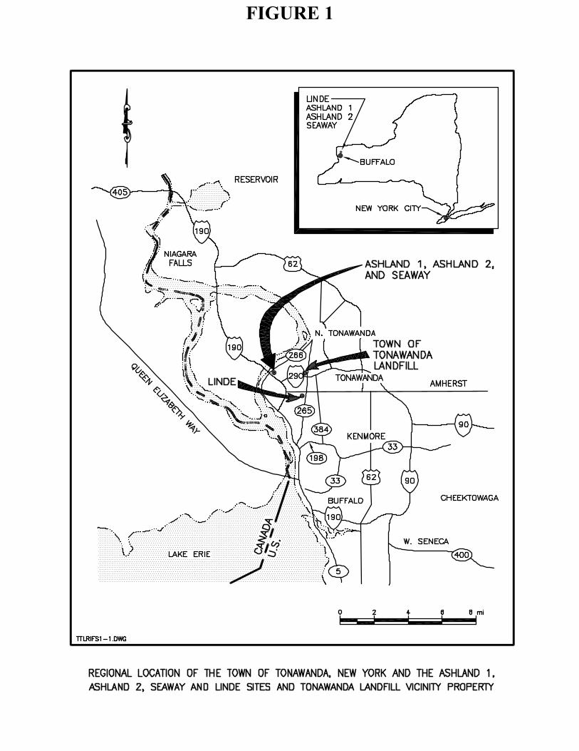
FIGURE 1
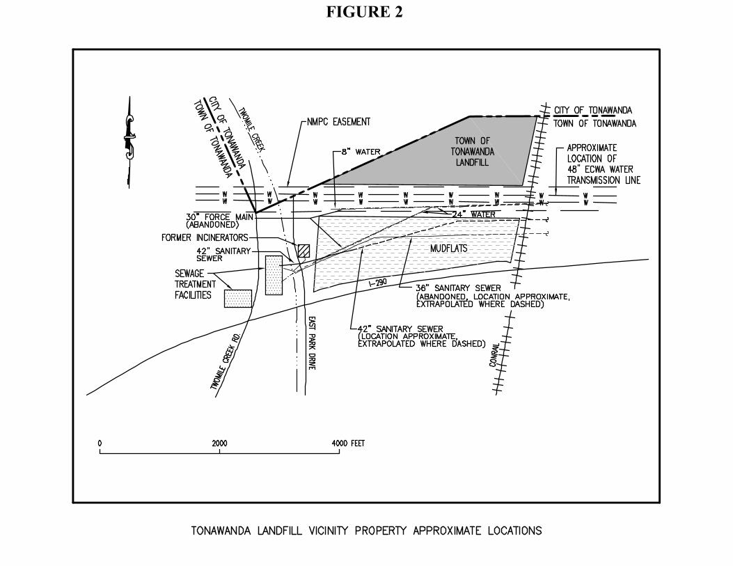
FIGURE 2

FIGURE 3

FIGURE 4
Table 1
Results Summary for Mudflats OU Soil Results
Nuclide Detections/
Results (1)
Maximum Concentration
(pCi/g)
Minimum Concentration
(pCi/g)
Mean Concentration
(pCi/g)
Standard Deviation
(pCi/g)
UCL95 Concentration
(pCi/g) Ra-226 160/162 22.6 0.07 1.01 1.72 1.23 Ra-228 162/162 1.36 0.14 0.72 0.18 0.75 Th-228 161/162 1.42 0.14 0.87 0.22 0.9 Th-230 162/162 31.5 0.34 1.11 2.41 1.42 Th-232 162/162 1.29 0.16 0.85 0.21 0.87 U-234 162/162 29 0.36 1.06 2.23 1.35 U-235 149/162 1.72 0.01 0.11 0.15 0.13 U-238 162/162 27.9 0.39 1.04 2.14 1.32
Am-241 * 6/162 0.47 -0.53 0 0.13 0.02 Notes: (1) Duplicate sample results were compared to the primary sample results and the greater value for each isotope was used in the calculations. * Am-241 is not a MED–like material. Its potential presence was evaluated because it was detected in the Landfill OU by DOE in 1984; it was necessary to determine whether this contaminant had migrated to the Mudflats OU. The source of Am-241 was a former local radioactive components manufacturing facility.
pCi/g – picocuries per gram Ra – Radium Th – Thorium U – Uranium Am – Americium

Table 2
Groundwater Sampling Results Mudflats Operable Unit – September 2001
UNFILTERED SAMPLES (Total)
Analytes Ra-226 Ra-228 Ra-226 + Ra-228 U-234 U-235 U-238 U-234 +
U-238 U
Total Gross Alpha
Gross Alpha
(2) Th-230 Th-232
Standard (1) NA NA 5 NA NA NA 30 44 NA 15 NA NA Units pCi/L pCi/L pCi/L pCi/L pCi/L pCi/L pCi/L ug/L pCi/L pCi/L pCi/L pCi/L WELL BM-8 0.2 1.9 2.1 2.5 0.2 2.0 4.5 9.4 5.6 0.9 0.1 0.1 BM-12 1.2 0.7 1.9 4.3 0.3 3.1 7.4 5.7 10.3 2.6 0.1 0.2 BM-15 0.6 0.6 1.2 7.4 0.4 6.0 13.4 14.8 17.1 3.3 0.1 0.2 BM-16 0.4 1.0 1.5 13.2 0.6 9.9 23.1 27.0 25.4 1.7 0.0 0.0
FILTERED SAMPLES (Total)
Analytes Ra-226 Ra-228 Ra-226 + Ra-228 U-234 U-235 U-238 U-234 +
U-238 U
Total Gross Alpha
Gross Alpha
(2) Th-230 Th-232
Standard (1) NA NA 5 NA NA NA 30 44 NA 15 NA NA Units pCi/L pCi/L pCi/L pCi/L pCi/L pCi/L pCi/L ug/L pCi/L pCi/L pCi/L pCi/L WELL BM-8 0.6 -0.7 -0.1 3.9 0.2 2.4 6.3 7.5 6.9 0.4 0.2 0.0 BM-12 0.7 1.5 2.3 4.2 0.1 2.6 6.8 5.4 4.9 -2.0 0.1 0.0 BM-15 0.6 2.1 2.7 6.3 0.4 5.1 11.4 15.4 11.1 -0.7 0.1 0.0 BM-16 0.4 -0.1 0.4 13.3 0.9 9.6 22.9 27.0 19.7 -4.1 0.1 0.0
Notes: (1) The Standard is the groundwater standard of 40 CFR Part 192 Subpart A. (2) Excluding radon and uranium. (Radon purged from sample as part of analytical method) Where results are reported by the laboratory as undetected, the detection limit is reported as a result in this table. All concentrations are net concentrations, determined by subtracting the average normalized background value from the gross laboratory result. This protocol has resulted in negative concentrations is some instances.
Table 3Reasonable Maximum Exposure Cancer Risk Summary for Mudflats OU Exposure Units
Current Future Additional
Exposure Unit Recreational RecreationalContruction
WorkerIndustrial Worker Residential
3 Surfacea 0 0 0 0Subsurface NA NA 2.E-07 8.E-06 2.E-05
4 Surface 6.E-07 6.E-07 1.E-07 6.E-06 8.E-06Subsurface NA NA 4.E-07 2.E-05 3.E-05
5 Surface 1.E-06 1.E-06 2.E-07 9.E-06 2.E-05Subsurface NA NA 1.E-06 5.E-05 1.E-04
Values reported in the Table reflect maximum risk between year 0 (current) and year 1000 (future)NA = Not analyzed. The exposure scenario does not include this depth interval.
a. No radionuclides were detected above the background UTL in the surface of EU 3 (Mudflat reference area)

APPENDIX A
MUDFLATS OPERABLE UNIT RESPONSIVENESS SUMMARY

TABLE OF CONTENTS
1. INTRODUCTION……………………………………………………………………2 2. OVERVIEW OF PUBLIC COMMENT……………………………………………2 3. RESPONSES TO COMMENTS………………………………………………….....3 3.1 Responses to comments, Public Meeting………………………………….......3 3.1.1 Mr. Casper Hoffman (meeting transcript, page 57)………….........3 3.1.2 Mr. Christopher Thomas (meeting transcript, page 65) ……..........4 3.1.3 Mr. Richard Dawton (meeting transcript, page 85) ………………4 3.1.4 Comments on Proposed Plan that Affect the Risk Assessment ………..4 PUBLIC MEETING TRANSCRIPT…………………………………………………...7
1
1. INTRODUCTION On March 26, 2007, the United States Army Corps of Engineers (USACE) issued a Proposed Plan (PP) for the Tonawanda Landfill Vicinity Property in Erie County, New York. A public meeting was held April 25, 2007, during which the USACE presented background information and its recommendation for no action at the site. During the meeting, the public was invited to submit comments and written comments were accepted until October 15th 2007. This Responsiveness Summary addresses the comments that pertain to the Mudflats Operable Unit received from the public during the public meeting and the comment period. As described in the Proposed Plan, the Selected Remedy for the Mudflats OU is no action. USACE conducted a Remedial Investigation (RI) and a Baseline Risk Assessment (BRA) of the Tonawanda Landfill Vicinity Property in 2001. This effort was in addition to previous investigations by the Department of Energy (DOE) and Oak Ridge National Laboratory (ORNL) in the early 1990’s. The Proposed Plan explains USACE’s position that a Comprehensive Environmental Response, Compensation, and Liability Act (CERCLA) response action is not warranted for any media (soil, groundwater, and surface water) in the vicinity of the Mudflats OU that contain low concentrations of radionuclides similar to Manhattan Engineer District (MED) materials found at the Linde Site. The results of the BRA indicate that no further action is required, as the MED-like materials at the Mudflats OU do not pose a cancer risk above the threshold presented in the National Oil and Hazardous Substances Pollution Contingency Plan (NCP) found at 40 C.F.R Part 300. The NCP provides the guidelines and procedures needed to respond to releases of hazardous substances under CERCLA.
2. OVERVIEW OF PUBLIC INVOLVEMENT On March 26, 2007, a press statement announcing the release of the Proposed Plan for Remediation of the Tonawanda Landfill Vicinity Property was released to the public. Display advertisements announcing the availability of the Proposed Plan for public review and comment, and the date and location of the April 25, 2007, public meeting were placed in local newspapers. The public meeting was held April 25, 2007, from 7:00 to 9:00 p.m. at the Tonawanda High School Auditorium, Hinds Street, Tonawanda New York. Prior to the meeting, representatives of the USACE were present to discuss any comments or concerns from members of the general public, and these discussions continued after the formal public meeting ended. At the meeting, USACE explained the history of the site, studies and completed investigations, CERCLA evaluation criteria, and the decision of no action. A stenographer was present at the meeting to Although nineteen public officials and members of the public requested and made oral comments, only three were specifically in regards to the Mudflats OU. Comments received at the public meeting and written comments received during the public comment period are responded to in this Responsiveness Summary. The meeting transcript is included as Attachment 1. The initial public comment period was extended from the usual 30 days to 90 days starting on March 26, 2007 and ending June 26, 2007. On June 7, 2007 the comment period was extended an additional 30 days to July 24, 2007 due to requests from public officials and members of the public for additional time. On July 13, 2007 the comment period was extended another 30 days to August 23, 2007. The USACE granted an additional extension on August 14, 2007 for 21 days
2

to September 13, 2007 and then another extension on September 12, 2007 for 32 days to end the comment period on October 15, 2007. The total time for comments was 203 days.
3. RESPONSES TO COMMENTS At the public meeting conducted on April 25, 2007, 19 individuals provided comments on the PP. Only three comments were specific to the Mudflats OU. Responses to these comments are provided below. The transcript of the public meeting is provided at the end of this Appendix, for reference. The comments made in reference to the Landfill OU will be responded to in a separate Responsiveness Summary. Twenty two written comments were received throughout the comment period from State agencies, Federal and local public officials and area residents. However, none were specific to the Mudflats OU. The twenty two comments that address the Landfill OU will be responded to in a separate Responsiveness Summary.
3.1 Responses to Comments, Public Meeting
3.1.1 Mr. Casper Hoffman (meeting transcript, page 57) Comment: Nobody has addressed the flats. The flats were created by Schwab Brothers to fill the land from Delaware Avenue to Niagara Falls Boulevard. Evidently they didn’t get all the nuclear waste out of there. So we got a nuclear highway from Delaware to the Falls Boulevard. Why isn’t that addressed? Response: The mudflats were evaluated for the presence of possible MED-like waste in both the 1991 DOE investigation and the 2001 USACE remedial investigation. The results of the USACE investigation indicate that construction (sewer pipe) activities and the use of the Mudflats for storage of debris/soil has significantly moved soils within the Mudflats OU. Because our authority under FUSRAP is limited to addressing the Landfill and Mudflats, and not off-site properties associated with road construction, we have limited our sampling to only the Landfill and Mudflats. The risks posed by the current level of contamination found by USACE in the Mudflats OU are all below levels deemed acceptable by the NCP, and so no further action is warranted to address the Mudflats OU. 3.1.2 Mr. Christopher Thomas (meeting transcript, page 65) Comment: Also, on the slides this evening, industrial residential use is listed in the mudflats area, and the industrial redevelopment of the mudflats it’s anywhere on 40 hours but no more than 6.6 years, so I’m sure as any of our careers would go, I’m sure someone wouldn’t want to work for a job 6.6 years and then have to be let go based upon contamination. The reason I’m focusing on that part of the slide is, you’re dealing with homeowners that live here 24/7. If you clearly have notated that in a mudflat area which is not that far off the property as well as the capped closure landfill that there’s limited time frames there, it really doesn’t have conclusive meat and potatoes in regards to what we deal with on a 24 hour basis. Response: The exposure duration for time spent with one employer in the Mudflat OU risk assessment (6.6 years) is an average value recommended by the EPA. However, it is also appropriate to use a reasonable maximum exposure duration, which would be 25 years, as recommended by the EPA. Therefore, for the industrial worker risk assessment in the Mudflats,
3

4
the exposure duration should be revised to 25 years instead of 6.6, consistent with USEPA guidance for conducting risk assessments (1997 Exposure Factors Handbook). Increasing the exposure duration from 6.6 to 25 years increases the projected hypothetical cancer risk for the industrial worker in the Mudflats from a maximum of approximately 1 in one hundred thousand for EU 5, subsurface soils, to approximately five in one hundred thousand. This revised cancer risk is still below the acceptable cancer risk limit established by the EPA in the National Oil and Hazardous Substances Pollution Contingency Plan (NCP) (of up to 1 in ten thousand), so no further action is necessary to protect human health under future use of the Mudflats for industrial or commercial use. In addition, other comments were made on the Proposed Plan which questioned some of the exposure assumptions used for the risk assessment for the Landfill (please see the table at the end of the responsiveness summary). Based on those comments, we believe it is also appropriate to revise the risks for two of the other receptors on the Mudflats. The exposure duration for the recreational user or trespasser was increased from 30 years to 42 years, commensurate with the length of time that a resident might own a home in the neighborhood, and the amount of time spent outdoors on the Mudflats was increased from 2 hours per week to 2 hours per day for a youth. While residential use of the Mudflats is not a likely future land use, residential exposure directly on the Mudflats was modeled by increasing the exposure duration from 30 to 42 years, and these risks are still within the acceptable excess cancer risks as established by the EPA in the NCP.
3.1.3 Mr. Richard Dawton (meeting transcript, page 85) Comment: The question I have is, when you took your boring samples, I believe you were over what they call the flats. The area where in 1959 and in the early 60s where they hauled all the dirt off to build the 290. They probably took, and I don’t know for sure but I’m going to say maybe anywhere around nine to 15 foot of soil out of there. You’re sampling right now the land that is missing 15 foot of soil, that you took the soil and dragged down the 290. We just don’t know whereabouts on the 290 that soil would all be from the top where uranium would be. But what really bothers me is, was there at one time uranium there? I don’t think your soil tests today would show that there was any there unless through ground seepage. Response: The mudflats were evaluated for the presence of possible MED-like waste in both the 1991 DOE investigation and the 2001 USACE remedial investigation. Because our authority under FUSRAP is limited to addressing the Landfill and Mudflats, and not off-site properties associated with road construction, we have limited our sampling to only the Landfill and Mudflats. The results of the USACE investigation indicate that construction (sewer pipe) activities and the use of the Mudflats for storage of debris/soil has significantly moved soils within the Mudflats OU. The risks posed by the current level of contamination found by the USACE in the Mudflats OU are all below levels deemed acceptable by the NCP, and so no further action is warranted to address the Mudflats OU. 3.1.4 Comments on the Proposed Plan that Affect the Risk Assessment Several comments were received by local persons, which indicated that the exposure durations for both residents and recreational users should be longer than those used in the human health risk assessment. USACE has carefully considered these comments and has lengthened the exposure times in a revised risk assessment as expressed in the following table of questions and responses pertaining to the issue.
COMMENTER/ AFFILIATION
COMMENT
PROPOSED RESPONSE
Resident, Mary Ann Camardo (Comment submitted in writing on USACE supplied comment form)
“My family and I have lived in Tonawanda for the past 36 ½ years.”
Resident, Jack Gallagher (Comment submitted in writing on USACE supplied comment form)
“Lived and owned 45 Murray Terrace Tonawanda NY since 1956 – 2003 (47 years).”
Resident, Mr. Hoffman (PP Meeting transcript, p. 58 – 59)
“My name is Hoffman. Since 1962 I’ve been on Hackett… I can tell you everybody that died of cancer on our street, 65 homes, 65 homes. Now we’re lucky we got approximately 18 original owners still there.”
These 3 comments by residents neighboring the landfill indicate that one of the exposure assessment parameter values used for the baseline risk assessment, that of exposure duration (or residence time in one location), could be made more site-specific. A value of 30 years was used in the risk assessment supporting the PP, as recommended by EPA guidance (USEPA 1997, Exposures Factor Handbook, Table 1-2, Summary of Exposure Factor Recommendations). It is the upper 95th percentile for residence time in one home, based on surveys of the population of the United States of America. In response to these comments, the USACE Buffalo District examined the dates of deeds or years the houses were built in the neighborhood of the Tonawanda Landfill. (These are publically available documents.) We identified 300 homes in the immediate vicinity of the landfill. In this neighborhood, 64 households have owned their homes for over 30 years. The upper 90th percentile of time in one home in that neighborhood is 42 years. Therefore, in the baseline risk assessment for the Mudflats, we have increased the exposure duration from 30 years to 42 years as the time at one residence for the recreational user of the Mudflats operable unit, as well as for the hypothetical residential exposure scenario. Choosing an upper 90th percentile value of this site-specific data set is consistent with EPA guidance concerning choice of reasonable maximum exposure values for the baseline risk assessment. In addition to increasing the total length of time that a recreational or residential user of the Mudflats is assumed to have potential exposures at the site (from 30 years to 42 years), the amount of time that a recreational visitor might spend on the site on a weekly or daily basis (exposure frequency) has also been increased, according to the next set of comments, below. In summary, the recreational site user is assumed to have a total of 42 years of potential exposure to the site, comprised of 12 years of more intense exposure (i.e., akin to how a child or youth might be exposed) at 2 hours per day, plus 30 years at approximately 2 hours per week. These changes in the exposure duration and exposure frequency are reflected in the cancer risk summary presented in Table 3 of the Mudflats ROD. Risks for all receptors in the Mudflats are still within the acceptable excess cancer risks as established by the EPA in the NCP.

Joyce Hoffman-Hogenkamp, Tonawanda Schools board of education / resident / CURE member
“In your proposed plan you speak, a range of recreational exposures to the landfill was considered from two hours per day for six months a year, for a six year-old juvenile, to 15 minutes per weekday, plus 23 minutes per weekend day for 30 year-old adults. Gentlemen, ladies, we have people in Riverview Elementary School which has not been mentioned tonight at all. We have children in that school at 8:30 in the morning for breakfast. Our extended day program goes to 4:15. The school is officially open to 9:00 o’clock for different activities for our children. That exceeds what you people are saying is safe. What are you thinking? You haven’t thought far enough. You need to go back and do further risk assessment. We are talking about 250 school children that are in there every day, Monday through Friday, for that many hours. They’re there for their extracurricular after school, from the high school, so you’re also attracting other students from other parts of our city to that school. Cheerleaders, soccer players.”
Tonawanda School Superintendent, Dr. Barbara Peters
“My concern is obviously for the children in the school area. When I read the report and saw how many minutes safely we could stay if the landfill is not re-mediated, the concern immediately was for the school area, not understanding how far away -- if you come to the school you can actually see the landfill from the school site. There’s a playground immediately adjacent to the school. We have 250 children that walk to and from school. They don’t understand when we say, stay away from something. Children are adventurous. And for the most part they love to play. And we can see them even now, even though there are fences, they climb and they move. And 15 minutes to them is nothing. They do not understand staying away from things that may be dangerous; to them it’s fun, and they see themselves as infallible, and it really frightens me to think that there could be some area where they’re supposed to be staying for less than 15 minutes a day, but to them, they’re not going to get hurt. That’s a very serious concern of mine.”
We agree that it is reasonable and plausible that school children may spend more time traversing the Landfill and Mudflats than what was assumed in the original risk assessment. In response to these comments, as well as comments from NYSDEC, NYSDOH, and others on the Landfill Operable Unit, USACE proposes to re-evaluate the recreational user on the Mudflats by increasing the exposure frequency to 2 hours per day, every day, year round, for the portion of the total exposure duration (42 years in one residence) that might be occupied as a child (12 years as a child/youth). This is consistent with more recent EPA guidance on child-specific exposure factors recommended for use in baseline risk assessments (USEPA 2002, Child-specific Exposure Factors Handbook, Table 9-62, Recommended values for activity patterns, mean total time outdoors for ages 6 - 17). As discussed in Section 6.5.4.2 of the 2005 RIR (baseline risk assessment: uncertainty in the exposure assessment), this exposure frequency value should encompass a more reasonable maximum exposure frequency for a juvenile receptor. These changes in the exposure duration and exposure frequency are reflected in the cancer risk summary presented in Table 3 of the Mudflats ROD. Risks for all receptors in the Mudflats are still within the acceptable excess cancer risks as established by the EPA in the NCP.
PUBLIC MEETING TRANSCRIPT

US. ARMY CORPS OF ENGINEERS Buffalo District 1776 Niagara Street Buffalo, New York 14207-3199 ---------------------------------------- ) In the Matter of: Public Meeting on ) The Tonawanda Landfill Vicinity Property) April 25, 2007 Proposed Plan. ) ) ----------------------------------------
Transcript of proceedings held in the above-entitled matter at The Tonawanda High School Auditorium, Hinds Street Tonawanda, New York on Wednesday, April 25, 2007 commencing at 7:00 p.m. pursuant to notice. PRESENTATION BY: LIEUTENANT COLONEL JOHN S. HURLEY COMMANDER OF BUFFALO DISTRICT, US ARMY CORPS OF ENGINEERS. 1776 Niagara Street Buffalo, New York 14207-3199 STEPHEN P. BUECHI ENVIRONMENTAL ENGINEER PROJECT MANAGER US ARMY CORPS OF ENGINEERS BUFFALO DISTRICT 1776 Niagara Street Buffalo, New York 14207-3199 ASSISTING: JOAN MORRISSEY COMMUNITY RESOURCE SPECIALIST 1776 Niagara Street Buffalo, New York 14207-3199 BRUCE I. SANDERS PUBLIC AFFAIRS OFFICER 1776 Niagara Street Buffalo, New York 14207-3199 TRANSCRIPTION SERVICE: Associated Reporting Service Post Office Box 674 229 West Genesee Street Buffalo, New York 14201 Proceedings recorded by electronic sound recording transcript produced by transcription service.
Associated Reporting Service (716) 885-2081
INDEX
SPEAKERS PAGE
LT. COLONEL JOHN HURLEY 3
STEPHEN P. BUECHI 12
LT. COLONEL JOHN HURLEY 31
RICK DAVIS 35
MICHELE IANNELLO 40
HONORABLE RONALD PILOZZI 42
RONALD MOLINE 45
CARL ZEISZ 47
PAUL KRANZ 49
JOYCE HOFFMAN-HOGENKAMP 53
CASPER HOFFMAN 57
JOHN PLYLER 60
EDWARD GEBERA 61
EUGENE PARKS 62
DIANE ESHELMEN 64
CHRISTOPHER THOMAS 65
CORINA BERMAN 68
PHILIP SWEET 70
DR. BARBARA PETERS 78
DAVID MORAN 79
RICHARD DAWTON 85
SUSAN TEMPEST 86
US Army Corps of Engineers Re: The Tonawanda Landfill Vicinity Property Proposed Plan
Associated Reporting Service (716) 885-2081
3
P R O C E E D I N G
LIEUTENANT COLONEL JOHN S. HURLEY: Good
evening and welcome to this public comment
meeting regarding the proposed plan for the
Tonawanda Landfill vicinity property. My
name is Lieutenant Colonel John Hurley and I
am the Commander of the Buffalo District,
United States Army Corps of Engineers.
The Buffalo District has been
investigating the Tonawanda Landfill under
the Formerly Utilized Sites Remedial Action
Program or FUSRAP, and we are here to present
our findings and our recommendation on what
action needs to be taken for this site.
I would like to take a minute before we
begin to acknowledge several key stakeholders
who have been involved with the investigation
at the site. First, and most importantly,
the local residents who live near and next to
the Tonawanda Landfill, the concerned
parents, faculty and staff from Riverview
Elementary School, the representatives from
the Cleanup Riverview’s Environment,
representatives from a Clean Tonawanda Site,

US Army Corps of Engineers Re: The Tonawanda Landfill Vicinity Property Proposed Plan
Associated Reporting Service (716) 885-2081
4
the Honorable Charles Schumer, the Honorable
Hillary Clinton, the Honorable Louise
Slaughter, represented tonight by Ms. Kathy
Lenihan, the Honorable Antoine Thompson, the
Honorable Mary Lou Rath, the Honorable Robin
Schimminger, represented tonight by Ms. Terry
Wegler, Ms. Michelle Iannello, Mr. Carl
Zeisz, Mr. Ron Pilozzi, Mr. Ron Moline, Mr.
John Camilleri, Mr. Rick Davis, Mr. Michael
Raab, Mr. Paul Kranz, Mr. Drew Eszak and Mr.
Tom Hersen from the Erie County Department of
Environment and Planning, Ms. Abby Snyder
from the New York State Department of
Environmental Conservation, Mr. Dan David,
Mr. Dennis Weiss and Mr. Mark Hans, all from
the New York State Department of
Environmental Conservation Region 9, Mr. John
Mitchell from the Department of Environmental
Conservation Radiation Program in Albany, and
Mr. Steven Gavitt, Director of the Bureau of
Environmental Radiation Protection and Mr.
Robin Snyder from the New York State
Department of Health.
I would also like to take a moment to
recognize a member of the Corps of Engineers

US Army Corps of Engineers Re: The Tonawanda Landfill Vicinity Property Proposed Plan
Associated Reporting Service (716) 885-2081
5
team that has been working on this, Mr. Jim
Karsten, our FUSRAP program coordinator.
Jim. Jim is in the back. Mr. Steve Buechi,
our Project Manager for the Tonawanda
Landfill. Steve. Ms. Joan Morrissey, our
community outreach specialist. She’s also in
the back. Mr. Steve Buske, our health
physicist sitting up front. Ms. Karen Kyle,
our risk assessor. Karen is in the back as
well. And Mr. Bruce Sanders, our Public
Affairs Officer.
Our purpose here tonight is twofold.
First we want to present the proposed plan
for the Tonawanda Landfill vicinity property.
The proposed plan describes the Corps’
recommendation to address the FUSRAP portion
of the Tonawanda Landfill. That is, this
proposal addresses only those materials
associated with the early atomic energy
program.
Second, we want to obtain your input on
the proposed plan, which we factored into the
final decision of action at the Tonawanda
Landfill.
We will record your comments for the
US Army Corps of Engineers Re: The Tonawanda Landfill Vicinity Property Proposed Plan
Associated Reporting Service (716) 885-2081
6
record and we will prepare formal written
responses to each of these comments after the
close of the public comment period on June
26th. I would ask you to save your comments
until the end of the presentation so that
they may be accurately recorded.
We understand that there are many
concerns regarding the Tonawanda Landfill and
not all of them are related to FUSRAP. For
example, I know there are concerns with the
odor issues and with the final design of the
landfill cap, and while we will not be able
to address all of these concerns tonight, we
will continue to work with the other agencies
and local elected officials to make sure
those concerns are properly addressed. We
have a fact sheet available tonight that was
jointly prepared by the Corps, the Town of
Tonawanda, the New York State Department of
Environmental Conservation and the New York
State Department of Health which describes
the area’s involvement of each of these
agencies has for the landfill.
Here is the agenda for our meeting
tonight. I will continue with the

US Army Corps of Engineers Re: The Tonawanda Landfill Vicinity Property Proposed Plan
Associated Reporting Service (716) 885-2081
7
introduction, after which I will turn the
presentation over to our Project Manager, Mr.
Steve Buechi. Mr. Buechi will then give some
background information on the site, describe
the results of the investigation conducted
and the risk assessment we developed, and
then present the proposed plan for addressing
the FUSRAP portion of the site.
We will then open up the floor to record
any comments you have regarding the proposed
plan and what you have heard tonight.
As I mentioned earlier FUSRAP stands for
the Formerly Utilized Sites Remedial Action
Program and it is a Federal program whose
mission is to investigate and if necessary
clean up sites that were contaminated by past
activities of the Federal government related
to the nation’s early atomic energy programs.
While executing that mission, our number one
priority is to insure protection of human
health and the environment. As I mentioned
in my letters to the editors of several local
papers, I take this responsibility seriously
and I am completely dedicated to this
mission.
US Army Corps of Engineers Re: The Tonawanda Landfill Vicinity Property Proposed Plan
Associated Reporting Service (716) 885-2081
8
We are also required by law to comply
with the Comprehensive Environmental
Response, Compensation and Liability Act, or
CERCLA in executing our mission. CERCLA is a
Federal law that governs the process we must
follow in investigating and cleaning up
sites. I will discuss CERCLA in a little
more detail in a minute.
The Buffalo District is charged with
managing 14 FUSRAP sites so we are well
experienced with these types of
investigations. We have successfully cleaned
up and completed three sites since 1997 when
the program was first transferred to the
Corps of Engineers. We have an excellent
safety record with respect to the workers on
the job and the surrounding community. We
use an experienced multidisciplinary team
including environment engineers, health
physicists, risk assessors, chemists and
construction managers.
The reports and plans we prepare go
through an extensive technical review process
including review by our National Center of
Expertise and others within the industry. We

US Army Corps of Engineers Re: The Tonawanda Landfill Vicinity Property Proposed Plan
Associated Reporting Service (716) 885-2081
9
work with and provide information to the
State regulatory agencies and local
stakeholders. And last, but certainly not
least, we provide information to and make our
investigation reports available to the
public.
As I mentioned earlier, we follow CERCLA.
CERCLA is essentially a framework that allows
us to address hazardous waste sites. It
insures that we take a rational, methodical
approach when we study, investigate and where
necessary remediate sites. It also insures
that we have transparency in our work and
allows for maximum public comment. The slide
outlines the steps in the site investigation
and cleanup process that we are required to
follow.
When management of this site was
transferred to us from the Department of
Energy it was essentially in the site
inspection phase. The Corps proceeded
forward with completing a remedial
investigation of the site which determined
the nature and extent of potential FUSRAP
contamination and evaluated the health risks

US Army Corps of Engineers Re: The Tonawanda Landfill Vicinity Property Proposed Plan
Associated Reporting Service (716) 885-2081
10
to people using the site now and in the
future.
We are here tonight to present the
proposed plan which describes the Corps’
recommendation for addressing the uranium,
radium and thorium found at the site. There
is a 90-day public review and comment period
for the proposed plan during which the public
may submit any comments on the plan to the
Corps of Engineers. The public comment
period ends on June 26th.
Following the public review of the
proposed plan we will evaluate and respond to
all comments received and then prepare the
record of decision which formally documents
the final decision on FUSRAP activities at
the site. Next.
I want to emphasize that public input
during the formal comment period is very
important. This is your chance to make your
opinions on the project and the proposed plan
known and have them recorded in the public
record. You also have the opportunity to
send us written comments on the proposed
plan. We openly welcome and solicit such

US Army Corps of Engineers Re: The Tonawanda Landfill Vicinity Property Proposed Plan
Associated Reporting Service (716) 885-2081
11
comments.
I also want to emphasize that the
proposed plan is not a final decision on the
FUSRAP action at the site. It is the Corps’
recommendation based upon our investigations
of the site. While many of you are focusing
on the word plan, for me the most important
part is proposed. This proposal can change.
A final decision on the site will not be made
until after all the public comments have been
considered and responded to.
Finally, I would just suggest to everyone
that when you submit your comments, please
make them as specific as possible. For
example, if you have comments regarding our
risk assessment, let us know exactly what
your concerns are or what additional
information you think we need to incorporate.
If you think our assumptions are flawed,
let us know. If you think our methodology
was incorrect, let us know why and how we can
improve it. Viewpoints and opinions are
important. However, specific concerns and
information will result in a more effective
comment evaluation period and ultimately a

US Army Corps of Engineers Re: The Tonawanda Landfill Vicinity Property Proposed Plan
Associated Reporting Service (716) 885-2081
12
more accurate decision.
I will now turn the presentation over to
our Project Manager, Mr. Steve Buechi. I
just would ask everyone again to please allow
us to finish our presentation. Save your
comments until the end and then we can record
them. Thank you.
MR. BUECHI: Thank you, sir. I’m going
to start off my portion of the presentation
tonight with a little bit on the site history
of the Tonawanda Landfill. This image here,
as you can see, is an aerial photo of the
site from 1942 and it looks a little
different than the way it looks today.
The Tonawanda Landfill consists actually
of two parcels of property that we have
investigated, one being the Town of Tonawanda
Landfill itself, and the second being the
mudflats area, which is a parcel of property
south of the landfill.
The Town of Tonawanda Landfill was
operated as a municipal landfill by the Town
of Tonawanda from the 1930's to 1989 and
accepted a variety of material including ash
generated by the Town’s incinerators,

US Army Corps of Engineers Re: The Tonawanda Landfill Vicinity Property Proposed Plan
Associated Reporting Service (716) 885-2081
13
construction demolition debris, some yard
refuse, and occasionally some small amounts
of municipal waste and wastewater sludge when
the Town’s incinerators were temporarily
inoperable.
The mudflats area, on the other hand, has
essentially been a vacant piece of property
over the years, with the exception of former
Town incinerators which had been located on
the western edge of the mudflats but have
since been inactivated and demolished.
This slide just shows a more recent
aerial photo. You can see now where the
residential development of the City of
Tonawanda has filled in along the northern
edge of the landfill. You can see down the
middle separating the mudflats and the
landfill is now a Niagara Mohawk Power
Company right of way with transmission lines,
and with the mudflats area south of the
Niagara Mohawk right of way.
As far as FUSRAP investigations at the
landfill, they started in the early 1990's
when actually the Department of Energy, who
was executing the FUSRAP program before the

US Army Corps of Engineers Re: The Tonawanda Landfill Vicinity Property Proposed Plan
Associated Reporting Service (716) 885-2081
14
Corps of Engineers, conducted some
preliminary investigations of the site as
part of investigations at the nearby Linde
FUSRAP site. And during those investigations
they found some isolated locations within the
landfill that contained uranium, radium and
thorium which are three radioactive elements
that are typically detected at FUSRAP sites
that have been investigated.
Based on these preliminary
investigations, the Department of Energy
designated the Tonawanda Landfill and
mudflats properties into FUSRAP in 1992 for
further investigation.
In 1997 FUSRAP was transferred from the
Department of Energy to the Corps of
Engineers and the Buffalo District assumed
responsibility for continuing the
investigations at the Tonawanda Landfill.
Our first step in 1999 was to complete a
document that had actually been started by
the Department of Energy before the program
was transferred, and that was a radiological
health assessment based on the data that had
previously been collected by the Department
US Army Corps of Engineers Re: The Tonawanda Landfill Vicinity Property Proposed Plan
Associated Reporting Service (716) 885-2081
15
of Energy. This radiological health
assessment looked at risks to human health to
anyone coming onto the landfill or mudflats
area, and that preliminary health assessment
concluded the risks to human health were
within the established U.S. EPA limits.
In 2001, in order to build on some of the
information that the Department of Energy had
collected previously, the Corps conducted
additional sampling at the site as part of a
remedial investigation to determine the
extent of the material found previously by
the Department of Energy.
The remedial investigation report was
released to the public in 2006 and this
included the results of the sampling
conducted by the Corps of Engineers as well
as a full baseline risk assessment
incorporating both the data collected
previously by the Department of Energy and
the additional data collected by the Corps of
Engineers.
Before I talk on the results of our
remedial investigation I just wanted to take
a minute to describe some of the rationale
US Army Corps of Engineers Re: The Tonawanda Landfill Vicinity Property Proposed Plan
Associated Reporting Service (716) 885-2081
16
that went into how we conducted the
investigations at the landfill, and the key
thing is that, even though the landfill is an
inactive landfill and has been inactive since
1989, we considered the presence of the
residents as adjacent to the landfill and the
indications that we had seen that some
residents or other people in the vicinity of
the site were coming onto the landfill and
mudflats area for recreational type purposes.
We, in order to look at the potential
risks to people coming onto the site, we
conducted walkover surveys and collected
additional sampling around the areas that had
previously been identified by the Department
of Energy as containing uranium, radium and
thorium, to insure that those materials were
not spread out over large areas of the site.
We also collected samples all along the
residential fence line to look for any
indication that material on the landfill was
extending or migrating off the landfill onto
the adjacent residents -- onto the
neighboring properties.
And in our baseline risk assessment we
US Army Corps of Engineers Re: The Tonawanda Landfill Vicinity Property Proposed Plan
Associated Reporting Service (716) 885-2081
17
looked at the potential human health risks to
anyone coming onto the landfill or mudflats
as those, as people coming onto the landfill
would be the users with the highest potential
risk at the landfill.
We provided information to the public
through public information meetings both
before and after our 2001 sampling, and we
also provided communications to the nearby
residents before our sampling regarding our
upcoming sampling activities and providing
the opportunity to meet one on one with Corps
personnel before the sampling to answer any
questions.
The sampling conducted at the landfill
and mudflats by the Department of Energy and
the Corps of Engineers was extensive and that
a total of 600 samples were collected from
202 locations in the landfill and 117
locations in the mudflats, including 23
samples directly on the fence line separating
the landfill from the adjacent properties.
We also collected groundwater samples
from 14 wells located in and around the
landfill and mudflats, and all these samples

US Army Corps of Engineers Re: The Tonawanda Landfill Vicinity Property Proposed Plan
Associated Reporting Service (716) 885-2081
18
were analyzed for the three radioactive
elements I mentioned earlier, the uranium,
radium and thorium, which are found typically
-- have typically been found at FUSRAP sites
in the past, including the Linde site.
Talk a little bit about the results from
our sampling, because I mentioned before we
collected groundwater samples from 14 wells
at the site. All the wells around the
perimeter of the landfill were within the
Federal drinking water limits for the
uranium, radium and thorium that we were
looking for, including the wells closest to
the residential area.
Of the wells sampled, only one well which
is located in the interior of the landfill
adjacent to where the Department of Energy
had previously found their highest levels of
uranium, radium and thorium at the site,
exceeded the Federal drinking water limit for
uranium. However, groundwater at the site
and in the area is not a public water source
as public water is drawn from the Niagara
River, and there are no private wells within
three miles of the site.

US Army Corps of Engineers Re: The Tonawanda Landfill Vicinity Property Proposed Plan
Associated Reporting Service (716) 885-2081
19
Twelve sampling results in the landfill
and mudflats, also samples collected within
50 feet of the property boundary on the
north, had results at normal background
levels for the area. In the landfill out of
the 202 sample locations 40 locations had
results above the normal background levels.
However, the majority of those locations were
just slightly above background.
In the mudflats area, out of 117 sample
locations, only two locations had results
slightly above the normal background levels.
This map shows all the locations where soil
samples were collected in the Tonawanda
Landfill. I’d just point out that the dots
on the map are made larger for visual
purposes. However, each sample represents a
single soil coring location, and those soil
cores are typically about four inches in
diameter.
All the green sample locations were the
samples that had results at normal background
levels for uranium, radium and thorium. The
yellow sample locations had levels above
normal background levels. The highest
US Army Corps of Engineers Re: The Tonawanda Landfill Vicinity Property Proposed Plan
Associated Reporting Service (716) 885-2081
20
concentrations were found at a location about
150 feet away from the residential fence
line. This is a similar map for the mudflats
area and as you can see, all the samples in
the mudflats area except two were at normal
background levels for the area. Again, the
yellow samples are, the soil is above
background levels, and the green are at
normal background levels. You can also see
on the northern edge the two blue triangles
which were groundwater wells sampled at the
mudflats.
I’d like to take a few moments to talk a
little bit about risk assessment because that
is an important part of the CERCLA
investigation process that we follow in
investigating these sites.
The first question you might be wondering
is, why do we do a risk assessment at these
sites? Well, the first reason is that risk
assessments are a mandated part of the CERCLA
process and it’s mandated by a Federal
regulation called the National Oil and
Hazardous Substances Pollution Contingency
Plan, or the National Contingency Plan for
US Army Corps of Engineers Re: The Tonawanda Landfill Vicinity Property Proposed Plan
Associated Reporting Service (716) 885-2081
21
short.
But really the purpose of the risk
assessment is, it is used to determine if
some sort of action is required to protect
human health and the environment based on the
level of risk or health hazard at a
particular site. And as a contingency plan
sets risk limits that if exceeded require
that action be taken at the site to protect
human health and the environment. The risk
in the NCP is expressed as an added chance
for someone to contract cancer from a
hazardous substance over and above the normal
lifetime chance of contracting cancer as
documented by the American Cancer Society.
The risk limit that is established in the
National Contingency Plan is one additional
incidence of cancer in a population of 10,000
people or basically an additional one in
10,000 chance of contracting cancer from a
hazardous substance over and above the normal
average lifetime chance of contracting
cancer.
So how do we determine risk? The risk
from a certain substance is based on the

US Army Corps of Engineers Re: The Tonawanda Landfill Vicinity Property Proposed Plan
Associated Reporting Service (716) 885-2081
22
toxicity of the substance and the level of
exposure to that substance. The toxicity is
a measure of how harmful a particular
substance is. And the US Environmental
Protections Agency through research has
developed toxicity numbers for various
hazardous substances and they publish that
information and provide it for use in risk
assessments on these types of sites.
Exposure is a measure of how much of a
particular substance someone may come into
contact with. The US Environmental
Protection Agency has developed a methodology
that is used to calculate exposure levels
based on site information and sampling data.
To follow up a little bit on exposure,
basically three things that determine a
person’s level of exposure to a certain
substance.
The first is a pathway, or how someone
comes in contact with a hazardous substance.
In order for an exposure and a risk to occur,
there must be some way to come in contact
with that hazardous substance. If there is
no pathway or no way for someone to contact
US Army Corps of Engineers Re: The Tonawanda Landfill Vicinity Property Proposed Plan
Associated Reporting Service (716) 885-2081
23
the substance then there is no risk from it.
The second item is concentration, or
basically how much of a substance someone
could possibly come into contact with.
That’s based primarily on the sampling data
that is collected at these sites. The lower
the concentration or amount of hazardous
substance the lower the level of exposure and
the lower the risk.
Finally, a combination of terms, are
frequency and duration, and that basically is
how often and how long and how long a
duration someone is exposed to or comes in
contact with that hazardous substance.
Again, similar to concentration, the lower
the frequency or duration, the lower the
level of exposure and the lower the risk to
someone.
When we calculate the level of exposure
we’re required to look at a reasonable
maximum exposure, using as much site specific
information as possible. And that includes
sampling data, information on the site
conditions and information on the current and
possible future uses of a particular site.

US Army Corps of Engineers Re: The Tonawanda Landfill Vicinity Property Proposed Plan
Associated Reporting Service (716) 885-2081
24
At the landfill the pathways that we
examined include three main pathways that
someone could come into contact with
hazardous material at the landfill. The
first is eating contaminated dirt, ingestion.
It is typically an accidental ingestion that
occurs while someone is doing other
activities on the site. And this requires
direct contact with the contaminated soil, so
you have to be on the landfill or on a
particular site in order to come into contact
to cause an ingestion pathway to be
completed.
The second pathway is breathing in
contaminated dust. Potentially contamination
that is in the surface soils at a site could
become airborne and be breathed in by someone
on the site.
At the Tonawanda Landfill in the areas
where we found the uranium, radium and
thorium, the heavy vegetation limits the
potential for soil to become airborne which
limits the potential for exposure to
contaminated dust and definitely limits the
potential for any contaminated dust to move

US Army Corps of Engineers Re: The Tonawanda Landfill Vicinity Property Proposed Plan
Associated Reporting Service (716) 885-2081
25
off of the landfill property. And also, the
majority of the radioactive elements, the
uranium, radium and thorium, were found at
the site, not in the surface soils but below
the surface soils, at a one foot depth and
below, so there is a lower chance for those
to become airborne.
Finally, the last pathway is direct
exposure to external gamma emissions.
Radioactive elements give off what is called
gamma radiation. It’s a direct exposure that
someone near a radioactive element could be
exposed to. The highest level of exposure is
someone directly on the source in the
landfill and as you move away from the source
of gamma radiation, the level of exposure
drops rapidly.
The last thing I’ll mention as far as
what we looked at in our risk assessment on
the landfill site is the frequency and
duration that someone could come into contact
or be exposed to the uranium, radium and
thorium at the site. When we look at
frequency during duration we look at, what is
the current use of the site, and what are the
US Army Corps of Engineers Re: The Tonawanda Landfill Vicinity Property Proposed Plan
Associated Reporting Service (716) 885-2081
26
reasonable anticipated future uses of a site.
And based on those site uses, the U.S.
Environmental Protection Agency provides
guidance on how to determine frequency and
duration for different types of site uses.
First, in the landfill and the mudflats
we looked at a recreational use. Although
the landfill is not being used anymore, as I
mentioned previously, we have seen
indications that people are coming onto the
landfill and onto the mudflats area for
limited time frames and for apparent
recreational purposes.
The U.S. EPA guidance equates a limited
type of site use to a recreational type use.
And that also fits with what we know of the
potential future use of the landfill after it
is capped by the Town of Tonawanda. So we
looked at both an adult and a youth
recreational user using U.S. EPA guidance and
other information for determining the
frequency and duration someone might be
exposed to at the site, and you can see those
levels of frequency, which is the number of
hours per week someone is on the site, and

US Army Corps of Engineers Re: The Tonawanda Landfill Vicinity Property Proposed Plan
Associated Reporting Service (716) 885-2081
27
duration, which is the total amount of time
that someone is in the area and on the site.
For the adult, you can see we used a two
hour duration per week over a 30 year -- or a
two hour frequency per week over a 30 year
duration, and for a youth we looked at a
seven hour frequency per week over a six year
duration.
Second scenario we looked at was a
construction worker in both the landfill and
the mudflats. Because work is being
conducted to close the landfill and because
there is potential for future development of
the mudflats area, we realize there is going
likely to be some type of construction work
in these areas. The construction worker
exposure was mild, to look at someone that
could be working in the soil containing the
uranium, radium and thorium, and it looks at
a full work week and it looks over a full
construction year.
In the mudflats, the landfill as we know
is under order by the DEC to be capped. So
that limits any potential future development
after it is capped. However, the mudflats is
US Army Corps of Engineers Re: The Tonawanda Landfill Vicinity Property Proposed Plan
Associated Reporting Service (716) 885-2081
28
available for possible development in the
future.
Then we looked at two separate scenarios
in the mudflats. First is an industrial or
commercial development of the mudflats as
there have been indications that the Town of
Tonawanda is looking to conduct some
commercial development there.
This looks like -- this scenario looks at
a worker working at the future development
for a 40-hour work week, or a six, slightly
over six years.
And finally, even though there are no
plans that we know of for future residential
development in the mudflats we looked at that
as a protective, another protective scenario,
and you can see the frequency and duration
used there. It’s obviously the highest
frequency for someone at a site and the
longest duration. And we also looked at an
adult and a youth for residential use on the
mudflats.
Now just briefly I’ll present the results
of our risk assessment. I mentioned
previously when we calculate the risk we

US Army Corps of Engineers Re: The Tonawanda Landfill Vicinity Property Proposed Plan
Associated Reporting Service (716) 885-2081
29
compare it to the limits that are established
in the National Contingency Plan, and in the
landfill for about the current conditions, or
uncapped conditions, both the recreational
use and the construction worker use were
within the limits established in the National
Contingency Plan. We also looked at future
recreational use after, assuming the Town
puts a cap on the landfill, and that scenario
is also within the National Contingency Plan
limits.
In the mudflats as I mentioned we again
looked at a recreational and construction
worker use, and we also looked at possible
future development for industrial and
commercial purposes or residential purposes,
and all those uses, all those scenarios, the
risk was within the limits established in the
National Contingency Plan.
So just in summary on risk assessment, as
I mentioned before risk is dependent on two
things, the toxicity, which is a measure of
how harmful a certain substance is, and the
exposure, which is how much someone could
possibly come into contact with a substance.
US Army Corps of Engineers Re: The Tonawanda Landfill Vicinity Property Proposed Plan
Associated Reporting Service (716) 885-2081
30
And it’s calculated following Federal
guidance. If there is not an exposure or if
their exposure is low, then the risk is low.
And as I mentioned previously, our
baseline risk assessment concluded that the
risks to someone coming onto the Tonawanda
Landfill or the mudflats area from the
uranium, radium and thorium that were
detected at the site are within the limits
established in the National Contingency Plan,
both for the current conditions at the site
and for potential future uses.
Based on the conclusions of the remedial
investigation report and the baseline risk
assessment, soils at the Tonawanda Landfill
and mudflats area that do contain uranium,
radium and thorium may safely remain in their
current condition without exceeding the risk
limits established in the National
Contingency Plan. Therefore, our current
proposed plan based on this information is,
the Corps of Engineers is recommending that
no action is necessary for those soils at the
site that do contain levels of uranium,
radium and thorium above normal background
US Army Corps of Engineers Re: The Tonawanda Landfill Vicinity Property Proposed Plan
Associated Reporting Service (716) 885-2081
31
levels.
I will now turn the meeting back over to
Lieutenant Colonel Hurley, who will go over
the next steps in the proposed plan process
and preside over the oral comment period.
LT. COL. HURLEY: Next slide, Steve. The
proposed plan has been made available in the
local library for review as well as on a
public website for downloading. Extra copies
have also been sent to the City of Tonawanda
and the Tonawanda City School District for
public availability. While the normal review
period is 30 days, you have asked for a
longer period of review and we are happy to
comply with this request.
We are required to respond to all of the
oral and written comments received on the
proposed plan. We will make the responsive
of this summary available to the public along
with a transcript of this meeting. Once all
of the comments on the proposed plan have
been evaluated and addressed, an authorized
official from the Corps of Engineers will
make the final decision on what action will
be taken at the Tonawanda Landfill and
US Army Corps of Engineers Re: The Tonawanda Landfill Vicinity Property Proposed Plan
Associated Reporting Service (716) 885-2081
32
vicinity property. This decision will be
documented in a record of decision which will
be placed in the administrative record file
and made available to the public.
We now have come to the portion of the
meeting where we will record your comments on
the Tonawanda Landfill proposed plan. I just
have a couple more slides before we open the
floor so please bear with me.
I know there are probably a large number
of you who would like to make a comment on
the proposal, and there are was least nine
who have signed up before the meeting, and
perhaps many of you want to make a comment
now that you have heard the briefing. So in
order to give everyone this opportunity to
make a comment, we have some ground rules
that we’re asking you to follow.
We would like to have only one person
speaking at a time. Please do not interrupt
when someone else is making a comment.
Please state your name and affiliation at the
beginning of your comment. Please speak into
one of the microphones so that everyone,
including our court recorders, can hear your
US Army Corps of Engineers Re: The Tonawanda Landfill Vicinity Property Proposed Plan
Associated Reporting Service (716) 885-2081
33
comments. There are two microphones
stationed up front and we have a microphone
available to come to you if you cannot make
it up to one of our two microphones.
Comments are limited to five minutes in
length in order to provide ample opportunity
for everyone who wishes to make a comment.
In order to maximize the number of people
who can make a public comment tonight, we
will not address your comments or questions
here. Quite frankly, some of the answers to
your great questions would require lengthy
and detailed responses, and as such may
deprive others the opportunity to make a
comment. We do have a court recorder here
though to record your comments, and which
will be entered into the public record, and
we will respond to each comment in writing in
a responsiveness summary. The responsive
summary will be issued some time after the 90
day public comment period is complete.
We will first ask any of our elected
officials if they would like to make a
comment to come up first. Following that we
will call on those people who indicated on
US Army Corps of Engineers Re: The Tonawanda Landfill Vicinity Property Proposed Plan
Associated Reporting Service (716) 885-2081
34
the sign-up sheet that they wish to make a
comment, and then we’ll open the floor up to
all others who wish to make a comment.
Although the meeting was originally
scheduled from 7:00 to 9:00 and we started a
few minutes late and there are a number of
people in the audience, we will gladly record
oral comments until 10:00 o’clock. Following
the meeting, my staff will be available,
either in the auditorium or by the displays,
if you would like to make additional comments
or to have an answer to a particular
question.
Additionally, if you do not have the
opportunity or choose not to make an oral
comment tonight, we will be accepting written
comments on the proposed plan up until the
end of the public comment period on June 26th.
Written comments should be mailed to the
address on the slide, which is also listed in
the proposed plan and on the proposed plan
fact sheet that are available tonight.
Again, I would suggest that any comments that
you submit, be as specific as possible,
because this will result in a more effective

US Army Corps of Engineers Re: The Tonawanda Landfill Vicinity Property Proposed Plan
Associated Reporting Service (716) 885-2081
35
comment evaluation period.
As I mentioned earlier, we’re driven by
CERCLA in this process and CERCLA requires us
to respond to all of your comments, and we
will do that once the public comment period
is closed. When the responses are ready,
they will be made available in the
administrative record file listed here as
well as on our public website.
Finally, if you would like any more
information on FUSRAP investigation at the
Tonawanda Landfill vicinity property, you can
contact the Buffalo District in several ways.
We will also place a copy of tonight’s
presentation in the Tonawanda Landfill public
website. We’ll now open the floor to any
comments. At this point, are there any
elected officials who would like to make a
comment? I’d ask you to please come forward.
MR. DAVIS: My name is Rick Davis. I’m
4th Ward Councilman in the City of Tonawanda
and also a co-chair for the, for CURE. I
want to thank the residents for taking time
out of their busy schedules in order to voice
their comments and concerns over the Army

US Army Corps of Engineers Re: The Tonawanda Landfill Vicinity Property Proposed Plan
Associated Reporting Service (716) 885-2081
36
Corps’ proposed plan for the Tonawanda
Landfill. I also want to thank everyone
that’s associated with CURE for all their
tireless efforts to date.
This plan falls miserably short of the
Army Corps and our Federal government’s
responsibility to take care of the mess left
behind from Linde and the Manhattan Project.
You have stated for years --
(Applause.)
MR. DAVIS: You have stated for years
that the nuclear waste isn’t your problem
because you have no documentation to show
that Linde illegally dumped at the landfill.
In the plan you state the nuclear waste you
did find was, quote, consistent with material
generated at the Linde site, end quote.
You insult the intelligence of my
constituents if we are to believe that Linde
and the Federal government weren’t
responsible for what’s buried in our
backyards. We’re not talking about the usual
household waste from back in the 40s and 50s.
We’re talking about radioactive isotopes that
were closely regulated back then, and no one
US Army Corps of Engineers Re: The Tonawanda Landfill Vicinity Property Proposed Plan
Associated Reporting Service (716) 885-2081
37
else in the area had the authorization to
house these materials except for Linde.
During the February 8th fiasco, as you’re
quoted in the Tonawanda News, you said that
the test wells went down to a depth of 20
feet. In the plan you state that in the
1920s a quarry was located in the landfill
and abandoned at a depth of 60 feet.
If you do the simple math, it seems like
you only went a third of the way down. I ask
that you conduct further testing at the
appropriate 60 feet boring depth to insure
the quality of samples retrieved.
Back in 2001 the Army Corps came into
Riverview Elementary School and told
residents that the landfill would be fully
remediated of all nuclear waste per
Department of Energy guidelines.
Now, six years later, you want to hang
your hats on looser EPA guidelines instead of
the more stringent Department of Energy
guidelines. Our residents deserve the
highest, most stringent standards for testing
and cleanup.
You have stated numerous times that the

US Army Corps of Engineers Re: The Tonawanda Landfill Vicinity Property Proposed Plan
Associated Reporting Service (716) 885-2081
38
nuclear waste hasn’t migrated onto residents’
properties along Hackett Drive. I have yet
to see any soil test results that you
conducted on properties along Hackett Drive,
Wadsworth Court, Wadsworth Avenue, Brookside
Terrace and Brookside Terrace West to back up
your statement. If anything, the government
has provided figures that rebut it.
Figure 7. That’s from the Department of
Energy, indicates nuclear waste, the radium
and thorium, leaching onto properties on
Wadsworth Court. This was something that was
released back in 1994. It specifically shows
radium and thorium leaching onto residents’
properties on Wadsworth Court. Now, one
property adjacent to where that is leaching
in, there was a beautiful nine year-old girl
who passed away from leukemia. I hope for
your sake that her untimely passing is not
connected to what’s buried in the landfill
and possibly leached onto a nearby property.
You also stated in the plan that the risk
of 1.3 in 10,000 excess cancer risks would
still be considered within the acceptable
risk range. This statement is immoral and

US Army Corps of Engineers Re: The Tonawanda Landfill Vicinity Property Proposed Plan
Associated Reporting Service (716) 885-2081
39
criminal. Any increase in risk is absolutely
unacceptable to the 700 plus homes within a
quarter mile of the landfill and the students
and faculty of Riverview Elementary School.
Furthermore, tell that to the family that has
a loved one that contracts cancer because you
felt the risk was, quote, within the
acceptable risk range.
This evening also you have indicated that
the exposure is within NCP guidelines for the
FUSRAP area after capping. You will not get
a cap over that FUSRAP area because in some
cases it abuts residents’ properties. The
Federal government has spent over a hundred
million dollars to clean up the former Linde
site where no one lives, but now you want to
close the checkbook when it deals with a more
densely populated area. What the residents
of the 4th Ward of the City of Tonawanda want
is not to be treated like second class
citizens.
What they deserve is testing of the
properties, proper testing of the landfill
and full re-mediation of all radioactive
waste from the Tonawanda Landfill. Thank you

US Army Corps of Engineers Re: The Tonawanda Landfill Vicinity Property Proposed Plan
Associated Reporting Service (716) 885-2081
40
for your time.
(Applause.)
LT. COL. HURLEY: Thank you for your
comments and we’ll insure that we address
those in our responsible summary. Are there
any other elected officials that --
MS. IANNELLO: Thank you. Erie County
legislator Michelle Iannello. I would like
to begin by thanking the Army Corps and the
DEC for the collaborative effort that has
been put forth so far in this landfill
process, together with the residents and the
elected officials. I feel that we have made
some progress regarding this problem.
As for the proposed plan I have to say
that I am very disappointed that the report
does not call for the removal of the medlike
materials before the closure of the landfill,
okay. Although recently we have been told
that there will be testing done in the
backyards of the residents, I am requesting
that there be additional testing done on the
opposite side of the fence, I guess it would
be retesting, inside the area that was
already tested, along the same fence line as
US Army Corps of Engineers Re: The Tonawanda Landfill Vicinity Property Proposed Plan
Associated Reporting Service (716) 885-2081
41
there is near the residents.
I am appreciative that the comment period
was extended to 90 days, as per my request,
but I also am requesting at this time
publicly that if need be, that we extend the
comment period longer than 90 days. Looking
at the facts that we’re going to have more
testing done, hopefully on both sides of the
fence, we may need that extra time to get the
results of the testing, and so I don’t want
there to be a finality of the day that we can
have comments made until we get those
results.
One of the concerns that was brought to
my attention by the residents, which is now
the look of the landfill and what it’s going
to look like at the time of the closure. I
believe that you need to include all of the
residents that live along Hackett Drive and
in that vicinity in the planning of the final
look of the closure, and again, as Councilman
Davis stated, knowing that there are some
spots close to the fence, it would be hard
not to have that landfill right on their
backyards of their houses.

US Army Corps of Engineers Re: The Tonawanda Landfill Vicinity Property Proposed Plan
Associated Reporting Service (716) 885-2081
42
So in closing I would like to remind
everybody if they didn’t see it in the paper,
and invite you to an informational meeting
that I have requested through the Energy and
Environment Committee of the Erie County
Legislature that will be held on Tuesday, May
8th, 3:30 in the afternoon, 4th floor of County
Hall, so that there can be more public
comment made at that time that could be
included in this public comment. And I would
also like to say that I give you all my word
that I will remain active in this process
until the cleanup is completed and the
medlike materials are removed. Thank you.
(Applause.)
LT. COL. HURLEY: Thank you, ma’am.
MR. PILOZZI: Good evening. My name is
Ron Pilozzi. I’m the Mayor of the City of
Tonawanda and I would like to extend my
appreciation to the Corps of Engineers, the
DEC, Department of Health, all the members of
government, from Federal, state and local,
all the way up and down the chain, and
obviously all the residents that are here
tonight. It’s very important that they be
US Army Corps of Engineers Re: The Tonawanda Landfill Vicinity Property Proposed Plan
Associated Reporting Service (716) 885-2081
43
here, obviously.
My remarks will be brief because I
believe the time tonight will be best spent
listening to the comments and concerns from
the public present. Also, the City will be
submitting in writing comments to the Army
Corps of Engineers and that will be
specifically from our engineering department
regarding our concerns about the proposed
plan in writing.
First of all, the City of Tonawanda
officials disagree with the Army Corps
proposed plan for the radioactive materials
in the Town’s landfill. The City’s position
is that FUSRAP for medlike material at the
landfill should be removed from the site for
the health, safety and welfare of the
surrounding residents and future users of the
site. CANIT of which the City is a member,
has advocated for the removal of radioactive
material from the Tonawanda since 1988. I
personally have advocated this position since
March of 2006 when, as Mayor, I received my
first report from the Army Corps on the
landfill. Since then the City has contacted

US Army Corps of Engineers Re: The Tonawanda Landfill Vicinity Property Proposed Plan
Associated Reporting Service (716) 885-2081
44
numerous local, state and Federal
representatives and agencies through letters,
phone calls, emails and meetings, to
intensify our efforts to advocate for the
removal of the radioactive materials.
Secondly, the government of the City of
Tonawanda supports additional testing on
private property on Hackett Drive. We need
to establish that the radioactive material
has not migrated from the landfill onto
private property.
We also need to give some peace of mind
to the homeowners who live next to the
landfill so they can feel that they and their
children are living in a safe environment.
Again, the walkover that will be conducted
shortly by the New York State Department of
Environmental Conservation is a good start,
but I believe and will continue to advocate
for the full bore sampling of residential
properties.
Finally, we will continue to work with
all levels of government to attain our goal.
That goal is to protect the health, safety
and welfare of our residents. This goal can

US Army Corps of Engineers Re: The Tonawanda Landfill Vicinity Property Proposed Plan
Associated Reporting Service (716) 885-2081
45
best be accomplished by the removal of the
radioactive material by the Army Corps and by
additional testing on the private residents
and school that abut the landfill. Thank
you.
LT. COL. HURLEY: Thank you, sir. Are
there any other elected officials? Yes, sir.
MR. MOLINE: My name is Ron Moline. I’m
Supervisor of the Town of Tonawanda. I would
like to make public comments based on a
letter to you, Colonel, that I will then
provide you with. But thank you for this
opportunity to comment on the proposed plan
for the Tonawanda Landfill vicinity property
site located in the Town of Tonawanda.
The objective of the Town Board and other
Town officials is to close the landfill based
on a plan that is protective of public health
and the environment and takes into
consideration appropriate and acceptable post
closure activities on the site. The key
questions that Town officials have raised
throughout the last 20 years on FUSRAP
related programs and activities have always
been based on concerns for the public health
US Army Corps of Engineers Re: The Tonawanda Landfill Vicinity Property Proposed Plan
Associated Reporting Service (716) 885-2081
46
and the environment and also apply to the
proposed plan for the landfill. Because
these issues have also been important to our
neighboring municipalities and the elected
officials at the County, State and Federal
levels, the Coalition Against Nuclear
Material in Tonawanda, CANIT was formed about
20 years ago to provide direct input into the
decision making process. We certainly
appreciate what the Corps of Engineers has
accomplished at the Linde, Ashland I and
Ashland II sites and more recently
Rattlesnake Creek, since taking jurisdiction
over the FUSRAP cleanup activities 10 years
ago.
We would like to take this opportunity to
support residents and officials of the City
of Tonawanda who are requesting additional
efforts with risk assessment evaluations
before a record or decision is issued by the
Corps of Engineers. While the remedial
investigation and proposed plan did examine
health related issues under certain
scenarios, we feel that more attention should
be given to a scenario that we know exists.
US Army Corps of Engineers Re: The Tonawanda Landfill Vicinity Property Proposed Plan
Associated Reporting Service (716) 885-2081
47
There are residents whose properties are
adjacent to the landfill and before any
permanent closure plan is approved by the
DEC, these individuals should have the
greatest comfort and confidence with the
final solution.
We would like to see the resources of the
County and State Health Departments utilized
along with appropriate Federal resources to
accomplish this objective. We expect that
you will also be receiving comments from
CANIT on this concern. Again, thank you for
your efforts to date and for your commitment
to protecting public health and the
environment in our community.
With all due respect, Colonel, I’d like
to point out that arguably frequency could be
24 hours and duration a lifetime. So we do
need the comfort of additional risk
assessment. Thank you very much.
LT. COL. HURLEY: Sir, thank you for your
comments. Yes, sir.
MR. ZEISZ: Carl Zeisz, Common Council
President. As an elected official, I’m
charged with the responsibility to protect

US Army Corps of Engineers Re: The Tonawanda Landfill Vicinity Property Proposed Plan
Associated Reporting Service (716) 885-2081
48
the health and safety of our community, and
also as a homeowner, the safety of my own
family, and given the information that’s
presented tonight and that has been presented
in the past, it’s totally unacceptable to
myself and also to all these residents who
are part of our community.
(Applause.)
MR. ZEISZ: I really only have one
question. It’s not a question of whether or
not I agree with the Corps numbers or what’s
acceptable or whatever. My one question is
this, millions of dollars have been invested
to clean up other sites totally not adjacent
to human life, and when we have one that is
adjacent to many homes in our community it’s
going to be left to sit there. That’s my
question.
(Applause.)
MR. ZEISZ: I do thank you for the time
that’s been put in, but I do respectfully
ask, along with many other officials
including many officials much higher in
stature than myself, that the Army Corps re-
look at this, and myself, Mayor Ron Pilozzi,

US Army Corps of Engineers Re: The Tonawanda Landfill Vicinity Property Proposed Plan
Associated Reporting Service (716) 885-2081
49
Rick Davis at the rest of the Council is
going to continue to push for full re-
mediation. Thank you.
(Applause.)
LT. COL. HURLEY: Sir, thank you for your
comments. We’ll do our best to answer that
question. Please.
MR. KRANZ: Good evening, everyone. My
name is Paul Kranz. I’m an associate
engineer with the Erie County Department of
Environment and Planning, and I am speaking
on behalf of my commissioner, Andrew Eszak,
who serves as chairman for the Coalition
Against Nuclear Materials in Tonawanda,
better known as CANIT. I’d first of all like
to start by thanking the Army Corps of
Engineers, Lieutenant Colonel Hurley, and the
staff for their presentation and the
opportunity to speak tonight. I was
requested to attend and provide these
comments, which are contained in a letter
from Commissioner Eszak to the Lieutenant
Colonel on behalf of the local CANIT
membership. That would include our State
Senators, State Assemblymen, County Executor,

US Army Corps of Engineers Re: The Tonawanda Landfill Vicinity Property Proposed Plan
Associated Reporting Service (716) 885-2081
50
County Legislator, and the Mayor and
Supervisor in the City and the Town of
Tonawanda. We understand that our Federal
delegation is monitoring the issue and will
be submitting comments independently.
Dear Lieutenant Colonel Hurley, as
chairman of the Coalition Against Nuclear
Materials in Tonawanda, I am writing to you
regarding the above referenced proposed plan
for the Tonawanda Landfill. CANIT is a
bipartisan coalition of elected officials
that seek action at the Federal level to
insure the safe and efficient removal and
offsite disposal of radioactive waste
originating from the Manhattan Engineering
District activities associated with the World
War II atomic bomb development. To date the
Army Corps of Engineers has successfully
implemented and completed remedial efforts
toward the cleanup of radioactive waste at
sites in the Town of Tonawanda. This
includes Ashland I, Ashland II and
Rattlesnake Creek.
The Corps is to be recognized for its
continued efforts at the Linde Praxair and
US Army Corps of Engineers Re: The Tonawanda Landfill Vicinity Property Proposed Plan
Associated Reporting Service (716) 885-2081
51
COA landfill sites. The Corps implemented a
remedial investigation of the waste in 2001
at the Tonawanda Landfill. A final report on
the investigation was issued in 2006. The
above referenced proposed plan for the
landfill is based upon results of that
investigation and a baseline risk assessment
which states that risks associated with the
waste materials are within CERCLA guidelines
for expected future use of the landfill. The
plan proposes leaving the waste in place,
given the assumed construction of a proper
landfill cap for the ultimate landfill
closure.
In a meeting held April 24th, 2007 the
CANIT membership discussed the proposed plan,
existing sampling data, the risk assessment
information. The concerns expressed by
residents living on properties abutting the
northerly property line of the landfill and
projections for time lines for the closure of
the landfill were also discussed.
A consensus was reached by local members
of CANIT that the proposed plan as presented
is premature. The membership feels that

US Army Corps of Engineers Re: The Tonawanda Landfill Vicinity Property Proposed Plan
Associated Reporting Service (716) 885-2081
52
additional investigation is warranted
particularly along the fence line of abutting
residential properties to first fill the gaps
in the overland gamma survey data missing
from the 2001 remedial investigation report,
and secondly, to perform any additional soil
sampling to further determine the extent of
radioactive waste materials near this
residential area.
In consideration of additional efforts
proposed by the New York State Department of
Environment Conservation to investigate
potential impacts to private property
adjacent to the landfill, additional time is
required to determine the appropriate action
or actions to address this issue. The U.S.
ACE, the Corps and the New York State DEC
should coordinate sampling protocols,
schedules and results to provide a uniform
and comprehensive understanding of the radio
material impacts and risks.
CANIT therefore requests the postponement
of the finalization of the proposed plan for
the Tonawanda Landfill and any issuance of
any record decision for the radioactive waste

US Army Corps of Engineers Re: The Tonawanda Landfill Vicinity Property Proposed Plan
Associated Reporting Service (716) 885-2081
53
materials. Very truly yours, Andrew M.
Eszak, Chairman of CANIT. Thank you.
(Applause.)
LT. COL. HURLEY: Thank you. Yes,
please.
MS. HOFFMAN-HOGENKAMP: My name is Joyce
Hoffman-Hogenkamp, City of Tonawanda Board of
Education. Also, gentlemen, I’d like you to
take a good look at my face. I am first
generation to grow up on that landfill. I
still live there.
You people need to understand, you put a
lot of time into this. I understand 18 plus
years. Your plan is absolutely appalling and
disgusting to somebody that has lived there
their whole life.
I grew up in an idyllic family situation,
lived there, had my son there. My whole idea
was to raise him the way I was raised. With
what I have found out, reading your
documents, reading everything that you people
have put into it, disgusts me, totally
disgusts me, as a board member.
(Applause.)
MS. HOFFMAN-HOGENKAMP: In your proposed

US Army Corps of Engineers Re: The Tonawanda Landfill Vicinity Property Proposed Plan
Associated Reporting Service (716) 885-2081
54
plan you speak, a range of recreational
exposures to the landfill was considered from
two hours per day for six months a year, for
a six year-old juvenile, to 15 minutes per
weekday, plus 23 minutes per weekend day for
30 year-old adults. Gentlemen, ladies, we
have people in Riverview Elementary School
which has not been mentioned tonight at all.
(Applause.)
MS. HOFFMAN-HOGENKAMP: We have children
in that school at 8:30 in the morning for
breakfast. Our extended day program goes to
4:15. The school is officially open to 9:00
o’clock for different activities for our
children. That exceeds what you people are
saying is safe. What are you thinking? You
haven’t thought far enough. You need to go
back and do further risk assessment.
We are talking about 250 school children
that are in there every day, Monday through
Friday, for that many hours. They’re there
for their extracurriculars after school, from
the high school, so you’re also attracting
other students from other parts of our city
to that school. Cheerleaders, soccer
US Army Corps of Engineers Re: The Tonawanda Landfill Vicinity Property Proposed Plan
Associated Reporting Service (716) 885-2081
55
players.
The other thing that has been addressed,
there has been no testing on the soil for
the school next to the school, any of the air
around the school, and nothing done in our
school, yet you’re telling us, this is safe.
This is safe for our children. I tried to
have more than the one child. I have had
fertility problems. No explanations. Many
of my friends that I grew up with had the
same problems. Yet I have not heard from one
person with risk assessment why. Why haven’t
you come to the residents that have been
living next to it, that played back there
when there wasn’t a fence?
You also state that you’re going to use
your standards, the EPA standards, and now we
have a letter from Mrs. Clinton that is
asking for the strictest governmental
standards. They are not the standards that
you have in this proposed plan. I would like
to know, when are you going to change your
standards? When are you going to clean up
these sites properly? You’re toting that you
cleaned up Ashland I and II to a standard,
US Army Corps of Engineers Re: The Tonawanda Landfill Vicinity Property Proposed Plan
Associated Reporting Service (716) 885-2081
56
and then I turn around and do my research and
find out it’s below the standards of what was
cleaned up on other sites across the country,
mainly sites out in California? There’s
sites out in San Francisco that have been
cleaned up better than that one, and now
we’re looking to put people to work there
nine hour days. If this is how you people
are cleaning up, you really need to go back
and rethink it.
I am one of the members of CURE and I am
not going to put up with the stuff being left
there. As a board we passed a resolution
requesting full re-mediation of that
landfill. We want the nuclear stuff out of
here. It is the only safe avenue for our
children that are attending school.
I am also asking you as a private
citizen, please, please go back, rethink what
you’ve done. I am not the only person that
has been hurt by what’s back there. October
I lost my mom. She died knowing what was
going on back there.
You people have no idea the amount of
stress that was put on my mom, and now sits
US Army Corps of Engineers Re: The Tonawanda Landfill Vicinity Property Proposed Plan
Associated Reporting Service (716) 885-2081
57
on my dad. You have no idea how this has
impacted my family. You need to get up on
Hackett and start talking to the residents.
Go house to house. Find out the cancer
rates. Find out how many children have
gotten sick. Find out the infertility rates.
Find out how this truly has impacted the
people that live next to it and have lived
next to it for years. Thank you.
(Applause.)
LT. COL. HURLEY: Thank you for your
comments. At this point are there other
elected officials?
MALE VOICE: Thank you, Joyce, and God
bless you.
(Applause.)
LT. COL. HURLEY: At this point we’ll
proceed with open comments and we’ll start
with those people who signed in before the
presentation began. Joan is going to call
folks forward to make a comment. If you
can’t come forward, we’ll gladly send the
mike out to you and make your comment. Joan.
MR. HOFFMAN: I said I’d make a comment.
JOAN: I was just going down the list

US Army Corps of Engineers Re: The Tonawanda Landfill Vicinity Property Proposed Plan
Associated Reporting Service (716) 885-2081
58
from who signed in.
MR. HOFFMAN: I don’t care. You just
talked to my daughter. My name is Hoffman.
Since 1962 I’ve been on Hackett, seen
everything, took pictures of everything, and
now I don’t know what you people are talking
about. Two things you show me up there. Up
against the houses and the flats, two things,
but they’re combined.
Nobody has addressed the flats. The
flats were created by Schwab Brothers to fill
the land from Delaware Avenue to Niagara
Falls Boulevard. Evidently they didn’t get
all the nuclear waste out of there. So we
got a nuclear highway from Delaware to the
Falls Boulevard. Why isn’t that addressed?
Are you aware of that, sir?
LT. COL. HURLEY: Sir, we’ll go back and
look at that.
MR. HOFFMAN: Go back where? It’s
there. You tell me it can’t go away. There
is more death than you people realize. The
City of Tonawanda has an ordinance, if we
sell the house, we have to put a sump pump
in. I’m in the highest house in the city. I

US Army Corps of Engineers Re: The Tonawanda Landfill Vicinity Property Proposed Plan
Associated Reporting Service (716) 885-2081
59
haven’t sold my house. I’m an original.
Next door to me they sold the house.
Sump pump’s in there. The kid’s sick all the
time. What’s going on with you people?
Nobody will address the health issues that
are on the properties. You’re going to walk
on the border of Hackett Drive. Seven people
across the street from me have died of
cancer. I don’t want to take up any more
time, but like Phil Sweet said, I got a
photographic memory. I can tell you
everybody that died of cancer on our street,
65 homes, 65 homes. Now we’re lucky we got
approximately 18 original owners still there.
And this is called either widowers hill or
widows hill, that’s what’s left up there.
Borderline to this, you call it a landfill,
since ‘62, I called it the dump. It’s a
shame that we have to have the Army to clean
it up. My daughter brought pictures,
Hiroshima, Nagasaki, beautiful metropolitan
cities. We cleaned it out, when I was in the
service. Navy had a base in Japan, but we
can’t get nothing out of you people. You say
we got a plan. You haven’t formulated a
US Army Corps of Engineers Re: The Tonawanda Landfill Vicinity Property Proposed Plan
Associated Reporting Service (716) 885-2081
60
plan. You say we won’t formulate it until we
talk to everybody. Again, we got the, what
we call Federal Texas two step. You’re not
facing the issues. Atomic Energy Commission,
the DEC, the EPA, whatever you want to call
it, it’s always pass the buck to the other
department. People are being fed up with
this. You’ve got to come on line with us and
understand what is happening up there.
When the people start dying off, you say
you want a survey. They conduct their survey
at Kenmore Mercy. What about the other
hospitals? Roswell, Buffalo General, Gates
Circle. Nobody has said any word about that.
There is a lot more, Colonel, a lot more, and
you better get into it, deep. You better
found out about the great nuclear highway.
(Applause.)
LT. COL. HURLEY: Thank you. Joan.
JOAN MORRISSEY: Okay. I’m going to go
through the list starting with page 1. And
the first individual I have here is a Mr.
John Plyler. Mr. Plyler, would you like to
come up and provide comment.
MR. PLYLER: This to me was a replay of

US Army Corps of Engineers Re: The Tonawanda Landfill Vicinity Property Proposed Plan
Associated Reporting Service (716) 885-2081
61
the last meeting basically. It was the same
information. Everything was given to us last
time, there’s no change. But what I’ve
learned with the help of the other people
from CURE is all this information was heard
and what none of us knew about this before.
What’s back there and everything else. I see
a map out there with test sites with yellow
dots. The next time I see from you people
I’d like to see another map with the houses
with yellow dots of who you’ve talked to,
cancer rates and everything else.
Show us this information. We already
know it because we live there. Show us that
you know it. And also, treat all this
information not by Federal standards, by
personal standards, of how you’d do this if
it was your land and your property, and throw
away the government standards. Thank you.
(Applause.)
LT. COL. HURLEY: Thank you, sir.
JOAN MORRISSEY: Okay. The next name I
have is a Mr. Edward, and I’m sorry if I get
this wrong, it’s either Gehara or Gebera.
MR. GEBERA: Edward Gebera, 157 Brookside

US Army Corps of Engineers Re: The Tonawanda Landfill Vicinity Property Proposed Plan
Associated Reporting Service (716) 885-2081
62
Terrace West. I’d like to know how you could
guarantee the water coming off of the site
doesn’t contaminate the water underneath our
homes.
That’s what I’d really like to know. To
start off with, you said they only went down
24 feet. Well, the pit was a lot deeper than
24 feet. And I’d like to know if you took
tests below 24 feet offsite as well as
onsite. Thank you.
(Applause.)
LT. COL. HURLEY: Thank you, sir. We’ll
definitely ask those questions.
JOAN MORRISSEY: The next person that
indicated they would like to make comment is
a Mr. Eugene Parks.
MR. PARKS: Hello. I am Eugene Parks. I
live at 68 Bellanger. I’m here to comment.
Actually I have more questions than I have
comments.
Sir, I’d like to know how many times the
standards have changed that your risk
assessment is based on, over the years, over
the past 40 years. How many times have these
standards changed?
US Army Corps of Engineers Re: The Tonawanda Landfill Vicinity Property Proposed Plan
Associated Reporting Service (716) 885-2081
63
And why hasn’t there been a health study
done up on the hill which affects everybody
who lives up there to find out; before you do
any final assessment of what’s going on here
there should be a health study done. You
need to look at your map and go further into
the city because if you look at the dots
along that line on Hackett Drive, I find it
hard to believe that those trucks stopped at
that border and didn’t go further into the
City of Tonawanda. No testing has been done
any further than right at those people’s
backyards.
I’m not talking about just their
backyards. I’m talking about further into
the City of Tonawanda, did you test it, to
give people peace of mind? Before this
process of capping the landfill started, were
there any monitoring stations set up, as far
as monitoring the air quality or anything
that’s going on, the water migration, other
than the one -- some ground wells?
For air quality, was anything done? And
please allow us to have some input as to how
this landfill is closed. The people that
US Army Corps of Engineers Re: The Tonawanda Landfill Vicinity Property Proposed Plan
Associated Reporting Service (716) 885-2081
64
border this landfill should have the right to
have some input into the closing process.
And finally, the benefit of removal should
have no price tag, for all our health.
(Applause.)
LT. COL. HURLEY: Thank you for your
comment, sir.
JOAN MORRISSEY: The next person I see it
marked here, and it might mean a yes, Diane
Eshelmen, would you like to provide comment?
MS. ESHELMEN: I have questions too.
But I guess I could say, I was born in 1945.
I got in on the beginning of it. I grew up
downstream of the Niagara River, and guess
what, I had thyroid cancer when I was 25.
But I can’t say it was definitely from
whatever, you know. Who’s to say.
But anyway, I corresponded with my
brother who happens to be a nuclear
physicist, and he wanted to know if any radon
testing could just be done in homes. I mean,
that would be a really simple thing. You
have to have your home tested for radon
before you sell it. I would think that maybe
you could do something like that, and since

US Army Corps of Engineers Re: The Tonawanda Landfill Vicinity Property Proposed Plan
Associated Reporting Service (716) 885-2081
65
radon gas is released as a decayed product of
uranium it would make sense to do that, you
know, to these homes that are surrounding the
landfill. I guess that’s all I have to say.
Thank you.
LT. COL. HURLEY: Thank you, ma’am.
(Applause.)
JOAN MORRISSEY: The next person I have
to give comment, and I think perhaps you
already have; a Ms. Joyce Hogenkamp? Okay.
Next is Mr. Chris Thomas.
MR. THOMAS: Good evening, Christopher
Thomas. A resident of 65 Hackett. Also
helped create CURE. I’m basically doing this
on the fly. I thought I was going to come in
with questions or comments but I wanted to
take the information provided this evening
and formulate some of the things that I
found. The first thing is, Lieutenant
Colonel Hurley, I would like to personally
put on record, I’m inviting you over to my
house for a cup of coffee. I would like you
to see truly what I see in my backyard on a
day to day basis.
Some of the things that I am definitely

US Army Corps of Engineers Re: The Tonawanda Landfill Vicinity Property Proposed Plan
Associated Reporting Service (716) 885-2081
66
questioning is the wording of, heavy
vegetations that would be blocking dust. I’m
sure as you can tell, behind our homes, and I
don’t know if you’ve been to the site or not
yet, but there truly is not a lot of heavy
vegetation. There’s a few trees here and
there. Some of them are damaged from the
October storm. And some of the vegetation as
referred to hasn’t grown yet due to the
climate has prevented it to grow -- or hasn’t
allowed it to grow. So how is that limiting
dust when that hasn’t really presented itself
to be the case yet?
Also, the Army Corps, background levels
are lower every year in regards to what the
Army Corps looks at in regard to the
background levels. So yet, how does that
relate to the half life remains of the
elements that we’re dealing with? They do
not.
Also, the groundwater may not be a source
for the city and town residents, but it is,
groundwater is used for Lockport, Niagara
Falls, Lewiston and North Tonawanda, as a
closed down stream. Also, as was referred

US Army Corps of Engineers Re: The Tonawanda Landfill Vicinity Property Proposed Plan
Associated Reporting Service (716) 885-2081
67
to, and of all the information I’ve
researched nothing has been mentioned in
regards to the sump pumps. As clearly stated
in your records that there is surface and
subsurface contamination, why were not the
sump pumps lists on private properties listed
in your reports?
Let’s see. Extensive independent review,
25 pages on proposed plan. In the 2005 re-
mediation report that book is over 300 plus
pages, yet the proposed plan is only 25 pages
long.
I would just like to comment that if
you’re going to put a proposed plan together
out to the general public, it should have a
little more meat and potatoes to it.
What else do I have here? Also, on the
slides this evening, industrial residential
use is listed in the mudflats area, and the
industrial redevelopment of the mudflats it’s
anywhere on 40 hours but no more than 6.6
years, so I’m sure as any of our careers
would go, I’m sure someone wouldn’t want to
work for a job 6.6 years and then have to be
let go based upon contamination.

US Army Corps of Engineers Re: The Tonawanda Landfill Vicinity Property Proposed Plan
Associated Reporting Service (716) 885-2081
68
The reason I’m focusing on that part of
the slide is, you’re dealing with homeowners
that live here 24/7. If you clearly have
notated that in a mudflat area which is not
that far off the property as well as the
capped closure landfill that there’s limited
time frames there, it really doesn’t have
conclusive meat and potatoes in regards to
what we deal with on a 24 hour basis.
And also, the last comment I have is,
there are sewers that are tied in to Rogers
and Hackett. Again we’re talking about
groundwater contamination, leaching. These
things have been proven in regards to the
documentation of the Department of Energy and
the Army Corps.
So in conclusion, I hope to see you at my
house for a cup of coffee.
LT. COL. HURLEY: Thank you for the
comments, sir, and thank you for the
invitation.
(Applause.)
JOAN MORRISSEY: The next person I have
listed is a Ms. Corina Berman.
MS. BERMAN: Hello. Can you hear me?

US Army Corps of Engineers Re: The Tonawanda Landfill Vicinity Property Proposed Plan
Associated Reporting Service (716) 885-2081
69
LT. COL. HURLEY: Yes.
MS. BERMAN: I see lots of studies that
say that X amount of thorium is safe, ad
nauseam, and I’d like you to site studies
that explore the risk posed by the cocktail
of contaminants, which is to say, what is
their combined effect on human health?
And though I know we are talking only
about this specific FUSRAP site tonight, we
must consider the combined effect of all
nearby FUSRAP sites on overall exposure
levels. In my opinion, no self-respecting
scientist would ever sign off on a plan of
total inaction, when the Riverview section is
reporting 26 residents out of 35, that’s 77%
with cancer. Regardless of what studies say,
you should feel compelled to conduct
different, more thorough, more intuitive
tests. You’re humans, not machines, so
you’re capable of thinking beyond studies and
statistics. Asking us to believe illness --
other illnesses and not just cancer, suffered
in this area are coincidental. I just don’t
feel that that’s plausible and I don’t feel
that that’s science.
US Army Corps of Engineers Re: The Tonawanda Landfill Vicinity Property Proposed Plan
Associated Reporting Service (716) 885-2081
70
LT. COL. HURLEY: Thank you.
(Applause.)
JOAN MORRISSEY: The next person is
Casper Hoffman. I’m sorry if I got -- the
last person I have listed that indicated they
-- oh, no, this is second to last, I’m sorry,
is Mr. Philip Sweet.
MR. SWEET: Good evening. I got to get
this mike up here.
LT. COL. HURLEY: Take your time.
MR. SWEET: About three foot higher.
Thank you for allowing me to speak. My name
is Philip Sweet. I live in the Town of
Tonawanda, 165 Oakvale Boulevard. Why am I
here from the Town? I was a former resident
of the City of Tonawanda, got sick, had to
sell my house, and I moved out.
I worked in a lot of really seriously bad
places. Niagara Falls construction
electrician. I have no plans for litigation.
I’m here to support the new, the new group in
the Tonawanda’s.
I’m in total favor of removing the
landfill. However, I would like to submit
one thing to you. I would like to submit a
US Army Corps of Engineers Re: The Tonawanda Landfill Vicinity Property Proposed Plan
Associated Reporting Service (716) 885-2081
71
document to you at this time. Would that be
possible?
LT. COL. HURLEY: Yes, sir.
MR. SWEET: Okay. Could I come forward?
Is Mrs. Lenihan still here? Kathy.
There’s a call for a congressional
investigation of what’s been going on here in
this community. This, what has occurred, is
beyond belief. What you have done to this
community, these residents, is beyond belief.
There has been clandestine dumping in the
landfill reports from years ago, going back
to when my wife was a member of the Tonawanda
Garden Club.
You have -- the United States Army has
totally destroyed this community, and let me
tell you something, I am pro Army. I am pro
defense of this country. What this United
States Army is doing today, absolving
themselves of what is happening to this
community, especially the children, emphasis
added, is a tragedy. What I’m calling for is
a mandatory blood urinalysis for the children
attending Riverview Community School.
The needs of these children must be met.
US Army Corps of Engineers Re: The Tonawanda Landfill Vicinity Property Proposed Plan
Associated Reporting Service (716) 885-2081
72
These radio nuclides, if they’re disturbed,
they are insidious. They go into the air.
They’re breathed in, and the bone structure
of the child looks at this as calcium. The
body is -- the radio nuclides are taken in,
small fine particles, and the child is
unaware of what is going on until the child
gets into their 20s, 30s, and then all at
once we hear, we have to have a benefit, we
hear of reports of early-on cancer.
This has happened door to door, house to
house, all over our whole community. It has
permeated this whole area. Congress really
needs to be involved.
One of the articles, the documents that I
submitted to you, has to do with the NRC
Commission that met in Austin, Texas in 1999,
and in that document, the document
specifically calls for a Congressional
investigation. The very possibility. And
here we are today. We’re looking at a
scenario that is very hard to back away from.
The human tragedy is beyond belief. I also
refer, in my handout I passed out, Major Doug
Rock, who has been speaking out about the

US Army Corps of Engineers Re: The Tonawanda Landfill Vicinity Property Proposed Plan
Associated Reporting Service (716) 885-2081
73
bleeded uranium on Armed Forces in Iraq. We
have totally inundated, destroyed the country
of Iraq with depleted uranium. The United
States Army, ladies and gentlemen, looks at
depleted uranium as play doh, children’s play
doh. They look at this happening in our
community as play doh, like the kids, it’s
completely safe for our children to play in
it.
I refer to a Sister Rosalie, Dr. Rosalie
Bertell, who was generous enough, a world’s
authority on low and high level radiation,
has agreed to come out and help this
community. Un-apologetically, the Buffalo
News has distanced themselves from reporting
to the serious condition we have in this
community. The Tonawanda News has to date
never specifically reported the human tragedy
that has taken place. Doug Rock, Major Rock
cites Army regulation and I would appreciate
if you would take note of this, AR748.
It requires that where uranium weapons
were manufactured or tested, including
Vasquez Puerto Rico, Colonie, New York, and
Jefferson Proving Grounds, Indiana, the

US Army Corps of Engineers Re: The Tonawanda Landfill Vicinity Property Proposed Plan
Associated Reporting Service (716) 885-2081
74
medical care must be provided by the United
States DOD. You are the DOD, by the way.
Testing of uranium munitions for all
concerned residents that require and ask for
medical attention. At this time I am asking
you specifically to test me for americium
241.
At one time not too many years ago, 20,
30 years ago, I can’t be specific, I worked
in a building that I don’t know if Ron was
the Mayor at that time, or the Supervisor at
that time, was inundated with americium 241.
I was not told of the dangers, what it was at
that time, and I’m asking you sir, at this
time, I would like for you to allow me to be
tested by your medical team at the earliest
possible convenience. The other thing I
would like to bring out to you is that the
children that are attending this school, they
are right atop one of the most contaminated
areas in the United States.
The DOE states that the levels of
contaminants in this site are 30 times over
acceptable limits, at this time. You have a
school that’s within walking distance. The
US Army Corps of Engineers Re: The Tonawanda Landfill Vicinity Property Proposed Plan
Associated Reporting Service (716) 885-2081
75
children cannot go out to play during the day
simply because the teachers are telling the
kids, you may ingest radio nuclides. This is
total irresponsibility.
I as an adult am asking you right now, I
need to be tested, blood monitoring. The
other thing, if I could address to the people
that are here, if you have kids, you could go
to your pediatrician. I mean, all of us give
a CBC count.
Every time we go to the doctor, the
doctor says to us, well, you need this type
of blood count. Ask them under your present
insurance policy, Dr. Bertell, Dr. Bertell
purveyed this, that you are, may be eligible
for blood screening, blood testing for heavy
metals. Now --
JOAN MORRISSEY: Mr. Sweet?
MR. SWEET: Okay. Now, just one other
thing, I’ll let it go, just one other thing.
JOAN MORRISSEY: We can come back to you
as soon as the other --
MR. SWEET: Just one other thing, if I
may. If upon your request, your doctor may
allow you to have a blood sampling, upon your

US Army Corps of Engineers Re: The Tonawanda Landfill Vicinity Property Proposed Plan
Associated Reporting Service (716) 885-2081
76
request. This would have to be voluntary.
Having said that, the total result of this
test may enhance the life of your child later
on in years, and you won’t have to hear from
the doctor, the oncologist says very
frequently, why did you not come to me
sooner.
The other thing, I’m here this evening to
change hearts. I’m asking you to look at the
human tragedy that’s taking place. I’m
asking you to look at the children, and I’m
asking you to test the kids, test the
residents. I am totally in favor of getting
rid of this landfill. Take it out, I don’t
know where you’re going to take it. Take it
in somebody else’s backyard. Having said
that, you need, if your plan is to re-
mediate, take it away, you need to get the
kids out of the area. You need to get them
out of the area.
And the other thing, and I’ll just leave
you with this, is that it was brought out, a
golfer, Ron Moline wants to put a golf course
there. The golfer can stay 15 minutes, he’s
got to get off. How crazy is this. The

US Army Corps of Engineers Re: The Tonawanda Landfill Vicinity Property Proposed Plan
Associated Reporting Service (716) 885-2081
77
other thing, if he excessively exercises, he
is more so in peril because of the intake of
the contaminants of the radio nuclides.
But what I am asking you tonight, this is
a chance for you to change your heart, to
agree to test the people, blood monitoring,
urinalysis. This is what is put before you.
The kids, the children, the people that have
lost their lives that should be here now with
us and are not. They’re in heaven. They’re
looking down on us. They’re looking down on
you right away.
If you are a religious person and you
believe in a judgment day, what will you say
upon that judgment day, what did you do this
for the security of the United States that
you had to do this, you had -- this is a
common trait, philosophy today.
We had to sacrifice a few to save the
most. Is this what you are saying to this
community? Thank you for allowing me to
speak this evening. Thank you very much.
(Applause).
LT. COL. HURLEY: Thank you, sir.
JOAN MORRISSEY: The next person is Ms.

US Army Corps of Engineers Re: The Tonawanda Landfill Vicinity Property Proposed Plan
Associated Reporting Service (716) 885-2081
78
Barbara Peters.
MS. PETERS: Thank you. I’m Dr. Barbara
Peters, Superintendent of Schools, Tonawanda
City School District. I’d like to thank the
Army Corps of Engineers and the DEC for
arranging this meeting tonight.
I appreciate being able to hear the
public comments from all of the -- actually
being able to hear the report and being able
to allow the community the opportunity to be
able to speak to you and give their time,
some air time with you.
My concern is obviously for the children
in the school area. When I read the report
and saw how many minutes safely we could stay
if the landfill is not re-mediated, the
concern immediately was for the school area,
not understanding how far away -- if you come
to the school you can actually see the
landfill from the school site.
There’s a playground immediately adjacent
to the school. We have 250 children that
walk to and from school. They don’t
understand when we say, stay away from
something. Children are adventurous. And

US Army Corps of Engineers Re: The Tonawanda Landfill Vicinity Property Proposed Plan
Associated Reporting Service (716) 885-2081
79
for the most part they love to play. And we
can see them even now, even though there are
fences, they climb and they move. And 15
minutes to them is nothing. They do not
understand staying away from things that may
be dangerous; to them it’s fun, and they see
themselves as infallible, and it really
frightens me to think that there could be
some area where they’re supposed to be
staying for less than 15 minutes a day, but
to them, they’re not going to get hurt.
That’s a very serious concern of mine.
To me, I’m listening to the residents. I
think anything less than full re-mediation is
foolhardy.
(Applause.)
MS. PETERS: I look at the future of
Tonawanda. In my eyes it’s the children and
I’m here to protect the children and I
appreciate you listening. So thank you.
LT. COL. HURLEY: Thank you, ma’am.
(Applause.)
JOAN MORRISSEY: The next person I have
listed is a Mr. David Moran.
MR. MORAN: Hi. My name is David Moran,

US Army Corps of Engineers Re: The Tonawanda Landfill Vicinity Property Proposed Plan
Associated Reporting Service (716) 885-2081
80
61 Hackett. Just to start off with a couple
of things, I grew up on Parkedge which was
directly in line with Linde. My aunt worked
at Linde. I went to Holmes Elementary
School. I was born in ‘59. I swam in the
creek back there. I fished golf balls out of
there. I was there watching them burn the
contaminants off that creek several times.
Now that same creek runs through our backyard
and through the dump.
A couple of questions I have that I need
some clarification on. A slide that you
showed said that you dig -- you were testing
soil down to the depth of 24 feet. We’ve
read some of your reports. We read the
papers and how deep the soil sampling was,
and also you have told us that you would dig
until you found something, then you would
stop digging. Most of the soil samples were
between six, 10, 14 inches, according to what
we saw in the books of the -- how many books
was that, Chris?
CHRIS: 45.
MR. MORAN: Out of the 45 books. The
other thing I have to ask is, when you were
US Army Corps of Engineers Re: The Tonawanda Landfill Vicinity Property Proposed Plan
Associated Reporting Service (716) 885-2081
81
testing the samples you said that the soil
samples were of safe levels. Quite a few
meetings ago they told us that there was some
elevated levels in some of the soil samples.
Well, that hasn’t even been addressed. We’re
talking about the safe levels.
What about the elevated ones? You know,
are we just glossing over them, are we
ignoring these? They don’t exist like the
nuclear waste didn’t exist when this all
started. We don’t know it was there. It’s
not supposed to be dumped there, but it’s
there. Now we need to deal with it.
And the other question I have is, one of
the slides mentioned earlier that the dump
has been closed since 1997. Well, looking at
the paper from the New York State DEC, their
answer to that very question was, it was
never officially closed because they didn’t
get the permits to close it.
So is it closed, isn’t it closed?
They’ve been dumping back there for three
years that I know of, and Mr. Hoffman’s got
pictures that they’ve been dumping back there
since early days. So to tell me that the
US Army Corps of Engineers Re: The Tonawanda Landfill Vicinity Property Proposed Plan
Associated Reporting Service (716) 885-2081
82
dump is closed and then find out that we
never filed for permits, or they were never
issued, and that there’s spot dumping going
on, I’d like to know, do we have any kind of
manifest as far as what trucks dumped what
back there? How much was dumped? These
trucks need to be weighed. They got to
travel over the highway. Where are they
getting this junk from? There’s got to be a
manifest somewhere. I work construction, I
understand that any time you dump anything,
what are you dumping, how much do you have to
dump, and here’s what we’re charging you to
dump. So I’d like to see the manifest. I’ve
seen nothing and I’ve asked for it several
times.
Another thing, looking back at the past,
that has been absolutely steeped in lies and
bad numbers, all the facts aren’t adding up.
We found discrepancies in all the information
that has been given, but yet every meeting we
have, everybody keeps saying, trust us, trust
us, trust us, we’re doing the right thing for
you, but yet you’re talking common neighbors
and common folk out here that are finding all
US Army Corps of Engineers Re: The Tonawanda Landfill Vicinity Property Proposed Plan
Associated Reporting Service (716) 885-2081
83
these lies and bad numbers in your project.
So you either need to lie better, you need to
come up and tell the truth, or you need to
fire whoever’s coming up with the numbers and
find somebody who can count, because your
numbers are bad, and we can’t possibly trust
you --
(Applause.)
MR. MORAN: -- if you’ve been lying to us
for years. Also, you said that the work
exposure back there, so far from what I’ve
been able to count, anywhere between 10 and
12 hours a day, five to six days a week for
about three years now, there’s been people
working back there. Have they ever been
tested? Have they ever been told what the
risks of working back there are? And what’s
being done with these trucks? They’re
driving over our highways littered with the
soil they’re stirring up back there, and
they’re just driving the stuff down the
highway. So we’re spreading this out.
Sir, you know, you’re in the military.
You take NBC. You know how you deal with it.
You can’t spread it. It’s got to stop there.
US Army Corps of Engineers Re: The Tonawanda Landfill Vicinity Property Proposed Plan
Associated Reporting Service (716) 885-2081
84
Okay. One other thing I do have to say, sir,
is I’m a combat veteran as yourself. I
notice by your uniform, I see your Ranger
tab, I see 101st Airborne, which is a combat
patch. I want to commend you for your
service. And I just, I just have to ask you,
I also notice you have leadership tabs. With
your rank you obviously led soldiers at one
point, correct?
LT. COL. HURLEY: Yes.
MR. MORAN: Okay. So every mission you
went on you did a risk analysis on your
mission, correct?
LT. COL. HURLEY: Yes.
MR. MORAN: Would you accept minimal
standards on those risks? Would you accept
people changing the numbers on it constantly?
Don’t you want to know what kind of risk
you’re putting your soldiers into?
LT. COL. HURLEY: Of course.
MR. MORAN: Okay. So what we’re saying
here is, we want to know the facts. We don’t
want these numbers to constantly change. We
don’t want to go by different standards every
time we look at this thing. And we want to

US Army Corps of Engineers Re: The Tonawanda Landfill Vicinity Property Proposed Plan
Associated Reporting Service (716) 885-2081
85
go by absolute minimal risk, not on, it’s
close enough, because close enough doesn’t
count when you have children dying and adults
dying. And by the way, most of my friends
have died from Parkedge, and most of the
families I grew up with, most of them have
gotten cancer and died. And the 14150 zip
code is an elevated area of cancer. Just so
you get your numbers straight. I want to
thank you very much for your time.
(Applause.)
LT. COL. HURLEY: Thank you, sir.
(Applause.)
JOAN MORRISSEY: I think what we need to
do now, I’ve exhausted the names of the
people who said they wanted to make a
comment, but I’m sure some of you may have
changed your minds and would like to come up
now. So, sir. Please state your name.
MR. DAWTON: Richard Dawton. I live at
49 Murray Terrace. I grew up over on James
Street, 15 years I lived there. I played on
the flats and over there in the dumps when I
was young. The question I have is, when you
took your boring samples, I believe you were

US Army Corps of Engineers Re: The Tonawanda Landfill Vicinity Property Proposed Plan
Associated Reporting Service (716) 885-2081
86
over what they call the flats. The area
where in 1959, in the early 60s where they
hauled all the dirt off to build the 290.
They probably took, and I don’t know for sure
but I’m going to say maybe anywhere around
nine to 15 foot of soil out of there. You’re
sampling right now the land that is missing
15 foot of soil, that you took the soil and
dragged down the 290. We just don’t know
whereabouts on the 290 that soil would all be
from the top where uranium would be. But
what really bothers me is, was there at one
time uranium there? I don’t think your soil
tests today would show that there was any
there unless through ground seepage. And
that’s my question for today. Thank you.
LT. COL. HURLEY: Thank you, sir.
JOAN MORRISSEY: Would anyone else like
to make a comment at this time?
MS. TEMPEST: Yes. I would like to say
that I grew up at 123 Hackett Drive. I lived
there my whole life.
JOAN MORRISSEY: Miss, could I have your
name, please?
MS. TEMPEST: My name is Susan Tempest.

US Army Corps of Engineers Re: The Tonawanda Landfill Vicinity Property Proposed Plan
Associated Reporting Service (716) 885-2081
87
I just recently moved back into that house to
take care of my father because of the fact
that I lost my mother from cancer, not even
two years ago. You people are saying that
there is no risk back there? Go down Hackett
Drive and know how many families and how many
people have died from cancer on that street
alone. My mother, one of my best friends.
My best friend in the whole wide world
died from cancer. My parents bought that
house when I was two years old. They had a
perfect right. They lived together through
thick and thin, and my father, I have to see
him every day missing my mother like my other
five brothers and sisters. You have to look
and say, oh, my God, these are real people
living on this street. These are people that
have lost their loved ones. Not your
freaking numbers saying that this and this
and it’s safe to live there. Excuse me.
Come and live at that house. My daughter is
now in that basement, and I need to know if
it’s safe for her to sleep in that basement
or not. Is she going to also die from the
same cancer my mother died from? Are you
US Army Corps of Engineers Re: The Tonawanda Landfill Vicinity Property Proposed Plan
Associated Reporting Service (716) 885-2081
88
going to be able to answer me that, sir? No.
Are your numbers going to be able to answer
that? No. I want that stuff moved from that
land as soon as possible, not no, we got to
do more tests, more tests, more tests.
That’s bull. Excuse me, but I want that
stuff gone and I want it gone now, before I
have to lose another family member. Thank
you.
(Applause.)
LT. COL. HURLEY: Thank you.
MR. SANDERS: Would anyone else care to
make a comment? Okay. If not, I’ll turn the
mike back over to Colonel Hurley.
LT. COL. HURLEY: Thank you, Bruce. Next
slide please, Steve. I just want to take a
moment here to thank everyone for your time
tonight.
I appreciate your patience and your
attentiveness as we have tried to explain our
proposed plan and how we came up with that
proposed plan. But I’d really like to thank
you for the sincere concerns that you’ve
expressed to us tonight. As I spoke earlier,
and I’ll say it again, we will address each
US Army Corps of Engineers Re: The Tonawanda Landfill Vicinity Property Proposed Plan
Associated Reporting Service (716) 885-2081
89
one of those questions and comments that were
made tonight so if you’ve addressed a
question or a comment we will answer that
before we come to any sort of final decision.
And you have my guarantee on that.
I’d just like to say one more thing, and
that is that the Corps team, the members of
the PDT our health physicists, risk
assessors, will be available after the
meeting if you have a specific question you’d
like to ask us. We’ll be up here and we’ll
stay and answer your questions. Thank you
again for your time tonight.
(Applause.)
(Public Meeting concluded at 9:00 p.m.)

US Army Corps of Engineers Re: The Tonawanda Landfill Vicinity Property Proposed Plan
Associated Reporting Service (716) 885-2081
CERTIFICATE
I, RHETT L. BAKER, certify that the
foregoing transcript of proceedings in the
Proposed plan for the Tonawanda Landfill
Vicinity Property, Tonawanda, New York.
Public Meeting, was recorded utilizing a Sony
BM-246, and transcribed via a Sony BM-246
transcribing and recording machine, and is a
true and accurate record of the proceedings
herein.
Signature______________________
Associated Reporting Service
Post Office Box 674
229 West Genesee Street
Buffalo, New York 14201-0674
Date: 5/6/07