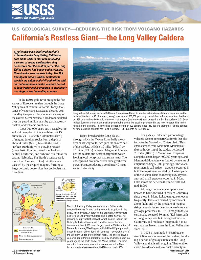
u.s. geological survey—reducing the risk ...long valley caldera in eastern california (here viewed...
TRANSCRIPT
U.S. GEOLOGICAL SURVEY—REDUCING THE RISK FROM VOLCANO HAZARDS
California’s Restless Giant—the Long Valley Caldera
Scientists have monitored geologic unrest in the Long Valley, California,
area since 1980. In that year, following a swarm of strong earthquakes, they discovered that the central part of the Long Valley Caldera had begun actively rising. Unrest in the area persists today. The U.S. Geological Survey (USGS) continues to provide the public and civil authorities with current information on the volcanic hazard at Long Valley and is prepared to give timely warnings of any impending eruption.
In the 1850s, gold fever brought the first waves of European settlers through the Long Valley area of eastern California. Today, thou-sands of visitors are attracted to the area year round by the spectacular mountain scenery of the eastern Sierra Nevada, a landscape sculpted over the past 4 million years by glaciers, earth-quakes, and volcanic eruptions.
About 760,000 years ago a cataclysmic volcanic eruption in the area blew out 150 cubic miles—600 cubic kilometers (km3)—of magma (molten rock) from a depth of about 4 miles (6 km) beneath the Earth’s surface. Rapid flows of glowing hot ash (pyroclastic flows) covered much of east-central California, and airborne ash fell as far east as Nebraska. The Earth’s surface sank more than 1 mile (1.6 km) into the space vacated by the erupted magma, forming a large volcanic depression that geologists call a caldera.
Long Valley Caldera in eastern California (here viewed from its southwest rim toward its northeast rim on the horizon 18 miles, or 30 kilometers, away) was formed 760,000 years ago in a violent volcanic eruption that blew out 150 cubic miles (600 cubic kilometers) of magma (molten rock) from beneath the Earth’s surface. U.S. Geo-logical Survey scientists are tracking continuing dome-like swelling centered in the low, forested hills in the middle of the caldera. This swelling affects more than 100 square miles (250 square kilometers) and is caused by magma rising beneath the Earth’s surface. (USGS photo by Roy Bailey.)
Today, broad and flat Long Valley, through which the Owens River lazily mean-ders on its way south, occupies the eastern half of this caldera, which is 10 miles (16 km) by 20 miles (32 km) in extent. Magma still under-lies the caldera and heats underground water, feeding local hot springs and steam vents. The underground heat now drives three geothermal power plants, producing a combined 40 mega-watts of electricity.
Volcanic rocks
Mono Lake
Mono Craters
InyoCraters
LONGVALLEY
CALDERA
MammothLakes
Mammoth Mountain
0 10 MILES
5 KILOMETERS
395
395
OWENS VALLEY Bishop
Bishop Tuff (arrows indicate directions of flow)
Mono-Inyo Craters volcanic chain
Other volcanic rocks
LONGVALLEYCALDERA
Known Distribution ofWind-Blown Ash from thePrehistoric Eruption thatFormed Long Valley Caldera
500 mi
1000m
i
Much of the Long Valley area of eastern California is covered by rocks formed during volcanic eruptions in the past 2 million years. A cataclysmic eruption 760,000 years ago formed Long Valley Caldera and ejected flows of hot glowing ash (pyroclastic flows), which cooled to form the Bishop Tuff. Wind-blown ash from that ancient erup-tion—more than 2,000 times larger than the 1980 eruption of Mount St. Helens, Washington, which killed 57 people and caused several billion dollars in damage—covered much of the Western United States (inset map). The photo shows a volcanic cone (Panum Dome) formed by eruptions about 600 years ago at the north end of the Mono Craters. The most recent volcanic eruptions in the area occurred in Mono Lake sometime between the mid-1700s and mid-1800s.
Long Valley Caldera is part of a large volcanic system in eastern California that also includes the Mono-Inyo Craters chain. This chain extends from Mammoth Mountain at the southwest rim of the caldera northward 25 miles (40 km) to Mono Lake. Eruptions along this chain began 400,000 years ago, and Mammoth Mountain was formed by a series of eruptions ending 58,000 years ago. The volca-nic system is still active—eruptions occurred in both the Inyo Craters and Mono Craters parts of the volcanic chain as recently as 600 years ago, and small eruptions occurred in Mono Lake sometime between the mid-1700s and mid-1800s.
Although no volcanic eruptions are known to have occurred in eastern California since those in Mono Lake, earthquakes occur frequently. These are caused by movement along faults and by the pressure of magma rising beneath the surface, two closely related geologic processes. In 1872, a magnitude 7.4 earthquake centered 80 miles (125 km) south of Long Valley was felt throughout most of California, and moderate (magnitude 5 to 6) earthquakes have shaken the Long Valley area since 1978.
In 1978 a magnitude 5.4 earthquake struck 6 miles southeast of the caldera, herald-ing a period of geologic unrest in the Long Valley area that is still ongoing. That temblor ended two decades of low quake activity in
U.S. Department of the InteriorU.S. Geological Survey
Fact Sheet 2014–3056August 2014
eastern California. The area has since expe-rienced numerous swarms of earthquakes, especially in the southern part of the caldera and the adjacent Sierra Nevada.
The most intense of these swarms began in May 1980 and included four strong magnitude 6 shocks, three on the same day. Following these shocks, scientists from the U.S. Geological Survey (USGS) began a reexamination of the Long Valley area, and they soon detected other evidence of unrest—a dome-like uplift within the cal-dera. Measurements showed that the center of the caldera had risen almost a foot (30 centimeters) since the summer of 1979—after decades of stability. This swelling, which by 2014 totaled more than 2.5 feet (75 centimeters) and affected more than 100 square miles (250 km2), is caused by new magma rising beneath the caldera.
In response to this increased unrest, USGS intensified its monitoring in the Long Valley region. Today, a state-of-the-art network of seismometers and geodetic equipment closely monitors earthquake activity and the swelling in the caldera. Data from these instruments help scientists to assess the volcanic hazard in the Long Valley area and to recognize early signs of possible eruptions. In cooperation with the Califor-nia Office of Emergency Services and civil authorities in eastern California, the USGS has established procedures to promptly alert the public to a possible eruption.
During the early 1990s, trees began dying at several places on Mammoth Moun-tain on the southwest edge of Long Valley Caldera. Studies conducted by USGS and U.S. Forest Service scientists showed that the trees are being killed by large amounts of carbon dioxide (CO2) gas seeping up through the soil from magma deep beneath Mammoth Mountain. Such emissions of volcanic gas, as well as earthquake swarms and ground swelling, commonly precede volcanic erup-tions. When they precede an eruption of a “central vent” volcano, such as Mount St. Helens, Washington, they normally last only a few weeks or months. However, symptoms of volcanic unrest may persist for decades or centuries at large calderas, such as Long Val-ley Caldera. Studies indicate that only about
one in six such episodes of unrest at large calderas worldwide actually culminates in an eruption.
Over the past 4,000 years, small to moderate eruptions have occurred some-where along the Mono-Inyo volcanic chain every few hundred years, and the possibility remains that the geologic unrest in the Long Valley area could take only weeks to escalate to an eruption. Nonetheless, geologists think that the chances of an eruption in the area in any given year are quite small.
To provide reliable and timely warning before an eruption, scientists of the USGS California Volcano Observatory continue to closely monitor geologic unrest in the Long Valley area of eastern California. The USGS Volcano Hazards Program monitors other vol-canic regions of the United States, including Hawaii, the Pacific Northwest, Wyoming, and Alaska, to better protect people’s lives and property from volcano hazards.
David P. Hill, Roy A. Bailey,James W. Hendley II, Peter H. Stauffer,
and Mae Marcaida
Graphic design by Sara Boore, Susan Mayfield,
and Vivian NguyenBanner design by Bobbie Myers
COOPERATING ORGANIZATIONS
California Office of Emergency ServicesCalifornia Geological Survey
Inyo County, CaliforniaMono County, CaliforniaTown of Mammoth Lakes
Mammoth Mountain Ski AreaUniversity of Nevada, Reno
U.S. Forest Service
For more information visit:http://volcanoes.usgs.gov/observatories/calvo/
MonoLake
EARTHQUAKES1978 through 2013
magnitude
3 to 55 to 66 to 6.2
5 MILES
5 KILOMETERS
0
1975 1985 1995 2005 2015Year
0
1
2
3
Rela
tive
uplif
t, in
feet
UPLIFT IN MIDDLE
OF CALDERA
LONG VALLEY
CALDERA
LONG VALLEY
CALDERA
MAY 1980MAY 1980
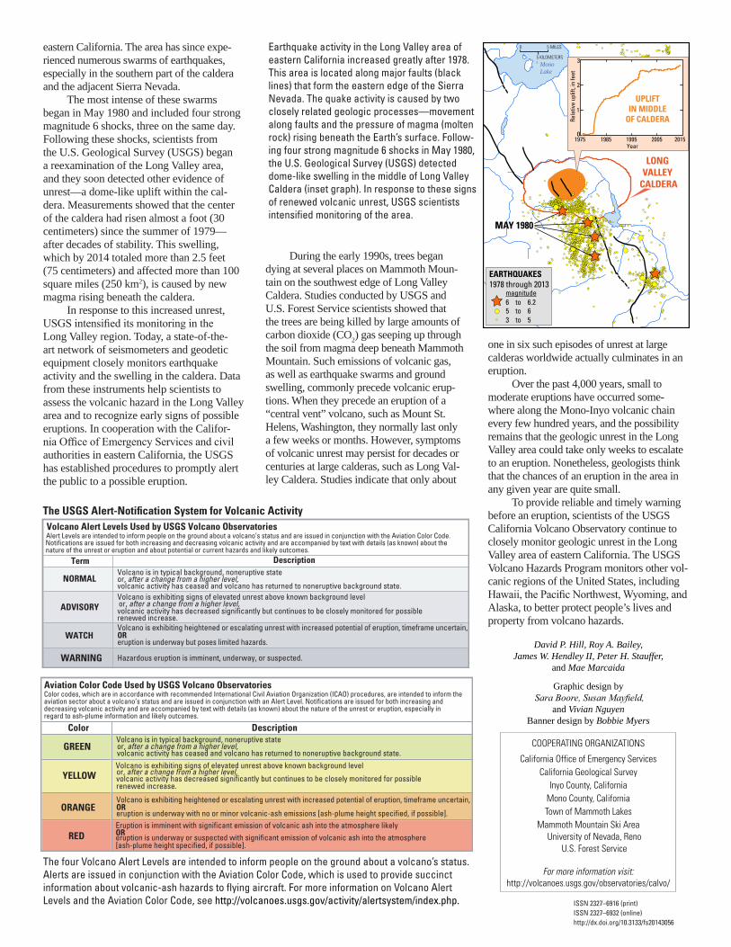
Earthquake activity in the Long Valley area of eastern California increased greatly after 1978. This area is located along major faults (black lines) that form the eastern edge of the Sierra Nevada. The quake activity is caused by two closely related geologic processes—movement along faults and the pressure of magma (molten rock) rising beneath the Earth’s surface. Follow-ing four strong magnitude 6 shocks in May 1980, the U.S. Geological Survey (USGS) detected dome-like swelling in the middle of Long Valley Caldera (inset graph). In response to these signs of renewed volcanic unrest, USGS scientists intensified monitoring of the area.
Volcano Alert Levels Used by USGS Volcano ObservatoriesAlert Levels are intended to inform people on the ground about a volcano’s status and are issued in conjunction with the Aviation Color Code.
Term Description
NORMALVolcano is in typical background, noneruptive state or, after a change from a higher level,volcanic activity has ceased and volcano has returned to noneruptive background state.
ADVISORYVolcano is exhibiting signs of elevated unrest above known background level or, after a change from a higher level,volcanic activity has decreased significantly but continues to be closely monitored for possible
WATCHVolcano is exhibiting heightened or escalating unrest with increased potential of eruption, timeframe uncertain, OReruption is underway but poses limited hazards.
WARNING Hazardous eruption is imminent, underway, or suspected.
renewed increase.
Notifications are issued for both increasing and decreasing volcanic activity and are accompanied by text with details (as known) about thenature of the unrest or eruption and about potential or current hazards and likely outcomes.
The USGS Alert-Notification System for Volcanic Activity
Volcano is in typical background, noneruptive state or, after a change from a higher level,volcanic activity has ceased and volcano has returned to noneruptive background state.
YELLOW
ORANGE
REDEruption is imminent with significant emission of volcanic ash into the atmosphere likelyOReruption is underway or suspected with significant emission of volcanic ash into the atmosphere
GREEN
Color Description
Volcano is exhibiting signs of elevated unrest above known background levelor, after a change from a higher level,volcanic activity has decreased significantly but continues to be closely monitored for possible
Volcano is exhibiting heightened or escalating unrest with increased potential of eruption, timeframe uncertain,OReruption is underway with no or minor volcanic-ash emissions [ash-plume height specified, if possible].
Aviation Color Code Used by USGS Volcano ObservatoriesColor codes, which are in accordance with recommended International Civil Aviation Organization (ICAO) procedures, are intended to inform the aviation sector about a volcano’s status and are issued in conjunction with an Alert Level. Notifications are issued for both increasing and decreasing volcanic activity and are accompanied by text with details (as known) about the nature of the unrest or eruption, especially in regard to ash-plume information and likely outcomes.
[ash-plume height specified, if possible].
renewed increase.
The four Volcano Alert Levels are intended to inform people on the ground about a volcano’s status. Alerts are issued in conjunction with the Aviation Color Code, which is used to provide succinct information about volcanic-ash hazards to flying aircraft. For more information on Volcano Alert Levels and the Aviation Color Code, see http://volcanoes.usgs.gov/activity/alertsystem/index.php. ISSN 2327–6916 (print)
ISSN 2327–6932 (online) http://dx.doi.org/10.3133/fs20143056