u.s. nuclear regulatory commission ma … · corporating multiple interpretations of seismologi-cal...
TRANSCRIPT

U.S. NUCLEAR REGULATORY COMMISSION Ma
REGULATORY GUll OFFICE OF NUCLEAR REGULATORY RESEARCH
REGULATORY GUIDE 1.165 S(Draft was DG-1 032)
IDENTIFICATION AND CHARACTERIZATION OF SEISMIC SOURCES AND DETERMINATION OF SAFE SHUTDOWN EARTHQUAKE GROUND MOTION
rch 1997 :E
A. INTRODUCTION
In 10 CFR Part 100, "Reactor Site Criteria," Section 100.23, "Geologic and Seismic Siting Factors," paragraph (c), "Geological, Seismological, and Engineering Characteristics," requires that the geological, seismological, and engineering characteristics of a site and its environs be investigated in sufficient scope and detail to permit an adequate evaluation of the proposed site, to provide sufficient information to support evaluations performed to arrive at estimates of the Safe Shutdown Earthquake Ground Motion (SSE), and to permit adequate engineering solutions to actual or potential geologic and seismic effects at the proposed site. Data on the vibratory ground motion, tectonic surface deformation, nontectonic deformation, earthquake recurrence rates, fault geometry and slip rates, site foundation material, and seismically induced floods, water waves, and other siting factors will be obtained by reviewing pertinent literature and carrying out field investigations.
. In 10 CFR 100.23, paragraph (d), "Geologic and Seismic Siting Factors," requires that the geologic and seismic siting factors considered for design include a determination of the SSE for the site, the potential for surface tectonic and nontectonic deformations, the de-
USNRC REGULATORY GUIDES Regulatory Guides wre Issued to describe and make available to the public such informalion as methods acceptable to the NRC staff for Implementing specific parts of the Commissions reguldion, techniques used by the staff In aluaftng specific problems orpoeUated accidents, and data needed by he NRC staff In Its review of applicatiors for permits aid licenses. Regulatory guides we not substitutes for regulations, and compliance with themn Is not required. Methods and aloutions different from those set out In the Ogides will be acceptable I #W provide a basis for the f•wngs requisfte to the issuance or con. tiriance of a permit or icense by fth Commission.
This guide was issued after consideration of comments received trom the public. Comments and suggestlons for rmprovements In these guides reancouraged at anlnts, and guides will be revlseds appropriate, to scomrnodste comments and to ref:ect now information or aperlence.
Written commerts may be submrted to fte Rules Review and Directives Branch. CFIPS, ADM, U.S. Nuclear Regulatory Commission, Washington. DC 20555-0001.
sign bases for seismically induced floods and water waves, and other design conditions.
In 10 CFR 100.23, paragraph (dX1), "Determination of the Safe -Shutdown Earthquake Ground Motion," requires that uncertainty inherent in estimates of the SSE be addressed through an appropriate analysis, such as a probabilistic seismic hazard analysis or suitable sensitivity analyses.
This guide has been developed to provide general guidance on procedures acceptable to the NRC staff for (1) conducting geological, geophysical, seismological, and geotechnical investigations, (2) identifying and characterizing seismic sources, (3) conducting probabilistic seismic hazard analyses, and (4) determining the SSE for satisfying the requirements of 10 CFR 100.23.
This guide contains several appendices that address the objectives stated above. Appendix A contains a list of definitions of pertinent terms. Appendix B describes the procedure used to determine the reference probability for the SSE exceedance level that is acceptable to the staff. Appendix C discusses the development of a seismic hazard information base and the determination of the probabilistic ground motion level and controlling earthquakes. Appendix D discusses site-specific geological, seismological, and
"The guides we issued In the following ten broad divisions:
1. Power Reactors 2. .Research and Test Reactors & Fuels and Materials Facilities 4. Environmental and Siting & Materials and Plant Protection
6. Products 7. Transportation 8. Occupational Health 9. Antilrust and Financial Review
10. General
Sinogle copies of regulatory guides may be obtained hre of charge by writng the Office of Administration. Attention: Distribution end Moi Services Section, U.S. Nuclear Regulatory Cornmission Washinglon. DC 20555-0001; or by fla at (301)4162260.
issued guides may also be purchased from the National Technical Information Service on a standing order basis. Dleails on this service may be obtained by writing NTIS, 5285 Port Royal Road, Springf•eld, VA 22161.

geophysical investigations. Appendix E describes a method to confirm the adequacy of existing seismic sources and source parameters as the basis for determining the SSE for a site. Appendix F describes procedures to determine the SSE.
The information collections contained in this regulatory guide are covered by the requirements of 10 CFR Part 50, which were approved by the Office of Management and Budget, approval number 3150-0011. The NRC may not conduct or sponsor, and a person is not required to respond to, a collection of information unless it displays a currently valid OMB control number.
B. DISCUSSION
BACKGROUND
A probabilistic seismic hazard analysis (PSHA) has been identified in 10 CFR 100.23 as a means to determine the SSE and account for uncertainties in the seismological and geological evaluations. The rule further recognizes that the nature of uncertainty and the appropriate approach to account for it depend on the tectonic regime and parameters such as the knowledge of seismic sources, the existence of historical and recorded data, and the level of understanding of the tectonics. Therefore, methods other than probabilistic methods such as sensitivity analyses may be adequate for some sites to account for uncertainties.
-Appendix A, "Seismic and Geologic Siting Crite
ria for Nuclear Power Plants," to 10 CFR Part 100 is primarily based on a deterministic methodology. Past licensing experience in applying Appendix A has demonstrated the need to formulate procedures that quantitatively incorporate uncertainty (including alternative scientific interpretations) in the evaluation of seismic hazards. A single deterministic representation of seismic sources and ground motions at a site may not explicitly provide a quantitative representation of the uncertainties in geological, seismological, and geophysical data and alternative scientific interpretations.
Probabilistic procedures were developed during the past 10 to 15 years specifically for nuclear power plant seismic hazard assessments in the Central and Eastern United States (CEUS) (the area east of the Rocky Mountains), also referred to as the Stable Continent Region (SCR). These procedures provide a structured approach for decisionmaking with respect to the SSE when performed together with site-specific investigations. A PSHA provides a framework to address the uncertainties associated with the identification and characterization of seismic sources by incorporating multiple interpretations of seismologi-
cal parameters. A PSHA also provides an evaluation of the likelihood of SSE recurrence during the design lifetime of a given facility, given the recurrence interval and recurrence pattern of earthquakes in pertinent seismic sources. Within the framework of a probabilistic analysis, uncertainties in the characterization of seismic sources and ground motions are identified and incorporated in the procedure at each step of the process for estimating the SSE. The role of geological, seismological, and geophysical investigations is to develop geosciences information about the site for use in the detailed design analysis of the facility, as well as to ensure that the seismic hazard analysis is based on up-to-date information.
Experience in performing seismic hazard evaluations in active plate-margin regions in the Western United States (for example, the San Gregorio-Hosgri fault zone and the Cascadia Subduction Zone) has also identified uncertainties associatedwith the characterization of seismic sources (Refs. 1-3). Sources of uncertainty include fault geometry, rupture segmentation, rupture extent, seismic-activity rate, ground motion, and earthquake occurrence modeling. As is the case for sites in the CEUS, alternative hypotheses and parameters must be considered to account for these uncertainties.
Uncertainties associated with the identification and characterization of seismic sources in tectonic environments in both the CEUS and the Western United States should be evaluated. Therefore, the same basic approach can be applied to determine the SSE.
APPROACH
The general process to determine the SSE at a site includes:
1. Site- and region-specific geological, seismological, geophysical, and geotechnical investigations and
2. A probabilistic seismic hazard assessment.
CENTRAL AND EASTERN UNITED STATES
The CEUS is considered to be that part of the United States east of the Rocky Mountain front, or east of Longitude 1050 West (Refs. 4, 5). To determine the SSE in the CEUS, an accepted PSHAmethodology with a range of credible alternative input interpretations should be used. For sites in the CEUS, the seismic hazard methods, the data developed, and seismic sources identified by Lawrence Livermore National Laboratory (LLNL) (Refs. 4-6) and the
1.165'-2
K

Electric Power Research Institute (EPRI) (Ref. 7) have been reviewed and accepted by the staff. The LLNL and EPRI studies developed data bases and scientific interpretations of available information
K1 and determined seismic sources and source characterizations for the CEUS (e.g., earthquake occurrence rates, estimates of maximum magnitude).
In the CEUS, characterization of seismic sources is more problematic than in the active plate-margin region because there is generally no clear association between seismicity and known tectonic structures or near-surface geology. In general, the observed geologic structures were generated in response to tectonic forces that no longer exist and have little or no correlation with current tectonic forces. Therefore, it is important to account for this uncertainty by the use of multiple alternative models.
The identification of seismic sources and reasonable alternatives in the CEUS considers hypotheses presently advocated for the occurrence of earthquakes in the CEUS (for example, the reactivation of favorably oriented zones of weakness or the local amplification and release of stresses concentrated around a geologic structure). In tectonically active areas of the CEUS, such as the New Madrid Seismic Zone, where geological, seismological, and geo
. physical evidence suggest the nature of the sources that generate the earthquakes, it may be more appropriate to evaluate those seismic sources by using procedures similar to those normally applied in the Western United States.
WESTERN UNITED STATES
The Western United States is considered to be that part of the United States that lies west of the Rocky Mountain front, or west of approximately 1050 West Longitude. For the Western United States, an information base of earth science data and scientific interpretations of seismic sources and source characterizations (e.g., geometry, seismicity parameters) comparable to the CEUS as documented in the LLNL and EPRI studies (Refs. 4-7) does not exist. For this region, specific interpretations on a site-by-site basis should be applied (Ref. 1).
The active plate-margin region includes, for example, coastal California, Oregon, Washington, and Alaska. For the active plate-margin region, where earthquakes can often be correlated with known tectonic structures, those structures should be assessed for their earthquake and surface deformation potential. In this region, at least three types of sources exist: (1) faults
that are known to be at or near the surface, (2) buried (blind) sources that may often be manifested as folds at the earth's surface, and (3) subduction zone sources, such as those in the Pacific Northwest. The nature of surface faults can be evaluated by conventional surface and near-surface investigation techniques to assess orientation, geometry, sense of displacements, length of rupture, Quaternary history, etc.
Buried (blind) faults are often associated with surficial deformation such as folding, uplift, or subsidence. The surface expression of blind faulting can be detected by mapping the uplifted or down-dropped geomorphological features or stratigraphy, survey leveling, and geodetic methods. The nature of the structure at depth can often be evaluated by core borings and geophysical techniques.
Continental United States subduction zones are located in the Pacific Northwest and Alaska. Seismic sources associated with subduction zones are sources within the overriding plate, on the interface between the subducting and overriding lithospheric plates, and in the interior of the downgoing oceanic slab. The characterization of subduction zone seismic sources includes consideration of the three-dimensional geometry of the subducting plate, rupture segmentation of subduction zones, geometry of historical ruptures, constraints on the up-dip and down-dip extent of rupture, and comparisons with other subduction zones worldwide.
The Basin and Range region of the Western United States, and to a lesser extent the Pacific Northwest and the Central United States, exhibit temporal clustering of earthquakes. Temporal clustering is best exemplified by the rupture histories within the Wasatch fault zone in Utah and the Meers fault in central Oklahoma, where several large late Holocene coseismic faulting events occurred at relatively close intervals (hundreds to thousands of years) that were preceded by long periods of quiescence that lasted thousands to tens of thousand years. Temporal clustering should be considered in these regions or wherever paleoseismic evidence indicates that it has occurred.
C. REGULATORY POSITION
1. GEOLOGICAL, GEOPHYSICAL, SEISMOLOGICAL, AND GEOTECHNICAL INVESTIGATIONS
1.1 Comprehensive geological, seismological, geophysical, and geotechnical investigations of the site and regions around the site should be performed.
1.165-3

For existing nuclear power plant sites where additional units are planned, the geosciences technical information originally used to validate those sites may, be inadequate, depending on how much new or additional information has become available since the initial investigations and analyses were performed, the quality of the investigations performed at the time, and the complexity of the site and regional geology and seismology. This technical information should be utilized along with all other available information to plan and determine the scope of additional investigations. The investigations described in this regulatory guide are performed primarily to gather information needed to confirm the suitability of the site and to gather data pertinent to the safe design and construction of the nuclear power plant. Appropriate geological, seismological, and geophysical investigations are described in Appendix D to this guide. Geotechnical investigations are described in Regulatory Guide 1.132, "Site Investigations for Foundations of Nuclear Power Plants" (Ref. 8). Another important purpose for the site-specific investigations is to determine whether there are new data or interpretations that are not adequately incorporated in the existing PSHA data bases. Appendix E describes a method for evaluating new information derived from the sitespecific investigations in the context of the PSHA.
These investigations should be performed at four levels, with the degree of their detail based on distance from the site, the nature of the Quaternary tectonic regime, the geological complexity of the site and region, the existence of potential seismic sources, the potential for surface deformations, etc. A more detailed discussion of the areas and levels of investigations and the bases for them is presented in Appendix D to this regulatory guide. The levels of investigation are characterized as follows.
1. Regional geological and seismological investigations are not expected to be extensive nor in great detail, but should include literature reviews, the study of maps and remote sensing data, and, if necessary, ground truth reconnaissances conducted within a radius of 320 km (200 miles) of the site to identify seismic. sources (seismogenic and capable tectonic sources).
2. Geological, seismological, and geophysical investigations should be carried out within a radius of 40 km (25 miles) in greater detail than the regional investigations to identify and char-
acterize the seismic and surface deformation potential of any capable tectonic sources and the seismic potential of seismogenic sources, or to demonstrate that such structures are not present. Sites with capable tectonic or seismogenic sources within a radius of 40 km (25 miles) may require more extensive geological and seismological investigations and analyses (similar in detail to investigations and analysis usually preferred within an 8-km (5-mile) radius).
3. Detailed geological, seismological, geophysical, and geotechnical investigations should be conducted within a radius of 8 km (5 miles) of the site, as appropriate, to evaluate the potential for tectonic deformation at or near the ground surface and to assess the ground motion transmission characteristics of soils and rocks in the site vicinity. Investigations should include monitoring by a network of seismic stations.
4. Very detailed geological, geophysical, and geotechnical engineering investigations should be conducted within the site [radius of approximately 1 km (0.5 miles)] to assess specific soil and rock characteristics as described in Regulatory Guide 1.132 (Ref. 8).
1.2 The areas of investigations may be expanded beyond those specified above in regions that include capable tectonic sources, relatively high seismicity, or complex geology, or in regions that have experienced a large, geologically recent earthquake.
1.3 It should be demonstrated that deformation features discovered during construction, particularly faults, do not have the potential to compromise the safety of the plant. The two-step licensing practice, which required applicants to acquire a Construction Permit (CP), and then during construction apply for an Operating License (OL), has been modified to allow for an alternative procedure. The requirements and procedures applicable to NRC's issuance of combined licenses for nuclear power facilities are in Subpart C of 10 CFR Part 52. Applying the combined licensing procedure to a site could result in the award of a license prior to the start of construction. During the construction of nuclear power plants licensed in the past two decades, previously unknown faults were often discovered in site excavations. Before issuance of the OL, it was necessary to demonstrate that the; faults in the excavation posed no hazard to the facility. Under the combined license procedure, these kinds of features should be mapped and assessed as to
1.165-4
their rupture and ground motion generating potential while the excavations' walls and bases are exposed. Therefore, a commitment should be made, in docu
ments (Safety Analysis Reports) supporting the license application, to geologically map all excavations and to notify the NRC staff when excavations are open for inspection.
1.4 Data sufficient to clearly justify all conclusions should be presented. Because engineering solutions cannot always be satisfactorily demonstrated for the effects of permanent ground displacement, it is prudent to avoid a site that has a potential for surface or near-surface deformation. Such sites normally will require extensive additional investigations.
1.5 For the site and for the area surrounding the site, the lithologic, stratigraphic, hydrologic, and structural geologic conditions should be characterized. The investigations should include the measurement of the static and dynamic engineering properties of the materials underlying the site and an evaluation of physical evidence concerning the behavior during prior earthquakes of the surficial materials and the substrata underlying the site. The properties needed to assess the behavior of the underlying material during earthquakes, including the potential for liquefaction, and the characteristics of the underlying material in transmitting earthquake ground motions to the foundations of the plant (such as seismic wave velocities, density, water content, porosity, elastic moduli, and strength) should be measured.
2. SEISMIC SOURCES SIGNIFICANT TO
THE SITE SEISMIC HAZARD
2.1 For sites in the CEUS, when the EPRI or LLNL PSHA methodologies and data bases are used to determine the SSE, it still may be necessary to investigate and characterize potential seismic sources that were previously unknown or uncharacterized and to perform sensitivity analyses to assess their significance to the seismic hazard estimate. The results of investigations discussed in Regulatory Position 1 should be used, in accordance with Appendix E, to determine whether the LLNL or EPRI seismic sources and their characterization should be updated. The guidance in Regulatory Positions 2.2 and 2.3 below and in Appendix D of this guide may be used if additional seismic sources are to be developed as a result of investigations.
2.2 When the LLNL and EPRI methods are not used or are not applicable, the guidance in Regulatory Position 2.3 should be used for identification and characterization of seismic sources. The uncertainties in the
characterization of seismic sources should be addressed as appropriate. Seismic source is a general term referring to both seismogenic sources and capable tectonic sources. The main distinction between these two types of seismic sources is that a seismogenic source would not cause surface displacement, but a capable tectonic source causes surface or near-surface displacement.
Identification and characterization of seismic sources should be based on regional and site geological and geophysical data, historical and instrumental seismicity data, the regional stress field, and geological evidence of prehistoric earthquakes. Investigations to identify seismic sources are described in Appendix D. The bases for the identification of seismic sources should be documented. A general list of characteristics to be evaluated for a seismic source is presented in Appendix D.
S2.3 - As part of the seismic source pharacterization, the seismic potential for each source should be evaluated. Typically, characterization of the seismic potential consists of four equally important elements:
1. Selection of a model for the spatial distribution of earthquakes in a source.
2. Selection of a model for the temporal distribution of earthquakes in a source.
3. Selection of a model for the relative frequency of earthquakes of various magnitudes, including an estimate for the largest earthquake that could occur in the source under the current tectonic regime.
4. A complete description of the uncertainty.
For example, in the LLNL study a truncated exponential model was used for the distribution of magnitudes given that an earthquake has occurred in a source. A stationary Poisson process is used to model the spatial and temporal occurrences of earthquakes in a source.
For a general discussion of evaluating the earthquake potential and characterizing the uncertainty, refer to the Senior Seismic Hazard Analysis Committee Report (Ref. 9).
2.3.1 For sites in the CEUS, when the LLNL or EPRI method is not used or not applicable (such as in the New Madrid Seismic Zone), it is necessary to evaluate the seismic potential for each source. The seismic sources and data that have been accepted by the NRC in past licensing decisions may be used, along with the
1.165-5

data gathered from the investigations carried out as described in Regulatory Position 1.
Generally, the seismic sources for the CEUS are area sources because there is uncertainty about the underlying causes of earthquakes. This uncertainty is due to a lack of active surface faulting, a low rate of seismic activity, and a short historical record. The assessment of earthquake recurrence for CEUS area sources commonly relies heavily on catalogs of observed seismicity. Because these catalogs are incomplete and cover a relatively short period of time, it is difficult to obtain reliable estimates of the rate of activity. Considerable care must be taken to correct for incompleteness and to model the uncertainty in the rate of earthquake recurrence. To completely characterize the seismic potential for a source it is also necessary to estimate the largest earthquake magnitude that a seismic source is capable of generating under the current tectonic regime. This estimated magnitude defines the upper bound of the earthquake recurrence relationship.
The assessment of earthquake potential for area sources is particularly difficult because the physical constraint most important to the assessment, the dimensions of the fault rupture, is not known, As a result, the primary methods for assessing maximum earthquakes for area sources usually include a consideration of the historical seismicity record, the pattern and rate of seismic activity, the Quaternary (2 million years and younger), characteristics of the source, the current stress regime (and how it aligns with known tectonic structures), paleoseismic data, and analogues to sources in other regions considered tectonically similar to the CEUS. Because of the shortness of the historical catalog and low rate of seismic activity, considerable judgment is needed. It is important to characterize the large uncertainties in the assessment of the earthquake potential.
2.3.2 For sites located within the Western United States, earthquakes can often be associated with known tectonic structures. For faults, the earthquake potential is related to the characteristics of the estimated future rupture, such as the total rupture area, the length, or the amount of fault displacement. The following empirical relations can be used to estimate the earthquake potential from fault behavior data and also to estimate the amount of displacement that might be expected for a given magnitude. It is prudent to use several of these different relations to obtain an estimate of the earthquake magnitude.
"* Surface rupture length versus magnitude (Refs. 10-13),
"* Subsurface rupture length versus magnitude (Ref. 14),
"* Rupture area versus magnitude (Ref. 15),
"* Maximum and average displacement versus magnitude (Ref. 14),
"* Slip rate versus magnitude (Ref. 16).
When such correlations as References 10-16 are used, the earthquake potential is often evaluated as the mean of the distribution. The difficult issue is the evaluation of the appropriate rupture dimension to be used. This is a judgmental process based on geological data for the fault in question and the behavior of other regional fault systems of the same type.
The other elements of the. recurrence model are generally obtained using catalogs of seismicity, fault slip rate, and other data. In some cases, it may be appropriate to use recurrence models with memory. All the sources of uncertainty must be appropriately modeled. Additionally, the phenomenon of temporal clustering should be considered when there is geological evidence of its past occurrence.
2.3.3 For sites near subduction zones, such as in the Pacific Northwest and Alaska, the maximum magnitude must be assessed for subduction zone seismic sources. Worldwide observations indicate that the largest known earthquakes are associated with the plate interface, although intraslab earthquakes may also have large magnitudes. The assessment of plate interface earthquakes can be based on estimates of the expected dimensions of rupture or analogies to other subduction zones worldwide.
3. PROBABILISTIC SEISMIC HAZARD ANALYSIS PROCEDURES
A PSHA should be performed for the site as it allows the use of multiple models to estimate the likelihood of earthquake ground motions occurring at a site, and a PSHA systematically takes into account uncertainties that exist in various parameters (such as seismic sources, maximum 'earthquakes,. and ground motion attenuation). Alternative hypotheses areý considered in a quantitative fashion in a PSHA. Alternative hypotheses can also be used to evaluate the sensitivity of the hazard to the uncertainties in the significant parameters and to identify the relative contribution of each seismic source to the hazard. Reference 9 provides guidance for conducting a PSHA.
The following steps describe a procedure that is acceptable to the NRC staff for performing a PSHA. The
1.165-6
.-

details of the calculational aspects of deriving controlling earthquakes from the PSHA are included in Appendix C.
/ 1. Perform regional and site geological, seismological, and geophysical investigations in accordance with Regulatory Position I and Appendix D.
2. For CEUS sites, perform an evaluation of LLNL or EPRI seismic sources in accordance with Appendix E to determine whether they are consistent with the site-specific data gathered in Step 1 or require updating. The PSHAshould only be updated if the new information indicates that the current version significantly underestimates the hazard and there is a strong technical basis that supports such a revision. It may be possible to justify a lower hazard estimate with an exceptionally strong technical basis. However, it is expected that large uncertainties in estimating seismic hazard in the CEUS will continue to exist in the future, and substantial delays in the licensing process will result in trying to justify a lower value with respect to a specific site. For these reasons the NRC staff discourages efforts to justify a lower hazard estimate. In most cases, limited-scope sensitivity studies should be sufficient to demonstrate that the existing data base in the PSHA envelops the findings from site-specific investigations. In general, significant revisions to the LLNL and EPRI data base are to be undertaken only periodically (every 10 years), or when there is an important new finding or occurrence. An overall revision of the data base would also require a reexamination of the acceptability of the reference probability discussed in Appendix B and used in Step 4 below. Any significant update should follow the guidance of Reference 9.
3. For CEUS sites only, perform the LLNL or EPRI probabilistic seismic hazard analysis using original or updated sources as determined in Step 2. For sites in other parts of the country, perform a site-specific PSHA (Reference 9). The ground motion estimates should be made for rock conditions in the free-field or by assuming hypothetical rock conditions for a nonrock site to develop the seismic hazard information base discussed in Appendix C.
4. Using the reference probability (1E-5 per year) described in Appendix B, determine the 5% of
critically damped median spectral ground motion levels for the average of 5 and 10 Hz, Sa-,510, and for the average of 1 and 2.5 Hz, Sa,1.2.5. Appendix B discusses situations in which an alternative reference probability may be more appropriate. The alternative reference probability is reviewed and accepted on a caseby-case basis. Appendix B also describes a procedure that should be used when a general revision to the reference probability is needed.
5. Deaggregate the median probabilistic hazard characterization in accordance with Appendix C to determine the controlling earthquakes (i.e., magnitudes and distances). Document the hazard information base as discussed in Appendix C.
4. PROCEDURES FOR DETERMINING THE SSE
After completing the PSHA (See Regulatory Position 3) and determining the controlling earthquakes, the following procedure should be used to determine the SSE. Appendix F contains an additional discussion of some of the characteristics of the SSE.
1. With the controlling earthquakes determined as described in Regulatory Position 3 and by using the procedures in Revision 3 of Standard Review Plan (SRP) Section 2.5.2 (which may include the use of ground motion models not included in the PSHA but that are more appropriate for the source, region, and site under consideration or that represent the latest scientific development), develop 5% of critical damping response spectral shapes for the actual or assumed rock conditions. The same controlling earthquakes are also used to derive vertical response spectral shapes.
2. Use Sa,5-10 to scale the response spectrum shape corresponding to the controlling earthquake. If, as described in Appendix C, there is a controlling earthquake for Sa,1-2.5, determine that the Sa,5-10 scaled response spectrum also envelopes the ground motion spectrum for the controlling earthquake for Sa,1-2.5. Otherwise, modify the shape to envelope the low-frequency spectrum or use two spectra in the following steps. See additional discussion in Appendix F. For a rock site go to Step 4.
3. For nonrock sites, perform a site-specific soil amplification analysis considering uncertainties in site-specific geotechnical properties and parame
65-7

ters to determine response spectra at the free ground surface in the freefield for the actual site conditions.
4. Compare the smooth SSE spectrum or spectra used in design (e.g., 0.3g, broad-band spectra used in advanced light-water reactor designs) with the spectrum or spectra determined in Step 2 for rock sites or determined in Step 3 for the nonrock sites to assess the adequacy of the SSE spectrum or spectra.
To obtain an adequate design SSE based on the site-specific response spectrum or spectra, develop a smooth spectrum or spectra or use a standard broad band shape that envelopes the spectra of Step 2 or Step 3.
Additional discussion of this step is provided in Appendix F.
D. IMPLEMENTATION
The purpose of this section is to provide guidance to applicants and licensees regarding the NRC staff's plans for using this regulatory guide.
Except in those cases in which the applicant proposes an acceptable alternative method for complying with the specified portions of the Commission's regulations, this guide will be used in the evaluation of applications for construction permits, operating licenses, early site permits, or combined licenses submitted after January 10, 1997. This guide will not be used in the evaluation of an application for an operating license submitted after January 10, 1997, if the construction permit was issued prior to that date.
1.165-8

REFERENCES
S1. Pacific Gas and Electric Company, "Final Report of the Diablo Canyon Long Term Seismic Program; Diablo Canyon Power Plant18 Doc8.t Nos. 50-275 and 50-323, 198PD1
2. R- Rood et aL, "Safety Evaluation Report Related to the Operation of Diablo Canyon Nuclear Power Plant, Units 1 and V" NUREG-0675, Supplement No. 34, USNRC, June 1991.2
3. Letter from G. Sorensen, Washington Public Power Supply System, to Document Control Branch, USNRC. Subject: Nuclear Project No. 3, Resolution of Key Licensing Issues, Response; February 29, 1988.1
4. D.L. Bernreuter et al., "Seismic Hazard Characterization of 69 Nuclear Plant Sites East of the Rocky Mountains," NUREG/CR-5250, Volumes 1-8, January 1989.2
5. P. Sobel, "Revised Livermore Seismic Hazard
Estimates for Sixty-Nine Nuclear Power Plant Sites East of the Rocky Mountains," NUREG-1488, USNRC, April 1994.2
2 6. J.B. Savy et al., "Eastern Seismic Hazard Character
ization Update," UCRL-ID-115111, Lawrence Livermore National Laboratory, June 1993.1 (Accession number 9310190318 in NRC's Public Document Room)
7. Electric Power Research Institute, "Probabilistic Seismic Hazard Evaluations at Nuclear Power Plant Sites in the Central and Eastern United States," NP-4726, All Volumes, 1989-1991.
lCopies are available for inspection or copying for a fee from the NRC Public Document Room at 2120 L Street NW., Washington, DC; the PDR's mailing address is Mail Stop LEA Washington, DC 20555; telephone (202)634-3273; fax (202)634-3343.
2 Copies are available for inspection or copying for a fee from the NRC Public Document Room at 2120 L Street NW., Washington, DC; the PDR's mailing address is Mail Stop LL-6, Washington, DC 20555; telephone (202)634-3273; fax (202)634-3343. Copies may be purchased at current rates from the U.S. Government Printing Office, PRO Box 37082, Washington, DC 20402-9328(telephone (202)512-2249); or from the National Technical Information Service by writing NMIS at 5285 Port Royal Road, Springfield, VA 22161.
8. USNRC, "Site Investigations for Foundations of Nuclear Power Plants," Regulatory Guide 1.132.3
9. Senior Seismic Hazard Analysis Committee (SSHAC), "Recommendations for Probabilistic Seismic Hazard Analysis: Guidance on Uncertainty and Use of Experts," Lawrence Livermore National Laboratory, UCRL-ID-122160, August 1995 (to be published as NUREG/CR6372).
10. D.B. Slemmons, "Faults and Earthquake Magnitude," U.S. Army Corps of Engineers, Waterways Experiment Station, Misc. Papers S-73-1, Report 6, 1977.
11. D.B. Slemmons, "Determination of Design Earthquake Magnitudes for Microzonation," Proceedings of the Third International Microzonation Conference, University of Washington, Seattle, Volume 1, pp. 119-130, 1982.
12. M.G. Bonilla, H.A. Villalobos, and R.E. Wallace, "Exploratory Trench Across the Pleasant Valley Fault, Nevada," Professional Paper 1274-B, U.S. Geological Survey, pp. B1-B14, 1984.1
13. S.G. Wesnousky, "Relationship Between Total Affect, Degree of Fault Trace Complexity, and Earthquake Size on Major Strike-Slip Faults in California" (Abs), Seismological Research Let-, ters, Volume 59, No. 1, p. 3, 1988.
14. D.L Wells and K.J. Coppersmith, 'New Empirical Relationships Among Magnitude, Rupture Length, Rupture Width, Rupture Area, and Surface Displacemen," Bulletn of the Seismological Sociy of America, Volume 84, August 1994.
15. M. Wyss, "Estimating Maximum Expectable Magnitude of Earthquakes from Fault Dimensions," Geology, Volume 7 (7), pp. 336-340, 1979.
16. D.P. Schwartz and KJ. Coppersmith, "Seismic Hazards: New Trends in Analysis Using Geologic Data," Active Tectonics, National Academy Press, Washington, DC, pp. 215-230, 1986.
3 Single copies of regulatory guides, both active and draft, may be obtained free of charge by writing the Office of Administration, Altn: Distribution and Services Section, USNRC, Washington, DC 20555, or by fax at (301)415-2260. Copies are available for inspection or copying for a fee from the NRC Public Document Room at 2120 L Street NW., Washington, DC; the PDR's mailing address is Mail Stop LL-., Washington, DC 20555; telephone (202)634-3273; fax (202)634-3343.
1.165-9

APPENDIX A DEFINITIONS
Controlling Earthquakes - Controlling earthquakes are the earthquakes used to determine spectral shapes or to estimate ground motions at the site. There may be several controlling earthquakes for a site. As a result of the probabalistic seismic hazard analysis (PSHA), controlling earthquakes are characterized as mean magnitudes and distances derived from a deaggregation analysis of the median estimate of the PSHA.
Earthquake Recurrence - Earthquake recurrence is the frequency of occurrence of earthquakes having various magnitudes. Recurrence relationships or curves are developed for each seismic source, and they reflect the frequency of occurrence (usually expressed on an annual basis) of magnitudes up to the maximum, including measures of uncertainty.
Intensity - The intensity of an earthquake is a measure of vibratory ground motion effects on humans, on human-built structures, and on the earth's surface at a particular location. Intensity is described by a numerical value on the Modified Mercalli scale.
Magnitude - An earthquake's magnitude is a measure of the strength of the earthquake as determined from seismographic observations.
Maximum Magnitude -The maximum magnitude is the upper bound to recurrence curves.
Nontectonic Deformation - Nontectonic deformation is distortion of surface or near-surface soils or rocks that is not directly attributable to tectonic activity. Such deformation includes features associated with subsidence, karst terrane, glaciation or deglaciation, and growth faulting.
Safe Shutdown Earthquake Ground Motion (SSE) -Th/o/SSE is the vibratory ground motion for which certain structures, systems, and components are designed, pursuant to Appendix S to 10 CFR Part 50, to remain functional.
The SSE for the site is characterized by both horizontal and vertical free-field ground motion response spectra at the free ground surface.
Seismic Potential - A model giving a complete description of the future earthquake activity in a seismic source zone. The model includes a relation giving the frequency (rate) of earthquakes of any magnitude, an estimate of the largest earthquake that could occur under the current tectonic regime, and a complete description of the uncertainty. A typical model used for PSHA
is the use of a truncated exponential model for the magnitude distribution and a stationary Poisson process for the temporal and spatial occurrence of earthquakes.
Seismic Source'- Seismic source is a general term referring to both seismogenic sources and capable tectonic sources.
Capable Tectonic Source - A capable tectonic source is a tectonic structure that can generate both vibratory ground motion and tectonic surface deformation such as faulting or folding at or near the earth's surface in the present seismotectonic regime. It is described by at least one of the following characteristics:
a. Presence. of surface or near-surfice deformation of landforms or geologic deposits of a recurring nature within the last approximately 500,000 years or at least once in the last approximately 50,000 years.
b. A reasonable association with one or more moderate to large earthquakes or sustained earthquake activity that are usually accompanied by significant surface deformation.
c. A structural association with a capable tectonic source having characteristics of either section a or b in this paragraph such that movement on one could be reasonably expected to be accompanied by movement on the other.
* In some cases, the geological evidence of past activity at or near the ground surface along a potential capable tectonic source may be obscured at a particular site. This might occur, for example, at a site having a deep overburden. For these cases, evidence may exist elsewhere along the structure from which an evaluation of its characteristics in the vicinity of the site can be reasonably based. Such evidence is to be used in determining whether the structure is a capable tectonic source within this definition.
Notwithstanding the foregoing paragraphs, the association of a structure with geological structures that are at least pre-Quaternary, such as many of those found in the Central and Eastern regions of the United States, in the absence of conflicting evidence will demonstrate that the structure is not a capable tectonic source within this definition.
1.165-10
K

Seismogenic Source - A seismogenic source is a portion of the earth that we assume has uniform earthquake potential (same expected maximum earthquake and recurrence frequency), distinct from the seismicity of the surrounding regions. A seismogenic source will generate vibratory ground motion but is assumed not to cause surface displacement. Seismogenic sources cover a wide range of possibilities from a well-defined tectonic structure to simply a large region of diffuse seismicity (seismotectonic province) thought to be characterized by the same earthquake recurrence model. A seismogenic source is also characterized by its involvement in the current tectonic regime (the Quaternary, or approximately the last 2 million years).
Stable Continental Region -A stable continental region (SCR) is composed of continental crust, including continental shelves, slopes, and attenuated continental
crust, and excludes active plate boundaries and zones of currently active tectonics directly influenced by plate margin processes. It exhibits no significant deformation associated with the major Mesozoic-to-Cenozoic (last 240 million years) orogenic belts. It excludes major zones of Neogene (last 25 million years) rifting, volcanism, or suturing.
Stationary Poisson Process - A probabilistic model of the occurrence of an event over time (space) that is characterized by (1) the occurrence of the event in small intervals is constant over time (space), (2) the occurrence of two (or more) events in a small interval is negligible, and (3) the occurrence of the event in non-overlapping intervals is independent..
Tectonic Structure - A tectonic structure is a largescale dislocation or distortion, usually within the earth's crust. Its 'extent may be on the order of tens of meters (yards) to hundreds of kilometers (miles).
1.165-11
I I I 1 .

APPENDIX B. REFERENCE PROBABILITY FOR THE EXCEEDANCE LEVEL OF THE
SAFE SHUTDOWN EARTHQUAKE GROUND MOTION
B.1 INTRODUCTION
This appendix describes the procedure that is acceptable to the NRC staff to determine the reference probability, an annual probability of exceeding the Safe Shutdown Earthquake Ground Motion (SSE), at future nuclear power plant sites. The reference probability is used in Appendix C in conjunction with the probabilistic seismic hazard analysis (PSHA).
B.2 REFERENCE PROBABILITY FOR THE SSE
The reference probability is the annual probability level such that 50% of a set of currently operating plants (selected by the NRC, see Table B.1) has an annual mpdian probability of exceeding the SSE that is below this level. The reference probability is determined for the annual probability of exceeding the average of the 5 and 10 Hz SSE response spectrum ordinates associated with 5% of critical damping.
B.3 PROCEDURE TO DETERMINE THE REFERENCE PROBABILITY
The following procedure was used to determine the reference probability and should be used in the future if general revisions to PSHA methods or data bases result in significant changes in hazard predictions for the selected plant sites in Table B.I.
The reference probability is calculated using the Lawrence Livermore National Laboratory (LLNL) methodology and results (Refs. B.1 and B.2) but is also considered applicable for the Electric Power Research Institute (EPRI) study (Refs. B.3 and B.4). This reference probability is also to be used in conjunction with sites not in the Central and Eastern United States (CEUS) and for sites for which LLNL and EPRI methods and data have not been used or are not available. However, the final SSE at a higher reference probability may be more appropriate and acceptable 1 for some sites considering the slope characteristics of the site hazard curves, the overall uncertainty in calculations (i.e., differences between mean and median hazard estimates), and the knowledge of the seismic sources that contribute to the hazard. Reference B.4 includes a procedure to determine an alternative reference probability
lThe use of a higher reference probability will be reviewed and accepted on a caseby-case basis.
on the risk-based considerations; its application will also be reviewed on a case-by-case basis.
B.3.1 Selection of Current Plants for Reference Probability Calculations..
Table B.1 identifies plants, along with their site characteristics, used in calculating the reference probability. These plants represent relatively recent designs that used Regulatory Guide 1.60, "Design Response Spectra for Seismic Design of Nuclear Power Plants" (Ref. B.5), or similar spectra as their design bases. The use of these plants should ensure an adequate level of conservatism-in determining an SSE consistent with recent licensing decisions. B3.2 Procedure To Establish Reference
Probability
Step 1
Using LLNL, EPRI, or a comparable methodology that is acceptable to the NRC staff, calculate the seismic hazard results for the site for spectral responses at 5 and 10 Hz (as stated earlier, the staff used the LLNL methodology and associated results as documented in Refs. B.1 and B.2).
Step 2
Calculate the composite annual probability of exceeding the SSE for spectral responses at 5 and 10 Hz using median hazard estimates. The composite annual probability is determined as:
Composite probability = 1/2(al) + 1/2(a2)
where al and a2 represent median annual probabilities of exceeding SSE spectral ordinates at 5 and 10 Hz, respectively. The procedure is illustrated in Figure B-1.
Step 3
Figure B-2 illustrates the distribution of median probabilities of exceeding the SSEs for the plants in Table B.1 based on the LLNL methodology (Refs. B.1 and B.2). The reference probability is simply the median probability of this distribution.
For the LLNL methodology, this reference probability is 1E-5/yr and, as stated earlier, is also to be used in conjunction with the current EPRI methodology (Ref. B.3) or for sites not in the CEUS.
1.165-12
K

Table B.A Plants/Sites Used In Determining Reference Probability
Soil Condition Soil Condition Plant/Site Name Primary/Secondary* Plant/Site Name Primary/Secondary*
limerick Rock Byron Rock
Shearon Harris Sand - S1 Clinton Till - T3
Braidwood Rock Davis Besse Rock
River Bend Deep Soil LaSalle Till - T2
Wolf Creek Rock Perry Rock
Watts Bar Rock Bellefonte Rock
Vogtle Deep Soil Callaway Rock/Sand - S1
Seabrook Rock Comanche Peak Rock
Three Mile Is. Rock/Sand - S1 Grand Gulf Deep Soil
Catawba Rock/Sand - S1 South Texas Deep Soil
Hope Creek Deep Soil Waterfoid Deep Soil
McGuire Rock Millstone 3 Rock
North Anna Rock/Sand - S1 Nine Mile Point Rock/Sand - S1
Summer Rock/Sand - S1 -Brunswick Sand - S1
Beaver Valley Sand - Si
*If two soil conditions are listed, the first is the primary and the second is the secondary soil condition. See Ref. B.1 for a discussion of soil conditions.
1.165-13

al
>11 4---•
" tW
I
5 Hz Spectral Response Median Hazard Curve
10 Hz Spectral Response Median Hazard Curve
Spectral Response
Figure B.1 Procedure To Compute Probability of Exceeding Design Basis
1.165-14
CD
0
a.

�1 �11.0
0.9
0.8
0.7
0 ---- ---- ---- --- - Q
0
0'
0'
0 o ': 0 o I 0
o 0 o 0
0
0II I I I SI II
10-5
w W
cc V,
10-4 10-3
Composite Probability of Exceeding SSE
Figure B.2 Probability of Exceeding SSE Using Median LLNL Hazard Estimates
1.165-15
I 1 ' 1' '''11
C2 .0
0
0.6
0. 5
0.4
0.3
0.2
0.1
0.01 0-7 10-6
I ~ ~~ ~~~~~~~ 0 lIl . . . . . . . .
| i ; " ' 'i g I i g i i i • I
0 0
0 0
0 0
.0 0
0 0 0 0
0 0 0 0
, . . . • • ,,I , . o , .,..!
I I

REFERENCES
B.1 D.L. Bernreuter et al., "Seismic Hazard Characterization of 69 Nuclear Plant Sites East of the Rocky Mountains," NUREG/CR-5250, January 1989.1
B.2 P. Sobel, "Revised Livermore Seismic Hazard Estimates for Sixty-Nine Nuclear Power Plant Sites East of the Rocky Mountains," NUREG-1488, USNRC, April 1994.1
B.3 Electric Power Research Institute, "Probabilistic Seismic Hazard Evaluations at Nuclear Power Plant Sites in the Central and Eastern United
lCopies are available for inspection orcopyingfora fee from the NRC Public Document Room at 2120 L Street NW., Washington, DC; the PDR's mailing address is Mail Stop LL-6, Washington, DC 20555; telephone (202)634-3273; fax (202)634-3343. Copies may be purchased at current rates from the U.S. Government Printing Office, P.O. Box 37082, Washington, DC 20402-9328 (telephone (202)512-2249); or from the National Technical Information Service by writing NTIS at 5285 Port Royal Road, Springfield, VA 22161.
States: Resolution of the Charleston Earthquake Issue," Report NP-6395-D, April 1989.
B.4 Attachment to Letter from D. J. Modeen, Nuclear Energy Institute, to A.J. Murphy, USNRC, Subject: Seismic Siting Decision Process, May 25, 1994.2
B.5 USNRC, "Design Response Spectra for Seismic Design of Nuclear Power Plants," Regulatory Guide 1.60.3
2Copies are available for inspection or copying for a fee from the NRC Public Document Room at 2120 L Street NW., Washington, DC; the PDR's mailing address is Mail Stop LL-6, Washington, DC 20555; telephone (202)634-3273; fax (202)634-3343.
3 Single copies of regulatory guides, both active and draft, may be obtained free of charge by writing the Office of Administration, Atta: Distribution and Mail Services Section, USNRC, Washington, DC 20555, or by fax at (301)415-2260. Copies are available for inspection orcopying for a fee from the NRC Public Document Room at 2120 L Street NW., Washington, DC; the PDR's mailing address is Mail Stop LL-6, Washington, DC 20555; telephone (202)634-3273; fax (202)634-3343.
1.165-16
K

APPENDIX C DETERMINATION OF CONTROLLING EARTHQUAKES AND DEVELOPMENT
OF SEISMIC HAZARD INFORMATION BASE
C.1 INTRODUCTION
This appendix elaborates on the steps described in Regulatory Position 3 of this rqgulatory'guide to determine the controlling earthquakes used to define the Safe Shutdown Earthquake Ground Motion (SSE) at the site and to develop a seismic hazard information base. The information base summarizes the contribution of individual magnitude and distance ranges to the seismic hazard and the magnitude and distance values of the controlling earthquakes at the average of 1 and 2.5 Hz and the average of 5 and 10 Hz. They are developed for the ground motion level corresponding to the reference probability as defined in Appendix B to this regulatory guide.
The spectral ground motion levels, as determined from a probabilistic seismic hazard analysis (PSHA), are used to scale a response spectrum shape. A sitespecific response spectrum shape is determined for the controlling earthquakes and local site conditions. Regulatory Position 4 and Appendix F to this regulatory guide describe a procedure 'to determine the SSE using the controlling earthquakes and results from the PSHA.
C.2 PROCEDURE TO DETERMINE CONTROLLING EARTHQUAKES
The following is an approach acceptable to the NRC staff for determining the controlling earthquakes and developing a seismic hazard information base. This procedure is based on a de-aggregation of the probabi-listic seismic hazard in terms of earthquake magnitudes and distances. Once the 'controlling earthquakes have been obtained, the SSE response spectrum can be deter-
mined according to the procedure described in Appendix F to this regulatory guide.
Step I
Perform a site-specific PSHA using the Lawrence Livermore National Laboratory (LLNL) or.Electric Power Research Institute (EPRI) methodologies for Central and Eastern United States (CEUS) sites or perform a site-specific PSHA for sites not in the CEUS or for sites for which LLNL or EPRI methods and data are not applicable, for actual or assumed rock conditions. The hazard assessment (mean, median, 85th percentile, and 15th percentile) should be performed for spectral accelerations at 1, 2.5, 5, 10, and 25 Hz, and the peak ground acceleration. A lower-bound magnitude of 5.0 'is recommended.
Step 2
(a) Using the reference probability (1E-5/yr) as defined in Appendix B to this regulatory guide, determine the ground motion levels for the spectral accelerations at 1, 2.5, 5, and 10 Hz from the total median hazard obtained in Step 1.
(b) Calculate the average of the ground motion level for the I and 2.5 Hz and the 5 and 10 Hz spectral acceleration pairs.
Step 3
Perform a complete probabilistic seismic hazard analysis for each of the magnitude-distance bins illustrated in Table C.1. (These magnitude-distance bins are to be used in conjunction with the LLNL or EPRI methods. For other situations, other binning schemes may be necessary.)
Table CA Recommended Magnitude and Distance Bins
Magnitude Range of Bin Distance Range " of Bin (kn) 5-5.5 5.5-6 6-6.5 6.5-7 >7 0-15 15-25 25-50 50-100 100-200 200 -300 >300
1.165-17

Step 4
From the de-aggregated results of Step 3, the median annual probability of exceeding the ground motion levels of Step 2(a) (spectral accelerations at 1, 2.5, 5, and 10 Hz) are determined for each magnitudedistance bin. These values are denoted by Hmdf.
Using Hmdf values, the fractional contribution of each magnitude and distance bin to the total hazard for the average of 1 and 2.5 Hz, P(m,d)1, is computed according to:
(>.lmHf)
- 2 Equation (1)
2 rM d
where f =1 and f =2 represent the ground motion measure at 1 and 2.5 Hz, respectively.
The fractional contribution of each magnitude and distance bin to the total hazard for the average of 5 and 10 Hz, P(md)2, is computed according to:
2
d 2 p 4
Equation (2)
where f = I and f = 2 represent the ground motion measure at 5 and 10 Hz, respectively.
Step S
Review the magnitude-distance distribution for the average of 1 and 2.5 Hz to determine whether the contribution to the hazard for distances of 100 km or greater is substantial (on the order of 5% or greater).
If the contribution to the hazard for distances of 100 km or greater exceeds 5%, additional calculations are needed to determine the controlling earthquakes using the magnitude-distance distribution for distances greater than 100 km (63 mi). This distribution, P>loo(md)l, is defined by:
P > 100 (m, d), = P(m9d)1
m d>100
Equation (3)
The purpose of this calculation is to identify a distant, larger event that may control low-frequency content of a response spectrum.
The distance of 100 km is chosen for CEUS sites. However, for all sites the results of full magnitudedistance distribution should be carefully examined to ensure that proper controlling earthquakes are clearly identified.
Step 6
Calculate the mean magnitude and distance of the controlling earthquake associated with the ground motions determined in Step 2 for the average of 5 and 10 Hz. The following relation is used to calculate the mean magnitude using results of the entire magnitudedistance bins matrix:
Me(5-10Hz) = >mEjP(md), m d
Equation (4)
where m is the central magnitude value for each magnitude bin.
The mean distance of the controlling earthquake is determined using results of the entire magnitudedistance bins matrix:
Ln{D.(5-10Hz)} = >jLn(d)>jP(md)2 d m
Equation (5)
where d is the centroid distance value for each distance bin.
Step 7
If the contribution to the hazard calculated in Step 5 for distances of 100 km or greater exceeds 5% for the average of 1 and 2.5 Hz, calculate the mean magnitude and distance of the controlling earthquakes associated with the ground motions determined in Step 2 for the average of 1 and 2.5 Hz. The following relation is used to calculate the mean magnitude using calculations based on magnitude-distance bins greater than distances of 100 km as discussed in Step 4:
M. (1 - 2.5 Hz) M rn P > 100 (m, d)
M d>100
Equation (6)
where m is the central magnitude value for each magnitude bin.
The mean distance of the controlling earthquake is based on magnitude-distance bins greater than distances of 100 km as discussed in Step 4 and determined according to:
1.165-18
I-.
P(M, d)2

Ln {D,(1 - 2.5 Hz)} = Ln(d) P > 100(m,d), d>10 .,
Equation (7)
where d is the centroid distance value for each distance bin.
Step 8
Determine the SSE response spectrum using the procedure described in Appendix F of this regulatory guide.
C.3 EXAMPLE FOR A CEUS SITE
To illustrate the procedure in Section C.2, calculations are shown here for a CEUS site using the 1993 LLNL hazard results (Refs. C.1 and C.2). It must be emphasized that the recommended magnitude and distance bins and procedure used to establish controlling earthquakes were developed for application in the CEUS where the nearby earthquakes generally control the response in the 5 to 10 Hz frequency range, and larger but distant events can control the lower frequency range. For other situations, alternative binning schemes as well as a study of contributions from various bins will be necessary to identify controlling earthquakes consistent with the distribution of the seismicity.
Step 1
The 1993 LLNL seismic hazard methodology (Refs. C.1 and C.2) was used to determine the hazard at the site. A lower bound magnitude of 5.0 was used in this analysis. The analysis was performed for spectral acceleration at 1, 2.5, 5, and 10Hz. The resultant hazard curves are plotted in Figure C.1.
Step 2
The hazard curves at 1, 2.5, 5, and 10 Hz obtained in Step I are assessed at the reference probability value of 1E-5/yr, as defined in Appendix B to this regulatory guide. The corresponding ground motion level values are given in Table C.2. See Figure C.1.
The average of the ground motion levels at the 1 and 2.5 Hz, Sa1-2.5, and 5 and 10 Hz, Sa5-10, are given in Table C.3.
Step 3
The median seismic hazard is de-aggregated for the matrix of magnitude and distance bins as given in Table C.1.
A complete probabilistic hazard analysis was performed for each bin to determine the contribution to the hazard from all earthquakes within the bin, e.g., all earthquakes with magnitudes 6 to 6.5 and distance 25 to 50 km from the site. See Figure C.2 where the median 1 Hz hazard curve is plotted for distance bin 25 - 50 km and magnitude bin 6 - 6.5.
The hazard vaiues corresponding to the ground motion levels found in step 2, and listed in Table C.2, are then determined from the hazard curve for each bin for spectral accelerations at 1, 2.5, 5, and 10 Hz. This process is illustrated in Figure C.2. The vertical line corresponds to the value 88 cm/s/s listed in Table C.2 for the 1 Hz hazard curve and intersects the hazard curve for the 25 - 50 bin, 6 - 6.5 bin at a hazard value (probability of exceedance) of 2.14E-08 per year. Tables C.4 to C.7 list the appropriate hazard value for each bin for 1, 2.5, 5, and 10 Hz respectively.
It should be noted that if the median hazard in each of the 35 bins is added up it does not equal 1.0E--05. That is because the sum of the median of each of the bins does not equal the overall median. However, if we gave the mean hazard for each bin it would add up to the overall mean hazard curve.
Step 4
Using de-aggregated median hazard results, the fractional contribution of each magnitude-distance pair to the total hazard is determined.
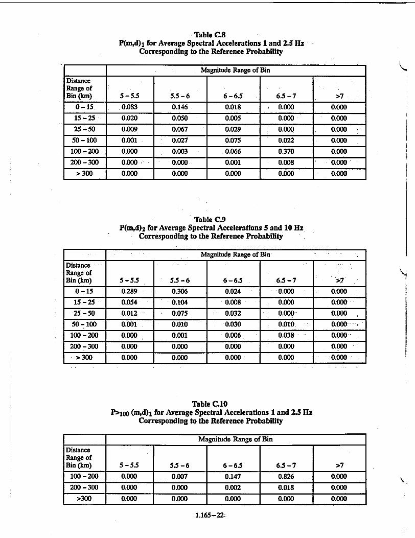
Tables C.8 and C.9 show P(m,d)I and P(m,d)2 for the average of 1 and 2.5 Hz and 5 and 10 Hz, respectively.
Step 5
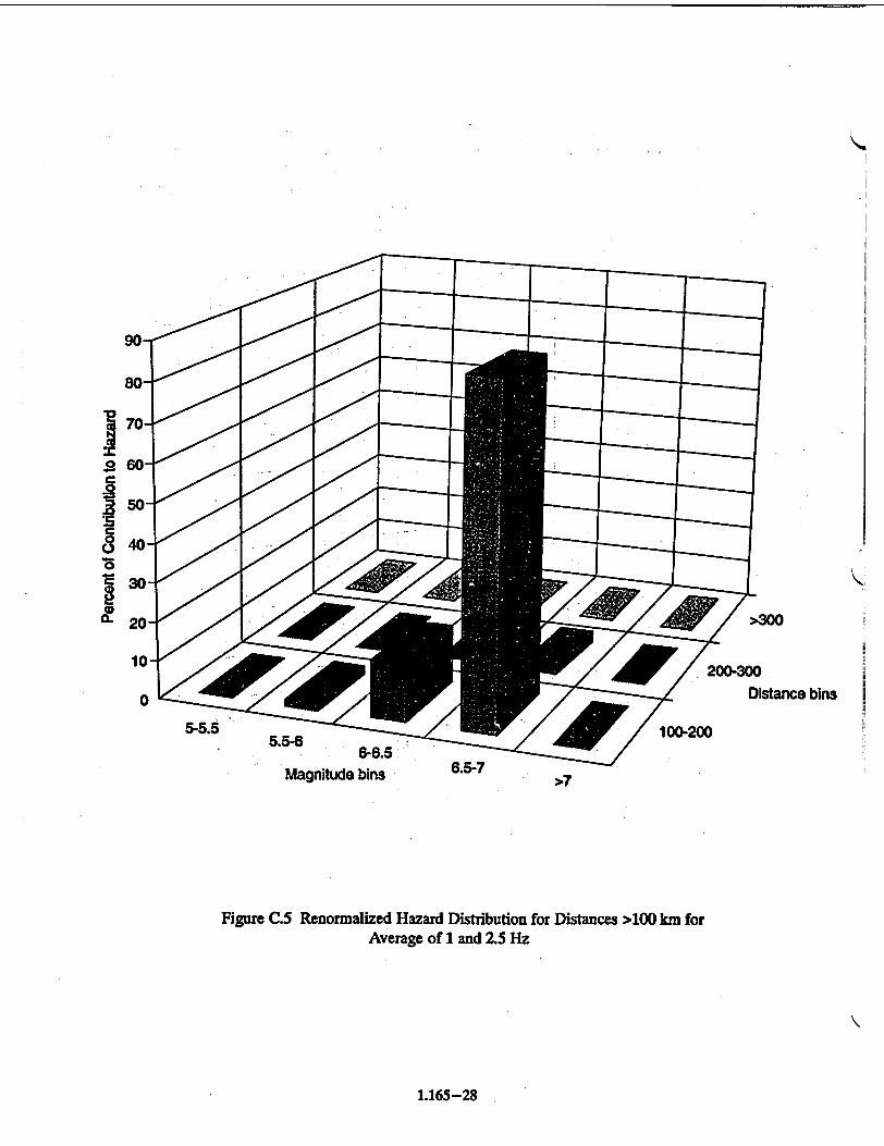
Because the contribution of the distance bins greater than 100 km in Table C.8 contains more than 5% of the total hazard for the average of 1 and 2.5 Hz, the controlling earthquake for the spectral average of 1 and 2.5 Hz will be calculated using magnitude-distance bins for distance greater than 100 kmn. Table C.1O shows P>I00 (md)l for the average of 1 to 2.5 Hz.
1,165-19
,II

Table C.2 Ground Motion Levels
Frequency (Hz) 1 1 2.5 5 10
Spectral Acc. (cm/s/s) I 88 258 351 551
Table C.3 Average Ground Motion Values
Sal-2.5 (cm/s/s) 173
S -s.io (cra/s/s) 451
Table C.4 Median Exceeding Probability Values for Spectral Accelerations
at I Hz (88 cm/s/s)
Distance Range of Bin (km) 5-5.5 5.5-6 6-6.5 6.5-7 >7
0-15 1.98E-08 9.44E-08 1.14E-08 0 0
15-25 4.03E-09 2.58E-08 2.40E-09 0 0
25-50 1.72E-09 3.03E-08 2.14E-08 0 0
50-100 2.35E-10 1.53E-08 7.45E-08 2.50E-08 0
100-200 1.OOE-11 2.36E-09 8.53E-08 6.101-07 0
200 - 300 0 1.90E-11 1.60E.-09 1.84E-08 0
> 300 0 0 8.99E-12 1.03E--11 1.69E-10
Table C.5 Median Exceeding Probability Values for Spectral Accelerations
at 2.5 Hz (258 cm/s/s)
Magnitude Range of Bin
Distance Range of Bin (km) 5-5.5 5.5-6. 6-6.5 6.5 -7 >7
0-15 2.24E-07 3.33E-07 4.12E-08 0 0
15-25 5.39E-08 1.20E-07 1.08E-08 0 0
25-50 2.60E-08 1.68E-07 6.39E-08 0 0
50-100 3.91E-09 6.27E-08 1.46E-07 4.09E-08 0
100-200 1.50E-10 7.801E-09 1.07E-07 4.75E-07 0
200 -300 7.16E-14 2.07E-11 7.47E-10 5.02E-09 0
> 300 0 1.52E-14 4.94E-13 9.05E-15 2.36E-15
1.165-20 -,
K
Magnitude Range of Bin
K

Table 0.6 Median Exceeding Probability Values for Spectral Accelerations
at 5 Hz (351 cm/sls)
Distance Range of Bin (kmi) 5-5.5 5.5-6 6-6.5 6.5-7 >7
0-15 4.96E-07 5.85E-07 5.16E-08 0 0
15-25 9.39E-08 2.02E-07 1.36E-08 •0 0
25-50 2.76E-08 1.84E-07. 7.56E-08 0 0
50- 100 1.23E-08 3.34E-08 9.98E-08 2.85E-08 0
100 - 200 8.06E-12 1.14E-09 2.54E-08 1.55E-07 0
200 -300 0 2.39E-13 2.72E-11 4.02E-10 0
> 300 0 0 0 0 0
Table C.7 Median Exceeding Probability Values for Spectral Accelerations
at 10 Hz (551 cmlsls)
_ __Magnitude Range of Bin.
Distance Range of Bin (km) 5-5.5 5.5-6 6-6.5 6.5-7 >7
0-15 1.11E-06 1.12E-06 8.30E-08 0 0
15-25 2.07E-07 3.77E-07 3.12E-08 0 0
25 -50 4.12E-08 235E-07 1.03E-07 0 0
50-100 5.92E-10 2.30E-08 6.89E-08 2.71E-08 0
S100-200 1.26E-12 1.69E-10 6.66E-09 5.43E-08 0
200-300 0 3.90E-15 6.16E-13 2.34E-11 0
> 300 0 0 0 0 0
1.165-21
Magnitude Range of Bin
STable C.8 P(m,d)1 for Average Spectral Accelerations 1 and 2.5 Hz
Corresponding to the Reference Probability
_ _ _Magnitude Range of Bin
Distance Range of Bin (km) 5-5.5 5.5-6 6-6.5 6.5-7 >7
0-15 0.083 0.146 0.018 0.000 0.000
15-25 0.020 0.050 0.005 0.000 0.000
25-50 0.009 0.067 0.029 0.000 0.000
50-100 0.001 0.027 0.075 0.022 0.000
100-200 0.000 0.003 0.066 0.370 0.000
200 -300 0.000 0.000 0.001 0.008 0.000
300 0.000 0.000 0.000 0.000 0.000
Table C.9 P(m,d)2 for Average Spectral Accelerations 5 and 10 Hz
Corresponding to the Reference Probability
_________Magnitude Range of Bin
Distance Range of Bin (km) 5-5.5 5.5-6 6-6.5 6.5-7 >7
0-15 0.289 0.306 0.024 0.000 0.000
15-25 0.054 0.104 0.008 0.000 0.000
25 -50 0.012 0.075 - 0.032 0.000 0.000
50-100 0.001 0.010 .-0.030 0.010 " 0.000 .100-200 0.000 0.001 0.006 0.038 0.000
200-300 0.000 0.000 0.000 0.000 0.000
- > 300 0.000 0.000 0.000 0.000 0.000
Table C.10 P> 1 00 (m,d)l for Average Spectral Accelerations 1 and 2.5 Hz
Corresponding to the Reference Probability
Magnitude Range of Bin
Distance Range of Bin (km) 5-5.5 5.5-6 6-6.5 6.5-7 >7
100-200 0.000 0.007 0.147 0.826 0.000
200-300 0.000 0.000 0.002 0.018 0.000
>300 0.000 0.000 0.000 0.000 0.000
1.165-22-

Figures C.3 to C.5 show the above information in terms of the relative percentage contribution.
Steps 6 and 7
To compute the controlling magnitudes and distances at 1 to 2.5 Hz and 5 to 10 Hz for the example site, the values of P> 100 (m,d)l and P(m,d)2 are used with m and d values corresponding to the mid-point of the magnitude of the bin (5.25, 5.75, 6.25, 6.75, 7.3) and centroid of the ring area (10, 20.4, 38.9, 77.8, 155.6, 253.3, and somewhat arbitrarily 350 km). Note that the mid-point of the last magnitude bin may change because this value is dependent on the maximum magnitudes used in the hazard analysis. For this example site, the controlling earthquake characteristics (magnitudes and distances) are given in Table C.11.
Step 8
The SSE response spectrum is determined by the procedures described in Appendix F.
C.4 SITES NOT IN THE CEUS
The determination of the controlling earthquakes and the seismic hazard information base for sites not in the CEUS is also carried out using the procedure described in Section C.2 of this appendix. However, because of differences in seismicity rates and ground motion attenuation at these sites, alternative magnitude-distance bins may have to be used. In addition, as discussed in Appendix B, an alternative reference probability may also have to be developed, particularly for sites in the active plate margin region and for sites at which a known tectonic structure dominates the hazard.
Table C.11 Magnitudes and Distances of Controlling Earthquakes
from the LLNL Probabilistic Analysis
1-2.51Hz 5 - 10Hz
Mc and Dc > 100 km MK and Dc 6.7 and 157 km 5.7 and 17 km
1.165-23
.I I II

K
.01. e "01-0-.., 1H z
.01 e- no."•
~~N.
1 e-6
I e-8
Ile-9
• .
\ N le--85
*.
10 100 1000 Sa ~cm/s**2
Figure C.A Total Median Hazard Curves
1.165-24

.001
le-4
1 e-5
le-6
1 e-7
1 e-8
1 e-9 10 100 1000
Sa - cm/s**2
Figure C.2 1 Hz Median Hazard'Curve forDistance Bin 25 - 50 km & Magnitude Bin 6 - 6.5
1,165-25

Magnitude bins
"D5c 25-50 50-100 0
Distance bins 1020200-300 > 300
Figure C.3 Full Distribution for Average of 5 and 10 Hz
K
1.165--26
0
0
"I'5 0.

35
.0 •)25
.0
- 15
•. O••66.5->7
Magnitude bins
5-5.50-15 15-25 " •"--• .• 25-50 50-100 100-200 200-300
Distance bins > 300
Figure C.4 Full Distribution for Average of 1 and 2.5 Hz
1.165-27
I I
/>300 200-300
Distance bins
Man5 d b6-6.5
Magnitude bins 6.5-7">7
Figure C.5 Renormalized Hazard Distribution for Distances >100 km for Average of I and 2.5 Hz
1.165-28
K
0.

REFERENCES
C.1 P. Sobel, "Revised Livermore Seismic Hazard Estimates for Sixty-Nine Nuclear Power Plant Sites East of the Rocky Mountains, NUREG-1488, USNRC, April 1994.1
lCopies are available for inspection or copying for a fee from the NRC Public Document Room at 2120 LStreet NW., Washington, DC; the PDR's mailing address is Mail Stop LL-6, Washington, DC 20555; telephone (202)634-3273; fax (202)634-3343. Copies may be purchased at current rates from the U.S. Government Printing Office, P.O. Box 37082, Washington, DC 20402-9328 (telephone (202)512-2249); or from the National Technical Information Service by writing NTIS at 5285 Port Royal Road, Springfield, VA 22161.
C.2 J.B. Savy et al., "Eastern Seismic Hazard Characterization Update," UCRL-ID-115111, Lawrence Livermore National Laboratory, June 1993 (Accession number 9310190318 in NRC's Public Document Room).2
2Copies are available for inspection or copying for a fee from the NRC Public Document Room at 2120 LStreet NW., Washington, DC; thePDR's mailing address is Mail Stop LL-6, Washington, DC 20555; telephone (202)634-3273; fax (202)634-3343.
1.165-29

APPENDIX D GEOLOGICAL, SEISMOLOGICAL, AND GEOPHYSICAL INVESTIGATIONS
TO CHARACTERIZE SEISMIC SOURCES
D.W INTRODUCTION
As characterized for use in probabilistic seismic hazard analyses (PSHA), seismic sources are zones within which future earthquakes are likely to occur at the same recurrence rates. Geological, seismological, and geophysical investigations provide the information needed to identify and characterize source parameters, such as size and geometry, and to estimate earthquake recurrence rates and maximum magnitudes. The amount of data available about earthquakes and their causative sources varies substantially between the Western United States (west of the Rocky Mountain front) and the Central and Eastern United States (CEUS), or stable continental region (SCR) (east of the Rocky Mountain front). Furthermore, there are variations in the amount and quality of data within these regions.
In active tectonic regions there are both capable tectonic sources and seismogenic sources, and because of their relatively high activity rate they may be more readily identified. In the CEUS, identifying seismic sources is less certain because of the difficulty in correlating earthquake activity with known tectonic structures, the lack of adequate knowledge about earthquake causes, and the relatively lower activity rate. However, several significant tectonic structures exist and some of these have been interpreted as potential seismogenic sources (e.g., the New Madrid fault zone, Nemaha Ridge, and Meers fault).
In the CEUS there is no single recommended procedure to follow to characterize maximum magnitudes associated with such candidate seismogenic sources; therefore, it is most likely that the determination of the properties of the seismogenic source, whether it is a tectonic structure or a seismotectonic province, will be inferred rather than demonstrated by strong correlations with seismicity or geologic data. Moreover, it is not generally known what relationships exist between observed tectonic structures in a seismic source within the CEUS and the current earthquake activity that may be associated with that source. Generally, the observed tectonic structure resulted from ancient tectonic forces that are no longer present. The historical seismicity record, the results of regional and site studies, and judgment play key
roles. If, on the other hand, strong correlations and data exist suggesting a relationship between seismicity and seismic sources, approaches used for more active tectonic regions can be applied.
The primary objective of geological, seismological, and geophysical investigations is to develop an upto-date, site-specific earth science data base that supplements existing information (Ref. D.1). In the CEUS the results of these investigations will also be used to assess whether new data and their interpretation are consistent with the information used as the basis for accepted probabilistic seismic hazard studies. If the new data are consistent with the existing earth science data base, modification of the hazard analysis is not required. For sites in the CEUS where there is significant new information (see Appendix E) provided by the site investigation, and for sites in the Western United States, site-specific seismic sources are to be determined. It is anticipated that for most sites in the CEUS, new information will have been adequately bounded by existing seismic source interpretations.
The following is a general list of characteristics to be evaluated for a seismic source for site-specific source interpretations:
"* Source zone geometry (location and extent, both surface and subsurface),
"• Historical and instrumental seismicity associated with each source,
"* Paleoseismicity,
* Relationship of the potential seismic source to other potential seismic sources in the region,
"* Seismic potential of the seismic source, based on the source's known characteristics, including seismicity,
"* Recurrence model (frequency of earthquake occurrence versus magnitude),
"* Other factors that will be evaluated, depending on the geologic setting of a site, such as:
* Quaternary (last 2 million years) displacements (sense of slip on faults, fault length and width, area of the fault plane, age of displacements, estimated displacement per event, estimated magnitude per offset, segmentation, orientations of regional tectonic stresses with
1.165-30
1%

respect to faults, and displacement history or uplift rates of seismogenic folds),
* The late Quaternary interaction between faults that compose a fault system and the
-' interaction between fault systems.
* Effects of human activities such as withdrawal of fluid from or addition of fluid to the subsurface, extraction of minerals, or the construction of dams and reservoirs,
* Volcanism. Volcanic hazard is not addressed in this regulatory guide. It will be considered on a case-by-case basis in regions where a potential for this hazard exists.
D.2. INVESTIGATIONS TO EVALUATE
SEISMIC SOURCES
D.2.1 General
Investigations of the site and region around the site are necessary to identify both seismogenic sources and capable tectonic sources and to determine their potential for generating earthquakes and causing surface deformation. If it is determined that surface deformation need not be taken into account at the site, sufficient data to clearly justify the determination should be presented in the application for an early site permit, construction permit, operating license, or combined license. Generally, any tectonic deformation at the earth's surface within 40 km (25 miles) of the site will require detailed examination to determine its significance. Potentially active tectonic deformation within the seismogenic zone beneath a site will have to be assessed using geophysical and seismological methods to determine its significance.
Engineering solutions are generally available to mitigate the potential vibratory effects of earthquakes through design. However, engineering solutions cannot always be demonstrated to be adequate for mitigation of the effects of permanent ground displacement phenomena such as surface faulting or folding, subsidence, or ground collapse. For this reason, it is prudent to select an alternative site when the potential for permanent ground displacement exists at the proposed site (Ref. D.2).
In most of the CEUS, instrumentally located earthquakes seldom bear any relationship to geologic structures exposed at the ground surface. Possible geologically young fault displacements either do not extend to the ground surface or there is insufficient geologic material of the appropriate age available to date the faults. Capable tectonic sources are not always exposed at the ground surface in the Western United States as demon-
strated by the buried (blind) reverse causative faults of the 1983 Coalinga,1988 Whittier Narrows, 1989 Loma Prieta, and 1994 Northridge earthquakes. These factors emphasize the need to conduct thorough investigations not only at the ground surface but also in the subsurface to identify structures at seismogenic depths.
The level of detail for investigations should be governed by knowledge of the current and late Quaternary tectonic regime and the geological complexity of the site and region. The investigations should be based on increasing the amount of detailed information as they proceed from the regional level down to the site area (e.g., 320 km to 8 km distance from the site). Whenever faults or other structures are encountered at a site (including sites in the CEUS) in either outcrop or excavations, it is necessary to perform many of the investigations described below to determine whether or not they are capable tectonic sources.
The investigations for determining seismic sources should be carried out at three levels, with areas describedby radii of 320 km (200 mi), 40 km (25 mi), and 8 km (5 mi) from the site. The level of detail increases closer to the site. The specific site, to a distance of at least 1 km (0.6 mi), should be investigated in more detail than the other levels.
The regional investigations [within a radius of 320 *km (200 mi) of the site] should be planned to identify seismic sources and describe the Quaternary tectonic regime. The data should be presented at a scale of 1:500,000 or smaller. The investigations are not expected to be extensive or in detail, but should include a comprehensive literature review supplemented by focused geological reconnaissances based on the results of the literature study (including topographic, geologic, aeromagnetic, and gravity maps, and airphotos). Some detailed investigations at specific locations within the region may be necessary if potential capable tectonic sources, or seismogenic sources that may be significant for determining the safe shutdown earthquake ground motion, are identified.
The large size of the area for the regional investigations is recommended because of the possibility that all significant seismic sources, or alternative configurations, may not have been enveloped by the LLNL/EPRI data base. Thus, it will increase the chances of (1) identifying evidence for unknown seismic sources that might extend close enough for earthquake ground motions generated by that source to affect the site and (2) confirming the PSHA's data base. Furthermore, because of the relatively aseismic nature of the CEUS, the area should be large enough to include as many historical and instrumentally recorded earthquakes for
1.165-31
1 11 'i t

analysis as reasonably possible. The specified area of study is expected to be large enough to incorporate any previously identified sources that could be analogous to sources that may underlie or be relatively close to the site. In past licensing activities for sites in the CEUS, it has often been necessary, because of the absence of datable horizons overlying bedrock, to extend investigations out many tens or hundreds of kilometers from the site along a structure or to an outlying analogous structure in order to locate overlying datable strata or unconformities so that geochronological methods could be applied. This procedure has also been used to estimate the age of an undatable seismic source in the site vicinity by relating its time of last activity to that of a similar, previously evaluated structure, or a known tectonic episode, the evidencý of which may be many tens or hundreds of miles away.
In the Western United States it is often necessary to extend the investigations to great distances (up to hundreds of kilometers) to characterize a major tectonic structure, such as the San Gregorio-Hosgri Fault Zone and the Juan de Fuca Subduction Zone. On the other hand, in the Western United States it is not usually necessary to extend the regional investigations that far in all directions. For example, for a site such as Diablo Canyon, which is near the San Gregorio-Hosgri Fault, it would not be necessary to extend the regional investigations farther east than the dominant San Andreas Fault, which is about 75 km (45 mi) from the site; nor west beyond the Santa Lucia Banks Fault, which is about 45 km (27 mi). Justification for using lesser distances should be provided.
Reconnaissance-level investigations, which may need to be supplemented at specific -locations by more detailed explorations such as geologic mapping, geophysical surveying, borings, and trenching, should be conducted to a distance of 40 km (25 mi) from the site; the data should be presented at a scale of 1:50,000 or smaller.
Detailed investigations should be carried out within a radius of 8 km (5 mi) from the site, and the resulting data should be presented at a scale of 1:5,000 or smaller. The level of investigations should be in sufficient detail to delineate the geology and the potential for tectonic deformation at or near the ground surface. The investigations should use the methods described in subsections D.2.2 and D.2.3 that are appropriate for the tectonic regime to characterize seismic sources.
The areas of investigations may be asymmetrical and may cover larger areas than those described above in regions of late Quaternary activity, regions with high
rates of historical seismic activity (felt or instrumentally recorded data), or sites that are located near a capable tectonic source such as a fault zone.
Data from investigations at the site (approximately 1 square kilometer) should be presented at a scale of 1:500 or smaller. Important aspects of the site investigations are the excavation and logging of exploratory trenches and the mapping of the excavations for the plant structures, particularly plant structures that are characterized as Seismic Category I. In addition to geological, geophysical, and seismological investigations, detailed geotechnical engineering investigations as described in Regulatory Guide 1.132 (Ref. D.3) should be conducted at the site.
The investigations needed to assess the Suitability of the site with respect to effects of potential ground motions and surface deformation should include determination of (1) the lithologic, stratigraphic, geomorphic, hydrologic, geotechnical, and structural geologic characteristics of the site and the area surrounding the site, including its seismicity and geological history, (2) geological evidence of fault offset or other distortion such as folding at or near ground surface within the site area (8 km radius), and (3) whether or not any faults or other tectonic structures, any part of which are within a radius of 8 km (5 mi) from the site, are capable tectonic sources. This information will be used to evaluate tectonic structures underlying the site area, whether buried or expressed at the surface, with regard to their potential for generating earthquakes and for causing surface deformation at or near the site. This partof the evaluation should also consider the possible effects caused by human activities such as withdrawal of fluid from or addition of fluid to the subsurface, extraction of minerals, or the loading effects of dams and reservoirs.
D.1.2 Reconnaissance Investigations, Literature Review, and Other Sources of Preliminary Information
Regional literature and reconnaissance-level investigations can be planned based on reviews of available documents and the results of previous investigations. Possible sources of information may include universities, consulting firms, and government agencies. A detailed list of possible sources of information is given in Regulatory Guide 1.132 (Ref. D.3).
D.2.3 Detailed Site Vicinity and Site Area Investigations
The following methods are suggested but they are not all-inclusive and investigations should not be limited to them. Some procedures will not be applicable to
1.165-32
K

every site, and situations will occur that require investigations that are not included in the following discussion. It is anticipated that new technologies will be available in the future that will be applicable to these investigations.
D.2.3.1 Surface Investigations
Surface exploration needed to assess the neotectonic regime and the geology of the area around the site is dependent on the site location and may be carried out with the use of any appropriate combination of the geological, geophysical, seismological, and geotechnical engineering techniques summarized in the following paragraphs and Ref. D.3. However, not all of these methods must be carried out at a given site.
D.2.3.1.1. Geological interpretations of aerial photographs and other remote-sensing imagery, as appropriate for the particular site conditions, to assist in identifying rock outcrops, faults and other tectonic features, fracture traces, geologic contacts, lineaments, soil conditions, and evidence of landslides or soil liquefaction.
D.2.3.1.2. Mapping of topographic, geologic, geomorphic, and hydrologic features at scales and with contour intervals suitable for analysis, stratigraphy (particularly Quaternary), surface tectonic structures such as fault zones, and Quaternary geomorphic features. For offshore sites, coastal sites, or sites located near lakes or rivers, this includes topography, geomorphology (particularly mapping marine and fluvial terraces), bathymetry, geophysics (such as seismic reflection), and hydrographic surveys to the extent needed for evaluation.
D.2.3.1.3. Identification and evaluation of vertical crustal movements by (1) geodetic land surveying to identify and measure short-term crustal movements (Refs. D.4 and D.5) and (2) geological analyses such as analysis of regional dissection and degradation patterns, marine and lacustrine terraces and shorelines, fluvial adjustments such as changes in stream longitudinal profiles or terraces, and other long-term changes such as elevation changes across lava flows (Ref. D.6).
D.2.3.1.4. Analysis of offset, displaced, or anomalous landforms such as displaced stream channels or changes in stream profiles or the upstream migration of knickpoints (Refs. D.7 through D.12); abrupt changes in fluvial deposits or terraces; changes in paleochannels across a fault (Refs. D.11 and D.12); or uplifted, downdropped, or laterally displaced marine terraces (Ref. D.12).
D.2.3.1.5. Analysis of Quaternary sedimentary deposits within or near tectonic zones, such as fault zones, including (1) fault-related or fault-controlled deposits such as sag ponds, graben fill deposits, and colluvial wedges formed by the erosion of a fault paleoscarp and (2) non-fault-related, but offset, deposits such as alluvial fans, debris cones, fluvial terrace, and lake shoreline deposits.
D.2.3.1.6. Identification and analysis of deformation features caused by vibratory ground motions, including seismically induced liquefaction features (sand boils, explosion craters, lateral spreads, settlement, soil flows), mud volcanoes, landslides, rockfalls, deformed lake deposits or soil horizons, shear zones, cracks or fissures (Refs. D.13 and D.14).
D.2.3.1.7. Analysis of fault displacements, such as by the interpretion of the morphology of topographic fault scarps associated with or produced by surface rupture. Fault scarp morphology is useful in estimating the age of last displacement (in conjunction with the appropriate geochronological methods described in Subsection D.2.4, approximate size of the earthquake, recurrence intervals, slip rate, and the nature of the c ausative fault at depth (Refs. D.15 through D.18).
D.2.3.2 Seismological Investigations
D.2.3.2.1. Listing of all historically reported earthquakes having Modified Mercalli Intensity (MMI) greater than or equal to IV or magnitude greater than or equal to 3.0 that can reasonably be associated with seismic sources, any part of which is within a radius of 320 km (200 miles) of the site (the site region). The earthquake descriptions should include the date of occurrence and measured or estimated data on the highest intensity, magnitude, epicenter, depth, focal mechanism, and stress drop. Historical seismicity includes both historically reported and instrumentally recorded data. For earthquakes without instrumentally recorded data or calculated magnitudes, intensity should be converted to magnitude, the procedure used to convert it to magnitude should be clearly documented, and epicenters should be determined based on intensity distributions. Methods to convert intensity values to magnitudes in the CEUS are described in References D.1 and D.19 through D.21.
D.2.3.2.2. Seismic monitoring in the site area should be established as soon as possible after site selection. For sites in both the CEUS and WUS, a single large dyn amic range, broad-band seismograph, and a network of short period instruments to locate events should be deployed around the site area.
1.165-33

The data obtained by monitoring current seismicity will be used, along with the much larger data base acquired from site investigations, to evaluate site response and to provide information about whether there are significant sources of earthquakes within the site vicinity, or to provide data by which an existing source can be characterized.
Monitoring should be initiated as soon as practicable at the site, preferably at least five years prior to construction of a nuclear unit at a site, and should continue at least until the free field seismic monitoring strong ground motion instrumentation described in Regulatory Guide 1.12 (Ref. D.22) is operational.
D.2.33 Subsurface Investigations
Ref. D.3 describes geological, geotechnical, and geophysical investigation techniques that can be applied to explore the subsurface beneath the site and in the region around the site, therefore, only a brief summary is provided in this section. Subsurface investigations in the site area and vicinity to identify and define seismogenic sources and capable tectonic sources may' include the following.
D.2.3.3.1. Geophysical investigations that have been useful in the past include, for example, magnetic and gravity surveys, seismic reflection and seismic refraction surveys, borehole geophysics, electrical surveys, and ground-penetrating radar surveys.
D.2.33.2. Core borings to map subsurface geology and obtain samples for testing such as determining the properties of the subsurface soils and rocks and geochronological analysis.
D.2.3.3.3. Excavating and logging of trenches across geological features as part of the neotectonic investigation and to obtain samples for the geochronological analysis of those features.
At some sites, deep unconsolidated material/soil, bodies of water, or other material may obscure geologic evidence of past activity along a tectonic structure. In such cases, the analysis of evidence elsewhere along the structure can be used to evaluate its characteristics in the vicinity of the site (Refs. D.12 and D.23).
D.2.4 Geochronology
An important part of the geologic investigations to identify and define potential seismic sources is the geochronology of geologic materials. An acceptable classification of dating methods is based on the rationale described in Reference D.24. The following techniques, which are presented according to that classification, are useful in dating Quaternary deposits. A de-
tailed discussion of each of these methods and their application to nuclear power plant siting is presented in a document that is currently under preparation and will be published as a NUREG.1
D.2.4.1 0
0
0
D.2.4.2 0
S
0
0
0
0
D±4.4 S
0
0
Sidereal Dating Methods
Dendrochronology
Varve chronology
Schlerochronology
Isotopic Dating Methods
Radiocarbon
Cosmogenic nuclides -M36 , 1OBe, 21pb, and 26A1
Potassium argon and argon-39-argon-40
Uranium series - 234U-23°'h and 235U231Pa 2 10Lead
Uranium-lead, thorium-lead
Radiogenic Dating Methods
Fission track
Luminescence (TL and OSL)
Electron spin resonance (ESR)
D.2.4.5 Chemical and Biological Dating Methods
0
0
0
D.2.4.6 S
0
0
Amino acid racemization
Obsidian and tephra hydration
Lichenometry
Geomorphic Dating Methods
Soil profile development
Rock and mineral weathering
Scarp morphology
D.2.4.7 Correlation Dating Methods * Paleomagnetism (secular variation and re
versal stratigraphy) • Tephrochronology
0
S
Paleontology (marine and terrestrial)
Global climatic correlations - Quaternary deposits and landforms, marine stable isotope records, etc.
1NUREG/CR-5562, "Quaternary Geochronology: Applications in Qua. ternary Geology and Paleoseismology," Editors H.S. Noller, LM. Sow. era, and W.R. Lettis, will be published in the spring of 1997. Copies will be available for inspection or copying for a fee from the NRC Public Document Room at 2120 L Street NW., Washington. DC; the PDR's mailing address is Mail Stop LL-6, Washington, DC 20555; telephone (202)634-3273; fax (202)53-41-3343.
K
1.165-34
In the CEUS, it may not be possible to reasonably demonstrate the age of last activity of a tectonic structure. In such cases the NRC staff will accept association of such structures with geologic structural features or tectonic processes that are geologically old (at least preQuaternary) as an age indicator in the absence of conflicting evidence.
These investigative procedures should also be applied, where possible, to characterize offshore structures (faults or fault zones, and folds, uplift, or subsidence related to faulting at depth) for coastal sites or those sites located adjacent to landlocked bodies of water. Investigations of offshore structures will rely heavily on seismicity, geophysics, and bathymetry rather than conventional geologic mapping methods that normally can be used effectively onshore. However, it is often useful to investigate similar features onshore to learn more about the significant offshore features.
D.2.5 Distinction Between Tectonic and Nontectonic Deformation
At a site, both nontectonic deformation and tectonic deformation can pose a substantial hazard to nuclear power plants, but there are likely to be differences in the approaches used to resolve the issues raised by the two
-" types of phenomena. Therefore, nontectonic deformation should be distinguished from tectonic deformation at a site. In past nuclear power plant licensing activities, surface displacements caused by phenomena other than tectonic phenomena have been confused with tectonically induced faulting. Such features include faults on which the last displacement was induced by glaciation or deglaciation; collapse structures, such as found
in karst terrain; and growth faulting, such as occurs in the Gulf Coastal Plain or in other deep soil regions subject to extensive subsurface fluid withdrawal.
Glacially induced faults generally do not represent a deep-seated seismic or fault displacement hazard because the conditions that created them are no longer present. However, residual stresses from Pleistocene glaciation may still be present in glaciated regions, although they are of less concern than active tectonically induced stresses. These features should be investigated with respect to their relationship to current in situ stresses.
The nature of faults related to collapse features can usually be defined through geotechnical investigations and can either be avoided or, if feasible, adequate engineering fixes can be provided.
Large, naturally occurring growth faults as found in the coastal plain of Texas and Louisiana can pose a surface displacement hazard, even though offset most likely occurs at a much less rapid rate than that of tec
"tonic faults. They are not regarded as having the capacity to generate damaging vibratory ground motion, can often be identified and avoided in siting, and their displacements can be monitored. Some growth faults and antithetic faults related to growth faults are not easily identified; therefore, investigations described above with respect to capable faults and fault zones should be applied in regions where growth faults are known to be present. Local human-induced growth faulting can be monitored and controlled or avoided.
. If questionable features cannot be demonstrated to be of nontectonic origin, they should be treated as tectonic deformation.
1.165-35
I II f I

REFERENCES
D.1 Electric Power Research Institute, "Seismic Hazard Methodology for the Central and Eastern United States," EPRI NP-4726,, All Volumes, 1988 through.1991,
D.2 International Atomic Energy Agency, "Earthquakes and Associated Topics in Relation to Nuclear Power Plant Siting," Safety Series No. 50-SG-S1, Revision 1, 1991.
D.3 USNRC, "Site Investigations for Foundations of Nuclear Power Plants," Regulatory Guide 1.132.1
D.4 R. Reilinger, M. Bevis, and G. Jurkowski, "Tilt from Releveling: An Overview of the U.S. Data Base," Tectonophysics, Volume 107, pp. 315330, 1984.
D.5 R.K. Mark et al., "An Assessment of the Accuracy of the Geodetic Measurements that Led to the Recognition of the'Southern California Uplift," Journal of Geophysical Research, Volume 86, pp. 2783-2808, 1981.
D.6 T.K. Rockwell et al., "Chronology and Rates of Faulting of Ventura River Terraces, California," Geological Society ofAmerica Bulletin, Volume 95, pp. 1466-1474, 1984.
D.7 K.E. Sieh, "Lateral Offsets and Revised Dates of Prehistoric Earthquakes at Pallett Creet, Southern California," Journal of Geophysical Research, Volume 89, No. 89, pp. 7641-7670, 1984.
D.8 K.E. Sieh and R.H. Jahns, "Holocene Activity of the San Andreas Fault at Wallace Creek, California," Geological Society of America Bulletin, Volume 95, pp. 883-896, 1984.
D.9 K.E. Sieh, M. Stuiver, and D. Brillinger, "A More Precise Chronology of Earthquakes Produced by the San Andreas Fault in Southern California,"
ISingle copies of the regulatory guides, both active and draft, may be obtained free of charge by writing the Office of Administration, Attn: Distribution and Mail Services Section, USNRC, Washington, DC 20555, or by fax at (301)415-2260. Copies are available for inspection or copying for a fee from the NRC Public Document Room at 2120 L Street NW., Washington, DC; the PDR's mailing address is Mail Stop LL,-6, Washington, DC 20555; telephone (202)634-3273; fax (202)634-3343.
Journal of Geophysical Research, Volume 94, pp. 603-623, 1989.
D.10 R.J. Weldon, III, and K.E. Sieh, "Holocene Rate of Slip and Tentative Recurrence Interval for Large Earthquakes on the San Andreas Fault, Cajon Pass, Southern California," Geological Society ofAmerica Bulletin, Volume 96, pp. 793-812, 1985.
D.11 F.H. Swan, III, D.P. Schwartz, and LS. Cluff, "Recurrence of Moderate to Large Magnitude Earthquakes Produced by Surface Faulting on the Wasatch Fault Zone," Bulletin of the Seismological Society of America, Volume 70, pp, 1431-1462, 1980.
D.12 Pacific Gas and Electric Company, "Final Report of the Diablo Canyon Long Term Seismic Program; Diablo Canyon Power Plant;" Docket Nos. 50-275 and 50-323, 1988.2
D.13 S.F. Obermeier et al., "Geologic Evidence for Recurrent Moderate to Large Earthquakes Near Charleston, South Carolina," Science, Volume 227, pp. 408-411, 1985.
D.14 D. Amick et al., "Paleoliquefaction Features Along the Atlantic Seaboard," U.S. Nuclear Regulatory Commission, NUREG/CR-5613, October 1990.3
D.15 R.E. Wallace, "Profiles and Ages of Young Fault Scarps, North-Central Nevada," Geological Society of America Bulletin, Volume 88, pp. 12671281, 1977.
D.16 R.E. Wallace, "Discussion-Nomographs for Estimating Components of Fault Displacement from Measured Height of Fault Scarp," Bulletin of the Association of Engineering Geologists, Volume 17, pp. 39-45, 1980.
2Copies are available for inspection or copying for a fee from the NRC Public Document Room at 2120 L Street NW., Washington, DC; the PDR's mailing address is Mail Stop LL-6, Washington, DC 20555; telephone (202)634-3273; fax (202)634-3343.
3Copies are available for inspection or copying for It fee from the NRC Public Document Room at 2120 L Street NW., Washington, DC; the PDR's mailing address is Mail Stop LL-6, Washington, DC 20555; telephone (202)634-3273; fax (202)634-3343. Copies may be purchased at current rates from the U.S. Government Printing Office, P.O. Box 37082, Washington, DC 20402-9328 (telephone (202)512-2249; or from the National Technical Information Service by writing NTIS at 5285 Port Roal Road, Springfield, VA 22161.
1,165-36
K

D.17 R.E. Wallace, "Active Faults, Paleoseismology, and Earthquake Hazards: Earthquake Prediction-An International Review," Maurice Ewing Series 4, American Geo1physical Union, pp. 209-216, 1981.
D.18 A.J. Crone and S.T. Harding, "Relationship of Late Quaternary Fault Scarps to Subjacent Faults, Eastern Great Basin, Utah," Geology, Volume 12, pp. 292-295, 1984.
D.19 O.W. Nuttli, "The Relation of Sustained Maximum Ground Acceleration and Velocity to Earthquake Intensity and Magnitude, State-of- the-Art for Assessing Earthquake Hazards in the Eastern United States," U.S. Army Corps of Engineers Misc. Paper 5-73-1, Report 16, 1979.
D.20 R.L. Street and F.T. Turcotte, "A Study of Northeastern North America Spectral Moments, Magnitudes and Intensities," Bulletin of the Seismo-
logical Society of America, Volume 67, pp. 599-614, 1977.
D.21 R.L. Street and A. Lacroix, "An Empirical Study of New England Seismicity," Bulletin of the Seismological Society of America, Volume 69, pp. 159-176, 1979.
D.22 USNRC, "Nuclear Power Plant Instrumentation for Earthquakes," Regulatory Guide 1.12, Revision 2.1
D.23 H. Rood et al., "Safety Evaluation Report Related to the Operation of Diablo Canyon Nuclear Power Plant, Units I and 2," USNRC, NUREG-0675, Supplement No. 34, June 1991.3
D.24 S.M. Colman, K.L Pierce, and P.W. Birkeland, "Suggested Terminology for Quaternary Dating Methods," Quaternary Research, Volume 288, pp. 314-319, 1987.
1.165-37
1 1

APPENDIX E PROCEDURE FOR THE EVALUATION OF NEW GEOSCIENCES INFORMATION
OBTAINED FROM THE SITE-SPECIFIC INVESTIGATIONS
E.1 INTRODUCTION
This appendix provides methods acceptable to the NRC staff for assessing the impact of new information obtained during site-specific investigations on the data base used for the probabilistic seismic hazard analysis (PSHA).
Regulatory Position 4 in this guide describes, acceptable PSHAs that were developed by Lawrence Livermore National Laboratories (LLNL) and the Electric Power Research Institute (EPRI) to characterize the seismic hazard for nuclear power plants and to develop the Safe Shutdown Earthquake ground motion (SSE). The procedure to determine the SSE outlined in this guide relies primarily on either the LLNL or EPRI PSHA results for the Central and Eastern United States (CEUS).
It is necessary to evaluate the geological, seismological, and geophysical data obtained from the sitespecific investigations to demonstrate that these data are consistent with the PSHA data bases of these two methodologies. If new information identified by the site-specific investigations would result in a significant increase in the hazard estimate for a site, and this new information is validated by a strong technical basis, the PSHA may have to be modified to incorporate the new technical information. Using sensitivity studies, it may also be possible to justify a lower hazard estimate with an exceptionally strong technical basis. However, it is expected that large uncertainties in estimating seismic hazard in the CEUS will continue to exist in the future, and substantial delays in the licensing process will result from trying to justify a lower value with respect to a specific site.
In general, major recomputations of the LLNL and EPRI data base are planned periodically (approximately every ten years), or when there is an important new finding or occurrence. The overall revision of the data base will also require a reexamination of the reference probability discussed in Appendix B.
E.2 POSSIBLE SOURCES OF NEW INFORMATION THAT COULD AFFECT THE SSE
Types of new data that could affect the PSHA results can be put in three general categories: seismic sources, earthquake recurrence models or rates of deformation, and ground motion models.
E.2.1 Seismic Sources
There are several possible sources of new information from the site-specific investigations that could affect the seismic hazard. Continued recording of small earthquakes, including microearthquakes, may indicate the presence of a localized seismic source. Paleoseismic evidence, such as paleoliquefaction features or displaced Quaternary strata, may indicate the presence of a previously unknown tectonic structure or a larger amount of activity on a known structure than was previously considered. Geophysical studies (aeromagnetic, gravity, and seismic reflection/refraction) may identify ckustal structures that suggest the presence of previously unknown seismic sources. In situ stress measurements and the mapping of tectonic structures in the future may indicate potential seismic sources.
Detailed local site investigations often reveal faults or other tectonic structures that were unknown, or reveal additional characteristics of known tectonic structures. Generally, based on past licensing experience in the CEUS, the discovery of such features will not require a modification of the seismic sources provided in the LLNL and EPRI studies. However, initial evidence regarding a newly discovered tectonic structure in the CEUS is often equivocal with respect to activity, and additional detailed investigations are required. By means of these detailed investigations, and based on past licensing activities, previously unidentified tectonic structures can usually be shown to be inactive or otherwise insignificant to the seismic design basis of the facility, and a modification of the seismic sources provided by the LLNL and EPRI studies will not be required. On the other hand, if the newly discovered features are relatively young, possibly associated with earthquakes that were large and could impact the hazard for the proposed facility, a modification may be required.
Of particular concern is the possible existence of previously unknown, potentially active tectonic structures that could have moderately sized, but potentially damaging, near-field earthquakes or could cause surface displacement. Also of concern is the presence of structures that could generate larger earthquakes within the region than previously estimated.
Investigations to determine whether there is a possibility for permanent ground displacement are espe-' cially important in view of the provision to allow for a
1.165r38

combined licensing procedure under 10 CFR Part 52 as an alternative to the two-step procedure of the past (Construction Permit and Operating License). In the
~j past at numerous nuclear power plant sites, potentially significant faults were identified when excavations were made during the construction phase prior to the issuance of an operating license, and extensive additional investigations of those faults had to be carried out to properly characterize them.
E.2.2 Earthquake Recurrence Models
There are three elements of the source zone's recurrence models that could be affected by new site-specific data: (1) the rate of occurrence of earthquakes, (2) their maximum magnitude, and (3) the form of the recurrence model, for example, a change from truncated exponential to a characteristic earthquake model. Among the new site-specific information that is most likely to have a significant impact on the hazard is the discovery of paleoseismic evidence such as extensive soil liquefaction features, which would indicate with reasonable confidence that much larger estimates of the maximum earthquake than those predicted by the previous studies would ensue. The paleoseismic data could also be significant even if the maximum magnitudes of the previous studies are consistent with the paleo-earthquakes if there are sufficient data to develop return period estimates significantly shorter than those previously used in the probabilistic analysis. The paleoseismic data could also indicate that a characteristic earthquake model would be more applicable than a truncated exponential model.
In the future, expanded earthquake catalogs will become available that will differ from the catalogs used by the previous studies. Generally, these new catalogues have been shown to have only minor impacts on estimates of the parameters of the recurrence models. Cases that might be significant include the discovery of records that indicate earthquakes in a region that had no seismic activity in the previous catalogs, the occurrence of an earthquake larger than the largest historic earthquakes, re-evaluating the largest historic earthquake to a significantly larger magnitude, or the occurrence of one or more moderate to large earthquakes (magnitude 5.0 or greater) in the CEUS.
Geodetic measurements, particularly satellite*based networks, may provide data and interpretations of rates and styles of deformation in the CEUS that can have implications for earthquake recurrence. New hypotheses regarding present-day tectonics based on new data or reinterpretation of old data may be developed that were not considered or given high weight in the
EPRI or LLNL PSHA. Any of these cases could have an impact on the estimated maximum earthquake if the result is larger than the values provided by LLNL and EPRI.
E.2.3 Ground Motion Attenuation Models
Alternative ground motion models may be used to determine the site-specific spectral shape as discussed in Regulatory Position 4 and Appendix F of this regulatory guide. If the ground motion models used are a major departure from the original models used in the hazard analysis and are likely to have impacts on the hazard results of many sites, a reevaluation of the reference probability may be needed using the procedure discussed in Appendix B. Otherwise, a periodic (e.g., every ten years) reexamination of PSHA and the associated data base is considered appropriate to incorporate new understanding regarding ground motion models.
E.3 PROCEDURE AND EVALUATION
The EPRI and LLNL studies provide a wide range of interpretations of the possible seismic sources for most regions of the CEUS, as well as a wide range of interpretations for all the key parameters of the seismic hazard model. The first step in comparing the new information with those interpretations is determining whether the new information is consistent with the following LLNL and EPRI parameters: (1) the range of seismogenic sources as interpreted by the seismicity experts or teams involved in the study, (2) the range of seismicity rates for the region around the site as interpreted by the seismicity experts or teams involved in the studies, and (3) the range of maximum magnitudes determined by the seismicity experts or teams. The new information is considered not significant and no further evaluation is needed if it is consistent with the assumptions used in the PSHA, no additional alternative seismic sources or seismic parameters are needed, or it supports maintaining or decreasing the site median seismic hazard.
An example is an additional nuclear unit sited near an existing nuclear power plant site that was recently investigated by state-of-the-art geosciences techniques and evaluated by current hazard methodologies. Detailed geological, seismological, and geophysical site
specific investigations would be required to update existing information regarding the new site, but it is very unlikely that significant new information would be found that would invalidate the previous PSHA.
On the other hand, after evaluating the results of the site-specific investigations, if there is still uncertainty about whether the new information will affect the estimated hazard, it will be necessary to evaluate the
1.165-39
I I

potential impact of the new data and interpretations on the median of the range of the input parameters. Such new information may indicate the addition of a new seismic source, a change in the rate of activity, a change in the spatial patterns of seismicity, an increase in the rate of deformation, or the observation of a relationship between tectonic structures and current seismicity. The new findings should be assessed by comparing them with the specific input of each expert or team that participated in the PSHA. Regarding a new source, for example, the specific seismic source characterizations for each expert or team (such as tectonic feature being modeled, source geometry, probability of being active, maximum earthquake magnitude, or occurrence rates) should be assessed in the context of the significant new data and interpretations.
It is expected that the new information will be within the range of interpretations in the existing data base, and the data will not result in an increase in overall seismicity rate or increase in the range of maximum earthquakes to be used in the probabilistic analysis. It can then be concluded that the current LLNL or EPRI results apply. It is possible that the new data may necessitate a change in some parameter. In this case, appropriate sensitivity analyses should be performed to determine whether the new site-specific data could affect the ground motion estimates at the reference probability level.
An example is a consideration of the seismic hazard near the Wabash River Valley (Ref. E.1). Geological evidence found recently within the Wabash River Valley and several of its tributaries indicated that an earthquake much larger than any historic event had occurred several thousand years ago in the vicinity of Vincennes, Indiana. A review of the inputs by the experts and teams involved in the LLNL and EPRI PSHAs revealed that many of them had made allowance for this possibility in their tectonic models by assuming the extension of the New Madrid Seismic Zone northward
into the Wabash Valley. Several experts had given strong weight to the relatively high seismicity of the area, including the number of magnitude 5 historic earthquakes that have occurred, and thus had assumed the larger event. This analysis of the source characterizations of the experts and teams resulted in the conclusion by the analysts that a new PSHA would not be necessary for this region because an event similar to the prehistoric earthquake had been considered in the existing PSHAs.
A third step would be required if the site-specific geosciences investigations revealed significant new information that would substantially affect the estimated hazard. Modification of the seismic sources would more than likely be required if the results of the detailed local and regional site investigations indicate that a previously unknown seismic source is identified in the vicinity of the site. A hypothetical example would be the recognition of geological evidence of recent activity on a fault near a nuclear power plant site in the stable continental region (SCR) similar to the evidence found on the Meers Fault in Oklahoma (Ref, E.2). If such a source is identified, the same approach used in the active tectonic regions of the Western United States should be used to assess the largest earthquake expected and the rate of activity. If the resulting maximum earthquake and the rate of activity are higher than those provided by the LL.L or EPRI experts or teams regarding seismic sources within the region in which this newly discovered tectonic source is located, it may be necessary to modify the existing interpretations by introducing the new seismic source and developing modified seismic hazard estimates for the site. The same would be true if the current ground motion models are a major departure from the original models. These occurrences would likely require performing a new PSHA using the updated data base, and may require determining the appropriate reference probability in accordance with the procedure described in Appendix B.
1.165-40
K

REFERENCES
E.1 Memorandum from A. Murphy, NRC, to Shao, NRC, Subject: Summary of a Public Me ing on the Revision of Appendix A, "Seismic a Geologic Siting Criteria for Nuclear Poi Plants," to 10 CFR Part 100; Enclosure (Vie graphs): NUMARC, "Development and Demn stration of Industry's Integrated Seismic Sit Decision Process," February 23, 1993.1
lCopies are available for inspection or copying for a fee from the NI Public Document Room at 2120 L Street NW., Washington, DC; PDR's mailing address is Mail Stop LL-6, Washington, DC 20555; 1 phone (202)634-3273; fax (202)634-3343.
L. E.2 A.R. Ramelli, D.B. Slemmons, and S.J. Bro:et- coum, "The Meers Fault: Tectonic Activity in md Southwestern Oklahoma," NUREG/CR-4852, Ver USNRC, March 1987.2
On
ing 2 Copies are available for inspection or copying for a fee from the NRC
Public Document Room at 2120 L Street NW., Washington, DC; the PDR's mailing address is Mail Stop LL-6, Washington, DC 20555; telephone (202)634-3273; fax (202)634-3343. Copies may be purchased at
RC current rates from the U.S. Government Printing Office, P.O. Box 37082, the Washington, DC 20402-9328 (telephone (202)512-2249); or from the ele- National Technical Information Service by writing NTIS at 5285 Pon
Royal Road, Springfield, VA 22161.
1.165-41
. I t I

APPENDIX F PROCEDURE TO DETERMINE THE
SAFE SHUTDOWN EARTHQUAKE GROUND MOTION
F.1 INTRODUCTION This appendix elaborates on Step 4 of Regulatory
Position 4 of this guide, which describes an acceptable procedure to determine the Safe Shutdown Earthquake Ground Motion (SSE). The SSE is defined in terms of the horizontal and vertical free-field ground motion response spectra at the free ground surface. It is developed with consideration of local site effects and site seismic wave transmission effects. The SSE response spectrum can be determined by scaling a site-specific spectral shape determined for the controlling earthquakes or by scaling a standard broad-band spectral shape to envelope the average of the ground motion levels for 5 and 10 Hz (Sa,5-10), and 1 and 2.5 Hz (Sa,1-2.5) as determined in Step C.2 of Appendix C to this guide.
It is anticipated that a regulatory guide will be developed that provides guidance on assessing sitespecific effects and determining smooth design response spectra, taking into account recent developments in ground motion modeling and site amplification studies (e.g., Ref. F.1).
F.2 DISCUSSION
For engineering purposes, it is essential that the design ground motion response spectrum be a broad-band smooth response spectrum with adequate energy in the frequencies of interest. In the past, it was general practice to select a standard broad-band spectrum, such as the spectrum in Regulatory Guide 1.60 (Ref. F.2), and
scale it by a peak ground motion parameter (usually peak ground acceleration (PGA)), which is derived based on the size of the controlling earthquake. During the licensing review this spectrum was checked against site-specific spectral estimates derived using Standard Review Plan Section 2.5.2 procedures to be sure that the SSE design spectrum adequately enveloped the site-specific spectrum. These past practices to define the SSE are still valid and, based on this consideration, the following three possible situations are depicted in Figures F.1 to F.3.
Figure F. 1 depicts a situation in which a site is to be used for a certified design with an established SSE (for instance, an Advanced light Water Reactor with 0.3g PGA SSE). In this example, the certified design SSE spectrum compares favorably with the site-specific response spectra determined in Step 2 or 3 of Regulatory Position 4.
Figure F.2 depicts a situation in which a standard broad-band shape is selected and its amplitude is scaled so that the design SSE envelopes the site-specific spectra.
Figure F.3 depicts a situation in which a specific smooth shape for the design SSE spectrum is developed to envelope the site-specific spectra. In this case, it is particularly important to be sure that the SSE contains adequate energy in the frequency range of engineering interest and is sufficiently broad-band.
1.165=42

r0
LUS8.1.
1.75 7.5 Frequency, Hz
Figure F.1 Use of SSE Spectrum of a Certified Design
0 SIP-10
0 .. ... " Modified or 0 5, Unmodified
" '8•- S \, Standard SI
CO
hape
1.75 7.5 Frequency, Hz
Figure F.2 Use of a Standard Shape for SSE
Smooth Broad-Band Spectrum
1.75 7.5 Frequency, Hz
Figure F.3 Development of a Site-Specific SSE Spectrum
(Note: the above figures illustrate situations for a rock site. For other site conditions, the SSE spectra are compared at free-field after performing site amplification studies as discussed in Step 4 of Regulatory Position 4.)
1.165-43
0
CO
I I i ti

REFERENCES
F.1 Electric Power Research Institute, "Guidelines for Determining Design Basis Ground Motions," EPRI Report TR-102293, Volumes 1-4, May 1993.1
tCopies may beobtained from the EPRI Distribution Center, 207 Coggins Drive, Pleasant Hill, CA 94523; phone (510)934-4212.
F.2 USNRC, "Design Response Spectra for Seismic Design of Nuclear Power Plants," Regulatory Guide 1.60.21
2Single copies of regulatory guides, both active and draft, may be obtained free of charge by writing the Office of Administration, Attn: Distribution and Mail Services Section, USNRC, Washington, DC 20555; or by fax at (301)415-2260. Copies are available for inspection orcopying for a fee from the NRC Public Document Room at 2120 L Street NW., Washington, DC; the PDR's mailing address is Mail Stop LL-6, Washington, DC 20555; telephone (202)634-3273; fax (202)634-3343.
1.165-44

REGULATORY ANALYSIS
A separate regulatory analysis was not prepared for this regulatory guide. The regulatory analysis, "Revi
sion of 10 CFR Part 100 and 10 CFR Part 50," was pre
pared for the amendments, and it provides the regulatory basis for this guide and examines the costs and
benefits of the rule as implemented by the guide. A copy of the regulatory analysis is available for inspection and copying for a fee at the NRC Public Document Room, 2120 L Street NW. (Lower Level), Washington, DC, as Attachment 7 to SECY-96-118.
1.165-45
I I I i I

on mr R cyclPraed
Federai Recycling ProgramK
I .

UNITED STATES NUCLEAR REGULATORY COMMISSION
WASHINGTON, DC 20555-0001
OFICIAL BUSINESS PENALTY FOR PRIVATE USE, $300
FIRST CUSS MAIL POSTAGE AND FEES PAID
USNRC PERMWf NO. G-67