user requirments for geospatial provenance
DESCRIPTION
Presentation for the PROV analytics 2014 workshopTRANSCRIPT

Date: 09/06/2014
User Requirements for Geospatial Provenance
Daniel Garijo, Andreas Harth, Yolanda Gil
Ontology Engineering Group. Universidad Politécnica de MadridInformation Sciences Institute, University of Southern California
Institute AIFB, Karlsruhe Institute of Technology

Problem statement
Maps can integrate many different sources• Open Street Maps• GeoNames• CIA World Factbook• Etc.
Interaction to standarize
2
Outline
1. Challenges
2. Assumptions
3. Types of provenance in the geospatial domain1. Provenance of datasets and sets of datasets2. Provenance of objects and sets of objects3. Provenance of properties and sets of properties4. Other requirements related to provenance
4. Modeling geospatial provenance with PROV-O1. Dataset level provenance
• Updating a map2. Object level provenance3. Property level provenance
5. Summary
6. Conclusions and Future work3
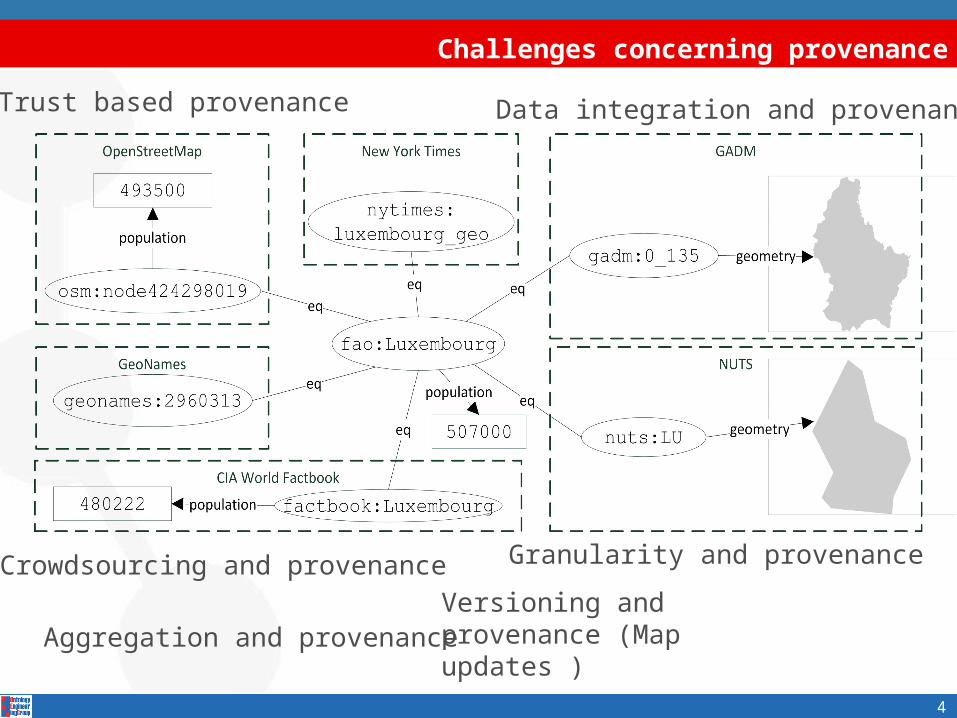
Challenges concerning provenance
Versioning and provenance (Map updates )
Trust based provenance Data integration and provenance
Crowdsourcing and provenance Granularity and provenance
Aggregation and provenance
4

Assumptions
Simplifying the problem…
• The entities across datasets have been mapped.
• The datasets share the same data model and vocabulary.
• Each dataset contains objects with unique identifiers.
• The integrated map is going to be presented to a user who is interested in using the information for some purpose.
5

Summary
1. Challenges
2. Assumptions
3. Types of provenance in the geospatial domain1. Provenance of datasets and sets of datasets2. Provenance of objects and sets of objects3. Provenance of properties and sets of properties4. Other requirements related to provenance
4. Modeling geospatial provenance with PROV-O1. Dataset level provenance
• Updating a map2. Object level provenance3. Property level provenance
5. Summary
6. Conclusions and Future work6
Types of provenance: Provenance of Datasets and sets of Datasets
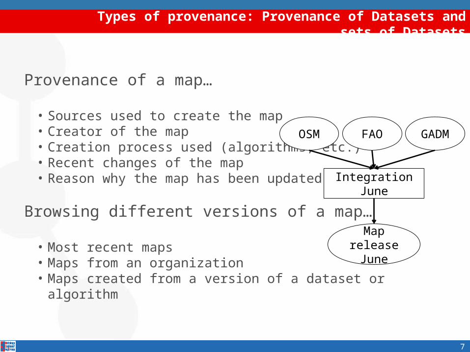
Provenance of a map…
• Sources used to create the map• Creator of the map• Creation process used (algorithms, etc.) • Recent changes of the map• Reason why the map has been updated
Browsing different versions of a map…
• Most recent maps• Maps from an organization• Maps created from a version of a dataset or algorithm
Map release
June
OSM FAO GADM
Integration June
7

Types of provenance: Provenance of Objects and sets of Objects
Objects: lower granularity entities in the map
• Original data source of the object• Organizations responsible for the creation of the object• Date of creation of the object• Date of insertion of the object in the map• Process of inclusion in the dataset
Provenance of collections of objects…
• Source of the objects of a region/area• Objects from a specific organization• Objects belonging to a type of source (e.g., crowdsourced map)• Objects introduced in the last version of the map
A
B
C
bridge
stadiumintersection
8

Types of provenance: Provenance of Properties and sets of Properties
Properties: attributes of objects in a map
• Sources of the property• Creator of the property• Date of the creation/update of the property• Process by which the property was added
Provenance of sets of properties…
• Properties of objects coming from one data source• Properties of objects belonging to a crowdsourced
map• Properties of the selected objects that have the same source
9
Source A Source B
Height: 20 mLength: 1 kmName: 405 Fwy overpass
Other requirements related to provenance
10
Other requirements might not be straightforward to answer…
• How did a set of manual corrections help to improve the map?
• What is new in this map?
• What objects are integrated with a high confidence?
• Why is an object not appearing?
• General highlights of the map
…but they can be addressed having provenance records

Summary
1. Challenges
2. Assumptions
3. Types of provenance in the geospatial domain1. Provenance of datasets and sets of datasets2. Provenance of objects and sets of objects3. Provenance of properties and sets of properties4. Other requirements related to provenance
4. Modeling geospatial provenance with PROV-O1. Dataset level provenance
• Updating a map2. Object level provenance3. Property level provenance
5. Summary
6. Conclusions and Future work11

Modeling provenance in the geospatial domain: PROV-O extension
Simple PROV-O extension to model the dataset level
12
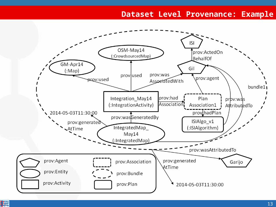
Dataset Level Provenance: Example
13

Dataset integration approaches
There are different alternatives for updating a map
14
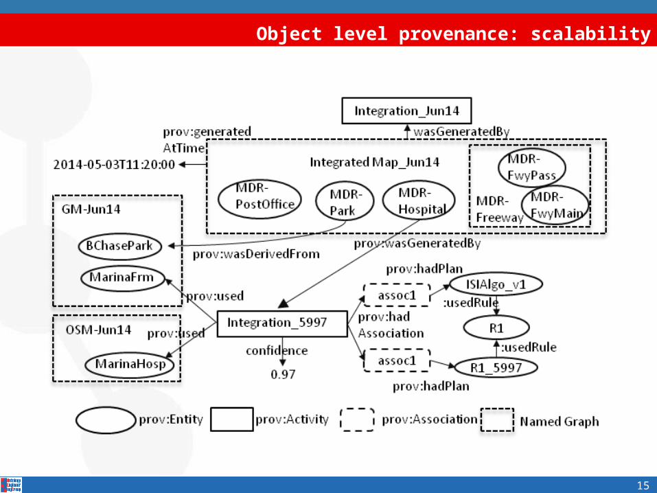
Object level provenance: scalability
15

Property level provenance
16
Asserted properties do not have URIs!
• New entities for describing their provenance
Source A Source B
:Bridge :height 20m:Bridge :length 1 km
:Bridge :name “405 Fwy overpass”
:metadata1
:metadata2
prov:wasDerivedFrom
prov:wasDerivedFrom

Conclusions
17
Requirements and major challenges for geospatial provenance
4 main categories:•Provenance of datasets•Provenance of objects appearing in the map•Provenance of properties•OtherAnalogous questions are relevant for dataset/object/property provenance in non-geospatial domains.

Date: 09/06/2014
User Requirements for Geospatial Provenance
Daniel Garijo, Andreas Harth, Yolanda Gil
Ontology Engineering Group. Universidad Politécnica de MadridInformation Sciences Institute, University of Southern California
Institute AIFB, Karlsruhe Institute of Technology