user story booklet the best faro laser scanner applications · user story booklet the best faro®...
TRANSCRIPT

User Story BookletThe Best FARO® Laser Scanner Applications
Watch the video Online @: www.faro.com/focus

About FAROwww.faro.com
Pioneer for portable measurementFARO develops portable devices for 3D measurement, inspec -tion, imaging and surveying. Our focus is on simplifying our customers’ work with tools and empowering them to dramatically reduce on-site measuring time and eliminate costly errors. As the pioneer in portable measurement, we have re-invented measur -ing: instead of carrying your parts to the measuring machine our systems can be deployed just where they are needed.
With FARO you have 3D measurement peace of mind. WWW.FARO.COM
No matter which accuracy and which measurement volume you want to measure - we’ve got the right portable measurement system for you!
* Depending on the measuring instrument di�erent accuracy test methods have been used. For all technical details please consul t the respective tech sheets.
The FARO Gage enables measurements right on the machine producing your part. With its 1.2m (48”) working volume, it is the ‘mount-it-to-where-you-make-it’, truly portable, cost-e�ective, 3D, minimal-training gages for machinists.
The FARO Laser Tracker is a portable 3D measurement system for large volume which uses laser technology and agile Absolute Distance Meter (ADM & IFM) to e�ectively and accurately measure large parts, tooling and machinery.
The FARO Laser Scanner is a portable non-contact measurement system to accurately capture 3D data. The system rotates 360° and measures everything within its line of sight with a scan rate of up to 976,000 points per seconds.
The FaroArm renders traditional CMMs, hand tools and other portable CMMs obsolete. It is available in di�erent arm lengths and is ideal for inspection, reverse engineering and CAD-to-part-analysis of parts, fixtures and assemblies.
The first fully integrated laser scanner on FARO’s patented seven-axis arm. The FaroArm combined with the Laser Line Probe is per -fect for reverse engineering and can inspect to CAD and records up to 45,000 points per second.
The right product for every measurement task
FARO is certi�ed according to ISO 9001 and accredited according to ISO/IEC 17025.
FaroArmAccuracyup to 0.016mm*
FARO GageAccuracy0.018mm*
0m
0m
1m 2m
40m
3m
80m
4m
120m
r 120 m =̂ Ø 240 m
ScanArmAccuracyup to 0.069mm*
r 1.85 m =̂ Ø 3.7 m
r 0.6 m =̂ Ø 1.2 m
FARO Laser ScannerDistance accuracyup to ±2mm*
FARO Laser TrackerAccuracy±0.049mm* (@10m) MPE
r 55 m =̂ Ø 110 m
General information www.faro.com
Things to know & important links
Fairs & Roadshows
Find out about upcoming events to meet the FARO team. www.faro.com/uk/events WWW.FARO.COM/DISTRIBUTION/EVENTS
Get a free demo!
We measure your parts on-site and show you how measuring tasks can be solved with portable 3D systems. WWW.FARO.COM/DEMO
Question & Answers
Do you want to learn more about quality control, measurement methods and software systems? Then improve your knowledge by visiting our website.
WWW.FARO-EUROPE.COM/Q-A
Free white papers
Improve your knowledge about measurement and 3D documentation. WWW.FARO.COM/WHITEPAPER
Subscribe to the monthly e-newsletter
E-Newsletter to receive interesting news and tips & tricks on how to measure more efficiently. WWW.FARONEWS.COM
Social media links
Visit us @
WWW.FACEBOOK.COM/ FARO EU WWW.YOUTUBE.COM/FAROGB WWW.LINKEDIN.COM/COMPANY/FARO-EUROPE-GMBH-&-CO-KG WWW.TWITTER.COM/FAROEUROPE WWW.XING.COM/COMPANIES/FAROEUROPEGMBH WWW.BLOG.FARO-EUROPE.COM
Product Videos
FARO webinarsHear from industry experts on emerging trends in 3D documentation, advancements in 3D metrology and portable CMMs and best practices without ever leaving the office. If you are unable to attend any of our live webinars, they are all recorded and up -loaded as podcasts here and are searchable by broadcast date.Check it out on our Website:
WWW.FARO.COM/SUPPORT/WEBINARS
Our FARO videos speak louder than words and highlight all the great features of every single FARO product. Watch in seconds how to measure complex parts in production or document a challenging surveying task. All videos are available in several languages.
WWW.FARO.COM

faro USER STORIES | 4
>>
www.trimetari.comTrimetari Consulting
The Shukhov tower in Moscow
ARCHITECTURE / 3D DOCUmEnTATIOn The Shukhov tower in Moscow has been an inspiration to architects for over 90 years, but now the once ground-breaking structure is dangerously corroded. FARO got involved to help save it.
Few constructions can match the innovative ele-gance of the Shukhov tower, Moscow that was built over 90 years ago by the great Russian engineer Vladimir Shukhov. His genius was to use a lattice of straight steel beams to create a hyperboloid structure that delivers enormous strength with a minimum of materials and little wind resistance. Originally planning to exceed the height of the Eiffel Tower by 45 metres with 60% less steel, Shukhov was still forced to scale down his tower due to the lack of steel in revo-lutionary Russia.
His final tower was nonetheless 160 metres tall and it supported the broadcast equipment of
Challanging assignment to save an architectural milestone
Soviet TV for 30 years and radio for much longer. Unfortunately, renovation was never a serious con-cern for the propaganda institutions so corrosion of the steel structure reached dangerous levels by 1991. Now, thanks to an international campaign, the government funding was finally provided to save the tower. At the time it was built, one of the inspirational features was the telescopic construc-tion method. The renovation of the top four sec-tions will involve a reversal of this process to dis-mantle the sections and then a complete overhaul and repositioning to restore the tower to its original 1922 state.
Before the renovation work started, the Rus-
sian Academy of Sciences1 decided to make a precise digital 3D model of the original tower.
The work was assigned to the Center for the Virtual History of Science and Technology and 3D specialists Trimetari Consulting who carried out the scanning work with the support of the FARO distributor Master Service.
The work began with a 3D scan of the whole tower in the middle of the Russian winter. 3 days of laser scanning were carried out in December 2011 and equipment used included a FARO La-ser Scanner Focus3D.
"Seven scanner stations were established – four at ground level, and three on the
faro USER STORIES | 5
– 4 good reasons –
www.trimetari.comTrimetari Consulting
trimetari consulting
Trimetari Consulting is a team of experts with a mission
to help specialists from different industries to solve
their tasks relating to measurements in three-dimen-
sional space.
Employing certified expert land surveyors and computer
science engineers, experienced in conventional survey-
ing, laser scanning, and 3D modelling, Trimetari takes
pride in their community approach.
Using inter-disciplinary insights they make the most of
their available hardware and software on every job.
www.trimetari.com
Only the FARO scanner was suitable for work in the confined yet exposed conditions of the upper platform.
>>
1 Speed: If you are scanning 140
metres off the ground at the top
of a windy tower that has been
declared dangerously rusted, you
want a scanner that works fast
and flawlessly.
2 Mobility: Thanks to the compact
size of the Focus3D we were actu-
ally able to get the scanner into
position – the competitor's prod-
uct was too bulky for that job.
3 Ease of use: For collecting data
outdoors in the middle of the
Russian winter you need equip-
ment that is easy to use and
robust.
4 Seamless: One of the project
aims is to develop the virtual
story about the tower so easy ex-
port to visualisation or web shar-
ing applications is important.
"The light, compact and easy to use FARO Focus3D, really made the differ-ence. Without it, we would not have
been able to complete this job"mICHAEL AnIkUSHkIn
CEO TRImETARI COnSULTInG.
tower platforms," explains Michael Anikush-kin, CEO Trimetari Consulting. The final data set contained about 100 million points referenced to a fixed position at the tower base and the Moscow Geodetic system. The mutual orientation precision of all the scans was 7 mm.
Having created a full 3D digital model of the cur-rent state of the tower, the next step will be to model the whole lifecycle of the tower based on available documentation and then to create a virtual 3D story about this inspiring monument.
"We are an independent service provider and we support our customers with various brands of equip-ment. On this job we had a long-range pulse-based scanner and the FARO Laser Scanner Focus3D. Both were suitable at the lower stations, but only the Focus3D was small enough to be taken up the ladder to the scanning station at 141 m. There was very little space
up there and no protection from the weather. The light, compact and easy to use FARO Focus3D, really made the difference. Without it, we would not have been able to complete this job," says Anikushkin thankfully.
1 The Vavilov Institute for the History of Science and Technology of the Russian Academy of Sciences (IHST RAS)
summaryA 90 year-old Soviet broadcast tower in-
spired a generation of architects. Now
threatened by corrosion, it is being saved
with the help of the FARO Focus3D.
Michael Anikushkin, CEO Trimetari Consulting, says:

faro USER STORIES | 6
>>
www.artgp.frAGP
At work in the rock shelters of Laas Geel.
ARCHAEOLOGy/ 3D DOCUmEnTATIOn A Neolithic rock-painting site in remote Somaliland has now been captured in 3D with the FARO Focus3D to facilitate scientific study and virtual tourism.
Thousands of years ago, our ancestors from the Neolithic age, decorated the walls of rock shel-ters at a place called Laas Geel with paintings of animals and humans. Little did they know that their work would last for perhaps 5,000 years and one day attract the attention of a team of Frenchmen armed to the teeth with 21st century advanced measuring technology.
Discovered in 2002 by Professor Xavier Gutherz, from Paul Valery University (in Montpel-lier, France), Laas Geel is probably the most sig-nificant Neolithic rock-painting site in the East-ern part of Africa. But it is located in Somaliland, an autonomous region of war-torn Somalia – not the kind of place that you can easily investigate
The Cave Paintings of Laas Geel
as an archaeologist or visit as a tourist. That is why the decision was made to create an accurate 3D model of the now endangered archaeological treasure. Having complete 3D measurements of the site will contribute to heritage preservation efforts, facilitate archaeological studies and al-low the creation of immersive virtual tourism ap-plications.
In April 2012, a team of five undertook the long journey from Paris to Laas Geel in the Horn of Africa to capture the necessary data. The ex-pedition, manned by 3 archaeologists from the Paul Valery University and 2 scanning experts from the company Art Graphique et Patrimoine (AGP), scanned all 24 rock shelters and the cave
paintings they contain. They also captured the site topography with a Total Station and made sub-millimetre level scans of the pre-eminent rock paintings. The French firm AGP has been a keen user of FARO scanners for over six years and are experts in immersive virtual reality for heritage preservation and promotion.
"We use 2 FARO Laser Scanner Focus3D on a daily basis," explains Didier Happe, CEO of AGP. The Focus3D was perfect for the Laas Geel expedi-tion because it is so light and portable, works on batteries for up to 6 hours and scans very fast. We also shot 36 mega-pixel images using a high-resolution digital camera."
"What you can do with the data really
faro USER STORIES | 7
– 4 good reasons –
www.artgp.frAGP
agp
Art Graphique et Patrimoine (AGP), founded in
1997, is a leading company in dimensional docu-
mentation of buildings and works of art. AGP have
documented more than 800 prestigious historic
monuments in Europe, Asia and Africa, including
Notre Dame Cathedral in Paris, Mont Saint Michel,
the Louvre and the Palace of Versailles. AGP also
produces films, interactive applications, augmented
reality applications and DVDs using state of the art
technologies for lasergrammetry, photogrammetry
and 3D metrology.
www.artgp.fr www.wikipedia.org/wiki/laas_gaal
Here the different scan positions are shown.
>>
1 Fast and efficient: We always
have to work very fast because
we can't get in the way of tour-
ists in French heritage sites and
you simply need to minimise the
duration of work in a country like
Somalia. So we appreciate a fast
and efficient scanner like the
Focus3D.
2 Light and compact: Weighing only
5 kg and measuring 24 x 20 x 10
cm, it is the smallest 3D scanner
ever built – perfect for interna-
tional assignments.
3 Support: If we miss a scanning
appointment we usually have to
wait for a long time for the next
window of opportunity. So we
rely very heavily on the FARO
support team in France to answer
questions or solve problems if
they arise. They have never let
us down.
4 All the details: We are power
users and probably scan more
frequently than any other com-
pany in the building/surveyor
industry in France. The FARO
products have so many features
that make our life easier.
The Focus3D was perfect for the Laas Geel expedition because it is so light and portable, works on batteries for
up to 6 hours and scans very fast. DIDIER HAPPE, CEO AGP
depends on how objectively you can integrate data from different scan positions and sources into a single database. So we developed a rigorous method using targets and reference spheres as well as chromatic cards for colometric calibration," ex-plains Happe. "We also had laptops equipped with point cloud and 3D modelling software so we could validate and begin processing all the data. That in-volved some night shifts but we wanted to make sure we had everything before flying home."
"We are heavy FARO users so we are very grateful for the close support of the FARO team in France. They have always been a great help and the R&D de-partment is always very interested in customer feed-back," says Happe with enthusiasm.
summaryA difficult trip to a war-torn region allowed FARO
Focus3D users to create an accurate 3D record
of caves and precious Neolithic paintings that
will serve science and public interest.
Didier Happe, CEO AGP, says:

faro USER STORIES | 8
>>
www.royalhaskoningdhv.comRoyal HaskoningDHV
Screenshot of WebShare: 1. Project contents, 2. Overview map, 3. Panoramic scan view.
HERITAGE / AS bUILT DOCUmEnTATIOn While renovation progresses, visitors can explore the inner workings of the world's largest steam pumping station that has been helping to keep feet dry in Friesland for almost one hundred years.
3D virtual reality tours are a growing phenomenon, which allow the general public to experience the fascination of remote and inaccessible or delicate and dangerous locations. One such place is the D.F. Woudagemaal pumping station. Built in 1920 to drain floodwaters from the province of Friesland in low-lying Holland, it is the largest operational steam pumping station in the world with a mind-boggling capacity of one million litres per minute. Being a UNESCO world heritage site, the pumping station fondly called 'the Cathedral of Steam' has started a 3-year program of ex-tensive renovations with engineering and con-
Fascinating visitors in the Cathedral of Steam
sultant service provider Royal HaskoningDHV managing the work. The first idea was to use 3D scans to create accurate 'As-Built Documenta-tion' for the renovation work. But the project quickly developed to include solutions that also support the visitor centre during the long period of renovation. "We spent 10 working days collecting about 185 scans with a FARO Laser Scanner Focus3D. Together with some conventional surveying in-formation these were registered in the software SCENE from FARO and then exported to the FARO WebShare environment," explains Eric Borst of Royal HaskoningDHV. WebShare allows
any authorized user to log in to the server and explore the processed scans of the whole site. "So you can navigate around the pumping sta-tion and look at the full 360° colour views from each scan position. Then there are various user tools for in-depth examinations."
"With more than 10,000 visitors per year and the building covered in scaffolding or with whole areas closed-off due to the renovation work, it was important to have an exciting exhibit in the visitor centre. We also wanted to maintain the interest of more casual visitors." So the next step was to export the data to Autodesk 3D Studio Max, with the Alice Labs Point Cloud plugin.
faro USER STORIES | 9
– 4 good reasons –
www.royalhaskoningdhv.comRoyal HaskoningDHV
royal haskoningdhv
Royal HaskoningDHV is a leading independent,
international project management, engineering and
consultancy service provider with 8,000 staff in 35
countries.
Specialising in planning and transport, infrastructure,
water, maritime, aviation, industry, energy, mining and
buildings, the company contributes to the delivery of
some 30,000 projects around the world each year.
With Dutch, UK and South African roots, Royal
HaskoningDHV is particularly focused on sustainability
and innovation.
www.royalhaskoningdhv.com www.woudagemaal.nl
A scan of the pumping station with colour provided by the integrated camera of the Focus3D.
>>
1 Customer demand: More and
more customers are requiring 3D
scanning services, so it is impor-
tant for us to be highly flexible
and able to scan very quickly.
2 A great price: We have been
renting scanning services for
about 12 years but with demand
surging and the Focus3D being
so affordable it definitely made
sense to buy one now.
3 Mobility: Because of the small
size and light weight, you can
try unusual methods to get
scans from weird and impossible
places – like inside casings or
down drains etc.
4 Workflow and software: I am
very satisfied with the overall
integration, from the scanning
and photo stitching to the web
presentation or export into visu-
alization software.
"The Focus3D is so compact and light, we often acquire unusual perspectives"
ERIC bORST vOn ROyAL HASkOnInGDHv
This was used to create a virtual tour – a 6 minute film that visitors can watch on 32-inch touch screens. It is a virtual flight through the building, with the option to stop in different places and see detailed information about the actual progress of the renovation work."
Borst and his team have also been able to take the visitors into places that you could otherwise never enter - like inside a steam boiler or down into the pitch dark areas below the waterline. "Be-cause the Focus3D is so compact and light, we of-ten acquire unusual perspectives. Dispensing with the tripod, we can stick the scanner down a drain or into a boiler casing – obviously something you could not do if the scanner was bigger or heavier," says Borst with satisfaction.
summaryFARO scan data is being put to multiple uses
during restoration of a historic pump station.
Besides accurate plans for the restoration,
a virtual flight and 3D photo database were
created as tourist attractions.
Eric Borst, Senior Design Engineer/ Market Manager Laser Scanning at Royal HaskoningDHV, says:
3D point cloud presenting the interior of the pumping station.
1 2
3

faro USER STORIES | 10
>>
www.sitecoinf.itSiteco
Buffering functionality for obtaining cross sections.
mObILE mAPPInG / AS bUILT DOCUmEnTATIOn One of the areas with the greatest potential for the use of laser scanning technology is the inspection and as-built documentation of road infrastructure, particularly bridges.
Siteco used its Mobile Mapping Road-Scanner3 system, equipped with three FARO Laser Scanner Focus3D, for a project commissioned by the Province of Naples that included the survey of 37 bridges. This allowed them to achieve excellent results in times that would be unthinkable with traditional surveying techniques.
The methodology used for this project required both moving and static scans, thus allowing the optimal exploitation of the features of the Focus3D which fits to both scanning methodologies.
The three FARO Focus3D installed on the new Siteco's Mobile Mapping System (MMS) al-
Survey and inspection of bridges in the Province of Naples
low three-dimensional laser scanning in motion. The Road-Scanner3 thus proves to be particularly suitable for scanning road infrastructures such as bridges and viaducts, since the work can be carried out without stopping traffic.
The extradoses of the bridges were surveyed with the vehicle equipped with the Mobile Map-ping System at normal operating speed, with obvi-ous advantages in terms of the speed of execution and completeness of the survey. For road over-passes, the intradoses were also surveyed in mo-tion by driving along the roads under the bridges. In contrast, works on railways or waterways require
static scanning in Stop & Go mode, with the rela-tive topographic framing.
Thanks to the three FARO Focus3D, Road-Scanner3 can capture almost 3 million points per second, with a mirror rotation speed of 100 Hz. Taking into account the surveying speed of 30 to 40 km/h, the density of the points obtained is comparable to that of a static scan, with the ad-ditional advantage of eliminating areas of shadow or limited coverage due to low radius incidence and distance.
Road-Scanner3 has an inertial platform and a GPS receiver to acquire position and
faro USER STORIES | 11
– 4 good reasons –
www.sitecoinf.itSiteco
siteco informatica s.r.l.
Headquartered in Bologna, since 2000 Siteco Infor-
matica has been developing solutions and providing
consulting services in the fields of Road Information
Systems and GIS (Geographic Information System)
applications. Since 2007, the company has been
developing mobile scanning systems based on FARO
technology.
Today, Siteco Informatica's software applications, which
were initially developed for Motorway Concessionaires,
are now also a standard for local governments and
engineering companies in Italy.
Their applications solve the main problems of managing
infrastructures: road registries, signage, concessions,
pavement studies, maintenance management, global
service contracts and expropriation. Since 2011, the
company has also been developing pavement manage-
ment systems for road and airport assets.
www.sitecoinf.it
Composition of point clouds for the as-built drawing of an arch bridge.
>>
1 In developing our Road-Scanner,
we searched for a solution that
had to assure reduced size and
weight, high speed, accuracy and
stability, and ease of use: these
are the reasons why we have
chosen FARO's products.
2 The very competitive price of the
FARO Focus3D also put the MMS
technology within the reach of a
much larger number of engineer-
ing companies.
3 We have been developing mobile
scanning systems based on
FARO technology since 2007.
The technological evolution of
the FARO Laser Scanner has
revolutionized our Road-Scanner
system in terms of performance,
ease of use and flexibility.
4 The installation of three FARO
Focus3D allows a survey of almost
3 millions of 3D points per
second and the creation of a very
large database that makes it pos-
sible to carry out any subsequent
analysis requested according
to the various mobile mapping
implementations.
attitude at a frequency of 1,000 Hz. This al-lowed the direct georeferencing of the point clouds. In this way, even while making several passes, the point clouds were already topographically coherent with the structures. The related film clips, made with seven high-definition cameras, and the point clouds were assigned to each of the different passes. These film clips are viewable with Siteco's Road-SIT suite of applications, which also supports the geographic querying of the images.
The first processing of the point clouds consisted in removing the points external to the structures, such as vegetation. This was done using SCENE, FARO's scan-data processing software. Once "clean" point clouds were obtained, it was possible to "assemble" them to reconstruct the structures in their entirety.
Once the point clouds were processed, the tech-nical drawings of the structures were produced, in-cluding all elements such as sections, perspective drawings and profiles. Moreover, the final outputs produced included a complete mapping of the main defects found on the various components of the struc-tures (beams, pillars, deck, supports, etc.), classified by type and importance. The database thus created was delivered to the Province of Naples.
Road-Scanner3 is also used with great results for other high-precision topographic surveys. In fact, the functions of point cloud editing and calibration through the use of control points, allow the execution of highly accurate surveys in incredibly short times, not comparable with static working methodologies.
According to Augusto Burchi:

faro USER STORIES | 12
>>
www.buryassociates.co.ukBury Associates Limited
Manchester Central Library.
ARCHITECTURE / AS bUILT DOCUmEnTATIOn Since 2007 Bury associates limited, a Worcester-based company, has been providing their clients with laser scanning and 3D Revit Building Information Models of existing buildings based on accurate measured surveys.
Early in 2010 Bury Associates Ltd. was awarded the contract to survey and model in Revit the iconic Manchester Central Library for a major re-furbishment programme. The building is circular in shape, with some interesting curved vaulted ceilings that intersect with each other - quite a task to model in 3D! This contract has been seen as a showcase for BIM and has been declared the ‘most BIM friendly’ project of 2011 by Buil-ding Magazine which made Bury really proud that their model has been used to underpin the whole process.
Not long after the company completed the library model they were asked to provide Revit models of parts of the world famous Blackpool Tower - a fascinating job. The model Bury Associ-ates created of the Tower top really shows that
Bringing Iconic Historical Buildings Back to Life
the company can survey and model even the most complicated of structures and produce really im-pressive results.
The Manchester Central Library and Black-pool Tower projects were both very complicated projects and show that any type of building or structure can be surveyed and accurately mod-elled by the Bury team. Most of the buildings Bury survey are of a more simple construction, but equally rigorous methods are employed to ensure the accuracy of the survey and that the finished model meets their clients’ exact requirements.
One of Bury’s more typical projects was The Derek Crothall Building at Lincoln University’s Hull campus which the company was commis-sioned by Capita Symonds to survey and produce a Revit Building Information Model of in Septem-
ber last year. This 1960’s building features two curtain-walled blocks connected to a concrete service tower with the left-hand block being can-tilevered out above the entrance. The model was needed to help undertake a major refurbishment of the building to make it suitable for future use. The client required the model to be coordinated to Ordnance Survey grid and datum as well as a topographical survey around the building and all of the site service runs traced and mapped out.
Around 400 scans were carried out to capture the entire building. The resulting ’point cloud’ was used by our modeling team to produce the Revit Building Information Model.
All of the early projects of Bury Associates Ltd. relied on gathering the necessary 2D and 3D information needed to create the model
faro USER STORIES | 13
– 4 good reasons –
www.buryassociates.co.ukBury Associates Limited
bury associates limited
Bury Associates Limited was established in 1997 in
Worcester (UK) by Steve Bury. His aim was to provide
a top quality service to clients needing topographical
and measured building surveys throughout the UK. The
company has grown steadily over the years and now
includes surveyors, CAD operators, dedicated BIM spe-
cialists and administrative staff. Bury have been using
the most innovative and effective robotic instruments
for years which allow large areas to be surveyed by just
one person working alone, complimented by network
GPS which gives them centimetre accurate Ordnance
Survey co-ordinates. From the early days of the
company, 3D data, usually in the form of 3D AutoCAD
drawings, has formed an important part of their output.
Sites have ranged from buildings and plant rooms to
motorway interchanges. Bury Associates Limited owns
2 FARO Laser Scanner Focus3D.
www.buryassociates.co.uk
Manchester Central Library.
>>
1 Affordable, small sized and light
weighted: The Laser Scanner
is portable, light (5 kg) and
compact (24 x 20 x 10 cm), and
is equipped with an integrated
lithium-ion battery, guaranteeing
up to five hours of battery life.
2 High scan precision: The inte-
grated colour camera enables
photorealistic 3D scans to be
acquired (70 megapixels) with-
out parallax.
3 Easy to operate: The touch-
screen controls make the
Focus3D scanner as easy to use
as a digital camera
4 Accuracy and Range: Cumula-
tive errors are a big threat in
large plant projects. FARO
devices give us greater ac-
curacy and reliability over large
distances.
“We were incredibly impressed with the Focus3D and as soon as we learned that Revit 2012 would support point clouds
we placed an order for one”mAnAGInG DIRECTOR OF bURy ASSOCIATES
using reflector-less total stations and handheld laser measurers. The company found this an efficient way of obtaining the measurements our Revit model-lers needed to generate the building information mod-els they were working on, but on larger complicated projects, Bury found they were spending long periods on site, which was costly. Bury’s experts had consid-ered using laser scanners for some time but their high purchase price combined with Revit not being able to import and use point cloud data meant it made little sense to change the way we were working.
Towards the end of 2010 the company started to take another look at scanning when they heard about the launch of the FARO Focus3D. "For the first time there was an affordable laser scanner available that was not just small and lightweight but it was quick and easy to operate too." says Steve Bury, the Manag-ing Director of Bury Associates. "Other scanners we’d seen always seemed to us quite cumbersome and not quite quick enough to scan". Another concern of Bury had been that many of the building they survey are ‘live’ with lots of people milling around - blocking off an area in a school or a hospital for half an hour
at a time for them to scan it was not always going to be practical. “We were incredibly impressed with the Focus3D and as soon as we learned that Revit 2012 would support point clouds we placed an order for one” says Steve Bury. “We are now scanning pretty much every site we work on - we even use it to gather some topographical information when suitable. We recently took delivery of our second Focus3D and we’re sure it won’t be the last one we purchase.”
summaryBury Associates Limited uses 2 FARO Laser
Scanner Focus3D for laser scanning, 3D
Revit Building Information Models and 3D
documentation of existing buildings.

faro USER STORIES | 14
>>
www.rechenbach-architecture.comRechenbach Architecture
Steel structure of the glass roof of the Leibniz University of Hannover.
ARCHITECTURE / REnOvATIOn Digital measurements using the FARO Laser Scanner Focus3D.If three-dimensional measurement of struc-tures has been very complicated, expensive and error-prone up until now, then data collection with the latest generation of 3D laser scanners is now easy, accurate and rapid.
These can be used to completely and accurately convert entire buildings and their fittings into dig-ital models. Current scanners record up to one million measuring points per second: This means that surfaces up to a distance of about 50 meters can be reproduced in detail and at high resolu-tion. The extremely small deviations of about 0.1 percent lie within the required DIN tolerances for construction.
Now the scan data can be easily edited by the end user, because the computer hardware has become more powerful and because di-
3D documentation of the 1200 m2 steel structure of the glass roof of the Leibniz University of Hanover
rect CAD import has become possible thanks to AutoDesk’s point cloud engine for AutoCAD and Revit Architecture. This eliminates expen-sive external processing of the data, so that the costs drop to a level similar to that of classical dimensioning. Thus the current niche existence of 3D documentation is now a thing of the past in many application areas: Laser scanning will revolutionise the current use of survey data!
Spatial building models have a number of advantages compared to traditional 2D surve-ys. As all the information in a spatial model is
available in three dimensions, multifunctional applications are possible. This ranges from sim-ple measurement and area calculations to stere-oscopic navigation in virtual buildings. Because the scanner records all the visible structures of buildings and components, this results in com-pletely seamless records that can be used across various disciplines. Information that is not nee-ded for the particular application can be deleted in order to reveal important details and keep file sizes small.
The areas of use are extremely diverse;
www.rechenbach-architecture.comRechenbach Architecture
everywhere where the precise geometric in-vestigation of the environment and rapid visu-alisation of the same are needed, optical 3D measurement using the latest laser scanning technology is impossible to beat:
survey documentation of objects for: Plant engi-neering - modifications to installations and pro-duction linesArchitecture - monument protection, renovation planning, quantity surveysCivil engineering - traffic structures, volume de-termination in open pits
recording and digitisation in the areas of: Ship-building - CAD import of free-form surfacesReverse engineering - 3D modelling in CAD after scanning a prototypeQuality managemen - production analysis of e.g. wind turbines
transfer of the scan data in virtual reality appli-cations for: Forensics - location- and time-inde-pendent crime scene analysisFilm business - location scouting und computer-generated sets Urban development - 3D city models and virtual flights
the projectRe-glazing was carried out using aluminium pro-file construction with highly insulated Schüco elements as part of the energy-related renova-tion of the glass roof over the listed courtyard of the Guelph castle. This is supported by the steel structure spanning the courtyard, with an area of around 1200 m2. The survey documentation of the spatial support structure, made of steel tub-ing and double I beams, were too old and impre-cise to provide all the necessary measurements. After intense consideration, the company in charge of the project chose Langenhagen-based Masche Metallbau to carry out surveying with 3D documentation. This service was provided by architect J. Rechenbach and his Laser Scan-ning Architecture office. To do this, the steel substructure was measured in three dimensions in 12 individual scans; the scan data were then transmitted to the in-house CAD department for the planning work.
Using this procedure, it was possible to ge-nerate the 3D digital image of the complete ge-ometry and pass it on within two working days. The laser scanner was on site for only 3 hours. Manual measurement would have taken about 40-60 hours of work, but without the assurance that every dimension had been determined to
the last detail. These numbers show that the 3D documentation method is not only accurate and rapid, but also very economical!
visualisation of the 3d point cloud using faro scene and autodesk navis-
worksClear visualisation was implemented using vari-ous software solutions. First, the FARO SCENE software provides a photo-realistic display mode for the recorded data; in addition, the scan was also read into AutoDesk Navisworks. This makes it possible to combine the data from the laser scan with 3D data from other sources. This al-lows a comparison of target and actual values to be carried out, in which the scan data are presented superposed on the newly created CAD plan so that deviations immediately become visible. Planning errors could thus be system-atically avoided early on, thereby optimising the construction process. In this case, the faulty production of a single large aluminium-glass ele-ment would have been more expensive than the entire 3-D measurement of the object!
autocad architecture as an optimal tool for further use of the data
The detailed drawings were made in
Evaluation of the scan data and project planning with AutoCAD Architecture: plan view and axonometry. Individual scan locations have different colours
>>
>>
faro USER STORIES | 15

faro USER STORIES | 17
– 4 good reasons –
www.rechenbach-architecture.comLeibniz Universität Hannover
contelos gmbh
Founded in 1992, Contelos GmbH, headquartered
in Gehrden with an office in Bremen, is an industry-
neutral consultancy and systems company that has
consistently transformed itself into a system integrator
and supervisor in all areas of AutoDesk over the past 10
years. Contelos GmbH is one of the few CAD industry
specialists that provide a single source for the areas of
architecture, construction, engineering and geographic
information. Contelos GmbH has also gathered exten-
sive experience in various projects in building survey
data collection with subsequent 3D modelling for use
in the field of facility management. Contelos GmbH is
happy to work together with your software customers
in these projects. As a result, extensive projects can be
brought to fruition effectively, economically and with
high quality.
www.contelos.de
The re-glazing as seen from above
>>
1 Small and compact: With a size of
only 24 x 20 x 10cm and a weight
of just 5.0kg, the Focus3D is the
smallest 3D scanner ever built.
2 Efficient: Due to its long range
of up to 120 m, the level sensor,
the compactness and ease of use
and the auto-registration at no
extra cost result in up to 50%
savings of scan and processing
time compared to conventional
laser scanners.
3 Integrated colour camera pho-
torealistic 3D colour scans due
to an integrated colour camera
featuring an automatic 70 meg-
apixels parallax-free colour overlay
4 Revolutionary simple: Due to its
intuitive control concept with
touchscreen display, the Focus3D
is as easy to operate as a digital
camera.Axonometric representation of the steel construction
www.rechenbach-architecture.comLeibniz Universität Hannover
The laser scanner was on site for only 3 hours. Manual measurement would have taken about 40-60 hours of work
ARCHITECT J. RECHEnbACH
faro USER STORIES | 16
>>
>>
Masche Metallbau’s CAD department in 2D mode using AutoCAD Architecture. To do this, the 3D point cloud model was “sliced” randomly to show the true geometry of the steel substructure at the desired position and to plan the glass elements of the roof accordingly. The freely available plug-in from AutoDesk, Cloud Point Extraction, was applied directly in Auto-CAD. As a result, the complex 3D model can be reduced to any 2D content quick as a flash. The process is very intuitive and simple. This al-lowed all the desired measurements to be made and the 2D details to be worked out rapidly.
transfer to schücocad based on autocad architecture
Once the basic geometry had been determined and the axis spacing of the support points had been specified, the component library of the Schücad software was accessed in order to incor-porate the profiles to be constructed in detail in the CAD planning.
conclusionThe successful completion of the construction project now documents how accurately the dig-ital surveying data are and what great benefits 3D documentation technology offers for construction applications in surveys and architectural monu-ment preservation. 3D documentation precisely portrays the as-built condition especially in more complex geometries and older buildings in which
deformations may have occurred, thus offering a high degree of planning reliability for an opti-mised construction process.
faro – the competent partner for 3d documentation combined with auto-
desk productsFARO Technologies, Inc. (NASDAQ: FARO) de-velop and market computer-aided measurement systems and software worldwide. The portable coordinate measuring devices from FARO, to-gether with their industry-specific software so-lutions, allow high-precision 3D measurements and 3D comparisons. They are used for inspec-ting components and component assemblies, production planning, and inventory documen-tation, as well as for the investigation and re-construction of accident sites and crime scenes. They are also used for digital scanning of histo-rical sites. The FARO Focus3D laser scanner is ideal for the three-dimensional documentation of buildings and building inspection, reverse en-gineering, monument preservation and forensic crime scene documentation – thanks to its sim-ple operation and compact design, it can be in-tuitively operated using a touch screen and used for various applications:
Indoor surveying documentation With the Focus3D, accurate 3D documentation of indoor spaces and technical facilities, such as building equipment, conveyor systems or process equip-ment, can be created in a short time.
Product and component documentation Whether for the quality control of large machine parts, for product design or for reverse engineering – the Focus3D measures products and components of any shape and size and then creates precise data and three-dimensional surface models.
Outdoor surveying documentation The Focus3D is well suited for the 3D documentation of buil-dings, construction sites, roads and natural fea-tures. Objects at a distance of up to 120 m are recorded.
laser scanning architectureYour partner for 3D documentation and survey documentation in construction
The Hanover-based architectural firm of qualified engineer Johannes Rechenbach spe-cialises in laser scanning services and building documentation as the basis for planning modi-fications and the preservation of evidence. The evaluation options for optical 3D measurement range from colour 360° panoramas that can also be posted online to vectorised 2D plan drawings to 3D CAD drawings with intelligent component objects. There are therefore numerous possible formats in which the results can be transferred to the customer, depending on the requirement that has been agreed upon:
- Colour 360° panoramas of the construction project and its integration into the environment allow visual analysis of structural details up to the urban context. Even distance measure-
ments and area calculations can be performed. These data are available online worldwide within one day to a freely selectable group of users. - Thanks to the easy integration into AutoDesk prod-ucts such as AutoCAD, the scan data can be trans-ferred to the client for further processing; alterna-tively, “lsa” can generate the desired 2D drawings in dwg format. Floor plans, sections and views at any point of the building can be extracted from the digital scan model. - The new point cloud engine in Revit Architecture has made the 3D modelling of the scanned object with integration into the Building Information Mo-delling Process possible. This means more effective planning processes, from early 3D visualisation to accurate component and mass determination to an inclusive planning process in which all participating planning specialists, such as structural engineers, building engineers and facility management, can work on the same building model without losses in communication.
The added value of 3D documentation by our ar-chitectural firm is that, if required, the owner is pro-vided with comprehensive support of their property, from digital measurement to planning and construc-tion. If only surveying is commissioned, we can provi-de statements regarding the quality of the structural fabric and proposals for energy-saving renovations as part of the scan analysis. We have the same perspec-tive as our clients, who also come from the construc-tion industry. Laser Scanning Architecture: We make sure that your architecture gets to the point.
faro USER STORIES | 18
>>
www.fascinate-project.euFascinatE
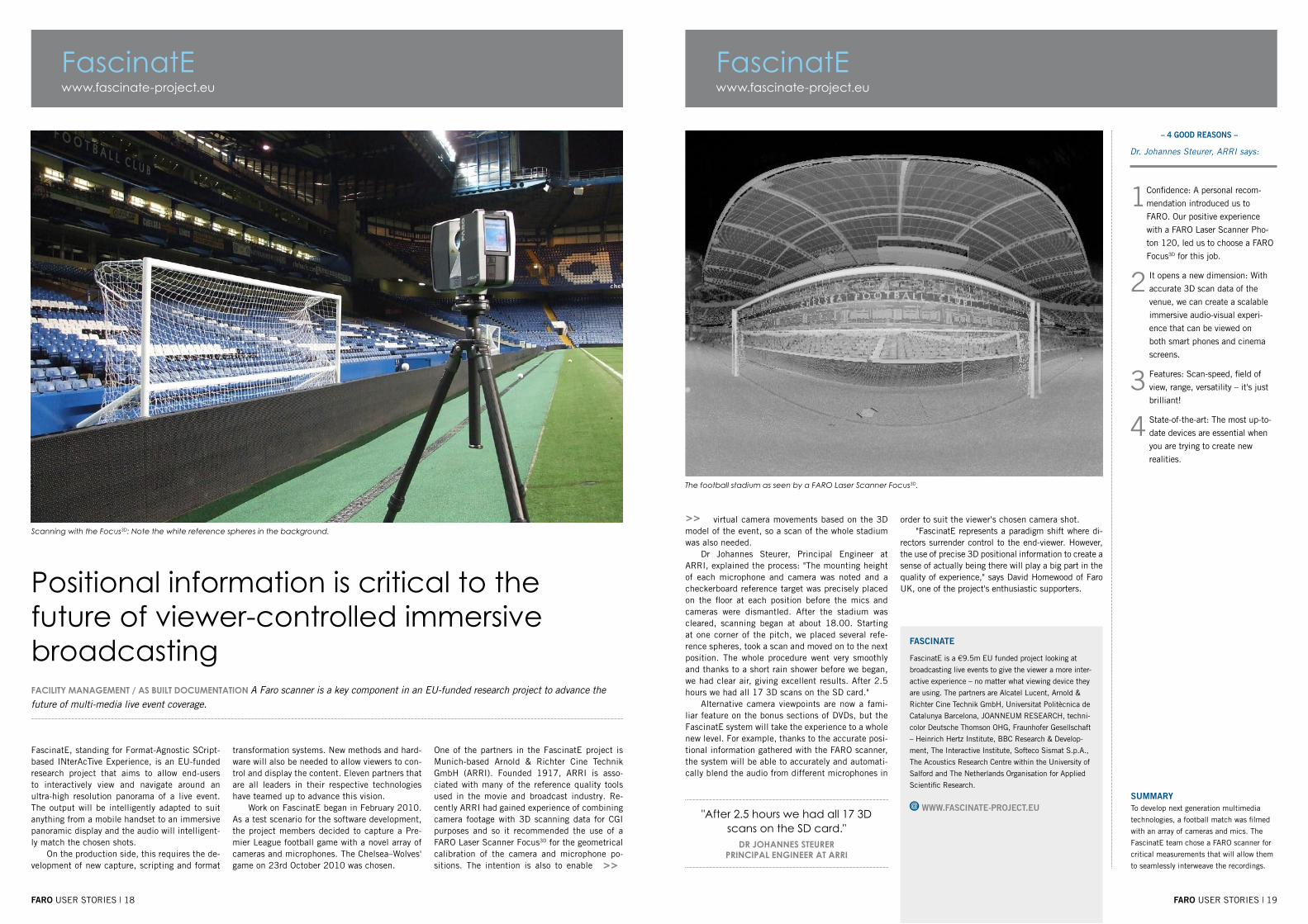
Scanning with the Focus3D: Note the white reference spheres in the background.
FACILITy mAnAGEmEnT / AS bUILT DOCUmEnTATIOn A Faro scanner is a key component in an EU-funded research project to advance the future of multi-media live event coverage.
FascinatE, standing for Format-Agnostic SCript-based INterAcTive Experience, is an EU-funded research project that aims to allow end-users to interactively view and navigate around an ultra-high resolution panorama of a live event. The output will be intelligently adapted to suit anything from a mobile handset to an immersive panoramic display and the audio will intelligent-ly match the chosen shots.
On the production side, this requires the de-velopment of new capture, scripting and format
Positional information is critical to the future of viewer-controlled immersive broadcasting
transformation systems. New methods and hard-ware will also be needed to allow viewers to con-trol and display the content. Eleven partners that are all leaders in their respective technologies have teamed up to advance this vision.
Work on FascinatE began in February 2010. As a test scenario for the software development, the project members decided to capture a Pre-mier League football game with a novel array of cameras and microphones. The Chelsea–Wolves' game on 23rd October 2010 was chosen.
One of the partners in the FascinatE project is Munich-based Arnold & Richter Cine Technik GmbH (ARRI). Founded 1917, ARRI is asso-ciated with many of the reference quality tools used in the movie and broadcast industry. Re-cently ARRI had gained experience of combining camera footage with 3D scanning data for CGI purposes and so it recommended the use of a FARO Laser Scanner Focus3D for the geometrical calibration of the camera and microphone po-sitions. The intention is also to enable
faro USER STORIES | 19
– 4 good reasons –
www.fascinate-project.eu
"After 2.5 hours we had all 17 3D scans on the SD card."
DR JOHAnnES STEURERPRInCIPAL EnGInEER AT ARRI
Dr. Johannes Steurer, ARRI says:
1 Confidence: A personal recom-
mendation introduced us to
FARO. Our positive experience
with a FARO Laser Scanner Pho-
ton 120, led us to choose a FARO
Focus3D for this job.
2 It opens a new dimension: With
accurate 3D scan data of the
venue, we can create a scalable
immersive audio-visual experi-
ence that can be viewed on
both smart phones and cinema
screens.
3 Features: Scan-speed, field of
view, range, versatility – it's just
brilliant!
4 State-of-the-art: The most up-to-
date devices are essential when
you are trying to create new
realities.
FascinatE
fascinate
FascinatE is a €9.5m EU funded project looking at
broadcasting live events to give the viewer a more inter-
active experience – no matter what viewing device they
are using. The partners are Alcatel Lucent, Arnold &
Richter Cine Technik GmbH, Universitat Politècnica de
Catalunya Barcelona, JOANNEUM RESEARCH, techni-
color Deutsche Thomson OHG, Fraunhofer Gesellschaft
– Heinrich Hertz Institute, BBC Research & Develop-
ment, The Interactive Institute, Softeco Sismat S.p.A.,
The Acoustics Research Centre within the University of
Salford and The Netherlands Organisation for Applied
Scientific Research.
www.fascinate-project.eu
The football stadium as seen by a FARO Laser Scanner Focus3D.
virtual camera movements based on the 3D model of the event, so a scan of the whole stadium was also needed.
Dr Johannes Steurer, Principal Engineer at ARRI, explained the process: "The mounting height of each microphone and camera was noted and a checkerboard reference target was precisely placed on the floor at each position before the mics and cameras were dismantled. After the stadium was cleared, scanning began at about 18.00. Starting at one corner of the pitch, we placed several refe-rence spheres, took a scan and moved on to the next position. The whole procedure went very smoothly and thanks to a short rain shower before we began, we had clear air, giving excellent results. After 2.5 hours we had all 17 3D scans on the SD card."
Alternative camera viewpoints are now a fami-liar feature on the bonus sections of DVDs, but the FascinatE system will take the experience to a whole new level. For example, thanks to the accurate posi-tional information gathered with the FARO scanner, the system will be able to accurately and automati-cally blend the audio from different microphones in
summaryTo develop next generation multimedia
technologies, a football match was filmed
with an array of cameras and mics. The
FascinatE team chose a FARO scanner for
critical measurements that will allow them
to seamlessly interweave the recordings.
>> order to suit the viewer's chosen camera shot. "FascinatE represents a paradigm shift where di-
rectors surrender control to the end-viewer. However, the use of precise 3D positional information to create a sense of actually being there will play a big part in the quality of experience," says David Homewood of Faro UK, one of the project's enthusiastic supporters.
faro USER STORIES | 20
>>
www.artgp.frART GRAPHIQUE ET PATRIMOINE
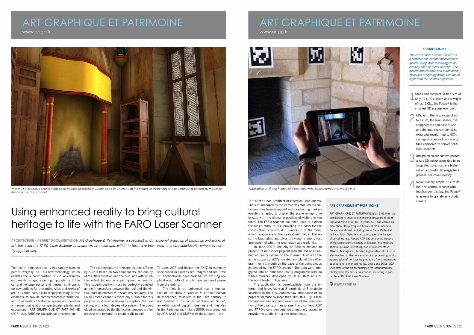
With the FARO Laser Scanner it has been possible to digitise in 3D the office of Charles V at the Palace of Vincennes and to construct a skinned 3D model on the basis of a mesh model.
ARCHITECTURE / AS bUILT DOCUmEnTATIOn Art Graphique & Patrimoine, a specialist in dimensional drawings of buildings and works of art, has used the FARO Laser Scanner to create virtual mock-ups, which in turn have been used to create spectacular enhanced real-ity applications.
The use of enhanced reality has rapidly become part of everyday life. This new technology, which enables the superimposition of virtual elements onto reality, is rapidly gaining in popularity. In the cultural heritage sector and museums, it opens up new options for presenting sites and works of art. It is thus possible to display missing or lost elements, to provide complementary information, and to reconstruct historical scenes and décor in a manner that is at once spectacular, playful and educational. ART GRAPHIQUE ET PATRIMOINE (AGP) uses FARO for exceptional presentations.
Using enhanced reality to bring cultural heritage to life with the FARO Laser Scanner
The exciting nature of the applications offered by AGP is based on two components: the quality of the 3D replication and the precision with which the virtual tableau is superimposed on reality. This superimposition must be perfectly adjusted as the intersections between the real and the vir-tual must be created with seamless accuracy. The FARO Laser Scanner is especially suitable for this purpose as it is able to rapidly capture the real setting with a high degree of precision. The point cloud generated by the digitisation process is then meshed and textured to create a 3D model.
To date, AGP and its partner AXYZ (a company specialised in synthesised images and real-time 3D applications) have created two exciting ap-plications, both of which have garnered praise from the public.
The first is an enhanced reality replica-tion of the study of Charles V, at the Château de Vincennes, as it was in the 14th century. It was created in the context of "Futur en Seine", an exhibition of digital industries and lifestyles in the Paris region, in June 2009, by a group led by AGP, AXYZ and CNRS with the support
faro USER STORIES | 21
– 4 good reasons –
www.artgp.frART GRAPHIQUE ET PATRIMOINE
art graphique et patrimoine
ART GRAPHIQUE ET PATRIMOINE is an SME that has
specialised in creating dimensional drawings of build-
ings and works of art for 15 years. AGP has worked on
more than 500 prestigious historical monuments in
France and abroad, including Notre Dame Cathedral
in Paris, Mont Saint Michel, the Louvre, the Palace
of Versailles, etc. Abroad AGP has conducted surveys
of the Lomonosov University in Moscow, the Marinsky
Theatre in Saint Petersburg, and of monuments in
Albania, Madagascar, Tunisia, Afghanistan, etc. AGP is
also involved in the conservation and promoting public
appreciation of heritage by producing films, interactive
applications, enhanced reality, books and DVDs. AGP
uses state of the art technologies for lasergrammetry,
photogrammetry and 3D restitution, including in par-
ticular a 3D FARO Laser Scanner.
www.artgp.fr
Application on site at Palace of Vincennes, with visible markers and mobile unit.
of the Head Architect of Historical Monuments. The site, managed by the Centre des Monuments Na-tionaux, has been equipped with positioning markers enabling a laptop to display the scene in real-time in step with the changing position of visitors in the room. The FARO scanner has been used to digitise the king's study in 3D, providing the basis for the construction of a virtual 3D mock-up of the room, which is accurate to the nearest millimetre. The re-sult is fascinating and gives the visitor a new, direct impression of what the royal study was really like.
In June 2010, the city of Amiens decided to present its municipal pageant with the aid of an en-hanced reality system on the internet. AGP, with the active support of AXYZ, created a model of the cathe-dral in only 1 month on the basis of the point clouds generated by the FARO scanner. The data were inte-grated into an enhanced reality programme with no visible markers, developed by TOTAL IMMERSION, the world leader in this area.
The application is downloadable from the in-ternet and is available at 3 terminals at 3 strategic locations in the city. Amiens saw attendance of its pageant increase by more than 30% this July. These two applications are good examples of the combina-tion of the quality of measurement and content, AGP and FARO’s core competencies, uniquely staged to provide the public with a new experience.
>>
The FARO Laser Scanner Focus3D is a portable non-contact measurement system using laser technology to ac-curately capture measurements. The system rotates 360° and automatically measures everything within the line of sight from the scanner´s position.
1 Small and compact: With a size of
only 24 x 20 x 10cm and a weight
of just 5.0kg, the Focus3D is the
smallest 3D scanner ever built.
2 Efficient: The long range of up
to 120m, the level sensor, the
compactness and ease of use
and the auto-registration at no
extra cost result in up to 50%
savings of scan and processing
time compared to conventional
laser scanners.
3 Integrated colour camera photore-
alistic 3D colour scans due to an
integrated colour camera featur-
ing an automatic 70 megapixels
parallax-free colour overlay
4 Revolutionary simple: Due to its
intuitive control concept with
touchscreen display, the Focus3D
is as easy to operate as a digital
camera.

faro USER STORIES | 22 faro USER STORIES | 23
www.andassoc.com
>>
www.andassoc.comAnderson & AssociatesAnderson & Associates
>>
The FARO Laser Scanner preparing for a scan inside the Twin Branch 1 tunnel.
TUnnEL AnD mInInG/ InSPEkTIOn For this project, A&A used a FARO Laser Scanner and ATS Real Reality Tunnel software to model the complete interiors of the tunnels and structures in 60% less time than is traditionally required.
“The FARO scanner turned out to be ideal for this project. Its high scanning speed made it possible to complete the job in a fraction of the time required by the conventional method.” The Heartland Corridor is the most ambitious rail-road engineering project of the last century. The
Anderson & Associates Reduces Tunnel Interior Measurement Time by 60% Using Laser Scanners
project required increasing the vertical clearance of 28 tunnels and removing 24 overhead obstruc-tions. Anderson & Associates (A&A) was hired to document the tunnels in order to check final clearances and provide a record for maintenance.
For this project, A&A used a FARO Laser Scan-
ner and ATS Real Reality Tunnel (RRT) software to model the complete interiors of the tunnels and structures in 60% less time than is traditionally required. “In addition to saving huge amounts of time, laser scanning made it possible to model the complete interior of the tunnel,” said
Neil Martin, Project Manager & Associate Vice President Surveying. “This approach gave us peace of mind that we had identified every con-flict. That was lacking in the past when we were only able to measure selected cross-sections.”
heartland corridor projectThe Heartland Corridor is a public-private part-nership between Norfolk Southern (NS) railroad, the states of Virginia, West Virginia, Ohio, and the federal government to create the shortest, fastest route for double-stack container trains moving be-tween the Port of Virginia in Norfolk and the Mid-west. The line dates back to the late 19th century and traditionally has carried mostly coal traffic. New construction began in October 2007 and involved modifying 5.7 miles of tunnels through roof excavation and liner replacement, arched roof notching, and track lowering and realign-ment. The improvements make it possible for the line to handle double-stack container trains and provide more capacity, speed, and reliability. The
The two tripods behind the scan technician show the survey sphere and the total station prism used for generating control points.
new routing improves transit time from four days to three from Norfolk to Chicago and is nearly 250 miles shorter than previous circuitous routings.
A&A’s involvement with the Heartland Corri-dor began in 2005 when the company was select-ed as a subcontractor to Hatch Mott McDonald for the clearance on 28 tunnels and 8 bridges in Vir-ginia, West Virginia, Kentucky, and Ohio. Double-stack rail transport involves stacking intermodal containers two high on railroad cars. Introduced in North America in 1984, double-stack railcars have become increasingly common. They are used for nearly 70% of United States intermodal ship-ments and sharply reduce the cost per container.
challenge of measuring tunnel profile
The centres of the tunnels were high enough near-ly everywhere for the double-stack railcars, but the original tunnel roofs were roughly spherical so they obstructed the outside corners of the stacked cars. These obstructions were addressed during
the construction phase of the project by cutting notches into the tunnel. Conventional equipment such as total stations were used for surveying dur-ing the design process. This traditional approach relies on visual observation to select the cross-sections that appear to be the lowest point in each tunnel section.
A total station is then used to determine the angle and distance of the points being measured to a prism. The traditional approach’s depend-ence on visual inspection makes it vulnerable to error as are the manual methods used to compare the resulting measurements to the train profile.For the construction phase, A&A was hired by STV/Ralph Whitehead to check the final clearanc-es after contractors had finished their work and to document the tunnels for future maintenance. “If traditional methods would have been used to vali-date this project it would have been nearly impos-sible to ensure that the entire distance covered by the survey was free of conflicts,” said Justin Lewis, Assistant Survey Manager for A&A. >>

faro USER STORIES | 25
– 4 good reasons –
www.andassoc.com
“In addition to saving huge amounts of time, laser scanning made it pos-sible to model the complete interior
of the tunnel.”nEIL mARTIn, PROJECT mAnAGER & ASSOCIATE
vICE PRESIDEnT SURvEyInG
1 The portability of the FARO
Laser Scanner was one of the
main selling points, sometimes
we have to scan in remote and
confined spaces. The scans can
also be saved onto the hard drive
of the scanner so there is no need
totake a laptop onsite.
2 We felt that the FARO system of-
fered excellent value for money.
3 The FARO Laser Scanner uses a
high end 10 mega pixel Nikon
digital camera; this allows high
quality colour overlay of the scan
points. It is easier to visualise
and process data that has clean
crisp edges.
4 Our company uses many differ-
ent types of scanners; the addi-
tion of the FARO Laser Scanner
has extended the knowledge of
data transfer and high quality
quick data acquisition.
Anderson & Associates
anderson & associates
Anderson & Associates is headquartered in Blacks-
burg, Virginia and has offices in West Virginia and
North Carolina as well. A&A is a professional design
firm that specializes in civil and environmental
engineering, surveying, planning, and landscape ar-
chitecture. Since 1968, they have served as planners,
designers, stewards, and advocates for institutional,
municipal, state, industrial, and private sector clients.
www.andassoc.com
Portal of Twin Branch tunnel.
www.andassoc.comAnderson & Associates
Top view of surface model of Twin Branch 1 tunnel.
Cross-sections generated from scan data show conflicts between double stack railcars and tunnel.
faro USER STORIES | 24
>>
>>
>> “A conflict that was not addressed during the construction phase could have resulted in a train hitting the tunnel wall. This would have been very expensive to repair and also potentially dan-gerous for the crew of the train.”
move to laser scanning“In order to perform the project economically and accurately, we evaluated various laser scanning systems designed for surveying,” Lewis said. “As a phase-based scanner, the FARO Photon 120 LS is faster than the time-of-flight scanners that we looked at. This laser scanner captures data at a rate of 120,000 points per second. We also were very impressed with the RRT software that FARO bundles with this scanner. It enabled us to cap-ture the tunnel profile, create a centerline and profile of the doublestackedcars and automati-cally compared the two over the entire length of the tunnel to quickly identify any conflicts.”
A&A survey technicians established control points at the starting end of the tunnel using a global positioning system (GPS). The surveyors referenced these points in the scanner coordinate system by placing a sphere mounted on a tripod on each of them. The scanner was positioned nearby on another tripod. A total station was used to determine the position of the scanner and the
sphere. The scanner was then used to scan the sphere to identify the starting control point in the scanned data. The surveyors traversed through the tunnel with multiple setups using a series of tripods and spherical targets. Every time they moved the tripod and target they measured its po-sition with the total station and then scanned it with the laser scanner to provide a point of refer-ence for the next batch of scan data. When the surveyors emerged from the opposite end of the tunnel they checked into the GPS to verify the accuracy of their traverse. “We found we could collect field data on the typical 1000 foot tunnel in less than 6 hours,” said Joey Conrad, Survey Technician.
ensuring that all conflicts were identified
The total station measurements were imported into FARO Scene software and used to align the scan data taken at different positions inside the tunnel into a single frame of reference. The scan data from each tunnel was stitched into a continu-ous surface model of the tunnel interior using the Scene software based on the total station measure-ments of the scanner and round target positions. This surface model was then imported into RRT software for clearance verification. The technicians
created the centerline and the silhouette of the doublestack cars based on the design plans using AutoCAD computer-aided design (CAD) software, then exported the data as a land.xml file. This file was imported into RRT software. On the typi-cal curved tunnel, this template has a constantly changing vertical orientation which would have made it very difficult to identify all of the conflicts using manual methods. RRT software, on the other hand, automatically identified the conflicts by run-ning the template for the double-stack train across the centerline for the entire tunnel. A&A produced cross-sections of these conflicts and provided them to the contractors for rework.
A&A then re-scanned these areas after the repairs were completed and checked them to be sure the conflicts had been eliminated. Providing a complete surface map of the tunnel interior and automatically checking it against the double-stack car contour provided a much higher level of assur-ance that all areas of conflict had been identified than would have been possible in the past. After the structure was verified to be conflict-free, the final drawings were provided to NS. “The FARO scanner turned out to be ideal for this project,” Lewis said. “Its high scanning speed made it pos-sible to complete the job in a fraction of the time required by the conventional method. We got
the job done right on schedule in spite of the challenge of only being able to work restricted hours.”“We are seeing more and more applications for laser scanning and it’s becoming an important part of the work we do,” Lewis concluded. “For future work, we recommend scanning all tunnels and bridges prior to design. These scans would then provide a precise base for design and would be used throughout the design and construction process. The final record drawings would also provide useful maintenance documentation.”

faro USER STORIES | 26
www.scantech-international.comScanTech International Ltd
faro USER STORIES | 27
>>
Locomotive scanning for model railway industry
RAILwAy InDUSTRy. / DOCUmEnTATIOn Accurate capture of outlines and features of locomotives for the model railway industry.
ScanTech International Ltd., a professional 3D laser scanning company based in Macclesfield, United Kingdom have utilised the FARO Laser Scanner Focus3D to accurately capture and docu-ment in 3D the outlines and features of several locomotives for the model railway industry.
In the 1840 “carpet railways”, the earliest
Locomotive scanning with the Laser Scanner Focus3D
model railways were created. Around the turn of the 20th century appeared the first models of electric trains. Today’s model train sets often mirror real locations and historical periods as well as currently existing railways.
Modern manufacturing techniques mean produced models achieve a high degree of pre-
cision and realism. For this there is a need for rapid, simple and accurate recording of railways to provide best-in-class results for the manuf-acturers.
FARO’s laser scanner Focus3D allowed ScanTech immediate processing of the data ac-quired on-site in a CAD programme to
– 4 good reasons –
scantech international ltd
ScanTech International was established in 2002
to provide a professional 3D laser scanning survey
service. The company is based in Macclesfield
(Stockport) and provide a UK/European-wide service
for topographical surveys, building and structure
surveys in the rail, highway, nuclear and process plant
environment.
www.scantech-international.com
Scanning with SCENE software
>>
1 Fast capture of data: The
Focus3D creates a virtual copy
of the subject at an incredible
speed - capturing up to 976,000
points a second.
2 Intuitive control concept with
touchscreen display enables to
take high resolution hotographs
and colourise the point cloud.
3 Accuracy of captured data of all
of the relevant features.
4 Ability of the scanner to work
close to surfaces in tight spaces
and independently – no ad-
ditional equipment or cables are
required.
“Precise scan data is an outstanding basis for planning and creation of a train model and ensures high quality
in the implementation of the project.”kEITH mCCRORy,
SCAnTECH InTERnATIOnAL LTD, mAnAGInG DIRECTOR
summeryMcCrory lists following advantages of
utilising the FARO Laser Scanner Focus3D
scanner for the applications in the model
railway industry:
Fast capture of data: The Focus• 3D
creates a virtual copy of the subject at
an incredible speed - capturing up to
976,000 point a second.
Intuitive control concept with touch-•
screen display enables to take high
resolution hotographs and colourise
the pointcloud
Accuracy of captured data of all of the •
relevant features
Ability of the scanner to work close to •
surfaces in tight spaces and indepen-
dently – no additional equipment or
cables are required
www.scantech-international.comScanTech International Ltd
produce accurate 3D models of the scan-ned locomotives.
Keith McCrory, Managing Director at ScanTech International Ltd. says: “Precise scan data is an out-standing basis for planning and creation of a train model and ensures high quality in the implementa-tion of the project.”
The produced 3D locomotive models are then checked by ScanTech specialists to ensure that all the required features like e.g. rivets, the fireman’s coat hook and the true shape of the locomotive etc. have been captured and incorporated.
Once the models have been checked, there are generally sent by ScanTech International’s clients to the manufacturer of the scale model. There are then a series of communications to facilitate the importation of ScanTech’s CAD models into the manufacturer’s software.
Keith McCrory, Managing Director at ScanTech International Ltd. speaks about 4 good reasons why to choose the Focus3D:

FARO Offices
www.faro.com/focus
Global HeadquartersFARO Technologies Inc.250 Technology ParkLake Mary. FL [email protected]
European HeadquartersFARO Europe GmbH & Co. KGLingwiesenstrasse 11/270825 Korntal-Mü[email protected]
Distribution (EMEA)FARO Swiss Holding GmbHWiesengasse 208222 [email protected]/distributorsTel: +49 7150 9797 400
Faro Technologies UK Ltd 9-10 The Cobalt CentreSiskin Parkway EastMiddlemarch Business ParkCoventry, CV3 4PEUnited [email protected] Call: 00 800 3276 7253
Freecall: 00 800 3276 7253
www.faro.com
Revised: 11 Dec. 2012 © 2012 FARO EU-EN-04REF404-006.pdf