version 1.1 (october 2012) - historic england wright, english heritage nick boldrini, north...
TRANSCRIPT

1
Version 1.1 (October 2012)

www.english-heritage.org.uk/publication/midas-heritage/ Contributor The Forum on Information Standards in Heritage (FISH) Coverage.spatial United Kingdom Creator English Heritage Date.issued 2012 Description Guidelines for recording historic environment information, covering the
elements and refinements that provide the structure for the MIDAS Heritage standard, Based on MIDAS, 1998.
Format Text Language eng Publisher English Heritage Rights.copyright English Heritage Subject Metadata; information management Title MIDAS Heritage – The UK Historic Environment Data Standard, v1.1 Title.alternative MIDAS Heritage, v1.1 Type Standard
2

Contents
FOREWORD .................................................................................................................................................................... 5
ACKNOWLEDGEMENTS ............................................................................................................................................. 6
1. INTRODUCTION ........................................................................................................................................................ 8
THE IMPORTANCE OF DATA STANDARDS.......................................................................................................................... 8 THE DEVELOPMENT OF MIDAS HERITAGE ..................................................................................................................... 8 WHO IS MIDAS HERITAGE FOR?..................................................................................................................................... 9 WHAT IS NOT INCLUDED IN MIDAS HERITAGE? ............................................................................................................. 9 WHAT’S NEW IN MIDAS HERITAGE? ............................................................................................................................ 11
The new Information Groups.................................................................................................................................... 11 Future plans.............................................................................................................................................................. 12
MIDAS HERITAGE AND RELATED STANDARDS ............................................................................................................. 13 SPECTRUM.............................................................................................................................................................. 13 GIS (Geographic Information System) metadata...................................................................................................... 13 CIDOC Conceptual Reference Model (CRM) .......................................................................................................... 13 Best practice guidelines ............................................................................................................................................ 13
MIDAS HERITAGE AND THE FISH INTEROPERABILITY TOOLKIT.................................................................................. 14
2. COMPLIANCE WITH THE MIDAS HERITAGE DATA STANDARD............................................................. 14
MAKING THE CASE FOR COMPLIANCE ............................................................................................................................ 14 COMPLIANCE WITH MIDAS .......................................................................................................................................... 15
Information system compliance and database design............................................................................................... 15 Documenting information system compliance .......................................................................................................... 16 Compliance statement for information systems ........................................................................................................ 16 Dataset compliance .................................................................................................................................................. 17
MIDAS HERITAGE COMPLIANCE PROFILE..................................................................................................................... 17 DEVELOPING A MIDAS HERITAGE COMPLIANCE PROFILE ............................................................................................ 17
3. MIDAS HERITAGE STRUCTURE......................................................................................................................... 20
MIDAS HERITAGE THEMES .......................................................................................................................................... 20 Main themes.............................................................................................................................................................. 20 Supporting themes .................................................................................................................................................... 21
4. INFORMATION GROUPS....................................................................................................................................... 23
PRESENTATION OF THE INFORMATION GROUPS ............................................................................................................. 23 4.1 HERITAGE ASSET THEME......................................................................................................................................... 25
Area .......................................................................................................................................................................... 25 Monument ................................................................................................................................................................. 28 Artefact and Ecofact ................................................................................................................................................. 33
4.2 ACTIVITIES THEME .................................................................................................................................................. 38 Investigative Activity................................................................................................................................................. 38 Designation and Protection ...................................................................................................................................... 41 Heritage Asset Management Activity........................................................................................................................ 45 Casework and Consultation...................................................................................................................................... 48 Research and Analysis .............................................................................................................................................. 51 Historical Event ........................................................................................................................................................ 55
4.3 INFORMATION SOURCES THEME .............................................................................................................................. 58 Archive and Bibliography......................................................................................................................................... 58 Narrative and Synthesis ............................................................................................................................................ 62 Management Activity Documentation....................................................................................................................... 65
4.4 SPATIAL INFORMATION THEME ............................................................................................................................... 68 Location .................................................................................................................................................................... 68 Map Depiction .......................................................................................................................................................... 72
4.5 TEMPORAL INFORMATION THEME ........................................................................................................................... 75 Date and Period........................................................................................................................................................ 75
4.6 ACTOR INFORMATION THEME ................................................................................................................................. 78 Actor and Role .......................................................................................................................................................... 78
3

5. DICTIONARY OF UNITS OF INFORMATION ................................................................................................... 83
A ................................................................................................................................................................................... 84 B ................................................................................................................................................................................... 87 C ................................................................................................................................................................................... 88 D ................................................................................................................................................................................... 92 E.................................................................................................................................................................................... 95 G ................................................................................................................................................................................... 97 H ................................................................................................................................................................................... 98 I..................................................................................................................................................................................... 99 L.................................................................................................................................................................................. 100 M................................................................................................................................................................................. 100 N ................................................................................................................................................................................. 103 O ................................................................................................................................................................................. 104 P.................................................................................................................................................................................. 105 Q ................................................................................................................................................................................. 109 R ................................................................................................................................................................................. 110 S.................................................................................................................................................................................. 112 V ................................................................................................................................................................................. 114 W ................................................................................................................................................................................ 115 X ................................................................................................................................................................................. 115 Y ................................................................................................................................................................................. 115 Z.................................................................................................................................................................................. 115
GLOSSARY .................................................................................................................................................................. 117
FURTHER INFORMATION ...................................................................................................................................... 118
LIST OF IMAGES ....................................................................................................................................................... 119
4

Foreword
The historic environment is a source of knowledge and inspiration for us all. Constantly altered by agriculture, by climate, by the development of tomorrow’s historic environment, it is also redefined as our knowledge of its reach grows. In addition to this, the creation, curation and use of historic environment records now take place, predominantly, in a digital environment. MIDAS Heritage (2007) has been developed to meet these evolving needs. In the Foreword to MIDAS (1998) Tom Hassall and Bob Croft wrote: “To interpret what is known, to communicate it to society, and to identify and protect and manage what remains, consistent, organised records are needed; inventories . . . that are accessible, useful and adaptable.” This principle endures, even as its areas of application broaden; both in terms of how we define `historic environment’, and the ways in which our records of this environment can be accessed, used and adapted. In response to this, MIDAS Heritage now includes new information groups to reflect the broader range of professional perspectives; and compliance now allows users to employ the FISH Toolkit suite of technical standards and protocols, to facilitate digital data-sharing and storage. The MIDAS Heritage vision is sharing the knowledge of the past. The intention of MIDAS Heritage is not to control the content of an inventory, only to provide a common framework within which information systems should develop. Appropriate use of the MIDAS Heritage framework in the creation of historic environment records: Provides a common format for information sharing Enhances retrieval Promotes consistency. As a result, it can: Facilitate the exchange of information; Assist in the migration of information from old information systems to new; Increase the opportunities for the evolution of new information systems, ensuring the survival and
relevance of the information they contain as technologies change. Data standards are responsive to the changing historic environment, and to the possibilities inherent in developing technologies. They facilitate the present life and future endurance of the record, ensuring the same knowledge and inspiration can be enjoyed by future generations. On behalf of the membership of the Forum on Information Standards in Heritage, I commend MIDAS Heritage to all those involved in the creation, curation or use of historic environment information. Isabel M Holroyd, Convenor, Forum for Information Standards in Heritage (FISH)
5

6
Acknowledgements
The Project Team has been assisted by many people, all of whom were very generous with their time and advice. Thank you to everyone who participated. Project Team Edmund Lee, Project Manager and Technical Editor Emma Turner, Project Administration Gillian Grayson, Project Executive and chair of Project Board Lisa Mullen, Project Manager
Tanja Sundstrom, Technical Editor Peer Reviewers Adam Mindykowski, Worcestershire County Council Alex Godden, Hampshire County Council Alice Froggatt, English Heritage Amanda Feather, English Heritage Anastasia Dakouri-Hild, Institute for Advanced Technology in the Humanities, Virginia Bronwen Russell, AIP Project, Bournemouth Bruce Mann, Aberdeenshire Council Charlie Johns, Cornwall County Council Chris Nicholas, RCAHMW Crispin Flower, exeGesIS David Forster, Adlib Information Systems David Thomas, RCAHMW Deanna Groom, RCAHMW Dominque De Moulins, English Heritage Emma Hancox, Worcestershire County Council Emma Jones, Warwickshire County Council Gail Higginbottom, Glamorgan-Gwent Archaeological Trust Gareth Edwards, RCAHMW Gemma Lewis, Durham County Council Gill Campbell, English Heritage Graham Tait, Devon County Council Hilary Malaws, RCAHMW Ian Sanderson, West Yorkshire Archaeology Advisory Service Jason Siddall, English Heritage Jeff Spencer, Clwyd-Powys Archaeological Trust
Project Board Brenda Forward, English Heritage Hilary Malaws, RCAHMW Isabel Holroyd, biab Rebecca Jones, RCAHMS Victoria Bryant, Worcestershire County Council
Jenny Hall, Trysor Jessica Mills, Cadw Kate Geary, Institute of Field Archaeologists Leanne McCafferty, RCAHMS Leif Isaksen, Oxford Archaeology Leonard Will, Willpower Louisa Matthews, South Yorkshire Archaeology Service Lucie Dingwall, Herefordshire County Council Marion Page, Dyfed Archaeological Trust Mark Bennet, Lincolnshire County Council Michael Wright, English Heritage Nick Boldrini, North Yorkshire County Council Nina Steele, Gwynedd Archaeological Trust Paul Adams, English Heritage Peter McKeague, RCAHMS Rachel Cockett, Birmingham Art Gallery and Museum Ron Cookson, The Mills Archive Trust Sally Carter, National Museum of Wales Sarah Poppy, Cambridgeshire Archaeology Sarah Ritchie, Historic Scotland Steve Burrow, National Museum of Wales Stuart Jeffrey, Archaeology Data Service Sue Whitehouse, Wolverhampton City Council Sylvina Tilbury, North Yorkshire County Council Tim Grub, Gloucestershire County Council Virginia Dellino-Musgrave, English Heritage

Other Contributors Adam Partington, Lincolnshire County Council Agnes Bell, English Heritage Alex Sharpe, Standard Eight Ltd Amber Xavier-Rowe, English Heritage Andy Hammon, English Heritage Barry Taylor, formerly of English Heritage Bruce Howard, English Heritage Bryn Tapper, Cornwall County Council Colin Clothier, English Heritage Danil Mikhailov, English Heritage Dave Hooley, English Heritage David Earle Robinson, English Heritage David Hilton, English Heritage Debbie Langley, Wolverhampton Council Dick Malt, Museum of London Archaeology Service Emily Brants, Surrey County Council Gary Green, Hartlepool Council Gordon McKenna, MDA Graham Fairclough, English Heritage Ian Panter, English Heritage Ian Scrivener-Lindley, Chichester SMR Ianto Wain, Oxford Archaeology James Vessey, Oxford Archaeology Jane Sidell, University College London Jo Lyon, Museum of London Archaeology Service John Button, Bookcraft Ltd John Meadows, English Heritage John Tallantyre, Department of Culture, Media and Sport
Julia Wiecken, West Sussex County Council Julie Satchwell, Hampshire and Wight Trust Karla Graham, English Heritage Kieran Byrne, English Heritage Kieron Niven, Archaeology Data Service Kris Lockyear, Institute of Archaeology Lisa Moffett, English Heritage Louise Goldie, English Heritage Lucy Farr, Royal Holloway College Mark Almond, English Heritage Martin Newman, English Heritage Matthew Stiff Matthew Wright, English Heritage Michael Fradley, English Heritage Mike Shaw, Wolverhampton City Council Neil Collins, English Heritage Nicholas Crofts, Musées d’art et d’histoire, Geneva Nick Davis, English Heritage Nick Seal, English Heritage Paul Jeffery, English Heritage Paul Schurer, English Heritage Phil Carlisle, English Heritage Sally Gale, Essex County Council Stewart Bryant, Hertfordshire County Council and ALGAO (England) Sue Cawood Tracy Clark, Chichester SMR Tyler Bell Vanessa Straker, English Heritage
7

8
1. Introduction
MIDAS Heritage is a data standard for information about the historic environment. It states what information should be recorded to support effective sharing and long-term preservation of the knowledge of the historic environment.
The importance of data standards A data standard is simply a list of what information should be recorded and how it should be recorded, to meet a particular objective. To illustrate this, imagine that you have been asked to write a description of each house in a street. You are given a blank notebook and a pen, nothing more. What do you do? Most people will, perhaps unconsciously, tend to adopt a set of rules or guidelines for their work. These can be thought of as the answers chosen to a set of questions such as: ‘what do I need to write for each house?’, or ‘what style is appropriate?’ Imagine now that only one house can be described each day. Over time you might forget what you have done on previous days. In order to minimise issues such as this, the answer is to make a list of the types of information recorded and notes on style, perhaps even a form to complete. The list or form can be referred to as each house is described. Such a list would be a data standard. Now imagine that someone wants to use your description to find out about one of the houses. Common problems that might occur are: you have not recorded the particular information asked for in your description (e.g. you described the
colour of the walls, but what colour was the door?) you have recorded the information but not in a format familiar to the enquirer so they can not find it (e.g.
you wrote ‘vermillion’; they were looking for ‘red’). Now imagine that you want to combine your description of one street with those made by others. A common problem that might occur is: your list of what to record is different to the list used by your fellow worker – you have recorded different
information in a different style. The answer to this is to develop an agreed list: a standard that meets an existing need and tells future users the information that has been recorded and why. This will ensure that all the important information is recorded. The list can tell a user what information is available, and the methods that can be used to find it; and different people can record the same sort of information and share their knowledge. Consistency is the key to addressing all these problems. It is not the intention of a data standard to restrict the intellectual or factual content of what is recorded: it simply assists in the use, communication and long-term survival of that content. MIDAS Heritage is designed to be updateable and responsive to the evolving needs of the historic environment community.
The development of MIDAS Heritage MIDAS Heritage builds upon the following sources: The first edition of this data standard MIDAS – A Manual and Data Standard for Monument Inventories
(RCHME 1998). Subsequent experience with the application of MIDAS 1st edition. The development of international data standards for the cultural heritage sector, in particular ISO 21127
(2005) the Conceptual Reference Model from CIDOC, the documentation committee of the International Council of Museums and the Council of Europe Cultural Heritage Committee.
The work of the Forum on Information Standards in Heritage (FISH) – in particular the development of the FISH Interoperability Toolkit designed to assist sharing of information between information systems.
The experience of the organisations which have contributed to MIDAS Heritage complemented by comments received from reviewers, many of whom hold or are in the process of establishing historic environment information systems.
Changes in the heritage profession, and the development of new recording methodologies.

Who is MIDAS Heritage for? MIDAS Heritage has been developed for all those who hold data about all aspects of the historic environment, or who develop information systems to capture, store and process this data. Specifically, it has been written to assist the following: Heritage managers and advisors employed in local authorities. This includes conservation officers,
archaeologists and Historic Environment Records officers who advise local authorities and local communities about the historic environment in their area. The increasing integration of local authority planning highlights the need for shared data standards.
Staff in national heritage sector organisations who maintain their own National Monuments Records, and are increasingly involved in the coordination and presentation to the public of data from local authorities. Shared data standards are essential for this.
Amenity groups and societies whose interest in the nation’s heritage prompts them to collect and record information in a systematic fashion. Increasingly this group provides the political pressure for preservation and documentation of the nation’s heritage.
The research community, both in national government organisations and the university sector – helping those collecting and organising information on their chosen topic, either with a view to publication of a gazetteer, or as a research tool to assist analysis.
Professional contractors involved in collecting data in the field, or undertaking commissioned creation of data archives to national standards.
Software vendors and consultants providing information management and software development services to the heritage sector.
MIDAS Heritage provides an overarching standard for these groups. It is a flexibly designed standard which can be adapted to a range of different situations. At its core are a series of Information Groups. Users of the standard have control over which Information Groups they choose to comply with. A procedure for developing a compliance profile is included in Section 2 to assist user groups in developing a standard that meets their needs but uses the overarching national standard provided by MIDAS Heritage.
What is not included in MIDAS Heritage? MIDAS Heritage aims to provide a common framework, not to anticipate the detailed requirements of every historic environment information user. For this reason, MIDAS Heritage deliberately does not cover the following issues: What software or file format to use – MIDAS Heritage has been designed so that it can be used by a
range of information system technologies, ranging from card indexes, paper forms and simple computerised databases, word processor or spreadsheet files, to advanced relational databases, and online information resources. A familiarity with emerging technologies for the production, presentation and dissemination of computerised information will assist users, but specifics are not covered by MIDAS Heritage. Instead it focuses on the text information stored in information systems. Without such standards new technologies can do little more than present bad data in a deceptively good way.
What to call fields and tables in a database and how they are designed – This has been deliberately excluded from MIDAS Heritage since database field and table design must relate to the information needs of the user group or project.
What indexing terms to use – Shared terminology (wordlists, thesauri, etc.) for indexing entries is a vital aspect of creating information systems that can share and exchange entries. Terminology standards need to be flexible and change rapidly and so are not documented here. Advice is given on how to obtain readily available indexing terminology for use in information systems.
How to record archives and museum collections – MIDAS Heritage is aimed at information systems that document the historic environment. Those managing these systems may well need to work closely with archives (e.g. local record offices) and museums, many of which maintain their own computerised record systems. Appropriate data standards for related areas already exist and are referred to where appropriate.
How to redesign an existing information system – MIDAS Heritage is designed to be applicable to all data models and technologies. It is not possible to include in the manual specific advice for redesigning
9

10

What’s new in MIDAS Heritage? The content has been substantially extended and reworked in comparison with the 1998 MIDAS standard. Specifically: The coverage has been broadened to reflect a wider range of heritage sector information needs.
A stricter, yet adaptable approach to compliance has been introduced.
Some new and some updated terminology has been introduced, for example ‘Heritage Asset’ reflecting
the broader coverage of MIDAS Heritage. A Glossary is provided to define the particular usage of terms in this context.
The ‘Getting Started’ manual that formed part 1 of MIDAS 1998 has been removed and will appear in a separate publication.
Water and aircraft wreck recording, and the specific requirements for GIS systems, previously issued as annexes to the 1998 standard have been incorporated into the main text.
Information schemes have been revised and renamed as ‘Information Groups’. Information Groups
incorporate the standards for record entry information which were presented as the Names and References information scheme in the 1998 standard. In effect, each Information Group represents a separate standard within the MIDAS Heritage framework, though they are intended in most cases to work together.
The new Information Groups The new Information Group are as follows. See the separate section on each Information Group for further details: ‘Area’ covering non site-based heritage assets; ‘Artefacts and Ecofact Character’ to cover specialist recording and interface with the Portable Antiquities
Scheme and museum records; ‘Designation and Protection’ covered as a specific activity; ‘Research and Analysis’ to support the incorporation of science-based research into Historic
Environment Records; ‘Casework and Consultation’, ‘Heritage Asset Management Activity’ and ‘Management Activity
Documentation’ introduced to provide fuller coverage of the management of heritage assets covered by the Monument Management Proposal information scheme from MIDAS 1998;
‘Historical Event’ and ‘Narrative and Synthesis’ to support the provision of background or contextual
information, particularly for education and outreach purposes; ‘Map Depiction’ covering the specific data standards to support effective use of Geographic Information
Systems; ‘Date and Period’ separated out to allow fuller discussion of the issues involved in recording chronology. In addition the following MIDAS 1998 Information Schemes have been renamed as part of the revision: Event renamed as ‘Investigative Activity’; Bibliography, Documentary Archive and Objects renamed as ‘Archive and Bibliography’; People Organisations and Roles renamed as ‘Actor and Role’.
11

Future plans Future plans for the development of MIDAS Heritage include the addition of further Information Groups and refinement of those presented here. The process for future development is set out below (see ‘Updating MIDAS Heritage’). Proposed areas for development include: Standards for the detailed recording of ‘components’ that is those heritage assets recorded at a scale
between monuments and artefacts. Examples would include details of individual rooms, spaces, walls, openings, etc. recorded in a detailed historic building survey, or the contexts, layers or features recorded by archaeological excavation. Pending development of this area, significant components can be recorded as part of monument entries (see the Monument Information Group).
More detailed standards for capturing the understanding of landscape, urban and sea areas from
Historic Landscape Characterisation are likely to be developed, based upon the Area, Research and Analysis and Management Report information groups.
All those using MIDAS Heritage are encouraged to become involved in the further development of the data standard.
12

MIDAS Heritage and related standards MIDAS Heritage is intended to complement existing standards in use in the museums, archive and library sectors. In particular the following standards have much in common with it.
SPECTRUM This is the standard for documentation in museums, developed and maintained by The Collections Trust (former MDA) in the UK. It consists of two main sections: Procedures – Defining best practice covering the entire process of handling a museum object from its
acquisition to its disposal.
Information requirements – Outlines the Information Groups and Units of Information which are needed to enable the recording of objects, and events, people and organisations associated with them.
http://www.collectionslink.org.uk/programmes/spectrum
GIS (Geographic Information System) metadata The UK GEMINI Discovery Metadata Standard specifies a set of metadata elements for describing geographic datasets. MIDAS Heritage complies with this data standard which is used by the GIgateway™ metadata service run by the Association for Geographic Information (AGI) and also to the UK e-Government Metadata Standard (e-GMS), which is based on Dublin Core. It is designed for use in GIgateway™, and for other metadata applications in the UK. http://www.agi.org.uk/uk-gemini/
CIDOC Conceptual Reference Model (CRM) The CIDOC CRM is an international standard (ISO 21127) providing definitions and a formal structure for describing the implicit and explicit concepts and relationships used in cultural heritage documentation. It is intended to promote a shared understanding of cultural heritage information by providing: a common and extensible semantic framework that any cultural heritage information can be mapped to; a common language for domain experts and implementers to formulate requirements for information
systems. It also serves as a guide to good practice for conceptual modelling. In this way, it can provide the ‘semantic glue’ needed to mediate between different sources of cultural heritage information, such as that published by museums, libraries and archives. Increasingly the CRM is being used to provide a common framework for the sharing of information across disparate datasets. MIDAS Heritage is intended to provide a specific application of the CRM appropriate to the needs of the UK historic environment community. It therefore adopts some terminology derived from the CRM, for example ‘Actors’. It is hoped that this will enable users familiar with either the CRM or MIDAS Heritage to seamlessly switch between the two. http://www.iso.org/iso/iso_catalogue/catalogue_tc/catalogue_detail.htm?csnumber=34424
Best practice guidelines MIDAS Heritage is designed to be used in conjunction with separate guidance covering specific types of application or project which will advise on the Units of Information required. One example is Informing the Future of the Past: Guidelines for HERs (Gilman and Newman 2007). This manual advises on the management of Historic Environment Records (HERs) in England and Wales and the equivalent Sites and Monuments Records (SMRs) in Scotland maintained by local authorities.
13

MIDAS Heritage and the FISH Interoperability Toolkit The MIDAS Heritage standard is based upon the assumption that the managers of information systems relating to the historic environment will often wish to share their information with others. Typically this will be to share knowledge and understanding with contemporaries to assist with the management of the historic environment. Other applications include the creation of digital archives of data (in effect sharing data with future users) or the migration of data from one information system to a replacement system, future-proofing the data as information technologies change. All of these have to be achieved as efficiently as possible, avoiding the need for expensive and error-prone re-typing of data entries. To address these needs FISH has established a suite of technical standards and protocols for information systems. Together these are called the FISH Interoperability Toolkit. http://www.heritage-standards.org.uk/ Compliance to the MIDAS Heritage standard will ensure that managers of information systems in the historic environment sector can make use of the FISH Interoperability Toolkit to share their data, archive it for future users or migrate data between systems. At the heart of the Toolkit are three component ‘tools’: MIDAS XML – A suite of schemas defined using the World Wide Web Consortium (W3C) XML
(Extensible Mark-up Language) standard. This provides a self-documenting structure for holding information derived from databases conforming to the MIDAS Heritage standard for content. MIDAS XML reflects the MIDAS Heritage data standard. Export of data from an information system to MIDAS XML, and import of data formatted in MIDAS XML into an information system is viewed by FISH as essential functional requirements for computerised information systems in the historic environment sector. MIDAS XML and the MIDAS Heritage documentation standard will be kept synchronised through a series of maintenance and update projects from FISH.
The Data Validator – An online open-source software application which allows those creating MIDAS
XML files to check the structure and content of their files. It checks that required information is given and that nationally agreed terminology standards are used. Validation of MIDAS XML derived from an information system file using the Data Validator is the FISH approved route for demonstrating that the system is MIDAS Heritage compliant.
The Historic Environment Exchange Protocol (HEEP) – A Web services protocol that supports the querying of MIDAS Heritage compliant information systems using the internet. The HEEP provides the best and most sustainable means of making historic environment data available.
2. Compliance with the MIDAS Heritage data standard
The first edition of MIDAS (1998) made ‘recommendations’ on the content of historic environment datasets. MIDAS Heritage introduces a more prescriptive approach, with specific standards to assess whether a dataset or information system is or is not compliant with the standard. The decision to do this has been taken in view of the improving technology for the sharing of data (e.g. the FISH Interoperability Toolkit), and also the professional requirement for more objective methods for assessing compliance. It must be stressed that the compliance approach adopted is adaptable. The Information Groups and compliance profile means that in effect MIDAS Heritage is a set of closely integrated data standards, rather than one single standard. It is not anticipated that any one information system or dataset will cover all the Information Groups included in MIDAS.
Making the case for compliance There are costs involved in complying with any new data standard. These costs include: adding additional mandatory information required by the standard; correcting inconsistencies in existing entries; changes to information systems; staff training.
14

Set against these costs are the following benefits: Improvement in the service provided by an information system to its users. This is achieved by improved
reliability of searches made in response to requests, rapid identification of errors, knowing where relevant information will be recorded, and in what form.
Reduction in information management costs. By making inventory entry compilation easier, training of users and inventory compilers is reduced, and less supervision is needed.
Protection of the investment made in compiling the information. The adoption of common standards greatly improves the ability to move an inventory from one information system to another as needs change. Manually held records that conform to set standards are more easily computerised. Existing computer databases that conform to set standards are more easily moved from one software or hardware system to another. Standards therefore allow an inventory to take advantage of changing technology.
An enhanced reputation that comes from providing flexible and re-usable information that can be more easily shared across the community.
Note that all of these benefits are to the individual information system manager. It should be stressed that the whole historic environment sector benefits from the wide adoption of agreed standards. For example: access to information is improved; research can build effectively on what is already known; costs of sharing information are lowered; new technologies become more easily available; data is more easily archived for the future.
Compliance with MIDAS
Information system compliance and database design Information system compliance means that the information system used has the functionality to store and export the Units of Information required by the standard. If it does so, the system can be said to be MIDAS Heritage compliant. This provides information systems designers, and those who commission their work, with a ready-made specification. MIDAS Heritage does not specify the precise way in which information systems must store the required Units of Information. A variety of database designs, therefore, can be MIDAS Heritage compliant. For example the Units of Information ‘Administrative Area Name’ and ‘Administrative Area Type’ could be implemented in a database as: a) two columns (or fields) as follows:
Administrative Area Name Administrative Area Type
SOUTH AYRSHIRE UNITARY AUTHORITY
or
15

b) as a single column (or field) dedicated to just storing unitary authority names as follows:
Unitary Authority
SOUTH AYRSHIRE
Both are compliant with the MIDAS Heritage standard as both can unambiguously store the required data. When exported (e.g. using the MIDAS XML format) either approach could provide both administrative area name and administrative area type. In example a) this would just be an export of the values from the two fields. In example b) it would be an export of the value of the Unitary Authority field, with the automatic addition of a default value of ‘Unitary Authority’ for Administrative Area Type. What would not be acceptable is the use of a single field, for example ‘Place Name’ with a mix of Unitary Authority names, civil parish names or village names, with no means of distinguishing between them.
Documenting information system compliance Information system compliance is documented by mapping between specific columns (or fields) in a database (or boxes on a recording form for manual information systems) and MIDAS Heritage Units of Information. This should take the form of a table showing: the MIDAS Heritage Unit of Information name; the database column(s) or field(s) or box name(s) that equates to it; any notes on specific points affecting compliance – these should include, for example, transformations to
the data required to provide MIDAS Heritage compliant data (e.g. concatenation of data from more than one database field, conditional updates to the data, insertion of default values, etc.).
Production of such a table should involve both the system developers and managers of the dataset. A Compliance Table will also greatly assist in the development of export routines, for example to make use of the FISH Interoperability Toolkit.
Compliance statement for information systems In the following statement ‘shall’ indicates a requirement to comply with the standard, in line with terminology used in British Standards (BS 0 Part 2 2005). Level 1 is Basic compliance: All Units of Information identified as Mandatory (M) in the Compliance Table shall be supported by the
system. For Mandatory Units of Information identified in the Compliance Table as Repeating (R), the information
system shall support recording of multiple values. All terminologies recommended in the Unit of Information description shall be available for use in
indexing and supported by the system. All Relationships between Information Groups identified as Mandatory shall be supported. Level 2 is Full compliance: All Units of Information identified as Mandatory (M) in the Compliance Table shall be supported by the
system. All Units of Information identified as Optional (O) in the Compliance Table shall be supported by the
system. For Units of Information identified in the Compliance Table as Repeating (R), the information system
shall support recording of multiple values. All terminologies recommended in the Unit of Information description shall be available for use in
indexing and supported by the system. All Relationships between Information Groups identified as Mandatory shall be supported. All Relationships between Information Groups identified as Optional shall be supported.
16

‘Supported’ for this purpose means that data matching the definition of the Units of Information can be input, imported, stored, processed, reported and exported. MIDAS Heritage does not require any particular data structure, field types, etc. The emphasis is on the content of the information system.
Dataset compliance Dataset compliance means that the Units of Information required by MIDAS Heritage have been recorded correctly in the information system, including the use of national standard controlled terminologies where appropriate. This provides the managers of heritage information, and those who resource this work, with a benchmark to guide data enhancement projects. Note that there may be instances where default values for Units of Information can be assumed rather than recorded specifically in every entry. For example, for an information system that only records the historic environment of a single county, it is not necessary to record that county name against every entry in the inventory. It does however become necessary when data is exported into a situation where it may be used with entries from other counties. In addition, note that Mandatory in MIDAS Heritage means that the information must be recorded where it is available. In some instances the necessary information is not available (e.g. the End Date of an activity that is in progress). The intention of making such units Mandatory is to focus attention on the need to plan to obtain that information when it does become available, and ensure that it is recorded. Where information systems require Mandatory fields to include data, then suitable default values should be entered. The aim is compliance in both information systems and datasets. Both are necessary: systems that support the requirements of the standard, and datasets that are standardised and managed to make best use of the information they contain.
MIDAS Heritage compliance profile A compliance profile is a document that describes the current level of system and dataset compliance of a particular information system. Each of the Information Groups can be assessed separately for compliance to build up a MIDAS Heritage compliance profile for any particular information system or dataset. This can be a useful tool for individual dataset managers to assess their progress towards an appropriate standard within the MIDAS Heritage framework. However, managers of information systems sharing similar functions can also use this approach to identify, for their community, the desired MIDAS Heritage compliance profile. This can act as an agreed benchmark. For example, the Historic Environment Record officers in England might form one group or community that can develop, for their professional purposes, a specific MIDAS Heritage compliance profile that they will aim to comply with. Similarly, local societies with similar research interests might collaborate to develop a profile that will assist in creating a national database of their research results. The profiles may differ, but, as they will both be based on the MIDAS Heritage standard, there will be a core of compatibility between them. Exchange of information between the HER and a national research project covering this core area will be greatly assisted.
Developing a MIDAS Heritage compliance profile The following procedure should be used by user communities who wish to develop a shared compliance profile. A compliance profile will typically consist of a table such as that given at Fig. 2. A similar procedure can be used for specifying the profile for a new ‘stand-alone’ historic environment information system, for example as an early product of a project to create a new database. 1) Determine which Information Groups are relevant to the needs of the community, and include these in the profile. MIDAS Heritage covers a broad range of information and not all communities will need or wish to record all of them. Note that inclusion of some Information Groups requires that others are also used. See the ‘Key relationships’ section of each Information Group for details. 2) For each Information Group included in the profile, agree the desired level of compliance. This can be: Non-compliant where the Information Group is not deemed relevant for the needs of sharing data
between community members, and so will not form part of the compliance requirement. (Note: members
17
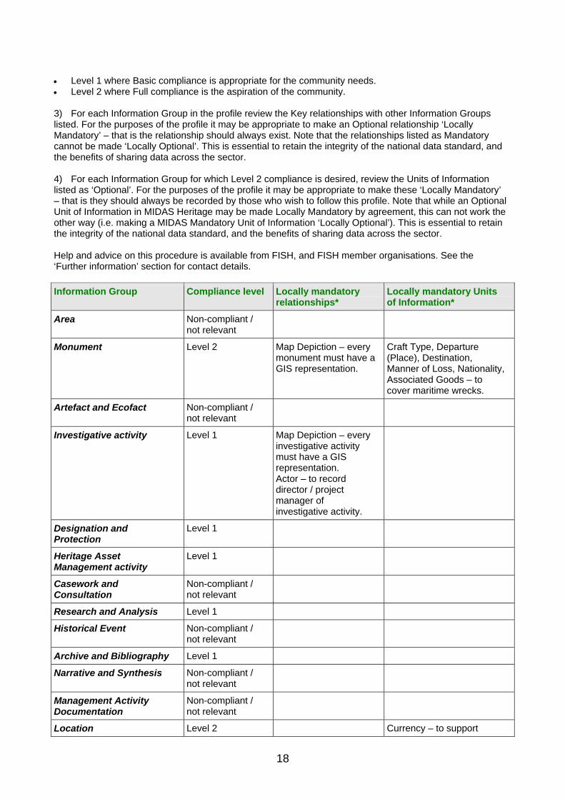
Level 1 where Basic compliance is appropriate for the community needs. Level 2 where Full compliance is the aspiration of the community.
3) For each Information Group in the profile review the Key relationships with other Information Groups listed. For the purposes of the profile it may be appropriate to make an Optional relationship ‘Locally Mandatory’ – that is the relationship should always exist. Note that the relationships listed as Mandatory cannot be made ‘Locally Optional’. This is essential to retain the integrity of the national data standard, and the benefits of sharing data across the sector. 4) For each Information Group for which Level 2 compliance is desired, review the Units of Information listed as ‘Optional’. For the purposes of the profile it may be appropriate to make these ‘Locally Mandatory’ – that is they should always be recorded by those who wish to follow this profile. Note that while an Optional Unit of Information in MIDAS Heritage may be made Locally Mandatory by agreement, this can not work the other way (i.e. making a MIDAS Mandatory Unit of Information ‘Locally Optional’). This is essential to retain the integrity of the national data standard, and the benefits of sharing data across the sector. Help and advice on this procedure is available from FISH, and FISH member organisations. See the ‘Further information’ section for contact details.
Information Group Compliance level Locally mandatory relationships*
Locally mandatory Units of Information*
Area Non-compliant / not relevant
Monument Level 2 Map Depiction – every monument must have a GIS representation.
Craft Type, Departure (Place), Destination, Manner of Loss, Nationality, Associated Goods – to cover maritime wrecks.
Artefact and Ecofact Non-compliant / not relevant
Investigative activity Level 1 Map Depiction – every investigative activity must have a GIS representation. Actor – to record director / project manager of investigative activity.
Designation and Protection
Level 1
Heritage Asset Management activity
Level 1
Casework and Consultation
Non-compliant / not relevant
Research and Analysis Level 1
Historical Event Non-compliant / not relevant
Archive and Bibliography Level 1
Narrative and Synthesis Non-compliant / not relevant
Management Activity Documentation
Non-compliant / not relevant
Location Level 2 Currency – to support
18

recording of historic administrative area names.
Map Depiction Level 1 Monument, investigative activity
Date and Period Level 1
Actor and Role Level 1 Investigative activity – to record director / project manager of investigation.
*i.e. those in addition to the nationally defined Mandatory relationships or units covered by MIDAS Heritage.
Figure 1 An example of a MIDAS Heritage Compliance Profile.
In this fictional example the focus is on Monuments. It has been decided for this group that Area and Artefact and Ecofact assets are not included. For the needs of this user group, Geographic Information System (GIS) depictions are made Locally Mandatory, as are specific Units of Information to support recording historic area names and maritime wreck sites.
19

20
3. MIDAS Heritage structure
The MIDAS Heritage data standard has a three-level structure. Working from the broadest to the most specific these are: Themes: the broadest level areas of interest to the historic environment community. These are set out below. Information Groups: these set the specific standard for what should be included in an entry covering a particular subject. Information Groups are defined and described in the following sections. Units of Information: the basic ‘facts’ or items that make up an entry. Units of information are defined and notes given on their usage in Section 5 ‘Dictionary of Units of Information’.
MIDAS Heritage Themes MIDAS Heritage divides the wide range of heritage sector information into the following broad themes. Themes can be used for convenient description of the principle focus of an information system or dataset. Most heritage sector information systems using the MIDAS Heritage standard will focus on one or more of the main themes of Heritage Asset, Activity and Information Sources. Where the text, tables and definitions in MIDAS Heritage refer to a theme name, that reference should be taken to apply equally to all the Information Groups that make up that theme.
Main themes The following are the principle themes of interest in heritage information recording. Definitions of each Information Group within each theme are given in the following sections.
Heritage Asset The Information Groups in this theme are the principal focus of study and investigation in the heritage sector. They are ‘what we want to know about’. In the first edition of MIDAS (1998) the focus was on Monuments (buildings, archaeological remains, wreck sites, find-spots, etc.). MIDAS Heritage reflects changing approaches to the study of material remains of the past. ‘Heritage Asset’ has been adopted as an appropriately inclusive heading to embrace landscape-scale areas at one end of the scale, and individual artefacts and ecofacts at the other. The description and recording of the character of these closely related assets remains a core function of inventories using the MIDAS Heritage standard. However, each asset type requires slightly different treatment, reflecting the nature of the asset and professional practices employed in their understanding. Information Groups in this theme are: Area Monument Artefact and Ecofact
Activity This theme covers things that have happened. This can also including the recording of plans for future work. A structured record of events relating to a particular Heritage Asset can be used to give context and meaning to the records of heritage asset character. It provides information on ‘how we know what we know’ (Investigative Activity, Research and Analysis) or on how a particular Heritage Asset has been managed through time (Heritage Asset Management Activity, Casework and Consultation, Designation and Protection). Historical events, not related to the investigation or recording of an asset, are also covered by MIDAS Heritage, as these may be recorded to provide explanatory context, for example for educational or outreach uses. Most information systems will only cover a few of these different activities. They are separated into distinct Information Groups to allow discussion of key issues and relationships relevant to each Activity.

Information Groups within this theme are: Investigative Activity Designation and Protection Heritage Asset Management Activity Casework and Consultation Research and Analysis Historical Event
Information Sources This theme covers traditional bibliographic references and references to primary archive materials, as well as online references. This is appropriate where the information is held outside an information system, for example in a publication, or on a web page. In this case the information system acts as a finding aid to point users to these further sources. Increasingly, however, additional information, for example text plus images, is being held within heritage information systems and may be deemed to be publications in their own right. This area is evolving as practice develops but two initial standards for this sort of content are included. Narrative and Synthesis covers education or instructional material integrated with the entries in an information system. Management Activity Documentation provides structured reports on aspects of the management of specific heritage assets. Information Groups included in this theme are: Archive and Bibliography Narrative and Synthesis Management Activity Documentation
Supporting themes The following themes provide supplementary information to the main themes.
Spatial Information Accurate knowledge of the position in space of Heritage Assets is central to their understanding and management. Similarly the location where events have occurred, or to which Information Sources are relevant, is essential. Information Groups in this theme are: Location Map Depiction
Temporal Information An understanding of the chronology of significant activities or events is common to all records of Heritage Assets. The standards presented here support recording of a wide variety of dates of different degrees of certainty, cultural periods and date ranges. These can either be derived from the physical aspects of the Heritage Asset itself (e.g. the style of a building) or from scientific investigation (e.g. radiocarbon dating) appropriate to recording the character of Heritage Assets. To avoid over-complication, where specific and undisputed ‘point in time’ dates are more appropriate, these are treated as separate units of information included in the appropriate Information Groups. The Information Group in this theme is: Date and Period
Actor Information Heritage Assets were originally created by people, groups and cultures. The subsequent investigation, documentation, management and presentation of these assets are also the responsibility of organisations and individuals.
21

The general term ‘actors’ is adopted by MIDAS Heritage, following usage in ISO 21127, for all the different organisations, groups, individuals documented in an information system. The information group in this theme is: Actor and Role
MIDAS Heritage The UK Historic Environment Data Standard
Activities Theme
Information Sources Theme
Spatial Information Theme
Temporal Information Theme
Actor Information Theme
Area Investigative Activity
Archive and Bibliography
Location Date and Period
Heritage Asset Theme
Actor and Role
Monument Designation and Protection
Casework and Consultation
Heritage Asset Management Activity
Research and Analysis
Historical Event
Narrative and Synthesis
Management Activity Documentation
Map Depiction
Artefact and Ecofact
Figure 2 An overview of the structure of MIDAS Heritage
22

4. Information Groups
Information Groups are thematic groupings of related Units of Information which together answer key questions about some aspect of the historic environment and its management. This section describes the MIDAS Heritage Information Groups and highlights key issues for consideration. It is unlikely that any one information system or dataset will make use of all the Information Groups presented. Instead the relevant groups should be identified for each community in the sector (see Section 2). The Units of Information referred to in each Information Group are detailed in Section 5 ‘Dictionary of Units of Information’.
Presentation of the Information Groups Each Information Group description has the following sections:
Definition The specific area covered by this Information Group.
Introduction The general purpose and value of standardising data for this subject area.
Key questions The key questions that information systems using this Information Group should be able to answer. It can be used to help determine which Information Groups are most relevant in a given situation.
Key issues and recommendations Advice on the issues that need to be considered when defining best practice for data capture, indexing, record management, etc. For each key issue a recommendation is given on how the MIDAS Heritage standard can be most effectively used. Recommendations are only intended to assist those setting up inventories and do not form part of the standard. Currently, not all Information Groups will have key issues documented. They will be updated to reflect continuing development of the MIDAS Heritage standard.
Key relationships between Information Groups Each Information Group includes a table which lists the requirement for Information Group entries to be qualified by entries in other Information Groups to create a full record. Relationships listed are not necessarily reciprocal; thus for example every Monument entry must have an Archive and Bibliography entry. However, Archive and Bibliography entries do not themselves have to relate to Monuments. Columns given are: Information Group: The Information Group to which a relation is made. Note that in some cases all the Information Groups in a theme are relevant. In this case the theme name is given. For example where ‘Heritage Asset’ is given, the relationship could be to an Area, Monument or Artefact/Ecofact. M/O: Indicates the relationship is Mandatory (M) or Optional (O). Mandatory means that an entry must also be recorded using the other Information Group. For example a Monument entry must have a Date and Period entry related to it. S/R: Indicates whether the relationship should only be to a single (S) entry in the related Information Group, or is repeatable (R) linking to one or more entries. Notes: Gives particular reasons for, or further explanation of, the relationship. Specific types of relationship may require qualification. Information systems should be designed so that the relationships between the Information Groups can be documented when data is exported from an information system using the Primary Reference Number and
23

Primary Reference Number Relation Units of Information. In practice within a particular information system, these relationships may be implied in the structure of the information system, or may result from the use of a GIS – that is, they are related because they exist in the same or close location.
Compliance Table Columns given in the table are as follows: Unit of Information: The name of the Unit of Information. The name is indented where the Unit of Information qualifies the unit listed above; e.g. Primary Reference Number Type qualifies Primary Reference Number in each case. Consult Section 5 ‘Dictionary of Units of Information’ for a definition and additional guidance and examples. M/O: Indicates whether this Unit of Information is Mandatory (M) and must always be recorded, or Optional (O) and may be recorded. S/R: Indicates whether the Unit of Information should be recorded once only as a Single value (S) or if multiple repeatable values are allowed (R). This is equivalent to the numeric notation used in other data standards as follows: 0:1 (Optional Single value), 1:1 (Mandatory Single value) 0:n (Optional Repeatable value) 1:n (Mandatory Repeatable value) Notes and examples: Additional notes relevant to the use of this Unit of Information in this particular Information Group. Example values are given to illustrate the use of the unit in the information scheme. Other example values are given in Section 5 ‘Dictionary of Units of Information’. Mandatory means that the information must be recorded where it is available. In some instances the necessary information is not available (e.g. the End Date of an activity that is in progress). The intention of making such units Mandatory is to focus attention on the need to plan to obtain that information when it does become available, and ensure that it is recorded. Where information systems require Mandatory fields to include data, then suitable default values should be entered.
24

4.1 Heritage Asset Theme
Area
Definition A defined area of land, urban or seascape, of significance for an understanding of the historic environment and its management.
Introduction Historic environment research and management activity increasingly looks beyond the boundaries of traditionally defined sites, monuments and built structures, taking a more holistic view of the landscape, townscape and seascape. Examples of ‘areas’ that typically might be identified in information systems include: Characterisation areas, used to document the
character of the historic environment across a site, a landscape or an administrative area.
Constraint areas used to assist planning decisions.
Designated areas subject to specific legal protection.
A conjectured or theoretical area of past landscape or environment or land ownership, such as the former extent of woodland or the projected territory of an Iron Age tribe.
The area covered by a research project. To provide general location of otherwise poorly
located heritage assets (e.g. documented losses of shipping or records lacking location detail).
Practice in this area is evolving. MIDAS Heritage’s standard setting for the recording of areas is limited to defining the area, recording the context in which it has been defined, and a generalised high-level categorisation. The standard for the depiction of the area is covered in Map Depiction.
Key questions Who has identified this area for study? What type of area is this?
Key issues and recommendations Recording multi-part areas Area definitions used for historic environment research will typically need to record complex multi-part areas, as well as simple single polygons. For example, a defined area of research might contain several discrete parcels of land, but for research or management purposes they need to be treated as one area. Recommendation: The use of the Map Depiction Information Group is recommended. For complex multi-part areas separate Map Depiction entries can be created, and linked to one Area entry using the relevant Primary Reference Numbers. Understanding the context Unlike a site or monument that may well have established and recognisable boundaries, an area defined for study will reflect the nature and interests of the study, rather than necessarily an aspect of the historic environment. For this reason it is particularly important for future users of area data to have access to
25

records of the study or activity that has defined the area, so that they can evaluate the relevance of the defined area to their purposes. Recommendation: Area entries should always be related to at least one Event, which has provided the context for the definition of the area. Typically this might be a research project recorded using a Research and Analysis entry, a Designation and Protection activity or a Management Activity.
Key relationships between Information Groups Area entries have the following key relationships:
Information Group M/O
S/R Notes
Map Depiction M R To record the outline of the area (or the separate constituent parts of a complex area).
Research and Analysis O S To document the research project or study which has identified and proposed the outline of the area.
All others O R
M = Mandatory; O = Optional S = Single; R = Repeatable
Compliance Table
Unit of Information M/O S/R Notes and examples
Primary Reference Number M S Identifies this area within the information system. Example: 187965
Primary Reference Number Type M S Used to support interoperability. Default value: “area”
Heritage Asset Name O R Identifies this area within the information system. Example: NORTH MOOR PROJECT AREA
Compiler (Organisation) M S Example: ENGLISH HERITAGE
Compiler (Person) O S Example: JAMES O’BRIEN
Date of Compilation M S Example: 23-FEB-2008
Date of Last Update M S Example: 14-MAY-2008
Entry Type O S To distinguish Rural, Urban, Seascape, etc. Example: RURAL AREA
External Information System O R Where this area is also documented by another information system. Example: WESTMORLAND HER
External Information System Primary Reference Number
O R FY6875
Description M R Example: Two areas of unimproved grassland/moorland North of Fyfield. The western, larger area centres on Fillborough henge.
Description Type O R Example: SUMMARY
Area Type M R A general indication of the type of area. Example: MOORLAND
Evidence O R Evidence on which the definition of the area
26

is based. Example: DOCUMENTARY EVIDENCE
Protection Type O R Used where a simple flag to indicate protection is appropriate. For detailed recording, a related Designation and Protection entry should be used. Example: CONSERVATION AREA
M = Mandatory; O = Optional S = Single; R = Repeatable
Primary Reference Number Primary Reference Number Type Description Compiler (Organisation) Date of Compilation Date of Last Update Area Type
AREA
MAP DEPICTION Primary Reference Number Primary Reference Number Type Compiler (Organisation) Date of Compilation Date of Last Update Positional Accuracy Spatial Feature Type X Coordinate Y Coordinate
AREA
Figure 3 The mandatory Units of Information which are required for the Area Information Group
27

Monument
Definition The documentation of any feature of the landscape or seascape that, by its nature (either extant or former), imparts knowledge about the historic environment. This includes built, buried and underwater heritage of all dates and types.
Introduction ‘Monument’ in MIDAS Heritage usage includes buildings (both ruined and in use), shipwrecks and aircraft crash sites, battlefields, parks and gardens and open spaces, relict landscape features, and sites with folklore associations, as well as field monuments such as barrows and field systems, wetlands, cropmarks, submerged landscapes, urban strata and find-spots typically associated with archaeology. The focus is on the ‘thing’ itself in this Information Group. Records of investigation of these features (e.g. archaeological excavations) are covered by Information Groups in the Activity theme. The broad definition of monument extends to the recording of the former existence of buildings or archaeological remains now destroyed (e.g. by quarrying or urban development). The knowledge of these sites contributes to the overall understanding of the historic environment.
Key questions What is it? What was it? How was it used? What is it built with?
Key issues and recommendations Indexing uncertainty In many cases, particularly where information system entries relate to archaeological sites of considerable antiquity, there will be uncertainty about the correct interpretation to record, for example in Monument Type or Period Units of Information. Two approaches should be considered. A monument in the information system can be indexed by either: what it is (i.e. best available current interpretation is that this monument is an ‘X’, it dates to ‘Y’) or what it might be (i.e. if you are interested in ‘X’ type of monument or monuments of ‘Y’ date you should
look at this record). Recommendation: Indexing should adopt the second approach and include all possible alternatives that can reasonably be supported by the evidence available. It is the purpose of indexing to maximise retrieval of relevant information system entries to assist future users. Uncertainty can be included in the Description for the entry. The use of a single authoritative interpretation to index is only appropriate where detailed research has been undertaken leading to a firm conclusion. Currency Should all information system indexing reflect current understanding, or should previous interpretations and information that have now been disproved or are known to be inaccurate be included in the indexing to record the changing interpretation and information about a monument over time?
28

Recommendation: Unless there is a specific need to be able to retrieve, not only current but also, previous interpretations of monument character, it is recommended that only the latest interpretation or interpretations that can be supported by the sources of information available should be included in the indexing. If it is desirable to hold historic or previous indexing then the information system must qualify entries with use of the Currency Unit of Information. This will allow the latest interpretations to be distinguished and retrieved separately from previous interpretations. Identification from documentary sources When using historical documents, identification is complicated by the limitations of the documentary sources – for example not giving precise locations (‘off Islay’, ‘North of Oxford’, etc). For example, sources relating to the craft or the nature of the surviving remains or documented references to battle sites may be ambiguous. This can lead to some known monuments not being recorded or to multiple entries in an information system for what is in fact the same monument. Use of the MIDAS Heritage data standard can assist in the identification of, for example, the surveyed remains of a nineteenth-century coal barge by matching it to a record documenting the loss of a vessel in the same area at the same time sharing similar attributes. Similarly the site of a possible battle identified from a metal detector survey may tie in with known historical references. Recommendation: Monument entries should be created from documentary sources even where locations are poorly known because this can assist targeting future field work and the future matching of documentation with identifiable monuments. Last journey details for air and watercraft Information regarding the last recorded journey of a craft, where known, is of particular value in placing the site within its historical context. Analysis of information such as the ports of departure and destination of cargo vessels carrying particular commodities can assist in the understanding of trade routes and the economic development of adjoining land areas. For military watercraft and aircraft, knowing the points of departure and any destinations, such as the targets of bombing raids, may assist in the interpretation of particular campaigns or battles. This is one of the areas that give the recording of watercraft and aircraft its unique character. Recommendation: Additional mandatory Units of Information are given in the Compliance Table for water and aircraft recording.
Key relationships between Information Groups Monument entries have the following key relationships:
Information Group M/O
S/R Notes
Date and Period M R Qualifies Monument type to record phases of development or changes in the monument over time.
Location M S To record the current position of the monument.
Investigative Activity O R To document the circumstances of discovery or subsequent information gathering.
Map Depiction O R Mandatory where the technology and adequate information exist.
Monument O R To document the relationship between individual structures in a complex or with other monuments where these are not documented elsewhere. Qualified by: Primary Reference Number relation.
Archive and Bibliography M R To document the sources that describe this monument. Qualified by: Archive/Source Reference.
29

Actor and Role O R To document owners, architects, persons of historic interest. Use Date and Period Information Group to qualify the association where appropriate. Qualified by: Date and Period.
All others O R
M = Mandatory; O = Optional S = Single; R = Repeatable
Compliance Table
Unit of Information M/O S/R Notes and Examples
Primary Reference Number M S Example: 187965
Primary Reference Number Type M S Used to support interoperability. Default value: “monument”
Heritage Asset Name O R Example: OLD GLOVE FACTORY
Description M S Example: Glove factory opened in 1887 to provide work for the…
Description Type O S Example: FULL
Compiler (Organisation) M S Example: WESTSHIRE INDUSTRIAL HERITAGE GROUP
Compiler (Person) O S Example: JAMES FARRELL
Date of Compilation M S Example: 23-MAY-2009
Date of Last Update M S Example: 25-MAY-2009
Entry Type O S Example: BUILDING
External Information System O R Links this Monument entry to records of the same building in other information systems. Example: ENGLISH HERITAGE LISTED BUILDING SYSTEM
External Information System Primary Reference Number
O R Example: 688907
Monument Type M R Qualified by: Date and Period entry Example: FACTORY
Currency O R Mandatory where previous, now disproved, interpretations of an asset’s character are indexed. Example: CURRENT
Evidence O R Example: EXTANT BUILDING
Material O R Example: LIMESTONE
Material Component O R Example: CARBON
Material Component Note O R Example: CARBON SOOTING ON LOWER EXTERIOR SURFACE
Material Name O R Example: MAGNESIAN LIMESTONE
Component O R Example: ORIEL WINDOW
Prime Motive Power O S For air and water craft, or for industrial installations Example: SAIL; STEAM
Craft Type O R Mandatory for wreck recording, but
30

otherwise an optional, repeatable field. Example: FISHING VESSEL
Departure (Place) O S For wreck recording. Example: NEWCASTLE
Destination O S For wreck recording. Example: NEWCASTLE
Manner of Loss O S For wreck recording. Example: GROUNDED
Nationality O S For wreck recording. Example: ENGLISH
Registration Place O S For wreck recording. Example: GRIMSBY
Associated Goods O R For wreck recording this would include Cargo. Example: FISH
Construction Method O R For air or water craft or buildings Example: STEEL PLATE; TIMBER-FRAMED
Protection Type O R Used where a simple flag to indicate protection is appropriate. For detailed recording, a related Designation and Protection entry should be used. Example: PROTECTED WRECK
Right Note O R To record other legal constraints where appropriate. Example: PROPERTY OF CROWN ESTATE
Right Type O R To document the type of legal constraint noted. Example: OWNERSHIP
Dimension O R Example: AREA
Dimension Measurement Unit O R Example: HECTARES
Dimension Value O R Example: 1.2
Condition O S For simple condition assessment. For more detailed recording use Heritage Asset Management Activity Example: GOOD
Condition Date O S For simple condition assessment. For more detailed recording use Heritage Asset Management Activity Example: 24-AUG-2010
Inscription Content O S For dedication plaques, memorial inscriptions, text of tombstones etc Example: IN GRATEFUL MEMORY OF THOSE WHO FELL ON THIS SITE IN..
Inscription Note O S Example: OVER EAST DOOR
M = Mandatory; O = Optional S = Single; R = Repeatable
31

MONUMENT
MONUMENT Primary Reference Number Primary Reference Number Type Description Compiler (Organisation) Date of Compilation Date of Last Update Monument Type
DATE AND PERIOD Primary Reference Number Primary Reference Number Type Start Date End Date
LOCATION Primary Reference Number Primary Reference Number Type Administrative Area Name Administrative Area Type Grid Reference
ARCHIVE AND BIBLIOGRAPHY
Primary Reference Number Primary Reference Number Type Description Compiler (Organisation) Date of Compilation Date of Last Update Archive/ Source Type Archive/ Source Location Archive/ Source Format Date of Origination Right Note Right Type
Figure 4 The mandatory Units of Information which are required for the Monument Information Group
32

Artefact and Ecofact
Definition Information recording the character of portable items of heritage significance, including individual artefacts, architectural items, artefact assemblages, individual ecofacts and ecofact assemblages, and environmental samples.
Introduction Artefacts and ecofacts provide primary evidence for the study of past societies. They may be found through systematic field investigation, excavation or chance discovery, or collected during building repair or demolition. Heritage organisations are increasingly cataloguing and improving the information used to manage their temporary or permanent collections of artefacts, excavation finds, ecofacts and samples, and architectural items. The MIDAS Heritage standard is intended to support: the creation of a consistent and complete
index for a wide range of users. It should allow them to identify broad object/ecofact types or groups of objects/ecofacts. Such information provides a base line which allows individual assemblages of artefacts/ecofacts to be studied in context or to aid in synthetic studies of particular artefacts/ecofact types.
the interface between the recording of the historic environment and museum collections. For detailed cataloguing of museum collections, see the SPECTRUM standard for museum collections (http://www.mda.org.uk/spectrum.htm).
descriptive and interpretive information to allow users to understand the significance of artefacts and ecofacts.
Key questions What is it? How was it found? Where is it stored What condition is it in?
Key issues and recommendations Item or assemblage level recording Archaeological investigation will yield many hundreds or thousands of individual artefacts. Documentation of each individually is time consuming and may not be appropriate. Recommendation: A more pragmatic approach is to record at the level of an excavation or assemblage first, for example to highlight that an excavation has yielded Roman pottery, vertebrate remains, coin and glass collections, and bulk samples of waterlogged deposit, and then only document selected artefacts of greater significance as a second stage of recording as resources allows.
33

Organic and non-organic materials For use with environmental or other sampling recording, a distinction can be made between biological remains (i.e. remains of whole or substantial identifiable parts of organisms, such as beetles, pollen, animal bones) and non-organic remains (glass or metal slag, pottery, building materials, etc.). These are subsequently examined by different specialists using different techniques. Different types of information are therefore relevant to the different categories (e.g. the Material Unit of Information is not relevant to biological remains). Recommendation: Alternative recording forms are designed, based upon the MIDAS standard, to improve the efficiency of data collection.
Key relationships between Information Groups Artefact and Ecofact entries have the following key relationships:
Information Group M/O S/R Notes
Investigative Activity M S To identify the excavation or other investigation that has recovered the artefact and ecofact material.
Date and Period M R To record the chronology of the artefacts or ecofacts, most significantly the dates of manufacture, deposition or death (for biological materials).
Research and Analysis O R To record the post-excavation or other research activity that has studied the artefacts or ecofacts.
Monument O S To record any monument from which this artefact has been derived or is associated with.
Artefact and Ecofact O R To record association with other artefacts, or with a collection of which this artefact or ecofact forms a part. Qualified by: Primary Reference Number Relation.
Heritage Asset Management Activity O R To record conservation or other work to preserve this sample.
Management Activity Documentation O R To record recommendations for future work, etc.
Actor and Role O R To record all actors associated with this artefact, for example makers, owners, finders, curators. Qualified by: Date and Period.
All others O R
M = Mandatory; O = Optional S = Single; R = Repeatable
Compliance Table
Unit of Information M/O S/R Notes and examples
Primary Reference Number M S Example: 51877
Primary Reference Number Type M S Used to support interoperability. Default value: “artefact or ecofact”
Heritage Asset Name O R Example: VERTEBRATE REMAINS FROM
34

CHARLTON FIELD
Description M R A description of the artefact or ecofact. Example: WELL-PRESERVED COLLECTION OF SMALL VERTEBRATE REMAINS WITH EVIDENCE FOR MULTIPLE SPECIES.
Description Type O R Example: SUMMARY
Compiler (Organisation) M S Example: WESTSHIRE ENVIRONMENTAL CENTRE
Compiler (Person) O S Example: JAMES FULLARD
Date of Compilation M S Example: 14-OCT-2009
Date of Last Update M S Example: 24-NOV-2009
Entry Type O S The general type of asset under study. Example: ECOFACT
External Information System O R Example: WESTCOMBE MUSEUM ACCESSION NUMBER Example: CHARLTON FIELD EXCATION CONTEXT NUMBER
External Information System Primary Reference Number
O R Example: 2008/4623 Example: CF2009/465
Artefact/Ecofact Type M R Example: CATTLE BONE
Modification State O R Example: ANOXIC
Condition O S Use a controlled vocabulary for a brief assessment. For more detailed records use Historic Asset Management Activity and Management Activity Documentation Example: GOOD
Condition Date O S Example: 23-SEP-2014
Recovery Method M S The technique used to recover an artefact or ecofact. Example: HAND EXCAVATION
Artefact Name Type O S Appropriate for recording ecofacts and biological samples. Example: TAXONOMIC
Recovery Purpose O S Example: TO ANALYSE SPECIES REPRESENTED IN DOMESTIC REFUSE
Production Method O R Example: CAST
Production Technique O R Example: LOST-WAX
Dimension O R Example: QUANTITY
Dimension Measurement Unit O R Example: MINIMUM NUMBER OCCURRING
Dimension Value O R Example: 27
Evidence O S Example: STRATIFIED FIND
Completeness O S Example: HIGH
Conservation Treatment Priority O S Example: URGENT
Environmental Condition Note O S Example: Stored in less than 10% relative humidity.
Inscription Content O R For coins, memorial stones, architectural
35

fragments, etc. Example: THIS STONE WAS RAISED BY HILD, SON OF JOHN
Inscription Note O R For coins, memorial stones, architectural fragments, etc. Example: INSCRIPTION IS ON A PLATE AFFIXED TO THE NORTH SIDE
Material O R Mandatory for artefact entries. Example: POTTERY
Material Component O R Example: CARBON
Material Component Note O R Example: CARBON SOOTING ON LOWER EXTERIOR SURFACE
Material Name O R Example: SAMIAN WARE
Component O R Example: LID
Collection Extent O S Example: 18 BOXES
Storage Location M S Example: WESTCOMBE MUSEUM STORE BAY 16 SHELF 4-6
Protection Type O R Used where a simple flag to indicate legal protection is appropriate. For detailed recording, a related Designation and Protection entry should be used. Example: TREASURE
Right Note O R To document any legal entitlement or interest. Example: ON LOAN FROM WESTBURY MANOR ESTATE
Right Type O R Example: OWNERSHIP
M = Mandatory; O = Optional S = Single; R = Repeatable
36

ARTEFACT AND ECOFACT
Primary Reference Number Primary Reference Number Type Description Compiler (Organisation) Date of Compilation Date of Last Update Artefact/Ecofact Type Recovery Method Storage Location
ARTEFACT AND ECOFACT
INVESTIGATIVE ACTIVITY
Primary Reference Number Description Compiler (Organisation) Date of Compilation Date of Last Update Activity Type
DATE AND PERIOD Primary Reference Number Primary Reference Number Type Start Date End Date
Figure 5 The mandatory Units of Information which are required for the Artefact and Ecofact Information Group
37

4.2 Activities Theme
Investigative Activity
Definition Any activity undertaken with the explicit intention of gathering information about, and understanding of, a Heritage Asset, and the creation of an information source to record that information and understanding.
Introduction Investigative Activity covers fieldwork, the full range of survey, investigation of standing buildings, excavations, core sample collection, etc. The term ‘activity’ is adopted to indicate the active involvement of participants on a particular piece of work. Investigative Activities covered include those undertaken to gain information about a known Heritage Asset, simply to advance knowledge, or as part of a wider objective (e.g. to provide information to guide monument management). They may be specific to one Monument or extensive relating to an Area. They can be part of wider research or be related to the planning process and monument protection and designation regimes. Investigations can also be targeted at areas where no monuments are recorded to establish what might be there.
Key questions What investigations have been carried out? Why were they undertaken? Who has carried out investigations and when? What were the results of investigations?
Key issues and recommendations Relation of Investigative Activity to Heritage Asset entries Separate Investigative Activities and Heritage Asset entries ensure that the origin of information on which an interpretation is based (the Investigative Activity) is made clearly distinct from the interpretation itself (documented in the Heritage Asset entry). The nature of the Investigative Activity is fixed, but the interpretation of the Heritage Asset may change as further information is gathered or existing information is reinterpreted (as a result of further Investigative Activities). This approach is particularly appropriate where the existing information is uncertain or incomplete. An example that illustrates the application of this approach is in documenting the archaeological remains (monuments) of earlier settlements beneath modern towns and cities. The interpretation of the remains seen in each excavation may only gradually develop to the extent where the monument can be interpreted. Future work may reinterpret the remains. There is a need, therefore, for a system that can accommodate changes to the interpretation over time, but still retain all the details of the activities that have influenced the interpretation. This can be achieved with an information system that can record the excavations (Investigative Activities) separately from the interpretation based upon the results (Monuments). Separation of Investigative Activity and Heritage Asset also has the advantage of being able to record ‘negative evidence’ where an investigation found no trace of any monument and therefore there will be no Monument character record to link it to. Negative evidence documented in this way can contribute to the interpretation of the heritage of an area and guide future management. Recommendation: The separation of Activities and Monument character entries is a useful way of tackling the particular needs of archaeological monuments and is recommended in this context.
38

Coverage Investigative activities have been conducted systematically for several hundred years. A decision as to whether to include earlier investigations as well as more recent or current activities in your information system should be made. Recommendation: All activities which are known about should be included as they help to place a monument in context.
Key relationships between Information Groups Investigative Activity entries have the following key relationships:
Information Group M/O S/R Notes
Archive and Bibliography M R To signpost sources of information, for example a project archive. Qualified by: Archive/Source Reference.
Location M S To indicate where the investigation took place.
Map Depiction O S For more detailed recording of the extent of the area of the investigation.
Date and Period M S To qualify the Activity Type indicating when the activity took place.
Actor and Role M R To record at least the organisation undertaking the activity. Qualified by: Date and Period to indicate duration of their involvement.
All others O R
M = Mandatory; O = Optional S = Single; R = Repeatable
Compliance Table
Unit of Information M/O S/R Notes and examples
Primary Reference Number M S
Primary Reference Number Type M S Used to support interoperability. Default value: “investigative activity”
Activity Name O R Use text names. Site codes as used by excavation teams should be recorded as external information system reference numbers. Example: 43 HIGH STREET
Description M S Example: EXCAVATION IN ADVANCE OF REDEVELOPMENT OF THE FORMER ‘BRADWORTHY BAKERY’ DURING APRIL 2009 REVEALED FOUR SEPARATE…’
Description Type O S Example: ABSTRACT
Compiler (Organisation) M S Example: WESTSHIRE ARCHAEOLOGY
Compiler (Person) O S Example: NORRIS FELTHAMOND
Date of Compilation M S Example: 23-JUN-2009
Date of Last Update M S Example: 14-JUL-2009
External Information System Primary Reference Number
O R Example: ND406
External Information System O R Example: WESTSHIRE ARCHAEOLOGY
39

EXCAVATION LIST
Activity Type M R Qualified by: Date and Period entry Example: EXCAVATION
Activity Objective O S Example: To examine the extent of medieval town wall remains.
Work Status O S For example, to record the project management stage. Example: ANALYSIS
M = Mandatory; O = Optional S = Single; R = Repeatable
INVESTIGATIVE ACTIVITY
Primary Reference Number Description Compiler (Organisation) Date of Compilation Date of Last Update Activity Type
INVESTIGATIVE ACTIVITY
ARCHIVE AND BIBLIOGRAPHY
Primary Reference Number Primary Reference Number Type Description Compiler (Organisation) Date of Compilation Date of Last Update Archive/ Source Type Archive/ Source Location Archive/ Source Format Date of Origination Right Note Right Type
Primary Reference Number
Primary Reference Number Primary Reference Number Type Compiler (Organisation) Date of Compilation Date of Last Update Person/ People/ Organisation Name Role
ACTOR AND ROLE
Primary Reference Number Type Administrative Area Name Administrative Area Type Grid Reference
LOCATION
Primary Reference Number Primary Reference Number Type Start Date End Date
DATE AND PERIOD
Figure 6 The mandatory Units of Information which are required for the Investigative Activity Information Group
40

Designation and Protection
Definition Activities which implement or revoke statutory and non-statutory designation and protection regimes which may apply to Heritage Assets.
Introduction Various designations provide legal protection to Heritage Assets, or otherwise designate them for particular consideration in decisions affecting their future management. These relate to buildings or archaeological sites (e.g. designation of a Protected Wreck) to artefacts (e.g. designation of an artefact group as treasure, or the imposition of a temporary export ban), or areas (e.g. designation or extension of a Conservation Area, or World Heritage Site). There is not always a one-to-one correlation between the designation as issued and the assets to which they relate. With monuments protection, for example, designations are typically concerned with defining an area within which controls exist to support the management of the historic environment. A designated area may, however, contain one or many monuments, each of which requires separate documentation for management or research purposes. Likewise a treasure designation may cover a number of significant artefacts each of which requires suitable documentation. For this reason, MIDAS Heritage separates entries relating to designation as an activity from the entries which document the Heritage Assets themselves.
Key questions Is this Heritage Asset protected? What aspects/extent are protected? By what measures is the Asset protected?
Key issues and recommendations Statutory names Legal documents relating to asset protection and designation will often cite the asset by name or create a name where one does not exist. As the actual wording of the legal document is significant, these statutory names should not be treated in the same way as names used generally for documentation. They should be recorded as cited in the legal document, so as to assist unambiguous cross-reference. Recommendation: Where names are given in legal documents, record these using the statutory name Unit of Information, even if this duplicates a name recorded elsewhere. Currency of protection For accurate management it is essential that information concerning the legal status of an asset is current. It may well be relevant to know exactly when an asset received its designation, for example when adjudicating on possible breaches of the law. Recommendation: It is recommended that Date Protection Start and Date Protection End units are used. An entry with a Date Protection Start completed, but no Date Protection End is assumed to be current.
41

Recording of the dates can assist cross-reference to appropriate legal documents which change the designation and protection status of the asset. Protection measures For England and Wales, the Government White Paper Heritage Protection for the 21st Century (2007) has recommended combining a number of the heritage designation regimes within one unified register. The detail of changes will affect the names of different asset protection regimes. However it will not affect the need to record designation history. Recommendation: The exact nature of the protection measure should be recorded in the Protection Type Unit of Information. Terminology standards covering this unit will be updated to reflect any changes introduced.
Key relationships between Information Groups Designation and Protection entries have the following key relationships:
Information Group M/O S/R Notes
Casework and Consultation M R To document the decision-making process that has led to the designation or revoking of designation.
Area O R For all site- or area-based designations this is mandatory. The actual outline of the designated area or areas will be covered by Map Depiction linked to an Area entry, to document the outline of the area to which the designation relates. Heritage Assets within this boundary will be deemed to be affected by the designation unless specifically excluded. Optional for non site-based designation (e.g. an export ban).
Location O R To give the administrative location of the designated area.
Archive and Bibliography M R To indicate additional sources of information about the area designated and Heritage Assets within it. Qualified by: Archive/Source Reference.
Management Activity Documentation O S For site-based designations it is Mandatory to record statutory management agreements relevant to this designation.
Actor and Role M S To record the authority responsible for the designation.
M = Mandatory; O = Optional S = Single; R = Repeatable
Compliance Table
Unit of Information M/O S/R Notes and examples
Primary Reference Number M S Example: 86395
Primary Reference Number Type M S Used to support interoperability. Default value: “designation”
Activity Name O S Example: DESIGNATION OF HMS SANDHURST
Description M S For example for notes used to document progress of a designation.
42

Example: CURRENTLY UNDER CONSIDERATION
Description Type O S Example: NOTE
Statutory Name M S Example: HMS SANDHURST DESIGNATED WRECK
Statutory Description M S Example: THE WRECK OF HMS SANDHURST SUNK DURING THE ENGAGEMENT WITH…
Compiler (Organisation) M S ENGLISH HERITAGE MARITIME TEAM
Compiler (Person) O R PAUL CHARLESTON
Date of Compilation M S 23-NOV-2009
Date of Last Update M S 14-JAN-2010
External Information System O R To link this designation activity to the appropriate Heritage Asset entry dataset, casework entry, etc. Example: ENGLISH HERITAGE ASSET REGISTER
External Information System Primary Reference Number
O R Identifying the appropriate entry in that dataset. Example: 16556/05
Entry Type M S To distinguish site-based designation from non-site-based designation. Example: SITE; COLLECTION
Protection Type M S Example: DESIGNATED WRECK
Protection Grade O S Mandatory where required by the protection measure. Example: I
Protection Start Date M S Example: 14-OCT-2008
Protection End Date O S Mandatory if designation has ceased to apply. Example: 26-MAR-2010
M = Mandatory; O = Optional S = Single; R = Repeatable
43

Primary Reference Number Primary Reference Number Type Description Compiler (Organisation) Date of Compilation Date of Last Update Entry Type Protection Type Protection Start Date Statutory Name Statutory Description
DESIGNATION AND PROTECTION
CASEWORK AND CONSULTATION
Primary Reference Number Primary Reference Number Type Description Compiler (Organisation) Date of Compilation Date of Last Update Management Proposal Type Notification Date Management Proposal Work Proposed Management Proposal Recommendation Case Status Management Proposal Outcome
Primary Reference Number Primary Reference Number Type Description Compiler (Organisation) Date of Compilation Date of Last Update Archive/ Source Type Archive/ Source Location Archive/ Source Format Date of Origination Right Note Right Type
ARCHIVE AND BIBLIOGRAPHY
Primary Reference Number Primary Reference Number Type Compiler (Organisation) Date of Compilation Date of Last Update Person/ People/ Organisation Name Role
ACTOR AND ROLE
DESIGNATION AND PROTECTION
Figure 7 The mandatory Units of Information which are required for the Designation and Protection Information Group
44

Heritage Asset Management Activity
Definition Activities undertaken to prevent damage to, or promote the survival of, Heritage Assets.
Introduction Heritage Asset Management Activity covers a range of activities relating to different Heritage Asset types. It embraces, for example: interventions, such as scrub clearance on
earthwork sites, pest-control in collections or protective cleaning of artworks;
routine on-site checking and monitoring activity, for example to assess the ‘at risk’ status of a building, or the water table on a waterlogged site;
off-site work, such as the development of a management agreement to cover the future management of an asset or area (e.g. a Conservation Area Appraisal);
collection condition checking as an aid to management of a collection in store or on display;
work to provide public access. Development of the standard for Heritage Asset management activities anticipates a closer integration of these areas with, for example, the record of investigative activities. The standard proposed here is fairly basic. For detailed checking of object collection conditions, for example, consult the SPECTRUM standard.
Key questions What activity has been undertaken/needs to be
done to manage, improve or protect this Heritage Asset?
When should that activity occur?
Key issues and recommendations To propose an issue for inclusion in MIDAS Heritage contact FISH (see the ‘Further information’ section for details).
Key relationships between Information Groups Heritage Asset Management Activity entries have the following key relationships:
Information Group M/O S/R Notes
Heritage Asset Theme (any Information Group)
M R To document the Heritage Assets affected by the management activity. The location where Heritage Asset Management Activity has taken place will generally be documented via the documentation of the Heritage Asset, unless more specific location information is required.
Management Activity Documentation O R To document the results of the management activity, for example condition reports and any recommendations for future work.
45

Date and Period M R Note that dates recorded might be for planned or future activity as well as past activity (e.g. to record that condition should be checked again in three years).
Actor and Role O R To document contractors, people involved in the work, sponsors, etc. Qualified by: Date and Period.
All others O R
M = Mandatory; O = Optional S = Single; R = Repeatable
Compliance Table
Unit of Information M/O S/R Notes and examples
Primary Reference Number M S Example: TYN1997
Primary Reference Number Type M S Used to support interoperability. Default value: “management activity”
Activity Name M S Example: TYNDALL HOUSE COLLECTION REVIEW
Description M S Example: Condition assessment of the Tyndall House collection, Summer 2009
Description Type O S Example: SUMMARY
Compiler (Organisation) M S Example: ENGLISH HERITAGE
Compiler (Person) O S Example: JOHN STEVENS
Date of Compilation M S Example: 14-AUG-2009
Date of Last Update M S Example: 23-SEP-2009
Entry Type O S The general nature of the activity (e.g. site management, collection management). Example: COLLECTION MANAGEMENT
External Information System O R Example: WESTSHIRE HISTORIC ENVIRONMENT RECORD
External Information System Primary Reference Number
O R Example: 40562
Management Activity Method O S For detailed notes on techniques used. Example: JOINTS RAKED OUT AND REPOINTED WITH LIME MORTAR
Management Activity Type M R Example: REPAIR
Work Status M S Example: PLANNED
M = Mandatory; O = Optional S = Single; R = Repeatable
46
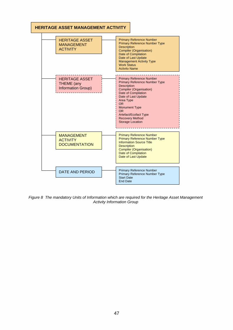
HERITAGE ASSET MANAGEMENT ACTIVITY
Primary Reference Number Primary Reference Number Type Description Compiler (Organisation) Date of Compilation Date of Last Update Management Activity Type Work Status Activity Name
HERITAGE ASSET MANAGEMENT ACTIVITY
Primary Reference Number Primary Reference Number Type Description Compiler (Organisation) Date of Compilation Date of Last Update Area Type OR Monument Type OR Artefact/Ecofact Type Recovery Method Storage Location
HERITAGE ASSET THEME (any Information Group)
MANAGEMENT ACTIVITY DOCUMENTATION
Primary Reference Number Primary Reference Number Type Information Source Title Description Compiler (Organisation) Date of Compilation Date of Last Update
Primary Reference Number Primary Reference Number Type Start Date End Date
DATE AND PERIOD
Figure 8 The mandatory Units of Information which are required for the Heritage Asset Management Activity Information Group
47

Casework and Consultation
Definition Entries record decision-making relevant to Heritage Assets. This may include for example, grants, designation, management agreements/plans or decisions made as part of the town and countryside planning process.
Introduction This broad definition encompasses development control, grant applications and conservation proposals (at the monument, artefact or artefact collection level) – in fact any activity which documents a formal response to a proposal. The extent to which inventories include information on the management of Heritage Assets will depend on the role, or roles, which are performed by the bodies which maintain them. These roles might include: the owner of an asset monitoring applications for
use, for example by visitors, functions, etc; curatorial responsibility, such as that exercised by a
local authority planning archaeologist. This role might need information on previous advice given to maintain consistency and monitor policy requirements;
assessment of applications for grant-aid for work affecting Heritage Assets;
campaigning bodies drawing attention to threats to a particular asset (e.g. buildings of a particular period). This role might need information on the condition of a monument over time and threats to its survival.
Key questions What is proposed? By whom and when? What advice has been given? Has this advice been followed? What is the status of this case?
Key issues and recommendations No specific issues. If you would like to contribute to this section of MIDAS Heritage please submit a change (see ‘Updating MIDAS Heritage’ in Section 1 for details).
Key relationships between Information Groups Casework and Consultation entries have the following key relationships:
Information Group M/O S/R Notes
Heritage Asset Theme (any Information Group)
M R To record the heritage asset(s) affected by the proposal.
Actors and Role O R To record the people and/or organisations involved in the proposal as, for example, applicants.
Archive and Bibliography O S To document the original proposal document.
Investigative Activity O R Where casework has prompted on-site investigations e.g. an excavation.
48
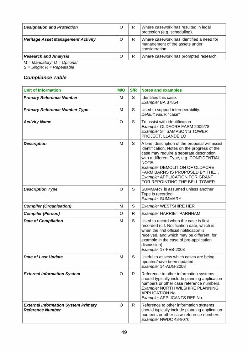
Designation and Protection O R Where casework has resulted in legal protection (e.g. scheduling).
Heritage Asset Management Activity O R Where casework has identified a need for management of the assets under consideration.
Research and Analysis O R Where casework has prompted research.
M = Mandatory; O = Optional S = Single; R = Repeatable
Compliance Table
Unit of Information M/O S/R Notes and examples
Primary Reference Number M S Identifies this case. Example: BA 37854
Primary Reference Number Type M S Used to support interoperability. Default value: “case”
Activity Name O S To assist with identification. Example: OLDACRE FARM 2009/78 Example: ST SAMPSON’S TOWER PROJECT, LLANDEILO
Description M S A brief description of the proposal will assist identification. Notes on the progress of the case may require a separate description with a different Type, e.g. CONFIDENTIAL NOTE. Example: DEMOLITION OF OLDACRE FARM BARNS IS PROPOSED BY THE… Example: APPLICATION FOR GRANT FOR REPOINTING THE BELL TOWER
Description Type O S SUMMARY is assumed unless another Type is recorded. Example: SUMMARY
Compiler (Organisation) M S Example: WESTSHIRE HER
Compiler (Person) O R Example: HARRIET PARNHAM.
Date of Compilation M S Used to record when the case is first recorded (c.f. Notification date, which is when the first official notification is received, and which may be different, for example in the case of pre-application discussion). Example: 17-FEB-2008
Date of Last Update M S Useful to assess which cases are being updated/have been updated. Example: 14-AUG-2008
External Information System O R Reference to other information systems should typically include planning application numbers or other case reference numbers. Example: NORTH WILSHIRE PLANNING APPLICATION No. Example: APPLICANTS REF No.
External Information System Primary Reference Number
O R Reference to other information systems should typically include planning application numbers or other case reference numbers. Example: NWDC 48-9076
49

Example: 2008/03/01-2
Management Proposal Type M R Example: PLANNING APPLICATION Example: GRANT APPLICATION
Notification Date M S When the first official documentation is received. Example: 01-MAR-2008
Management Proposal Work Proposed M S Example: DEMOLITION Example: REPAIR
Management Proposal Recommendation M S The recommendation made. Example: RECORDING IN ADVANCE OF DEMOLITION… Example: APPROVED
Case Status M S Example: CURRENT
Management Proposal Outcome M S Recorded when the case has been determined. Used to assess whether or not the Recommendation made was actually followed. Example: AGREED
Authorisation Required O S Example: SENIOR CASEWORK OFFICER APPROVAL Example: GRANTS OFFICER
M = Mandatory; O = Optional S = Single; R = Repeatable
Primary Reference Number Primary Reference Number Type Description Compiler (Organisation) Date of Compilation Date of Last Update Management Proposal Type Notification Date Management Proposal Work Proposed Management Proposal Recommendation Case Status Management Proposal Outcome
CASEWORK AND CONSULTATION
Primary Reference Number Primary Reference Number Type Description Compiler (Organisation) Date of Compilation Date of Last Update Area Type OR Monument Type OR Artefact/Ecofact Type Recovery Method Storage Location
HERITAGE ASSET THEME (any Information Group)
CASEWORK AND CONSULTATION
Figure 9 The mandatory Units of Information which are require for the Casework and Consultation Information Group
50
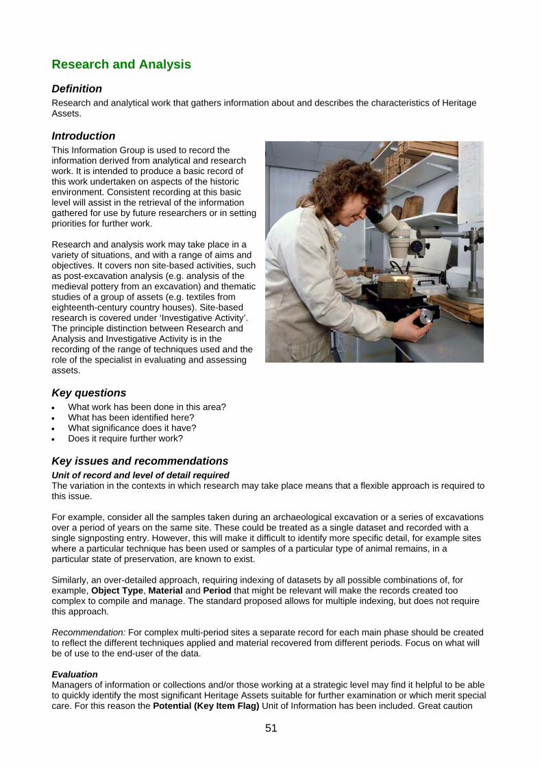
Research and Analysis
Definition Research and analytical work that gathers information about and describes the characteristics of Heritage Assets.
Introduction This Information Group is used to record the information derived from analytical and research work. It is intended to produce a basic record of this work undertaken on aspects of the historic environment. Consistent recording at this basic level will assist in the retrieval of the information gathered for use by future researchers or in setting priorities for further work. Research and analysis work may take place in a variety of situations, and with a range of aims and objectives. It covers non site-based activities, such as post-excavation analysis (e.g. analysis of the medieval pottery from an excavation) and thematic studies of a group of assets (e.g. textiles from eighteenth-century country houses). Site-based research is covered under ‘Investigative Activity’. The principle distinction between Research and Analysis and Investigative Activity is in the recording of the range of techniques used and the role of the specialist in evaluating and assessing assets.
Key questions What work has been done in this area? What has been identified here? What significance does it have? Does it require further work?
Key issues and recommendations Unit of record and level of detail required The variation in the contexts in which research may take place means that a flexible approach is required to this issue. For example, consider all the samples taken during an archaeological excavation or a series of excavations over a period of years on the same site. These could be treated as a single dataset and recorded with a single signposting entry. However, this will make it difficult to identify more specific detail, for example sites where a particular technique has been used or samples of a particular type of animal remains, in a particular state of preservation, are known to exist. Similarly, an over-detailed approach, requiring indexing of datasets by all possible combinations of, for example, Object Type, Material and Period that might be relevant will make the records created too complex to compile and manage. The standard proposed allows for multiple indexing, but does not require this approach. Recommendation: For complex multi-period sites a separate record for each main phase should be created to reflect the different techniques applied and material recovered from different periods. Focus on what will be of use to the end-user of the data. Evaluation Managers of information or collections and/or those working at a strategic level may find it helpful to be able to quickly identify the most significant Heritage Assets suitable for further examination or which merit special care. For this reason the Potential (Key Item Flag) Unit of Information has been included. Great caution
51

should be exercised in the assessment of potential, and advice from suitably experienced professionals should be sought if this approach is adopted. It is important that potentially useful assets and research are not overlooked because their potential has not been appropriately flagged. Recommendation: Potential (Key Item Flag) should only be used in conjunction with the Potential (Note) Unit of Information. The Potential (Note) unit may, however, be used on its own.
Key relationships between Information Groups Research and Analysis entries have the following key relationships:
Information Group M/O S/R Notes
Date and Period M S To record when the research or analysis took place.
Heritage Asset Theme (any Information Group)
M R To record which heritage assets were studied
Archive and Bibliography M R To document where detailed results are published or the archive of work can be found. Qualified by: Archive/Source Reference.
Actor and Role M R To document the practitioner(s) who undertook the research or analytical activity.
All others O R
M = Mandatory; O = Optional S = Single; R = Repeatable
Compliance Table
Units of Information M/O S/R Notes and examples
Primary Reference Number M S Number assigned to this research work or project by the record holder for identification. Example: WE5821
Primary Reference Number Type M S Used to support interoperability. Default value: “research and analysis”
Activity Name O S A name assigned to this research work or project. Example: BRACKFIELD ROMAN RUBBISH PIT F56 SAMPLING
Description O S Use specific descriptive Units of Information such as Activity Objective where appropriate. Example: Sample taken to establish relative proportion of cattle and horse within significant third-century rubbish pit…
Description Type O S Example: TECHNICAL
Compiler (Organisation) M S Who created/edited this entry (N.B. not necessarily the same as who undertook the research). Example: ENGLISH HERITAGE
Compiler (Person) O S Who created/edited this entry (N.B. not necessarily the same as who undertook the research).
52

Example: ANNE FARNHAM
Date of Compilation M S Example: 12-Sep-2006
Date of Last Update M S Example: 15-Sep-2006
Entry Type O S The general type of asset under study. Example: ENVIRONMENTAL MATERIAL
Activity Type M R The technique or type of activity employed in research and analysis (not the Investigative Activity type that produced the material under study). For example, Excavation may have produced a sample of fish bone, but what is recorded here is the technique to analyse the fish bone, not the excavation. Example: VISUAL IDENTIFICATION
Activity Objective O S Example: TO ESTABLISH THE ECONOMIC BASIS FOR THE SETTLEMENT
Work Status O S Example: COMPLETE
Recovery Method M R The technique used to recover an artefact or ecofact. Example: COARSE SIEVING
Potential (Key Item Flag) O R Example: YES
Potential (Note) M R Example: A VERY USEFUL COLLECTION, LIKELY TO BE SUITABLE FOR…
External Information System O R For example, to link this research work to a project monitoring system maintained by a financial sponsor. Example: English Heritage SHAPE system
External Information System Primary Reference Number
O R Example: 1B45c
M = Mandatory; O = Optional S = Single; R = Repeatable
53

RESEARCH AND ANALYSIS
Primary Reference Number Primary Reference Number Type Compiler (Organisation) Date of Compilation Date of Last Update Activity Type Recovery Method Potential (Note)
RESEARCH AND ANALYSIS
Primary Reference Number Primary Reference Number Type Description Compiler (Organisation) Date of Compilation Date of Last Update Area Type OR Monument Type OR Artefact/Ecofact Type Recovery Method Storage Location
HERITAGE ASSET THEME (any Information Group)
DATE AND PERIOD Primary Reference Number Primary Reference Number Type Start Date End Date
ARCHIVE AND BIBLIOGRAPHY
Primary Reference Number Primary Reference Number Type Description Compiler (Organisation) Date of Compilation Date of Last Update Archive/ Source Type Archive/ Source Location Archive/ Source Format Date of Origination Right Note Right Type
Primary Reference Number Primary Reference Number Type Compiler (Organisation) Date of Compilation Date of Last Update Person/ People/ Organisation Name Role
ACTOR AND ROLE
Figure 10 The mandatory Units of Information which are required for the Research and Analysis Information Group
54

Historical Event
Definition This Information Group records things that have happened. Historical events that relate to the historic environment in some way provide additional historical context for an entry. Historical events include both human and natural events.
Introduction Recording historical events can provide context for an entry and assist in the planning of archaeological or survey work and the understanding of the results. The information is recorded to add context and provide a setting for features in the historic environment. Recording historical events is a useful way to broaden access to an understanding of the past by tying the physical remains of the historic environment to an understanding of personal, local, regional and national history (e.g. my grandparents’ wedding, the construction of the Mary Rose, the Black Death, the formation of the English Channel after the last Ice Age). In addition to a recognised name for the historical event, information relating to the time-span and the type of the event is required. Associated information includes historical sources, the location where the event occurred and associated people. There are different types of historical events, recorded for different purposes, for example maritime, architectural or social. The Getty Art & Architecture Thesaurus (AAT), the UNESCO Thesaurus and the UK Archival Thesaurus (UKAT) all include historical event types which may be useful as a starting point when creating a look-up list for recording. It must be remembered that historical events are bound in space as well as time and this spatial aspect of a historical event should be taken into consideration. For example, an event such as the Black Death affected a large proportion of the country and it may be possible to map its overall impact through the positioning of contemporary plague pits and burials. Similarly it might be possible to map the extent of the Great Fire of London using evidence from the archaeological record.
Key questions What events have occurred here? What historical context has this Heritage Asset developed in?
Key issues and recommendations The Units of Information contained within the Historical Event Information Group can be used to record significant historical events which may have impacted on, or resulted in, a Heritage Asset. They are intended to provide the wider context for an entry or group of entries. What constitutes a historical event? The most obvious event types which would be recorded include battles, fires and land clearance but single-phase events such as the construction of a planned town could also be regarded as a historical event. Recording historical events also allows the capture of more personal memories of events associated with a Historic Asset (for example, a wedding at a church or service aboard a naval vessel). Another possibility is the inclusion of legendary and folklore events, such as the sheltering of a fleeing monarch in a local tree. Recommendation: It is not the purpose of the MIDAS Heritage standard to state what should and should not be recorded. Instead the standard is provided should this be undertaken. Managers of information systems
55

are encouraged to canvass the opinions of their community they serve to determine the type and nature of historical events that it would be of interest to record. Alternative versions of historical events A valuable feature of recording historical events is the opportunity it gives to allow alternative interpretations, influenced by cultural, social, ethnic or political affinities, or changing perspective over time. Clearly the same event can be interpreted in many ways. Recording of historic events should allow for this. Recommendation: For recording alternative versions of historical events the different alternatives should be recorded as separate entries, linked to appropriate sources, associated actors, etc. Monument phases and historical events Should phases of formation, construction, development and destruction in the lifespan of a monument or other asset be treated as historic events? If so, what aspects of a phase constitute the event? For example, should the construction/demolition of a building be considered a historic event? These are the kinds of questions which need to be considered and a consistent approach should be applied. It may be that the first and last phase of a monument will be seen as historic events particularly where the monument is of major historical interest (such as Stonehenge, Bath Royal Crescent, etc.), but for the most part it is likely that phases will not be considered as historical events. Recommendation: Although technically historic events, monument phases treated as separate events to the monument character entry provide little additional information. Unless a single site or building is the principle focus of an information system (e.g. the detailed documentation of an historic property), it will be better to limit historic events to those which have an effect on a group of monuments or other assets recorded as separate entries (e.g. a substantial fire in a town centre or a siege).
Key relationships between Information Groups Historical Event entries have the following key relationships:
Information Group M/O S/R Notes
Heritage Asset Theme (any Information Group)
O R To document relationships with specific Heritage Assets.
Date and Period M S To document when the event occurred.
Location O R To document the location at which the event occurred.
Narrative and Synthesis O R To provide more detailed discussion of the event in its local context.
Actor and Role O R To document significant historical figures involved.
All others O R
M = Mandatory; O = Optional S = Single; R = Repeatable
Compliance Table
Unit of Information M/O S/R Notes and examples
Primary Reference Number M S Example: 1169
Primary Reference Number Type M S Used to support interoperability. Default value: “historic event”
Activity Name M R Example: BATTLE OF HASTINGS
Description M S Example: The decisive battle between the Anglo-Saxon forces of Harold II and the invading Norman forces of William of Normandy.
56

Description Type M S Example: SUMMARY
Compiler (Organisation) M S Example: ENGLISH HERITAGE
Compiler (Person) O S Example: IVOR DEANE
Date of Compilation M S Example: 12-September-2008
Date of Last Update M S Example: 15-October-2008
External Information System O R Example: REGISTER OF SCHEDULED MONUMENTS DATABASE
External Information System Primary Reference Number
O R Example: 137
Historical Event Type M S Example: BATTLE
M = Mandatory; O = Optional S = Single; R = Repeatable
LOCATION
HISTORICAL EVENT
Primary Reference Number Primary Reference Number Type Activity Name Description Description Type Full Description Full Description Type Compiler (Organisation) Date of Compilation Date of Last Update Historical Event Type
HISTORICAL EVENT
Primary Reference Number Primary Reference Number Type Administrative Area Name Administrative Area Type Grid Reference
Primary Reference Number Primary Reference Number Type Start Date End Date
DATE AND PERIOD
Figure 11 The mandatory Units of Information which are required for the Historical Event Information Group
57

4.3 Information Sources Theme
Archive and Bibliography
Definition This Information Group covers documentation of references to sources of information held outside of the information system.
Introduction This section provides guidance on how to document the sources used in the compilation or enhancement of entries. This information provides authority for the entries without which the entries have no substantiating evidence. The information also allows future users to trace the origin of a given entry and to avoid the inefficiency of re-examining sources that have already been checked. References may comprise published or unpublished printed matter, documentary archives, drawings, photographic materials or electronic media. As well as these physical archive sources, MIDAS Heritage entries may be based on personal observations, oral testimony or local tradition. Whatever the source of information, it should be recorded to allow future re-examination. Published works and documentary archives may at first sight appear quite distinct with different recording requirements. However, as MIDAS Heritage is a generalised rather than a detailed standard it is possible to combine them successfully. The basic criteria recorded for textual material are, for example, the same whether this material is published or unpublished, as are the criteria used to direct future users to documentary archive and objects. This Information Group overlaps with data standards already established for the cataloguing of library or record office collections, or museum collections. The data standard, therefore, is intended to cover the types of information needed to direct future users to a particular source or archive. If an information system manager wishes to catalogue these items in greater detail, then these other standards should be referred to. (Details of these standards can be found in the ‘Further information’ section.)
Key questions Where can I find out more?
Key issues and recommendations Bibliography Different approaches to recording bibliography can be adopted by MIDAS-compliant information systems. The simplest way to create bibliographic references to published sources (books, serials, published
maps, etc.) is to include a set of Units of Information (e.g. Information Source Title, Date of Origination, Statement of Responsibility and Archive/Source Reference) attached directly to other Information Group entries (e.g. Heritage Asset Management Activity, Historical Event, etc.). However, this may make searching for, for example, all the Heritage Assets referred to in a particular bibliographic source more difficult. One way to reduce this problem is to adopt one of the existing standards for the
58

Adopting a structure of cross-referenced entries allows an information system to go a step further and create a separate information system entry for the bibliographic item which can then be cross-referenced to other entries. This approach allows information system holders to reduce duplication of reference information and provide a facility for more detailed cataloguing of bibliographic items. Another advantage is that the Description Unit of Information attached to each bibliographic entry could be used to record an abstract or summary of the item. This would assist future users in deciding whether they might need to consult the original source that the entries have been based upon.
Recommendation: The second approach, creating Archive and Bibliography entries and relating them to other entries in the information system is recommended. Referencing of websites Websites are an invaluable source of information, but need to be treated with caution in the development of an information system that may be in use for many years during which the websites may change beyond recognition or be deleted altogether. In essence a website can be treated as a bibliographic source, but with special attention paid to recording when the site was consulted (i.e. use the Date of Compilation Unit of Information to record when the site was first checked, and Date of Last Update to record the date it was most recently checked). Archive/Source Type can record the fact that it is a website, with Archive/Source Location giving the website’s address (URL or ‘Uniform Resource Locator’). Recommendation: For essential information found on the Web, it may be preferable to take a copy of the website and store it locally, treating it as an electronic archive. Be aware of the copyright issues involved. Contact the owner of the website to discuss your proposed use of the site. Archives Archives refer to sources that can generally only be consulted in one place, rather than to widely available published information. Examples might include excavation archives, documentary archives, photographic libraries, county record office collections, etc. Recommendation: The distinct nature of archives as opposed to bibliographic sources means that more detailed information will need to be recorded in an information system. Specific recommendations are included in the Compliance Table Coverage of non-relevant material A particular case is the entry of references that, on examination, do not in fact contain material relevant to the inventory. Although it is additional effort to include these entries, it can reduce the risk of wasted effort if they are re-examined in future. Recommendation: Record separate entries for Archive and Bibliography rather than incorporating this material into entries describing assets. This will allow records of the non-relevant material to be held separately and marked as not relevant (use the Description Unit of Information). These entries would then not be related to other entries, but kept on file to allow future researchers to see that the reference has been checked.
Key relationships between Information Groups Archive and Bibliography entries have the following key relationships:
Information Group M/O S/R Notes
All others O R
M = Mandatory; O = Optional S = Single; R = Repeatable
Compliance Table
59

Unit of Information M/O S/R Notes and examples
Primary Reference Number M S To uniquely identify this archive or bibliographic reference. Example: CLA-68543
Primary Reference Number Type M S Used to support interoperability. Default value: “reference”
Information Source Title O R Used to record the title of published works or reports, or the given name for a documentary archive, or captions of images. Example: FACULTIES GRANTED BY THE DIOCESE OF WESTCHESTER 1800–1896 Example: EXCAVATIONS AT MARLHAM HALL 1965–67
Description M S To assist identification and assessment of value to future users. Example: Correspondence and plans relating to alterations to churches, ordered by year.
Description Type O S Example: SUMMARY
Compiler (Organisation) M S Example: WESTSHIRE HER
Compiler (Person) O S Example: ANNE HIGGINS
Date of Compilation M S Example: 15-NOV-2011
Date of Last Update M S Example: 28-JUL-2012
Entry Type O S Used to distinguish primary archive from bibliographic or published references. Example: ARCHIVE
External Information System O R For both archive and bibliography. Example: ARCHIVES HUB Example: ISBN
External Information System Primary Reference Number
O R For both archive and bibliography. Example: 45-896 Example: 0 7513 3005 1
Statement of Responsibility O S For archive and bibliography. Actors and Roles should be used for more detailed recording. Example: DR IAN BENTLEY (Ed)
Archive/Source Type M S For both archive and bibliography. Example: PLAN Example: CORRESPONDENCE
Archive/Source Location M S For archive. Example: WESTSHIRE RECORD CENTRE
Archive/Source Reference O R To reference a particular item – used when linking an archive or bibliography entry to another entry in the information system. Example: BUNDLE 15 (1827) Example: p.23–25
Archive Extent O S For archive. Example: 20 BUNDLES
Archive/Source Format M S For archive. Example: PAPER
Start Date O R For both archive and bibliography.
60

Example: 1914
End Date O R For both archive and bibliography. Example: 1954
Subject O R The subject matter or intellectual content of the narrative text. Example: CHURCH HISTORY
Date of Origination M S For both archive and bibliography. Example: 1800
Language O R For archive. Example: Eng-GB
Right Note M S For both archive and bibliography. Example: OUT OF COPYRIGHT FROM 1999
Right Type M S For both archive and bibliography. Example: COPYRIGHT
M = Mandatory; O = Optional S = Single; R = Repeatable
ARCHIVE AND BIBLIOGRAPHY
Primary Reference Number Primary Reference Number Type Description Compiler (Organisation) Date of Compilation Date of Last Update Archive/ Source Type Archive/ Source Location Archive/ Source Format Date of Origination Right Note Right Type Start Date End Date
ARCHIVE AND BIBLIOGRAPHY
Figure 12 The mandatory Units of Information which are required for the Archive and Bibliography Information Group
61

Narrative and Synthesis
Definition This Information Group documents the output of synthesis of information and construction of narrative. Typically this is drawn from, and linked to, other entries in the information system. For example, an essay about the Clearances in the Highlands or medieval leather shoes in Shropshire, or an online teacher’s pack.
Introduction This Information Group records the details of a descriptive text or synthesis. It includes the actual text (narrative) and metadata describing the text. It is treated as separate to the Archives and Bibliography Information Group as the description or text to which it refers is maintained within the MIDAS information system, and it is closely integrated with other entries (e.g. those documenting Heritage Assets). As such there is a need for a wider range of Units of Information covering authoring and access to the material, rights, audience, etc. than would be necessary for a simple reference, although there is much overlap. Alternative syntheses may exist relating to the same events, information resources or Heritage Assets. These may express, for example, different viewpoints, or be aimed at a different audience.
Key questions What is known about this subject? Who created this descriptive/interpretative
information? Whose point of view does it represent? Who is it aimed at?
Key issues and recommendations To propose an issue for inclusion in MIDAS Heritage contact FISH (see the ‘Further information’ section for details).
Key relationships between Information Groups Narrative and Synthesis entries have the following key relationships:
Information Group M/O S/R Notes
Actor or Role M R To record the roles of the author/contributor to the narrative or synthesis work.
Heritage Asset Theme (any Information Group)
O R The asset records which the narrative or synthesis entry elates to (e.g. church buildings referred to in a discussion of county medieval architecture).
Activity Theme (and Information Group) O R Activities to which the narrative or synthesis entry relates. Typically investigations (e.g. excavations of a medieval church) or historical events (e.g. the dissolution of the monasteries).
62

All others O R
M = Mandatory; O = Optional S = Single; R = Repeatable
Compliance Table
Unit of Information M/O S/R Notes and examples
Primary Reference Number M S Example: 38961
Primary Reference Number Type M S Used to support interoperability. Default value: “synthesis”
Information Source Title M R Example: ABBEYS OF WESTSHIRE
Description M S Example: Illustrated teacher’s pack prepared in 2012 by HeritageTeach covering the history of medieval abbeys in Westshire. Suitable for… .
Description Type M S Example: FULL
Compiler (Organisation) M S Example: WESTSHIRE HER
Compiler (Person) O S The person who has created this entry, about the teacher’s pack, not who has written the narrative or synthesis (recorded as an actor). Example: ANN FARLEY
Date of Compilation M S Example: 23-MAR-2008
Date of Last Update M S Example: 14-NOV-2008
External Information System O R Example: HeritageTeach catalogue
External Information System Primary Reference Number
O R Example: WS54
Statement of Responsibility M S Example: KUSHLA MERONIVI, HERITAGETEACH
Audience M R Example: TEACHERS
Educational Level O S Example: LEVEL 3
Narrative Text M S Example: Did you know there used to be more than 30 abbeys all over our county? …
Subject M R The subject matter or intellectual content of the narrative text. Example: RELIGION; HISTORY
Language O S The following example is for Gujarati Example: gn
Right Note M S Example: © HERITAGETEACH 2008
Right Type M S Example: COPYRIGHT
M = Mandatory; O = Optional S = Single; R = Repeatable
63

NARRATIVE AND SYNTHESIS
Primary Reference Number Primary Reference Number Type Information Source Title Description Description Type Compiler (Organisation) Date of Compilation Date of Last Update Statement of Responsibility Audience Narrative Text Subject Right Note Right Type
NARRATIVE AND SYNTHESIS
ACTOR AND ROLE Primary Reference Number Primary Reference Number Type Compiler (Organisation) Date of Compilation Date of Last Update Person/ People/ Organisation Name Role
Figure 13 The mandatory Units of Information which are required for the Narrative and Synthesis Information Group
64

Management Activity Documentation
Definition The Management Activity Documentation Information Group includes information recorded to document the significance of a Heritage Asset and the factors affecting its condition and survival.
Introduction Management Activity Documentation covers a wide range of documentation, relating to the whole range of Heritage Assets. This includes landscapes, areas, individual buildings at risk, surveys of collections, and conservation plans for individual artefacts. Although relating to assets at these very different scales, they share common concepts. Typically they will be developed as the result of one or more Heritage Asset Management Activities. That activity or activities will provide the information to make statements about an asset, which are documented in this Information Group.
Key questions What is the significance of this asset? What factors affect its continued survival? What measures are appropriate to ensure its
continued survival?
Key issues and recommendations Document or database? A key issue is whether the Units of Information set out in the MIDAS standard are better recorded in traditional database fields or as headings in a document. The value of the database approach is that different entries can be easily queried, sorted and presented in a variety of formats, for example to analyse trends across a large group of separate reports. Documents have the advantage of simplicity of development, portability between information systems (or, for example, from a contractor) and readability. Recommendation: Information system designers should balance the needs for analysis of multiple reports, which suggests the use of database fields, against readability, which suggests the use of documents. A mixed approach, with documents (or references to documents) stored in a database along with indexing of key Units of Information may present the best solution. Coverage The precise content of Management Activity Documentation will be greatly influenced by the nature of the Heritage Asset Management Activity that has informed its development. The language and terminology used in this area of work will also vary considerably between different professional areas, for example collection conservators, local authority conservation officers or land managers each will have different jargon relevant to their practices. MIDAS Heritage provides Units of Information covering three common areas. All three or any combination may be appropriate. These areas are: the documentation of the need for future work to maintain or conserve the assets involved; the assessments of risks affecting assets; and the assessment or evaluation of the significance of the assets.
Key relationships between Information Groups Management Activity Documentation entries have the following key relationships:
65
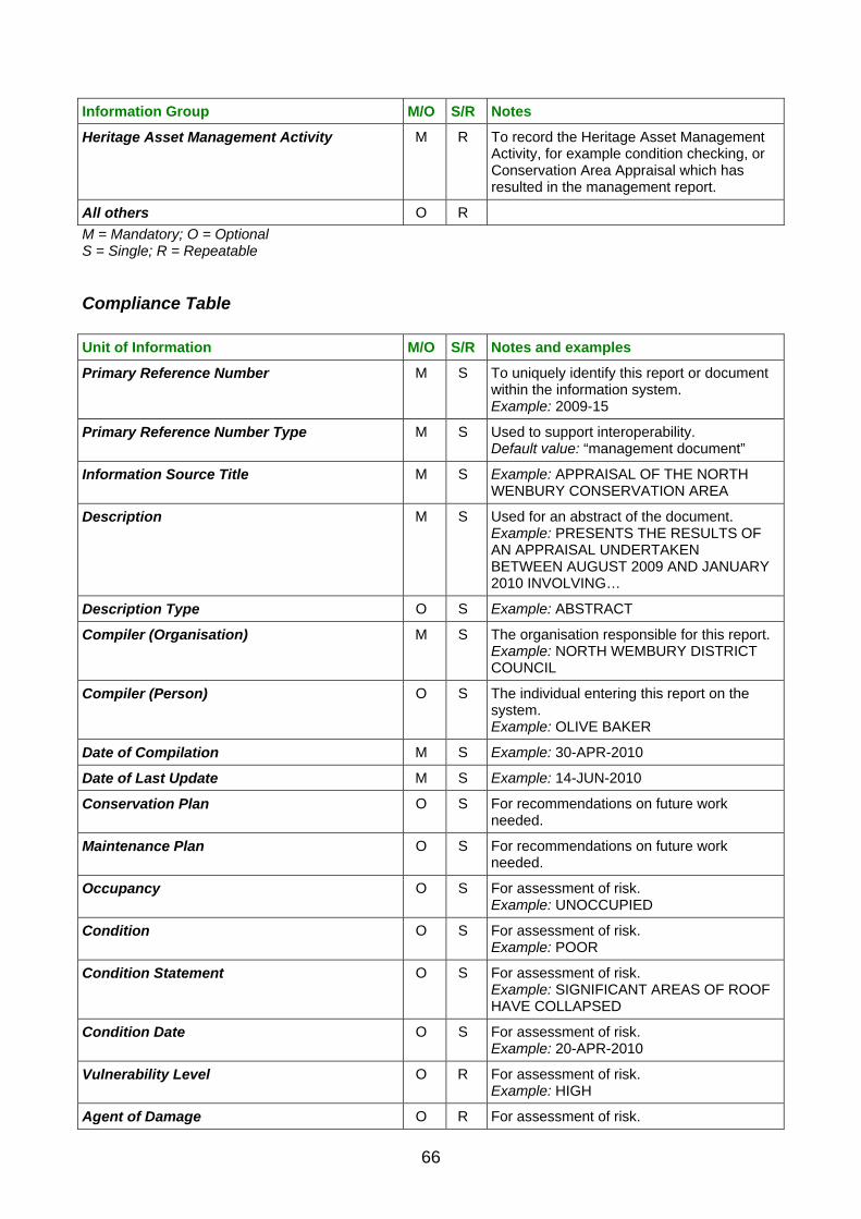
Information Group M/O S/R Notes
Heritage Asset Management Activity M R To record the Heritage Asset Management Activity, for example condition checking, or Conservation Area Appraisal which has resulted in the management report.
All others O R
M = Mandatory; O = Optional S = Single; R = Repeatable
Compliance Table
Unit of Information M/O S/R Notes and examples
Primary Reference Number M S To uniquely identify this report or document within the information system. Example: 2009-15
Primary Reference Number Type M S Used to support interoperability. Default value: “management document”
Information Source Title M S Example: APPRAISAL OF THE NORTH WENBURY CONSERVATION AREA
Description M S Used for an abstract of the document. Example: PRESENTS THE RESULTS OF AN APPRAISAL UNDERTAKEN BETWEEN AUGUST 2009 AND JANUARY 2010 INVOLVING…
Description Type O S Example: ABSTRACT
Compiler (Organisation) M S The organisation responsible for this report. Example: NORTH WEMBURY DISTRICT COUNCIL
Compiler (Person) O S The individual entering this report on the system. Example: OLIVE BAKER
Date of Compilation M S Example: 30-APR-2010
Date of Last Update M S Example: 14-JUN-2010
Conservation Plan O S For recommendations on future work needed.
Maintenance Plan O S For recommendations on future work needed.
Occupancy O S For assessment of risk. Example: UNOCCUPIED
Condition O S For assessment of risk. Example: POOR
Condition Statement O S For assessment of risk. Example: SIGNIFICANT AREAS OF ROOF HAVE COLLAPSED
Condition Date O S For assessment of risk. Example: 20-APR-2010
Vulnerability Level O R For assessment of risk. Example: HIGH
Agent of Damage O R For assessment of risk.
66

Example: VANDALISM
Statement of Significance O S For asset evaluation (collections of, or individual, artefacts and ecofacts).
Value Statement O R For asset evaluation (monuments and areas).
Value Type O R For asset evaluation (monuments and areas). Example: EVIDENTIAL
Characterisation Statement O M For asset evaluation (areas).
M = Mandatory; O = Optional; S = Single; R = Repeatable
MANAGEMENT ACTIVITY DOCUMENTATION
Primary Reference Number Primary Reference Number Type Information Source Title Description Compiler (Organisation) Date of Compilation Date of Last Update
MANAGEMENT ACTIVITY DOCUMENTATION
Primary Reference Number Primary Reference Number Type Description Compiler (Organisation) Date of Compilation Date of Last Update Management Activity Type Work Status Activity Name
HERITAGE ASSET MANAGEMENT ACTIVITY
Figure 14 The mandatory Units of Information which are required for the Management Activity Documentation Information Group
67

4.4 Spatial Information Theme
Location
Definition The units of Information in this Information Group record the location of the subject of an information system entry.
Introduction The Units of Information in this section identify the geographic, administrative and address location of the subject of a Heritage Asset record. This will typically be an Area or Monument Heritage Asset, or the location of an Investigative Activity or the subject of a Designation and Protection activity. It may also be used to qualify Archive and Bibliography entries. In these cases, it is the Location that the entry relates to rather than where it is currently held (which is covered by the Archive/Source Location Unit of Information in the Archive and Bibliography Information Group). For example, a Location entry would be the place depicted in a photograph, while Archive/Source Location would be where the photograph was held (e.g. a negative in a record centre). This Information Group is complemented by, but distinct from, the Map Depiction Information Group, which covers the representations of locations on maps, primarily now through the use of Geographic Information Systems (GIS). GIS is not required to comply to MIDAS Heritage but it should be noted that, depending on the availability of data, GIS can calculate many Location Information Group Units of Information automatically, thus reducing the amount of user input and reducing maintenance time. New additions to this Information Group have been introduced to support international use, reflecting current practice and following international recording standards for location information. For example, administrative types and names of places have replaced country-specific ones.
Key questions Where is the subject of this entry located? What entries do we have that relate to a particular place?
Key issues and recommendations The principal options for identifying a location are: by national or international spatial coordinates (e.g. the Ordnance Survey National Grid Reference
(NGR) in the UK, or latitude and longitude). Grid reference information is independent of any future changes in address or area information. The use of grid references also creates compatibility between entries and GIS systems (see the Map Depiction Information Group).
by its address or the name given to its location (including administrative area and Road or Street Name
with corresponding Number in Road or Street, or other means of identifying a known area). This approach has the advantage of familiarity for users. It can be seen on the ground as street names and numbers and is particularly appropriate for built monuments. The disadvantages are that traditional
68

Recommendation: The range of sources used to obtain the location information about a feature is reflected in the wide range of units in this group. Whilst the majority of units are optional, to allow for the range of source material available, the recorder is encouraged to record as many units as possible for an entry to increase the options for future users to find and analyse the information. Recommendation: The administrative areas in the UK are hierarchical in nature and the full hierarchy, where known, should be recorded to improve record retrieval rates (e.g. if the parish is known then the appropriate district and county, where appropriate, should be recorded). Note that these may be default values only added when entries are exported or shared with others. For example, if all the entries in a dataset relate to one county, then county name information can be added by default as part of the export procedure. Particular care should be taken with parish, township or other local administrative area names as these are not unique across the UK, or even within counties in some cases (e.g. there are four parishes called Ashton in England: two of them in Northamptonshire). Additional information (e.g. district and county names), therefore, must be recorded in addition to the parish name. Recommendation: MIDAS Heritage compliant inventories should, where possible, include grid references for entries, even in areas where address information is also available. This is especially important for archaeological monuments and investigative activities. Security of the information It may be relevant to consider whether recording precise information about the location of an item of interest may unwittingly lead to damage or theft by looters using your information system to locate likely targets. Recommendation: The information system should ideally record location information as precisely as possible. The information system should adopt a policy on the dissemination of this precise information in response to enquiries or in publications. This should take account of any prevailing policies that are relevant to the information system holding organisation. Such policies may originate from the host organisation of the information system (particularly for local or national government organisations) or be a requirement of sponsoring bodies. Consideration should also be given to the physical security of the information system (i.e. that the computer holding the data or the card indexes are held in a secure location), especially in cases where its existence is widely known. Currency The nature of the administrative geography of the UK is such that a number of elements recorded, such as street names, postcodes, administrative units, etc., are subject to change over time. Historical sources may refer to names or areas that are no longer in use and therefore not in standardised recording lists. Recommendation: It is strongly recommended that Location entries should refer to the current street or area names to aid retrieval. However, old administrative areas and streets can be stored as additional information using the Currency Unit of Information to indicate that these are no longer current. Geopolitical units Certain information/Units of Information only become relevant when you want to share data (e.g. geopolitical information). For example, during compilation of a project-based information system that has only worked on monuments in Scotland, it is not necessary to record ‘Scotland’ against each monument entry. However, when exported for use in a UK-wide or international context it becomes important to add this information to allow for analysis of the complete dataset. Recommendation: Thought must be given when sharing data to providing appropriate geopolitical information. Representing approximate locations Approximate locations will be attributed mainly to monuments whose location is not given precisely in available information or whose existence is conjectural. An example is shipping and aircraft losses whose remains have not been discovered but which have been recorded as an indicator of the archaeological potential of the area in which they were lost.
69

Recommendation: In the absence of coordinates provided by sources, and in order to attribute location data to these records, use either Named Location (for offshore wreck sites and other monuments) or a generalised administrative area name (e.g. a district). The details of the approximate location should be included in the Description. Spatial reference system For others to be able to make effective use of your data, it is essential that the system of spatial referencing used to record the location is recorded. Examples of such systems include the British National Grid (based on the Ordnance Survey Great Britain (OSGB 1936) datum), WGS84, etc. Recommendation: Grid references used within a dataset should all use the same spatial referencing system. Details of this can be added as a default value if entries are exported, as part of the export procedure.
Key relationships between Information Groups Location entries have the following key relationships:
Information Group M/O S/R Notes
All others O R
M = Mandatory; O = Optional S = Single; R = Repeatable
Compliance Table
Unit of Information M/O S/R Notes and examples
Primary Reference Number M S To uniquely identify a location and link it to related entries. Example: 58643
Primary Reference Number Type M S Used to support interoperability. Default value: “location”
Description O S Example: APPROXIMATE LOCATION, INTERPRETED FROM TEXT IN SOURCE…
Description Type O S Example: NOTE
Administrative Area Name M R Example: CRICKLADE
Administrative Area Type M R Example: HUNDRED
Currency O S Example: FORMER
Locality O R Example: CALCUTT
Named Location O R Example: THAMES VALLEY
Map Sheet O R Example: SU67SW
Road or Street Name O R Example: CALCUTT STREET
Number in Road or Street O R Example: 26
Post Code O R Example: SN6 6FJ
Language O R Can be used to qualify Administrative Area Name, Geopolitical Area Name, Locality, Road or Street Name, Directions.
Geopolitical Area Type O R Significant when data is shared across national borders. Example: COUNTRY
70

Geopolitical Area Name O R Example: ENGLAND
Cadastral Reference Value O R Example: 564
Cadastral Reference Source O R Example: LAND REGISTRY
Directions O S Example: NORTH OF THE JUNCTION OF THE B4040 and A417.
Grid Reference M S Mandatory for Locations related to monuments or Investigative Activity entries. Example: TQ685443
Buffer Zone Width O S Example: 100
M = Mandatory; O = Optional S = Single; R = Repeatable
LOCATION
Primary Reference Number LOCATION Primary Reference Number Type Administrative Area Name Administrative Area Type Grid Reference
Figure 15 The mandatory Units of Information which are required for the Location Information Group
71

Map Depiction
Definition This Information Group includes information to improve the understanding and use of spatial depictions. Spatial or Map Depiction may be appropriate to represent the extent of a Heritage Asset (a building, an area of study or the location of a find-spot) or areas covered by particular events such as an archaeological excavation or the area to which a particular item of archive, such as a photograph, relates.
Introduction Where a Geographical Information System (GIS) is used to record location information then Map Depiction Units of Information should be recorded. This provides further information and understanding to spatial features recorded as part of the information system. The use of GIS is highly recommended. It provides additional options for recording spatial extents as well as extended querying functionality. Where resource allows MIDAS Heritage, Location Units of Information should also be recorded for the information system. It is possible, using Web services, or dynamic database-to-GIS links, to update textual information from the GIS directly and this is something people should investigate further to increase accuracy and reduce the resource needed to record attributes. The Map Depiction Information Group does not cover spatial metadata such as bounding box and spatial reference system. This information should be recorded for the information system as a whole and should be recorded to the UK GEMINI Discovery Metadata standard as published by e-Government Unit. (For further information visit www.gigateway.org.uk.)
Key questions What does this feature represent? How accurate is the feature boundary? How precise is the location?
Key issues and recommendations How to represent an entry on a map The main spatial feature types which can be used are point, line and polygon (also known as area). It is possible to represent a feature as a combination of spatial feature types but often, for system administration ease, one type is chosen. Points are the simplest graphical representation of an object. Generally these are treated under
Location. Emerging best practice is to move away from the use of point data other than for very generalised mapping (e.g. for distribution maps on a regional or national scale).
Lines connect at least two points. Appropriate for any kind of object that is fundamentally long and very narrow. Lines have the disadvantage that they have no effective ‘width’, which may not be appropriate for accurate recording of many types of assets.
Polygons are used to represent areas. They are most useful for the depiction of most historic assets, giving an impression of the shape and size of the asset they depict.
Surfaces. Combining height measurements with a polygon allows recording of the surfaces. Rare in current use, but increasingly of significance.
72

It is important to choose the most appropriate feature type for your information system, however the decision as to which feature type to use is not necessarily straightforward. Factors to consider include: Type of feature: In the historic environment some features lend themselves to different spatial object
types which might influence your decision-making (e.g. lines for Roman roads, points for mile posts, polygons for the constraint areas of a scheduled monument).
Likely scale that the data will be viewed at. In a large-scale representation (e.g. 1:1250) a building may
be shown as a polygon whereas it may only be appropriate to show as a point (symbol) at small scale (e.g. 1:25,000).
Information available to create a feature. If, for example, you only have a national grid reference and no
other information regarding the accuracy/precision of the national grid reference, then you have no other option but to generate a point.
Stage of GIS maturity. If you are upgrading from a text-only database system to a GIS system working
with data from a database you should consider using use the Buffer Zone Width to generate polygons. This will improve record retrieval.
Balancing precision and accuracy Precision is a measure of how specific the information given about a location is. The Positional Accuracy Unit of Information is a statement as to whether the recorded location actually corresponds to the true position of a recorded feature. It is possible for a feature’s spatial record to be very precise (e.g. a 12 figure grid reference) but totally inaccurate (e.g. identifies a location 100 km away from the true site). Similarly, the Map Depiction could be very accurate but not very precise (e.g. just detailing the 10 km grid square that the feature is located in). It is important to balance the precision and accuracy of a record: you can increase the precision of a record but that might mean the accuracy is decreased. It is important to note that GIS systems will automatically turn an imprecise six-figure grid reference (e.g. 123456) into a precise 12-figure one (e.g.123000, 456000). The precision of the data captured should therefore be recorded, not the precision of the data available within the GIS. Projection system to use Note that when setting up your information system you should consider what spatial reference system to store your records in as a whole dataset. It is practically very difficult to store different features, in the same GIS information system, in different projections. For datasets with both onshore and offshore data, this may mean storing coordinates in more than one projection, depending on how that data is to be used. It is not recommended to continuously convert between coordinate systems as this degrades the precision of the data. Metadata and feature data Units of Information included in the MIDAS Heritage Map Depiction standard should be available to users when data is exported from a system or archived for long-term preservation. In practice, during use of a GIS, it may well be that some of the units listed are recorded as metadata describing all spatial features in a GIS layer, rather than recorded against every spatial feature. For example, if the Precision is the same for all features in a layer, it is quite acceptable to record that precision once in the layer metadata. When the data is exported, it will be necessary to add that precision data to each spatial feature entry as a default value.
Key relationships between Information Groups Map Depiction entries have the following key relationships:
Information Group M/O S/R Notes
Actor and Role O S Used to record the source of spatial data used where this has been provided by another organisation.
All others O R
M = Mandatory; O = Optional S = Single; R = Repeatable
73

Compliance Table
Unit of Information M/O S/R Notes and examples
Primary Reference Number M S Unique number for this spatial feature. This is usually auto-generated by a GIS system. One Heritage Asset or activity may have a number of GIS features which make up the full spatial depiction. Example: 148698
Primary Reference Number Type M S Used to support interoperability. Default value: “map depiction”
Compiler (Organisation) M S Example: WESTSHIRE HER
Compiler (Person) O S Example: ANNE HIGGINS
Date of Compilation M S Example: 01-MAY-2007
Date of Last Update M S Example: 05-MAY-2007
External Information System O R Example: O.S. MASTERMAP TOID
External Information System Primary Reference Number
O R Example: 667544325469
Data Capture Process O S Example: HEADS UP DIGITISING
Positional Accuracy M S Example: APPROXIMATE – BASED ON 1ST EDITION O.S.
Quality O S Example: NEEDS CHECKING FROM AIR PHOTOS
Spatial Feature Type M S Generally auto-generated by a GIS system. Example: POLYGON
X Coordinate M S Example: 776856
Y Coordinate M S Example: 866855
Z Coordinate O S Example: 546854
Precision O S Example: 100
Buffer Zone Width O S Example: 50
Representation Source O R Example: O.S. 1:1250 SHEET SX75
Data Capture Scale O S Example: 1 INCH TO 1 MILE
M = Mandatory; O = Optional S = Single; R = Repeatable
MAP DEPICTION Primary Reference Number Primary Reference Number Type Compiler (Organisation) Date of Compilation Date of Last Update Positional Accuracy Spatial Feature Type X Coordinate Y Coordinate
MAP DEPICTION
Figure 16 The mandatory Units of Information which are required for the Map Depiction Information Group
74

4.5 Temporal Information Theme
Date and Period
Definition This Information Group specifies the starting and ending dates of all periods, events, activities, states and conditions which have happened or will happen over a limited extent in time.
Introduction Date and historical period information can express the lifespan, life cycle and place a record in its chronological context. In the case of monuments, dates can be assigned to express when it was built, altered, extended or destroyed. Each of the various phases of its existence can in themselves be expressed with their own beginning and end dates. In the case of a building, the purpose for which it is used may have changed from its original intended purpose, and so this phase of its life can also be expressed regardless of whether any physical alteration occurred to its structure. This can also apply to phases of ownership, management, guardianship, legal status, etc. Defining these separate phases builds a picture of how the monument has evolved and changed during its lifetime. In addition to the particular dates relating to phases or events, the assignment of relevant historical periods to a record will provide an extra layer of context, especially valuable as an aid to retrieving data relating to a particular era or period of history. Dates for an artefact or monument provided by scientific dating methods, such as radiocarbon dating or dendrochronology, should also be recorded.
Key questions When was it
made/built/altered/extended/destroyed? When did it happen? How long did it last?
Key issues and recommendations Monument chronology Careful consideration needs to be given to the nature of the chronology recorded in Period (Name), Start Date, End Date, etc. Does an entry record the date or period of construction, or the period of use of a monument, or phases within the development of a monument? For example, an entry relating to a church, with the Start Date of 1450 and End Date of 1600: this could imply that the church was built during this date range (and still exists, but did not previously), existed during this date range (and now does not), or was altered in some way during this period (and may have existed before or after this range). Recommendation: The best approach is to record the phases within the development of a monument, indexing at the most specific level supported by available information. This maximises the possibilities for retrieval. For monuments, especially those relating to earlier historical periods, only broadly dated phases of occupation may be discernible. If more detailed chronological information is required, the Date Range Qualifier and Display Date Units of Information may be needed to distinguish, for example, dates of use from dates of construction. It is recommended that the Display Date should be used to highlight the precise nature of the date range, for example ‘Built during the twentieth-century’ would imply only that the monument was known to have been built at some point between 1901 and 2000, whereas ‘Extended 1564–1569’ would point to a continuous process throughout the date range of 1564 and 1569.
75

Scientific dates Scientific dates as supplied by specialists will generally have multiple parts (e.g. date range, units of measure, standards deviation, lab number, etc.). Where a detailed approach is required to recording these it is appropriate to deconstruct a scientific date and record the parts in separate Units of Information. These can then be combined for data export purposes to comply with the MIDAS Heritage approach. Recommendation: For most MIDAS Heritage purposes it is sufficient to record all components of a scientific date as one Unit of Information, Scientific Date, qualified with Scientific Date Method. Record the scientific date exactly as supplied by the specialist. Where Start Date and End Date values are extrapolated from scientific dates, this should be made clear in the Display Date Unit of Information. Prehistoric dates It will be necessary to record BC/BCE dates. These usually cannot be supported by the date fields in most database systems, so simple integer numerical data is conventionally used to record years, with negative numbers indicating BC/BCE Recommendation: Ensure that any database numeric field used is capable of handling negative numbers and that any fields for recording prehistoric dates have a minimum of eight characters to adequately cover the whole range of human prehistory. Period Care should be taken when recording within historical periods which can have more than one meaning. For instance, the Victorian era, as well as describing the period of history defined by the reign of Queen Victoria, is also understood to be an architectural style. Although this style originates with this particular historical period, buildings continued to be built in the Victorian style after the death of Queen Victoria. Therefore, there is the potential for confusion in the description of a building as Victorian unless it is clearly expressed to which aspect of the monument this term relates. Defining exactly when a particular historical period begins and ends can sometimes be problematic. There can be some disagreement as to how a period should be defined. For example, the Roman period will have different date ranges in different countries or regions depending upon when Roman occupation commenced and ended. As there is no definitive guide to international historical periods, it is recommended that reference data used to index this aspect of records should incorporate each period’s date ranges for the use of those creating and retrieving monuments and events records.
Key relationships between Information Groups Date and Period entries are not qualified by defined relationships with other Information Groups. Instead, many Information Groups are themselves qualified by Date and Period entries.
Compliance Table
Unit of Information M/O S/R Notes and examples
Primary Reference Number M S Identifies this Date/Period statement. Example: 1265
Primary Reference Number Type M S Used to support interoperability. Default value: “time-span”
Description O S Brief description of the Date/Period to assist identification. Example: The period in English history from the Norman Conquest in 1066 until the dissolution of the monasteries in the reign of Henry VIII.
Entry Type O S Example: GENERAL PERIOD
Start Date M S A Period (Name) or date range is mandatory. Date range is to be preferred. Example: 1066
76

End Date M S A Period (Name) or date range is mandatory. Date range is to be preferred. Example: 1540
Period (Name) O S Mandatory if the Start Date and End Date are not known. Example: MEDIEVAL
Dimension Measurement Unit O S Example: YEARS
Dimension Value O S Example: 474
Dimension O S Example: DURATION
Display Date O S Example: Built during the Medieval period
Date Range Qualifier O S Used to clarify the relationship between a Start Date and an End Date. Example: 1854–1859, where ‘–’ represents ‘throughout’
Scientific Date O S Mandatory where scientific dating methods have been applied. Record precisely as received from the specialist. Example: 1250 bp +/-30 PBN-1675
Scientific Date Method O S Mandatory where scientific dating methods have been applied. Example: RADIOCARBON DATING
M = Mandatory; O = Optional S = Single; R = Repeatable
DATE AND PERIOD Primary Reference Number Primary Reference Number Type Start Date End Date
DATE AND PERIOD
Figure 17 The mandatory Units of Information which are required for the Date and Period Information Group
77

4.6 Actor Information Theme
Actor and Role
Definition Information that identifies key persons, peoples or organisations, and their roles in relation to a Heritage Asset, Activity or Information Source.
Introduction Information systems commonly record the names of persons, peoples and organisations (‘actors’). These may be the names of the individuals who, for example, have carried out work on a site, the organisation which has funded the work, the author of an information source or merely a person or group of historic interest associated with it. Other examples could include cultural affinities of a group of people with a particular Heritage Asset (e.g. the Iceni tribe, the Arts and Crafts movement). The assignment of a role gives the user of an information system a greater understanding of the reason for the association of a person or organisation with a specific Heritage Asset and improves options for searching. For example, ‘Show me all the heritage assets associated with Sir Mortimer Wheeler where his role was that of excavator’.
Key questions Who was involved? How?
Key issues and recommendations The Units of Information in this Information Group can be used to identify those who have participated in investigations of a Heritage Asset, in their role as excavators, surveyors, etc., or those who hold information relevant to a Heritage Asset in archives or collections. Also, this information can be used to record the association of historical figures with a particular Heritage Asset, or people or organisations who have been responsible for the Heritage Asset in some way (e.g. in the role of owners, architects, financiers, etc.). As with Location information, in many cases it will be adequate to simply index each relevant entry with appropriate Units of Information. These would be repeated in each information system entry as needed. It is strongly recommended that standardised formats for recording the Person Name and Organisation Name Units of Information are adopted for all information system entries. The Description Unit of Information may be used to record brief biographical notes. If this level of detail is appropriate, it may be worth referring to specialist standards currently available in this area (e.g. the National Council on Archives Rules for the Construction of Personal, Place and Corporate Names, 1997. See the ‘Further information’ section for details). Naming conventions When recording people and organisations, consideration should be given to the format of the name. Formats may vary considerably, and this inconsistency can make it difficult for a user to retrieve entries from a database. Recommendation: As a minimum, for people, entries should include a salutation (Mr, Mrs, Dr, etc.), forename(s) and surname. For organisations, the recognised legal name of the organisation should be used and abbreviations expanded where known.
78

Obviously a source may not give all the necessary information so the information system structure should be sufficiently flexible to include initials (where only initials are known) and epithets (where surnames are not known, e.g. William of Malmesbury, where ‘of Malmesbury’ is the epithet). Identification of individuals Personal and, in some cases, organisation names are rarely unique, even within the heritage sector. For historical people the situation is much worse! To assist in full identification of a historic person it may be necessary to include additional data. Recommendation: The inclusion of birth and death dates (or, in the case of organisations, dates relating to the time-span) is recommended to disambiguate entries with the same name. This is particularly important for common names such as ‘John Smith’ and those names where members of the same family have the same forename (e.g. a father and son both practising in the same field of interest). Who to include? Obviously there is a vast number of people, organisations and groups who potentially could be associated with an entry, in an almost limitless number of roles. Recommendation: The purpose and nature of your information system should be considered carefully to avoid over-elaboration. One useful approach may be to define a group or groups of people that are of interest to your entries, by virtue of their role, dates, etc. For example, it might be appropriate to record all architects, or the kings and queens of England up to 1500, or all glass manufacturers listed in the guild directory for 1850, and ensure that all entries that relate to these groups are appropriately indexed. The Compliance Tables accompanying the Information Groups indicate specific cases where particular people, organisations, groups and roles should be recorded to comply with the MIDAS Heritage standard. Data protection Information about specific living people held within an information system in the U.K. will be subject to the provisions of data protection legislation. Recommendation: All those holding inventories should inform themselves about the provisions of current data protection legislation. Contact details for advice are given in the ‘Further information’ section. Roles Where roles are recorded, a list of role types should be maintained to improve consistency. It should also be noted that the same person (or group or organisation) may be assigned a different role for different records. For example, a record for the Houses of Parliament may include A.W.N. Pugin as the architect, whereas a record for 10 Smithson Square may include Pugin as a Person of Historic Interest (if he lived there). National standards There is currently no single national authority file for people and organisations. However a project to develop National Name Authority Files (for all major architects, designers, people of historic interest, etc.) has been proposed (by the British Library) and the National Council on Archives has developed a standard for recording people and corporate names, to ensure a consistent approach. The Oxford Dictionary of National Biography is also a useful source.
Key relationships between Information Groups Actor and Role entries have the following key relationships:
Information Group M/O S/R Notes
Date and Period M S To describe when the actor was involved in a particular role.
M = Mandatory; O = Optional S = Single; R = Repeatable
79

Compliance Table
Unit of Information M/O S/R Notes and examples
Primary Reference Number M S Example: 57298
Primary Reference Number Type M S Used to support interoperability. Default value: “actor”
Description O S Can be used for biographical notes to assist identification of this actor. Example: “THE ICENI WERE A CELTIC TRIBE OCCUPYING MUCH OF…”
Description Type O S
Compiler (Organisation) M S Relate to the entry documenting this actor, not the actor. Example: WESTSHIRE HER
Compiler (Person) O R Relate to the entry documenting this actor, not the actor. Example: JOHN FOX
Date of Compilation M S Example: 31-MAY-2009
Date of Last Update M S Example: 6-JUN-2009
External Information System O R To document where this actor is recorded in another information system. Example: Dictionary of National Biography
External Information System Primary Reference Number
O R A unique reference in the other information system to assist identification. Example: 597290
Contact Point O R Example: [email protected]
Contact Point Type O R Example: EMAIL
People Name O R A value in People Name, Person Name or Organisation Name is mandatory to assist identification of the actor. Qualified by: Currency Example: ICENI
Organisation Name O R A value in People Name, Person Name or Organisation Name is mandatory to assist identification of the actor. Qualified by: Currency Example: CADW
Person Name O R A value in People Name, Person Name or Organisation Name is mandatory to assist identification of the actor. Qualified by: Currency Example: JOHN HENRY ADAM
Occupation O S Example: SURVEYOR
Role M R Qualified by: Date and Period Information Group Example: ARCHITECT
M = Mandatory; O = Optional S = Single; R = Repeatable
80

ACTOR AND ROLE
Primary Reference Number Primary Reference Number Type Compiler (Organisation) Date of Compilation Date of Last Update Person/ People/ Organisation Name Role
ACTOR AND ROLE
Figure 18 The mandatory Units of Information which are required for the Actor and Role Information Group
81

82

5. Dictionary of Units of Information
This section gives the details of individual Units of Information which are listed in the MIDAS Heritage Information Group compliance tables and text. The Units of Information are listed in alphabetical order for ease of reference. Each entry for a Unit of Information includes the following:
Unit name The name by which the Unit of Information is referred to. This name should be used in information system documentation to indicate that the MIDAS Heritage data standard is being applied.
Definition The purpose of a particular Unit of Information; why it has been included in the MIDAS Heritage standard. Once adopted by an information system the definition of a Unit of Information should not be allowed to change to accommodate extra or related information. Additional concepts should be recorded in additional Units of Information or included by creating additional Units of Information outside the scope of MIDAS Heritage in your information system. Breaking this rule will compromise the ability of the information system to retrieve entries effectively.
Guidance Covers considerations that should be taken into account for a particular Unit of Information.
Controlled entry Recommends whether or not a centrally controlled list of acceptable terms should be used to create consistent entries, or other notes on the format of entries. In many cases a nationally agreed controlled list vocabulary is available from the INSCRIPTION site managed by FISH. See Further Information for details of accessing INSCRIPTION. Note that it is good practice to document the controlled vocabularies used for entries. The Controlled Vocabulary Name Unit of Information should be used for this. This is a requirement when entries are shared between information systems. Where a controlled vocabulary is recommended, but no existing list is referred to, dataset managers should maintain a consistent list of terms. Where ‘Free text’ is shown here, the information system should adopt a standard practice. Retrieval is generally improved by: minimising the use of punctuation; avoiding the use of abbreviations, unless these are standardised and included in
compilation manuals for the information system; standardising accepted spelling using an agreed dictionary.
Information group Lists the Information Group or Groups that a particular Unit of Information occurs in.
Examples Instances of the sort of information that might appear in this Unit of Information in an information system. Note that all examples are fictitious to illustrate the use of the unit. Note that in most cases examples are given in upper case for clarity, with additional notes or labels in mixed case. Information system managers should adopt upper or lower case consistently for entries in each Unit of Information, as appropriate for their needs.
83

A
Activity Name
Definition The name of an activity recorded in a heritage information system.
Guidance Record names as used in information sources where known.
Controlled entry Free text.
Information group Activity (All)
Examples EXCAVATIONS AT BOG MARSH (SEASON 2); RESTORATION OF THE ORANGERIE AT BOG MARSH HOUSE; DELISTING OF BOG MARSH FARM.
Activity Objective
Definition The specific purpose of an activity.
Guidance Used to distinguish activities by the overall objective or intention, as distinct from the technique used. Derive this from project documentation where available. Free text field.
Controlled entry Free text.
Information group Investigative Activity; Research and Analysis
Examples TO ESTABLISH THE ECONOMIC BASIS FOR THE ROMAN SETTLEMENT.
Activity Type
Definition The method or technique employed in an investigative, research or analytical activity.
Guidance Use a controlled vocabulary.
Controlled entry Yes, see INSCRIPTION.
Information group Investigative Activity; Research and Analysis
Examples GEOPHYSICAL SURVEY; DOCUMENTARY RESEARCH; FIELD VISIT; QUANTIFICATION; VISUAL INSPECTION; X-RAY CRYSTALLOGRAPHY.
Administrative Area Name
Definition The name by which an administrative area is known.
Guidance The full, official title should be used, with no abbreviations or nicknames (e.g. do not use ‘Salop’ for ‘Shropshire’ or ‘So’ton’ for ‘Southampton’). The standard followed by an authoritative list such as the Office of National Statistics and Ordnance Survey mapping products should be used. Use with Administrative Area Type. Administrative area names are liable to be changed or made redundant by government or reorganisation of administrative structures. By default current names at the time of entry compilation should be used and measures may need to be taken to keep the dataset up to date. The Currency Unit of Information should be used where it is necessary to record historic or former administrative area names (e.g. Saxon hundred names). The Language Unit of Information may be used to qualify this unit where alternate language versions need to be recorded.
Controlled entry Yes. See INSCRIPTION.
Information group Location
Examples OGBOURNE ST GEORGE; DEVON; KILMARNOCK; YFENNI
84

Administrative Area Type
Definition A type of geographical area defined for government, administrative or electoral purposes.
Guidance Location details will ordinarily consist of a number of administrative area types as part of devolved levels of government. For example, a civil parish can be within a district, which will be within a county. Existing administrative area types may be changed, made redundant and new types introduced as part of government reorganisation, so current names should be used at the time of inventory entry and measures may need to be taken to keep the dataset up to date. Use with Administrative Area Name.
Controlled entry Yes.
Information group Location
Examples COUNTY; DISTRICT; CIVIL PARISH; UNITARY AUTHORITY; COMMUNITY; TOWNSHIP; DIOCESE; ECCLESIASTICAL PARISH.
Agent of Damage
Definition The physical, biological or other source of damage to a Heritage Asset.
Guidance Used to monitor the causes of damage. Recorded as a result of Heritage Asset Management Activity. More than one may be recorded to give a full picture.
Controlled entry Yes. Maintain a list of standards terms.
Information group Management Activity Documentation
Examples BADGERS; WATER INGRESS; PLOUGHING; CLOTHES MOTH; VANDALISM.
Archive Extent
Definition The size or volume of material.
Guidance Used primarily to give an indication of the volume of material within a group/collection of archive. However, it may be used also as a means of recording the number of pages which make up an archival item or the number of volumes which form a published document. It may be given as a run of pages (e.g. for an article in a journal).
Controlled entry Free text.
Information group Archive and Bibliography
Examples 26 PHOTOGRAPHS; 3 FILES; 100 BOXES; 55 PAGES; 2 VOLUMES; 30–54.
Archive/Source Location
Definition The actual location of archive materials referred to, to assist in future retrieval.
Guidance Should record all the information necessary to locate an archive. This may include the name of the organisation or person that holds the archive, the repository building plus detailed information such as library shelf, file reference numbers, etc.
Controlled entry Free text. Entries referring to storage systems used by archive holders should follow exactly the format used by the archive holder.
Information group Archive and Bibliography
Examples BEDFORDSHIRE COUNTY COUNCIL SITES AND MONUMENTS RECORD FILE RM101/SH5/BX23.
Archive/Source Format
Definition Information resources described according to their physical properties.
Guidance Indexing of format is particularly relevant to storage, conservation and management of resources. Intended to answer questions such as ‘How should I store this resource?’
Controlled entry Yes, see INSCRIPTION.
85

Information group Archive and Bibliography
Examples PAPER; PHOTOGRAPHIC FILM.
Archive/Source Reference
Definition Specific reference within a bibliographic or archive item.
Guidance Use to record details specific to the volume number, chronological designation, page numbers, figures and plates. The bibliographic reference may be a general one, for example citing a whole article, or a specific cross-reference, for instance citing a page within an article as a source for descriptive text. If a monograph is being cross-referenced it will be necessary only to record the page, figure and plate numbers.
Controlled entry Free text.
Information group Archive and Bibliography
Examples VOLUME 36; NOVEMBER 1992; PAGES 77–85; FIGURE 1.
Subject
Definition The main topic of the archive/resource material.
Guidance Expressed as keywords or key phrases. Classification codes.
Controlled entry Yes, see INSCRIPTION.
Information group Archive and Bibliography
Examples AGRI-ENVIRONMENT; CANAL BUILDING; PALYNOLOGY.
Archive/Source Type
Definition Documentation of information resources according to their general nature and distinguishing features.
Guidance The type often determines the means of access to the information contained within the resource. Intended to answer questions such as ‘What have you got?’. C.f. Archive/Source Format which records what the archive is available as.
Controlled entry Yes, see INSCRIPTION.
Information group Archive and Bibliography
Examples PLAN; PHOTOGRAPH.
Area Type
Definition A general category to which this area belongs.
Guidance Used to group areas for research or management purposes.
Controlled entry Yes, see INSCRIPTION.
Information group Area
Examples PARKLAND; SUBURB; CONSERVATION AREA.
Artefact Name Type
Definition The type of artefact name recorded.
Guidance Use a single term, without punctuation or capitalisation. Maintain a list of standard terms. Record only once for an Artefact Name.
Controlled entry Yes. Maintain a standard list of terms.
Information group Artefact and Ecofact
Examples TYPOLOGICAL; SIMPLE; CLASSIFIED; TAXONOMIC; DENOMINATION.
86

Artefact/Ecofact Type
Definition A description of the form, function or type of artefact/ecofact.
Guidance Maintain a list of standard terms, based on a recognised terminology source. Use as many times as required to describe an artefact or ecofact at a general or specific level.
Controlled entry Yes, see INSCRIPTION.
Information group Artefact and Ecofact
Examples INSECT REMAINS; COIN; AXE; BASKET.
Associated Goods
Definition Type of raw materials or manufactured goods associated with a Heritage Asset.
Guidance Used to support thematic searching for particular materials or products. For craft, this can be used to record known cargo. For industrial sites this might be raw materials used or products manufactured.
Controlled entry Yes. Maintain a standard list of terms.
Information group Monument
Examples BALL BEARINGS; LACE; STEEL PLATE.
Audience
Definition The intended users of a particular Information Source.
Guidance Use to identify information relevant to a particular group.
Controlled entry Yes. Maintain a standard list of terms.
Information group Narrative and Synthesis
Examples MANAGEMENT; TECHNICAL; PUBLIC; EDUCATION.
Authorisation Required
Definition A note of authorisation required in advance of a proposed activity or response.
Guidance Generally record job titles of those authorising, rather than personal names. Contact details may be added if necessary.
Controlled entry Free text.
Information group Casework and Consultation
Examples COUNTY ARCHAEOLOGIST; ENGLISH HERITAGE CASEWORK OFFICER.
B
Buffer Zone Width
Definition The radius or width in metres of a zone around a point/line/polygon.
Guidance Used to indicate an area beyond the recorded extent of a spatial feature to alert potential users to the presence of the feature during searching. Can be used to generate simple polygons from point data.
Controlled entry Yes – numeric data expressed in metres.
Information group Location
Examples 200.
87

C
Cadastral Reference Source
Definition The name of the source or body that has assigned a recorded cadastral reference value.
Guidance Record the proper name of the body or organisation.
Controlled entry Yes. Maintain a standard list of terms.
Information group Location
Examples ORDNANCE SURVEY; LAND REGISTRY.
Cadastral Reference Value
Definition A unique identifier, usually numerical, assigned by a particular source or body, to parcels of land, fields, etc.
Guidance The reference format and content can vary from source to source. Content may be derived from sources such as land owner, area, land quality or other information relating to the area’s content and inhabitants.
Controlled entry No. Free text.
Information group Location
Examples 507
Case Status
Definition The current status of the ongoing casework.
Guidance Identifies whether the consultation is ongoing or completed, enabling monitoring of casework. For more detailed recording this Unit of Information can be used for the name of defined stages in the progress of a case.
Controlled entry Yes. Maintain a standard list of terms.
Information group Casework and Consultation
Examples OPEN; CLOSED; PRE-APPLICATION; CONSULTATION STAGE; PENDING AUTHORISATION.
Characterisation Statement
Definition A statement of the character of the historic environment in an area of landscape, urban or seascape.
Guidance Content will be influenced by professional guidelines and practices, and is likely to be a multi-section text. Formatting should support sub-sections (e.g. using HTML). Typically content might include an assessment of the geological and topographic influences upon settlement, evidence for time depth and survival of relict features; characteristic form of settlements, field systems, communications or other monuments in the area.
Controlled entry No. Free text.
Information group Management Activity Documentation
Examples NORTH WEM VALLEY IS AN AREA OF EXTENSIVE 18TH CENTURY ENCLOSURE FARMS WORKING THE ALLUVIAL SOILS OF THE WEM… .
Collection Extent
Definition The number of items in the collection.
Guidance Use when recording a group of finds or artefacts (not individual items). Generally a numerical value. Precise or estimated figures may be used. Use for heritage assets
88

only. Quantity of archive material is recorded in Archive Extent.
Controlled entry No. Free text.
Information group Artefact and Ecofact
Examples 23; >100; 10–100.
Compiler (Organisation)
Definition The name of the organisation responsible for the compilation or curation of entries in a dataset.
Guidance Use to establish the provenance of the original entry during data exchange. Typically this data will be added as a default value when entries are exported.
Controlled entry Yes. Use the format, language and spelling as they appear on official documents from the organisation.
Information group Heritage Asset (All); Activity (All); Information Source (All); Map Depiction
Examples WESSEX ARCHAEOLOGY; COMISIWN BRENHINOL HENEBION CYMRU.
Compiler (Person)
Definition The name of the individual responsible for the compilation of the entry.
Guidance Use to establish the provenance of the entry within an organisation. Use a consistent format of the individual’s name. Sufficient detail should be included to create a unique name (e.g. by the inclusion of middle names where necessary). Where possible, use and maintain a controlled list.
Controlled entry Yes.
Information group Heritage Asset (All); Activity (All); Information Source (All); Map Depiction
Examples JOHN M. BROWN; ANNE HAILSHAM.
Completeness
Definition The completeness of an artefact/ecofact as observed during a condition assessment.
Guidance Record once for each assessment. Use Condition Date to record when this was observed. For more detailed recording this should be linked to information about the heritage asset management event which observed the state of completeness.
Controlled entry Yes.
Information group Artefact and Ecofact
Examples COMPLETE; INCOMPLETE; FRAGMENTED.
Component
Definition A distinct and identifiable part of a Heritage Asset (e.g. monument, artefact or ecofact).
Guidance Used to highlight a feature of particular interest. Multiple entries of this unit may be required (e.g. to cater for instances where uncertainty exists over the interpretation of the heritage asset component, or where more than one entry term is appropriate). Maintain a list of standard terms based on a recognised terminology source.
Controlled entry Yes, see INSCRIPTION.
Information group Monument; Artefact and Ecofact
Examples TOWER; NAVE; HANDLE; BLADE; SLEEVE; DISTAL END.
Condition
Definition An indication of the overall current condition of a Heritage Asset as observed during a condition assessment.
89

Guidance Record once for each assessment. Greater detail can be included in the separate Condition Statement Unit of Information.
Controlled entry Yes. See INSCRIPTION.
Information group Monument; Artefact and Ecofact
Examples GOOD; FAIR; POOR; BAD.
Condition Date
Definition The date when an assessment of the condition of a Heritage Asset was made.
Guidance This may be used for simple recording of condition checking. Where more detailed records are appropriate (e.g. to see who undertook the check, how the check was done, etc.) then the full Heritage Asset Management Activity Information Group should be used, in conjunction with Management Activity Documentation.
Controlled entry Yes. A consistent format for recording calendar dates should be adopted.
Information group Monument; Artefact and Ecofact; Management Activity Documentation
Examples 23-OCT-2008.
Condition Statement
Definition A detailed assessment of the condition of a Heritage Asset and any treatment required.
Guidance Record once for each condition assessment.
Controlled entry No.
Information group Management Activity Documentation
Examples BADLY INFECTED WITH WOODWORM. REQUIRES EMERGENCY TREATMENT. SEE REPORT GCM 0573.
Conservation Plan
Definition A description of planned activity intended to conserve or prevent from further deterioration a particular Heritage Asset.
Guidance The specific content should follow appropriate professional guidelines.
Controlled entry Free text.
Information group Management Activity Documentation
Examples
Conservation Treatment Priority
Definition The level of priority for conservation treatment of a Heritage Asset.
Guidance Useful for highlighting urgent priority needs. For clarity, wording is preferred to numeric scoring.
Controlled entry Yes. Maintain a standard list of terms.
Information group Artefact and Ecofact
Examples HIGH; MEDIUM; LOW; URGENT; NON-URGENT.
Construction Method
Definition The main methods used to create a Heritage Asset (building, artefact, etc.).
Guidance Use a controlled vocabulary. Repeatable field. Use with Start Date and End Date to record when a stage in the design or construction of a monument took place.
Controlled entry Yes.
90

Information group Monument
Examples BRICK-BUILT; CLINKER; TIMBER-FRAMED.
Contact Point
Definition Information identifying how a person or organisation can be contacted.
Guidance Use with Contact Point Type to describe the nature of the contact point (e.g. postal address, telephone number, URL, etc.). Repeat as many times as required. If a greater degree of precision is required, particularly for information exchange, use an alternative standard such as BS7666, vCard, etc. Principally used for current, living or active actors. For deceased individuals this could be the executors or trustees of their estate, or for defunct organisations or groups it could be a successor organisation or umbrella body.
Controlled entry Free text.
Information group Actor and Role
Examples 19 HIGH STREET, BOGMARTON, WESTSHIRE; www.bogmarshcc.gov.uk; +44 1234 567890.
Contact Point Type
Definition The nature of the Contact Point (e.g. postal address, telephone number, etc.).
Guidance Use with Contact Point. Repeat as many times as required. Select from a controlled vocabulary.
Controlled entry Yes. Maintain a standard list of terms.
Information group Actor and Role
Examples WORK EMAIL ADDRESS; HOME POSTAL ADDRESS; URL; WORK TELEPHONE NUMBER; WORK MOBILE NUMBER.
Controlled Vocabulary Name
Definition The controlled vocabulary or classification system used to populate a Unit of Information.
Guidance May be used to qualify any MIDAS Heritage Unit of Information where it is necessary to record the source of the terminology used. This will often be the name of the appropriate INSCRIPTION vocabulary. In many cases this unit will be populated with a default value, which is only needed when entries are exported from an information system.
Controlled entry Yes. Use of the INSCRIPTION registered vocabulary identifier is mandatory where this has been assigned.
Information group All
Examples ART AND ARCHITECTURE THESAURUS; THESAURUS OF RESOURCE DESCRIPTION; ENGLISH HERITAGE MONUMENT TYPES THESAURUS.
Craft Type
Definition A term describing a watercraft or aircraft by form or function.
Guidance Can be used to record watercraft and aircraft at a broad level (e.g. FISHING VESSEL, FIGHTER) or a more precise level (e.g. SLOOP, SPITFIRE). Records should be indexed at the most specific level possible.
Controlled entry A controlled list of terms is recommended. See INSCRIPTION for English Heritage Thesaurus of Maritime Craft Types and English Heritage Historic Aircraft Thesaurus.
Information group Monument
91

Examples WARSHIP; SCHOONER; LANCASTER.
Currency
Definition An indication of the currency of a Unit of Information entry with which it is associated.
Guidance Appropriate where it is important to qualify information held in the inventory which is likely to change over time. Typically this includes Location Units of Information (such as Road or Street Name or Administrative Area Name) or ‘name’ Units of Information (e.g. Heritage Asset Name).
Controlled entry Yes, see INSCRIPTION
Information group Monument; Location; Actor and Role
Examples ALTERNATE; FORMER; CURRENT.
D
Data Capture Process
Definition The technique by which the spatial object has been captured.
Guidance This is recorded to ensure the spatial object is interpreted correctly. Capture from desk-based digitising will differ from accurate survey work.
Controlled entry Free text.
Information group Map Depiction
Examples DESK-BASED DIGITISATION; HARD-COPY SCANNING; FIELD SURVEY.
Data Capture Scale
Definition The scale of the original map from which a spatial feature has been digitised
Guidance This is recorded to ensure the spatial feature is interpreted correctly. Data captured from a small-scale map may well not be adequately accurate when viewed or combined with data digitised from large-scale maps.
Controlled entry Yes. Maintain a list of terms, or follow exactly the wording given on the original map
Information group Map Depiction
Examples 1:25 000
Date of Compilation
Definition The date on which an inventory entry was first added to the inventory.
Guidance Enter a date specific to a given calendar day. Adopt a consistent format for recording calendar dates throughout the inventory. Use with Compiler (Person).
Controlled entry Yes. A consistent format for recording calendar dates should be adopted.
Information group Heritage Asset (All); Activity (All); Information Source (All); Map Depiction; Actors and Role
Examples 21-DEC-2008.
Date of Last Update
Definition The date on which an inventory entry was most recently revised or updated.
Guidance Enter a date specific to a given calendar day. Adopt a consistent format for recording calendar dates throughout the inventory. Use together with Compiler (Person).
92

Controlled entry Yes. A consistent format for recording calendar dates should be adopted.
Information group Heritage Asset (All); Activity (All); Information Source (All); Map Depiction; Actors and Roles
Examples 23-OCT-2005.
Date of Origination
Definition The date of creation of an Information Source. The year of publication or issue of a bibliographic item.
Guidance Where only vague dates are known for the origination of an item, the Date and Period Information Group should be used.
Controlled entry Yes. A consistent format for recording calendar dates should be adopted.
Information group Archive and Bibliography
Examples 1997, 31-MAR-2005
Date Range Qualifier
Definition The nature of the date range given in an entry.
Guidance Use with Start Date and End Date when recording an event or activity to distinguish whether it was continuous through a date range or happened once in that period.
Controlled entry Yes, see INSCRIPTION.
Information group Date and Period
Examples WITHIN.
Departure (Place)
Definition The port or place of departure from which a watercraft or aircraft embarked upon its final voyage or flight.
Guidance It is recommended that the currently accepted name for any port or place of departure should be used. A properly structured terminology supporting the recording of this data can express the development of, and variations in, place names to inform the recording and retrieval processes.
Controlled entry Yes, see INSCRIPTION
Information group Monument
Examples PLYMOUTH (DEVON); PLYMOUTH (MONTSERRAT); GLASGOW.
Description
Definition A free-text description of an inventory entry (e.g. a Heritage Asset, event, information source, actor, etc.).
Guidance This should be used to record text descriptions in an appropriate level of detail and style. This can expand upon the indexing terms used in other Units of Information to include, for example, uncertainties about date. Use Description Type to specialise the nature of the description, for example to distinguish non-technical summary text from more detailed synthesised works.
Controlled entry Free text.
Information group Heritage Asset (Al); Activity (All); Information Source (All); Location; Actor and Role
Examples GLASS BLOWING WORKSHOP OF THE 16TH CENTURY, DOCUMENTED IN THE 17TH CENTURY.
93

Description Type
Definition Allows a Description to be specialised by level of detail or intended use.
Guidance Used to distinguish brief non-technical descriptions (summaries) from more detailed text.
Controlled entry Yes.
Information group Heritage Asset (All); Activity (All); Information Source (All); Location; Actor and Role
Examples SUMMARY; FULL; ABSTRACT; PUBLIC.
Destination
Definition The port or place of destination to which a watercraft or aircraft was heading upon its final voyage or flight.
Guidance It is recommended that the currently accepted name for any port or place of destination should be used. A properly structured terminology supporting the recording of this data can express the development of, and variations in, place names to inform the recording and retrieval processes.
Controlled entry Yes, see INSCRIPTION
Information group Monument
Examples PLYMOUTH (DEVON); PLYMOUTH (MONTSERRAT); GLASGOW.
Dimension
Definition The property being measured during an activity.
Guidance May be used to record any measurable dimension associated with a Heritage Asset or event/activity. Dimensions can be physical properties or spatial (e.g. the area of a building or the resistivity of soil). Should be used as a repeatable group with Dimension Measurement Unit and Dimension Value. Use a controlled vocabulary. Note: temporal duration is recorded separately using the Date and Period Information Group.
Controlled entry Yes. Maintain a standard list of terms.
Information group Monument; Artefact and Ecofact
Examples AREA; HEIGHT; DIAMETER; WEIGHT; TONNAGE; LENGTH; RESISTIVITY; LONGITUDE.
Dimension Measurement Unit
Definition The unit used to measure a dimension.
Guidance Record once only for each Dimension. Use a controlled vocabulary.
Controlled entry Yes.
Information group Monument; Artefact and Ecofact Character; Date and Period
Examples METRES; SQUARE METRES; TONNES; HECTARES.YEARS
Dimension Value
Definition The numeric value of the measurement of a Dimension.
Guidance Record a numerical value. The value should be to the level of precision dictated by the type of Heritage Asset and the needs of the procedure and the organisation. Record once only for each dimension.
Controlled entry No.
Information group Monument; Artefact and Ecofact; Date and Period
Examples 43; 189; 3.6.
94

Directions
Definition Free-text field to accommodate directions to a place whose absolute position is unknown.
Guidance Clear and concise description ideally referring to permanent structures, landmarks or buildings with explicit location information where possible. Give as much location information as possible.
Controlled entry No.
Information group Location
Examples 200 METRES NORTH OF THE RED LION PUB AT 32 HIGH STREET, ABINGDON.
Display Date
Definition Free-text field used to qualify or expand upon the date information recorded in Start Date and End Date, or Period (Name). May also include a brief description of what is referred to by the date given.
Guidance Record the date information exactly as it appears in a source used. This allows the original information upon which a date range or period entry has been based to be recorded. This may be a reference to a historic event, a reign, or some other indicator of date.
Controlled entry No.
Information group Date and Period
Examples STUART; EARLY ENGLISH; BUILT PRE-1860; FOUNDED CIRCA 1145; ACHEULIAN.
E
Educational Level
Definition The educational achievement level at which an information resource is aimed.
Guidance Used in conjunction with the Audience Unit of Information to promote and direct appropriate material to appropriate learning groups.
Controlled entry Yes. Use UK Educational Levels (separate lists exist, one for England, Wales and Northern Ireland, and one for Scotland).
Information group Narrative and Synthesis
Examples INTERMEDIATE LEVEL: SCQF Level 7.
End Date
Definition The latest year of a date range.
Guidance Associated with a Start Date entry. Used together, they provide a range of dates within which something has taken place (where this is not precisely known) or to indicate the span of dates over which a longer event has taken place. Year dates are recommended. Conventions should be adopted to indicate the appropriate date range for recording date statements. For BC dates, the use of negative numbers is recommended.
Controlled entry Yes.
Information group Date and Period
Examples 1897.
95

Entry Type
Definition A generic indicator of the type or sub-type of an entry.
Guidance Serves a useful grouping function, for example to group together Maritime wreck entries in a dataset of Monument entries.
Controlled entry Yes. Maintain a standard list of terms.
Information group Heritage Asset (Al)l
Examples WRECK; BUILDING; URBAN LANDSCAPE CHARACTER AREA; COLLECTION; ECOFACT.
Environmental Condition Note
Definition A record of the environmental conditions in which an artefact or ecofact is being, or has been, kept.
Guidance Use as many times as required for an artefact or ecofact, repeating each time the conditions are changed. Use in association with Currency, Start Date and End Date to maintain a log of the environmental conditions in which an artefact or ecofact has been kept.
Controlled entry No.
Information group Artefact and Ecofact
Examples Stored in wet store; Stored in metals store; stored at 20°C in 90% relative humidity.
Evidence
Definition A description of the existing physical remains of a Heritage Asset when investigated, or the means by which it was identified where no remains exist or are visible.
Guidance By default this refers to the current known state of evidence. Use Currency and Start Date/End Date to record observed changes in evidence over time. Multiple entries may be necessary. Artefacts and ecofacts may be recognised by the finds themselves or identified by other evidence such as stains or chemical traces. For craft remains a list of terms describing various forms of craft structure and remains should be used. Use DOCUMENTARY EVIDENCE for documentary sources of information.
Controlled entry Yes, see INSCRIPTION.
Information group Area; Monument; Artefact and Ecofact
Examples DOCUMENTARY EVIDENCE; EARTHWORK; BUILDING; CROPMARK; BURIED FEATURES; COMPLEX; SIDE SCAN SONAR CONTACT; COHERENT AIRCRAFT STRUCTURE; SCATTERED VESSEL STRUCTURE.
External Information System
Definition The full name of an inventory or other information system holding information to which an entry in your information system is cross-referenced.
Guidance Entries should be sufficient to allow the other information system to be unambiguously identified. Where used, care should be taken to standardise abbreviations.
Controlled entry Yes. Maintain a standard list of terms. Use the full name for the external information system as used by the compilers of it. This may include the organisation name where appropriate. For information systems in the historic environment sector the HEIRNET Registered name should be used.
Information group Heritage Asset (All); Activity (All); Archive and Bibliography; Narrative and Synthesis; Map Depiction; Actor and Role
Examples WESTSHIRE HISTORIC ENVIRONMENT RECORD; THE BOGMARSH ARCHIVE; DEFRA GENESIS DATABASE.
96
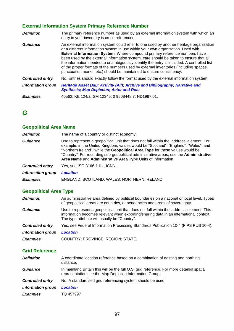
External Information System Primary Reference Number
Definition The primary reference number as used by an external information system with which an entry in your inventory is cross-referenced.
Guidance An external information system could refer to one used by another heritage organisation or a different information system in use within your own organisation. Used with External Information System. Where compound primary reference numbers have been used by the external information system, care should be taken to ensure that all the information needed to unambiguously identify the entry is included. A controlled list of the proper formats of the numbers used by external inventories (including spaces, punctuation marks, etc.) should be maintained to ensure consistency.
Controlled entry No. Entries should exactly follow the format used by the external information system.
Information group Heritage Asset (All); Activity (All); Archive and Bibliography; Narrative and Synthesis; Map Depiction; Actor and Role
Examples 40562; KE 124/a; SM 12345; 0 9508448 7; ND1987.01.
G
Geopolitical Area Name
Definition The name of a country or distinct economy.
Guidance Use to represent a geopolitical unit that does not fall within the ‘address’ element. For example, in the United Kingdom, values would be “Scotland”, “England”, “Wales”, and “Northern Ireland”, while the Geopolitical Area Type for these values would be “Country”. For recording sub-geopolitical administrative areas, use the Administrative Area Name and Administrative Area Type Units of Information.
Controlled entry Yes, see ISO 3166-1 list, ICNN.
Information group Location
Examples ENGLAND; SCOTLAND; WALES; NORTHERN IRELAND.
Geopolitical Area Type
Definition An administrative area defined by political boundaries on a national or local level. Types of geopolitical areas are countries, dependencies and areas of sovereignty.
Guidance Use to represent a geopolitical unit that does not fall within the ‘address’ element. This information becomes relevant when exporting/sharing data in an international context. The type attribute will usually be “Country”.
Controlled entry Yes, see Federal Information Processing Standards Publication 10-4 (FIPS PUB 10-4).
Information group Location
Examples COUNTRY; PROVINCE; REGION; STATE.
Grid Reference
Definition A coordinate location reference based on a combination of easting and northing distance.
Guidance In mainland Britain this will be the full O.S. grid reference. For more detailed spatial representation see the Map Depiction Information Group.
Controlled entry No. A standardised grid referencing system should be used.
Information group Location
Examples TQ 457997
97

H
Height Above Ordnance Datum
Definition The height of the land surface at the location to which an inventory entry relates expressed as the difference from the Ordnance Survey datum point (mean sea-level at Newlyn, Cornwall), plus the unit of vertical distance used. Abbreviated AOD.
Guidance This information serveds as a general indicator to inform future users. If searching and indexing is a requirement for the inventory, then a more detailed approach will be needed, converting all height measurements to a single standard measure (e.g. metres). For detailed analysis of relative heights of monuments or other entries (e.g. to assess intervisibility of monuments) it may be appropriate to consider use of a Geographic Information System linked to the text inventory.
Controlled entry No. Standard abbreviations for units of measurement should be adopted.
Information group Map Depiction
Examples 15.6 m; 224 ft
Height Below Ordnance Datum
Definition Depth below mean sea level calculated from observation taken at Newlyn, Cornwall, and used as the official basis for height calculation on British maps. Abbreviated BOD.
Guidance This information serveds as a general indicator to inform future users. If searching and indexing is a requirement for the inventory, then a more detailed approach will be needed, converting all height measurements to a single standard measure (e.g. metres). For detailed analysis of relative heights of monuments or other entries (e.g. to assess intervisibility of monuments) it may be appropriate to consider use of a Geographic Information System linked to the text inventory.
Controlled entry No.
Information group Map Depiction
Examples 8.4 m; 24 ft
Heritage Asset Name
Definition A free-text field which records the name by which a Heritage Asset is most commonly known.
Guidance It is not necessary to construct artificial names if there is no name in common or recognised use. If no name exists use Description to provide brief identifying information. For historic or former names (e.g. names by which a factory used to be known, or archaic spellings used in historical documents) or alternative names, qualify with the Currency Unit of Information. For names in languages other than the principle language of the dataset qualify with the Language Unit of Information.
Controlled entry No.
Information group Heritage Asset (All)
Examples ELTHAM PALACE; MAES HOWE; OCKWELLS GLOVE FACTORY; THE KINGSTON BROOCH.
Historical Event Type
Definition The type or category of a historic events.
Guidance Use a controlled vocabulary.
Controlled entry Yes, see INSCRIPTION.
98

Information group Historical Event
Examples BATTLE; EARTHQUAKE; DISCOVERY; EPIDEMIC; WEDDING.
I
Information Source Title
Definition A name assigned to an information source, generally by its creator, to assist in identification.
Guidance Use for titles of published material, names assigned to archive collections or items, captions for images, web page titles, etc. Record exactly as given by the creator of the information source, where this is known.
Controlled entry Free text.
Information group Information Source (All)
Examples THE BUILDINGS OF WILTSHIRE; FARNHAM COURT – VIEW NORTH FROM THE GATEHOUSE; OS LANDRANGER SERIES SHEET 16; HOMEPAGE – WESTSHIRE ARCHAEOLOGY GROUP.
Inscription Content
Definition The text inscribed as a part of the decoration or content of a Heritage Asset.
Guidance Free-text field. Record the inscriptions and marks on a Heritage Asset, entering any inscribed text exactly as seen including spelling, punctuation and capitalisation.
Controlled entry No.
Information group Monument; Artefact and Ecofact
Examples THIS STONE WAS RAISED BY HILD, SON OF JOHN; George II Fecit.
Inscription Note
Definition A note field used to record additional information relating to the style or positioning of an inscription, as well as any non-textual marks or symbols associated with it.
Guidance Record once for each Inscription Content.
Controlled entry No.
Information group Artefact and Ecofact; Monument
Examples INSCRIPTION IS ON A PLATE AFFIXED TO THE NORTH SIDE.
Internal Cross Reference Number
Definition Used to cross-reference one entry in the inventory to another, related entry.
Guidance Cross-reference numbers should be reciprocal, such that the connection can be followed from either entry.
Controlled entry No.
Information group Artefact and Ecofact; Monument
Examples In the following example, Entry 1 is cross-referenced to Entry 2. Entry 2 is reciprocally cross-referenced to Entry 1. Entry 1: Number/UID 1296 Internal Cross-reference Number 1297 Entry 2: Number/UID 1297 Internal Cross-reference Number 1296
99

L
Language
Definition The language of the intellectual content of an information source.
Guidance Used with Information Source entries to identify the language of the content, or Location and Monument entry data to record the language of place names, and distinguish, for example, Welsh from English versions.
Controlled entry Yes. Use ISO639, which defines two- and three-letter primary language tags with optional sub-tags.
Information group Archive and Bibliography; Narrative and Synthesis; Location
Examples En-GB (for English spelling as used in Great Britain).
Locality
Definition A free-text field for a named area within which a monument lies. Used to provide assistance in locating a monument or activity. Generally refers to an area contained within a Civil Parish (or other local administrative area).
Guidance For detailed recording of location, Locality should be used to identify more specific areas lying within a civil parish (or other local administrative area). This could be, for example, a village or hamlet name, an area of a town, an estate or farm name.
Controlled entry No.
Information group Location
Examples SOHO; CHURCH FARM.
M
Maintenance Plan
Definition The description of planned activities aimed at maintaining the current condition of a Heritage Asset.
Guidance Content should follow appropriate professional guidelines for this sort of document.
Controlled entry Free text.
Information group Management Activity Documentation
Examples
Management Activity Method
Definition A record of the method used in a Heritage Asset Management Activities.
Guidance Used for techniques applied to, for example, building repair, scrub clearance.
Controlled entry No. Free text.
Information group Heritage Asset Management Activity
Examples JOINTS RAKED OUT AND REPOINTED WITH LIME MORTAR.
Management Activity Type
Definition A record of the type of work used in Heritage Asset Management Activities.
100

Guidance Should only be used to record officially-sanctioned activities directly related to the management of a historic asset. May be necessary to record more than once for each Heritage Asset Management Activity. The method used for each type of activity should be recorded using the Management Activity Method Unit of Information.
Controlled entry Yes. Maintain a standard list of terms.
Information group Heritage Asset Management Activity
Examples ACQUISITION; CONSERVATION; DISPOSAL; REPAIR.
Management Proposal Outcome
Definition The eventual outcome of a proposal affecting a Heritage Asset.
Guidance Use to record the result or outcome of a proposal. This serves to monitor the effectiveness of recommendations made by the information system holders. Use a controlled vocabulary. Details of the outcome can be given in the Description Unit of Information.
Controlled entry Yes. Maintain a standard list of terms.
Information group Casework and Consultation
Examples SUCCESSFUL; REFERRED; UNSUCCESSFUL.
Management Proposal Recommendation
Definition A recommendation made by the information system holders relating to the proposed work affecting a Heritage Asset.
Guidance Recording recommendations can assist in ensuring consistency of advice when responding. They can also be used to audit the number of proposals dealt with by the information system holders. Use a controlled vocabulary.
Controlled entry Yes, see INSCRIPTION.
Information group Casework and Consultation
Examples SUPPORT; REJECT; REFER.
Management Proposal Type
Definition The nature of a proposal that affects a Heritage Asset.
Guidance Use External Information System and External Information System Primary Reference Number to cross-reference to the original proposal (e.g. a planning application number assigned by a local planning authority). This can be used to monitor the threat posed to monuments by different types of proposal. Use a controlled vocabulary.
Controlled entry Yes, see INSCRIPTION.
Information group Casework and Consultation
Examples GRANT AID.
Management Proposal Work Proposed
Definition The nature of work proposed affecting a Heritage Asset recorded in the information system.
Guidance May assist in assessing the impact of different types of work on the heritage asset recorded in the information system. Use a controlled vocabulary.
Controlled entry Yes, see INSCRIPTION.
Information group Casework and Consultation
Examples RENOVATION
101

Manner of Loss
Definition The primary cause of loss of a watercraft or aircraft.
Guidance More than one term can be entered in this field to build up a picture of the craft’s loss. For example, a record of a watercraft that grounded on a submerged rock, drifted off and then sank could have two entries under Manner of Loss: GROUNDED and FOUNDERED. Similarly, an aircraft may have crash-landed as the result of mechanical failure or damaged sustained through enemy gun action. Further relevant details concerning the circumstances of the craft’s loss may be recorded as descriptive text elsewhere in the record.
Controlled entry Yes, see INSCRIPTION.
Information group Monument
Examples STRANDED
Map Sheet
Definition The title of a map sheet which depicts the location of the Heritage Asset.
Guidance In the UK this is typically an Ordnance Survey 1:10,000 Quarter Sheet or larger scale Ordnance Survey Map.
Controlled entry Yes. Maintain a standard list of terms.
Information group Location
Examples SU 45 NE
Material
Definition The basic materials and media of which a Heritage Asset is composed.
Guidance Record each material separately. Maintain a list of standard terms. Do not include brand names. Use as many times as required. For more detailed recording of separate components of an asset, the Component and Material Component Units of Information may be used in addition.
Controlled entry Yes, see INSCRIPTION.
Information group Monument; Artefact and Ecofact
Examples WOOD; FLINT; CLAY.
Material Component
Definition The material of which a significant component, inclusion or trace is made.
Guidance This could also include a patina or corrosion product which has developed on an object or construction and which is of sufficient significance to require documenting. Only significant components of assets that have undergone scientific examination and analysis should be recorded.
Controlled entry Yes. Maintain a standard list of terms.
Information group Monument; Artefact and Ecofact
Examples CARBON; TEXTILE; SHELL.
Material Component Note
Definition Descriptive information about a material component.
Guidance Free-text field. Use normal grammar and punctuation. Record if necessary for a Material Component.
Controlled entry No.
Information group Monument; Artefact and Ecofact
102

Examples CRUSHED SHELL, IRREGULAR, RANGE 1–2.5 MM; CARBON SOOTING ON LOWER EXTERIOR SURFACE; COMPOUND IN PATINA SUGGESTIVE OF BURIAL IN DRY CONDITIONS.
Material Name
Definition The name commonly used to designate a particular or characteristic material and additional to or further defining the basic material itself. This may be the vernacular or generally used name for a certain type of material or a brand name.
Guidance Record as it is commonly used.
Controlled entry No.
Information group Monument; Artefact and Ecofact
Examples SAMIAN WARE; BACOLITE; IPSWICH WARE; GORE-TEX; MAGNESIAN LIMESTONE; KERATIN.
Modification State
Definition An attribute of an artefact/ecofact, recording how it has been preserved or altered.
Guidance This covers natural processes that have affected the artefact or ecofact subsequent to its incorporation in the archaeological record. Modification subsequent to discovery would be recorded as a Condition. Used to assist analysts understand the potential of material for particular forms of study.
Controlled entry Yes. Maintain a standard list of terms.
Information group Artefact and Ecofact
Examples DESSICATED; MINERALISED; ANOXIC.
Monument Type
Definition The term(s) which classifies the monument principally with reference to its function or use.
Guidance Multiple entries of this unit may be required (e.g. to cater for instances where uncertainty exists over the interpretation of a monument, or where more than one entry term is appropriate).
Controlled entry Yes, see English Heritage Thesaurus of Monument Types.
Information group Monument
Examples General terms: BARROW; BUILDING; CEMETERY. Specific terms: BELL BARROW; BRASS FOUNDRY; ENCLOSED CREMATION CEMETERY.
N
Named Location
Definition The text description of a location which can be defined in space as an area but not as a single point.
Guidance These can be, for example, settlements, hills, roads, beaches, sandbanks, waterways, etc. Named Locations should be entered when no precise coordinates for an entity are given to provide some consistency in recording imprecise spatial data. For more detailed recording, the Area Information Group (with associated Map Depiction) is appropriate.
Controlled entry Yes. Maintain a standard list of terms.
Information group Location
Examples LAKE WINDERMERE; THE GRAMPIANS; OFF WHITBY NORTH YORKSHIRE; WEST
103
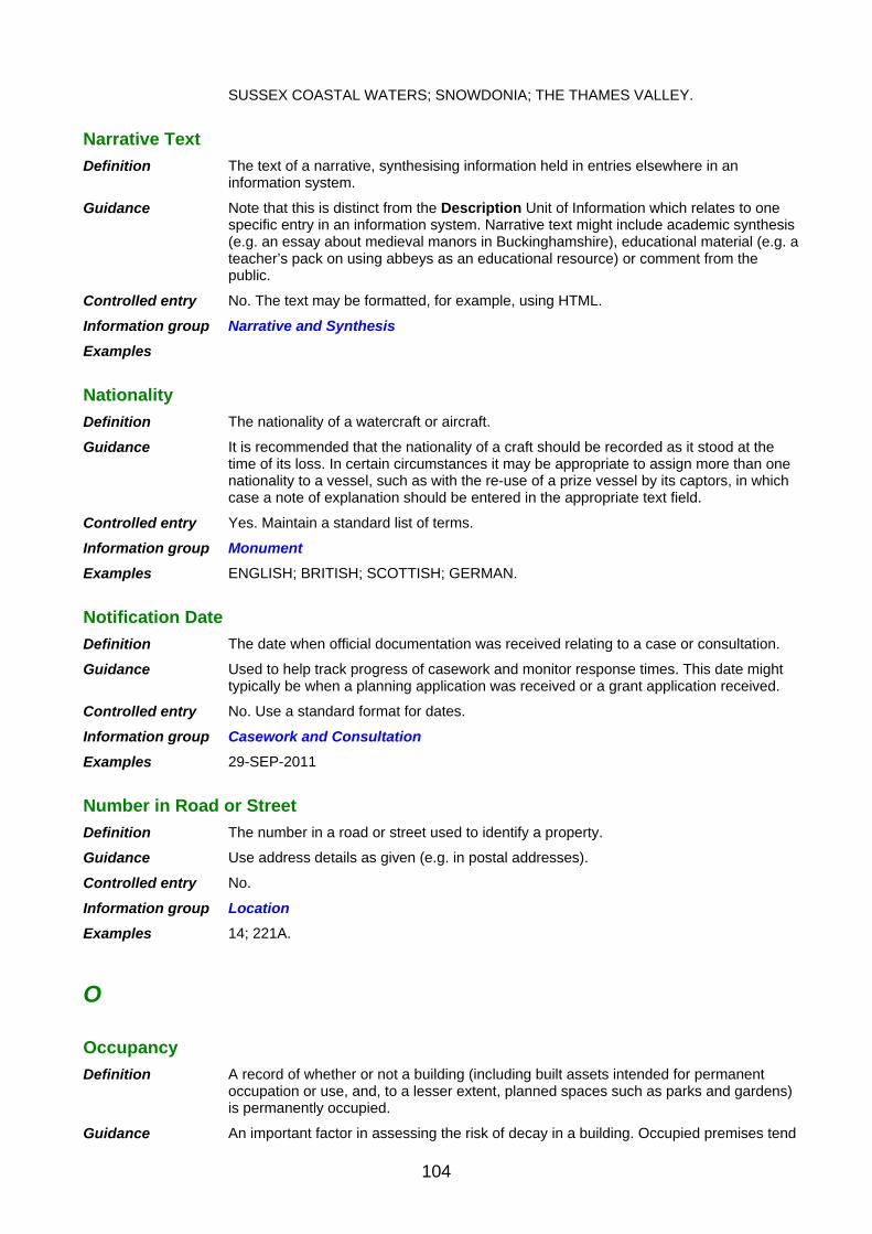
SUSSEX COASTAL WATERS; SNOWDONIA; THE THAMES VALLEY.
Narrative Text
Definition The text of a narrative, synthesising information held in entries elsewhere in an information system.
Guidance Note that this is distinct from the Description Unit of Information which relates to one specific entry in an information system. Narrative text might include academic synthesis (e.g. an essay about medieval manors in Buckinghamshire), educational material (e.g. a teacher’s pack on using abbeys as an educational resource) or comment from the public.
Controlled entry No. The text may be formatted, for example, using HTML.
Information group Narrative and Synthesis
Examples
Nationality
Definition The nationality of a watercraft or aircraft.
Guidance It is recommended that the nationality of a craft should be recorded as it stood at the time of its loss. In certain circumstances it may be appropriate to assign more than one nationality to a vessel, such as with the re-use of a prize vessel by its captors, in which case a note of explanation should be entered in the appropriate text field.
Controlled entry Yes. Maintain a standard list of terms.
Information group Monument
Examples ENGLISH; BRITISH; SCOTTISH; GERMAN.
Notification Date
Definition The date when official documentation was received relating to a case or consultation.
Guidance Used to help track progress of casework and monitor response times. This date might typically be when a planning application was received or a grant application received.
Controlled entry No. Use a standard format for dates.
Information group Casework and Consultation
Examples 29-SEP-2011
Number in Road or Street
Definition The number in a road or street used to identify a property.
Guidance Use address details as given (e.g. in postal addresses).
Controlled entry No.
Information group Location
Examples 14; 221A.
O
Occupancy
Definition A record of whether or not a building (including built assets intended for permanent occupation or use, and, to a lesser extent, planned spaces such as parks and gardens) is permanently occupied.
Guidance An important factor in assessing the risk of decay in a building. Occupied premises tend
104

to be maintained, so there is less risk of damage to the built structure, loss due to theft, etc. Unoccupied generally implies absence of occupation for an extended period (e.g. months) rather than temporary changes of occupation, etc. Recording should allow for partial occupation.
Controlled entry Yes. Maintain a standard list of terms.
Information group Management Activity Documentation
Examples UNOCCUPIED; OCCUPIED; PARTIALLY OCCUPIED.
Occupation
Definition The principle business interest, or job title, of a person.
Guidance Used to help identify individuals recorded in an information system. This may be different to their Role, which is recorded in a separate Unit of Information.
Controlled entry Yes. Maintain a standard list of terms.
Information group Actor and Role
Examples FARMER; BUILDER; PLANNING OFFICER.
Organisation Name
Definition The official name of the organisation associated with an entry in the information system.
Guidance Maintain a list of names of organisations. Use as many times as required. More than one organisation may be associated with the entry.
Controlled entry No. Use the name as exactly given by the organisation.
Information group Actor and Role
Examples NATIONAL INVENTORY OF GLASS MAKING; CRICKLADE MUSEUM; OXFORD ARCHAEOLOGY.
P
People Name
Definition The name given to gatherings or groupings of people that act collectively or in a similar way due to any form of unifying relationship (social, ethnic or cultural).
Guidance Contrasts with Organisation Name, which should be used for any legally identifiable body. Repeat as many times as required.
Controlled entry Free text (although commonly used entries may be selected from a controlled vocabulary).
Information group Actor and Role
Examples ICENI; THE JARROW MARCHERS.
Period (Name)
Definition The name given to the period when an event in the history of a Heritage Asset is thought to have occurred, or the archaeological period to which it is thought to belong.
Guidance A broad chronological assessment used usually in archaeological datasets where more precise dates are rarely available. The terms used should include ‘Unknown’ to record entries of unknown period. A hierarchical list to allow indexing of records at either a specific level or a general level is recommended. Alternatively, separate entries giving both a broad period term and a narrow term should be used. For retrieval purposes in computerised systems it is recommended that default Start Date and End Date entries are recorded automatically based on the period terms entered. Default date ranges may need to be adjusted to allow for regional variation.
105

Controlled entry Yes.
Information group Date and Period
Examples Broad terms: PREHISTORIC. Specific terms: LATE NEOLITHIC; MEDIEVAL; BRONZE AGE; MING DYNASTY; VICTORIAN.
Person Name
Definition The name of a person associated with an entry in the information system.
Guidance Where known Person Name should be composed of a SURNAME, FORENAME(S) and TITLE. Where FORENAME(S) is not known INITIALS should be recorded (if known). Use the capitalisation and punctuation normally used by the person.
Controlled entry Yes. A list of people should be maintained.
Information group Actor and Role
Examples Brown, Jane; Johnson, Dr; Jones, Miss T.
Positional Accuracy
Definition The accuracy of the data source used to locate a feature.
Guidance Record any limitations on the accuracy imposed by the use of particular source data. A feature might be recorded as a polygon but it might be that the location of that feature within the polygon is unknown.
Controlled entry Free text.
Information group Map Depiction
Examples APPROXIMATE LOCATION FROM 1ST EDITION MAP (1870).
Post Code
Definition A geographically referencing codification scheme used by postal services in the sorting and delivery of mail.
Guidance Appropriate when referencing standing buildings as a means of location and maintaining written contact. It is less useful in reference to non-standing buildings, although could still be used when referring to a monument or feature in the grounds of the building to which the postcode relates.
Controlled entry Yes.
Information group Location
Examples SN2 2GZ; CB1 3EF; W3.
Potential (Key Item Flag)
Definition An indicator of a particularly significant asset, suitable for further research.
Guidance Used to indicate to curatorial staff the potential for future work. This should be used sparingly and always supported with a Potential (Note).
Controlled entry Use of a simple Yes/No flag is appropriate.
Information group Research and Analysis
Examples YES.
Potential (Note)
Definition The potential of a sample or assemblage for use in further research.
Guidance Potential will generally only be appropriate within the context of the recording of one particular research project. For example, an assemblage that is regarded as of limited potential for one technique or research approach may be of great significance for
106
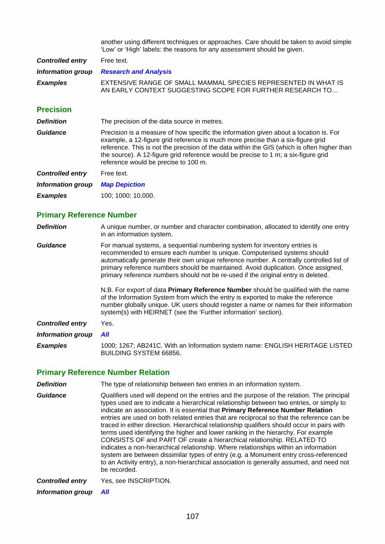
another using different techniques or approaches. Care should be taken to avoid simple ‘Low’ or ‘High’ labels: the reasons for any assessment should be given.
Controlled entry Free text.
Information group Research and Analysis
Examples EXTENSIVE RANGE OF SMALL MAMMAL SPECIES REPRESENTED IN WHAT IS AN EARLY CONTEXT SUGGESTING SCOPE FOR FURTHER RESEARCH TO…
Precision
Definition The precision of the data source in metres.
Guidance Precision is a measure of how specific the information given about a location is. For example, a 12-figure grid reference is much more precise than a six-figure grid reference. This is not the precision of the data within the GIS (which is often higher than the source). A 12-figure grid reference would be precise to 1 m; a six-figure grid reference would be precise to 100 m.
Controlled entry Free text.
Information group Map Depiction
Examples 100; 1000; 10,000.
Primary Reference Number
Definition A unique number, or number and character combination, allocated to identify one entry in an information system.
Guidance For manual systems, a sequential numbering system for inventory entries is recommended to ensure each number is unique. Computerised systems should automatically generate their own unique reference number. A centrally controlled list of primary reference numbers should be maintained. Avoid duplication. Once assigned, primary reference numbers should not be re-used if the original entry is deleted. N.B. For export of data Primary Reference Number should be qualified with the name of the Information System from which the entry is exported to make the reference number globally unique. UK users should register a name or names for their information system(s) with HEIRNET (see the ‘Further information’ section).
Controlled entry Yes.
Information group All
Examples 1000; 1267; AB241C. With an Information system name: ENGLISH HERITAGE LISTED BUILDING SYSTEM 66856.
Primary Reference Number Relation
Definition The type of relationship between two entries in an information system.
Guidance Qualifiers used will depend on the entries and the purpose of the relation. The principal types used are to indicate a hierarchical relationship between two entries, or simply to indicate an association. It is essential that Primary Reference Number Relation entries are used on both related entries that are reciprocal so that the reference can be traced in either direction. Hierarchical relationship qualifiers should occur in pairs with terms used identifying the higher and lower ranking in the hierarchy. For example CONSISTS OF and PART OF create a hierarchical relationship. RELATED TO indicates a non-hierarchical relationship. Where relationships within an information system are between dissimilar types of entry (e.g. a Monument entry cross-referenced to an Activity entry), a non-hierarchical association is generally assumed, and need not be recorded.
Controlled entry Yes, see INSCRIPTION.
Information group All
107

Examples Hierarchical examples: 1) A warehouse Monument entry could be ‘PART OF’ an industrial complex, which ‘CONSISTS OF’ warehouses, factories, depots, offices, etc. 2) Excavation (an Investigative Activity) could be ‘PART OF’ of a larger project which ‘CONSISTS OF’ excavation, photographic survey, field walking, etc. 3) An article in a journal would be ‘PART OF’ the journal which ‘CONSISTS OF’ several articles. Non-hierarchical example: The industrial complex entry could also be ‘RELATED TO’ an entry recording a goods yard, used to export products and bring in materials.
Primary Reference Number Type
Definition The meaning of a primary reference number.
Guidance Used with exported data to distinguish primary reference numbers that identify different things within MIDAS. It is not necessary to report Primary Reference Number Type against every entry in a dataset in normal use. However default values should be included with the data at the point that they are exported.
Controlled entry Yes. See the Compliance Tables.
Information group All
Examples AREA; MONUMENT.
Prime Motive Power
Definition The main or commonly referred to energy source for propelling, or moving parts within, a Heritage Asset.
Guidance Used for air and water craft, or for industrial sites. Most useful where the prime motive power forms part of the characterisation of the Heritage Asset. For example, STEAM ENGINE or WATER MILL. Repeat unit where more than one power source exists. Use Currency to distinguish between current and previous sources of motive power (e.g. conversion of gas turbine to diesel-electric with removal of previous power source).
Controlled entry Yes. Maintain a standard list of terms.
Information group Monument
Examples STEAM; HORSE; WIND.
Production Method
Definition The primary means used to manufacture an artefact.
Guidance May be amplified by Production Technique (e.g. method – painted, technique – watercolour).
Controlled entry Yes. Maintain a standard list of terms.
Information group Artefact and Ecofact
Examples CAST; PAINTED.
Production Technique
Definition The recognised variations in the production method (e.g. method – cast, technique – lost wax).
Guidance Should only be used to amplify Production Method. A common approach to recording used within museums and included within MIDAS Heritage to facilitate interoperability.
Controlled entry Yes. Maintain a standard list of terms.
Information group Artefact and Ecofact
Examples LOST WAX; WATERCOLOUR.
108

Protection End Date
Definition The date at which a specific protection designation ends.
Guidance This should be used in conjunction with Protection Start Date, Protection Type, Statutory Name and, where appropriate, Statutory Description and Protection Grade. Protection designations are not necessarily consecutive. A Heritage Asset may be covered by more than one form of protection at any one period of time.
Controlled entry Yes. A standard format for dates should be adopted.
Information group Designation and Protection
Examples 14-FEB-2006
Protection Grade
Definition The grade of protection assigned by a protection activity.
Guidance Not all Protection Types have associated Protection Grades. This should always be used in conjunction with Protection Start Date, Statutory Name and Protection Status, and where appropriate with Statutory Description and Protection End Date.
Controlled entry Yes, see INSCRIPTION.
Information group Designation and Protection
Examples I; II*; II.
Protection Start Date
Definition The date from which a specific protection designation starts.
Guidance This should be used in conjunction with Protection Type, Statutory Name and, where appropriate, Statutory Description, Protection Grade and Protection End Date. Protection designations are not necessarily consecutive. A Heritage Asset may be covered by more than one form of protection at any one period of time.
Controlled entry Yes. A standard format for dates should be adopted.
Information group Designation and Protection
Examples 21-FEB-2008
Protection Type
Definition The type of designation applying to a Heritage Asset, providing protection in law.
Guidance Select a term in use within the appropriate designation system, ideally contained within a controlled vocabulary. This should always be used in conjunction with Protection Start Date, Statutory Name and, where appropriate, Statutory Description and Protection End Date.
Controlled entry Yes, see INSCRIPTION.
Information group Heritage asset (All); Designation and Protection
Examples SCHEDULED MONUMENT; LISTED BUILDING; CONSERVATION AREA; WORLD HERITAGE SITE; TREASURE.
Q
Quality
Definition A description of any quality checking to a map depiction.
Guidance Free-text field with details of the quality checking which allows users to know what checking has already taken place and highlights issues which are currently known
109

about the spatial representation of a feature.
Controlled entry No.
Information group Map Depiction
Examples Boundaries are indicative based on currently known extent of archaeological features. Refer to compiler for clarification.
R
Recovery Method
Definition The technique used to recover an artefact or ecofact. To record the technique used to cover an artefact or ecofact. Use a controlled vocabulary; see INSCRIPTION.
Guidance Use once only for each artefact or ecofact. Select term from a controlled vocabulary. For material from early investigations, or other cases where this can not be ascertained, use UNKNOWN.
Controlled entry Yes. Maintain a standard list of terms.
Information group Artefact and Ecofact; Research and Analysis
Examples FIELD WALKING; HAND EXCAVATION; SIEVED SAMPLE.
Recovery Purpose
Definition A record of the reason why a particular artefact or ecofact sample has been recovered.
Guidance This should ideally be recorded at the time that the sample is recovered (e.g. during excavation) to guide and inform future analysis.
Controlled entry Free text.
Information group Artefact and Ecofact
Examples SAMPLED TO ASSESS THE SPECIES REPRESENTED IN DOMESTIC RUBBISH FOOD DEBRIS.
Registration Place
Definition The port at which a watercraft was registered.
Guidance Applies exclusively to the recording of watercraft. The currently accepted name for a port of registration should be used to allow for variations in spelling or place name. Care should be taken when consulting documentary sources not to confuse a vessel’s port of departure with its port of origin/registration.
Controlled entry A controlled list of terms is recommended.
Information group Monument
Examples PLYMOUTH (DEVON); OSLO; SZCZECIN; LONDON.
Representation Source
Definition The source map, chart or document used to define a Map Depiction entry.
Guidance Adequately detailed information should be recorded to allow a user to gauge how the source used might affect the quality of the map depiction.
Controlled entry Free text.
Information group Map Depiction
Examples 0S 1:10560 Epoch 2 London; OS 1:10,000; Admiralty Chart 2175-0.
110

Right Note
Definition A descriptive note of property or other legal entitlement or interest held by an actor with respect to a Heritage Asset or information source.
Guidance Includes property and intellectual property rights. Use with Right Type, which indicates the category of right referred to. Related Actor entries should be used to record full details of the actor involved.
Controlled entry Free text.
Information group Artefact and Ecofact; Monument; Archive and Bibliography; Narrative and Synthesis
Examples ©HISTORIC SCOTLAND; PROPERTY OF CROWN ESTATE.
Right Type
Definition The type of property or other legal entitlement or interest held by an actor with respect to a Heritage Asset or information source.
Guidance Includes property and intellectual property rights. Use with Right Note, which gives an appropriate form of words to express the claim.
Controlled entry Yes. Maintain a list of standard terms.
Information group Artefact and Ecofact; Monument; Archive and Bibliography; Narrative and Synthesis
Examples COPYRIGHT; OWNERSHIP; EASEMENT.
Road or Street Name
Definition The name assigned to a thoroughfare.
Guidance Record to assist in providing location. Use spelling and punctuation taken from a recognised source. For recording former street names qualify with the Currency Unit of Information.
Controlled entry Yes. Where available use street gazetteers.
Information group Location
Examples HIGH STREET; QUEEN MARY’S AVENUE; BACK LANE; THE SHAMBLES.
Role
Definition The particular role played by a person, people or organisation associated with a Heritage Asset, event or information source.
Guidance Use to record the role of the person, people or organisation associated with the Heritage Asset, for example the role of Sir Christopher Wren when associated with St Paul’s Cathedral is that of ARCHITECT. Examples of associated roles may relate to the design of a building (ARCHITECT), the construction of a site or monument (BUILDER), the occupier of a building (OWNER, TENANT) or merely the fact that a historic person is associated with the Heritage Asset, for example a tomb or gravestone of a historic figure (PERSON OF HISTORIC INTEREST), etc. Some roles may need to be linked with Start Date and End Date.
Controlled entry Yes.
Information group Actor and Role
Examples SURVEYOR; SITE MANAGER; FIELD COLLECTOR; OWNER; PERSON OF HISTORIC INTEREST.
111

S
Scientific Date
Definition The scientific date associated with a Heritage Asset.
Guidance Use to record the date given by scientific date determinations. If it is intended to automate analysis of this information it may be appropriate to use additional Units of Information to record the standards deviation, laboratory number, etc. Entries should be exactly as given by the provider of the scientific date information, or in the source used. Uncalibrated dates should be quoted whenever this information is given. Where known, laboratory numbers should always be recorded to assist in identifying the sample that has provided the date.
Controlled entry No. Free text.
Information group Date and Period
Examples 3580 bp +/- 120 (HAR-1234)
Scientific Date Method
Definition The existence and type of scientific dating technique(s) available for a monument, artefact or ecofact.
Guidance The absolute dates provided by scientific methods may contribute to the assessment of the Period (Name) or Start Date and End Date entries for these, but only after the qualification attached to the method, sample or context have been assessed and given due weight.
Controlled entry Yes, see INSCRIPTION.
Information group Date and Period
Examples RADIOCARBON DATING; THERMOLUMINESCENCE DATING; DENDROCHRONOLOGY.
Spatial Feature Type
Definition The spatial object type used to depict the spatial element of a feature.
Guidance This is usually auto-generated by a GIS system. Different systems will use different terminology/numbering systems. Adoption of common terminology becomes significant when data is shared between different systems.
Controlled entry Free text. For storing this data in databases, use of the Well-Known Text standard from the Open Geospatial Consortium is recommended.
Information group Map Depiction
Examples POINT; POLYGON; MULTIPOINT.
Start Date
Definition The earliest date in a date range.
Guidance Associated with an End Date entry. Conventions should be adopted to indicate the appropriate date range for recording date statements. For BC dates, the use of negative numbers is recommended.
Controlled entry Yes.
Information group Date and Period
Examples 1914; -237).
112

Statement of Responsibility
Definition A statement of the origin of an information source.
Guidance Typically this will be personal names for the author, editor, photographer, cartographer, etc., but may also be used for publishers or issuing organisation names if individual names are not known. For more detailed recording, the use of the Actor and Role Information Group should be considered.
Controlled entry Identify, adopt and use a standardised format such as that used in bibliographic citation rules.
Information group Archive and Bibliography; Narrative and Synthesis
Examples HARCOURT, J (Ed); CADW.
Statement of Significance
Definition A statement of the perceived significance of a collection.
Guidance Used in documenting the result of assessment of a collection, for example a museum collection or the contents of an historic property. Professional guidelines should be consulted for guidance on the appropriate content. Statements of significance should always be accompanied by details of the Heritage Asset Management Activity that informed them.
Controlled entry Free text.
Information group Management Activity Documentation
Examples
Statutory Description
Definition The legal description of a designated asset.
Guidance Use to record the description of the designated area, as contained in legal documents that have designated the asset, where one exists. Not all designations have a statutory description.
Controlled entry Free text. Entries should be exactly as given on the official notification documentation.
Information group Designation and Protection
Examples Stone built 18th-century farmhouse, rectangular in plan with two bay windows on the east elevation at ground floor level, mansard stone tile roof…
Statutory Name
Definition The official name of the protected area given in the designation notification.
Guidance Use to record the name of the designated area, which is not necessarily the same as the Heritage Asset Name. This can be a proper name, a descriptive name or an address.
Controlled entry Free text. Entries should be exactly as given on the official notification documentation.
Information group Designation and Protection
Examples Down House; Cross 10 m west of the tower of the Church of St Anthony; 1–9 (Odd), High Street, Trumpton; North Hill Barrows.
Storage Location
Definition The physical location where an artefact/ecofact is kept.
Guidance Maintain a list of storage locations. Ensure that all locations can be uniquely identified. Record once only each time a new storage location is used. By default the current storage location. If required, use Currency, Start Date/End Date to differentiate current and previous storage locations.
113

Controlled entry No.
Information group Artefact and Ecofact
Examples Hangar B, Room 3, case 2, shelf 2.
Subject
Definition The subject matter or intellectual content of the narrative text.
Guidance Used to index by general subject area the intellectual content of narrative or synthesis text, stored in the Narrative Text Unit of Information.
Controlled entry Yes. See INSCRIPTION. Suitable terminology sources include the UK Archival Thesaurus.
Information group Archive and Bibliography; Narrative and Synthesis
Examples waterways; enclosure; landscape.
V
Value Statement
Definition A free-text description of the cultural, evidential, economic or other value assigned to a recorded Heritage Asset.
Guidance Content should be guided by appropriate professional standards on stewardship and conservation.
Controlled entry Free text.
Information group Management Activity Documentation
Examples
Value Type
Definition A category of cultural, social, economic or other value types used to characterise a Heritage Asset.
Guidance Derived from professional guidelines on stewardship and conservation.
Controlled entry Yes. Maintain a standard list of terms.
Information group Management Activity Documentation
Examples EVIDENTIAL
Vulnerability Level
Definition The severity of vulnerability of a Heritage Asset to an identified Agent of Damage.
Guidance Used to assess the relative severity of different agents of damage as assessed by Heritage Asset Management Activity.
Controlled entry Yes. Maintain a standard list of terms. Words are preferable to numeric scores for clarity.
Information group Management Activity Documentation
Examples HIGH; VERY HIGH; LOW.
114

W
Work Status
Definition The current state of progress of an activity.
Guidance Record once only to show current status. Maintain or use a controlled vocabulary. Should not be used to refer to named phases in a specific Heritage Asset management plan. Use Description to record detailed information about work status.
Controlled entry Yes. Maintain a standard list of terms.
Information group Investigative Activity; Research and Analysis; Heritage Asset Management Activity
Examples PLANNED, IN PROGRESS, COMPLETE, SUSPENDED
X
X Coordinate
Definition The numerical easting (X) coordinate for a feature.
Guidance Generally six figure coordinates are necessary, following UK standards for GIS. Single coordinate pair (i.e. with Y coordinate) will identify a point. This will be assumed to be a centroid for a recorded feature unless otherwise documented. Repeat values in pairs with Y coordinates form lines or polygons.
Controlled entry Yes. Numerical values only.
Information group Map Depiction
Examples 456789
Y
Y Coordinate
Definition Numerical northing (Y) coordinate for a feature.
Guidance Generally six figure coordinates are necessary, following UK standards for GIS. Single coordinate pair (i.e. with X coordinate) will identify a point. This will be assumed to be a centroid for a recorded feature unless otherwise documented. Repeat values in pairs with X coordinates form lines or polygons.
Controlled entry Single numerical value.
Information group Map Depiction
Examples 234567
Z
Z Coordinate
Definition Numerical coordinate for defining depth or height for a feature. This enables you to recreate the site more accurately than Height Above or Below Ordnance Datum.
Guidance Could be used for example in photogrammetric survey. The numerical Z Coordinate should be linked with the Reference System used. Generally six figure coordinates are
115

necessary, following UK standards for GIS. Single coordinate pair (i.e. with X coordinate) will identify a point. This will be assumed to be a centroid for a recorded feature unless otherwise documented. Repeat values in pairs with X coordinates for lines or polygons.
Controlled entry Single numerical value.
Information group Map Depiction
Examples 546854
116

117
Glossary
Compliance profile A document setting out a specific information system or dataset, or community. The level of compliance with the standard (Non-compliant, Level 1, Level 2) for each MIDAS Heritage Information Group. Data model A definition or specification of an information system, showing the content and structure. Dataset A collection of entries. The term is used to distinguish the data (the actual recorded facts) from the database or other information system, which is the hardware and software used to store and process the data. Data standard A statement of what data should be recorded, and how the data should be recorded, to facilitate consistency between information system entries and between different information systems using the same standard. Entity Overall term embracing any or all of the subjects of interest recorded in an entry, including heritage assets, activities, information sources, spatial and temporal information, and actors. Entry The complete set of recorded information about a specific MIDAS Heritage entity comprising the full set of Units of Information from principle Information Groups and any other Information Group with Mandatory relationships to the principle Information Group. FISH The Forum on Information Standards in Heritage. A consortium of heritage sector organisations that collaborate to set information standards for the sector. See www.fish-forum.info Heritage Asset The main subject of interest of most MIDAS Heritage information systems – the documented real world and conjectured or proposed things that the information recorded relates to. Historic environment The sum of physical changes made to the natural world by past human activities. Includes all types of heritage assets. Information Group (was Information Scheme) A grouping of Units of Information together constituting the information required to record in the information system a particular aspect of a subject. Approximately equivalent to the MIDAS 1998 use of ‘Information Scheme’. Information System The system used to store, process and retrieve entries. Typically this will be a computerised database application. MIDAS 1998 used ‘Inventory’. Interoperability The ability of an information system to be able to provide data in a way which can be used by another information system or service without the need for additional work (e.g. re-keying of data). Metadata Information recorded to assist in finding, understanding and managing a dataset, rather than the data itself. Sphere of interest The definition of what sort of entries are relevant to an information system. This definition is used to manage what entries should be included, and what irrelevant entries should not be prioritised.

Thesaurus A wordlist (q.v.) with a particular structure (as defined in relevant BS and ISO standards), that supports precise and inclusive indexing and retrieval of entries. Unit of Information Units of Information are the fundamental facts of interest contained within an information system. Each Unit of Information is generally the equivalent of a field in a computerised database, or a box on an index card, or a question on a survey form. Wordlist A list of accepted terms used to control the information recorded in a specific Unit of Information within an information system. This ensures accurate retrieval of all relevant information by a future user of the system. Also known as a controlled vocabulary, authority list, authority file or reference data list.
Further information
To support implementation of the MIDAS Heritage standard a list of relevant web sites and other online resources is maintained by the members of the Forum on Information Standards in Heritage (FISH). This can be accessed via the FISH website, which also gives further details of the Forum, at www.fish-forum.info . Or directly via the MIDAS Heritage page at http://www.english-heritage.org.uk/professional/archives-and-collections/nmr/heritage-data/midas-heritage/links-to-other-resources/
118

119
List of images
1. Front cover: Bolton Abbey, Skipton, North Yorkshire. © Photographer Paul Adams, 26/11/2005. 2. Foreword: Tyddyn-y-Felin, Merionethshire. View of a small lateral-chimneyed house dated 1595. Crown © RCAHMW, 1981 (DI2006_1854). 3. Area: Hadrian’s Wall, Chesters Roman Fort, Northumberland, aerial view. The fort was built to guard the Roman bridge which carried both Hadrian’s Wall and the military road over the North Tyne. © English Heritage. Photographer Dave MacLeod, 30/03/2007 (Image Ref N070098). 4. Monument: Belsay Castle, Northumberland. Detail of the turrets of a late 14th century tower house. The fighting gallery at roof level is equipped with machicolations and corbelled out angle turrets of French influence. © English Heritage (Image Ref No N070011). 5. Artefact and Ecofact: A selection of artefacts and ecofacts, including decorated pottery shards and animal bone. © Worcestershire County Council. Photographer Simon Sworn, 07/09/2007. 6. Investigative Activity: Ashby de la Zouch Castle, Leicestershire. Surveyor working near Trench 2. Ashby de la Zouch Castle was originally a 12th century stone fortified manor house, founded by Alain de Parrhoet, la Zouch. In 1474, William, Lord Hastings, founded an impressive stone keep and courtyard fortress. © English Heritage. Photographer Alun Bull, 14/08/2006. (Image Ref No N060477). 7. Designation and Protection: Pontcysyllte Aqueduct, Denbighshire. Built by Thomas Telford and opened in 1805, the aqueduct carries the Llangollen Canal across the River Dee. Crown © RCAHMW, 2005 (Image Ref No D12005_0878). 8. Heritage Asset Management Activity: Picture conservation staff at work in the painting conservation studio, Rangers House, London. © English Heritage. Photographer Nigel Corrie, 19/01/2007 (Image Ref No N060500). 9. Casework and Consultation: Hanover Square, City of Westminster, London. Staff at work in the street. © English Heritage. Photographer Nigel Corrie, 06/09/2005 (Image Ref No N050004). 10. Research and Analysis: Archaeology Research School, Sheffield, West Yorkshire. A staff member working on the measuring stage in the dendrochronology laboratory. © English Heritage. Photographer Jonathan Bailey, 01/03/1996 (Image Ref No K960228). 11. Historical Event: HMS Vanguard Memorial, Lyness, Orkney. War memorial erected in Lyness Royal Naval Cemetery. The two-metre high Celtic cross in Lyness Cemetery commemorates those who lost their lives on board HMS Vanguard on July 9, 1917. Crown © RCAHMS, 1996 (Image Ref No SC 645457). 12. Archive and Bibliography: English Heritage (National Monuments Record Centre), Swindon, Wiltshire. Interior of main archive building with curator. © English Heritage (Image Ref No N060669). 13. Narrative and Synthesis: Pendennis Castle, Cornwall. View of a World War 1 exhibition. © English Heritage. Photographer Mike Hesketh-Roberts, 01/12/2006 (Image Ref No K980602). 14. Management Activity Documentation: Whitford Point Lighthouse, Glamorganshire. A 130ft cast-iron lighthouse in south west Wales, built in 1865 and last used in 1926. Crown © RCAHMW, 2006 (Image Ref No DS2007_023_003). 15. Location: Oblique aerial view of Glasgow. View of the city centre looking along the river, taken from the south east. © RCAHMS, 2005 (Image Ref No DP 009519). 16. Map Depiction: Map of an area of North Yorkshire, showing historic sites in the district of Hambleton. © English Heritage, 17/08/2007. 17. Date and Period: Kelmarsh Hall, Northamptonshire. Festival of History 2006 re-enactment. Replica Saxon helmet. © English Heritage. Photographer Alun Bull, 21/12/2006 (Image Ref No N060447).

18. Actor and Role: RCAHMS Surveyor Mr Alan Leith using the EDM (Electronic Distance Measurer) in the field at Pitcarmick Burn, North East Perthshire. Crown © RCAHMS, September 1987 (Image Ref No SC 371010). 19. Dictionary of Units of Information: Crosby Sands, Liverpool, Merseyside. General view of the beach including a section of the art installation ‘Another Place’. The installation, by Anthony Gormley, features 100 cast iron figures spread out over two miles of beach, and extends half a mile into the sea. © English Heritage. Photographer James O. Davies, 01/08/2006 (Image Ref No N060824). 20. Glossary: Drawing of the Aberlemno Pictish Symbol Stone No. 2 (reverse of cross-slab), taken from J Stuart’s The Sculptured Stones of Scotland, 1, pl. LXXIX, 1856. The original upright cross-slab, made of Old Red Sandstone, measuring 7”6’ by 4”2’, depicts a battle scene consisting of three rows of figures. © RCAHMS, 1997 (Image Ref No SC 342321). 21. Back cover: Maiden Castle Iron Age hillfort. View of the ramparts to the south-east from the west. © English Heritage. Photographer Alun Bull, 21/06/2006 (Image Ref No N060316).
120

121

If you require an alternative accessible version of this document (for instance in audio, Braille or large print) please contact our Customer Services Department: Telephone: 0870 333 1181 Fax: 01793 414926 Textphone: 0800 015 0516 E-mail: [email protected]