victorville landfill jd - san bernardino county, california · 44 montgomery street, suite 2200 ......
TRANSCRIPT

Jurisdictional Delineation
Victorville Landfill Solar Project
10 MW AC Photovoltaic Solar Array
(57.6 Acres; APN #472-011-34)
Victorville 7.5 Minute Quadrangle,
Section 23, Township 6 N, Range 4 W
San Bernardino County, California
Prepared for:
SunEdison 44 Montgomery Street, Suite 2200
San Francisco, CA 941014
&
EPD Solutions 2030 Main St., Ste. 1200
Irvine, CA 92614
Prepared by:
Ryan Young Phoenix Biological Consulting
PO Box 720949 Pinon Hills, CA 92372
September 24, 2014

Page 2 of 58
Phoenix Biological Consulting 09/24/2014 (949) 887-0859 [email protected]
TABLE OF CONTENTS
Acronyms and Abbreviation ................................................................................................................. 4
1.0 Summary ....................................................................................................................................................... 5 2. Introduction 2.1 Project Location ....................................................................................................................................... 6 2.2 Project Description ................................................................................................................................... 6
2.3 Purpose of Assessment ............................................................................................................................. 6 3. Regulatory Framework .................................................................................................................................... 7 3.1 California Department of Fish Wildlife Streambed Alteration Agreement............................................... 7 3.2. Regional Water Quality Control Board 401 Certification. ............................................................................. 8 3.3 United States Army Corps of Engineers Clean Water Act 404 Permit ....................................................... 9 4. Project Setting ................................................................................................................................................. 9 4.1 Environmental Setting……………………………………………………………………………………………………………………………9
4.2 Vegetation Community ........................................................................................................................... 10 4.3 Hydrology…………………………………………………………………………………………………………………………………………… 10 4.4 Soils…………………………………………………………………………………………………………………………………………………… 11
5. Methodology ................................................................................................................................................. 11 5.1 Pre-Survey Investigations ....................................................................................................................... 12 5.2 Field Surveys ........................................................................................................................................... 11 5.2.1 Jurisdictional Drainages ....................................................................................................................... 13 5.2.2 Wetlands…………………………………………………………………………………………………………………………………………..17 5.2.3 Impact Evaluation……………………………………………………………………………………………………………………………..17 6. Results……………………………………………………………………………………………………………………………………………………… 18 6.1 Drainages Occurring Within the Solar Project Footprint……………………………………………………………………….18 6.2 Existing Riparian, Stream or Wetland Habitat……………………………………………………………………………………….19 6.3 Agency Jurisdiction……………………………………………………………………………………………………………………………...24 6.3.1 Drainage 1………………………………………………………………………………………………………………………………….24 6.3.2 Drainage 2………………………………………………………………………………………………………………………………….24 6.3.3 Drainage 3………………………………………………………………………………………………………………………………….25 6.3.4 Drainage 4………………………………………………………………………………………………………………………………….26 6.3.5 Drainage 5………………………………………………………………………………………………………………………………….27 6.3.6 Drainage 6………………………………………………………………………………………………………………………………….27 6.3.7 Drainage 7………………………………………………………………………………………………………………………………….28 6.3.8 Drainage 8………………………………………………………………………………………………………………………………….29 6.3.9 Drainage 9………………………………………………………………………………………………………………………………….29 6.3.10 Drainage 10……………………………………………………………………………………………………………………………..30 6.3.11 Gen-Tie Transmission Corridor Drainage 11 & 12……………………………………………………………………..30 6.4 Project Impact to Jurisdictional Areas…………………………………………………………………………………………………..32 6.4.1 Permanent Impacts to Jurisdictional Drainages………………………………………………………………………….32 6.4.2 Project Impacts to Wetlands………………………………………………………………………………………………………32 6.4.3 Summary of Agency Jurisdiction and Permanent Impacts…………………………………………………………..32

Page 3 of 58
Phoenix Biological Consulting 09/24/2014 (949) 887-0859 [email protected]
7.0 Discussion……………………………………………………………………………………………………………………………………………….33 7.1 Permits………………………………………………………………………………………………………………………………………………..33 7.1.1 Streambed Alteration Notification……………………………………………………………………………………………..33 7.1.2 Army Corps of Engineers 404 Permit………………………………………………………………………………………….33 7.1.3 Regional Water Quality Control Board 401 Certification…………………………………………………………….33 7.2 Avoidance and Minimization Recommendations………………………………………………………………………………….33 7.3 Existing Mitigation……………………………………………………………………………………………………………………………….38 8 References ..................................................................................................................................................... 39 9 Certification……………………………………………………………………………………………………………………………………………….42
LIST OF TABLES
Table 1. Summary of Jurisdictional Drainage .................................................................................................... 17
Table 2. Jurisdictional Delineation Results – Impacted Drainages within the Victorville Solar Site……………….43
Table 3. Jurisdictional Delineation Results – Drainages within the Phase 3 VSL (No Impact)…….....................44
LIST OF FIGURES
Figure A. Regional Location Map ............................................................................................................................ 45 Figure B. USFWS National Wetlands Inventory of Victorville Landfill Area Map ................................................ 46 Figure C. Bell Mountain Wash – Mojave River Watershed ................................................................................... 47 Figure D. Soil Map for Victorville Solar Project ................................................................................................ 48 Figure E. Victorville Landfill Aerial View Comparison 1994-2009 .................................................................... 49 Figure F. Jurisdictional Delineation Results Aerial View .................................................................................. 50 Figure G. Photo Points Topographic View........................................................................................................ 51 Figure H. Jurisdictional Delineation Results and Permanent Impacts – Aerial View ....................................... 52 Figure I. Gen-Tie Transmission Line – Victorville Solar .................................................................................... 53 Figure J. Victorville Solar Site Plan ................................................................................................................... 54 Figure K-N Drainage Photos .............................................................................................................................. 55

Page 4 of 58
Phoenix Biological Consulting 09/24/2014 (949) 887-0859 [email protected]
ACRONYMS AND ABBREVIATIONS
AMSL above mean sea level
CEQA California Environmental Quality Act
CDFW California Department of Fish and Wildlife
CWA Clean Water Act
District Snowline Joint Unified School District
EPA Environmental Protection Agency
FAC Facultative
FACU facultative upland
FACW facultative wetland
GIS Geographic Information System
NL not listed
NWI National Wetlands Inventory
OBL Obligate
OHWM ordinary high water mark
Rapanos Rapanos v. U.S. and Carabell v. U.S.
RPW relatively permanent waterway
RWQCB Regional Water Quality Control Board
SWANCC Solid Waste Agency of Northern Cook County v. USACE
TNW traditionally navigable waterway
UPL Upland
USACE U.S. Army Corps of Engineers
USDA United States Department of Agriculture, Natural Resources Conservation Service
USFWS United States Fish and Wildlife Service
USGS U.S. Geological Survey
WSC Waters of the State of California
WUS Waters of the United States

Page 5 of 58
Phoenix Biological Consulting 09/24/2014 (949) 887-0859 [email protected]
1.0 SUMMARY
At the request of EPD Solutions, Inc, Phoenix Biological Consulting (Phoenix) initiated a
jurisdictional delineation (JD) within the phase 3 portion of the Victorville Sanitary Landfill
(VSL). Lilburn Corporation prepared a jurisdictional delineation for the VSL that included all
three phases of the project site (Lilburn, 2008). The original jurisdictional delineation (JD)
has since expired and Phoenix was contracted to complete a new JD. The original JD
identified 30.26 acres of waters of the US & state within the entire landfill footprint. 11.52
acres of jurisdictional water were originally identified to be impacted by the development of
the landfill. The County of San Bernardino completed a land transfer to the Bureau of Land
Management (BLM) of 23 acres of drainages to cover the mitigation requirements. Twenty-
three acres were mitigated specifically for desert wash habitat as mandated by the Biological
Opinion (BO) from the United States Fish and Wildlife Service (USFWS) which fulfilled the
permit requirements. The 23 acres were part of a larger 2,251 acres transfer known as the
Black Hills Mitigation Land Transfer of October 19, 1999. VSL was one of several landfills
included in this mitigation package.
SunEdison is proposing to build a photovoltaic solar energy plant on 57.6 acres, within the
phase 3 portion of the landfill (Figure I). The site has been previously fenced and the County
previously certified an Environmental Impact Report (EIR) for a multiphase expansion of the
VSL (Lilburn, 2004), including the Phase 3 area where the proposed solar facility is located. A
404 permit was obtained for the Phase 1 portion of the landfill (ACOE Permit # SPL-2009-
00910-GS; ACOE, 2011). The 404 permit covered approximately 2.41 acres of waters of the
U.S. Additionally, a 1600 Streambed Alteration Agreement (SAA) and a 401 Regional Water
Quality Control Board (RWQCB) permit were obtained. Both the 401 and 1600 permit
included the entire landfill site. However, the permits did not cover the change in use.
Therefore, the project proponent will seek an amendment to both the 401 and 1600 permit
to cover the change in use category for these existing permits. Additionally, the project
proponent will seek a 404 permit to cover the impacts within the solar footprint (5.14 acres).
The site is located in an unincorporated area of the County of San Bernardino, adjacent to
the northern boundary of the City of Victorville and west of Interstate 15 (I-15). The
vegetation at the landfill is considered Mojave Creosote Bush Scrub. Various drainages
traverse the site and will be permanently impacted by solar project. Based on this JD
report, the phase 3 portion of the landfill has 7.64 acres of Department of Fish and Wildlife
(CDFW), United States Army Corps of Engineers (ACOE), and the RWQCB jurisdictional
drainages of which 5.14 acres will be impacted by solar project (Figure F).

Page 6 of 58
Phoenix Biological Consulting 09/24/2014 (949) 887-0859 [email protected]
2.0 INTRODUCTION
2.1. Project Location
The Victorville solar project is located in an unincorporated area of the County of San
Bernardino, adjacent to the northern boundary of the City of Victorville and west of
Interstate 15 (I-15). The site is located within Section 23, Township 6 North, Range 4 West as
identified on the US Geological Survey Victorville 7.5 Minute Quadrangle. The site is situated
along the southern slope of Quartzite Mountain which is approximately one mile to the
north. Bell Mountain wash is situated between the site and Interstate 15, to the south. The
main access point to the site is a 1,500-foot paved road from the southeast, off Stoddard
Wells Road (see Figures A & F).
The solar site is enclosed in a perimeter fence, with tortoise fencing, that is within the future
phase 3 portion of the VSL. The phase 3 portion consists of approximately 90 acres. Of the
90 acres, approximately 57.6 acres are within the solar project boundary. The remaining
32.4 acres of the phase 3 portion of the landfill will not be impacted during the lifetime of
the solar installation.
2.2. Project Description SunEdison is intent on constructing a 10-Megawatt MW AC photovoltaic (PV) solar energy
generation facility (the “Victorville Solar Project”) on approximately 57.6 acres, within the
assessor parcel (APN 472-011-34) located in the County of San Bernardino. The Victorville
Landfill Solar project will utilize polycrystalline silicon (P-Si) PV modules and a flat tracker
mounting system. The project is sited on land owned by San Bernardino County adjacent to
the Victorville Sanitary Landfill (VSL). The site will be enclosed with a 6 ft tall chain link fence
with a perimeter road around the site, inside the fence. A 33 KV gen-tie transmission line
consisting of two utility poles will connect the site at the northwest corner with the
transmission line located near the railroad tracks along the northwestern edge of the site.
Approximately 925 feet of new paved entry road will also be installed at the northwest corner
of the site to connect via Quarry Road.
2.3. Purpose of Assessment The purpose of performing a formal jurisdictional delineation is to identify the absence or
presence (with their types, location, boundaries, and acreages) of potential jurisdictional
waters of the U.S. and state (including wetlands) occurring within the project area. Once the
presence or absence of potential jurisdictional waters is identified through this formal

Page 7 of 58
Phoenix Biological Consulting 09/24/2014 (949) 887-0859 [email protected]
delineation, the results of this JDLR will be verified by the requisite federal and state agencies
(e.g., USACE, CDFW, and RWQCB) of which these resource agencies will assert their regulatory
administration over. This jurisdictional delineation report is intended to support and provide
agency documentation in the process of obtaining the following:
Jurisdictional determination (JD) of “Geographic Isolation” (e.g., non-jurisdictional
waters of the U.S.) or authorization under Section 404 of the CWA (as regulated by
USACE and USEPA) (as applicable).
Certification of compliance under Section 401 of the CWA, (as regulated by the
RWQCB [as applicable]). Issuance of Waste Discharge Requirements (WDRs) or
waiver under Article 4 of Porter-Cologne (as regulated by the RWQCB [as applicable]).
CFGC Chapter 6 Section 1600 et seq. (as regulated by CDFW [as applicable13]).
Additionally, this jurisdictional determination for the Victorville solar project provides:
1. Update of the jurisdictional delineation extent since the previous delineation which was
prepared by Lilburn Corporation in 2008 (Lilburn, 2008).
2. Determine the extent of state or federal jurisdictional waters that are present within
the project property;
3. Determine if the solar project will have any impacts on jurisdictional waters; 4. Determine if the solar project will need to obtain state of federal permits to
impact jurisdictional waters; 5. Recommend mitigation measures to offset impacts to state or federal jurisdictional
waters.
3.0. REGULATORY FRAMEWORK 3.1. California Department of Fish and Wildlife Streambed Alteration Agreement
The California Department of Fish and Wildlife (CDFW) is responsible for conserving,
protecting, and managing California's fish, wildlife, and native plant resources. To meet this
responsibility, the law requires any person, state or local governmental agency, or public
utility to notify the CDFW before beginning an activity that will substantially modify a river,
stream, or lake. If the CDFW determines that the activity could substantially adversely affect
an existing fish and wildlife resource, a Section 1602 Lake or Streambed Alteration Agreement
is required.
For the purposes of clarification a “stream” is defined by the state as: “a body of water that
flows at least periodically or intermittently through a bed or channel having banks and

Page 8 of 58
Phoenix Biological Consulting 09/24/2014 (949) 887-0859 [email protected]
supports fish or other aquatic life. This includes water courses having a surface or subsurface
flow that supports or has supported riparian vegetation.”
Pursuant to Section 1600 et seq. of the California Fish and Game Code (CFGC), the California
Department of Fish and Wildlife (CDFW) regulates activities of an applicant’s project that
would substantially alter the flow, bed, channel, or bank of streams or lakes unless certain
conditions outlined by CDFW are met by the applicant. The limits of CDFW jurisdiction are
defined in CFGC Section 1600 et seq. as the “bed, channel, or bank of any river, stream, or lake
designated by the department in which there is at any time an existing fish or wildlife resource
or from which these resources derive benefit.” However, in practice, CDFW usually extends its
jurisdictional limit and assertion to the top of a bank of a stream, the bank of a lake, or outer
edge of the riparian vegetation, whichever is wider.
For desert aquatic features, CDFW provides specific guidance concerning their regulatory
administration in California Code of Regulations Title 14 Section 720 (Designation of Waters of
Department Interest), which states:
For the purpose of implementing Sections 1601 and 1603 of the Fish and Game
Code which requires submission to the department of general plans sufficient to
indicate the nature of a project for construction by or on behalf of any person,
governmental agency, state or local, and any public utility, of any project which
will divert, obstruct or change the natural flow or bed of any river, stream or lake
designated by the department, or will use material from the streambeds
designated by the department, all rivers, streams, lakes, and streambeds in the
State of California, including all rivers, streams and streambeds which may have
intermittent flows of water, are hereby designated for such purpose (italics
added).
3.2. Regional Water Quality Control Board 401 Certification/Waste Discharge
Requirements
Pursuant to Section 13000 et seq. of the California Water Code (CWC) (the 1969 Porter-
Cologne Water Quality Act [Porter-Cologne]), the RWQCB is authorized to regulate any activity
that would result in discharges of waste and fill material into waters of the state, including
“isolated” waters and wetlands. Waters of the state include any surface or groundwater
within the boundaries of the state (CWC Section 13050[e]). Porter-Cologne authorizes the
State Water Resources Control Board (SWRCB) to adopt, review, and revise policies for all
Page 9 of 58
Phoenix Biological Consulting 09/24/2014 (949) 887-0859 [email protected]
waters of the state and directs the RWQCB to develop regional Basin Plans. CWC Section
13170 also authorizes the SWRCB to adopt water quality control plans on its own initiative.
The Water Quality Control Plan for the Lahontan Region North and South Basins (RWQCB
Region 6) (1995, as amended RWQCB 2013a) is designed to preserve and enhance the quality
of water resources. The purpose of the plan is to designate beneficial uses of the surface and
ground waters, designate water quality objectives for the reasonable protection of those uses,
and establish an implementation plan to achieve the objectives within RWQCB Region 6.
3.3. United States Army Corps of Engineers Clean Water Act 404 Permit
The United States Army Corps of Engineers (ACOE) regulates discharge of dredged or fill
material into wetlands and waters of the United States, which includes tidal waters,
interstate waters, and all other waters, interstate lakes, rivers, streams (including
intermittent streams), mud flats, sand flats, wetlands, sloughs, prairie potholes, wet
meadows, playa lakes or natural ponds, the use, degradation, or destruction of which
could affect interstate or foreign commerce or which are tributaries to waters subject to
the ebb and flow of the tide (33 C.F.R. 328.3(a)), pursuant to provisions of Section 404 of the
Clean Water Act.
The ACOE requires that the 1987 Corps of Engineers Wetland Delineation Manual
(Environmental Laboratories, 1987) be used for delineating wetlands and waters of the
United States. To qualify for wetlands status; vegetation, soils, and hydrologic parameters
must all be met. “Waters” of the U.S. are delineated based upon the “ordinary high water
mark” as determined by erosion, the deposition of vegetation or debris, and changes in
vegetation within rivers and streams.
4.0. PROJECT SETTING
4.1 Environmental Setting The area surrounding the landfill consists of private and public vacant land that is owned
and/or administered by Bureau of Land Management and Cemex Cement Corporation. The
majority of the surrounding land is undeveloped Mojave Desert scrub. There are roads to the
north of the site (Quarry Road) and Stoddard Wells Road, to the south. A railroad line lies
parallel to Quarry Road which receives two to three trains per day. There is some light
industrial development located approximately 1,500 south of the facility boundary. The city
limits for the City of Victorville lie just to the south of the landfill but the site is within the
sphere of influence for the City. The Victorville Water District is adjacent to the south of the
site. There has been minimal amount of modification to the phase 3 portion of the landfill

Page 10 of 58
Phoenix Biological Consulting 09/24/2014 (949) 887-0859 [email protected]
since the landfill came into operation. A review of aerial imagery from Google Earth photos
(1994 to 2009) shows increased runoff from the landfill due to culverts and channeling of
surface runoff from the landfill. The runoff has modified some of the drainages along the
eastern portion of the phase 3 landfill, as depicted in Figure E.
4.2 Vegetation Community
The plant communities observed during the site visit on May 6-9, 2014 consist of Mojave
Creosote Bush Scrub (Holland 1986), which covers extensive areas of the Mojave Desert
from Death Valley to the Little San Bernardino Mountains. It is the dominant plant
community below 4,000 feet elevation in this region. Widely spaced shrubs, from 0.5 to
3 meters tall, characterize this plant community with bare ground dominating the space
between shrubs. Growth is limited by cold in the winter and by drought during other
seasons. Many species of ephemeral herbs may flower in late March and April if winter rains
are sufficient. The dominant species of this plant community are creosote (Larrea
tridentata) and burrobush (Ambrosia dumosa) with other characteristic species including
cheesebush (Hymenoclea salsola), senna (Cassia armata), and Mormon tea (Ephedra
nevadensis). Scattered throughout the site are small numbers of Joshua trees (Yucca
brevifolia), Mojave yucca (Yucca schidigera) and several species of cactus.
4.3 Hydrology
The site is located in an area characterized by isolated mountains surrounded by alluvial fans
and broad alluvial plains. Quartzite Mountain is located just north of the site. No
continuously flowing streams or water bodies are currently located within one mile of the
site. The drainages on the site flow south and southeast to Bell Mountain Wash. The
drainages are small and braided along the northern boundary. As the slope increases and
the elevation on site drops towards Bell Mountain Wash the drainages become more incised
and wider. At the southern end of the parcel boundary, some of the drainages are 15-20
feet wide and 5-20 feet deep. The Bell Mountain Wash drainage basin is a tributary of the
Mojave River located approximately three miles southwest of the site. Surface water
flowing in the vicinity of the site is normally ephemeral, occurring in intermittent washes
during and immediately following precipitation events. Blue-line drainages are present on
site, as depicted on the USGS topographic map for the area. Additionally, the USFWS
National Wetlands Inventory was queried and the database indicates riverine-type drainages
are located on the site (Figure B). The site is located in the Southern Lahontan Hydrologic
Region and is part of the Bell Mountain Wash – Mojave River watershed (Mohave Hydrologic
Unit 628, Upper Mohave Hydrologic Area) which drains into the Mojave River (Figure C). The
average annual rainfall in the Victor Valley is less than five inches. The greatest

Page 11 of 58
Phoenix Biological Consulting 09/24/2014 (949) 887-0859 [email protected]
accumulation of rainfall occurs during the months of January, February and March.
4.4 Soils
The soils mapped by the United States Department of Agriculture (USDA) Natural Resources
Conservation Service (NRCS) are representative of an arid environment, and the alluvial
characteristics of the Mojave River Valley (Figure D). These tend to be sandy and well to very
well-drained. The site is located on a middle bajada and slopes to the southeast from
Quartzite Mountain at a four to six percent grade toward Bell Mountain Wash. The old
alluvial fan surface contains a one to two-foot thick zone of caliche (alluvium that has been
cemented by porous calcium carbonate) cementing exposed soils approximately one foot
below the surface along some drainage areas. Caliche was observed along several of the
drainages. The older portion of the fan surface is cut by numerous arroyos, showing
unconsolidated sand and gravel at their base. The soils consist of cobble, sand and caliche
within the drainages. Outside of the drainages the surface soils are desert pavement and
cobble. No hydric soils are present.
The soil types on site consist of:
Nebona-Cuddeback Complex, 2 to 9 percent slopes. The Nebona units occur in fan remnants
and consist of sandy loam and moderate-strongly alkaline (0-2 inches). These soils are well
drained and occur between 1,800 to 3,400 feet with a mean annual precipitation of 3 to 5
inches. The Cuddeback unit occur in inset fans and consist of sandy loam and moderately
alkaline (0-3 inches). Depth to water table is more than 80 inches for both units. Neither soil
unit is prime farmland.
Cajon-Arizo Complex, 2 to 15 percent slopes. The Cajon unit is gravelly sand with
moderately alkaline properties (0-60 inches). These soils are somewhat excessively drained
and occur between 2,800 and 3,300 feet, in alluvial fans, with a mean annual precipitation of
3 to 6 inches. The composition is gravelly surface. Arizo soils are moderately alkaline,
gravelly loamy sand (0-6 inches) and extremely gravelly loamy coarse sands (6-60 inches).
Depth to water table is more than 80 inches for both units. Neither soil unit is prime
farmland
5.0 METHODOLOGY
5.1. PRE-SURVEY INVESTIGATIONS

Page 12 of 58
Phoenix Biological Consulting 09/24/2014 (949) 887-0859 [email protected]
Prior to conducting delineation fieldwork, the following literature and materials were
reviewed:
Aerial photographs (from 1992 to 2014) of the project site at a scale of 1:480
with 1-foot elevation contours to determine the potential locations of USACE,
RWQCB, and CDFW jurisdictional waters or wetlands;
USGS topographic map (Figure G) to determine the presence of any “blue line”
drainages or other mapped water features;
USFWS NWI maps to identify areas mapped as wetland features; and
Natural Resource Conservation Service (NRCS) Soils Website (NRCS 2014b)
National Wetlands Inventory (NWI) Interactive Wetlands Mapper (USFWS 2014)
California Environmental Resources Evaluation System, California Wetlands
Information System Wetland Databases and Inventories (CERES 2014)
California Soil Resource Lab (U.C. Davis 2014b)
California Watershed Portal (Cal/EPA 2014)
California Watershed Network (CWN 2014)
Office of Water Programs, Water Quality Planning Tool (CSUS 2014)
Digital Watershed (USEPA 2014)
Western Regional Climate Center (WRCC 2014)
National Weather Service Climate Office (NOAA 2014)
5.2. Field Surveys
Field surveys of the study area were conducted by Phoenix biologist Ryan Young on May
May 6-8, 2014. Mr. Young has conducted over twenty-four delineations and has completed
the ACOE Wetland Delineation Training in 2004 through Richard Chinn Environmental
Training, Inc. Boulder, CO. The field effort consisted of walking the entire study area and
identifying potential jurisdictional water features. Visual observations of vegetation types
and changes in hydrology were used to locate areas for evaluation. Drainages were
recorded using a Trimble GeoExplorerHXTM 6000 series sub-meter accuracy GPS device. Data
was later post-processed for increased 5-15 cm accuracy. Weather conditions during
delineation fieldwork were conducive for surveying with generally clear skies.
USACE regulated WUS, including wetlands, and RWQCB WSC were delineated according to
the methods outlined in and A Field Guide to the Identification of the Ordinary High Water
Mark (OHWM) in the Arid West Region of the Western United States (USACE, 2008a). The

Page 13 of 58
Phoenix Biological Consulting 09/24/2014 (949) 887-0859 [email protected]
extent of WUS was determined based on indicators of an OHWM. The OHWM width was
measured at points wherever clear changes in width occurred.
Evaluation of CDFW jurisdiction followed guidance in the Fish and Game Code and A Field
Guide to Lake and Streambed Alteration Agreements (California Department of Fish and
Game, 1994). Specifically, CDFW jurisdiction was delineated by measuring the outer width
and length boundaries of on-site streambeds which consisted of either the top of bank
measurement (bankfull width) or the extent of associated riparian vegetation.
To determine jurisdictional boundaries, the surveyor walked the length of the drainage
within the project area and recorded the centerline with a Trimble GeoXH global positioning
system. The width of the drainage was determined by the OHWM and bankfull width
measurements at locations where transitions were apparent. Other data recorded included
bank height and morphology, substrate type, and all vegetation within the streambed and
riparian vegetation adjacent to the streambed. Upon completion of fieldwork, all data
collected in the field were incorporated into a Geographic Information System (GIS) along
with basemap data. The GIS was then used to quantify the extent of jurisdictional waters.
5.2.1. Jurisdictional drainages Jurisdictional drainages were identified by looking for features such as a bed, bank or
channel. Furthermore, the presence of an ordinary high water mark (OHWM) was recorded.
Measurements were taken with a tape measure from the top of the bank to the opposite top
of bank. Where riparian vegetation was present, the drip line of the outer edge of the
vegetation was used as the measuring criteria. Where the presence of an OHWM was
evident, a second measurement was taken for the width of the OHWM and recorded. The
OHWM is defined as: “on non-tidal rivers, the line on the shore established by the
fluctuations of water and indicated by the physical characteristics such as a clear, natural line
impressed on the bank; shelving; changes in the character of soil; destruction of terrestrial
vegetation; the presence of litter and debris; or other appropriate means that consider the
characteristics of the surrounding area.” Areas measured were also recorded using hand-
held GPS for accurate location reference. OHWM indicators were used to delineate the
lateral jurisdictional extent of potential non-wetland waters of the U.S. Lateral jurisdictional
limits were established for all drainage features/channels occurring within the project survey
area in conjunction with field verification for a determination of the OHWM, which provides
an acceptable estimate for the lateral jurisdictional limits. The OHWM of the drainage
features/channels was identified on the basis of the following:
Page 14 of 58
Phoenix Biological Consulting 09/24/2014 (949) 887-0859 [email protected]
Water marks within their respective channel banks established by the fluctuations of water
and indicated by physical characteristics such as clear, natural lines impressed on the banks;
Scour and shelving, local deposition, distinct and indistinct terraces, and changes in
the character of soil;
The presence of developed longitudinal bars within channel margins;
Type, abundance, and relative age of vegetation and/or destruction of terrestrial
vegetation, exposed roots, and the presence and absence of litter and debris within
the ephemeral channels;
Ephemeral channel configuration, estimated stream flow behavior, and other subtle
geomorphic evidence indicative of regular flow levels;
Consideration of precipitation patterns and lack of consistent flow;
Geomorphic OHWM indicators (e.g., surface relief, cobblebars, benches, crested
ripples, particle size distribution, mudcracks, gravel sheets, desert pavement, and
dunes); and
Pattern and location of relictual channels and discontinuous drainage features.
The criteria for frequency and duration of the OHWM have not been defined under the CWA
or under any guidance from USACE for field delineators; therefore, identifiable field
indicators and characteristics of OHWM, best professional judgment, interpretation of 33 CFR
328.3(e), and appropriate RGLs were applied to determine the potential jurisdictional extent
of OHWM within the project survey area. Fluvial channels occurring within the arid western
region of the U.S. have recently been described as “ordinary” when they typically correspond
to a 5- to 8-year event and typically have an active floodplain with sparse vegetation cover,
shifts in soil texture, and occasional alignment with distinctive bed and bank features (USACE
2007a). However, modeling has shown that slightly larger events (5- to 10-year recurrence)
may be necessary to engage the active floodplain in arid systems (USACE 2006).
OHWM and the limits of jurisdiction are discussed in the preamble to the USACE November
13, 1986, Final Rule, Regulatory Programs of the Corps of Engineers, Federal Register
Volume 51, No. 219, page 41217, which discusses the proper interpretation of 33 CFR Part
328.4 (c)(1) as follows:
Section 328.4: Limits of Jurisdiction. Section 328.4 (c)(1) defines the lateral limit of jurisdiction in
nontidal waters as the OHWM provided that the jurisdiction is not extended by the presence of
wetlands. Therefore, it should be concluded that in the absence of wetlands the upstream limit
of Corps jurisdiction also stops when the OHWM is no longer perceptible. In addition, RGL 88-

Page 15 of 58
Phoenix Biological Consulting 09/24/2014 (949) 887-0859 [email protected]
06, issued June 27, 1988, discussed the OHWM as follows: OHWM: The OHWM is the physical
evidence (shelving, debris lines, etc.) established by normal fluctuations of water level. For
rivers and streams, the OHWM is meant to mark the within-channel high flows, not the
average annual flood elevation that generally extends beyond the channel. RGL 05-05, issued
December 7, 2005, discusses the field practice and practicability of identifying, determining,
and applying the OHWM for nontidal waters under Section 404 of the CWA (and under
Sections 9 and 10 of the Rivers and Harbors Act of 1899), and states the following:
Where the physical characteristics are inconclusive, misleading, unreliable, or
otherwise not evident, districts may determine OHWM by using other
appropriate means that consider the characteristics of the surrounding areas,
provided those other means are reliable. Such other reliable methods that may
be indicative of the OHWM include, but are not limited to, lake and stream gage
data, elevation data, spillway height, flood predictions, historic records of water
flow, and statistical evidence.
Many stream channels in arid regions are dry for much of the year and, at times, may
lack hydrology indicators entirely or exhibit relic OHWM features from exceptional
hydrological events. RGL 05-05 further states the following:
When making OHWM determinations, districts should be careful to look at
characteristics associated with ordinary high water events, which occur on a
regular or frequent basis. Evidence resulting from extraordinary events,
including major flooding and storm surges, is not indicative of OHWM. For
instance, a litter or wrack line resulting from a 200-year flood event would in
most cases not be considered evidence of an OHWM.
Jurisdictional Determination for Potential Waters of the U.S.
Therefore, all potential waters formally delineated (utilizing the latest federal protocol and
guidance) within the project area are considered as “geographically isolated” waters (e.g.,
potential nonjurisdictional waters of the U.S. [including final acreages and types]). Prior to an
Approved or Preliminary JD performed by USACE (with potential oversight by USEPA
depending on the relationship of the delineated feature toward traditionally navigable waters
[TNW]), the final JD may remove portions of delineated waters from being considered as
jurisdictional and/or may include additional waters not initially considered as jurisdictional
during the field delineation (and, thus, not included in this JDLR).
Page 16 of 58
Phoenix Biological Consulting 09/24/2014 (949) 887-0859 [email protected]
Determining whether the delineated nonwetland waters occurring within the project site are in
fact nonjurisdictional and outside the regulatory administration of USACE, including the final
acreages and types of jurisdictional waters occurring within the project area, is primarily based
on the procedural changes and guidance outlined by the following:
A) The June 5, 2007, USACE/USEPA Memorandum Re: Jurisdiction Following the U.S.
Supreme Court Decision In Rapanos v. United States on the interpretation of the
Rapanos Supreme Court case for making a JD for waters of the U.S. (including
wetlands) (USEPA/USACE). This memorandum provides guidance to USEPA and
USACE on implementing the Rapanos Supreme Court decision.
B) The June 5, 2007, USEPA/USACE Memorandum for the Field: Coordination on JDs
under the CWA in light of SWANCC and Rapanos Supreme Court decisions. This
memorandum outlined procedures that replace the coordination procedures
contained in the January 2003 USEPA/USACE guidance implementing the SWANCC
decision (but leaves the remainder of that guidance unaffected) and articulates new
coordination procedures for JDs affected by Rapanos (USEPA/USACE).
C) The May 5, 2007, U.S. Army Corps of Engineers Jurisdictional Determination Form
Instructional Guidebook (USACE 2007b) and the Approved JD Form.
D) The June 5, 2007, USACE RGL 07-01. Practices for Documenting Jurisdiction under
CWA Section 404 (and Rivers and Harbors Act CWA Sections 9 & 10) This RGL provides
coordination requirements for Approved JDs and outlines a consistent approach for
making, documenting, and approving JDs in a timely manner by USACE. This RGL also
outlines the differences between Approved JDs and Preliminary JDs. The January 28,
2008, Coordination Memorandum. This memorandum outlined the process for
coordinating JDs with USEPA and USACE.
E) The June 26, 2008, USACE RGL 08-02. This RGL primarily explains the goals of a
Preliminary JD and differences between Approved JDs and Preliminary JDs. This RGL
provides guidance on when an Approved JD is required and when a landowner, permit
applicant, or other “affected party” can decline to request and obtain an Approved JD
and elect to use a Preliminary JD instead. This RGL also outlines that it is the goal of
USACE that every JD requested by an affected party should be completed within 60
calendar days of receiving the request.

Page 17 of 58
Phoenix Biological Consulting 09/24/2014 (949) 887-0859 [email protected]
F) The December 2, 2008, USACE Guidance Memorandum Clean Water Act Jurisdiction
Following the U.S. Supreme Court’s Decision in Rapanos v. United States and Carabell v.
United States. This guidance incorporates revisions to the USEPA/USACE Memorandum
originally issued on June 6, 2007, after careful consideration of public comments
received and based on the agencies’ experience in implementing the Rapanos decision.
G) The December 2, 2008, USACE Response to Comments “Clean Water Act Jurisdiction
Following the Supreme Court’s Decision in Rapanos v. United States & Carabell v. United
States Guidance” issued June 5, 2007.
H) The December 2, 2008, USACE Questions and Answers Regarding the Revised
Rapanos & Carabell Guidance.
As of this writing, this jurisdictional delineation presents 5.14 acres of potential jurisdictional
waters of the U.S. The final acreages of jurisdictional waters of the U.S. delineated within the
project survey area will be based on the JD process per the USACE/USEPA Guidance and
procedure for Rapanos (see above).
5.2.2. Wetlands
Where changes in plant community composition were apparent, the area was examined for
the possibility of wetlands. Whether or not adjacent to “waters of the U.S.” the potential
wetland area is evaluated for the presence of the three wetland indicators: Hydrology, hydric
soils and hydrophytic vegetation. The guidelines followed are the ones established in the
1987 Army Corps of Engineers Manual.
5.2.3. Impact evaluation
Jurisdictional drainages and wetlands were evaluated for impacts associated with the
project. The site plan (or any other information regarding project impacts), is referenced to
quantify the area to be impacted by the solar project. The construction footprint,
vegetation, wildlife, hydrology, and water quality impacts are all determined and recorded.
The jurisdictional drainages and wetlands are also evaluated for their conductivity to
“navigable waters” as described in “The Clean Water Act”.

Page 18 of 58
Phoenix Biological Consulting 09/24/2014 (949) 887-0859 [email protected]
6.0 RESULTS
6.1. Drainages Occurring Within the Solar Project Footprint
(PLEASE SEE FIGURE F & H).
Table 1 - Drainages Occurring On-site

Page 19 of 58
Phoenix Biological Consulting 09/24/2014 (949) 887-0859 [email protected]
6.2. EXISTING RIPARIAN, STREAM OR WETLAND HABITAT Drainage 1: An ephemeral, braided wash dominated by Mojave Creosote Bush Scrub. The
bed and bank is easily distinguishable. The “ordinary high water mark” was delineated by
areas of sand deposition, scoured banks and changes in vegetation. Drainage 1 empties
into Bell Mountain Wash which is a tributary of the Mojave River.
Drainage 1 has an average width of 8 feet and a length of 370 feet within the Phase 3
parcel boundary. 0.06 acres occur within the parcel boundary. None of the drainage is
within the solar footprint.
Dominant vegetation for Drainage 1 is creosote (Larrea tridentata) and cheesebush
(Hymenoclea salsola).
Drainage 2: An ephemeral braided wash dominated by Mojave Creosote Bush Scrub. The bed
and bank is easily distinguishable. The “ordinary high water mark” was delineated by areas
of sand deposition, scoured banks and changes in vegetation. Drainage 2 empties into Bell
Mountain Wash which is a tributary of the Mojave River.
Drainage 2 has an average width of 6 feet and a length of 241 feet within the Phase 3 parcel
boundary. 0.03 acres occur within the parcel boundary. None of the drainage is within the
solar footprint.
Dominant vegetation for Drainage 2 is cheesebush (Hymenoclea salsola) and Mormon tea
(Ephedra nevadensis). Other associates include creosote (Larrea tridentata) and
burrobush (Ambrosia dumosa).
Drainage 3: An ephemeral braided wash dominated by Mojave Creosote Bush Scrub. The
bed and bank is easily distinguishable. The “ordinary high water mark” was delineated by
areas of sand deposition, scoured banks and changes in vegetation. Drainage 3 empties
into Bell Mountain Wash which is a tributary of the Mojave River.
Drainage 3 is comprised of three subgroups:
3A.1 – 336 linear feet. 5 feet wide. 0.046 acres within the solar footprint.
3A.2 – 496 linear feet. 8 feet wide. 0.085 acres outside the solar footprint but within the Phase
3 parcel boundary.
3B.2 – 1,610 linear feet. 30 feet wide. 0.898 acres outside the solar footprint but within the
fenced Phase 3 parcel boundary.
Page 20 of 58
Phoenix Biological Consulting 09/24/2014 (949) 887-0859 [email protected]
Dominant vegetation for Drainage 3 is creosote (Larrea tridentata) and burrobush
(Ambrosia dumosa), cheesebush (Hymenoclea salsola), senna (Cassia armata), and
Mormon tea (Ephedra nevadensis).
Drainage 4: An ephemeral braided wash dominated by Mojave Creosote Bush Scrub which
gradually becomes more incised and distinguished towards the southern end. The bed and
bank is easily distinguishable. The “ordinary high water mark” was delineated by areas of
sand deposition, scoured banks and changes in vegetation. Drainage 4 empties into Bell
Mountain Wash which is a tributary of the Mojave River.
Drainage 4 is comprised of two subgroups:
4A.1 – 281 linear feet. 5 feet wide. 0.040 acres within the solar footprint.
4A.2 – 1,431 linear feet. 20 feet wide. 0.441 acres outside the solar footprint but within the
fenced Phase 3 parcel boundary.
Dominant vegetation for Drainage 4 is creosote (Larrea tridentata), cheesebush
(Hymenoclea salsola) and Mormon tea (Ephedra nevadensis).
Drainage 5: An ephemeral braided wash dominated by Mojave Creosote Bush Scrub which
becomes more incised and prominent towards the southern end. The bed and bank is easily
distinguishable. The “ordinary high water mark” was delineated by areas of sand
deposition, scoured banks and changes in vegetation. Drainage 5 empties into Bell
Mountain Wash which is a tributary of the Mojave River.
Drainage 5 is comprised of four subgroups:
5A – 526 linear feet. 12 feet wide. 0.155 acres within the solar footprint.
5B – 1,278 linear feet. 12 feet wide. 0.392 acres within the solar footprint.
5C.1 – 788 linear feet. 15 feet wide. 0.285 acres within the solar footprint.
5C.2 – 750 linear feet. 18 feet wide. 0.413 acres outside the solar footprint but within the
fenced Phase 3 parcel boundary.
Dominant vegetation for Drainage 5 is creosote (Larrea tridentata), cheesebush (Hymenoclea
salsola) and Mormon tea (Ephedra nevadensis).
Drainage 6: An ephemeral braided wash dominated by Mojave Creosote Bush Scrub which
becomes more incised and prominent towards the southern end. The bed and bank is easily
distinguishable. The “ordinary high water mark” was delineated by areas of sand
deposition, scoured banks and changes in vegetation. Drainage 6 empties into Bell
Mountain Wash which is a tributary of the Mojave River.
Page 21 of 58
Phoenix Biological Consulting 09/24/2014 (949) 887-0859 [email protected]
Drainage 6 is comprised of two subgroups:
6A.1 – 474 linear feet. 6 feet wide. 0.079 acres within the solar footprint.
6A.2 – 334 linear feet. 18 feet wide. 0.126 acres outside the solar footprint but within the
fenced Phase 3 parcel boundary.
Dominant vegetation for Drainage 6 is creosote (Larrea tridentata), cheesebush
(Hymenoclea salsola) and Mormon tea (Ephedra nevadensis).
Drainage 7: An ephemeral braided wash dominated by Mojave Creosote Bush Scrub which
becomes more incised and prominent towards the southern end. The bed and bank is easily
distinguishable. The “ordinary high water mark” was delineated by areas of sand
deposition, scoured banks and changes in vegetation. Drainage 7 combines with drainage 8
& 9 and empties into Bell Mountain Wash which is a tributary of the Mojave River.
Drainage 7 is comprised of six subgroups:
7A – 347 linear feet. 3 feet wide. 0.114 acres within the solar footprint.
7B – 207 linear feet. 3 feet wide. 0.020 acres within the solar footprint.
7C – 724 linear feet. 6 feet wide. 0.226 acres within the solar footprint.
7D – 615 linear feet. 5 feet wide. 0.151 acres within the solar footprint
7E – 1,579 linear feet. 12 feet wide. 0.153 acres within the solar footprint
7F – 1,212 linear feet. 12 feet wide. 0.964 acres within the solar footprint
Dominant vegetation for Drainage 7 is creosote (Larrea tridentata) and burrobush
(Ambrosia dumosa), cheesebush (Hymenoclea salsola), Winterfat (Krashinninikovia lanata)
and Mormon tea (Ephedra nevadensis).
Drainage 8: An ephemeral braided wash dominated by Mojave Creosote Bush Scrub which
becomes more incised and prominent towards the southern end. The bed and bank is easily
distinguishable. The “ordinary high water mark” was delineated by areas of sand
deposition, scoured banks and changes in vegetation. Drainage 8 combines with drainage 7
& 9 and empties into Bell Mountain Wash which is a tributary of the Mojave River.
Drainage 8 is comprised of three subgroups:
8A – 335 linear feet. 15 feet wide. 0.873 acres within the solar footprint.
8B – 1,008 linear feet. 8 feet wide. 0.383 acres within the solar footprint.
8C – 123 linear feet. 5 feet wide. 0.022 acres within the solar footprint.
Dominant vegetation for Drainage 8 is creosote (Larrea tridentata), cheesebush (Hymenoclea

Page 22 of 58
Phoenix Biological Consulting 09/24/2014 (949) 887-0859 [email protected]
salsola) and Mormon tea (Ephedra nevadensis). Drainage 9: An ephemeral braided wash dominated by Mojave Creosote Bush Scrub which
becomes more incised and prominent towards the southern end. The bed and bank is easily
distinguishable. The “ordinary high water mark” was delineated by areas of sand deposition,
scoured banks and changes in vegetation. Drainage 9 is fed by drainages 7 & 8 and runoff
from the landfill. Drainage 9 empties into Bell Mountain Wash which is a tributary of the
Mojave River. Drainage 9 has been become more incised and wider due to culverts that feed
into it from the existing landfill. Changes in the drainages are evident on Figure E.
Drainage 9 is comprised of two subgroups:
9A.1 – 2,068 linear feet. 15 feet wide. 1.234 acres within the solar footprint.
9A.2 – 183 linear feet. 10 feet wide. 0.247 acres outside of the solar footprint but within the
fenced portion of Phase 3 parcel boundary. Dominant vegetation for Drainage 9 is burrobush (Ambrosia dumosa) and cheesebush
(Hymenoclea salsola).
Drainage 10: An ephemeral braided wash dominated by Mojave Creosote Bush Scrub. The
bed and bank is easily distinguishable. The “ordinary high water mark” was delineated by
areas of sand deposition and scoured banks. Drainage 10 empties into Bell Mountain
Wash which is a tributary of the Mojave River.
Drainage 10 has an average width of eight feet and a length of 300 feet within the phase 3
property boundary for a total of 0.134 acres. No impacts are anticipated to drainage 10.
Dominant vegetation for Drainage 10 is creosote (Larrea tridentata) and cheesebush
(Hymenoclea salsola).
Drainage 11 & 12: Drainage 11 & 12 are two ephemeral braided washes dominated by
Mojave Creosote Bush Scrub. The bed and banks are easily distinguishable. The ordinary
high water mark was delineated by areas of sand deposition and scoured banks. Drainage
11 & 12 are located north of the project boundary and were considered due to their proximity
to the 33KV gen-tie transmission line. Both drainages combine into drainage 7 which empties
into Bell Mountain Wash which is a tributary of the Mojave River.
Drainage 11 & 12 has an average width of 5 feet and a length of 20 feet within the disturbance
area for a total of 0.007 acres. No impacts are associated with either of these drainages since
the transmission pole locations will be outside of the drainages (Figure H).

Page 23 of 58
Phoenix Biological Consulting 09/24/2014 (949) 887-0859 [email protected]
Dominant vegetation for Drainage 11 & 12 is creosote (Larrea tridentata) and burrobush
(Ambrosia dumosa) with other characteristic species including cheesebush (Hymenoclea
salsola), senna (Cassia armata), and Mormon tea (Ephedra nevadensis).

Page 24 of 58
Phoenix Biological Consulting 09/24/2014 (949) 887-0859 [email protected]
6.3 AGENCY JURISDICTION 6.3.1 Drainage 1
CDFW: Drainage 1 would fall under the jurisdiction of the California Department of Fish and
Game’s Streambed Alteration Agreement, Section 1602 of the California Fish and Game Code.
Drainage 1 does have a definable bed and bank and directly connects to the Mojave River.
Drainage 1 is outside the solar project footprint and should not require notification under
Section 1602 of the Fish and Game Code.
ACOE: The ACOE regulates discharge of dredged or fill material into wetlands and
“waters of the United States”, which includes “tidal waters”,” interstate waters”, and “all
other waters, interstate lakes, rivers, streams (including intermittent streams), mud flats, sand
flats, wetlands, sloughs, prairie potholes, wet meadows, playa lakes or natural ponds, the use,
degradation, or destruction of which could affect interstate or foreign commerce or which are
tributaries to waters subject to the ebb and flow of the tide” pursuant to provisions of Section
404 of the Clean Water Act. Drainage 1 is a tributary to Bell Mountain Wash which is a
tributary to the Mojave River which is a “Traditional Navigable Water.” Drainage 1 will not be
impacted by the solar project and therefore would not require a 404 permit for any impacts.
RWQCB: Section 401 of the CWA specifies that certification from the State is required for any
project requesting a federal license or permit to conduct any activities including, but not
limited to, the construction or operation of facilities that may result in any discharge into
navigable waters. Drainage 1 would not require Section 401 Certification from the RWQCB
since the drainage is outside the solar array footprint.
6.3.2 Drainage 2 CDFW: Drainage 2 would fall under the jurisdiction of the California Department of Fish and
Game’s Streambed Alteration Agreement, Section 1602 of the California Fish and Game Code.
Drainage 2 does have a definable bed and bank and directly connects to the Mojave River.
Drainage 2 is outside the solar project footprint and should not require notification under
Section 1602 of the Fish and Game Code.
ACOE: The ACOE regulates discharge of dredged or fill material into wetlands and
“waters of the United States”, which includes “tidal waters”,” interstate waters”, and “all
other waters, interstate lakes, rivers, streams (including intermittent streams), mud flats, sand
flats, wetlands, sloughs, prairie potholes, wet meadows, playa lakes or natural ponds, the use,

Page 25 of 58
Phoenix Biological Consulting 09/24/2014 (949) 887-0859 [email protected]
degradation, or destruction of which could affect interstate or foreign commerce or which are
tributaries to waters subject to the ebb and flow of the tide” pursuant to provisions of Section
404 of the Clean Water Act. Drainage 2 is a tributary to Bell Mountain Wash which is a
tributary to the Mojave River which is a “Traditional Navigable Water.” Drainage 2 will not be
impacted by the solar project and therefore would not require a 404 permit for any impacts.
RWQCB: Section 401 of the CWA specifies that certification from the State is required for any
project requesting a federal license or permit to conduct any activities including, but not
limited to, the construction or operation of facilities that may result in any discharge into
navigable waters. Drainage 2 would not require Section 401 Certification from the RWQCB
since the drainage is outside the solar array footprint.
6.3.3 Drainage 3
CDFW: Drainage 3 would fall under the jurisdiction of the California Department of Fish and
Game’s Streambed Alteration Agreement, Section 1602 of the California Fish and Game Code.
Drainage 3 does have a definable bed and bank and directly connects to the Mojave River. A
portion of drainage 3 is within the solar project footprint (Drainage #3A.1; 0.046 acres) and
would require notification under Section 1602 of the Fish and Game Code.
ACOE: The ACOE regulates discharge of dredged or fill material into wetlands and
“waters of the United States”, which includes “tidal waters”,” interstate waters”, and “all
other waters, interstate lakes, rivers, streams (including intermittent streams), mud flats, sand
flats, wetlands, sloughs, prairie potholes, wet meadows, playa lakes or natural ponds, the use,
degradation, or destruction of which could affect interstate or foreign commerce or which are
tributaries to waters subject to the ebb and flow of the tide” pursuant to provisions of Section
404 of the Clean Water Act. Drainage 3 is a tributary to Bell Mountain Wash which is a
tributary to the Mojave River which is a “Traditional Navigable Water.” A portion of drainage
3 is within the solar project footprint (Drainage #3A.1; 0.046 acres) will be impacted by the
solar project and therefore would not require a 404 permit for any impacts.
RWQCB: Section 401 of the CWA specifies that certification from the State is required for any
project requesting a federal license or permit to conduct any activities including, but not
limited to, the construction or operation of facilities that may result in any discharge into
navigable waters. A portion of drainage 3 is within the solar project footprint (Drainage
#3A.1; 0.046 acres) and would require Section 401 Certification from the RWQCB.
Page 26 of 58
Phoenix Biological Consulting 09/24/2014 (949) 887-0859 [email protected]
6.3.4 Drainage 4
CDFW: Drainage 4 would fall under the jurisdiction of the California Department of Fish and
Game’s Streambed Alteration Agreement, Section 1602 of the California Fish and Game Code.
Drainage 4 does have a definable bed and bank and directly connects to the Mojave River. A
portion of drainage 4 is within the solar project footprint (Drainage #4A.1; 0.040 acres) and
would require notification under Section 1602 of the Fish and Game Code.
ACOE: The ACOE regulates discharge of dredged or fill material into wetlands and
“waters of the United States”, which includes “tidal waters”,” interstate waters”, and “all
other waters, interstate lakes, rivers, streams (including intermittent streams), mud flats, sand
flats, wetlands, sloughs, prairie potholes, wet meadows, playa lakes or natural ponds, the use,
degradation, or destruction of which could affect interstate or foreign commerce or which are
tributaries to waters subject to the ebb and flow of the tide” pursuant to provisions of Section
404 of the Clean Water Act. Drainage 4 is a tributary to Bell Mountain Wash which is a
tributary to the Mojave River which is a “Traditional Navigable Water.” A portion of drainage
4 is within the solar project footprint (Drainage #4A.1; 0.040 acres) will be impacted by the
solar project and therefore would not require a 404 permit for any impacts.
RWQCB: Section 401 of the CWA specifies that certification from the State is required for any
project requesting a federal license or permit to conduct any activities including, but not
limited to, the construction or operation of facilities that may result in any discharge into
navigable waters. A portion of drainage 4 is within the solar project footprint (Drainage
#4A.1; 0.040 acres) and would require Section 401 Certification from the RWQCB.
6.3.5 Drainage 5
CDFW: Drainage 5 would fall under the jurisdiction of the California Department of Fish and
Game’s Streambed Alteration Agreement, Section 1602 of the California Fish and Game Code.
Drainage 5 does have a definable bed and bank and directly connects to the Mojave River. A
portion of drainage 5 is within the solar project footprint (Drainages #5A & #5B; 0.677 acres)
and would require notification under Section 1602 of the Fish and Game Code.
ACOE: The ACOE regulates discharge of dredged or fill material into wetlands and
“waters of the United States”, which includes “tidal waters”,” interstate waters”, and “all
other waters, interstate lakes, rivers, streams (including intermittent streams), mud flats, sand
flats, wetlands, sloughs, prairie potholes, wet meadows, playa lakes or natural ponds, the use,
degradation, or destruction of which could affect interstate or foreign commerce or which are

Page 27 of 58
Phoenix Biological Consulting 09/24/2014 (949) 887-0859 [email protected]
tributaries to waters subject to the ebb and flow of the tide” pursuant to provisions of Section
404 of the Clean Water Act. Drainage 5 is a tributary to Bell Mountain Wash which is a
tributary to the Mojave River which is a “Traditional Navigable Water.” A portion of drainage
5 is within the solar project footprint (Drainages #5A & #5B; 0.677 acres) will be impacted by
the solar project and therefore would not require a 404 permit for any impacts.
RWQCB: Section 401 of the CWA specifies that certification from the State is required for any
project requesting a federal license or permit to conduct any activities including, but not
limited to, the construction or operation of facilities that may result in any discharge into
navigable waters. A portion of drainage 5 is within the solar project footprint (Drainages
#5A & #5B; 0.677 acres) and would require Section 401 Certification from the RWQCB.
6.3.6 Drainage 6
CDFW: Drainage 6 would fall under the jurisdiction of the California Department of Fish and
Game’s Streambed Alteration Agreement, Section 1602 of the California Fish and Game Code.
Drainage 6 does have a definable bed and bank and directly connects to the Mojave River. A
portion of drainage 6 is within the solar project footprint (Drainage #6A.1; 0.079 acres) and
would require notification under Section 1602 of the Fish and Game Code.
ACOE: The ACOE regulates discharge of dredged or fill material into wetlands and
“waters of the United States”, which includes “tidal waters”,” interstate waters”, and “all
other waters, interstate lakes, rivers, streams (including intermittent streams), mud flats, sand
flats, wetlands, sloughs, prairie potholes, wet meadows, playa lakes or natural ponds, the use,
degradation, or destruction of which could affect interstate or foreign commerce or which are
tributaries to waters subject to the ebb and flow of the tide” pursuant to provisions of Section
404 of the Clean Water Act. Drainage 6 is a tributary to Bell Mountain Wash which is a
tributary to the Mojave River which is a “Traditional Navigable Water.” A portion of drainage
6 is within the solar project footprint (Drainage #6A.1; 0.079 acres) will be impacted by the
solar project and therefore would not require a 404 permit for any impacts.
RWQCB: Section 401 of the CWA specifies that certification from the State is required for any
project requesting a federal license or permit to conduct any activities including, but not
limited to, the construction or operation of facilities that may result in any discharge into
navigable waters. A portion of drainage 6 is within the solar project footprint (Drainage
#6A.1; 0.079 acres) and would require Section 401 Certification from the RWQCB.
Page 28 of 58
Phoenix Biological Consulting 09/24/2014 (949) 887-0859 [email protected]
6.3.7 Drainage 7
CDFW: Drainage 7 would fall under the jurisdiction of the California Department of Fish and
Game’s Streambed Alteration Agreement, Section 1602 of the California Fish and Game Code.
Drainage 7 does have a definable bed and bank and directly connects to the Mojave River. All
of drainage 7 is within the solar project footprint (Drainages #7A-#7F, 1.628 acres) and would
require notification under Section 1602 of the Fish and Game Code.
ACOE: The ACOE regulates discharge of dredged or fill material into wetlands and
“waters of the United States”, which includes “tidal waters”,” interstate waters”, and “all
other waters, interstate lakes, rivers, streams (including intermittent streams), mud flats, sand
flats, wetlands, sloughs, prairie potholes, wet meadows, playa lakes or natural ponds, the use,
degradation, or destruction of which could affect interstate or foreign commerce or which are
tributaries to waters subject to the ebb and flow of the tide” pursuant to provisions of Section
404 of the Clean Water Act. Drainage 7 is a tributary to Bell Mountain Wash which is a
tributary to the Mojave River which is a “Traditional Navigable Water.” All of drainage 7 is
within the solar project footprint (Drainages #7A-#7F, 1.628 acres) will be impacted by the
solar project and therefore would not require a 404 permit for any impacts.
RWQCB: Section 401 of the CWA specifies that certification from the State is required for any
project requesting a federal license or permit to conduct any activities including, but not
limited to, the construction or operation of facilities that may result in any discharge into
navigable waters. All of drainage 7 is within the solar project footprint (Drainages #7A-#7F,
1.628 acres) and would require Section 401 Certification from the RWQCB.
6.3.8 Drainage 8
CDFW: Drainage 8 would fall under the jurisdiction of the California Department of Fish and
Game’s Streambed Alteration Agreement, Section 1602 of the California Fish and Game Code.
Drainage 8 does have a definable bed and bank and directly connects to the Mojave River. All
of drainage 8 is within the solar project footprint (Drainages #8A-#8C, 1.278 acres) and
would require notification under Section 1602 of the Fish and Game Code.
ACOE: The ACOE regulates discharge of dredged or fill material into wetlands and
“waters of the United States”, which includes “tidal waters”,” interstate waters”, and “all
other waters, interstate lakes, rivers, streams (including intermittent streams), mud flats, sand
flats, wetlands, sloughs, prairie potholes, wet meadows, playa lakes or natural ponds, the use,
degradation, or destruction of which could affect interstate or foreign commerce or which are

Page 29 of 58
Phoenix Biological Consulting 09/24/2014 (949) 887-0859 [email protected]
tributaries to waters subject to the ebb and flow of the tide” pursuant to provisions of Section
404 of the Clean Water Act. Drainage 8 is a tributary to Bell Mountain Wash which is a
tributary to the Mojave River which is a “Traditional Navigable Water.” All of drainage 8 is
within the solar project footprint (Drainages #8A-#8C, 1.278 acres) will be impacted by the
solar project and therefore would not require a 404 permit for any impacts.
RWQCB: Section 401 of the CWA specifies that certification from the State is required for any
project requesting a federal license or permit to conduct any activities including, but not
limited to, the construction or operation of facilities that may result in any discharge into
navigable waters. All of drainage 8 is within the solar project footprint (Drainages #8A-#8C,
1.278 acres) and would require Section 401 Certification from the RWQCB.
6.3.9 Drainage 9
CDFW: Drainage 9 would fall under the jurisdiction of the California Department of Fish and
Game’s Streambed Alteration Agreement, Section 1602 of the California Fish and Game Code.
Drainage 9 does have a definable bed and bank and directly connects to the Mojave River. A
portion of drainage 9 is within the solar project footprint (Drainage #9A.1, 1.234 acres) and
would require notification under Section 1602 of the Fish and Game Code.
ACOE: The ACOE regulates discharge of dredged or fill material into wetlands and
“waters of the United States”, which includes “tidal waters”,” interstate waters”, and “all
other waters, interstate lakes, rivers, streams (including intermittent streams), mud flats, sand
flats, wetlands, sloughs, prairie potholes, wet meadows, playa lakes or natural ponds, the use,
degradation, or destruction of which could affect interstate or foreign commerce or which are
tributaries to waters subject to the ebb and flow of the tide” pursuant to provisions of Section
404 of the Clean Water Act. Drainage 9 is a tributary to Bell Mountain Wash which is a
tributary to the Mojave River which is a “Traditional Navigable Water.” A portion of drainage
9 is within the solar project footprint (Drainage #9A.1, 1.234 acres) will be impacted by the
solar project and therefore would not require a 404 permit for any impacts.
RWQCB: Section 401 of the CWA specifies that certification from the State is required for any
project requesting a federal license or permit to conduct any activities including, but not
limited to, the construction or operation of facilities that may result in any discharge into
navigable waters. A portion of drainage 9 is within the solar project footprint (Drainage
#9A.1, 1.234 acres) and would require Section 401 Certification from the RWQCB.

Page 30 of 58
Phoenix Biological Consulting 09/24/2014 (949) 887-0859 [email protected]
6.3.10 Drainage 10
CDFW: Drainage 10 would fall under the jurisdiction of the California Department of Fish
and Game’s Streambed Alteration Agreement, Section 1602 of the California Fish and Game
Code. Drainage 10 does have a definable bed and bank and directly connects to the Mojave
River. Drainage 10 is outside the solar project footprint and should not require notification
under Section 1602 of the Fish and Game Code.
ACOE: The ACOE regulates discharge of dredged or fill material into wetlands and
“waters of the United States”, which includes “tidal waters”,” interstate waters”, and “all
other waters, interstate lakes, rivers, streams (including intermittent streams), mud flats, sand
flats, wetlands, sloughs, prairie potholes, wet meadows, playa lakes or natural ponds, the use,
degradation, or destruction of which could affect interstate or foreign commerce or which are
tributaries to waters subject to the ebb and flow of the tide” pursuant to provisions of Section
404 of the Clean Water Act. Drainage 10 is a tributary to Bell Mountain Wash which is a
tributary to the Mojave River which is a “Traditional Navigable Water.” Drainage 10 will not be
impacted by the solar project and therefore would not require a 404 permit for any impacts.
RWQCB: Section 401 of the CWA specifies that certification from the State is required for any
project requesting a federal license or permit to conduct any activities including, but not
limited to, the construction or operation of facilities that may result in any discharge into
navigable waters. Drainage 10 would not require Section 401 Certification from the RWQCB
since the drainage is outside the solar array footprint.
6.3.11 Gen-Tie Transmission Corridor Drainage 11 & 12
CDFW: Drainage 11 & 12 would fall under the jurisdiction of the California Department of
Fish and Game’s Streambed Alteration Agreement, Section 1602 of the California Fish and
Game Code. Drainage 11 & 12 does have a definable bed and bank and directly connects to
the Mojave River. Drainage 11 & 12 are outside the area of impact. The two transmission
poles are not anticipated to impact either drainage and should not require notification under
Section 1602 of the Fish and Game Code.
ACOE: The ACOE regulates discharge of dredged or fill material into wetlands and
“waters of the United States”, which includes “tidal waters”,” interstate waters”, and “all
other waters, interstate lakes, rivers, streams (including intermittent streams), mud flats, sand
flats, wetlands, sloughs, prairie potholes, wet meadows, playa lakes or natural ponds, the use,
degradation, or destruction of which could affect interstate or foreign commerce or which are

Page 31 of 58
Phoenix Biological Consulting 09/24/2014 (949) 887-0859 [email protected]
tributaries to waters subject to the ebb and flow of the tide” pursuant to provisions of Section
404 of the Clean Water Act. Drainage 11 & 12 is a tributary to Bell Mountain Wash which is a
tributary to the Mojave River which is a “Traditional Navigable Water.” Drainage 11 & 12 are
outside the area of impact. The two transmission poles are not anticipated to impact either
drainage and therefore would not require a 404 permit for any impacts.
RWQCB: Section 401 of the CWA specifies that certification from the State is required for any
project requesting a federal license or permit to conduct any activities including, but not
limited to, the construction or operation of facilities that may result in any discharge into
navigable waters. Drainage 11 & 12 are outside the area of impact. The two transmission
poles are not anticipated to impact either drainage 11 & 12. Therefore a Section 401
Certification from the RWQCB would not be required.

Page 32 of 58
Phoenix Biological Consulting 09/24/2014 (949) 887-0859 [email protected]
6.4. PROJECT IMPACTS TO JURISDICTIONAL AREAS 6.4.1. Permanent impacts to jurisdictional drainages The project proposes to fill 5.138 acres of ephemeral washes during the development of the
solar project site located within the Phase 3 landfill expansion area.
6.4.2. Project impacts to wetlands There are no wetlands on site. 6.4.3. Summary of Agency Jurisdiction and Permanent Impacts (please see Figure H).

Page 33 of 58
Phoenix Biological Consulting 09/24/2014 (949) 887-0859 [email protected]
7.0 DISCUSSION
7.1. PERMITS
7.1.1 Streambed Alteration Notification
The Victorville solar project will substantially alter the bed, bank, and channel of 5.138 acres
of ephemeral washes in the vicinity of the City of Victorville. The solar project is necessary
to reduce greenhouse emissions and provide renewable energy as mandated by the State of
California. An amendment of the existing 1602 Streambed Alteration Agreement
will be prepared and submitted to the California Department of Fish and Game.
7.1.2 Army Corps of Engineers 404 permit
The Victorville solar project will place fill within the “ordinary high water mark” of 5.138
acres of “waters of the U.S.” A Clean Water Act, Section 404 Permit will be necessary from
the U.S. Army Corps of Engineers before any fill is placed within “water of the U.S.”
associated with the Victorville solar project.
7.1.3 Regional Water Quality Control Board 401 Certification
The Victorville solar project will amend the existing 401 Certification from the Regional
Water Quality Control Board. The ACOE will not issue a 404 permit without the project
complying with state water quality standards.
7.2. AVOIDANCE AND MINIMIZATION RECOMMENDATIONS
To minimize impacts associated with the solar project on resources associated with the
drainages, the following avoidance and minimization measures are recommended:
1.1 Permittee shall have an approved Designated Biologist(s) (DB) on-site during all Project
activity to ensure Agreement conditions are being met and impacts to wildlife habitat are
minimized. Permittee shall obtain CDFW approval of Designated Biologist(s) in writing
before commencement of project activities, and shall also obtain approval in advance in
writing if a Designated Biologist must be changed. Permittee shall ensure that the
Designated Biologist(s) is knowledgeable and experienced in the biology, natural history,
collecting, and handling of appropriate species, and shall provide. When construction
activities have progressed to the point where biological resources are no longer present,
as determined by the DB, biological monitoring in the area may be reduced or
discontinued with written from approval CDFW. To protect wildlife resources the DB
shall have the authority to immediately stop any Project activity. If a State listed Species
Page 34 of 58
Phoenix Biological Consulting 09/24/2014 (949) 887-0859 [email protected]
of Special Concern, or threatened or endangered species are found within the Project
work area the DB shall immediately stop work within the Project work area and notify
CDFW in writing. Consultation with CDFW is required prior to cancellation of a stop work
order.
1.2 Qualified biologist trained in desert tortoise detection/monitoring work shall be
required on-site during clearing, grubbing, grading and installation of solar panels.
Desert tortoise-proof fencing shall be maintained around project boundaries and
areas inside the fencing shall be surveyed to detect and remove/relocate any desert
tortoise.
1.3 Prior to any construction activities on the Project site, the Permittee will implement a
Worker Environmental Awareness Program (WEAP) to educate on-site workers about
sensitive environmental issues associated with the Project. The program will be
administered to all on-site personnel, including the Applicant’s personnel, contractors,
and all subcontractors, prior to the employee’s commencing work on the site. The WEAP
will include but not be limited to protected species that have potential to occur within
the Victorville Solar site; burrowing owl, Mojave ground squirrels, desert tortoises,
nesting birds, plants, and other wildlife species. All personnel will sign the WEAP training
to provide a record of compliance.
1.4 At the end of each workday, the Permittee shall place an escape ramp at each end of any
open trenches or pits to allow any animals that may have become entrapped in the
trench to climb out overnight. The ramp may be constructed of either dirt fill or wood
planking or other suitable material that is placed at an angle no greater than 30 degrees.
1.5 A Nesting Bird Plan (NBP) shall be submitted to CDFW for review and approval. CDFW
shall approve the NBP prior to vegetation clearing or ground disturbance associated with
construction or grading that would occur during the nesting/ breeding season (February
through August, unless determined otherwise by a qualified biologist based on
observations in the region). The NBP shall include project specific measures to ensure
that impacts to nesting birds do not occur and that the project complies with all
applicable law related to nesting birds and birds of prey. The NBP shall include at a
minimum: monitoring protocols; survey timing and duration; the creation, maintenance,
and submittal to CDFW of a bird nesting log; and project-specific avoidance and
minimization measures. Avoidance and minimization measures shall include, at a
minimum: project phasing and timing, monitoring of project-related noise, sound walls,
and buffers, where appropriate. In project areas where nesting birds may occur, the
applicant: 1) shall avoid removing potential nesting riparian vegetation from March 15
through July 30, or 2) shall survey all potential nesting riparian vegetation within the
project site for active bird nests. If an active bird nest is located, the nest site shall be
Page 35 of 58
Phoenix Biological Consulting 09/24/2014 (949) 887-0859 [email protected]
flagged or staked a minimum of 50 meters in all directions, and this flagged zone shall not
be disturbed until the nest becomes inactive.
1.6 The Burrowing Owl is protected under the Federal Migratory Bird Treaty Act (MBTA) of
1918 (50 C.F.R. Section 10.13) and Sections 3503, 3503.5 and 3513 of the FGC, which
prohibit take of all birds and their nests including raptors. Habitat assessments, surveys,
impact assessments, and all associated reports for burrowing owl shall be completed
following the recommendations and guidelines provided within the Staff Report on
Burrowing Owl Mitigation (Department of Fish and Game, March 2012). It is the
responsibility of the Permittee to ensure compliance with these laws for the entire
Project site. The Permittee shall conduct a Burrowing Owl preconstruction take
avoidance survey prior to ground disturbance. The survey shall be conducted within
fourteen (14) days of ground disturbance and it will be conducted by a biologist
knowledgeable of Burrowing Owl habitat, ecology, and field identification of the species
and burrowing owl sign and in accordance with the attached Staff Report on Burrowing
Owl Mitigation (Department of Fish and Game, March 2012). The survey shall consist of
walking 20 meter belt transects throughout the entire Project site and adjoining areas
within 150 meters, including areas that may be indirectly impacted by the Project, to
identify the presence of Burrowing Owl habitat. A report summarizing the results of the
survey shall be submitted to CDFW within 30 days following the completion of the survey
and shall include all information as outlined in Appendix C of the Staff Report on
Burrowing Owl Mitigation (Department of Fish and Game, March 2012). The previous
field surveys have detected burrowing owls on site. If surveys confirm additional owls on
site the CDFW will be notified to discuss recommended options to assist in the
development of avoidance, minimization, and mitigation measures, prior to commencing
Project activities.
1.7 A pair of burrowing owls have been detected on site. The project proponent will need to
submit a burrowing owl mitigation and relocation plan to the CDFW prior to ground
disturbance. The plan will specify passive relocation methodology, the receiver site and
habitat enhancements at the receiver site.
1.8 Spoil sites shall not be located within a wash or locations that may be subjected to high
storm flows, where spoil may be washed back into washes, or where it may impact
streambed habitat, aquatic or riparian vegetation.
1.9 Permittee and all contractors, subcontractors, and employees shall not dump any litter or
construction debris within the washes, or where it may pass into the washes.
1.10 Storm water pollution prevention program (SWPPP) and Best Management Practices
(BMP) will be adhered to minimize silt-laden water and hazardous materials from
entering any drainages. Specific BMP may include straw bales, gravel bags, straw fiber
Page 36 of 58
Phoenix Biological Consulting 09/24/2014 (949) 887-0859 [email protected]
rolls, silt fencing along any drainages that will be disturbed. Additionally hazardous fuels
will have secondary containment and no refueling of vehicles will occur within 100 feet
from a drainage.
1.11 Permittee shall pick up all debris and waste daily and dispose of in a legal manner. In
addition, the Permittee shall remove all Project generated debris, building materials and
rubbish from the stream and from areas within one hundred and fifty (150) feet of the
high water mark where such materials could be washed into the stream following
completion of Project activities.
1.12 Water containing mud, silt, or other pollutants from equipment washing, panel washing
or other activities, shall not be allowed to enter a wash or placed in locations that may be
subjected to high storm flows.
1.13 No broken concrete, debris, soil, silt, sand, bark, slash, sawdust, rubbish, cement or
concrete or washings thereof, oil or petroleum products or other organic or earthen
material from construction, or associated activity of whatever nature shall be allowed to
enter into or placed where it may be washed by rainfall or runoff into a wash or any
other jurisdictional feature. When construction is completed, excess materials or debris
shall be removed from the work area. No rubbish shall be deposited within 150 feet of
the high water mark of a wash.
1.14 No equipment maintenance or fueling shall be done within or near any wash where
petroleum products or other pollutants from the equipment may enter these areas under
flow.
1.15 Mitigation for the removal of vegetation associated with the drainage shall include re-
vegetation of suitable areas with desirable vegetation native to the area wherever
applicable. Hydro-seeding, jute netting and/or straw fiber rolls will be used to stabilize
temporary impacts to any drainages after the project is complete.
1.16 Work areas within jurisdictional drainages shall be flagged as to assure work
activities and impacts do not exceed those permitted.
1.17 All areas of disturbed soils with slopes towards a wash shall be stabilized to reduce
erosion potential. Where possible, stabilization shall include the re- vegetation of
stripped or exposed areas with vegetation native to the area. Where suitable vegetation
cannot reasonably be expected to become established, non- erodible materials may be
used for such stabilization.
1.18 Structures and associated materials, including debris, not designed to withstand high
seasonal flows shall be relocated to areas above the high water mark before such flows
occur.
1.19 All debris, bark, slash, sawdust, rubbish, silt, cement or concrete or washings
thereof, asphalt, paint or other coating materials, oil or other petroleum products, or
Page 37 of 58
Phoenix Biological Consulting 09/24/2014 (949) 887-0859 [email protected]
any other substance resulting from project-related activities which would be hazardous
to aquatic life or waters of the state, shall be prevented from contaminating the soil
and/or entering the waters of the state. None of these materials shall be allowed to
enter into or be placed within or where they may be washed by rainfall or runoff into
waters of the state. When operations are completed, any excess materials or debris
shall be removed from the work area. No rubbish shall be deposited within 150 feet of
the high water mark of any stream.
1.20 Any project-disturbed portions of drainages not permanently impacted by this
project will be restored to as near pre-project conditions as possible.
1.21 Precautions to minimize turbidity/siltation shall be taken into account during project
planning and implementation. This will include the work site to be isolated and/or
the construction of silt catchment basins, so the silt or other deleterious materials
are not allowed to pass to the downstream reaches. BMP and SWPPP measures will be
installed along drainages where newly cut slopes and sediment/siltation may flow into
drainages. These may include straw fiber rolls, straw bales, silt fencing, gravel bags, jute
netting and catchment basins.
1.22 Spoil sites shall not be located within a wash, where spoil can be washed back into a
stream, or where it will cover aquatic or riparian vegetation. The applicant will remove
all human-generated debris.
2. Reporting Measures
2.1 If any sensitive species are observed on or in proximity to the Project site, or during
Project surveys, Permittee shall submit California Natural Diversity Data Base (CNDDB)
forms and maps to the CNDDB within five working days of the sightings, and provide the
regional CDFW office with copies of the CNDDB forms and survey maps. The CNDDB form
is available online at: www.DFW.ca.gov/whdab/pdfs/natspec.pdf. This information shall
be mailed within five days to: Department of Fish and Wildlife, Natural Diversity Data
Base, 1807 13th Street, Suite 202, Sacramento, CA 95814, Phone (916) 324-3812. A copy
of this information shall also be mailed within five days to Department of Fish and
Wildlife, Inland Deserts Region at the address below under Contact Information.
2.2 Permittee shall notify CDFW, in writing, at least five (5) days prior to initiation of Project
activities and within five (5) days of completion of Project activities.
2.3 Permittee shall provide a final report to CDFW no later than one month after
construction activities are complete. This report shall summarize Project activities, and
shall include site photos, a written description of Project activities, and the results of
preconstruction surveys for nesting birds and burrowing owl, and a summary of any
species observed by the designated biologist.

Page 38 of 58
Phoenix Biological Consulting 09/24/2014 (949) 887-0859 [email protected]
7.3. EXISTING MITIGATION AND PERMITS
The County of San Bernardino Solid Waste Management Division has previously mitigated
the impacts for the permanent loss of 11.52 acres of desert wash habitat with a 480 acre
land transfer with the Bureau of Land Management (BLM) for the Victorville Landfill and
expansion area. Twenty-three acres were mitigated specifically for desert wash habitat as
mandated by the Biological Opinion (BO) from the United States Fish and Wildlife Service
(USFWS) which fulfilled the ACOE 404 permit requirements for the Phase 1 portion of the
project site. The desert wash habitat is located on Sections 31 and 33 of Township 31S,
Range 44E, approximately 27 miles northwest of the City of Barstow, California.
The County also obtained a 401 permit (WDID # 6B360901004; May 12, 2010) and 1600
permit (SAA # 1600-2009-0007-R6; February 11, 2010) which covered the entire project site.
However, neither of these permits included the change in use from a landfill to solar project.
Therefore, the project proponent will apply for amendment on both permits to include this
change in use. The project proponent will also apply for a new 404 ACOE permit to cover
impacts associated with the removal of 5.14 acres of waters of the US.
Page 39 of 58
Phoenix Biological Consulting 09/24/2014 (949) 887-0859 [email protected]
8.0 REFERENCES CITED Brady, N.C. 1990. The Nature and Property of Soils, 10th ed., Macmillan Publishing Company, New York. California Environmental Protection Agency (Cal/EPA) 2013 California Watershed Portal (CWP). Available at http://www.conservation.ca.gov/dlrp/wp/Pages/Index.aspx . Accessed May. California Environmental Resources Evaluation System (CERES) 2013. Available at http://www.ceres.ca.gov/ . Accessed May. California Watershed Network (CWN) 2013 Available at http://www.watershednetwork.org/ . Accessed May. California State University Sacramento (CSUS) Office of Water Programs. 2013 Available at http://www.owp.csus.edu/research/software-tools.php . Accessed May. Cowardin, L., V. Carter, F. Golet, and E. LaRoe. 1979 Classification of Wetlands and Deepwater Habitats of the United States. U.S. Department of Interior. U.S. Fish and Wildlife Service. FWS/OBS-79/31. December 1979. Environmental Laboratory. 1987 Corps of Engineers Wetlands Delineation Manual. Technical Report Y-87-1. U.S. Army Engineer Waterways Experiment Station. Vicksburg, Mississippi.
2008 Regional Supplement to the Corps of Engineers Wetland Delineation Manual: Arid West Region (Version 2.0). September. Hauer, Richard and Gary A. Lamberti (editors) 2007 Methods in Stream Ecology. Second Edition. London: Academic Press. Holland, R. F. 1986. Preliminary Descriptions of the Terrestrial Natural Communities of California. Prepared for California Department of Fish and Game. Lilburn Corporation. Final Program Environmental Impact Report for Revisions to Solid Waste Facilities Permit 36-AA-0045 For the Expansion of the Victorville Sanitary Landfill. March 2004. Lilburn Corporation. Jurisdictional Delineation. Victorville Landfill Expansion. San Bernardino County. California. October, 2008. National Oceanic and Atmospheric Administration (NOAA). 2013. Available at: http://forecast.weather.gov/MapClick.php?lat=34.53610995000048&lon=-117.29115904699972&site=all&smap=1#.U3plAHVOXG4 . Accessed May.
Natural Resource Conservation Service (NRCS). 2013a NRCS Soil Technical References-Soil

Page 40 of 58
Phoenix Biological Consulting 09/24/2014 (949) 887-0859 [email protected]
Classification. Available at: http://www.nrcs.usda.gov/wps/portal/nrcs/site/national/home Accessed May. 2013b NRCS Soils Website. Available at http://www.nrcs.usda.gov/wps/portal/nrcs/site/soils/home . Accessed March. 2013c NRCS Web Soil Survey. Available at http://websoilsurvey.sc.egov.usda.gov/App/WebSoilSurvey.aspx . Accessed March. Regional Water Quality Control Board, Colorado River Basin (RWQCB) 2013a Water Quality Control Plan for the Lahontan Region North and South Basins. Available at http://www.waterboards.ca.gov/lahontan/water_issues/programs/basin_plan/references.shtml . Accessed March. 2013b CWA Section 303(d) List of Water Quality Limited Segments. Available at http://www.waterboards.ca.gov/lahontan/water_issues/programs/tmdl/index.shtml Accessed May. State Water Resources Control Board (SWRCB) 2013 Total Maximum Daily Load Program. Available at http://www.waterboards.ca.gov/lahontan/ . Accessed March. Sawyer, J. O., and T. Keeler-Wolf. 2008 A Manual of California Vegetation. Second Edition. California Native plant Society in association with the California Department of Fish and Game. U.C. Davis 2013a The Information Center for the Environment. Available at http://ice.ucdavis.edu/. Accessed May. 2013b California Soil Resource Lab. Available at http://casoilresource.lawr.ucdavis.edu/soilweb/. Accessed May. U.S. Army Corps of Engineers (USACE). 2006 Distribution of Ordinary High Water Mark (OHWM) Indicators and Their Reliability in Identifying the Limits of “Waters of the United States” in Arid Southwestern Channels. USACE ERDC/CRREL TR-08-12. 2007a Review and Synopsis of Natural and Human Controls on Fluvial Channel Processes in the Arid West USACE ERDC/CRREL TR-07-16.
2007b The U.S. Army Corps of Engineers Jurisdictional Determination Form Instructional Guidebook. Prepared in cooperation with the U.S. Environmental Protection Agency. May. 2008 A Field Guide to the Identification of the Ordinary High Water Mark (OHWM) in the Arid West Region of the Western United States: A Delineation Manual. Engineering Research and Development Center. August.
Page 41 of 58
Phoenix Biological Consulting 09/24/2014 (949) 887-0859 [email protected]
U.S. Department of Agriculture (USDA). 1970 Soil Survey of the Mojave River Area, California. Natural Resources Conservation Service, University of California Agricultural Experiment Station. 2011. National Agricultural Imagery Program. U.S. Environmental Protection Agency (USEPA) 2013. Digital Watershed. Available at http://www.iwr.msu.edu/dw/. Accessed May. U.S. Fish and Wildlife Service (USFWS) 2013 National Wetlands Inventory Interactive Wetlands Mapper. Available at http://www.fws.gov/wetlands/ Accessed May. U.S. Geological Survey (USGS) 1973 Victorville 7.5 Topographic Quadrangle 2013 National Hydrography Dataset (in cooperation with the USEPA). Available at http://nhd.usgs.gov/ . Accessed May. Western Regional Climate Center (WRCC). 2013. Western US COOP Station Map. Available at http://www.wrcc.dri.edu/cgi-bin/cliMAIN.pl?ca9325 . Accessed May.

Page 42 of 58
Phoenix Biological Consulting 09/24/2014 (949) 887-0859 [email protected]
This concludes the jurisdictional delineation report for the Victorville Solar Project; APN #472-
011-34) within San Bernardino County, California.
Certification: I hereby certify that the statements furnished above and in the attached exhibits
present the data and information presented are true and correct to the best of my knowledge
and belief. Field work conducted for this report was performed by me or under my direct
supervision. I certify that I have not signed a non-disclosure or consultant confidentiality
agreement with the project applicant or applicant’s representative and that I have no financial
interest in the project. Any federally and/or state threatened/endangered species cannot be
taken under State and Federal law. The report and recommended mitigation measures
included in this report do not constitute authorization for incidental take for any sensitive
species.
Field work conducted by
Date: _May 19, 2014_____ Signature: _________________________________
Ryan Young, Senior Biologist & Principal
Report Prepared by
Date: _ September 24, 2014__ Signature: _________________________________
Ryan Young, Senior Biologist & Principal
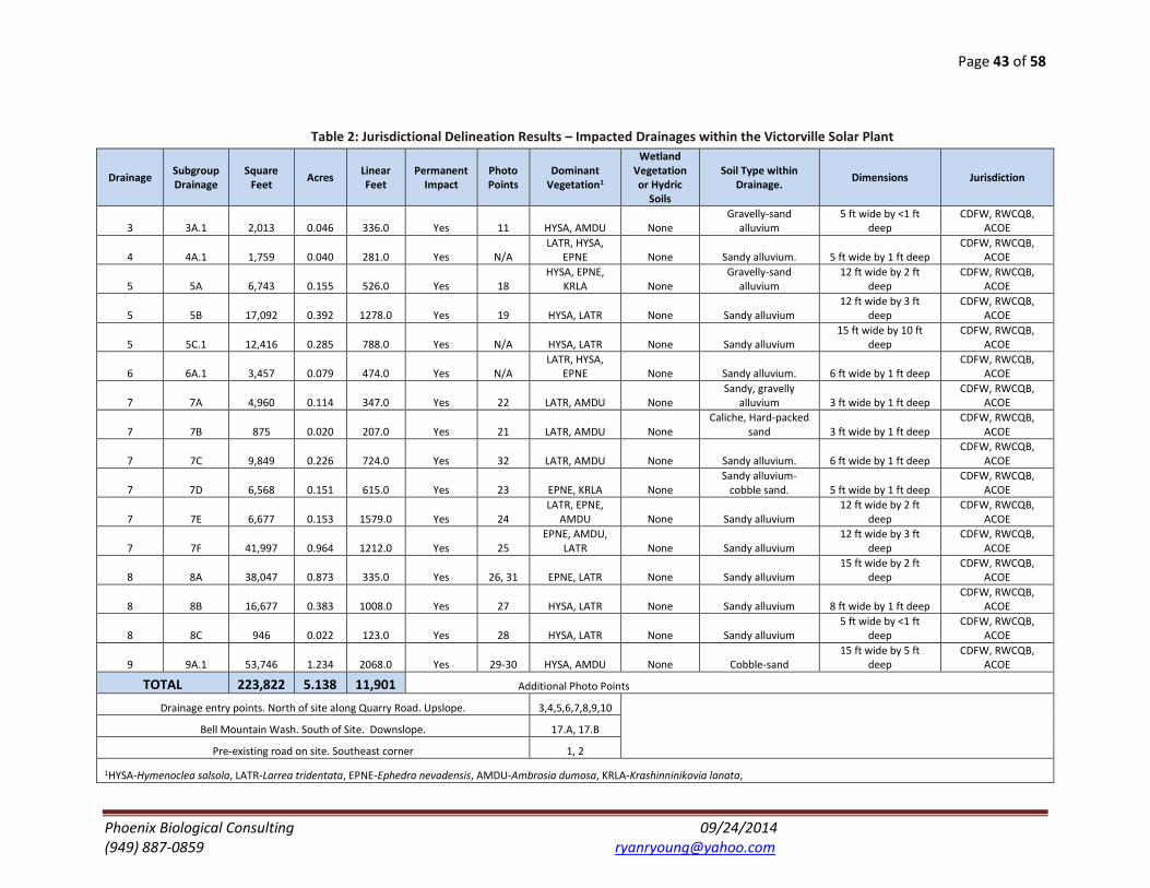
Page 43 of 58
Phoenix Biological Consulting 09/24/2014 (949) 887-0859 [email protected]
Table 2: Jurisdictional Delineation Results – Impacted Drainages within the Victorville Solar Plant
Drainage Subgroup Drainage
Square Feet
Acres Linear Feet
Permanent Impact
Photo Points
Dominant Vegetation1
Wetland Vegetation or Hydric
Soils
Soil Type within Drainage.
Dimensions Jurisdiction
3 3A.1 2,013 0.046 336.0 Yes 11 HYSA, AMDU None Gravelly-sand
alluvium 5 ft wide by <1 ft
deep CDFW, RWCQB,
ACOE
4 4A.1 1,759 0.040 281.0 Yes N/A LATR, HYSA,
EPNE None Sandy alluvium. 5 ft wide by 1 ft deep CDFW, RWCQB,
ACOE
5 5A 6,743 0.155 526.0 Yes 18 HYSA, EPNE,
KRLA None Gravelly-sand
alluvium 12 ft wide by 2 ft
deep CDFW, RWCQB,
ACOE
5 5B 17,092 0.392 1278.0 Yes 19 HYSA, LATR None Sandy alluvium 12 ft wide by 3 ft
deep CDFW, RWCQB,
ACOE
5 5C.1 12,416 0.285 788.0 Yes N/A HYSA, LATR None Sandy alluvium 15 ft wide by 10 ft
deep CDFW, RWCQB,
ACOE
6 6A.1 3,457 0.079 474.0 Yes N/A LATR, HYSA,
EPNE None Sandy alluvium. 6 ft wide by 1 ft deep CDFW, RWCQB,
ACOE
7 7A 4,960 0.114 347.0 Yes 22 LATR, AMDU None Sandy, gravelly
alluvium 3 ft wide by 1 ft deep CDFW, RWCQB,
ACOE
7 7B 875 0.020 207.0 Yes 21 LATR, AMDU None Caliche, Hard-packed
sand 3 ft wide by 1 ft deep CDFW, RWCQB,
ACOE
7 7C 9,849 0.226 724.0 Yes 32 LATR, AMDU None Sandy alluvium. 6 ft wide by 1 ft deep CDFW, RWCQB,
ACOE
7 7D 6,568 0.151 615.0 Yes 23 EPNE, KRLA None Sandy alluvium-
cobble sand. 5 ft wide by 1 ft deep CDFW, RWCQB,
ACOE
7 7E 6,677 0.153 1579.0 Yes 24 LATR, EPNE,
AMDU None Sandy alluvium 12 ft wide by 2 ft
deep CDFW, RWCQB,
ACOE
7 7F 41,997 0.964 1212.0 Yes 25 EPNE, AMDU,
LATR None Sandy alluvium 12 ft wide by 3 ft
deep CDFW, RWCQB,
ACOE
8 8A 38,047 0.873 335.0 Yes 26, 31 EPNE, LATR None Sandy alluvium 15 ft wide by 2 ft
deep CDFW, RWCQB,
ACOE
8 8B 16,677 0.383 1008.0 Yes 27 HYSA, LATR None Sandy alluvium 8 ft wide by 1 ft deep CDFW, RWCQB,
ACOE
8 8C 946 0.022 123.0 Yes 28 HYSA, LATR None Sandy alluvium 5 ft wide by <1 ft
deep CDFW, RWCQB,
ACOE
9 9A.1 53,746 1.234 2068.0 Yes 29-30 HYSA, AMDU None Cobble-sand 15 ft wide by 5 ft
deep CDFW, RWCQB,
ACOE
TOTAL 223,822 5.138 11,901 Additional Photo Points
Drainage entry points. North of site along Quarry Road. Upslope. 3,4,5,6,7,8,9,10
Bell Mountain Wash. South of Site. Downslope. 17.A, 17.B
Pre-existing road on site. Southeast corner 1, 2
1HYSA-Hymenoclea salsola, LATR-Larrea tridentata, EPNE-Ephedra nevadensis, AMDU-Ambrosia dumosa, KRLA-Krashinninikovia lanata,

Page 44 of 58
Phoenix Biological Consulting 09/24/2014 (949) 887-0859 [email protected]
Table 3: Jurisdictional Delineation Results – Drainages Located Within the Phase 3 Landfill Parcel - Outside the Victorville Solar Plant (No Impact)
Drainage Subgroup Drainage
Square Feet Acres
Linear Feet Impact
Photo Points
Dominant Vegetation1
Wetland Vegetation or Hydric
Soils Soil Type in Drainage. Dimensions Jurisdiction
1 1 2,604 0.060 370.0 None N/A LATR, HYSA None Cobbly alluvium 8 ft wide by 15 ft deep CDFW, RWCQB,
ACOE
2 2 1,406 0.032 241.0 None N/A HYSA, EPNE None Cobble & Caliche 6 ft wide by 6 ft deep CDFW, RWCQB,
ACOE
3 3A.2 3,715 0.085 496.0 None 12 HYSA, AMDU None Gravelly-sand
alluvium 8 ft wide by <1 ft deep CDFW, RWCQB,
ACOE
3 3B.2 39,137 0.898 1610.0 None 13 LATR, HYSA None Cobbly-sand alluvium 30 ft wide by 20 ft
deep CDFW, RWCQB,
ACOE
4 4A.2 19,216 0.441 1431.0 None 14 LATR, HYSA,
EPNE None Sandy alluvium. 20 ft wide by 15 ft
deep CDFW, RWCQB,
ACOE
5 5C.2 17,978 0.413 750.0 None 20 HYSA, LATR None Sandy alluvium 18 ft wide by 10 ft
deep CDFW, RWCQB,
ACOE
6 6A.2 5,486 0.126 334.0 None 15 LATR, HYSA,
EPNE None Sandy alluvium. 15 ft wide by 10 ft
deep CDFW, RWCQB,
ACOE
9 9A.2 10,779 0.247 183.0 None N/A HYSA, AMDU None Cobbly sand 10 ft wide by 5 ft deep CDFW, RWCQB,
ACOE
10 10 5,838 0.134 300.0 None N/A LATR, HYSA None Sandy alluvium. 8 ft wide by 2 ft deep CDFW, RWCQB,
ACOE
11 11A.2 680 0.016 241.0 None N/A HYSA, LATR None Sandy alluvium 5 ft wide by <1 ft deep CDFW, RWCQB,
ACOE
11 11A.3 877 0.020 N/A None N/A HYSA, LATR None Sandy alluvium 5 ft wide by <1 ft deep CDFW, RWCQB,
ACOE
12 12A.2 870 0.020 N/A None 16 HYSA, LATR None Sandy alluvium 5 ft wide by <1 ft deep CDFW, RWCQB,
ACOE
12 12A.3 205 0.005 N/A None 16 HYSA, LATR None Sandy alluvium 5 ft wide by <1 ft deep CDFW, RWCQB,
ACOE
11 11A.1 190 0.004 20.0 None 16 HYSA, LATR None Sandy alluvium 5 ft wide by <1 ft deep CDFW, RWCQB,
ACOE
12 12A.1 115 0.003 20.0 None 16 HYSA, LATR None Sandy alluvium 5 ft wide by <1 ft deep CDFW, RWCQB,
ACOE
TOTAL 109,096 2.504 5,996
1HYSA-Hymenoclea salsola, LATR-Larrea tridentata, EPNE-Ephedra nevadensis, AMDU-Ambrosia dumosa, KRLA-Krashinninikovia lanata

Page 45 of 58
Phoenix Biological Consulting 09/24/2014 (949) 887-0859 [email protected]
Figure A: Regional Setting
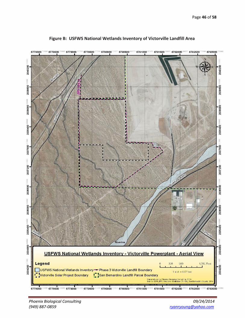
Page 46 of 58
Phoenix Biological Consulting 09/24/2014 (949) 887-0859 [email protected]
Figure B: USFWS National Wetlands Inventory of Victorville Landfill Area

Page 47 of 58
Phoenix Biological Consulting 09/24/2014 (949) 887-0859 [email protected]
Figure C: Bell Mountain Wash – Upper Mojave River Watershed
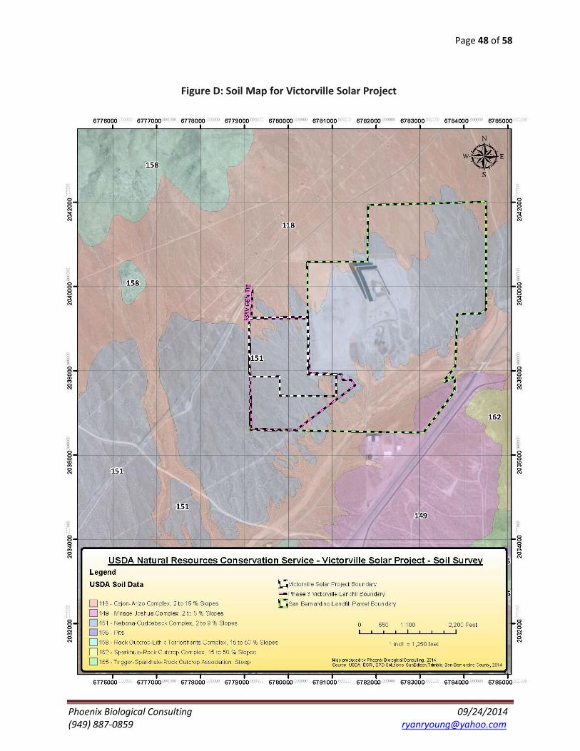
Page 48 of 58
Phoenix Biological Consulting 09/24/2014 (949) 887-0859 [email protected]
Figure D: Soil Map for Victorville Solar Project
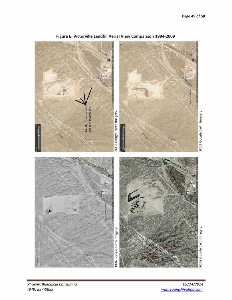
Page 49 of 58
Phoenix Biological Consulting 09/24/2014 (949) 887-0859 [email protected]
Figure E: Victorville Landfill Aerial View Comparison 1994-2009

Page 50 of 58
Phoenix Biological Consulting 09/24/2014 (949) 887-0859 [email protected]
Figure F: Jurisdictional Delineation Aerial View
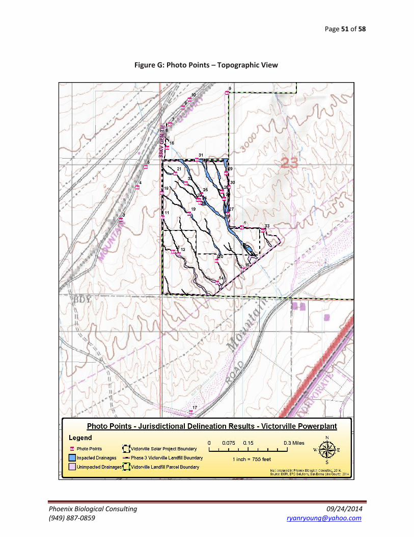
Page 51 of 58
Phoenix Biological Consulting 09/24/2014 (949) 887-0859 [email protected]
Figure G: Photo Points – Topographic View

Page 52 of 58
Phoenix Biological Consulting 09/24/2014 (949) 887-0859 [email protected]
Figure H: Jurisdictional Delineation and Permanent Impacts - Aerial View

Page 53 of 58
Phoenix Biological Consulting 09/24/2014 (949) 887-0859 [email protected]
Figure I: Gen-Tie Transmission Line - Victorville Solar

Page 54 of 58
Phoenix Biological Consulting 09/24/2014 (949) 887-0859 [email protected]
Figure J: Victorville Solar Site Plan

Page 55 of 58
Phoenix Biological Consulting 05/15/2014 (949) 887-0859 [email protected]
Figure K: Drainage Photos
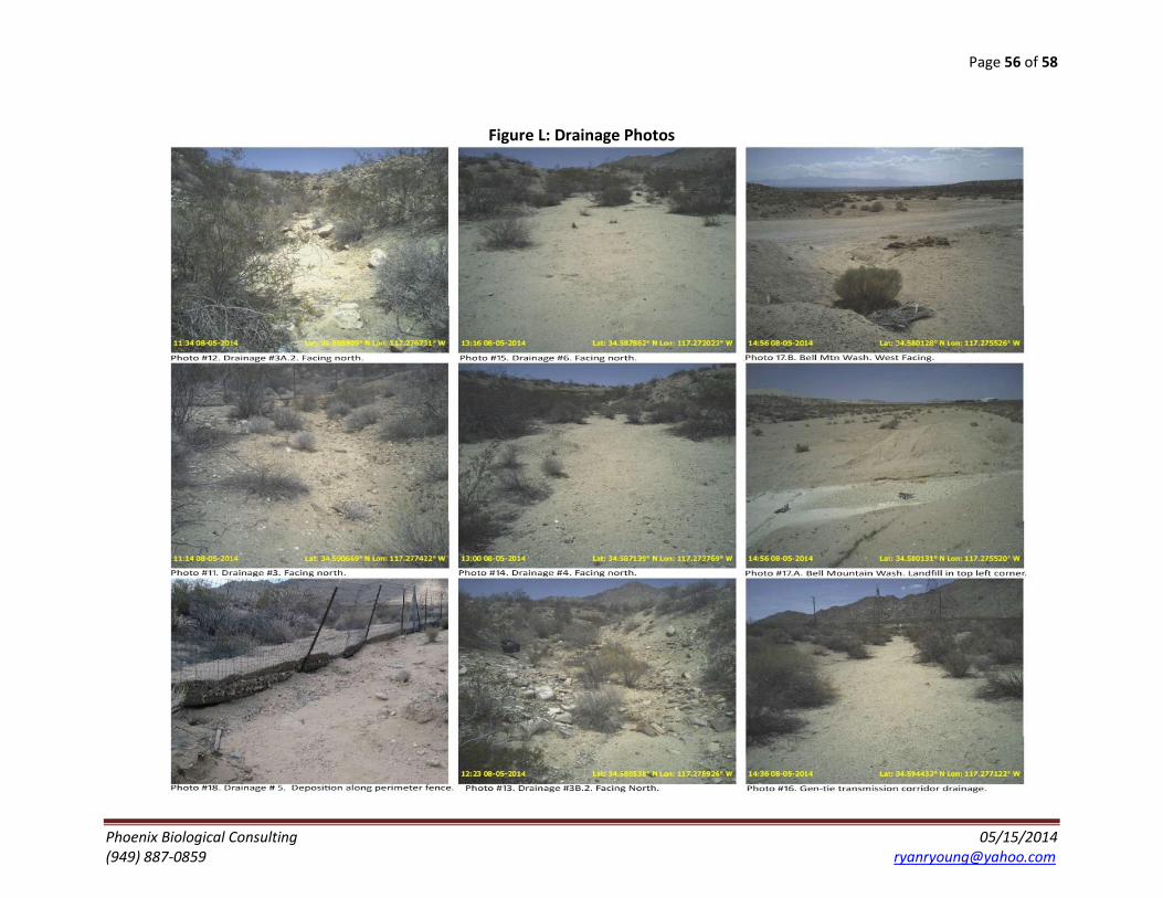
Page 56 of 58
Phoenix Biological Consulting 05/15/2014 (949) 887-0859 [email protected]
Figure L: Drainage Photos
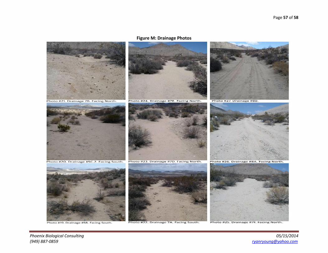
Page 57 of 58
Phoenix Biological Consulting 05/15/2014 (949) 887-0859 [email protected]
Figure M: Drainage Photos

Page 58 of 58
Phoenix Biological Consulting 05/15/2014 (949) 887-0859 [email protected]
Figure N: Drainage Photos