viking age sites in northern europe hyllestad quernstone quarries … · unesco world heritage list...
TRANSCRIPT

UNESCO World Heritage ListViking Age Sites in Northern Europe
Hyllestad quernstone quarries
Management plan 2012–2016
1
Prepared by the working group for World Heritage status for Hyllestad quernstone quarries
Author: Irene Baug
First edition 2011, revised autumn 2013
Cover photos by Kim Søderstrøm and Jørgen Magnus © Directorate for Cultural Heritage
Front page: Upper: Deep quarry in Millstone Park, Myklebust. Middle: Shallow quarry in Millstone Park,
Myklebust. Lower: Damaged quernstones at the seabed by the shipment harbour Otringsneset, Rønset.
Back page: Otringsneset, Rønset, unfinished quernstone still attached to the bedrock.
Translation: Akasie kurs og veiledning, Oslo
Cover: Sture Balgård, Folium Form, Stockholm
Print:, Oslo digitaltrykk
Oslo, January 2014

2
Preface The overarching objective of the management plan is to protect the Outstanding Universal
Value (OUV) that is the foundation for the nomination to the World Heritage List. The
landscape and its production sites must be safeguarded for the future while at the same time
the sustainable development of the area and the local communities must be safeguarded. The
management plan will thus function as a tool to balance the need for the protection and
conservation of the cultural landscape and the accessibility and economic development of the
local environment.
This management plan is based on a previous management plan for the quernstone landscape
in the municipality of Hyllestad, which was prepared by Aurland Landscapeworks in 2008
(Håland and Knagenhjelm 2008). However, in conjunction with the UNESCO nomination, it
has proved necessary to fine-tune the management plan more specifically towards potential
World Heritage status.
The first edition of the management plan was prepared in 2011. It was worked out in
cooperation between representatives from the previous foundation Norwegian Millstone
Centre (now a section of the Museums in Sogn og Fjordane), Hyllestad municipality, Sogn og
Fjordane county authority and the Directorate of Cultural Heritage, and was written by World
Heritage coordinator Irene Baug. This present plan represents a revised edtion of 2013, and is
valied within the period 2012-2016.
The management plan is given as a separate appendix to the application for World Heritage
status, and will only come into force if the quernstone quarries are granted such status. This is
a first generation plan that has not yet been fully developed. If and when the nomination is
adopted, the management plan will be valid for approximately six years, until the next
periodic report to UNESCO.
Leikanger, Desember 2013
Åshild Kjelsnes
Chairman of the County Council

3
Contents Preface ........................................................................................................................................ 2 1 Declaration of intent ................................................................................................................ 5 2 World Heritage values in the quernstone quarries .................................................................. 6
2.1 Draft Statement of Outstanding Universal Value............................................................. 7 Brief Synthesis ................................................................................................................... 7 Justification for criteria ...................................................................................................... 8 Statement of Integrity ......................................................................................................... 9 Statement of authenticity .................................................................................................. 10 Requirements for protection and management ................................................................. 10
2.2 Geology in the quarries .................................................................................................. 11 2.3 The quarry landscape ..................................................................................................... 13 2.4 Delimitation of the nominated property and the buffer zone ......................................... 17 2.5 Historical overview ........................................................................................................ 22
3 Visions and objectives for the World Heritage area.............................................................. 25 3.1 Short-term visions (5 years) ........................................................................................... 25 3.2 Long-term visions (20 years) ......................................................................................... 26
4 Instruments ............................................................................................................................ 27 4.1 The legislation ................................................................................................................ 27 4.2 Sources of funding ......................................................................................................... 30
5 Distribution of administrative responsibility ......................................................................... 31 6 Amenities for visitors ............................................................................................................ 34
6.1 World Heritage Site status and visitor attraction value .................................................. 34 6.2 Marketing ....................................................................................................................... 34 6.3 Grading and regulating accessibility .............................................................................. 35
6.3.1 Measures .................................................................................................................. 36 6.3.2 Parking and infrastructure ....................................................................................... 37
7 Monitoring system ................................................................................................................. 37 8 Factors affecting the nominated property .............................................................................. 37
8.1 Development pressures .................................................................................................. 37 8.2 Forestry ........................................................................................................................... 39 8.3 Environmental pressures ................................................................................................ 40 8.4 Natural disaster and risk preparedness ........................................................................... 40 8.5 Visitor/tourism pressures ................................................................................................ 42 8.6 Care and clearance ......................................................................................................... 42
9 Capacity building and research ............................................................................................. 43 10 Information and dissemination initiatives ........................................................................... 44
10.1 Cultural history ............................................................................................................. 45 10.1.1 Millstone Park ....................................................................................................... 45
10.2 Hyllestad seminar ......................................................................................................... 46 10.3 Craft traditions .............................................................................................................. 46 10.4 Quernstone quarries as a pedagogical arena................................................................. 47 10.5 Relevant actors ............................................................................................................. 48 10.6 Specific measures ......................................................................................................... 48
11 The transnational management of the Viking Age nomination. Collaboration on management. ............................................................................................................................ 51 12 Action Programme 2011 – 2015 ......................................................................................... 51 13 Revision of the management plan ....................................................................................... 53 14 Documentation .................................................................................................................... 54
List of photographs, maps and drawings .............................................................................. 54

4
Bibliography ......................................................................................................................... 58 Informants ............................................................................................................................ 60 Websites ............................................................................................................................... 60
Appendix 1 Photos and maps……………………………………………………………… .. 62 Appendix 2 Declaration of Intent…………………………………………………………… 84

5
1 Declaration of intent All the administrative levels responsible for the management of the nominated sites in Norway have signed the following Declaration of Intent. (For the complete text, see annex 1.) In connection with the preparation of the application for inscription on the World Heritage List, the municipalities of Horten, Sandefjord, Tønsberg and Hyllestad as well as Sogn og Fjordane and Vestfold county authorities and county governors together with the Directorate for Cultural Heritage, the Norwegian Environment Agency and the Ministry of Climate and Environment are in agreement on the following:
The intention of the World Heritage nomination Viking Age monuments and sites is to protect, preserve, disseminate and transfer to future generations the Outstanding Universal Value the sites represent.
The Norwegian component part in the nomination shall help to strengthen local identity and contribute positively to experiencing the values of the cultural environments and to developing social and business activities in the municipalities.
The sites shall be included in the active dissemination of World Heritage values, and the scientific values will form the basis of knowledge production through national and international research and professional network building.
The Hyllestad Quernstone Quarries and the Vestfold Ship Burials shall be
managed in accordance with national legislation and the intentions of the World Heritage Convention. A key objective is to achieve best practice in the management of cultural heritage and to represent Norway in a worthy manner in the transnational nomination and on the World Heritage List.
A Norwegian World Heritage council will be set up for the Hyllestad
quernstone quarries and the Vestfold ship burials. The council will ensure the joint management of the World Heritage values and will promote the use of World Heritage Site status in the best interests of the local communities.
Norway will participate actively in the international management of the serial
nomination Viking Age Sites in Northern Europe.

6
2 World Heritage values in the quernstone quarries The Hyllestad quernstone quarries form part of the transnational serial nomination Viking Age
Sites in Northern Europe, which incorporates sites and monuments from the Viking Age.
Seven locations in five different countries have been nominated, and all represent key
elements of the Viking Age. Together the nomination and the component parts selected give a
broad and varied picture of the social, economic and cultural development of the Viking Age.
The quernstone quarries represent a unique industrial environment that demonstrates the
development of mass production and bulk trade during the Viking Age. In this respect the
stone quarries reveal a somewhat different aspect of Viking Age culture than the other
component parts included in the nomination. The distribution of the quernstones shows a
strong affiliation to the maritime culture, and stones from Hyllestad have been found in
several of the other locations represented in the nomination.
Hyllestad represents an extensive cultural monument testifying to the use of resources and the
stone industry in the Viking Age. Operations commenced in the production landscape at that
time, and large-scale production on an almost industrial scale took place – with quernstones
being mass-produced for bigger markets. The quernstone quarries have played a significant
role far beyond the local community in the Viking Age, and large parts of Northern Europe
were part of the contact network of this production area. Thus the quernstone quarries are of
importance in understanding central aspects of the Viking Age – not only the use of resources
and production but also the contact network and trade/bartering of goods. The quarries
explicitly demonstrate the extent and significance of this, and also reflect important historical
events and processes since they represent a very wide span of cultural heritage. The quarries
are well preserved, visible and easily accessible. Together the traces in the landscape form a
unique and extensive cultural site that provides a background for experiencing an industry that
is more than 1,200 years old (Figure 1).
The range of products at Hyllestad included more than quernstones. The quarries have been a
major production site for stone crosses, of which the oldest probably date back to the first
period of Christianity and the transition from the Viking Age to the Middle Ages. Extraction
of this kind sets the place of production in a wider context with links to regional kingdoms,

7
local elites and again to the major social upheavals of the Viking Age in both a concrete and
symbolic manner.
The quarries within the nominated property are located in outlying areas, i.e. outside the areas
of settlement at Hyllestad. As an archaeological site the vast majority of the quarries within
the nominated property have remained untouched, without modern intrusions, since the
production ended. Minor archaeological surveys have been undertaken which date the
extraction to the Viking Age (Baug 2002; 2013). The investigations show that the production
that commenced in the early Viking Age formed the basis of large-scale extraction over the
following centuries.
After quernstone production was terminated, these areas have mostly been used as hayfields
and grazing land for livestock. This has helped to check the regrowth of the ground flora.
Only about 3% of the quarries within the nominated property have been disturbed in
connection with activities in recent times such as the construction of a road, a power line and
a small-scale hydropower station. The majority of the quarries and the spoil heaps remain
however untouched – just as they were when the stonecutters once abandoned them (Figure 2).
The quernstone quarries at Hyllestad represent a unique production environment in respect of
integrity and authenticity, and as part of the serial nomination they represent a cultural
heritage of Outstanding Universal Value (OUV).
2.1 Draft Statement of Outstanding Universal Value
The following extracts are taken from the nomination dossier of the Viking Age Sites in Northern Europe.
Brief Synthesis The serial transnational property Viking Age Sites in Northern Europe is an ensemble of
seven component parts, from five States Parties, all of which are monumental archaeological
sites or groups of sites dating from the 8th – 11th centuries AD.
During this time, commonly referred to as the “Viking Age”, the Norse people travelled from
their homelands in Scandinavia – as Vikings – for the purposes of trade, raiding, exploration
and the search for new lands to settle. They interacted with pre-existing local populations
during the course of their sea voyages eastwards and westwards and thereby also exerted
8
substantial influence on areas outside Scandinavia. The nominated property includes five
component parts from the core region of Scandinavia and two North European sites from the
area of expansion and interaction.
The Jelling mounds, runic stones and church in Denmark and the Þingvellir National Park in
Iceland are World Heritage Sites.
The Viking Age was an important transitional period in Northern Europe which, for the most
part, had never been part of the Roman Empire. Made up of a network of politically unstable
chiefdoms and petty kingdoms in the 8th century AD, the region became dominated by the
formation of Medieval states by the 11th century AD. All the nomination’s component parts
are located where essential historical actions took place during the Viking Age. These actions
have left various physical constructions which illuminate central themes in the making and
development of Viking Age societies. The component parts are scientific keys to an
understanding of this transition and the concurrent changes in economy, society and religion.
This series of sites thereby constitutes an important testimony relative to the cultural-
historical period of the Viking Age in the geo-cultural region of Northern Europe.
The serial property comprises the archaeological remains of a trading town and an assembly
site, as well as of harbours, sites of governance, defensive structures, production sites,
settlements and burial places, covering the entire duration of the Viking Age. Consequently,
the series of sites testifies to the diversity of remarkable material evidence available from the
Viking Age, and provides valuable information on the changing societal, economic, religious
and political conditions of the time supported by contemporary written sources.
Justification for criteria Criterion iii). In the Viking Age, local tribal societies in Northern Europe became an integral
part of the civilisation of the European Middle Ages. The development of shipbuilding
technology and navigational skills for sea voyages was crucial for the political, religious,
social and economic processes of this transition. In the course of this transition, the people of
the Viking Age became the first to inhabit the North Atlantic islands of the Faroes and Iceland.
They were also the first European people to reach Greenland and even North America in
historical times.
The interaction with people and power structures in Europe changed the Scandinavian
societies.

9
Collectively, this series of the seven component parts explains the change in pagan local
traditions, the shift in settlement structures and economic concepts and the development of
parliamentary traditions and of lasting institutions of power in Northern Europe,
characterising the transition to Medieval states, through a remarkable material heritage
extending from the 8th – 11th centuries and rendering the ensemble an exceptional testimony
to the Viking Age.
Criterion iv): The migration and the interaction of the Norse with other peoples in Europe led
to new architectural expressions and uses of the landscape which are preserved today as
impressive archaeological sites dating from the 8th – 11th centuries.
This series of Viking Age localities consists of archaeological key-sites that illustrate the
emergence of Medieval societies and states in Northern Europe during the Viking Age.
It encompasses the archaeological remains of sites of governance with symbolic and religious
monuments, assembly sites for deciding legal and political issues, defensive structures such as
ring fortresses and border defences, production sites such as quarries, trading towns with
harbours, burial places such as ship burials in large barrows and sites of cultural interaction.
These types of archaeological sites are distinctive for the Viking Age in their specific form,
architecture and layout, use and function and material expression and, as such, bear
exceptional witness to this time of transition in Northern Europe.
Statement of Integrity All the archaeological sites in this nomination belong to the same cultural-historic group,
which is characteristic of the Viking Age in Northern Europe. They cover the entire historical
period from the 8th to the 11th century AD. Due to the archaeological nature of the remains, a
large number of the sites from the Viking Age have been destroyed over the course of time,
whereas others still await detection. This series constitutes a selection of well-preserved
Viking Age sites of great historical and scientific value, which are large enough to be able to
preserve these values for the future. Together, the component parts complement each other
exceptionally well, reflecting different aspects of the transition from tribal chiefdoms to
Medieval kingdoms in the Viking Age and therefore serving as “scientific keys” to its
understanding.
The borders of the nominated property are defined by the extent of the complete
archaeological sites of the component parts. Representing all important historical building

10
phases and structures, the archaeological material and substance, the construction and
layout and the situation and setting of these sites are adequately intact in order to convey the
significance of each component part and of the property as a whole.
Statement of authenticity The credibility and truthfulness of the evidence for the interpretation of the archaeological
sites in this series for the transitional process from tribal societies to Medieval states in the
Viking Age is conveyed by the genuine archaeological material, as well as the construction
and layout and the situation and setting of the component parts. All archaeological remains
of the nominated property have retained their authentic construction and layout since the
Viking Age. The archaeological material and substance of the nominated property is also
entirely authentic. All building phases, features and their remains relevant to this nomination
date from the Viking Age or are likely to do so. Important topographical conditions and
features, which were historically availed of in the choice of site and the layout of the
structures, are still recognisable even today. Where recent repairs and restorations have been
carried out, these can clearly be distinguished from the historical material and are based on
complete and detailed archaeological documentation.
The credibility of the evidence has been corroborated by numerous written sources and
extensive research using established archaeological and scientific methods. The theories
employed in the interpretation of the sites and of historical processes in the Viking Age are
derived from this research and have wide acceptance in the scientific community.
Requirements for protection and management The values and integrity of the nominated serial property are managed and safeguarded by
management systems on two levels. The integrity and values of the entire serial property are
maintained within a transnational management framework, with all States Parties committed
to the aims of protecting, preserving, monitoring and promoting the Outstanding Universal
Value of the nominated property.
integrity and authenticity takes place on the level of the individual component part. The
responsibility for the management on this level remains within each State Party.
All component parts and their buffer zones are protected according to the legal systems in
place in each State Party. In addition, the majority of sites and areas are owned by public
bodies. The various protection and planning mechanisms, and acts which apply directly to the

11
component parts, are sufficient to guarantee the protection and preservation of the
Outstanding Universal Value, integrity and authenticity of the whole nominated property and
its component parts.
Funding is provided by the participating States Parties or regional government for the
Steering Group and the Secretariat, while the funds for the management of each component
part are generally sustained by the responsible States Parties or regional authorities.
A core issue of cooperation among the partners in the serial nomination and beyond is the
building of an active network between Viking Age key sites and their stakeholders which will
improve management, conservation, communication and monitoring of the Viking Age
heritage on an international level. Among the main tasks for this network will be to improve
the overall parameters for the common monitoring system, to maintain and enhance support
from regional and local communities and other stakeholders for the preservation of the sites
and their settings and to secure financial support in order to improve maintenance and
presentation of the sites.
Threats common to most of the sites included in this nomination, such as land use, housing
developments and visitor pressure, and also natural agents like plant growth and animal
activities, need to be tackled in a collaborative way. More site-specific threats, such as
damage by development, specific animals or plants, or earthquakes, require additional
research and training and the exchange of expertise, knowledge and mutual support.
The overall management group will consist of representatives from National Heritage Boards,
Cultural Heritage Agencies and/or Ministries in the respective States Parties, according to
the legal responsibilities awarded them by their respective cultural heritage laws. The
respective site managers will also form part of the group.
The formation of the overall management group will take place in 2014 and the first meeting
is planned for December 1st 2015.
2.2 Geology in the quarries
The quernstone quarries in the municipality of Hyllestad are situated on the Åfjorden fjord,
north of the outlet of the Sognefjorden fjord in the county of Sogn og Fjordane. The natural

12
prerequisite for quarrying operations at Hyllestad was provided by a special type of rock
which can be described as garnet-kyanite mica schist lying in a belt along the north and east
sides of the Åfjorden fjord. The rock that the stones have been carved from is easy to
recognise, and is thus well suited to studies of provenance (Figure 3).
In 2007, the Geological Survey of Norway (NGU) undertook a complete registration of the
entire quarry landscape at Hyllestad. Each single quarry was mapped and recorded in
databases and all the quarries were characterised on the basis of geological features,
extraction techniques, morphology and size. This characterisation of the quarry area
establishes that there are minor mineralogical differences within the various zones at
Hyllestad. Geological factors have set the terms for extraction, and certain geological
differences have been of importance in quernstone operations (Heldal and Bloxam 2007).
White mica (muscovite and sericite) is predominant among the micaceous minerals in the
quarry area. Quartz is also common, as well as small quantities of staurolite and chloritoid.
Within the mica schist zone, mineralogical variations between the various quarry areas have
been demonstrated. The garnets vary in size and distribution, and there is evidence that there
was a clear preference for operations in areas where the garnets were between 2 and 7
millimetres in size. Although kyanite also varies in distribution, this does not seem to have
played a decisive role in the selection of the production area (Heldal and Bloxam 2007:15).
The mica varies in both extent and texture. The most common type is the frequently occurring
coarse-grained aggregates of white mica that give the schist the silvery corrugated surface that
is typical of the Hyllestad stone. This variety of mica was preferred in quarries where the
quernstones were shaped and carved directly from the bedrock, and most of the quarries are
located where this type of mica occurs (ibid.).
In the eastern parts of the larger quarry area at Hyllestad we find areas with less of these
coarse-grained aggregates, and the coarse-grained mica occurs more frequently as isolated
grains. This type is also richer in quartz and the combination results in harder rock. When
gunpowder was utilised in quernstone production at a later date, this type of mica schist was
preferred. Normally the garnets are less cracked and display better formed crystals than is the
case with the softer type of schist. This may have ensured greater durability and improved
grinding properties in the quernstones. Therefore the location of blasting quarries in this sub-

13
type of mica schist in more recent times may be explained by quality-related considerations.
The stone was harder to carve but it may have been more suited to blasting operations than the
softer type, while the quernstones may have had a higher user quality. This harder type of
schist was not exploited in the Viking Age. The older production areas are all located where
the softest variety of schist is found. This rock is easier to cut, which may be a key factor in
the concentration of the earliest operations in these areas (ibid.).
The cleavage in the mica schist is the plane surface along which the schist can most easily be
split. The quernstones were generally oriented along this surface, and they were loosened
from the plane surface by splitting. The direction of the cleavage was often the deciding factor
in the extraction of the stones. In some places the cleavage is almost horizontal while in others
it is closer to vertical (Heldal and Bloxam 2007:18). As a result the quarries differ in
appearance in that the stones at some quarries were extracted almost horizontally, while at
others they were shaped and carved out of almost vertical rock walls. Moreover, in a few
quarries the mica schist contained secondary cleavage lines, and in quarries located in such
zones there might have been a higher degree of wastage and thus more unusable and damaged
quernstones than in other quarries (ibid.).
Another kind of variation in quality in the quarry area is the folding of the mica schist. In
areas where the cleavage is strongly folded it is difficult to extract quernstones.
Pervasive fracturing in the rock also created difficulties for the quarrying operations. Some
cracks are filled with quartz, and too many veins of quartz in the quernstones marred the
quality. This can be seen quite clearly since quarrying operations ceased in sections with a
large amount of quartz. However, during extraction activities, existing cracks in the rock were
used as a natural delimitation of the quarry or the extraction zones in the individual quarry.
2.3 The quarry landscape
The stone quarries are scattered along a belt on the northern and eastern side of Åfjorden. So
far a total of 367 stone quarries and trial extractions have been recorded within an area of
approximately 20 square kilometres, distributed among 18 different farms in the land register.
The quarries are found along the edge of the fjord and and up to over 200 metres above sea
level. Nonetheless the majority are located along the fjord and in the adjacent sloping terrain

14
above, less than one kilometre from the sea (Figure 4). Thus the entire quarry landscape is
superbly located in an area of great natural beauty with wide diversity. This gives visitors to
the area a unique experience.
Dense vegetation in many places and the extent of the cultural landscape makes it likely that
there are still undiscovered quarries. Ever since the Viking Age, large-scale production has
played a role in altering the original landscape of Hyllestad, and quarrying operations must
have been a key factor in shaping the identity of the local community over a period of several
hundred years.
In the Viking Age the quernstones were shaped and carved directly from the bedrock, and
quernstones that have not been loosened from the rock can be found in a number of the
quarries (Figure 5). However, the quarry landscape is varied and manifold. The investigations
undertaken by NGU provided evidence of different quernstone types with different methods
of production, and the work resulted in detailed maps and databases of the stone quarries and
their geology as well as of the remains of roads and infrastructure in the production landscape
(Heldal and Bloxam 2007). NGU’s report provides an excellent starting point for the work on
the management plan and choice of the nominated property, and forms the basis of this
presentation of the quarry landscape.
The quarries can be divided into a number of sub-types: Shallow quarries, where quernstones
and millstones were split along the cleavage plane, were the most common type of quarrying
in Hyllestad with a total of 130 recorded quarries (Figure 6). Here the quernstones were
carved from the cleavage surface. Extraction took place one layer at a time, so that the quarry
finally appeared with large cleavage planes with numerous circular depressions side by side
from the quernstone extraction (Figure 8). Even though quernstones for use as both hand
quernstones and larger water millstones were produced at this type of quarry, the extraction of
hand quernstones predominated. We find such shallow quarries in the entire quarry area of
Hyllestad (Heldall and Bloxam 2007:48-50).
Another sub-type is deep quarries, characterised by deeper extraction perpendicular to the
cleavage and resulting in deeper and more precipitious quarries (Figures 7 and 8). Altogether
45 such quarries have been recorded. This kind of extraction led to tall, smoothly carved rock
walls and steps where the quernstones had been hewn out, one on top of another rather than
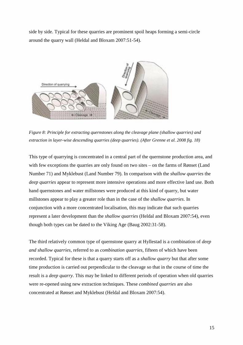
15
side by side. Typical for these quarries are prominent spoil heaps forming a semi-circle
around the quarry wall (Heldal and Bloxam 2007:51-54).
Figure 8: Principle for extracting quernstones along the cleavage plane (shallow quarries) and
extraction in layer-wise descending quarries (deep quarries). (After Grenne et al. 2008 fig. 18)
This type of quarrying is concentrated in a central part of the quernstone production area, and
with few exceptions the quarries are only found on two sites – on the farms of Rønset (Land
Number 71) and Myklebust (Land Number 79). In comparison with the shallow quarries the
deep quarries appear to represent more intensive operations and more effective land use. Both
hand quernstones and water millstones were produced at this kind of quarry, but water
millstones appear to play a greater role than in the case of the shallow quarries. In
conjunction with a more concentrated localisation, this may indicate that such quarries
represent a later development than the shallow quarries (Heldal and Bloxam 2007:54), even
though both types can be dated to the Viking Age (Baug 2002:31-58).
The third relatively common type of quernstone quarry at Hyllestad is a combination of deep
and shallow quarries, referred to as combination quarries, fifteen of which have been
recorded. Typical for these is that a quarry starts off as a shallow quarry but that after some
time production is carried out perpendicular to the cleavage so that in the course of time the
result is a deep quarry. This may be linked to different periods of operation when old quarries
were re-opened using new extraction techniques. These combined quarries are also
concentrated at Rønset and Myklebust (Heldal and Bloxam 2007:54).

16
Many of the quarries at Hyllestad are very overgrown and covered by spoil from operations.
In several cases extraction has been so intensive that all accessible rock faces have been
exhausted, and the only visible signs of production are the spoil heaps. Today these quarries
appear as pits in the terrain, often with a semi-circular spoil heap around the pit (Figure 9).
There are 42 such quarries appearing as pits, as well as 35 registrations of what are in all
probability quernstone quarries. Again with few exceptions this type of quarry is to be found
on the farms of Rønset and Myklebust, where the most intensive production took place
(Heldal and Bloxam 2007:57).
In addition, 72 trial extractions for quernstones have been recorded (Figure 10). These vary
from between one to ten quernstone extractions and can be characterised as pilot and trial
operations to assess the quality of the rock. Such trial extractions are found throughout the
entire expanse of the quarry area – but once again the majority are found on the key sites of
Rønset and Myklebust. They are primarily located on the rocky shoreline of the Åfjorden
fjord, on exposed rock and in stream beds. Thus systematic exploration has been conducted of
the area where the most suitable exposed rocks are to be found, proving that the search for
good resources has been methodical but has been mostly carried out within a defined area
(Heldal and Bloxam 2007:59).
Apart from the quarry types mentioned, a small number of other sub-types have been
identified. These consist of quarries in scree deposits (3 quarries), loose block quarrying (6
quarries), splitting with wedges (1 quarry) and 18 blasting quarries. The latter two sub-types
represent a later development in the extraction of quernstones and cannot be dated to the
Viking Age. Most of the blasting quarries are situated in a belt between the farms of Berge
(Land Number 80) and Rønset (Land Number 71). Since gunpowder was first introduced into
mining operations in Norway in the 17th century, all blasting quarries must be later than this
(Heldal and Bloxam 2007:56-57).
Quarry pits in scree deposits are characterised by circular depressions in natural scree with
blocks of schist. Stones of a suitable shape and size were selected and carved as quernstones,
and only hand quernstones have been recorded in these quarries. No archaeological
investigations have been conducted at this type of quarry, but a possible hypothesis is that
they represent the commencement of quernstone production at Hyllestad (Heldal and Bloxam
2007:47-48).

17
Loose block quarrying has only been recorded at a couple of places – and neither of these is
situated in the World Heritage area. Large stone blocks have been used, and there may be up
to ten to twelve circular marks from quernstone extraction on each single block. Only one
unfinished water millstone has been recorded, and the remaining extraction marks relate to
hand quernstones (Heldal and Bloxam 2007:56). The dating of this type of quarry at Hyllestad
is unknown.
2.4 Delimitation of the nominated property and the buffer zone
The large stretch of the quernstone landscape at Hyllestad means that it is necessary to select
the area that will be incorporated as World Heritage from a much bigger production area.
Three nominated areas have been selected. These are located at the farms of Rønset (Land
Number 71), Sæsol (Land Number 78) and Myklebust (Land Number 79). The delimitation of
the nominated property has been decided in consultation with the landowners of the three
farms respectively. The three nominated areas each offer different qualitative experiences, and
each provides individual insight into the stone industry from the Viking Age, while in
combination they clearly portray the dimensions, intensity and diversity of the production.
Size and coordinates of the nominated property are shown in the table below.
Nominated property
Coordinates of the central point in the nominated areas
Nominated areas and buffer zone (ha)
Rønset N 61°11´47” E 5°17´25” 28,7 Sæsol N 61°10´35” E 5°18´53” 33,3 Myklebust N 61°10´00” E 5°18´14” 15,2 Total nominated property 77,2 Area of the buffer zone 5928,4
The nominated areas at the farms of Rønset and Myklebust represent the main area of
production, with a total of 129 and 70 quernstone quarries respectively.1 The quarries lie very
close together and in several places they appear to be overlapping and adjoining quarry areas.
In some areas large outcrops were levelled and enormous amounts of stone rubble cover these
1 All mapping of the quarries and the quarry areas in the following maps have been derived from NGU’s registrations at Hyllestad, conducted by Tom Heldal.
18
and the area around. At times the quarry and the spoil heaps are so close together that the
original terrain is no longer visible.
In contrast the nominated area at Sæsol farm is located in a marginal area, and only 11
quarries are identified within the property. The area is characterised by more scattered and
isolated quarries, and in addition each individual quarry is generally smaller and has fewer
extractions of quernstones. Thus the area is of significance in portraying the various nuances,
intensity and forms of operation. In total these three areas provide a clear, varied and
representative picture of Viking Age production – and aspects and nuances that are of
importance for the quarry area as a whole are incorporated and preserved.
Rønset (Land Number 71)
The historical farm of Rønset is situated on the northern side of Sørfjorden, a narrow arm of
the fjord in the inner reaches of Åfjorden. In the east the farm borders on Berge farm (Land
Number 80) and in the west on Leirpollen (Land Number 25). Rønset is the area of Hyllestad
where the most intensive production took place. The majority of the quarries are located in the
outlying area in the northeast part of the farm, and little activity has affected the cultural
landscape after the termination of production. The transport roads used in connection with
operations are still visible at some places in the landscape. Today these appear in the form of
sunken roads and a few loosely-laid stone roads leading from the quarries by the shortest
route down to the sea and the closest shipment harbour.
In the northwestern part of the farm several blasting quarries from more recent times have
been recorded, but these are on a much smaller scale than the older quarries. The modern
quarries are not included in the nomination.
Rønset has a shoreline of approximately 1.6 km and traces of large-scale extraction are visible
all the way down to the foreshore. Two shipment harbours, Otringsneset and Aurgota, have
also been recorded at the farm (Figure 11). Large quantities of quernstones are scattered on
the sea bed close to the harbours – some of these probably stem from unsuccessful production
along the shoreline while others represent quernstones lost during loading. Ballast stones have
also been recorded in the sea – which again clearly indicates that the loading of quernstones
took place here. In this respect the nominated area at Rønset also constitutes underwater
cultural heritage (Figure 12).

19
Moreover, two mooring hollows have been hewed in the rock at Otringsneset. These have
probably been used for mooring boats during the loading of the quernstones. Therefore
Rønset farm and Otringsneset together represent a powerful symbol of the far-reaching
distribution of and bulk trade in quernstones. Thus the area helps to illustrate and clarify the
maritime communication that was so important during the Viking Age.
At Rønset large parts of the property are defined as a noble hardwood forest reserve, which
restricts the use of the area.
The nominated area follows the river to the northwest and the farm boundary between Rønset
and the neighbouring farm of Leirpollen (Land Number 25). To the northeast the boundary
partly follows an old farm road, while the boundary to the southeast follows the border
between the arable land and the outlying areas of the farm. To the south the nominated area is
extended into the sea in order to incorporate the underwater quernstone landscape (Figure 13).
Myklebust (Land Number 79)
Myklebust farm is situated on the east side of Hyllestadfjorden, the second arm of the fjord in
the inner reaches of Åfjorden. The farm has a shoreline which is approximately 2 km long.
Myklebust borders on Hyllestad farm (Land Number 77) to the north where the border runs
from the bay of Hyllestadvika south of Kyrkjefjellet, a bay with good harbour conditions. To
the east the farm borders on the outlying areas of Kleive (Land Number 80).
The nominated area at Myklebust contains several stretches with very large quarries and
spoils heaps (Figure 14). Here too some areas appear as adjoining production areas where it is
difficult to distinguish between the different quarries. There is a rich variety in the area, which
is characterised by an alternation between open stretches of cultivated land and hardwood
forest with elements of spruce.
The boundaries of the nominated area have been established with a view to incorporating the
extent and diversity of the production area. To the northeast the boundaries follow the farm
borders of Myklebust and the neighbouring farm of Hyllestad (Land Number 77). The
southern boundary largely runs parallel to the River Myklebust (Figure 15).

20
The southern part of the nominated area at Myklebust is situated beside the busiest main road
leading to the centre of Hyllestad, and is thus the first thing visitors to Hyllestad see. The area
is easily accessible from the road and the carpark. Millstone Park has also been established in
the same area, directly south of national road 607, and is adapted for visits by the general
public in an area that is very suited for conveying information. The park was opened on 11
June 2002 by Queen Sonja.
One of the quarries in Millstone Park was released by the Directorate for Cultural Heritage on
18 October 2005 so that test cutting and research on cutting techniques and the use of tools in
quernstone production could be carried out. The area released amounted to 200 square metres.
The remains of an old hydropower station can be found in the western part of Millstone Park.
This has resulted in some disturbance and destruction of the spoil heaps from production in
this area. The remains of the power station are barely visible today, and therefore do not mar
the aesthetic value of the landscape. Nonetheless, the majority of the quarries in the area are
untouched, and this – combined with the large extent and dimensions of the quarry area –
means that Millstone Park stands out as an area of great integrity.
The nominated area at Myklebust extends north of Millstone Park. This includes a quarry that
has been a production site for stone crosses (Figures 16 and 17). This is the only quarry we
know of – both within Norway and elsewhere – where traces of a large and important
production of stone crosses can be seen. In addition, the quarry shows that quernstones and
stone crosses were produced at the same quarries at Hyllestad. In the southern part of this area,
parts of the spoil heaps have been disturbed due to the excavation of drainage ditches in
connection with agricultural operations. However, these encroachments are relatively small –
taking into account the large size of the quarry.
Continuing further northwards the landscape is more open, and the area thus gives an
excellent visual impression of the quernstone extraction. Several large deep quarries are
situated here, bearing witness to highly intensive operations and efficient land use. It is
possible that these quarries represent more recent production, perhaps from the Middle Ages.
Nevertheless, the quarries have been incorporated into the nominated area at Myklebust in
order to present the extraction in its entirety in this area and to safeguard it.

21
Sæsol (Land Number 78)
The more marginal production areas at Hyllestad are located northwest of Rønset farm, as
well as on the eastern side of Åfjorden. The farmland of Sæsol is situated within the latter
area, along the steep mountain slope east of Sørefjorden. The farm buildings and the
cultivated fields both lie on a hilly slope with a good view of Åfjorden. The farm has barely
200 m of shoreline south of Stigedalen (Title Number 2 at Sørefjorden, Land Number 72).
Here there are fairly good harbour facilities. The outlying areas stretch eastwards to Lake
Gåsetjørna in the direction of the outlying areas at Akse (Land Number 68), with the
neighbouring farm of Sørefjorden (Land Number 72) to the north. To the south lies Hyllestad
farm (Land Number 77).
The quarries at Sæsol are situated on the fringes of the large quarry areas at Hyllestad and
differ in character from the central areas. The quarries are more widely dispersed and isolated,
and in addition each individual quarry is generally smaller with fewer quernstone extractions
(Figure 18). Thus the area plays a significant role in capturing the various nuances, intensity
and forms of operation.
A large degree of folding has been demonstrated at Sæsol. The occurrence of good cleavage is
much more widely dispersed here in comparison with other areas, and this may well be the
reason that the quarries at Sæsol are relatively few and scattered (Heldal and Bloxam
2007:20).
The waste deposits from one of the quarries have been disturbed. Apart from this there has
been no activity here that has affected the production area.
To a large extent the nominated area at Sæsol incorporates all the recorded quernstone
quarries on the farm. The northeastern boundary follows the farm perimeter in the direction of
the neighbouring farm of Sørefjord (Land Number 72), while the boundary to the south
follows the river that flows out of Gåsetjørna. Gåsetjørna forms a natural boundary to the
southeast, and this boundary also passes two modern quarries. The eastern and western
boundaries largesly has the shape of straight lines, as there are no clear demarcations in the
terrain forming natural boundaries (Figure 19).

22
Buffer zone
The buffer zone2 follows to a large extent the occurrence of garnet mica schist on the northern
and eastern sides of Åfjorden and thus includes most of the quarry landscape (Figure 20).
Several unregistered quarries may also be located here beneath the vegetation. These will be
managed in keeping with normal administrative practice, cf. the Cultural Heritage Act and the
Planning and Building Act.
At the same time the hills and ridges along Åfjorden on the northern, eastern and southern
sides form a natural boundary in the landscape around Åfjorden and its seaward approach.
The buffer zone south of Åfjorden is situated outside the area of garnet mica schist.
Nonetheless, it is deemed important to include this area in the buffer zone due to its proximity
to the production landscape and the view from there. In particular the visual impact of
encroachments on the quernstone landscape will be of significance.
2.5 Historical overview
In the Viking Age milled grain was one of the most important constituents of the diet. It was
essential that the grain was milled so that people could make use of it in their food. The hand
quernstones must therefore have been used frequently and must have been an essential
household article. Mass production of this type of utilitarian product was a new phenomenon
in Scandinavia which emerged in the Viking Age, and the production of this important tool
has left behind a unique cultural landscape at Hyllestad.
In the Viking Age the main product at Hyllestad was hand quernstones. These could vary in
size from approximately 30-60 cm in diameter although the average size appears to have been
approximately 40-45 cm. At the transition to the Middle Ages production of water millstones
commenced at Hyllestad, and bigger millstones were now produced along with hand
quernstones (Baug 2002:53, 60).
The production landscape at Hyllestad is large and comprehensive and archaeological
investigations that cover the whole quarry landscape are not feasible. Consequently several
minor archaeological registrations and investigations have been conducted at selected places
2 The buffer zone has been drawn up in line with the proposal of Tom Heldal, NGU, and in consultation with him.

23
within the extensive quarry landscape. So as to acquire the most accurate picture of the
extraction it has been important to include different kinds of quernstone quarries within the
various farm areas in addition to quarries located at varying distances from the sea and the
transport roads.
The first investigations were carried out in 2001 (Baug 2002), with later investigations in
2006 and 2008 (Baug 2013). Within the nominated property, four quarry sites have been
investigated at Rønset, two at Sæsol and two at Myklebust. The archaeological surveys show
that the production dates to the early Viking Age – possibly to approximately the 8th-9th
century. The intensive exploitation of the area has meant that the oldest quarries are covered
by stone waste from subsequent quarrying. Therefore it is difficult to date the start-up phase
of production, and the oldest operations are thus earlier than the oldest datings from the
quarries.
In all likelihood this early extraction was based on local and regional use within Norway.
Towards the last half of the Viking Age, approximately 950, production expanded to an
industrial level with mass production of quernstones for a bigger market. The extraction was
now based on sale and profit. Thus the quarries represent a special production environment
which sheds light on the development of both mass production and bulk trade in the Viking
Age.
The quernstones were exported over extensive areas and the far-reaching and comprehensive
shipments demonstrate that Hyllestad was part of an “international” trade network in the
Viking Age. The shipbuilding technology of the time paved the way for new forms of contact
and trade, and the trade in consumer goods in particular of which the quarries at Hyllestad
formed part was associated with the development of merchant vessels with considerable
freight capacity. In Norway18 cargoes with quernstones have been found wrecked (Nymoen
2011:68). So far provenance studies have only been conducted in a few cases, but six of the
cargoes contain quernstones from Hyllestad, bearing witness to the maritime trade and
seafaring connected to the quarries (Figures 21 and 22). No remains from the shipwrecks have
been found, and the cargoes with Hyllestad stones cannot be dated (Hansen 1992; 1997;
pers.com.; Baug 2002:75-77). However, the finds clearly indicate how important the sea
routes were for the export of quernstones. Two of the cargoes have been raised – one from
Alverstraumen in the municipality of Lindås and one from Bukken in the municipality of

24
Sund, both located in Nordhordland – and are currently on show in Millstone Park at
Hyllestad. The cargo from Alverstraumen is the largest, comprising 505 quern- and millstones
and weighing more than 13 tonnes.
Large parts of northern Europe were included in Hyllestad’s contact sphere, but we find the
largest distribution of Hyllestad stone in the areas bordering on the Baltic Sea. Quernstones
from Hyllestad have been found in such large quantities in Sweden and Denmark as to
indicate well-organised trade within defined contact networks (Carelli and Kresten 1997).
Figure 23: Quernstone regions in Southern Scandinavia. (I) garnet mica-schist from Hyllestad, (II)
Mayen Lava from Rhineland in Germany, (III) schistose sandstone from Malung in Sweden and (IV)
gneiss from Lugnås in Sweden (After Carelli and Kresten 1997: fig. 18).
The range of products at Hyllestad included more than quernstones. The quarries have been a
major production site for stone crosses, of which the oldest probably date back to the first
period of Christianity and the transition from the Viking Age to the Middle Ages – with a

25
continued production into the Middle Ages (Baug 2013). A number of the stone crosses are
still preserved at very special places along the coast of western Norway (Figures 24 and 25).
Extraction of this kind sets the place of production in a wider context with links to regional
kingdoms, local elites and again to the major social upheavals of the Viking Age in both a
concrete and symbolic manner. Hyllestad represents a unique area of production. The
production of crosses continued into the Middle Ages, with smaller crosses being produced
and placed in different churchyards.
Quernstone operations at Hyllestad in the Viking Age formed the basis of a production that
continued for over 1,200 years, through the whole of the Middle Ages and up to more recent
times. During the Middle Ages the range of products was also extended to include grave slabs
and stone vessels, as well as smoke vent stones in more recent times. Nevertheless, the main
product throughout the entire period was quernstones. The last quernstones were extracted in
Hyllestad in 1930 using a different technology – that of gunpowder.
Quernstone quarries have been recorded at several places in Norway with a type of rock very
similar to that we find in Hyllestad. However, the Hyllestad production area stands out. It is
the oldest that we know of in Norway. It has been part of a large network of contacts and as
previously mentioned it has been a central place of production of stone crosses. This makes
the production area very special and unique, also in a European context.
3 Visions and objectives for the World Heritage area Visions and objectives are developed in accordance with proposals from and in dialogue with
Hyllestad municipality, Norwegian Millstone Centre and Sogn og Fjordane county authority.
3.1 Short-term visions (5 years)
Hyllestad will be developed into a national and international attraction for visitors, while
reinforcing local identity and roots. Good and simple visitor amenities will be provided so that
Hyllestad will become an important destination with high-quality communication. The local
people will be well informed and will take their role as hosts seriously, and the quernstone

26
quarries will play a role in the development of identity and pride with regard to the coming
generation.
In cooperation with the landowners, walking trails will be established within the nominated
property, and signposts, maps and GPS will be in use. The local business sector will use the
World Heritage status positively in order to stimulate sustainable development and growth
within the local community.
The infrastructure – road and parking facilities as well as overnight accommodation – will be
improved for the benefit of both local inhabitants and visitors.
Expertise within research, management and dissemination based on cooperation with
Norwegian Millstone Centre/The Museums in Sogn og Fjordane, Sogn og Fjordane county
authority, the University Museum of Bergen, the University of Bergen and Norwegian
Geological Survey will be established.
3.2 Long-term visions (20 years)
In 20 years time the production landscape will remain well preserved and the nominated
property will be well adapted for visits where this is appropriate, while parts of the area will
remain undisturbed. The property will be examined and documented to a greater extent and
archaeological and geological expertise related to the quarries will be extended.
Norwegian Millstone Centre will be a well-functioning World Heritage centre. A visitor’s
centre will be established in connection with Millstone Park, and conference facilities and
exhibition space will be available.
The established expertise within research, management and dissemination based on
cooperation with Norwegian Millstone Centre/The Museums in Sogn og Fjordane, Sogn og
Fjordane county authority, the University Museum of Bergen, the University of Bergen and
Norwegian Geological Survey will be further developed.
Collaboration with the other component parts will lead to internationally accepted best
practice of site management and high quality research. Norwegian Millstone Centre will

27
become an arena for national and international conferences within archaeology, history,
geology and crafts.
The activity will lead to an increase in visitors within a living and sustainable local
community. Overnight accommodation capacity will be improved and the facilities
established for visitors will be well adapted to the landscape and building traditions in the area.
4 Instruments World Heritage status does not entail a new form of protection but gives an additional stamp
of quality to the area – in addition to preeminent status nationally and internationally.
The national statutory and regulatory frameworks apply with regard to safeguarding World
Heritage. The Norwegian administrative system is thus responsible for the management of the
World Heritage areas.
4.1 The legislation
The Cultural Heritage Act and the Planning and Building Act are the most important legal
instruments for the protection of the nominated property. The principle of participation and
early involvement in planning processes ensures transparency, predictability and public
participation for all affected groups and authorities. Any administrative decision made
pursuant to these Acts can be passed on to a higher administrative level with the Ministry of
Climate and Environment as the highest appeal instance.
The Cultural Heritage Act
In Norway cultural sites and monuments from before 1537 are regarded as automatically
protected cultural heritage and have a security zone of a minimum of 5 metres. This also
applies to the quernstone quarries in the nominated property. Without exception they are
automatically protected and governed by the Act of 9 June 1978 no. 50 concerning the
Cultural Heritage (the Cultural Heritage Act). Any measures to be taken in the quarry area
will require a dispensation from the Act granted by the Directorate for Cultural Heritage.

28
The majority of the quernstone quarries outside the nominated property but within the buffer
zone are also automatically protected cultural heritage monuments, governed by the Cultural
Heritage Act. The exception is 18 blasting quarries from more recent times.
The Planning and Building Act
The Act of 27 June 2008 no. 71 relating to Planning and the Process of Building Applications
(the Planning- and Building Act) provides for a system of coordinated planning in the use of
land and resources for central government, regional and municipal functions. One objective is
to achieve sustainable development. The Planning and Building Act is thus an important
instrument for safeguarding cultural and natural values in an appropriate manner – also the
large number of cultural monuments and sites that are not protected by the Cultural Heritage
Act. The Act contributes to coordinate governmental, regional and municipal tasks and gives
a basis for decisions regarding the use and protection of resources, and thus safeguards
cultural and natural values in an appropriate manner.
The Planning and Building Act requires the municipalities to prepare a municipal master plan
comprising a social element and a land-use element, and thus coordinate physical, economic,
social, aesthetic and cultural developments within the municipality. In the land-use element,
cultural monuments and sites and cultural environments can be safeguarded by means of land-
use objectives and zones requiring special consideration. The Act gives the municipalities the
main responsibility for detailed planning, but requires safeguarding of regional and national
considerations in matters involving cultural heritage and cultural environments. The Act thus
gives the municipalities the main responsibility for preparing zoning plans. These state the use,
protection and design of the land area and physical surroundings in delimited areas. Thus at
the local level, the municipal master plan and the zoning plans constitute the management
instrument.
The municipal master plan for Hyllestad 2009-2020 applies to the whole of the municipality.
The final planning decision was made on 1 October 2009. There are eight zoning plans within
the buffer zone passed in the period between 1991 and 2004, as well as a protection plan for
the nature reserve at Rønset. The zoning plans mainly include areas that are regulated for the
building of dwelling houses/residential estates, holiday cabins for rental, and industrial
enterprises.

29
In areas designated for agriculture, natural and recreational purposes (ANR areas) there is in
general a ban on building. However, the erection of buildings or the implementations of
measures that are necessary in agriculture are permitted.
There is also a general ban on building inside a 100-metre belt along the shoreline, and parts
of the property at Rønset lie within this zone.
The Nature Diversity Act
The Act of 19 June 2009 no. 100 relating to the Management of Biological, Geological and
Lanscape Diversity (the Nature Diversity Act) is of importance in protecting biological,
geological and landscape diversity and ecological processes. Altogether there are five
protection areas in the municipality of Hyllestad as defined by Nature Diversity Act – one
bird protection area and four nature reserves. One is located within the nominated area at
Rønset and one within the buffer zone.
Within the nominated area at Rønset a large part of the property is defined as a noble
hardwood forest reserve in accordance with the earlier Nature Conservation Act (Act of 19
June 1970 no. 63 relating to Nature Conservation) which was replaced by the Natural
Diversity Act of 19 June 2009. In keeping with this, the area has been incorporated into the
municipal master plan as a protected area pursuant to the Nature Diversity Act. To a large
extent this has restricted the use of the area, and agricultural activities other than livestock
grazing are not permitted (Figure 25).
Another protection area is located at Lake Aksevatnet in the buffer zone. The site was
designated as a bird protection area in Sogn og Fjordane county by Royal Decree of 20
December 1991. There are no quarries here and the protected lake will not affect the quarries
and the nominated area.
The remaining protection areas are located outside both the nominated property and the buffer
zone.
The Land Act

30
The purpose of the Act of 12 May 1995 no. 23 relating to the Use of Land (the Land Act) is to
ensure that land is used in a way that is beneficial for society and for those employed in
agriculture. Provisions in the Land Act state that cultivated land must not be used for purposes
that are not directed at agricultural production, and that cultivated land must not be used in
such way that it becomes unsuitable for agricultural production in the future.The Act
contributes to the preservation of the cultural landscape in the nominated property and the
buffer zone.
4.2 Sources of funding
National schemes
A few grant schemes are relevant for World Heritage Sites. Funds have been allocated for
projects in the World Heritage areas through appropriations via the state budget to the
Directorate for Cultural Heritage, post 72.9.
The Directorate for Cultural Heritage also has a grant scheme for the management of
automatically protected cultural heritage, post 72.6. Funding for both management and
dissemination activities can be applied for.
The Norwegian Cultural Heritage Fund initiates and stimulates projects and measures at
cultural heritage sites and cultural environments to ensure that the sites are preserved. World
Heritage areas have been given high priority.
Regional and local schemes
Regional environmental programmes offer grant schemes with the aim of promoting active
agricultural operations that preserve and develop open cultural landscape in the county.
Applications can be made for grants for the care of automatically protected cultural
monuments and sites (www.fylkesmannen.no).
In accordance with the regulation concerning grants for special environmental initiatives in
agriculture (Forskrift om tilskudd til spesielle miljøtiltak i jordbruket), special subsidy
arrangements are available with the aim to protect and develop an open cultural landscape. It
is possible to apply for funding for the management of cultural heritage sites (Municipal
SMIL funding (special environmental measures in agriculture). Possible measures are to make

31
the cultural heritage visible through hay making, clearing and grazing. The municipality
makes the decision on financial support.
The Museums in Sogn og Fjordane, section Norwegian Millstone Centre receives annual
grants from Hyllestad municipality and Sogn og Fjordane county authority which finance the
operation and management of Millstone Park. In addition, as the owner of Millstone Park,
Hyllestad municipality grants funds directly to the management of the Park when required.
The amount varies, and grants received and used in 2011 are shown in the table below. Activity and investments costs 2011
Hyllestad municipality; Plan and development
Hyllestad municipality; Hyllestad Primary school
Norwegian Millstone Centre
Total
Activity 10 000,- 15 000,- 20 000,- 45 000,- Investments 375 000,- 375 000,- Total 385 000,- 15 000,- 20 000,- 420 000,-
5 Distribution of administrative responsibility The responsibility for the use and protection of cultural heritage monuments is divided among
three different levels of management: national, regional and local.
National level Ministry of Climate and Environment has the overall responsibility for the management of
cultural heritage and cultural and natural environments. The Ministry develops legal and
economic measures and is engaged in the protection of nature and cultural monuments and
sites. The Ministry is also the highest administrative appeal body, and it is the responsible
State Party to the World Heritage Convention.
The Directorate for Cultural Heritage acts as the advisory and executive arm of Ministry of
Climate and Environment, with responsibility for monitoring national policies for cultural
heritage and the cultural environment. The Directorate is responsible for the implementation
of cultural heritage policies and in connection with this also exercises the general professional
responsibility for the work of the county authorities on cultural monuments and sites, the
cultural environment and the landscape. The Directorate has special responsibility for
ensuring the provision of adequate measures for protected monuments and sites and for

32
paving the way for local and regional actors to carry out their tasks. The Directorate is also
empowered to grant dispensations pursuant to the Cultural Heritage Act.
The archaeological museums conduct archaeological excavations and manage the state’s right
of ownership to archaeological artefacts and movable cultural objects found on land (e.g.
quernstones that have been moved from their original context). For Hyllestad, the University
Museum of Bergen manages this right, and the museum has the responsibility for excavations
and investigations of archaeological monuments and sites in western Norway.
The maritime museums conduct marine archaeological surveys and manage the state’s right of
ownership to marine cultural heritage. They preserve marine cultural heritage, such as
shipwrecks or parts of the hull/cargo or other objects that originate from boats/ships. When
plans are made that involve encroachments on the sea bed, the museums evaluate, register and
express their views on behalf of the cultural departments of the county authorities. In
Hyllestad, Bergen Maritime Museum has management responsibility for the two quernstone
cargoes that are displayed in Millstone Park. Moreover, the museum has a special
responsibility for the shipment harbours where ballast stones and quernstones on the sea bed
have been thrown overboard or lost from a vessel during shipment.
The Norwegian Environment Agency. On 1 July 2013, the Directorate for Nature Management
and the Norwegian Climate and Pollution Agency were merged into one agency, the
Norwegian Environment Agency. This is an advisory and executive government agency
reporting to the Ministry of Climate and Environment. It will provide expertise for the
Government’s national and international environmental work and will be responsible for
ensuring that the Government’s policy is implemented. The agency is responsible for the
protection of the natural diversity of plants, animals and the landscape and it designates nature
conservation areas.
The Sogn og Fjordane county governor is the state’s representative in the region, and ensures
that national interests are attended to within the municipalities’ land use management. The
county governor is responsible for managing the established protected area in accordance with
legislation on nature preservation. Thus the clearing and care of the nominated area at Rønset,
which is also defined as a protected noble hardwood reserve, must take place in agreement

33
with the county governor. The county governor has no authority pursuant to the Cultural
Heritage Act, but often the interests of the natural- and cultural environments concur.
The Norwegian Nature Inspectorate was established by Royal Decree of 25 October, 1996.
The Inspectorate must supervise and monitor compliance with decisions made in accordance
with the Cultural Heritage Act and other legislation. Thus its main objective is to safeguard
national environmental values and to prevent environmental crime.
Regional level
The county authority is an independent political organisation to which authority has been
delegated pursuant to the Cultural Heritage Act. The county authority is thus responsible for
the follow-up of national cultural heritage policies and for preserving cultural monuments and
sites as well as cultural environments. It has a special responsibility for the management of
automatically protected cultural heritage. Thus the Sogn og Fjordane county authority must
take the initiative to ensure that cultural monuments and sites as well as the cultural
environment are perceived as key resources in the local community of Hyllestad.
Local level
The municipality controls land use within its own boundaries and is responsible for ensuring
that building development plans have been clarified in accordance with the Cultural Heritage
Act by submitting them to the county authority. The municipalities have no powers pursuant
to the Act but have every opportunity to safeguard cultural heritage through the use of the
Planning and Building Act.
Local and regional museums have no authority according to the Cultural Heritage Act, but are
collaborators in the management of cultural monuments. Norwegian Millstone Centre, which
became a part of the Museums in Sogn og Fjordane in 2013, plays a crucial role. The key
objectives for Norwegian Millstone Centre are research, management and the presentation of
the quernstone areas in Norway as historical monuments and sites, and travel destinations.
Norwegian Millstone Centre maintains close contact with several Norwegian research
communities, including the University of Bergen and the Geological Survey of Norway in

34
Trondheim. Millstone Centre is located at Hyllestad, and will have a central executive role
when it comes to the use and management of the property.
In connection with the nomination, a provisional cooperation council has been established.
Provided that the nominated property is inscribed on the World Heritage List, the provisional
cooperation council will be made permanent for Hyllestad quernstone quarries and Vestfold
ship burials. The council will ensure the joint management of World Heritage values and will
promote the exploitation of World Heritage Site status in the best interests of the local
community.
6 Amenities for visitors The quernstone quarries represent cultural heritage that is suited for presentation to the public.
The quarries are well preserved, visible and accessible. Together all the historical traces in the
quarry landscape constitute unique and comprehensive cultural heritage that provides a frame
for experiencing a stone industry that is more than 1,200 years old.
6.1 World Heritage Site status and visitor attraction value
Further development of the range of options for travel and tourism in Hyllestad is an
important objective for the municipality.World Heritage Site status will increase the visitor
attraction value of the quarries, and this will undoubtedly lead to a greater number of visitors
to the municipality and the quarries than is the case today. This brings both opportunities and
challenges, and it is important to be well-prepared. Measures for coping with visitors and
regulating access to the World Heritage area must be in place. Norwegian Millstone Centre
will be a central institution with regard to organisation and development.
6.2 Marketing
World Heritage Site status will facilitate strong marketing both nationally and internationally.
It will be important to establish good collaboration with transport and travel companies both
nationally and regionally and to make use of the travel companies that exist now and in the
future to profile World Heritage values at Hyllestad. Contact with travel companies has
already been established in Hyllestad, and collaboration is being planned.

35
6.3 Grading and regulating accessibility
The location and vulnerability of some of the quernstone areas make it important to grade
accessibility to the nominated property. Concern for both the cultural heritage and the local
residents at Hyllestad entails that some parts of the nominated property should be subject to
the increased regulation of visits, while visitors can be more strongly encouraged to visit and
discover other areas. Therefore different targets must be set for the various sub-areas of the
World Heritage regarding activities, information and accessibility. Thus it is necessary to
have a carefully planned division of the World Heritage whereby there are different areas with
different objectives and levels of ambition. This will make it possible to protect vulnerable
areas, while other areas can be more accessible and open to the public.
So far Millstone Park has been adapted for the public and was opened on 11 June 2002. A
culture trail has been established through parts of the nominated area at Myklebust. Today this
is the most important area for the dissemination of the history of quernstones and further
focus on visits and communication in this area will be necessary. Millstone Park should
continue to be developed as a resource, and the park should be exploited as a central element
in communication with the public in order to channel visits to this area. To a large extent the
park appears as a miniature version of the extensive quarry landscape and gives a good,
representative picture of the production.
Millstone Park is also the area that is best suited to universal design. It is a short distance from
the road and the carpark to the quarries, and the specially adapted walking trail is easy and
suitable for visitors of all ages. It is also possible for people with disabilities to move around
within the established activity arena at Millstone Park – located just outside of the nominated
property.
It will be necessary to regulate visits to the nominated areas on Rønset and Sæsol farms to a
certain degree. At Rønset some of the quarries are situated very close to cultivated land and
the farmyard. Morover, the shipment harbour at Rønset appears to be a vulnerable area
regarding both wear and tear and cultural heritage criminality. Many of the quernstones weigh
so little that they could be removed without difficulty, and the close proximity to the road
increases the risk of theft. Allowing unrestricted public access is therefore not recommended
here. Visits should be regulated to a greater extent through organised and guided tours.

36
Organised tours to Otringsneset and Aurgota can also take place by sea with Hyllestadvikja
bay in the municipal centre as the point of departure. Guided boat tours from here with
scheduled stops at the shipment harbours – without having to go ashore – will constitute an
ideal framework for visits, while also making the area more accessible for people who are not
able to explore the hilly terrain.
Sæsol is one of the few farms at Hyllestad where agricultural operations are still carried out
and the proposed nominated area is currently located on grazing land. This will have to be
taken into account to avoid problems with the system of farm fences and gates. The walking
routes at Sæsol should therefore be placed in the outlying areas, while the quarries located in
pastureland should only be open to visitors to a limited extent.
All the three nominated areas are situated in an area where red deer are hunted. This takes
place in the autumn – normally from September to December. During this period visits within
the hunting grounds should be restricted to a minimum and should be agreed with the
landowners in question. As far as possible, visits at this time of the year should be confined to
Millstone Park – which is located outside the hunting grounds.
6.3.1 Measures
To be better able to regulate visits to the various areas of the nominated property, measures
such as signposting, maps, guidebooks and organised tours will be necessary. This will give a
greater degree of control, which is required both to protect vulnerable areas and to show
consideration for local inhabitants.
It is necessary to prepare walking trails which give the general public the opportunity to
experience the history of quernstones in the correct context. Permanent marked trails also
facilitate the monitoring and management of visits to the selected area while making it easier
for visitors to find their bearings. Therefore walking trails should be given greater prominence
– and be developed in consultation with the landowners. Clearing, marking and maintaining
the trails will be required, and a plan must be prepared for the approval of the landowners.

37
A plan for maps, guidbooks and signposts is since 2013 under progress, and the work on such
measures will be continued and developed.
6.3.2 Parking and infrastructure
An increase in the number of visitors to the quernstone quarries will make it necessary to
improve both the road and the parking potential.
The nominated areas at Rønset and Sæsol will require more parking spaces so that the private
access road and parking facilities at the farms are not used by visitors. At Rønset carparks
should also be big enough to permit the parking of large buses. In addition, access to the stone
quarries should be organised and signposted so as to avoid encroaching on arable land on the
farms. Moreover, in the long term it may be necessary to improve the roads to both Rønset
and Sæsol. Prior to this, access at least to Sæsol must be limited to smaller vehicles.
7 Monitoring system To safeguard the universal values in the nominated property, the condition of the production
landscape must be monitored. Photographic documentation of the quarries, mounds and loose
quernstones has been carried out in connection with the UNESCO nomination, and constitutes
important documentation of the present condition of the landscape. Inspections and future
photographic documentation will be key instruments in monitoring the condition of the
cultural herigage.
8 Factors affecting the nominated property Potential factors and challenges that may have an affect on the properties are listed below.
8.1 Development pressures
The nominated property is situated in outlying areas and thus lies outside the area of
settlement at Hyllestad. Therefore there are no inhabitants in the nominated property. In
contrast the buffer zone covers large parts of the municipality of Hyllestad with
approximately 450-500 inhabitants. Public buildings and office buildings are also located here
in addition to private houses.
38
Challenges in connection with development features and land use designation in the
nominated property are particularly linked to physical encroachments such as the building of
houses, cabins/holiday homes and possibly industry in the form of the extraction of raw
materials and the building of a mini hydropower station. It is very likely that large numbers of
quernstone quarries are covered by vegetation today, and are therefore not visible. These may
come into conflict with further expansion and industrial development. However, the location
of the nominated property in outlying areas means that it is situated outside the areas of the
municipality that are subject to development pressure. To a large extent this limits the
potential threat scenario.
All the three nominated areas are situated within an area marked as an “ANR area with
monuments and sites”in the municipal land-use plan, which entails that the occurrence of
quernstone quarries must be normative for land use.
Here the key considerations include cultural heritage, cultural landscape and landscape
aesthetics. In these areas the occurrence of quernstone quarries will be normative for land use.
This lessens the likelihood that an increase in building activities and industrial enterprises will
come into conflict with the cultural heritage values of the nomination.
In the buffer zone, care and consideration must be paid to the World Heritage values in the
nominated property. Therfore activities and business development can be permitted in the
buffer zone as long as the cultural heritage values of the quernstone landscape are preserved.
Local trade and industry must be allowed to develop in a modern and sustainable direction. In
this way, enterprises, visitor facilities and settlements can be developed within the buffer zone.
Mini hydropower station
The present zoning plan for the municipality of Hyllestad opens up for the establishment of a
mini hydropower station in the river Myklebustelva in the vicinity of Millstone Park. The
Norwegian Church Endowment/Rectory owns the waterfall rights, and is interested in
development. The municipality is taking part in discussions with the Norwegian Church
Endowment and Sunnfjord Energi AS.

39
The establishment of a mini hydropower station in the nominated property is not in
conformity with the safeguarding of World Heritage values, and the power station and the
transmission lines must be placed outside the nominated property. Consideration should be
given to placing them in the buffer zone in a manner that preserves the landscape and cultural
heritage values and OUV in Millstone Park. If Lake Kleivatnet east of the park is regulated in
conjunction with a mini hydropower station, it will then be necessary to take into account the
River Myklebustelva that today runs through Millstone Park and to ensure that this does not
dry out. The river constitutes a prominent element of the landscape in the park and forms a
natural border to the south.
Extraction of raw-materials
Local players want to identify places where in the future it will be possible to extract raw
materials for use in the production of souvenirs and larger products such as quernstones,
millstones and stone crosses. Here it will be crucial to find good deposits of garnet mica schist
that have not been worked earlier. This is absolutely feasible within the large deposits of
garnet mica schist along Åfjorden. For instance there are a few interesting areas to the north
west of Åfjorden, in the area around Eidehalsen (Heldal pers.com.).
The blasting quarries in the buffer zone at Hyllestad stemming from the time after the
Reformation do not represent automatically protected cultural heritage, but constitute
nevertheless an important cultural site and a further development of Viking Age production.
Therefore the extraction of raw materials at these quarries should be avoided and should
preferably be carried out in an area where there are no traces of previous quernstone
extraction.
8.2 Forestry
The nominated areas are all situated in outlying regions and also partly in afforested areas.
Forestry is an industry with a large potential in Hyllestad, and the general demand for timber
is higher than that the industry can produce. Forestry in Hyllestad has traditionally concerned
the small-scale felling of spruce but this has now changed considerably because of the large
quantities of mature pine. It is thus an industry with a large potential in Hyllestad and the
general demand for timber is higher than what the industry can produce. Care must be
exercised in the case of any extraction of timber, and forest roads must not be laid over

40
quernstone quarries. Nevertheless, the establishment of forest roads may conflict with
quernstone quarries that are covered with vegetation today, and are therefore neither visible
nor known.
8.3 Environmental pressures
A general problem for the property is the overgrowth of the entire area and the monuments
and sites. Today this constitutes the greatest challenge for landscape and cultural heritage
values. The keeping of livestock at Hyllestad has been substantially reduced in the last
decades. A termination of agricultural operations and grazing activities within the nominated
property will lead to an even greater extent of regrowth of the open area. Grazing land will
again be covered with undergrowth and forest, which will make the cultural landscape less
attractive and more difficult to move around in. Thus agricultural operations will be important
for the preservation of World Heritage and cultural landscape values.
8.4 Natural disaster and risk preparedness
Sea-level rise
Sea-level rise and increased levels of flooding can result in negative impacts on only a few of
the quarries. During the 21st century the sea level along the coast of western Norway is
estimated to rise by approximately 70 cm (uncertainty linked to the calculations means that
the sea level may be 20 cm lower or 35 cm higher than estimated). This means that a few
quarries in the nominated area at Rønset that are situated closest to the sea, for example at
Otringsneset, may lie under water. The sea level rise will not result in the destruction of the
quarries themselves but saltwater in the spoil heaps may alter the conditions for preservation,
which may in turn have a negative impact on any organic material that might be found here.
Flood wave
On the basis of a report from the Norwegian Geotechnical Institute (NGI) dated 22 October
1999 the shoreline at Rønset is defined as an area potentially exposed to the risk of local flood
waves in connection with rockslides from the mountains Lifjellet and Katleneset, the latter
approximately 1 km southwest of Rønset. The shoreline at Rønset is thus an area where a risk
of natural damage may arise as defined in the Act relating to protection against and

41
compensation for natural damage (Act on Natural Damage), and the municipality of Hyllestad
therefore imposed a ban on building and other activities along the shoreline here on 15
February 2002. The risk limit of flood waves following rockslides from Lifjellet is estimated
to approximately 3-5 m above the average water level, while the estimate after a rockslide
from Katleneset is 4-7.5 m.
A flood wave could lead to disturbance and movement of the quernstones in the sea in the
vicinity of the shipment harbours. Loose stones on land might also be moved, but a flood
wave in all probability would not have any impact on the quernstone quarries and the spoil
heaps.
Rock fall
A certain risk of rock fall is documented to the northeast of the nominated area at Rønset.
Rock fall refers to blocks of stones falling, and it should not be confused with rockslides. A
larger area below the release area may nevertheless be reached during a rock fall.
There may also be a possible risk of rock fall in the steep ground to the northeast of
Myklebust, even though no such event has been documented here. Additionally, in periods of
extreme precipitation there may be a potential risk that some spoil-heaps may slide out.
Trees uprooted by the wind
The majority of the quarries are located in afforested areas, and the uprooting of trees by the
wind may lead to minor disturbances of the spoil heaps. However, the spoil heaps are
generally deep, and it is likely that only the upper parts of them would be disturbed if trees are
uprooted by the wind or blown over in storms.
Biological decay
Regrowth may make the quarries less visible. The increased growth of plants and trees in the
production areas may also result in the roots splitting rocks. This is due to plants or trees
taking root in cracks in rock and causing further fractures in the rock as they grow. Strong
root growth in the spoil heaps can also lead to the disturbance of these.

42
8.5 Visitor/tourism pressures
The nominated property represents an outdoor cultural environment where visitors may walk
without being supervised and monitored. Cultural monuments may thus be vulnerable to
destruction as well as to the littering of the area.
A large part of the cultural heritage in the production area consists of damaged quernstones,
quernstone blocks and waste from cutting activities scattered around on the surface. This
leads to the danger that they may be moved, taken away or stolen. The majority of the
quarries are relatively easily accessible from the roadway, and the distance from areas of
settlement is such that there may be a risk of theft in some areas. A large increase in the
number of visitors may also lead to wear and tear to the quarry sites.
There must be a focus on information activities aimed at communicating to the public that the
removable cultural heritage is automatically protected, that it forms an integral part of the
cultural landscape and must not be removed or even moved. Such information must be
prepared in conjunction with Sogn og Fjordane county authority and the University Museum
of Bergen, and signposts will be erected along the walking trails in the World Heritage area.
In addition, the information should also be clearly visible in the central area of /at the entrance
to Millstone Park where most visits and tours to Millstone Park will start.
8.6 Care and clearance
Continual care and maintenance of the World Heritage will be required. The nominated
property at Hyllestad is situated in outlying areas where the greatest challenge will be
regrowth affecting the whole area as well as the cultural monuments and sites. The thinning-
out of forest and clearing of bushes and other vegetation must be carried out annually. Today
this is carried out within the Millstone Park. Often farmers are the main contributors to the
care of the cultural landscape. Through daily operations, agriculture helps to preserve the
landscape. It will be important to encourage farmers who are still operating their farms to
keep up their work through grant schemes and administrative measures.

43
At Sæsol today the vegetation is kept down through the grazing of livestock. This also applies
to parts of the World Heritage area at Rønset. Continued and perhaps extended grazing would
be beneficial for all three nominated areas.
In the case of the World Heritage area at Rønset, which is also defined as a nature reserve for
noble hardwoods, clearance and care must be carried out in agreement with the county
governor as previously mentioned. In addition, future care or management plans for hardwood
forest must take cultural heritage into consideration.
It will be necessary to clear and thin the forest in Millstone Park and the area to the north of
the park, which is located on the opposite side of national road 607. This is necessary in
connection with walking trails, and to open the landscape and make the quarries accessible.
This work was started in 2013.
A power line runs through parts of the quernstone landscape at Hyllestad. When clearing is
carried out along the transmission route, special attention must be paid to the quarries. Trees
and branches that have been cleared must not be left lying around in the terrain hindering free
access or concealing cultural heritage.
Care measures must be carried out in keeping with the authorities’ guidelines. The county
governor provides advice and brochures on care measures in cultural landscape where the
goal is to open both overgrown landscape and the landscape generally (www.fylkesmannen.no).
These measures should be the basis for the care and tending of the quarry landscape at
Hyllestad.
9 Capacity building and research The quernstone landscape at Hyllestad is extensive and includes hundreds of quarries so that
there is a large potential for further research on the history of quernstones. The archaeological
surveys that have been conducted have been limited to sample investigations at a small
number of quarries in a few areas. There is a need and potential for further archaeological
registration and investigation.

44
In order to target future archaeological surveys more accurately, a LIDAR scan of the
nominated property should be conducted. This will give a bird’s eye view of the quarries and
spoil heaps without the interference of the vegetation. Such an overview will make it easier to
establish the relative chronology of the different quarries in the area.
An international quernstone network has been established and seminars are arranged every
second year with the participation of researchers from a number of countries. In 2011 the
seminar was held in Bergen with an excursion to the quernstone quarries at Hyllestad. It is
vital for the future presentation of the quarries in a wider international professional arena that
Hyllestad continues to be vigorously represented in this network.
The unique geology of the area around Hyllestad and its neighbour municipalities (the HAFS-
region – with the municipalities of Hyllestad, Askvoll, Fjaler, Solund and Gulen) offers a
potential for research on and dissemination of a more than 400-million-year old history that
can be linked to the nominated property. A project is currently being planned – in which the
quernstone quarries will also be in focus. There are excellent opportunities to call attention to
locations and topics related to the geological landscape as the background for the operations
(Heldal and Bloxam 2007:116). Aspects such as the formation of the landscape and the
quality of the quernstones with regard to geological processes can be highlighted, bringing a
new dimension into the history of Hyllestad quernstone quarries.
Research on craft techniques and the use of tools at the quarry sites helps to increase our
knowledge of old craft traditions, production techniques and the stone industry from the
Viking Age and up to more recent times. The knowledge acquired may also shed light on
technology and quarrying on a more general basis.
10 Information and dissemination initiatives Active dissemination initiatives will draw attention to the cultural heritage values in the
World Heritage. This will form the basis of increased understanding of the values and
knowledge linked to World Heritage Site status. To ensure that the value and importance of
the quarry landscape can be preserved in a long-term perspective, these must be documented
and communicated to coming generations.

45
The degree of preservation of the quarries gives the cultural heritage great value as a source
and provider of knowledge, and not least as a source of experience. The production landscape
is varied and diverse – each walk in the landscape can reveal new aspects. The cultural and
historical values are found on several levels, and there are a number of related topics within
the subjects of archaeology, geology and crafts that can be exploited when presenting
quernstone operations.
The traces of production have influenced the local community at Hyllestad in a unique
manner. The history of the quernstones has a strong focus in the municipality through the
municipality’s coat-of-arms, school education, business development and voluntary
organisations. This forms an excellent starting point for a broad and well-founded
presentation of the nominated property. Quernstones are gradually becoming a trademark for
Hyllestad, a trademark that can be used in the further development of the area. There is a great
potential for disseminating knowledge about this, and an assessment should be made of
whether to draw up a special communication plan for the quarries.
10.1 Cultural history
The restored water mill complex at Skor, north of Lake Makusvatnet, can play a key role as
an arena for communication. The area consists of a restored grinding mill and a sawmill, and
will thus help to place quernstone production in a wider context where the use of the products
will be more strongly highlighted.
10.1.1 Millstone Park
An activity arena with houses and equipment is located outside the actual cultural heritage
area in Millstone Park. This is used in activity-based communication, whereby visitors can
first observe and then try stone cutting, working at the forge, using quernstones and the like.
This is a splendid introduction to the visit in the quarries and gives a clear presentation of the
history of quernstones and the activities that were once carried out here. This kind of
communication should be further exploited, and there is a considerable potential for continued
development.

46
In addition, it should be made possible to arrange smaller exhibitions in the area. So far
quernstone cargoes found at Alverstraumen in Lindås municipality and at Bukken in Sund
municipality have been exhibited. These direct focus towards the maritime aspect of the
quarries, and ship technology, transport routes and bulk trade are naturally in focus.
Plans for upgrading of the houses and the activity area in connection with Millstone Park are
currently being developed.
10.2 Hyllestad seminar
The Hyllestad seminar was first held in 1998, and in the course of time it has become an
annual seminar and meeting place for the professional environment and others who have an
interest in the history of quernstones or merely a general interest in archaeology, geology and
history. The aim of the seminar is to disseminate knowledge about the quernstone operations
and associated topics both within Norway and abroad. By the same token the intention is to
make the local community more aware of the resources and values constituted by the quarries
and their history. The seminar combines subject-based lectures with events and tours of the
quarry landscape.
The seminar is arranged by Norwegian Millstone Centre with Kvernsteinslauget (quernstone
guild) and Folkeakademiet Hyllestad (folk academy) as co-arrangers. In addition, a subject
committee made up of researchers in the fields of archeology, geology and history has been
set up. The seminar receives support from the Sogn og Fjordane county authority.
The Hyllestad seminar will play an important role in the academic dissemination of the
quernstone operations and the World Heritage area. The seminar should function as an arena
of dissemination also in the future, and as a contact arena for experts, researchers and others
who are interested in cultural history, quernstone operations and the Viking Age as a
historical period.
10.3 Craft traditions
The quarries bear witness to ancient craft traditions. There are no written sources that provide
information about the technology and organisation of the work in the quarries. The traces left

47
on rocks and damaged quernstones in the area are of great value in understanding the craft,
the use of tools and cutting techniques.
In 2005 a craft project was initiated as a collaboration between the municipality and
Norwegian Crafts Development, Maihaugen Museum. The goal was to shed light on the
technical and functional aspects of quernstone production. At the released quarry in Millstone
Park, test cutting and research on cutting techniques and the use of tools in quernstone
production could be carried out. The results can be used as a key to understanding the
technology applied in the extraction of stone products in the Viking Age. The quarry is well-
suited for use in communication with the public and gives visitors a practical and pedagogical
introduction to work techniques and the theories on which they are based.
10.4 Quernstone quarries as a pedagogical arena
The results of archaeological and geological surveys of the quernstone quarries as well as
studies of craft techniques have in recent years been included as an educational programme
entitled “Handlingsboren kunnskap” (knowledge through action) in the Hyllestad school
system. The quarries constitute a pedagogical arena whereby pupils at Hyllestad School move
their classroom to the production landscape one day a week, and in this manner the
preservation and presentation of the quernstone quarries are brought in as a regular feature of
the school system (Figures 26 and 27). This has ensured that the quernstone quarries and their
history have been highlighted in a unique way with the integration not only of quernstone
production but also other related aspects of the Viking society in the school syllabus. Through
the teaching programme Hyllestad School thus plays an important role in identity building
and in dissseminating the history of quernstones locally. The quarries function as a portal for
further knowledge and presentation of the Viking Age.
This close association with the school system should be continued in the future. There is room
for further development, and a similar scheme has been carried out for schools elsewhere in
Norway. In addition, there is a large potential for topic-based study trips with the main focus
on the exploitation of resources, archaeology and geology.
The development of measures as part of the Cultural Rucksack is also a possibility. This is a
national programme for culture and the arts in school in which cultural heritage is an

48
important element. In this respect the quernstone quarries can provide a splendid natural
frame where a variety of age-adapted activities and dissemination initiatives can be offered.
10.5 Relevant actors
Central actor
The Museums in Sogn og Fjordane, section Norwegian Millstone Centre will be the central
executive body in the management and preservation of the nominated property. Moreover,
Millstone Centre will play a key role in research, information and the presentation of the
quernstone quarries as World Heritage (cf. the Action Programme 2011–2015).
Other actors
A millstone network has been established that incorporates the municipalities of Brønnøy,
Hyllestad, Saltdal, Selbu and Vågå, which have the largest and best known quernstone
quarries in the country. The five municipalities are now in the process of organising a formal
national partnership in which quernstones as cultural heritage compose the key element.
Hyllestad’s pedagogical communication project for schools “Handlingsboren kunnskap”
(knowledge through action) is one of the options offered to other municipalities. Thus the
network will also be an important arena for providing information about and presenting
Hyllestad as World Heritage.
Hyllestad School plays an important role in building identity and in providing a strong local
base for the history of quernstones through its teaching programme.
Important voluntary work is constituted by the Kvernsteinslauget (quernstone guild) and
Folkeakademiet Hyllestad (folk academy), and both play an important role with regard to
marketing of the quernstone quarries, local foundation and identity.
10.6 Specific measures
Walking trails
Walking trails must be established in the nominated property. This must be done in
cooperation with or by contract with the landowners. The work will demand a considerable

49
amount of clearance of vegetation along the walking trails and also at some of the quarries.
Uncovering the quarry face to a limited degree in some areas may be feasible and may help to
enhance the value and understanding of the quarries for tourists. Although this will increase
the speed of degradation of uncovered surfaces in some measure, the huge number of quarries
means that there will be minimal impacts on the nominated property as a whole. Annual
maintenance of both walking trails and quarries will be required.
At Rønset there are good opportunities to establish a number of walking trails of different
lengths and in different parts of the nominated property. On account of the noble hardwood
forest reserve at Rønset such interventions must also take place in cooperation with the county
governor.
In the area between Myklebust with Millstone Park and Sæsol conditions are well suited for
establishing an exciting and varied walking trail. This trail will allow the visitor to view and
experience quarries that were probably from a later period than the Viking Age but which
show that operations in the Viking Age were sustainable and formed the basis of operations
well into the Middle Ages. A trail should be established between the quarry landscape at
Nygård (Land Number 1 at Myklebust) and Øvre Myklebust as an extension of Millstone
Park. This will require some clearance and thinning of vegetation.
A walking trail between Myklebust and Sæsol will also make the nominated area at Sæsol
more accessible. Today access to the quarries via Sæsol farm is difficult because both the road
and the parking area here are somewhat unsuited for a large number of visitors.
The quarries at Sæsol are situated at a greater distance from each other in difficult terrain. A
solution might be to give GPS coordinates for suitable quarries, thus permitting the discovery
of the quernstone landscape in a more challenging and demanding way.
Plan for signposting
A plan for signposting must be prepared for the nominated property. Information boards can
be useful in many places, perhaps especially in areas where archaeological excavations have
been carried out. In Millstone Park in particular it is vital that visitors can move around the
area on their own, but at the same time information about the quernstone quarries and the
extraction here must also be provided. Nevertheless, it is essential that the signposting is not

50
over intrusive, but allows individual discovery of the area. A plan for signposting and
brochures is currently being developed.
Information material
Information material on Hyllestad as World Heritage must be prepared. Brochures in
Norwegian, English, German and French will be important. These must be available at tourist
information centres in nearby towns such as Bergen and Førde.
Information on World Heritage can be distributed through Hyllestad’s natural infrastructure
systems. Major and natural channels for distributing information material are the ferries
(Lavik-Oppedal and Rysjedalsvika-Rutledal), the express boat between Bergen and Sogn, and
Nordfjord and Sogn, express buses and tourist coaches, as well as the tourist boat between
Bergen and Flåm.
Day trips from Bergen
Organised day trips from Bergen will make the quarries more accessible for a larger number
of groups and thus contact with a wider public can be established.
World Heritage tour in Sogn og Fjordane county
Two other sites within Sogn og Fjordane county are World Heritage Sites – Urnes Stave
Church, and West Norwegian Fjords – Geirangerfjord and Nærøyfjord. Joint marketing
activities would be an advantage, and a tour combining the three sites would constitute an
interesting and varied trip – with regard to both the cultural and natural landscapes.
Internet
Consideration should be given as to whether a website dedicated to World Heritage should be
set up. It will be necessary to develop a net-based guide for World Heritage that deals with
cultural monuments and sites, the landscape and geology. Another option is to further develop
the website of Norwegian Millstone Centre www.kvernstein.no so that it covers a broader
public. At present the site only has Norwegian pages, and if it is to present information about
World Heritage, it must be translated into English, French and German. Moreover, Norwegian
Millstone Centre will also host the webpage of the Millstone project www.millstone.no which
was completed in 2012, and will thus also contain extensive information about the other
Norwegian quernstone quarries.

51
Souvenirs
Today garnet mica schist – the rock once used to cut quernstones – is used to produce
jewellery as well as decorative and utilitarian objects. The products are heavily influenced by
the production of both quernstones and stone crosses, and this work can be developed further.
11 The transnational management of the Viking Age nomination. Collaboration on management. A management group, which will meet once a year, will be established for the transnational
serial nomination. Each country will send a representative of its national cultural heritage
authority and a representative for each of the nominated properties. A permanent secretariat
will also be set up. The management group will prepare joint guidelines and advice on good
management and will promote increased knowledge of the cultural sites and monuments of
the Viking Age vis-à-vis the general public. In addition, the group will work to increase
research activities and will coordinate periodic reporting to the World Heritage Committee.
12 Action Programme 2011 – 2015 Planned and current projects are shown in the table below. Action Collaborators Responsible
agency Time frame
The Hyllestad Seminar (annual seminar)
Kvernsteinslauget (quernstone guild), Folkeakademiet Hyllestad (folk academy)
Norwegian Millstone Centre
Current project – will be continued
“Handlingsboren kunnskap” (knowledge through action) in the Hyllestad school system
Norwegian Millstone Centre, Hyllestad municipality
Hyllestad School Current project – will be continued
Establish walking trails
Landowners, Hyllestad municipality, Sogn og Fjordane county authority
Norwegian Millstone Centre
2012 – 2015
Establish signposts Hyllestad municipality, Sogn og Fjordane county authority, University Museum of Bergen
Norwegian Millstone Centre
2013 – 2015. The work started in 2013
Publish the progress of the nomination process on the websites of the municipality and
Sogn og Fjordane county authority, Hyllestad municipality,
2011 – 2013

52
county authority Norwegian Millstone Centre
Make information material about World Heritage
Sogn og Fjordane county authority, Hyllestad municipality, Norwegian Millstone Centre
Directorate for Cultural Heritage
2013 – onwards
Marketing of World Heritage
Hyllestad municipality, Sogn og Fjordane county authority
Norwegian Millstone Centre
2013 – onwards
Care and clearance of the properties
Norwegian Millstone Centre, landowners, Hyllestad municipality
Sogn og Fjordane county authority
2011 – onwards. The work has started in Millstone Park
Planning of visitors’ centre/exhibition building
Hyllestad municipality, Sogn og Fjordane county authority, Ministry of Climate and Environment
Norwegian Millstone Centre
2013 – onwards. Planes are currently (2013) being developed.
Develop a better infrastructure, both road and parking facilities
Landowners, The Norwegian Public Roads Administration
Hyllestad municipality, Sogn og Fjordane county authority
2012 – onwards
Set up road signs along the main routes to Hyllestad
The Norwegian Public Roads Administration
Directorate for Cultural Heritage
2013 – onwards
Develop greater accommodation capacity
Hyllestad municipality, Business sector
2013 – onwards
Stimulate local trade and industries to concentrate on tourism at Hyllestad
Hyllestad municipality, Sogn og Fjordane county authority
Norwegian Millstone Centre
2013 – onwards
Begin work on a second generation management plan
Norwegian Millstone Centre, Directorate for Cultural Heritage
Sogn og Fjordane county authority
2014 – 2015
Establish a monitoring and reporting system for the state of conservation of the properties
Sogn og Fjordane county authority, Hyllestad municipality, Norwegian Millstone Centre
Directorate for Cultural Heritage
2013 – 2015
Establish a Norwegian World Heritage council for the Hyllestad quernstone quarries and the Vestfold ship burials
Sogn og Fjordane and Vestfold county authorities, the municipalities of Hyllestad, Horten, Sandefjord and Tønsberg
Directorate for Cultural Heritage
2013 – 2014
Establish a cooperation with the other World Heritage Sites in Sogn og Fjordane county
Hyllestad municipality, Aurland municipality, Luster municipality
Sogn og Fjordane county authority
2013 – onwards

53
13 Revision of the management plan The work with the second generation management plan will start in 2014. The management
plan will then be revised in connection with the next periodic reporting to UNESCO. Periodic
reporting will be conducted every sixth year and will be prepared with the aim of assessing
the state of conservation of the World Heritage properties.

54
14 Documentation
List of photographs, maps and drawings ID no Format Caption Year Photographer Copyright Contact details of
copyright owner Front cover
Photo Upper: Deep quarry in Millstone Park, Myklebust. Middle: Shallow quarry in Millstone Park, Myklebust. Lower: Demaged quernstones at the seabed by the shipment harbour Otringsneset, Rønset
2011 Kim Søderstrøm and Jørgen Magnus
Directorate for Cultural Heritage
Directorate for Cultural Heritage Dronnongensgate 13, Pb. 8196 Dep. NO-0034 Oslo Phone: (+47) 22 94 04 00 Fax: (+47) 22 94 04 04 Email: [email protected]
Figure 1
Photo Deep quarry with production of quernstones and millstones located in Millstone Park, Myklebust
2011 Kim Søderstrøm and Jørgen Magnus
Directorate for Cultural Heritage
Directorate for Cultural Heritage Dronnongensgate 13, Pb. 8196 Dep. NO-0034 Oslo Phone: (+47) 22 94 04 00 Fax: (+47) 22 94 04 04 Email: [email protected]
Figure 2
Photo Damaged quernstones left by the stonecutters are scattered at the quarry sites – here in the Millstone Park, Myklebust
2011 Kim Søderstrøm and Jørgen Magnus
Directorate for Cultural Heritage
Directorate for Cultural Heritage Dronnongensgate 13, Pb. 8196 Dep. NO-0034 Oslo Phone: (+47) 22 94 04 00 Fax: (+47) 22 94 04 04 Email: [email protected]
Figure 3
Map The location of Hyllestad quernstone quarries
2011 Sogn og Fjordane County Council
Sogn og Fjordane County Council Kulturavdelinga Postboks 173, NO-6801 Førde Phone: (+47) 57 65 61 00 Email: [email protected]
Figure 4
Map The extensiveness of the garnet mica schist and the quarries
2011 Sogn og Fjordane County Council
Sogn og Fjordane County Council Kulturavdelinga Postboks 173, NO-6801 Førde Phone: (+47) 57 65 61 00 Email: [email protected]
Figure 5
Photo Unfinished quernstone still attached to the rock wall at Otringsneset,
2011 Kim Søderstrøm and Jørgen Magnus
Directorate for Cultural Heritage
Directorate for Cultural Heritage Dronnongensgate 13, Pb. 8196 Dep.

55
Rønset NO-0034 Oslo Phone: (+47) 22 94 04 00 Fax: (+47) 22 94 04 04 Email: [email protected]
Figure 6
Photo Shallow quarry in Millstone Park, Myklebust
2011 Kim Søderstrøm and Jørgen Magnus
Directorate for Cultural Heritage
Directorate for Cultural Heritage Dronnongensgate 13, Pb. 8196 Dep. NO-0034 Oslo Phone: (+47) 22 94 04 00 Fax: (+47) 22 94 04 04 Email: [email protected]
Figure 7
Photo Deep quarry in Millstone Park, Myklebust
2011 Kim Søderstrøm and Jørgen Magnus
Directorate for Cultural Heritage
Directorate for Cultural Heritage Dronnongensgate 13, Pb. 8196 Dep. NO-0034 Oslo Phone: (+47) 22 94 04 00 Fax: (+47) 22 94 04 04 Email: [email protected]
Figure 8
Drawing Principle for extracting quernstones along the cleavage plane (shallow quarries) and extraction in layer-wise descending quarries (deep quarries)
2008 After Grenne et al. 2008 fig. 18
Figure 9
Photo Quarry pit at the farm Rønset. A demaged quernstone is still visible on the surface
2011 Kim Søderstrøm and Jørgen Magnus
Directorate for Cultural Heritage
Directorate for Cultural Heritage Dronnongensgate 13, Pb. 8196 Dep. NO-0034 Oslo Phone: (+47) 22 94 04 00 Fax: (+47) 22 94 04 04 Email: [email protected]
Figure 10
Photo Trial extractions at
the farm Sæsol
2011 Kim Søderstrøm and Jørgen Magnus
Directorate for Cultural Heritage
Directorate for Cultural Heritage Dronnongensgate 13, Pb. 8196 Dep. NO-0034 Oslo Phone: (+47) 22 94 04 00 Fax: (+47) 22 94 04 04 Email: [email protected]
Figure 11
Photo Production at the shipment harbour Otringsneset at Rønset
2011 Kim Søderstrøm and Jørgen Magnus
Directorate for Cultural Heritage
Directorate for Cultural Heritage Dronnongensgate 13, Pb. 8196 Dep. NO-0034 Oslo Phone: (+47) 22 94 04 00 Fax: (+47) 22 94 04 04 Email: [email protected]
Figure 12
Photo Underwater photo from the shipment
2011 Kim Søderstrøm
Directorate for Cultural
Directorate for Cultural Heritage

56
harbour Aurgota at Rønset, showing demaged quernstones on the bottom of the seabed
and Jørgen Magnus
Heritage Dronnongensgate 13, Pb. 8196 Dep. NO-0034 Oslo Phone: (+47) 22 94 04 00 Fax: (+47) 22 94 04 04 Email: [email protected]
Figure 13
Map Nominated area at Rønset
2011 Sogn og Fjordane County Council
Sogn og Fjordane County Council Kulturavdelinga Postboks 173, NO-6801 Førde Phone: (+47) 57 65 61 00 Email: [email protected]
Figure 14
Photo Large quarry site with deep quarries in Millstone Park, Myklebust
2011 Kim Søderstrøm and Jørgen Magnus
Directorate for Cultural Heritage
Directorate for Cultural Heritage Dronnongensgate 13, Pb. 8196 Dep. NO-0034 Oslo Phone: (+47) 22 94 04 00 Fax: (+47) 22 94 04 04 Email: [email protected]
Figure 15
Map Nominated area at Myklebust
2011 Sogn og Fjordane County Council
Sogn og Fjordane County Council Kulturavdelinga Postboks 173, NO-6801 Førde Phone: (+47) 57 65 61 00 Email: [email protected]
Figure 16
Photo Production site for stone crosses at Myklebust
2011 Kim Søderstrøm and Jørgen Magnus
Directorate for Cultural Heritage
Directorate for Cultural Heritage Dronnongensgate 13, Pb. 8196 Dep. NO-0034 Oslo Phone: (+47) 22 94 04 00 Fax: (+47) 22 94 04 04 Email: [email protected]
Figure 17
Photo The largest stone cross found at the quarry site at Myklebust
2011 Svein Skare University Museum of Bergen
University Museum of Bergen Postboks 7800, NO-5020 BERGEN Phone: (+47) 55 58 00 00 Fax: (+47) 55 58 93 64 Email: [email protected]
Figure 18
Photo Shallow quarry at Sæsol
2011 Kim Søderstrøm and Jørgen Magnus
Directorate for Cultural Heritage
Directorate for Cultural Heritage Dronnongensgate 13, Pb. 8196 Dep. NO-0034 Oslo Phone: (+47) 22 94 04 00 Fax: (+47) 22 94 04 04 Email: [email protected]
Figure 19
Map Nominated area at Sæsol
2011 Sogn og Fjordane County Council
Sogn og Fjordane County Council Kulturavdelinga Postboks 173, NO-6801 Førde Phone: (+47) 57 65 61 00

57
Email: [email protected]
Figure 20
Map Buffer zone with the nominated property
2011 Sogn og Fjordane County Council
Sogn og Fjordane County Council Kulturavdelinga Postboks 173, NO-6801 Førde Phone: (+47) 57 65 61 00 Email: [email protected]
Figure 21
Map Position of cargoes with quernstones from Hyllestad
2011 Sogn og Fjordane County Council
Sogn og Fjordane County Council Kulturavdelinga Postboks 173, NO-6801 Førde Phone: (+47) 57 65 61 00 Email: [email protected]
Figure 22
Photo Wrecked cargo at Gulen with quern and millstones from Hyllestad
2010 Atle Ove Martinussen
Atle Ove Martinussen Phone: (+47) 90368990 Email: [email protected]
Figure 23
Map Quernstone regions in Southern Scandinavia. (I) garnet mica-schist from Hyllestad, (II) Mayen Lava from Rhineland in Germany, (III) schistose sandstone from Malung in Sweden and (IV) gneiss from Lugnås in Sweden
1997 After Carelli and Kresten 1997: fig. 18
Figure 24
Map Location of the crosses most likely produced at Hyllestad
2011 Sogn og Fjordane County Council
Figure 25
Map Rønset with the noble hardwood forest reserve and nominated area indicated
2011 Sogn og Fjordane County Council
Sogn og Fjordane County Council Kulturavdelinga Postboks 173, NO-6801 Førde Phone: (+47) 57 65 61 00 Email: [email protected]
Figure 26
Photo Knowledge through action for pupils at Hyllstad School, here within Millstone Park
2011 Kim Søderstrøm and Jørgen Magnus
Directorate for Cultural Heritage
Directorate for Cultural Heritage Dronnongensgate 13, Pb. 8196 Dep. NO-0034 Oslo Phone: (+47) 22 94 04 00 Fax: (+47) 22 94 04 04 Email: [email protected]
Figure 27
Photo Knowledge through action for pupils at Hyllstad School, here within Millstone Park
2011 Kim Søderstrøm and Jørgen Magnus
Directorate for Cultural Heritage
Directorate for Cultural Heritage Dronnongensgate 13, Pb. 8196 Dep. NO-0034 Oslo Phone: (+47) 22 94 04 00 Fax: (+47) 22 94 04 04
58
Email: [email protected]
Back Cover
Photo Unfinished quernstone still attached to the bedrock at Otringsneset, Rønset
2011 Kim Søderstrøm and Jørgen Magnus
Directorate for Cultural Heritage
Directorate for Cultural Heritage Dronnongensgate 13, Pb. 8196 Dep. NO-0034 Oslo Phone: (+47) 22 94 04 00 Fax: (+47) 22 94 04 04 Email: [email protected]
Bibliography Act of 9 June 1978 no. 50 concerning the Cultural Heritage (Cultural Heritage Act). Ministry of Climate and Environment Act of 14 June 1985 No. 77 the Planning and Building Act. Ministry of Climate and Environment and the Ministry of Local Government and Regional Development Act of 19 June 2009 no. 100 relating to the Management of Biological, Geological and Lanscape Diversity (Nature Diversity Act). Ministry of Climate and Environment Act of 19 June 1970 no. 63 relating to Nature Conservation (Nature Conservation Act). Ministry of Climate and Environment Act of 12 May 1995 no. 23 relating to the Use of Land (the Land Act). Ministry of Climate and Environment Baug, Irene 2002: Kvernsteinsbrota i Hyllestad. Arkeologiske punktundersøkingar i steinbrotsområdet i Hyllestad i Sogn og Fjordane. Bergkversmuseet, skrift nr. 22. Kongsberg Baug, Irene 2005: Who owned the products? Production and exchange of quernstones, Hyllestad in Sogn, Western Norway. "Utmark" - The Outfield as Ideology and Industry in the Iron Age and the Middle Ages. S. 99-108. Bergen Baug, Irene 2006: The Quarries in Hyllestad - Production of Quernstones and Millstones in Western Norway. Millstone Quarries. Research, Protection and Valorization of an European Technical Heritage. s.55-59. Mainz: Verlag des Römisch-Germanischen Zentralmuseums 2006. Baug, Irene 2007: Prehistoric Quarrying on the west coast of Norway - the production of quernstones, millstones and crosses in Hyllestad, Sogn og Fjordane. Arts and Crafts in Medieval Rural Environment. Ruralia VI. 2007 s. 219-225. Turnhout, Belgium: Brepolish Publishers Baug, Irene and Torbjørn Løland 2011: The millstone quarries in Hyllestad: an arena of research and education. Bread for the people: The archaeology of mills and milling. Proceedings of a conference held in the British School at Rome, 4th -7th November 2009.

59
(Williams, David and David Peacock, eds.). Southampton University Monograph, no 2. pp. 349–356. Southampton Baug, Irene 2013: Quarrying in Western Norway. An archaeological study of production and distribution in the Viking period and the Middle Ages (Unpublished doctoral thesis at the University of Bergen). Bergen Carelli, Peter and Peter Kresten 1997: Give us this day our daily bread. A study of Late Viking Age and Medievel Quernstones in South Scandinavia. Acta Archaeologica. Vol. 68-1997. pp. 109-137. Munksgaard Forskrift om tilskudd til spesielle miljøtiltak i jordbruket (the regulation concerning grants for special environmental initiatives in agriculture). Adopted by the Ministry of Agriculture on 4 February 2004 pursuant to the Act relating to Land of 12 May 1995 no. 23, sections 3 and 18. Grenne, Tor, Tom Heldal, Gurly B. Meyer and Elizabeth G. Bloxam 2008: From Hyllestad to Selbu: Norwegian millstone quarrying through 1300 years. Geology of Society. Geological Survey of Norway Special Publication (Norges geologiske undersøkelse). pp. 47-66. Geological Survey of Norway. Trondheim Hansen, Arild Marøy 1992: ”Kverna som maler på havets botn”. Et kvernsteinsfunn i Alverstraumen, Lindås i Hordaland. Sjøfartshistorisk årbok 1991. pp. 195-215. Bergen Hansen, Arild, Marøy 1997: Maritime perspektiv på kvernsteinsproduksjonen i Hyllestad. Arkeologi og kystkultur. Foredrag ved seminaret ”Arkeologi og kystkultur” på Sunnmøre Museum 25-26/10 1997. (Sørheim, H. red.). pp. 58-63. Ålesund Havnivåstigning. Estimater av framtidig havnivåstigning i norske kytkommuner. Revidert utgave 2009. Published by Det nasjonale klimatilpasningssekretariatet ved Direktoratet for samfunnssikkerhet og beredskap. Heldal, Tom and Elizabeth Bloxam 2007: Kartlegging og karakterisering av kvernsteinsbruddene i Hyllestad. NGU Rapport 2007.079. Heldal, Tom and Gurli Birgitte Meyer 2011: The rise and fall of the Hyllestad millstone quarry landscape, Western Norway. Bread for the people: The archaeology of mills and milling. Proceedings of a conference held in the British School at Rome, 4th -7th November 2009. (Williams, David and David Peacock, eds.). Southampton University Monograph, no 2. pp. 325–339. Southampton Hyllestad municipality. Assessment of the risk of rockslides and flood waves in Åfjorden. NGI report, 22/10 1999 Håland, Marte Tørud and Trude Knutzen Knagenhjelm 2008: Stein på stein. Forvaltnings- og utviklingsplan for kvernsteinslandskapet i Hyllestad. Aurland Naturverkstad rapport 10/2008 Linge, Trond Eilev 30.04.05 Arkeologisk registrering i samband med etablering av steinhoggarleir/hoggeplass ved Kvernsteinsparken i Hyllestad. Gnr 79, bnr. 2, Myklebust. Hyllestad kommune. Unpublished report at the Topographical archive, University Museum of Bergen

60
Nymoen, Pål 2011: Kun for den smarte skippers regning? Skipsvrak med omsettelig ballast: på sporet av kvernstein, kleber og brynehandelen fra Norge ca 800-1800. Nicolay. Arkeologisk Tidsskrift. Nr. 114. Feltnummer. Oslo Regulations for a protection plan for the hardwood forests in Sogn og Fjordane. The protection of Rønset nature reserve in the municipality of Hyllestad, county of Sogn og Fjordane. Stiftinga Norsk Kvernsteinsenter, årsplan 2011, dated 08.03.2011 The protection plan for the hardwood forest in the county of Sogn og Fjordane (concerns the Rønset nature reserve)
Informants Hansen, Arild Marøy, Bergen Maritime Museum Heldal, Tom, NGU Løland, Torbjørn, The Museums in Sogn og Fjordane, section Norwegian Millstone Centre Waage, Astrid, The Museums in Sogn og Fjordane, section Norwegian Millstone Centre
Websites www.fylkesmannen.no www.kvernstein.no www.millstone.no http://denkulturelleskolesekken.no www.skrednett.no

61

62
APPENDIX 1 PHOTOS AND MAPS For figure 8: see page 15 For figure 23: see page 24

Figure1: Deep quarry with production of quernstones and millstones located in Millstone Park, Myklebust . Photo: Kim Søderstrøm and Jørgen Magnus, Di t t f C lt l H it


Figure 2: Damaged quernstones left by the stonecutters are scattered at the quarry sites – here in the Millstone Park,. Photo: Kim Søderstrøm and Jørgen Magnus, Directorate for Cultural Heritage

Figure 3: The location of Hyllestad quernstone quarries.
Figure 4: The extensiveness of the garnet mica schist and the quarries.

FiFiFigugugurerere 555:: UnUnUnUnfinfinnfinfinisisisisshehehehehedddd quuquququqq erereee nsnsnsnsstotoototonenenenee sssstitititiilllllllll aaaattttttttttacacacaachehehehed d too ttthehe rrococck kk k wawawawaaalllllll aaaaaat t t OtOttOtririririnngn sneset, Røønsnsete . PhPhPhotototo oo KiKiKiKiim m mm m SøSøøSøSødededededersrstrtrtrttrømømmm aaaandndndn JJJørørørrgegegegeen n nnn MaMaMaMaMaM gngngngnusuu , , DiDiD rerectctororo atatata e e ee fofofofor r r r CuCuCuCuCultlttltlltururururu alalala HHHHerereeritagge

Figure 6: Shallow quarry in Millstone Park, Myklebust. Photo Kim Søderstrøm and Jørgen Magnus, Directorate for Cultural Heritage
Figure 7: Deep quarry in Millstone Park, MyklebusPhoto: Kim Søderstrøm and Jørgen Magnus, Directorate for Cultural Heritage

Figure 10: Trial extractions at the farm Sæsol.
Figure 9: Quarry pit at the farm Rønset. A demaged quernstone is still visible on the surface.Photo: Kim Søderstrøm and Jørgen Magnus, Directorate for Cultural Heritage

Figure 14: Large quarry site with deep quarries in Millstone Park, Myklebust.
Figure 13: Nominated area at Rønset.


Figure 11: Production at the shipment harbour Otringsneset at Rønset. Photo: Kim Søderstrøm and Jørgen Magnus,Directorate for Cultural Heritage

Figure 12: Underwater photo from the shipment harbour Aurgota at Rønset, showing demaged quernstones on the bottom of the seabed.Photo: Kim Søderstrøm and Jørgen Magnus Directorate for Cultural Heritage


Figure 15: Nominated area at Myklebust.

Figure 16: Production site for stone crosses at Myklebust.Photo: Kim Søderstrøm and Jørgen MagnusDirectorate for Cultural Heritage
Figure 17: The largest stone cross found at the quarry site atMyklebustPhoto: Svein Skare, University Museum of Bergen

Figure 18: Shallow quarry at Sæsol.Photo: Kim Søderstrøm and Jørgen Magnus, Directorate for Cultural Heritage
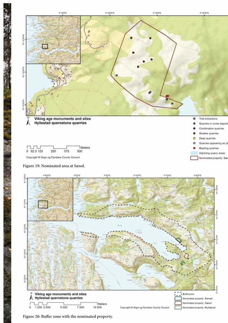
Figure 19: Nominated area at Sæsol.
Figure 20: Buffer zone with the nominated property.

Figure 21: Position of cargoes with quernstones from Hyllestad.

Figure 24: Location of the crosses most likely produced atHyllestad.
Figure 25: Rønset with the noble hardwood forest reserve and nominated area indicated.
Figure 22: Wrecked cargo at Gulen with quern and millstones from Hyllestad. Photo Atle Ove Martinussen

Figure 26: Knowledge through action for pupils at Hyllstad School, here within Millstone Park Photo: Kim Søderstrøm and Jørgen Magnus Directorate for Cultural Heritage


Figure 27: Knowledge through action for pupils at Hyllstad School, here within Millstone Park. Photo: Kim Søderstrøm and Jørgen Magnus Directorate for Cultural Heritage
84
APPENDIX 2 DECLARATION OF INTENT

85
The Viking Age as World Heritage Declaration of Intent
The Hyllestad quernstone quarries and the Vestfold ship burials are
component parts of the transnational serial nomination Viking Age Sites in Northern Europe to UNESCO’s World Heritage List
The transnational serial nomination Viking Age Sites in Northern Europe includes cultural heritage from the Viking Age linked to the land-, sea- and townscapes from the North Atlantic to the Baltic Sea. Altogether seven sites in five countries have been selected and nominated. These represent in an outstanding manner the same breadth, variation and development in the culture of the Vikings. In the Viking Age – from the 8th to the 11th century – the peoples of Scandinavia developed a maritime culture that not only deeply affected the rest of Northern Europe but also influenced far distant peoples. The Viking Age was an epoch of major changes in the Scandinavian countries:
Shift from tribal and clan structures via monarchy to nation building Change of religion from Norse customs and beliefs to Christianity Growth of towns and urbanisation in a society based on primary industry and the
production of raw materials.
The development of advanced shipbuilding technology and highly developed maritime skills permitted the Vikings to make use of waterways – the ocean, lakes and rivers – for expansion, exploration, overseas settlements and trade over long distances. The swift, easily manoeuvrable Viking ships were technological innovations at that time. The various component parts of the serial nomination include trading towns, harbours, fortifications, production sites, burial sites and places of assembly. In their entirety the sites in the serial nomination testify to social, economic and cultural development in the Viking Age. In addition to the Norwegian sites, the nomination includes Jelling and its mounds, runic stones and church as well as the fortifications at Trelleborg, Aggersborg and Fyrkat in Denmark, Þingvellir in Iceland, the Grobina archaeological complex in Latvia, and Danevirke and Hedeby in Germany (Schleswig-Holstein). Hyllestad quernstone quarries demonstrate the development of mass production and bulk trade during the Viking Age. Quernstone production began in the 700s in order to satisfy a local need. The Hyllestad quarries represent a unique production environment with regard to extent and authenticity, as well as links to the maritime culture that helps to unite the sites in the serial nomination.

86
The Vestfold ship burials – Gokstad, Oseberg and the Borre mounds – represent burial customs that are unparalleled in Viking Age culture. Common to the three locations are the large ships placed in the mound. Nowhere else in the world is the occurrence of ship burials so numerous, splendid and well-preserved. Three burial mounds with their wonderful ships and wealth of equipment that testify to a high degree of craft expertise are documented by archaeological excavations. The mounds at Borre are situated along the sailing route and underline in particular the association between technology, communication and landscape. If the transnational serial nomination of Viking Age Sites in Northern Europe is inscribed on the World Heritage List, Norway guarantees that the Outstanding Universal Value of the Hyllestad quernstone quarries and the Vestfold ship burials will be preserved. In connection with the preparation of the application for inscription on the World Heritage List, the municipalities of Horten, Sandefjord, Tønsberg and Hyllestad as well as Sogn og Fjordane and Vestfold county authorities and county governors together with the Directorate for Cultural Heritage, the Norwegian Environment Agency and the Ministry of Climate and Environment are in agreement on the following:
The intention of the World Heritage nomination Viking Age Sites in Northern Europe is to protect, preserve, disseminate and transfer to future generations the Outstanding Universal Value the sites represent.
The Norwegian component parts in the nomination shall help to strengthen local identity and contribute positively to experiencing the values of the cultural environments and to developing social and business activities in the municipalities.
The sites shall be included in the active dissemination of World Heritage values, and the scientific values will form the basis of knowledge production through national and international research and professional network building.
The Hyllestad quernstone quarries and the Vestfold ship burials shall be
managed in accordance with national legislation and the intentions of the World Heritage Convention. A key objective is to achieve best practice in the management of cultural heritage and to represent Norway in a worthy manner in the transnational nomination and on the World Heritage List.

87
A Norwegian World Heritage council will be set up for the Hyllestad quernstone quarries and the Vestfold ship burials. The council will ensure the joint management of the World Heritage values and will promote the use of World Heritage Site status in the best interests of the local communities.
Norway will participate actively in the international management of the
serial nomination Viking Age Sites in Northern Europe.

