volunteer lake watershed surveys - maine · phosphorus survey based on the maine ... land use and...
TRANSCRIPT
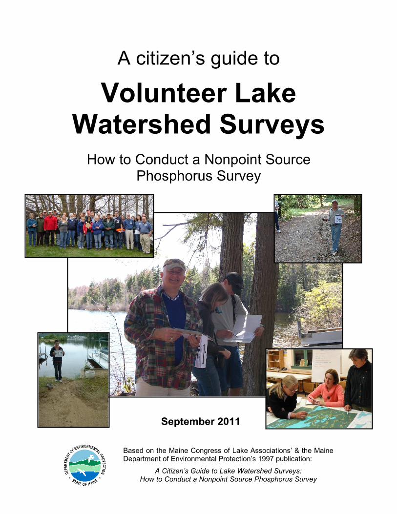
A citizen’s guide to
Volunteer Lake Watershed Surveys How to Conduct a Nonpoint Source
Phosphorus Survey
Based on the Maine Congress of Lake Associations’ & the Maine Department of Environmental Protection’s 1997 publication:
A Citizen’s Guide to Lake Watershed Surveys: How to Conduct a Nonpoint Source Phosphorus Survey
September 2011
Acknowledgements This manual was originally produced by the Maine Congress of Lake Associations (COLA) and the Maine Department of Environmental Protection (DEP) in 1992 and was revised in 1997. This 2011 version is the third edition of the manual.
The principal contributors to 1992 and 1997 versions of this publication were:
Maine Congress of Lake Associations – Scott Williams, Joan Irish
Maine Department of Environmental Protection – Karen Hahnel, Barbara Welch, Sally Fitch, Roy Bouchard, Kathy Hoppe, Deb Aja, Don Kale, Mary Ellen Dennis, Jeanne DiFranco
Androscoggin Valley Soil and Water Conservation District – Pauline Pare
Silver Lake (Roxbury Pond) Camp Owners Association – Leigh Breidenbach, Ross Swain
Graphics and design: Maine Tomorrow, Hallowell – Brian Kent, Wendy Mahoney Info Design, Yarmouth – Lisa Perkins Graphic Communications, Falmouth – Julie Motherwell
The contributors to this version of this publication were:
Maine Department of Environmental Protection – Kristin Feindel (author and editor), Wendy Garland, Norm Marcotte, Don Witherill
Maine Conservation Corps/AmeriCorps – Susan Pienta
This publication also draws from the following publications: Stream Survey Manual: A Citizen’s Guide to Basic Watershed, Habitat, and Geomorphology Surveys in Stream and River Watersheds — Volume I, Maine Stream Team Program of the Maine DEP, February 2009. Maine Lake and Stream Watershed Survey Quality Assurance Project Plan, Maine DEP, December 2009.
Thank you to all the lake and watershed associations, SWCDs, and others whose great work and ideas (and photographs!) have been used as examples in this manual.
September 2011 Publication # DEPLW-1218

Table of Contents
INTRODUCTION & BACKGROUND INFORMATION................................1
Watersheds, Lakes, & Phosphorus ........................................................................................ 1 Figure 1: Natural vegetation acts as a filter .............................................................. 5 Figure 2: Land Use and Phosphorus - Wilson Pond Study....................................... 7 Table 1: Phosphorus from Developed Land ............................................................. 8
What Does A Watershed Survey Do? ..................................................................................... 9 Figure 3: Should you do a lake watershed survey? .................................................11
HOW TO CONDUCT A WATERSHED SURVEY .....................................12
1. Determine if a Watershed Survey is the Right Course....................................................12 Identify Concerns and Issues ........................................................................................12 Determine How Much Community Support is Available .................................................12 Decide if Conducting a Volunteer Survey Now Makes Sense........................................13
2. Form a Steering Committee to Organize and Guide the Project ....................................13
3. Involve Key Organizations and Line up Technical Support ...........................................15
4. Determine Survey Focus ...................................................................................................17
5. Line up Financial Support for the Project ........................................................................18 Common Survey Expenses ...........................................................................................19 Sources of Non-Grant Funds.........................................................................................19 Grant Funding ...............................................................................................................20
6. Gather Existing Information about the Lake and Watershed .........................................20
7. Determine the Survey Schedule........................................................................................21 Spring is the Best Time to Conduct a Survey ................................................................21 Table 2: Sample Project Timeline............................................................................22 Watershed Survey Task Descriptions............................................................................23 Table 3: Sample Task Description...........................................................................23
8. Communicate with and Involve the Watershed Community...........................................24 Send Mailing to Every Landowner in Watershed Survey Area.......................................24 Notify the Public about the Project.................................................................................24
9. Recruit Volunteers ............................................................................................................25 Finding Field Volunteers................................................................................................25 Number of Volunteers ...................................................................................................26 What Volunteers Should Expect ....................................................................................26
10. Divide the Watershed into Sectors .................................................................................27

11. Private Property and Safety Issues ................................................................................28 Accessing Private Property ...........................................................................................28 Safety Issues.................................................................................................................29 Insurance Considerations..............................................................................................30
12. Compile Materials for Survey..........................................................................................31 Maps .............................................................................................................................31 Forms............................................................................................................................31 Outreach Material..........................................................................................................32
13. Hold Training for Field Volunteers .................................................................................32 Who Should Do the Training .........................................................................................32 What Volunteers Should Bring to the Training...............................................................32 What Volunteers Should Learn from the Training..........................................................33 Divide into Teams for Each Sector ................................................................................33 Rainy Weather ..............................................................................................................35
14. Conduct the Survey .........................................................................................................35 Survey Methods ............................................................................................................35 Some Basic Tips to Keep in Mind while Conducting the Survey ....................................38
15. Give Preliminary Data to Technical Team for Review ...................................................40 Send the Technical Team into the Field for Follow-up Site Visits ..................................40 Review Data Sheets ......................................................................................................40 Collect Data for and Calculate Pollutant Loading (optional) ...........................................41
16. Dealing with the Data.......................................................................................................41 Enter Data into a Spreadsheet and Create Map of Sites ...............................................41 Analyze the Data ...........................................................................................................42
17. Prepare and Distribute Summary Report (Optional) .....................................................42
18. Prepare the Final Survey Report.....................................................................................43
AFTER THE SURVEY ..............................................................................47
Distributing the Findings........................................................................................................47
Taking Further Action.............................................................................................................48 Putting Shovels in the Ground.......................................................................................48 Working with Towns ......................................................................................................49 Further Outreach & Education.......................................................................................50 Fundraising/Grants........................................................................................................50
Keeping Survey Data Up-to-Date ...........................................................................................51
ONLINE APPENDICES ............................................................................52
RESOURCE DIRECTORY........................................................................................................53

1
Introduction & Background Information Everyone loves lakes – whether boating, swimming, fishing, or just relaxing next to – especially lakes with clean, clear water. However, lakes are particularly sensitive to pollution, and once a lake’s health has declined, it can be extremely difficult to restore. To ensure clean, clear water for future generations to enjoy, many groups have worked to protect their lake by identifying and controlling pollution. Volunteer lake watershed surveys are one of the first steps to protecting lake water quality. In watershed surveys, trained volunteers identify sources of water pollution and help their communities find ways to eliminate them. Over the past two decades, over one hundred lake watershed surveys have been conducted in Maine. These surveys have resulted in the identification of thousands of pollution problems, many of which have now been eliminated or reduced. Surveys demonstrate how many communities are working together to do their part to protect Maine lakes.
Watersheds, Lakes, & Phosphorus
What is a Watershed?
A watershed includes all the land that drains
to a lake through streams, ditches, directly over the ground's surface, or through groundwater. Even though a watershed may extend many miles away from the lake itself, the watershed is actually part of the lake ecosystem, and the two cannot be separated. Whatever happens in a lake watershed can affect the lake.
Why Are Lakes So Sensitive To
Pollution? Lakes are sensitive and fragile water resources. One reason for this is that, when compared to streams, rivers, and coastal waters, the water exchange or flushing rate of lakes is very slow. Pollutants spend more time in a lake and have more opportunity to cause damage. But many other factors also determine the sensitivity of individual lakes. The size of the lake and its watershed, the types of soils in the watershed,
Lake Watershed
All the land that surrounds a lake that drains or sheds its water into the lake.
This can be through streams or ditches, directly over the ground surface, or
through the ground.
Watershed surveys help determine what’s happening in the watershed that can
affect the lake.
Whatever happens in the lake’s watershed – and it can be miles away - can affect the lake.
2
the steepness of the terrain, the location of streams and other physical aspects of the ecosystem play an important role in determining sensitivity.
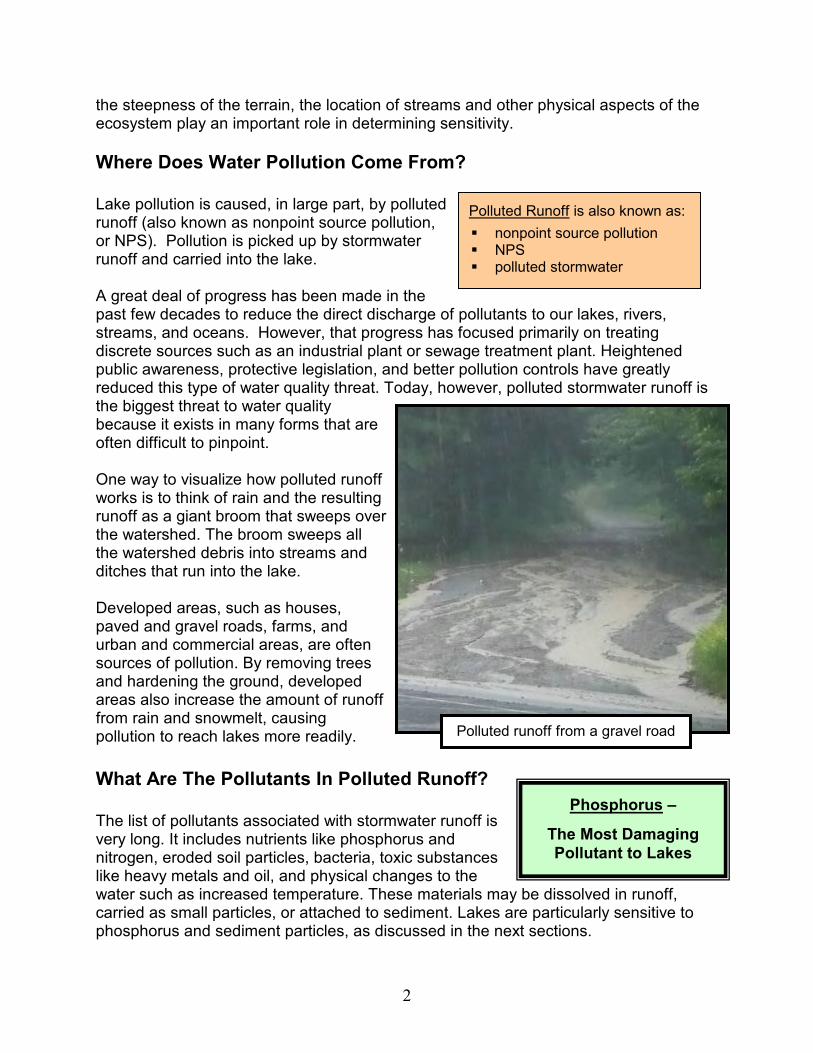
Where Does Water Pollution Come From?
Lake pollution is caused, in large part, by polluted runoff (also known as nonpoint source pollution, or NPS). Pollution is picked up by stormwater runoff and carried into the lake. A great deal of progress has been made in the past few decades to reduce the direct discharge of pollutants to our lakes, rivers, streams, and oceans. However, that progress has focused primarily on treating discrete sources such as an industrial plant or sewage treatment plant. Heightened public awareness, protective legislation, and better pollution controls have greatly reduced this type of water quality threat. Today, however, polluted stormwater runoff is the biggest threat to water quality because it exists in many forms that are often difficult to pinpoint. One way to visualize how polluted runoff works is to think of rain and the resulting runoff as a giant broom that sweeps over the watershed. The broom sweeps all the watershed debris into streams and ditches that run into the lake. Developed areas, such as houses, paved and gravel roads, farms, and urban and commercial areas, are often sources of pollution. By removing trees and hardening the ground, developed areas also increase the amount of runoff from rain and snowmelt, causing pollution to reach lakes more readily.
What Are The Pollutants In Polluted Runoff?
The list of pollutants associated with stormwater runoff is very long. It includes nutrients like phosphorus and nitrogen, eroded soil particles, bacteria, toxic substances like heavy metals and oil, and physical changes to the water such as increased temperature. These materials may be dissolved in runoff, carried as small particles, or attached to sediment. Lakes are particularly sensitive to phosphorus and sediment particles, as discussed in the next sections.
Polluted Runoff is also known as:
� nonpoint source pollution � NPS � polluted stormwater
Phosphorus –
The Most Damaging
Pollutant to Lakes
Polluted runoff from a gravel road

3
What Is Phosphorus And Where
Does It Come From?
Phosphorus is a naturally occurring substance that is present in nearly all plant and animal matter. It is a nutrient essential to all living organisms. Nearly all soils contain at least some phosphorus. Fine soil particles like clays, silts, and rich organic soils contain high concentrations. Sewage, manure, and street runoff also contain very high phosphorus concentrations. Phosphorus is a common ingredient in lawn and garden fertilizers, and it is found in gas and oil residues.
What Are The Negative Effects Of
Too Much Phosphorus?
Lakes are very sensitive to phosphorus. The amount of phosphorus in a lake’s water influences biological growth in the lake—and there’s a very fine balance. Even small increases of phosphorus in lake water can cause big problems. The amount of phosphorus in lake water determines how much algae can grow. Although algae are an important component of the lake food chain, too much algal growth causes lake water to turn green and cloudy, and generally undesirable for most recreational uses. Excess algal growth causes a decline of oxygen in the water. When the algae die, microbes break it down and use up oxygen in the process. This reduction of oxygen can seriously impair fish habitat, resulting in the slow decline of some sensitive species such as trout and salmon. In extreme cases, algal “blooms” can cause thick, foul smelling scums that form on the
Negative Impacts of Algal Blooms:
� Reduced swimming and boating appeal
� Loss of fishing as cold-water species (trout and salmon) habitat disappears
� Increased expense of treating drinking water
� Loss of shorefront property value � Increased costs to communities for
lake improvement or restoration
Algal bloom
Some sources of phosphorus
4
Soil is a major source of phosphorus.
Phosphorus binds to and is carried with eroded soil particles in stormwater runoff.
water surface, and large numbers of fish may die from oxygen depletion.
How Much Phosphorus Is Too Much?
Natural phosphorus levels in lake water are normally so low that they are measured in parts per billion (ppb). A part per billion, expressed in terms of time, is equivalent to 1 second in 32 years. Another way of expressing this would be to say that 1 ppb is equivalent to 1 grain of salt in about 35 gallons of water. Lakes that have phosphorus levels in the 3-5 ppb range are typically clear and have good water quality. Levels of only 15 ppb or more, however, can cause lake water to turn green from excess algal growth. Phosphorus concentrations in Maine lakes range from approximately 3 to 35 ppb, with 10 (a relatively high level) being the average.
Can A Lake's Health Be Restored?
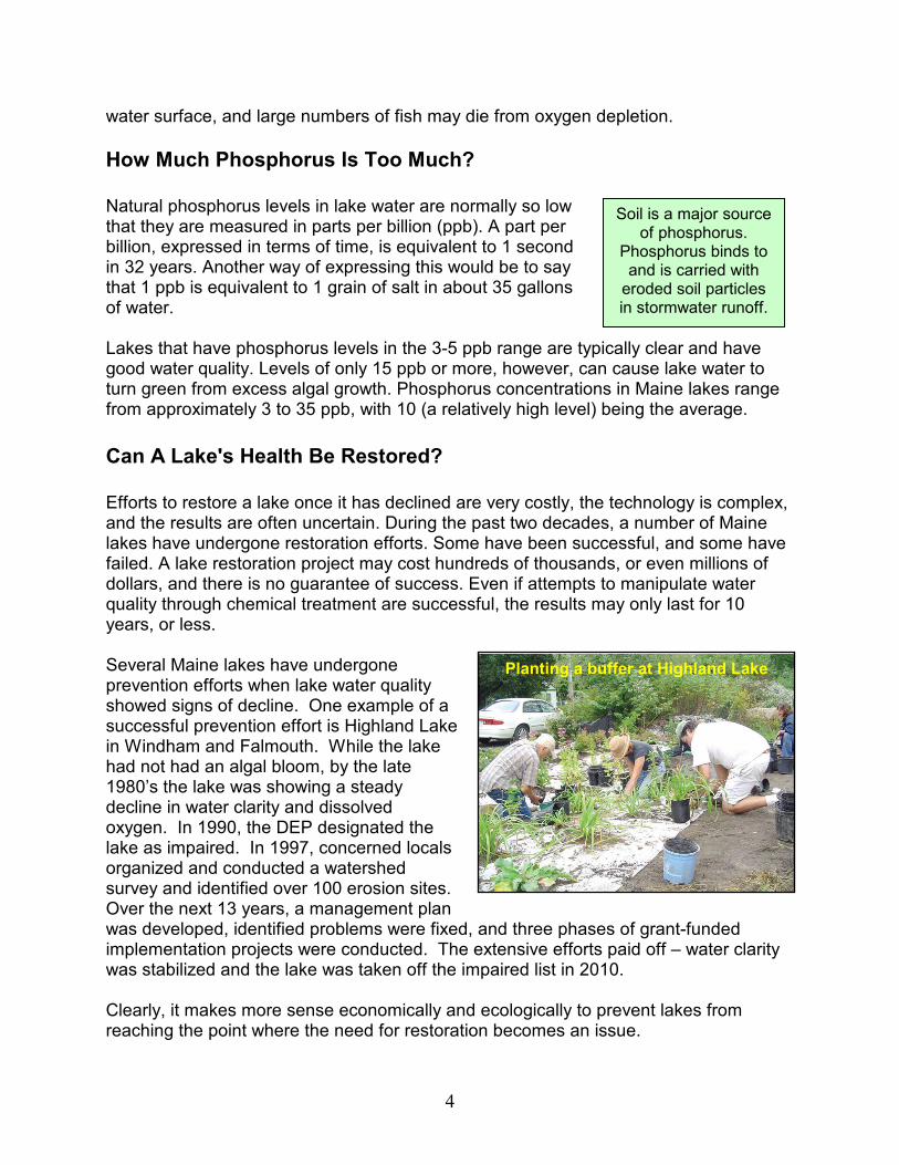
Efforts to restore a lake once it has declined are very costly, the technology is complex, and the results are often uncertain. During the past two decades, a number of Maine lakes have undergone restoration efforts. Some have been successful, and some have failed. A lake restoration project may cost hundreds of thousands, or even millions of dollars, and there is no guarantee of success. Even if attempts to manipulate water quality through chemical treatment are successful, the results may only last for 10 years, or less. Several Maine lakes have undergone prevention efforts when lake water quality showed signs of decline. One example of a successful prevention effort is Highland Lake in Windham and Falmouth. While the lake had not had an algal bloom, by the late 1980’s the lake was showing a steady decline in water clarity and dissolved oxygen. In 1990, the DEP designated the lake as impaired. In 1997, concerned locals organized and conducted a watershed survey and identified over 100 erosion sites. Over the next 13 years, a management plan was developed, identified problems were fixed, and three phases of grant-funded implementation projects were conducted. The extensive efforts paid off – water clarity was stabilized and the lake was taken off the impaired list in 2010. Clearly, it makes more sense economically and ecologically to prevent lakes from reaching the point where the need for restoration becomes an issue.
Planting a buffer at Highland Lake
5
How Does Land Use Affect The Transport Of Phosphorus Into Lakes?
Stormwater runoff is the primary means by which phosphorus from the watershed reaches a lake. But the volume of stormwater runoff and the amount of phosphorus in the runoff depends on how land throughout the watershed is being used.
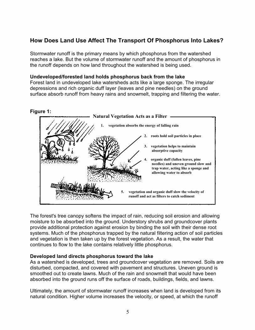
Undeveloped/forested land holds phosphorus back from the lake Forest land in undeveloped lake watersheds acts like a large sponge. The irregular depressions and rich organic duff layer (leaves and pine needles) on the ground surface absorb runoff from heavy rains and snowmelt, trapping and filtering the water.
Figure 1: Natural vegetation acts as a filter
The forest's tree canopy softens the impact of rain, reducing soil erosion and allowing moisture to be absorbed into the ground. Understory shrubs and groundcover plants provide additional protection against erosion by binding the soil with their dense root systems. Much of the phosphorus trapped by the natural filtering action of soil particles and vegetation is then taken up by the forest vegetation. As a result, the water that continues to flow to the lake contains relatively little phosphorus.
Developed land directs phosphorus toward the lake As a watershed is developed, trees and groundcover vegetation are removed. Soils are disturbed, compacted, and covered with pavement and structures. Uneven ground is smoothed out to create lawns. Much of the rain and snowmelt that would have been absorbed into the ground runs off the surface of roads, buildings, fields, and lawns. Ultimately, the amount of stormwater runoff increases when land is developed from its natural condition. Higher volume increases the velocity, or speed, at which the runoff
4.
Natural Vegetation Acts as a Filter
5. vegetation and organic duff slow the velocity of
runoff and act as filters to catch sediment
2. roots hold soil particles in place
3. vegetation helps to maintain
absorptive capacity
4. organic duff (fallen leaves, pine
needles) and uneven ground slow and
trap water, acting like a sponge and
allowing water to absorb
1. vegetation absorbs the energy of falling rain
6
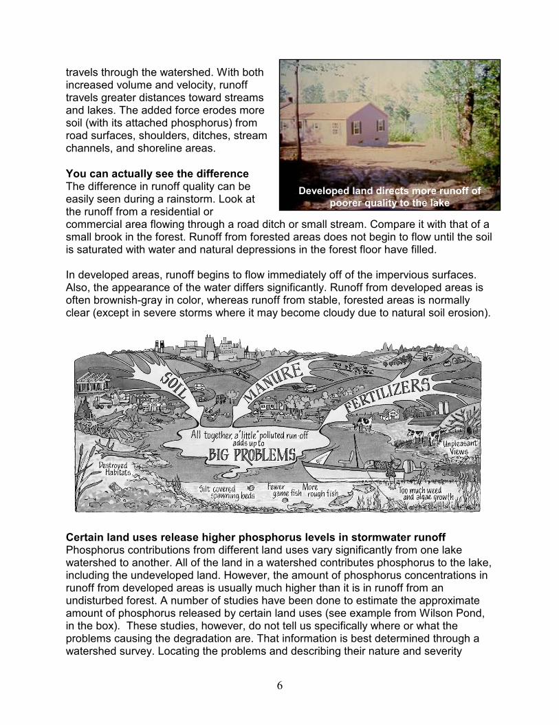
travels through the watershed. With both increased volume and velocity, runoff travels greater distances toward streams and lakes. The added force erodes more soil (with its attached phosphorus) from road surfaces, shoulders, ditches, stream channels, and shoreline areas.
You can actually see the difference The difference in runoff quality can be easily seen during a rainstorm. Look at the runoff from a residential or commercial area flowing through a road ditch or small stream. Compare it with that of a small brook in the forest. Runoff from forested areas does not begin to flow until the soil is saturated with water and natural depressions in the forest floor have filled. In developed areas, runoff begins to flow immediately off of the impervious surfaces. Also, the appearance of the water differs significantly. Runoff from developed areas is often brownish-gray in color, whereas runoff from stable, forested areas is normally clear (except in severe storms where it may become cloudy due to natural soil erosion).
Certain land uses release higher phosphorus levels in stormwater runoff Phosphorus contributions from different land uses vary significantly from one lake watershed to another. All of the land in a watershed contributes phosphorus to the lake, including the undeveloped land. However, the amount of phosphorus concentrations in runoff from developed areas is usually much higher than it is in runoff from an undisturbed forest. A number of studies have been done to estimate the approximate amount of phosphorus released by certain land uses (see example from Wilson Pond, in the box). These studies, however, do not tell us specifically where or what the problems causing the degradation are. That information is best determined through a watershed survey. Locating the problems and describing their nature and severity
Developed land directs more runoff of
poorer quality to the lake
7
provides valuable information about the extent of problems and the overall character of the lake watershed.
What’s actually happening in the watershed affects the level of polluted runoff The degree to which pollutants threaten a lake depends on everything that’s happening in the watershed: how the land is being used, the extent of development, and the way surface water travels down through the watershed to the lake. The location of streams, soil type, and variations in the slope of the land are all factors that affect the way polluted runoff travels to lakes. Lake watershed surveys help to determine what is happening in the watershed and how that affects the lake. For example, in a small forested watershed with moderate shoreline development, much of the phosphorus is probably coming from the shoreline development. But in a watershed with more upland development away from the shoreline, that development (such as residential development, forestry operations, farms, and commercial development) is likely all contributing to the lake’s phosphorus load.
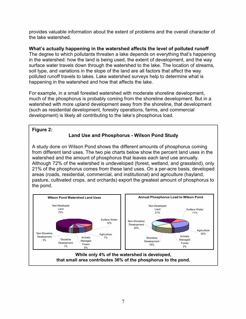
Figure 2:
Land Use and Phosphorus - Wilson Pond Study
A study done on Wilson Pond shows the different amounts of phosphorus coming from different land uses. The two pie charts below show the percent land uses in the watershed and the amount of phosphorus that leaves each land use annually. Although 72% of the watershed is undeveloped (forest, wetland, and grassland), only 21% of the phosphorus comes from these land uses. On a per-acre basis, developed areas (roads, residential, commercial, and institutional) and agriculture (hayland, pasture, cultivated crops, and orchards) export the greatest amount of phosphorus to the pond.
Wilson Pond Watershed Land Uses
Non-Shoreline
Development
3% Shoreline
Development
1%
Actively
Managed
Forest
5%
Surface Water
12%
Agriculture
7%
Non-Developed
Land
72%
Annual Phosphorus Load to Wilson Pond
Non-Developed
Land
21%
Agriculture
30%
Surface Water
11%
Actively
Managed
Forest
2%
Shoreline
Development
16%
Non-Shoreline
Development
20%
While only 4% of the watershed is developed,
that small area contributes 36% of the phosphorus to the pond.

8
Table 1: Phosphorus from Developed Land
Land Use
& Sources of Phosphorus Potential Impacts
Agriculture � Tilled soil � Animal waste � Fertilizers � Diverted water that
runs into ditches � Unstable stream banks or shoreline
areas from livestock grazing
Agriculture creates the potential for high phosphorus runoff. There may be large areas of exposed soil, concentrated water diversions, fields tilled too close to unbuffered road ditches, and livestock grazing too close to streams or the lake. Runoff from manure storage and fertilized areas can also be a serious problem.
Forestry Operations � Soil erosion from
skidder trails, clear cuts, log yards, logging roads, and stream crossings
Forestry operations can be a source of phosphorus due to soil exposure and erosion from logging trails, especially at stream crossings. Stream bank erosion may occur due to increased runoff from heavily logged sites.
Commercial Development � Exposed soil from
construction sites � Gas and oil
residues from road surfaces
� Sand and gravel from roads
� Temperature changes to streams due to runoff from large areas of pavement
High runoff volumes from buildings and parking areas can erode streambanks. Urban runoff contains moderately high levels of phosphorus and many other pollutants that are potentially harmful to water resources. Sand spread on roads in winter is easily washed into storm drains, streams, and the lake.
Residential Development � Soil erosion from
construction � Soil erosion from
driveways � Runoff from fertilized
lawns and gardens � Septic systems � Pet waste
The phosphorus pollution potential is high partly due to rapid growth of residential development in many watersheds. While the per-acre impact from residential land use may be low compared to agriculture or urban areas, the cumulative phosphorus load from residential areas (including roads) throughout the watershed can easily exceed that of all other land uses in the watershed combined.
Roads: Private, State, & Town � Soil erosion from
road surfaces, shoulders, and ditches
� Erosion from unstable stream crossings and culverts
� Ditches discharging directly to streams � Winter sand � Gas and oil residues from road surfaces
A significant source of phosphorus in most watersheds because of the extensive network of roads, alteration of surface water drainage pathways, and often inadequate construction and maintenance.

9
What’s The Problem With Soil Erosion? Because phosphorus can affect lake water quality so negatively, this guide places particular emphasis on identifying and reducing sources of phosphorus-rich stormwater runoff. One way of doing this is to address soil erosion in the watershed, because soil is a major source of phosphorus. Soil erosion is also easy to see and identify. When soil particles erode and are carried into streams and lakes in runoff, phosphorus travels with the runoff. Very small soil particles can travel great distances in stormwater runoff. Detached soil particles (sediment) from eroded areas in the watershed can also cause serious damage to the streams that feed a lake by smothering sensitive habitat for fish and aquatic insects. Sediment that travels to the lake causes similar damage. Phosphorus occurs in several different forms in the soil. When stormwater runoff picks up loose soil matter, some of the phosphorus sticks to the soil particles, and some dissolves in the stormwater. Soil erosion is a common problem in virtually all lake watersheds. It is common to all types of land uses.
What Does A Watershed Survey Do? A watershed survey helps determine where and what the problems actually are. It helps us understand whether or not particular types of land uses are problematic for a watershed. And most important, the survey nearly always confirms that the problems are not just the large, obvious ones. There are many small situations that are commonly overlooked. And these small problems add up and can cause serious water quality problems!
If the majority of soil erosion problems could be identified and eventually resolved, a significant amount of the phosphorus coming from the watershed could be reduced.
Soil erosion not far from lake
10
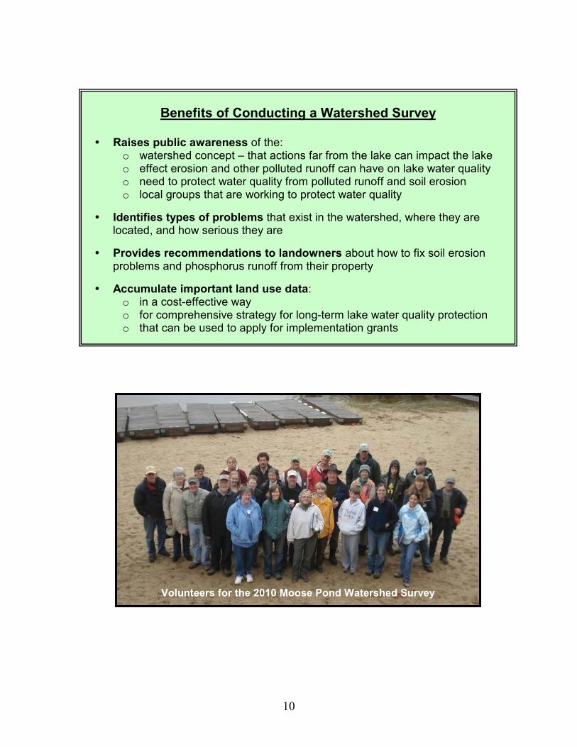
Benefits of Conducting a Watershed Survey
� Raises public awareness of the: o watershed concept – that actions far from the lake can impact the lake o effect erosion and other polluted runoff can have on lake water quality o need to protect water quality from polluted runoff and soil erosion o local groups that are working to protect water quality
� Identifies types of problems that exist in the watershed, where they are located, and how serious they are
� Provides recommendations to landowners about how to fix soil erosion problems and phosphorus runoff from their property
� Accumulate important land use data: o in a cost-effective way o for comprehensive strategy for long-term lake water quality protection o that can be used to apply for implementation grants
Volunteers for the 2010 Moose Pond Watershed Survey

11
Figure 3: Should you do a lake watershed survey?
12
How to Conduct a Watershed Survey The information in this section is for watershed survey organizers, which in most cases will be the survey’s steering committee. The general and specific guidelines are intended to provide structure and direction. However, because each survey project has different needs, goals, and available resources, please use this information with the uniqueness of your project in mind. Keep in mind that it may be necessary to customize the process to meet the needs of your watershed community and the volunteers involved in your project.
1. Determine if a Watershed Survey is the Right
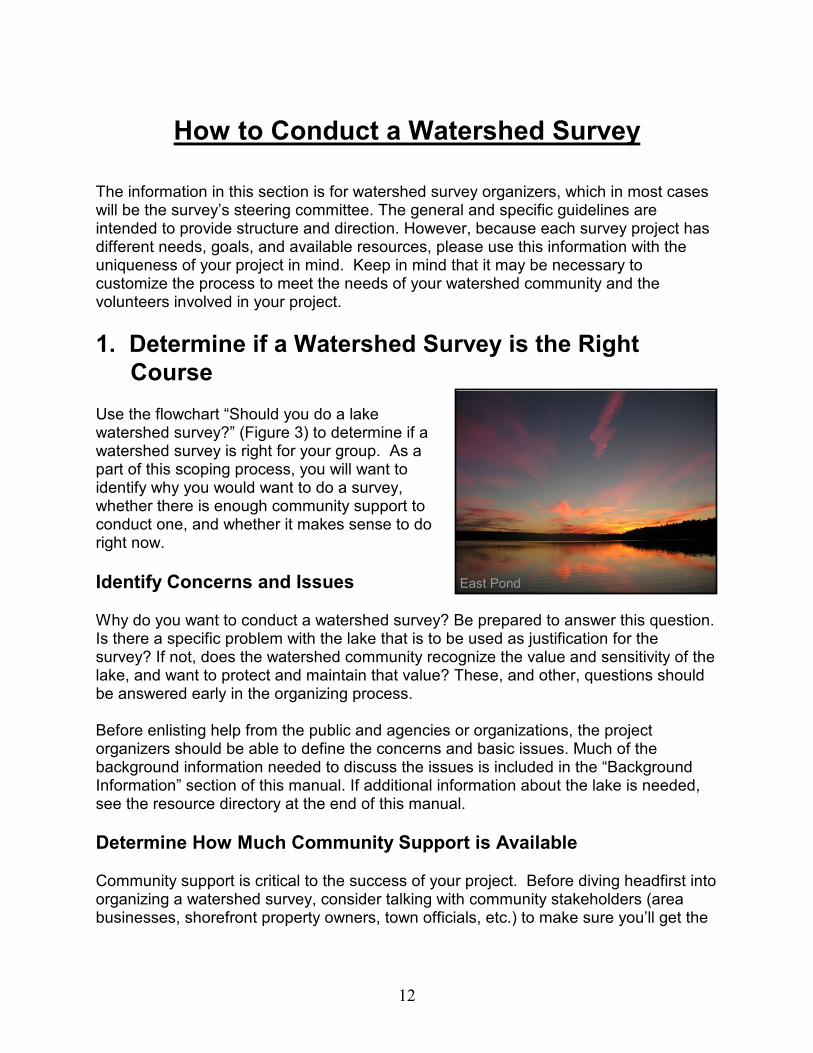
Course Use the flowchart “Should you do a lake watershed survey?” (Figure 3) to determine if a watershed survey is right for your group. As a part of this scoping process, you will want to identify why you would want to do a survey, whether there is enough community support to conduct one, and whether it makes sense to do right now.
Identify Concerns and Issues Why do you want to conduct a watershed survey? Be prepared to answer this question. Is there a specific problem with the lake that is to be used as justification for the survey? If not, does the watershed community recognize the value and sensitivity of the lake, and want to protect and maintain that value? These, and other, questions should be answered early in the organizing process. Before enlisting help from the public and agencies or organizations, the project organizers should be able to define the concerns and basic issues. Much of the background information needed to discuss the issues is included in the “Background Information” section of this manual. If additional information about the lake is needed, see the resource directory at the end of this manual.
Determine How Much Community Support is Available Community support is critical to the success of your project. Before diving headfirst into organizing a watershed survey, consider talking with community stakeholders (area businesses, shorefront property owners, town officials, etc.) to make sure you’ll get the
East Pond
13
support needed. This could be done at the first steering committee meeting, or it might be better accomplished by making a few phone calls ahead of time. You may want to take several months to meet with local conservation commissions, lake associations, the County Soil and Water Conservation District, DEP staff, and others to present the concept before setting the process in motion.
Decide if Conducting a Volunteer Survey Now Makes Sense Consider the guidance from the flowchart “Should you Do a Watershed Survey” (page 11). You may also want to contact DEP staff or others to discuss what the best next steps may be. If a survey has been done recently (in the last five years) or the main objective of doing a survey is to update or put together a list of sites for a 319 implementation grant proposal (see the Fundraising/Grants section on page 50 for more information about grants), you may want to have a few professionals do a quicker windshield survey rather than the volunteer survey described in this manual. Contact DEP staff to discuss if this may be the case. If conducting a volunteer-led watershed survey makes sense, use this manual to start planning.
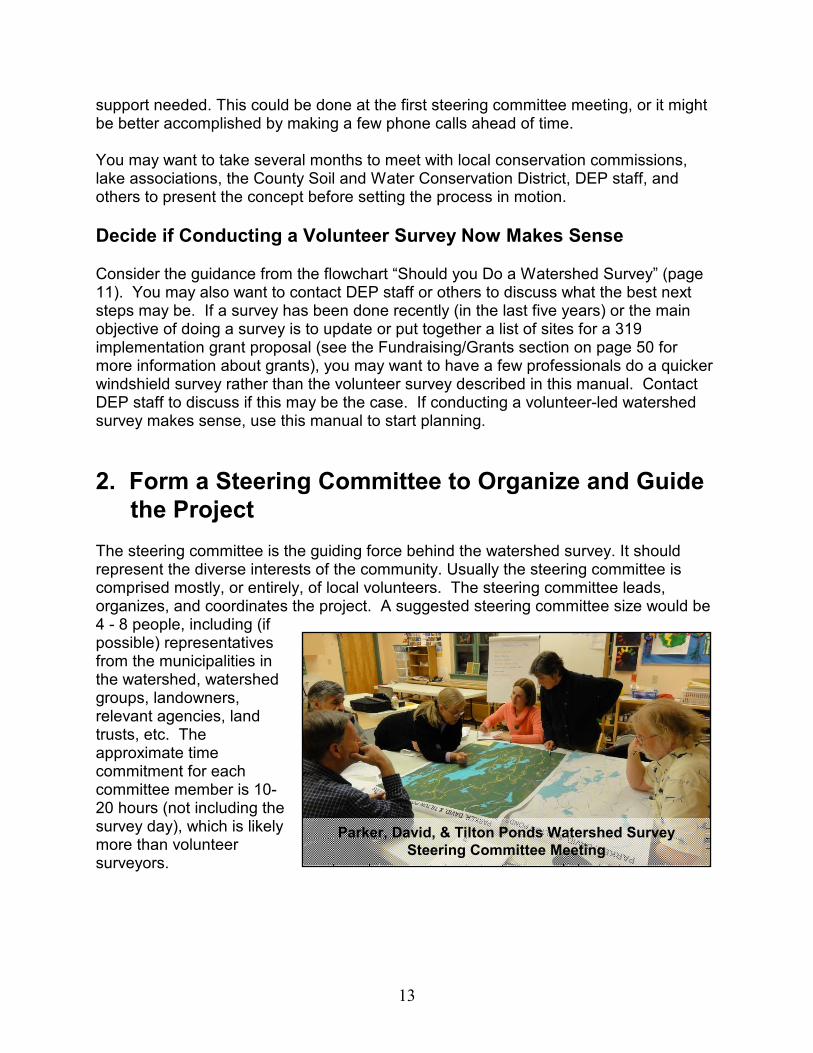
2. Form a Steering Committee to Organize and Guide
the Project The steering committee is the guiding force behind the watershed survey. It should represent the diverse interests of the community. Usually the steering committee is comprised mostly, or entirely, of local volunteers. The steering committee leads, organizes, and coordinates the project. A suggested steering committee size would be 4 - 8 people, including (if possible) representatives from the municipalities in the watershed, watershed groups, landowners, relevant agencies, land trusts, etc. The approximate time commitment for each committee member is 10-20 hours (not including the survey day), which is likely more than volunteer surveyors.
Parker, David, & Tilton Ponds Watershed Survey
Steering Committee Meeting
14
Steering Committee Responsibilities The responsibilities of the steering committee are to:
• Compile a mailing list for all watershed properties, usually using tax maps.
• Arrange training location, date and time.
• Notify landowners about the survey and when it will take place.
• Provide a contact number for those who do not want their property to be surveyed.
• Make a list of properties excluded from the survey.
• Advertise the survey in local papers, newsletters, cable access channels, posters or flyers.
• Find technical help to help conduct training and survey if needed.
• Recruit 15-20 volunteers to attend training and conduct the survey.
• Provide snacks and beverages for volunteer training session.
• Notify volunteers about training schedule and expectations.
• Develop the format of the final report and distribution plan.
• Determine the next steps of how to use the survey data.
Steering Committee Roles There are several key roles for steering committee members to take on. In many cases, these jobs are done by paid staff. For smaller projects (that are not paid for by grants) these roles will need to be done by volunteers.
� Project Manager (1 person): Responsible for overall coordination of the project, including overseeing the activities of the steering committee. Approximate time commitment: 20-30 hours.
� Volunteer Coordinator (1 person): Responsible for coordinating activities of
volunteers, including distribution of materials and the collection and preliminary review of data. This individual will communicate directly with the project manager, technical team, and steering committee. Approximate time commitment: 10-20 hours.
� Data Coordinator (1-2 people): Responsible for compiling and storing data,
works closely with the technical team on producing reports. Approximate time commitment: 20-30 hours. Responsibilities:
• Collect and organize survey data and make sure forms are complete.
• Collect and organize photos.
• Enter survey data into Excel spreadsheet or other electronic format.
• Coordinate final report and printing.
Document the amount of time you spend on the project:
Documentation of your time may prove valuable in demonstrating the level of commitment that a group of individuals, an organization, or the town has made to the project. This may be very useful if additional assistance is needed for a follow-up project to “fix” problems that have been identified in the survey.

15
� Technical Team / Resource Professionals (3-5 people): Responsible for
advising the steering committee on technical issues and providing technical help on the day of the survey training. Some good technical team members could include local soil and water conservation district staff, state/federal agency staff, and private consultants. Approximate time commitment: 8-20 hours. Responsibilities:
• Deliver presentations at classroom portion of training session.
• Lead small groups through field portion of training session.
• Conduct follow-up surveys to check volunteer survey data.
• Review or assist with final report
3. Involve Key Organizations and Line up Technical
Support A number of agencies and organizations may be able to provide useful and time-saving information and expertise for the survey. They can also be a good source of technical team members.
Technical Support It is very helpful to locate and involve any individual(s) who has/have a thorough understanding of lake water quality issues and the watershed survey process. This person may serve as project manager and/or as a member of the technical team, and can address specific technical issues as they arise.
� The Watershed Management Division of the DEP can provide valuable help in all phases of the project. Division staff may be able to give technical support and materials such as watershed maps, and may be able to refer you to other qualified technical support. They may also be able to provide electronic templates of survey materials such as letter, reports, form, press releases, etc. They should be among the first you contact.
� The County Soil and Water Conservation District (SWCD) may also provide
watershed maps and aerial photographs of the watershed; both are extremely useful in determining land-use patterns. The District staff may also be familiar with existing problems in the watershed that can be used as examples during the training of volunteer surveyors. They also may be able to provide technical
Technical support and community
members at Echo Lake
16
assistance, depending on funding available. Contact the SWCD early in the survey process, even if only to inform them of your project.
� Regional Lake or
Watershed Association, if there is one in your area, may have knowledge of past surveys or other work that has occurred in the watershed or in other local watersheds. They can also be a great source of technical support, mapping capabilities, and volunteers.
� Qualified private consultants are available to assist with watershed survey
projects. If a consultant is retained to work with the steering committee, the individual or firm should be thoroughly familiar with polluted runoff issues, lake water quality and watershed land-use relationships and issues, watershed survey methods, and the use of conservation practices (BMPs). Hiring a consultant will add expense to the project, depending on the level of involvement required.
Other Organizations to Involve The following are examples of some key organizations you should consider involving or informing of your watershed survey.
� Town Government should not only be informed about the survey, but its participation should be encouraged. Clean lakes benefit towns in many ways—and direct financial benefit is one of the most motivating. High property valuation around clean lakes results in higher tax revenues for towns; and tourists, who are more likely to visit clean lakes and patronize local businesses, substantially increase local revenues. Towns may be willing to cover the cost of materials required for the survey and expenses for professional oversight, or may help compile mailing lists and labels for the watershed mailing and tax maps for the survey materials. Regardless of how much support is available from towns in the watershed, however, it is essential that they be kept fully informed of the philosophy, progress, and findings of the project. Town officials are likely to field questions from the public, and it’s important to the project’s success that they provide accurate information.
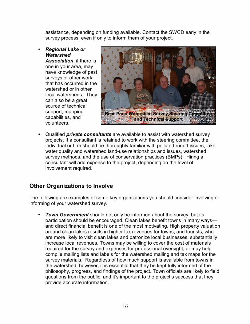
Bear Pond Watershed Survey Steering Committee
and Technical Support
17
� Town Conservation Commissions can be an excellent source of information about the lake watershed. Sensitive areas may have already been identified by the commission, and its members may be interested in participating on survey teams. They may also have land-use maps and aerial photos. Coordination with a town conservation commission in preparing the final project report may add credibility to the findings and conclusions of the survey.
� Regional Planning Commissions (RPCs) may also be able to direct you to
problem areas in the watershed and may be able to help with organizing information. In addition, RPCs may be able to direct you to key people involved in community planning in the watershed towns. And they may know of grants that could cover costs for the survey or for restoring problem sites identified during the survey.
� The University of Maine Cooperative Extension is another organization that could be made aware of the project and approached for help. They work with agricultural producers in improving nutrient management and pesticide reduction. They also work to solve well-water problems and conduct environmental education projects such as the Master Gardener and the Watershed Stewards programs.
� The Maine Volunteer Lake Monitoring Program maintains water quality
databases for many Maine lakes. They may also have useful information on land use activities in your lake watershed.
More information about the organizations discussed above can be found in through the Resource Directory at the end of this manual.
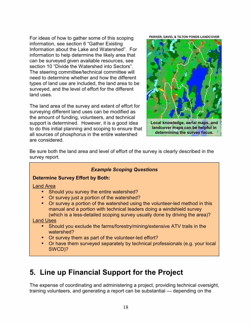
4. Determine Survey Focus The steering committee/technical committee should conduct a broad assessment of the watershed area and land use. While the type of watershed survey described in this manual is designed specifically to focus on erosion issues from development and roads, all likely phosphorus sources in the watershed should be considered in determining the focus and extent of the survey. There may be erosion problems from other land uses such as agricultural operations, gravel mining and/or forestry present in the watershed. There may also be other non-erosion sources of phosphorus such as agriculture, septic systems, extensive paved areas or buildings, extensive turf areas such as golf courses, and/or industries.
Determining Your Survey Focus
� Take a “bird’s eye view” of the entire watershed.
� Determine what the most likely sources of phosphorus are.
� Design your survey to evaluate the likely important phosphorus sources.
18
For ideas of how to gather some of this scoping information, see section 6 “Gather Existing Information about the Lake and Watershed”. For information to help determine the likely area that can be surveyed given available resources, see section 10 “Divide the Watershed into Sectors”. The steering committee/technical committee will need to determine whether and how the different types of land use are included, the land area to be surveyed, and the level of effort for the different land uses. The land area of the survey and extent of effort for surveying different land uses can be modified as the amount of funding, volunteers, and technical support is determined. However, it is a good idea to do this initial planning and scoping to ensure that all sources of phosphorus in the entire watershed are considered. Be sure both the land area and level of effort of the survey is clearly described in the survey report.
5. Line up Financial Support for the Project The expense of coordinating and administering a project, providing technical oversight, training volunteers, and generating a report can be substantial — depending on the
Local knowledge, aerial maps, and
landcover maps can be helpful in
determining the survey focus.
Example Scoping Questions
Determine Survey Effort by Both:
Land Area
� Should you survey the entire watershed? � Or survey just a portion of the watershed? � Or survey a portion of the watershed using the volunteer-led method in this
manual and a portion with technical leaders doing a windshield survey (which is a less-detailed scoping survey usually done by driving the area)?
Land Uses � Should you exclude the farms/forestry/mining/extensive ATV trails in the
watershed? � Or survey them as part of the volunteer-led effort? � Or have them surveyed separately by technical professionals (e.g. your local
SWCD)?
19
scope of the project, the size of the watershed, and whether or not resource agencies can provide free technical assistance. In some instances, such as for surveys in small watersheds, there may be fairly minimal costs and they may not need much funding; as long as volunteers and professionals can provide the bulk of their time, labor, and equipment for free or as “in-kind” match or support.
Common Survey Expenses
� Technical assistance – if the watershed is large or free technical assistance from resource agencies or organizations is not available, technical assistance may need to be paid for.
� Postage – for mailings to watershed residents � Photocopying – of the letter to landowners, survey datasheets, and maps, if not
available through the DEP Division of Watershed Management � Beverages and snacks – for survey training � Printing of report – cost depends on how many copies, length of report, color
Try not to rely on only a single source of funding. The more sources you have, the more secure your project will be.
Sources of Non-Grant Funds
� Municipal Funding — If the survey process is planned well in advance, a town may be able to include expenses for the project in its annual budget. A town’s conservation commission may help with survey material costs.
� Local Youth Conservation Corps — Some watershed organizations in the state employ small teams of youth through the summer, implementing best management practices (BMPs) throughout the watershed. These groups often participate in watershed surveys — which helps to identify sites for future BMP work.
� Local Businesses and Corporate
Sponsors — Local sponsors sometimes may contribute money, food, printing, or equipment loans.
� Fundraising — This method has the added value of gaining support and promoting education in the community you serve. Some ideas include: lake festivals, fundraising events, association dues, membership drives, product sales, and direct mail solicitation.
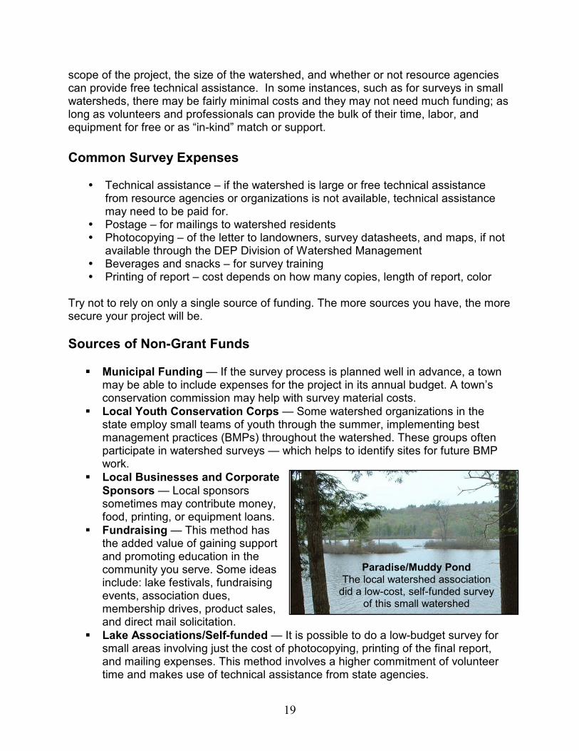
� Lake Associations/Self-funded — It is possible to do a low-budget survey for small areas involving just the cost of photocopying, printing of the final report, and mailing expenses. This method involves a higher commitment of volunteer time and makes use of technical assistance from state agencies.
Paradise/Muddy Pond The local watershed association did a low-cost, self-funded survey
of this small watershed
20
Grant Funding For larger projects, consider applying for grant funding such as through the 319 Nonpoint Source Pollution Grant Program. The 319 NPS grant program is a EPA-based grant originating from Section 319 of the Clean Water, and is administered by the DEP. Because the funding of these grants is on a competitive basis and the grants have considerable reporting and time requirements, they are usually fit best with larger, more extensive watershed projects. Also, due to the grant funding cycle, you will need to apply at least a year before the survey takes place. It is recommended that small lake associations team up with SWCD or a larger watershed group to apply for funds. For more information, contact DEP Division of Watershed Management or visit www.maine.gov/dep/blwq/grants.htm.
6. Gather Existing Information about the Lake and
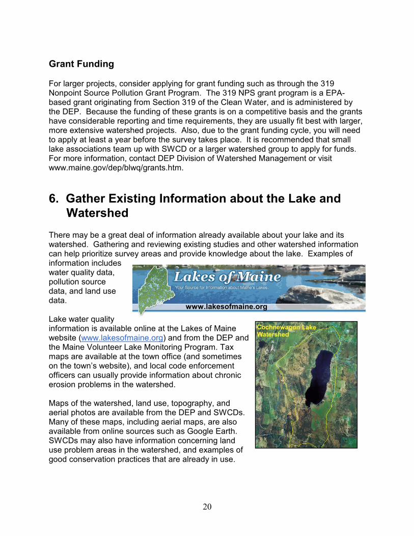
Watershed There may be a great deal of information already available about your lake and its watershed. Gathering and reviewing existing studies and other watershed information can help prioritize survey areas and provide knowledge about the lake. Examples of information includes water quality data, pollution source data, and land use data. Lake water quality information is available online at the Lakes of Maine website (www.lakesofmaine.org) and from the DEP and the Maine Volunteer Lake Monitoring Program. Tax maps are available at the town office (and sometimes on the town’s website), and local code enforcement officers can usually provide information about chronic erosion problems in the watershed. Maps of the watershed, land use, topography, and aerial photos are available from the DEP and SWCDs. Many of these maps, including aerial maps, are also available from online sources such as Google Earth. SWCDs may also have information concerning land use problem areas in the watershed, and examples of good conservation practices that are already in use.
www.lakesofmaine.org
21
Driving the watershed and looking for likely sources of phosphorus (i.e. a windshield survey) is an optional additional method for gathering preliminary information about problems in the watershed. Also, depending on the size of the watershed, identified water quality priorities and anticipated resources available, the project may only focus on a portion of the watershed. For example, if it is not feasible to survey all of a 20 square mile watershed, the project might focus in on the most heavily developed areas covering only 5 square miles. Be sure to note in the final report the geographic extent and land use types that were included in the survey.
7. Determine the Survey Schedule It’s important to establish a time frame for each phase of the survey. This ensures that surveyors are in the field during the best time of the year for seeing runoff-related NPS problems, and it provides volunteers with a deadline for returning field forms. Volunteer help is the backbone of the project, and their interest and enthusiasm is critical to the project’s success. Volunteer interest is more easily sustained by giving volunteers clearly defined goals to accomplish within a reasonable time.
Spring is the Best Time to Conduct a
Survey
The best time to conduct the survey is in spring, soon after the snow has melted and the ground is exposed. Mid-April through Mid-May is ideal. At this time, runoff and erosion problems are usually most evident. However, some lakes with large numbers of seasonal, out of state residents decide to hold surveys in late May or early June since they need to wait until volunteers are back. Spring surveys are most effective because:
� The ground is usually saturated with water from snowmelt. Under these conditions runoff from rainstorms is at a maximum and problems are more visible.
� Eroded areas are more visible due to the absence of ground cover vegetation. � Eroded sediment in runoff flows is usually at its highest concentration and most
visible because the freeze-thaw cycles and high levels of runoff weaken unstable soils.
� Maintenance on town and private roads has not taken place, and problems are more obvious than they would be after roads have been regraded and culverts reset.
Survey Schedule

22
� Enough time remains to complete the project during the summer months if needed.
If a spring survey is not possible, the next best time is in the fall before leaf fall. Conditions, however, may not be as favorable, and safety issues are greater because of fall’s hunting season. If you have to hold the survey in the fall, try to avoid hunting season if possible, or at least be sure to have volunteers wearing blaze orange clothing. Summer surveys can be conducted if volunteers are not available in the spring or fall, although problems will be much less visible compared to spring or fall conditions. The amount of time to complete the field survey component of a watershed area (per team) is typically 1⁄2 to 2 days, though it may take more. Variables affecting length of time include: size of the watershed, complexity of pollution problems, and number of volunteers. The amount of time needed for gathering data on the watershed, doing follow-up, and preparing a report is variable.
Lake watershed surveys typically take nearly a year to plan and fully carry out. However, timelines can be condensed if needed. Table 2 shows a typical timeline for a survey project.
Table 2: Sample Project Timeline
Major Tasks Feb/Mar
Apr May Jun Jul Aug Sept Oct Nov Dec Jan Feb/Mar
1. Project Design X X
2. Survey Preparation X X X
3. Volunteer Training X X X
4. Watershed Survey X X
5. Survey Follow-up X X X
6. Enter Data X X X X
7. Data Interpretation X X X
8. Preliminary Results X X
9. Final Report Prep X X X
10. Report Distribution and Outreach
X
Winter sand and shoulder erosion
(Brandy Pond Watershed Survey)
23
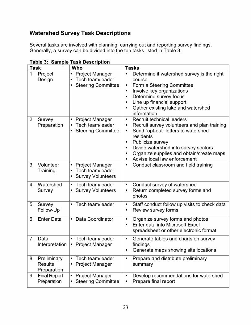
Watershed Survey Task Descriptions Several tasks are involved with planning, carrying out and reporting survey findings. Generally, a survey can be divided into the ten tasks listed in Table 3.
Table 3: Sample Task Description
Task Who Tasks
1. Project Design
� Project Manager � Tech team/leader � Steering Committee
� Determine if watershed survey is the right course
� Form a Steering Committee � Involve key organizations � Determine survey focus � Line up financial support � Gather existing lake and watershed
information
2. Survey Preparation
� Project Manager � Tech team/leader � Steering Committee
� Recruit technical leaders � Recruit survey volunteers and plan training � Send “opt-out” letters to watershed
residents � Publicize survey � Divide watershed into survey sectors � Organize supplies and obtain/create maps � Advise local law enforcement
3. Volunteer Training
� Project Manager � Tech team/leader � Survey Volunteers
� Conduct classroom and field training
4. Watershed Survey
� Tech team/leader � Survey Volunteers
� Conduct survey of watershed � Return completed survey forms and
photos
5. Survey Follow-Up
� Tech team/leader � Staff conduct follow up visits to check data � Review survey forms
6. Enter Data � Data Coordinator � Organize survey forms and photos � Enter data into Microsoft Excel
spreadsheet or other electronic format
7. Data Interpretation
� Tech team/leader � Project Manager
� Generate tables and charts on survey findings
� Generate maps showing site locations
8. Preliminary Results Preparation
� Tech team/leader � Project Manager
� Prepare and distribute preliminary summary
9. Final Report Preparation
� Project Manager � Steering Committee
� Develop recommendations for watershed � Prepare final report
24
10. Report Distribution & Outreach
� Steering Committee � Project Manager
� Distribute reports to partners � Plan & conduct outreach on survey results � Begin discussions of the next steps
8. Communicate With and Involve the Watershed
Community Communicating with the local watershed community throughout the project is critical to a successful project. Misunderstandings about the purpose of a survey can ruin a project before it gets started! Early public awareness raises citizens’ questions and concerns and affords the steering committee time to address any issues. Communication also helps with raising public awareness about the link between erosion and water quality and provides education about conservation practices for landowners. See Appendix A for a sample outreach brochure about what a watershed survey is.
Send Mailing to Every Landowner in Watershed Survey Area To notify all landowners in the watershed about the survey and to give them an opportunity to “opt-out” their property, a mailing should be sent to every landowner in the survey area. Mailing addresses for each landowner are available from tax maps available through the town office – either download from the town website (if available) or photocopy at the town office. See Appendix B for a sample landowner letter. Some things to consider including in your letter:
� Purpose of the survey � Educational information needed to convey the
purpose of the survey � Goals of the survey � How the information will be used � Invitation to participate in survey � Date(s) and time(s) of the survey � Contact information in case the landowner has
questions or wishes to deny permission to access property
Notify the Public about the Project It is recommended to notify the watershed community in as many ways as possible. These are the most common methods:
� Public Information Meetings – Hold public information meetings to explain the purpose and procedures of the project. Public meetings could be scheduled before, during, and/or after the project. The meeting(s) should include the following components:
o Education on polluted runoff and lake water quality
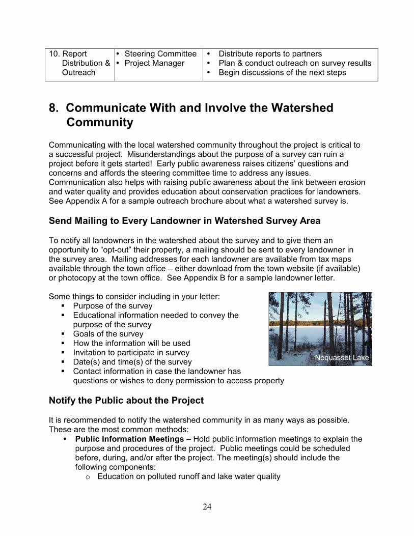
Nequasset Lake
25
o Information about known problems or sensitive habitats in the watershed/stream
o Summary of project goals o Description of survey process o Question and answer session
� Newsletter Articles – Include information about the survey in your lake association newsletter, or in another local entity’s newsletter.
� Local Media – Many people would prefer to learn about the project through the media rather than attending meetings or actively participating. Invite the press to all public meetings and volunteer training sessions. Send press releases to the local newspaper with written progress summaries throughout the life of the project. See Appendix C for a sample press release.
� Police and/or Town Office – Notify the police or town office about the survey, in case they receive phone calls about suspicious people walking around taking notes the day of your survey. Giving a heads-up to the police can help reduce confusion and suspicion.
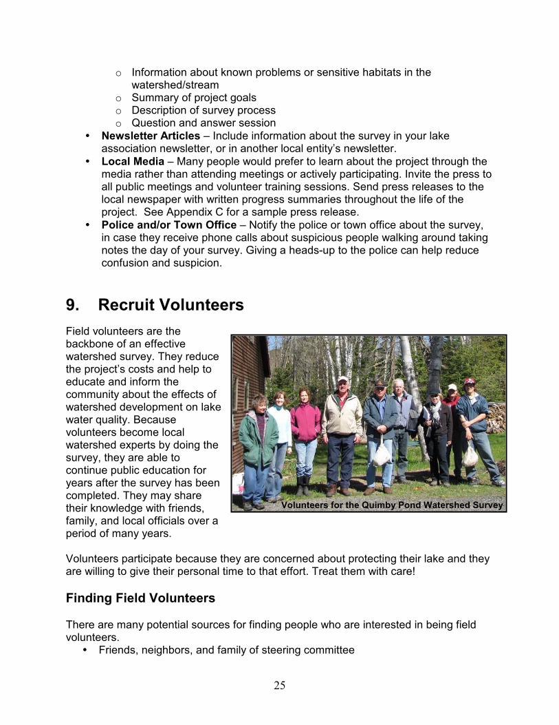
9. Recruit Volunteers
Field volunteers are the backbone of an effective watershed survey. They reduce the project’s costs and help to educate and inform the community about the effects of watershed development on lake water quality. Because volunteers become local watershed experts by doing the survey, they are able to continue public education for years after the survey has been completed. They may share their knowledge with friends, family, and local officials over a period of many years. Volunteers participate because they are concerned about protecting their lake and they are willing to give their personal time to that effort. Treat them with care!
Finding Field Volunteers There are many potential sources for finding people who are interested in being field volunteers.
� Friends, neighbors, and family of steering committee
Volunteers for the Quimby Pond Watershed Survey

26
� Lake association board members � Lake association members � Road associations � Local conservation associations � Conservation commissions � Comprehensive planning committees � Students from college environmental studies programs � Local community service organizations: retiree organizations (such as AARP) or
a local organization of retired business persons. � Fish and Game clubs � Youth conservation groups and high school students – generally, groups have
had the best experience working with volunteers older than 16 years since they tend to have greater attention spans and patience, and be more responsible. Students ages 12 - 15 may also make good survey participants, but try to make sure ahead of time that they would be interested in the event and there is a chaperone for every 3 students.
Number of Volunteers The size of and amount of development in your lake watershed affects how many survey volunteers you will need. Most volunteers have limited time to devote to a watershed survey, and it is important to avoid causing people to 'burn out" on the project. Involve enough volunteers to get a critical look at all developed property, including roads and logging areas. If you have too few volunteers, it may be difficult to cover all of the watershed in the time allotted or you may have volunteers burn out. In general, 15-20 volunteers, or 2-3 volunteers per sector, is the average for a watershed survey. For large, densely developed watersheds, it may not be feasible to survey the entire watershed in one year. Try to estimate how much area can be covered, based on the size of the watershed, the number of volunteers available, and an assumption that each volunteer is willing to spend one to two days in the field.
What Volunteers Should Expect Usually survey volunteers should plan on a time commitment of 8 to 25 hours (1 to 3 days). Each volunteer should make a minimum time commitment of the one full day of the training and survey. If more time is needed to finish up the survey, the volunteers
Sabbathday Lake Watershed Survey Volunteers
27
from the unfinished sectors may also be asked if they can finish it up within a certain amount of time (often 2 weeks to a month). Volunteers should expect to work in a group to carefully provide written, photographic, and possibly other types of documentation of the problem sites they find. Volunteers should be prepared to work rain or shine, since a survey is usually only postponed if there is dangerous weather such as lightning. Volunteers should dress for the elements and bring bug spray, sunscreen, a hat, water, lunch, hiking shoes, and appropriate clothing outdoor walking. Since the survey focuses only on developed areas though, volunteers won’t need to hike up streams, through wetlands, or across forested areas. See Appendix D and E for handouts for volunteers regarding their roles and responsibilities.
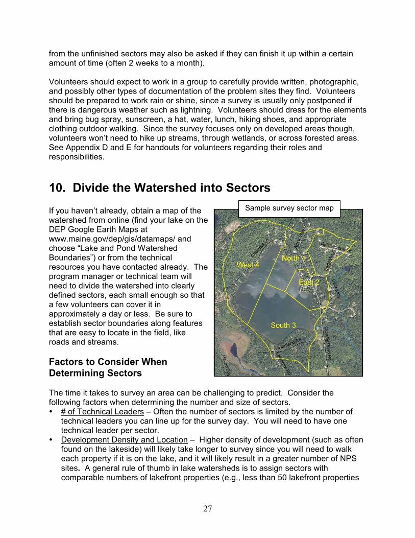
10. Divide the Watershed into Sectors If you haven’t already, obtain a map of the watershed from online (find your lake on the DEP Google Earth Maps at www.maine.gov/dep/gis/datamaps/ and choose “Lake and Pond Watershed Boundaries”) or from the technical resources you have contacted already. The program manager or technical team will need to divide the watershed into clearly defined sectors, each small enough so that a few volunteers can cover it in approximately a day or less. Be sure to establish sector boundaries along features that are easy to locate in the field, like roads and streams.
Factors to Consider When
Determining Sectors The time it takes to survey an area can be challenging to predict. Consider the following factors when determining the number and size of sectors. � # of Technical Leaders – Often the number of sectors is limited by the number of
technical leaders you can line up for the survey day. You will need to have one technical leader per sector.
� Development Density and Location – Higher density of development (such as often found on the lakeside) will likely take longer to survey since you will need to walk each property if it is on the lake, and it will likely result in a greater number of NPS
sites. A general rule of thumb in lake watersheds is to assign sectors with comparable numbers of lakefront properties (e.g., less than 50 lakefront properties
Sample survey sector map

28
would be a feasible number to survey). The physical size of sectors with dense lakefront development will likely be considerably smaller than sparsely developed areas in the upper watershed.
� # of Volunteers – You will need to have 2-3 volunteers per sector. The more sectors you can make, the less time each one will take to survey, and the happier your volunteers will be.
� # of Erosion Sites Found – If there are very few erosion sites or other NPS problems, volunteers can move quickly through a large area. Oftentimes, steep gravel roads and high density lakefront developments have more erosion sites and take longer to survey. Estimate more time (and therefore make a smaller sector) for areas that you expect to have lots of erosion sites.
� Landowner Interaction – If the survey takes place when most landowners are home, while this can be a great educational opportunity, it can also be time consuming to talk with people.
In some cases, the entire watershed may not be surveyed, particularly if the lake watershed is very large, highly developed, or if there is limited technical support staff or volunteers. The technical team needs to decide which areas will be surveyed, and might choose to focus on a portion of the watershed or a mix of representative sectors (e.g. shoreline areas, upland areas, higher developed areas). While you will likely sketch the sector boundaries in by hand when you are determining where they will be, you may also want to get them into an electronic format. To do this, either do so in Google Earth, or see if someone from the technical team or DEP may be able to do so. Having an electronic version is helpful when creating maps of different scales to be used during the survey.
11. Private Property and Safety Issues
Accessing Private Property Before accessing or traveling on private property, it is important to have permission to access the property. This should be done ahead of time by sending a letter to affected landowners, giving them the opportunity to ‘opt-out’ their property. (See section 8 for more on how to do this.)
Tips on Accessing Private Property � Identify in the sector binder landowners who have denied access to their
property, and communicate this verbally to the volunteers surveying in those sectors or reaches.
Erosion site at lakeside property
29
� Do not survey any properties that ‘opted-out’ their property. Always honor the rights and wishes of property owners.
� Prior to surveying a property, knock on the door to ask permission. � If the property owner does not wish to have his or her property surveyed, you
must leave. � Always honor “No Trespassing” signs. � Avoid confrontations; they will not help to reach the overall goals of the survey
and could potentially jeopardize the project. � Make sure all volunteers have nametags, ID cards to leave in vehicle
windshields, extra copies of landowner letters, etc., as forms of identification for people they meet.
� These same procedures should be followed when surveying commercial properties.
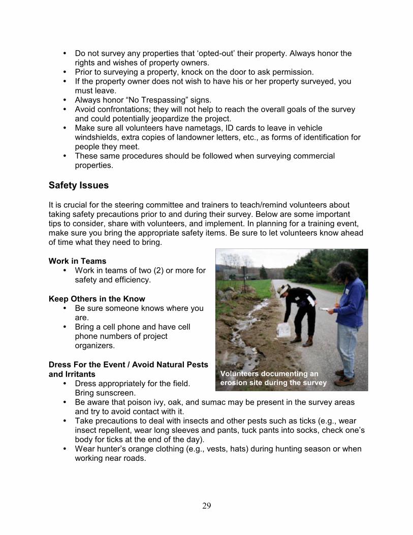
Safety Issues It is crucial for the steering committee and trainers to teach/remind volunteers about taking safety precautions prior to and during their survey. Below are some important tips to consider, share with volunteers, and implement. In planning for a training event, make sure you bring the appropriate safety items. Be sure to let volunteers know ahead of time what they need to bring.
Work in Teams � Work in teams of two (2) or more for
safety and efficiency.
Keep Others in the Know � Be sure someone knows where you
are. � Bring a cell phone and have cell
phone numbers of project organizers.
Dress For the Event / Avoid Natural Pests
and Irritants � Dress appropriately for the field.
Bring sunscreen. � Be aware that poison ivy, oak, and sumac may be present in the survey areas
and try to avoid contact with it. � Take precautions to deal with insects and other pests such as ticks (e.g., wear
insect repellent, wear long sleeves and pants, tuck pants into socks, check one’s body for ticks at the end of the day).
� Wear hunter’s orange clothing (e.g., vests, hats) during hunting season or when working near roads.
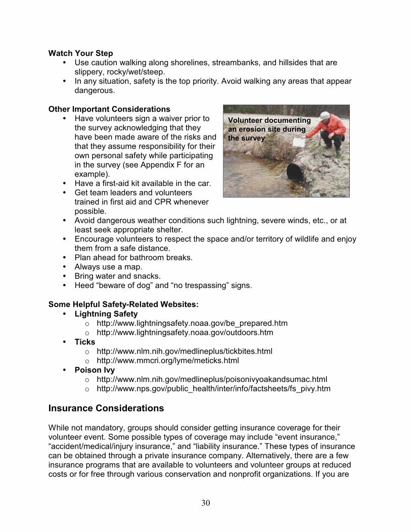
Volunteers documenting an
erosion site during the survey
30
Watch Your Step � Use caution walking along shorelines, streambanks, and hillsides that are
slippery, rocky/wet/steep. � In any situation, safety is the top priority. Avoid walking any areas that appear
dangerous.
Other Important Considerations � Have volunteers sign a waiver prior to
the survey acknowledging that they have been made aware of the risks and that they assume responsibility for their own personal safety while participating in the survey (see Appendix F for an example).
� Have a first-aid kit available in the car. � Get team leaders and volunteers
trained in first aid and CPR whenever possible.
� Avoid dangerous weather conditions such lightning, severe winds, etc., or at least seek appropriate shelter.
� Encourage volunteers to respect the space and/or territory of wildlife and enjoy them from a safe distance.
� Plan ahead for bathroom breaks. � Always use a map. � Bring water and snacks. � Heed “beware of dog” and “no trespassing” signs.
Some Helpful Safety-Related Websites:
� Lightning Safety o http://www.lightningsafety.noaa.gov/be_prepared.htm o http://www.lightningsafety.noaa.gov/outdoors.htm
� Ticks o http://www.nlm.nih.gov/medlineplus/tickbites.html o http://www.mmcri.org/lyme/meticks.html
� Poison Ivy o http://www.nlm.nih.gov/medlineplus/poisonivyoakandsumac.html o http://www.nps.gov/public_health/inter/info/factsheets/fs_pivy.htm
Insurance Considerations While not mandatory, groups should consider getting insurance coverage for their volunteer event. Some possible types of coverage may include “event insurance,” “accident/medical/injury insurance,” and “liability insurance.” These types of insurance can be obtained through a private insurance company. Alternatively, there are a few insurance programs that are available to volunteers and volunteer groups at reduced costs or for free through various conservation and nonprofit organizations. If you are
Volunteer documenting
an erosion site during
the survey

31
partnering with a county SWCD, you might be able to have coverage through the Earth Team program. Contact the DEP for advice on possible insurance opportunities. Insurance agents are another good source of information. You can also check out resources available on the Internet that may answer your questions:
Nonprofit Risk Management Center � Insurance for Volunteer Programs
o http://nonprofitrisk.org/library/articles/insurance052004.shtml � Glossary of Risk Management and Insurance Terms
o http://nonprofitrisk.org/library/glossary.shtml � Myths of Volunteer Risk Management – in three parts:
o http://nonprofitrisk.org/library/articles/volunteer050098.shtml o http://nonprofitrisk.org/library/articles/volunteer09001998.shtml o http://nonprofitrisk.org/library/articles/volunteer010299.shtml
Public Entity Risk Institute � Insuring Volunteers - www.riskinstitute.org/peri/ � Myths About Nonprofit Liability and Risk Management -
www.riskinstitute.org/peri/
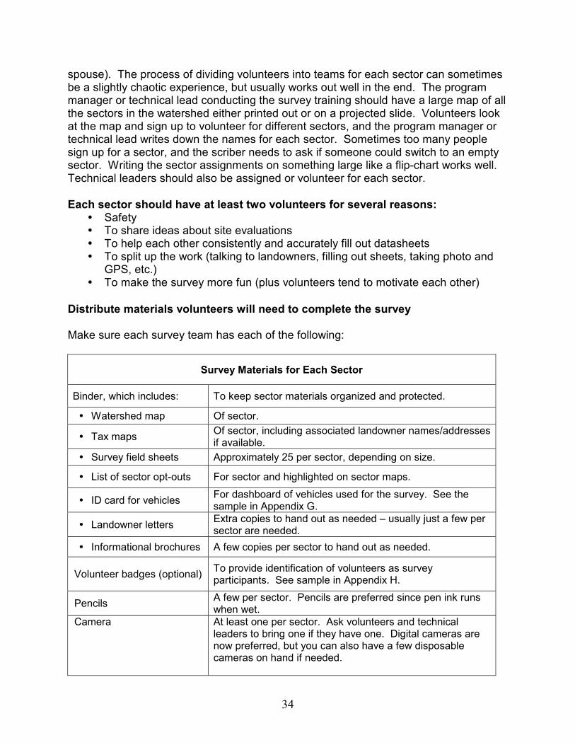
12. Compile Materials for Survey See pages 34-35 for a list of materials for each sector. Following are some more details on a few of the materials that will need to be developed prior to the survey.
Maps Each sector will need a map of their sector to know what area to survey, to reference where they are, and to mark sites on. If available, use a map with aerial photos (available from Google Maps, Google Earth, or GIS), overlain with the watershed and sector boundaries. Be sure to label each sector so groups are sure what area they need to survey, and where to stop. Town tax maps may also be used to supplement the GIS survey maps. Generally the tax maps are used to note tax map lot number and landowner name. This information is important if you plan to share survey findings with landowners associated with identified erosion sites.
Forms Each sector will also need forms to complete for each site. The number of forms to give each sector should vary depending on the amount of development in the sector and the likely number of NPS problems that will be encountered. Generally, around 25

32
forms per sector should be sufficient for the survey day. See Appendix J for a sample survey form.
Outreach Material Each sector will also need a few copies of the landowner letter and any brochures to hand out to interested landowners. Usually just 2-3 of each is sufficient, unless you anticipate a lot of interaction with landowners.
13. Hold Training for Field Volunteers Training is generally broken into two sessions. The first is an indoor session providing volunteers with background information on lake and watershed ecology and instructions on how to identify and document erosion sites. The second is an outdoor training where the large group is divided into smaller sector groups, and each small group goes into the field with a technical support person. Attention is taken to ensure that each volunteer has the opportunity to practice identifying a site, filling out the survey form, and receiving feedback.
Who Should Do the Training
Training should be provided by technically-qualified individuals (i.e., technical team members) who have been selected by the steering committee. Names of qualified individuals can be obtained from the Watershed Management Division of the DEP or your county soil and water conservation district.
What Volunteers Should Bring to the Training Volunteers should dress for the elements and bring bug spray, sunscreen, a hat, water, lunch, hiking shoes, and appropriate clothing for outdoor walking. Also, if you don’t have enough cameras and GPS units to loan to each survey team, check with
Indoor training session
33
volunteers to see if they can provide their own. Since conducting the survey typically directly follows the training, volunteers should be dressed and ready for field work.
What Volunteers Should Learn from the Training Classroom training includes an overview of typical nonpoint source problems and solutions, and how to complete the field sheet. At the end of the training, photos are presented to the group showing sample problems. The group discusses how to describe and fix each problem. Volunteers should understand there are three fundamental questions that need to be answered in reporting each problem:
� Where is the problem? � What is the problem? � How might this problem be fixed (as best as the volunteer can determine)?
A Microsoft PowerPoint presentation which covers these questions is available from DEP Division of Watershed Management and can be tailored to your local watershed.
The following topics are typically included in volunteer training: � What a watershed is and what the local watershed looks like. � What stormwater runoff and nonpoint source pollution are and how they affect
lake water quality. � How soil erosion and phosphorus affect lake water quality. � Lake ecology and how changes to the lake’s ecology can reduce recreational
enjoyment. � How changes in water quality affect the local economy. � Examples of typical erosion and other pollution problems. � How to fill out a survey form. � How to approach, and discuss the survey with, landowners. � How to use GPS units, and the importance of recording every digit without
rounding off. � Survey-specific details: survey deadline,
how and where to turn in completed survey materials.
� Next steps: how the survey data will be used.
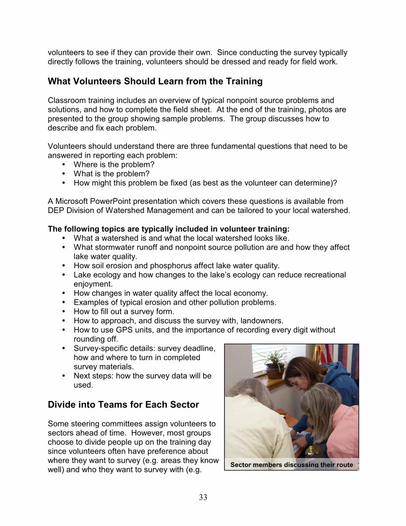
Divide into Teams for Each Sector Some steering committees assign volunteers to sectors ahead of time. However, most groups choose to divide people up on the training day since volunteers often have preference about where they want to survey (e.g. areas they know well) and who they want to survey with (e.g.
Sector members discussing their route
34
spouse). The process of dividing volunteers into teams for each sector can sometimes be a slightly chaotic experience, but usually works out well in the end. The program manager or technical lead conducting the survey training should have a large map of all the sectors in the watershed either printed out or on a projected slide. Volunteers look at the map and sign up to volunteer for different sectors, and the program manager or technical lead writes down the names for each sector. Sometimes too many people sign up for a sector, and the scriber needs to ask if someone could switch to an empty sector. Writing the sector assignments on something large like a flip-chart works well. Technical leaders should also be assigned or volunteer for each sector.
Each sector should have at least two volunteers for several reasons: � Safety � To share ideas about site evaluations � To help each other consistently and accurately fill out datasheets � To split up the work (talking to landowners, filling out sheets, taking photo and
GPS, etc.) � To make the survey more fun (plus volunteers tend to motivate each other)
Distribute materials volunteers will need to complete the survey Make sure each survey team has each of the following:
Survey Materials for Each Sector
Binder, which includes: To keep sector materials organized and protected.
� Watershed map Of sector.
� Tax maps Of sector, including associated landowner names/addresses if available.
� Survey field sheets Approximately 25 per sector, depending on size.
� List of sector opt-outs For sector and highlighted on sector maps.
� ID card for vehicles For dashboard of vehicles used for the survey. See the sample in Appendix G.
� Landowner letters Extra copies to hand out as needed – usually just a few per sector are needed.
� Informational brochures A few copies per sector to hand out as needed.
Volunteer badges (optional) To provide identification of volunteers as survey participants. See sample in Appendix H.
Pencils A few per sector. Pencils are preferred since pen ink runs when wet.
Camera At least one per sector. Ask volunteers and technical leaders to bring one if they have one. Digital cameras are now preferred, but you can also have a few disposable cameras on hand if needed.

35
Handheld GPS unit One per sector. Check with your technical leaders to see if they can bring some to use for the survey day. Also ask volunteers to bring one if they have one.
Site photo numbers One flipchart per sector. For site identification in photographs. Check with the DEP or SWCD to see if they have some for loan, or create your own using template in Appendix I.
Blaze orange safety clothing
Blaze orange vests, hats, or other clothing for groups working on roads or during hunting season.
Rainy Weather It is often easy to identify problems if the survey takes place when it is raining or soon after a rainstorm. That said, it can be difficult to conduct the survey during a steady rain or downpour conditions. Unless write-in-the-rain paper is used, it can be difficult to clearly fill out field sheets. Photos can also be of poor quality in the rain. Rainy conditions are also uncomfortable for volunteers so they might not be as thorough in their survey methods. In such cases, volunteers should be given the option to discontinue the survey and reschedule the remainder of their field work under better conditions. Since it might not be possible for the technical leader to reschedule, the group should at least visit a few sites so they are trained to continue independently.
14. Conduct the Survey The collection of survey data usually begins during the field portion of the training. Volunteers, with guidance from the technical leader, document sites by completing standard forms, taking digital photos, recording the GPS coordinates and marking the site location on maps.
Survey Methods Volunteers should visit all developed areas in their assigned sector. A good way to do this is for volunteers to start at one side of their assigned survey sector and walk or drive all roads and properties (except where landowners have denied access). Typically, properties not on the shore can be viewed from the downhill side to see if there is any evidence of erosion making its way off the property to the lake. If there is, investigate further. If not, you do not
Sleuthing out a site
Do you document all erosion sites? No. Only sites where the eroded sediment likely makes it to the lake should be documented. The purpose of the survey is to document sources of phosphorus to the lake, not all erosion sites.
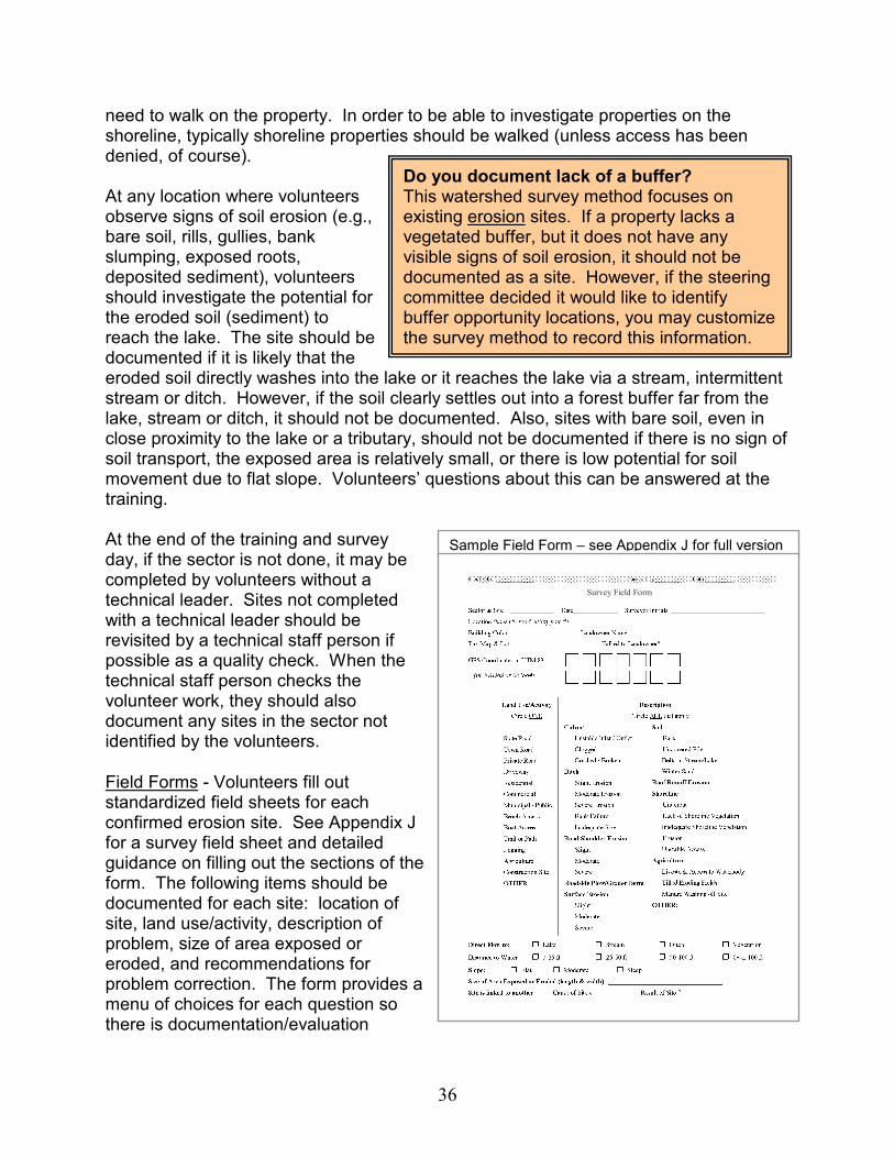
36
need to walk on the property. In order to be able to investigate properties on the shoreline, typically shoreline properties should be walked (unless access has been denied, of course). At any location where volunteers observe signs of soil erosion (e.g., bare soil, rills, gullies, bank slumping, exposed roots, deposited sediment), volunteers should investigate the potential for the eroded soil (sediment) to reach the lake. The site should be documented if it is likely that the eroded soil directly washes into the lake or it reaches the lake via a stream, intermittent stream or ditch. However, if the soil clearly settles out into a forest buffer far from the lake, stream or ditch, it should not be documented. Also, sites with bare soil, even in close proximity to the lake or a tributary, should not be documented if there is no sign of soil transport, the exposed area is relatively small, or there is low potential for soil movement due to flat slope. Volunteers’ questions about this can be answered at the training. At the end of the training and survey day, if the sector is not done, it may be completed by volunteers without a technical leader. Sites not completed with a technical leader should be revisited by a technical staff person if possible as a quality check. When the technical staff person checks the volunteer work, they should also document any sites in the sector not identified by the volunteers.
Field Forms - Volunteers fill out standardized field sheets for each confirmed erosion site. See Appendix J for a survey field sheet and detailed guidance on filling out the sections of the form. The following items should be documented for each site: location of site, land use/activity, description of problem, size of area exposed or eroded, and recommendations for problem correction. The form provides a menu of choices for each question so there is documentation/evaluation
Do you document lack of a buffer? This watershed survey method focuses on existing erosion sites. If a property lacks a vegetated buffer, but it does not have any visible signs of soil erosion, it should not be documented as a site. However, if the steering committee decided it would like to identify buffer opportunity locations, you may customize the survey method to record this information.
Sample Field Form – see Appendix J for full version
Survey Field Form
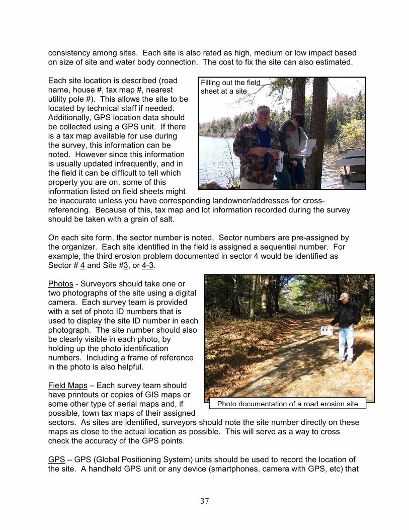
37
consistency among sites. Each site is also rated as high, medium or low impact based on size of site and water body connection. The cost to fix the site can also estimated. Each site location is described (road name, house #, tax map #, nearest utility pole #). This allows the site to be located by technical staff if needed. Additionally, GPS location data should be collected using a GPS unit. If there is a tax map available for use during the survey, this information can be noted. However since this information is usually updated infrequently, and in the field it can be difficult to tell which property you are on, some of this information listed on field sheets might be inaccurate unless you have corresponding landowner/addresses for cross-referencing. Because of this, tax map and lot information recorded during the survey should be taken with a grain of salt. On each site form, the sector number is noted. Sector numbers are pre-assigned by the organizer. Each site identified in the field is assigned a sequential number. For example, the third erosion problem documented in sector 4 would be identified as Sector # 4 and Site #3, or 4-3. Photos - Surveyors should take one or two photographs of the site using a digital camera. Each survey team is provided with a set of photo ID numbers that is used to display the site ID number in each photograph. The site number should also be clearly visible in each photo, by holding up the photo identification numbers. Including a frame of reference in the photo is also helpful. Field Maps – Each survey team should have printouts or copies of GIS maps or some other type of aerial maps and, if possible, town tax maps of their assigned sectors. As sites are identified, surveyors should note the site number directly on these maps as close to the actual location as possible. This will serve as a way to cross check the accuracy of the GPS points.
GPS – GPS (Global Positioning System) units should be used to record the location of the site. A handheld GPS unit or any device (smartphones, camera with GPS, etc) that
Photo documentation of a road erosion site
Filling out the field sheet at a site

38
has a way to read the coordinates from, can be used. Currently, the recommended method is to record the coordinates on the field sheet. As cameras with GPS become more common, methods to download the coordinates with the photos will be developed. Coordinate readings should be made in either UTM Zone 19 (Universal Transverse Mercator) coordinates or latitude/longitude using either NAD 83 or WGS84 datum. UTM coordinates are preferred if GIS mapping of identified sites will be done using ArcMap or ArcInfo software. Latitude/longitude are preferred if mapping will be done using Google Earth or Google Map. Having the coordinates in the preferred format reduces the need to convert to the appropriate format, and therefore saves time. Before the survey begins, the project manager should decide which coordinate system is preferred based on the software planned for mapping. The field form should note which type of coordinate format is required, and should have the correct number of place holders to ensure all numbers are recorded. This information should also be highlighted at the training, and, ideally, all GPS units will be turned on and compared before the training to make sure they are set correctly and uniformly. Organizers should ensure there are enough GPS units for the training and survey day so that each sector will have one.
Site Sketches (optional) – The Project Manager and technical team can decide if site sketches are needed for the survey or not, or if they can be done only on an ‘as-needed’ basis. Generally, a sketch is only needed if it would help clarify what is occurring at a particularly complex site. Whether a site sketch is needed or not is often left up to the survey team to decide on a site-specific basis. If a sketch is deemed necessary, one person in the survey team should complete a quick sketch of each problem site on the provided Sketch Sheet (Appendix J). The sketch should include identifying features surrounding the site (e.g., lake, road, stream, house), symbols to describe the location and extent of erosion, and if possible the location and types of recommended BMPs.
Some Basic Tips to Keep in Mind while Conducting the Survey:
At the beginning of the day Have a sign-in sheet for all survey participants to sign when they arrive. This is helpful to make sure you have the name and contact of everyone who was involved – to be able to acknowledge them in the report and contact them in case of questions about their survey sector. Also, if you can, take a photo of all the survey participants prior to their going out in the field. A photo of the whole group is great to include in survey reports and other outreach materials.
Duckpuddle Pond survey participants
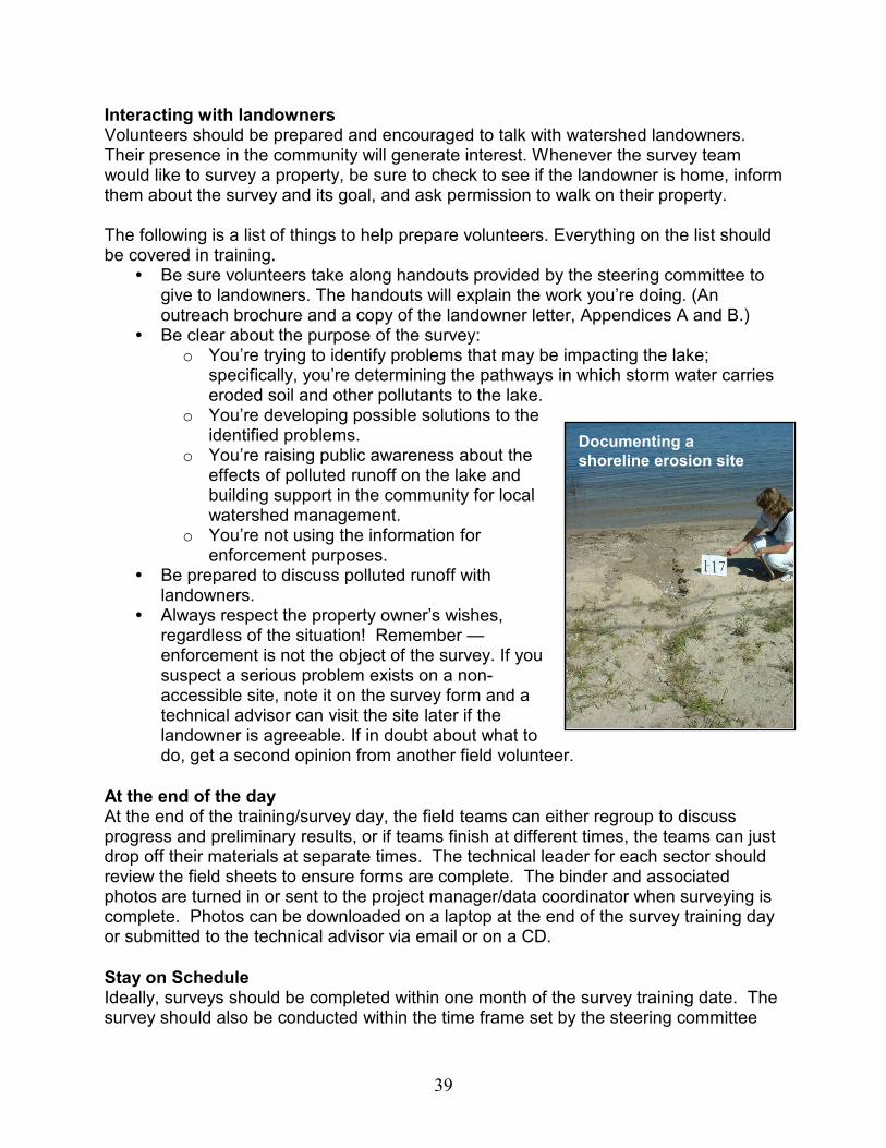
39
Interacting with landowners Volunteers should be prepared and encouraged to talk with watershed landowners. Their presence in the community will generate interest. Whenever the survey team would like to survey a property, be sure to check to see if the landowner is home, inform them about the survey and its goal, and ask permission to walk on their property. The following is a list of things to help prepare volunteers. Everything on the list should be covered in training.
� Be sure volunteers take along handouts provided by the steering committee to give to landowners. The handouts will explain the work you’re doing. (An outreach brochure and a copy of the landowner letter, Appendices A and B.)
� Be clear about the purpose of the survey: o You’re trying to identify problems that may be impacting the lake;
specifically, you’re determining the pathways in which storm water carries eroded soil and other pollutants to the lake.
o You’re developing possible solutions to the identified problems.
o You’re raising public awareness about the effects of polluted runoff on the lake and building support in the community for local watershed management.
o You’re not using the information for enforcement purposes.
� Be prepared to discuss polluted runoff with landowners.
� Always respect the property owner’s wishes, regardless of the situation! Remember — enforcement is not the object of the survey. If you suspect a serious problem exists on a non-accessible site, note it on the survey form and a technical advisor can visit the site later if the landowner is agreeable. If in doubt about what to do, get a second opinion from another field volunteer.
At the end of the day At the end of the training/survey day, the field teams can either regroup to discuss progress and preliminary results, or if teams finish at different times, the teams can just drop off their materials at separate times. The technical leader for each sector should review the field sheets to ensure forms are complete. The binder and associated photos are turned in or sent to the project manager/data coordinator when surveying is complete. Photos can be downloaded on a laptop at the end of the survey training day or submitted to the technical advisor via email or on a CD.
Stay on Schedule Ideally, surveys should be completed within one month of the survey training date. The survey should also be conducted within the time frame set by the steering committee
Documenting a
shoreline erosion site

40
and technical advisors. Make sure the volunteers are aware of the survey deadlines. The public will be expecting volunteers to be surveying the watershed within the period of time discussed in newspaper articles and landowner letters. Staying within the designated time frame also allows time during the follow-up process for technical advisors to contact volunteers with questions concerning their findings.
15. Give Preliminary Data to Technical Team for
Review Immediately after the survey is finished, all data should be reviewed first by the volunteer coordinator (if there is one), and then by the technical advisor(s) to be sure each team has properly completed the survey forms and that all survey sectors have been completely covered. If information is missing or incomplete, the volunteer coordinator should contact the volunteers immediately to ask them to provide the missing information or return to the field to get it. Volunteers may be reluctant to return to the field several weeks after the information has been collected. Contacting the volunteers shortly after they have completed their work can save the time and expense of having technical advisors spend hours in the field attempting to locate problems of undetermined location and nature.
Send the Technical Team into the Field for Follow-up Site Visits A technical team advisor should do follow up in areas that were visited after the original training day (i.e., sites identified by volunteers without a technical advisor present). The purpose of this step is to check the accuracy of documented sites and to look for additional undocumented sites. This process may take several weeks, depending on the number of problems identified and the time availability of the technical team. The technical advisor should expect to spend approximately the same amount of time (or possibly more) following up on each sector as the volunteers spent surveying that sector. If volunteers did a fairly thorough and accurate job, the follow-up by the technical person will take less time.
Review Data Sheets The project manager or technical advisor should check all the completed survey forms for consistency with the methods described in this manual, that they are consistent in their evaluation method across sectors, and that recommendations are appropriate. The ratings for ‘Impact’ and items listed under ‘Description’ and ‘Size’ should all be consistent. For example, small sites with only ‘slight surface erosion’, should probably not be listed as ‘high impact’ sites. Project managers should also check forms to see if types of problems and solutions match. For example, a site with an unstable culvert
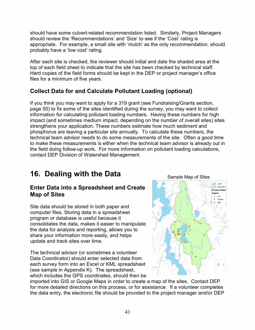
41
should have some culvert-related recommendation listed. Similarly, Project Managers should review the ‘Recommendations’ and ‘Size’ to see if the ‘Cost’ rating is appropriate. For example, a small site with ‘mulch’ as the only recommendation, should probably have a ‘low cost’ rating. After each site is checked, the reviewer should initial and date the shaded area at the top of each field sheet to indicate that the site has been checked by technical staff. Hard copies of the field forms should be kept in the DEP or project manager’s office files for a minimum of five years.
Collect Data for and Calculate Pollutant Loading (optional) If you think you may want to apply for a 319 grant (see Fundraising/Grants section, page 50) to fix some of the sites identified during the survey, you may want to collect information for calculating pollutant loading numbers. Having these numbers for high impact (and sometimes medium impact, depending on the number of overall sites) sites strengthens your application. These numbers estimate how much sediment and phosphorus are leaving a particular site annually. To calculate these numbers, the technical team advisor needs to do some measurements of the site. Often a good time to make these measurements is either when the technical team advisor is already out in the field doing follow-up work. For more information on pollutant loading calculations, contact DEP Division of Watershed Management.
16. Dealing with the Data
Enter Data into a Spreadsheet and Create
Map of Sites Site data should be stored in both paper and computer files. Storing data in a spreadsheet program or database is useful because it consolidates the data, makes it easier to manipulate the data for analysis and reporting, allows you to share your information more easily, and helps update and track sites over time. The technical advisor (or sometimes a volunteer Data Coordinator) should enter selected data from each survey form into an Excel or KML spreadsheet (see sample in Appendix K). The spreadsheet, which includes the GPS coordinates, should then be imported into GIS or Google Maps in order to create a map of the sites. Contact DEP for more detailed directions on this process, or for assistance. If a volunteer completes the data entry, the electronic file should be provided to the project manager and/or DEP
Sample Map of Sites
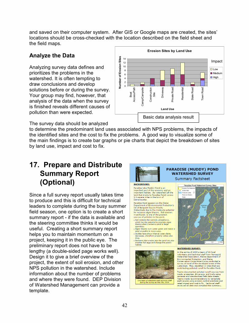
42
and saved on their computer system. After GIS or Google maps are created, the sites’ locations should be cross-checked with the location described on the field sheet and the field maps.
Analyze the Data Analyzing survey data defines and prioritizes the problems in the watershed. It is often tempting to draw conclusions and develop solutions before or during the survey. Your group may find, however, that analysis of the data when the survey is finished reveals different causes of pollution than were expected. The survey data should be analyzed to determine the predominant land uses associated with NPS problems, the impacts of the identified sites and the cost to fix the problems. A good way to visualize some of the main findings is to create bar graphs or pie charts that depict the breakdown of sites by land use, impact and cost to fix.
17. Prepare and Distribute
Summary Report
(Optional) Since a full survey report usually takes time to produce and this is difficult for technical leaders to complete during the busy summer field season, one option is to create a short summary report - if the data is available and the steering committee thinks it would be useful. Creating a short summary report helps you to maintain momentum on a project, keeping it in the public eye. The preliminary report does not have to be lengthy (a double-sided page works well). Design it to give a brief overview of the project, the extent of soil erosion, and other NPS pollution in the watershed. Include information about the number of problems and where they were found. DEP Division of Watershed Management can provide a template.
Erosion Sites by Land Use
0
2
4
6
8
10
12
14
Boat
Access/Path
Camp/Campsite
Construction
Site
Driveway
Private Road
Residential
State Road
Town Road
Land Use
Number of Erosion Sites
Low
Medium
High
Impact
Basic data analysis result
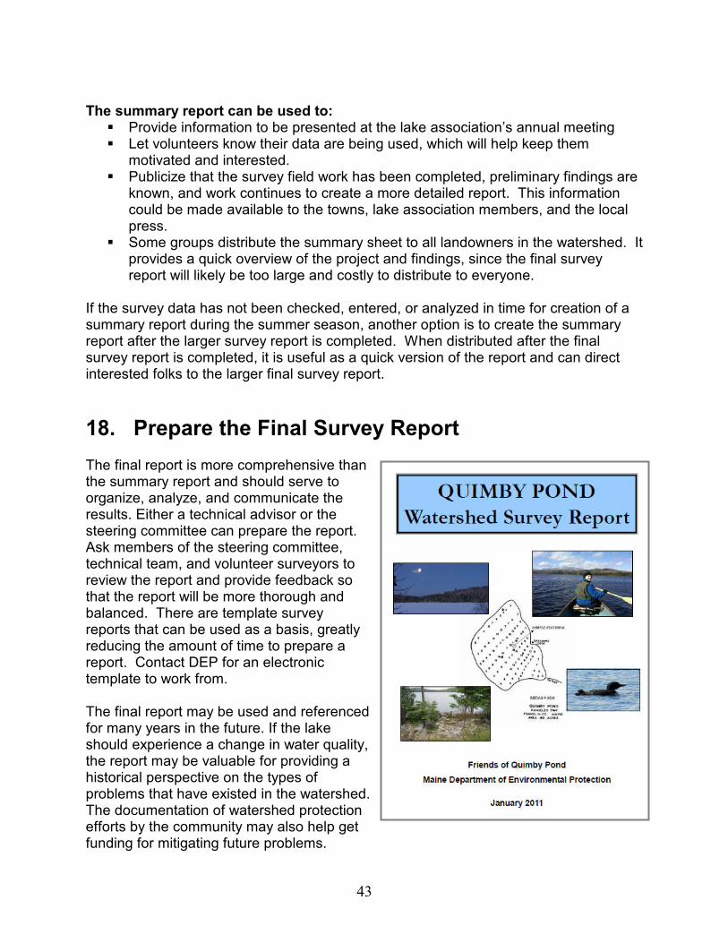
43
The summary report can be used to: � Provide information to be presented at the lake association’s annual meeting � Let volunteers know their data are being used, which will help keep them
motivated and interested. � Publicize that the survey field work has been completed, preliminary findings are
known, and work continues to create a more detailed report. This information could be made available to the towns, lake association members, and the local press.
� Some groups distribute the summary sheet to all landowners in the watershed. It provides a quick overview of the project and findings, since the final survey report will likely be too large and costly to distribute to everyone.
If the survey data has not been checked, entered, or analyzed in time for creation of a summary report during the summer season, another option is to create the summary report after the larger survey report is completed. When distributed after the final survey report is completed, it is useful as a quick version of the report and can direct interested folks to the larger final survey report.
18. Prepare the Final Survey Report The final report is more comprehensive than the summary report and should serve to organize, analyze, and communicate the results. Either a technical advisor or the steering committee can prepare the report. Ask members of the steering committee, technical team, and volunteer surveyors to review the report and provide feedback so that the report will be more thorough and balanced. There are template survey reports that can be used as a basis, greatly reducing the amount of time to prepare a report. Contact DEP for an electronic template to work from. The final report may be used and referenced for many years in the future. If the lake should experience a change in water quality, the report may be valuable for providing a historical perspective on the types of problems that have existed in the watershed. The documentation of watershed protection efforts by the community may also help get funding for mitigating future problems.
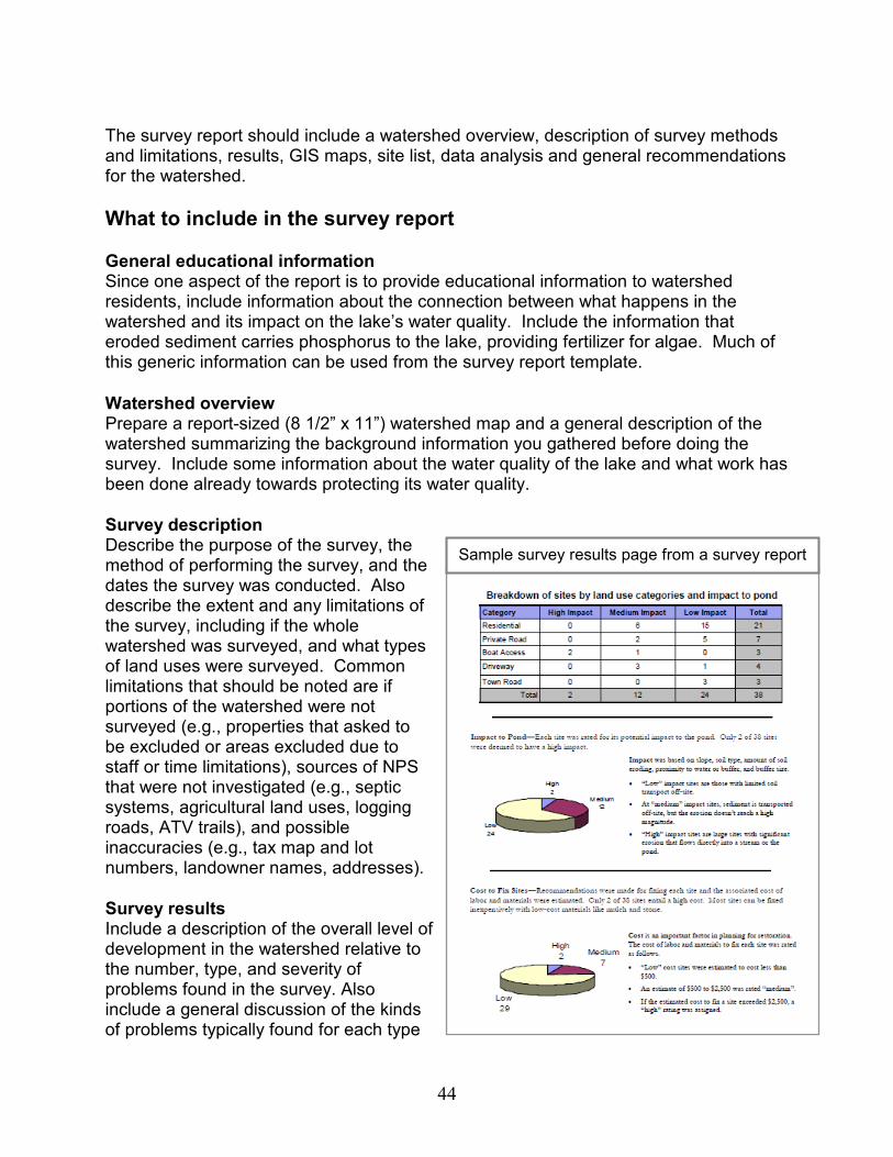
44
The survey report should include a watershed overview, description of survey methods and limitations, results, GIS maps, site list, data analysis and general recommendations for the watershed.
What to include in the survey report
General educational information Since one aspect of the report is to provide educational information to watershed residents, include information about the connection between what happens in the watershed and its impact on the lake’s water quality. Include the information that eroded sediment carries phosphorus to the lake, providing fertilizer for algae. Much of this generic information can be used from the survey report template.
Watershed overview Prepare a report-sized (8 1/2” x 11”) watershed map and a general description of the watershed summarizing the background information you gathered before doing the survey. Include some information about the water quality of the lake and what work has been done already towards protecting its water quality.
Survey description Describe the purpose of the survey, the method of performing the survey, and the dates the survey was conducted. Also describe the extent and any limitations of the survey, including if the whole watershed was surveyed, and what types of land uses were surveyed. Common limitations that should be noted are if portions of the watershed were not surveyed (e.g., properties that asked to be excluded or areas excluded due to staff or time limitations), sources of NPS that were not investigated (e.g., septic systems, agricultural land uses, logging roads, ATV trails), and possible inaccuracies (e.g., tax map and lot numbers, landowner names, addresses).
Survey results Include a description of the overall level of development in the watershed relative to the number, type, and severity of problems found in the survey. Also include a general discussion of the kinds of problems typically found for each type
Sample survey results page from a survey report
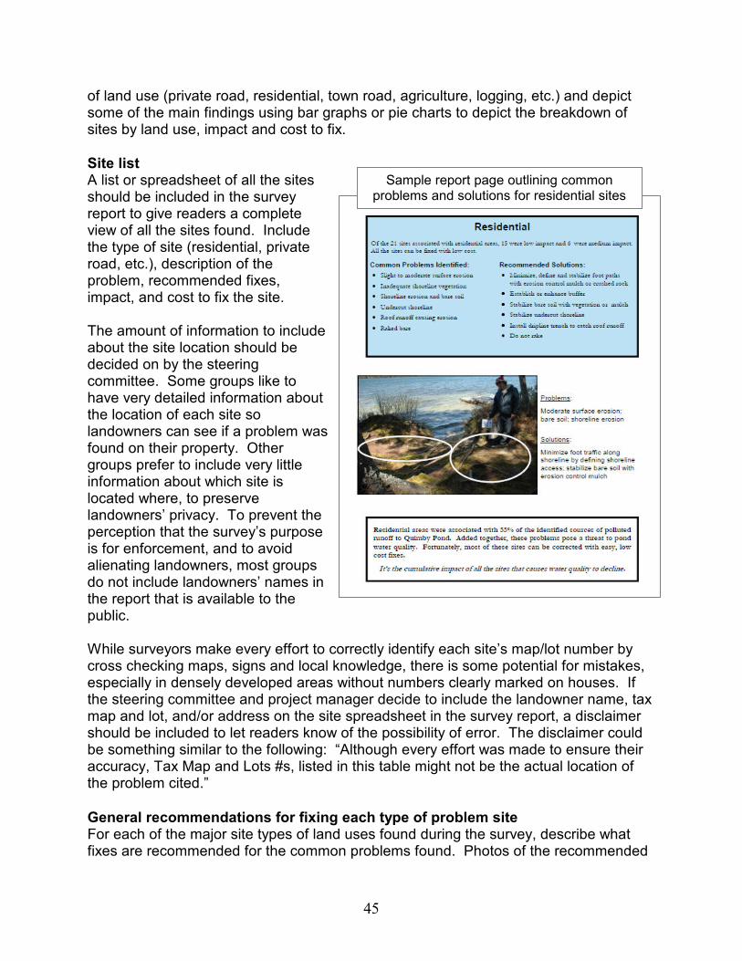
45
of land use (private road, residential, town road, agriculture, logging, etc.) and depict some of the main findings using bar graphs or pie charts to depict the breakdown of sites by land use, impact and cost to fix.
Site list A list or spreadsheet of all the sites should be included in the survey report to give readers a complete view of all the sites found. Include the type of site (residential, private road, etc.), description of the problem, recommended fixes, impact, and cost to fix the site. The amount of information to include about the site location should be decided on by the steering committee. Some groups like to have very detailed information about the location of each site so landowners can see if a problem was found on their property. Other groups prefer to include very little information about which site is located where, to preserve landowners’ privacy. To prevent the perception that the survey’s purpose is for enforcement, and to avoid alienating landowners, most groups do not include landowners’ names in the report that is available to the public. While surveyors make every effort to correctly identify each site’s map/lot number by cross checking maps, signs and local knowledge, there is some potential for mistakes, especially in densely developed areas without numbers clearly marked on houses. If the steering committee and project manager decide to include the landowner name, tax map and lot, and/or address on the site spreadsheet in the survey report, a disclaimer should be included to let readers know of the possibility of error. The disclaimer could be something similar to the following: “Although every effort was made to ensure their accuracy, Tax Map and Lots #s, listed in this table might not be the actual location of the problem cited.”
General recommendations for fixing each type of problem site For each of the major site types of land uses found during the survey, describe what fixes are recommended for the common problems found. Photos of the recommended
Sample report page outlining common problems and solutions for residential sites
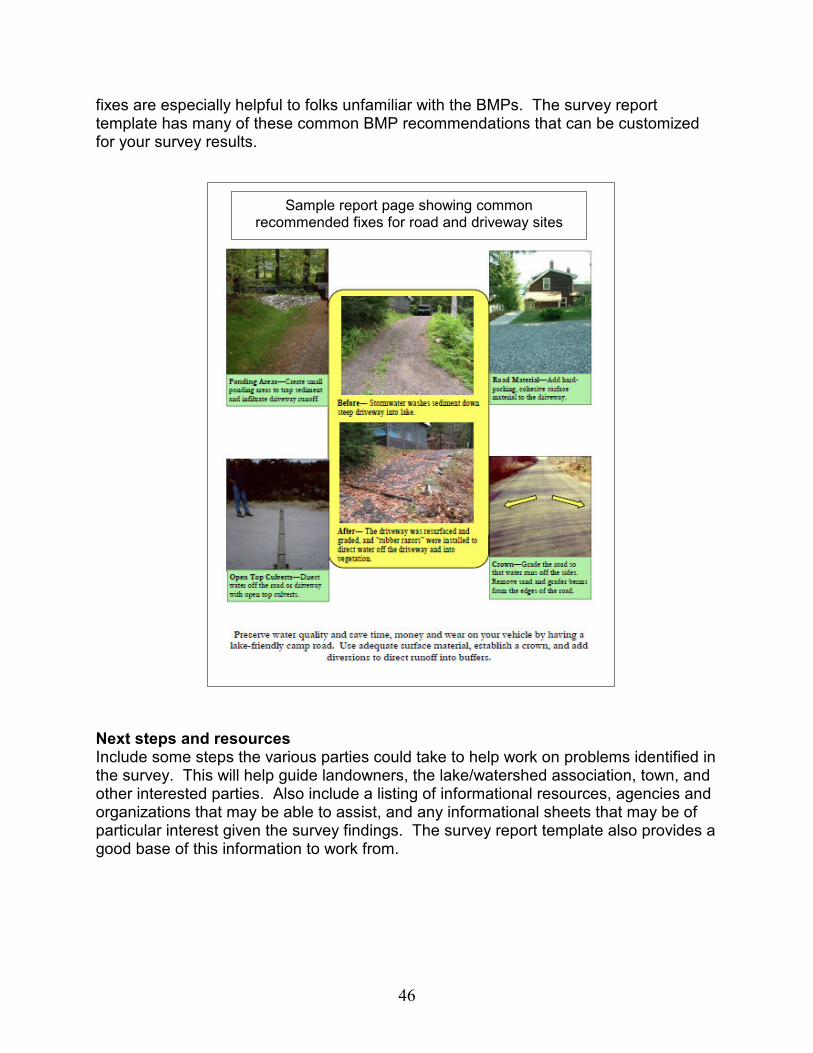
46
fixes are especially helpful to folks unfamiliar with the BMPs. The survey report template has many of these common BMP recommendations that can be customized for your survey results.
Next steps and resources Include some steps the various parties could take to help work on problems identified in the survey. This will help guide landowners, the lake/watershed association, town, and other interested parties. Also include a listing of informational resources, agencies and organizations that may be able to assist, and any informational sheets that may be of particular interest given the survey findings. The survey report template also provides a good base of this information to work from.
Sample report page showing common recommended fixes for road and driveway sites

47
After the Survey
Distributing the Findings Distribution of the survey findings can be done in several different ways depending on the number of reports printed, the plan for outreach about the results, and what actions have already been taken. At a minimum, the survey report should be distributed to the following:
� The lake or watershed association (see Appendix M for a sample newsletter article)
� Towns in the watershed – to the Conservation Commission, the selectmen, the planning board, or the code enforcement officer
� DEP Division of Watershed Management (electronic copy is sufficient) � Local county soil and water conservation district � Any other involved agencies/organizations, such as regional lake associations,
local land trusts, local conservation organizations, the University of Maine Cooperative Extension, etc.
� Individuals who requested a copy Other methods of outreach include:
� Presentation of the
findings to the town. Present to the conservation commission, planning board, or Board of Selectman. Have one or more of the participants in the survey present the information, and, if available, a technical advisor to help answer questions. Having a powerpoint presentation or posterboards to visually present the information can be particularly effective in helping people understand the survey findings. This can also be a good opportunity to provide specific information on town roads and other town sites and encourage the town to fix sites.
� Mailing to landowners with sites. Many lake/watershed associations send a letter to landowners with sites describing very briefly about the survey, the basics of what was found on their property, the recommended fixes for the site, and sources of more information. Be sure to be diplomatic. This is not intended to be an enforcement action, but rather an educational tool. See example in Appendix L.
The survey steering committee can decide the best method of distributing the survey results –
and can help make it happen
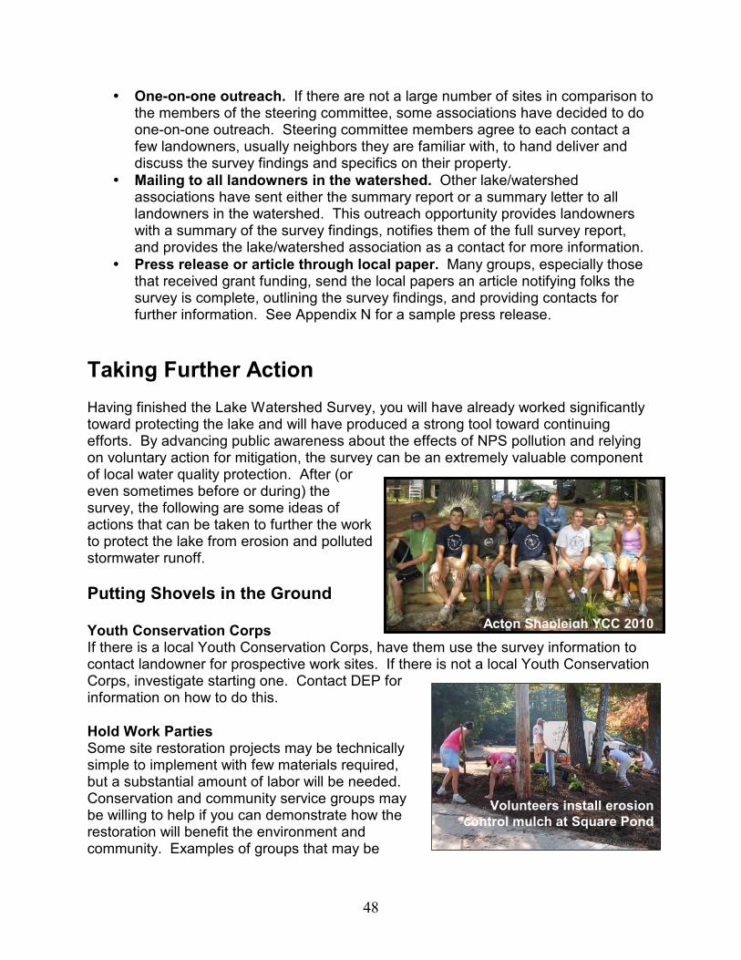
48
� One-on-one outreach. If there are not a large number of sites in comparison to the members of the steering committee, some associations have decided to do one-on-one outreach. Steering committee members agree to each contact a few landowners, usually neighbors they are familiar with, to hand deliver and discuss the survey findings and specifics on their property.
� Mailing to all landowners in the watershed. Other lake/watershed associations have sent either the summary report or a summary letter to all landowners in the watershed. This outreach opportunity provides landowners with a summary of the survey findings, notifies them of the full survey report, and provides the lake/watershed association as a contact for more information.
� Press release or article through local paper. Many groups, especially those that received grant funding, send the local papers an article notifying folks the survey is complete, outlining the survey findings, and providing contacts for further information. See Appendix N for a sample press release.
Taking Further Action Having finished the Lake Watershed Survey, you will have already worked significantly toward protecting the lake and will have produced a strong tool toward continuing efforts. By advancing public awareness about the effects of NPS pollution and relying on voluntary action for mitigation, the survey can be an extremely valuable component of local water quality protection. After (or even sometimes before or during) the survey, the following are some ideas of actions that can be taken to further the work to protect the lake from erosion and polluted stormwater runoff.
Putting Shovels in the Ground Youth Conservation Corps If there is a local Youth Conservation Corps, have them use the survey information to contact landowner for prospective work sites. If there is not a local Youth Conservation Corps, investigate starting one. Contact DEP for information on how to do this.
Hold Work Parties Some site restoration projects may be technically simple to implement with few materials required, but a substantial amount of labor will be needed. Conservation and community service groups may be willing to help if you can demonstrate how the restoration will benefit the environment and community. Examples of groups that may be
Acton Shapleigh YCC 2010
Volunteers install erosion
control mulch at Square Pond

49
willing to provide assistance include Conservation Commissions, Scouts, 4-H Clubs, local road associations, local businesses, students from environmental studies programs, and service clubs in local schools.
Working with Towns
Town-Owned Properties Town properties can set a good example for sound land use. Areas of public access, such as boat launches and town beaches, should be stable, and measures should be taken to limit and control stormwater runoff. Towns should be encouraged to develop an annual work plan to address areas of chronic erosion within the lake watershed.
Building Permit Attachments Ask watershed towns to attach a list of BMPs for erosion and sediment control (with emphasis on water quality protective measures) to building permits. When construction is proposed in a lake watershed, information about the lake and the special measures that should be taken during construction could also be attached (see the Resources Directory or Appendix P for publications). A form could be included that would require a signature from the contractor indicating that the attached information had been read and that appropriate measures were taken to protect lake water quality.
Town Training Encourage town code enforcement officers and road crew members to attend workshops on the basics of erosion and sediment control for water quality protection. The DEP, SWCDs, USDA Natural Resources Conservation Service, and Maine Department of Transportation periodically offer training seminars on this subject.
Town Comprehensive Planning Encourage volunteers from the survey project (who have now become local experts on erosion control and lake protection) to be involved in the town comprehensive planning process or the conservation commission. Education and awareness of the need to address NPS issues are vital precursors to the development of effective water quality protection guidelines and ordinances. Sponsors of the survey should get involved in the town planning and implementation process using the results of the survey to justify a review of educational measures and land use standards in the watershed. Comprehensive plans should acknowledge that surveys and/or other watershed protection efforts have been done or exist in particular watersheds, if applicable.
Phosphorus Control Method Encourage towns to incorporate the DEP's Phosphorus Control Methodology (see the publications Appendix P) for determining the effect of new development on lake water quality. This method takes into account the sensitivity of individual lakes, the value a
Site visit with town
representatives
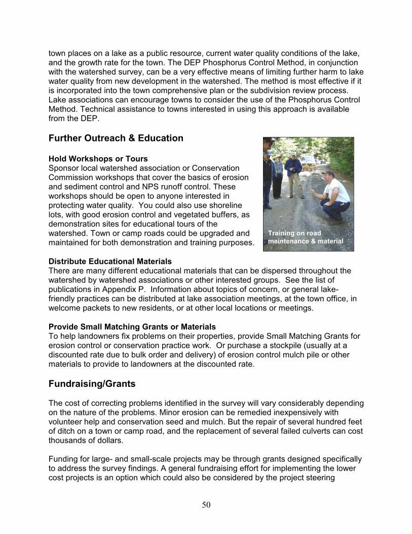
50
town places on a lake as a public resource, current water quality conditions of the lake, and the growth rate for the town. The DEP Phosphorus Control Method, in conjunction with the watershed survey, can be a very effective means of limiting further harm to lake water quality from new development in the watershed. The method is most effective if it is incorporated into the town comprehensive plan or the subdivision review process. Lake associations can encourage towns to consider the use of the Phosphorus Control Method. Technical assistance to towns interested in using this approach is available from the DEP.
Further Outreach & Education Hold Workshops or Tours Sponsor local watershed association or Conservation Commission workshops that cover the basics of erosion and sediment control and NPS runoff control. These workshops should be open to anyone interested in protecting water quality. You could also use shoreline lots, with good erosion control and vegetated buffers, as demonstration sites for educational tours of the watershed. Town or camp roads could be upgraded and maintained for both demonstration and training purposes.
Distribute Educational Materials There are many different educational materials that can be dispersed throughout the watershed by watershed associations or other interested groups. See the list of publications in Appendix P. Information about topics of concern, or general lake-friendly practices can be distributed at lake association meetings, at the town office, in welcome packets to new residents, or at other local locations or meetings.
Provide Small Matching Grants or Materials To help landowners fix problems on their properties, provide Small Matching Grants for erosion control or conservation practice work. Or purchase a stockpile (usually at a discounted rate due to bulk order and delivery) of erosion control mulch pile or other materials to provide to landowners at the discounted rate.
Fundraising/Grants The cost of correcting problems identified in the survey will vary considerably depending on the nature of the problems. Minor erosion can be remedied inexpensively with volunteer help and conservation seed and mulch. But the repair of several hundred feet of ditch on a town or camp road, and the replacement of several failed culverts can cost thousands of dollars. Funding for large- and small-scale projects may be through grants designed specifically to address the survey findings. A general fundraising effort for implementing the lower cost projects is an option which could also be considered by the project steering
Training on road
maintenance & material
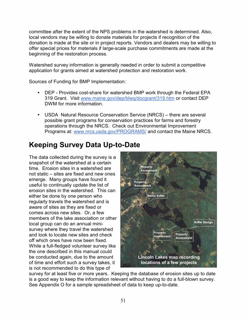
51
committee after the extent of the NPS problems in the watershed is determined. Also, local vendors may be willing to donate materials for projects if recognition of the donation is made at the site or in project reports. Vendors and dealers may be willing to offer special prices for materials if large-scale purchase commitments are made at the beginning of the restoration process. Watershed survey information is generally needed in order to submit a competitive application for grants aimed at watershed protection and restoration work. Sources of Funding for BMP Implementation:
� DEP - Provides cost-share for watershed BMP work through the Federal EPA
319 Grant. Visit www.maine.gov/dep/blwq/docgrant/319.htm or contact DEP DWM for more information.
� USDA Natural Resource Conservation Service (NRCS) – there are several
possible grant programs for conservation practices for farms and forestry operations through the NRCS. Check out Environmental Improvement Programs at: www.nrcs.usda.gov/PROGRAMS/ and contact the Maine NRCS.
Keeping Survey Data Up-to-Date The data collected during the survey is a snapshot of the watershed at a certain time. Erosion sites in a watershed are not static – sites are fixed and new ones emerge. Many groups have found it useful to continually update the list of erosion sites in the watershed. This can either be done by one person who regularly travels the watershed and is aware of sites as they are fixed or comes across new sites. Or, a few members of the lake association or other local group can do an annual mini-survey where they travel the watershed and look to locate new sites and check off which ones have now been fixed. While a full-fledged volunteer survey like the one described in this manual could be conducted again, due to the amount of time and effort such a survey takes, it is not recommended to do this type of survey for at least five or more years. Keeping the database of erosion sites up to date is a good way to keep the information relevant without having to do a full-blown survey. See Appendix O for a sample spreadsheet of data to keep up-to-date.
Lincoln Lakes map recording
locations of a few projects
52
Online Appendices
Appendix A: Outreach Brochure Sample
Appendix B: Pre-Survey Landowner Letter Sample
Appendix C: Pre-Survey Press Release Sample
Appendix D: Pre-Survey Handout for Volunteers
Appendix E: Volunteer Roles and Responsibilities
Appendix F: Volunteer Waiver Sample
Appendix G: Vehicle ID Card Sample
Appendix H: Volunteer Badge Sample
Appendix I: Photo Number Template
Appendix J: Survey Field Forms and Guidance
Appendix K: Data Entry Template
Appendix L: Post-Survey Letter to Landowners Sample
Appendix M: Post-Survey Newsletter Article Sample
Appendix N: Post-Survey Press Release Sample
Appendix O: Site Tracking Template
Appendix P: Publications
53
RESOURCE DIRECTORY
OTHER RESOURCES
University of Maine Cooperative Extension – Provides information to the public on protecting Maine’s water resources. 581-3188 http://extension.umaine.edu/waterquality/
Maine Volunteer Lake Monitoring Program 783-7733 www.mainevolunteerlakemonitors.org
Maine Congress of Lake Associations – Lake association contact information, lake protection resources and information. 877-254-2511 www.mainecola.org
Regional Planning Councils – List & contacts available at: www.maine.gov/spo/landuse/techassist/regionalcouncillist.htm
This publication, associated appendices, and other related materials are available at the DEP DWM materials website:
www.maine.gov/dep/blwq/docwatershed/materials.htm
MAINE SOIL & WATER CONSERVATION
DISTRICT OFFICES
• Education and training on a variety of lake related issues.
• Grant project planning and development.
• Site evaluations to assess erosion and/or drainage concerns.
• Best Management Practice design.
http://maineswcds.org/locations.htm
Androscoggin Valley 753-9400 x 3 Central Aroostook County 764-4153 Cumberland County 892-4700 Franklin County 778-4279 Hancock County 664-7496 Kennebec County 622-7847 x 3 Knox-Lincoln County 273-2005 x101 Oxford County 743-5789 x 3 Penobscot County 990-3676 x 3 Piscataquis County 564-2321 x 3 Somerset County 474-8324 Southern Aroostook County 532-2087 x 3 St. John Valley 834-3311 x 3 Waldo County 338-1964 x 3 Washington County 255-3995 x 3 York County 324-0888 x214
MAINE DEPARTMENT OF
ENVIRONMENTAL PROTECTION
(DEP)
www.maine.gov/dep 1-800-452-1942 (in state only) 207-287-7688
DEP Division of Watershed
Management (DWM)– nonpoint source pollution control, watershed surveys, BMP training, technical assistance
DEP Division of Land Resource
Regulation (DLRR) – licensing, enforcement, shoreland zoning, and field services
DEP Offices – DWM & DLRR Augusta 287-3901 (main office) Bangor 941-4570 Portland 822-6300 Presque Isle 764-0477