waas technical report william j. hughes … reports pdf/dr 66 waas...william j. hughes technical...
TRANSCRIPT

WAAS Technical Report William J. Hughes Technical Center
Atlantic City International Airport, New Jersey 2/19/2008
Author(s): Tom McHugh
DR#66: WAAS Observations of GPS AEP Upload to IIR/M Satellites Dates: 10/8/07 to 10/10/07 Background WAAS is the FAA's augmentation of GPS that allows GPS to be used for safety critical aviation applications. WAAS consists of a network of 38 WAAS reference stations (WRS), 3 corrections and verification subsystems (C&V), 2 GEO communications and control segments (GCCS), 2 Operations and Maintenance subsystems (O&M), and two fully independent terrestrial communications networks (TCN). WAAS augments GPS by providing corrections and integrity information for the GPS satellites in view of WAAS. That information is broadcast to users via Geosynchronous satellites (GEOs). The signal from the WAAS GEOs is on the GPS L1 frequency and is modulated similar to a normal civilian GPS signals but with additional information. The GEO signals also provide additional ranging sources. WAAS does not provide single lumped differential range corrections per satellite. Instead, separate corrections are provided for satellite position, satellite clock, and for ionosphere delay. The ionosphere corrections are broadcast for a longitude latitude grid. Satellite position, velocity, acceleration, and slow clock corrections are updated every five minutes. Satellite fast clock corrections are updated every 6 seconds. Ionosphere delay corrections are updated every five minutes. Integrity information is monitored once a second and normally updated with the corrections, but it will be updated immediately if an alarm is needed. WAAS system latency is 5 seconds and provides a 6 second time to alarm. WAAS aviation receivers calculate vertical and horizontal accuracy protection bounds using the integrity information provided by WAAS. Those bounds are essentially weighted HDOP and weighted VDOP. The bounds are a "7 nines" guarantee that the difference between the true position and the calculated position are within the bounding estimates. That is, the probability of the error being larger than the bound is less than 0.0000001 per the operation period (150 sec for approach, 1 hr for en route). WAAS receivers compare the bounds against published vertical and horizontal alarm limits to determine whether an operation is allowed (available). LPV approach alarm limits are 40 meters horizontal and 50 meters vertical. LPV-200 alarm limits are 40 meters horizontal and 35 meters vertical. LNAV/VNAV alarm limits are 556 meters

horizontal and 50 meters vertical. RNP-0.3 horizontal alarm limit is 556 meters with no vertical requirement. RNP-0.1 horizontal alarm limit would be 185 meters with no vertical requirement. Each WRS has three independent sets of equipment consisting of NovAtel WAAS G2 receivers, a PCTEL (MicroPulse) 2225NW L1/L2/L5 antenna, a Symmetricom CSIII cesium frequency reference, an IBM processor, and an ETI power conditioner. The three sets of receiving equipment share a keyboard/display and two routers with embedded ethernet switches. WRSs do not perform any end function processing of the measurement data. The processor for each set of receiving equipment packages the receiver measurement data each second and multicasts that data simultaneously onto both networks. GPS subframes 1, 2, and 3 are multicast onto each network as the subframe data is received every 6 seconds. WAAS only uses subframe 4 and 5 during cold start initialization of the C&V systems and for leap second information. Leap second data is sent periodically in a dedicated message. Leap second data is only used for display and recording timestamps and for coordinate transforms. Each C&V systems consist of 2 IBM 615 processors and a specialized safety computer. The two IBM processors contain independent instances of the satellite orbit determination and ionosphere estimation kalman filters. Each IBM processor performs all functions using separate input data. One processor normally utilizes data from the first set of receiving equipment from each WRS, the other processor normally utilizes data from the second set of receiving equipment from each WRS. The third set of receiving equipment is a shared backup. The processors coordinate so that they do not both use the third thread at the same time. If two sets of data are not available from a WRS, no data from that WRS is used. All three sets of data are forwarded to the safety computer. The safety computer receives the correction information from each processor and performs validation cross checks. The safety computer also implements a set of safety monitoring functions and generates the WAAS correction messages that are later transmitted to the users by the GCCS. The safety computer also generates the WAAS ionospheric corrections. Note, the ionosphere kalman filter in the IBM processors is only used to estimate the satellite and receiver L1L2 biases. The safety computer has two identical sets of internal hardware boards that receive the exact same input data and are expected to generate identical WAAS correction messages. Each processor board forwards its WAAS correction message for the current second to a specialized hardware comparator board which performs a bit by bit comparison across the two processors before forwarding the message on to one of the IBM processors which then multicasts it onto both networks for transmission to the GUSs. If the bit by bit comparison fails, that C&V faults. A time stamp protects the WAAS message being sent to the GUS’s, a 24-bit CRC and a 32 bit CRC calculated by the safety computer. All software in the safety computer, including the operating system, is certified to RTCA DO-178B to Level B. The hardware comparator mitigates against hardware failures in the safety

computer causing Hazardously Misleading Information (HMI). For WAAS, loss of function is considered a Minor hazard. HMI is considered a Severe/Hazardous hazard. The 3 C&Vs receive the same multicast data from all WRS. All three C&Vs continually multicast corrections to all uplink systems. The GUS selects one of the streams for transmission and can transparently switch to another stream in the event of a C&V failure. Each GCCS consists of a leased transponder onboard a commercial geosynchronous satellite (GEO) and two Ground Uplink Systems (GUS). Each GUS consists of a signal generation subsystem (SGS) and a radio frequency uplink system (RFU). The SGS consists of a pair of routers, a pair of power conditioners, an IBM processor, a safety computer, a NovAtel L1/L5 signal generator, an Agilent cesium frequency reference, a phase noise enhancer, and a NovAtel WAAS GUS receiver. The RFU consists of the up-converters, high power amplifiers, the dish, the RFU control processor and all the ancillary RF hardware. The current two WAAS GEOs are CRE and CRW (CONUS region east and west). CRE is the Canadian Telsat ANIK-F1R satellite at W107.3 degrees longitude using PRN-138. CRW is the INTELSAT (formerly PANAMSAT) Galaxy 14 satellite at W133 degrees longitude using PRN-135. Both GEOs currently broadcast the same WAAS user message data on L1 and L5, but the hardware design would permit independent messages on L5 in the future. The GUS IBM processor basically acts as a network interface for the safety computer. It also interfaces with GUS receiver RS-232 ports for the safety computer. The safety computer adds the preamble and 24-bit user CRC to the WAAS user message and performs the 500 bit FEC processing. Each processor board within the safety computer sends its FEC encoded message to the comparator board that then forwards the user message directly to the signal generator. The GUS safety computer also implements the ranging control loop algorithms. The outputs from the first processor are used to control the ranging loops. The GUS that is currently transmitting is designated as primary and the other of the pair is designated as backup. In event of a primary GUS failure, the backup becomes primary in about 12 seconds. Redundant GEO coverage is used to mitigate the interruption in service caused by switching between uplinks. Each of the two O&Ms are staffed 24/7 by the WAAS operators. At any one time one operator is the controlling operator and the other is the monitoring operator. The operators switch roles every couple hours. One O&M is located in the National Operations Control Center (NOCC) in Herndon VA, the other is located at the Pacific Operations Control Center (POCC) in San Diego, CA. Each O&M has a large digital linear tape drive (DLT) that is used to record all WAAS data. The WAAS terrestrial communications system consists of two independent networks composed of dedicated routers, switches, and dedicated communications lines. In addition to the redundancy of the two networks, each individual communications line is composed of a primary line and an alternate line. Most of the communications lines are terrestrial, but satellite communication is used for some of the lines in Alaska, Canada, and Mexico.

Special one-way only outgoing interfaces are located at several points on the WAAS network to allow data to be sent to engineering support activities at Raytheon, Fullerton CA, FAA Technical Center, Atlantic City International Airport, Atlantic City NJ, and the FAA Mike Monroney Aeronautical Center, Oklahoma City, OK. The FAA Technical Center records all WAAS measurement data and maintains an archive of that data. The FAA Technical Center also forwards the data to the NGS CORS network.

GPS Anomaly Description (all times are GPS) During the three days from 10/8/07 to 10/10/07, GPS experienced 6 unplanned outages of Block IIR satellites because of an interface discrepancy between the recently fielded AEP version of the master control segment and the IIR satellites. For a small subset of uploads the navigation payload processor entered a faulted condition where the processor became stuck in a continual reset loop. During this continual reset state valid C/A code with invalid subframe data continued to be broadcast. P(Y) code was untrackable during this interval and the GPS ground initially believed that the satellites were transmitting non-standard code. An emergency software upgrade was fielded in several days that mitigates the risk of this problem reoccurring. The 6 events were: PRN-19 / SVN-59 PRN-19 on 10/8/07 starting at 04:14:40, rising over SE Asia an hour or so before it came into view of the WRS in Cold Bay AK (CDB). PRN-12 / SVN-58 PRN-12 on 10/8/07 starting at 06:33, setting over the tip of South America, just minutes after it set out of view of the WRS in Tapachula Mexico (MTP). PRN-14 / SVN-41 PRN-14 on 10/8/07 starting at 21:04, over top of Russia, in view of the WRSs in Kotzebue AK (OTZ), Barrow AK (BRW) and Iqaluit Canada (YFB). PRN-23 / SVN-60 PRN-23 on 10/9/07, starting at 08:55, rising over Australia several hours before it came into view of WAAS. PRN-16 / SVN-56 PRN-16 on 10/9/07, starting at 12:02, rising north over Mexico, well viewed by WAAS. PRN-20 / SVN-51 PRN-20 on 10/10/07, starting a 08:24, rising over Australia, several hours before it came into view of WAAS. During the events there were four phases of symptoms of consequence to WAAS. Phase 1 consisted of the IIR satellite broadcasting trackable C/A code on L1 with invalid subframe data. Phase 2 consisted of the satellite transmitting Non-Standard Code (NSC). Phase 3 consisted of the IIR satellite transmitting normal C/A code with default navigation data. Phase 4 consisted of the satellite transmitting normal C/A coded with valid subframe data with the satellite health status set to unhealthy. The Phase 1 symptom was the anomalous condition. The Phases 2, 3, and 4 symptoms are expected states for a GPS satellite under going recovery from a failure.

In addition, PRN-19 on 10/8/07 experienced a clock ramp because the VCO on the satellite became un-locked from the atomic frequency reference because a watchdog monitor was disabled as part of the recovery and trouble shooting activities. The PRN-19 event was the only event during which the watchdog monitor was disabled. The WAAS receivers require subframe data that passes parity to accomplish initial acquisition of the GPS signals. If subframe data becomes invalid after initial acquisition, the WAAS NovAtel receivers will continue to track the satellite with valid measurements and invalid subframe 1 2 3 data. Additionally there is a "feature" in the receivers that prevents Signal Quality Monitoring (SQM) data from being output if the subframe data is invalid. SQM data is raw correlator measurements for 8 correlator spacings and the prompt. WAAS software does not currently require continuous valid subframe data to utilize a GPS satellite. WAAS will continue to use the lasted validated subframe data from a satellite until; 1) that data is replaced, 2) the stored subframe data times out, or 3) that data becomes invalid for another reason. The current timeout is the ephemeris Time of Clock (TOC) plus 2 hours. TOC is normally the middle of the ephemeris fit interval. Normally ephemeris information is updated every two hours with a TOC two hours into the future with a 4 hour fit interval. Only the PRN-14 and the PRN-16 events were in view of WAAS at the start of the event, so these were the only events where WAAS tracked the faulty satellite. WAAS never acquired any of the other satellites during phases 1 or 3 of the events. During the onset of the PRN-14 event, PRN-14 was over top of Russia and being tracked by the OTZ, BRW, and YFB reference stations. PRN-14 was below 5 degrees elevation at YFB and therefore the YFB data was not used in the generation of the corrections or monitors. At the start of the event PRN-14 was still coming into view of WAAS with a User Differential Range Error (UDRE) status of Not Monitored (NM). About 10 minutes into the event WAAS lowered the UDRE to 50 meters and then set it back to NM 5 minutes later. PRN-14 stayed NM for the rest of the event until it was set unhealthy, at which point WAAS set it to Do Not Use (DNU) while in view of WAAS. Satellites out of view of WAAS are set to NM. During the onset of the PRN-16 event, PRN-16 was rising over the Pacific, south west of Mexico. At that time PRN-16 was well viewed by WAAS such that UDRE had almost reached it's floor value. At a point about 3-5 minutes into the event, WAAS set PRN-16 to NM. This coincides with PRN-16 transitioning to non-standard code. PRN-16 remained NM until it was set unhealthy, at which time WAAS set it to DNU. During both the PRN-16 and PRN-14 events, the WAAS receivers reported slightly higher than normal carrier phase standard deviation during the phase 1 interval. Residuals and rms fit error from a single frequency 60-second quadratic fit cycle slip detector were also elevated during that same interval. None of the six events had a large impact on WAAS. The impacts were the minor degradations in availability associated with the loss of the service from the affected satellites during the events. The WAAS network time monitor did not trip.

MSAS and GAGAN Impacts MSAS is the Japanese equivalent of WAAS and is a derivative of WAAS. MSAS is the acronym for MTSAT Satellite Augmentation System. MTSATs are the Japanese Multi-function Transport Satellites. MSAS uses a much smaller reference station network (8 ea) than WAAS and is using an older version of the WAAS receiver. That version of the receiver never outputs subframe data if the data is invalid and does not have a SQM data capability. MSAS was commissioned 9/17/07. GAGAN is the Indian equivalent of WAAS and is also a derivative of WAAS. GAGAN is the acronym for GPS Aided GEO Augmented Navigation or GPS and GEO Augmented Navigation system. GAGAN is still in development, but it entered full scale testing during July 2007. Currently GAGAN is operating in "Test Mode" with an eight reference station network that is expected to grow to 16. GAGAN uses the newer WAAS NovAtel G2 receiver with SQM capability. The PRN-19 and PRN-20 events initiated degradation of the MSAS network time steering function. This degradation caused MSAS network time to diverge from GPS time, tripping the MSAS network time monitor in the C&V safety computers. The network time steering functions are identical for WAAS, MSAS, and GAGAN. Network time steering is an input to the satellite orbit determination kalman filter executing in the IBM processors of the C&Vs. Network time steering is used to drive the average satellite clock correction towards zero. The network time steering function collects samples of the difference between the ground system network time and observed GPS time every 30 seconds over 4 hour intervals. The 4 hour intervals are tied to wall time, i.e. 00:00, 04:00, 08:00, etc. The 30-second samples are computed by averaging the differences between the satellite times calculated from the broadcast ephemeris and the times estimated by the kalman filter for the satellites in view of the ground system. Differences larger than 250 meters are screened out prior to computing the average. At the end of the 4 hour interval a least square linear fit is performed on the 480 thirty second samples in order to estimate ground network time to GPS time offset and drift rate. The network time steering values are then updated to remove the drift and to attempt to remove the offset over the next 8 hours. The PRN-19 event started at approximately 04:15. The last valid ephemeris update was at 04:00 with a TOC of 06:00. The clock ramp started at about 06:20 when the watchdog monitor was disabled. The next MSAS network time steering update occurred at 08:00. That clock steering update was corrupted by the PRN-19 clock ramp. At 08:00 MSAS also timed out the ephemeris on PRN-19 and stopped using the satellite. At about 09:00 PRN-19 started transmitting NSC and all receivers stopped tracking the satellite. At about 10:41 the MSAS time to GPS time difference had grown large enough to cause the network time monitor in the safety computer to trip (13.5 m). That monitor sets the status of all satellites to Not Monitored, disabling all MSAS service. At 12:00 another update of the network time steering function took place and MSAS time began to reconverge with GPS time. By 15:58 the offset was below the trip threshold. The MSAS operators between about 17:00 to 18:00 restarted the MSAS system.
Elevated carrier phase standard deviation and elevated cycle slip detector residuals were also observed in the MSAS data for PRN-19 from the beginning of the event until the watch dog monitor was disabled. The MSAS PRN-20 network time steering problems were caused by software bugs in the MSAS code coupled with the fact that PRN-20 made it to phase 3 of the anomaly very quickly before MSAS timed out the prior subframe data and a unique characteristic of the older receivers. Phase 1 of the PRN-20 event started at about 08:24. The satellite signal was transitioned to non-standard code at 08:32:30 (phase2). The MSAS receivers stopped tracking PRN-20 at that point. At 09:05:49 the satellite began transmitting standard code with default navigation data (start of phase 3). MSAS began tracking PRN-20 again a couple seconds after that point. While PRN-20 was offline during phase 2, the timing of the signal was reinitialized which caused the prior ephemeris clock information to be grossly incorrect. Only the older MSAS receivers acquired a faulty satellite during phase 3. None of the WAAS receivers ever acquired during phase 3 of any of the events even though PRNs 12, 23, 16, and 20 were relatively high elevation to one or more WAAS reference stations during the phase 3 intervals. The last ephemeris update for PRN-20 was at 08:10 with a TOC of 10:00 with a 4 hour fit interval, IODE = IODC = 90. This ephemeris set replaced a set that had just been updated at 08:00 with a TOC of 11:00 with a 6 hour fit interval, IODE = IODC = 104. In addition to the unusual case where an ephemeris set was replaced after just 10 minutes, there was also one set of invalid ephemeris during the transition where the IODE was the new IODE (90) and the IODC was the old IODC (104). At about 09:06 the MSAS maneuver detection functions observed a -22 Km clock step relative to the old ephemeris information from before the start of the event. The MSAS software excluded PRN-20 from all processing at that point. At 09:12 periodic processing initiated a one-time retry logic that let the data back into the processing where it was promptly rejected after 30 seconds for the final time. However, during that retry interval the very large clock error corrupted one of the 30-second network time steering samples. This corruption happened because the MSAS screening check has a bug that checks whether or not the value is less than the 250 meter threshold instead of whether or not the absolute value is less than the screening threshold. This bug was fixed in WAAS in 1998 during normal software development testing. The 30-second retry was also removed from WAAS a long time ago. It is TBD how these two errors were re-introduced into MSAS. The error in that single sample was sufficiently large that it corrupted the 12:00 network time steering update. The corrupted network time steering caused the difference between network time and GPS time to grow to the point that the safety computer network time monitor tripped at 13:50, setting all satellites to Not Monitored. The network time steering update at 16:00 began to correct the problem such that the difference between MSAS time and GPS time dropped below the monitor trip threshold at 19:53, almost 10 hours after MSAS excluded PRN-20.

GAGAN Impacts The impact of the events on GAGAN was different than MSAS because of a software bug in the GAGAN reference station software. At the time of the events, the GAGAN reference stations were using a version of WAAS reference station software that has a bug that causes all subframe data for all satellites to be discarded if one or more satellites have invalid subframe data. This bug resulted in GAGAN losing ephemeris data for all satellites if a satellite in phase 1 of an event was in view by most the GAGAN reference stations. This software bug was removed in WAAS because it was determined to be a potential Single Point Of Failure (SPOF). The reference stations apply a 32-bit CRC and time stamp to the 300 bit subframe data from each satellite. Every 30 seconds after subframe 3 has been received, a function in the safety computer performs a vote across the subframe CRCs to determine the valid ephemeris set and to check to see if there has been an update. That voting function requires a minimum of 4 sets of subframe data for each satellite. This voting function could not execute because there was no data or not enough data. The failure of the voting function to execute caused all satellites to be set to NM. A similar voting function in the IBM processors prevented all data from being processed. If GAGAN did not have this bug, it is very likely that PRN-19 event would have impacted GAGAN in the same manner as it impacted MSAS. It is suspected that since GAGAN uses the newer version of the receivers, GAGAN would not have been susceptible to the PRN-20 event because the newer receivers do not acquire satellites transmitting default navigation data. MSAS does not have this reference station software bug because the bug is related to the implementation of the newer receivers. WAAS Impacts WAAS may or may not have developed network time steering errors if the PRN-19 event had been in view of WAAS. WAAS usually has visibility to twice as many GPS satellites as MSAS. This means the individual contribution of the PRN-19 ramp to the network time steering update samples would be averaged across 16 to 20 satellites instead of 8 to 10 satellites, significantly reducing the magnitude of the drift rate error. WAAS does not have any of the bugs mentioned above. However, WAAS did see a disturbance in WAAS network time resulting from PRN-18 being maneuvered while healthy earlier this year. That PRN-18 "maneuver while healthy event" caused a divergence in WAAS network time, but that divergence never became large enough to trip the network time monitor. The impact of an undetected maneuver on network time steering is similar to that of a clock ramp. A network time robustness enhancement to address the "maneuver while healthy" risk was already planned as part of WAAS release 8/9.2 which will be fielded during the 2nd half of 2008. That change lowers the screening threshold in the maneuver detection logic from 250 meters down to something around 60 meters (exact value is TBD).

As a result of AEP IIR upload events the scope of the network time robustness enhancement will be increased to also lower the threshold used for screening data going into the 30 second network time samples and implementations of a timeout of the current ephemeris data if it is not continually reconfirmed by CRC vote within TBD seconds (90 to 180 sec). Raytheon has prototyped the ephemeris CRC vote reconfirmation timeout using 180 seconds and have shown that it prevents the MSAS problems with no other detrimental impacts. Raytheon has also been tasked to see if median edit functionality can be used to screen the data going into the 30 second network time sample calculations. It is TBD if the median edit functionality will be available in time for release 8/9.2. In addition a WAAS problem report (WPR) will be opened to track other possible future enhancements related to the symptoms seen during AEP IIR upload events. Of particular interest would be changes to detect the symptoms and set the WAAS satellite status (UDRE) to "Do Not Use" instead of "Not Monitored". Topics / Issues This set of anomaly events has highlighted a list of topics and issues that may require further discussion and actions. 1. Identification and resolution of the root causes of how the AEP to IIR ICD requirements
error remained undetected during the AEP development and testing. 2. Identification and implementation of procedure steps to ensure that satellites are not
transmitting trackable C/A code when the ground believes the satellites are transmitting non-standard code.
3. Identification and implementation of procedures steps to ensure that clock steps or ramps are not introduced on trackable signals during the execution of trouble shooting steps.
4. Identification of a better process for the interface between the governmental augmentation systems and GPS.
5. Discussion of the RAIM assertion that simultaneous GPS failures are extremely rare. 6. Identification of how the software bugs that had been fixed in WAAS made it into MSAS
and GAGAN and status of when those bugs will be corrected. 7. Identification if there needs to be a requirement for WAAS receivers to acquire satellites
broadcasting default navigation data

Appendix A - WAAS Site Locations

ID Site Latitude Longitude 1 BET Bethel, AK 60.78791717 -161.8417245 2 BIL Billings, MT 45.80370726 -108.5397219 3 BRW Barrow, AK 71.28276702 -156.7899228 4 CDB Cold Bay, AK 55.20033523 -162.7184717 5 FAI Fairbanks, AK 64.80963173 -147.84734 6 HNL Honolulu, HW 21.31298806 -157.9208234 7 JNU Juneau, AK 58.36257539 -134.5857055 8 MMD Merida, MX 20.93190924 -89.66284033 9 MMX Mexico City, MX 19.43165306 -99.06838949 10 MPR Puerto Vallarta, MX 20.67900362 -105.2492028 11 MSD San Jose De Cabo 23.16044567 -109.7176454 12 MTP Tapachula, MX 14.79136591 -92.36799904 13 OTZ Kotzebue, AK 66.88733425 -162.6113727 14 YFB Iqaluit, CA 63.73149003 -68.54318106 15 YQX Gander, CA 48.9664893 -54.59763092 16 YWG Winnipeg , CA 49.90057461 -97.25939591 17 YYR Goose Bay, CA 53.30864629 -60.41946692 18 ZAB Albuquerque, NM 35.17357566 -106.5673486 19 ZAN Anchorage, AK 61.22920259 -149.7802482 20 ZAU Chicago, IL 41.78265797 -88.33133538 21 ZBW Boston, MA 42.73572009 -71.48042441 22 ZDC Wash. DC 39.10159553 -77.5427451 23 ZDV Denver, CO 40.18730364 -105.1272231 24 ZFW Fort Worth, TX 32.83064962 -97.06647094 25 ZHU Houston, TX 29.96189619 -95.33142531 26 ZJX Jacksonville, FL 30.6988593 -81.9081842 27 ZKC Kansas City, MO 38.88015943 -94.79083249 28 ZLA Los Angeles, CA 34.60351767 -118.0838933 29 ZLC Salt Lake City, UT 40.78604386 -111.9521761 30 ZMA Miami, FL 25.82461199 -80.31918905 31 ZME Memphis, TN 35.06739381 -89.95536896 32 ZMP Minneapolis, MN 44.63746334 -93.15208396 33 ZNY New York, NY 40.78432818 -73.0971644 34 ZOA Oakland, CA 37.54305267 -122.0159449 35 ZOB Cleveland, OH 41.29715427 -82.20644333 36 ZSE Seattle, WA 47.28699356 -122.1883719 37 ZSU San Juan, PR 18.4313378 -65.99347565 38 ZTL Atlanta, GA 33.37968843 -84.29672497

Appendix B - Invalid Subframe Data Observed by WAAS During the PRN-14 and PRN-16 Events
The following is examples of the raw 300 bit subframe data reported by the receiver prior to the application of the GPS parity algorithm and the RINEX conversion for that data . The first row contains a timestamp that is integer seconds since the start of GPS time, a subframe 1 2 or 3 label, and the receiver subframe validity status 0 = fail.
PRN-14 Subframe 1, 2, 3 data from Iqaluit (YFB-A)
First Middle Last
875912527, sub1, 0 000001011101000010100000001100 010100000001100010100000001100 010100000001100010100000001100 001100010011011001100010011011 001100010011011001100010011011 001100010011011111101111001011 111101111001011111101111001011 111101111001011111101111001011 111111111111111111111111111111 111111111111111111111111111111 875912533, sub2, 0 111111111111111010100000001100 010100000001100010100000001100 010100000001100010100000001100 110110011110100110110011110100 110110011110100110110011110100 110110011110100111111110011001 111111110011001111111110011001 111111110011001111111110011001 111100110000110111100110000110 111100110000110111100110000110 875912539, sub3, 0 111100110000110010100000001100 010100000001100010100000001100 010100000001100010100000001100 001110110101110001110110101110 001110110101110001110110101110 001110110101110011110100111001 011110100111001011110100111001 011110100111001011110100111001 000000000101000000000000101000 000000000101000000000000101000
875913667, sub1, 0 000001011101000010100000001100 010100000001100010100000001100 010100000001100010100000001100 001100010011011001100010011011 001100010011011001100010011011 001100010011011111101111001011 111101111001011111101111001011 111101111001011111101111001011 111111111111111111111111111111 111111111111111111111111111111 875913673, sub2, 0 111111111111111010100000001100 010100000001100010100000001100 010100000001100010100000001100 110110011110100110110011110100 110110011110100110110011110100 110110011110100111111110011001 111111110011001111111110011001 111111110011001111111110011001 111100110000110111100110000110 111100110000110111100110000110 875913679, sub3, 0 111100110000110010100000001100 010100000001100010100000001100 010100000001100010100000001100 001110110101110001110110101110 001110110101110001110110101110 001110110101110011110100111001 011110100111001011110100111001 011110100111001011110100111001 000000000101000000000000101000 000000000101000000000000101000
875914837, sub1, 0 000001011101000010100000001100 010100000001100010100000001100 010100000001100010100000001100 001100010011011001100010011011 001100010011011001100010011011 001100010011011111101111001011 111101111001011111101111001011 111101111001011111101111001011 111111111111111111111111111111 111111111111111111111111111111 875914843, sub2, 0 111111111111111010100000001100 010100000001100010100000001100 010100000001100010100000001100 110110011110100110110011110100 110110011110100110110011110100 110110011110100111111110011001 111111110011001111111110011001 111111110011001111111110011001 111100110000110111100110000110 111100110000110111100110000110 875914849, sub3, 0 111100110000110010100000001100 010100000001100010100000001100 010100000001100010100000001100 001110110101110001110110101110 001110110101110001110110101110 001110110101110011110100111001 011110100111001011110100111001 011110100111001011110100111001 001111111110100001010000011101 011100100111100101001101011000
First 875912539 debug print 10/8/2007, Mon, 21:02:19 14 05 10 13 22 24 0.0 0.000000000000D+00 0.000000000000D+00 0.000000000000D+00 0.800000000000D+02 0.197000000000D+03-0.348264506615D-08-0.186897219424D+01 -0.181626528502D-04-0.390017020982D-02 0.379979610443D-06 0.336182117462D+02 0.995536000000D+06 0.381916761398D-04-0.235050330877D+01 0.283047556877D-04 0.290184709328D+01-0.979593750000D+03 0.282784655550D+00-0.731494755407D-08 0.182864759908D-08 0.100000000000D+01 0.134400000000D+04 0.000000000000D+00 0.960000000000D+02 0.400000000000D+02 0.745058059692D-08 0.800000000000D+01 0.246054000000D+06 0.600000000000D+01 0.000000000000D+00 0.000000000000D+00

Middle 875913679 debug print 10/8/2007, Mon, 21:21:19 14 05 10 13 22 24 0.0 0.000000000000D+00 0.000000000000D+00 0.000000000000D+00 0.800000000000D+02 0.197000000000D+03-0.348264506615D-08-0.186897219424D+01 -0.181626528502D-04-0.390017020982D-02 0.379979610443D-06 0.336182117462D+02 0.995536000000D+06 0.381916761398D-04-0.235050330877D+01 0.283047556877D-04 0.290184709328D+01-0.979593750000D+03 0.282784655550D+00-0.731494755407D-08 0.182864759908D-08 0.100000000000D+01 0.134400000000D+04 0.000000000000D+00 0.960000000000D+02 0.400000000000D+02 0.745058059692D-08 0.800000000000D+01 0.246054000000D+06 0.600000000000D+01 0.000000000000D+00 0.000000000000D+00
Last 875914849 debug print 10/8/2007, Mon, 21:40:49 14 05 10 13 22 24 0.0 0.000000000000D+00 0.000000000000D+00 0.000000000000D+00 0.800000000000D+02 0.197000000000D+03-0.348264506615D-08-0.186897219424D+01 -0.181626528502D-04-0.390017020982D-02 0.379979610443D-06 0.336182117462D+02 0.995536000000D+06 0.381916761398D-04-0.235050330877D+01 0.283047556877D-04 0.290184709328D+01-0.979593750000D+03 0.282784655550D+00-0.149586266583D-05 -0.277297264830D-08 0.100000000000D+01 0.134400000000D+04 0.000000000000D+00 0.960000000000D+02 0.400000000000D+02 0.745058059692D-08 0.800000000000D+01 0.246054000000D+06 0.600000000000D+01 0.000000000000D+00 0.000000000000D+00
PRN-16 Subframe 1, 2, 3 data from Tapachula (MTP-A)
First Middle Last 875966377, sub1, 0 011010111011101101011111110011 101011111110011101011111110011 101011111110011101011111110011 100010101111100100010101111100 100010101111100100010101111100 100010101111100011011011000111 011011011000111011011011000111 011011011000111011011011000111 111111111111111111111111111111 111111111111111111111111111111 875966383, sub2, 0 111111111111111101011111110011 101011111110011101011111110011 101011111110011101011111110011 110011000011011110011000011011 110011000011011110011000011011 110011000011011000000010110100 000000010110100000000010110100 000000010110100000000010110100 000011011110101000011011110101 000011011110101000011011110101 875966389, sub3, 0 000011011110101101011111110011 101011111110011101011111110011 101011111110011101011111110011 001101110110110001101110110110 001101110110110001101110110110 001101110110110000010101100010 000010101100010000010101100010 000010101100010000010101100010 111111111010010111111111010010 111111111010010111111111010010
875966437, sub1, 0 011010111011101101011111110011 101011111110011101011111110011 101011111110011101011111110011 100010101111100100010101111100 100010101111100100010101111100 100010101111100011011011000111 011011011000111011011011000111 011011011000111011011011000111 111111111111111111111111111111 111111111111111111111111111111 875966443, sub2, 0 111111111111111101011111110011 101011111110011101011111110011 101011111110011101011111110011 110011000011011110011000011011 110011000011011110011000011011 110011000011011000000010110100 000000010110100000000010110100 000000010110100000000010110100 000011011110101000011011110101 000011011110101000011011110101 875966449, sub3, 0 000011011110101101011111110011 101011111110011101011111110011 101011111110011101011111110011 001101110110110001101110110110 001101110110110001101110110110 001101110110110000010101100010 000010101100010000010101100010 000010101100010000010101100010 111111111010010111111111010010 111111111010010111111111010010
875966527, sub1, 0 011010111011101101011111110011 101011111110011101011111110011 101011111110011101011111110011 100010101111100100010101111100 100010101111100100010101111100 100010101111100011011011000111 011011011000111011011011000111 011011011000111011011011000111 111111111111111111111111111111 111111111111111111111111111111 875966533, sub2, 0 111111111111111101011111110011 101011111110011101011111110011 101011111110011101011111110011 110011000011011110011000011011 110011000011011110011000011011 110011000011011000000010110100 000000010110100000000010110100 000000010110100000000010110100 000011011110101000011011110101 000011011110101000011011110101 875966539, sub3, 0 000011011110101101011111110011 101011111110011101011111110011 101011111110011101011111110011 001101110110110001101110110110 001101110110110001101110110110 001101110110110000010101100010 000010101100010000010101100010 000010101100010000010101100010 111111111010010111111111010010 111111111010010111111111010010

First 875966389 debug print 16 05 10 14 8 43 44.0 0.000000000000D+00 0.000000000000D+00 0.000000000000D+00 0.800000000000D+02 0.197000000000D+03 0.473448292450D-08 0.253296495428D+01 0.246930867434D-04-0.584864593111D-02 0.670552253723D-06 0.657393093109D+02 0.991568000000D+06 0.381916761398D-04-0.233696446569D+01 0.264272093773D-04 0.270511972312D+01 0.861250000000D+02 0.516449716821D+00-0.822927135361D-08 -0.205758570670D-08 0.100000000000D+01 0.134400000000D+04 0.000000000000D+00 0.960000000000D+02 0.400000000000D+02 0.167638063431D-07 0.146000000000D+03 0.246054000000D+06 0.600000000000D+01 0.000000000000D+00 0.000000000000D+00
Middle 875966449 debug print 16 05 10 14 8 43 44.0 0.000000000000D+00 0.000000000000D+00 0.000000000000D+00 0.800000000000D+02 0.197000000000D+03 0.473448292450D-08 0.253296495428D+01 0.246930867434D-04-0.584864593111D-02 0.670552253723D-06 0.657393093109D+02 0.991568000000D+06 0.381916761398D-04-0.233696446569D+01 0.264272093773D-04 0.270511972312D+01 0.861250000000D+02 0.516449716821D+00-0.822927135361D-08 -0.205758570670D-08 0.100000000000D+01 0.134400000000D+04 0.000000000000D+00 0.960000000000D+02 0.400000000000D+02 0.167638063431D-07 0.146000000000D+03 0.246054000000D+06 0.600000000000D+01 0.000000000000D+00 0.000000000000D+00
Last 875966539 debug print 16 05 10 14 8 43 44.0 0.000000000000D+00 0.000000000000D+00 0.000000000000D+00 0.800000000000D+02 0.197000000000D+03 0.473448292450D-08 0.253296495428D+01 0.246930867434D-04-0.584864593111D-02 0.670552253723D-06 0.657393093109D+02 0.991568000000D+06 0.381916761398D-04-0.233696446569D+01 0.264272093773D-04 0.270511972312D+01 0.861250000000D+02 0.516449716821D+00-0.822927135361D-08 -0.205758570670D-08 0.100000000000D+01 0.134400000000D+04 0.000000000000D+00 0.960000000000D+02 0.400000000000D+02 0.167638063431D-07 0.146000000000D+03 0.246054000000D+06 0.600000000000D+01 0.000000000000D+00 0.000000000000D+00
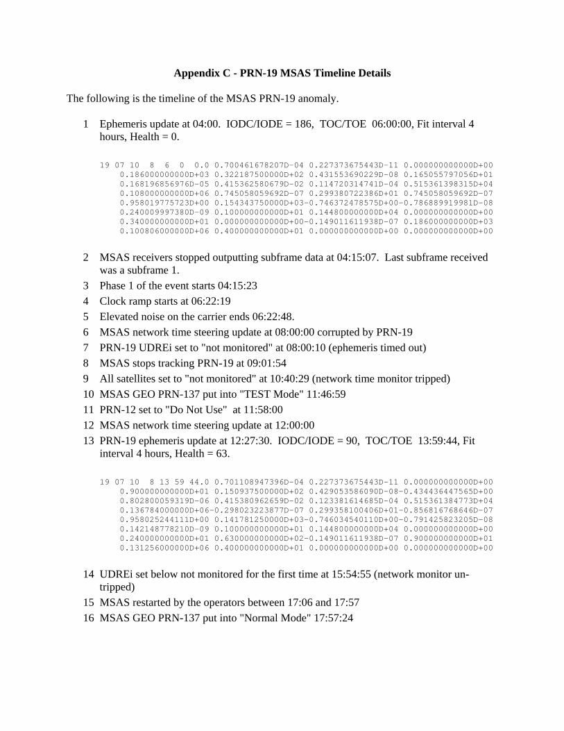
Appendix C - PRN-19 MSAS Timeline Details
The following is the timeline of the MSAS PRN-19 anomaly.
1 Ephemeris update at 04:00. IODC/IODE = 186, TOC/TOE 06:00:00, Fit interval 4 hours, Health = 0.
19 07 10 8 6 0 0.0 0.700461678207D-04 0.227373675443D-11 0.000000000000D+00 0.186000000000D+03 0.322187500000D+02 0.431553690229D-08 0.165055797056D+01 0.168196856976D-05 0.415362580679D-02 0.114720314741D-04 0.515361398315D+04 0.108000000000D+06 0.745058059692D-07 0.299380722386D+01 0.745058059692D-07 0.958019775723D+00 0.154343750000D+03-0.746372478575D+00-0.786889919981D-08 0.240009997380D-09 0.100000000000D+01 0.144800000000D+04 0.000000000000D+00 0.340000000000D+01 0.000000000000D+00-0.149011611938D-07 0.186000000000D+03 0.100806000000D+06 0.400000000000D+01 0.000000000000D+00 0.000000000000D+00
2 MSAS receivers stopped outputting subframe data at 04:15:07. Last subframe received was a subframe 1.
3 Phase 1 of the event starts 04:15:23 4 Clock ramp starts at 06:22:19 5 Elevated noise on the carrier ends 06:22:48. 6 MSAS network time steering update at 08:00:00 corrupted by PRN-19 7 PRN-19 UDREi set to "not monitored" at 08:00:10 (ephemeris timed out) 8 MSAS stops tracking PRN-19 at 09:01:54 9 All satellites set to "not monitored" at 10:40:29 (network time monitor tripped) 10 MSAS GEO PRN-137 put into "TEST Mode" 11:46:59 11 PRN-12 set to "Do Not Use" at 11:58:00 12 MSAS network time steering update at 12:00:00 13 PRN-19 ephemeris update at 12:27:30. IODC/IODE = 90, TOC/TOE 13:59:44, Fit
interval 4 hours, Health = 63.
19 07 10 8 13 59 44.0 0.701108947396D-04 0.227373675443D-11 0.000000000000D+00 0.900000000000D+01 0.150937500000D+02 0.429053586090D-08-0.434436447565D+00 0.802800059319D-06 0.415380962659D-02 0.123381614685D-04 0.515361384773D+04 0.136784000000D+06-0.298023223877D-07 0.299358100406D+01-0.856816768646D-07 0.958025244111D+00 0.141781250000D+03-0.746034540110D+00-0.791425823205D-08 0.142148778210D-09 0.100000000000D+01 0.144800000000D+04 0.000000000000D+00 0.240000000000D+01 0.630000000000D+02-0.149011611938D-07 0.900000000000D+01 0.131256000000D+06 0.400000000000D+01 0.000000000000D+00 0.000000000000D+00
14 UDREi set below not monitored for the first time at 15:54:55 (network monitor un-tripped)
15 MSAS restarted by the operators between 17:06 and 17:57 16 MSAS GEO PRN-137 put into "Normal Mode" 17:57:24

Appendix D - PRN-19 Clock Ramp on 10/8/07
The following figure shows an estimate of PRN-19 clock ramp as observed by the MSAS reference stations. The satellite clock error is estimated by differencing the receiver clock time estimated by using only PRN-19 and the time estimated using a filtered estimate of the receiver clock using all satellites other than PRN-19. Australia is included in the legend, but PRN-19 set out of view of GAU before the clock ramp started.

Appendix E - Plots of the increased noise on the signal during phase 1 of the events
The following are plots showing the increase in noise on the L1 and L2 carriers during phase 1 of the events. Plots of receiver reported carrier phase measurement standard deviation, cycle slip detector residuals, and the rms fit error in the cycle slip detectors are provided. The cycle slip detector performs a quadratic fit of the prior 60 seconds of 1 Hz data. Data is provided for MSAS Kobe for PRN-19 and WAAS Tapachula for PRN-16. The PRN-19 plots show that the noise went away after the watch dog monitor was disabled. The PRN-16 plots are for a much shorter time scale and also show the difference in how the old and new receivers estimate carrier phase standard deviation.


