waitomo caves village
TRANSCRIPT
WAITOMO CAVES VILLAGE TOWN CONCEPT PLAN | 1
WAITOMO CAVES
VILLAGETOWN CONCEPT PLAN
2 | JUNE 2019
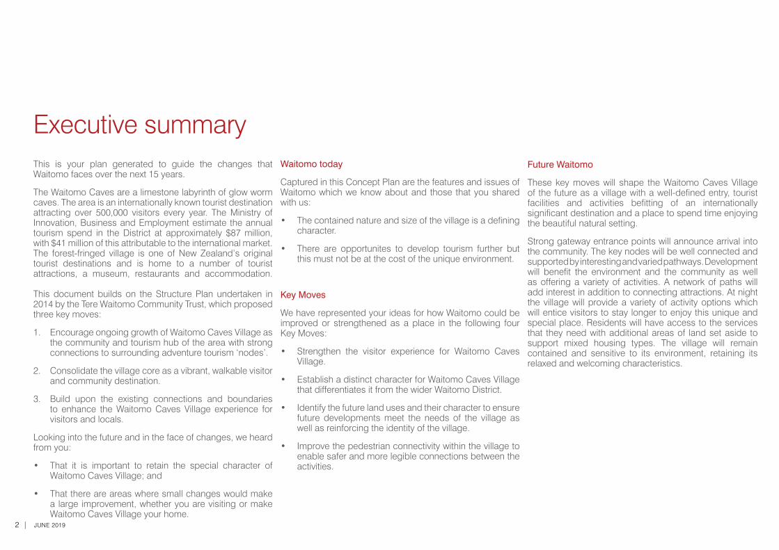
Executive summaryThis is your plan generated to guide the changes that Waitomo faces over the next 15 years.
The Waitomo Caves are a limestone labyrinth of glow worm caves. The area is an internationally known tourist destination attracting over 500,000 visitors every year. The Ministry of Innovation, Business and Employment estimate the annual tourism spend in the District at approximately $87 million, with $41 million of this attributable to the international market. The forest-fringed village is one of New Zealand’s original tourist destinations and is home to a number of tourist attractions, a museum, restaurants and accommodation. This document builds on the Structure Plan undertaken in 2014 by the Tere Waitomo Community Trust, which proposed three key moves:
1. Encourage ongoing growth of Waitomo Caves Village as the community and tourism hub of the area with strong connections to surrounding adventure tourism ‘nodes’.
2. Consolidate the village core as a vibrant, walkable visitor and community destination.
3. Build upon the existing connections and boundaries to enhance the Waitomo Caves Village experience for visitors and locals.
Looking into the future and in the face of changes, we heard from you:
• That it is important to retain the special character of Waitomo Caves Village; and
• That there are areas where small changes would make a large improvement, whether you are visiting or make Waitomo Caves Village your home.
Waitomo today
Captured in this Concept Plan are the features and issues of Waitomo which we know about and those that you shared with us:
• The contained nature and size of the village is a defining character.
• There are opportunites to develop tourism further but this must not be at the cost of the unique environment.
Key Moves
We have represented your ideas for how Waitomo could be improved or strengthened as a place in the following four Key Moves:
• Strengthen the visitor experience for Waitomo Caves Village.
• Establish a distinct character for Waitomo Caves Village that differentiates it from the wider Waitomo District.
• Identify the future land uses and their character to ensure future developments meet the needs of the village as well as reinforcing the identity of the village.
• Improve the pedestrian connectivity within the village to enable safer and more legible connections between the activities.
Future Waitomo
These key moves will shape the Waitomo Caves Village of the future as a village with a well-defined entry, tourist facilities and activities befitting of an internationally significant destination and a place to spend time enjoying the beautiful natural setting.
Strong gateway entrance points will announce arrival into the community. The key nodes will be well connected and supported by interesting and varied pathways. Development will benefit the environment and the community as well as offering a variety of activities. A network of paths will add interest in addition to connecting attractions. At night the village will provide a variety of activity options which will entice visitors to stay longer to enjoy this unique and special place. Residents will have access to the services that they need with additional areas of land set aside to support mixed housing types. The village will remain contained and sensitive to its environment, retaining its relaxed and welcoming characteristics.
WAITOMO CAVES VILLAGE TOWN CONCEPT PLAN | 3
Executive summary 2
What you love about Waitomo... 4
01 Introduction 5
02 Context
Context: Location and History 6
Context: Mana whenua 7
Context: Natural Environment 8
Context: Built Environment 10
03 What you told us 12
Community Involvement 13
04 Key Moves 14
Key Move 1 16Strengthen the visitor experience for Waitomo Caves Village
Key Move 2 20Establish a distinct character for Waitomo Caves Village that differentiates it from the wider Waitomo District
Key Move 3 24Identify the future land uses and their character to ensure future developments meet the needs of the village as well as reinforcing the identity of the village
Key Move 4 28Improve the pedestrian connectivity within the Village to enable safer and more legible connections
between the activities
Contents05 Implementation Plan
Key points for District Plan implementation 32
Implementation Plan 33
MAPS 34
Key Move 1 35
Key Move 2 36
Key Move 3 37
Key Move 4 38
Proposed Re-zoning 39
06 Appendix
Statutory Framework 40
Community Outcomes 41
4 | JUNE 2019
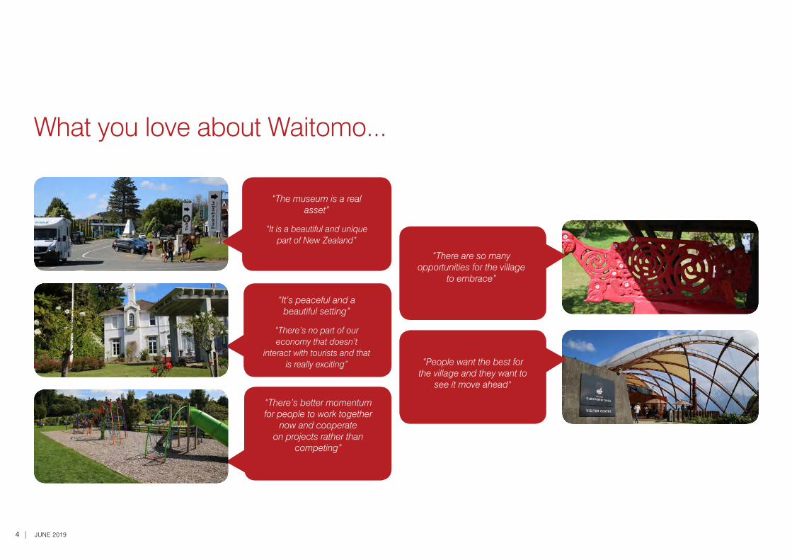
What you love about Waitomo...
“There are so many opportunities for the village
to embrace”
“People want the best for the village and they want to
see it move ahead”
“It’s peaceful and a beautiful setting”
“There’s no part of our economy that doesn’t
interact with tourists and that is really exciting”
“The museum is a real asset”
“It is a beautiful and unique part of New Zealand”
“There’s better momentum for people to work together
now and cooperate on projects rather than
competing”
WAITOMO CAVES VILLAGE TOWN CONCEPT PLAN | 5
What’s the Vision?
The Council’s Vision for the Waitomo District is “Creating a better future with vibrant communities and thriving business”. The intent of the vision is to make the District an attractive place that people will want to come and visit, work and live in. The Moves, Actions and Plans (MAP) in this document provide direction on ‘how’ this Vision can be achieved in Waitomo Caves Village. The Key Moves align with the community outcomes identified in the Long Term Plan to meet Council’s vision. A summary of these community outcomes is contained in the Appendix at the back of this plan.
How has this concept plan come about?
The Council identified early on in the District Plan project that it was important to have a strategic approach. This plan provides this approach for Waitomo Caves Village.
The plan has been developed in conjunction with the community, tangata whenua, Council staff, Councillors and stakeholders.
A MAP for the future:
This Concept Plan identifies the key features of Waitomo and the known challenges / issues. Using this information as a starting point, 4 key strategic Moves/directions have been identified. The Moves are as follows:
Move 1: Strengthen the visitor experience for Waitomo Caves Village.
Move 2: Establish a distinct character for Waitomo Caves Village that differentiates it from the wider Waitomo District.
Move 3: Identify the future land uses and their character to ensure future developments meet the needs of the village as well as reinforcing the identity of the village.
Move 4: Improve the pedestrian connectivity within the Village to enable safer and more legible connections between the activities.
For each Move, several Actions have been suggested. A Plan for how each of the actions will be realised is also presented. The Plan is prioritised in terms of what actions can happen soon and which actions are likely to happen later.
Underpinning these moves, actions, and plans is the need for infrastructure (including electricity supply) that is well planned, safe, and resilient.
Introduction01
How will the MAP be used?
The MAP will be used to provide a cohesive way forward for Waitomo. It provides direction for Council on how public areas (such as parks, roads, and walkways) can be developed. It also tells Council which areas the community of Waitomo Caves Village want to develop and in what order. This helps Council, and other infrastructure providers, to plan for infrastructure in an integrated manner. It provides community groups with a common basis for community projects. For people who are wishing to develop in Waitomo Caves Village, it provides a blueprint for where and what the community want to see developed. In addition to all of these things it will help both the Council and the community develop our new District Plan. It is a launch pad for the future!
Timeframes
It is anticipated that the Concept Plan will run for the life of the District Plan ie: 15 year framework with the ability to update if needed.
6 | JUNE 2019
Key features are:
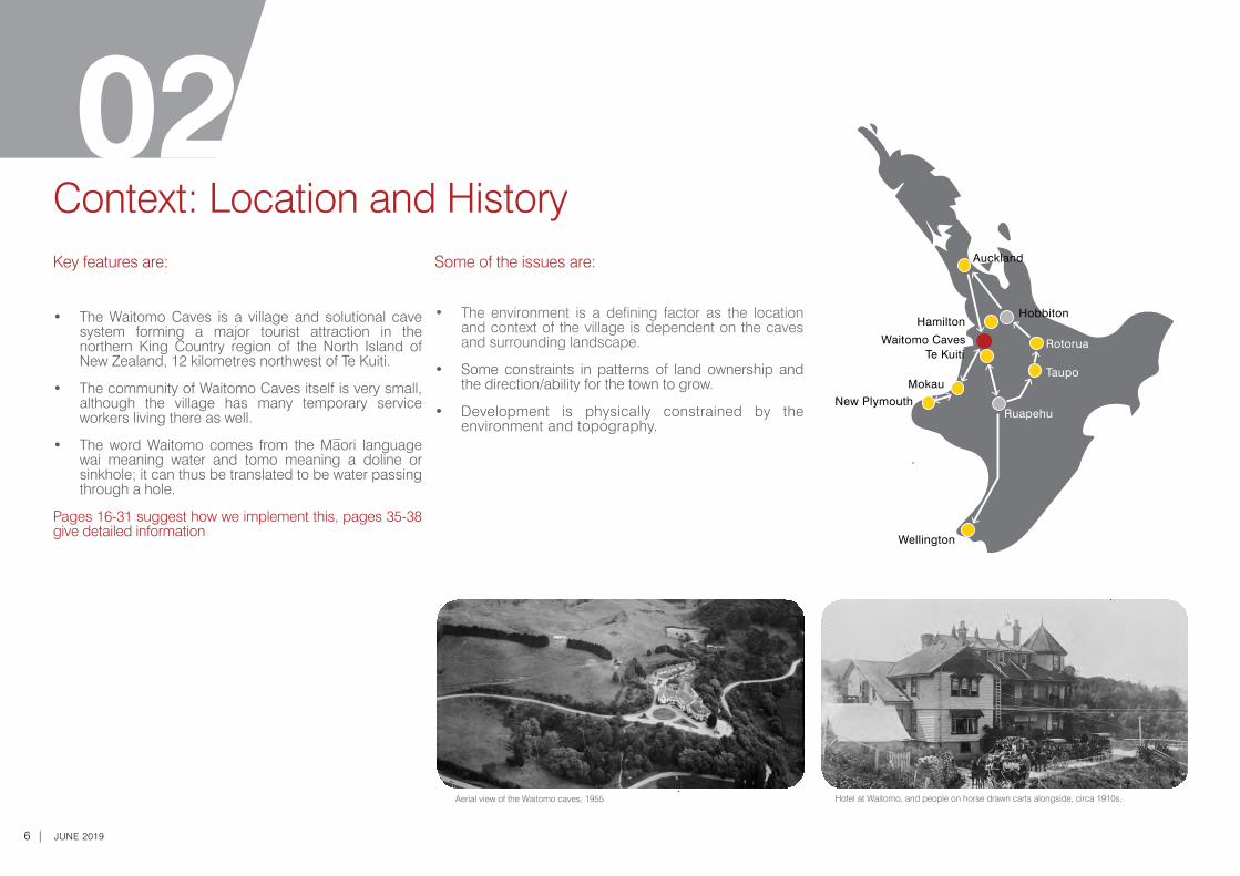
• The Waitomo Caves is a village and solutional cave system forming a major tourist attraction in the northern King Country region of the North Island of New Zealand, 12 kilometres northwest of Te Kuiti.
• The community of Waitomo Caves itself is very small, although the village has many temporary service workers living there as well.
• The word Waitomo comes from the Maori language wai meaning water and tomo meaning a doline or sinkhole; it can thus be translated to be water passing through a hole.
Pages 16-31 suggest how we implement this, pages 35-38 give detailed information
Some of the issues are:
• The environment is a defining factor as the location and context of the village is dependent on the caves and surrounding landscape.
• Some constraints in patterns of land ownership and the direction/ability for the town to grow.
• Development is physically constrained by the environment and topography.
Context: Location and History02
Ruapehu
Rotorua
Hobbiton
Waitomo CavesTe Kuiti
Hamilton
New Plymouth
Wellington
Auckland
TaupoMokau
Hotel at Waitomo, and people on horse drawn carts alongside, circa 1910s.Aerial view of the Waitomo caves, 1955
WAITOMO CAVES VILLAGE TOWN CONCEPT PLAN | 7
Key features are:
• The Waitomo Caves were discovered in the late 1800s by local Maori chief Tane Tinorau, who owned the land on which they were located. Tinorau and surveyor Fred Mace explored the caves together in 1887, floating in on a raft of flax flower stalks. Tinorau later found an entrance to the caves on land, which is the same entry point used today.
• The caves were opened to tourists in 1889, with local Maori acting as guides. Many of the staff working at the caves today are direct descendants of Chief Tane Tinorau and his wife Huti, as the cave and its lands were returned to his family in 1989, following a period of government administration.
• The nearby Ruakuri Cave is Waitomo’s longest underground guided walking tour and is also the only wheelchair-accessible cave in the Southern Hemisphere. Ruakuri is famed for its spiritual links to Maori and its incredible limestone formations and spectacular caverns.
Some of the issues are:
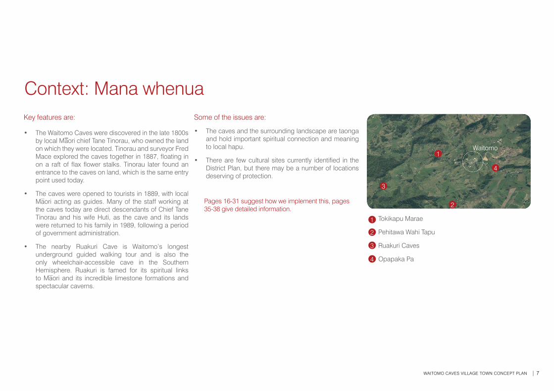
• The caves and the surrounding landscape are taonga and hold important spiritual connection and meaning to local hapu.
• There are few cultural sites currently identified in the District Plan, but there may be a number of locations deserving of protection.
Pages 16-31 suggest how we implement this, pages 35-38 give detailed information.
Context: Mana whenua
2
3
Tokikapu Marae
Pehitawa Wahi Tapu
Ruakuri Caves
Opapaka Pa
1
2
3
4
4
1Waitomo
8 | JUNE 2019
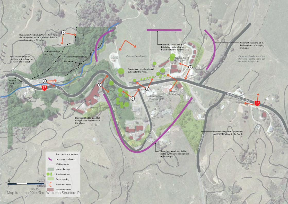
Key features are:
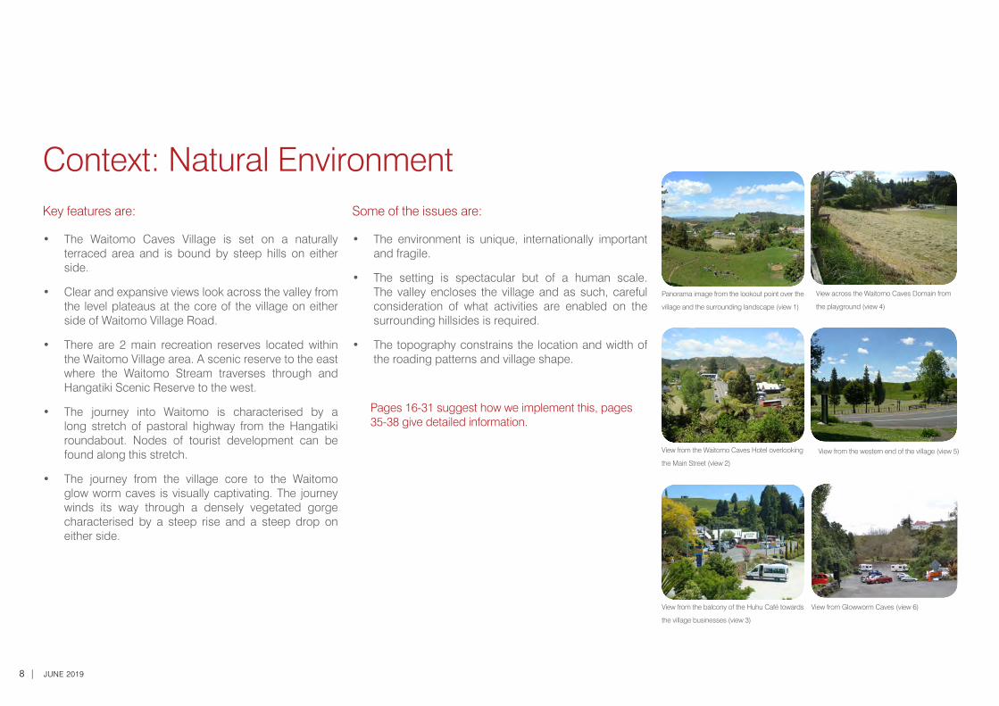
• The Waitomo Caves Village is set on a naturally terraced area and is bound by steep hills on either side.
• Clear and expansive views look across the valley from the level plateaus at the core of the village on either side of Waitomo Village Road.
• There are 2 main recreation reserves located within the Waitomo Village area. A scenic reserve to the east where the Waitomo Stream traverses through and Hangatiki Scenic Reserve to the west.
• The journey into Waitomo is characterised by a long stretch of pastoral highway from the Hangatiki roundabout. Nodes of tourist development can be found along this stretch.
• The journey from the village core to the Waitomo glow worm caves is visually captivating. The journey winds its way through a densely vegetated gorge characterised by a steep rise and a steep drop on either side.
Context: Natural EnvironmentSome of the issues are:
• The environment is unique, internationally important and fragile.
• The setting is spectacular but of a human scale. The valley encloses the village and as such, careful consideration of what activities are enabled on the surrounding hillsides is required.
• The topography constrains the location and width of the roading patterns and village shape.
Pages 16-31 suggest how we implement this, pages 35-38 give detailed information.
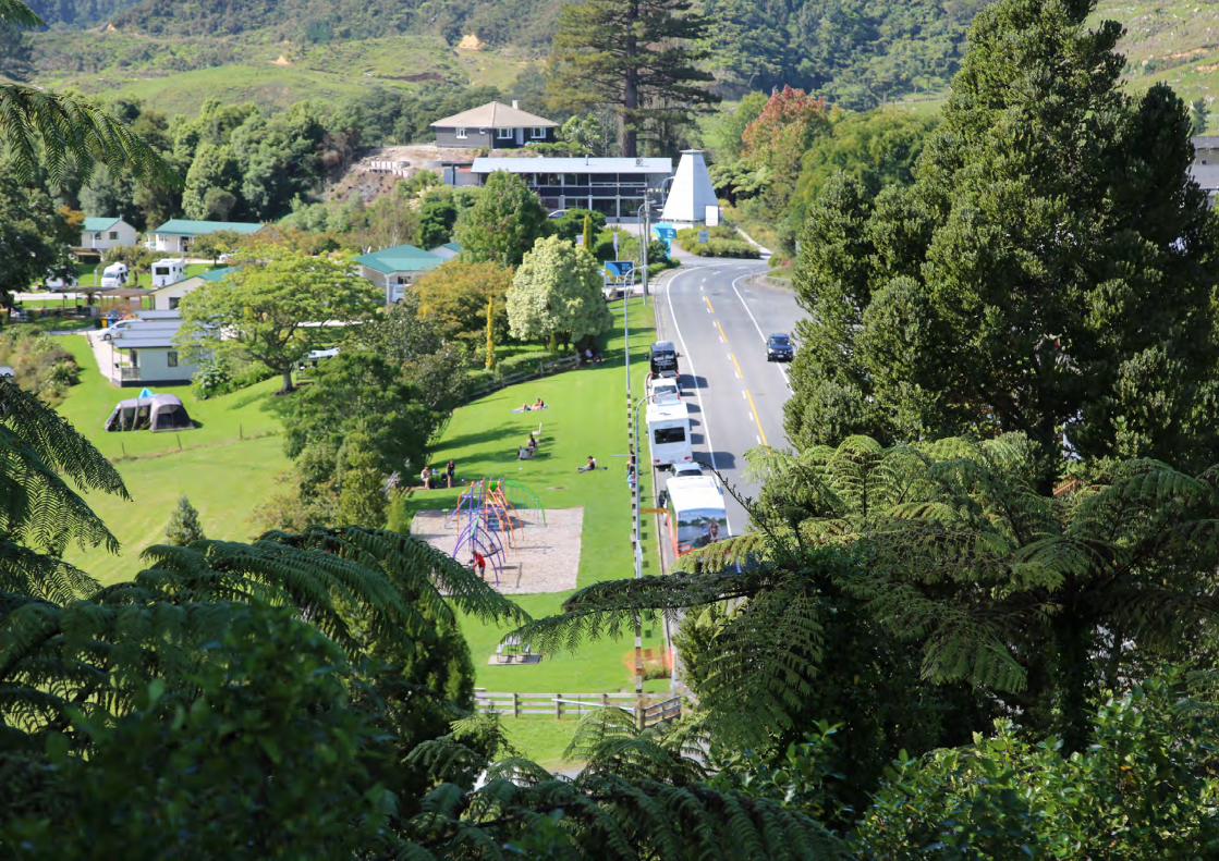
Panorama image from the lookout point over the
village and the surrounding landscape (view 1)
View across the Waitomo Caves Domain from
the playground (view 4)
View from the western end of the village (view 5)
View from Glowworm Caves (view 6)
View from the Waitomo Caves Hotel overlooking
the Main Street (view 2)
View from the balcony of the Huhu Café towards
the village businesses (view 3)
WAITOMO CAVES VILLAGE TOWN CONCEPT PLAN | 9
5 min
200 m100 m
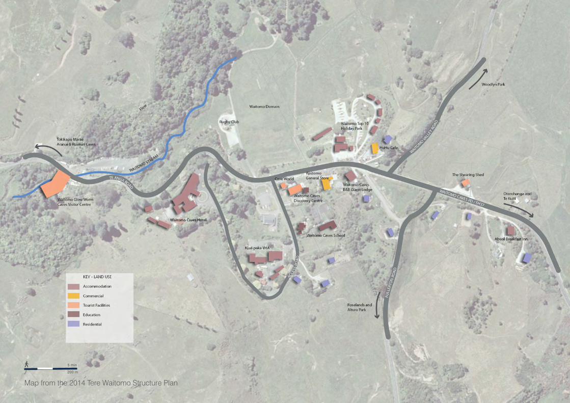
Map from the 2014 Tere Waitomo Structure Plan
10 | JUNE 2019
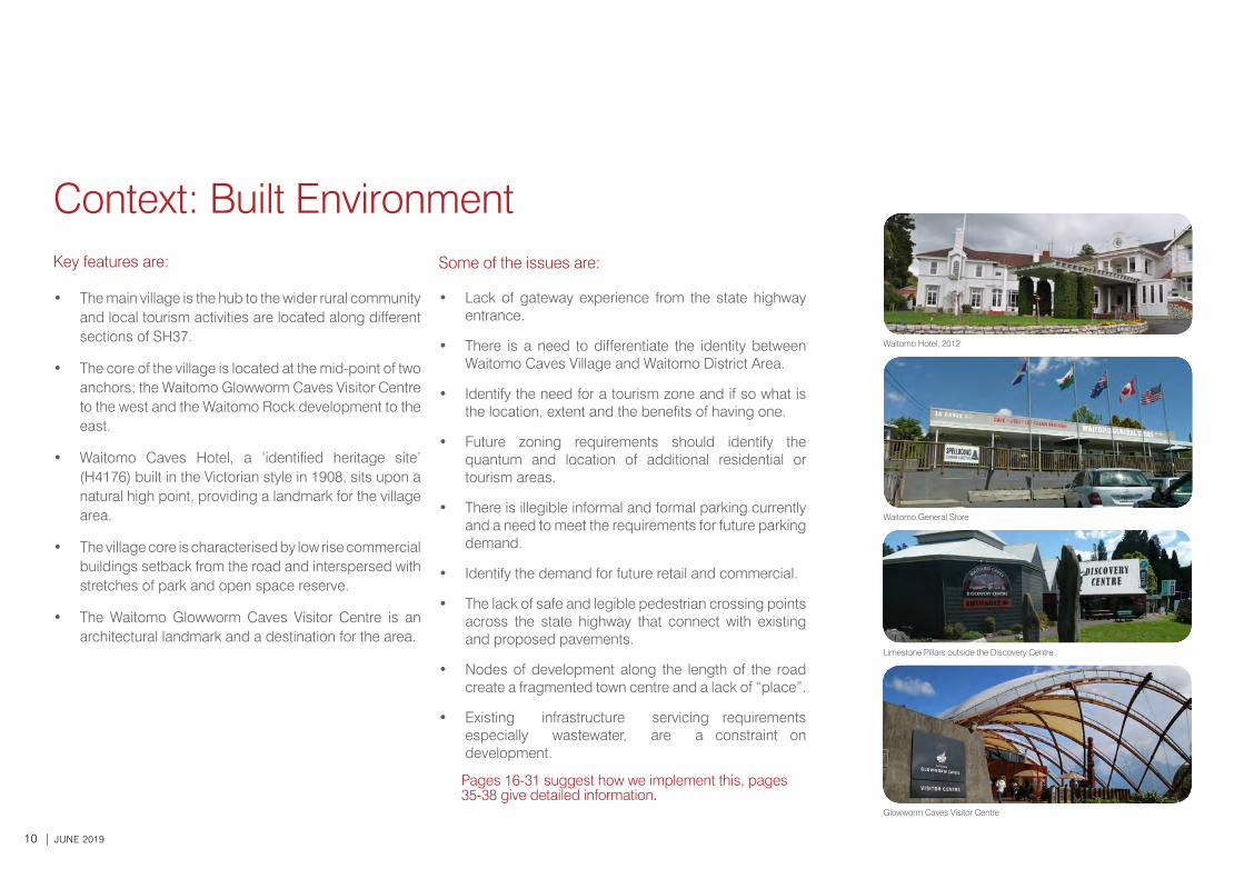
Some of the issues are:
• Lack of gateway experience from the state highway entrance.
• There is a need to differentiate the identity between Waitomo Caves Village and Waitomo District Area.
• Identify the need for a tourism zone and if so what is the location, extent and the benefits of having one.
• Future zoning requirements should identify the quantum and location of additional residential or tourism areas.
• There is illegible informal and formal parking currently and a need to meet the requirements for future parking demand.
• Identify the demand for future retail and commercial.
• The lack of safe and legible pedestrian crossing points across the state highway that connect with existing and proposed pavements.
• Nodes of development along the length of the road create a fragmented town centre and a lack of “place”.
• Existing infrastructure servicing requirements especially wastewater, are a constraint on development.
Pages 16-31 suggest how we implement this, pages 35-38 give detailed information.
Key features are:
• The main village is the hub to the wider rural community and local tourism activities are located along different sections of SH37.
• The core of the village is located at the mid-point of two anchors; the Waitomo Glowworm Caves Visitor Centre to the west and the Waitomo Rock development to the east.
• Waitomo Caves Hotel, a ‘identified heritage site’ (H4176) built in the Victorian style in 1908, sits upon a natural high point, providing a landmark for the village area.
• The village core is characterised by low rise commercial buildings setback from the road and interspersed with stretches of park and open space reserve.
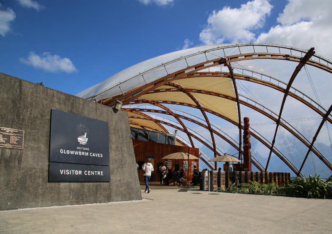
• The Waitomo Glowworm Caves Visitor Centre is an architectural landmark and a destination for the area.
Waitomo Hotel, 2012
Waitomo General Store
Limestone Pillars outside the Discovery Centre
Glowworm Caves Visitor Centre
Context: Built Environment
WAITOMO CAVES VILLAGE TOWN CONCEPT PLAN | 11
5 min
200 m
Map from the 2014 Tere Waitomo Structure Plan
12 | JUNE 2019
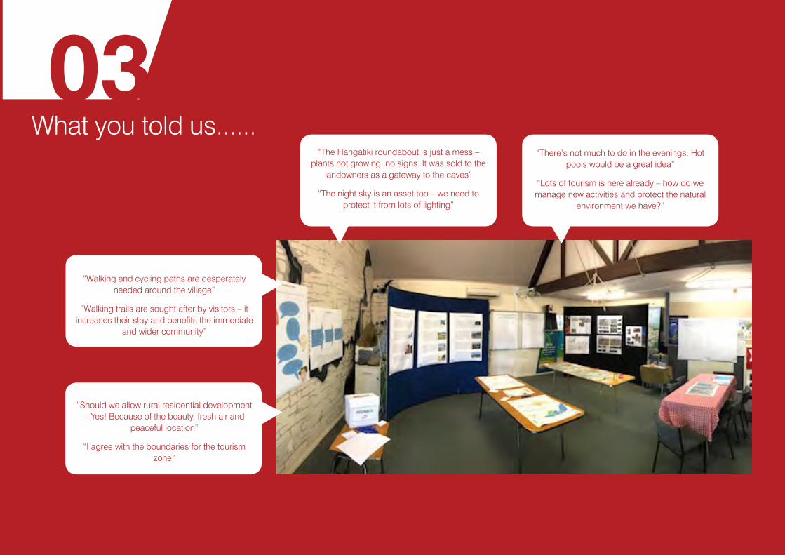
What you told us...... 03
“The Hangatiki roundabout is just a mess – plants not growing, no signs. It was sold to the
landowners as a gateway to the caves”
“The night sky is an asset too – we need to protect it from lots of lighting”
“There’s not much to do in the evenings. Hot pools would be a great idea”
“Lots of tourism is here already – how do we manage new activities and protect the natural
environment we have?”
“Walking and cycling paths are desperately needed around the village”
“Walking trails are sought after by visitors – it increases their stay and benefits the immediate
and wider community”
“Should we allow rural residential development – Yes! Because of the beauty, fresh air and
peaceful location”
“I agree with the boundaries for the tourism zone”
WAITOMO CAVES VILLAGE TOWN CONCEPT PLAN | 13
Community Involvement
An open day was held at the Caves Discovery Centre on the 3rd July 2018. A second open day was held on 20 February 2019 to receive further feedback on this document. Maps and posters of the features, issues and opportunities for shaping Waitomo Village into the future were displayed. Council staff were present to assist with any questions and receive feedback from residents and the public.
Ideas boards captured thoughts and suggestions for the Waitomo Caves Village township. People also filled in individual feedback slips. These responses have helped determine the future character of Waitomo Caves Village and what key moves are required to get there. The main issues raised are summarised below with the corresponding Key Move; these are expanded on and illustrated in Section 4:
• The proposed tourism zoning is a good fit for the area but we must manage new activities to protect the natural environment (Key Move 3).
• There are opportunities to develop walking and cycling paths around the village to increase visitor stay and benefit the immediate and wider community (Key Move 4).
Iwi Engagement
Meetings were held with representatives from the Hauauru ki Uta Regional Marae Committee on 3 and 9 July 2018. Issues raised have been actioned, either integrated into the Concept Plan key moves, or followed up by Council. Key points raised for consideration in the Concept Plan were:
• The upcoming settlement brings the potential for both change and opportunity for hapu. There is a desire for development that focuses on the welfare of whanau and the protection and care of the environment. (Key Move 3)
• Hauauru ki Uta support the concept of Marae and Papakaainga Zones providing that rating is fairly apportioned. (Key Move 3)
• There are sites of significance and other taonga that require protection and proper management to ensure that they are kept safe in perpetuity. (Key Move 2)
• It was observed that sometimes there is a disconnect with decision making in consents and policy that community focused documents like the Concept Plan could help to address. (Key Move 2)
• Members have aspirations for development of Maori Land including ensuring that it is well looked after and succession is properly planned for. This includes managing land subject to rahui. (Key Move 3)
• Hauauru ki Uta support the opportunity to build on the relationship with the Council as being in the wider and longer term interests of the community. (Key Move 2)
• There are opportunities to offer lots of different experiences to visitors to encourage them to stay longer and enjoy the village (Key Move 1)
• New residential areas are needed so that people can live and work here (Key Move 3).
Some of the issues are being addressed through other Council processes including: Long Term Plan (LTP) - outlines what will be done over the plan's 10 year period, including key projects such as infrastructure upgrades to parks and other public facilities, the reasons for Council to do these projects and their cost.
Proposed District Plan (PDP) - The Operative District Plan is currently being reviewed and modified. This document sets the framework for managing land use and development within Waitomo District. The MAPS identify where actions are being addressed through the LTP and PDP.
14 | JUNE 2019
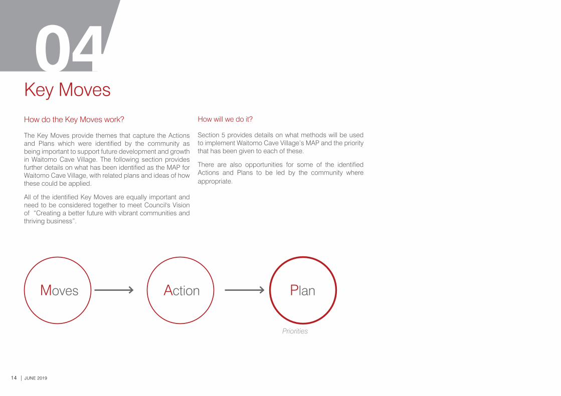
How do the Key Moves work?
The Key Moves provide themes that capture the Actions and Plans which were identified by the community as being important to support future development and growth in Waitomo Cave Village. The following section provides further details on what has been identified as the MAP for Waitomo Cave Village, with related plans and ideas of how these could be applied.
All of the identified Key Moves are equally important and need to be considered together to meet Council's Vision of “Creating a better future with vibrant communities and thriving business”.
How will we do it?
Section 5 provides details on what methods will be used to implement Waitomo Cave Village’s MAP and the priority that has been given to each of these.
There are also opportunities for some of the identified Actions and Plans to be led by the community where appropriate.
Key Moves
Priorities
04
Moves Action Plan
WAITOMO CAVES VILLAGE TOWN CONCEPT PLAN | 15

16 | JUNE 2019
Key Move 1Strengthen the visitor experience for Waitomo Caves VillageThe community suggested these actions to implement Key Move 1:
Action A:
Consolidate development between the three key nodes - the glow worm caves visitor centre, the village centre and the proposed Waitomo Rock development.
The suggested plan is: i. Upgrade the museum/i-site to attract people to
the heart of the villageii. Consolidate the village coreiii. Encourage community events such as festivals
and markets in the Waitomo Caves Domainiv. Consider the potential location of new public
toilets which could showcase local artwork
Action B:
Improve the visitor amenity in the village core through public realm upgrades
The suggested plan is: i. Provide better shade and places to sit and restii. Explore opportunites to provide a bus shelter
next to the playgroundiii. Investigate the potential to provide a formal edge
(either landscaping or building) to complete the village centre
iv. Landscape the parking areasv. Use planting/landscape to green the village
corevi. Examine ways to reduce vehicle and pedestrian
conflict in the village
Pages 17-19 suggest how we implement this. Page 35 provides detailed information.
WAITOMO CAVES VILLAGE TOWN CONCEPT PLAN | 17
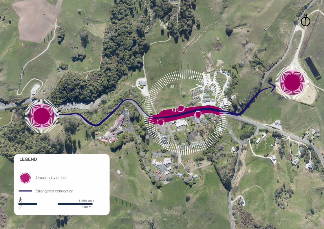
N
LEGEND
5 min walk
200 m
Opportunity areas
Strengthen connection

18 | JUNE 2019
WAITOMO CAVES ROAD
POSSIBLE COMMERCIAL DEVELOPMENT WITH MULTIPLE UNITS
OUTDOOR SPACE IN FRONT OF NEW COMMERCIAL SPACE FOR OUTDOOR DINING/ DISPLAYS
EXTENDED TERRACES ALONG THE DISCOVERY CENTRE FRONTAGE
NEW CONNECTION TO WAITOMO STREAM WALKWAY
NORTH
PEDESTRIAN AND VEHICLE ACCESS TO LONG TERM DOMAIN CARPARK
PEDESTRIAN MEDIAN
POSSIBLE TEMPORARY OR PERMANENT DEVELOPMENT ALONG THE PARK EDGE FOR RESTAURANT/ CAFE OR RETAIL SPACES
CENTRAL COMMUNITY SPACE OPENING UP TO THE ICONIC DOMAIN
FORM THE EXISTING SLOPE TO CREATE A NATURAL AMPHITHEATRE OPENING ONTO DOMAIN
PEDESTRIAN BUILD OUT AND CROSSING TO SLOW TRAFFIC AND TO CONNECT EITHER SIDE OF THE MAIN STREET
ACCESS TO REAR LOT CARPARK FOR MEDIUM TO LONG TERM VISITORS
NEW PEDESTRIAN PRIORITY STRIP ACROSS ACCESS ROAD
EXTENDED FOOTPATH FACILITIES TO LINK TO SCHOOL AND KIWI PAKA
BUS PICK UP/ DROP OFF AREA
FREE WIFI WITHIN TOWN CENTRE FOR COMMUNITY AND VISITOR USE
SHORT TERM PARKING ON STREET
PLAYGROUND AREA RELOCATED WITH CLEAR VIEWS FROM NEW DEVELOPMENT AND CENTRAL COMMUNITY SPACE
ADDITIONAL PLANTING TO DISGUISE CONCRETE WALL
RETAIN WAKA AND ROCK FEATURES IN THIS AREA
POTENTIAL EXTENSION TO CAVE WORLD TO BALANCE DEVELOPMENT ON ACCESS ROAD
GENERAL STORE
WAITOMO TOP 10 HOLIDAY PARK
WAITOMO CAVES DOMAIN
CAVE WORLD
A
B
A’ B’
ACCESS RO
AD
Some ideas
Action B:
Improve the visitor amenity in the village core through public realm upgrades
Map from the 2014 Tere Waitomo Structure Plan
WAITOMO CAVES VILLAGE TOWN CONCEPT PLAN | 19
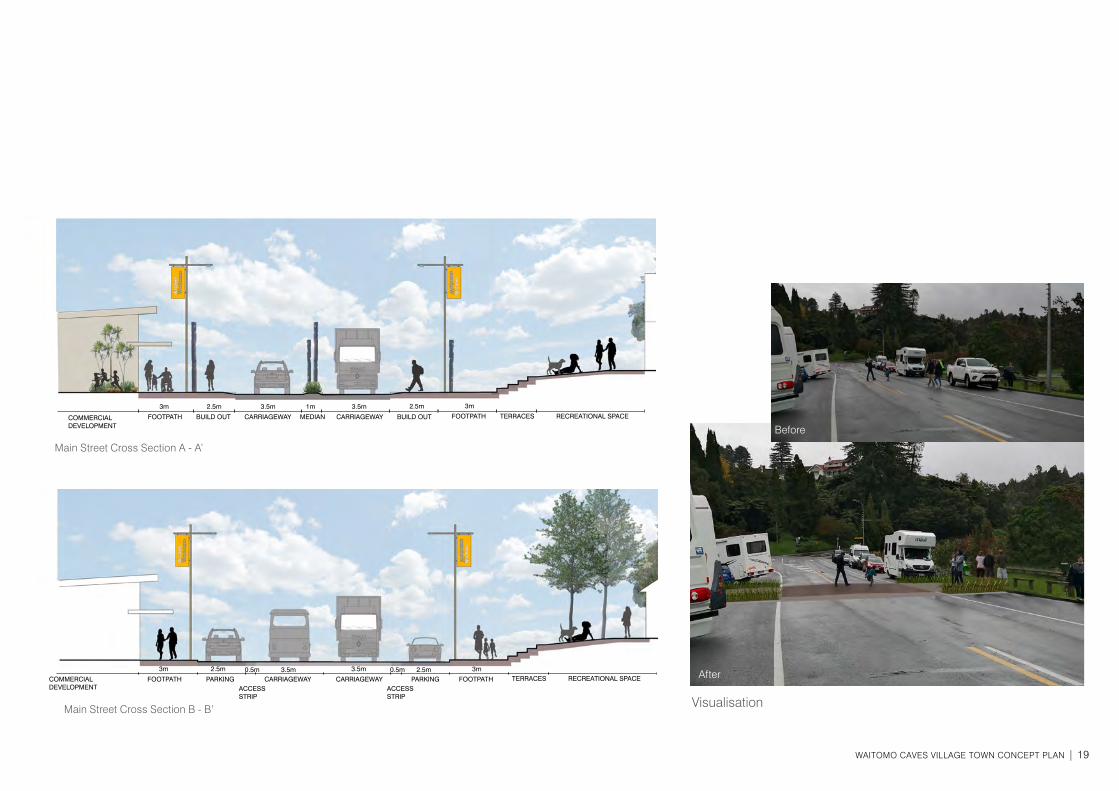
Visualisation
FOOTPATH
COMMERCIAL DEVELOPMENT
FOOTPATH
Main Street Cross Section A - A’
FOOTPATH TERRACES
TERRACES
RECREATIONAL SPACE
RECREATIONAL SPACEFOOTPATH
BUILD OUT
PARKING
MEDIAN BUILD OUT
PARKINGACCESS STRIP
ACCESS STRIP
CARRIAGEWAY
CARRIAGEWAY
CARRIAGEWAY
CARRIAGEWAY
3m
3m
2.5m
2.5m
3.5m
3.5m
3.5m
3.5m
1m 2.5m
2.5m0.5m0.5m
3m
3m
Main Street Cross Section B - B’
Before
After
BeforeCOMMERCIAL DEVELOPMENT
20 | JUNE 2019
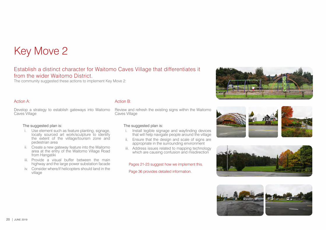
Key Move 2
Establish a distinct character for Waitomo Caves Village that differentiates it from the wider Waitomo District.The community suggested these actions to implement Key Move 2:
Action A:
Develop a strategy to establish gateways into Waitomo Caves Village
The suggested plan is: i. Use element such as feature planting, signage,
locally sourced art work/sculpture to identify the extent of the viillage/tourism zone and pedestrian area
ii. Create a new gateway feature into the Waitomo area at the entry of the Waitomo Village Road from Hangatiki
iii. Provide a visual buffer between the main highway and the large power substation facade
iv. Consider where/if helicopters should land in the village
Action B:
Review and refresh the existing signs within the Waitomo Caves Village
The suggested plan is: i. Install legible signage and wayfinding devices
that will help navigate people around the villageii. Ensure that the design and scale of signs are
appropriate in the surrounding environmentiii. Address issues related to mapping technology
which are causing confusion and misdirection
Pages 21-23 suggest how we implement this.
Page 36 provides detailed information.
WAITOMO CAVES VILLAGE TOWN CONCEPT PLAN | 21
N
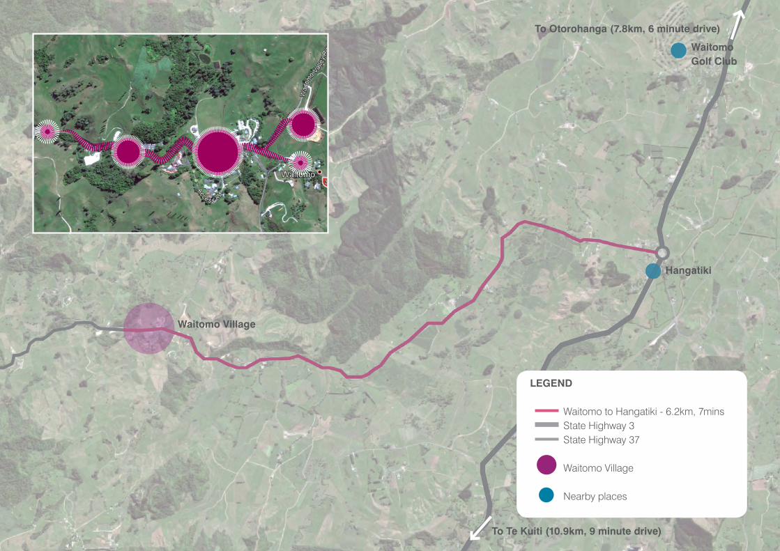
Large scale map
LEGEND
Waitomo to Hangatiki - 6.2km, 7mins State Highway 3 State Highway 37 Waitomo Village Nearby places
Hangatiki
WaitomoGolf Club
To Otorohanga (7.8km, 6 minute drive)
To Te Kuiti (10.9km, 9 minute drive)
Waitomo Village
22 | JUNE 2019
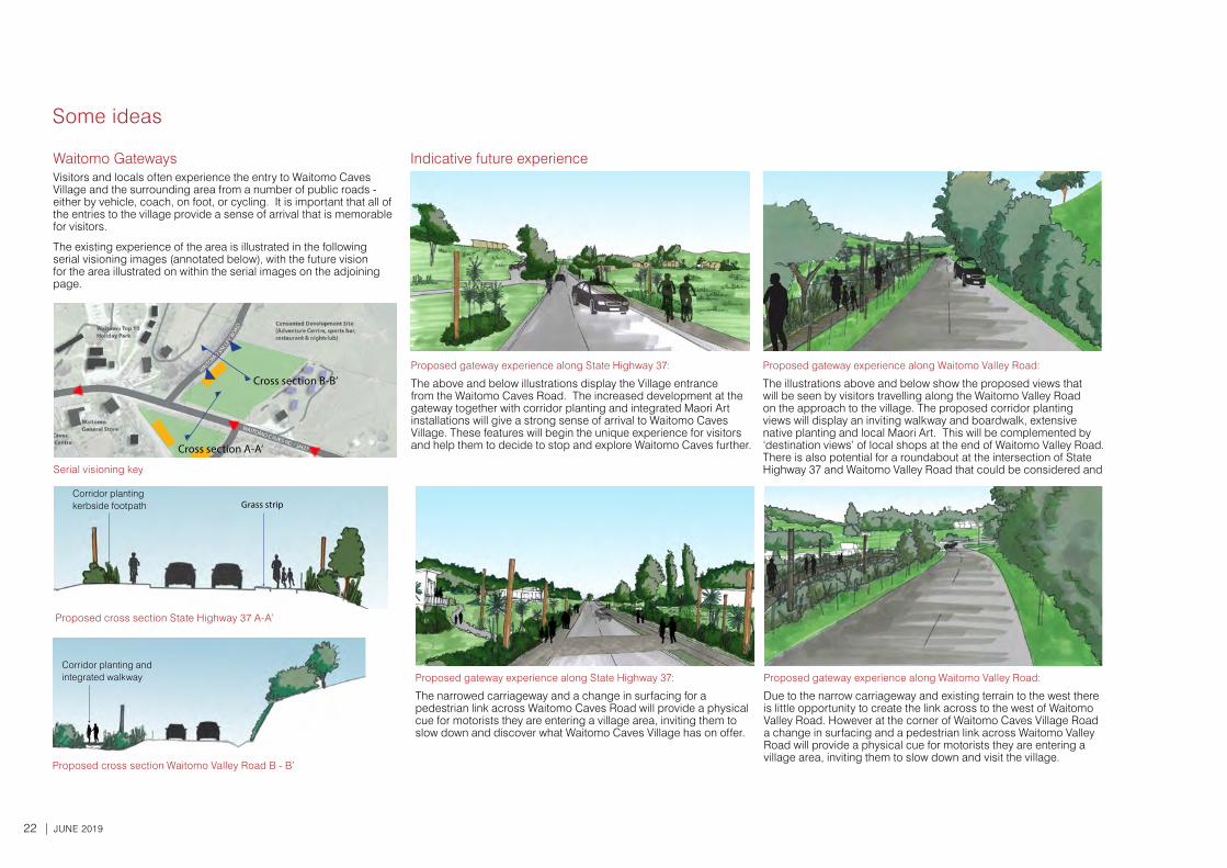
Some ideas
Corridor planting and integrated walkway
Corridor planting kerbside footpath Grass strip
Proposed cross section Waitomo Valley Road B - B’
Proposed cross section State Highway 37 A-A’
Proposed gateway experience along Waitomo Valley Road:
The illustrations above and below show the proposed views that will be seen by visitors travelling along the Waitomo Valley Road on the approach to the village. The proposed corridor planting views will display an inviting walkway and boardwalk, extensive native planting and local Maori Art. This will be complemented by ‘destination views’ of local shops at the end of Waitomo Valley Road. There is also potential for a roundabout at the intersection of State Highway 37 and Waitomo Valley Road that could be considered and
Proposed gateway experience along State Highway 37:
The above and below illustrations display the Village entrance from the Waitomo Caves Road. The increased development at the gateway together with corridor planting and integrated Maori Art installations will give a strong sense of arrival to Waitomo Caves Village. These features will begin the unique experience for visitors and help them to decide to stop and explore Waitomo Caves further.
1.
2.
Waitomo GatewaysVisitors and locals often experience the entry to Waitomo Caves Village and the surrounding area from a number of public roads - either by vehicle, coach, on foot, or cycling. It is important that all of the entries to the village provide a sense of arrival that is memorable for visitors.
The existing experience of the area is illustrated in the following serial visioning images (annotated below), with the future vision for the area illustrated on within the serial images on the adjoining page.
Indicative future experience
Serial visioning key
Cross section B-B’
Proposed gateway experience along Waitomo Valley Road:
Due to the narrow carriageway and existing terrain to the west there is little opportunity to create the link across to the west of Waitomo Valley Road. However at the corner of Waitomo Caves Village Road a change in surfacing and a pedestrian link across Waitomo Valley Road will provide a physical cue for motorists they are entering a village area, inviting them to slow down and visit the village.
Proposed gateway experience along State Highway 37:
The narrowed carriageway and a change in surfacing for a pedestrian link across Waitomo Caves Road will provide a physical cue for motorists they are entering a village area, inviting them to slow down and discover what Waitomo Caves Village has on offer.
Cross section A-A’

WAITOMO CAVES VILLAGE TOWN CONCEPT PLAN | 23
Hangatiki Roundabout Precedent images from Waikato and Bay of Plenty
Some ideas
Action A:
Create a new gateway feature into the Waitomo area at the entry of the Waitomo Village Road from Hangatiki.
24 | JUNE 2019
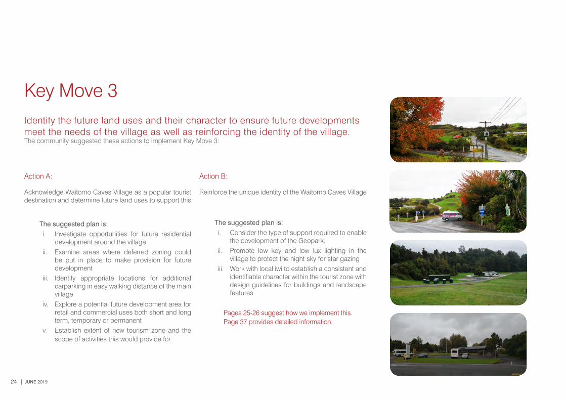
Key Move 3Identify the future land uses and their character to ensure future developments meet the needs of the village as well as reinforcing the identity of the village.The community suggested these actions to implement Key Move 3:
Action A:
Acknowledge Waitomo Caves Village as a popular tourist destination and determine future land uses to support this
The suggested plan is: i. Investigate opportunities for future residential
development around the villageii. Examine areas where deferred zoning could
be put in place to make provision for future development
iii. Identify appropriate locations for additional carparking in easy walking distance of the main village
iv. Explore a potential future development area for retail and commercial uses both short and long term, temporary or permanent
v. Establish extent of new tourism zone and the scope of activities this would provide for.
Action B:
Reinforce the unique identity of the Waitomo Caves Village
The suggested plan is: i. Consider the type of support required to enable
the development of the Geopark.ii. Promote low key and low lux lighting in the
village to protect the night sky for star gazingiii. Work with local iwi to establish a consistent and
identifiable character within the tourist zone with design guidelines for buildings and landscape features
Pages 25-26 suggest how we implement this. Page 37 provides detailed information.
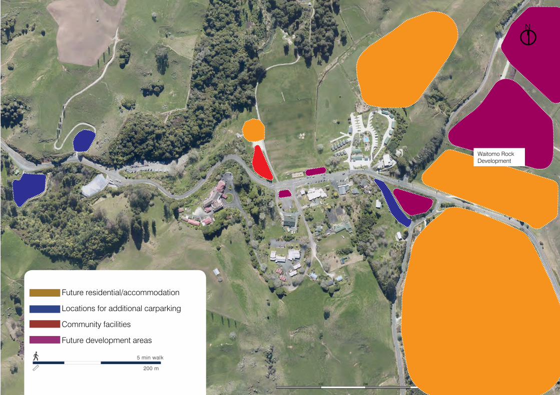
WAITOMO CAVES VILLAGE TOWN CONCEPT PLAN | 25
Waitomo Rock Development
N
5 min walk
200 m
Future residential/accommodation
Locations for additional carparking
Community facilities
Future development areas
26 | JUNE 2019
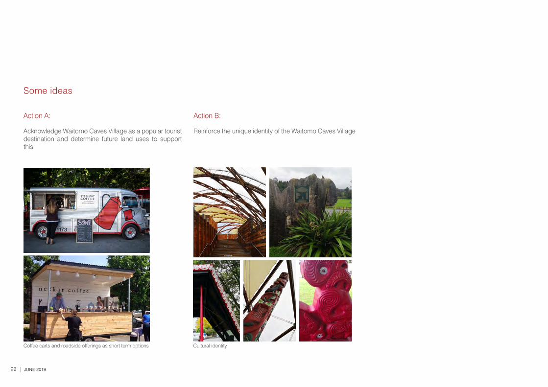
Coffee carts and roadside offerings as short term options Cultural identity
Some ideas
Action A:
Acknowledge Waitomo Caves Village as a popular tourist destination and determine future land uses to support this
Action B:
Reinforce the unique identity of the Waitomo Caves Village
WAITOMO CAVES VILLAGE TOWN CONCEPT PLAN | 27
28 | JUNE 2019
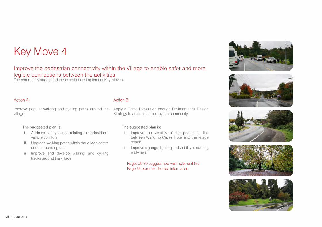
Key Move 4Improve the pedestrian connectivity within the Village to enable safer and more legible connections between the activitiesThe community suggested these actions to implement Key Move 4:
Action A:
Improve popular walking and cycling paths around the village
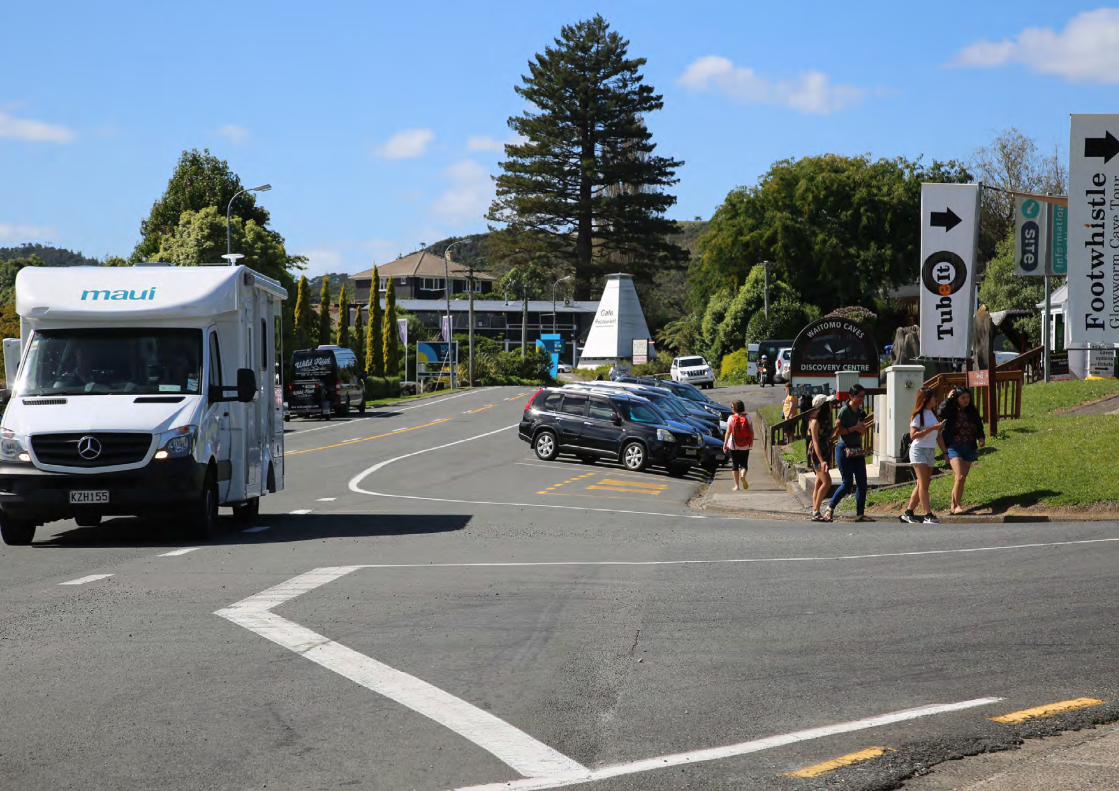
The suggested plan is: i. Address safety issues relating to pedestrian -
vehicle conflictsii. Upgrade walking paths within the village centre
and surrounding areaiii. Improve and develop walking and cycling
tracks around the village
Action B:
Apply a Crime Prevention through Environmental Design Strategy to areas identified by the community
The suggested plan is: i. Improve the visibility of the pedestrian link
between Waitomo Caves Hotel and the village centre
ii. Improve signage, lighting and visbility to existing walkways
Pages 29-30 suggest how we implement this. Page 38 provides detailed information.
WAITOMO CAVES VILLAGE TOWN CONCEPT PLAN | 29
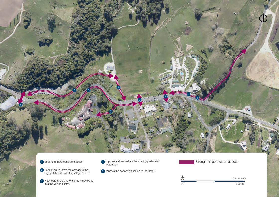
N
5 min walk
200 m
Strengthen pedestrian accessExisting underground connection
Pedestrian link from the carpark to the rugby club and up to the Village centre
New footpaths along Waitomo Valley Road into the Village centre.
Improve and re-mediate the existing pedestrian footpaths
Improve the pedestrian link up to the Hotel
1
1
2
22
22
3
33
4
4
5
5

30 | JUNE 2019
Some ideas
Action A:
Improve popular walking and cycling paths around the village
9/18/2018 10 Waitomo Caves Rd - Google Maps
https://www.google.co.nz/maps/@-38.2605953,175.1106928,3a,75y,82.92h,79.14t/data=!3m6!1e1!3m4!1svo6f_W8aPKnl44uYLfYKdQ!2e0!7i13312!8i6656 1/1
Image capture: Jan 2010 © 2018 Google
Waitomo, Waikato
Google, Inc.
Street View - Jan 2010
10 Waitomo Caves Rd
After
Before
WAITOMO CAVES VILLAGE TOWN CONCEPT PLAN | 31
32 | JUNE 2019
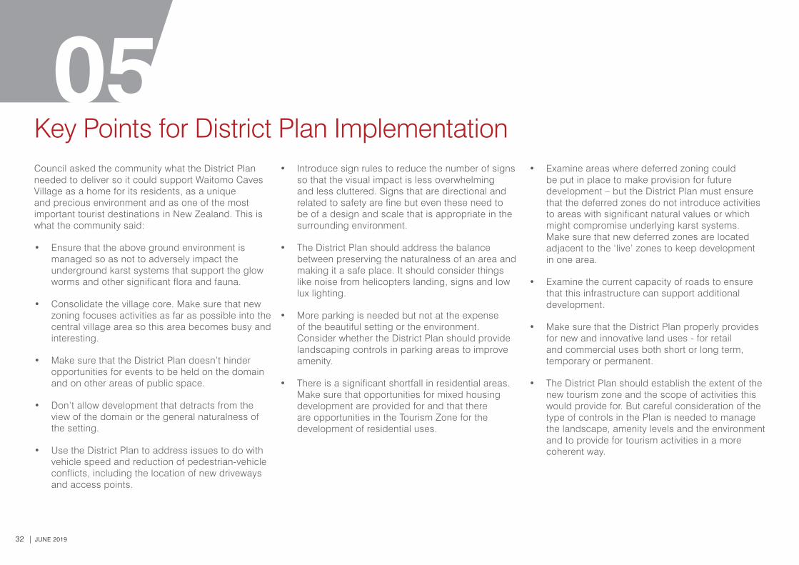
05Council asked the community what the District Plan needed to deliver so it could support Waitomo Caves Village as a home for its residents, as a unique and precious environment and as one of the most important tourist destinations in New Zealand. This is what the community said:
• Ensure that the above ground environment is managed so as not to adversely impact the underground karst systems that support the glow worms and other significant flora and fauna.
• Consolidate the village core. Make sure that new zoning focuses activities as far as possible into the central village area so this area becomes busy and interesting.
• Make sure that the District Plan doesn’t hinder opportunities for events to be held on the domain and on other areas of public space.
• Don’t allow development that detracts from the view of the domain or the general naturalness of the setting.
• Use the District Plan to address issues to do with vehicle speed and reduction of pedestrian-vehicle conflicts, including the location of new driveways and access points.
• Introduce sign rules to reduce the number of signs so that the visual impact is less overwhelming and less cluttered. Signs that are directional and related to safety are fine but even these need to be of a design and scale that is appropriate in the surrounding environment.
• The District Plan should address the balance between preserving the naturalness of an area and making it a safe place. It should consider things like noise from helicopters landing, signs and low lux lighting.
• More parking is needed but not at the expense of the beautiful setting or the environment. Consider whether the District Plan should provide landscaping controls in parking areas to improve amenity.
• There is a significant shortfall in residential areas. Make sure that opportunities for mixed housing development are provided for and that there are opportunities in the Tourism Zone for the development of residential uses.
Key Points for District Plan Implementation • Examine areas where deferred zoning could
be put in place to make provision for future development – but the District Plan must ensure that the deferred zones do not introduce activities to areas with significant natural values or which might compromise underlying karst systems. Make sure that new deferred zones are located adjacent to the ‘live’ zones to keep development in one area.
• Examine the current capacity of roads to ensure that this infrastructure can support additional development.
• Make sure that the District Plan properly provides for new and innovative land uses - for retail and commercial uses both short or long term, temporary or permanent.
• The District Plan should establish the extent of the new tourism zone and the scope of activities this would provide for. But careful consideration of the type of controls in the Plan is needed to manage the landscape, amenity levels and the environment and to provide for tourism activities in a more coherent way.
WAITOMO CAVES VILLAGE TOWN CONCEPT PLAN | 33
Implementation PlanHow will the MAP's be implemented?
This section of the Report provides further detail on how the Key Moves identified in Section 4 of this document will be carried out. This includes:
i. An implementation plan for each of the Key Moves, Actions and Plans identified in Section 4. It also provides an indication of priority based on community feedback and cost to undertake. This plan also recognises which projects have been identified in the current Long Term Plan and which matters will be addressed in the District Plan review.
ii. The draft zoning proposed as per Key Move 1 and 3.
The wider statutory framework that this Concept Plan with its Moves, Actions and Plans fits into, is illustrated in the Appendix on page 40.
When will the Waitomo Caves Village Concept Plan be reviewed?
The Concept Plan will be reviewed in full prior to the preparation of the next District Plan.
34 | JUNE 2019
MAP (Moves, Actions, Plans)
What are the priorities?
The priorities identified in this Section are based on the following timeframes:
1= Urgent, quick win (1-2 years).
2= Urgent, more complex issues require addressing (2-3 years)3= Medium term priority (3-5 years).
4= Longer term priority (5-7 years).
In the preparation of this Concept Plan there are already some projects that have been able to be incorporated into the Long Term Plan (LTP).
Other sources of Funding
There are multiple ways that the Actions and Plans identified in this document can be achieved, other than the Long Term Plan. These include:
• Community led.• Fundraising.• Funding/grants.
When will the implementation table be reviewed?
The implementation actions will be reviewed annually, with an update on the Waitomo District Council website on the projects that have been completed.
05
Projects that will form part of the proposed District Plan (PDP) are outlined in blue; and Projects that are incorporated into the Long Term Plan (LTP) are outlined in green.
WAITOMO CAVES VILLAGE TOWN CONCEPT PLAN | 35
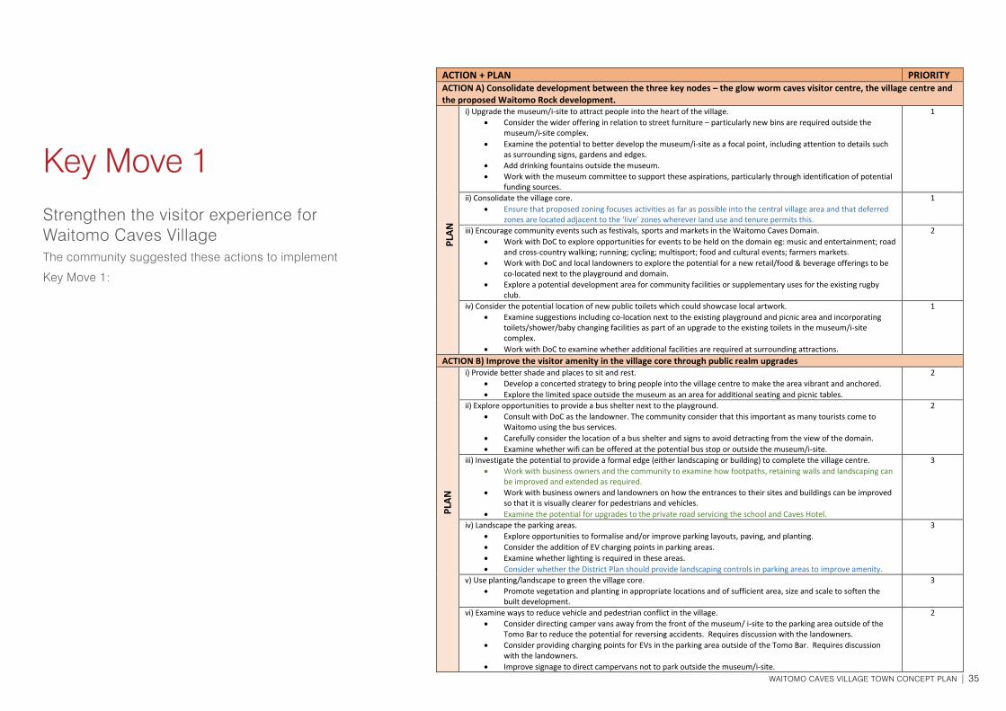
Key Move 1Strengthen the visitor experience for Waitomo Caves VillageThe community suggested these actions to implement
Key Move 1:
Key Move 1: Strengthen the visitor experience for Waitomo Caves Village.
ACTION + PLAN PRIORITY ACTION A) Consolidate development between the three key nodes – the glow worm caves visitor centre, the village centre and the proposed Waitomo Rock development. i) Upgrade the museum/i-site to attract people into the heart of the village.
• Consider the wider offering in relation to street furniture – particularly new bins are required outside the museum/i-site complex.
• Examine the potential to better develop the museum/i-site as a focal point, including attention to details such as surrounding signs, gardens and edges.
• Add drinking fountains outside the museum. • Work with the museum committee to support these aspirations, particularly through identification of potential
funding sources.
1
ii) Consolidate the village core. • Ensure that proposed zoning focuses activities as far as possible into the central village area and that deferred
zones are located adjacent to the ‘live’ zones wherever land use and tenure permits this.
1
iii) Encourage community events such as festivals, sports and markets in the Waitomo Caves Domain. • Work with DoC to explore opportunities for events to be held on the domain eg: music and entertainment; road
and cross-country walking; running; cycling; multisport; food and cultural events; farmers markets. • Work with DoC and local landowners to explore the potential for a new retail/food & beverage offerings to be
co-located next to the playground and domain. • Explore a potential development area for community facilities or supplementary uses for the existing rugby
club.
2
iv) Consider the potential location of new public toilets which could showcase local artwork. • Examine suggestions including co-location next to the existing playground and picnic area and incorporating
toilets/shower/baby changing facilities as part of an upgrade to the existing toilets in the museum/i-site complex.
• Work with DoC to examine whether additional facilities are required at surrounding attractions.
1
ACTION B) Improve the visitor amenity in the village core through public realm upgrades i) Provide better shade and places to sit and rest.
• Develop a concerted strategy to bring people into the village centre to make the area vibrant and anchored. • Explore the limited space outside the museum as an area for additional seating and picnic tables.
2
ii) Explore opportunities to provide a bus shelter next to the playground. • Consult with DoC as the landowner. The community consider that this important as many tourists come to
Waitomo using the bus services. • Carefully consider the location of a bus shelter and signs to avoid detracting from the view of the domain. • Examine whether wifi can be offered at the potential bus stop or outside the museum/i-site.
2
iii) Investigate the potential to provide a formal edge (either landscaping or building) to complete the village centre. • Work with business owners and the community to examine how footpaths, retaining walls and landscaping can
be improved and extended as required. • Work with business owners and landowners on how the entrances to their sites and buildings can be improved
so that it is visually clearer for pedestrians and vehicles. • Examine the potential for upgrades to the private road servicing the school and Caves Hotel.
3
iv) Landscape the parking areas. • Explore opportunities to formalise and/or improve parking layouts, paving, and planting. • Consider the addition of EV charging points in parking areas. • Examine whether lighting is required in these areas. • Consider whether the District Plan should provide landscaping controls in parking areas to improve amenity.
3
v) Use planting/landscape to green the village core. • Promote vegetation and planting in appropriate locations and of sufficient area, size and scale to soften the
built development.
3
vi) Examine ways to reduce vehicle and pedestrian conflict in the village. • Consider directing camper vans away from the front of the museum/ i-site to the parking area outside of the
Tomo Bar to reduce the potential for reversing accidents. Requires discussion with the landowners. • Consider providing charging points for EVs in the parking area outside of the Tomo Bar. Requires discussion
with the landowners. • Improve signage to direct campervans not to park outside the museum/i-site.
2
PLAN
PL
AN
36 | JUNE 2019
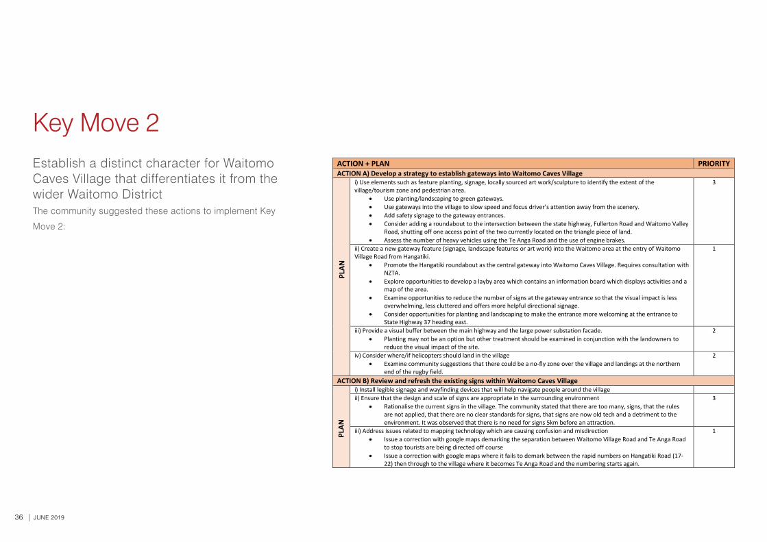
Key Move 2Establish a distinct character for Waitomo Caves Village that differentiates it from the wider Waitomo DistrictThe community suggested these actions to implement Key
Move 2:
Key Move 2: Establish a distinct character for Waitomo Caves Village that differentiates it
from the wider Waitomo District.
ACTION + PLAN PRIORITY ACTION A) Develop a strategy to establish gateways into Waitomo Caves Village i) Use elements such as feature planting, signage, locally sourced art work/sculpture to identify the extent of the
village/tourism zone and pedestrian area. • Use planting/landscaping to green gateways. • Use gateways into the village to slow speed and focus driver’s attention away from the scenery. • Add safety signage to the gateway entrances. • Consider adding a roundabout to the intersection between the state highway, Fullerton Road and Waitomo Valley
Road, shutting off one access point of the two currently located on the triangle piece of land. • Assess the number of heavy vehicles using the Te Anga Road and the use of engine brakes.
3
ii) Create a new gateway feature (signage, landscape features or art work) into the Waitomo area at the entry of Waitomo Village Road from Hangatiki.
• Promote the Hangatiki roundabout as the central gateway into Waitomo Caves Village. Requires consultation with NZTA.
• Explore opportunities to develop a layby area which contains an information board which displays activities and a map of the area.
• Examine opportunities to reduce the number of signs at the gateway entrance so that the visual impact is less overwhelming, less cluttered and offers more helpful directional signage.
• Consider opportunities for planting and landscaping to make the entrance more welcoming at the entrance to State Highway 37 heading east.
1
iii) Provide a visual buffer between the main highway and the large power substation facade. • Planting may not be an option but other treatment should be examined in conjunction with the landowners to
reduce the visual impact of the site.
2
iv) Consider where/if helicopters should land in the village • Examine community suggestions that there could be a no-fly zone over the village and landings at the northern
end of the rugby field.
2
ACTION B) Review and refresh the existing signs within Waitomo Caves Village i) Install legible signage and wayfinding devices that will help navigate people around the village
ii) Ensure that the design and scale of signs are appropriate in the surrounding environment • Rationalise the current signs in the village. The community stated that there are too many, signs, that the rules
are not applied, that there are no clear standards for signs, that signs are now old tech and a detriment to the environment. It was observed that there is no need for signs 5km before an attraction.
3
iii) Address issues related to mapping technology which are causing confusion and misdirection • Issue a correction with google maps demarking the separation between Waitomo Village Road and Te Anga Road
to stop tourists are being directed off course • Issue a correction with google maps where it fails to demark between the rapid numbers on Hangatiki Road (17-
22) then through to the village where it becomes Te Anga Road and the numbering starts again.
1
Key Move 3: Identify the future land uses and their character to ensure future developments meet the needs of the village as well as reinforcing the identity of the village.
PLAN
PL
AN
WAITOMO CAVES VILLAGE TOWN CONCEPT PLAN | 37
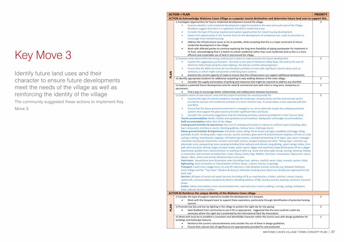
Key Move 3Identify future land uses and their character to ensure future developments meet the needs of the village as well as reinforcing the identity of the villageThe community suggested these actions to implement Key
Move 3:
ACTION + PLAN PRIORITY ACTION A) Acknowledge Waitomo Caves Village as a popular tourist destination and determine future land uses to support this. i) Investigate opportunities for future residential development around the village.
• Examine whether rural-residential development might be located to the west and south east of the Village. Residents suggest that there is a significant shortfall in residential areas.
• Consider the type of housing required and explore opportunities for mixed housing development. • Explore the opportunities in the Tourism Zone for the development of residential uses. Look at provisions to
encourage more (mixed) housing. • Address the infrastructure issues as far as possible, while accepting that this is a major constraint to future
residential development in the village. • Work with affected parties to continue exploring the long term feasibility of piping wastewater for treatment in
Te Kuiti, acknowledging that it is better to unlock residential rather than rural residential land as this is a more efficient and sustainable use of land in and around the village.
3
ii) Examine areas where deferred zoning could be put in place to make provision for future development • Explore the suggestions put forward – the land, to the west of Waitomo Valley Road, the land to the east of
Waitomo Valley Road along the state highway, the domain and the old backpackers • Ensure that the deferred zones do not introduce activities to areas with significant natural values such as
wetlands, or which might compromise underlying karst systems. • Examine the current capacity of roads to ensure that this infrastructure can support additional development.
2
iii) Identify appropriate locations for additional carparking in easy walking distance of the main village. • Consider the supply and location of parking and measures that might be required to address any shortfall. 2
iv) Explore a potential future development area for retail & commercial uses both short or long term, temporary or permanent.
• Find a way to encourage better relationships and collaboration between businesses
2
v) Establish extent of new tourism zone and the scope of activities this would provide for • Examine the type of controls needed to manage the landscape, amenity levels and the environment and to
provide for tourism and residential activities in a more coherent way. A conversation is also required with DoC and NZTA.
• Ensure that the above ground environment is managed so as not to adversely impact the underground karst systems that support the glow worms and other significant flora and fauna.
• Consider the community suggestions that the following activities could be provided for in the Tourism Zone: Tourist accommodation Hotels; Chalets and upmarket accommodation: Backpacker and budget accommodation. Staff accommodation within 5km of the village Underground Activities & Experiences: Any sort of underground activity in natural or artificial caves (including cafes; bars; restaurants and dance-rooms; shooting galleries; fantasy tours; challenge tours). Above ground Activities & Experiences: Hot pools, horse-riding; horse drawn carriages; quadbike and buggy riding; paintball; airsoft; climbing walls; ropes courses; zip line activities; glow worm & bioluminescent displays; off and on-road cycling; e-biking; hoverboards; segways; self-balancing scooters; skating and boarding of all types; spa; sauna; massage; relaxation and beauty treatments, retreats and health centres; bungee jumping and other “falling-type” activities e.g. descender units; parapenting; base-jumping including from balloons and drones; hang gliding ; giant swings; slides; mini-golf; pitch and putt; driving ranges; bumper boats; water sports; digger and machinery experiential parks (drive a digger experience); guided tours; demonstration or teaching of skills e.g. wood and stone jade caving; carving; weaving. Display or interaction with animals including Deer; Cows; Sheep; Goats; Pigs; Rabbits; Ostriches; Cassowaries; Opossums; Llama; Alpaca ; Bees. Artists and artisan demonstrations and sales. Farm tours: Aquaculture tours & produce sales (including trout; salmon; crayfish; paua; crabs; mussels; oysters; kina) Sightseeing: local orientation or interpretation of flora; fauna ; culture; history; or geology Transport: Coach tours; buggy tours; on and off road tours; links between tourism activities e.g. between Waitomo Caves Village and the “Top Caves” (Ruakuri & Aranui); Helicopter landing areas (there are already two approved for the Rock site) Services: All types of rental and repair services (including off & on road bicycles; e-bikes; vehicles; canoes; kayaks; watercraft; communications equipment) electric refuelling stations; ATMs; laundry and dry cleaning; minimart: Souvenir shops. Events: Indoor and outdoor music and entertainment; road and cross-country walking; running; cycling; multisport; food; cultural; farmers markets.
2
ACTION B) Reinforce the unique identity of the Waitomo Caves village. i) Consider the type of support required to enable the development of a Geopark.
• Work with the Geopark team to support these aspirations, particularly through identification of potential funding sources.
2
ii) Promote low key and low lux lighting in the village to protect the night sky for star gazing • Seek feedback from community to see if this is appropriate. Suggested that the area could be a dark sky
sanctuary where the night sky is protected by the International Dark Sky Association.
3
iii) Work with local Iwi to establish a consistent and identifiable character within the tourist zone with design guidelines for buildings and landscape features.
• Reinforce the current cultural elements and consider the use of these in design guidelines. • Ensure that cultural sites of significance are appropriately provided for and protected.
2
PLAN
PL
AN
38 | JUNE 2019
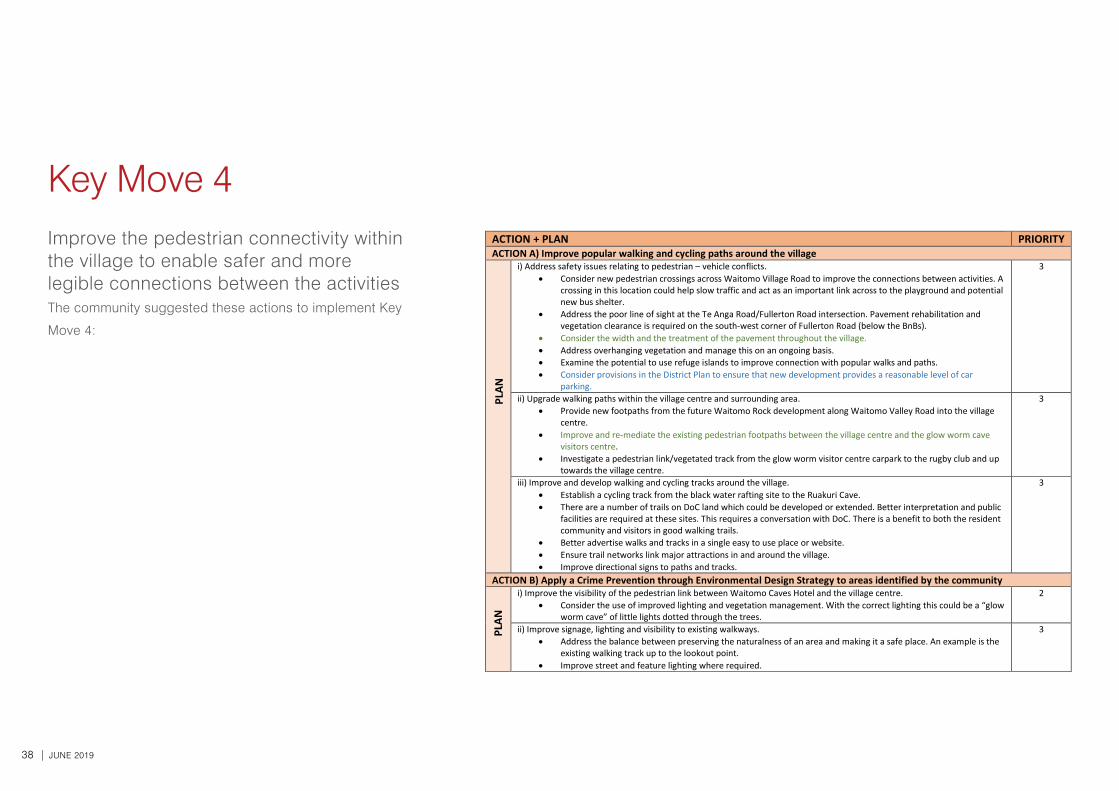
Key Move 4: Improve the pedestrian connectivity within the village to enable safer and
more legible connections between the activities.
ACTION + PLAN PRIORITY ACTION A) Improve popular walking and cycling paths around the village i) Address safety issues relating to pedestrian – vehicle conflicts.
• Consider new pedestrian crossings across Waitomo Village Road to improve the connections between activities. A crossing in this location could help slow traffic and act as an important link across to the playground and potential new bus shelter.
• Address the poor line of sight at the Te Anga Road/Fullerton Road intersection. Pavement rehabilitation and vegetation clearance is required on the south-west corner of Fullerton Road (below the BnBs).
• Consider the width and the treatment of the pavement throughout the village. • Address overhanging vegetation and manage this on an ongoing basis. • Examine the potential to use refuge islands to improve connection with popular walks and paths. • Consider provisions in the District Plan to ensure that new development provides a reasonable level of car
parking.
3
ii) Upgrade walking paths within the village centre and surrounding area. • Provide new footpaths from the future Waitomo Rock development along Waitomo Valley Road into the village
centre. • Improve and re-mediate the existing pedestrian footpaths between the village centre and the glow worm cave
visitors centre. • Investigate a pedestrian link/vegetated track from the glow worm visitor centre carpark to the rugby club and up
towards the village centre.
3
iii) Improve and develop walking and cycling tracks around the village. • Establish a cycling track from the black water rafting site to the Ruakuri Cave. • There are a number of trails on DoC land which could be developed or extended. Better interpretation and public
facilities are required at these sites. This requires a conversation with DoC. There is a benefit to both the resident community and visitors in good walking trails.
• Better advertise walks and tracks in a single easy to use place or website. • Ensure trail networks link major attractions in and around the village. • Improve directional signs to paths and tracks.
3
ACTION B) Apply a Crime Prevention through Environmental Design Strategy to areas identified by the community
i) Improve the visibility of the pedestrian link between Waitomo Caves Hotel and the village centre. • Consider the use of improved lighting and vegetation management. With the correct lighting this could be a “glow
worm cave” of little lights dotted through the trees.
2
ii) Improve signage, lighting and visibility to existing walkways. • Address the balance between preserving the naturalness of an area and making it a safe place. An example is the
existing walking track up to the lookout point. • Improve street and feature lighting where required.
3
PLAN
PL
AN
Key Move 4Improve the pedestrian connectivity within the village to enable safer and more legible connections between the activitiesThe community suggested these actions to implement Key
Move 4:
WAITOMO CAVES VILLAGE TOWN CONCEPT PLAN | 39
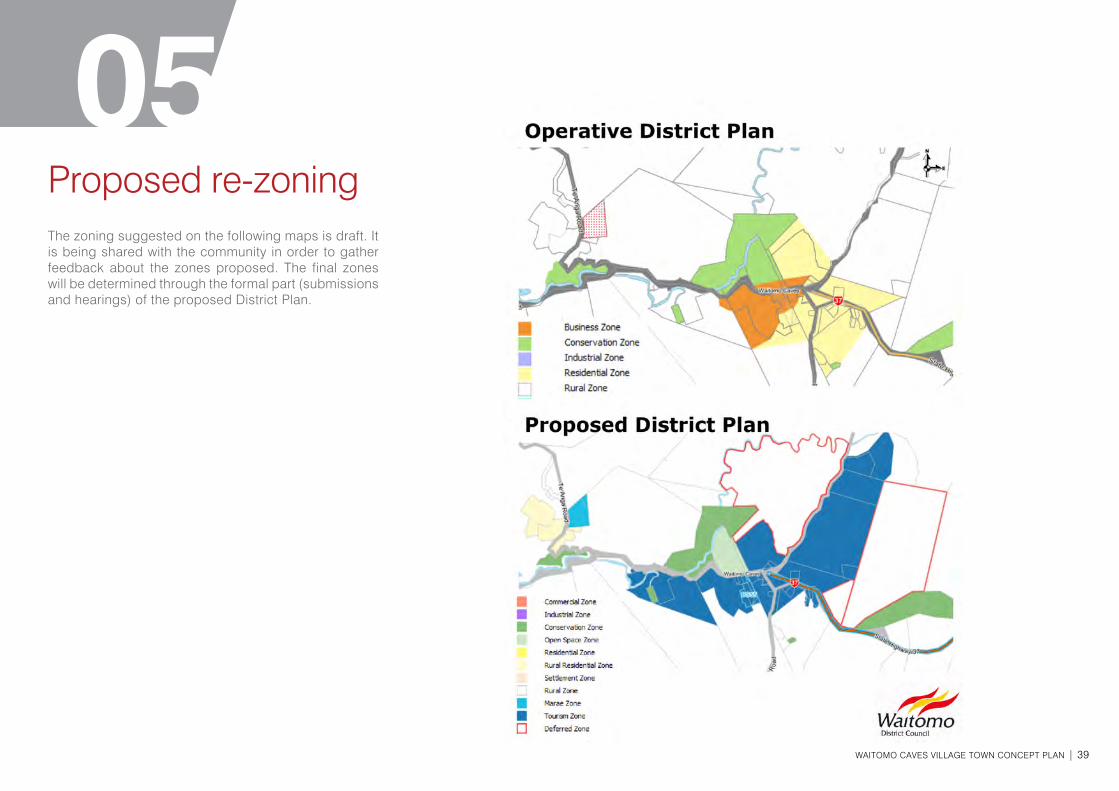
05Proposed re-zoning The zoning suggested on the following maps is draft. It is being shared with the community in order to gather feedback about the zones proposed. The final zones will be determined through the formal part (submissions and hearings) of the proposed District Plan.

40 | JUNE 2019
Influential
Legislation
Consultation
How it fits in
This Concept Plan informs not only the community but also the District Plan, long term planning and other strategic documents at a local and regional level as shown in the diagram.
Councils are required to prepare a Long Term Plan (LTP) under the Local Government Act 2002 every three years, that describes the community outcomes for the district, and what its priorities are over the next 10 years.
A Concept Plan can provide a longer term capture of community aspirations and thereby inform the LTP. Waitomo District Council has just completed their LTP. Some of the Key Moves and actions identified in this Concept Plan will inform the next LTP.
06Appendix: Statutory Framework
COMMUNITY FEEDBACK
LEGISLATION• Local Government Act 2002• Resource Management Act 1991• Land Transport Management Act 2003• Reserves Act 1977
NATIONAL• National Policy Statements• National Environmental Standards• Reserve Classiciation• NZ Transport Strategy• National Land Transport Programme
REGIONAL• Regional Council LTP's• Regional Growth Strategies• Regional Plans• Regional Land Transport Strategies • Regional Land Transport Programme• Regional Policy Statement
LOCAL/DISTRICT• Territorial Authority LTP's• Local Growth Strategies• District/City Plans• Reserve Management Plans• Annual Plan • Infrastructure Strategy
LOCAL GOVERNMENT STRATEGIES
• Concept Plan
WAITOMO CAVES VILLAGE TOWN CONCEPT PLAN | 41
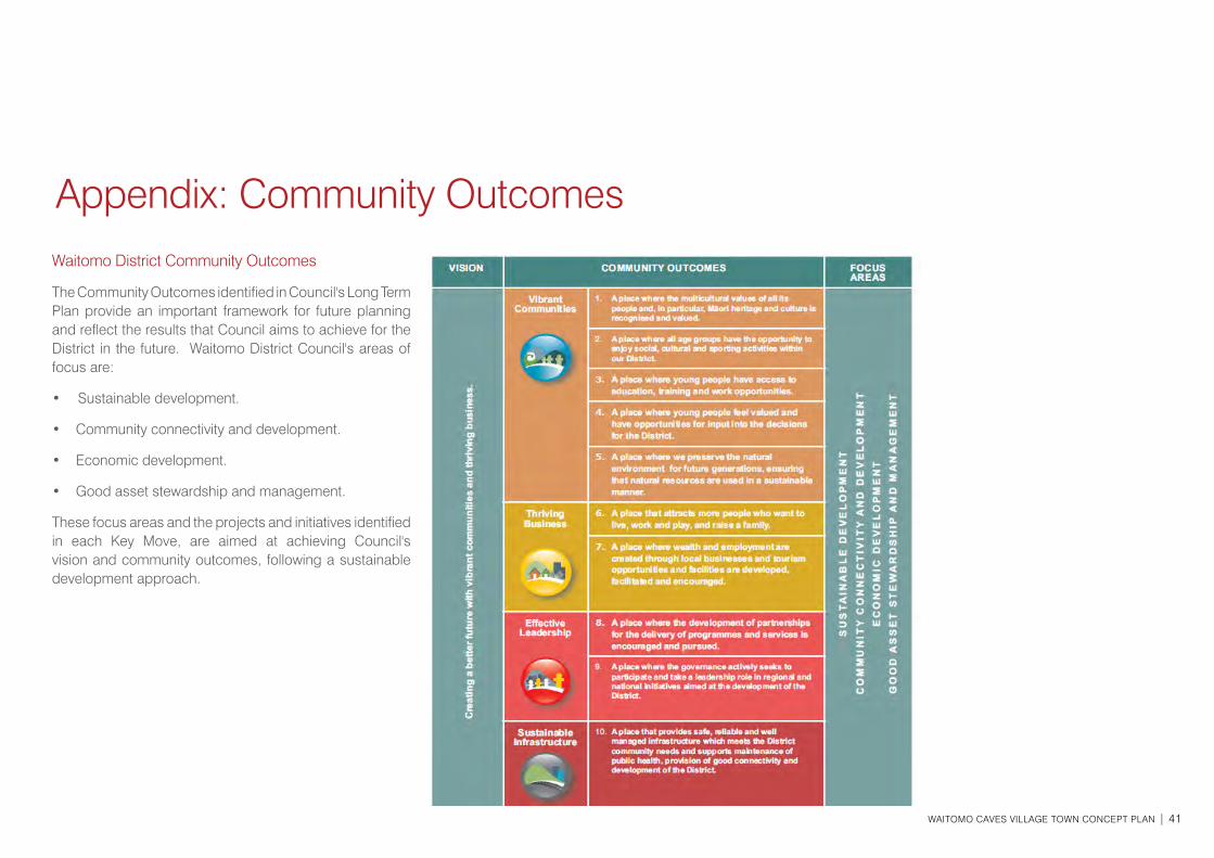
Waitomo District Community Outcomes
The Community Outcomes identified in Council's Long Term Plan provide an important framework for future planning and reflect the results that Council aims to achieve for the District in the future. Waitomo District Council's areas of focus are:
• Sustainable development.
• Community connectivity and development.
• Economic development.
• Good asset stewardship and management.
These focus areas and the projects and initiatives identified in each Key Move, are aimed at achieving Council's vision and community outcomes, following a sustainable development approach.
Appendix: Community Outcomes
42 | JUNE 2019