wambo coal pty ltd - microsoft coal pty ltd extraction plan longwalls 8 to 10a north wambo...
TRANSCRIPT

WAMBO COAL PTY LTD
EXTRACTION PLAN
LONGWALLS 8 TO 10A
EXTRACTION PLAN
LONGWALLS 8 TO 10A
NORTH WAMBO UNDERGROUND MINE
REPORT 3
SURFACE WATER IMPACT
ASSESSMENT REVIEW

Advisian Pty Ltd Level 17, 141 Walker Street North Sydney NSW 2060 Australia
P +61 (0)2 9495 0500 F +61 (0)2 9495 0520 E [email protected]
ABN 50 098 008 818
www.advisian.com
Micheal Alexander Director Projects and Technical Services Wambo Coal Pty Limited PMB 1 Singleton NSW 2330
Dear Michael
RE: Surface Water Impact Assessment Review – Revised Subsidence Impacts on Wambo Creek and Stony Creek
In August 2014 Evans & Peck (now trading as Advisian) completed an assessment of potential subsidence impacts on Wambo Creek and Stony Creek in support of an application to modify DA 305-7-2003 to enable extraction of an additional longwall panel (Longwall 10A).
The assessment considered extraction of Longwall 10A directly beneath a portion of Wambo Creek and Stony Creek, along with the approved longwall panels in the Wambo Seam (Longwalls 1 to 10) and future approved extraction of longwalls in the Arrowfield and Bowfield Seams.
The layout of Longwall 10A has been revised to shorten the commencing end by 245 metres. This revised layout of Longwall 10A will be presented in the North Wambo Underground Mine Extraction Plan for Longwalls 8 to 10A.
For the purposes of this letter report, the “Previous Layout” refers to the longwall layout presented and assessed in Evans & Peck (2014). The “Extraction Plan Layout” refers to the Longwall 10A with the shortened commencing end. The difference between the Previous Layout and the Extraction Plan Layout (i.e. the current layout of Longwall 10A) is shown on Figure 1 (attached at the end of this report).
This letter report has been prepared to support the Extraction Plan for Longwalls 8 to 10A and provides a review of the potential subsidence impacts and environmental consequences to Wambo Creek and Stony Creek as a result of the Extraction Plan Layout.
Revised Predictions of Subsidence Impacts and Consequences
An assessment of the revised likely magnitude and impacts of subsidence on Wambo and Stony Creeks from the North Wambo Underground Mine (Longwalls 8 to 10A) based on the Extraction Plan Layout was undertaken by MSEC (2015).
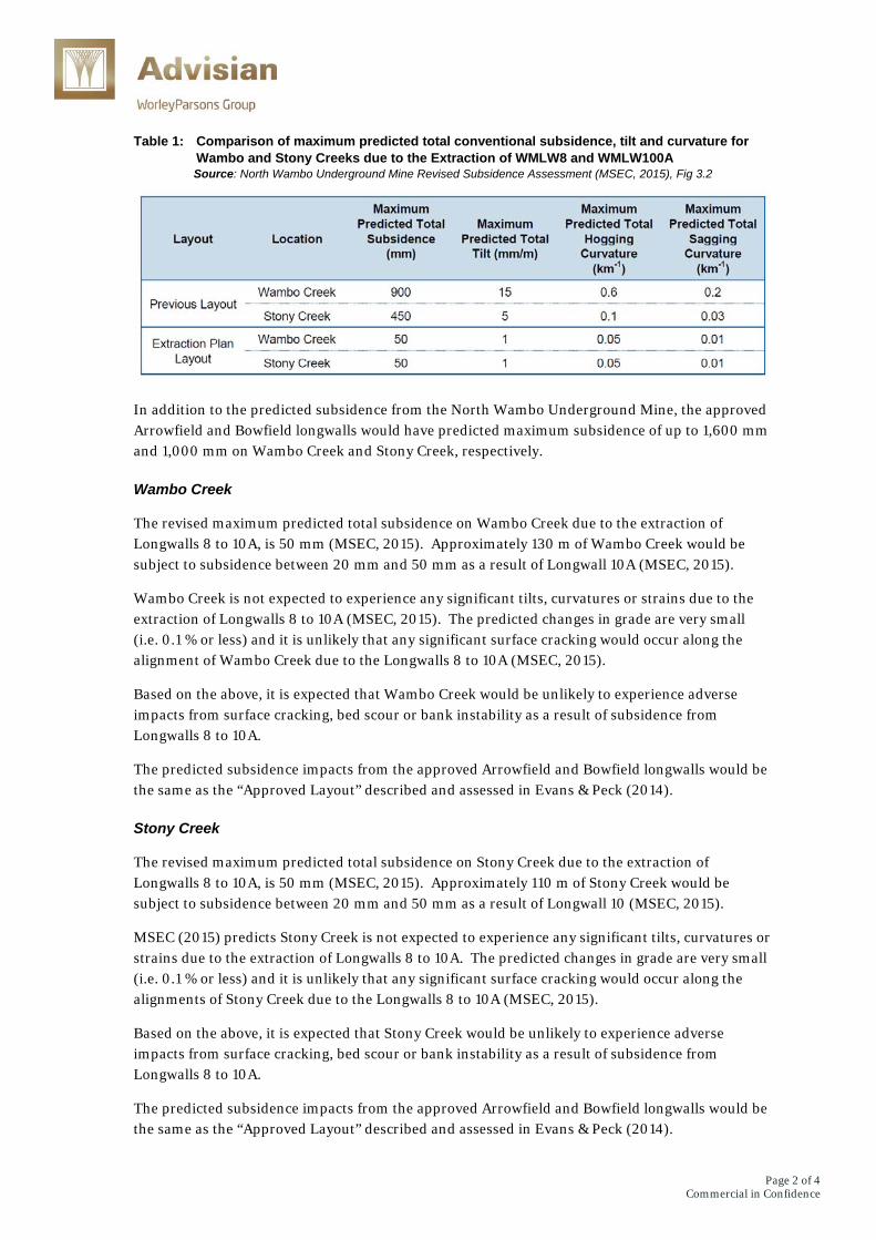
Table 1 provides a comparison of the maximum predicted values of total conventional subsidence, tilt and curvature for Wambo and Stony Creeks, due to the extraction of Longwalls 8 to 10A. It shows that the Extraction Plan Layout is predicted to significantly reduce subsidence impacts on the two creeks.
7 April 2015
Page 2 of 4Commercial in Confidence
Table 1: Comparison of maximum predicted total conventional subsidence, tilt and curvature for Wambo and Stony Creeks due to the Extraction of WMLW8 and WMLW100A Source: North Wambo Underground Mine Revised Subsidence Assessment (MSEC, 2015), Fig 3.2
In addition to the predicted subsidence from the North Wambo Underground Mine, the approved Arrowfield and Bowfield longwalls would have predicted maximum subsidence of up to 1,600 mm and 1,000 mm on Wambo Creek and Stony Creek, respectively.
Wambo Creek
The revised maximum predicted total subsidence on Wambo Creek due to the extraction of Longwalls 8 to 10A, is 50 mm (MSEC, 2015). Approximately 130 m of Wambo Creek would be subject to subsidence between 20 mm and 50 mm as a result of Longwall 10A (MSEC, 2015).
Wambo Creek is not expected to experience any significant tilts, curvatures or strains due to the extraction of Longwalls 8 to 10A (MSEC, 2015). The predicted changes in grade are very small (i.e. 0.1 % or less) and it is unlikely that any significant surface cracking would occur along the alignment of Wambo Creek due to the Longwalls 8 to 10A (MSEC, 2015).
Based on the above, it is expected that Wambo Creek would be unlikely to experience adverse impacts from surface cracking, bed scour or bank instability as a result of subsidence from Longwalls 8 to 10A.
The predicted subsidence impacts from the approved Arrowfield and Bowfield longwalls would be the same as the “Approved Layout” described and assessed in Evans & Peck (2014).
Stony Creek
The revised maximum predicted total subsidence on Stony Creek due to the extraction of Longwalls 8 to 10A, is 50 mm (MSEC, 2015). Approximately 110 m of Stony Creek would be subject to subsidence between 20 mm and 50 mm as a result of Longwall 10 (MSEC, 2015).
MSEC (2015) predicts Stony Creek is not expected to experience any significant tilts, curvatures or strains due to the extraction of Longwalls 8 to 10A. The predicted changes in grade are very small (i.e. 0.1 % or less) and it is unlikely that any significant surface cracking would occur along the alignments of Stony Creek due to the Longwalls 8 to 10A (MSEC, 2015).
Based on the above, it is expected that Stony Creek would be unlikely to experience adverse impacts from surface cracking, bed scour or bank instability as a result of subsidence from Longwalls 8 to 10A.
The predicted subsidence impacts from the approved Arrowfield and Bowfield longwalls would be the same as the “Approved Layout” described and assessed in Evans & Peck (2014).

Page 3 of 4Commercial in Confidence
Revised Monitoring and Management Recommendations
As described above, it is unlikely that extraction of Longwalls 8 to 10A would result in adverse impacts on Wambo Creek and Stony Creek. Therefore, mitigation works are unlikely to be required for the Extraction Plan Layout to manage the risk of any change in sediment movement along the creek or upstream migration of head-cuts along both creeks.
It is recommended that:
Wambo Coal Pty Limited (WCPL) should continue its current monitoring program, including bed and bank stability monitoring of Wambo Creek and Stony Creek and regular visual inspections in accordance with Section 5 the Water Management Plan.
In the unlikely instance that subsidence impacts (e.g. surface cracking, bed scour or bank instability) are observed along Wambo Creek or Stony Creek, WCPL should undertake repair and remediation in accordance with the Land Management Plan.
A detailed monitoring and remediation plan for Wambo Creek and Stony Creek should be developed as part of the future Extraction Plan Application for the approved Arrowfield and Bowfield longwall panels.
Yours sincerely,
Steve Perrens Principal
Documents Referenced
Evans & Peck (2014), North Wambo Underground Mine Longwall 10A Modification – Subsidence Impacts on Wambo Creek and Stony Creek, Report for Wambo Coal Pty Ltd, 27 August 2014
MSEC (2015), North Wambo Underground Mine Revised Subsidence Assessment, Report prepared for Peabody Energy, 1 April 2015.

Page 4 of 4Commercial in Confidence
Figure 1: Location of Wambo Creek and Stony Creek in relation to the ‘Previous Layout’ and the Extraction Plan Layout’ Source: North Wambo Underground Mine Revised Subsidence Assessment (MSEC, 2015), Drawing MSEC754-03