wastewater study - scottsdaleaz
TRANSCRIPT

Wastewater Study

PRELIMINARY BASIS OF DESIGN for WASTEWATER
MUSEUM SQUARE 2nd Steet and Marshall Way
Scottsdale, AZ
Prepared For:
3225 N. Central Avenue, Suite 100
Phoenix, AZ 85012
Prepared by:
Sustainability Engineering Group 8280 E. Gelding Drive, Suite 101
Scottsdale, AZ 85260
480.588.7226 www.azSEG.com
Project Number: 180109
Submittal Date: June 15, 2018
Revision Date: September 25, 2018
Case No.: 391-PA-2018; 13-ZN-2018 Plan Check No.: TBD
PRELIMINARY Basis of DesignReport
ACCEPTED
BY DATE
Disclaimer: If accepted; the preliminary approval is granted underthe condition that a final basis of design report will also besubmitted for city review and approval (typically during the DR orPP case). The final report shall incorporate further water or sewerdesign and analysis requirements as defined in the city designstandards and policy manual and address those items noted inthe preliminary review comments (both separate and includedherein). The final report shall be submitted and approved prior tothe plan review submission.For questions or clarifications contact the Water ResourcesPlanning and Engineering Department at 480-312-5685.
ACCEPTED AS NOTED
REVISE AND RESUBMIT
✔
ldillon 11/14/2018
9379 E San Salvador Dr.Scottsdale, AZ 85258
11/14/2018
Comments throughout.See next page forhighlights.
This is review Round 3

LDillon comments 11/14/2018
New 10"/8" parallel sewer servicing Canopy Hotel and Museum Square hotel and condos is proposedherein. Coordination with Canopy is required as Canopy is further along.
If a parallel sewer is not able to be constructed then upsizing of the existing sewer shall berequired. Upsized sewer shall convey 813gpm/453gpm at max d/D=0.65. Given the slope of the existing 8"sewer this would be a 12-inch min sewer from 2nd Street north to Museum Square Hotel/condo tie-in toconvey 813gpm, then a 10-inch min sewer north to alley north of 1st street to convey 453gpm.
Note that only 4.5ft of wall to wall separation from new to existing sewer is shown on the utility plan herein.Minimum separation is 6 feet. Refer to utility plan comments.
------------------------------------------------------------------------------------------------------Private sewer shall conform to Scottsdale adopted plumbing code.
Per Section 5.1 herein: "South of 2nd Street - three residential buildings will be constructed over a commonunderground garage and operate as a single structure located on a single lot under management of aproperty agreement. Sewer service will be routed through a privately owned, operated and maintainedsewer line from each high-rise down through the garage and over to Marshall Way"
Note that garage limits are not clear on utility plan herein. Several sections of pipe appears to leave buildingenvelope and reenter another building. This is not allowed per plumbing code. Clarify/correct as needed onsubmitted plans.------------------------------------------------------------------------------------------------------Designer shall confirm all sewer diameters,inverts, and hydraulic/capacity conformance for formal designand plan submittal.
"LEED®ing and Developing Smart Projects"
Museum Square Preliminary BOD Report for Wastewater
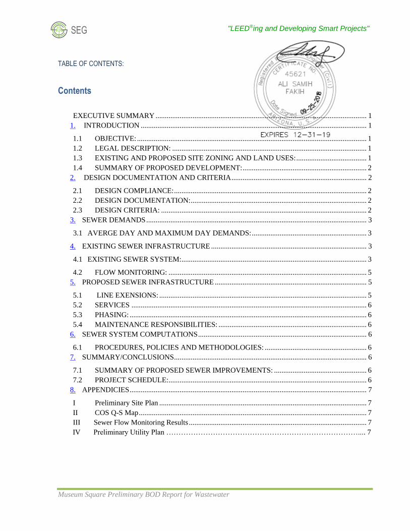
TABLE OF CONTENTS:
Contents
EXECUTIVE SUMMARY .................................................................................................................. 1
1. INTRODUCTION .......................................................................................................................... 1
1.1 OBJECTIVE: ............................................................................................................................ 1
1.2 LEGAL DESCRIPTION: ......................................................................................................... 1
1.3 EXISTING AND PROPOSED SITE ZONING AND LAND USES: ...................................... 1
1.4 SUMMARY OF PROPOSED DEVELOPMENT: ................................................................... 2
2. DESIGN DOCUMENTATION AND CRITERIA ......................................................................... 2
2.1 DESIGN COMPLIANCE: ........................................................................................................ 2
2.2 DESIGN DOCUMENTATION: ............................................................................................... 2
2.3 DESIGN CRITERIA: ............................................................................................................... 2
3. SEWER DEMANDS ....................................................................................................................... 3
3.1 AVERGE DAY AND MAXIMUM DAY DEMANDS: .............................................................. 3
4. EXISTING SEWER INFRASTRUCTURE .................................................................................... 3
4.1 EXISTING SEWER SYSTEM: .................................................................................................... 3
4.2 FLOW MONITORING: ........................................................................................................... 5
5. PROPOSED SEWER INFRASTRUCTURE .................................................................................. 5
5.1 LINE EXENSIONS: ................................................................................................................ 5
5.2 SERVICES ............................................................................................................................... 6
5.3 PHASING: ................................................................................................................................ 6
5.4 MAINTENANCE RESPONSIBILITIES: ................................................................................ 6
6. SEWER SYSTEM COMPUTATIONS ........................................................................................... 6
6.1 PROCEDURES, POLICIES AND METHODOLOGIES: ....................................................... 6
7. SUMMARY/CONCLUSIONS ........................................................................................................ 6
7.1 SUMMARY OF PROPOSED SEWER IMPROVEMENTS: .................................................. 6
7.2 PROJECT SCHEDULE: ........................................................................................................... 6
8. APPENDICIES ................................................................................................................................ 7
I Preliminary Site Plan ................................................................................................................ 7
II COS Q-S Map ........................................................................................................................... 7
III Sewer Flow Monitoring Results ................................................................................................ 7
IV Preliminary Utility Plan …………………………………………………………………….... 7

"LEED®ing and Developing Smart Projects"
Museum Square Preliminary BOD Report for Wastewater Page 1
EXECUTIVE SUMMARY Museum Square is a proposed mixed-use development located within the West Main Street area of Scottsdale
generally lying south and west of East 1st Avenue and Marshall Way. The project includes:
• a high-rise hotel
• an apartment / condominium building
• three high-rise residential buildings
• related site amenities
1. INTRODUCTION
1.1 OBJECTIVE:
The purpose of this report is to provide an analysis of the impact to the existing sewer system and make
recommendations for any necessary improvements.
1.2 LEGAL DESCRIPTION:
The improvement area lies within Sections 27 of Township 2 North, Range 4 East of the Gila and Salt
River Base and Meridian, Maricopa County, Arizona. The present Assessor’s Parcel Numbers are as
follows:
Hotel: North of 2nd Street and west of Marshall Way. Part of APNs 130-13-106, -108, and -109A
Apartment / Condos: North of 2nd Street east of Marshall Way. APNs 130-13 -164A, -165A, -166A,
and -169B
2nd Street ROW: APNs 130-13-111 and -112 (from Goldwater Blvd to Marshall Way). Plus, 121A
and 131A
Marshall Way ROW: APNs 130-13-107 and -117 (from Goldwater Blvd to an alley south of E
Main Street).
Residential Buildings: Courtyard at Main Street Plaza Scottsdale Condominium (MCR 973-06 and
Loloma Partial Replat (MCR 823-22), and APN 130-12-172 an access drive.
1.3 EXISTING AND PROPOSED SITE ZONING AND LAND USES:
In 2003 Scottsdale City Council approved the Downtown Overlay to this general area. The original
Loloma school site is zoned C-2 DO HP with the surrounding properties a mix of D/OC-2 PBD DO,
D/DMU-2 PDB DO and D/OC-2 DO. The site presently supports the Loloma School, Museum of the
West, The Stagebrush Theatre, the Loloma Transportation Center, and various parking areas. The transit
center will be razed.
Proposed development will be a combination of a high-rise hotel, three residential buildings, and an
apartment/condominium building along with the associated site amenities.

"LEED®ing and Developing Smart Projects"
Museum Square Preliminary BOD Report for Wastewater Page 2
Vicinity Map
1.4 SUMMARY OF PROPOSED DEVELOPMENT:
297 residential units within four buildings and a hotel with 190 rooms are proposed on what is
presently vacant land. Reference APPENDIX I for a Preliminary Site Plan.
2. DESIGN DOCUMENTATION AND CRITERIA
2.1 DESIGN COMPLIANCE:
The sewer system will be evaluated and designed compliant with the City’s 2012 Water Reuse
Master Plan and 2018 Design Standards and Criteria Manual (DS+PM) along with requirements of
Arizona Department of Environmental Quality (“ADEQ”) and Maricopa County Environmental
Services Department (“MCESD”).
2.2 DESIGN DOCUMENTATION:
City of Scottsdale Sewer Quarter-Section Map 16-44
Downtown water and sewer line as-built plans
2.3 DESIGN CRITERIA:
Domestic demands are from DS+PM Figure 7-1.2 Average Day Sewer Demand and referenced in
Table 1.
Not applicable, flowmonitoring performed
OK, but field confirm for plansubmittal, due diligence

"LEED®ing and Developing Smart Projects"
Museum Square Preliminary BOD Report for Wastewater Page 3
3. SEWER DEMANDS
3.1 AVERGE DAY AND MAXIMUM DAY DEMANDS:
The following chart represents the proposed flow from both Museum Square and the Canopy Hotel
projects. It will be added to the monitored peak flow for basis of evaluating the sewer infrastructure.
4. EXISTING SEWER INFRASTRUCTURE
4.1 EXISTING SEWER SYSTEM:
Wastewater from this area generally flows to Marshall Way. An 8” pipe north of 2nd Street flows
to a 12” pipe south of 2nd Street, then continues south to a 12” pipe in Osborn Road and east to the
trunk sewer in Miller Road. The City’s modeled system includes hydraulics on the existing Osborn
Land UseDemand
(gpd)Units
Peaking
Factors
High Density Condominium (condo) 140 per unit 4.5
Resort Hotel (includes site amenities) 380 per room 4.5
Restaurant 1.2 per sf 6
Commercial/ Retail 0.5 per sf 3
Commercial High Rise 0.5 per sf 3
Office 0.4 per sf 3
School: without cafeteria 30 per person 6
TABLE 1 - AVERAGE DAILY DEMANDS
Map Key Use Sq. Ft. UnitsTotal Use
(gpd)
ADD
(gpm)
MDD
(gpm)
4 Hotel 190 380 50.1 225.6
5 Residential 105,000 80 140 7.8 35.0
18 Hotel (by others) 176 380 46.4 209.0
N/A School 50 30 1.0 6.3
Additional flow due to a pool backwash 100.0 100.0
205.4 575.9
N/A School 50 30 1.0 6.3
1 Residential 115,000 61 140 5.9 26.7
2 Residential 162,000 79 140 7.7 34.6
3 Residential 150,000 77 140 7.5 33.7
22.1 101.2
Totals 227.5 677.1
TABLE 2 - CALCULATED WASTEWATER DEMANDS
New Demand North of 2nd Street
New Demand South of 2nd Street
Canopy Hilton
309 gpm(100gpmCanopypoolbackwash)
675.9
777.1
+ 137gpm(exist. flows)---------------908gpm
Same flows updated here were used forthe Canopy hotelcase analysis.
Note that there arealso poolsassociated withresidential building#2 and theapartment/condobuilding..simultaneous backwash ofall 4 pools duringpeak sewer flowperiod is unlikely..therefore only the2 hotel poolbackwash flowsimpacting theupper lowercapacity 8" line areaccounted for inthe design flowsrevised in Table 2.

"LEED®ing and Developing Smart Projects"
Museum Square Preliminary BOD Report for Wastewater Page 4
Road line. Therefore, analysis of sewer capacities in this report will be limited to the sewer north
of Osborn Road.
Existing manhole inverts and related pipe slopes were surveyed. This data is shown on the
Preliminary Utility Plan. The segment of 8” pipe with the shallowest slope is just north of 2nd Street
at 0.0059 ft/ft. The segment of 12” pipe with the shallowest slope is just south of 4th Street at
0.0048 ft/ft.
Refer to APPENDIX II – COS QS Map 16-44 and the APPENDIX IV - Preliminary Utility
Plan for reference.
Table 3 and Table 4 represent the existing pipe hydraulics of the two reaches described above.
Inputs:
Pipe Diameter, dₒ 8 in
Manning Roughness, n 0.0130
Slope (ft/ft) 0.0059 slope
d/D 0.65 fraction
Results:
Flow, Q 315.1 gal/min
Velocity, v 2.9 ft/s
Velocity head, hv 0.1328 ft
Flow Area, A 34.5867 in^2
Wetted Perimeter, P 15.0039 in
Hydraulic Radius 2.3052 in
Top Width, T 7.6315 in
Froude Number, F 0.84
Shear Stress (tractive force), τ 0.1596 psf
TABLE 3 - Ex 8" Pipe at d/D = 0.65
Inputs:
Pipe Diameter, dₒ 12 in
Manning Roughness, n 0.0130
Slope (ft/ft) 0.0048 sloped/D 0.65 fraction
Results:
Flow, Q 838.0 gal/min
Velocity, v 3.5 ft/s
Velocity head, hv 0.1855 ft
Flow Area, A 77.8201 in^2
Wetted Perimeter, P 22.5059 in
Hydraulic Radius 3.4578 in
Top Width, T 11.4473 in
Froude Number, F 0.81Shear Stress (tractive force), τ 0.1948 psf
TABLE 5 - Ex 12" Pipe at d/D = 0.65

"LEED®ing and Developing Smart Projects"
Museum Square Preliminary BOD Report for Wastewater Page 5
4.2 FLOW MONITORING:
A flow monitor was placed by RDH Environmental in the manhole just south of 2nd Street (Ex.
MH#7) on April 27, 2018 and data was collected for 14 days. RDH used an AV Sensor with logger
to monitor the flow in the 12” pipe system flowing straight through the manhole. Notes indicate
the flow was steady and the system was clean. A plotted flow graph of the 12” sewer in
APPENDIX III – Flow Monitoring indicates an average high flow of approximately 30 gpm with
sixteen daily spikes between 35 and 136.8 gpm. The realty school was verified to be closed at the
time of monitoring.
5. PROPOSED SEWER INFRASTRUCTURE
5.1 LINE EXENSIONS:
A previous report for Zoning Case 21-ZN-2017 noted the proposed peak flows for that development
were less than the existing peak flows generated by the present use, therefore, no offsite sewer
improvements were found to be necessary for that project. The maximum monitored flow noted
above is well within the capacity of the existing system.
North of 2nd Street – a hotel and residential building along with the Canopy Hotel are occurring
over presently vacant land. The sewer system is being evaluated by adding the proposed peak flow
to the monitored maximum flow and checking capacity of the existing 8” sewer segment with the
shallowest slope. From Table 2, the total maximum flow north of 2nd Street is proposed to be 713.7
gpm (575.9 + 136.8 gpm). A parallel reach of 10” sewer is will be constructed north of the 2nd
Street intersection with a slope similar to the existing 8” pipe. The two pipes will have a combined
capacity of 886.4 gpm (315.1 + 571.3 gpm). It should be noted that four highest existing peak
flows were recorded in the midnight to 2 am period potentially representing final cleanup activities
in local restaurants. The average daily flow was on the order of 30 to 35 gpm and would represent
the time period of the proposed maximum residential demands.
Inputs:
Pipe Diameter, dₒ 10 in
Manning Roughness, n 0.0130
Slope (ft/ft) 0.0059 sloped/D 0.65 fraction
Results:
Flow, Q 571.3 gal/min
Velocity, v 3.4 ft/s
Velocity head, hv 0.1788 ft
Flow Area, A 54.0418 in^2
Wetted Perimeter, P 18.7549 in
Hydraulic Radius 2.8815 in
Top Width, T 9.5394 in
Froude Number, F 0.87Shear Stress (tractive force), τ 0.1995 psf
TABLE 5 - New 10" Pipe at d/D = 0.65
used peak in capacitycalcs
not all info was provided or analysiscompleted for Canopy rezoning case
813gpm
675.9gpm
225.6+100+35+6.3+309=676gpm,Smin=0.59%,d/D=0.73,acceptable inthe 10"dead-endextension
Note: new 8" sewerextending north fromnew 10" for Canopywould convey309gpmSmin=0.59%,d/D=0.65, ok
If a parallel sewer is notable to be constructedthen upsizing of theexisting sewer shall berequired. Upsized sewershall convey813gpm/453gpm at maxd/D=0.65. Given the slopeof the existing 8" sewerthis would be a 12-inchmin sewer from 2nd Streetnorth to Museum SquareHotel/condo tie-in toconvey 813gpm, then a10-inch min sewer north toalley north of 1st street toconvey 453gpm.
"LEED®ing and Developing Smart Projects"
Museum Square Preliminary BOD Report for Wastewater Page 6
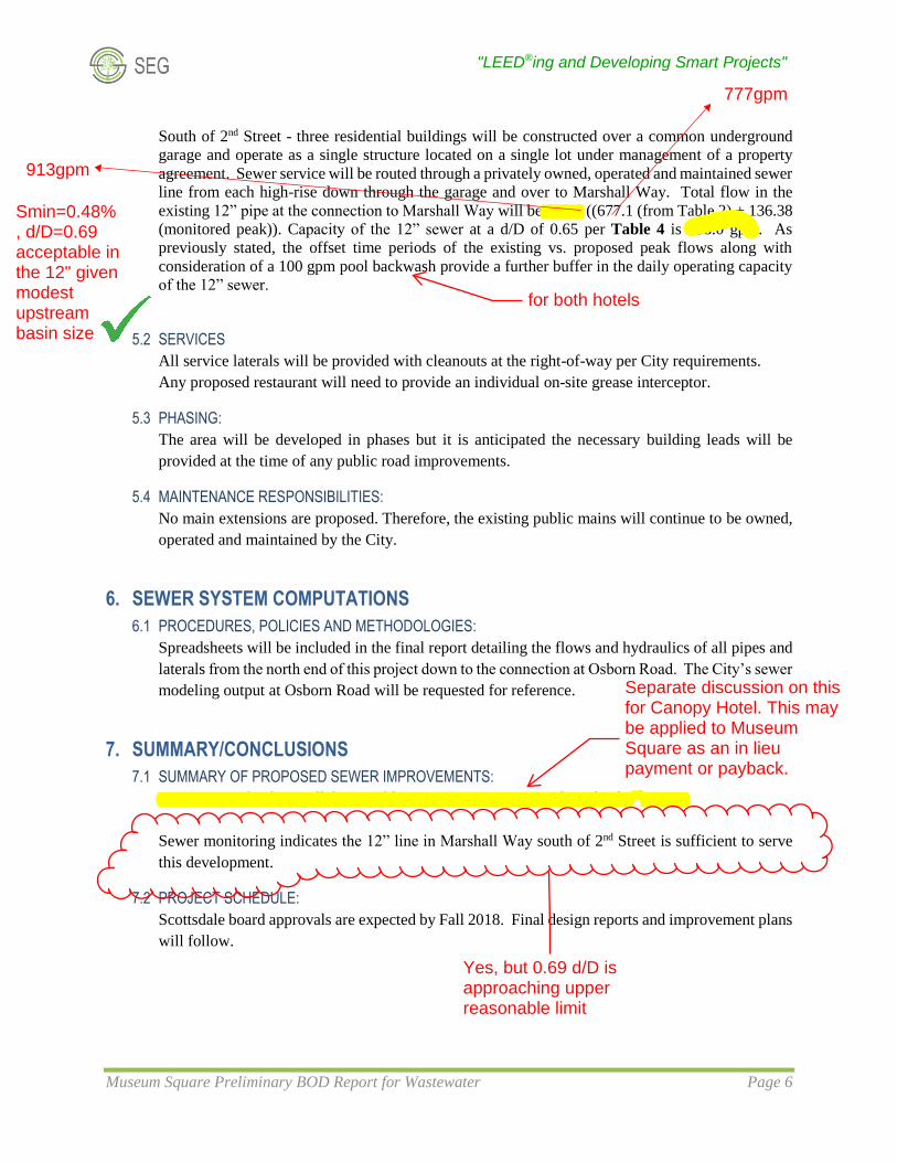
South of 2nd Street - three residential buildings will be constructed over a common underground
garage and operate as a single structure located on a single lot under management of a property
agreement. Sewer service will be routed through a privately owned, operated and maintained sewer
line from each high-rise down through the garage and over to Marshall Way. Total flow in the
existing 12” pipe at the connection to Marshall Way will be 813.9 ((677.1 (from Table 2) + 136.38
(monitored peak)). Capacity of the 12” sewer at a d/D of 0.65 per Table 4 is 838.0 gpm. As
previously stated, the offset time periods of the existing vs. proposed peak flows along with
consideration of a 100 gpm pool backwash provide a further buffer in the daily operating capacity
of the 12” sewer.
5.2 SERVICES
All service laterals will be provided with cleanouts at the right-of-way per City requirements.
Any proposed restaurant will need to provide an individual on-site grease interceptor.
5.3 PHASING:
The area will be developed in phases but it is anticipated the necessary building leads will be
provided at the time of any public road improvements.
5.4 MAINTENANCE RESPONSIBILITIES:
No main extensions are proposed. Therefore, the existing public mains will continue to be owned,
operated and maintained by the City.
6. SEWER SYSTEM COMPUTATIONS
6.1 PROCEDURES, POLICIES AND METHODOLOGIES:
Spreadsheets will be included in the final report detailing the flows and hydraulics of all pipes and
laterals from the north end of this project down to the connection at Osborn Road. The City’s sewer
modeling output at Osborn Road will be requested for reference.
7. SUMMARY/CONCLUSIONS
7.1 SUMMARY OF PROPOSED SEWER IMPROVEMENTS:
One new reach of a parallel 10” public sewer main is proposed north of 2nd Street.
Sewer monitoring indicates the 12” line in Marshall Way south of 2nd Street is sufficient to serve
this development.
7.2 PROJECT SCHEDULE:
Scottsdale board approvals are expected by Fall 2018. Final design reports and improvement plans
will follow.
913gpm
777gpm
Smin=0.48%, d/D=0.69acceptable inthe 12" givenmodestupstreambasin size
for both hotels
Yes, but 0.69 d/D isapproaching upperreasonable limit
Separate discussion on thisfor Canopy Hotel. This maybe applied to MuseumSquare as an in lieupayment or payback.
"LEED®ing and Developing Smart Projects"
Museum Square Preliminary BOD Report for Wastewater Page 7
8. APPENDICIES
I Preliminary Site Plan
II COS Q-S Map
III Sewer Flow Monitoring Results
IV Preliminary Utility Plan

“LEED®ing and Developing Smart Projects”
8280 E. Gelding Dr., Suite 101 Scottsdale, AZ 85260
Sustainability Engineering Group [email protected] 480.588.7226 www.azSEG.com APPENDIX
APPENDIX I
Preliminary Site Plan

6.12.18
DRAFTSCOTTSDALE’S MUSEUMSQUAREREZONING DEVELOPMENT APPLICATION
MUSEUMSQUARE
RESIDENTIAL BUILDING #1 - 11 STORIES - 135 ‘ HEIGHT
1
EXISTINGMUSEUM
APARTMENT / CONDO BUILDING
RESIDENTIAL BUILDING #1
HOTEL
RESIDENTIAL BUILDING #2
RESIDENTIAL BUILDING #3
EXISTINGRESIDENTIAL
MAP KEY
ARTISTSCHOOL
DROP OFF
DROP OFFSHARED ACCESSE . 2 N D S T R E E T
E . 2 N D S T R E E T
E . 1 S T S T R E E T
N. G
OL D
WAT E R B O
U L E VA R D
1
2
4
5
6
7
9
11
12
13
14
16
18
19
21
23
25
HOTEL GARAGE PARKING ACCESS
COVERED PROMENADE
MUSEUM “BRIDGE” EXPANSION
NORTH / SOUTH DISTRICT PROMENADE
MUSEUM EXPANSION - 30,000 SQFT +/-
PROPOSED HOTEL (HILTON CANOPY) - 66’ HEIGHT - 185 KEYS
RECONFIGURED ENTRY DRIVE(SHARED ACCESS / EGRESS)
MAIN ART SCHOOL SHARED DRIVE ENTRY
MULTI-USE PUBLIC SPACE - LAWN AREA, PATIOS, & TERRACES - PERFORMANCE SPACE - SPLASH PAD - SCULPTURE GARDEN
RECONFIGURED HOTEL PARCEL PURCHASE - (47,343 SQFT)ADDITIONAL ON STREET PARKING - UP TO 28 SPACES (south of 1st street)
APARTMENT / CONDO BUILDING - TBD
HOTEL - THE ARIZONAN - 13 STORIES - 150 ‘ HEIGHT - 190 KEYS
RESIDENTIAL BUILDING #2 - 13 STORIES - 150 ‘ HEIGHT
SURFEACE PARKING LOT - 120 SPACES
RESIDENTIAL PARCEL PURCHASE - 134,213 SQFT
CONDOMINIUM PARKING TRAY - 376 SPACESGARAGE PARKING ACCESS
PLAZA / DRIVE COURT
OPEN SPACE / GARDENS
POOL & TERRACE
RESIDENTIAL BUILDING #3 - 13 STORIES - 150 ‘ HEIGHT
THE GOLDWATER (CONDOMINIUMS)
NEW SIGNALIZED CROSSWALK
NEW SIGNALIZED MID-BLOCK CROSSWALK (HAWK)
HOTEL PARKING TRAY - UPPER LEVEL (84 SPACES) - LOWER LEVEL (84 SPACES)
PEDESTRIAN CONNECTION
ADDITIONAL ON-STREET PARKING - UP TO 46 SPACES (W. of Marshall Way)
ADDITIONAL ON-STREET PARKING - UP TO 37 SPACES (South of 2nd Street)
ADDITIONAL ON-STREET PARKING - UP TO 37 SPACES (East of Marshall Way)
ADDITIONAL ON-STREET PARKING - UP TO 21 SPACES (north of 1st street)
2
3
4
5
6
7
8
9
10
11
12
13
14
15
16
17
18
19
20
21
22
23
24
25
26
27
28
29
30
31
32
30
29
27
22
17
11
15
28
0’ 30’ 60’ 120’
scale: 1” = 60’
180’
N. M
AR
SH
AL
L W
AY
23F. SITE PLAN
DROP OFF
3
20
24
8 26
10
31
32

“LEED®ing and Developing Smart Projects”
8280 E. Gelding Dr., Suite 101 Scottsdale, AZ 85260
Sustainability Engineering Group [email protected] 480.588.7226 www.azSEG.com APPENDIX
APPENDIX II
COS Q-S Map
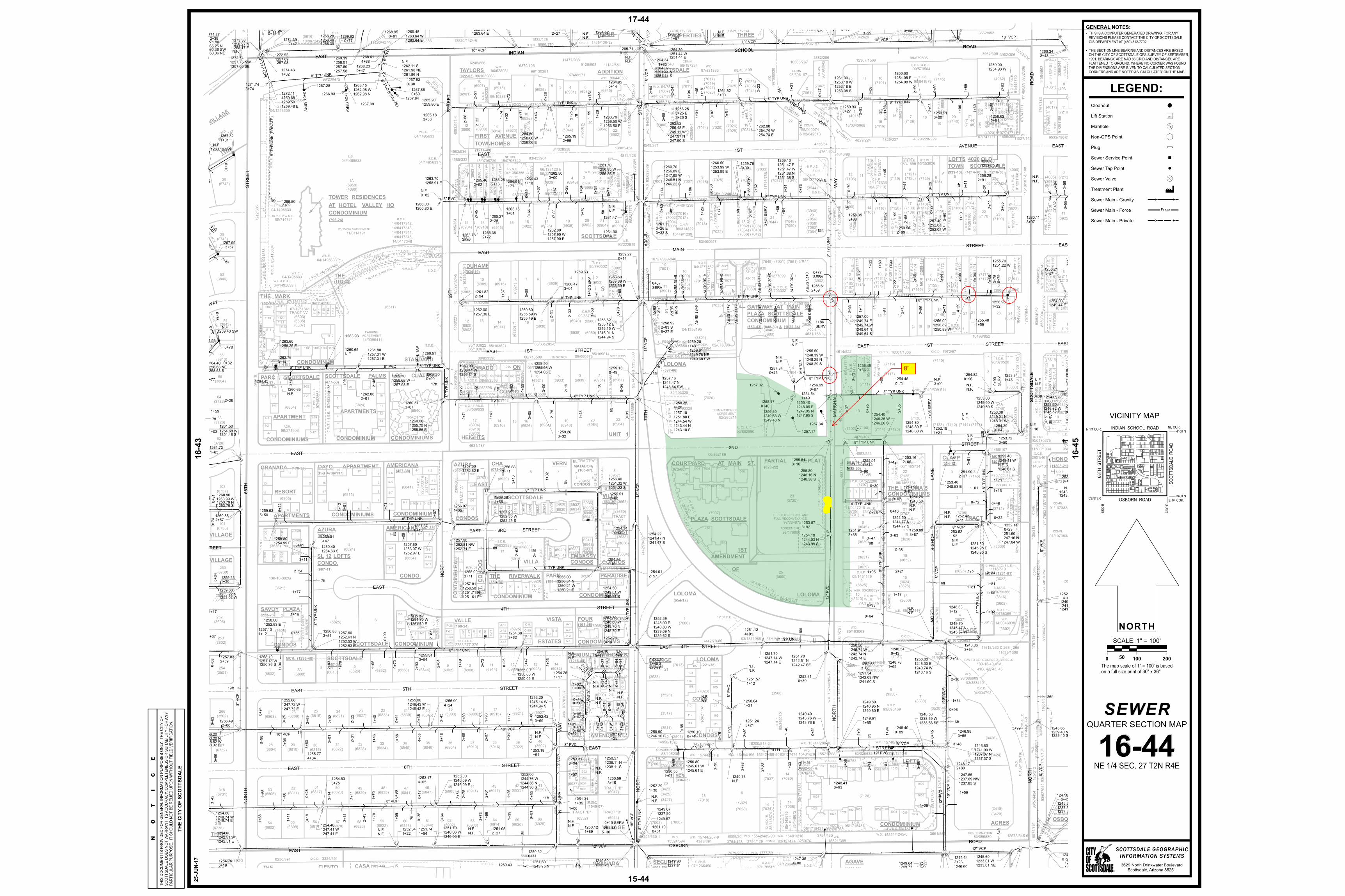
8"

“LEED®ing and Developing Smart Projects”
8280 E. Gelding Dr., Suite 101 Scottsdale, AZ 85260
Sustainability Engineering Group [email protected] 480.588.7226 www.azSEG.com APPENDIX
APPENDIX III
Sewer Flow Monitoring Results
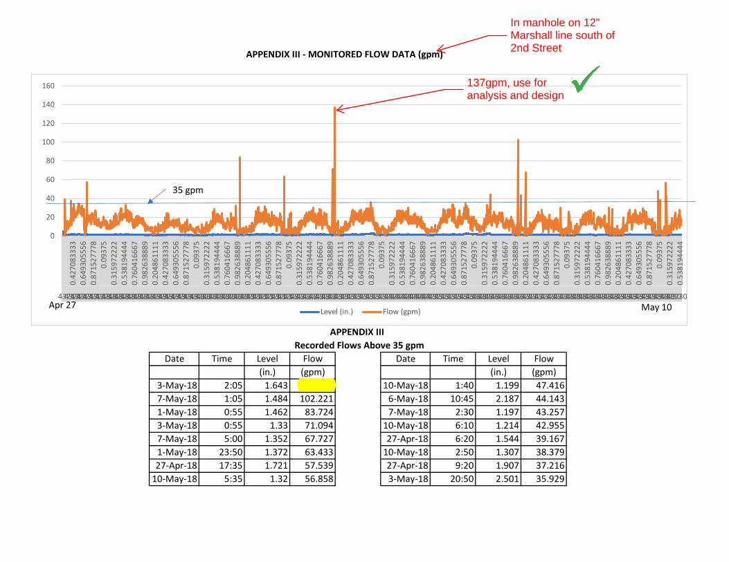
APPENDIX III - MONITORED FLOW DATA (gpm)
Date Time Level Flow Date Time Level Flow(in.) (gpm) (in.) (gpm)
3-May-18 2:05 1.643 136.766 10-May-18 1:40 1.199 47.4167-May-18 1:05 1.484 102.221 6-May-18 10:45 2.187 44.1431-May-18 0:55 1.462 83.724 7-May-18 2:30 1.197 43.2573-May-18 0:55 1.33 71.094 10-May-18 6:10 1.214 42.9557-May-18 5:00 1.352 67.727 27-Apr-18 6:20 1.544 39.1671-May-18 23:50 1.372 63.433 10-May-18 2:50 1.307 38.37927-Apr-18 17:35 1.721 57.539 27-Apr-18 9:20 1.907 37.216
10-May-18 5:35 1.32 56.858 3-May-18 20:50 2.501 35.929
APPENDIX III Recorded Flows Above 35 gpm
0
20
40
60
80
100
120
140
160
0.42
7083
333
0.64
9305
556
0.87
1527
778
0.09
375
0.31
5972
222
0.53
8194
444
0.76
0416
667
0.98
2638
889
0.20
4861
111
0.42
7083
333
0.64
9305
556
0.87
1527
778
0.09
375
0.31
5972
222
0.53
8194
444
0.76
0416
667
0.98
2638
889
0.20
4861
111
0.42
7083
333
0.64
9305
556
0.87
1527
778
0.09
375
0.31
5972
222
0.53
8194
444
0.76
0416
667
0.98
2638
889
0.20
4861
111
0.42
7083
333
0.64
9305
556
0.87
1527
778
0.09
375
0.31
5972
222
0.53
8194
444
0.76
0416
667
0.98
2638
889
0.20
4861
111
0.42
7083
333
0.64
9305
556
0.87
1527
778
0.09
375
0.31
5972
222
0.53
8194
444
0.76
0416
667
0.98
2638
889
0.20
4861
111
0.42
7083
333
0.64
9305
556
0.87
1527
778
0.09
375
0.31
5972
222
0.53
8194
444
0.76
0416
667
0.98
2638
889
0.20
4861
111
0.42
7083
333
0.64
9305
556
0.87
1527
778
0.09
375
0.31
5972
222
0.53
8194
444
4321743217432174321743217432184321843218432184321843218432184321843219432194321943219432194321943219432204322043220432204322043220432204322043221432214322143221432214322143221432224322243222432224322243222432224322343223432234322343223432234322343223432244322443224432244322443224432244322543225432254322543225432254322543226432264322643226432264322643226432264322743227432274322743227432274322743228432284322843228432284322843228432284322943229432294322943229432294322943230432304323043230
Level (in.) Flow (gpm)Apr 27 May 10
35 gpm
137gpm, use foranalysis and design
In manhole on 12"Marshall line south of2nd Street

“LEED®ing and Developing Smart Projects”
8280 E. Gelding Dr., Suite 101 Scottsdale, AZ 85260
Sustainability Engineering Group [email protected] 480.588.7226 www.azSEG.com APPENDIX
APPENDIX IV
Preliminary Utility Plan

E
E
S
S
S
S
S
S
S
T
T
T
E
E
E
E
E
E
E E
E
E
E
E
E
E
E
E
E
EE
EE
E
EE
EE
E
EE
EE
E
EE
EE
E
E
E
E
EE
EE
EE
E
EE
E
E
EE
E
EE
EE
E
E
EE
EE
EE
EE
EE
E
E
EE
EE
EE
EE
E
E
E
E
EE
EE
EE
E
EE
E
E
E
EE
EE
E
EE
E
E
E
EE
EE
E
EE
EE
EE
E
EE
E
EE
EE
E
E
EE
EE
EE
EE
E
E
E
E
E
EE
E
EE
EE
E
E
E
EE
E
EE
EE
EE
EE
E
EE
E
EE
EE
E
E
EE
EE
EE
EE
E
E
E
E
EE
EE
EE
E
EE
E
E
EE
E
EE
E
E
EE
E
EE
E
E
EE
E
EE
E
E
EE
E
EE
E
E
EE
EE
E
EE
EE
EE
E
EE
EE
EE
E
EE
EE
EE
E
EE
EE
EE
E
EE
E
E
EE
EE
E
E
EE
EE
E
E
E
EE
E
E
E
E
E
E
E
E
E
E
E
E
E
E
E
E
E
E
E
E
E
E
E
E
E
E
E
E
E
E
E
E
E
E
E
E
E
E
E
E
E
E
E
E
E
E
E
E
E
E
E
E
E
E
E
E
E
E
E
E
E
E
E
E
E
E
E
E
E
E
E
E
E
E
E
E
E
E
E
E
E
E
E
E
E
E
E
E
E
E
E
E
E
E
E
E
E
E
E
E
E
E
E
E
E
E
E
E
E
E
E
E
E
E
E
E
E
E
E
E
E
E
E
E
E
E
E
E
E
E
E
E
E
E
E
E
E
E
E
E
E
E
E
E
E
E
E
E
E
E
E
E
E
E
E
E
E
E
E
E
E
E
E
E
E
E
E
E
E
E
E
E
E
E
E
E
E
E
E
E
E
E
E
E
E
E
E
E
E
E
E
E
E
E
E
E
E
E
E
E
E
E
E
E
E
E
E
E
E
E
E
E
E
E
E
E
E
E
E
E
E
E
E
E
E
E
E
E
E
E
E
E
E
E
E
E
E
E
E
E
E
E
E
E
E
E
E
E
E
E
E
E
E
E
E
E
E
E
E
E
E
E
E
E
E
E
E
E
E
E
E
E
E
E
E
E
E
EE
E
E
E
E
E
E
E
E
E
E
E
E
E
E
E
E
E
E
E
E
E
E
E
E
E
E
E
E
E
E
E
EE
E
E
E
E
E
E
E
E
E
E
E
E
E
E
E
E
E
E
E
E
E
E
E
E
E
E
E
E
E
E
E
E
E
E
E
E
E
E
E
E
E
E
E
E
E
E
E
E
E
E
E
E
E
E
E
E
EEEEEEEEEEEEEEEEE
EEEEEEEEEEEEEEEEEEEEEEEEEEEEEEEEEEEEEEEEEEEEEEEEEEEEEEEEEEEEEEE
EEEEEEEEEEEEEEEEEEEEEEEEEEEEEEEEEEEEEEEEEEEEEEEEEEEEEEEEEEEEEEEE
EEEEEEEEEEEEEEEEEEEEEEEEEEEEEEEEEEEEEEEEEEEEEEEEEEEEEEEEEEEEEEE
EEEEEEEEEEEEEEEEEEEEEEEEEEEEEEEEEEEEEEEEEEEEEEEEEEEEEEEEEEEEEEE
EEEEEEEEEEEEEEEEEEEEEEEEEEEEEEEEEEEEEEEEEEEEEEEEEEEEEEEEEEEEEEE
EEEEEEEEEEEEEEEEEEEEEEEEEEEEEEEEEEEEEEEEEEEEEEEEEEEEEEEEEEEEEEEE
EEEEEEEEEEEEEEEEEEEEEEEEEEEEEEEEEEEEEEEEEEEEEEEEEEEEEEEEEEEEEEE
EEEEEEEEEEEEEEEEEEEEEEEEEEEEEEEEEEEEEEEEEEEEEEEEEEEEEEEEEEEEEEEEEEEEEEEEEEEEEEEEE
EEEEEEEEEEEEEEEEEEEEEEEEEEEEEEEEEEEEEEEEEEEEEEEEEEEEEEEEEEEEEEEEEEEEEEEEEEEEEEEEEEEEEEEE
EEEEEEEEEEEEEEEEEEEEEEEEEEEEEEEEEEEEEEEEEEEEEEEEEEEEEEEEEEEEEEEEEEEEEEEEEEEEEEEE
IS
SLM
EJB
C-VLT
CJB
SLM
EJB
TSJB
TSJB
LP
LP
SCO
SCO
SCO
SCO
SCO
SCO
SCO
WV
WV
WV
FH
WMB
WV
WV
WV
WVWV
WV
FH
WBO
WV
WMB
WV
FH
WV
WV
WMB
WMB
WMB
WMB
WV
WV
WV
FH
WVWV
WV
WV
FH
E
S
S
S
S
S
S
C-VLT
EJB
D
U-VLT
CB
SLM
EJB
CB
C-VLT
CTR
EJB
TS
JB
C
B
SLM
EJB
SLM
EJB
DW
SLM
EJB
SLM
EJB
CB
DD
CB
SLM
D
SLM
EJB
SLM
EJB
SLM
EJB
CB
CB
DW
D
WMB
D
D
SRP MH
CB
E
E
FDC
SDG
TR
FP
FDC
SCO
SCO
SCO
SDG
FH
SDG
SDG
SDG
SDG
SDG
SCO
SCO
SCO
SCULPTURE
M
E
T
A
L
B
R
ID
G
E
M
E
T
A
L
B
R
ID
G
E
M
E
T
A
L
B
R
ID
G
E
M
E
T
A
L
B
R
ID
G
E
M
E
T
A
L
B
R
ID
G
E
ME
TA
L
BR
ID
GE
T
LP
LP
SLM
EJB
W
PP
PP
SLM
EJB
EJB
SLM
EJB
SLM
EJB
WB
P
WB
P
SLM
EJB
PP
ET
PP
EJB
EM
EJB
TR
WB
P
SCO
ST
SCO
SCO
T
T
RAMP
EJB
AL
AL
AL
AL
AL
EJB
EJB
AL
TSJB
EX
. 1
2''S
EX
. 1
2''S
EX
. 1
2''S
EX
. 1
2''S
EX
. 1
2''S
EX
. 1
2''S
EX. 8''S
D
SD
SD
SD
SD
SD
SD
SD
S
D
SD
CB
C
B
S
D
S
D
S
D
S
D
S
D
S
D
S
D
S
D
S
D
S
D
S
D
S
D
S
D
S
D
S
D
S
D
D
D
S
D
S
D
S
D
S
D
C
B
SDSD
SDSD
SDSD
SDSD
SDSD
SDSD
SDSD
SD
SDSD
SDSD
SD
SDSD
SD
SD
SDSD
SDSD
EX. 16''W
EX. 16''W
EX. 16''W
EX. 16''W
EX. 16''W
EX. 8''W
EX. 8''W
EX. 8''W
EX. 8''W
EX
. 8
''W
EX
. 8
''W
EX
. 8
''W
EX
. 8
''W
EX
. 8''W
EX
. 1
2''W
EX
. 1
2''W
EX. 16''W
EX. 16''W
EX. 8''W
EX. 8''W
RIM:57.40'
INV:43.58'E-W
W
FH
TSJB
TR
CB
CB
RIM:56.10'
INV:52.79'N
SD
INV:52.35'S
RIM:56.30'
INV:41.30'E-W
INV:42.30'N-S
RIM:53.67'
INV:46.66'S-NW
RIM:52.72'
INV:45.03'E-W
INV:45.53'N
RIM:52.84'
INV:44.21'E-W
INV:44.03'S
E
X
.
1
2
'
'
W
EX. 6''W
EX. 8''S
EX. 8''S
S
CONDOFFE=58.20
HOTELFFE=57.60
BUILDING 3FFE=55.50
BUILDING 2FFE=57.50
EXISTINGTHEATERFFE=56.46
BUILDING 1FFE=58.00
6''S
6''S
6
''S
6
''S
6''S
4
'
'
W
4
'
'
W
2
'
'
W
6''S
FDC FDC
4''W
FDC
FDC
FDC
6''W
S
8
''S
10
''S
S
EXISTINGART SCHOOL
E. 2ND STREET
N. M
ARSH
ALL
WAY
N. GOLDWATER BLVD.
S
THIS DR
AWING
IS AN INST
RUME
NT OF
SERVICE
AND TH
E PROP
ERTY O
F SUSTA
INABILIT
Y ENGIN
EERING
GROU
P, AND SH
ALL REM
AIN THE
IR PROP
ERTY. TH
E USE O
F THIS DR
AWING
SHALL B
E RESTR
ICTED TO
THE OR
IGINAL S
ITE FOR
WHIC
H IT IS PRE
PARED A
ND PU
BLICATIO
N THERE
OF IS EX
PRESSLY
LIMITED
TO SUC
H USE.
SEG
82
80
E
G
EL
DIN
G D
R #
10
1, S
CO
TT
SD
AL
E, A
RIZ
ON
A 8
52
60
WW
W. A
ZS
EG
.C
OM
T
EL
. 4
80
.5
88
.7
22
6
SEAL
PREPARED UNDER THE DIRECTSUPERVISION OF ALI FAKIH, P.E.ARIZONA REGISTRATION NO. 45621FOR AND ON BEHALF OFSUSTAINABILITY ENGINEERING GROUP,LLC.
MUSEUM SQUAREPRELIMINARY UTILITY PLAN
E 2ND STREET & N MARSHALL WAY SCOTTSDALE, AZ 85251
VICINITY MAPSCALE: NTS
DEVELOPER
ENGINEER
ARCHITECT
SITE
EXISTING LEGEND
PROPOSED LEGENDKEY NOTES
6" S
8" W
NOTES:
EXISTING SANITARY SEWER MANHOLE SCHEDULE
FDC
BENCHMARK
BASIS OF BEARING
LEGAL DESCRIPTION
This portion ofsewer does notappear to bewithin garageenvelope thusviolatingplumbing code.Garage limitsunclear. Seecomments on2nd page ofBOD.
5.52
only about 4.5ft from sewer pipe wall to wall distance isshown here, 6ft is requiredto reduce risk of pipe orpipe bedding disturbance(existing pipe likely VCP).
Verify 12" sewerduring design.
this sewer only serves existingtheater per previous round applicantresponses.
Surveyedindependently perapplicant

COMMENT TRACKING LOG “LEED®ing and Developing Smart Projects”
DATE: 9/11/2018
REFERENCE: Rezoning 2nd Comments
No. Sheet No. Reviewer COMMENTResponsible
PartyRESPONSE
1 Pg. 1 LDAddress comments on following page and
throughout document.SEG
Noted
2 Pg. 2 LD
1.) New 8” sewer extended north of 2nd
Street. However, report text states it will
be extended to new hotel. Utility plan only
shows it extended to Building 5 (condo). It
is expected and required that this new 8”
sewer be extended all the way north to the
new hotel as stated in the report. LDillon
9/7/18
SEG
It does go to Hotel service. The theater service from the
west has been rerouted to go around the new hotel and
has been separated from the hotel service.
3 Pg. 2 LD
2.) DS&PM 7-1.409. 2 cleanouts need to be
added to each sewer service lines per MAG
detail 440-3. LDillon 9/7/18SEG
Added keynote 15 for MAG detail 440-2 (double CO)
4 Pg. 2 LD
3.) Refer to IPC 2015: utility plan needs to
be modified to remove building sewer lines
servicing multiple buildings from being
routed underneath separate buildings.
Multiple buildings may not share in the
sewer system, public or private, that goes
underneath other buildings. Update design
and utility site plan included within BOD
accordingly. LDillon 9/7/18''
SEG
Refer to Section 5.1 for clarification. Buildings are
considered a single structure.
The following comments are from: City Of Scottsdale Scottsdale Water: Levi Dillon
CLIENT:
PROJECT:
MacDonald Development
Museum Square
SUSTAINABILITY ENGINEERING GROUP
8280 E. Gelding Dr, Suite 101
[email protected] Scottsdale, AZ 85260 www.azSEG.com COMMENT TRACKING LOG
Previous Round 2 BOD comments responses for Round 3 BOD

COMMENT TRACKING LOG “LEED®ing and Developing Smart Projects”
5 Pg. 2 LD
4.) Sewer flow calculation in Table 2 states
a negative flow of -41gpm (250 credit
applied to 209) coming from map key area
number 18. This is not possible unless the
previous flow from this area was 459gpm
and the revised flow for a development by
others will be 209gpm. 209gpm should be
used and the -250 gpm credit removed
from the table. This will add 250gpm to the
Table 2 totals. This will bring the existing
sewer d/D up to max of 0.65 and require
the new 8” sewer to be extended to accept
the sewer from the new hotel. This will
also result in the 12” sewer to slightly
exceed 0.65 d/D (by the existing flow).
Please further address the 12” flows in a
subsequent ZN case BOD. LDillon 9/10/18
SEG
Calculations are updated
6 Pg. 2 LD
5.) Sewer outlet onto Marshall Way for
building 1,2, and 3 is not clearly shown.
Why is it shown with a sewer plug?
Building leads for road work? LDillon
9/7/18
SEG
Added keynote 15 for MAG detail 440-2 (double CO); all
services are plugged / capped until building
construction connects.
7 Pg. 2 LD
6.) The utility plan provided shows the
existing Marshall Way sewer south of 2nd
street as 8”. It should be shown as 12”
south of 2nd Street as stated in the report
(unless verified otherwise by the Engineer).
LDillon 9/7/18
SEG
Revised to 12"
SUSTAINABILITY ENGINEERING GROUP
8280 E. Gelding Dr, Suite 101
[email protected] Scottsdale, AZ 85260 www.azSEG.com COMMENT TRACKING LOG

COMMENT TRACKING LOG “LEED®ing and Developing Smart Projects”
8 Pg. 6 LD
Refer to comment #4 on 2nd page: You are
suggesting the future hotel and all
upstream contributions will only amount
to a peak of 95gpm...not valid!Canopy by
Hilton in
22-DR-2018 SEG report suggests either a
future max incoming basin flow of
394,000gpd (Table 3) or 693,000gpd
(Figure 6), 273gpm or 481gpm,
respectively. It is unclear in the SEG report
where Fig.6 693,000gpd originates.
Per SEG report 300,000gpd was to come
from Canopy hotel versus 360,000gpd
from AZ School of Real Estate and
Business. As SEG projected, 79% (250gpm)
of the existing total flow of 453,000gpd
(314gpm) is from existing school flow, the
flow monitoring data is therefore very
sensitive to activities at the school.
Given the large discrepancy of the peak
flow monitoring value (136gpm) versus
projected current peak flow (314gpm), and
the inconsistency in the data it is unlikely
the school flow was accurately captured,
or captured at all, with flow monitoring.
SEG
Calculations are updated
9 Pg. 6 LD
In Table 2: --
Remove 250gpm credit.
---Add line item for existing flow amount of
at least 64gpm (273-209), and at most
136gpm or more (if school not captured in
flow monitoring or data is invalid)
SEG
Calculations are updated. School reference is removed
(building is vacant - not is operation during monitoring)
SUSTAINABILITY ENGINEERING GROUP
8280 E. Gelding Dr, Suite 101
[email protected] Scottsdale, AZ 85260 www.azSEG.com COMMENT TRACKING LOG

COMMENT TRACKING LOG “LEED®ing and Developing Smart Projects”
10 Pg. 6 LDMDD 325.9 (gpm) change to 576-648gpm
SEGCalculations updated
11 Pg. 6 LDMDD 427.1 (gpm) change to 677-749gpm
SEGCalculations updated
12 Pg. 6 LD
0.0059: Where did the revised inverts for
8" pipe come from to determine this
slope? See note on utility plan.
SEG
Existing pipe data is confirmed by field survey
13 Pg. 7 LD
2.7 depth: Higher depths shown, why don't
these correspond to higher flows? Is there
averaging occurring?Want peak
instantaneous minute flows not averages
SEG
Refer to revised monitoring data in Appendix III
14 Pg. 8 LD
Pool backwash: 576 to 648gpm, see
section 3 notes. Proposed dual 8" should
still work as long as all new hotel and
condo flows go to new 8" sewer line.
SEG
Calculations updated
15 Pg. 8 LDTabel 4: 677 to 749gpm, see section 3
notes.SEG
Calculations updated
16 Pg. 8 LDTabel 4 is 673.4 : Exceeding capacity
slightly, in at least 1 pipe sectionSEG
Calulations updated based on verifyed pipe data
17 Pg. 8 LD
(136.8 gpm + 427.1 gpm) : Refer to
comments on flow monitoring data in
appendix, could not make sense of data,
no pattern...appears random. Was AZ real
estate school in session?
SEG
Refer to revised monitoring data in Appendix III
18 Pg. 15 LDDates: Duration stated in report is 7 days.
SEGReport corrected to 14 days
19 Pg. 15 LDDates: Was AZ real estate school in
session?SEG
No
20 Pg. 15 LD
Max Time: no consistent maximum,
repeating diurnal pattern, random time
and flow data
SEG
Refer to revised monitoring data in Appendix III
SUSTAINABILITY ENGINEERING GROUP
8280 E. Gelding Dr, Suite 101
[email protected] Scottsdale, AZ 85260 www.azSEG.com COMMENT TRACKING LOG

COMMENT TRACKING LOG “LEED®ing and Developing Smart Projects”
21 Pg. 15 LD
Maximum (in) 4.997: Depth of flow max
here, where is corresponding max gpm
value?
SEG
Refer to revised monitoring data in Appendix III
22 Pg. 15 LD
Maximum (in)2.627 and Average (in)
1.677: Higher depths shown outside of
May 3rd, why don't these correspond to
higher flows? Is there averaging
occurring?Want peak instantaneous
minute flows not averages
SEG
Refer to revised monitoring data in Appendix III
23 Pg. 15 LD
DATA DOES NOT MAKE SENSE, NO
INTERPRETATION OR EXPLANATION
PROVIDED.
SEG
Refer to revised monitoring data in Appendix III
24 Pg. 17 LDExtension of sewer appears to partially
server hotelSEG
Theater and Hotel services are separated
25 Pg. 17 LDShould be 12-inch sewer south of 2nd
Street?? See note #6.SEG
Revised to 12"
26 Pg. 17 LD
Shared building sewers under other
buildings. Refer to note #3 in comments SEG
Refer to Section 5.1 for clarification. Buildings are
considered a single structure.
27 Pg. 17 LD
New 8" sewer extent only shown to condo,
should extend to all points where hotel
flows enter i.e. MH#4. Refer to note #1 in
comments
SEG
New tie-in for Hotel is at proposed MH
28 Pg. 17 LDSewer connection and cleanout. Refer to
note #2 and #5 in commentsSEG
Added key note 15
29 Pg. 17 LD
These elevations deviate from City GIS,
what is the source of this information?? SEG
Verified by field servay
SUSTAINABILITY ENGINEERING GROUP
8280 E. Gelding Dr, Suite 101
[email protected] Scottsdale, AZ 85260 www.azSEG.com COMMENT TRACKING LOG

COMMENT TRACKING LOG “LEED®ing and Developing Smart Projects”
30 Pg. 17 LD
Existing/Relevant GIS/quarter section
invert data:
MH#4 1248.29
MH#5 1247.95
Slope 4 to 5: 0.34/66=0.00515ft/ft (SEG
has +0.00712) MH#6 1248.16
Slope 5 to 6: -0.21/150=-0.0014ft/ft**
(SEG has +0.0058) **Slope is negative!!!
Line slopes back to upstream manhole.
Verify with invert survey data.
SEG
Pipe data was verified by field survey
31 Pg. 17 LD
Utility plan not reviewed for water
infrastructure. Assumed no changes since
1st round "accepted as noted version".SEG
Noted
SUSTAINABILITY ENGINEERING GROUP
8280 E. Gelding Dr, Suite 101
[email protected] Scottsdale, AZ 85260 www.azSEG.com COMMENT TRACKING LOG