water availability during extreme droughts like the … · how do we define drought? droughts are...
TRANSCRIPT

Water Availability During Extreme Droughts like the 1950s
September 21, 2012 presentation“Showcasing the Kaskaskia”
H. Vernon Knapp Illinois State Water Survey
Prairie Research InstituteUniversity of Illinois

How do we define drought?
Droughts are defined primarily by their impacts Meteorological drought – pronounced deficits in rainfall; but not
necessarily associated with specific impacts Agricultural drought – caused by shortages in soil moisture;
impacting crop production Hydrological drought – caused by shortages in streamflow, lake
storage or groundwater; impacting community and industrial water supplies, navigation, recreation, and ecosystems
This presentation focuses on hydrologic drought

The 2012 Drought 2012 was a devastating agricultural drought for many
southern and central Illinois locations In parts of south-central Illinois, rains from Hurricane
Isaac and several earlier rains in August effectively ended the drought but were too late to help most crops.
But for other regions of Illinois, 2012 remains a hydrologic drought in progress.
Supplies for 3 community systems (Decatur, La Harpe, and the Vienna CC) are currently of concern.
The drought will need to continue into next year before concern develops for other communities

Severe hydrologic droughts
The most severe hydrologic impacts in Illinois are associated with multi-year drought episodes. These are normally caused by a very dry summer/fall period followed by a dry winter/spring during which reservoirs and groundwater supplies do not have a chance to become replenished.
Such extreme droughts occur infrequently. For example, we have identified only 4 historical drought episodes (1894-95, 1930-31, 1933-34, and 1953-54) such that – if they occurred again – Lake Shelbyville and Carlyle Lake might not be expected to refill during the spring of the 2nd year. For the Kaskaskia region, the 1953-54 drought is considered the worst of these droughts (the drought of record).

Occurrence of an ‘early-season’ drought During a drought with an early (April/May) onset, there is the
possibility that Lake Shelbyville and Carlyle Lakes might not fully transition from winter pool and could start a drought below full summer pool.
The likelihood of this happening is much greater for Lake Shelbyville than Carlyle Lake. The 1936, 1976, 1988 drought years are the only historical droughts we identified for which Carlyle Lake could potentially start slightly below 445’.
However, most droughts start later in the summer, including all of the multi-year droughts experienced (so far) in the Kaskaskia region.

Water Supply Availability during a drought like the 1950s
This presentation will touch on 4 topics:1. Groundwater supplies2. Community water supply reservoirs3. Allocation yield for Lake Shelbyville and
Carlyle Lake4. Water needs for the Navigation Channel

1. Sand and Gravel Aquifers
Active Public Supply Wells
Sand and gravel aquifers are the primary source of groundwater.
Except for where these aquifers occur along the river, the geology is largely limited and unfavorable for developing sizable water supply systems

2. Community surface water supplies
23 communities in the Kaskaskia watershed provide their own water from surface water sources. An additional 6 community systems from the greater region were also evaluated.
4 of these community systems have water allocated from Carlyle and Shelbyville
Another 7 systems have intakes on the Kaskaskia River The remaining systems have reservoirs A large number of small towns purchase water from
these systems
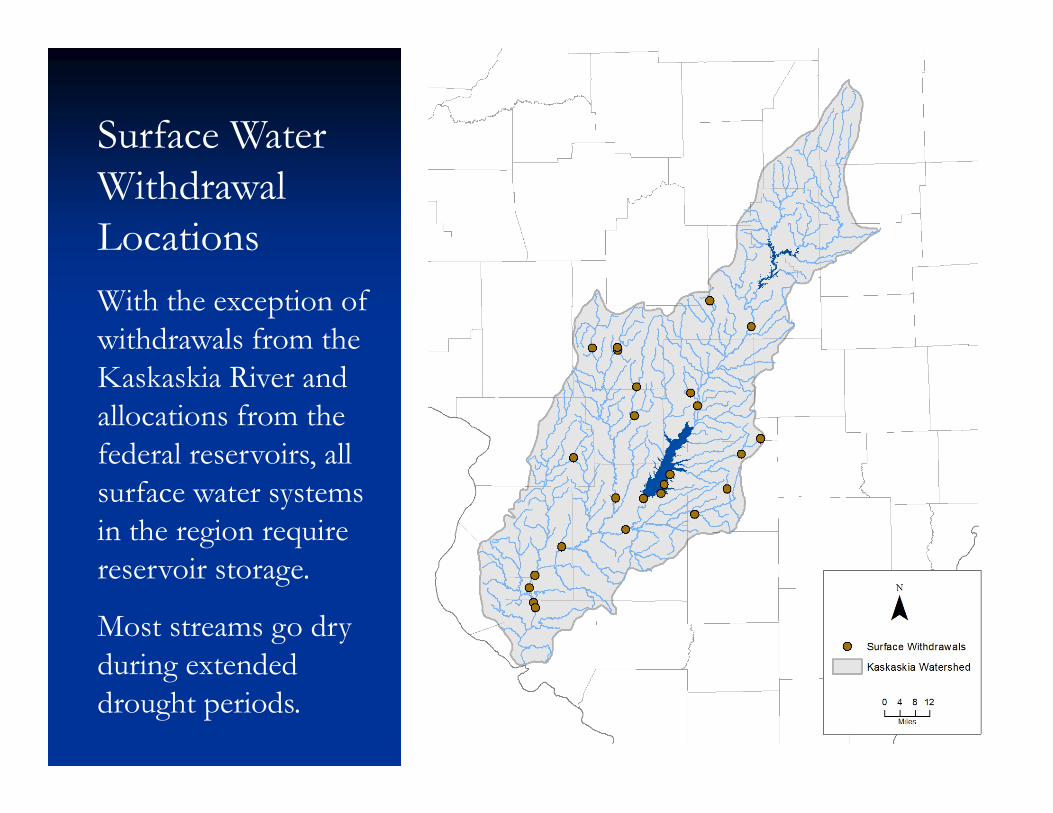
Surface Water Withdrawal LocationsWith the exception of withdrawals from the Kaskaskia River and allocations from the federal reservoirs, all surface water systems in the region require reservoir storage.
Most streams go dry during extended drought periods.

Categories of Drought Vulnerability Adequate System = 90% confidence that thesystem will meet
expected demands during a drought of record without substantial threat of shortage
Inadequate System = Greater than 50% chance that the system will not meet expected demands during the drought of record
At Risk System = 10% to 50% chance that the system will not meet expected demands (confidence < 90%)
Marginal System = Meets expected demands of the drought of record with 90% confidence; however, the threat of shortages in the later stages of drought may lead the community to adopt extraordinary measures.

Inadequate and At-Risk Systems in the Kaskaskia region
Altamont, Coulterville & Farina are classified by the ISWS as inadequate
Fairfield, Mt. Olive & Staunton were classified as at risk Two other systems, Hillsboro and Litchfield, could
become at risk by 2050 depending on their rate of growth and sedimentation to their lakes
But with expected rates of growth, most systems have supplies that will be adequate for years to come (unless they try to take on large industries or sell large amounts of their supply)

3. Water Supply Allocations from Carlyle and Shelbyville Lakes
The State of Illinois has been granted water supply rights to roughly 14% of the joint-use storages in Lake Shelbyville and Carlyle Lake.
Prior to 2000 the water was in essence unallocated But by 2004, the water supply storage had been fully allocated,
with agreements amounting to an potential average water use of 44.7 million gallons per day. Most (80%) of the allocated water is for power plants located downstream of the reservoirs.
Although a small portion of the allocated amount is withdrawn for community systems on a daily basis, to date there have been no requests for downstream releases from the reservoirs

Estimated yield of the water supply storage in Carlyle and Shelbyville
At the request of IDNR, which administers the allocations, the ISWS has twice analyzed the available yield of the water supply storage in the 2 reservoirs.
In 2001, the collective yield of the 2 reservoirs during a 50-year drought was estimated to be 41.5 mgd. This included subtractions for the State’s obligated share of water quality releases (5.5 mgd) and the estimated loss of storage caused by sedimentation through 2040 (5 mgd).
In 2011, the ISWS conducted a new analysis, which resulted in a slight increase in the estimated 50-year yield – 44.0 mgd.
Note that the new estimate is roughly equivalent to the amount of water that has already been allocated.

4. Water availability in the Kaskaskia Navigation Channel during droughtThe “third” federal reservoir in the region –developed originally for coal transportation
Lockages and power plants need considerable amounts of water

The summer of 2012Rough Estimates of Average Daily Supply & Use
Inflow to the Navigation Channel Water quality release from Carlyle 97 mgd (150 cfs) Inflow from tributaries 40 mgd
137 mgd (213 cfs)
Uses of water from the Navigation Channel Lockages for navigation 34 mgd (4 lockages/day) Pool Evaporation 25 mgd Baldwin net withdrawal 30 mgd Prairie State withdrawal 7 mgd
96 mgd (149 cfs)

During a very dry summerRough Estimates of Average Daily Supply & Use
Inflow to the Navigation Channel Water quality release from Carlyle 97 mgd (150 cfs) Inflow from tributaries 27 mgd
124 mgd (192 cfs)
Uses of water from the Navigation Channel Lockages for navigation 40 mgd (4 lockages/day) Pool Evaporation 25 mgd Baldwin net withdrawal 30 mgd Prairie State withdrawal 7 mgd
102 mgd (158 cfs)

With Prairie State at Full CapacityRough Estimates of Average Daily Supply & Use
Inflow to the Navigation Channel Water quality release from Carlyle 97 mgd (150 cfs) Inflow from tributaries 27 mgd
124 mgd (192 cfs)
Uses of water from the Navigation Channel Lockages for navigation 40 mgd (4 lockages/day) Pool Evaporation 25 mgd Baldwin net withdrawal 30 mgd Prairie State withdrawal 26 mgd
121 mgd (188 cfs)

Scenario: Projected Increases in NavigationRough Estimates of Average Daily Supply & Use
Inflow to the Navigation Channel Water quality release from Carlyle 97 mgd (150 cfs) Inflow from tributaries 27 mgd
124 mgd (192 cfs)
Uses of water from the Navigation Channel Lockages for navigation 70 mgd (7 lockages/day) Pool Evaporation 25 mgd Baldwin net withdrawal 30 mgd Prairie State withdrawal 26 mgd
151 mgd (235 cfs)

1988 Drought – actual demands
0
100
200
300
400
500
600
700
800
900
1000
Flow
and
Dem
and
(cub
ic fe
et p
er s
econ
d) WQ release from Carlyle
New Athens flow
Total inflow to Nav Pool
Water use demand

Simulation of Extreme (1936) w/ 7 lockages/day
0
100
200
300
400
500
600
700
800
900
1000
Flow
and
Dem
and
(cub
ic fe
et p
er s
econ
d)
WQ release from Carlyle
New Athens flow
Total inflow to Nav Pool
Water use demand

Need for water supply and navigation releases from Carlyle Lake (summer)
With a summer water quality release of 150 cfs, water supply and navigation releases from Carlyle Lake might not be needed until commercial navigation increases.
On the other hand, water supply and navigation releases would likely be required in a very dry year if the water quality release was not to be maintained at the 150 cfs level.

Navigation Channel water needs during a fall/winter/spring period similar to 1954
Rough Estimates of Average Daily Supply & Use
Inflow to the Navigation Channel Minimum flow release from Carlyle 33 mgd (50 cfs) Inflow from tributaries 27 mgd
60 mgd (93 cfs)Uses of water from the Navigation Channel Lockages for navigation 18 mgd (2 lockages/day) Pool Evaporation+ Precipitation 0 mgd Baldwin net withdrawal 20 mgd Prairie State withdrawal 18 mgd
56 mgd (87 cfs)

Conditions requiring a release from water supply storage
If the flow at New Athens is 92 cfs or less, to withdraw water from the navigation pool Prairie State and Dynegy must request a release amount equal to or greater than their respective withdrawals.
Each company must further “restrict their withdrawals … to the extent necessary which ensures the protection of the quantity of flow released for (other) purpose(s).” In essence, this means that if there is the need for a navigation release, then both companies would likely also need to request a release for their own withdrawals to avoid interference.
Thus, when severe multi-year (infrequent) droughts occur, winter allocations would likely be needed.

1953-54 flows with additional Carlyle release
0
100
200
300
400
500
600
700
800
900
1000
Flow
and
Dem
and
(cub
ic fe
et p
er s
econ
d)
Carlyle release
Flow at New Athens
Total inflow to Nav Pool
Water demands

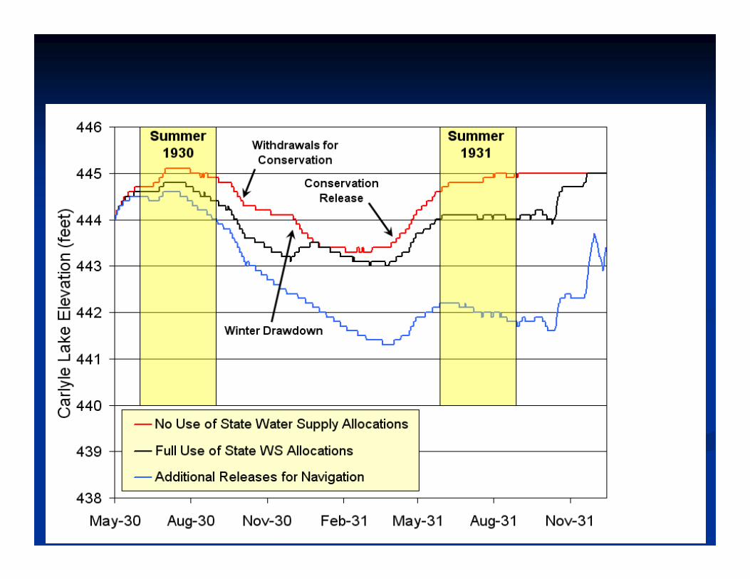
Impacts of releases on Carlyle Lake levels

Conclusions Groundwater is primarily available near the river and in limited
quantities. For the most part, community reservoir supplies appear to be in
good shape for the next 40 years, although a handful of smaller systems are inadequate or at risk.
The water supply storage from Shelbyville and Carlyle is fully allocated. While current needs and moderate growth to 2050 will be met, there is no available source should a new large water use want to locate to the area.
Water quality or navigation/water supply releases will result in low water levels in the federal reservoirs, especially during the second year of infrequent multi-year drought episodes.
