water quality management handbook · 5/23/2011 · usda forest service pacific southwest region ....
TRANSCRIPT
USDA Forest Service Pacific Southwest Region
DRAFT Water Quality Management Handbook
May 23, 2011 Vallejo, California

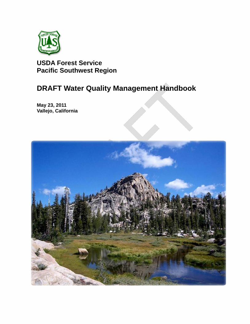
Cover photo: Lake Valley on the Stanislaus National Forest (USFS photo by James Frazier).
The U.S. Department of Agriculture (USDA) prohibits discrimination in all its programs and activities on the basis of race, color, national origin, age, disability, and where applicable, sex, marital status, familial status, parental status, religion, sexual orientation, genetic information, political beliefs, reprisal, or because all or part of an individual’s income is derived from any public assistance program. (Not all prohibited bases apply to all programs.) Persons with disabilities who require alternative means for communication of program information (Braille, large print, audiotape, etc.) should contact USDA’s TARGET Center at (202) 720-2600 (voice and TDD). To file a complaint of discrimination, write to USDA, Director, Office of Civil Rights, 1400 Independence Avenue, S.W., Washington, D.C. 20250-9410, or call (800) 795-3272 (voice) or (202)720-6382 (TDD). USDA is an equal opportunity provider and employer.
2
DRAFT Water Quality Management Handbook
Table of Contents
Acronyms..................................................................................................................................... ii Acknowledgements ......................................................................................................................... iii Chapter 1: Introduction .................................................................................................................... 1
Objectives................................................................................................................................... 2 Relationship between the Clean Water Act and Forest Service Best Management practices .. 3 Water Quality Management Handbook Chronology................................................................... 3 Forest Service Authorities .......................................................................................................... 6 Related Forest Service Programs .............................................................................................. 7 Policy ........................................................................................................................................ 11 References ............................................................................................................................... 13
Chapter 2. Best Management Practices........................................................................................ 14 The Water Quality Management Handbook and Site-Specific Best Management Practices .. 14 Organization and Format of Best Management Practices ....................................................... 16
Timber Management ........................................................................................................ 17 Timber Management BMPs.............................................................................................. 18 Road Management Activities............................................................................................ 46 Road Management BMPs ................................................................................................ 47 Mining ............................................................................................................................... 94 Mining BMPs..................................................................................................................... 94 Recreation ...................................................................................................................... 102 Recreation BMPs............................................................................................................ 102 Vegetation Manipulation ................................................................................................. 138 Vegetation manipulation BMPs ...................................................................................... 138 Fire Suppression and Fuels Management ..................................................................... 153 Fire Suppression and Fuels Management BMPs........................................................... 153 Watershed Management ................................................................................................ 161 Watershed management BMPs...................................................................................... 161 Range Management ....................................................................................................... 172 Range Management BMPs ............................................................................................ 177
Chapter 3: Administrative Processes for BMP Implementation .................................................. 188 General................................................................................................................................... 188 National Environmental Policy Act Procedures...................................................................... 190 Project Implementation........................................................................................................... 191
Chapter 4: Adaptive Management............................................................................................... 193 Purpose and Scope................................................................................................................ 193
Chapter 5: Watershed Prioritization for Restoration.................................................................... 209 Chapter 6: Monitoring .................................................................................................................. 215 Chapter 7: Total Maximum Daily Load Implementation .............................................................. 224
Minimizing Adverse Effects of Current Activities.................................................................... 224 Chapter 8: Needed Future Actions.............................................................................................. 226
Administrative Practices ......................................................................................................... 226 BMPs ...................................................................................................................................... 226 Restoration ............................................................................................................................. 227
Glossary of Terms ....................................................................................................................... 228
List of Figures
Figure 1. – Road management options ......................................................................................... 49 Figure 2. Adaptive management process for managing range allotments.................................. 182 Figure 3. Lines of communication feedback loop within Forest Service organization................. 196 Figure 4. State Water Quality Management Handbook conceptual model for identifying key
monitoring questions ........................................................................................................... 201
i
Acronyms
ACS Aquatic conservation strategy
AMP Allotment management plan
AOI Annual operating instructions
BMP Best management practice
BMPEP Best management practice evaluation program
CWE Cumulative water effects
EHR Erosion hazard rating
EPA Environmental Protection Agency
FIB Fecal indicator bacteria
FERC Federal Energy Regulatory Commission
FSH Forest Service Handbook
FSM Forest Service Manual
HazMat Hazardous materials
HUC Hydrologic unit code
LRMP Land and resource management plan
NEPA National Environmental Policy Act
NFS National Forest System
NWFP Northwest Forest Plan
OHV Off-highway vehicle
RWQCF Regional Quality Management Handbook
SCI Stream condition inventory
SMZ Streamside management zone
SNFPA Sierra Nevada Forest Plan Amendment
SPCC Spill prevention control and countermeasures
SWAMP Surface water ambient monitoring program
SWRCB State Water Resources Control Board
TMDL Total maximum daily load
TRACS Trail assessment and condition survey
USFS United States Forest Service
WIN Watershed improvement needs inventory
WIP Watershed improvement program
WWOS Wet weather operations standards
ii


ACKNOWLEDGEMENTS
This Water Quality Management Handbook is based largely on the original Water Quality Management Handbook prepared by retired Forest Service Regional Hydrologist John Rector in 1981. The revised text includes material and suggestions from a wide array of contributors, including staff of the State Water Resources Control Board, the North Coast, Central Valley, and Lahontan Regional Water Quality Control Boards, a diverse public stakeholder group, tribal governments, and U.S. Department of Agriculture Forest Service (Forest Service) staff from the national forests and regional office of the Pacific Southwest Region. The Forest Service acknowledges that participation of water board staff, stakeholders, and tribal governments does not necessarily constitute endorsement of this Water Quality Management Handbook, and we would like to express our appreciation for the efforts of the following:
State Water Resources Control Board Bert Angel Melenee Emmanuel James Giannopoulos Gita Kapahi Gaylon Lee Phil Wyels
North Coast Regional Water Quality Control Board Fred Blatt Robert Klamt
Central Valley Regional Water Quality Control Board Matt Boone Drew Coe Angela Wilson
Lahontan Regional Water Quality Control Board Douglas Cushman Lauri Kemper
Public Stakeholder Group Laurel Ames Lisa Belenky, Center for Biological Diversity Steve Brink, California Forestry Association John Buckley, Central Sierra Environmental Resource Center Eric Carlson, Associated California Loggers Amy Granat Michael Hogan, Integrated Environmental Restoration Services, Inc. Elisa Noble, California Farm Bureau Justin Oldfield, California Cattlemen’s Association
iii
Pacific Southwest Region
Don Rivenes, Sierra Forest Legacy Karen Schambach, Public Employees for Environmental Responsibility John Stewart, MUIRNet Consulting Mike Thornton, The Sierra Fund Stan VanVelsor, The Wilderness Society Wilson Yee, USEPA
Tribal Governments Crystal Bowman, Quartz Valley Indian Reservation Ken Fetcho, Yurok Tribe Beorn Zepp, Yurok Tribe
Consultants Dave Franzen, Natural Resources Conservation Service (ret.) Roger Poff, Roger Poff Associates Sherman Swanson, University of Nevada, Reno Ken Tate, University of California, Davis
U.S. Forest Service Mike Chapel, Regional Forester’s Liaison, Regional Office James Frazier, Hydrologist, Stanislaus National Forest Barry Hill, Regional Hydrologist Christine Mai, Hydrologist, Shasta-Trinity National Forest Kathy Mick, Trails Program Manager, Regional Office Sue Norman, Hydrologist, Lake Tahoe Basin Management Unit Al Olson, Resource Staff Officer, Shasta-Trinity National Forest Robert Taylor, Hydrologist, San Bernardino National Forest Jeff Tenpas, Watershed Improvement Program Manager, Regional Office Melissa Totheroh, Regional Road Engineer, Regional Office Anne Yost, Range Program Manger, Regional Office
iv
CHAPTER 1: INTRODUCTION
The Organic Administration Act of June 4, 1897, which created the National Forest System (NFS), established as a primary purpose of the forests the “securing of favorable conditions of water flow.” In the 114 years since Congress approved that act, the national forests in California have generally provided a high level of protection for the headwaters of the State. For example, a recent statewide survey found that streams in forested watersheds were in better condition than streams in watersheds in any other land use (Ode 2007). Water quality of the Sacramento River and its tributaries, which drain primarily NFS lands, have generally good quality and support their beneficial uses (Domagalski and others 2000). Sediment and nutrient loads from forested watersheds in the Sierra Nevada, including large areas within national forests, were found to be substantially lower than loads from downstream agricultural areas and significantly lower than average pollutant loads nationwide (Kratzer and Shelton 1998). Ahearn and others (2005) compared water quality in the upper Consumnes River watershed, which is mostly national forest, to the more agricultural and heavily populated lower watershed, and found that “upland drainages tended to deliver dilute, clear waters to the lowlands, while lower elevation sub-watersheds produced more turbid waters with elevated levels of constituents” (p. 242).
Nevertheless, resource-management and protection activities on NFS lands have the potential to result in nonpoint source pollution of the State’s waters, and continual efforts are needed to maintain and improve water quality. The USDA Forest Service (USFS) has as its goal the ecological restoration of NFS lands in California (Forest Service Manual (FSM) 2020, USFS Pacific Southwest Region Leadership Intent 2010), and water quality is an important component of forest ecosystems. Recognizing increasing stresses on the environment, new regulatory developments, and its responsibility for leadership in ecological restoration within the state, the Forest Service has worked with the State Water Resources Control Board (SWRCB), the Regional Water Quality Control Boards (RWQCB), tribes, and stakeholders to develop this revised Water Quality Management Handbook for NFS lands in California.
The FSM directs that best management practices (BMP) will be used to control nonpoint source pollution related to all management actions with the potential to affect water quality on NFS lands (FSM 2532). BMPs are the practices that both the Federal and State water-quality regulatory agencies expect the Forest Service to implement to meet its obligation for complying with applicable water-quality laws and standards, and to maintain and improve water quality. BMPs address protection of water quality from new and ongoing activities. Restoration of water-quality problems resulting from past land uses (legacy sites) is also an important component of this plan.
1
A decision by the Ninth Circuit Court of Appeals in August 2010 will result in many NFS roads being classified and regulated as point sources. The regulatory process that will be used for roads meeting criteria for point sources has not yet been developed. This Water Quality Management Handbook includes all road-related BMPs developed for management of roads as nonpoint sources. The Forest Service fully intends to comply with any future point source regulatory process the State of California and the U.S. Environmental Protection Agency (EPA) develop for forest roads.
Monitoring by the Forest Service (USFS 2004, 2009) indicates that improved implementation of BMPs is likely to be the most effective approach to improving protection of water quality on NFS lands. Most of this revised handbook focuses on steps to improve BMP implementation through changes in administrative practices and adaptive management. The handbook also includes several new BMPs to address developing water-quality issues and revisions of several BMPs selected on the basis of monitoring results and priorities as described in chapter 2.
This Water Quality Management Handbook for NFS lands in California describes background, legal, and policy basis for the handbook (chapter 1); BMPs that will be used for controlling nonpoint source pollution (chapter 2); processes for implementing those BMPs (chapter 3); an adaptive management system to continually improve BMPs (chapter 4); restoration of legacy water-quality problems (chapter 5), a monitoring plan to evaluate the success of the handbook (chapter 6); specific measures for total maximum daily load (TMDL) implementation (chapter 7); and needed future actions (chapter 8). The Forest Service will use these BMPs and processes to comply with provisions of:
1) Federal water-quality statutes and regulations, including the Clean Water Act, the Coastal Zone Act Reauthorization Amendments, and the related regulations of the EPA.
2) California’s water-quality requirements, including the Porter-Cologne Water Quality Control Act; the five elements of implementation and enforcement for the SWRCB Non-point Source Pollution Control Policy; the Basin Plans of the RWQCBs; and water-quality control regulations, plans, policies, and program plans approved by the SWRCB pursuant to the foregoing Federal and State statutes.
The provisions of this Water Quality Management Handbook are designed to conform and comply with all of these legal requirements, as well as with applicable Forest Service directives.
Objectives The objectives of this Water Quality Management Handbook for NFS lands in California are:
1) To ensure that the quality and beneficial uses of water are maintained where they are in good condition, consistent with the Federal and State anti-degradation/non-degradation policies, and the principles of conservation biology.
2
2) To protect the quality and beneficial uses of water from further degradation in water bodies that are trending toward impairment, as defined by Clean Water Act Section 303 (d).
3) To make substantial progress toward eventual delisting of water body segments listed pursuant to Clean Water Act Section 303(d).
4) To remediate legacy sources of pollution.
5) To ensure compliance with Federal and State water-quality objectives and legal requirements in the most efficient manner.
6) To enhance Forest Service performance as a water-quality management agency, and increase and improve its responsibility, transparency and accountability in its relationships with the Water Boards and the public.
Relationship between the Clean Water Act and Forest Service Best Management practices Section 313 of the Clean Water Act states that the Federal Government is subject to and will comply with all Federal, State, interstate, and local requirements, administrative authority, and process and sanctions respecting the control and abatement of water pollution in the same manner, and to the same extent as any nongovernmental entity. This means the Forest Service must use nonpoint source controls, including BMPs, approved by the State.
Several different relationships occur throughout the United States regarding State-specific BMPs and NFS lands. States usually have their own sets of BMPs, and when they do, the Forest Service adheres to them. A second situation occurs when the Forest Service has authored the BMPs and a state has agreed that those practices conform to state requirements. The use of Forest Service-authored BMPs is usually formalized through a memorandum of understanding. The third situation occurs when Forest Service-authored BMPs have gone through a formal public review process, been approved by the state and/or EPA, and the governor of the state has designated the Forest Service as the water-quality management agency for NFS lands within the state. In California, the State is the final authority on adequacy of BMPs.
Water Quality Management Handbook Chronology Water-quality regulation of activities on NFS lands is the result of both Federal and State laws. As noted above, Congress, in amending the Federal Water Pollution Control Act (Clean Water Act) in 1972, waived sovereign immunity for Federal agencies, and included in the law a requirement that Federal agencies comply with all state and local laws pertaining to water quality to the same extent as nonfederal entities. The State’s Porter-Cologne Water Quality Control Act was chaptered in 1969, augmenting the State Water Resources Control Board (SWRCB) and establishing the nine Regional Water Quality Control Boards (RWQCB). The Federal Water Pollution Control Act of 1972 was amended by the Clean Water Act of 1977. Clean Water Act Section 208 provided authority and funding for states to develop water quality management plans and to designate water quality management agencies with primary responsibility for
3
implementing those plans. The water quality management plans were to address, among other things, nonpoint source pollution. EPA promulgated regulations specifying the contents required in a water quality management plan (including best management practices and the process by which they were to be implemented), the process to be used for water-quality management plan development, and the qualifications required of a management agency (40 CFR, Part 130, Section 130.6).
The Porter-Cologne Water Quality Control Act authorized the SWRCB to exercise any powers delegated to the states by the Federal Water Pollution Control Act or subsequent amendments. Also, the governor delegated to the SWRCB the authority granted by Clean Water Act Section 208 to certify proposed water quality management plans for the State. Accordingly, the Forest Service and SWRCB initiated a 208 water quality management planning process for nonpoint source activities on NFS lands in California. The Forest Service, including the Pacific Northwest Region, the Pacific Southwest Region, and the Intermountain Region, drafted a proposed water quality management plan for NFS lands in California, and the SWRCB reviewed the draft water quality management plan.
In 1981, the SWRCB, in accordance with Clean Water Act Section 208, took the following actions:
1) The SWRCB certified the document titled “Water Quality Management for National Forest System Lands in California” as a water quality management plan.
2) The SWRCB designated the Forest Service (all three Regions) as the management agency with primary responsibility for water quality management plan implementation.
3) The SWRCB executed a management agency agreement with the Forest Service setting forth the latter’s commitment to implementing the water-quality management plan, and expressing the anticipation that RWQCBs would waive imposition of waste discharge requirements under the Porter-Cologne Water Quality Control Act.
In accordance with EPA regulations, all these SWRCB actions were submitted to the EPA for approval, which was granted in 1981.
During the following 20 years, a number of new Federal and State laws were enacted that affected the status of the water quality management plan and accompanying management agency agreement. In 1987, the Federal Water Quality Act was approved, adding Section 319 to provide funding for implementing nonpoint source management plans. Congress eliminated funding for implementing Section 208, and rescinded the related EPA regulations. In 1988, SWRCB adopted the “Source of Drinking Water” Policy (SWRCB Resolution 88-63). The Coastal Zone Act Reauthorization Amendments of 1990 (Section 6217) required affected states to develop nonpoint source control programs for waters that flowed to the ocean. The EPA promulgated “Guidance Specifying Management Measures for Sources of Nonpoint Pollution in Coastal Waters
4
(g-Guidance)” to implement it, specifying the contents of such plans and requiring implementation of specific “management measures” (mostly performance standards) for silviculture and some other nonpoint sources of pollution.
In 2000, the Forest Service, SWRCB, and the RWQCBs collaboratively reviewed and revised the water quality management plan and BMPs. Revisions primarily involved the references cited for the BMPs. The SWRCB deemed these changes to be administrative and non-substantive, so re-certification of the water quality management plan was not needed.
Additional major changes in California’s water-quality regulatory landscape occurred after approval of the revised water quality management plan in 2000:
1) The Porter-Cologne Act was amended to require that all Water Board waivers of waste discharge requirements be formal, temporary, conditional, and include monitoring as a condition. Two RWQCBs have adopted conditional waivers of waste discharge requirements for timber harvesting and vegetation management, and one has adopted a waiver covering most resource-management activities on NFS lands.
2) The SWRCB was, for the first time, authorized to adopt its own waivers, which could be statewide.
3) Pursuant to the Coastal Zone Act Reauthorization Amendments and EPA (g) guidance regulations, SWRCB and the State Coastal Commission adopted, and EPA approved, California's Nonpoint Source Pollution Control Program (NPS Program Plan), which sets forth “management measures” (mostly performance standards) for silviculture and several other activities that generate nonpoint source pollution. The EPA holds the State accountable for conforming to these management measures.
4) SWRCB adopted the policy titled “Implementation and Enforcement of the Nonpoint Source Pollution Control Program” (NPS Policy). It sets forth key elements for a third-party nonpoint source pollution-control program.
5) SWRCB adopted the policy titled “Addressing Impaired Waters: Regulatory Structure and Options.” It sets forth alternative ways of meeting TMDL goals.
6) Many water bodies on and downstream of NFS lands were added to the State’s section 303(d) list of impaired water bodies.
7) The National Marine Fisheries Service and the State Department of Fish and Game began listing various populations of anadromous salmonids and steelhead trout as threatened or endangered pursuant to the Federal or State Endangered Species Acts, a process that is still continuing. NFS lands harbor much of the remaining habitat and refugia for some of these populations, especially along the North Coast.
8) The EPA and the North Coast RWQCB began calculating sediment and thermal pollution TMDLs (which are the two most frequently observed pollutants
5
contributing to water-body impairment on NFS lands), and the RWQCB has been developing TMDL implementation plans.
9) The Forest Service began developing a set of national core BMPs.
The many changes indicated that the 2000 water quality management plan needed to be significantly revised and updated, and that the regulatory mechanisms needed to be reconsidered and streamlined. This Water Quality Management Handbook is the immediate successor to the 2000 water quality management plan.
Forest Service Authorities As a Federal agency, the Forest Service is bound by Federal laws, Executive orders, and Department of Agriculture directives, which are the basis for Forest Service programs and operations. Federal laws and Executive orders of direct and specific application to water-quality management include the following:
1) Organic Administration Act of 1897 (16 U.S.C. 475). This law defines original national forest purposes to improve and protect the forests; to secure favorable conditions of water flows; and to furnish a continuous supply of timber for the use and necessities of the citizens of the United States.
2) Multiple Use Sustained-Yield Act of 1960 (16 U.S.C. 528). This law expands national forest purposes to include watershed, wildlife and fish, outdoor recreation, range, and timber. Renewable surface resources are to be managed for multiple use and sustained yield of the several products and services that they provide. The principles of multiple use and sustained yield include the provision that the productivity of the land shall not be impaired.
3) Wild and Scenic Rivers Act of 1968 (16 U.S. C. 1271-1287; PL 90-452) requires that the Forest Service manage for nondegradation and enhancement of water quality in designated rivers on national forests.
4) National Environmental Policy Act (NEPA) of 1969 (42 U.S.C. 4321, 4331-4335, 4341-4346, 4346a-b, 4347). This law declares a national policy that encourages a “productive and enjoyable harmony between humans and their environment.” All Federal agencies, including the Forest Service, are required to use a systematic interdisciplinary approach to planning and decision-making. In addition, Federal agencies are to prepare detailed statements assessing the environmental impact of and alternatives to major Federal actions significantly affecting the environment.
5) Environmental Quality Improvement Act of 1970 (42 U.S.C. 4371-4374). This act establishes a national policy for the environment, which provides for the enhancement of environmental quality.
6) Federal Water Pollution Control Act of 1972, as amended (33 U.S.C. 1251, 1254, 1323, 1324, 1329, 1342, 1344). This series of laws establishes goals, policies, and procedures for maintaining and improving the Nation's waters. It addresses both point and nonpoint sources of pollution and establishes or requires programs for controlling both sources of pollution.
6
Section 208 requires area-wide waste-treatment management plans and water-quality management plans for nonpoint sources of pollution. The act established specific roles for Federal, State and local authorities in the regulation, enforcement, planning, control, and management of water pollution. Section 313 requires Federal agencies to comply with water-quality regulations of state and local governments. Section 319 addresses nonpoint source pollution and also requires development of water-quality management plans.
7) Forest and Rangeland Renewable Resources Planning Act of 1974 (16 U.S.C. 1600-1614). This law provides for systematic, long-range planning in managing renewable resources. The plans are based on a national assessment conducted every 10 years. The plans are updated every 5 years and submitted to Congress.
8) National Forest Management Act of 1976 (16 U.S.C. 1600-1602, 1604, 1606, 1608-1614). This law amended the Forest and Rangeland Renewable Resources Planning Act, emphasizing interdisciplinary involvement in the preparation of land and resource management plans. The law reinforced the concept of multiple use management of NFS lands and added requirements for resource protection.
9) Executive Order 12088 of October 13, 1978. This order requires Federal agencies to comply with environmental laws to be consistent with requirements that apply to a private person. Compliance will be in line with authorities and responsibilities of other Federal agencies, State, interstate, and local authorities as specified and granted in each of the various environmental laws.
10) The Antideficiency Act, 31 U.S.C. §1341. This act prohibits federal agency officials from obligating funds in advance or in excess of Congressional appropriations. As a result, a federal agency official cannot agree to commit the federal agency to future, indefinite, or potentially unlimited financial obligations or expenditures of funds for which there is no Congressional appropriation. All actions by the USFS as a federal agency are covered by this act. However, under this handbook, implementation and monitoring of BMPs are required for funded USFS projects.
Related Forest Service Programs This Water Quality Management Handbook is related to other Forest Service directives and programs that govern water-quality protection and improvement on NFS lands. These directives and programs are briefly described in this section.
Forest Service activities are governed by a planning framework that includes general policies and directives, as well as specific standards and guidelines. The Forest Service planning framework includes formal directives contained in the Forest Service Manual (FSM) and Forest Service Handbook (FSH), standards and guidelines from provincial and national forest plans, and the Forest Service Watershed Improvement Program.
7
Key water quality components of the Forest Service planning framework are described below:
Land and Resource Management Plans – Each national forest has a Land and Resource Management Plan (LRMP), also known as a “forest plan.” These plans provide broad guidance for forest management over relatively long (10 to 15 years) periods. LRMPs determine areas within each forest that are suitable for different resource management activities, including timber harvest, livestock grazing, and recreation, and establish desired conditions for forest resources. LRMPs include plans for wildfire suppression and standards and guidelines for activities and projects within the national forest. LRMPs are prepared and analyzed under NEPA.
Northwest Forest Plan (NWFP) - The NWFP includes an assessment and planning process for the Six Rivers, Klamath, Mendocino, Shasta-Trinity, and Rogue River-Siskiyou National Forests, as well a portion of the Modoc National Forest. The NWFP amended the LRMPs for these forests in 1994.
The Aquatic Conservation Strategy (ACS) of the NWFP (http://www.reo.gov/library/reports/newsandga.pdf) has nine objectives for maintaining and restoring the function, diversity, and integrity of the riparian and aquatic system, including water-quality protection:
1) Maintain and restore the distribution, diversity, and complexity of watershed and landscape-scale features to ensure protection of the aquatic systems to which species, populations, and communities are uniquely adapted.
2) Maintain and restore spatial and temporal connectivity within and between watersheds. Lateral, longitudinal, and drainage network connections include floodplains, wetlands, upslope areas, headwater tributaries, and intact refugia. These network connections must provide chemically and physically unobstructed routes to areas critical for fulfilling life history requirements of aquatic and riparian-dependent species.
3) Maintain and restore the physical integrity of the aquatic system, including shorelines, banks, and bottom configurations.
4) Maintain and restore water quality necessary to support healthy riparian, aquatic, and wetland ecosystems. Water quality must remain within the range that maintains the biological, physical, and chemical integrity of the system and benefits survival, growth, reproduction, and migration of individuals composing aquatic and riparian communities.
5) Maintain and restore the sediment regime under which aquatic ecosystems evolved. Elements of the sediment regime include the timing, volume, rate, and character of sediment input, storage, and transport.
6) Maintain and restore in-stream flows sufficient to create and sustain riparian, aquatic, and wetland habitats and to retain patterns of sediment, nutrient, and wood routing. The timing, magnitude, duration, and spatial distribution of peak, high, and low flows must be protected.
8
7) Maintain and restore the timing, variability, and duration of floodplain inundation and water table elevation in meadows and wetlands.
8) Maintain and restore the species composition and structural diversity of plant communities in riparian areas and wetlands to provide adequate summer and winter thermal regulation, nutrient filtering, appropriate rates of surface erosion, bank erosion, and channel migration; and to supply amounts and distributions of coarse woody debris sufficient to sustain physical complexity and stability.
9) Maintain and restore habitat to support well-distributed populations of native plant, invertebrate, and vertebrate riparian-dependent species.
Key watersheds comprise a system of large refugia for fish and wildlife based at the watershed scale. Key watersheds comprise nearly 40 percent of Forest Service lands within the forests managed under the NWFP, and are managed to maintain or recover habitat for anadromous and resident fish species. Key watersheds have a high priority for restoration. Specific road management guidelines apply to key watersheds: 1) no new roads in roadless areas within key watersheds; 2) no new roads in unroaded portions of roadless areas within key watersheds; and 3) reduction in existing road mileage within key watersheds (no net increase if funding is insufficient to implement reductions).
Riparian reserves are a key component of the ACS and comprise lands along streams and unstable and potentially unstable areas where special standards and guidelines direct land use. Riparian reserves apply to all ephemeral, intermittent, and perennial streams, and geologically unstable areas. These reserve areas maintain hydrologic, geomorphic, and ecological processes that directly affect streams and fish habitats. Widths of the reserves can range from a minimum of 100 feet on each side of ephemeral and/or intermittent streams to over 300 feet on each side of perennial fish-bearing streams. Only activities that protect or enhance ACS objectives are permissible within a riparian reserve. Riparian reserves serve to protect aquatic resources and water quality from timber-harvesting activities, road building, and other nonpoint source activities such as grazing, by maintaining a diverse riparian community, a buffer area from upslope activities, canopy for shade and aquatic nutrition, and filtration of sediment from hillslopes.
Watershed analysis, another component of the ACS, is required for all 5th-field watersheds managed under the NFWP. Watershed analysis is a process that evaluates the geomorphic and ecological processes operating in a watershed, and is intended to enable watershed planning to achieve ACS objectives. Watershed analysis provides the basis for monitoring and restoration programs. Watershed analysis informs restoration planning efforts by identifying watershed problems, such as erosional features, problem roads and road sections, and riparian areas not meeting the ACS objectives, as well as identifying those areas that should be preserved from any activities.
The Sierra Nevada Framework Plan Amendment (SNFPA), amended in 2004 (http://www.fs.fed.us/r5/snfpa/final-seis/), is analogous to the NWFP. The SNFPA provides similar guidance for forests in the Sierra Nevada and Modoc Plateau, including
9
the Modoc, Lassen, Plumas, Tahoe, Eldorado, Stanislaus, Sierra, Inyo, and Sequoia National Forests, and the Lake Tahoe Basin Management Unit. The SNFPA includes an Aquatic Management Strategy (AMS) similar to the ACS. The SNFPA equivalent to the riparian reserve is the “riparian conservation area,” and the SNFPA equivalent to key watershed is “critical aquatic refuge.” The SNFPA equivalent to “watershed analysis” is “landscape analysis.”
The four southern California national forests (Los Padres, Angeles, San Bernardino, and Cleveland National Forests) have consistent LRMPs that are comparable to the NWFP or SNFPA. Although each southern California national forest has its own LRMP, they all have adopted similar supplements to the Forest Service Handbook (FSH 2509-22) that provide protection to riparian conservation areas similar to the protection afforded through the NWFP and SNFPA.
The Forest Service Watershed Improvement Program (WIP) is a nationwide program that guides assessment of watershed conditions, inventories and identifies watershed restoration needs, and implements restoration activities. Implementation of the WIP results in assessment and restoration on a watershed scale.
In accordance with the WIP, each forest identifies priority watersheds for restoration, and essential projects that will improve watershed condition. The intent of the program is to focus watershed restoration activities in priority watersheds and progress through the priority watersheds in a stepwise manner, eventually providing assessment and restoration for all the watersheds. As described in more detail below, priority watersheds receive heightened water-quality protection under Forest Service guidance and are integral for maintaining sanctuary habitats for threatened and endangered species and unique plant and animal communities. Watershed restoration projects are not limited to priority watersheds, and are used to address watershed issues and water-quality problems in lower priority watersheds.
Primary components of the WIP are:
1) Priority watershed selection
2) Watershed assessments or watershed analyses
3) Watershed improvement needs inventories
4) Essential project identification (for example, road crossings, road decommissioning, and landslide stabilization)
5) Watershed restoration plans
6) Annual watershed improvement accomplishments reporting
Forest Service directives that provide guidance for watershed-scale planning, restoration, and assessment, include:
10
The Forest Service Region 5 FSH 2509.22 Soil and Water Conservation Handbook, chapter 20 (July 1988), requires that the Forest Service assess and consider the potential for cumulative watershed effects of proposed activities. The Forest Service Pacific Southwest Region Cumulative Watershed Effects policy provides an approach to assessing the potential for cumulative watershed effects related to management activities on NFS lands. The approach uses the equivalent roaded area model to make a preliminary assessment of watershed conditions by comparing effects of past, existing, and reasonably foreseeable actions to a watershed threshold of concern. More detailed analyses are required when equivalent roaded area totals equal or exceed the threshold of concern. Although the policy does not include mitigations, the assessment of potential cumulative watershed effects is included in NEPA analyses and can guide selection of alternatives by decision makers.
FSM chapter 2520 provides national direction for watershed condition assessment, watershed improvement, emergency burned area response for wildfires, monitoring, riparian area management, floodplain management and wetland protection, emergency watershed protection, and natural disaster and flood damage surveys. Watershed improvement activities include road decommissioning, meadow restoration, and reforestation of burned areas.
FSM chapter 2020 (September 2008) provides a policy for using ecological restoration in managing NFS lands, further supporting watershed analysis and restoration, and the ACS.
Policy The Forest Service will comply with the objectives, policies, and procedures of agency directives, handbooks and manuals, including, but not limited to, those required in FSM 2532.
The Forest Service will comply with applicable forest plan standards and guidelines.
The Forest Service will be responsive, in an ongoing and cooperative manner, to the environmental intent, goals and objectives provided by the Clean Water Act, the Coastal Zone Act Reauthorization Amendments, and related EPA regulations.
The Forest Service will comply with the State’s Porter-Cologne Water Quality Control Act, applicable water-quality control plans and policies enacted by the Water Boards, and regulatory mechanisms imposed by the Water Boards.
The following actions will be used to manage water quality on NFS lands in California:
• Implement BMPs during all current management activities on all NFS lands in California.
• Review and revise BMPs as needed to reflect the most recent state-of-the-art methods and techniques of BMP implementation and changes in Forest Service policy and direction.
11

• Implement an iterative adaptive management process for BMP implementation (chapter 4).
• Correct legacy water-quality problems (chapter 5).
• Establish a monitoring program (chapter 6) to determine the effectiveness of the Water Quality Management Handbook for protecting and improving water quality.
12
References Ahearn, D.S.; R.W. Sheibley; R.A. Dahlgren; Michael Anderson; Joshua Johnson; and
K.W. Tate. 2005. Land use and land cover influence on water quality in the last free-flowing river draining the western Sierra Nevada, California: Journal of Hydrology 313: 234-247.
Domagalski, J.L.; D.L. Knifong; P.D. Dileanis; L.R. Brown; J.T. May; Valerie Connor; and C.N. Alpers. 2000. Water Quality in the Sacramento River Basin, California, 1994–98: U.S. Geological Survey Circular 1215, 36 p., on-line at http://pubs.water.usgs.gov/circ1215/
Kratzer, C.R. and Jennifer Shelton. 1998. Water Quality Assessment of the San Joaquin–Tulare Basins, California: Analysis of Available Data on Nutrients and Suspended Sediment in Surface Water, 1972–1990: U.S. Geological Survey Professional Paper 1587, 93 p. http://ca.water.usgs.gov/sanj/pub/usgs/pp1587/pp1587.pdf
Ode, P.R. 2007. Ecological condition assessment of California’s perennial wadeable streams. Report to the State Water Resources Control Board’s Non-Point Source Program: California Department of Fish and Game Aquatic Bioassessment Laboratory, Rancho Cordova, California. http://www.swrcb.ca.gov/water_issues/programs/swamp/docs/reports/cmap_conditionassessment.pdf
U.S. Department of Agriculture. Forest Service. 2004. Best Management Practices Evaluation Program, 1992-2002 Monitoring Results U.S. Department of Agriculture, Forest Service, Pacific Southwest Region. 76 p.
U.S. Department of Agriculture. Forest Service. 2009. Water Quality Protection on National Forests in the Pacific Southwest Region: Best Management Practices Evaluation Program, 2003-2007. U.S. Department of Agriculture, Forest Service, Pacific Southwest Region. 28 p.
13
CHAPTER 2. BEST MANAGEMENT PRACTICES
This chapter describes the Forest Service programmatic BMP guidance and describes procedures for developing site-specific BMP prescriptions using the guidance contained in the Water Quality Management Handbook. The programmatic BMPs described in this handbook are intended to lead to on-the-ground site-specific BMP prescriptions, but are not intended to be such prescriptions themselves. The programmatic BMPs described below include practices and standards, rather than specific erosion-control structures that would be included in site-specific BMPs. This distinction is important because confusion has resulted from using the term “BMP” to describe both performance standards and specific structures or prescriptions.
Based on BMP implementation and effectiveness monitoring from 2003 to 2007 (USFS 2008), BMPs for Road Management (2-1 to 2-13) and Range Management (8-1 to 8-3) were reviewed and revised. New BMPs were developed for Off-Highway Vehicles (4-7.1 to 4-7.9). All other BMPs are identical to those in the previous Water Quality Management Handbook (USFS 2000). Some formatting changes have been made to improve consistency in this document. Some disparities in the amount of detail and format remain apparent between groups of new and revised BMPs and the BMPs that were retained from the original 1981 handbook. As described in chapter 8, review and revision of these remaining BMPs is planned for the future. All BMPs are intended to be dynamic and to undergo periodic review and revisions to ensure that they incorporate the best available information and techniques.
The Water Quality Management Handbook and Site-Specific Best Management Practices As noted above, the programmatic BMPs described in this Water Quality Management Handbook are performance standards. They are neither detailed prescriptions nor solutions to specific nonpoint pollution sources. Rather, they are action-initiating mechanisms, processes, and practices that call for the development of site-specific detailed prescriptions that are designed at the project scale during planning. Development of prescriptions is aided by results from ongoing monitoring, and may also follow direction developed at the national forests.
A new procedure in this Water Quality Management Handbook is the inclusion of an On-Line Library, at the end of this chapter, which includes reference materials for specific pollution-control techniques. National forest interdisciplinary teams are required to use techniques selected from these references when appropriate, or provide specific measures with equivalent or greater protection for water quality. For example, the erosion control plans described in BMP 2.13 should rely on techniques described in one or more of the references in the On-Line Library.
14
Although some pollutants may be thought of as characteristic of a management activity, the actual extent to which contaminants from an activity have the potential to degrade water quality will vary based on:
1) The physical, biological, meteorological, and hydrological environment where the activity takes place (for example, topography, physiography, precipitation, channel density, soil type, or vegetative cover).
2) The type of activity imposed on a given environment (for example, recreation, mineral exploration, or timber management), and the proximity of the activity area to surface waters.
3) The method of application and time frame over which the activity is applied (for example, grazing system used, types of silvicultural practices used, constant use as opposed to seasonal use, recurrent application, or one-time application).
4) The kind of beneficial uses of the water in proximity to the management activity and their relative sensitivity to the type of contaminants associated with the activity.
These four factors vary throughout NFS lands in California. It follows then, that the extent and type of potential contaminants are variable, as are the most appropriate abatement and control measures.
The NEPA process is crucial for developing site-specific methods and techniques for applying BMPs to fit individual project needs. Direction for environmental evaluations and preparation of environmental documents to comply with NEPA are contained in established NFS policy and procedures found in FSM 1900, FSM 1950, and FSH 1909.15. These references also contain direction to incorporate the interdisciplinary process into planning and decision making.
Under NEPA, interdisciplinary involvement is required to evaluate projects that may influence water quality and to develop the appropriate BMP applications for maintaining and improving water quality. The line officer responsible for a project selects and convenes an interdisciplinary team to evaluate a proposed activity, and assigns them the task of formulating and evaluating alternatives. A major part of the team evaluation is an analysis of environmental consequences. Alternatives that cannot fully protect water quality and associated beneficial uses with full application of BMPs will not be considered viable alternatives.
An interdisciplinary team is comprised of individuals representing two or more areas of professional knowledge and skills. They are not a fixed set of professionals. Each team includes a unique combination of skills that the line officer selects according to the identified issues, concerns, and opportunities associated with each project proposal. The team does not make decisions, but provides the line officer with alternatives, evaluations, and recommended mitigation and protection measures needed to make a reasoned decision and protect the environment. The final decision authority lies with the line officer.
15
Commonly, the methods and techniques for water-quality protection that apply to a project site are a composite package of multiple BMPs with site-specific applications the interdisciplinary team develops.. The appropriate BMPs and the methods and techniques of implementing the BMPs are included in the environmental documentation, permit, contract, or other controlling document used to conduct and administer the project (see chapter 3, Administrative Processes).
BMPs should be used when appropriate for activities other than the primary activity for which they were developed. For example, BMPs 1-8 and 1-19, which deal with designation and protection of streamside management zones, are included with the Timber Management BMPs, but may and should be used for other types of activities and projects that may affect riparian zones, including engineering, recreation, and range management.
The BMPs are dynamic and always subject to improvement and development. Monitoring and evaluation of existing practices may disclose areas where refinement is warranted. Research, academia, and administrative studies are continually evolving new methods and techniques applicable to water-quality protection. Provision has been made to allow for the continued updating and refinement of the existing practices as well as development of new practices (see chapter 4, Adaptive Management).
Organization and Format of Best Management Practices BMPs are grouped into subject areas based on the type of resource management or use activity:
• Timber management • Road building and site construction • Mining • Recreation • Vegetation management • Fire suppression and fuels management • Watershed management • Range management
Each BMP includes the following sections:
Practice: Includes the sequential number of the BMP and a brief title.
Objective: Describes the desired results or attainment of the practice as it relates to water-quality protection.
Explanation: Further amplifies the brief title and expresses how to apply the practice. Describes criteria or standards when applicable.
Implementation: Describes where to apply the practice; who is responsible for application, direction, and supervision; and when to employ the practice.
16

Timber Management Timber harvesting and reforestation are the culmination of several years of multiple resource assessment and detailed project planning.
Timber harvest includes felling, bucking, skidding, yarding, loading, and hauling designated trees to a mill. Harvest can be followed by reforestation, which includes preparation of the harvested site to treat excess fuels and competing vegetation, followed by tree planting, and stand maintenance as needed.
An effective starting point for identifying, documenting, and incorporating BMPs in the timber sale planning process is during the formulation of silvicultural prescriptions. Forest and districts may differ in how and when they formulate prescriptions in the planning process, but they generally follow the sequence of: stand examination, diagnosis of stand treatment and detailed silvicultural prescriptions, with post-treatment monitoring and evaluation.
Certified silviculturists develop silvicultural prescriptions. These specialists must meet high standards of professional knowledge, skills, and experience in multiple-use silviculture. Their training for certification requires continuing education in soils and watershed management. They are familiar with the terminology of these disciplines, and consult with soil and water specialists in the process of writing, or approving timber harvest prescriptions.
Timber sale proposals are evaluated and refined during the interdisciplinary preparation of environmental documentation as required by NEPA. The line officer identifies the members comprising the interdisciplinary team, and assigns them the responsibility for preparing environmental documentation, including the conduct of requisite field investigation of the proposed harvest site.
The team selects those BMPs necessary to protect or improve the water quality for specific sites, and the appropriate method and technique for their implementation, and incorporates them into the environmental document. When the appropriate line officer approves the environmental document, the BMPs are officially made a part of the harvest plan.
Planning begins 1 to 5 years before timber harvesting begins. Timber harvest planning and implementation also must follow the guidelines and requirements of the Forest Land and Resource Management Plan.
The timber sale planning process includes the following steps:
1) Position statement development
2) Sale area design (includes the environmental documentation process)
3) Sale plan implementation (includes harvest unit layout and stand record card updates)
17

4) Final sale package preparation (includes sale area improvement plan and contract preparation)
5) Sale award
While the timber sale is in progress, the implementation and effectiveness of the BMP prescription for the sale area are evaluated. This evaluation process continues through the completion of reforestation. This is when the actual environmental effects onsite are compared to the expected effects the interdisciplinary team estimated.
Findings are documented for use by future interdisciplinary teams on proposed timber sales and to update BMPs where warranted.
Timber Management BMPs 1.1 Timber Sale Planning Process 1.2 Timber Harvest Unit Design 1.3 Determining Surface Erosion Hazard for Timber Harvest Unit Design
1.4 Using Sale Area Maps and/or Project Maps for Designating Water Quality Protection Needs
1.5 Limiting the Operating Period of Timber Sale Activities 1.6 Protecting Unstable Lands 1.7 Prescribing the Size and Shape of Regeneration Harvest Units 1.8 Streamside Management Zone Designation 1.9 Determining Tractor-loggable Ground
1.10 Tractor Skidding Design 1.11 Suspended Log Yarding in Timber Harvesting 1.12 Log Landing Location
1.13 Erosion Prevention and Control Measures During Timber Sale Operations
1.14 Special Erosion-prevention Measures on Disturbed Land 1.15 Regeneration of Areas Disturbed by Harvest Activities 1.16 Log Landing Erosion Control 1.17 Erosion Control on Skid Trails 1.18 Meadow Protection during Timber Harvesting 1.19 Streamcourse and Aquatic Protection 1.20 Erosion-control Structure Maintenance
1.21 Acceptance of Timber Sale Erosion-control Measures Before Sale Closure
1.22 Slash Treatment in Sensitive Areas 1.23 Five-year Restoration Requirement
1.24 Non-recurring “C” Provisions that can be used for Water-quality Protection
1.25 Modification of the Timber Sale Contract
18
The following are the BMPs for the control of nonpoint source pollution associated with timber management activities. The line officer on each administrative subunit is responsible for fully implementing the directives that provide for water-quality protection and improvement during timber harvest and management activities. The directives, referenced for each BMP in section 13, give details on methods to incorporate water-quality controls into each phase of the timber management program.
Earth scientists and other trained and qualified individuals are available to work with the timber management work force to provide technical assistance in identifying beneficial uses, the most recent state-of-the-art water-quality control, methods and techniques, and evaluation of results.
BMP 1.1 - Timber Sale Planning Process
Objective: To incorporate water-quality and hydrologic considerations into the timber sale planning process.
Explanation: The interdisciplinary team will address potential water-quality problems and provide for administrative controls, corrective treatments, and preventive measures. As warranted, a qualified specialist will define and quantify the potential changes to water quality and instream beneficial uses.
The result is an environmental document and sale contract(s). These documents describe methods to prevent unacceptable effects to water quality during and following sale layout and logging operations. They document mitigation measures to ameliorate, and/or preclude adverse effects for those treated areas. Silvicultural treatment is excluded from environmentally sensitive areas where adverse environmental effects from the activity cannot be mitigated to conform to Federal, State, and local water-quality standards.
Implementation: Earth scientists or other trained and qualified individuals participate in the environmental documentation process to evaluate onsite watershed characteristics and potential environmental consequences of the proposed timber harvest and related activities. They design the timber sale to include site-specific prescriptions for each area of water-quality concern. The resulting contract will include those provisions set forth in the environmental document to meet water-quality protection objectives.
19

BMP 1.2 - - Timber Harvest Unit Design
Objective: To ensure that timber harvest unit design will secure favorable conditions of water quality and quantity, while maintaining desirable stream channel characteristics and watershed conditions. The design should consider the size and distribution of natural structures (snag and down logs) as a means of preventing erosion and sedimentation.
Explanation: This is an administrative and preventive practice. Proposed timber harvest units will be evaluated to predict watershed response to the proposed timber harvest unit design. This includes onsite examination of the watersheds to evaluate their ability to absorb the effects of the proposed harvest without incurring unacceptable effects on water quality.
Characteristics to be evaluated can include recovery from past harvests; size and extent of past management activities; protection of channels; number, size and location of harvest units; planned location and size of roads, landings and skid trails; logging system design; potential natural recovery rate of the watershed; and needs of associated beneficial uses.
Where it is not possible to mitigate adverse effects on water quality and undesirable streamflow conditions, the harvest unit design will be modified to reduce adverse effects. To the fullest extent possible, the unit design is made to be amendable to implementing mitigation measures.
Implementation: Earth scientists or qualified specialists will conduct a hydrologic and geologic survey of the area affected by proposed harvest activities. Mitigations or changes needed to stabilize slopes and project or improve stream courses will be incorporated into the harvest unit design. It is the responsibility of the aale administrator to carry out on-the-ground accomplishments of environmental protection measures, and the timber sale contract-specific areas will be identified during design for monitoring attainment of water-quality objectives.
20
BMP 1.3 - Determining Surface Erosion Hazard for Timber Harvest Unit Design
Objective: To identify high-erosion hazard areas to adjust treatment measures and prevent downstream water-quality degradation.
Explanation: This is a preventive practice. The California Soil Survey Committee erosion hazard rating (EHR) system is a method used to estimate the potential erosion hazard of a given area. It evaluates the soil-topography-climate-soil cover relationships of site-specific areas. Where the post-harvest hazard is predicted to be “moderate,” an onsite evaluation is conducted to determine the need for erosion control measures. Where the post-harvest hazard is predicted to be “high,” or “very high,” erosion-control measures are necessary to reduce the potential risk of accelerated erosion to a low or moderate level.
Where the harvest impacts cannot be reduced to a low or moderate level with treatments, then the harvest units should be avoided or harvest methods modified, or both (see also BMP 1-6).
Implementation: The erosion-hazard determination is part of the pre-sale planning process, as input to the environmental document. Only trained and qualified Forest Service employees will establish the EHR for individual harvest units. The timber sale Planning Forester uses this information to help design the timber sale, and apply appropriate erosion control.
21
BMP 1.4 - Using Sale Area Maps and/or Project Maps for Designating Water-Quality Protection Needs
Objective: To ensure recognition and protection of areas related to water-quality protection delineated on a sale-area map or a project map.
Explanation: This is an administrative and preventative practice. The following are examples of water-quality protection features that pre-sale foresters can designate on the sale area map or project map, thereby ensuring their incorporation as timber sale contract requirements:
1) Location of streamcourses and riparian zones to be protected, including the width of the protection zone required for each stream
2) Wetlands (meadows, lakes, springs, and so forth) to be protected
3) Boundaries of harvest units
4) Specified roads
5) Roads where log hauling is prohibited, or restricted
6) Structural improvement
7) Area of different skidding and/or yarding method application
8) Sources of rock for road work, riprapping, and borrow materials
9) Water sources that are available for purchasers' use
10) Other features that are required by contract provisions
11) Site preparation/fuel treatment
Implementation: The interdisciplinary team will identify and delineate these and other features on maps, as part of the environmental documentation process. The Sale Preparation Forester will include them on the sale area map at the time of contract preparation. The sale administrator and the purchaser will review these areas on the ground before commencing harvest.
22
BMP 1.5 - Limiting the Operating Period of Timber Sale Activities
Objective: To ensure that the purchasers conduct their operations, including, erosion-control work, road maintenance, and so forth, in a timely manner, within the time specified in the timber sale contract.
Explanation: Contract provision C6.3, “Plan of Operation” is required in all timber sale contracts. This provision states that the purchaser must submit a general plan of operation which will set forth planned periods for, and methods of road construction, timber harvesting, completion of slash disposal, erosion-control work, and other contractual requirements. Forest Service written approval of the Plan of Operation is prerequisite to commencement of the purchaser's operation. Contract clause B6.31, “Operation Schedule,” requires that the purchaser provide an annual schedule of anticipated activities such as road maintenance and erosion-control work until the sale is closed. Contract clause C6.313, “Limited Operating Period,” will be used in a contract to limit the purchaser's operation to specified periods when adverse environmental effects are unlikely. Contract provision B6.6 can be used to close down operations due to the rainy season, high water, and other adverse operating conditions, to protect resources.
Implementation: During the timber sale planning process, the interdisciplinary team will identify and recommend limited operating periods. The Sale Preparation Forester prepares the contract to include clause C6.313. Provisions B6.3, B6.31, and C6.3 are all mandatory provisions of the timber sale contract. Provision C6.3 is mandatory only for sales over a 2-year contract period. The purchaser must submit a general plan and annual plans to the Forest Service. The purchaser may commence operations only after written Forest Service approval of the general plan under C6.3.
23
BMP 1.6 - Protecting Unstable Lands
Objective: To provide special treatment of unstable areas to avoid triggering mass slope failure with resultant erosion and sedimentation.
Explanation: This practice is an administrative and preventative control. Where unstable lands are delineated, they are taken out of suitable forest lands and are reclassified as unsuitable forest land. Using existing harvest technologies, unsuitable forest lands cannot be managed for timber production where irreversible adverse effects to soils, productivity, or watershed conditions may occur. Timber harvesting is deferred pending technology development proven to be operational on these sites without causing adverse environmental effects.
Implementation: The interdisciplinary team will prepare plans and environmental documents, utilizing information provided by specialists trained and qualified to identify unstable areas. When warranted, based on location and size of the sale, proposed harvest units may be assessed for relationships to unstable areas through aerial photo reconnaissance (most recent photos at least 1:24,000 or larger scale) and a landslide hazard map, where available. These features are then assessed on the ground as the team deems necessary. Where unstable lands are presently classified as suitable forest lands, the classification is changed to unsuitable forest lands. Unsuitable forest lands will not be harvested until they can be harvested without irreversible or unmitigable resource effects. If the team determines that current or prospective logging methods would result in irreversible or unmitigable watershed effects, then the line officer should reclassify the area to unsuitable forest land and defer harvesting.
24
BMP 1.7 - Prescribing the Size and Shape of Regeneration Harvest Units
Objective: To control the physical size and shape of regeneration harvest units as a means of preventing erosion and sedimentation.
Explanation: This is an administrative and preventive practice. 36 CFR 219.27 (d)(2) limits the size of openings created by the application of even-aged silviculture in California in a single entry (a clearcut) to 60 acres for Douglas-fir forest type and 40 acres for all other forest types with certain exceptions. Exceptions can be made in the case of salvage harvesting or with Regional Forester approval. The National Forest Management Act, section 6, contains the following:
“(F) insure that clearcutting, seed tree cutting, shelterwood cutting and other cuts designed to regenerate an even aged stand of timber will be used...only where...(iv) there are established according to geographic areas, forest types, or other suitable classifications the maximum size limits for areas to be cut in one harvest operation including provision to exceed the established limits after appropriate public notice and review by the responsible Forest Service officer one level above the Forest Service officer who normally would approve the harvest proposal: Provided, That such limits shall not apply to the size of areas harvested as a result of natural catastrophic conditions such as fire, insect and disease attack, or windstorm; and (v) such cuts are carried out in a manner consistent with the protection of soil, watershed, fish, wildlife, recreation, and esthetic resources, and the regeneration of the timber resource.”
Implementation: The size and the shape of the proposed regeneration units are reviewed on the ground in the pre-sale planning process. A map showing proposed units is included in the contract, which is reviewed and approved by the appropriate line officer. The timber sale should be, and normally is, delineated on the ground (roads staked, timber marked) after the environmental analysis is complete and a formal decision is made.
25
BMP 1.8 - Streamside Management Zone Designation
Objective: To designate a zone along riparian areas, streams, and wetlands that will minimize potential for adverse effects from adjacent management activities. Management activities within these zones are designed to improve riparian values.
Explanation: As a preventive measure, roads, skid trails, landings, and other timber-harvesting facilities will be kept at a prescribed distance from designated stream courses.
Factors such as stream class, channel aspect, channel stability, sideslope steepness, and slope stability are considered in determining the limitations on activities within the width of streamside management zones (SMZ). Aquatic and riparian habitat, beneficial riparian zone functions, their condition and their estimated response to the proposed timber sale are also evaluated in determining the need for and width of the streamside management zones.
The SMZ will be a zone of total exclusion of activity, or a zone of closely managed activity as described in the “Glossary of Terms.” It is a zone that acts as an effective filter and absorptive zone for sediment; maintains shade; protects aquatic and terrestrial riparian habitats; protects channel and streambanks; and promotes floodplain stability.
Implementation: Identify the streamside management zone requirements during the environmental documentation process. Each forest's LRMP identifies specific measures to protect these zones. As a minimum, forest requirements must be identified and implemented. The timber sale project is designed to include site-specific prescriptions for preventing sedimentation and other stream damage from logging debris. The timber sale contract will be designed to ensure retention of streamside vegetation and improve the condition and beneficial functions of the riparian area.
As appropriate, water-quality monitoring is identified in the environmental document. The Timber Sale Preparation Forester is responsible for including the zones in the timber sale contract and on the sale area map as identified by the environmental document. The sale administrator is responsible for contract compliance during harvest operations.
26
BMP 1.9 - Determining Tractor-loggable Ground
Objective: To minimize erosion and sedimentation resulting from ground disturbance of tractor logging systems.
Explanation: This preventative practice is intended to minimize accelerated soil erosion and sedimentation, and water-quality degradation. To determine tractor-loggable ground, consider physical site characteristics such as steepness of slopes, landslide prone areas, and soil properties. The EHR is one method. For example, where the post-tractor logging EHR is predicted to be “moderate,” an onsite evaluation is conducted to determine the need for erosion-control measures. Where the post-tractor logging EHR is predicted to be ”high,” or “very high,” erosion-control measures are required to reduce the risk of accelerated erosion.
Avoid tractor logging where the predicted, post-logging erosion hazard cannot be reduced to either “low” or “moderate.”
Implementation: A trained and qualified Forest Service employee will evaluate the EHR during the on-the-ground planning phase of the timber sale. This work is done within each sale area by evaluating representative sites. The resulting EHRs are considered during the selection of logging methods and silvicultural prescriptions, of erosion-control measures to reduce risk, and in determining the intensity of and controls for land-disturbing activities.
Interpretations of the considerations are described in the environmental document. Provisions in the timber sale contract specify the areas, determined by the EHR, upon which tractors can operate.
27
BMP 1.10 - Tractor Skidding Design
Objective: By designing skidding patterns to best fit the terrain, the volume, velocity, concentration, and direction of runoff water can be controlled in a manner that will minimize erosion and sedimentation.
Explanation: This is a preventative practice. Watershed factors considered include slope, soil stability, exposure, SMZs, meadows, and other factors that may affect the surface water runoff and sediment yield potential of the land. The careful control of skidding patterns serves to avoid onsite and downstream channel instability, build-up of destructive runoff flows, and erosion in sensitive watershed areas such as meadows and SMZs.
Methods for protecting water quality while utilizing tractor skid trail systems are:
– End-Lining. This method involves winching the log directly out of the sensitive areas (such as SMZs and meadows) with a cable operated from outside the sensitive area. In this manner, logs can be removed from the sensitive areas, while avoiding encroachment by heavy equipment and associated adverse environmental effects.
– Felling to the Lead. This method involves felling trees toward a predetermined skid pattern. This procedure facilitates an uncomplicated approach of the tractor operating between the log and the skid trail. Soil disturbance and compaction are consequently lessened, and residual stand and site damage is minimized.
– Specialized Equipment Access. Specialized equipment (harvesters, feller bunchers) having low ground pressures can move in and out of selected SMZs without turning and leaving disturbed ground.
Implementation: For skid trail design, sensitive areas will be identified and evaluated in the environmental documentation process during the timber sale planning process. When needed to protect water quality, prescriptions must be included in the basic TSC by the use of special contract provisions (C-clauses). The sale administrator then executes the prescription on the ground by locating the skid trails with the timber purchaser, or by agreeing to the purchaser's proposed locations prior to construction. Guidelines for skid trail locations are referenced in the sale administrator Handbook, and will be in the environmental documentation and the timber sale contract.
28
BMP 1.11 - Suspended Log Yarding in Timber Harvesting
Objective:
1) To protect the soil mantle from excessive disturbance.
2) To maintain the integrity of the SMZ and other sensitive watershed areas.
3) To control erosion on cable corridors.
Explanation: Suspended log yarding includes all yarding systems that suspend logs either partially or completely off the ground. These systems include, but are not limited to, skyline, helicopter, and balloon yarders. The systems are used on steep slopes where tractors cannot operate. All of the systems result in less soil disturbance since heavy machinery is not used over the sale area. Erosion-control measures are applied as necessary in cable corridors to control erosion and runoff.
Implementation: The areas where suspended log yarding is required will be determined during the pre-sale planning process, and they will be included in the sale plan. The specific systems must be included in the timber sale contract, and designated on the sale area map by the Sale Preparation Forester. The sale administrator will oversee the project operation using the guidelines and standards established in the timber sale contract and sale administrator handbook with reference to the sale plan.
29
BMP 1.12 - Log Landing Location
Objective: To locate new landings or reuse old landings in such a way as to avoid watershed impacts and associated water-quality degradation.
Explanation: This practice is both administrative and preventive. The location of and clearing limits for log landings are commonly evaluated by the interdiscipliinary team, and are agreed to by the sale administrator and purchaser prior to construction. The following criteria are used by the sale administrator in evaluating landings:
1) The cleared or excavated size of landings should not exceed that needed for safe and efficient skidding and loading operations. Trees considered dangerous will be removed around landings to meet the safety requirements of the Occupational Safety and Health Administration (OSHA).
2) To the extent feasible, select landing locations that involve the least amount of excavation and the least erosion potential, and are well outside of the SMZ.
3) Where feasible, locate landings near ridges away from headwater swales in areas that will allow skidding without crossing channels, violating the SMZ, or causing direct deposit of soil and debris to the stream.
4) Locate landings where the least number of skid roads will be required, and sidecast can be stabilized without entering drainages, or affecting other sensitive areas.
5) Position landings such that the skid road approach will be as nearly level as feasible, to promote safety, and protect the soil from erosion.
6) Keep to a minimum the number of skid trails entering a.
7) Avoid excessive fills associated with landings constructed on old landslide benches. Do not change the mass balance to point to destabilize the landslide.
8) Construct stable landing fills or improve existing landings by using appropriate compaction and drainage specifications. Engineered fills will be needed under certain conditions.
Implementation: The sale administrator must agree to landing locations proposed by the purchaser or their representatives. Relying on interdiscipliinary team input and the stated criteria, the sale administrator can negotiate to select mutually acceptable landing locations—other than those identified in the NEPA document. To be an acceptable landing, it must meet the above criteria. Should agreement not be reached, the decision of the Forest Service will prevail within contract
30

limitations.
31
BMP 1.13 - Erosion Prevention and Control Measures during Timber Sale Operations
Objective: To ensure that the purchasers' operations will be conducted reasonably to minimize soil erosion.
Explanation: Timber is purchased by individuals or companies who either harvest the timber themselves, or sub-contract to other parties. Therefore, it is necessary to ensure that purchasers and their sub-contractors understand and adhere to water-quality BMP prescriptions formulated during the timber sale planning process. This is accomplished by setting forth the purchaser's responsibilities in the timber sale contract, and holding the purchaser accountable for actions of their sub-contractor.
Implementation: Equipment will not be operated when ground conditions are such that excessive damage will result. The kinds and intensity of control work required of the purchaser will be adjusted to ground and weather conditions, with emphasis on the need to control overland runoff, erosion, and sedimentation. Erosion-control work required by the contract will be kept current. At certain times of the year this means daily, if precipitation is likely, or at least weekly when precipitation is predicted for the weekend.
If the purchaser fails to perform seasonal erosion-control work prior to any seasonal period of precipitation, or runoff, the Forest Service may temporarily assume responsibility, complete the work, and use any unencumbered deposits as payment for the work.
32
BMP 1.14 - Special Erosion-prevention Measures on Disturbed Land
Objective: To provide appropriate erosion and sedimentation protection for disturbed areas.
Explanation: This is an administrative and preventive treatment. When required by the contract, the purchaser will give adequate treatment by spreading slash, mulch, or wood chips (or, by agreement, some other treatment) on portions of tractor roads, skid trails, landings, cable corridors or temporary road fills. This provision is to be used only for sales which contain identified special soil stabilization problems which are not expected to be adequately treated by normal methods prescribed under other contract provisions.
Implementation: During the timber sale planning process and/or during sale appraisal, the interdisciplinary team will identify criteria for selecting treatment areas or classes of areas for special treatment and document them in the environmental assessment. The Sale Preparation Forester will identify the acreage to be treated in the legend of the sale area map. The sale administrator will designate the specific areas to be treated on the ground.
33
BMP 1.15 - Revegetation of Areas Disturbed by Harvest Activities
Objective: To establish a vegetative ground cover on disturbed sites to prevent erosion and sedimentation.
Explanation: Where the purchaser's operations have severely disturbed the soil, and the establishment of vegetation is needed to control accelerated erosion, the purchaser will be required to take appropriate measures normally used to establish an adequate ground cover of grass or other vegetative stabilization measures acceptable to the Forest Service. The type and intensity of treatment to establish ground cover is prescribed by the sale administrator, with assistance from earth scientists and botanists, as needed.
This measure is applied in contracts where it is expected that disturbed soils in parts of the sale area will require vegetative cover for stabilization and other contract provisions will not mitigate problems.
Implementation: The Forest Service will include an estimate of the need for revegetation in the timber sale appraisal and sale contract. Where revegetation is prescribed, the prescription must be included in the timber sale contract. The sale administrator will designate the areas of disturbed soils, such as logging areas and temporary roads that must be treated.
The Forest Service will provide advice as to soil preparation and the application of suitable seed mixtures, mulch, and fertilizer, and the timing of such work. The sale administrator is responsible for ensuring that revegetation work is done correctly and in a timely manner.
34
BMP 1.16 - Log Landing Erosion Control
Objective: To reduce the impacts of erosion and subsequent sedimentation associated with log landings by use of mitigating measures.
Explanation: This practice uses administrative, preventive, and corrective controls to meet the objective. The Sale Planning Forester and sale administrator assess the need for stabilization, with the assistance of earth scientists as needed.
Implementation: Timber sale contract requirements provide for erosion prevention and control measures on all landings. The Timber Sale Preparation Forester will include provisions in the timber sale contract for landings to have proper drainage. After landings have served the purchaser's purpose, the purchaser will ditch, or slope the landings, and may be required to rip or subsoil and make provisions for revegetation to permit the drainage and dispersion of water. Erosion-prevention measures such as waterbars will be constructed to divert water away from landings.
Other provisions may include aggregate surfacing; scarifying; smoothing and sloping; construction of drainage ditches; spreading slash; covering with mulch or wood chips; or applying straw mulch. Prevent road drainage from reaching landings. Unless agreed otherwise, cut and fill banks around landings will be reshaped to stabilize the area.
The specific work needed on each landing will depend on the actual onsite conditions. The sale administrator is responsible for ensuring that this practice is properly implemented on the ground. The sale administrator will agree upon the location and size of log landings proposed by the purchaser before clearing and construction begins.
35
BMP 1.17 - Erosion Control on Skid Trails
Objective: To protect water quality by minimizing erosion and sedimentation derived from skid trails.
Explanation: This practice uses preventive controls to reach the objective.
The timber sale contract requires the installation of erosion-control measures on skid trails, tractor roads, and temporary roads. Normally, the work involves constructing cross ditches and water-spreading ditches. Other methods such as backblading will be agreed to in lieu of cross drains. Grass seeding or other erosion-control and compaction remediation measures may also be required by a “C” provision, which will be added to the timber sale contract. Areas to be treated are shown on the sale area map legend. During the life of the contract, these areas are designated on the ground annually as logging and temporary access construction progresses.
Implementation: Locations of all erosion-control measures are designated and agreed to on the ground by the sale administrator. The sale administrator handbook section on Skid Trails and Firelines contains guidelines for spacing of cross drains, construction techniques, and cross drain heights. The sale administrator should use these guidelines on the ground to identify site-specific preventive work that is required of the purchaser. The purchaser is obligated to complete and maintain erosion-control work specified in contract provisions during the life of the contract.
36
BMP 1.18 - Meadow Protection during Timber Harvesting
Objective: To avoid damage to the ground cover, soil, and the hydrologic function of meadows.
Explanation: This is an administrative and preventive action. The interdisciplinary team identifies these sensitive environments during the scoping and onsite evaluation portion of the environmental document preparation process. As a minimum, meadow protection requirements contained in the forest LRMP must be identified and implemented. Trained and qualified Forest Service employees will assess these areas. Protection zones and tree directional felling are prescribed according to site conditions and within guidelines provided by the Forest Service directive system and the LRMP guidelines.
The timber sale contract prohibits unauthorized operation of vehicular or skidding equipment in meadows or in protection zones designated on sale area maps and marked on the ground. Vehicular or skidding equipment is not to be used on meadows except when specifically approved by the sale administrator. Where feasible, directional felling will be used to avoid felling trees into meadows. Unless otherwise agreed, trees felled into meadows will be removed by end-lining, slash removed, and resulting disturbance will be repaired where necessary to protect vegetative cover, soil, and water quality.
Implementation: The concerns and requirements will be set forth in the timber sale contract requirements for sale areas with meadow land. The contract may also specify that a purchaser is subject to liquidated damage charges each time equipment enters a designated meadow. The purchaser will repair damage to these designated areas and/or their associated protection zones in a timely manner, as agreed to by the sale administrator.
The purchaser will repair damage to a streamcourse, or SMZs caused by unauthorized purchasers' operations in a timely and agreed-upon manner.
37
BMP 1.19 - Streamcourse and Aquatic Protection
Objective:
1) To conduct management actions within these areas in a manner that maintains or improves riparian and aquatic values.
2) To provide unobstructed passage of stormflows.
3) To control sediment and other pollutants entering streamcourses.
4) To restore the natural course of any stream as soon as practicable, where diversion of the stream has resulted from timber management activities.
Explanation: This management practice uses administrative, preventive, and corrective measures to meet the objectives.
Streams within proposed timber sale areas are surveyed and protection zones are prescribed during the timber sale planning process. The interdiscipliinary team formulates stream-protection requirements, and includes the prescription in the decision document. The requirements are then included in the timber sale contract and identified on the sale area map.
The following principles are fundamental to protecting streamcourses:
– The sale administrator must agree to location and method of streamcourse crossings prior to construction. This is done at the same time as agreements are made with the purchaser or purchaser’s representative for the locations of landings, skid trails, tractor roads, and temporary roads.
– All damage to a streamcourse, including damage to banks and channels, will be repaired to the extent practicable.
– All sale-generated debris is removed from streamcourses, unless otherwise agreed to by the sale administrator, and in an agreed-upon manner that will cause the least disturbance.
– Limit, or exclude equipment use in designated SMZs. Widths of SMZ and restrictions pertaining to equipment use are defined by onsite project investigation and are included in the timber sale contract. The Forest Service identifies these areas on the sale area map prior to advertising. Boundaries of zones will be modified by agreement between the contractor and sale administrator, to compensate for unforeseen operation conditions.
– Methods for protecting water quality while utilizing tractor skid trail design in streamcourse areas where harvest is approved include: 1) end lining, 2) felling to the lead, and 3) utilizing specialized equipment with low ground pressure such as a feller buncher harvester. Permit
38
equipment to enter streamside areas only at locations agreed to by the sale administrator and the purchaser.
– Water bars and other erosion-control structures will be located so as to disperse concentrated flows and filter out suspended sediments prior to entry into streamcourse.
– Material from temporary road and skid trail streamcourse crossings is removed and streambanks restored to the extent practicable.
– In cable log yarding operations, logs will be fully airborne within the SMZ, when required by the timber sale contract.
– Special slash-treatment site-preparation activities will be prescribed in sensitive areas to facilitate slash disposal without use of mechanized equipment.
Implementation: The sale administrator works with the purchaser's representative to ensure that the timber sale contract clauses covering the above items are carried out on the ground. Specialists can be called upon to help the sale administrator with decisions. In the event the purchaser causes debris to enter streamcourses in amounts which may adversely affect the natural flow of the stream, water quality, or fishery resource, the purchaser will remove such debris as soon as practicable, but not to exceed 48 hours, and in an agreed-upon manner that will cause the least disturbance to streamcourses.
39
BMP 1.20 - Erosion-control Structure Maintenance
Objective: To ensure that constructed erosion-control structures are stabilized and working.
Explanation: Erosion-control structures are only effective when they are in good repair and function as designed. Once the erosion-control structures are constructed, there is a possibility that they may not become adequately effective, or they will become damaged from subsequent harvest activities. It is necessary to provide follow-up inspection and structural maintenance to avoid these problems and ensure adequate erosion control.
Implementation: During the period of the timber sale contract, the purchaser will provide maintenance of soil erosion-control structures constructed by the purchaser until they become stabilized, but not for more than one year after their construction. After one year, accomplish needed erosion-control maintenance work using other funding sources under timber sale contract provisions B6.6 and B6.66.
The Forest Service may agree to perform such structure maintenance under timber sale contract provision B4.225 (Cooperative Deposits), if requested by the purchaser, subject to agreement on rates. If the purchaser fails to do seasonal maintenance work, the Forest Service may assume responsibility and charge the purchaser accordingly.
40
BMP 1.21 - Acceptance of Timber Sale Erosion-control Measures before Sale Closure
Objective: To ensure the adequacy of required erosion-control work on timber sales.
Explanation: The effectiveness of soil erosion prevention and control measures is determined by the conditions found after sale areas have been exposed for one, or more years to the elements. The evaluation is to ensure that erosion-control treatments are in good repair and functioning as designed before releasing the purchaser from the contract responsibility.
Although a careful check is required before a timber sale is closed to ensure that planned erosion work has been completed to the standard prescribed, the erosion prevention work done in previous years must also be inspected during the life of the timber sale. These inspections will help determine whether the planned work was adequate, if maintenance work is needed, the practicability of the various treatments used, and the necessity for modifying present standards, or procedures.
Implementation: “Acceptable” erosion control means only minor deviation from established objectives, provided no major, or lasting damage is caused to soil, or water. Sale administrators will not accept erosion-control measures that fail to meet these criteria. Specific requirements for erosion control are included in each timber sale contract and the sale administrator handbook.
41

BMP 1.22 - Slash Treatment in Sensitive Areas
Objective: To maintain or improve water quality by protecting sensitive areas from degradation which would likely result from using mechanized equipment for slash disposal.
Explanation: Special slash treatment site preparation will be prescribed in sensitive areas to facilitate slash disposal without use of mechanized equipment. Meadows, wetlands, SMZs, and landslide areas are typically sensitive areas where equipment use is normally prohibited. Slash-treatment and site-preparation methods are specified in environmental documents, where applicable, for each cut unit in project and contract documents such as a timber sale contract, project map, or sale area map.
Implementation: An assessment of the sale area will be made in the timber sale planning process. Sensitive areas requiring protection are identified. Assessment results will be documented in the environmental document, and identified in the timber sale contract and on the sale area map. The sale administrator, contract inspector, or Forest Service specialist will inspect the treatment for correct and satisfactory slash disposal accomplishment.
42
BMP 1.23 - Five-Year Reforestation Requirement
Objective: To assure a continuous forest cover and to limit disturbance on areas with limited regeneration potential where there is no assurance that the site can be reforested within 5 years.
Explanation: When trees are cut to achieve timber production objectives, the cuttings shall be made in such a way as to assure that the technology and knowledge exists to adequately restock the lands within 5 years after harvest. Adequate stocking means that the cut area will contain the minimum number, size, distribution, and species composition of regeneration as specified in regional silvicultural guides for each forest type. Five years after final harvest means 5 years after clear cutting, 5 years after final overstory removal in shelterwood cutting, 5 years after seed tree removal cut in seed tree cutting, or 5 years after selection cutting (36 CFR Part 219.27 (c ) (3)).
The implementation of this practice protects water quality by helping to stabilize soils, increasing ground cover, and providing improved infiltration.
Implementation: During the timber sale planning process, the interdiscipliinary team assesses the capability of proposed areas to achieve reforestation within the prescribed period. The silviculturist uses information the interdisciplinary team collected, including soil productivity, soil depth, and available moisture-holding capacity to determine harvesting and regeneration methods.
43
BMP 1.24 - Non-recurring “C” Provisions that can be used for Water-quality Protection
Objective: To use the option of inserting Special “C” provisions in the timber sale contract to protect water quality where standard “B” or “C” provisions do not apply or are inadequate to protect watershed values.
Explanation: At times, District Rangers or Forest Supervisors will propose special “C” provisions to meet management objectives for a particular sale area. However, the Regional Forester must approve the provisions. Such authorization will apply only to the sale for which approval was given.
An example of a Special "C" provision commonly used for water-quality protection is the provision concerning the directional felling of timber. This provision is used for SMZs where it is important to avoid felling trees into streams, or into important areas of riparian vegetation, or residual timber.
Another example is the use of a “swing yarding” special provision in situations where such a method would help protect water quality. Swing yarding refers to the use of more than one yarding system to accomplish a difficult yarding problem. In one situation, it might be possible to avoid building a stream crossing by using a tractor to yard logs to a point where a skyline yarder could lift them across the stream to a landing.
This practice can be used in a variety of special situations, which may occur on any timber sale. There are no standards, or set provisions that can be referenced, since each Special “C” provision is unique and specific to one sale.
Implementation: The interdisciplinary team will identify and recommend the need for Special “C“ provisions during the timber sale planning process. The Sale Preparation Forester will prepare documentation describing the Special “C“ provision needed and submit it through line officers to the Regional Forester for approval. The Regional Forester will prepare the appropriate contract wording of the provision and return it approved. The sale administrator will apply the Special “C” provision in the same manner as the standard contract provisions.
44
BMP 1.25 - Modification of the Timber Sale Contract
Objective: To modify the timber sale contract if new circumstances or conditions indicate that the timber sale will damage soil, water, or watershed values.
Explanation: Once timber sales are sold, they are harvested as planned via the timber sale contract. At times, however, it will be necessary to modify a timber sale contract because of new concerns about the potential effects of land disturbance on the water resource. If new evidence raises serious concerns to the Forest Service representative, an interdiscipliinary team will be assigned to assess the evidence and implications.
The team will report to the appropriate line officer on whether the timber sale as currently planned will (1) damage soil, water, or watershed conditions or (2) inadequately protect stream courses, streambanks, shorelines, lakes, wetlands, and other bodies of water from detrimental changes in water quality, and/or blockages of watercourses. The interdiscipliinary team will also recommend mitigation and corrective actions. The environmental document prepared for the timber sale will then be amended to reflect the findings of the interdiscipliinary team.
Implementation: Where the project is determined to unacceptably affect watershed values, the appropriate line officer will take corrective actions, which may include contract modification. The timber sale modification can be accomplished by agreement with the timber sale purchaser, or unilaterally by the Forest Service (with suitable compensation to the purchaser) using the amended environmental document prepared by the interdiscipliinary team.
45
Road Management Activities The purpose of this set of BMPs is to control nonpoint source pollution that may occur as a result of road (and motorized trail) management activities on NFS lands in the Pacific Southwest Region. Activities associated with road (and motorized trail) management include travel route planning, design, construction, operation, maintenance, reconstruction, storage, and decommissioning.
Considering the proportion of the landscape that they occupy, roads are a prevalent cause of hydrologic and geomorphic process alteration on NFS lands. Highly compacted road surfaces generate infiltration-excess overland flow, even during small precipitation events. In addition, cut slopes can intercept transient hillslope groundwater (that is, subsurface stormflow) when the height of the cut slope exceeds the depth to the water table. This runoff is laterally redistributed and often concentrated along inside ditches or the running surface, where it is discharged to hillslopes below the road or trail prism or routed directly into streams. These hydrologic process and pathway alterations largely drive the water-quality impacts associated with roads.
When roads and associated drainage-control features contribute flow directly to a natural waterbody, they become part of the drainage network and are said to be hydrologically connected. These drainage systems may further increase hydrologic connectivity if they deteriorate because of use, weather, or inadequate maintenance. Drainage facilities may be inadequate after wildfires or extreme precipitation events, due to increased surface runoff, loss of vegetative cover, and stream bulking, and can increase the length of road hydrologically connected to the stream network. Furthermore, many slope disturbances are spatially linked to the road network, and roads are often the pathway for transporting pollutants from these other types of disturbances (for example, dispersed recreation). Hydrologically disconnecting roads is a fundamental practice for eliminating chronic water-quality impacts from roads and other disturbances.
Location and design strongly influence the risk and degree of road and trail impacts on water, aquatic and riparian resources, as can maintenance practices. Roads located adjacent to unstable slopes, streams, lakes, wetlands, springs, and other waters are particularly susceptible to causing adverse impacts. Proper road and trail design, construction, maintenance, and operation can reduce impacts to natural hydrogeomorphic functions and water resources.
Stream crossings are the most frequent location of adverse road and trail impacts to water, aquatic, and riparian resources. Road surfaces typically drain toward crossings, so the likelihood of connectivity of road surface with channels is greatest. Crossings comprised of fine-grained native materials may erode and deliver sediment to channels. Culverts may be inadequately sized to properly pass flow, bedload and debris and, due to size and/or gradient, may present barriers to fish and aquatic organism movement. Crossings also present the risk of catastrophic failure if flood flows exceed crossing capacity. In such cases the crossing fill may be lost. In the worst case scenario, crossing failure results in diversion of flows from the channel onto the adjacent roadway. For
46
these reasons, management activities conducted at crossings are vitally important to water, aquatic, and riparian resources, and are emphasized in the BMPs that follow.
The following BMPs are to be applied as needed to prevent adverse impacts of road management activities on water, aquatic, and riparian resources to the extent possible. BMPs range from suggested practices to prohibitions, as required by Forest Service directives.
Section 404 permits, so named because they were created under section 404 of the Clean Water Act, are required for discharges of dredged or fill materials to waters of the United States, including wetlands. They are administered by the U.S. Army Corps of Engineers. Section 401 Water Quality Certifications are completed for section 404 permits and any other permit issued by a Federal agency for a project with potential to affect water quality. In California, Regional Water Boards administer section 401 Water Quality Certifications. Each section 404 permit needs a section 401 Water Quality Certification UNLESS the section 404 permit is obtained under a nationwide permit that has a “blanket” Water Quality Certification.
National Pollutant Discharge Elimination System (NPDES) permits may also be required. Forest Service engineers and hydrologists shall work together during the permitting process.
Road Management BMPs 2.1 Travel Management Planning and Analysis
2.2 General Guidelines for the Location and Design of Roads
2.3 Road Construction and Reconstruction 2.4 Road Maintenance and Operations 2.5 Water Source Development and Utilization 2.6 Road Storage 2.7 Road Decommissioning 2.8 Stream Crossings 2.9 Snow Removal and Storage
2.10 Parking and Staging Areas 2.11 Equipment Refueling and Servicing 2.12 Aggregate Borrow Areas 2.13 Erosion Control Plans (roads and other activities)
47
BMP 2.1 - Travel Management Planning and Analysis
References: FSM 7700 – Travel Management FSM 7710 – Travel Planning FSH 7709.55 – Travel Planning FSH 7709.59 chapter 10 – Road Management
Objective: Roads impact water quality to varying degrees. Use the travel analysis and road management planning processes to develop measures to avoid, minimize, and mitigate adverse impacts to water, aquatic, and riparian resources during road management activities, contribute toward restoration of water quality where needed, and identify the road system which can be effectively maintained.
Explanation: The Forest Service is currently engaged in a nationwide effort to identify the minimum road networks needed on national forests for resource management and visitor access. This effort is being implemented under the Travel Management Rule subpart A (36 CFR, part 212). Roads on NFS lands are assessed through the travel management process both in terms of the benefits provided and the risks to natural resources, including water quality. Decisions as to whether a road will or will not be retained in the NFS road network will be made by national forest supervisors.
Various planning processes are involved in determining the number, type, and location of roads. Road management-related planning includes travel analyses, as well as consideration of road management in projects. Planning occurs at scales that range from forestwide assessments and plans, to watershed-scale or project-level analyses, to individual road activities. Effects to the water, aquatic, and riparian resources are assessed during planning and balanced with the social, economic, and land-management needs of the area. Appropriate protection and mitigation measures are considered when water, aquatic, and riparian resources are anticipated to be adversely impacted, or are already impaired.
The line officer determines the scope and scale of travel analysis conducted, such as forest, watershed, landscape, or project level. This is the mandated agency procedure for advising road-related project decisions on cumulative effects and connected actions that may be involved with those decisions. Legacy roads with a history of impacts to water quality are analyzed to a degree commensurate with the scale of the particular travel analysis being performed. Project-level travel analysis is conducted to inform decisions and facilitate vegetation, fuels, range, recreation, or other management actions. Such analysis contains detail on the condition of individual roads within the project area, as well as the impacts by the roads. Specific actions for protection, and improvement of water quality, if needed, are identified for implementation as funding for a project becomes available. Options for road management include maintaining, improving, relocating,
48
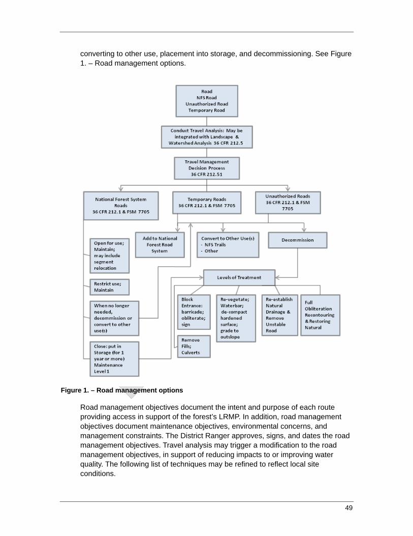
49
converting to other use, placement into storage, and decommissioning. See Figure 1. – Road management options.
Figure 1. – Road management options
Road management objectives document the intent and purpose of each route providing access in support of the forest’s LRMP. In addition, road management objectives document maintenance objectives, environmental concerns, and management constraints. The District Ranger approves, signs, and dates the road management objectives. Travel analysis may trigger a modification to the road management objectives, in support of reducing impacts to or improving water quality. The following list of techniques may be refined to reflect local site conditions.
Techniques
• Apply techniques of BMP 2.1(Travel Management Planning and Analysis) as applicable.
• Conduct Travel Analysis (see description of the Travel Management Rule Subpart A above under Explanation) to determine the minimum road system needed for safe and efficient travel, administration, utilization, and protection of forest land and water resources. Identify current and future needs and uses of each NFS system and unauthorized road.
• Identify road segments causing or threatening to cause adverse impacts to environmental resources (that is, soils, water, aquatic or riparian habitat), utilizing refinement of modeling commensurate with the scale of travel analysis being performed.
○ Use physically based, empirical, or conceptual road erosion and delivery models based on field-based road inventory data to identify the relative impact or risk of adverse impacts to water resources.
o Identify relative risk of crossing failure by assessing: Hydraulic capacity of crossing Signs of plugging or aggradation at the culvert inlet Condition of drainage structure (for example, a culvert) Potential for drainage diversion
○ Identify relative risk of road-induced mass wasting. ○ Update road information periodically to adequately reflect time-varying
road conditions (that is, road condition after high-magnitude, low-frequency storm events).
• Locate, correctly interpret, and use readily available and relevant scientific literature and field data in the analysis. Disclose any assumptions made during the analysis, and reveal the limitations of the information on which the analysis is based. Use and/or collect data in accordance with FSH 7709.55 chapter 20, to identify the relative impact or risk of adverse impacts to water resources.
• Identify and rank relative risk of crossing failure. • Identify and prioritize mitigation measures for existing roads that cause
resource or watershed impacts. Mitigation measures may include any of the following:
○ Relocating road segments that adversely impact soil or water resources.
○ Reconstructing road segments to modify, improve, or restore road drainage.
○ Improving roads with deferred maintenance needs to current standards.
50
○ Improving stream crossings to accommodate bedload and debris, and provide for aquatic habitat and passage.
○ Hardening road surfaces (that is, running surface or inside ditches) to prevent the generation of fine-grained surface material and/or armor portions of the road prism subject to concentrated runoff.
○ Putting roads in storage, while maintaining hydrologic and geomorphic functionality of drainage features (see BMP 2.6 – Road Storage).
○ Closing roads seasonally to protect water resources. ○ Restoring surface and subsurface hydrologic properties by removing
roads from sensitive environments including riparian areas and meadows. May include relocation or decommissioning.
○ Permanently closing roads that cause significant adverse impacts to soil or water resources.
○ Decommissioning or converting unnecessary roads to other uses, such as trails (see BMP 2.7 – Decommissioning). Assess risk of impact to water quality by decommissioning, placing road in storage, or converting to other use, and various treatments for each option.
• Review road management options for on-site changes to originally recorded documents.
○ Identify current type of vehicle use and volume. ○ Monitor for effectiveness of design features on water quality, aquatic,
and riparian resources. ○ Identify appropriate access management strategy (that is, encourage
use, accept use, discourage use, eliminate use, and prohibit use (FSM 7731.11)) for each road.
○ Incorporate changes from original road management objectives into analysis, and if necessary, update objectives.
○ Propose mitigations where needed and prioritize • Avoid keeping roads that display risks to water quality that outweigh benefits,
when possible. Define mitigation measures for existing roads that impact water quality.
• Plan new NFS roads only when needed to support the forest LRMP. • Inventory and analyze unauthorized roads. Based on benefits and risks,
identify roads for future inclusion in the forest’s transportation system, conversion to another use, or decommissioning.
• At project-level analysis, roads identified for one-time use only are temporary roads, subject to decommissioning according to the Forest and Rangeland Renewable Resources Planning Act (16 USC 1608).
51
BMP 2.2 - General Guidelines for the Location and Design of Roads
References: FSM 7720 – Development FSH 7709.56 – Road Preconstruction
Objective: Locate roads to minimize problems and risks to water; aquatic, and riparian resources. Incorporate measures that prevent or reduce impacts, through design for construction, reconstruction, and other route system improvements.
Explanation: A road’s location and design may have long-term effects on water quality, construction and maintenance costs, safety, and other public resources. Road location and design control hydrologic connectivity—the degree that road runoff and sediment are linked to the stream channel network. The extent of hydrologic connectivity, along with the magnitude and frequency of road erosion, drives road-related water-quality impacts.
Roads are located according to standards and specifications to meet their use objectives, while protecting other resources. Well-defined project objectives are necessary to locate and design roads that will best address environmental and resources issues, as well as safety and traffic requirements.
Designs of new roads and upgrades to existing roads consider ways to reduce impacts to beneficial uses of water. Management needs have changed considerably since most NFS roads were constructed. Influences of roads on aquatic and riparian resources are recognized and considered. Road maintenance budgets and opportunities have diminished. Designs for improvements to existing roads significantly reduce or eliminate impacts to beneficial uses of water. Drainage features and surfacing are among elements often considered for change. Improvements to the road system are made on a priority basis that considers road and resource condition, beneficial uses at risk, and cost.
In addition, some situations may require adherence to special conditions associated with Clean Water Act permits for water quality certification (401), stormwater (402), and discharge of dredge and fill material (404). State and local entities may also provide guidance and regulations such as a Forest Practices Act or a Stream Alteration Act. Forest plans often contain direction on location of roads relative to streams, wetlands, and unstable landforms.
The risk from road management activities can be managed by using the appropriate techniques for road location and design from the following list, and adapted as needed to local site conditions.
Implementation: Implementation considers new road location, relocation, and design only. Construction, reconstruction, maintenance, decommissioning, and erosion control are covered in subsequent BMPs.
52
Location
• Avoid locating new roads where water-quality risks outweigh beneficial uses. • Locate roads to fit the terrain, limit the need for excavation, and prevent
damage to improvements and resources. • Avoid sensitive areas such as riparian areas, wetlands, meadows, bogs, fens,
inner gorges, overly steep slopes, and unstable landforms to the extent practicable. If such areas cannot be avoided:
○ Use bridges or raised prisms with diffuse drainage to sustain flow patterns
○ Set crossing bottoms at natural levels of channel beds and wet meadow surfaces
○ Avoid actions that may dewater or reduce water budgets in wetlands. Consider compensatory mitigation or mitigation banking.
• Locate roads outside SMZs whenever possible, with a minimum of number of crossings and connections between the road and streams.
• Relocate existing routes or segments that are in high-risk locations, including the SMZ, to the extent practicable.
• Relocate roads that are causing uncontrollable adverse effects to beneficial uses of water, with commensurate decommissioning of high-risk roads.
• Consider potential for generation of waste material in location of roads, and need for access to appropriate disposal areas. Waste or spoil may not be placed within SMZs, on slopes greater than 60 percent, on unstable slopes, or in areas subject to converging runoff.
• Locate roads in an interdisciplinary manner with a hydrologist, soils scientist, and geologist, if necessary.
• Final road location drives design features, assuring protection of water quality. Incorporate modeling as necessary to assist with design of road segments displaying higher erosion potential.
Design
• Design roads to balance cuts and fills or use full bench construction where stable fill construction is not possible.
○ Consider full bench construction or mechanically stabilized fills on unstable slopes or slopes greater than 60 percent.
○ Ensure design addresses method to stabilize constructed fill slopes, including key ways where fill slopes exceed 3 feet in height at the hinge point.
○ Do not design to discharge runoff on to unstable landforms, such as hollows.
53

• Design road surfaces to dissipate intercepted water in a uniform manner along the road by outsloping, insloping with drains, or crowning with drains, subject to site soil characteristics.
• Design to reduce the hydrologic connectivity of the road segment or network. • Limit occurrence of connectivity areas to water crossings only, if possible. • Choose low-maintenance designs (for example, outsloping and rolling the
grade) for roads that may be subject to minimal use or will be put in storage. • Follow general principles of stormwater and erosion control related to roads
including permanent and temporary controls that: ○ Minimize soil compaction (except as needed to achieve compaction
standards on road prism) and bare ground coverage. ○ Separate exposed bare ground from surface waters. Incorporate
vegetation or slash over exposed fill slopes. ○ Design stable road prisms and stream crossings. ○ Use geotextiles when necessary to avoid mixing aggregate with
subgrade and subsequent rutting of road. • Employ treatments that control stormwater and erosion at the source through
the use of small-scale treatments distributed throughout the road prism. • Design properly spaced cross drains to provide maximum filter distance and
to limit hydrologic connectivity between the road and water resource where practicable.
• Design subsurface dispersion measures and cross drains as necessary to capture and disperse expected flows contributed by locally shallow groundwater and road surfaces.
• Design energy dissipaters, apron, downspouts, gabions, flumes, oversize drains and debris racks, culvert and cross drain inlets and outlets, where appropriate. Do not discharge runoff on to unstable surfaces.
• Design stable ditch configuration that does not erode, yet does not fail during mechanical maintenance activity
• Carefully consider impacts vs. benefits of berm in the control of runoff. Avoid berms except where needed to facilitate drainage patterns without adverse impact to water quality.
• Design spot surface treatments to areas that are sensitive, erodible, subject to high seasonal water tables, or will be heavily traveled.
• For roads located within the SMZ where adequate buffer zone does not exist, design for aggregate or paved surface. Design for a floodplain surface to slow water velocities and minimize erosion by flood flows (energy dissipation).
• Generally use the minimum road standards for grade and alignment (width, turning radius, maximum slope) to accommodate the design vehicle and traffic mix and volume.
• Consider maintenance requirements in road design.
54

• For roads to be reconstructed, incorporate design features to reduce or eliminate identified water-quality impacts.
Crossings
• Design both temporary and system roads to limit the number of surface-water crossings necessary to meet planned activity objectives and safety requirements.
• When necessary to cross streams, find optimal places for road-stream crossings. If possible avoid:
○ Areas requiring steep road approaches. ○ Crossing braided or migrating stream channels. ○ Flat stream gradient immediately downstream of steep stream
gradients. ○ Areas requiring deep fills. ○ Areas immediately downstream of unstable slopes or landforms.
• Design crossing approaches so road surfaces and drainage features have minimum hydrologic connectivity with channels.
• Design diversion potential dips at existing crossings where there is a risk of flow diversion or where crossing fills are higher than approaches.
○ Consider hardened fills commensurate with fill height. Consult with hydrologist.
• Design stream-crossing structures to provide the most resource protection consistent with facility needs, legal obligations, and cost considerations.
• Provide for desired passage of aquatic and terrestrial organisms, debris, and bedload as well as flow.
○ Size crossings for the 100-year flood event, plus associated debris and sediment, or greater.
○ Design for stream simulation if feasible in consultation with hydrologists and fisheries biologists.
• Consider using culvert arrays, perched culverts and/or permeable fills in meadow environments or areas with naturally high water tables to encourage meadow function.
55
BMP 2.3 - Road Construction and Reconstruction
Reference: FSH 7709.57 Standard and Supplemental Specifications for FP-03 • Section 105 – Control of Material • Section 107 – Legal Relations and Responsibility to the Public • Division 200 – Earthwork (includes vegetation removal)
Objective: Minimize erosion and sediment delivery from roads during road construction or reconstruction, and their related activities.
Explanation: During road construction and reconstruction activities, vegetation and ground cover are removed, often exposing both the surface and subsurface soil to erosion. Temporary and long-term erosion-control measures are necessary to reduce erosion and maintain overall slope stability. These erosion-control measures may include vegetative and structural techniques to ensure the area’s long-term stability. The risk from road construction and reconstruction activities can be managed by using the appropriate techniques from the following list adapted as needed to local site conditions.
Techniques: Enforcement of the techniques is the responsibility of the inspector and contracting officer’s representative for public works contracts, the inspector and engineering representative for timber sale roads, and the permit administrator for roads constructed or reconstructed under administrative operations (that is, Road Use Permit, Special Use Permit, and so forth). If roads are constructed or reconstructed by force account crews, the project manager and foreman are responsible for adherence to project drawings, specifications, and erosion control plan.
• Implement the approved erosion control plan that covers all disturbed areas, including borrow areas and stockpiles used during road management activities (see BMP 2.13– Erosion Control Plan). Include the forest’s wet weather operations standards (WWOS).
• Maintain erosion-control measures to function effectively throughout the project area during road construction and reconstruction, and in accordance with the approved erosion control plan (see BMP 2.13– Erosion Control Plan).
• Set the minimum construction limits needed for the project and confine disturbance to that area.
• Locate and designate waste areas before operations begin. ○ Deposit and stabilize excess and unsuitable materials only is designated
sites. ○ Do not place such materials on slopes with a high risk of mass failure, in
areas subject to overland flow (for example, convergent areas subject to saturation overland flow), or within the SMZ.
56
○ Provide adequate surface drainage and erosion protection at disposal sites.
• Comply with BMP 2.5 – Water Source Development and Utilization. • Comply with BMP 2.11 – Equipment Refueling and Servicing. • Do not permit sidecasting within the SMZ.
○ Prevent excavated materials from entering water ways or SMZs. • Develop and follow blasting plans to move materials when necessary.
○ To the extent possible, restrict blasting in sensitive areas and those sites with high landslide potential.
○ Restrict blasting after intense storms when soils are saturated. ○ Prevent damage from fly rock and overshot by not overloading shots,
installing blasting mats, or avoiding setting charges through variable rock strata.
• Schedule operations when rain, runoff, wet soils, snowmelt or frost melt are less likely. Follow seasonal restrictions of the forest’s WWOS, and notification protocols, as outlined in an approved erosion control plan.
○ Optimally, schedule construction during dry periods, while still adhering to other seasonal restrictions (wildlife breeding, spawning, fire activity levels, and so forth), consistent with local ordinances.
○ Stabilize project area during normal operating season when the National Weather Service predicts a 30 percent or greater chance of precipitation, such as localized thunderstorm or approaching frontal system.
○ Keep erosion-control measures sufficiently effective during ground disturbance to allow rapid closure when weather conditions deteriorate.
○ Complete all necessary stabilization measures prior to predicted precipitation that could result in surface runoff.
• To the extent possible, construct new stream crossings when streams are dry or when stream flow is at its lowest. Install sediment controls.
• Comply with BMP 2.8– Stream Crossings. • Limit operation of equipment when ground conditions could result in excessive
rutting, soil compaction (except on the road prism or other surface to be compacted), or runoff of sediments directly to streams.
• On slopes greater than 40 percent, the organic layer of the soil shall be removed prior to fill placement, according to project specifications.
• Waste organic material, such as uprooted stumps, cull logs, accumulations of limbs and branches, and unmerchantable trees, shall not be buried in logging road or landing fills. Dispose of waste organic material according to project specifications, in locations designated for waste disposal. Assure compliance with the project erosion control plan.
57
• Construct fills and keyways according to design drawings and specifications, not exceeding specified lift thickness and moisture content. Ensure uncompacted materials are prevented from leaving disturbance limits.
• Stabilize all disturbed areas with mulch, erosion fabric, vegetation, rock, large organic materials, engineered structures, or other stabilization measures according to the Erosion Control Plan, and project specifications and drawings for permanent controls (that is, crib walls, gabions, riprap placement, and so forth).
• Scatter construction-generated slash on disturbed areas to help control erosion. ○ Ensure ground contact between slash and disturbed slopes. ○ Windrow slash at the base of fill slopes to reduce sedimentation. ○ Ensure that windrows are placed along the contour and that there is
ground contact between slash and disturbed slope. • Remove large limbs and cull logs to designated sites outside the SMZ or relocate
within the SMZ to meet aquatic resource management objectives. • Monitor contractor’s plans and operations to assure contractor does not open up
more ground than can be substantially completed before expected winter shutdowns, unless erosion-control measures are implemented.
• If snow/rainy season operations are proposed, specifications for snow/ice depth or soil operability conditions must be described. Include these specifications in the erosion control plan (see BMP 2.13– Erosion Control Plans).
• Install erosion-control measures on incomplete roads prior to precipitation events or the start of the winter period (November 16 through March 31) and in accordance with the approved erosion control plan:
○ Remove ineffective temporary culverts, culvert plugs, diversion dams, or elevated stream crossings, leaving a channel at least as wide as before construction and as close to the original grade as possible.
○ Install temporary culverts, side drains, cross drains, diversion ditches, energy dissipaters, dips, sediment basins, berms, dikes, debris racks, pipe risers, or other facilities needed to control erosion.
○ Remove debris, obstructions, and spoil material from channels, floodplains, and riparian areas.
○ Do not leave project areas for the winter with remedial measures incomplete.
○ Plant vegetation, mulch, and amendments, or provide other protective cover for exposed soil surfaces.
• When pioneer roads are necessary: ○ Confine construction of pioneer roads to the planned roadway limits
unless otherwise specified or approved. ○ Locate and construct pioneering roads to prevent undercutting of the
designated final cut slope. ○ Avoid deposition of materials outside the designated roadway limits.
58

○ Dewater live streams where crossed by pioneer roads with appropriate diversion devices.
○ Accommodate drainage with adequate temporary crossings.
59
BMP 2.4 - Road Maintenance and Operations
References: FSM 7700 – Travel Management FSM 7710 – Travel Planning FSM 7700, chapter 30 – Road Operation and Maintenance FSH 7709.58 – Transportation System Maintenance FSH 7709.59 – Transportation System Operations Timber Sale – Road Maintenance T-800 Specifications
Objective: To ensure water-quality protection by providing adequate and appropriate maintenance and by controlling road use and operations.
Explanation: Appropriate maintenance and control of road use and operations can protect water quality, aquatic and riparian resources, and capital investments. Maintenance needs and operational controls are informed by periodic inventory and assessment that determine road condition and the potential impacts the road has on water quality.
Properly designed and maintained road surfaces and drainage systems can reduce adverse effects to water resources by facilitating natural hydrologic function. Roads and drainage systems normally deteriorate because of traffic, weather, and effects of maintenance. In addition, roads occasionally become saturated by new groundwater springs and seeps after a wildfire or unusually wet periods. Many such conditions can be corrected by timely maintenance. However, while routine maintenance may be needed to ensure the road performs as designed, it can also be a source of soil disturbance and therefore, sediment production. In particular, the grading of inside ditches and road surfaces can significantly increase sediment production rates. Less aggressive maintenance may be desired to minimize disturbance of stable sites.
Road management objectives include the level and type of maintenance that a road is expected to receive. Assigned road maintenance levels vary from 1 to 5, and are directly linked to the operational objectives for the road. Maintenance Level 1 is assigned to roads closed to all motorized vehicles for a year or more; they should be left in a stable condition, and by definition, require less maintenance. Maintenance Levels 4 and 5 are assigned to roads that are typically double-lane, aggregate-surfaced or paved, and passenger vehicle traffic is “encouraged.” They are well maintained to provide a moderate to high degree of user comfort and convenience.
Operational objectives and activities are also defined by the road management objectives, and depend upon the amount of maintenance a road is expected to receive. Road operations also include permit, contract, and agreement administration, control of seasonal use, sustaining roads in closed status and revising maintenance levels and seasonal closures, as needed. Road closures and restrictions are necessary because many forest roads are designed for dry-season
60
use. Most local roads are not surfaced, while others have some surfacing or spot stabilization. Roads without stabilized surfaces or adequate base can be damaged by use during wet periods or by loads heavier than the road was designed to convey.
Road maintenance plans are implemented through contract, cooperators, force account, and active timber sale or other authorized activities. Contract, timber sale, and other authorized or permitted operations are bound by specifications and drawings. BMPs are incorporated as specifications, contract or sale clauses, operating plan requirements, permit clauses, and are often shown in the drawings. The contracting officer’s representative is responsible for assuring compliance by contractors; engineering representative, TSA, or FSR assures compliance by cooperator, purchaser or permitted operator. Project manager and crew supervisor assures compliance for force account work. Optimally, the forest hydrologist works with the forest quality assurance personnel to determine if approved maintenance tasks are completed with minimal resource impacts. Adjustments to future maintenance plans and methods are considered when previous methods do not provide the needed protection to water quality.
Risk from road maintenance activities can be managed by using the appropriate techniques from the following list adapted as needed to local site conditions.
Techniques:
Inspection
• Periodically inspect system travel routes to assess condition and linkage to water quality. This information assists in setting maintenance and improvement priorities.
○ Provide training to the engineering personnel performing condition surveys to successfully identify and assess linkage to water quality.
○ Conduct condition surveys jointly with engineering and hydrology personnel, to more accurately assess potential of road to impact water quality.
○ Prioritize inspections to roads at high risk of failure, followed by road segments that are hydrologically connected to the stream network, to reduce risk of diversions and cascading failures.
○ Identify diversion potential on roads, and prioritize for treatment. • Inspect drainage structures and runoff patterns after major storm events and
snowmelt, and perform any necessary maintenance. Major storm events include all storm events for which the National Weather Service issues a local flood watch, advisory, or warning.
○ Determine the extent of hydrologic connectivity during and/or just after major storm events, including the connectivity of disturbed areas directly adjacent to the road network.
61

○ Immediately clean out, repair or reconstruct waterbars, inside ditches, culverts, and other features that are not functioning.
• Regularly inspect roads during all operations. • Keep roads closed to public use, but open for administrative use, in
hydrologically functional condition. If waterbars are breached as a result of administrative use, forest personnel will promptly repair them.
• Encourage field personnel of all disciplines to observe road deterioration or damage commensurate with travel to field activities, and report to engineering, for immediate action, if necessary.
○ Restrict operations if impact or imminent threat of impact to water quality is occurring.
○ Consider restricting operations if road damage such as surface displacement or active rutting is occurring.
Maintenance Planning
• Incorporate the forest’s Wet Weather Operations Standards and notification protocols in maintenance and operations.
• Develop and implement an erosion control plan commensurate with the complexity and scale, and duration of the activity. See BMP 2.13.
• Develop and implement annual maintenance plans that prioritize road maintenance work for the forest or district.
○ Include roads identified as needing maintenance from field condition surveys, and roads identified through roads analysis and travel analysis that negatively impact water quality.
○ Determine method of accomplishment (contract, force account, permit, and cooperative) and define responsibilities and maintenance timing in the plan.
• Planning for emergency interim/temporary erosion controls to protect water quality is considered for roads that may require immediate maintenance, but are beyond capability of annual maintenance plan.
• Identify roads with potential to improve water quality by modifying road prism and drainage patterns through maintenance operations.
○ Analyze roads in an interdisciplinary manner to identify other impacts that may occur due to changes in road prism or drainage patterns. Consider local conditions and site characteristics.
○ Implement diversion potential method per Forest Service Publication 9777-1814P-SDTDC Diversion Potential at Road-Stream Crossings.
○ Consider user safety and protection of other forest resources. ○ Provide training and reference materials for forest road managers,
road maintenance operators, and road maintenance contract preparation personnel to work with hydrologists in identifying appropriate roads for revised maintenance procedures.
62

• Evaluate road management objectives when an inspection indicates road design is not meeting current transportation and/or resource needs. Road management objectives support forest LRMP prescriptions.
Maintenance Activities
• Maintain road surfaces to dissipate intercepted water in a uniform manner along the road by outsloping with rolling dips, insloping with drains, or crowning with drains.
○ Where feasible and consistent with protecting public safety, utilize outsloping and rolling the grade (rolling dips) as the primary drainage technique.
• Adjust surface drainage structures to minimize hydrologic connectivity by: ○ Discharging road runoff to areas of high infiltration and high surface
roughness. ○ Armoring drainage facility outlet as energy dissipater and to prevent
gully initiation. ○ Increasing the number drainage facilities with SMZs.
• Clean ditches and drainage structure inlets only as often as needed to keep them functioning.
○ Prevent unnecessary or excessive vegetation disturbance and removal on features such as swales, ditches, shoulders, and cut and fill slopes.
• Minimize diversion potential by installing diversion prevention dips that can accommodate overtopping runoff.
○ Place diversion prevention dips downslope of crossing, rather than directly over the crossing fill, and in a location that minimizes fill loss in the event of overtopping.
○ Armor diversion prevention dips when the expected volume of fill loss is significant.
• Address risk and consequence of future failure at the site when repairing road failures.
○ Use vegetation, rock, and other native materials to help stabilize failure zones.
• Maintain road surface drainage by removing berms, unless specifically designated otherwise.
• Install and preserve markers to identify and protect drainage structures that can be damaged during maintenance activities (that is, culverts, subdrains, and so forth)
• When grading roads or cleaning drainage structure inlets and ditches, avoid undercutting the toe of the cut slope.
63
• Grade road surfaces in accordance with road management objectives and assigned maintenance level. Grade only as needed to maintain a stable running surface and adequate surface drainage.
• Accompany grading of hydrologically connected road surfaces and inside ditches with erosion and sediment control installation.
• Identify additional road maintenance measures to protect and maintain water; aquatic, and riparian resources including: surfacing and resurfacing, outsloping, dips and cross drains, armoring of ditches, spot rocking, replacing culverts, and installing new drainage features.
• Effectively maintain roads in storage to eliminate all motorized vehicle use. Maintain physical closure devices, if present, to be safe and effective.
○ For roads where physical closure methods are not feasible, install signing to inform of road closure.
• Enforce pre-haul maintenance, maintenance during haul, and post haul maintenance (putting the road back in storage) specifications when maintenance level 1 roads are opened for use on commercial resource management projects.
○ Require the commercial operator to leave roads in a satisfactory condition when project is completed.
Operations
• Restrict or prohibit road use during periods when such use would likely damage the roadway surface or road drainage features are identified through Travel Analysis and Travel Management, and implement through enforcement of motor vehicle use map. Changes in road management are supported by appropriate analysis.
○ Follow the forest’s WWOS. See BMP 2.13. • Require users to obtain permit(s) when proposed operations involve use of
roads by vehicles larger than the design vehicle, or beyond typical operation period or season of use (that is, timber purchasers, mining operations, oversize vehicle movement, and so forth. Conditions of the permitted use may require:
○ Strengthening the road surface by adding rock, dust palliatives, pavement, or armor, particularly in areas where surfaces are vulnerable to movement such as corners and steep sections.
○ Considering short-term road surface stabilization by dust abatement methods, such as watering.
○ Upgrading drainage structures. ○ Restricting use to low-ground-pressure vehicles or frozen ground
conditions. ○ Strengthening the road base if roads are tending to rut.
64
○ Using a base course of rock and/or geotextile fabric to provide subsurface stability.
○ Intensifying maintenance to handle the traffic without creating excessive erosion and damage to the road surface.
○ Repairing damage to road and forest resources associated with use by permittee.
○ Restoring the road to original standard of features, such as restoring waterbars.
• To the extent possible, ensure drainage features are fully functional before the start of the local winter season (such as November 16 to March 31) or before the start of runoff-inducing precipitation events.
• Permits to oversize or overweight loads require that damage by such loads be repaired by the permit holder. Damage includes impacts to water quality.
• Cooperative maintenance agreements follow Forest Service direction for use, maintenance, repairs, and responsibilities.
• Roads under easement are subject to terms of conditions for operation and maintenance.
65
BMP 2.5 - Water Source Development and Utilization
Objective: To supply water for road construction, maintenance, dust abatement, fire protection, and other management activities, while protecting and maintaining water quality.
Explanation: Water source development is needed to supply water for road construction and maintenance, dust control, and fire control. In-stream water drafting can substantially affect water flow and/or configuration of the bed, bank, or channel of streams. Aquatic species present could be at risk due to rapid changes or sustained reductions in flow, reduced dissolved oxygen, and/or increased water temperature. Exposed surfaces of water holes or other developments could erode and discharge sediment back into the waterway. In addition to direct hydrogeomorphic (forming and shaping landform by water) disruption to the channel and subsequent impacts to aquatic species, water-quality impacts can occur from road approaches that access the water drafting site. Many water drafting sites have steep approaches and in the absence of adequate drainage or surfacing, these approaches can become chronic sources of sediment and runoff to the channel. Water trucks often leak oil, and sometimes fuel, onto drafting pads, becoming a source of petroleum product contamination to surface waters.
Regular monitoring of water supply developments, during construction and use, and enforcement of contract and sale clauses, specifications, and restrictions is the responsibility of inspectors, contracting officer representatives, engineering representatives, sale administrators, and force account crew foreman.
Techniques:
Location and Development
Critical to the effectiveness of this practice is the coordination of engineering representatives, hydrologists, fishery biologists, and permit and sale administrators. Locate existing developments, or proposed streams, and evaluate for feasibility of use; determine scope and scale of environmental risks; select techniques for mitigating disturbance to water quality; and compare with the economics of development and use:
• Water sources designed for permanent installation, such as piped diversions to off-site storage, are preferred over temporary, short-term-use developments.
• If off-site storage is not an option then the following locations shall be considered. ○ Locations where flowing side channels rather than the main thread of the
channel can be used for drafting. ○ Areas with existing pools that can be partially blocked, rather than in-
channel excavation are preferred.
66
○ Sites where road approaches can be hydrologically disconnected from streams.
○ Sites where the drafting pad can be placed above the bankfull elevation of the channel with little or no excavation and/or fill placement.
• Develop and implement Erosion Control Plan for water supply site construction and use.
• Follow the forest’s wet weather operations standards and guidelines. See BMP 2.13.
• Excavation of streambed or bank materials for approaches, drafting pads, and water drafting intakes are subject to local or regional restrictions on ground-disturbing activities.
○ Excavations should not occur during peak runoff season. ○ Federally listed threatened and endangered species, sensitive (including
State-listed) species, management Indicator species, and aquatic organisms of interest may impose further restrictions.
○ Other restrictions such as spawning season may be applicable • Basins shall not be constructed at culvert inlets for the purpose of developing a
waterhole, as these can exacerbate plugging of the culvert. • Access approaches are located as close to perpendicular as possible to prevent
stream bank excavation. • Access approaches are stabilized with appropriate materials, depending on
expected life and use frequency of the developed water source. • Fish-bearing streams that are temporarily dammed to create a drafting pool shall
provide fish passage for all life stages of fish. ○ Temporary dams shall be removed when operations are complete. ○ Removal shall be done gradually so that released impoundments do not
discharge sediment into the streamflow. • When diverting water from streams, bypass flows shall be maintained that ensure
continuous surface flow in downstream reaches, and keep habitat in downstream reaches in good condition.
Drafting Operations
○ For fish-bearing streams, the water drafting rate should not exceed 350 gallons per minute for streamflow greater than or equal to 4.0 cubic feet per second (cfs).
Below 4.0 cfs, drafting rates should not exceed 20 percent of surface flows.
Water drafting should cease when bypass surface flows drop below 1.5 cfs.
○ For non-fish-bearing streams, the water drafting rate should not exceed 350 gallons per minute for stream flow greater than or equal to 2.0 cfs.
67

Drafting rate should not exceed 50 percent of surface flow for non-fish-bearing streams.
Water drafting should cease from non-fish-bearing streams when bypass surface flow drops below 10 gallons per minute.
• Intakes, for trucks and tanks, shall be placed parallel to the flow of water and screened, with opening size consistent with the protection of aquatic species of interest.
• Drafting from gravity-fed storage tanks shall utilize the following ○ Water storage tanks shall be fitted with properly sized pipes designed to
cleanly return the tank overflow to the source stream. ○ Outflow pipes shall be sized to fully contain the tank overflow and prevent
it from overflowing onto the drafting pad or road surface. ○ Water storage tank return pipes at the water outfall area shall be armored
to prevent erosion of the streambed, bank, or channel. ○ At the end of drafting operations, intake screens shall be removed and
drafting pipes plugged, capped, or otherwise blocked or removed from the active channel to terminate water drafting during the winter season.
• Trucks directly drafting from the channel shall utilize the following practices. ○ Water drafting by more than one truck shall not occur simultaneously
Approaches and Drafting Pads
• Road approaches and drafting pads shall be treated to prevent sediment production and delivery to a watercourse or waterhole.
○ Road approaches shall be armored as necessary from the end of the approach nearest a stream for a minimum of 50 feet, or to the nearest drainage structure (for example, waterbar or rolling dip) or point where road drainage does not drain toward the stream.
○ Areas subject to high flood events shall be armored to prevent erosion and sediment delivery to water courses.
○ Where overflow runoff from water trucks or storage tanks may enter the stream, effective erosion control devices shall be installed (for example, gravel berms or waterbars).
○ All water-drafting vehicles shall be checked daily and shall be repaired as necessary to prevent leaks of petroleum products from entering SMZs.
Water-drafting vehicles shall contain petroleum-absorbent pads, which are placed under vehicles before drafting.
Water-drafting vehicles shall contain petroleum spill kits. Dispose of absorbent pads according to the Hazardous Response Plan.
68
BMP 2.6 - Road Storage
Reference: FSH 7709.59 chapter 60
Objective: Ensure that roads placed in storage are maintained to so that drainage facilities and runoff patterns function properly, and damage to adjacent resources is prevented. Stored roads are managed to be returned to service, at various intervals.
Explanation: Road maintenance needs on NFS lands typically exceed maintenance budgets. As a result, many low-standard, closed roads receive no maintenance and may go years without being inspected for maintenance needs. Plans for and design of such roads should reflect long intervals between maintenance activities, but provide protection to resources and investments. This approach reduces the risk of adverse impacts to water, aquatic, and riparian resources and reduces long-term maintenance costs.
Road storage is not an alternative to road decommissioning (BMP 2.7). As described in BMP 2.1, each national forest will designate its minimum road network. Roads not included in the minimum road network will eventually be decommissioned. Only roads that are needed in the future will be considered for storage.
A primary reason for putting roads into Intermittent Stored Service is to reduce maintenance needs while limiting the risk of adverse effects to hydrologic function from stream crossing failures, fill failures, surface water routing, and modified drainage patterns. Roads placed in Intermittent Stored Service have the roadway retained to the extent practicable while meeting the watershed objectives of reducing sediment delivery and restoring natural flow patterns. These are achieved by reducing sediment delivery from the road surface and fills, and reducing the risk of crossing failure and stream diversion.
The risk from roads in Intermittent Stored Service condition can be managed by using the appropriate techniques from the following list adapted as needed to local site conditions. Project crew leaders and supervisors are responsible for ensuring that force account projects meet road closure procedures standards. Contracted projects are implemented by the contractor, or operator. Compliance with plans, specifications, and operating plans is ensured by the contracting officer’s representative, engineering representative, or Forest Service representative. Permitted use of stored roads requires restoring the road to its previous stable condition after use by the permittee, as enforced by the permit administrator.
69
Techniques:
• Roads that are placed in storage, but open as trails, motorized and non-motorized, will need to provide for the safety of the intended users. As such, pulling culverts may not be warranted.
• In an interdisciplinary manner, prepare and implement an erosion and sediment control plan for roads to be placed in storage.
• The forest watershed staff will work with the forest engineering staff to identify which culverts pose a threat to water quality and must be removed before a road is placed in storage.
• Road-stream crossings deemed safe to leave in stored roads will be treated to remove the potential for streamflow diversions in the event of a crossing failure or blockage, and will have rock armor added to downstream crossing fill where needed to prevent erosion.
• Existing crossings in low-risk situations where the culvert is sized appropriately, is stable, and does not impede aquatic passage remain in place. Prior to storing, ensure that the road, culvert, and all hydrologically connected drainage structures are cleaned, and sediment and erosion controls are intact and functioning.
• Only structures that have a long planned storage period and present a significant risk to stream channels are removed, due to increased disturbance and exposure. The removal of drainage structures is tied to the length of period of storage, as well as the ability to access structures that are not removed.
○ The risk of increased sedimentation from ground disturbance and exposed surfaces associated with drainage structure removal is weighed carefully against the benefits of restoring long-term hydrologic functionality.
○ Lay back the streambanks at the crossing-site at a width and angle that allows flows from infrequent events to pass without scouring or puddling.
○ Armor the crossing-site, if needed to prevent scour and erosion. ○ Maintain the same size and gradient at the crossing-site as the
channel above and below the removed crossing-site. ○ Angle the banks such that undercutting and slumping is not expected,
and revegetation has a strong chance of success. • Avoid concentrated flow in ditches by outsloping or using frequent waterbars
or other means of cross draining the road. • Outslope the road template where appropriate to disperse runoff, prevent
concentrated flow, and avoid overly steep fills. • Remove unstable material at unstable sites, seeps, slumps or where fills are
failing.
70
○ Place removed materials in stable locations where the stored material will not present a future risk to water, aquatic, or riparian resources.
• Depending on the extent of anticipated closure period, the following are performed in direct proportion to that time period:
○ Scarify or de-compact the road surface to promote vegetation growth and/or infiltration of runoff and intercepted flow.
○ Consider re-contouring highly unstable portions of road. ○ Re-vegetate disturbed areas, particularly at or near stream crossings.
Coordinate type and species of vegetation, along with any amendments, with the forest botanist.
• Closure method at the entrance to the stored road is commensurate with the terrain, alternate uses, and extent of time road is expected to be stored. Stored roads are not shown on the motor vehicle use map, thereby prohibiting motor vehicle use.
○ Use gates or barriers as appropriate for the site. ○ Sign the closure as necessary to inform the public.
• Regularly perform condition surveys to monitor and evaluate the effectiveness of the closure measures.
71
BMP 2.7 - Road Decommissioning
Reference: FSM 7734 – Road Decommissioning
Objective: Stabilize, restore, and vegetate unneeded roads to a more natural state as necessary to protect and enhance NFS lands, resources, and water quality. The end result is that the decommissioned road will not represent a significant impact to water quality by:
• reducing erosion from road surfaces and slopes and related sedimentation of streams
• reducing risk of mass failures and subsequent impact on water quality • restoring natural surface and subsurface drainage patterns • restoring stream channels at road crossings and where roads run adjacent to
channels. Explanation: Roads no longer needed are identified during transportation planning activities (see description of Travel Management subpart A in BMP 2.1) at the forest, watershed or project level. The unneeded road may be decommissioned, or converted to a trail or other use as appropriate. Temporary roads constructed for a specific short-term purpose (for example, ski area development, minerals exploration, or vegetation extraction) are decommissioned at the completion of their intended use, and vegetation reestablished within 10 years.
Road decommissioning terminates the use of the road as a road, and as such, treatments can range from simply blocking the road entrance, to totally eliminating the road prism and structures, and restoring the land to original contours. Treatment method is carefully chosen to minimize negative impacts to water quality, reestablish vegetation, and restore ecological processes. More aggressive techniques may include greater and longer term risks to water quality through exposure of larger disrupted soil surfaces. Road decommissioning can be accomplished by using the appropriate techniques from the following list adapted as needed to local site conditions.
Techniques:
• Engineering and hydrology personnel conduct field review of road selected for decommissioning to determine site characteristics: aspect, soil type(s), topography, surrounding vegetation, proximity to water sources, and so forth.
• Optimize treatments that will achieve long-term watershed protection goals on individual roads to stretch the available funds for road decommissioning over as many miles as practicable.
○ Weigh benefits and costs of treatments against alternative of placing road in storage and costs for continuing to maintain for hydrologic functionality. See BMP 2.1.
72

• Prepare and implement an approved erosion and sediment control plan for both temporary and long-term recovery of the site as specified.
• Outslope road by pulling back unstable or perched fill. Remove berms. ○ Restore stream courses and floodplains where feasible, to natural grade
and configuration. • Remove drainage structures determined as necessary to protect water quality:
○ Re-contour disturbed fill material, and compact minimally to allow filtration.
• Re-contour the road surface cut and fill slopes to restore natural hillslope topography where specified.
○ De-compact areas with stable fill but reduced infiltration and productivity. ○ Haul excess fill to stable disposal areas outside of the SMZ.
• Provide effective soil cover (such as mulch, woody debris, rock, vegetation, blankets) to exposed soil surfaces for both short- and long-term recovery.
• Revegetate disturbed areas, particularly at or near stream crossings. • Block vehicle access to prevent motorized traffic, in conjunction with signing,
publication, and enforcement of the forest’s motor vehicle use map.
73
BMP 2.8 - Stream Crossings
References: FSM 7720 – Transportation System – Development FSH 7709.56 – chapter 10 – Preconstruction Decisions FP-03 – Section 107 – Legal Relations and Responsibility to the Public FP-03 – Section 157 – Soil Erosion Control FP-03 – Division 200 – Earthwork FP-03 – Division 550 – Bridge Construction FP-03 – Division 600 – Incidental Construction
Objective: Minimize water, aquatic, and riparian resource disturbances and related sediment production when constructing, reconstructing, or maintaining temporary and permanent water crossings.
Explanation: Stream crossings present the highest risk to water quality associated with roads. Forest management activities often occur in areas that require surface waters to be crossed. Depending on the activity type and duration, crossings may be needed permanently or temporarily. Permanent crossings are designed to meet applicable standards while also protecting water, aquatic, and riparian resources.
Examples of crossings include culverts, bridges, arched pipes, low water crossings, fords, vented fords, and permeable fills. Crossing materials and construction will vary, based on the type of access required and volume of use expected. Optimally, crossings should be designed and installed to provide passage for the flow of water plus anticipated sediment and debris, provide for desired aquatic organism passage, and minimize disturbance to the surface and shallow groundwater resources. Sizing is based on a weighed balance between providing for larger storm events, and cost feasibility, while still meeting other resource objectives.
Construction, reconstruction, and maintenance of a water crossing usually requires heavy equipment to be in and near streams, lakes, and other aquatic habitats to install or remove culverts, fords and bridges and their associated fills, abutments, piles, and cribbing. Such disturbance near the waterbody can increase the potential for accelerated erosion and sedimentation from destabilization of streambanks or shorelines, vegetation and ground cover removal, and soil exposure or compaction. In addition, heavy equipment has potential for contamination of the surface water from vehicle fluids.
Permits may be required for in-stream work associated with stream crossing construction and maintenance projects. There are specific requirements for such projects under the Clean Water Act and implementing regulations. State and local entities may also provide guidance and regulations such as the Forest Practices Act and others. Insert brief description of different permits, who issues…
74
The risk from construction, reconstruction or maintenance of stream crossings can be managed by using the appropriate techniques from the following list adapted as needed to local site conditions.
Techniques:
Enforcement of the techniques is the responsibility of the inspector and contracting officer’s representative for public works contracts, the inspector and engineering representative for timber sale roads, and the permit administrator for stream crossings constructed or reconstructed under administrative operations (for example, Road Use Permit, Special Use Permit). If stream crossings are constructed, reconstructed, or maintained by force account crews, the project manager and foreman are responsible for adherence to project drawings, specifications, and Erosion Control Plan. The forest hydrologist works in conjunction with engineering and administrative personnel to provide additional monitoring and evaluation during implementation, as needed.
Location and Design
• Locate roads in an interdisciplinary manner with a hydrologist, soils scientist, and geologist if necessary.
• Plan and locate surface water crossings to limit the number and extent required to service the activity.
• Design the stream crossing to pass the 100-year flood flow plus associated sediment and debris; armor to withstand design flows and to provide desired passage of fish and other aquatic organisms.
• Locate and design crossings to minimize disturbance to the waterbody. • Use structures appropriate to the site conditions and traffic levels:
○ Favor bridges, bottomless arches, or buried pipe-arches for those streams with identifiable floodplains and elevated road prisms, instead of pipe culverts.
Place bridge and arch footings below the scour depth for the 100-year flood flow plus the appropriate factor of safety.
○ Favor armored fords for those streams where vehicle traffic is either seasonal or temporary, or the ford design maintains the channel pattern, profile and dimension.
For perennial streams, use vented fords, so that the crossing can pass low flows.
• See BMP BMP 2.2: General Guidelines for the Location and Design of Roads, for further guidance.
75
Construction and reconstruction – permanent and temporary crossings
• Implement the approved erosion control plan that covers all disturbed areas, including borrow areas, stockpiles, stream diversions, etc. used during stream crossing construction or reconstruction (see BMP 2.13– Erosion Control Plan).
○ Use temporary filters, berms, barriers, conveyances or other materials to collect sediment and prevent it from entering surface waters.
• Set the minimum construction limits needed for the project and confine disturbance to within this area.
• Accurately establish and preserve vertical control through design invert and outlet elevations on site for each crossing, to assure that the constructed stream-crossing structure will perform as intended, and promote effective drainage without damage or impact to water, aquatic, or riparian resources.
• Accurately establish and preserve horizontal alignment for each stream-crossing structure, to assure that flows do not erode stream banks or shoreline.
○ Install stream crossings according to project design specifications and drawings. Design should sustain bankfull dimensions of width, depth and slope, and maintain streambed and bank resiliency.
• Minimize streambank and riparian area excavation during construction: ○ Stabilize adjacent areas disturbed during construction using surface cover
(mulch), retaining structures, and or mechanical stabilization materials. ○ Keep excavated materials out of channels, floodplains, wetlands, and
lakes. ○ Install silt fences or other sediment- and debris-retention barriers between
the water body and construction material stockpiles and wastes. • Bypass roads for use during construction are considered temporary roads, and
are subject to the all relevant BMPs. Decommissioning and stabilization of the bypass roads are inherent in the project plan.
• Ensure imported fill materials meet project specifications, and are free of toxins and invasive aquatic or riparian species.
• To the extent possible, conduct operations during the least critical periods for water and aquatic resources: when streams are dry; during low-water conditions; in compliance with spawning and breeding season restrictions.
• Divert or dewater stream flow for all live streams or standing waterbodies during crossing installation and invasive maintenance:
○ Return clean flows to channel or water body downstream of the activity. ○ Restore flows to their natural stream course as soon as possible after
construction or prior to seasonal closures. • Install downstream collection basins, retention facilities, or filtering systems as
needed to capture and retain turbid water. ○ Remove collected sediment as needed to maintain their design capacity
during the life of the project.
76
• Construct diversion prevention dips to accommodate overtopping of runoff if diversion potential exists, when shown on project drawings and specifications. Locate diversion prevention dips downslope of the crossing rather than directly over crossing fill; if designed, armor diversion prevention dips based on soil characteristics and potential risk.
• Install cross drains (for example, rolling dips; waterbars) to hydrologically disconnect the road above the crossing and to dissipate concentrated flows.
• Remove all project debris from the water body in a manner that will cause the least disturbance.
• Dispose of unsuitable material in approved waste areas outside of the SMZ. • Clean equipment used for instream work prior to entering the water body:
○ Remove external oil, grease, dirt and mud from the equipment and repair leaks prior to arriving at the project site.
○ Inspect all equipment before unloading at site. ○ Inspect equipment daily for leaks or accumulations of grease, and correct
identified problems before entering streams or areas that drain directly to waterbodies.
○ Remove all dirt and plant parts to ensure that noxious weeds and aquatic invasive species are not brought to the site.
• Fuel and service equipment used for in-stream or riparian work (including chainsaws and other hand power tools) only in designated areas (see BMP Road-10).
• Fully suspend logs, pipes, posts and other transported materials when crossing waterbodies and SMZs.
• Restore the original surface of the streambed, lake bottom, or wetland upon completing the crossing construction or maintenance. Construct the surface of the streambed according to project specifications and drawings for aquatic passage projects.
○ Stockpile materials by strata or as indicated by specified design criteria when extensive dredging or excavation of these substrates is required.
• Stabilize streambanks, shorelines, cut and fill slopes, turnouts, and other disturbed areas adjacent to the water resource following crossing installation or maintenance:
○ Use riprap or rock, wood, vegetation, and other native materials as appropriate.
○ Install riprap or other slope protection to prevent erosion from water movement.
Size rock slope protection for the 100-year flood flow. ○ Use appropriate construction techniques (keying in riprap) and
underlayments (filter blankets or other geotextile) to prevent undermining.
77
○ Ensure stone used for riprap is free of weakly structured rock, soil, organic material, and other material not resistant to erosive water action.
○ Place stable materials below drainage outlets on erodible soils to dissipate energy.
• Provide effective soil cover (mulch, woody debris, rock, vegetation, blankets) on exposed soil surfaces for both short- and long-term recovery.
• Revegetate disturbed areas. • Stabilize temporary crossings that must remain in place during high-runoff
seasons. • Remove temporary crossings and restore the waterbody profile and substrate
when the need for the crossing no longer exists.
Maintenance
• Implement the approved erosion control plan that covers all disturbed areas, including borrow areas, stockpiles, stream diversions used during stream-crossing maintenance and culvert cleaning (see BMP 2.13– Erosion Control Plan).
○ Use temporary filters, berms, barriers, conveyances, or other materials to collect sediment and prevent it from entering surface waters.
• Remove all project debris from the stream or creek in a manner that will cause the least disturbance.
• Dispose of unsuitable material in approved waste areas outside of the SMZ. • Clean equipment used for instream work prior to entering the stream/creek:
○ Remove external oil, grease, dirt and mud from the equipment, and repair leaks prior to arriving at the project site.
○ Inspect all equipment before unloading at site. ○ Inspect equipment daily for leaks or accumulations of grease, and correct
identified problems before entering streams or areas that drain directly to waterbodies.
○ Remove all dirt and plant parts to ensure that noxious weeds and aquatic invasive species are not brought to the site.
• Fuel and service equipment used for in-stream or riparian work (including chainsaws and other hand power tools) only in designated areas (see BMP 2.10).
• Maintain and remove buildup of sediment and debris in diversion prevention dips, rolling dips, and waterbars to ensure they are functioning properly, and do not contribute to the hydrological connectivity of the road.
• Ensure that inside ditches are maintained properly, and are relieved at regular intervals to eliminate hydrological connectivity. See BMP 2.4, Road Maintenance and Operations.
78
BMP 2.9 - Snow Removal and Storage
Reference: FSM 7732.17 – Road Use Permits FSM 7732.25 – Maintenance Conducted by Associations
Objective: Prevent or reduce erosion, sedimentation, and chemical pollution that may result from snow removal and storage activities.
Explanation: Forest roads and parking areas are sometimes used in areas that receive snow. Snow removal from these facilities may adversely affect water; aquatic, and riparian resources in several ways. Plowing may physically displace native or engineered surfaces on roads, damage drainage structures, or alter drainage patterns. Plowing may also remove protective soil cover (for example, vegetation and mulch). These changes can result in concentrated flow, increased erosion, and a greater risk of sediment delivery to waterbodies.
Snow piled in large heaps or in sensitive areas may contribute to increased run-off, hill slope erosion, mass slope instability, and in-channel erosion from snowmelt. Snow stored in riparian areas and floodplains may compact soils, break or stunt vegetation, or channel runoff in undesirable patterns, thereby weakening the buffering capacity of areas. Additionally, both snow removal and storage may result in additions of nutrients or fine aggregates used for de-icing or traction control directly to surface water and indirectly to both surface water and groundwater during runoff.
Sale administrators, contracting officer’s representatives, engineering representatives, inspectors, permit administrators, and force account crew supervisors are responsible for implementing snow removal and storage operations. The line officer is responsible for approving and assuring implementation of the snow removal plan, and the winter road maintenance plan. The risk from snow removal and storage can be managed by using the appropriate techniques from the following list adapted as needed to local site conditions.
Techniques:
• Review the forest’s wet weather operations standards. See BMP 2.13. • Prepare a winter road maintenance plan for roads and parking facilities routinely
subject to snow removal operations. Include an erosion and sediment control component to address the following, particularly when no other alternatives exist:
○ Snow storage areas that could impact water bodies, riparian areas, wetlands, floodplains, and streams.
○ Fill slopes subject to erosion. ○ Snow storage locations whose runoff could overwhelm drainage features. ○ Winter logging operations.
79
○ Traditional snow play and winter recreation areas, including those under permit.
○ Snow-park locations. ○ Administrative access. ○ Store snow in pre-approved areas where snowmelt will not cause erosion
or deposit snow, road de-icers, or traction enhancing materials directly into surface waters.
○ Plan as though snowmelt from snow storage is the equivalent of an intense localized rainfall.
○ Mark drainage structures to avoid damage during plowing. • Move snow in a manner that will prevent disturbance of road surfaces and
drainage structures, while protecting adjacent water; aquatic and riparian resources.
• Control areas where snow removal equipment can operate to prevent damage to riparian areas, floodplains, and stream channels.
• Install snow berms where such placement will preclude concentration of snowmelt runoff and will serve to rapidly dissipate melt water.
o Provide frequent drainage through snow berms to avoid hydrologic connectivity with surface waters, concentration of snowmelt runoff on fillslopes and other erosive areas, to dissipate melt water, and to prevent sediment delivery to waterbodies.
• Limit use of approved deicing and traction-control materials, but do not compromise in areas where safety is critical (intersections and approaches, steep segments, corners).
○ Do not over-apply these materials, and limit spray distribution, when near surface waters.
○ Design paved roads and parking lots to facilitate sand removal (with curbs or paved ditches).
• Conduct frequent inspections at the earliest possible opportunity to ensure road drainage is not adversely affecting soil or water resources.
• Where feasible, discontinue road use and snow removal when sediment delivery, or threat thereof, is occurring.
• Replace lost road surface materials with similar quality material and repair structures damaged in snow removal operations as soon as practicable and as funding allows.
• Develop a snow removal plan for roads with winter-logging operations, or roads plowed for recreation, administrative or other access, either by force account or contract, to provide written guidelines on how to implement these techniques, and to provide a map that includes:
○ Locations of drainage structures ○ Locations of streams ○ Control areas for equipment
80

○ Pre-approved snow storage areas ○ Locations to avoid
• Federal Land Policy and Management Act easements shall include best management practices for snow removal for roads where snow removal and storage affects NFS land, providing access to non-forest users (residential areas).
• Modify snow removal procedures as necessary to meet water-quality concerns.
81

BMP 2.10 - Parking and Staging Areas
Reference: ??
Objective: Construct, install, and maintain an appropriate level of drainage and runoff treatment for parking and staging areas to protect water, aquatic, and riparian resources.
Explanation: Designated parking and staging areas on NFS lands may be permanent or temporary and are associated with a variety of uses including administrative buildings, developed recreation sites, trailheads, off-highway vehicle (OHV) areas, and management projects. These parking facilities sometimes constitute large areas with little or no infiltration capacity. Runoff from these areas can create rills or gullies, and carry sediment, nutrients, and other pollutants to nearby surface waters. The risk from parking and staging areas can be managed by using the appropriate techniques from the following list adapted as needed to local site conditions.
Techniques:
• Design and locate parking and staging areas of appropriate size and configuration to accommodate expected vehicles and prevent damage to adjacent water; aquatic, and riparian resources.
○ Avoid sensitive areas such as riparian areas, wetlands, meadows, bogs, fens, inner gorges, overly steep slopes, and unstable landforms to the extent practicable.
○ For staging areas, designate specific locations for fueling so that water-quality impacts are minimized.
• Consider the number and type of vehicles to determine parking or staging area size.
○ Calculate the expected runoff generated using the appropriate design storm to determine necessary drainage based on the size of the parking or staging area.
○ Consider run-on from any contributing areas. • Provide signage to designate parking, staging, and refueling areas, and to
minimize impacts to sensitive areas. • Use permeable pavements where possible, and integrate vegetative islands to
trap and filter runoff. ○ Infiltrate as much of the runoff as possible using permeable surfaces and
infiltration ditches or basins in areas where groundwater contamination risk is low.
• Pave parking areas that experience heavy use and those that are used during wet periods.
82
○ Install curbs and gutters to direct and capture surface flow from these paved surfaces.
• Install and maintain oil and grease separators in larger parking lots with high use and where drainage discharges directly to streams.
○ Plan for necessary clean out and disposal of material collected in these vaults.
• Connect drainage system to existing stormwater conveyance systems where available and desirable.
• Conduct maintenance activities commensurate with parking or staging area surfacing and drainage requirements as well as precipitation timing, intensity, and duration.
• Limit the size and extent of temporary parking or staging areas. ○ Take advantage of existing openings, sites away from waterbodies, and
areas that are apt to be more easily restored. • Rehabilitate temporary parking or staging areas immediately following use.
○ Effectively prevent access to the area once site restoration activities have been completed.
• Consider the need to upgrade roads that access parking areas such as OHV parking areas or snow play areas.
83
BMP 2.11 - Equipment Refueling and Servicing
Reference: FSM 2160 – Hazardous Materials FSH 7109.19 chapter 40 – Fleet Equipment Inspection, Maintenance, Repair FP-03 – Section 107.10 – Environmental Protection
Objective: Prevent fuels, lubricants, cleaners, and other harmful materials from discharging into nearby surface waters or infiltrating through soils to contaminate groundwater resources.
Explanation: Many activities require the use and maintenance of petroleum-powered equipment in the field: vegetation harvest and regeneration; road, trail, and facility construction, reconstruction, and maintenance. The activities often employ equipment that uses or contains gasoline, diesel, oil, grease, hydraulic fluids, antifreeze, coolants, cleaning agents, and/or pesticides. These petroleum and chemical products may pose a risk to surface water and groundwater during refueling and servicing the equipment.
Sale administrators, contracting officer’s representatives, engineering representatives, inspectors, permit administrators, and force account crew supervisors are responsible for enforcing requirements of equipment fueling and servicing activities. They can manage the risk from fuel and chemical spills during equipment refueling or servicing by using the appropriate techniques from the following list adapted as needed to local site conditions.
Techniques
• Plan for appropriate equipment refueling and servicing sites during project planning and design.
○ Allow temporary refueling and servicing only at approved locations, which are well away from water or riparian resources.
• Develop or use existing fuel and chemical management plans (for example, spill prevention control and countermeasures (SPCC), spill response plan, emergency response plan) when developing the management prescription for refueling and servicing sites.
• Locate, design, construct, and maintain petroleum and chemical delivery and storage facilities consistent with local, State and Federal regulations.
• Install contour berms and trenches around vehicle service and refueling areas, chemical storage and use areas, and waste dumps to fully contain spills.
○ Use liners as needed to prevent seepage to groundwater. • Provide training for all personnel handling fuels and chemicals in their proper
use, handling, storage, and disposal.
84
• Avoid spilling fuels, lubricants, cleaners, and other chemicals during handling and transporting.
• Prohibit excess chemicals or wastes from being stored or accumulated in the project area.
• Remove service residues, waste oil, and other materials from NFS land and properly dispose them following completion of the project.
• Clean up and dispose of spilled materials according to specified requirements in the appropriate guiding document.
• Report spills and initiate appropriate clean-up action in accordance with applicable State and Federal laws, rules and regulations. The forest hazardous materials coordinator’s name and phone number shall be available to Forest Service personnel who administer or manage activities utilizing petroleum-powered equipment.
○ Remove contaminated soil and other material from NFS lands and dispose of this material in a manner according to controlling regulations.
• Prepare a certified SPCC Plan for each facility, including mobile and portable facilities that have oil storage capacity of at least 1,320 gallons in containers 55 gallons or greater.
○ Install or construct the containment features or countermeasures called for in the SPCC Plan to ensure that spilled oil does not reach groundwater or surface water.
○ Ensure that each SPCC Plan includes a spill contingency plan at each facility that is unable to provide secondary spill containment.
○ Ensure that clean-up of spills and leaking tanks complies with Federal, State and local regulations and requirements.
• Prepare a contingency plan when quantities of petroleum products are capable of violating Basin Plan water-quality objectives.
• Section H clauses for Public Works Construction include a standard clause for Spill Plan when project or activity includes oil or oil products storage exceeding 1,320 gallons, or a single container exceeding 660 gallons. Section H clauses also require designation of contractor’s key personnel, including authorized on-site representative and phone number(s).
85

BMP 2.12 - Aggregate Borrow Areas
Reference: FSM 2520 – Watershed and Air Management – Region 5 Supplement FSM 2853 – Mineral Materials, including Region 5 Supplement FP-03 – Section 105 – Control of Material FP-03 – Section 107 – Legal Relations and Responsibility to the Public FP-03 – Division 150 – Project Requirements
Objective: Minimize disturbance to water; aquatic, and riparian resources when developing and using aggregate borrow sites.
Explanation: Materials deposited along channels and in floodplains during high flows and storm runoff can provide a source of aggregates such as gravels, cobbles, and boulders for some management activities. Many of these aggregate deposits also include finer materials such as sand, silt, clay, and organic debris that can be mobilized during or following desired material-extraction operations. Additionally, the location of these deposits may require equipment to pass over or through water courses or riparian areas, increasing the potential for bed, bank, riparian, and aquatic habitat disturbance.
Adequate planning is necessary to minimize adverse impacts on water, aquatic, and riparian resources; natural geomorphic processes; and existing infrastructure while removing aggregate deposits. The size and location of the deposit, as well as the amount and duration of need for materials, are commonly the key factors to consider when evaluating and designing an appropriate strategy to remove the materials and stabilize the site following extraction. Project crew leaders and supervisors are responsible for implementing force account projects; contracted projects are implemented by the contractor or equipment operator, and compliance is ensured by Forest Service engineering representative, contracting officer’s representative, inspector, or Forest Service representative. They can manage the risk to water-quality impacts from aggregate borrow activities by using the appropriate techniques from the following list adapted as needed to local site conditions.
Techniques:
• Determine the limits of disturbance for extraction such that water and adjacent water-dependent resources are protected.
• Determine safe periods of use and limit extraction to those periods. • Install temporary barriers between the extraction area and surface waters to
prevent sedimentation. • Provide for appropriate soil and stream crossings, as necessary, while working in
the SMZ and waterbodies.
86

• Develop detailed mitigation measures to stabilize and restore the borrow area to desired conditions for the site.
○ Ensure that areas restored within active channels and floodplains will be stable and function as expected under higher flows.
Special use permits issued for gravel bar excavation will follow the above techniques, and will require an approved operating plan and reclamation plan. District Ranger or permit administrator is responsible for ensuring compliance.
87
BMP 2.13 - Erosion Control Plan
References: FSM 7700 – Travel Management FSH 7709.56 – Road Preconstruction Handbook FSH 7709.57 – Project Preparation and Planning FP-03 – Section 157 – Soil Erosion Control FP-03 – Section 158 – Watering for Dust Control CASQA BMP Handbook (California Stormwater Quality Association) State of California – Department of Transportation – Stormwater and Water Pollution Control Guidelines
Objective: Effectively limit and mitigate erosion and sedimentation from any ground-disturbing activities, through planning prior to commencement of project activity, and through project management and administration during project implementation.
1) Provide seamless transition between planning-level (NEPA) mitigation descriptions and on-the-ground implementation of erosion-control measures tailored to site conditions.
2) Ensure that all disturbance-related mitigation requirements and provisions for field revisions or modifications are accurately captured in one comprehensive document for each project or activity.
3) Activities include, but are not limited to: timber sale harvest; facility site, road, bridge, trail and appurtenance construction, reconstruction, and maintenance; watershed improvement; road and trail decommissioning; administratively permitted activities; and vegetation and fuels management activities.
4) Comply with overarching area plans, such as Northwest Forest Plan and Sierra Nevada Framework Plan Amendment.
Explanation: Ground-disturbing activities can result in erosion and sedimentation. By effectively planning for erosion control, sedimentation can be controlled or prevented. Engineering and hydrology personnel jointly develop mitigation recommendations and preliminary BMPs using an interdisciplinary team during the project planning process and environmental analysis phase. Erosion control plans are not be confused with design features whose primary objective is to provide or improve water quality, such as a bridge; reinforced earth retaining wall; or landscaping. The long-term mitigation objectives are typically described in the NEPA document for the project, and then refined in project drawings and specifications as design features. Short-term mitigation measures to prevent erosion and sedimentation are described in detail in the project’s erosion control plan.
88
NEPA document mitigations are typically generic. Detailed mitigation measures are based on site-specific surveys, conditions, and characteristics, and are developed in the project design phase. They are ultimately displayed in the project document’s design documents (specifications and drawings) based on site-specific surveys, conditions, and characteristics. Furthermore, field personnel have the responsibility to make refinements or additional recommendations to adjust to actual current and predicted future conditions.
This flexibility is a necessary and desirable component of project implementation, but must ultimately result in implementation of requirements to protect soil and water quality. To ensure that all required and relevant mitigation measures are documented and implemented, an environmental control plan will be prepared to complement design (design addresses required mitigations specified in NEPA documents), site-specific prescriptions, and amended to include changes made in the field. Detailed and accurate environmental control plan will allow Forest Service and Water Board staff to conduct efficient, meaningful inspections of ground-disturbing projects, and will provide a needed check to ensure that mitigation measures for addressing impacts from the activities are accurately communicated to field staff.
Implementation: Ground-disturbing activities that would generally be exempt from needing to prepare an environmental control plan that meet any of the four exemption categories below:
1) Area-based less than 50 square feet in riparian area; less than 500 square feet in a non-riparian area;
2) Activity-based: activities conducted under a categorical exclusion with no wheeled or tracked equipment;
3) Site-condition criteria – project locations that are: outside of riparian areas; on soils with high infiltration rates (more than 2 inches per hour); on slopes less than 15 percent.
4) Flexibility criteria – any activity approved by the forest hydrologist with documentation explaining the rationale for the exemption.
Environmental control plans for any ground-disturbing activity not meeting the exemption categories above will be reviewed and recommended by the forest hydrologist, and approved and signed by the District Ranger. The hydrologist’s recommendation and signature indicates that all mitigation measures prescribed in environmental documents and project plans, or resource specialist's recommendations are included on the environmental control plan. The Forest Supervisor will approve and sign the environmental control plan for forestwide ground-disturbing activities, such as annual road maintenance.
All forests shall develop wet weather operations standards (WWOS). The purpose of the WWOS is to provide guidance with the end result of preventing significant adverse impacts to water quality from wet weather operations on NFTS roads and
89
trails. Such operations may include winter hauling, fuelwood gathering, public access for hunting or Christmas tree cutting, administrative access on closed roads for springtime burning of slash piles, reforestation activities, snow plowing, or other ground disturbance outside normal operating season. WWOS must include notification protocols for informing resource specialists (hydrologists, biologists, soil scientists) as well as line officers prior to initiation or continuation of a project or activity into wet weather season.
Project field operations cannot begin until the District Ranger approves and signs the plan. The erosion control plan will be kept on site during project activity and made available for review upon request of a representative of the Water Board or any local storm water management agency which receives the storm water discharge. The erosion control plan shall be amended if there is a change in control practices, site conditions, or BMPs that may result in less water-quality protection than specified in the project's environmental document, project plan, accepted erosion control plan, or permit/waiver. The amendment must include: name of person requesting the change; a description of the change, including revised BMPs or control practices to mitigate the effects of the change; and why the change is needed.
Even the best erosion and sediment control plan cannot cover the specifics of each situation that will arise on a site during the life of a project. All parties involved in the project have a role and responsibility to ensure the activity complies with the goals or intent of the erosion control plan at all times. All temporary erosion and sediment control practices must be maintained and repaired as needed to assure continued performance of their intended function.
Erosion Control Plan Contents
1. Erosion and Sediment Control
The erosion control plan shall include:
a. List of anticipated ground-disturbing actions associated with the project (for example, stream diversion; exposed cut slopes; stripped and stockpiled topsoil; water source development or use)
b. Checklist which includes mitigation measures required by project NEPA/CEQA documents, requirements to meet BMPs, project plans, specifications, and permits, if any. The selection of erosion and sedimentation control measures shall be based on assessments of site conditions and how storm events may contribute to erosion.
c. Illustrations of control practices designed to prevent erosion and sedimentation. Illustrations must show construction and installation details for control practices, and must be included in the erosion control plan. (for example, California Stormwater Quality Association BMP standard specifications CASQA at http://www.cabmphandbooks.com, or Caltrans
90
Stormwater and Water Pollution Control guides at http://www.dot.ca.gov/hq/construc/stormwater/stormwater1.htm)
d. Map/drawing(s) showing soil or water buffer zones, RCAs, RCHAs, SMZs or other soil or water protection areas to be protected from project activities. Project boundary extends beyond disturbance limits.
e. A description of the color and/or pattern of flagging or marking for soil or water buffer zones, RCAs, RCHAs, SMZs or other soil or water protection areas for each unit.
f. Relevant sections from the forest’s WWOS that apply to activity/activities. The WWOS will provide guidance to prevent significant adverse impacts to water quality from wet weather operations on NFTS roads and trails.
i. Forest motor vehicle use map will be used to determine seasonal closures for all NFTS routes that are not under permit or for administrative use only.
ii. A storm preparedness plan that describes additional control practices to be implemented when the National Weather Service predicts a 50 percent or greater chance of precipitation.
iii. A winterization plan that describes additional control practices to be implemented to stabilize the site during periods of seasonal inactivity. The dates vary by locality, and may be determined by the individual RWQCB (for example, October 15 through May 1). “Winterized” means that the site is stabilized to prevent soil movement permanently if project activities are complete, or temporarily in a manner which will remain effective until end of the stabilization period.
iv. If winter activity, including over-snow operation is proposed, specifications for snow/ice depth or soil operability conditions must be described.
g. Control practices to reduce the tracking of sediment onto paved roads. These roads will be inspected and cleaned as necessary.
h. Control practices to reduce wind erosion and control dust.
i. A proposed sequential schedule to implement erosion and sediment control measures, in addition to the general construction schedule.
j. Location information, including directions to access the project area. Include a scaled map, with road names/numbers.
k. Contact information of project personnel, including name and cell phone number (that is, sale administrator, contracting officer’s representative,
91
project manager, project supervisor, contractor, site superintendent, hydrologist, permit administrator and so forth)
2. Mapping Requirements
Maps must be clear, legible, and of a scale such that depicted features are readily discernable. For example, sale area maps may be used to satisfy the mapping requirements outlined in b.ii, below, if they meet this intent.
a. As a means of determining BMPs and erosion control measures, a topographic map should be in the project file. The map should extend beyond the boundaries of the project site, showing the project site boundaries, and surface and subsurface water bodies (ephemeral and intermittent waters, springs, wells, and wetlands) that could be at risk of water-quality impacts from project activities.
b. For timber harvest activities, unit-specific map(s) shall be scaled no smaller than 1 inch equals 1,000 feet (1:12,000). For all other activities, maps shall be scaled to provide legible interpretation of requirements shown above. All maps shall include:
i. Specific locations of storm water structures and controls used during project activities.
ii. Erosion hazard ratings for each unit, specified down to 20 acres if different EHRs exist within each unit.
iii. Locations of existing and proposed haul roads, watercourse crossings, skid trails, and landings.
iv. Locations of post-project storm water structures and controls. v. Equipment access, storage, and service areas.
3. Diversion of Live Streams
If the project involves stream diversions for crossing construction, the erosion control plan must include detailed plans for these activities, including storm contingencies. See BMP 2.8 – Stream Crossings.
4. Non-Storm Water Management
The erosion control plan shall include provisions which eliminate or reduce the discharge of materials other than storm water to the storm sewer system and/or receiving waters. Such provisions shall ensure that discharged materials shall not have an adverse effect on receiving waters. Materials other than storm water that are discharged shall be listed, along with the estimated quantity of the discharged material.
5. Waste Management and Disposal
The erosion control plan shall describe waste management and disposal practices to be used at the project site. All wastes (including equipment and maintenance waste) removed from the site for disposal shall be disposed of in a manner that is
92
in compliance with Federal, State, and local laws, regulations, and ordinances. Include plan for project-specific activities that produce waste products, such as concrete truck/chute/pump washout, equipment servicing, equipment washing, and so forth.
6. Maintenance, Inspection, and Repair
The erosion control plan shall include inspection, maintenance and repair procedures to ensure that all pollution-control devices identified in the erosion control plan are maintained in good and effective condition and are promptly repaired or restored. A qualified person shall be assigned the responsibility to conduct inspections. The name and telephone number of that person shall be listed in the erosion control plan. A tracking and follow-up procedure shall be described to ensure that all inspections are done by trained personnel and that adequate response and corrective actions have been taken in response to the inspection. This procedure may be in the form of a written checklist, with inspections signed and dated. Photo documentation is encouraged.
7. Other Plans
This erosion control plan may incorporate, by reference, the appropriate elements of other plans required by local, State, or Federal agencies. A copy of any requirements incorporated by reference shall be kept in the project file.
8. Post-Project Storm Water Management
The erosion control plan shall describe the storm water control structures and management practices that will be implemented to minimize pollutants in storm water discharges after project activity phases have been completed at the site. It shall also specify controls to be removed from the activity site(s) and methods for their removal. The discharger must consider site-specific factors and seasonal conditions when designing the control practices that will function after the project is complete.
9. Preparer
The erosion control plan shall include the title and signature of the person responsible for preparation of the erosion control plan, the date of initial preparation, and the person and date responsible for any amendments to the erosion control plan.
10. Template
The Forest Service will develop sample templates for erosion control plans based on activity type. Complexity of the template will be commensurate with the degree of risk to impact water quality by the activity.
93
Mining Mineral exploration and extraction activities on NFS land including oil, gas, and geothermal resources, fall into the following categories:
1) Locatable Mineral Activities - Administered under the U.S. Mining Laws, Act of May 10, 1872, as amended. This Law applies to most hard rock and placer mineral deposits on NFS lands reserved from the public domain. The Law generally allows "...that all valuable mineral deposits in lands belonging to the United States...are free and open to exploration and purchase...by citizens of the United States..."
2) Leasable Mineral Activities - Minerals such as coal, oil and gas, phosphate, potash, sodium, geothermal steam, and other minerals that will be acquired under the Mineral Leasing Act of 1920, as amended. This also applies to all minerals on lands the Forest Service acquires under authority of the Weeks Act.
3) Saleable Mineral Activities - Administered under the Materials Act of July 31, 1947, as amended. Common varieties of sand, stone, gravel, pumice, cinders, and clay located on NFS land may be disposed of by sale, or given free to other units of government and non-profit entities when consistent with good public land management and the public interest.
Mining BMPs 3.1 Water Resource Protection on Locatable Mineral Operations
3.2 Administering Terms of Bureau of Land Management (BLM)- issued Permits or Leases for Mineral Exploration and Extraction on NFS Lands
3.3 Administering Common Variety Mineral-removal Permits
The following BMPs are for the control of nonpoint source pollution associated with mining activities. Each BMP synthesizes the referenced administrative directives into a process to be followed by the Forest Service to permit and administer mining activity on NFS land.
The line officer on each administrative subunit will be responsible for fully implementing the directives that provide water-quality protection and improvement during mining activities. The directives referenced in Section 13, provide details on methods to incorporate water-quality controls into each phase of mining activities.
Trained and qualified earth scientists, and other professional employees, are available to assist the minerals program management work force with technical assistance to identify beneficial uses, the most recent state-of-the-art water-quality control methods and techniques, and help evaluate results.
94

Mining operations usually involve activities such as site clearing, road construction, and use of heavy equipment. The BMPs for those types of activities are described in other sections of this guidance, and though applicable to mining related actions, they are not repeated here. The appropriate BMP for other activities associated with mining must also be implemented along with the following BMP.
95

BMP 3.1 - Water Resources Protection on Locatable Mineral Operations
Objective: To protect water quality from degradation by physical and chemical constituents resulting from locatable mineral operations, including exploration, development, production, and associated activities, on National Forest System (NFS) lands.
To ensure that all mineral operations and associated activities are conducted in an environmentally sound manner and in compliance with applicable Federal and State water quality standards and requirements and that the operator reclaims the NFS lands disturbed by the mineral operations and associated activities by taking such measures to restore the NFS lands and to prevent or control damage to NFS lands including, but not limited to, control of erosion, landslides, and water runoff.
Explanation: The occupancy and use of surface resources of NFS lands in connection with mining operations authorized by the United States 1872 Mining Law (30 USC §§ 21-54 et seq.), as amended, is subject to Forest Service regulation under the Organic Act (16 U.S.C. §§ 478 and 551). Forest Service regulations at 36 CFR Part 228, subpart A require the operator and the Forest Service to minimize adverse environmental impacts to the surface resources, including water quality, of NFS lands from mining operations and associated activities. See, 36 CFR 228.1.
Implementation: Seven instruments are used in the process of determining adverse environmental impacts to surface resources, including water quality, from mining operations and associated activities and the measures, controls, and requirements to minimize any adverse environmental impacts. It is seldom necessary to use all of these in every case. The seven instruments are listed below:
1) Notice of Intent to Operate
A Notice of Intent (NOI) is required from persons proposing to conduct mining operations which might cause significant disturbance of surface resources, including water quality, of NFS lands. The NOI must include sufficient information concerning the proposed mining operations and associated activities to allow the authorized officer determine whether the operator may proceed under the NOI or whether the operator must submit a proposed Plan of Operations for Forest Service approval before the mining operations and associated activities may be conducted.
2) Plan of Operations
Operators are required to submit a Plan of Operations if the proposed operations will likely cause, or are causing, a significant disturbance of surface resources, including surface waters. The authorized officer may determine that mining operations are causing or will likely cause significant disturbance of surface
96
resources and require a Plan of Operations. When a Plan of Operations is required, operators are required to submit a proposed Plan of Operations to the Forest Service. The Forest Service must approve the Plan of Operations before the operator can conduct mining operations or associated activities. The Forest Service’s approved Plan of Operations will incorporate the mitigation measures, controls and other requirements identified in the environmental document.
When a operator is discharging, or proposes to discharge, waste, as that term is defined in Cal. Water Code §13050, in connection with mining operations or associated activities that could affect the quality of the waters of the state of California, the operator is required to file a report of waste discharge (ROWD) with the appropriate Regional Water Quality Control Board (Regional Board). When an operator is discharging, or proposes to discharge, pollutants to the navigable waters of the United States within California or is discharging, or proposes to discharge, dredged or fill material into the navigable waters of the United States within California, the operator must file a ROWD with the appropriate Regional Board. The Regional Board will determine whether the operator must obtain waste discharge requirements (WDRs) and/or a NPDES permit for the mining operations and associated activities. Additionally, when an operator proposes to discharge dredged or fill material into the navigable waters of the United States, the Army Corps of Engineers will determine whether the operator must obtain a 404 permit for the mining operations and associated activities. If the Forest Service determines that the mining operations and associated activities under the Plan of Operations may result in a discharge into navigable waters, for example when a NPDES permit or 404 permit is required, the operator must provide the Forest Service certification from the appropriate Regional Board that any discharge from the mining operations and/or associated activities is in compliance with the applicable requirements of the Clean Water Act, or has been waived as provided for in 42 U.S.C. §1341(1), before the Forest Service can approve the Plan of Operations. This certification is commonly known as “401 certification” (42 U.S.C. §1341 is also referred to as Section 401 of the Clean Water Act). The Forest Service shall include the substantive provisions of the WDRs and/or NPDES permit as terms and conditions in the Plan of Operations, which the Forest Service approves and administers. The Forest Service ensures that the operator complies with all terms and conditions of the approved Plan of Operations.
If the Regional Board does not require WDRs and/or a NPDES permit but the Regional Board provides comments, the comments will be considered during the authorized officer’s evaluation of the adequacy of the proposed project’s water-quality protection mitigation measures to be included in the Plan of Operations.
Operators must comply with all applicable federal, state, and local laws and regulations when conducting mining operations and associated activities on NFS lands.
3) Environmental Document
97
The procedural requirements of the National Environmental Policy Act (NEPA) and its implementing regulations (43 C.F.R. Parts 1500-1508) must be followed in the environmental evaluation of a proposed Plan of Operations. The appropriate authorized officer will convene an interdisciplinary team to assess the impacts of the proposed mining operations and associated activities on the environment, formulate alternatives, and prescribe mitigation measures, controls, and other requirements. The environmental document will identify mitigation measures, controls, and other requirements for the proposed mining operations and associated activities. The Forest Service shall include the mitigation measures, controls, and requirement identified in the environmental document as terms and conditions in the Plan of Operations, which the Forest Service approves and administers. The Forest Service ensures that the operator complies with all terms and conditions of the approved Plan of Operations.
4) Reclamation Bond
If the operator is required to file a Plan of Operations, the Forest Service may require the operator to furnish a bond or other financial guarantee to cover the estimated costs of reclamation, including stabilizing, rehabilitating, and reclaiming the area of operations. When a bond or other financial guarantee is required, the operator must furnish the required bond or other financial guarantee to the Forest Service prior to the Forest Service’s approval of a Plan of Operations. Hence, mining operations and associated activities cannot be approved until the Forest Service receives the required reclamation bond.
5) Special Use Permit
Special use permits may be required for associated activities, such as water diversion, transmission facilities, and power lines. These permits may be authorized and issued by the Forest Service in conjunction with the approval of a Plan of Operations, when a Plan of Operations is required.
6) Road use permit
Road use permits may be required for commercial use of certain NFS roads. In this case, the appropriate BMP in Section 12.2 will apply. These permits may be authorized and issued by the Forest Service in conjunction with the approval of a Plan of Operations, when a Plan of Operations is required.
7) Notice of noncompliance
When an operator fails to comply with Forest Service regulations at 36 C.F.R. Part 228, Subpart A or an approved Plan of Operations, and the noncompliance is causing injury, loss or damage to surface resource, including water quality, the authorized officer will issue the operator a “Notice of Noncompliance.” This notice will describe the noncompliance, specify the actions to comply, and time frames within which to comply (generally not to exceed 30 days). In addition to a notice of
98

noncompliance, civil and/or criminal enforcement actions are additional remedies that the Forest Service may pursue.
99
BMP 3.2 - Administering Terms of Bureau of Land Management (BLM)-Issued Permits or Leases for Mineral Exploration and Extraction on NFS Lands
Objective: To ensure that other resource values, including water quality, are protected during mineral exploration and extraction processing, and that reclamation activities carried out are under the terms of prospecting permits and mineral leases on NFS land.
Explanation: The Department of the Interior has the major role in issuing and supervising operations on mineral licenses, permits, and leases. The Forest Service coordinates with the Department of Interior agencies to ensure that Forest Service resource management goals and objectives are achieved, that impacts to the land surface resources are minimized, and that the affected land is promptly rehabilitated.
Through the NEPA process, the Forest Service and BLM determine whether a prospecting permit or lease will be issued to an applicant. The decision is based primarily on whether the mineral operation, including the construction and maintenance of access roads and other associated facilities, can be done in a manner which adequately protects other resource values. The Forest Service and BLM develop the lease stipulations needed to protect water quality and other resources.
All prospecting permits and leases require that an operating plan be prepared by the applicant and approved by the Forest Service prior to any ground-disturbing activities.
Implementation: An interdisciplinary team will develop detailed mitigation that will be written into the special stipulations section of prospecting permits and leases. These special stipulations are also required in the Operating Plan. On-the-ground checks for compliance with the stipulations of the lease, or operating plan will be the responsibility of the Forest Service official designated "Authorized Officer" who is usually the District Ranger, or Forest Supervisor.
The BLM is primarily responsible for activities taking place on a lease site. By interdepartmental agreement, all applications to lease lands under Forest Service jurisdiction are referred to the Forest Service for review, recommendation, and development of special stipulations to prevent adverse impacts on the surface resources.
100
BMP 3.3 - Administering Common Variety Mineral-removal Permits
Objective: To ensure that resource values, including water quality, are protected to the maximum extent possible.
Explanation: Mineral materials such as sand, stone, gravel, pumice, cinders, and clay will be sold when consistent with good public land management and when the sale is in the public interest. Permits and mineral material sale contracts will include reasonable erosion control measures, reclamation of the surface to a predetermined productive second use of the land, and revegetation. Material sales will be approved if adequate measures can be implemented to minimize erosion and stream pollution, and if satisfactory arrangements can be made for restoration. If a choice of mineral deposit locations exists, extraction will be directed to those where the adverse effects of removal can be most readily controlled, or minimized (see also BMP 2.18).
Implementation: Removal is authorized by a Forest Service-issued mineral material permit or contract. Project location and detailed mitigation to prevent adverse effects to land surface resources will be developed through the environmental documentation process using an interdisciplinary team. These mitigations are then incorporated into the permit.
Projects are implemented by the permittee following approval of an operating plan and reclamation plan, if warranted, and issuance of a mineral material permit. the The District Ranger or their representative will ensure compliance with terms of the permit .
101
Recreation Recreation on NFS lands occurs in developed sites, as well as dispersed areas such as trails, on rivers or lakes, and in wilderness and general forest areas.
Developed recreation sites are those that have been designed and built to provide facilities for the user and commonly require a fee payment for use. An example is a constructed campground where tables, fireplaces, and toilets are provided. Developed recreation sites also include recreation residences, resorts, ski areas and similar facilities.
Dispersed sites are not specifically designed and constructed. However, some structures or facilities will be installed in dispersed recreation areas for the health and safety of the users, to protect resources, and to enhance the quality of visitor experience.
Access roads and parking areas at recreation sites are addressed through appropriate road BMPs (2.1 to 2.13).
Recreation BMPs
4.1 Sampling, Surveillance, and Sanitary Surveys of Primary Contact Recreation Waters
4.2 Providing Safe Drinking Water Supplies 4.3 Documenting Water Quality Data 4.4 Control of Sanitation Facilities 4.5 Control of Solid Waste Disposal
4.6 Assuring that Organizational Camps Have Proper Sanitation and Water Supply Facilities
4.7.1 to 4.7.9
Best Management Practices for Off-Highway Vehicle Facilities and Use
4.8 Sanitation at Hydrants and Water Faucets within Developed Recreation Sites
4.9 Protecting Water Quality within Developed and Dispersed Recreation Areas
4.10 Location of Pack and Riding Stock Facilities and Use Areas in Wilderness, Primitive, and Wilderness Study Areas
The following BMPs are for the control of nonpoint source pollution associated with recreation activities. The BMPs were formulated to reflect the administrative directives that guide and direct the Forest Service’s development and administration of recreation resources on NFS land.
The line officer on each administrative unit is responsible for fully implementing the directives that provide for water-quality protection and improvement during recreation management activities. The Forest Service Manual, Handbook, and directives provide
102

details on methods to incorporate water-quality controls into each phase of the recreation management program.
Trained and qualified earth scientists, and other professional employees are available to assist the recreation management work force with technical assistance in identifying beneficial uses, the most recent state-of-the-art water-quality control methods and techniques, and to help evaluate results of BMP implementation.
103

BMP 4.1 - Sampling, Surveillance, and Sanitary Surveys of Primary Contact Recreation Waters
Objective: To ensure the health and safety of recreationists in primary contact waters, (e.g., hot springs, designated NFS swimming sites).
Explanation: Sampling and testing for bacterial water quality (fecal coliform), pH, and clarity will be conducted at all developed, designated primary contact recreation water sites. A prescribed minimum number of tests for fecal coliform, pH, and clarity will be made during the site-use season. Tests for other biological pollutants and for chemical and physical character of the water will be made when there is reason to believe that water quality is not satisfactory for primary contact.
Adjacent areas and the aquatic environment are surveyed to detect potential or existing hazards which may, or may not be demonstrated through water sample analysis from a single sample or short series of samples. The survey provides information needed in defining the cause(s) of contamination of primary contact recreation waters.
Fecal coliform is used as the indicator for the potential presence of pathogens in the water because of the relative ease of detection and measurement. Analysis values are tested against standards for primary-contact recreation as stated by the County Health Departments, California RWQCB, and EPA (“Water Quality Criteria”) swimming water-quality standards.
Implementation: Each forest with designated primary contact recreation water sites will develop a water-quality monitoring plan for that site. This plan will identify water monitoring locations, data requirements, monitoring frequency, procedures, data analysis and interpretations, and reporting. If standards are exceeded, the area will be closed to all contact-recreation use until the cause, or causes have been identified and remedied. The Forest Supervisor will be responsible for closure.
A sanitary survey will be made prior to the development of plans for each new primary-contact recreation facility. All areas where contact is specifically encouraged or permitted should have a sanitary survey conducted as soon as practical prior to use. Subsequent surveys will be repeated periodically in accordance with a prescribed schedule, usually annually, prior to the use season or following a change in the watershed condition; fire, flood, and so forth. All sanitary surveys must be conducted by a person trained in environmental sanitation and experienced in making such surveys. Results of the surveys are documented and provided to the Forest Supervisor and District Ranger for evaluation and action as appropriate.
104
BMP 4.2 - Providing Safe Drinking Water Supplies
Objective: To provide safe drinking water to Forest Service facilities such as campgrounds, picnic grounds, trailheads, visitor centers, winter sport areas, and developed roadside facilities.
Explanation: Administrative guidelines for water source location and development; testing frequency and maximum contaminant levels for bacteriological, chemical, and physical contaminants; performance of sanitary surveys; closing, correction, and reopening of defective water systems; and documentation of data are provided in the EPA Drinking Water Standards, and State and local health department standards. The strictest standards will be followed for each individual item.
When test results indicate that prescribed limits are exceeded, the water supply will be closed until the problem is corrected and satisfactory results are obtained. Seasonal systems will be tested and proven to be satisfactory prior to opening.
Preventive measures will be taken in the location, construction, operation, and maintenance of water supply systems to minimize possibilities of contamination.
Implementation: Location, design, sampling, and sanitary surveys will be performed by qualified individuals who are familiar with drinking water supply systems and guidelines. Coordination and cooperation will be pursued with State or local health department representatives in all phases of drinking water system management.
Sampling and testing frequencies vary depending on the water source, the number and type of user, and the type of test. Use State-certified laboratories if State, or local health departments do not perform water sample analyses.
105
BMP 4.3 - Documenting Water Quality Data
Objective: To assure water-quality data and related information is available for making water-quality management analysis and interpretations.
Explanation: An inventory of the location of all designated potable water supplies and primary-contact recreation water sites will document pertinent site information such as times, dates, and results of all water-quality tests and surveys. This is an administrative record-keeping practice to establish a record of cause and effect to aid in identifying any sources of contamination.
Implementation: The EPA STORET system will be the repository for water-quality data collected to monitor designated primary contact recreation water sites. Forests will use the computer-based “potable Water Supply Inventory” for site documentation of potable water supplies. Bacteriological test data will also be placed in a Forest Service computer for storage and review. Each forest will retain all laboratory test results for a minimum of 5 years (see also BMP 7.6).
106
BMP 4.4 - Control of Sanitation Facilities
Objective: To protect surface and subsurface water from bacteria, nutrients, and chemical pollutants resulting from the collection, transmission, treatment, and disposal of sewage at Forest Service sites.
Explanation: Toilet facilities are provided at developed recreation sites. The type and number depends on the capacity of a given site. Sanitation facilities (which may vary from a portable toilet to a sophisticated treatment plant) will be planned, located, designed, constructed, operated, inspected, and maintained to minimize the possibility of water contamination. Toilet facilities may also be made available at dispersed sites with the same goal of preventing water contamination.
Implementation: The appropriate disciplines will perform field investigations to evaluate soil, geological, vegetative, climatic, and hydrological conditions. The location, design, inspection, operation, and maintenance must be performed, or controlled by qualified trained personnel familiar with the sanitation system and operational guidelines. Proximity of toilets to open water and other sensitive areas will follow guidelines.
State and local authorities will be consulted prior to the installation of new sanitation facilities or modification of existing facilities to assure compliance with all applicable State and local regulations. All phases of sanitation management (planning, design, inspection, operation, and maintenance) will be coordinated with State and local health departments and RWQCB representatives.
107
BMP 4.5 - Control of Solid Waste Disposal
Objective: To protect water from nutrients, bacteria, and chemicals associated with solid waste disposal.
Explanation: Encourage the users of NFS recreation facilities to cooperate in the proper disposal of solid waste, and to burn their combustible trash in fireplaces or stoves. Receptacles are provided for unburnables at most developed sites. Garbage and trash must be “packed out” by those who use dispersed sites and wilderness areas where receptacles are not available.
Final disposal of collected garbage will be at a properly designed and operated county, or State sanitary landfill. Each landfill site will be located where groundwater and surface waters are at a safe depth and distance from the site, as prescribed in the provisions of the California Administrative Code, Title 23, chapter 3, Subchapter 15, and the State, or local regulations.
Implementation: A public education effort to control refuse disposal will be a continuing process accomplished by using signs, printed information, mass media, and personal contact. Public cooperation is vital.
Solid waste disposal plans, which define and describe collection, removal, and final disposal methods, will be maintained on each forest. Garbage containers will be placed in areas that are easily maintained and convenient for recreationists . Authorized Forest Officers may issue citations to violators.
108
BMP 4.6 - Assuring That Organizational Camps Have Proper Sanitation and Water Supply Facilities
Objective: To protect the quality of water that is consumed by, and discharged from organizational camps under special use permit.
Explanation: Organizational camps are required to comply with local public health and sanitation ordinances. Camp buildings and grounds must be supplied with at least the minimum sanitary facilities required by local codes. Water systems must provide an adequate volume of acceptably clean water for drinking, cooking, and general sanitation. Structures designed with toilets, showers, and washbasins will be planned and constructed to serve the camps' needs and meet sanitation and water-quality requirements.
Implementation: Management requirements and controls to protect water quality through installation and maintenance of proper sanitation and water supply facilities must be incorporated into the special use permit for each organizational camp. Permittees are required to inspect their facilities and test their drinking water according to local codes and regulations to ensure a safe water supply and proper sanitation. Reports of these test results must be provided periodically to the Forest Service.
Periodic inspection and monitoring of the camp by the authorized Forest Officer and county and State health officers are necessary to assure compliance.
109
BMP 4.7 - Best Management Practices for Off-Highway Vehicle Facilities and Use (BMPs 4.7.1 to 4.7.9)
Introduction
Over the past few decades, the availability and capability of off-highway vehicles (OHV) have increased tremendously, as has the intensity of OHV use on NFS lands. While these vehicles have provided new recreational opportunities and access to otherwise remote locations, this increase in OHV use has the potential to impact water resources.
OHV use near water bodies, particularly at stream crossings, has the potential to:
• Deliver sediment, particularly during storm events • Cause vertical and lateral erosion of stream channels • Destroy or weaken riparian vegetation, compromising stream-bank stability
and increasing water temperature • Pollute waters with petroleum and chemical products and other organic and
inorganic waste, including human pathogens Careful and wise management of OHV use can mitigate these impacts. The purpose of this set of BMPs is to control nonpoint source pollution that may occur because of OHV recreation activities on NFS lands. The types of OHV activities that could directly or indirectly affect water quality include
• Trail planning • Trail location and design • Trail construction and reconstruction • Operations and maintenance • Monitoring • Restoration of OHV-damaged areas.
This set of BMPs applies to OHV trails, with the exception of BMP 4.9, which is specific to concentrated-use area management. For the purpose of this set of BMPs, the term “OHV Trail” means trails managed for OHV use. The three types of OHV trails are:
1) Single-track trails - 12 to 24 inches in width, used by off-highway motorcycles
2) Double-track trails – 50 inches or less in width, used by off-road motorcycles and all-terrain vehicles
3) Four-wheel drive or high-clearance trails – 50 inches or greater in width, used by off-road motorcycles and all-terrain vehicles, side-by side utility terrain vehicles, and high-clearance four-wheel drive vehicles.
110

111
Best management practices for roads utilized by OHVs, such as high-clearance vehicle roads (Maintenance Level - 2), are covered under the set of roads BMPs. It is important to recognize the distinction between OHV trails and OHV routes on roads, because their design, construction, management, and potential impacts to water quality are quite different. This distinction is with the full acknowledgement that a large percentage of OHV use occurs on Maintenance Level - 2 roads, and that many OHV trails have evolved from old roads or firebreaks.
Sediment is by far the primary pollutant associated with OHV activity, although human waste and petroleum products from concentrated use areas can be pollutants locally. Discharges of sediment into California’s waters that are associated with OHV activity are caused by accelerated soil erosion.
Trails are linear features that concentrate runoff. When runoff concentrated on a trail flows directly to a watercourse or water body, the trail becomes part of the drainage network, and creates hydrologic connectivity.1 OHV trails located near watercourses and water bodies have a high potential for hydrologic connectivity. Consequently, watercourse crossings and OHV trails located near them have the greatest risk for sediment delivery from off-highway vehicle activity.
Trails can also alter natural drainage patterns by intercepting, diverting, blocking, and concentrating surface and subsurface flows. Proper off-highway vehicle management, including trail location, design, construction, and maintenance, can reduce the impact to natural hydrologic functions and water resources.
Drainage treatments such as out-sloping, inside ditches, and crowned prisms are effective on roads, but are not typically effective on OHV trails. OHV trails typically occur in native soil material that easily erodes. This is in contrast to roads, which are constructed from deeper sub-soil or regolith. Roads are also typically wider, have larger cut and fill slope, a more compacted prism, and generally have gradients that are less steep than OHV trails. Watercourse crossings on OHV trails are not designed and constructed the same way watercourse crossings for roads are. Because of these differences, the potential for sediment delivery from OHV trails is not the same as for OHV routes on roads, and BMPs developed for OHV trails differ from those developed for roads.
Additional site-specific practices may be needed for water bodies listed pursuant to Clean Water Act section 303(d) as being impaired by sediment, siltation, or turbidity; and for key watersheds in the areas covered by the Northwest Forest Plan and the Sierra Nevada Framework.
1 When trails concentrate runoff that flows directly to a watercourse or water body, they become part of the drainage network and are said to be hydrologically connected. The amount of sediment that can be transported to a water body from an OHV trail depends on the hydraulic power and capacity of the flow leaving the trail. The hydraulic power and capacity of the flow are influenced by the degree to which runoff has been concentrated in the trail.
Authorities
The Travel Management Rule (36 CFR, Parts 212, 251, and 261) adopted in 2005, and the Forest Service Manual and Forest Service Handbook provide the framework for managing OHV use on NFS lands. These resources contain the mandate for the Forest Service to designate routes for motor vehicle use by vehicle type, and if applicable by time of year, and to identify the route designations and seasonal restrictions on a motor vehicle use map.
Both the Northwest Forest Plan and the Sierra Nevada Framework incorporate Aquatic Conservation Strategies that encourage identification of key watersheds on NFS lands where protection of aquatic and riparian resources is a priority.
The Forest Service receives grant funding from the California State Parks Off-Highway Motor Vehicle Recreation Division grant program to help manage, operate, maintain, and develop OHV use on NFS lands. Where applicable, the Forest Service will use these BMPs to achieve the California State Parks, 2008 Soil Conservation Standard associated with receiving monies from the California OHV Trust fund. The soil standard specifically requires management of OHV activities to avoid impacts to both on-site and off-site resources, including water quality.
This Water Quality Management Handbook provides specific practices to protect and restore water quality while providing opportunities for OHV recreation.
112
BMP 4.7.1 - Planning
Reference: FSM 7710, FSH 7709.55 and FSH 7709.59 chapter 10
Objective: To use the travel management planning processes, including travel analysis, to develop measures to avoid, minimize, and mitigate adverse impacts to water, aquatic, and riparian resources during OHV management activities, and to identify restoration for OHV-damaged areas and trails not designated for use.
Explanation: The amount, type, and location of OHV trails are determined through various planning processes. OHV trail planning includes travel analysis as well as trail management at the project level. Planning occurs at scales that can range from forestwide assessments and plans, to watershed-scale analyses, to project-level trail activities. During planning, potential effects on water, and on aquatic and riparian resources are identified, and protection and mitigation measures are proposed.
Trail management objectives are developed to define the type of recreation experience each trail is designed to provide, and to provide direction on management of the trail. In addition to guiding trail management at the site-specific scale, TMOs also document Forest-wide trail maintenance needs and identify the potential for environmental effects and conflicts with other resources.
The risk from OHV trail management activities can be reduced by using the appropriate techniques from the following list, adapted as needed to local site conditions.
Implementation Techniques:
Conduct travel analysis to determine the appropriate trail system for the recreational objective.
Plan trails to:
1) Minimize the number of stream crossings
2) Avoid locations near wetlands (for example, seeps, springs, marshes, and wet meadows)
3) Favor existing trails over new construction when less damage to water quality will occur
To the degree feasible, locate new construction on natural benches, flatter slopes, and stable soils.
Avoid locating new trails on:
1) Areas prone to mass wasting
113
2) Slopes steeper than 55 percent
3) Slopes steeper than 45 percent where the erosion potential is high or extreme
Limit steep pitches to less than 200 feet where possible.
Identify trail segments causing adverse impacts to water resources and prioritize mitigation measures such as:
1) Relocate existing trails or trail segments that are in high-risk locations, including SMZs, riparian areas, and meadows, to restore surface and subsurface hydrologic function
2) Reconstruct trails to improve, modify, or restore effective drainage
3) Upgrade stream crossings
4) Develop or update a trail management objective for each trail:
5) Define the recreation experience and level of difficulty the trail is designed to provide.
6) Identify current and future needs and uses of each authorized trail in the trail management objective.
7) Determine whether existing trail design standards are adequate to support the defined recreational experience, and whether impacts to water, aquatic, and riparian resources are likely to result from not following trail management objectives.
8) Identify trails that are managed differently and/or are serving purposes other than those identified in trail management objectives. Modify the objective to match the intended use and management of the trail.
9) Operate the trail as intended by the trail management objectives until they are revised and/or the trail is reconstructed to accommodate different uses.
114
BMP 4.7.2 - Location and design
Reference: FSM 7720 and FSH 7709.56
Objective: To reduce the risk that sediment originating from designated OHV trails and OHV areas will enter watercourses and water bodies by locating OHV trails to minimize hydrologic connectivity, and by incorporating drainage structures into trail design to disperse concentrated runoff.
Explanation: Proper on-site location and design of OHV trails are essential, particularly at stream crossings (see BMP 4.3).
The amount of sediment delivered to a water body from an OHV trail is affected by runoff concentration and hydrologic connectivity. Properly located and designed drainage structures disperse concentrated runoff. Typically, runoff as overland flow will not penetrate a buffer strip, but runoff concentrated in rills or gullies will.
The potential to deliver sediment originating from OHV trails and OHV areas to watercourses and water bodies is a function of the:
– number, location, and design of watercourse crossings
– volume and energy of concentrated flow leaving the trail or area
– ability of the intervening terrain to absorb or disperse concentrated flow, including slope gradient and surface cover
– distance between the trail and the receiving water body
– inherent erodability of the soil
The first four of these five factors determine the hydrologic connectivity between the trail and the watercourse or water body. Watercourses are so important in managing the effects of OHV use on water quality that they have a BMP of their own (BMP 4.3).
Techniques included in this BMP are intended to improve drainage and reduce or eliminate the hydrologic connectivity of trails and watercourses. The risk from OHV use can be managed by using the appropriate techniques from the following list, adapted as needed to local site conditions.
Implementation Techniques:
Trail Location
– Locate trails and drainage structures to minimize hydrologic connectivity.
– Limit the number of watercourse crossings to those needed to meet the recreational objective.
115

116
– Maximize the filter distance between the trail and the water body.
– Locate drainage structures where dispersion or absorption of runoff is effective.
– Avoid sensitive areas such as riparian areas, wetlands, meadows, bogs, fens, inner gorges, and unstable landforms.
– Avoid the capture, diversion, and/or concentration of runoff from slopes adjacent to OHV trails.
– Locate steep trail segments on well-armored locations than can sustain traffic without accelerated erosion.
Trail Design
– Design and space trail drainage structures to remove storm runoff from the trail surface before it concentrates enough to initiate rilling.
– Design trails to dissipate intercepted water by rolling the grade.
– Where trails cannot be effectively drained by rolling the grade or using reverse grades, provide trail drainage using OHV rolling dips 2 as specified in Rolling Dips for Drainage of OHV Trails, USDA-Forest Service, Pacific SW Region, January, 2006.
– Wherever possible, incorporate sediment basins at OHV rolling dip outlets instead of lead off ditches.
– Where sediment basins cannot be installed, provide energy dissipaters at OHV rolling dip outlets.
– Design trails to be no wider than necessary to provide the recreation experience defined in the trail management objective.
– Incorporate design elements that discourage off-route use (for example, taking shortcuts, cutting new lines).
– Extend drainage outlets beyond the toe of fill or side-cast.
– Install aggregate, paver blocks, or other surfacing treatment on tread segments that are steep, erodible, or heavily traveled.
2 Many OHV trails were not originally designed for OHV use, but evolved from roads, skid trails, firelines, etc., or were user-created. This means that drainage cannot be provided by rolling the grade as is done on trails designed and constructed specifically for OHV use. OHV Rolling Dips are drainage structures that were developed to provide effective drainage on trails not originally designed for OHV use, and on trails that are difficult to drain by rolling the grade.
BMP 4.7.3 - Watercourse crossings
Reference: FSM 7722 and FSH 7709.56b
Objective: To prevent or minimize the discharge of sediment into water bodies when locating, designing, constructing, reconstructing, and maintaining watercourse crossings.
Explanation: The importance of watercourse crossings in managing the effects of OHV use on water quality cannot be overemphasized. Of the pollutants generated by OHV use, sediment has by far the greatest volume. The greatest potential for sediment delivery is at and near watercourse crossings where the potential for hydrologic connectivity is high. The approaches to watercourse crossings are typically constructed in native soils that can erode and deliver sediment to channels.
Typical OHV watercourse crossings include low-water crossings, fords, bridges, arched pipes, culverts, and permeable fills. Crossing materials and construction vary based on the type of trail and kind of use. To minimize impacts to water quality, design new crossings to provide for the unimpeded flow of water, bed-load, large woody debris, and aquatic organisms. Watercourse crossings must be constructed with minimal disturbance to the streambed and to surface and shallow groundwater resources.
The approaches to watercourse crossings and fill-slopes are especially important. All sediment resulting from erosion on these surfaces is delivered directly into the watercourse.
Construction, reconstruction, and maintenance of watercourse crossings often require equipment to be in and near streams, lakes, and other aquatic habitats. Such disturbance can increase the potential for accelerated erosion and sedimentation by destabilizing stream banks or shorelines, removing vegetation and ground cover, and by exposing and compacting the soil. Permits may be required for in-stream work associated with stream-crossing construction and maintenance projects.
The risk of sediment delivery at watercourse crossings can be managed by using the appropriate techniques from the following list, adapted as needed to local site conditions. Location, construction, and maintenance of watercourse crossings, and assessment of watercourse crossing condition, require consultation with qualified personnel.
117
118
Implementation Techniques:
Crossing Location
– Locate new OHV trails to limit the number of watercourse crossings to those necessary to meet planned activity objectives (see also BMP 4.1).
– Avoid long, steep OHV trail segments on approaches to watercourse crossings.
– Orient stream crossings perpendicular to the channel in straight and resilient stream reaches.
Trail Approaches to Watercourse Crossings3
– Where possible, make crossing approaches short and level, or reverse the grade if possible.
– Install cross drainage (cut-off waterbreaks) at crossings to prevent water and sediment from being channeled directly into watercourses.
– Locate cut-off waterbreaks as close to the crossing as possible without being hydrologically connected to the watercourse.
– Armor steep crossing approaches with stable aggregate or trail-hardening materials.
– Where possible (for example, at bridges or arch culverts), reverse the grade of the crossing approaches so runoff drains away from the watercourse.
Design of Watercourse Crossings
– Design crossing approaches and nearby drainage structures to minimize hydrologic connectivity.
– Design watercourse crossings to avoid diversion of flow down the trail should the crossing fail.
– Rocked diversion potential prevention dips and rock armoring of downstream crossing fill will be used to minimize potential for failure of trail-stream crossings.
– Design watercourse crossings for a 100-year storm event, to allow for unobstructed flow including bed-load and organic debris, and to provide for passage of desired aquatic and terrestrial organisms.
– Harden crossing approaches as needed to minimize soil displacement by traffic.
3 The watercourse crossing approach is the segment of trail from the last point where all runoff is diverted from the trail to the edge of the stream channel. This last drainage structure is referred to as a “cut-off waterbreak” and may or may not be an OHV rolling dip. Because of its close proximity to the watercourse, each cut-off waterbreak must be carefully located and designed to avoid hydrologic connectivity.

– Place stable materials below the outlets of cut-off waterbreaks to dissipate energy.
– Set crossing bottoms at natural levels of channel beds.
– Harden fords with gravel or cobble of sufficient size and depth to prevent movement by traffic.
– Construct watercourse crossings to sustain bankfull dimensions of width, depth and slope, and to maintain streambed and bank resiliency.
– Instead of pipe culverts, use bridges, bottomless arches, or buried pipe-arches for watercourses with identifiable floodplains and elevated trail prisms.
– Cross wet areas with naturally high water tables with permeable fills, perched culverts, and/or culvert arrays to maintain hydrologic function.
– Use Forest Service design specifications for bridges.
Construction of Watercourse Crossings
– Conduct construction operations during the least critical periods for water and aquatic resources (usually during low-water conditions and non-spawning/breeding seasons).
– Disturb as little area as possible when crossing watercourses.
– Minimize excavation of stream banks and riparian areas during construction.
– Keep excavated materials out of channels, floodplains, wetlands, and lakes.
– Stabilize adjacent areas disturbed during construction.
119
BMP 4.7.4 - Construction, reconstruction
Reference: FSH 7709.57 – Project Preparation and Planning
Objective: To prevent or minimize the discharge of sediment into water bodies during construction, reconstruction, and realignment of OHV trails.
Explanation: Vegetation and ground cover is removed during trail construction and reconstruction, exposing the surface and subsurface soil to erosion. Temporary and long-term erosion control measures are necessary to minimize erosion and sediment delivery. The risk of erosion and sediment delivery from trail construction and reconstruction activities can be managed by using the appropriate techniques from the following list, adapted as needed to local site conditions.
Implementation Techniques:
Develop and implement an erosion and sediment control plan that describes:
– Amount of vegetative clearing and amount of soil material to be moved
– Proposed erosion control measures to prevent soil detachment and mobilization
– Proposed sediment control measures to capture mobilized sediment
– Proposed sequence of implementation for erosion and sediment control treatments
Maintain erosion and sediment control measures to function effectively throughout the project area during trail construction and reconstruction.
Keep erosion and sediment control measures sufficiently effective during ground disturbance to allow rapid closure and site stabilization if weather conditions deteriorate. For each project, specify a rainfall probability threshold (generally 30 to 50 percent, based on National Weather Service local forecasts) at which wet-weather sediment control measures will be installed.
Complete all necessary stabilization measures prior to predicted precipitation that could result in surface runoff.
Complete erosion and sediment control treatments before leaving project areas for the winter or rainy season.
Do not operate equipment when ground conditions could result in excessive rutting, or runoff, that could deliver sediment directly to watercourses or water bodies.
120

121
When constructing trails near SMZs, do not permit side casting of soil into the SMZ.
Windrow slash and organic litter at the base of fill slopes to trap sediment.
Construct OHV rolling dips4 when soil moisture is sufficient to allow adequate compaction of OHV rolling dip drainage structures.
Close newly constructed trails for one season to allow consolidation of soils in treads and drainage structures, so treads and structures can better withstand OHV traffic.
4 Rolling Dips for Drainage of OHV Trails, USDA-Forest Service, Pacific SW Region, January 2006.
BMP 4.7.5 - Monitoring
Reference: See chapter 6 of this Water Quality Management Handbook
Objective: To reduce the risk of sediment delivery to water, aquatic, and riparian resources by identifying watercourse crossings and OHV trail segments in need of maintenance, by setting priorities for maintenance, and by identifying OHV areas and trails that require closure and restoration.
Explanation: The Forest Service will schedule systematic monitoring of OHV trails, activities and effects to detect existing and probable impacts to water quality, aquatic and riparian resources. If adverse water-quality effects are occurring, or there is a potential for substantial adverse impacts to water quality, the Forest Service will take immediate corrective action. Corrective actions may include, but are not limited to:
– Temporary or permanent erosion and sediment control treatments
– Barriers and signing to redistribute use
– Temporary closure of trails or areas until completion of corrective action
– Partial or total closure and restoration of trails or areas
– Reduction in the amount, type, or season of OHV use
Implementation Techniques:
Monitoring specific to OHV trails is included here and in chapter 6 of this Water Quality Management Handbook.
Conduct G-Y-R Trail Condition Monitoring as described in Revised OHV Trail Monitoring Form (GYR Form) and Training Guide, USDA-Forest Service, Pacific SW Region, July 30, 2004, to identify trails and watercourse crossings in need of maintenance and to prioritize maintenance activities.
Evaluate all watercourse crossings rated “red” during the G-Y-R Trail Condition Monitoring in consultation with a qualified watershed specialist.
Schedule G-Y-R Trail Condition Monitoring so high-risk and high-maintenance trails are monitored annually; schedule the monitoring of stable trails less frequently, but not less than every 3 years.
Monitor a 2-percent sample of trails each year using the Trail Assessment and Condition Survey (TRACS) protocol.
Monitor the effectiveness of the OHV BMPs using the established the Pacific Southwest Region BMP effectiveness monitoring program.
122
During routine inspections of OHV trails and while conducting photo point monitoring, use a standardized form to document and report newly created unauthorized OHV use, and trail segments with potential water-quality impacts.
Temporarily close trails that pose immediate significant threats to water quality. As a minimum, install temporary erosion and sediment control treatments prior to the winter season.
Permanently close and restore trails that cannot sustain OHV use without causing adverse effects to the beneficial uses of water per Water Quality Management Handbook objective 2 (page 8).
123
BMP 4.7.6 - Maintenance and operations
Reference: FSM 7732, FSH 7709.58 and FSH 7709.59 chapter 60
Objective: To prevent or minimize discharges of sediment into watercourses and water bodies by maintaining OHV trails and associated drainage structures.
Explanation: OHV trails are linear features constructed in native soil that concentrate runoff. Except for occasional hardened segments, trails are not typically surfaced with aggregate. In addition, normal OHV traffic tends to create an outside berm along the tread. Due to the presence of this berm, and to gradients typically steeper than roads, runoff from trails cannot be readily drained by crowning or out-sloping as it can for roads. Drainage and erosion control facilities cease to function if they are worn down by continued traffic. These factors make periodic maintenance and field inspection critically important in minimizing the impacts of OHV use on water quality.
Trail drainage systems may further increase hydrologic connectivity if they deteriorate because of use, weather, or inadequate maintenance. Trail drainage facilities may become inadequate after wildfires or extreme precipitation events due to increased surface runoff, loss of vegetative cover, and stream bulking. New springs and seeps occasionally saturate trails after the occurrence of a wildfire or following unusually wet periods. Timely maintenance can correct these conditions.
Drainage structures constructed with mechanized equipment last longer than hand-constructed drainage. However, trail maintenance with mechanized equipment such as SWECO-type trail tractors and mini-excavators can disturb soil, making it susceptible to erosion. Less aggressive maintenance is often necessary to minimize disturbance of stable sites.
The construction of OHV rolling dips is from native soil material. For these structures to hold up under traffic they need to be well compacted. This requires moist soils and the scheduling of maintenance to exploit the narrow window of time when soil moisture is optimal for compaction.
Obstructions to traffic such as fallen logs and potholes can lead to trail braiding, puddles, and off-trail traffic. Prior to opening trails for use—or periodically for trails open year-round—clearing trails of obstructions can reduce the need for repair and restoration. Volunteers do much of this work.
Trail management objectives define the designed use, type of recreation experience, and the level of difficulty that a trail is designed to provide. It is important to maintain trails to the defined maintenance rotation, designed use and level of difficulty. The deterioration of trails to a more challenging difficulty level due to a lack of maintenance can affect water resources. More challenging trails often produce more sediment.
124
The effects of trail maintenance activities on water quality are managed by using the appropriate techniques from the following list, adapted as needed to local site conditions.
Implementation Techniques:
Maintenance Planning
Develop and implement annual maintenance plans based on the results of the G-Y-R and TRACS trail condition surveys and other periodic inspections (see BMP 4.7.5).
Schedule maintenance to maximize the time period when soils are at optimal moisture levels for soil compaction.
Inspection
Periodically inspect, monitor, and assess trail condition to assist in setting maintenance priorities (see BMP 4.7.5).
Identify the need for additional drainage structures, spot rocking, or trail hardening to protect and maintain water, aquatic, and riparian resources.
After major storm events, to the extent staffing allows, inspect potential problem trails, drainage structures, and runoff patterns and, as needed:
– Clean out, repair, or reconstruct drainage structures that are not functioning
– Clear the tread of obstructions to traffic that could lead to trail braiding or off-site impacts
Maintenance Activities
As per Regional Forester’s direction dated November 8, 2002, follow the maintenance standards and guidelines in A Field Evaluation of the Use of Small Trail Tractors to Maintain and Construct OHV Trails on National Forests in California, USDA-Forest Service Pacific SW Region, August 22, 2001. Specifically, these standards and guidelines are:
– Use certified operators, or persons under their direct supervision, to operate trail tractors and mini-excavators.
– Construct new trails using R-5 design standards.
– Close newly constructed trails to all use for one season.
– Construct OHV rolling dips using design standards.
– Before moving equipment in, examine trails to determine the need for maintenance with mechanical equipment.
125

126
– Lift the blade and walk equipment across sections of trail that need no maintenance.
– Examine drainage structures, and the tread between them, for evidence of tread loss before starting maintenance.
– At failed drainage structures, determine the cause of failure before starting repairs.
– Recycle soil collected in rolling dip outlets into rolling dip structures or back into the trail tread.
– Do not blade outside berms off the trail as side-cast; work berms back into the trail tread.
– Repair rills and gullies in treads with soil reclaimed from rolling dip outlets or from outside berms, not with soil bladed from the trail tread.
– Blade soil sloughed from cutbanks, or from sideslopes above trails, only as needed to maintain a safe trail; do not undercut or blade into cutbanks.
– Repair “stutterbumps” by ripping, blading, and compacting the trail tread when soil is moist (except for non-cohesive soils).
– Move the smallest amount of soil necessary to meet the maintenance objective.
– Defer maintenance on drainage structures, or do hand maintenance, where soil is too dry or too wet for compaction.
– Maintain trail surfaces to dissipate intercepted water in a uniform manner along the trail by the use of OHV rolling dips.5
– Groom trails as needed with a rock rake to keep drainage outlets open.
Operations
Restrict OHV travel to designated trails or designated motor vehicle use areas.
Prior to opening trails for use, clear obstructions to traffic to avoid braiding.
Close trails or restrict OHV use when the potential for sediment delivery is high or during periods when such use would likely damage the tread or drainage features (also see BMP 4.7.7).
5 Rolling Dips for Drainage of OHV Trails, USDA-Forest Service, Pacific SW Region, January 2006.
BMP 4.7.7 - Wet-weather operations
Reference:
Objective: To prevent or minimize the discharge of sediment into water bodies by closing OHV trails to traffic when soil strength is low and trail treads and drainage structures are susceptible to damage.
Explanation: Soil strength decreases as moisture increases. When soil strength is low, OHV traffic can lead to tread failure and damage to drainage structures, including OHV rolling dips. Damage to trail drainage structures increases the risk of sediment delivery to watercourses and water bodies. Soil is easily displaced when soil strength is low. Under these conditions OHV traffic near watercourses and on crossing approaches can result in direct delivery of sediment.
The susceptibility of OHV trails to damage when soil strength is low varies with soil type, amount of traffic, and type of vehicle. Each OHV area has a unique combination of soil types and precipitation patterns that determine the appropriate implementation techniques to minimize impacts to water resources during wet weather.
Implementation Techniques: To manage the potential for sediment delivery from OHV use when soils are wet, the Forest Service will use its authority under 36 CFR Section 261 to close designated OHV trails and areas to vehicular travel. This must be done seasonally by a given date, or be based on local conditions such as precipitation, or measurements of soil trafficability. Use the following techniques, as appropriate for local conditions, to manage OHV trail systems under wet weather conditions:
– Develop a wet-weather management plan.
– Close trails seasonally for the months when soil moisture is typically high and sedimentation is likely to occur; or
– Close trails for a core period when soil moisture is expected to be high, and extend the closure period as needed, based on precipitation or soil trafficability, or
– Determine the levels of soil strength and moisture at which OHV trail damage begins to occur for typical traffic, and close trails when measurements of soil strength predict a high risk of damage to drainage structures and trail treads.
Identify benchmark locations where measurements of precipitation or soil trafficability will be taken to determine when trails will be closed.
Identify trails, or loops of trails, with similar conditions that can be selectively closed.
127

Identify and reroute or reconstruct trail segments that cause entire trail systems to be closed because they retain moisture longer than is typical for the trail system.
128
BMP 4.7.8 - Restoration of off-highway vehicle-damaged areas
Reference: FSM 7734
Objective: To prevent or minimize the discharge of sediment into watercourses and water bodies by permanently restoring OHV-damaged areas, watercourse crossings, and OHV trails no longer designated for use.
Explanation: Loss of surface duff, litter, and vegetation leaves soils exposed and easily eroded. Ruts and tracks created by OHV traffic are unnatural channels that concentrate surface runoff and increase its erosive power. OHV traffic can also compact soils, causing increased surface runoff.
OHV traffic in wet meadows and marshes damages the root network that stabilizes sensitive soils. This can cause stream incision, which lowers the water table and results in a loss of meadow and riparian vegetation.
OHV-damaged areas, and OHV trails no longer available for use, are identified during the route designation process at the forest and watershed level and during trail condition surveys and monitoring (see BMP 4.5). Identify additional trail segments for restoration when rerouting trails.
Restoration of OHV-damaged areas and closed trails includes activities that stabilize and restore the landscape to a more natural state. Treatments can range from simply scattering slash or raking in duff and litter, to watercourse or meadow restoration, to using heavy equipment to break up compaction, fill in incised trails, reshape the area to its natural contour, and install drainage structures. Planting native vegetation helps stabilize slopes by absorbing the impacts of rainfall and overland flow.
Effective closure from OHV traffic is essential to allow restored sites to recover.
Accomplish restoration of OHV-damaged landscapes by using the appropriate techniques from the following list, adapted as needed to local site conditions.
Implementation Techniques:
Restoration of Trails and OHV-damaged Areas
When planning the restoration of OHV-damaged trails and areas, consider the following steps taken from Restoration of OHV-damaged Areas – A Ten-Step Checklist, USDA-Forest Service, Pacific SW Region, May 31, 2006:
1) Identify the source of the problem
2) Effectively close the area to OHV traffic
3) Reshape the land surface to its original contour
129
4) Disperse concentrated runoff
5) Prepare the seedbed
6) Planting or seeding
7) Stabilize the surface
8) Signing
9) Enforcement and monitoring
10) Remove signs and barriers
Few sites will require all ten steps. A more complete description of each step is included in the report. Additional information on restoring OHV-damaged areas can be found in Restoration of Off-Highway Degraded Landscapes (in press) USDA-Forest Service, San Dimas Technology and Development Center 2010.
Restoration of Watercourse Crossings
Restoration of watercourse crossings should be done under the direction of—or after consulting—a qualified watershed specialist. A permit may be required if in-channel work is necessary.
When restoring OHV watercourse crossings, follow these general guidelines as appropriate:
– Remove all trail-hardening materials and fill, and restore the channel bottom to its natural gradient and width.
– If necessary, replace hardening material in the channel with cobble similar in size to the native bed-load.
– Restore crossing approaches to ensure that surface runoff does not reach the watercourse.
– If necessary to divert runoff from crossing approaches, install cutoff waterbreaks as close to the crossing as feasible without creating hydrologic connectivity.
– To the extent possible, reshape the streambanks to their former natural contour.
– Stabilize and revegetate the streambanks.
130
BMP 4.7.9 - Concentrated-use area management
Reference: FSM 2160 and FSH 7109.19 chapter 40
Objective: To prevent or minimize the discharge of sediment, petroleum, and chemical products, or human waste into water bodies—and the contamination of groundwater by infiltration through soils—by planning, constructing, installing and maintaining drainage and runoff treatments at OHV staging areas, and by managing the risk of pollution at high-use and high-risk OHV areas.
Explanation: Petroleum products and chemicals from spills during refueling, leaking, damaged or overturned vehicles, and from improper disposal practices can be a source of water contamination. Small amounts can be absorbed by the soil and broken down, but the risk of water contamination is often high in concentrated use areas located near watercourses and water bodies.
Where sanitation facilities are not available or are inadequate, fecal matter and pathogens can enter water bodies. The risk of contamination from fecal matter and pathogens is highest in areas near water bodies with concentrated use. OHV staging areas sometimes constitute large areas with little or no infiltration capacity. Runoff from these areas is high and can transport sediment, nutrients, microbes, and other pollutants to any nearby watercourses or surface waters.
OHV staging areas are sometimes used for winter recreation. Snow removal from these facilities may adversely affect water, aquatic, and riparian resources. Plowing can physically displace native or engineered surfaces, damage drainage structures, or alter drainage patterns. Snow plowing may also remove protective soil cover such as vegetation and mulch. These changes can result in concentrated flow, increased erosion, and a risk of sediment delivery.
The risk of delivering sediment, petroleum and chemical products, and human pathogens to water bodies at concentrated use areas can be reduced by using the appropriate techniques from the following list, adapted as needed to local site conditions.
Implementation Techniques:
Staging Areas
Locate new staging to avoid the potential for hydrologic connectivity with water bodies and watercourses.
Design OHV staging areas to accommodate the amount of use expected.
To determine necessary drainage, calculate the expected runoff using the appropriate design storm.
131
Include any run-on from adjacent areas in the calculation.
Armor new and existing high-use areas with protective materials appropriate for the site.
Except where the risk of groundwater contamination is high, armor with permeable pavements and/or integrate vegetative islands to trap and filter runoff.
Infiltrate as much of the runoff as possible in areas where the risk of groundwater contamination is low.
Where existing staging areas are located near watercourses or water bodies, and the potential for hydrologic connectivity is high, install a contour berm or trench around the perimeter to contain sediment and potential spills.
Provide permanent or temporary sanitation facilities as appropriate for the level of recreation use.
Adopt and implement a substance spill prevention, containment, and countermeasures (SPCC) plan.
Report hazardous spills and initiate appropriate clean-up action in accordance with applicable State and Federal laws, rules and regulations.
High Risk Areas and Events
Develop and implement a fuel and chemical management plan (for example. SPCC, spill response plan, emergency response plan) for permitted special events and at locations where the risk of overturned vehicles is high. For example, for extreme (highly technical) 4x4 trails and rock-crawling areas.
Clean up and dispose of spilled materials according to specified requirements in the event permit and plan.
Report hazardous spills and initiate appropriate clean-up action in accordance with applicable State and Federal laws, rules and regulations.
Provide temporary or permanent sanitation facilities as appropriate for the level of use.
Camping Areas
Provide permanent or temporary sanitation facilities at high-use areas, especially at campsites and day-use areas near water bodies, watercourses, and riparian areas and meadows.
As necessary and feasible, provide sanitation facilities at commonly used camping and resting sites and at other areas of concentrated use.
132
133
Provide education and training on the principles of backcountry sanitation, pack-it-in and pack-it-out.
References for OHV BMPs6
Antos-Ketcham, Peter S. and Richard Andrews, Ed., 2001. Backcountry Sanitation Manual Green Mountain Club/Appalachian Trail Conference, 220 p.
Birkby, Robert C. 2006. Lightly on the Land: The SCA Trail-Building and Maintenance Manual, 268 p.
Crimmons, Tom M. 2006. Management Guidelines for Off-Highway Vehicle Recreation, NOHVCC, 51 p.
California State Parks. 2008 Soil Conservation Standard and Guidelines, 50 p.
Demrow, Carl and David Salisbury. 1988. The Complete Guide to Trail Building and Maintenance, 3rd Edition, 256 p.
International Mountain Bicycling Association, 2004. Trail Solutions: IMBA's Guide to Building Sweet Singletrack, 272 p.
Parker, Troy Scott. 2004. Natural Surface Trails by Design: Physical and Human Design Essentials of Sustainable, Enjoyable Trails, 80 p.
Parker, Troy Scott. 1994. Trails Design and Management Handbook, 230 p.
Steinholtz, Robert and Brian Vachowski. 2001. Wetland Trail Design and Construction. USDA Forest Service.
USDA-Forest Service, 2010 Restoration of Off-Highway Degraded Landscapes San Dimas Technology and Development Center (in press).
USDA Forest Service — Engineering Staff, 1996 Standard Specifications for Construction and Maintenance of Trails, EM-7720-103 and EM-7720-104, September 1996.
USDA-Forest Service Pacific SW Region, 2001. A Field Evaluation of the Use of Small Trail Tractors to Maintain and Construct OHV Trails on National Forests in California, August 22, 2001.
USDA-Forest Service, Pacific SW Region, 2004. Revised OHV Trail Monitoring Form (GYR Form) and Training Guide, July 30, 2004.
USDA-Forest Service, Pacific SW Region, 2006. Rolling Dips for Drainage of OHV Trails, January 2006.
6 These references include information on OHV management, including trail location, design, construction, and maintenance, all of which affect OHV trail drainage, and therefore ultimately sediment delivery and potential impacts on water quality.

USDA-Forest Service, Pacific SW Region, 2006. Restoration of OHV-damaged Areas – A Ten-Step Checklist, May 31, 2006.
Wernex, Joe. 2002. Off-Highway Motorcycle and ATV Trails: Guidelines for Design, Construction, Maintenance and User Satisfaction, Second Edition, 56 p.
134
BMP 4. 8 - Sanitation at Hydrants and Water Faucets within Developed Recreation Sites
Objective: To maintain high water-quality standards around hydrants and faucets, which provide water for consumptive use in developed recreation site.
Explanation: Regulations prohibit the cleaning, or washing of any personal property, fish, animal, or food at a hydrant or at a water faucet not provided for that purpose. The public must be informed of their responsibilities concerning sanitary regulations. Acceptable designated cleaning areas are located away from consumptive water sources and where effluent from the washing operation can be disposed of properly.
Implementation: The forest officer authorized to administer developed recreation site regulations will inform the public of their sanitary responsibilities by posting signs on recreation site bulletin boards and at hydrants or faucets, by notices in newspapers, and by personal contact. Authorized forest officers may issue citations to violators.
135
BMP 4.9 - Protection of Water Quality within Developed and Dispersed Recreation Areas
Objective: To protect water quality by regulating the discharge and disposal of potential pollutants.
Explanation: This practice prohibits placing in, or near a stream, lake, or other water body, substances, which may degrade water quality. This includes, but is not limited to, human and animal waste, petroleum products, other hazardous substances, and sediment eroded from the site. Areas will be closed to restrict use or until the problem is mitigated.
Implementation: Encourage the public through the use of signs, pamphlets, and public contact to conduct their activities in a manner that will not degrade water quality. Forest officers may accept and act on violations observed and reported by private citizens. Forest officers may issue citations to violators.
136
BMP 4. 10 - Location of Pack and Riding Stock Facilities and Use Areas in Wilderness, Primitive, and Wilderness Study Areas
Objective: To avoid degradation of water quality from pack, riding stock facilities, and heavy-use areas.
Explanation: This practice directs the location of pack and riding stock facilities to locations away from springs, streams, lakes, wet meadows, and other surface waters where pollution is likely to occur. This includes large camp sites and trails repeatedly used by customers of commercial stock operators and other recreational uses.
Implementation: Forest Supervisors may authorize the construction and installation of simple temporary facilities when approved in the wilderness implementation plan, including corrals in connection with pack stock operation. Forest Supervisors may authorize the locations and use of large campsites for pack stock users and recreational users. If approved, facilities will not be located immediately adjacent to streams or lakes, and should generally be in place for no more than one season of use.
The wilderness patrol will check the temporary livestock facilities authorized by the Forest Supervisor for compliance with the terms of the authorization.
137
Vegetation Manipulation Vegetation manipulation on NFS lands is conducted in the course of reforestation, brushland treatment for hazard reduction, brushland conversion to forest, fire or fuels treatment, forest health and range land improvement, and wildlife habitat improvement. The most common means of treatment are chemical, mechanical, burning, and biological (such as grazing). Program environmental impact statements covering these activities are the “Vegetation Management for Reforestation” and “Brushland Management” documents. Individual projects are, however, evaluated by an interdisciplinary team through the environmental analysis process.
The environmental analysis process is the mechanism whereby applicable Federal, State, and local water-quality laws are considered, as well as national, Regional, Forest, and District goals, objectives, management requirements, and management direction. The document specifies where, when, and in most cases, how management practices will be applied to meet project, administrative, and environmental objectives.
Vegetation manipulation BMPs 5.1 Soil-disturbing Treatments on the Contour 5.2 Slope Limitations Mechanical Equipment Operation 5.3 Tractor Operation Limitation in Wetlands and Meadows 5.4 Revegetation of Surface-disturbed Areas 5.5 Disposal of Organic Debris 5.6 Soil Moisture Limitations for Tractor Operations 5.7 Pesticide Use Planning Process
5.8 Pesticide Application According to Label Directions and Applicable Legal Requirements
5.9 Pesticide Application Monitoring and Evaluation 5.10 Pesticide Spill Contingency Planning 5.11 Cleaning and Disposal of Pesticide Containers and Equipment 5.12 Streamside Wet Area Protection During Pesticide Spraying 5.13 Controlling Pesticide Drift During Spray Application
The following BMPs are for the control of nonpoint source pollution associated with vegetation manipulation activities. Each BMP was formulated based on the administrative directives that guide and direct the Forest Service to plan and implement vegetation management activities on NFS land.
The line officer on each administrative unit is responsible for fully implementing the Forest Service Manual, Handbooks, and directives that require water-quality protection and improvement during vegetation-manipulation activities. The directives provide details on methods to incorporate water-quality controls into each phase of the vegetation-manipulation program.
138

Trained and qualified personnel will be available to assist the vegetation-manipulation work force to identify beneficial uses and the most recent state-of-the-art water-quality control methods and techniques, and to help evaluate results of BMP application.
Vegetation manipulation can involve activities such as road construction and use of heavy equipment. The BMPs for those types of activities are described in other sections of this text and are not repeated here. The appropriate BMPs for those activities must be implemented along with the following vegetation-manipulation BMPs.
139
BMP 5.1 - Soil-disturbing Treatments on the Contour
Objective: To decrease sediment production and stream turbidity, while mechanically treating slopes.
Explanation: This is a preventive measure that limits surface-disturbance activities, such as, but not limited to, disking, seed drilling, and windrowing, to preclude water from concentrating by providing means of adequate infiltration and by decreasing the velocity of surface runoff so infiltration is enhanced. Due to mechanical limitation of the equipment, slopes greater than 30 percent are usually not considered for this type of treatment.
Factors evaluated are slope, infiltration rate, permeability, and water-holding capacity of the soil. Trained and qualified personnel make field evaluations of these factorsas input to project planning. Implementation: Following NEPA procedures and using interdisciplinary team input, project planners will be responsible for formulating the appropriate contract provisions and/or mitigation measures for the contract, or project plans.
The project leader will be responsible for enforcing management requirements and mitigation measures that deal with soil-disturbing treatments through force account projects.
The contracting officer’s representative will be responsible for enforcing provisions of the contract.
140
BMP 5.2 - Slope Limitations for Mechanical Equipment Operation
Objective: To reduce gully and sheet erosion and associated sediment production by limiting tractor use.
Explanation: This is a preventive measure that limits excessive surface disturbance and keeps surface water from concentrating. This measure facilitates making allowances for proper drainage of disturbed areas by limiting tractor operation to slopes where corrective measures such as water bars can be effectively installed.
Criteria used to determine slope restrictions are onsite evaluations of soil stability, mass stability and geology, climate conditions, and soil water-holding capacity. These field determinations will be made as part of the environmental documentation process during project planning.
Implementation: Project planners will be responsible for ensuring that appropriate tractor operation provisions are included in the decision and activity-controlling documents. This practice will be implemented on vegetation-manipulation projects where determined to be appropriate by the interdisciplinary team.
The project leader will be responsible for applying management requirements and mitigation measures on site-specific areas, with the assistance of selected interdisciplinary team members.
The contracting officer’s representative will be responsible for ensuring implementation of the contract provisions that pertain to tractor operation on steep slopes.
141
BMP 5.3 - Tractor Operation Limitation in Wetlands and Meadows
Objective: To limit turbidity and sediment production resulting from compaction, rutting, runoff concentration, and subsequent erosion by excluding the use of mechanical equipment in wetland and meadows except for the purpose of restoring wetland and meadow function.
Explanation: This is a preventative practice designed to preclude the concentration of surface runoff and soil compaction, which can lead to rill and gully erosion with associated turbidity and sedimentation. This measure precludes, or reduces the need to take corrective measures to dissipate concentrated surface water runoff.
Target areas will be protected from mechanical operations except when trained and qualified interdisciplinary team personnel identify the areas for treatment. Specific protection measures will be established for each area that could incur adverse water-quality impacts (see also BMP 1.18).
Implementation: The application of this BMP will be mandatory on all vegetation-manipulation projects as prescribed in the environmental documentation.
Project planners will be responsible for including appropriate contract specifications and identifying management requirements and mitigation measures in the project decision and implementation documents.
The project leader will be responsible for identifying wet area and meadows not previously identified by the project planner during the implementation of Forest Service force account projects. The project leader will also be responsible for following project management requirements pertaining to wet areas and meadows.
On contracted projects, the contracting officer’s representative will be responsible for identifying additional wet areas and meadows not previously identified by the project planners.
142
BMP 5.4 - Revegetation of Surface-disturbed Areas
Objective: To protect water quality by minimizing soil erosion through the stabilizing influence of vegetation foliage and root network.
Explanation: This is a corrective practice to stabilize an otherwise unstable soil surface during vegetation-manipulation projects. The plant species selected will be a mix best suited for site conditions and attainment of multiple management objectives for the area. Native plant species will be used to the fullest extent feasible. Soil amendments and irrigation, along with application of mulch with tackifier, jute netting, or other supplement treatments may be necessary to ensure revegetation.
Grass or browse species will be seeded between previously planted trees where deemed appropriate for control of overland runoff, and to meet wildlife needs. The onsite factors evaluated include soil productivity, topography, EHR, soil water-holding capacity, target species, environmentally associated species, and climatic variables. Evaluation includes the collection of onsite data, and office interpretation by the interdisciplinary team (see also BMP 1.15).
Implementation: During the environmental documentation process, trained and qualified employees will assess the need for treatment, and prescribe the vegetative species mix for each project.
The project leader will implement the BMP on the project, under supervision of the responsible line officer.
143
BMP 5.5 - Disposal of Organic Debris
Objective: To prevent gully and surface erosion with associated reduction in sediment production and turbidity during and after treatment.
Explanation: This is a preventive practice to reduce excessive volumes and velocities of overland flow, promote infiltration, and prevent wildfires from consuming excessive amounts of surface and soil organic matter and creating hydrophobic soil conditions.
The interdisciplinary team will identify project controls and mitigation measures after evaluating such onsite factors as soil water-holding capacity, EHR, slope and topographic limitations, the quantity of debris: density and ratio of rearranged debris, residual ground cover density objectives, climatic variables, and the probability of creating water-repellant soils.
Implementation: The District Ranger will be responsible for debris treatment following timber sales and other projects such as chaparral manipulation.
Project planners will be responsible for determining the method(s) of debris disposal and/or placement of debris after treatment. Methods of disposal include, but are not limited to: prescribed burning, chipping and mulching, lop and scatter, and mechanical harvesting and collection.
The contracting officer’s representative will be responsible for enforcing the contract clauses that provide for debris disposal in contracted projects.
The project leader will implement the water-quality protection measures either through the contract provisions, or by use of force account crews.
144
BMP 5.6 - Soil Moisture Limitations for Mechanical Equipment Operations
Objective: To prevent compaction, rutting, and gullying, with resultant sediment production and turbidity.
Explanation: This is a preventive practice that reduces surface disturbance during wet soil conditions, which would result in compaction, rutting, and gullying. Soil moisture guidelines will be developed for each site, based on the characteristics of the soil.
The project should then be conducted as guided by soil erodibility, climate factors, soil and water relationships, and mass stability hazards identified by trained and qualified earth scientists (see also BMP 1.5).
Implementation: Soil conditions will be evaluated during the environmental documentation process and the interdisciplinary team will develop operating limitations as the alternatives are formulated. Project planners will also be responsible for including appropriate contract provisions and management requirements in project work plans and environmental documentation.
For force account projects, the project leader will be responsible for determining when the soil surface is unstable and susceptible to damage, and for terminating operations.
The contracting officer’s representative will determine when optimum soil conditions exist, and administer the operation to prevent adverse soil effects, in addition to suspending, or terminating operations for contracted projects as soil moisture conditions warrant.
145
BMP 5.7 - Pesticide Use Planning Process
Objective: To introduce water quality and hydrologic considerations into the pesticide use planning process.
Explanation: The pesticide use planning process is the framework for incorporating water-quality protection requirements contained in BMPs 5.8 through 5.14 into project design and management. The project environmental document will incorporate these considerations in discussion of environmental effects and mitigation measures.
Implementation: The interdisciplinary team will evaluate the project in terms of site response, social and environmental impacts, and the intensity of monitoring needed.
The responsible line officer will prepare environmental documentation, project plan, and the safety plan. Project plans and safety plans will specify management direction.
Approval for proposed pesticide projects will proceed according to direction established in Pacific Southwest Region supplement No. 2100-95-1 to 2150.
146

BMP 5.8 - Pesticide Application According to Label Directions and Applicable Legal Requirements
Objective: To avoid water contamination by complying with all label instructions and restrictions for use.
Explanation: Directions on the label of each pesticide are detailed and specific, and include legal requirements for use.
Implementation: Constraints identified on the label and other legal requirements of application must be incorporated into project plans and contracts.
For force account projects, the Forest Service project supervisor (who will have a Qualified Applicator Certificate) is responsible for ensuring that label directions and other applicable legal requirements are followed.
For contracted projects, the contracting officer, or the contracting officer’s representative will be responsible for ensuring that label directions and other applicable legal requirements are followed.
147
BMP 5.9 - Pesticide Application Monitoring and Evaluation
Objective:
1) To determine whether pesticides have been applied safely, were restricted to intended target areas, and have not resulted in unexpected non-target effects.
2) To document and provide early warning of hazardous conditions resulting from possible pesticide contamination of water or other non-target areas.
3) To determine the extent, severity, and duration of any potential hazard that might exist.
Explanation: This practice documents the accuracy of application, amount applied, and any water-quality effects so as to reduce, or eliminate hazards to non-target species. Monitoring methods include spray cards, dye tracing (fluorometry), and direct measurement of particles in, or near water. Type of pesticide, type of equipment, application difficulty, public concern, beneficial uses, monitoring difficulty, availability of laboratory analysis, and applicable Federal, State, and local laws and regulations are all factors considered when developing the monitoring plan.
Implementation: The need for a monitoring plan will be identified during the pesticide use planning process as part of the project environmental evaluation and documentation.
The water-quality monitoring plan will specify:
1) Who will be involved and their roles and responsibilities;
2) What parameters will be monitored and analyzed;
3) When and where monitoring will take place;
4) What methodologies will be used for sampling and analysis, and the rationale behind each of the preceding specifications.
A water-quality specialist and the project leader will evaluate and interpret the water-quality monitoring results in terms of compliance with and adequacy of project specifications.
148
BMP 5.10 - Pesticide Spill Contingency Planning
Objective: To reduce contamination of water by accidental pesticide spills.
Explanation: This is a preventative and corrective practice. The pesticide spill contingency plan prepared by each forest consists of predetermined actions to be implemented in the event of a pesticide spill. The plan lists who will notify whom and how, time requirements for the notification, guidelines for spill containment, and who will be responsible for cleanup.
Site-specific planning will be included in the project safety plan.
Implementation: Pesticide spill contingency planning will be incorporated into the project safety plan.
The site-specific environmental evaluation and resulting documentation will include public and other agency involvement in plan preparation. The plan will list the responsible authorities.
149
BMP 5.11 - Cleaning and Disposal of Pesticide Containers and Equipment
Objective: To prevent water contamination resulting from cleaning, or disposal of pesticide containers.
Explanation: The cleaning and disposal of pesticide containers must be done in accordance with Federal, State, and local laws, regulations, and directives. Specific procedures for the cleaning and disposal of pesticide containers are documented in the Forest Service Pesticide Use Management and Coordination Handbook (FSH 2109.114), and State and local laws.
Implementation: The forest, or district Pesticide Use Coordinator (Qualified Applicator) will approve proper rinsing procedures in accordance with State and local laws and regulations, and arrange for disposal of pesticide containers when Forest Service personnel apply the pesticide.
When a contractor applies the pesticide, the contractor will be responsible for proper container rinsing and disposal in accordance with label directions and Federal, State, and local laws.
150
BMP 5.12 - Streamside Wet Area Protection during Pesticide Spraying
Objective: To minimize the risk of pesticides inadvertently entering waters, or unintentionally altering the riparian area, SMZ, or wetland.
Explanation: When spraying pesticides for the purpose of meeting non-riparian area land management objectives, an untreated strip of land and vegetation will be left alongside surface waters, wetlands, riparian areas, or SMZ. The interdisciplinary team will establish strip width and, when county permits are required, in consultation with the county agricultural commissioner. When spraying pesticides for purposes of meeting riparian-area land management objectives, localized buffers around target species will be established and only hand application will be used.
Factors considered in establishing buffer strip widths are beneficial water uses, adjacent land uses, rainfall, wind speed, wind direction, terrain, slope, soils, and geology. The persistence, mobility, acute toxicity, bio-accumulation, and formulation of the pesticide are also considered. Equipment used, spray pattern, droplet size, and application height and past experience are other important factors.
Implementation: The interdisciplinary team will identify the perennial and intermittent surface waters, wetlands, riparian areas, and SMZ from onsite observation, and map them during project planning.
When included as part of the environmental evaluation and documentation, the project work plan, the protection of surface waters, wetlands, riparian areas, or the SMZ will be the responsibility of the project supervisor for force account projects, and the COR will be responsible on contracted projects.
The certified applicators must be briefed about the location of surface waters, wetlands, riparian areas, or SMZ. Buffer strip boundaries will be flagged, or otherwise marked, when necessary, to aid identification from the air.
151
BMP 5.13 - Controlling Pesticide Drift during Spray Application
Objective: To minimize the risk of pesticide falling directly into water, or non-target areas.
Explanation: The spray application of pesticide is accomplished according to prescription which accounts for terrain and specifies the following: spray exclusion areas; buffer areas; and factors such as formulation, equipment, droplet size, spray height, application pattern, and flow rate; and the limiting factors of wind speed and direction, temperature, and relative humidity.
Implementation: An interdisciplinary team will prepare the prescription, working with the Forest or District Pesticide Use Coordinator during project planning.
For force account projects, the Forest Service project supervisor will be responsible for ensuring that the prescription is followed during application and for closing down application when specifications are exceeded.
On contracted projects, the contracting officer, or the contracting officer’s representative will be responsible for ensuring that the prescription is followed during application and for closing down application when specifications are exceeded.
152
Fire Suppression and Fuels Management Emergency fire suppression rehabilitation activities on NFS lands are conducted to reduce erosion and the loss of soil productivity, degradation of water quality, and threats to life and property both onsite, and off site. Suppression activities include fireline construction, construction of temporary access roads, back-firing operations, and aerial or ground application of short-term and long-term fire retardants.
Water quality objectives are weighed along with the need for rapid suppression during the development of fire attack plans. Objectives of the fire-suppression program are to preclude catastrophic watershed damage and rehabilitate suppression-related damage.
An interdisciplinary team will conduct a burned area rehabilitation survey on all fires exceeding 300 acres to assess actual fire damages. The District Ranger may request that an interdisciplinary team perform a survey for smaller fires where significant resource damage has, or could occur.
An emergency rehabilitation proposal must be submitted to the Regional Office, Ecosystem Conservation Staff for approval and funding, no later than 3 days after the fire is controlled. Rehabilitation work is accomplished both by the Forest Service force account crews and through contracts.
Fuels management activities are intended to reduce the size, cost, and damage from wildfire. Fuel biomass is altered by changing fuel type, creating fuel breaks, or by reducing or altering fuels over extensive areas.
Fuels management is also concerned with controlling dead biomass such as cull logs and slash. These materials will be rearranged, removed, or burned to reduce fuel loading.
Fire Suppression and Fuels Management BMPs 6.1 Fire and Fuels Management Activities 6.2 Consideration of Water Quality in Formulating Fire prescriptions 6.3 Protection of Water Quality from Prescribed Burning Effects 6.4 Minimizing Watershed Damage from Fire-suppression Efforts 6.5 Repair or Stabilization of Fire-suppression-related Watershed Damage 6.6 Emergency Rehabilitation of Watersheds Following Wildfires
The following BMPs are for the control of nonpoint source pollution associated with fire suppression and fuels management activities. Each BMP is based on the administrative directives that guide and direct the Forest Service permitting and administering fire suppression and fuels management activities on NFS land.
The line officer on each administrative subunit is responsible for fully implementing the directives that require water-quality protection and improvement during fire suppression
153

and fuels management activities. The directives provide details on methods and techniques to effectively incorporate water-quality controls into each phase of the fire suppression and fuels management program.
Trained and qualified earth scientists, and other professional employees, are available to assist the fire suppression and fuels management work force identify beneficial uses and the most recent state-of-the-art water-quality control methods and techniques, and to help evaluate results.
154
BMP 6.1 - Fire and Fuels Management Activities
Objective: To reduce public and private losses and environmental impacts which result from wildfires and/or subsequent flooding and erosion by reducing or managing the frequency, intensity, and extent of wildfire.
Explanation: These administrative, corrective, and preventive measures include the use of prescribed fire or mechanical methods to achieve:
1) Defensive fuel profile zones,
2) Type conversions,
3) Greenbelt establishment to separate urban areas from wildlands,
4) Fuel reduction units,
5) Access roads and trails for rapid ingress and egress,
6) Fire-suppression activities,
7) Fuel utilization and modification programs, and
8) Public information and education programs.
Implementation: Fuel management will be implemented through normal program planning and budgeting and NEPA processes, predominantly, but not exclusively, by personnel in the Forest Service fire management organization.
Other resource managers, such as timber, range; watershed, and wildlife may initiate fuel-modification projects that also benefit fire management. Fuel-management projects will be evaluated by the interdisciplinary team. Management requirements, mitigation measures, and multiple resource-protection prescriptions are documented in the project-specific decision and implementation documents.
The project planners and supervisor are responsible for applying mitigation measures and prescriptions.
155
BMP 6.2 - Consideration of Water Quality in Formulating Fire Prescriptions
Objective: To provide for water-quality protection while achieving the management objectives through the use of prescribed fire.
Explanation: Prescription elements will include, but not be limited to, such factors as fire weather, slope, aspect, soil moisture, and fuel moisture. These elements influence the fire intensity and thus have a direct effect on whether a desired ground cover remains after burning, and whether a water-repellent layer is formed. The prescription will include at the watershed- and subwatershed-scale the optimum and maximum burn block size, aggregate burned area, acceptable disturbance for contiguous and aggregate length for the riparian/SMZ; and expected fire return intervals and maximum expected area covered by water-repellant soils.
Implementation: Field investigations will be conducted as required to identify site-specific conditions, which may affect the prescription. Both the optimum and allowable limits for the burn to ensure water-quality protection will be established prior to preparation of the burn plan. An interdisciplinary team will assess the prescription elements and the optimum and maximum acceptable disturbance, and the fire management officer or fuel management specialist will prepare the fire prescription. The fire prescription will be reviewed by the interdisciplinary team and approved by the appropriate line officer.
156
BMP 6.3 - Protection of Water Quality from Prescribed Burning Effects
Objective: To maintain soil productivity; minimize erosion; and minimize ash, sediment, nutrients, and debris from entering water bodies.
Explanation: Some of the techniques used to prevent water-quality degradation are:
1) Constructing water bars in fire lines,
2) Reducing fuel loading in drainage channels,
3) Maintaining the integrity of the SMZ within the limits of the burn plan,
4) Planning prescribed fires for burn intensities so that when water-repellant soils are formed, they are within the limits and at locations described in the burn plan, and
5) Retaining or re-establishing ground cover as needed to keep erosion of the burned site within the limits of the burn plan.
Implementation: Forest Service and other crews will be used to prepare the units for burning. This will include, but not be limited to, water barring firelines, reducing fuel concentrations, and moving fuel to designated disposal and burning areas.
The interdisciplinary team will identify the SMZ and soils with high risk of becoming water-repellant as part of project planning.
157
BMP 6.4 - Minimizing Watershed Damage from Fire-suppression Efforts
Objective: To avoid watershed damage in excess of that already caused by the wildfire.
Explanation: Avoid heavy equipment operation on fragile soils and steep slopes whenever possible.
Major project fires will utilize a Resource Advisor to assist the Incident Commander in protecting resource values during the suppression effort. National fire management policies provide in part that a wildland fire situation analysis will be prepared for all fires where containment of the fire is not expected prior to the second burning period. The analysis will be prepared by a line officer with Incident Management Team input. Watershed considerations must be part of the analysis.
Implementation: A Resource Advisor will be assigned by the Forest Supervisor and work for the Incident Management Team, specifically for the Planning Section chief.
An earth scientist will be available to identify fragile soils and unstable areas, and will be assigned to the fire as a Resource Advisor.
158
BMP 6.5 - Repair or Stabilization of Fire-suppression-related Watershed Damage
Objective: To stabilize all areas that have had their erosion potential significantly increased, or their drainage pattern altered by suppression-related activities.
Explanation: Treatments for fire-suppression damages include, but are not limited to, installing water bars and other drainage diversions in fire roads, firelines, and other cleared areas; seeding, planting and fertilizing to provide vegetative cover; spreading slash, or mulch to protect bare soil; repairing damaged road drainage facilities; clearing stream channels or structures and removing debris deposited by suppression activities which can have adverse life, property, and environmental impacts.
Implementation: This work will be done by the fire fighting forces either as a part of the suppression effort, or before personnel and equipment are released from the fire lines. The incident commander will be responsible, under the direction of the local line officer, for repair of suppression-related resource damage.
159
BMP 6.6 - Emergency Rehabilitation of Watersheds Following Wildfires
Objective: To minimize as far as practicable:
1) Loss of soil and onsite productivity;
2) Overland flow, channel obstruction, and instability; and
3) Threats to life and property, both on-site and off-site.
Explanation: Emergency rehabilitation is a corrective measure that involves a variety of treatments. Treatments may include, but are not limited to:
1) Providing a protective soil cover, prior to the rainy season, such as seeding, mulching, or installing log erosion barriers;
2) Installing log or straw bale check dams;
3) Clearing hazardous debris from stream channels; and
4) Constructing trash racks, channel-stabilization structures, and debris-retention structures.
Treatments are selected on the basis of onsite values, downstream values, probability of successful implementation, social, and environmental considerations, and cost as compared to benefits.
Implementation: Burned-area surveys will be made promptly on all burned over areas to determine if watershed emergency rehabilitation treatment is needed. Burned-area surveys of all class E (300 acres) and larger fires will be conducted by an interdisciplinary team. Team members normally include a hydrologist, a soil scientist, and representatives of other disciplines, as needed.
The burned-area survey and proposed rehabilitation treatment measures will be transmitted to the Regional Office, within 3 days of control of the fire for approval. Upon approval of the rehabilitation project, a project supervisor and restoration team will begin work with the objective of project completion before damaging storms occur.
Rehabilitation projects will be evaluated following major storms and runoff events, and at least annually until the watershed is stabilized. The evaluation will determine the effectiveness of the rehabilitation measures and indicate if follow-up actions are warranted.
160
Watershed Management Watershed management is the art and science of protecting, maintaining, and enhancing soil, water, and geologic resources.
Management is oriented toward maintaining, or improving watershed conditions for optimum water yield and timing, water quality, and soil productivity. It also includes the rehabilitation and restoration of NFS lands damaged by catastrophic events (for example, fire, flood, or earthquake), or degraded by past use.
Watershed management BMPs 7.1 Watershed Restoration 7.2 Conduct Floodplain Hazard Analysis and Evaluation 7.3 Protection of Wetlands
7.4 Forest Hazardous Substance Spill Prevention Control and Countermeasures Plan
7.5 Control of Activities under Special Use Permit 7.6 Water Quality Monitoring 7.7 Management by Closure to Use (Seasonal, Temporary, and Permanent) 7.8 Cumulative Off-site Watershed Effects
The following BMPs are for the control of nonpoint source pollution associated with watershed management activities. Each BMP is based on administrative directives that guide and direct the Forest Service management of the watershed resources on NFS lands.
The line officer on each administrative subunit is responsible for fully implementing the directives that require water-quality protection and improvement during watershed management activities. The directives provide details on methods and techniques to incorporate water-quality controls into each phase of the watershed management program.
Trained and qualified earth scientists and other professional employees are available to provide technical assistance and identify beneficial uses, the most recent state-of-the-art water-quality control methods and techniques, and help evaluate results.
The full implementation of BMPs in watershed management activities may require the application of other BMPs as well as those listed in this section. The BMPs listed in this section may also be applicable to many other resource management activities. Coordination of these BMPs with other resource issues and concerns is an essential part of project planning.
161
BMP 7.1 - Watershed Restoration
Objective: To repair degraded watershed conditions, and improve water quality and soil stability.
Explanation: Watershed restoration is a corrective measure to:
1) Improve ground cover density;
2) Improve infiltration;
3) Prevent excessive overland runoff and conserve the soil resource;
4) Stabilize stream banks and stream channels;
5) Improve soil productivity;
6) Reduce flood occurrence and flood damage;
7) Enhance economic, social and/or aesthetic values of the watershed; and
8) Improve overall watershed function.
The following factors will be considered during development of restoration projects: predicted changes in water quality and any direct or indirect impacts on the beneficial uses of water, downstream values, site productivity, and threats to life and property.
Watershed restoration measures will reflect the state-of-the-art and must be chosen to custom fit the unique hydrological, physical, biological, and climatic characteristics of each watershed. Examples of watershed-restoration measures are check dam installation, streambank and channel stabilization structures, soil scarification, and seeding and planting.
Implementation: This management practice is implemented through the development of a Watershed Improvement Needs (WIN) inventory, identification of projects, preparation and approval of restoration plans and related environmental documentation, and the funding and implementation of the restoration actions.
The Forest Supervisor ensures that a WIN inventory is completed and identified restoration projects prioritized.
Planning will be through an interdisciplinary team effort. Multifunctional funding of projects will be pursued where improvement of watershed conditions will benefit multiple resource areas and/or where causal actions of deteriorated conditions can be identified.
162

The actual work will be done by force account or through contract. Effectiveness of the restoration measures used will be monitored by project proponents. Physical, hydrological, biological, or aquatic indicators of deteriorated conditions will be the focus of the monitoring effort.
163
BMP 7.2 - Conduct Floodplain Hazard Analysis and Evaluation
Objective: To avoid, where possible, the long- and short-term adverse impacts to water quality associated with the occupancy and modification of floodplains.
Explanation: Floodplain analysis and evaluation are part of the environmental documentation process. Analysis must be performed prior to acquisition or exchange of land within floodplains and when sites within floodplains are being considered for structures or developments.
Environmental quality, ecological effects, and individual safety and health must be considered as well as flood frequencies, watershed conditions, climatic and environmental factors associated with past flood events, flood flow quantities and specific flood boundaries.
Implementation: The Regional Forester will be responsible for ensuring consideration of floodplain hazards and values in all NEPA environmental analysis.
1) Ensure that flood hazards, floodplain and wetland values, and all alternatives that affect floodplain or that involves new construction in wetlands are fully considered in the Forest Service planning and decision-making process.
2) Coordinate activities and interchange of floodplain and wetlands information with other concerned Federal and State agencies.
3) Ensure that cooperative technical and financial assistance programs include an evaluation of floodplain and wetland values.
4) Ensure that all documents conveying interest in or authorizing use of floodplains and wetlands on NFS lands contain disclosure of and/or restrictions as warranted which will reduce the risk of loss and preserve the national and beneficial values served by floodplains and wetlands.
The Forest Supervisor, through use of earth scientists, will:
1) Analyze proposed actions affecting floodplains or involving new construction in wetlands to access the specific flood hazards, quantify floodplain or wetland values of the areas; determine the impacts of the proposal on those hazards and values; formulate and evaluate land and resource management options; develop practicable alternative actions or locations for evaluation and decision making.
2) In actions where an alternative affecting the floodplain or new construction in a wetland is not practicable, modify plans, activities, and designs to minimize impacts of the action and mitigate its effects on the national and beneficial values of the floodplain or wetland.
164

3) Ensure that all practicable and necessary mitigation measures are incorporated in specifications for the proposed action, and that the implementation of the selected action is accomplished in a manner that to the extent practicable restores and preserves the natural and beneficial values served by the floodplains and preserves and enhances the natural and beneficial values of wetlands.
4) Require flood hazard and wetland evaluations prior to issuing licenses, permits, loans, or grants-in-aid. Provide assistance to applicants in obtaining help to make such evaluations in their proposals.
5) Ensure that design, construction or rehabilitation of Forest Service real property is in accordance with standards and criteria outlined in the National Flood Insurance Program (42 U.S.C. 4001 and following) using flood-proofing measures and structural elevation where practicable.
6) Provide for the placement of appropriate signs to enhance public awareness and knowledge of flood hazards.
7) Establish specific management standards and guidelines for floodplains and wetlands as part of forest planning actions.
8) Cooperate with State and county governments in developing and implementing appropriate early flood warning and evacuation plans.
165

BMP 7.3 - Protection of Wetlands
Objective: To avoid adverse water-quality impacts associated with destruction, disturbance, or modification of wetlands.
Explanation: The Forest Service will not permit the implementation of activities and new construction in wetlands when there is a practical alternative. Factors relevant to the effect of the proposal on the survival and quality of the wetlands will be considered when evaluating proposed actions in wetlands. Factors to be evaluated include, but are not limited to, water supply, water quality, recharge areas, functioning of the wetland during flood and storm events, flora and fauna, habitat diversity and stability, and hydrologic function of riparian areas.
Implementation: The Regional Forester will be responsible for ensuring that wetland values are considered and documented as an integral part of all planning processes.
The Forest Supervisor, through the use of earth scientists, will determine whether proposed actions will be located in wetlands and, if so, whether there is a viable alternative. Replacement in kind of lost wetlands should be evaluated to apply a “no net loss” perspective to wetland preservation. During project planning, the Forest Supervisor will establish communications with other agencies legislatively responsible for protecting wetlands, Corps of Engineers and EPA at the minimum, to ensure that local requirements are identified and incorporated into the project plan.
The Forest Supervisor must ensure that all mitigating measures are incorporated into project plans and designs, and that the actions maintain the hydrologic and biologic function of the wetlands. All potentially impacted wetlands will be identified on maps as part of project development.
Identification and mapping of wetlands will be a part of the LRMP data inventory process.
166
BMP 7.4 - Forest and Hazardous Substance Spill Prevention Control and Countermeasure Plan
Objective: To prevent contamination of waters from accidental spills.
Explanation: This is a preventive and corrective practice. The forest substance spill prevention control and countermeasure (SPCC) plan is a document designed to guide the emergency response to spills, or discovery of hazardous materials (HazMat) within the boundaries of each national forest. Spills are defined as either an intentional or accidental release, known or unknown substance; or the incidental discovery of a known or unknown substance. Each forest SPCC Plan must be compatible with appropriate county SPCC Plans that also guide emergency responses to spills and discoveries of HazMat. Forest SPCC Plans are prepared according to references and county SPCC Plans are prepared according to State guidelines.
The composite of forest and county SPCC Plans provide a process to coordinate the various local, State and Federal agencies that have emergency response capabilities, into a unified force that can effectively react to actual or threatened releases or HazMat within the forest boundary. Factors considered for each spill include, but are not limited to, the specific substance spilled, the quantity, its toxicity, proximity of the spill to waters, and the hazard to life and property.
An SPCC Plan must be prepared if the total oil products on site in above-ground storage exceed 1,320 gallons, or if a single container exceeds a capacity of 660 gallons. Other HazMat (pesticides, raw sewage, road oils) also have specific criteria that determine when a SPCC Plan must be prepared and implemented.
Implementation: Each Forest Supervisor will be responsible for designating emergency spill response coordinators and documenting names with telephone numbers of agencies to call regarding response to emergency incidents. Individual forests should maintain an inventory of materials to use during the emergency response phase of HazMat within their capability. Disposal methods and sites must be coordinated with EPA, State, and local officials responsible for safe disposal.
All forests will maintain a SPCC plan, which meets the criteria of the referenced directives in Section 13, and require appropriate special use permittees, timber sale operators, other contractors, and forest users to develop companion SPCC Plans before operating within the national forest boundary. Forest SPCC Plans and forest users’ SPCC Plans must be approved by the Forest Supervisor. Timber sale SPCC Plans must be approved by a licensed professional engineer.
167
BMP 7.5 - Control of Activities under Special Use Permit
Objective: To protect surface and subsurface water quality from physical, chemical, and biological pollutants resulting from activities that are under special use permit.
Explanation: Some activities and uses by others take place on NFS lands, which are not directly related to Forest Service management activities (for example, electronic sites; highway, road, and railroad rights-of-way; waste water treatment and disposal; and power transmission lines).
There are also uses by others on NFS land, which are related to NFS management activities. (Examples of these types of uses are organization camps, recreation residence tracts, and ski areas.) Both the related and non-related uses of NFS lands by others are administered through permits issued by the Forest Service to public or private agencies, a group, or an individual.
Activities on lands withdrawn under authority of the Federal Energy Regulatory Commission (FERC) will be exempt from Forest Service administrative control through the NFS permit system. When a FERC permit is issued, or renewed, the Forest Service makes a complete study of water quality and quantity needs, and provides FERC with recommended requirements and mitigation measures under which the permittee should operate to protect natural resources.
Implementation: The Forest Service official responsible for permit issuance and administration will include in the special use permit under which the permittee must operate, details of the conditions that must be met including management requirements and mitigation measures necessary to protect water quality. The permittee will be required to conform to all applicable State and local regulations governing water quality and sanitation.
State water quality law may require that the permittee obtain a waste discharge requirement from a RWQCB. Failure on the part of the permittee to meet the conditions of the special use permit may result in the permit being revoked.
168
BMP 7.6 - Water Quality Monitoring
Objective: To collect representative water data to determine base line conditions for comparison to established water-quality standards that are related to beneficial uses for that particular watershed.
Explanation: Water quality monitoring is a mechanism which evaluates the implementation and effectiveness of a management prescription in protecting water quality (beneficial uses identified in the environmental analysis.) A water quality monitoring plan will be part of an environmental document, a management plan, or a special use permit, or it will be developed in response to other needs.
Implementation: A water quality monitoring plan will be written, or reviewed by a hydrologist and will be implemented by the hydrologist, or by other qualified forest personnel. The actual analysis of the data will be performed by the hydrologist, State-certified laboratory, or other trained forest personnel, or combinations of these as appropriate. (See also BMP 4.2 and BMP 4.3.)
Interpretation of the data and any reporting will be accomplished by the hydrologist, or trained personnel. The EPA STORET system will be used for computer storage of all data collected.
169

BMP 7.7 - Management by Closure to Use (Seasonal, Temporary, and Permanent)
Objective: To exclude activities that could result in damages to either resources or improvements, such as roads and trails, resulting in impaired water quality.
Explanation: A watershed may be in such a sensitive condition that any use during a given portion of the year, usually the rainy season, could result in soil and/or land stability problems and associated adverse effects to water quality. In other cases, water quality may already be impaired, and improvement may not be considered practical without substantially reducing or eliminating further use.
These conditions could have resulted from past land use or natural disasters. Closure to use will be used when the condition of the watershed must be protected to preclude adverse water-quality effects. (See also BMP 1.5 and BMP 2.9.)
Implementation: Closures will be made when the Forest Supervisor, District Ranger, or Forest Service officer responsible for resource protection determines that a particular resource or improvement needs protection from use. An interdisciplinary team or resource specialist normally recommends closure. The decision will be made to close an area after an evaluation of alternative methods of protection dictates that closure is a required action. This is usually a last-step protective measure.
170
BMP 7.8 - Cumulative Off-site Watershed Effects
Objective: To protect the identified beneficial uses of water from the combined effects of multiple management activities which individually may not create unacceptable effects, but collectively may result in degraded water-quality conditions.
Explanation: Cumulative off-site watershed effects (CWE) include all effects on beneficial uses that occur away from the sites of actual land use activities and which are transmitted through the drainage system. Effects can be either beneficial or adverse and result from the synergistic or additive effects of multiple management activities within a watershed.
Professional judgment is used to evaluate CWE susceptibility, on a watershed basis, as part of the decision-making process. These assessments are made using known information about beneficial uses, climate, watershed characteristics, land use history, and present and reasonably foreseeable future land use activities. Initial evaluation of CWE susceptibility is based on what is known about the study watershed and other watersheds with similar physical and climatic characteristics. Comparison of land-disturbance history and resulting impacts to beneficial uses in these watersheds results in an estimate of the upper limit of watershed tolerance to land disturbance.
Implementation: CWE susceptibility evaluations and development of mitigative measures are accomplished through the environmental documentation process, using an interdisciplinary approach, guided by the Regional methodology. Forests having similar climatic, watershed, and land-use characteristics will work together to refine CWE assessments to be responsive to local conditions. Each forest will monitor to determine the effectiveness of CWE analysis in reducing the risk of adverse effects and obtaining desired results from mitigation measures and management requirements. Monitoring results will also be used to refine the analysis and, where necessary, modify the analysis process.
171
Range Management Lands that are now part of the National Forest System (NFS) were, for the most part, being used by domestic livestock prior to establishment of the national forests in California. Grazing is a recognized and compatible use of public lands. Grazing can be a means of managing vegetation to meet other resource management objectives, such as fuels management, and reducing competing vegetation in plantations.
Many years ago, grazing use was often uncontrolled and much heavier than it is today. Through the application of improved grazing systems, improved forage management technology, and adjustments of animal numbers to better fit the range capacity, grazing use has been adjusted to a level more compatible with resource capability. Range use includes grazing by cattle, sheep and goats, and horses and saddle stock used to manage the range.
Designated grazing allotments are managed to accommodate livestock grazing and are typically 4 to 40 square miles in size. Livestock owned by local ranchers graze on NFS land, authorized by both term and temporary permits administered by the Forest Service.
Range management involves range analysis, allotment management planning and improvement, and the grazing permit system. It includes controlling overall livestock numbers and season of use, livestock distribution, structural and non-structural improvements, providing for other uses, and restoration of deteriorated range land.
Pacific Southwest Region national forests address water quality on grazed allotments following the procedures described below.
Plans that guide range management activities with respect to water quality
1) Forest Land and Resource Management Plans (LRMPs)
a. Set standards and guidelines for range management.
b. Set goals and objectives for water quality.
2) Northwest Forest Plan Aquatic Conservation Strategy (ACS)
a. Directive to “maintain and restore” water quality with all actions.
3) Sierra Nevada Forest Plan Amendment (SNFPA) Riparian Conservation Objectives
a. Strategy for aquatic management provides broad goals which are endpoints toward which management moves watershed processes and maintain and restore water quality to meet goals.
4) Southern California Forest Plans
172

Allotment NEPA
The Rescissions Act of 1995, Public Law 104-19 (Pub. L. 104-19) became law on July 27, 1995. Section 504 addresses allotment analysis, grazing permit issuance, and compliance with the National Environmental Policy Act (NEPA) and other environmental laws. Term grazing permits which expire or are waived before the NEPA analysis and decision is completed shall be issued on the same terms and conditions and for the full term of the waived or expired permits. Upon completion of the scheduled NEPA analysis and decision for the allotment, the terms and conditions of existing grazing permits may be modified or re-issued, if necessary to conform to such NEPA analysis.
The 2004 Interior Appropriations Act, Public Law 108-108 (Pub. L. 108-108), Section 325 provides that the Forest Service has the discretion to periodically update the allotment NEPA schedules and reprioritize which allotments will be done, based on emerging environmental issues and available funding for allotment NEPA analyses.
NEPA for range allotments may be either environmental assessments or environmental impact statements. Except as authorized under section 504(a) of the Rescissions Act of 1995 (Pub. L. 104-19) or the 2004 Omnibus Appropriations Resolution (Pub. L. 108-108, Nov. 10, 2003), the project-level NEPA-based decision to authorize grazing on one or more allotments is made by the authorized officer upon completion of site-specific environmental analysis. The decision to authorize grazing is made in the NEPA-based decision document whose major focus is on maintaining or achieving the desired land condition. The grazing permit, accompanying allotment management plan AMP) (sec. 94.1) as appropriate, and annual operating instructions (sec. 94.3) all serve to implement the project-level decision to authorize grazing (sec. 96). The AMP becomes a part of the grazing permit. If an AMP currently exists, it should be revised to reflect new information from the most recent project-level decision. The grazing permit is then modified to include the revised AMP. Subsequent modifications to grazing or related management activities may be made as long as those changes are within the scope of the project-level decision.
Permit administration
The Region 5 Grazing Permit Administration Handbook (FSH 2209.13 chapter 10) sets procedures for administering permits and handling non-compliance issues. Grazing permits with term status, also known as “term grazing permits” authorize the use of NFS lands and lands under Forest Service control for commercial livestock production purposes. Objectives and policy for issuing grazing permits with term status are set forth in FSM 2230.2 and 2230.3.
Permits are issued to a permittee to authorize grazing of owned livestock on designated lands administered by the Forest Service. Permits include a description of the range including a map of the grazing allotment(s) and specify the number, kind, and class of livestock, period of use, and grazing allotment on which the livestock are permitted to graze. At most, a permit is for a renewable 10-year term.
173
Part 3 of term grazing permits contains terms and conditions which outline permittee responsibilities for constructing and maintaining structural improvements or for range rehabilitation. Part 3 is also where the authorized officer includes standards, guidelines, and other provisions that specify requirements related to the management of vegetation, soil, water, and other resources affected by livestock grazing that may be found in forest and grassland land management plans, allotment management plans, and annual operating instructions.
In managing permitted livestock use over time, changes in the term grazing permit terms and conditions are based on changes in laws, regulations, policies, Endangered Species Act consultation requirements, and LRMPs, as well as decisions from Federal courts. In addition, analysis of monitoring results as described below and in chapter 6 constantly provides information to the authorized officer regarding status of management in terms of meeting or moving toward established objectives and points out the need for the adjustment in livestock grazing to achieve the objectives. These types of changes to the grazing authorization can be made administratively through modification of the term grazing permit (FSH 2209.13 Ch 10 sec. 16). Examples of actions that can be taken administratively through modification of the term grazing permit include annual adjustments of numbers and dates for grazing, and changes in grazing system or livestock numbers based on evaluation of monitoring results. These types of changes do not require analysis and disclosure through the NEPA process, but they may be appealed by the permittee under provisions of 36 CFR 251.81.
If changes are based on current or previous-year monitoring results, Part 2 Clause 8(c) of the term grazing permit states the authorized officer may require the permittee to defer placing livestock on the allotment at the beginning of the use season or may require early removal if available forage has been consumed. In these two cases, the decision of the authorizing officer cannot be appealed.
Grazing permits are subject to administrative actions such as partial or total suspension or cancellation for violations of terms and conditions of the permit, which are found in Parts 1, 2 and 3 of the grazing permit with term status and set forth at 36 CFR. 222.4. Suspensions are the temporary withholding of some or all of a permit holder’s grazing privileges. Cancellations are the permanent invalidation of some or all of a permit holder’s grazing privileges. Suspensions and cancellations can apply to permitted livestock numbers, seasons of use, or grazing allotments. Forests must follow the Suspension and Cancellation Guidelines included in FSH 2209.13. An allotment may be “vacant” with no current permit, or “active” with a current permit to graze held by a permittee. An active allotment may be in “non-use” in any given year for either the permittee’s “personal convenience” or for “resource protection” reasons, and the allotment will be either not grazed, or grazed with reduced numbers of animals.
In response to concerns with bacterial contamination of surface waters used for recreation, the Forest Service is including as part of this Water Quality Management Handbook an in-stream bacterial monitoring program linked to field evaluations and potential permit actions under the authorities and following the procedures described above. Monitoring (described in chapter 6, section D) will focus on sites in or
174
downstream of range allotments where public water contact recreation or use of surface water for drinking is frequent. The Forest Service will concentrate its efforts to control livestock access to surface waters in and upstream of these high-use areas, and if persistent problems are detected through monitoring, the Forest Service will take actions to reduce livestock access to streams through water-source development, fencing, active herding, reduced stocking rates, or reduced seasons of use following the established guidelines for permit administration described above.
Allotment Management Plans
AMPs contain the pertinent livestock management direction from the project-level NEPA-based decision (sec. 92.23, para. 2). AMPs also refine direction in the project-level NEPA-based decision deemed necessary by the authorized officer to implement that decision. The plans should be developed concurrently with the completion of the site-specific analysis and project-level decision. Each plan becomes a part of Part 3 of the grazing permit.
Annual Operating Instructions
The annual operating instructions (AOI) specify those annual actions that are needed to implement the management direction set forth in the project-level NEPA-based decision. Actions in the AOIs must be within the scope of the project-level decision, and, as such, are not required to undergo any additional site-specific environmental analysis.
The AOIs set forth:
• The maximum permissible grazing use authorized on the allotment for the current grazing season (should specify numbers and timing and duration of use).
• The planned sequence of grazing on the allotment, or the management prescriptions and monitoring that will be used to make changes.
• Structural and non-structural improvements to be constructed, reconstructed, or maintained, and who is responsible for these activities.
• Allowable use or other standards to be applied and followed by the permittee to properly manage livestock.
• Monitoring for the current season that may include, among other things, documentation demonstrating compliance with the terms and conditions in the grazing permit, AMP (sec. 94.1), and AOI. Where adaptive management prescriptions are being followed, this section of the AOI must provide details about those monitoring items and decision points needed to determine when a change is necessary and to guide the direction that those changes take (sec. 95). See description of compliance and effectiveness monitoring below and chapter 6 of this Water Quality Management Handbook.
175

Compliance and effectiveness monitoring
1) Allotment inspections: performed periodically to ensure compliance with stocking rates, season of use, allotment boundaries, and range improvement.
2) Utilization monitoring: performed at a minimum at the end of grazing season to ensure compliance with forage utilization limits and other requirements included in the terms and conditions of the permit.
3) Riparian (greenline) monitoring: performed once every 5 years on selected sites and allotments in key areas to track the ecological trend of riparian vegetation and streambank stability. The Regional long-term goal is to identify additional sites as funding and resources allow, based on identified needs.
4) Rooted frequency monitoring or other assessment of rangeland condition and trend: performed once every 5 years on selected allotments in key areas to track the ecological trend of upland and meadow vegetation. Currently, over 900 permanent monitoring locations are established on 17 national forests in California.
5) BMP evaluation program: performed annually at one or more, randomly selected site on each forest to assess implementation and effectiveness of best management practices identified in Water Quality Management for Forest System Lands in California, Best Management Practices (USFS, Pacific Southwest Region 2000) and fulfills requirements of the Management Agency Agreement with the California State Water Resources Control Board. This monitoring assesses whether site-specific BMPs have been developed and implemented, as well as vegetation and riparian condition.
6) Regional monitoring of fecal coliform bacteria in representative range allotments: this program is described in chapter 6, section D.
Examples of practices used to comply with the Aquatic Conservation Strategy, Forest LRMP, and Allotment NEPA
1) Management of livestock numbers and season of use.
2) Use of drift fencing, fence enclosures, salt blocks or other supplementation, water developments, and herding to manage livestock distribution and forage utilization.
3) Prohibition on the use of salt blocks closer than ¼ mile from water.
4) Locating new and relocating existing animal handling structures (corrals) outside of riparian reserves if existing facilities pose a risk to riparian objectives.
5) Use of spring developments and pipelines to reduce impacts to sensitive and impaired wetlands.
176
6) Other forest activities also address vegetation and watershed management (prescribed fire, fuels management, noxious weed control, habitat management, timber harvest, road management), with planning that includes the analysis of the cumulative effects of multiple activities.
Range Management BMPs 8.1 Range Analysis and Planning
8.2 Grazing Permit Administration
8.3 Rangeland improvements
The purpose of this set of BMPs is to protect water quality and aquatic and riparian resources that may be affected by rangeland management activities. Rangeland management involves range analysis of multiple resources, allotment management planning and improvement, and the grazing permit system. Administration of the program includes controlling overall livestock numbers and season of use, controlling livestock distribution, implementation and maintenance of structural and non-structural improvements, and improvement of deteriorated rangeland soil and water resources.
Livestock grazing is recognized as an appropriate and compatible use of NFS lands when properly managed. A primary purpose of the rangeland management program is to provide forage for commercial livestock operations. Grazing can also be a means of managing vegetation to meet other resource management objectives, such as fuels management and reduction of competing vegetation in plantations.
Historically, grazing use was often uncontrolled and much heavier than it is now. In many allotments, grazing use has been adjusted to a level more compatible with resource capability by applying improved grazing systems and forage management technology, eliminating grazing in unsuitable land types, and adjusting animal numbers. Rangeland use includes grazing by cattle, sheep and goats, and horses and saddle stock used to manage the range. On some national forests there is also grazing use by transportation or recreational stock. The Forest Service administers both term and temporary livestock grazing permits that define criteria for privately owned stock to graze within defined areas (allotments) on NFS lands.
Trained and qualified watershed and other specialists are available to work with range management specialists in planning and administration. Tasks include identifying beneficial water uses, developing and applying state-of-the-art water-quality control methods and techniques, and assisting in evaluating management and monitoring results.
The Forest Supervisor or delegated District Ranger approves the AMPs. AMPs, including numbers permitted and seasons of use, are revised at any time during the term of the permit. Reasons for revisions include resource conditions, or the need to conform to changes brought about by law, regulation, Executive order, or land management planning.
177
The line officer on each administrative subunit is responsible for implementing the Forest Service administrative directives that require water-quality protection and improvement during livestock grazing activities. The directives referenced in this section provide details on methods to incorporate water-quality controls into each phase of the range management program.
The full implementation of BMPs in livestock grazing activities may require application of other BMPs as well as those listed in this section. For example, if burning is a means of range improvement, appropriate BMPs for wildland fire management will be implemented. Similarly, if system roads are involved, appropriate BMPs for road management will be implemented. Often improvements to stream channels and riparian areas are implemented as watershed improvement projects (aquatic ecosystem activities) and are not the responsibility of the permittee as outlined in BMP 8.3.
The BMPs that follow are to be applied as needed for the control of nonpoint source pollution associated with livestock grazing activities on NFS land. Each BMP is based on administrative directives that guide and direct the Forest Service planning and permitting of livestock grazing activities on NFS land.
178
BMP 8.1 - Rangeland Management Planning
Objective: Use the allotment management planning process to develop measures to avoid, minimize, mitigate and/or restore adverse impacts to water and aquatic and riparian resources during rangeland management activities.
Explanation: Analysis of existing rangeland conditions and other resource values is conducted for each allotment in the development of an AMP. The AMP is the primary document that guides implementation of forest plan direction for rangeland resources at the allotment (project) level. It is included as part of the grazing permit and provides special management provisions, instructions, and terms and conditions for that permit. The risk from livestock grazing can be managed in the planning process by using the appropriate techniques from the following list adapted as needed to local site conditions.
Techniques:
• Determine potential grazing suitability. • Determine rangeland condition as part of rangeland analysis and planning
process. • Assess the current functionality in relation to compliance with water-quality
objectives and protection of the beneficial uses of water of rangeland and riparian areas using proper functioning condition protocols.
• Identify sites at risk of degradation using proper functioning condition protocols.
• Assess long-term trends of rangeland sites within riparian allotments using accepted protocols (the rooted frequency protocol).
• Establish desired conditions for rangelands that consider linkages to riparian and aquatic systems.
• Establish desired conditions for riparian and aquatic systems that reflect their ecological potential.
• Review past management within the allotment. • Identify potential management strategies. • Identify improvement needs. • Include management objectives for livestock grazing and all resources
including compliance with water-quality objectives and protection of the beneficial uses of water affected by livestock grazing in AMP, Grazing Permit and Annual Operating Instructions (AOI).
○ The objectives are derived from management direction in the forest plan, biological opinions, or other binding direction.
• Establish management requirements such as the season of use; number, kind, class of livestock; and the grazing system to be used in the AMP.
179
○ Management requirements should maintain or move resources in the allotment toward desired conditions.
• Establish annual endpoint indicators of use related to the desired conditions and triggers (thresholds) for management actions, including modification of livestock intensity; frequency, duration and timing of livestock use (better distribution of stock); change in animal months and/or season of use; and livestock exclusion.
• Set the indicator thresholds at levels that protect or improve condition of riparian areas and aquatic ecosystems.
• Include schedules in the AMP for: ○ rehabilitating rangelands that do not meet forest plan objectives; ○ initiating range improvements; and ○ maintaining existing improvements (see BMP 8.3).
• Include monitoring requirements in the allotment management plan to evaluate:
○ compliance with triggers and annual endpoint indicators of use (for example, utilization, stubble height, stream alteration) and other forest plan standards as appropriate; and
○ indicators of management effectiveness, such as greenline vegetation stability, bank stability, greenline-to-greenline width, and shrub height.
180
BMP 8.2 - Rangeland Permit Administration
Objective: Manage rangeland vegetation and grazing to protect water and aquatic and riparian resources through administration and monitoring of grazing permits and annual operating instructions.
Explanation: Improper grazing can adversely affect watershed condition in several ways. Loss of effective ground cover in the uplands leads to increases in overland flow and peak runoff. Soil compaction and loss of ground cover and plant vigor in riparian areas decrease the ability of the riparian area to filter pollutants and function as a floodplain. Streambank trampling increases stream channel width/depth ratio, resulting in a change in stream type and a lowering of the water table. Wider and shallower streams have higher stream temperatures and lower dissolved oxygen content. Introduction of sediment, nutrients, and pathogens from grazing can lower water quality. The potential for these impacts can be limited by managing livestock numbers, distribution, timing and season of use.
A temporary or term grazing permit authorizes livestock grazing on NFS lands. The permit delineates the area to be grazed and defines the number, kind, and class of livestock to be grazed, and the season of use. The permit includes both general and special terms and conditions. Required management practices are included under the special terms and conditions. These practices contain standards designed to protect water quality and other resource values. Standards included in the permit may be derived from the forest plan, applicable biological opinions, or site-specific measures developed during range analysis. The permit also includes the location and type of monitoring to be conducted to assess compliance with standards, and determine trend in range condition.
When an AMP is in place, AOIs are issued to the grazing permit permittee. The instructions specify those annual actions needed to implement the management direction set forth in the project-level NEPA-based decision. Actions in the instructions must be within the scope of the project-level decision, and as such, are not required to undergo any additional site-specific environmental analysis. The AOIs identify the obligations of the permittee and the Forest Service, and clearly articulate annual grazing management requirements, standards, and monitoring necessary to document compliance.
The Forest Supervisor or District Ranger will approve grazing permits and annual operating instructions; the permittee carries out the terms and conditions of the permit under the immediate direction and supervision of the District Ranger.
The risk from livestock grazing can be managed by using the appropriate techniques from the following list adapted as needed to local site conditions.
181
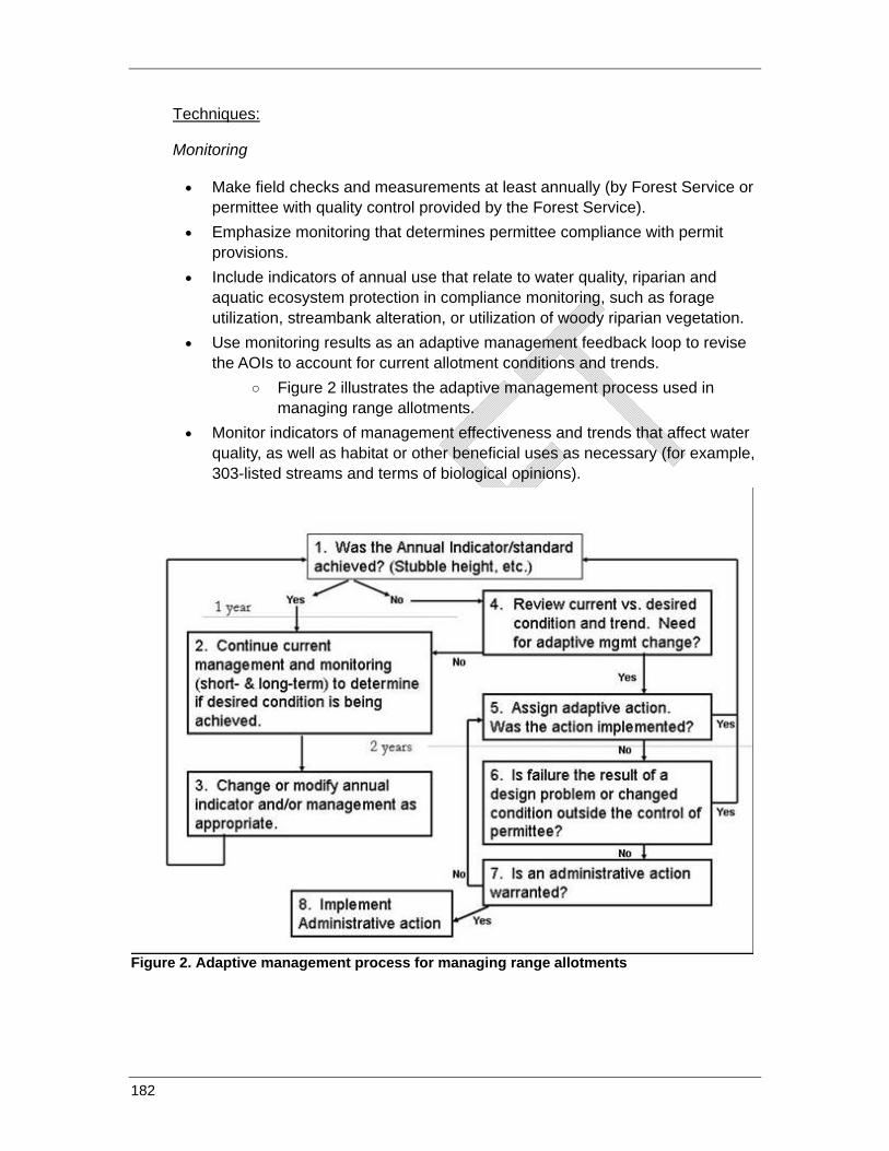
Techniques:
Monitoring
• Make field checks and measurements at least annually (by Forest Service or permittee with quality control provided by the Forest Service).
• Emphasize monitoring that determines permittee compliance with permit provisions.
• Include indicators of annual use that relate to water quality, riparian and aquatic ecosystem protection in compliance monitoring, such as forage utilization, streambank alteration, or utilization of woody riparian vegetation.
• Use monitoring results as an adaptive management feedback loop to revise the AOIs to account for current allotment conditions and trends.
○ Figure 2 illustrates the adaptive management process used in managing range allotments.
• Monitor indicators of management effectiveness and trends that affect water quality, as well as habitat or other beneficial uses as necessary (for example, 303-listed streams and terms of biological opinions).
Figure 2. Adaptive management process for managing range allotments
182
Livestock Number and Distribution
• Use results of annual compliance monitoring and periodic trend monitoring, as well as forage utilization by wildlife, to determine allowable annual amount of livestock use to meet rangeland desired conditions.
• Document allowable use, the planned sequence of grazing on the allotment, and any other operational changes in the AOIs issued to the permittee each year.
• Alter livestock distribution when monitoring and periodic assessments indicate consistent non-compliance with permit provisions.
• Manage livestock use through control of time/timing, intensity, and duration/frequency of use in riparian areas and wetlands to
○ maintain or improve long-term functional stream condition, and ○ allow for riparian hardwood growth extension and/or other stabilizers
(herbaceous plants) and reproduction where the riparian plant community is below its desired condition and livestock are a key contributing factor.
• Manage livestock to prevent further degradation of riparian areas and wetlands that are not meeting or moving toward desired condition objectives.
• Exclude livestock if monitoring information shows continued livestock grazing would prevent attainment of those objectives.
• Locate stock tanks, salt supplements, and similar features to distribute cattle evenly over the allotment and prevent concentrations of cattle in SMZs and wetlands.
• Keep stock driveways out of riparian areas except to cross at designated points. • Establish triggers for livestock trampling and riparian vegetation utilization on or
immediately adjacent to stream banks for timing livestock moves between units.
• Manage livestock herds to avoid concentrating in riparian areas and wetlands during the hot season (mid-to-late summer).
Season of Use
• Adjust livestock numbers and/or season of use when monitoring and periodic assessments show consistent non-compliance with permit provisions.
• Manage to avoid livestock grazing through an entire growing season in pastures that contain riparian areas and wetlands.
○ Apply short-duration grazing as practicable (generally less than 20 days) to minimize re-grazing of individual plants, to provide greater opportunity for regrowth, and to manage utilization of woody species and reduce soil compaction.
183

Permit Administration
• Use permit authorities to change operations to protect water and aquatic and riparian resources when special circumstances (such as drought) occur.
• Take corrective actions if monitoring and periodic assessments show consistent non-compliance with permit provisions. Actions might include:
○ adjusting livestock numbers and/or season of use ○ altering livestock distribution ○ installing fences and water developments. and ○ rest, placing the allotment (or unit of concern) in non-use status for a
period of time that allows for natural recovery of resource condition where potential exists.
• Apply suspension and cancellation guidelines in cases of intentional noncompliance with the terms and conditions of the permit.
• Modify, cancel or suspend the permit in whole or in part as needed where it has been determined to be necessary to ensure proper use of the rangeland resource and protection of other resources, such as water quality.
184
BMP 8.3 - Rangeland Improvements
Objective: Implement range improvements to protect, maintain or improve water and aquatic and riparian resources and associated beneficial uses.
Explanation: Rangeland improvements targeted at water and aquatic and riparian resources are designed to protect or improve conditions of sensitive areas such as streams, riparian areas, and wetlands or upland areas in danger of crossing a threshold to a less desirable condition and move these resources toward desired conditions. Improvements should emphasize protecting the beneficial uses in these areas. Improvements may supplement administrative actions such as rest or changes in annual use levels, seasonal use, distribution, and number.
Either the permittee or the Forest Service can be responsible for developing and maintaining rangeland. The District Ranger will ensure that the permittee is involved as a cooperator in rangeland improvements. And, as appropriate, the permittee may participate in the construction and/or maintenance of improvements under Forest Service direction. Implementation may also be done by Forest Service crews, or contractors.
Use the appropriate techniques from the following list adapted as needed to local site conditions to implement rangeland improvements.
Techniques:
• Identify range improvement needs during watershed analysis, watershed condition assessment, AMPs, or other assessment efforts.
• Evaluate improvement needs in the AMP. • Include and schedule improvement actions as appropriate in the AMP and
grazing permit. • Design improvements to sustain forage production for livestock and provide
protection to the other resources. • Consider the following when evaluating need for improvements:
○ Fencing ○ Soil and stream rehabilitation ○ Off-site water development ○ Seeding and planting
185
Rangeland Management References
Compendium of Best Management Practices to Control Polluted Runoff: A Source Book. J. Meitl and T. Maguire, eds. Idaho Department of Environmental Quality. March 2003. (http://www.deq.state.id.us/water/data_reports/surface_water/nps/reports.cfm#bmps )
BMPs for Grazing. Montana Department of Natural Resources and Conservation. 1999.
Best Management Practices for Grazing. Wyoming Department of Environmental Quality. 1997. (http://deq.state.wy.us/wqd/watershed/Downloads/NPS%20Program/92602.pdf)
Burton, Timothy A., Steven J. Smith, and Ervin R. Cowley. 2008. Monitoring Streambanks and Riparian Vegetation – Multiple Indicators. Technical Bulletin No 2008-5.
NRCS National Conservation Practice Standards (http://www.nrcs.usda.gov/technical/standards/nhcp.html) -- 383 Fence
TR1737-15 Riparian Area Management – Guide to Assessing Proper Functioning Condition and the Supporting Science for Lotic Areas. USDAI –BLM; USDA FS; USDA NRCS. 1998.
TR1737-16 Riparian Area Management – Guide to Assessing Proper Functioning Condition and the Supporting Science for Lentic Areas. USDAI –BLM; USDA FS; USDA NRCS. 1999.
University of Idaho. 2004. Stubble height study report: University of Idaho Forest, Wildlife, and Range Experiment Station Contribution No. 986, 33 pp.
FSM 2240
FSH 2200
FSH 2209.13
186
On-line Library of Appropriate Nonpoint Source Pollution Control Techniques
[only information available via the internet without charge is listed below]
1) USDA Forest Service directives—Forest Service Manual and Forest Service Handbook: http://www.fs.fed.us/im/directives/
2) California Department of Transportation stormwater BMP field manual: http://www.dot.ca.gov/hq/construc/stormwater/BMP_Field_Manual_Master_5x8_revision5.pdf
3) Federal Highways Administration standard specifications: http://flh.fhwa.dot.gov/resources/pse/specs/
4) California Forest Practice Rules: http://www.fire.ca.gov/resource_mgt/downloads/2010_FP_Rulebook_w-Diagrams_wo-TechRule_No1.pdf
5) California Stormwater Quality Association development BMP handbook: http://www.cabmphandbooks.com/development.asp
6) U.S. Environmental Protection Agency forestry BMPs: http://www.epa.gov/owow/nps/forestrymgmt/
187
CHAPTER 3: ADMINISTRATIVE PROCESSES FOR BMP IMPLEMENTATION
One of the objectives of this Water Quality Management Handbook is “to enhance Forest Service performance as a water-quality management agency, and increase and improve its responsibility, transparency and accountability in its relationships with the Water Boards.” This chapter describes Forest Service administrative processes that are intended to meet this objective by providing formal and systematic processes to ensure that measures for water-quality protection and improvement are incorporated into all activities on National Forest System lands in California.
The Forest Service Best Management Practices Evaluation Program (BMPEP) monitoring report for 2003 to 2007 (USFS 2009) showed that 86 percent of the evaluated BMPs were properly implemented, and of these, 93 percent were effective in protecting water quality. A major conclusion of this report was that “improved implementation of BMPs is the single most useful step that can be taken to improve water-quality protection on National Forests in California.” The changes to administrative practices described in this chapter and the adaptive management system described in chapter 4 constitute an effort to put this recommendation into practice.
General Responsibility, transparency, and accountability depend on Water Board and public access to Forest Service information and decisions and opportunities to exchange information and viewpoints with diverse stakeholders. The Water Quality Management Handbook includes the following steps to enhance overall information exchange and accountability:
1) Beginning in 2011, the Forest Service will track the condition of all 6th-field hydrologic units on NFS lands using protocols developed by the Washington Office headquarters staff at intervals of approximately 3 years. Watersheds will be classified into 1 of 3 condition classes representing high, moderate, and low geomorphic, hydrologic, and biotic integrity in relation to natural potential conditions. Changes in conditions will be related to Forest Service resource management actions and compared to assigned targets as a basis for funding allocations, and will be considered in performance appraisals of Forest Service staff.
2) The Forest Service will create a publically accessible Internet site where information related to water-quality protection and improvement and current
188
activities on NFS lands that may affect water quality will be posted or made available through links. Documents available on this site will include our current Water Quality Management Handbook, including all BMPs; the current Users Guide for the Best Management Practices Evaluation Program; the Stream Condition Inventory protocol; and Regional and National Forest BMPEP reports. Links will be provided to relevant supporting information, including Forest Service directives (FSM, FSH) and plans (Northwest Forest Plan, Sierra Nevada Framework Planning Amendment, individual national forest LRMPs and Schedules of Proposed Actions (SOPAs), project documents, including NEPA documents and contracts###, current wildfire and prescribed fire information (InciWeb), current weather (National Weather Service), and streamflow (U.S. Geological Survey). Following the conversion of the BMPEP data base to a new server, expected in 2011, the Forest Service will develop methods to provide data from BMPEP and in-channel monitoring via the Internet. Until such methods are developed, these data can be obtained by request to the appropriate national forest.
3) Interagency (Forest Service-Water Board) training sessions will be held annually on BMP development, implementation, and monitoring. Each annual training session will focus on specific issues and topics of current importance, and will cover any changes made to BMPs or evaluation protocols in the preceding year. Training will generally be held in late fall or early winter, and training locations will be rotated. Training for the Forest Service will not be required annually, but all permanent full-time (GS-9 level and above) Forest Service watershed, timber, fire and fuels, engineering, range, and recreation staff will attend an introductory training within 3 years of the implementation of this Water Quality Management Handbook (or within 3 years of being hired as new employees), and will attend refresher training at least once every 5 years. Water Board staff will be invited. Web-based training will be developed to reduce travel costs. The Forest Service Regional Hydrologist will coordinate the training.
4) Each national forest will continue to coordinate with their appropriate Regional Board(s) regarding monitoring, restoration, and other issues on an annual basis. This may involve meetings, reports, field visits, or other methods of communication.
5) An interagency coordination meeting will be held annually between the Forest Service Regional Office and the State Board. The purpose of these meetings is to present and discuss monitoring results, approve or reject recommended changes to BMPs, and evaluate progress on restoration of legacy sites. The Forest Service Regional Hydrologist will coordinate this meeting.
6) A public stakeholder and tribal advisory group will be established and will meet annually with the Forest Service Regional Office and the State Board to discuss any issues of concern related to water quality on NFS land. The stakeholder and tribal advisory group will be provided with all monitoring plans and reports, and the group will participate in field reviews of selected Forest Service activities on
189
an annual basis. The stakeholder and tribal advisory group will select the activities to be reviewed. This group, its meetings, and the field reviews will be arranged and coordinated by the Forest Service Regional Hydrologist with assistance from the Regional Forester’s Liaison Officer and Public Affairs staff.
7) Actual or potential water-quality problems observed on NFS lands can be reported by email or telephone to the Forest Service Regional Hydrologist. The current email address for the regional hydrologist is [email protected], and the current telephone number for the regional hydrologist is (707) 562-8968. A response will be provided to all observations as soon as possible, which will normally be within 1 to 5 business days. The regional hydrologist’s email and voicemail will be updated to provide alternative contact information during periods of travel or leave.
8) Each national forest will designate an emergency response team of Forest Service employees available year-round and trained to respond to non-hazardous pollutant discharges (any discharges that appear likely to result in immediate violations of basin plan objectives). Examples of discharges that would be controlled by a national forest emergency response team include blockage and diversions at road-stream crossings. Potential actions that the teams might take include removal of debris blocking culvert inlets and modifications of road drainage to prevent diversions and erosion. The emergency response teams may include permanent full-time firefighters; recreation, range, and forestry technicians; and engineering staff. Adjacent or nearby forests may “pool” staff for emergency response teams if necessary. Hazardous materials will be handled by Forest Service Hazardous Materials Coordinators and trained contractors only.
9) “Tailgate” water-quality discussions will be held during project implementation, and will involve Forest Service project and watershed staff, contracting officer’s representatives, contractors, and operators.
National Environmental Policy Act Procedures Under the National Environmental Policy Act (NEPA), all ground-disturbing activities on NFS lands are required to be analyzed for environmental impacts prior to implementation. All NEPA analyses result in a documented decision by the appropriate Forest Service line officer, usually a district ranger or forest supervisor, and all NEPA decisions incorporate site-specific best management practices for protecting water quality. Most low-impact activities that do not involve “extraordinary circumstances” such as impacts to floodplains, wetlands, municipal watersheds, cultural resources, wilderness, or listed species, may be categorically excluded from the requirement to fully analyze environmental impacts in an environmental assessment or environmental impact statement. Decisions to use categorical exclusions are documented with decision memos signed by line officers. Environmental assessments normally require two or more alternatives and are used for activities that may involve “extraordinary circumstances,” but pose a low risk of significant adverse environmental impacts. A decision to select an
190
alternative with an environmental assessment is documented in a decision notice and accompanied by a finding of no significant impact. Activities that may include significant adverse effects require an environmental impact statement, which includes a broader range of alternatives. A decision to select an alternative in an environmental impact statement is documented in a record of decision. Although an alternative selected in a record of decision may include adverse environmental effects, all alternatives must comply with the Federal Clean Water Act, the Porter-Cologne Act, and all other applicable laws. Similarly, all decisions made using an environmental assessment or categorical exclusion must comply with the Clean Water Act and the Porter-Cologne Act.
The Forest Service will incorporate the following practices for NEPA analyses and decisions:
1) National forest schedules of proposed actions will continue to be updated via the Internet quarterly, in March, June, September, and December each year.
2) NEPA analyses for timber harvest, fuels, vegetation management, engineering, and recreation activities that include ground-disturbing activities will include an inventory of controllable sediment discharge sources and other legacy sites that may affect water quality within project boundaries and along appurtenant Forest Service roads. Inventories of legacy sites will not be required for range allotments, routine road maintenance, hazard-tree removals, or other activities that are not restricted to a discrete project area. Legacy sites will be restored as described in chapter 5, either on a watershed or project basis.
3) Maps will be provided at scales of 1:24,000 or larger when needed to show road and project details or proposed alternatives.
Project Implementation Projects on NFS lands are implemented through contracts of various types, permits, and using Forest Service (force account) staff. Protection of water quality depends on a complete and accurate transfer of the site-specific BMPs described in NEPA decision documents into contracts, permits, and force-account job specifications. The procedures described below are specific to the various types of project documents used by the Forest Service. Common to all projects involving ground disturbance is the requirement for the development and completion of BMP checklists before ground disturbance begins and as needed, based on weather conditions and project activities.
Timber Sales, Stewardship, and Service Contracts
Site-specific BMPs will be included in timber sales, stewardship, and service contracts using standard regional C-clauses that include “fill in the blank” tables to allow development of site-specific measures similar to standard Regional clause R5 C6.6. If necessary, special non-recurring C clauses will be used when standard Regional C clauses do not apply. BMP checklists (see chapter 6) will be completed for timber sales and all other activities. Copies of timber sales and other contracts will be provided upon request.
191
Stewardship and Service Contracts
BMPs will be added directly as requirements in stewardship and service contracts.
Engineering Contracts
Implementation of BMPs will be required in contracts through drawings and plans, specifications, submittals, and pertinent clauses from Federal Acquisitions Regulations. Lack of compliance to the contract requirements can result in actions ranging from reduced payment, termination of contract due to default, and potential for fiscal liability of fines, depending on the severity of water-quality impact by a contractor’s operations or negligence.
Erosion control plans (see BMP 2.13 in chapter 2) will be included as part of the project record for all projects involving ground disturbance and with a risk of adverse impacts to water quality.
Force-Account (Forest Service staff) Projects
Although the work done with in-house agency personnel does not require written binding direction between staffs to carry out the Forest Service mission, force account projects and activities with potential to adversely affect water quality will incorporate BMPs through planning, design; drawings; and carefully selected methods and procedures, equipment, and materials, in addition to development, implementation, and monitoring of an approved project erosion control plan.
Road-Use Permits and Agreements
BMPs will be included in road-use permits, annual operating plans, reconstruction plans and specifications, and maintenance requirements.
Rangeland Grazing Permits
Range allotment grazing permits are managed under Allotment Management Plans (AMPs) and Annual Operating Instructions (AOIs). AMPs and AOIs can be modified based on a NEPA decision for permit renewal. BMPs will be added to AMPs and AOIs when permits are analyzed through NEPA. Range NEPA will include analysis of legacy problems within range allotments. Specific measures for monitoring and controlling bacterial contamination are described in chapters 2 and 6.
192
CHAPTER 4: ADAPTIVE MANAGEMENT
Purpose and Scope Adaptive management is “an approach to managing complex natural systems that builds on learning – based on common sense, experience, experimenting, and monitoring – by adjusting practices based on what was learned” (Bormann et al. 1999). An adaptive approach is necessary for water-quality management, given that the conceptual models underlying most resource management decisions rely on an imperfect understanding of the cause-and-effect relationships between land use activities and water-quality response. This imperfect knowledge can increase the risk of a management activity on the resource of concern, and can potentially result in unintended consequences to these resources. Adaptive management is considered an effective process for dealing with this type of uncertainty and risk (Ralph and Poole 2002).
The purpose of this adaptive management system (AMS) is to provide the information needed for the Forest Service, the State and Regional Water Boards, and stakeholders and tribes to ensure that the implementation of activities on the National Forest System lands of California occur in a manner that protects, maintains, and restores water quality and the beneficial uses of water, and complies with Federal water-quality statutes and regulations (for example, the Clean Water Act), in addition to California water-quality requirements (for example, the Porter-Cologne Water Quality Control Act). The primary mechanism for achieving this goal is through the implementation of BMPs. Explicit in the Water Quality Management Handbook is the acknowledgement that there is still uncertainty regarding how well BMPs are implemented, and how effective BMPs are in achieving objectives across time and space. As such, the handbook recognizes that an adaptive approach is necessary to optimize the implementation and effectiveness of BMPs on National Forest System lands.
By designing and implementing an adaptive management system developed cooperatively between the Forest Service and State Water Board, the process can achieve the following desirable outcomes:
• Land use activities are addressed in a manner that prevents or minimizes nonpoint source pollution and protects, maintains, and restores water quality and the beneficial uses of water on National Forest System lands;
• Sufficient feedback mechanisms are in place so that the Forest Service, State Water Board, stakeholders and tribes can determine whether the program is achieving its stated objectives;
193
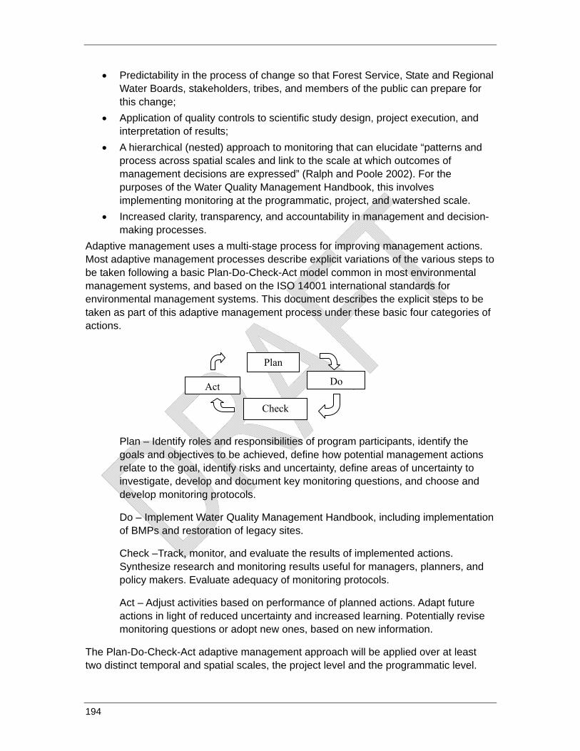
194
• Predictability in the process of change so that Forest Service, State and Regional Water Boards, stakeholders, tribes, and members of the public can prepare for this change;
• Application of quality controls to scientific study design, project execution, and interpretation of results;
• A hierarchical (nested) approach to monitoring that can elucidate “patterns and process across spatial scales and link to the scale at which outcomes of management decisions are expressed” (Ralph and Poole 2002). For the purposes of the Water Quality Management Handbook, this involves implementing monitoring at the programmatic, project, and watershed scale.
• Increased clarity, transparency, and accountability in management and decision-making processes.
Adaptive management uses a multi-stage process for improving management actions. Most adaptive management processes describe explicit variations of the various steps to be taken following a basic Plan-Do-Check-Act model common in most environmental management systems, and based on the ISO 14001 international standards for environmental management systems. This document describes the explicit steps to be taken as part of this adaptive management process under these basic four categories of actions.
Plan – Identify roles and responsibilities of program participants, identify the goals and objectives to be achieved, define how potential management actions relate to the goal, identify risks and uncertainty, define areas of uncertainty to investigate, develop and document key monitoring questions, and choose and develop monitoring protocols.
Do – Implement Water Quality Management Handbook, including implementation of BMPs and restoration of legacy sites.
Check –Track, monitor, and evaluate the results of implemented actions. Synthesize research and monitoring results useful for managers, planners, and policy makers. Evaluate adequacy of monitoring protocols.
Act – Adjust activities based on performance of planned actions. Adapt future actions in light of reduced uncertainty and increased learning. Potentially revise monitoring questions or adopt new ones, based on new information.
The Plan-Do-Check-Act adaptive management approach will be applied over at least two distinct temporal and spatial scales, the project level and the programmatic level.
Plan
Do
Check
Act
Project-level application is intended to do the following:
1) Improve the speed and certainty with which problems and threatened problems caused by a project are identified and corrected, so as to minimize water-quality impacts that may have already begun, and to prevent future impacts.
2) Shorten the institutional feedback loop whereby field personnel and their supervisors learn from their own experience and that of others what has worked well, what has not, and why, so that knowledge can be immediately applied to future projects.
Programmatic-level application is intended to do the following:
1) Identify the degree to which BMPs are being properly implemented and are effective in protecting the quality and beneficial uses of water, so that needed statewide programmatic changes can be made in the BMPs and/or the processes by which they are administered.
2) Identify the knowledge gaps where more rigorous scientific studies are needed.
Where it is beneficial to do so and resources permit, the Plan-Do-Check-Act approach will also be applied in selected priority watersheds to evaluate causal linkages between off-stream management activities and instream conditions, or to evaluate cumulative watershed effects.
PLAN—Roles and responsibilities
Forest Service roles and responsibilities under this AMS are described below. The Forest Service will conduct the monitoring program and reporting, and seek non-regulatory review and input from State and Regional Water Board staff in interpretation of results, and recommendations for adapting either management actions or the monitoring approach. The process for Forest Service and Water Board staff collaboration will be described in the revised State management agency agreement. The Forest Service monitoring and reporting program will occur at both the project and programmatic scale. Project-scale monitoring refers to project-specific implementation monitoring. Project implementation information is used by Forest Service staff to make immediate adjustments to Forest Service management as needed during project implementation to protect soil and water resources. Programmatic monitoring refers to larger scale monitoring that is not tied to a particular project, but data is collected strategically at a larger scale to determine whether BMPs are successful at the Regional, Forest, or watershed scale in protecting soil and water resources The illustration below shows the Forest Service organization related to these two scales of monitoring and reporting.
Stakeholders and tribes will provide review and perspective or input to design of AMS, monitoring strategies, monitoring reports, and management recommendations. Stakeholders and tribes can also submit data and observations related to their own project or watershed-scale monitoring, according to the process described in Section VIII
195
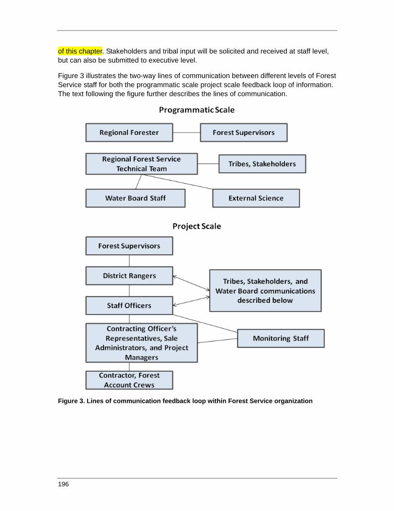
196
of this chapter. Stakeholders and tribal input will be solicited and received at staff level, but can also be submitted to executive level.
Figure 3 illustrates the two-way lines of communication between different levels of Forest Service staff for both the programmatic scale project scale feedback loop of information. The text following the figure further describes the lines of communication.
Figure 3. Lines of communication feedback loop within Forest Service organization
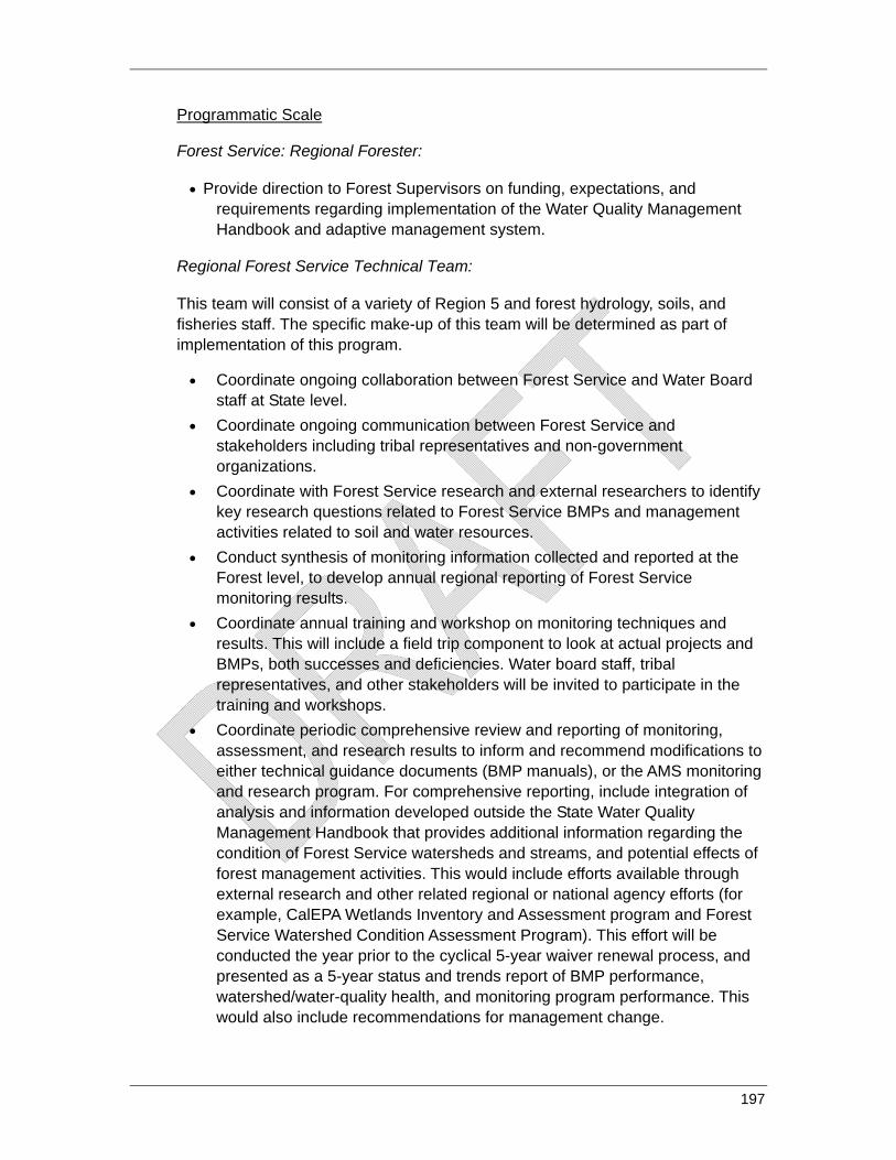
Programmatic Scale
Forest Service: Regional Forester:
• Provide direction to Forest Supervisors on funding, expectations, and requirements regarding implementation of the Water Quality Management Handbook and adaptive management system.
Regional Forest Service Technical Team:
This team will consist of a variety of Region 5 and forest hydrology, soils, and fisheries staff. The specific make-up of this team will be determined as part of implementation of this program.
• Coordinate ongoing collaboration between Forest Service and Water Board staff at State level.
• Coordinate ongoing communication between Forest Service and stakeholders including tribal representatives and non-government organizations.
• Coordinate with Forest Service research and external researchers to identify key research questions related to Forest Service BMPs and management activities related to soil and water resources.
• Conduct synthesis of monitoring information collected and reported at the Forest level, to develop annual regional reporting of Forest Service monitoring results.
• Coordinate annual training and workshop on monitoring techniques and results. This will include a field trip component to look at actual projects and BMPs, both successes and deficiencies. Water board staff, tribal representatives, and other stakeholders will be invited to participate in the training and workshops.
• Coordinate periodic comprehensive review and reporting of monitoring, assessment, and research results to inform and recommend modifications to either technical guidance documents (BMP manuals), or the AMS monitoring and research program. For comprehensive reporting, include integration of analysis and information developed outside the State Water Quality Management Handbook that provides additional information regarding the condition of Forest Service watersheds and streams, and potential effects of forest management activities. This would include efforts available through external research and other related regional or national agency efforts (for example, CalEPA Wetlands Inventory and Assessment program and Forest Service Watershed Condition Assessment Program). This effort will be conducted the year prior to the cyclical 5-year waiver renewal process, and presented as a 5-year status and trends report of BMP performance, watershed/water-quality health, and monitoring program performance. This would also include recommendations for management change.
197
Project Scale
Forest Supervisors and District Rangers:
• Provide internal resources to support agencies’ roles and responsibilities under the Water Quality Management Handbook and management system as directed by Regional Forester.
• Implement direct actions and decisions based on recommendations provided in monitoring reports produced by forest staff and/or by the Regional Forest Service Technical Team.
Forest and District Watershed Specialists and Staff Officers:
Watershed specialists can include any resource staff with qualifications and training to be able to conduct monitoring, analysis, and provide recommendations. This can include hydrologists, soil scientists, fisheries biologists, ecologists, and foresters.
• Implement Forest-level monitoring as described in the Water Quality Management Handbook. Use monitoring data collected during the project to immediately inform and adapt project implementation to correct and mitigate deficiencies, and prevent harm to soil and water resources and beneficial uses. This information is communicated directly to Forest Service staff directly responsible for project implementation to include contracting officer representatives, sale administrators, and project managers.
• Report monitoring data and analysis results to the Regional Forest Service Technical Team. Use annual reporting to share lessons learned, and recommend to line officers modifications to project-specific design features or BMPs, and administrative processes at the forest level to improve planning, contracting, and implementation of forest-management activities to improve the effectiveness of BMPs and restoration efforts.
• Report monitoring data and analysis results as required or requested, to affected Regional Water Board staff.
Contracting officer’s representative, sale administrator, and project:
• Through either contracting (if project implemented through contracts) or supervisory authority (if implemented by Forest Service staff), direct contractors and/or forest staff to implement any needed corrective actions as a result of project-scale monitoring.
The Forest Service Technical Team and Forest staff will actively coordinate with Water Board staff and other stakeholders and tribes as part of implementation of the Water Quality Management Handbook. This will occur at both the project and programmatic scale. The purpose of this coordination is to provide timely reporting of monitoring results and management responses to monitoring results, as well as to consider and integrate input received from Water Board staff and stakeholders and tribes relative to
198
adjustments to the adaptive management program including monitoring strategies, monitoring reports, and management recommendations.
PLAN—Identify risk and uncertainty
An important step in planning an adaptive management process is to identify current risk and uncertainty as they relate to ecological processes and current management practices. This should include an evaluation of past administrative processes used in the program. As part of the development of this Water Quality Management Handbook and the Forest Service existing adaptive management of this program, evaluation of BMPs and the BMPEP has occurred. Changes to both the BMP handbook and the BMPEP manual have been made as a result. However, we recognize that more will need to done, so the following describes how to move forward from where we are now. Because there are already-established monitoring programs in place that the Forest Service and State Water Board would like to continue using, additional evaluation of risk and uncertainties will take place as part of the ACT phase of the proposed program. The following actions are recommended for this step.
• Synthesize existing research to identify risk and uncertainties related to the current condition of resources, and the effects of forest management on, soil, water, and aquatic resources
• Continue to investigate the performance of the Forest Service Region 5 BMP and BMPEP program and identify its strengths and weaknesses and need for change. Implement an independent evaluation of the BMPEP to assess the reliability and statistical robustness of results obtained using the current program.
• Investigate the performance of the current Stream Condition Inventory (SCI) program, and identify its strengths and weaknesses. Conduct synthesis and BMPEP reliability evaluation in consultation with stakeholders and tribes, and collaboration with research professionals from outside institutions. Frame the discussion of risks and uncertainties in a statewide context, as well as Forest-specific context. Because of the differences in current resource conditions, past and proposed application of management practices and specific resource concerns, important risks and uncertainties relevant to each Forest (or ecoregions within a Forest) will likely differ. Monitoring should focus on areas that present the highest risk and/or the highest level of uncertainty (based on current science).
PLAN—Conceptual model and key monitoring questions
The conceptual model shown in Figure 4 illustrates the information needed to determine whether we are achieving the goals and objectives described in this Water Quality Management Handbook.
From this conceptual model, the following describes the key questions for evaluation by the monitoring program described in chapter 6, to provide the information needed to determine whether we are meeting the Water Quality Management Handbook general objectives.
199

1) Are Forest Service practices adequate for protecting water quality at the project scale (BMPEP effectiveness monitoring and retrospective BMPEP) monitoring?
2) Are Basin Plan water-quality objectives being met on NFS lands (in channel monitoring)?
3) Are Forest Service practices adequate for protecting beneficial uses (in channel monitoring and “nested” BMPEP monitoring—note that results can help determine the need for new BMPs as well as effectiveness of existing BMPs)?
4) Are water-quality conditions trending upward or downward on NFS lands (in channel monitoring)?
5) Does the Forest Service follow its management practices (BMP implementation checklists, BMPEP implementation monitoring)?
6) Are key areas with high recreational use protected from bacterial contamination (rangeland in-channel fecal indicator bacteria (FIB) monitoring)?
A description of the methods used to evaluate attainment of specific monitoring objectives and targets is presented in chapter 6 of this handbook.
200
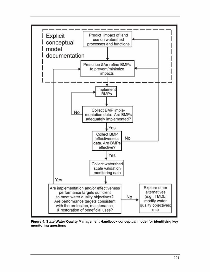
201
Figure 4. State Water Quality Management Handbook conceptual model for identifying key monitoring questions
DO—Implement the BMPs and Water Quality Management Handbook
This work will involve implementing the BMPs and other prescribed water-quality protection practices during all project planning and implementation activities, including the restoration of legacy sites as described in chapter 5 of the Water Quality Management Handbook. Methods used will be the current practices and procedures as prescribed in current BMPs, Forest Plan Standards and Guidelines, and other relevant documents (see list of on-line references at the end of chapter 2).
CHECK—Implementation, effectiveness, and validation monitoring strategy
A comprehensive and regionally consistent water-quality monitoring program is needed to guide water-quality protection programs on national forests in Region 5 of the Forest Service. The monitoring program is described in chapter 6 of this handbook. The program described in chapter 6 is intended to meet the needs of the Region as well as the State Water Resources Control Board and the Regional Water Quality Control Boards for water-quality information. The program includes procedures for evaluating if the practices for protecting water quality were implemented as prescribed, often described as implementation or compliance monitoring. The program also assesses whether current practices are effective and whether the performance targets are adequate for accomplishing the intended water-quality goal. The program will also include regular evaluation of the performance of the monitoring program itself.
The adaptive management component of the Water Quality Management Handbook program involves the regular analysis, synthesis, and reporting of the data collected through the monitoring program. This will include the following three tiers of reporting, with management recommendations.
1) Development of annual forest monitoring reports presenting and summarizing results from BMP monitoring (BMPEP and Implementation Checklists). Use annual reporting to share lessons learned, and recommend to line officers modifications to project-specific design features and BMPs, and administrative processes at the forest level to improve planning, contracting, and implementation of forest management activities.
2) Development of annual Regional report that presents a synthesis of monitoring information collected and reported at the Forest level. In addition to raw results, provide some analysis of trends in successes and deficiencies, including identification of causes. Also identify short-term corrections, if needed, to BMP monitoring protocols or analysis tools.
3) Development of periodic report, which presents a comprehensive review of monitoring, assessment, and research results to inform and recommend modifications to either technical guidance documents (for example, BMP manuals), or the AMS monitoring and research program. For comprehensive reporting, include integration of analysis and information developed outside the State Water Quality Management Handbook, which provides additional information regarding condition of Forest Service watersheds and streams, and
202
potential effects of forest management activities. This would include efforts available through external research and other related regional/national agency efforts (for example, CalEPA Wetlands Inventory and Assessment program, Forest Service Watershed Condition Assessment Program). This effort will be conducted the year prior to the cyclical 5-year waiver renewal process, and presented as a 5-year status and trends report of BMP performance, watershed and water-quality health, and monitoring program performance. The report will also include recommendations for management change.
Evaluation of Monitoring Program
As part of the discussion included in each annual forest monitoring report, identification of problems encountered in implementing the monitoring program will be included. This will include problems encountered with using existing data collection and analysis protocols, accuracy of results, and sufficiency in training and funding received. Results presented will include identification of any caveats or uncertainties related to the accuracy of the results presented. Forest input will be synthesized in Forest Service Region 5 reports.
In addition, identification of observed deficiencies or difficulties in implementing the monitoring program, will be a key component of the annual BMPEP training and workshop, organized by the Regional Forest Service Hydrologist. The workshop will also identify recommendations for improvements in the monitoring approach. Results from the workshop will be included in Forest Service statewide Regional reporting.
Independent peer review of protocols and analysis may be solicited from the science community, including the Forest Service Pacific Southwest Research Station, as recommended by the Regional Forest Service Technical Team. Testing and piloting efforts of revised techniques and protocols may also be recommended by the Regional Forest Service Technical Team.
Further discussion regarding how monitoring data will be used and reported to initiate a management response is described below.
ACT—Short-term corrective actions, reporting, and recommendations or decisions for programmatic change
Adaptive management as used in this plan means adjusting preventive and restorative methods to improve water-quality protection based on monitoring results. The general approach is to:
1) Identify problems through systematic monitoring and research synthesis. Include input provided by Water Board staff, stakeholders and tribes;
2) Describe measurement and data variability, and any uncertainties associated with monitoring;
3) Identify current risks and uncertainties through synthesis of existing monitoring and research;
203
4) Identify appropriate corrective actions;
5) Verify implementation of corrective actions;
6) Document implementation of corrective actions; and
7) Report discrepancies and corrective actions in annual reports to State and Regional Boards.
Response procedures for monitoring program components
1) Annual BMP implementation checklist discrepancies. Discrepancies are instances when BMPs implemented on the ground does not match what was stated in project planning, contract, or permitting documents.
District and forest hydrologists will:
a. Check with project administrator to verify discrepancies; b. Identify corrective actions in cooperation with project administrator; c. Conduct follow-up inspections to verify corrective actions; d. Document corrective actions in project file; e. Describe discrepancies and corrective actions in annual reports.
2) Annual random BMPEP monitoring implementation failures
District and forest hydrologists will:
a. Discuss failure with project administrator; b. Identify corrective actions; c. Conduct follow-up inspections to verify corrective actions; d. Document corrective actions in project file; e. Describe discrepancies and corrective actions in annual reports.
3) Annual random BMPEP effectiveness failures
District and forest hydrologists will:
a. Evaluate hydrologic conditions at the time of failure; b. Conduct field visit to determine causes of failure; c. Identify corrective actions; d. Verify implementation of corrective actions during the following year; e. Recommend measures to improve BMP effectiveness to the regional
hydrologist; f. Document findings in project file and in annual report.
4) Retrospective BMPEP effectiveness failures
District and forest hydrologists will:
a. Evaluate hydrologic conditions most likely to have contributed to failure;
204
b. Determine whether the BMPs selected were appropriate for the specific local application based on local conditions (soils, hydrology, etc.)? Was the BMP selected appropriate for the nature and scale of the anticipated resource impact? Were there pre-existing conditions or cumulative effects involved, and were these adequately addressed as part of BMP selection. Conduct field visit to determine causes of failure;
c. Identify corrective actions; d. Verify implementation of corrective actions during the following year, and
document benefits and failures of corrective actions.; e. Recommend measures to improve BMP effectiveness to the regional
hydrologist; f. Document findings in project file and in annual report.
5) In-channel monitoring (SCI)
a. Annual results will be reviewed by the forest hydrologist to identify any current conditions or trends that indicate potential cumulative watershed effects, including identification of pre-existing legacy issues and suspected causes and sources of effects.
b. Forest watershed staff will identify preventive or restoration actions needed to improve channel conditions, and observations or monitoring results of benefits and failures of corrective actions.
c. Results of monitoring and a description of corrective actions will be included in annual reports.
6) Field observations independent of systematic monitoring programs
a. All Forest Service staff will report observations of existing or potential water-quality impairments immediately to the local line officer and forest hydrologist.
b. Line officers will determine appropriate corrective actions. c. Forest hydrologists will report violations of basin plans to regional board
staff. d. All water-quality impairments requiring corrective actions will be
documented in annual reports.
7) Storm patrols
a. Forest Service staff assigned to storm patrol duties will be qualified to use the necessary tools to make emergency repairs to road drainage facilities and other BMP failures that can be safely addressed with hand tools.
b. Road patrol teams will document locations of problems with GPS units and provide information on problem locations to the district or forest hydrologist.
c. District and forest hydrologists will work with engineering staff to prevent future recurrences.
205

8) Rangeland FIB monitoring for high-use recreational sites
a. Forest Service range management staff will investigate all monitoring results for either FIB or other indicators that indicate excedance of basin plan objectives.
b. If terms and conditions of the grazing permit are not being met, the Forest Service will take immediate corrective actions as described in chapter 2.
Reporting
Annual reports will include information on the funding used to support monitoring on each national forest each year.
Project Implementation Monitoring:
Implementation monitoring results are formally reported to Water Boards within 90 days of project completion. These are reported through implementation checklists for all projects implemented through a NEPA decision. These monitoring requirements are described in the Water Board permit documents. Informal reporting of project implementation monitoring is ongoing throughout the project on an as-needed basis between monitoring staff and contracting officers’ representatives/sale administrators/project leaders and regulatory staff. Implementation checklists are developed by Forest Service staff specific to each project, and they are to be reviewed and approved by Water Board staff if requested, prior to project initiation.
BMPEP and Watershed Monitoring:
Each national forest will submit an annual draft monitoring report to the State Water Board and the appropriate Regional Boards and make it available to the public. The Forest Service Regional Office will submit a draft annual summary of monitoring results to the State Water Board, appropriate Regional Boards, and make it available to the public for all forests in the Pacific Southwest Region, and will compile a draft report containing a more detailed analysis and synthesis of monitoring results every 3 years.
After submission of draft annual reports, the Forest Service and Water Board staffs will be invited to meet each year, both at the forest level and the regional level (for example, the Joint Forest Service / Water Board Science team), to review annual findings and finalize any recommendations for immediate change in the final report. Recommendations will include both those related to management activities as well as the monitoring program. It is expected that the scale of recommended change would be fairly limited during the annual reporting cycle, and primarily address change at the Forest level.
The 3-year report will consist of a much more in-depth and detailed analysis and synthesis of findings to identify trends and causes for repeated BMP implementation and effectiveness deficiencies, and trends in stream channel conditions. Upon meeting with Water Board staff, this final 3-year report is when a more in-depth analysis of results would be used to develop a larger scope of recommendations related to changes in
206
management direction or the monitoring program would occur. Any new findings from available relevant research would also be integrated into this 3-year synthesis report.
Draft reports will be made available for stakeholders and tribes to review, to also provide comment and input in preparation of the final report, for both the annual and periodic comprehensive reports. Reports will be posted online.
The finalized annual report, as well as the periodic comprehensive report, will then be submitted to the executive staff for both the Forest Service and the Water Board for the consideration of management decisions as described in below.
Field Reviews:
Annually complete a field review to visit and discuss implementation and effectiveness monitoring results. Forest Service and Water Board staffs should organize this event and locations should change each year. Stakeholders and tribes should be invited and may be asked to help select the sites for field visits. Results of BMPEP evaluations should be discussed at these events. Areas of non-compliance or ineffective BMPs should be included on the field visits.
Executive Management Decisions
A synthesis of findings and management recommendations from annual reports and the comprehensive reports will be presented to appropriate executive staff within the Forest Service. Based on this synthesis, executive staff will initiate actions and appropriate decision documents following their respective agency processes to implement changes to either individual Forest practices (including the BMP and BMPEP program), or the State Water Quality Management Handbook, or the State management agency agreement. These actions and decisions will be broadly communicated to Water Board staff, tribal leaders, and stakeholders. Executive management decisions should be made early enough so that actions undertaken or being considered can be reported for State Water Board consideration during an upcoming waiver-renewal process. This should be done at least a few months before the CEQA process for waiver renewal is to begin. More time may be needed if decisions made are controversial.
Decisions and the rationale for the decisions will be described and documented in a decision briefing. The decision briefing will be made available to all interested parties and is intended to inform Water Board staff, tribal governments, and stakeholders, regarding the factors that drive management decisions.
One possible decision the Forest Service would implement if consistent failure to meet basin-plan objectives was discovered, is to voluntarily request termination of waiver coverage and file a report of waste discharge for the project or stop the project. Consistent failure for a type of activity on an individual forest would result in the forest disenrolling the activity from the waiver and either seeking alternate permit coverage through ROWD or ending the activity.
207
Sources of information used to determine failure would include all of our own monitoring programs and information from external observers, including Regional Boards. Based on this information, the Forest Service would make a determination as to whether we actually had a consistent failure for an individual project or an activity that resulted in violation of Basin Plan standards.
Stakeholder and Tribal Consultation
The role of a stakeholder and tribal advisory group is described in chapter 3 of this handbook.
Information System
A web-based system for providing and receiving information related to water-quality management on NFS lands is described in chapter 3.
208

CHAPTER 5: WATERSHED PRIORITIZATION FOR RESTORATION
The Forest Service Watershed Improvement Program (WIP) is a nationwide Forest Service program of assessment and restoration on a watershed scale (http://www.fs.fed.us/biology/watershed/index.html). The WIP is complimentary to the BMPs described in chapter 2. The BMPs provide protection from current and new activities, while the WIP addresses adverse effects of past land uses. Both programs are integral components of this Water Quality Management Handbook. The term “restoration” as used here conforms to the definition provided by FSM 2020:
“The process of assisting the recovery of resilience and adaptive capacity of ecosystems that have been degraded, damaged, or destroyed. Restoration focuses on establishing the composition, structure, pattern, hydrologic function and ecological processes necessary to make terrestrial and aquatic ecosystems sustainable, resilient, and healthy under current and future conditions.”
Restoration has also been defined as “an intentional activity that initiates or accelerates the recovery of an ecosystem with respect to its health, integrity and sustainability.” (Society for Ecological Restoration)
Adverse impacts resulting from past land uses are often termed “legacy” problems. This term is used here to distinguish between impacts that can be prevented by application of BMPs to current projects and impacts related to past land uses that require additional action to control.
The Forest Service approach to watershed improvement and restoration follows the principle of conservation biology to “protect the best, restore the rest.” This approach is likely to be strongly supported in the future by the Forest Service national headquarters. This philosophical approach means that the Forest Service focuses on watersheds with critical aquatic habitat needed to support threatened and endangered species. These watersheds are generally, although not always, in relatively good geomorphic, hydrologic, and biologic condition. Restoration efforts in these watersheds are likely to be more cost-effective than restoration of badly damaged watersheds. This approach differs from the Total Maximum Daily Load approach used by USEPA and the Water Boards to restore impaired watersheds. However, critical aquatic refugia and impaired watersheds are not completely mutually exclusive, and opportunities exist to restore watersheds that act as critical aquatic refugia and are listed as impaired water bodies.
209

In accordance with the WIP, each national forest identifies the priority watersheds for restoration, and the essential projects that will bring about improvement in watershed condition. The intent of the program is to focus watershed restoration activities in priority watersheds and progress through the priority watersheds in a stepwise manner, eventually providing assessment and restoration for all watersheds. As described in more detail below, priority watersheds receive heightened water-quality protection under Forest Service guidance and are integral for maintaining sanctuary habitats for threatened and endangered species and unique plant and animal communities.
Watershed restoration projects are not limited to priority watersheds. However, national forests are required to use at least 75 percent of their available resources for watershed improvement in priority watersheds.
The primary components of the WIP are:
1) Priority Watershed Selection
2) Watershed Condition Assessments
3) Watershed Improvement Needs Inventories
4) Essential Project Identification
5) Watershed Restoration Plans
6) Annual Watershed Improvement Accomplishments Reporting
1. Priority Watershed Selection
The Forest Service has adopted a “priority watershed” approach in its watershed restoration program. As of 2001, each forest in the Pacific Southwest Region identified priority watersheds where watershed improvement work would be focused. In 2001, priority watersheds were defined at the 5th-field hydrologic unit code (HUC) scale (40,000 to 250,000 acres). According to the new draft Implementation Guide, priority watersheds will be redefined at the 6th-field HUC scale (10,000 to 40,000 acres).
In 2001, priorities were defined based on (1) existing watershed conditions, (2) values, and (3) opportunities. Existing watershed conditions at the 5th-field scale served as the primary criterion in priority setting. Values were typically tangible assets of importance to people and included: sources of domestic water, rare ecosystems, unique recreation areas, threatened and endangered species, rural communities, and soil productivity. Opportunity was defined by factors that enhance the likelihood that the desired outcome is achievable and could include: available infrastructure, ownership patterns, policy direction, partnerships, and sufficient financial and political support. In other words,
Condition + Values + Opportunity = Priority.
Based on the draft 2009 “Implementation Guide,” national forests will identify an appropriate number of watersheds for improvement that correspond to a reasonable and achievable program of work over the next 5 years (the “planning cycle”) within current budget levels. These watersheds will be the new “priority watersheds.” The number of
210
priority watersheds will vary by forest but it is expected to range from 1 to 5, given current funding levels.
Each forest will identify priority watersheds using an interdisciplinary process that includes representatives from soil, water, range, wildlife and fish, roads and trails, vegetation, planning, fuels, and others as appropriate. In cases, where one or more forests share watersheds, the affected Forests/Regions will need to work together to assure that the selection of priority watersheds is coordinated.
Information provided by the State and Regional Boards and other partners (local, State, tribal, other Federal agencies or interest groups) will be considered in the priority watershed identification process. The public will be given opportunities to provide suggestions for selecting priority watersheds during the development of forest plans.
While the task of identifying priority watersheds is largely left to the discretion of the national forests, three factors, along with local issues, needs, and opportunities must be considered:
• A rapid assessment of resource value,
• A rapid assessment of the estimated cost effectiveness, and
• National and Regional watershed condition policy, direction, and guidance.
2. Watershed Condition Assessment
The Forest Service conducted watershed condition assessments in 2000 at the 5th-field HUC scale. This is equivalent to a 40,000- to 250,000-acre watershed. These watershed condition assessments are expected to be revised or replaced in the immediate future at a finer scale and with revised indicators or factors.
The Forest Service is in the process of developing a new watershed condition assessment tool. A draft “Implementation Guide for Assessing and Tracking Changes to Watershed Condition” was completed in 2009 and is currently under review. The assessment strategy includes the following 12 indicators:
• Water Quality Condition • Water Quantity Condition • Stream and Habitat Condition • Aquatic Biota Condition • Riparian Vegetation Condition • Road and Trail Condition • Soil Condition • Fire Effects and Regime Condition • Forest Cover Condition • Rangeland, Grasslands, and Open Area Condition • Terrestrial Non-native Invasive Species Condition
211
• Forest Health Condition When the assessment tool is completed, approved, and adopted on a national basis, it will be implemented at the 6th-field HUC scale. This scale is equivalent to 10,000- to 40,000-acre subwatersheds. It is expected that this revised watershed condition assessment will be conducted in Fiscal Year 2011.
3. Watershed Improvement Needs Inventories
The Forest Service Watershed Improvement Program includes as a component a forest-level inventory of watershed improvement needs (WIN). This is an ongoing process that is integrated with the forest program of work and subject to available funding. The degree of progress in these inventories varies considerably by forest, depending on available resources and capabilities. Significant progress is being made in inventories of road-related watershed improvement needs following procedures outlined by Napper (2008).
The existing WIN inventories are in a combination of forms including hardcopy files of field inventory forms, local spreadsheet and/or GIS data, and in a national database (Watershed Improvement Tracking database or WIT). Few forests in the Region have yet transitioned to the WIT database, but national training in the database is currently being provided.
4. Essential Project Identification
Identification of “essential projects” is introduced as a new component of the Watershed Improvement Program in the draft Implementation Guide. Essential projects are being defined as projects that “prevent or remedy a problem that impairs the physical, chemical or biologic function of the watershed and, when implemented, sustain or move a watershed to a better condition class.”
Essential projects may be individual projects or a group of projects which cumulatively require work or action to maintain or improve watershed condition class. A watershed may have only one essential project (for example, head cut stabilization) or a suite of essential projects (for example, decommission 5 roads, upgrade 15 culverts, change a grazing system, remove 3 check dams, remove hazardous fuels from 30 acres of riparian area, and restore native riparian vegetation). In most cases, integrated suites of projects would need to be implemented.
Essential projects will address all resources and may be funded from many budget accounts. While emphasizing on-the-ground work, essential projects can also include planning aspects. National forest personnel, as part of an interdisciplinary team, identify essential projects which the appropriate line officer agrees to, as needed, to sustain or improve watershed condition.
Work or actions that are not necessary to improve physical, chemical, or biological conditions at a watershed scale are considered “non-essential.” The determination of whether a project or group of projects is considered essential vs. non-essential will be
212
made at a local level. Examples of non-essential projects include eradication of non-native fish, vegetation manipulation that does not improve or reduce risk to watershed condition, or replacement of a culvert in a stream where the crossing is stable and aquatic passage is not a concern.
A description of techniques for site-specific watershed improvement projects is beyond the scope of this Water Quality Management Handbook. The Forest Service has successfully completed many road decommissioning, stormproofing, meadow restoration, abandoned mine reclamation and other projects in the past several decades. Methods for these types of projects are described in NEPA project documents.
5. Watershed Restoration Plans
For each of the priority watersheds, national forests will identify the specific projects necessary to improve watershed condition class and develop a Watershed Action Plan. The action plan will be based on a detailed assessment of each priority watershed. The assessment should document specific problems affecting ecological conditions; identify appropriate projects that address these problems; propose an implementation schedule, project sequencing, potential partners, and funding sources.
Acceptable watershed assessment methods must be used to analyze watershed condition and make general recommendations for any needed improvement. Examples of accepted methods include: Ecosystem Analysis at the Watershed Scale (EWAS), Hydrologic Condition Analysis (HCA), Total Maximum Daily Load assessments (TMDLs), Watershed Improvement Needs (WIN) inventories and large-scale NEPA. National forests may use other accepted methods, provided their assessment method has sufficient information about watershed function and processes to determine specific problems, current and desired watershed condition, and provides information that can be used to identify restoration objectives.
The watershed condition assessment should result in development of a Watershed Action Plan (also known as a restoration plan or strategy) that synthesizes problems, actions and timelines. These plans provide details on maintenance and restoration objectives for the watershed. Potential partners and funding sources may also be listed. The goal of these assessments is to identify essential projects.
6. Annual Watershed Improvements Accomplishments Reporting
Each national forest annually reports its accomplishments for watershed improvements to the Regional Office. Accomplishments are reported in acres improved or linear feet of channel restored. Accomplishments are compared to annual targets assigned by the Regional Office to the national forests to assess performance and allocate funding. The Forest Service is shifting nationally to targets based on improvements in overall watershed condition. This change is likely to be implemented in Fiscal Year 2011.
Implementation and effectiveness of restoration projects will be monitored as described in NEPA documents. In addition, programmatic monitoring of road decommissioning and
213
stormproofing projects will be conducted under the Legacy Roads program by the Rocky Mountain Forest and Range Experiment Station.
Project Level Restoration
The Forest Service has current authority and direction to assess restoration needs and conduct restoration of legacy problems within the boundaries of timber sales (FSH 2409.19, FSM 2522.22), although restoration is limited by available funds generated by the sale of forest products or external grant funding.
Ecological restoration has recently been identified as a responsibility for all Forest Service resource management programs (FSM 2020.3). The watershed-scale restoration approach described above provides an effective approach for addressing legacy problems. However, not all watersheds will have watershed restoration plans in effect immediately. Therefore, most projects conducted in watersheds without established watershed restoration plans will restore legacy problems within project boundaries. Projects that cover large areas, such as hazard tree removals, routine road maintenance, and range allotments, will not include restoration of legacy sites.
Directives
Forest Service documents that provide guidance for watershed-scale planning, restoration, and assessment include:
Forest Service Region 5 Forest Service Handbook (FSH) 2509.22 Soil and Water Conservation Handbook chapter 20 (July 1988) that provides direction for assessing cumulative watershed effects.
Forest Service Manual (FSM) chapter 2020 (March 2010), Ecological Restoration and Resilience
Forest Service FSM chapter 2520 (May 2004), Watershed Protection and Management
References
Napper, Carolyn. 2008. Soil and Water Road-Condition Index - Field Guide, 0877 1806P, San Dimas, CA: U.S. Department of Agriculture, Forest Service, San Dimas Technology and Development Center, 104 pp. http://www.fs.fed.us/t-d/pubs/pdf/08771806.pdf
214
CHAPTER 6: MONITORING
A monitoring program is a critical component of the Water Quality Management Handbook. The monitoring program assesses Forest Service success in protecting and improving water quality, identifies program elements that can be made more effective through adaptive management (chapter 4), and evaluates trends in water-quality conditions resulting from natural and anthropogenic factors. Results of the monitoring program will be used to inform and modify Forest Service project management as described in detail in chapter 4.
Objectives
The objectives of the monitoring program are:
1) Early detection of actual or potential water-quality problems associated with current management activities.
2) Documentation and correction of known deficiencies in BMP implementation.
3) Assessment of long-term (3 to 5 years) effectiveness of water-quality protection measures.
4) Evaluation of linkages between resource management activities, including BMP implementation and watershed restoration programs, and cumulative watershed effects.
5) Calibration of thresholds of concern for cumulative watershed effects analyses.
6) Evaluation of water-quality trends affecting beneficial uses in receiving waters downstream of forest management activities, including waters listed as impaired under section 303(d).
7) Assessments of water quality in reference streams for comparison with listed and potentially listed impaired waters.
Program Management
1) The monitoring program will be a regional program coordinated by the Regional Office and conducted by the national forest staffs.
2) Regional monitoring targets (numbers of evaluations) will be based on available funds and determined by the Regional Office. Annual targets for all monitoring activities at the national forest level will be set by the Regional Office. Targets will be changed as necessary to reflect changes in water-quality protection priorities, funding, and staffing.
215
3) Funding to support monitoring will be allocated based on assigned targets.
4) Watershed staff will be used to conduct monitoring to the extent possible, but monitoring may also be conducted by other Forest Service personnel trained in water-quality monitoring.
5) The Forest Service Regional Office will prepare a Quality Assurance Project Plan for the monitoring program within one year of adoption of this Water Quality Management Handbook.
6) Relevant data provided by other agencies and organizations that meets Quality Assurance Project Plan criteria will be used as part of the monitoring program.
Monitoring Protocols
This plan will rely on existing well-documented monitoring methods. Hillslope monitoring for current management activities will use the Best Management Practice Evaluation Program (BMPEP, U.S. Forest Service, Pacific Southwest Region 2002) protocols. In-channel monitoring will follow Stream Condition Inventory (SCI, U.S. Forest Service, Pacific Southwest Region 2005) protocols.
Incentive-Based Approach
The monitoring program will follow the incentive-based approach adopted by the North Coast Regional Board waiver approved on June 10, 2010. Under this incentive-based approach, each national forest will establish a network of baseline in-channel and hillslope monitoring sites at the watershed (5th-field HUC) scale (described below). This network fulfills most monitoring requirements and eliminates the need for project-level monitoring within the monitored watersheds, with the exception of the BMP checklists described below. Projects in watersheds that do not have baseline monitoring sites will be required to conduct project-level monitoring (described below).
Both baseline and project-level monitoring offer some advantages for understanding the effectiveness of Forest Service BMPs and watershed improvement projects in protecting water quality. Baseline monitoring is useful for evaluating cumulative effects, as well as conditions and trends. Project-level monitoring allows linking the results of BMP monitoring to in-channel monitoring results. In practice, most national forests are likely to use a combination of baseline and project-level monitoring based on the relative costs of the two programs under the incentive-based approach.
Baseline Hillslope and In-Channel Monitoring
A. Hillslope monitoring of current management activities and corrective actions
1) All projects with potential to adversely affect water quality will have BMP implementation monitoring using a “checklist” approach. BMP implementation checklists will document whether, and when, the site-specific BMPs specified in NEPA analyses were implemented. These checklists will be the primary systematic means for early detection of potential water-quality problems, and will
216
be completed early enough to allow corrective actions to be taken, if needed, prior to any significant rainfall or snowmelt throughout the duration of the project. Checklists will be completed several times during the life of most projects, including prior to ground-disturbing activities, prior to winter periods, and at the completion of the project. Forest Service watershed staff will develop the checklists based on BMPs identified in NEPA documents. Forest Service project staff (timber, range, recreation, engineering, etc.) will complete the checklists and forest hydrologists will coordinate and review the checklists to ensure that any deficiencies are corrected effectively.
2) The BMPEP, with random site selection, will continue to be the primary means of assessing the effectiveness of water-quality protection for current projects on NFS lands at the hillslope scale. Random effectiveness monitoring for BMPEP protocols that have consistently scored 95 percent or higher for 5 consecutive years at the Regional level will be reduced to allow staff resources to be used for non-random BMP evaluations and in-channel monitoring.
3) National forests will conduct road patrols to the extent allowed by weather, safety, and road conditions during and after major storms to detect and correct road drainage problems that could affect water quality. Road patrols will be conducted along NFTS roads before and after major storms to prevent and repair damage to roads that may adversely affect water quality. The Regional Hydrologist will develop a template road patrol protocol and each national forest will use the template to develop its road patrol plan. Road patrol plans will describe conditions under which road patrols are appropriate, safety precautions, and monitoring, corrective, and reporting procedures. Reports will be prepared for each storm or series of storms that involves a road-patrol response. Reports will be posted to the Forest Service water-quality web site described in chapter 3.
4) Conduct G-Y-R Trail Condition Monitoring as described in Revised OHV Trail Monitoring Form (GYR Form) and Training Guide, USDA-Forest Service, Pacific SW Region, July 30, 2004, to identify trails and watercourse crossings in need of maintenance and to prioritize maintenance activities.
5) Evaluate all watercourse crossings rated “red” during the G-Y-R Trail Condition Monitoring in consultation with a qualified watershed specialist.
6) Schedule G-Y-R Trail Condition Monitoring so high-risk and high-maintenance trails are monitored annually; schedule the monitoring of stable trails less frequently, but not less than every 3 years.
7) Monitor a 2 percent sample of trails each year using the Trail Assessment and Condition Survey (TRACS) protocol.
8) Monitor the effectiveness of the OHV BMPs using the established Pacific Southwest Region BMP effectiveness monitoring program.
9) During routine inspections of OHV trails and while conducting photo point monitoring, use a standardized form to document and report newly created unauthorized OHV use, and trail segments with potential water-quality impacts.
217
B. Retrospective hillslope monitoring of past management activities
1) Follow-up BMPEP monitoring for sites that were evaluated and rated as “not implemented” or “not effective” the previous year will be conducted to determine if corrective actions have been taken.
2) Sample pools will be developed annually for BMPs evaluated in the previous 3 to 5 years that were rated as effective, and sites will be selected randomly from this pool for retrospective BMPEP effectiveness evaluations.
3) Retrospective BMPEP evaluations will follow the standard BMPEP protocols. If protocols change between the time of the original evaluation and the retrospective evaluation, the current protocol will be used.
4) Results of retrospective monitoring will be compared to original BMPEP effectiveness scores to determine if BMPs remained effective over a period of 3 to 5 years.
5) The recurrence interval for the highest rainfall (based on design storm criteria) during the period between the original and retrospective evaluations will be estimated for the stream nearest the site of the evaluation. Recurrence interval estimates will be compared to long-term effectiveness in national forest and regional BMPEP reports.
C. Representative in-channel monitoring
The purpose of in-channel monitoring is to determine whether Forest Service BMPs and restoration activities collectively are effective in protecting and improving water quality at the watershed scale. Effectiveness will be assessed by monitoring trends in channel characteristics that affect beneficial uses and by comparing measures of central tendency for channel characteristics of streams downstream of actively managed areas with those in pristine or nearly pristine reference watersheds. Reference watersheds will be defined using the State Board Surface Water Ambient Monitoring Program (SWAMP) criteria (Ode 2009). Actively managed watersheds are those that do not meet criteria for reference watersheds, and may include watersheds with 303(d)-listed waters.
Representative in-channel monitoring sites will be selected for 5th-field hydrologic units (watersheds), which are generally between 20 and 200 square miles in area. Each watershed in the baseline monitoring network will have one site representative of reference conditions and one site representative of actively managed conditions. Relating downstream channel changes to upstream activities is problematic in large watersheds (MacDonald and Coe 2006), so monitoring sites will be located on relatively small headwaters streams (6th- and 7th-field hydrologic units). Monitoring sites will be selected to have similar valley segment and stream reach characteristics (Bisson and others 2006).
1) Fixed long-term locations for SCI surveys will be selected by national forest aquatic specialists and the Regional Office in cooperation with the State and Regional Board staffs. These locations will remain in the monitoring pool unless
218
removed by consensus of the national forest, Regional Office, and Regional and State Boards.
2) SCI surveys will be conducted annually, with the goal of monitoring each 5th-field watershed at least once every 5 years and as soon as possible following major (RI greater than 10 year) floods. Roughly 20 percent of the watersheds will be surveyed each year, on average. Survey locations will be rotated among all 5th-field watersheds within each 4th-field sub-basin. For repeat surveys, the recurrence interval of the highest peak flow between consecutive surveys will be estimated and reported.
3) For watersheds 303(d) listed for pollutants other than sediment, additional parameters will be monitored to assess progress in reducing loads. Examples include stream temperature, nutrients, and bacteria. Monitoring frequency and protocols for this additional monitoring will be determined on a case-by-case basis.
D. Livestock management and microbial pollutants on U.S. Forest Service grazing allotments
1. Purpose
This project was initiated on the Stanislaus National Forest during summer 2010 as the initial phase of a larger project which will be conducted across Forest Service Region 5. The project is a collaboration of the Forest Service, University of California, and interested stakeholders. This will be a multi-year project focused on research, monitoring, and outreach to support adaptive management to minimize microbial pollutant levels in Forest Service waters. The fundamental goal is to provide safe recreational water for forest and downstream users.
Recent reports indicate that elevated FIB levels have been monitored in surface waters on NFS lands. Concerns have been raised that current livestock management may impair water-quality standards. The water-quality monitoring conducted during this project is designed to determine the extent and sources of microbial pollution, determine under what circumstances all potential sources contribute microbial pollutants that may impair recreational uses, and identify management alternatives to mitigate impairments. Outreach will be conducted simultaneously to improve manager and stakeholder understanding of microbial water quality, risk factors, and management alternatives to reduce risk.
2. Objectives
The following objectives were developed for the pilot project on the Stanislaus National Forest during summer and fall 2010. As the project progresses, long-term objectives will be developed based upon information gathered during the pilot project and from stakeholder input.
Objective 1 – Conduct an initial FIB source search monitoring program on representative grazing allotments to identify patterns and sources of FIB across
219
the watersheds draining these allotments throughout the mid to late summer recreation and grazing season. This will provide information about FIB levels above and below key grazing/livestock concentration areas, above and below human sources such as campgrounds, and at recreational sites frequented by forest users.
Objective 2 – Measure indicators of annual livestock utilization (for example, herbage utilization, fecal loading rates) and evaluate overall long-term ecological conditions and trends at key grazing areas throughout these watersheds. Key areas include meadows near streams, stream crossings, and livestock drinking points. These use data will be critical in interpreting FIB results above and below a key area and between key areas. This objective links the source search monitoring to current range management and planning on the allotments.
Objective 3 – Conduct outreach with local and regional stakeholders to deliver the best available science on microbial water-quality risks and management options, to provide stakeholders formal and informal opportunities to engage in this project, and to report the specific findings under objectives 1 and 2.
3. Approach
Objective 1 is achieved via an FIB source search water-quality monitoring effort. Allotments are selected to be representative of other allotments and grazing management in Forest Service Region 5. During the sample site-selection process, potential sources of fecal contamination within each watershed are identified. These include obvious sources such as key livestock grazing areas, developed and unimproved campgrounds, and in-stream bathing/swimming pools. Sample sites are selected to isolate potential sources using an “above and below” monitoring strategy.
A minimum of two sample events occur, with a goal of three events. All sites are sampled on the same day.
Samples are processed for fecal coliform, indicator E. coli, nitrogen (total, nitrate, ammonium), and phosphorus (total and soluble reactive phosphorus) via standard methods (http://www.standardmethods.org/), and following CA Surface Water Ambient Monitoring Program quality assurance project plan (QAPP) protocols from SWRCB approved QAPPs (SWRCB Agreements 04-121-555-0; 04-122-555-0; 04-122-555-0). Samples are held on ice upon collection and transported to the UC Davis Rangeland Watershed Laboratory for analysis. FIB is determined as quickly as possible following collection with a goal of hold time no longer than 8 hours (6 hours to lab, 2 hours in lab until processed). Nutrient analysis is conducted within 30 days, with samples remaining frozen until they are processed. At the time of sample collection, instantaneous stream discharge is measured, and water temperature is determined at every sample location.
Objective 2 is accomplished by measuring Forest Service meadow and riparian standards and guidelines in all key grazing areas sampled in the FIB source search monitoring described for Objective 1. Specific annual use metrics include: utilization of herbaceous biomass, residual herbaceous vegetation stubble height, stream bank
220
disturbance, and incidence of browse on woody riparian plant species. Standard methods described in Technical Reference 1734-3 are used to measure annual use metrics. In addition, livestock fecal loading rates are determined in these grazing areas following Tate and others (2003). Key grazing areas currently enrolled in the long-term meadow condition and trend monitoring effort are selected as sample sites when possible, to allow comparison of meadow and riparian condition and trend data to FIB results.
Objective 3 is accomplished by conducting formal outreach activities such as workshops and field days, as well as informally via frequent communication with interested stakeholders. A workshop will be scheduled annually to report the results of data collected under Objectives 1 and 2. In addition, we will present the participants with the latest scientific and management information about managing livestock to minimize risks of microbial pollution on rangeland streams. As the project progresses, information and results will be posted at the California Rangeland Watershed Laboratory website, http://rangelandwatersheds.ucdavis.edu.
Project-Level Monitoring for Projects in Watersheds without Baseline Monitoring
A. Hillslope monitoring of current management activities and corrective actions
1. All projects with potential to adversely affect water quality will have administrative BMP implementation monitoring using a “checklist” approach, as described above for baseline monitoring.
2. Projects in watersheds without baseline monitoring will be included in sample pools for random annual BMPEP monitoring as described for baseline monitoring above.
3. Projects will have non-random BMPEP effectiveness monitoring for all high-risk activities. High-risk activities include road construction or reconstruction, stream crossings, grazing, and all ground-disturbing activities within designated riparian buffers, including riparian reserves, riparian conservation areas, riparian habitat conservation areas, and streamside management zones.
4. Follow-up BMPEP monitoring for sites that were evaluated and rated as “not implemented” or “not effective” the previous year will be conducted to determine if corrective actions have been taken.
B. Project-level in-channel monitoring
1. Project-level in-channel monitoring will be conducted for any project within a watershed at or above its Threshold of Concern as determined from an analysis of cumulative watershed effects.
2. SCI surveys will be made at the nearest suitable reach downstream of the project area before any ground-disturbing activities and after project completion.
221
3. For repeat surveys, the recurrence interval of the highest peak flow between consecutive surveys will be estimated and reported.
4. SCI survey results will be compared to BMPEP results to evaluate relations between BMP effectiveness and stream-channel responses.
Reporting
All monitoring results, including project-level monitoring, will be reported annually by each national forest to the appropriate Regional Board(s). A summary of results for all national forests in the Pacific Southwest Region will be provided to the State Board annually. Detailed reports summarizing results, including hydrologic conditions, will be prepared and provided to the State Board at intervals of 3 to 5 years.
References
Bisson, P.A., J.M. Buffington, and D.R. Montgomery. 2006. Valley segments, stream reaches, and channel units: chapter 2 in Methods in Stream Ecology, Elsevier Publishing, 23-49.
Frazier J.W., K.B. Roby, J.A. Boberg, K. Kenfield, J.B. Reiner, D.L. Azuma, J.L. Furnish, B.P. Staab, and S.L. Grant. 2005. Stream Condition Inventory Technical Guide Version 5.0: USDA Forest Service, Pacific Southwest Region - Ecosystem Conservation Staff, Vallejo, California, 111 p.
MacDonald, L.H., and Coe, D., 2006, Influence of headwater streams on downstream reaches in forested areas: Forest Science 53(2):148-168.
Ode, P. 2009. Recommendations for the development and maintenance of a reference condition management program (RCMP) to support biological assessment of California’s wadeable streams. Report to the State Water Resources Control Board’s Surface Water Ambient Monitoring Program (SWAMP), SWAMP Aquatic Bioassessment Laboratory/ Water Pollution Control Laboratory California Department of Fish and Game.
SWRCB Agreement 04-121-555-0. Implementation of Vegetative Buffer, Irrigation, and Grazing Best Management Practices to Reduce Pathogens, Organic Carbon, and Colloids in Runoff from Rangelands and Irrigated Pastures. P.I. K.W. Tate, UC Davis Department of Plant Sciences.
SWRCB Agreement 04-122-555-0. Source Identification, Optimized Monitoring and Local Outreach for Reducing Agricultural Pathogens into the Sacramento-San Joaquin Delta Estuary. P.I. E.R. Atwill, UC Davis School of Veterinary Medicine.
SWRCB Agreement 04-317-555-0. Upper Feather River Watershed (UFRW) Irrigation Discharge Management Program. P.I. H.A. George, UC Cooperative Extension.
222

Tate, K.W., E.R. Atwill, N.K. McDougald, and M.R. George. 2003. Spatial and Temporal Patterns of Cattle Feces Deposition on Rangeland. J. Range Management. 56:432-438.
Technical Reference 1734-3. Utilization Studies and Residual Measurements. Interagency Technical Reference. Bureau of Land Management. http://www.blm.gov/nstc/library/techref.htm
USDA Forest Service 2002, Investigating water quality in the Pacific Southwest Region, Best Management Practices Evaluation Program: A User’s Guide: USDA Forest Service, Pacific Southwest Region, Vallejo, California.
223
CHAPTER 7: TOTAL MAXIMUM DAILY LOAD IMPLEMENTATION
Although the quality of waters on NFS lands is generally good, many water bodies that originate on or flow through national forests have been listed as impaired on the State’s 303(d) list. These listings include water bodies containing pollutants that are linked to forest management activities, such as sediment and stream temperature, and other pollutants that are not related to forest land uses, for example, mercury contamination resulting from historic gold mining.
The Forest Service is committed to working with the State to improve the condition of all impaired waters on the National Forest System. Effective management to restore impaired water bodies involves minimizing adverse effects of current activities, repairing damage caused by past activities, and monitoring loads of the listed pollutant(s) to determine compliance with load allocations.
Minimizing Adverse Effects of Current Activities The Forest Service will evaluate potential adverse water-quality effects of all proposed projects in watersheds with total maximum daily loads (TMDL) through NEPA. No alternatives that have significant potential adverse effects on water quality will be selected in NEPA decisions.
BMPs will be implemented for all activities in watersheds with TMDLs. The BMPs described in chapter 3 are designed to minimize adverse effects to water quality under all circumstances. As described in chapters 3 and 4, BMPs are intended to be dynamic. The Forest Service will work with the State and Regional Boards to continually adjust BMPs to improve their effectiveness when monitoring results indicate that their effectiveness, when implemented, is less than 90 percent.
Additional protective measures may be needed for some impaired waters. For example, watersheds with listings for nutrients, sediment, and water temperature can be further impaired by wildfires and road-related erosion. The Forest Service will prioritize treatments to reduce hazardous fuels and improve road drainage in these watersheds.
Repairing Damage from Past Activities
Effective restoration of impaired waters will depend on cooperation between Regional Boards to prioritize among TMDLs statewide. The Forest Service will work with the State and Regional Boards to prioritize watersheds with impaired water bodies for restoration using the procedures described in chapter 5. Resources for restoration will be based on this statewide prioritization. For some pollutants, new and innovative restoration techniques may be required. For example, common Forest Service restoration projects
224
such as road decommissioning and meadow restoration will do little to reduce concentrations of interstitial mercury in alluvial gravels. In this and similar situations, cooperation between the State and Regional Boards and the Forest Service will be needed to ensure that appropriate methods are applied for water-quality improvement.
Monitoring
BMPEP monitoring targets will be adjusted so that more intensive monitoring is conducted in watersheds with TMDL s. This shift will require that less monitoring will be conducted in watersheds without TMDLs.
The standard Forest Service in-channel monitoring program described in chapter 6 focuses primarily on those aspects of water quality that are most likely to be affected by forestry activities, including sediment and water temperature. The Forest Service water-quality monitoring program will be augmented in impaired waters when necessary to document changes in loads of pollutants other than sediment and temperature. Examples include mercury or fecal coliform concentrations in streams.
225
CHAPTER 8: NEEDED FUTURE ACTIONS
This Water Quality Management Handbook is not intended to remain static. Continual improvements and adjustments are needed to realize the desired level of water-quality protection. Additional work is needed to adjust and improve administrative practices; review, revise, and add BMPs to the handbook; develop additional guidelines for restoration; and refine the monitoring program. All of these adjustments to the handbook will conform to the procedures described in chapter 4, Adaptive Management.
Administrative Practices The Forest Service Regional Office will develop new standard Regional C clauses that can be used to include site-specific BMPs in timber sale contracts.
The changes to the BMPs in this Water Quality Management Handbook will require revised and additional BMPEP evaluation forms and changes to the electronic database used to store BMPEP results. The BMPEP forms in need of revision include E08 through E20 and G24. Additional forms will be needed to evaluate the new OHV BMPs (4-7.1 though 4-7.9). In 2010, the BMPEP data base began migrating to the new Forest Service data server. During the migration, the scoring procedure will be changed as described in the BMPEP monitoring report for 2003 to 2007 (USDA Forest Service, Pacific Southwest Region 2009). The data entry forms for the revised road BMPs will need to be revised and new forms will to be created in the data base for all new BMPs.
Another needed future action is the entry of in-channel monitoring results, watershed improvement inventories, and watershed improvement accomplishments into centralized Forest Service geospatial data bases. These efforts are currently underway.
Development of a web site for distributing information related to water quality on national forests in California will be a high priority for 2011. Options for using a web site to report water-quality problems on NFS lands will be explored during web site development.
Training will be critical for appropriate implementation and monitoring of new and revised BMPs. The Forest Service Regional Office will coordinate annual training sessions at national forests around the region during 2011. State and Regional Water Board staff will be invited to these training sessions.
BMPs The highest priority for BMP revisions in 2011 will be fire and fuels BMPs. A need for a BMP for fire operations during fire suppression has been identified. A BMP specific to fuels treatments in riparian zones is also needed. Based on BMPEP monitoring results, BMPs for recreation will also be a high priority for review and revision.
226
Restoration The planned 2011 reassessment of watershed conditions for all 6th-field subwatersheds on NFS lands will provide a baseline for evaluating overall changes in watershed condition. As results become available, they will provide a means of evaluating the overall effectiveness of the Forest Service watershed improvement program. Results will be used in conjunction with monitoring results from other programs, such as the State Board SWAMP and WRAMP programs, the USFS-BLM AREMP program, and the Forest Service monitoring of legacy road projects.
Monitoring
The Forest Service Regional Office will prepare a Quality Assurance Project Plan for the monitoring program. In 2011, each national forest will determine its baseline monitoring network for in-channel monitoring. Each forest will also develop sample pools for retrospective BMPEP evaluations.
227
GLOSSARY OF TERMS
Amendment Revised sections of the Forest Service Manual and the Forest Service Handbook system to keep the text updated.
Apron A reinforcement mechanism that protects soil from erosional and gravitational displacement.
Armoring Protective coverings or structures used to dissipate the erosive energy of water. Aprons and rip-rap are types of armoring.
Beneficial Use A use of the waters of the state to be protected against quality degradation, including but not necessarily limited to domestic, municipal, agricultural, industrial supply, power generation, recreation, esthetic enjoyment, navigation, conservation and enhancement of fish, wildlife, and aquatic resources.
Best Management Practice (BMP)
A practice, or a combination of practices, that is determined by the State (or designated area-wide planning agency) after problem assessment, examination of alternative practices, and appropriate public participation to be the most effective, practicable (including technological, economic, and institutional considerations) means of preventing, or reducing the amount of pollution generated by nonpoint sources to a level compatible with water-quality goals.
Best Management Practice Evaluation Program
The field evaluation process developed and used by Region 5, to systematically evaluate the implementation and effectiveness of BMP.
Cross Drain A ditch constructed to intercept surface water runoff and divert it before the runoff concentrates to erosive volumes and velocities.
Crowning Forming a convex road surface, which allows runoff to drain from the running surface to either side of the road prism.
228
Designated Stream A stream or portion of a stream identified as warranting special consideration in management decisions and project activities. See also Stream or Streamcourse.
Designated Swimming Waters
Those waters in which swimming, wading, dabbling, diving, and other forms of primary water-contact recreation are specifically encouraged by signs, or public notice.
Earth Scientist Air resource specialists, geologists, hydrologists, and soil scientists working for the Forest Service in the field of natural sciences. These personnel, with knowledge and skills in the fields of soil-precipitation-runoff relationships, are primarily concerned with on-site productivity and protection of water quality.
Erosion Hazard Rating (EHR)
A relative rating of the potential for soil erosion on a given site. Commonly used to estimate the erosion response expected from a given land management activity. Ratings are the result of a composite analysis of the following factors: soil, topography, climate, soil cover.
Extremely Unstable Lands
Land areas exhibiting one, or more of the following characteristics:
1) Active landslides. 2) Erosion hazard rating is greater than a score of “29”
on the R-5 rating scale. 3) Inner gorges. 4) Portions of shear zones and dormant landslides
having slope gradients that are typically steeper than 60 to 65 percent.
5) Unconsolidated deposits with slope gradients at, or steeper than the stable angle of repose.
6) Lands with slope gradients at, or steeper than the mechanical strength of the underlying soil and rock materials.
Floodplain The areas adjoining inland streams and standing bodies of water and coastal waters, including debris cones and flood-prone areas of offshore islands, including at a minimum, that area subject to a 1-percent chance of flooding in any given year.
Ground Cover Material on the soil surface that impedes raindrop impact and overland flow of water. Material may include duff and organic matter such as needles, sticks, and limbs, in addition to exposed roots, stumps, surface gravels, and living vegetation
229
Hazardous Substances
Any of a wide variety of materials—solid, liquid, or gas—which requires specific cautionary handling and procedures to permit their safe use. (Health and Safety Code 6709.11, chapter 9)
Horizontal Drains Horizontal pipes installed in road cut slopes and fills to drain subsurface water and guard against landslides. Includes perforated metal or plastic pipes in horizontal drill holes in water-bearing formation.
Inner Gorge A geomorphic feature that consists of the area of channel side slope situated immediately adjacent to the stream channel, and below the first break in the slope above the stream channel. Debris sliding and avalanching are the dominant mass wasting processes associated with the inner gorge.
Land and Resource Management Plan (LRMP)
A forestwide document that provides direction for managing National Forest System lands within the forest boundaries, with the goal to fully integrate a mix of management actions that provide for multiple use and protection of forest resources, satisfy guiding legislation, and address local, regional, and national issues for the plan period. Also frequently referred to as LMP.
Legacy Site A site disturbed by a previous land use that is causing or has potential to cause adverse effects to water quality.
National Pollutant Discharge Elimination Permit System (NPDES)
The system for issuing, conditioning, and denying permits for the discharge of pollutants from point sources, by State water-quality regulatory authorities, or the Environmental Protection Agency. The program is administered by the Regional Water Quality Control Boards of California.
Nonpoint Source Diffuse sources of water pollution that originate at indefinable sources, such as from silvicultural and recreational activities. Practically, nonpoint sources do not discharge at a specific, single location such a conveyance pipe.
Outsloping Shaping a road prism without an inside drainage ditch to direct runoff to the outside shoulder, as opposed to insloping which directs runoff to an inside ditch. Emphasis is on maintaining flow at an angle across the road to avoid buildup of an erosive flow of water.
Permittee Individual or entity that uses National Forest System resources by permit from the Forest Service.
230
Pesticide A general term applied to a variety of chemical pest controls, including insecticides for insects, herbicides for plants, fungicides for fungi, and rodenticides for rodents.
Pipe Underdrains A perforated pipe or fabric at the bottom of a narrow trench backfilled with filter material. This kind of installation is used where there is a need to lower the water table adjacent to the roadbed, or other structure.
Pitting Making shallow pits or basins of adequate capacity and distribution to retain water from snowmelt and rainfall to enhance infiltration, augment soil moisture, and retard runoff.
Point Source Water pollution originating from a discrete identifiable source, or conveyance.
Road Decommissioning
Activities that result in the stabilization and restoration of unneeded roads to a more natural state (36 CFR 212.1), (FSM 7703)
Sale Area Improvement Plan (SAI Plan)
A plan of work for post sale enhancement and improvement of the sale project area. The plan addresses development, protection, and maintenance actions for the future production of renewable resources.
Sale Area Map A map of suitable scale and detail to be legible, which is part of a timber sale contract. The map identifies sale area boundaries and contract requirements specific to the sale.
Sale Plan The document used to identify the approved locations for timber harvest and transportation improvements in a given sale, including a description of project results to be accomplished. The sale plan also includes required mitigation measures that were identified in the environmental documentation process.
Specified Road A forest development transportation-system road identified (specified) in a timber sale contract.
Stabilization Trenches
These are wide trenches with sloping sides and a blanket of filter material approximately 3 feet on the bottom and sides. Perforated drainpipes are installed on the bottom of the trench to transmit the collected water. Stabilization trenches are placed in swales or ravines and under side hill fills, to stabilize fill foundation areas that are saturated.
231
Standard Specifications
Standards and design requirements, from the current version of “Engineering Management (EM) 7720-100,” Forest Service Standard specifications for constructing roads and bridges, which direct Forest Service construction activities.
Stream Classification The ordering of streams in a manner that reflects (1) flow characteristics, (2) present and foreseeable downstream values of the water, and (3) physical characteristics of the stream environment—as evaluation criteria. Class I is the highest value stream, Class IV is the lowest value stream.
Streamside Management Zone (SMZ)
An administratively designated zone adjacent to ephemeral, intermittent, and perennial channels; and around standing bodies of water, wetlands, springs, seeps and other wet or marshland areas. SMZ is also meant to include other naming conventions for streamside buffering areas such as stream protection zone, riparian reserves, riparian habitat conservation areas, and so forth. SMZs are designed and delineated for the application of special management controls aimed at the maintenance and/or improvement of water quality. SMZ delineation may include floodplains and riparian areas when present. SMZ delineation can have synergistic benefits with other resources such as maintenance and improvement of riparian area-dependent resources, visual and aesthetic quality, wildlife habitat, and recreation opportunities.
Suitable Forest Land Land that is subject to being managed for timber production on a sustained scheduled basis. Some determinants of land suitability for harvesting are reforestation potential, timber growth rate, economics, and land stability. Also included are forest lands where the land and resource management plan recognized an emphasis for achieving other key resource objectives, such as recreation, visual, wildlife, water, and so forth, in addition to timber management.
Timber Sale Contract Provisions
Often referred to by the section of the timber sale contract in which they occur: • B Provisions - Standard provisions for Forest Service timber
sale contracts, located in section “b” of the contract. • C Provisions - Special provisions needed to tailor the timber
sale contract to meet specific management objectives in R-5, located in section “c” of the contract.
232
Unsuitable Forest Land
Forest land that is not currently suitable for timber production. Some reasons for classifying land as unsuitable include: potential soil productivity loss and potential, irreversible damage to soil which cannot be prevented using current technology, mineral withdrawals, low-volume growth rates, and inadequate assurance that the land can be restocked within 5 years after harvest.
Watershed Restoration
The process of assisting the recovery of resilience and adaptive capacity of ecosystems that have been degraded, damaged, or destroyed. Restoration focuses on establishing the composition, structure, pattern, hydrologic function and ecological processes necessary to make terrestrial and aquatic ecosystems sustainable, resilient, and healthy under current and future conditions.
Wetlands Those areas that are inundated by surface or groundwater with a frequency sufficient to support a prevalence of vegetation, or aquatic life that requires saturated or seasonally saturated soil conditions for growth and reproduction. Wetlands generally include swamps, marshes, bogs, and similar areas such as sloughs, potholes, springs, seeps, wet meadows, river overflows, mud flats, and natural ponds.
233