watershed best management practices toolbox
TRANSCRIPT

4 watershed best management practices toolbox

141 T H E D E A D R I V E R | W AT E R S H E D - B A S E D P L A N
4 stormwater bestmanagement practices toolboxThis section presents a brief illustrated overview of a variety of policy/regulation, site planning, and stormwater/landscaping best management practices (BMPs). Each of the BMPs were integrated into the Dead River W atershed management action items and recommendations presented in Chapter 6. Policies and standards BMPs provide the legal framework for conservation development, while planning process BMPs are on-site strategies that preserve natural features and facilitate conservation stormwater BMPs. Stormwater BMPs are individual practices that achieve on-site stormwater management objectives. Common to many of the techniques is the use of native plants that function not only as a part of an ef fective stormwater management system but also as native landscapes. Following the brief descriptions, more detailed information is provided including guidance on applicable scale and land use, bene f ts & effectiveness, and design considerations. A more detailed toolbox is included in Appendix F.
4.1 POLICIES AND STANDARDS
Policies and Standards serve as the f rst step to establish and then enforce minimum standards for natural resource preservation and stormwater management. Policies express goals for natural resource, water quality , habitat, and open space preservation. Standards (along with zoning described below) are the tools used to implement the policies. Policy actions or standards may include acquisition of Conservation Easements, Stream/Wetland Restoration and Management, and adoption of Watershed Development Ordinances.
Conservation Easement: Legal mechanism for landowners to place voluntary restrictions on the future use of their land, generally requires landowner to sell, permanently relinquish, or donate the rights of development.
Conservation and Floodplain Standards: Standards established to preserve stream corridors and f oodplains from urban development and other encroachments.
Watershed Development Ordinance: Ordinance to regulate development for the purpose of minimizing on-site and off-site impacts to f ooding and water quality.
Wetland/Stream Management and Restoration: Practices that restore and/or create healthy aquatic ecosystems. Activities include stream corridor restoration, hydrologic restoration, and vegetative management. In some cases, creation of wetland banks and fee-in-lieu of wetland mitigation can be used as funding mechansisms for wetland creation and enhancement.
142T H E D E A D R I V E R | W AT E R S H E D - B A S E D P L A N
4.2 PLANNING PROCESS BMPS
Planning practices are also used to implement policy goals of maintaining high environmental quality as a watershed develops. Signi f cant natural features and other areas to be preserved are identif ed using environmental planning processes. Many of these areas can then be preserved by open space requirements and other standards. Open Space/Natural Greenway delineation, Riparian Buf fers, and Floodplain Standards are tools used to preserve natural resource areas from development. Conservation Development and Impervious Area Reduction are critical site-level planning and design strategies to create environmentally sensitive developments to achieve stormwater management and watershed goals. Conservation Development : Site planning and design approaches that preserve existing natural areas and utilize naturalized drainage and detention measures for stormwater management, energy consumption, transportation eff ciency, and habitat enhancement.
Impervious Area Reduction: Impervious area reduction can be achieved in a number of ways, such as: narrower streets; shorter streets in lower density residential neighborhoods; creative driveway design; shared parking facilities; and designing roads, walkways, and trails for multiple uses as an integrated system.
Open Space/Natural Greenway: Designation of open spaces and/or natural areas as greenways, in order to preserve and connect signif cant natural features and accommodate aesthetic, recreational and/or alternative transportation uses.
Riparian Buffer: A buffer of native vegetation along lakes, streams, and wetlands that provides water quality and habitat benef ts.
4.3 ON-SITE STORMWATER BMPS
On-site stormwater BMPs are site-speci f c practices that can minimize onsite and of fsite hydrologic and water quality impacts derived from stormwater runoff via methods of incorporating and re-establishing natural hydrologic process into an urbanized environment. These measures can be designed and implemented into new development as well as retro f tted into existing development in cost effective ways.
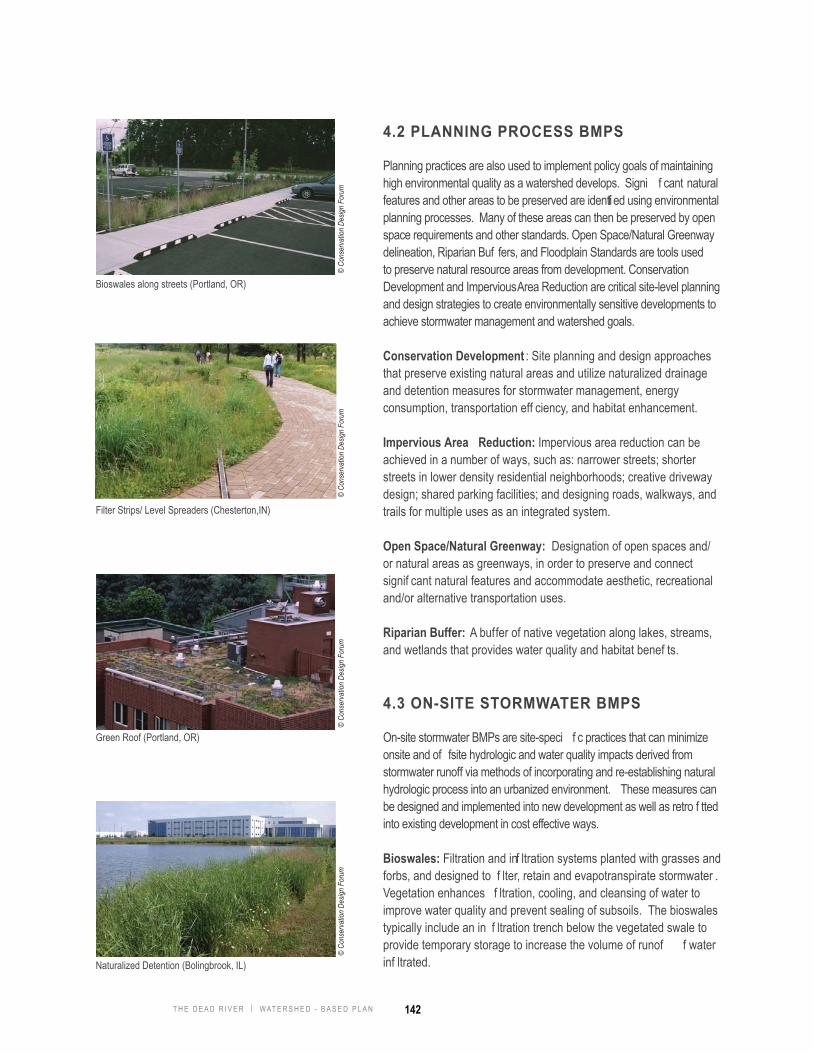
Bioswales: Filtration and inf ltration systems planted with grasses and forbs, and designed to f lter, retain and evapotranspirate stormwater . Vegetation enhances f ltration, cooling, and cleansing of water to improve water quality and prevent sealing of subsoils. The bioswales typically include an in f ltration trench below the vegetated swale to provide temporary storage to increase the volume of runof f water inf ltrated.
Bioswales along streets (Portland, OR)
Filter Strips/ Level Spreaders (Chesterton,IN)
Green Roof (Portland, OR)
Naturalized Detention (Bolingbrook, IL)
© Co
nser
vatio
n De
sign
Foru
m©
Cons
erva
tion
Desig
n Fo
rum
© Co
nser
vatio
n De
sign
Foru
m©
Cons
erva
tion
Desig
n Fo
rum

143 T H E D E A D R I V E R | W AT E R S H E D - B A S E D P L A N
Filter Strips/Level Spreaders: Filter strips are an area of dense, preferably native, vegetative cover used to f lter and absorb runof f. Level spreaders are often used in conjunction with f lter strips and are laid on the contour to distribute runof f over f lter strip areas. Filter strips/level spreaders can be used within stream and wetland buf fers to diffuse stormwater prior to discharge to streams and wetlands.
Green Roofs: Vegetated roof system designed to capture, temporarily store, and evapotranspirate rainwater on the top of roofs. Typically, green roofs are planted with drought and wind tolerant vegetation. Green roofs can be designed as simple, lightweight systems that provide stormwater bene f ts, or as more elaborate rooftop gardens that also provide outdoor space.
Naturalized Detention: Naturalized detention basins are used to temporarily store runoff and release it at a rate allowed by ordinances. Native wetland and prairie vegetation improves water quality and habitat bene f ts. Naturalized detention basins can be designed as either shallow marsh systems with little or no open water or as open water ponds with a wetland fringe and prairie side slopes.
Porous Pavement: Permeable or perforated paving materials with spaces that allow for the in f ltration of rainwater and the transmission of water to aggregate base and subsoils. Runoff is temporarily stored in the base for in f ltration into the subsoils and/or slow release to a bioswale or stormwater system.
Rain Barrels/Cisterns: A vessel used to capture and temporarily store rainwater for various uses, including landscape irrigation, reuse for graywater purposes, etc.
Rain gardens: A landscaped garden designed to retain, detain, inf ltrate and evapotranspirate stormwater runof f from individual lots and roofs.
Vegetated Swales: V egetated stormwater features that convey , retain, inf ltrate and cleanse stormwater . Native vegetation enhances f ltration and retention of stormwater.
Rain Barrel (Chicago, IL)
Rain garden (Maplewood, MN)
Vegetated Swales (Madison, WI)
Porous Pavement (Elmhurst, IL)
© Co
nser
vatio
n De
sign
Foru
m©
Cons
erva
tion
Desig
n Fo
rum
© Co
nser
vatio
n De
sign
Foru
m©
Cons
erva
tion
Desig
n Fo
rum

144T H E D E A D R I V E R | W AT E R S H E D - B A S E D P L A N
4.4 LANDSCAPING BMPS
Landscaping, as a BMP , stands alone in its own category due to the importance of vegetation in biodiversity , aesthetics, habitat, cooling of ambient air, and stormwater management. Native landscapes, including native prairies and wetlands, can improve water quality through in f ltration and cleansing of stormwater runof f. Properly designed landscapes that incorporate native plants and hydrologically and ecologically appropriate vegetation can not only facilitate effectiveness of stormwater management but also provide wildlife habitat and quality open space.
Native Landscaping: Native vegetation in either large restoration or smaller garden projects. Native vegetation uses plants that are endemic to a specif c geographic region prior to European settlement. Native landscapes can serve a variety of purposes, including habitat, inf ltration, f ltering, and evapotranspiration of stormwater, and wildlife habitat.
Stream/Wetlands Management and Restoration: Landscape restoration practices that maintain existing remnant landscapes and/or restore them to thier natural state.
4.5 FLOOD REDUCTION BMPS
Structural Flood Control: Structural measures control or contain water and are generally designed to prevent f oodwaters from reaching buildings. Structural alternatives generally include reservoirs, levees and f oodwalls, diversions, stream channel conveyance improvements and drainage and storm sewer improvements. Because of their size and cost, structural projects are often implemented with help from state or federal f ood control agencies such as the Illinois Department of Natural Resources - Of f ce of Water Resources, or the U.S. Army Corps of Engineers.
Non-Structural Flood Control: In addition to structural controls for f ood remediation, f ooding problems can also be addressed using non-structural means. Some of the non-structural f ood control techniques include f oodproof ng, acquisition of f oodplain buildings, building elevation and building relocation. More communities and county-wide agencies could get involved in non-structural programs such as acquisition by helping to identify repetitively f ooded properties.
Native Landscaping (Geneva, IL)©
Cons
erva
tion
Desig
n Fo
rum

145 T H E D E A D R I V E R | W AT E R S H E D - B A S E D P L A N
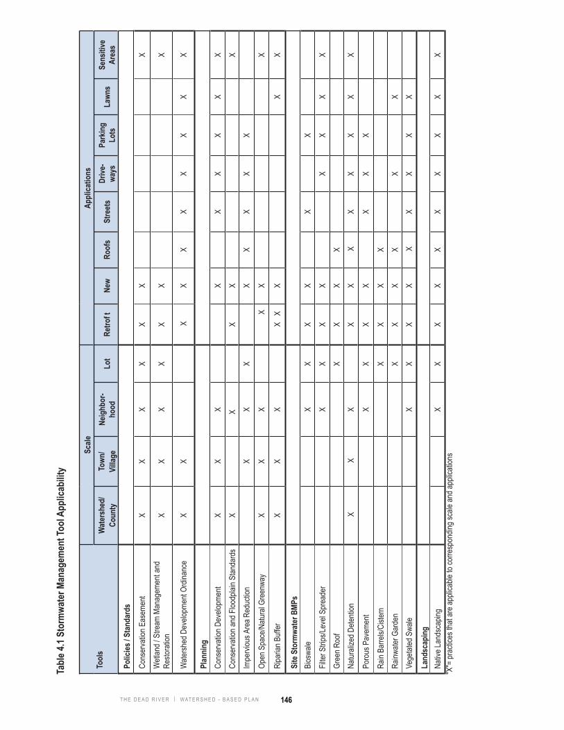
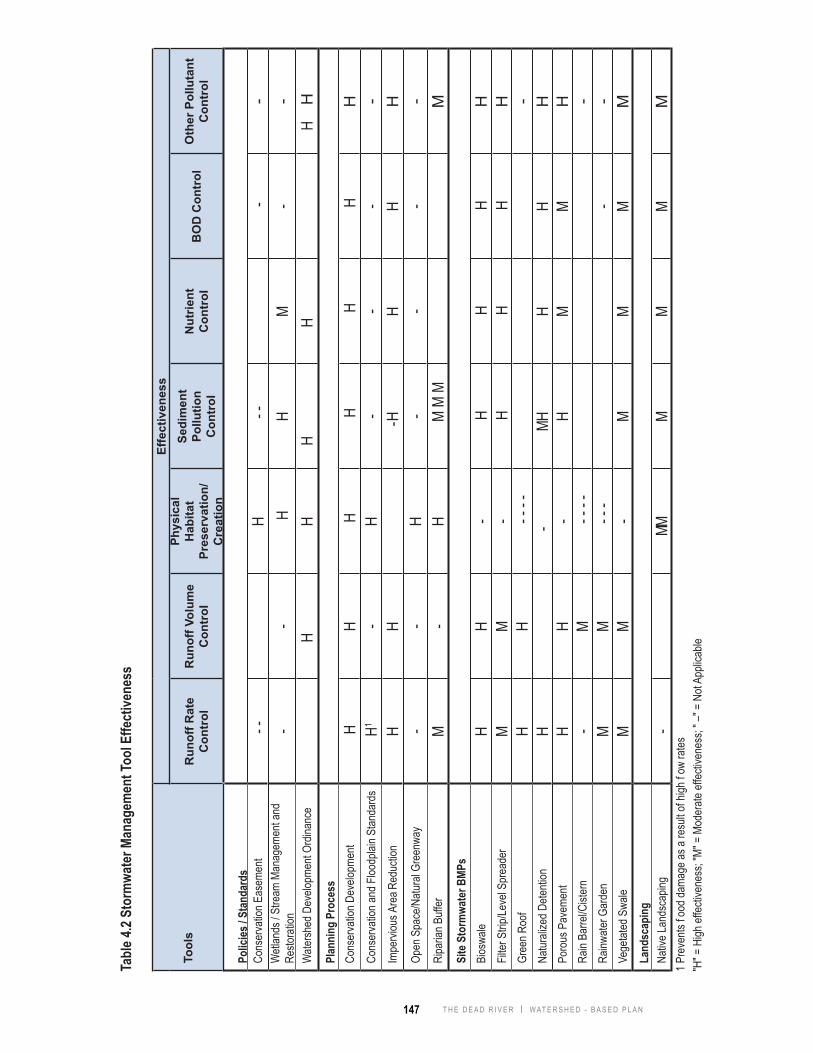
Tables 4.1 and 4.2 summarize the stormwater management tool applicability and ef fectiveness for each of the best management practices described in this toolbox. Following these tables is a vignette for each of the BMPs that begins with its de f nition and continues with its range of applicability, associated benef ts, and f nally some potential design considerations, as described below.
Def nition - A brief description of the BMP relative to stormwater management.
Applicability - Where and how each BMP is the most applicable is addressed in three aspects: scale, applicable applications, and effectiveness:
Scale• Watershed/County: Applied at a regional scale in watershed or county-wide.• Town/Village: Applied at municipal or other scale with common zoning authority.• Neighborhood: Applied at development or other sub-municipal scale.• Lot: Applied within individual residential lot or commercial parcel.
Applications• Retrof t: Applied to existing developed areas, inf ll, and redevelopment.• New: Applied to new development.• Roofs: Applied on roofs or used to treat roof runoff.• Streets: Applied on or used to treat runoff from public/private streets and roads.• Driveways: Applied on or used to treat runoff from driveways.• Parking Lots: Applied on or used to treat runoff from parking lots.• Lawns: Applied on or used to treat runof f from existing open lawns that are generally planted with turfs, such as parks,
campuses, individual yards, etc.• Sensitive Areas: Applied on ecologically sensitive areas such as remnant habitats, f oodplains, wetlands, steep slopes,
and highly erodible soils.
Effectiveness• Runoff Rate Control: Practices that can control or reduce runoff rates.• Runoff Volume Control: Practices that can control or reduce runoff volumes.• Physical Habitat Preservation/Creation: Practices that can preserve, introduce, or provide wildlife habitats.• Sediment Pollution Control: Practices that can remove suspended solids from runoff.• Nutrient Control: Practices that have the ability to reduce or remove nutrients such as nitrogen and phosphorus from
runoff.• BOD Control: Practices that can remove constituents that exert a Biological Oxygen Demand (BOD) in runoff.• Other Pollutant Control: Practices that can reduce and remove other pollutants such as heavy metals and petroleum-
based hydrocarbons. Benef ts - Other positive ef fects that the individual or system of practices performs. Bene f ts can be speci f c to stormwater management or be more general to various functions and values for the quality of life.
Design Considerations - Design recommendations and suggestions that should be considered when implementing the speci f c BMP. Drawings are not illustrated for construction, but rather as a general guidance on the components of the practice.
146T H E D E A D R I V E R | W AT E R S H E D - B A S E D P L A N
Tabl
e 4.1
Stor
mwa
ter M
anag
emen
t Too
l App
licab
ility
Tool
sSc
aleAp
plica
tions
W
ater
shed
/Co
unty
Town
/Vi
llage
Neig
hbor
-ho
odLo
tRe
trof t
New
Roof
sSt
reet
sDr
ive-
ways
Park
ing
Lots
Lawn
sSe
nsiti
ve
Area
s
Polic
ies / S
tand
ards
Cons
erva
tion E
asem
ent
XX
XX
XX
XW
etlan
d / S
tream
Man
agem
ent a
nd
Resto
ratio
nX
XX
XX
X
X
Wate
rshed
Dev
elopm
ent O
rdina
nce
XX
XX
XX
XX
XX
Plan
ning
Cons
erva
tion D
evelo
pmen
tX
XX
X
XX
XX
XCo
nser
vatio
n and
Floo
dplai
n Stan
dard
sX
X
X
X
X
Impe
rviou
s Are
a Red
uctio
n
XX
X
XX
XX
X
Open
Spa
ce/N
atura
l Gre
enwa
yX
XX
X
X
X
Ripa
rian B
uffer
XX
X
XX
X
X
X
Site
Sto
rmwa
ter B
MPs
Bios
wale
X
XX
X
XX
Filter
Strip
s/Lev
el Sp
read
er
X
XX
X
XX
XX
Gree
n Roo
f
XX
XX
Na
turali
zed D
etenti
on X
XX
X
X X
XX
XX
X
Poro
us P
avem
ent
XX
XX
XX
X
Rain
Barre
ls/Ci
stern
X
XX
X
Rainw
ater G
arde
n
XX
XX
X
X
Vege
tated
Swa
le
X
XX
X X
XX
XX
Land
scap
ing
Nativ
e Lan
dsca
ping
XX
XX
XX
XX
XX
"X"=
prac
tices
that
are a
pplic
able
to co
rresp
ondin
g sca
le an
d app
licati
ons
147 T H E D E A D R I V E R | W AT E R S H E D - B A S E D P L A N
Tabl
e 4.2
Stor
mwa
ter M
anag
emen
t Too
l Effe
ctive
ness
Tool
s
Effe
ctiv
enes
s
Run
off R
ate
Con
trol
Run
off V
olum
e C
ontr
ol
Phys
ical
H
abita
t Pr
eser
vatio
n/C
reat
ion
Sedi
men
t Po
llutio
n C
ontr
ol
Nut
rient
C
ontr
olB
OD
Con
trol
Oth
er P
ollu
tant
C
ontr
ol
Polic
ies / S
tand
ards
Cons
erva
tion E
asem
ent
- -
H- -
-
- W
etlan
ds / S
tream
Man
agem
ent a
nd
Resto
ratio
n-
- H
HM
--
Wate
rshed
Dev
elopm
ent O
rdina
nce
H
H
H
H
H
H H
Plan
ning
Pro
cess
Co
nser
vatio
n Dev
elopm
ent
HH
HH
H H
H
Cons
erva
tion a
nd F
loodp
lain S
tanda
rds
H1
-H
--
--
Impe
rviou
s Are
a Red
uctio
nH
H
-HH
HH
Open
Spa
ce/N
atura
l Gre
enwa
y-
-H
--
--
Ripa
rian B
uffer
M-
HM
M M
M
Site
Sto
rmwa
ter B
MPs
Bios
wale
HH
- H
HH
HFil
ter S
trip/Le
vel S
prea
der
MM
- H
HH
HGr
een R
oof
HH
- - -
- -
Natur
alize
d Dete
ntion
H
-MH
HH
HPo
rous
Pav
emen
tH
H-
HM
MH
Rain
Barre
l/Cist
ern
-M
- - -
- -
Rainw
ater G
arde
nM
M- -
--
- Ve
getat
ed S
wale
MM
-M
MM
MLa
ndsc
apin
g
Nativ
e Lan
dsca
ping
-
MMM
MM
M1 P
reve
nts f o
od da
mage
as a
resu
lt of h
igh f o
w ra
tes"H
" = H
igh ef
fectiv
enes
s; "M
" = M
oder
ate ef
fectiv
enes
s; " –
" = N
ot Ap
plica
ble

148T H E D E A D R I V E R | W AT E R S H E D - B A S E D P L A N
Preserves signif cant natural features and open space.Preserves created/restored natural areas from development and other disturbances.Provides opportunity to preserve morphologically and ecologically-based corridors that may be more dif f cult to preserve with f xed width buf fers in many stormwater ordinances.Can be used as a tool to create interconnected network of open space to improve ecological functioning of overall system.
Def nitionLegal mechanism for landowner to place voluntary restrictions on the future use of their land. Generally requires landowner to sell, permanently relinquish, or donate the rights of development.
Benef ts
Design Considerations
Conservation Easement
Conservation easements, along with f oodplain/open space zoning, ordinance buf fer requirements, and conservation design should be used to preserve and create natural resource networks.Conservation easements are best suited to areas not subject to land use change and therefore cannot readily be preserved through the development process.Conservation easements may also be used to preserve high quality uplands and other areas not readily preserved through zoning and/or stormwater ordinances.
Polic
ies/
Stan
dard
s
conservation easements provide mechanism for long term preservation of morphologically-based corridors
one’s backyard may be wildlife’s treasure habitat
ApplicabilityScale
Effectiveness
Watershed/County
Roofs Streets
Parking Lots Lawn
Applications Retro f t New
Town/Village Neighborhood Lot
Driveways
Sensitive Areas
Runoff Rate Control
Runoff Volume Control
Nutrient Control
BOD Control
Physical Habitat Preservation/CreationOther Pollutant Control
Sediment Pollution Control
Preventive Remedial Ongoing/ Maintenance
© Co
nser
vatio
n De
sign
Foru
m©

149 T H E D E A D R I V E R | W AT E R S H E D - B A S E D P L A N
Coffee Creek streambank restoration (Chesterton, IN) (Conservation Design Forum)
a successful wetland restoration ensures the healthiness of ecosystems and improves quality of life for both human and wildlife
Benef tsPreserves signi f cant natural features and their habitat, runof f moderation, and water quality benef ts.Reduces the impact to natural systems by f oods and other natural perturbations and improves recovery from these disturbances by preserving natural processes and functions.
Design ConsiderationsConduct a thorough analysis of existing and historic conditions of the restoration site, surrounding area, and watershed to understand system processes and functions.Establish stewardship program with local governments, stakeholders, interest groups, and communities to ensure sustained management and monitoring ef forts on managed/restored ecosystems. Management and stewardship activities should be recognized as ongoing activities. Intensiveness of stewardship activities will decrease as system health and processes are restored.
Def nitionPractices that maintain a healthy ecosystem and/or restore a deteriorated ecosystem to its natural state.
Wetland / Stream Management & Restoration Management
Polic
ies/
Stan
dard
s
ApplicabilityScale
Effectiveness
Watershed/County
Roofs Streets
Parking Lots Lawn
Applications Retro f t New
Town/Village Neighborhood Lot
Driveways
Sensitive Areas
Runoff Rate Control
Runoff Volume Control
Nutrient Control
BOD Control
Physical Habitat Preservation/Creation
Other Pollutant Control
Sediment Pollution Control
Preventive Remedial Ongoing/ Maintenance
© Co
nser
vatio
n De
sign
Foru
m©
Cons
erva
tion
Desig
n Fo
rum

150T H E D E A D R I V E R | W AT E R S H E D - B A S E D P L A N
Watershed DevelopmentOrdinanceDef nition
Ordinance to regulate development for the purpose of minimizing on-site and off-site impacts to f ooding and water quality.
watershed development ordinances are designed to preserve and enhance natural site features and protect downstream areas from stormwater impacts
Benef tsProvides consistent standard throughout watershed.Prevents/minimizes degradation of watershed resources. Establishes orderly rules and procedures for development activities.
Design ConsiderationsOrdinances should comprehensively address stormwater management, f oodplain management, stream and wetland preservation, and soil erosion and sediment control.Ordinances should include standards to address runof f volumes, runof f rates, and water quality. Ordinances should provide f exibility in methods of meeting standards.Ordinances should facilitate watershed resources restoration activities.
Polic
ies/
Stan
dard
s
the watershed development ordinance is a critical element of the Dead River Watershed Management Plan
(Conservation Design Forum)
comprehensive land use plan
ApplicabilityScale
Effectiveness
Watershed/County
Roofs Streets
Parking Lots Lawn
Applications Retro f t New
Town/Village Neighborhood Lot
Driveways
Sensitive Areas
Runoff Rate Control
Runoff Volume Control
Nutrient Control
BOD Control
Physical Habitat Preservation/CreationOther Pollutant Control
Sediment Pollution Control
Preventive Remedial Ongoing/ Maintenance
© Co
nser
vatio
n De
sign
Foru
m©
Cons
erva
tion
Desig
n Fo
rum

151 T H E D E A D R I V E R | W AT E R S H E D - B A S E D P L A N
conservation moderate density residential site plan (Conservation Design Forum)
Def nitionSite planning and design approach that preserves existing natural areas and utilizes naturalized drainage and detention measures for stormwater management, energy consumption, transportation eff ciency, and habitat enhancement.
Benef tsPreserves signif cant natural features and open space.Minimizes changes in runof f volumes, rates, and water quality typically associated with urban development.Improves views and site aesthetics, while at the same time providing site drainage and water quality functions.
Design ConsiderationsOn-site natural areas should be identif ed and preserved. Existing natural drainageways should be incorporated into site plan.Roadway should generally follow ridge lines.Impervious runoff should be routed through naturalized drainage systems integrated into the site plan.Use of native vegetation adapted to expected hydrologic conditions will improve runoff reduction and water quality benef ts.Naturalized drainage systems should be preserved from construction site runoff during establishment.
Conservation Development
Plan
ning
residential conservation development (Grayslake, IL)
ApplicabilityScale
Effectiveness
Watershed/County
Roofs Streets
Parking Lots Lawn
Applications Retro f t New
Town/Village Neighborhood Lot
Driveways
Sensitive Areas
Runoff Rate Control
Runoff Volume Control
Nutrient Control
BOD Control
Physical Habitat Preservation/CreationOther Pollutant Control
Sediment Pollution Control
Preventive Remedial Ongoing/ Maintenance
© Co
nser
vatio
n De
sign
Foru
m©
Cons
erva
tion
Desig
n Fo
rum

152T H E D E A D R I V E R | W AT E R S H E D - B A S E D P L A N
Floodplain ZoningDef nition
Zoning regulations established to preserve stream corridors and f oodplains from urban development and other encroachments.
f oodplain zoning overlays underlying zoning (source: SEMCOG)
Benef tsPreserves stream corridors and riparian wetlands and provides natural buffer.Enhances safety and quality of life.Protects properties from f ood damages.Preserves natural f oodplain functions.
Design ConsiderationsZoning regulations should allow for and encourage riparian corridor restoration.
Plan
ning
f oodplain zoning prevents development from occurring in f oodprone areas
ApplicabilityScale
Effectiveness
Watershed/County
Roofs Streets
Parking Lots Lawn
Applications Retro f t New
Town/Village Neighborhood Lot
Driveways
Sensitive Areas
Runoff Rate Control
Runoff Volume Control
Nutrient Control
BOD Control
Physical Habitat Preservation/CreationOther Pollutant Control
Sediment Pollution Control
Preventive Remedial Ongoing/ Maintenance

153 T H E D E A D R I V E R | W AT E R S H E D - B A S E D P L A N
Impervious AreaReductionDef nition
Impervious area reduction can be achieved by reducing street widths and building setbacks, examining parking lot requirements, and through building design alternatives.
Benef tsReduces runoff volumes and rates and associated pollutants.Reduces urban heat island ef fect and thermal impacts to waterbodies.Reduces development and maintenance costs.
Design ConsiderationsImpervious area reductions can be achieved through reduced road widths, shared parking, reduced setbacks, and other measures. These reductions will often require changes in subdivision code.Street length can often be reduced by clustering development onto portions of the site.Benef ts of impervious area reduction are enhanced when combined with methods to “disconnect” impervious surfaces, e.g. vegetated swales, bioswales, f lter strips/level spreaders, etc.
Plan
ning
reduce impervious areas by reducing street width (Seattle, WA)
impervious areas reduced by lessening road length through clustering of development (Plano, IL) (Conservation Design Forum)
ApplicabilityScale
Effectiveness
Watershed/County
Roofs Streets
Parking Lots Lawn
Applications Retro f t New
Town/Village Neighborhood Lot
Driveways
Sensitive Areas
Runoff Rate Control
Runoff Volume Control
Nutrient Control
BOD Control
Physical Habitat Preservation/CreationOther Pollutant Control
Sediment Pollution Control
Preventive Remedial Ongoing/ Maintenance
© Co
nser
vatio
n De
sign
Foru
m

154T H E D E A D R I V E R | W AT E R S H E D - B A S E D P L A N
Open Space / Natural GreenwayDef nition
Designation of linear open space and/or natural areas as greenways to preserve and connect signi f cant natural features and to accommodate aesthetic, recreational, and/or transportation uses.
Benef tsPreserves large contiguous natural areas and resources.Provides opportunity for wildlife movement and habitat within an ecological network.Provides alternative and connected passive recreation and transportation opportunities.
Design ConsiderationsA natural resources inventory should be completed to identify signif cant natural features and functioning ecological networks.Signif cant cultural features should also be integrated into the network.Buffer requirements, open space/ f oodplain zoning, conservation easements, and conservation design should be used together to implement greenway networks.
Plan
ning
an open space/natural greenway system is designated to preserve key natural resources in the Dead River W atershed Area
(Conservation Design Forum)
open space greenways can provide recreational as well as habitat and water quality benef ts
ApplicabilityScale
Effectiveness
Watershed/County
Roofs Streets
Parking Lots Lawn
Applications Retro f t New
Town/Village Neighborhood Lot
Driveways
Sensitive Areas
Runoff Rate Control
Runoff Volume Control
Nutrient Control
BOD Control
Physical Habitat Preservation/CreationOther Pollutant Control
Sediment Pollution Control
Preventive Remedial Ongoing/ Maintenance
© Co
nser
vatio
n De
sign
Foru
m©
Cons
erva
tion
Desig
n Fo
rum

155 T H E D E A D R I V E R | W AT E R S H E D - B A S E D P L A N
riparian buffers preserve riparian habitat
Riparian BufferDef nition
A buffer of native vegetation along lakes, streams, and wetlands that provides water quality and habitat benef ts.
Benef tsPreserves natural functions of lakes, streams, and wetlands.Naturally attenuates f ow rates.Provides f ltering of lateral surface and groundwater inf ows.Helps stabilize streambanks and shorelines against erosion.
Design ConsiderationsRiparian buf fer width should be dependent on lake, stream, or wetland quality, ground slope, and size of feature.Buffer should be planted with native riparian vegetation.Buffers are often established/ preserved through a watershed development ordinance.
Plan
ning
25 ft min. setbackouter zone
stream
foot path
50-100 ft middle zone
25 ft min. streamside zone
bike path
the three-zone urban stream buffer system (source: Center for Watershed Protection)
buffers of native vegetation along streams and wetlands provide natural stabilization and pollutant f ltering
ApplicabilityScale
Effectiveness
Watershed/County
Roofs Streets
Parking Lots Lawn
Applications Retro f t New
Town/Village Neighborhood Lot
Driveways
Sensitive Areas
Runoff Rate Control
Runoff Volume Control
Nutrient Control
BOD Control
Physical Habitat Preservation/CreationOther Pollutant Control
Sediment Pollution Control
Preventive Remedial Ongoing/ Maintenance
© Co
nser
vatio
n De
sign
Foru
m©
Cons
erva
tion
Desig
n Fo
rum

156T H E D E A D R I V E R | W AT E R S H E D - B A S E D P L A N
Bioswale Def nition
Vegetated swale system with an in f ltration trench designed to retain and temporarily store stormwater . Bioswales are planted with native grasses and forbs that enhance f ltration, cooling, and cleansing of water in order to improve water quality and prevent sealing of subsoils.
Benef ts
Design Considerations
Site
Sto
rmw
ater
BM
Ps
Reduces impervious runoff volumes and rates.Recharges groundwater and sustains base f ows.Reduces sediment and nutrient runoff.Can reduce detention needs.
Bioswales must be sized and designed to account for drainage area and soils.Filtration bene f ts can be improved by planting native deep-rooted vegetation.Inf ltration storage should be designed to drain in 24 hours to prevent sealing of subsoils.Topsoil should be amended with compost and/or sand to improve organic content for f ltering and to achieve adequate inf ltration rates.Bioswales should be protected from construction site runof f to prevent sealing of topsoil and/or subsoils.Direct entry of stormwater runof f into in f ltration trench should be prevented to preserve groundwater quality and to prevent sealing of subsoils.Underdrain should be suf f ciently low in the trench to provide adequate drainage of aggregate base of adjacent paved areas but suff ciently high to provide inf ltration storage.
6’-0” bioswale
sand/soil/compost mix
perforated underdrain
cross section of bioswale (Conservation Design Forum)
bioswale in a parking lot (Tellabs, Napeville, IL)(Conservation Design Forum)
inf ltration trench
Vegetated swale system with an in f ltration trench designed to retain and temporarily store stormwater . Bioswales are planted with native grasses and forbs that enhance f ltration, cooling, and cleansing of water in order to improve water quality and prevent sealing of subsoils.
ApplicabilityScale
Effectiveness
Watershed/County
Roofs Streets
Parking Lots Lawn
Applications Retro f t New
Town/Village Neighborhood Lot
Driveways
Sensitive Areas
Runoff Rate Control
Runoff Volume Control
Nutrient Control
BOD Control
Physical Habitat Preservation/CreationOther Pollutant Control
Sediment Pollution Control
Preventive Remedial Ongoing/ Maintenance
© Co
nser
vatio
n De
sign
Foru
m©
Cons
erva
tion
Desig
n Fo
rum
157 T H E D E A D R I V E R | W AT E R S H E D - B A S E D P L A N
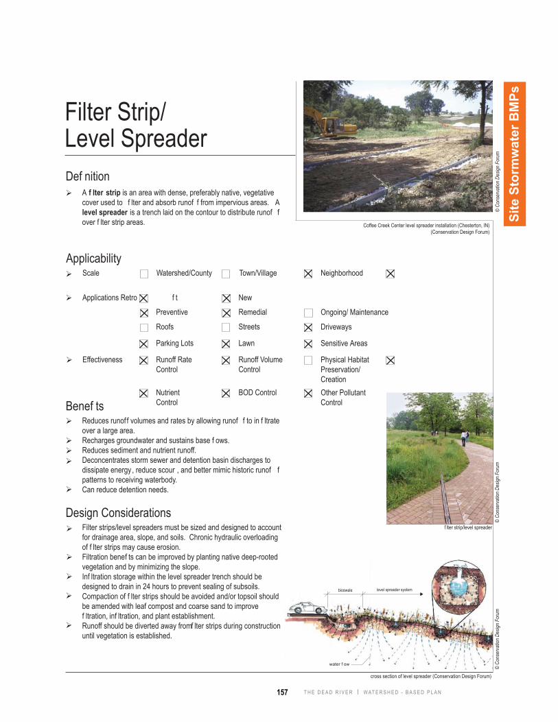
Filter Strip/Level Spreader Def nition
A f lter strip is an area with dense, preferably native, vegetative cover used to f lter and absorb runof f from impervious areas. A level spreader is a trench laid on the contour to distribute runof f over f lter strip areas.
Benef ts
Design ConsiderationsSi
te S
torm
wat
er B
MPs
Reduces runof f volumes and rates by allowing runof f to in f ltrate over a large area.Recharges groundwater and sustains base f ows.Reduces sediment and nutrient runoff.Deconcentrates storm sewer and detention basin discharges to dissipate energy , reduce scour , and better mimic historic runof f patterns to receiving waterbody.Can reduce detention needs.
Filter strips/level spreaders must be sized and designed to account for drainage area, slope, and soils. Chronic hydraulic overloading of f lter strips may cause erosion.Filtration benef ts can be improved by planting native deep-rooted vegetation and by minimizing the slope.Inf ltration storage within the level spreader trench should be designed to drain in 24 hours to prevent sealing of subsoils. Compaction of f lter strips should be avoided and/or topsoil should be amended with leaf compost and coarse sand to improve f ltration, inf ltration, and plant establishment.Runoff should be diverted away from f lter strips during construction until vegetation is established.
Coffee Creek Center level spreader installation (Chesterton, IN)(Conservation Design Forum)
f lter strip/level spreader
cross section of level spreader (Conservation Design Forum)
bioswale level spreader system
water f ow
ApplicabilityScale
Effectiveness
Watershed/County
Roofs Streets
Parking Lots Lawn
Applications Retro f t New
Town/Village Neighborhood
Driveways
Sensitive Areas
Runoff Rate Control
Runoff Volume Control
Nutrient Control
BOD Control
Physical Habitat Preservation/CreationOther Pollutant Control
Preventive Remedial Ongoing/ Maintenance
© Co
nser
vatio
n De
sign
Foru
m©
Cons
erva
tion
Desig
n Fo
rum
© Co
nser
vatio
n De
sign
Foru
m
158T H E D E A D R I V E R | W AT E R S H E D - B A S E D P L A N
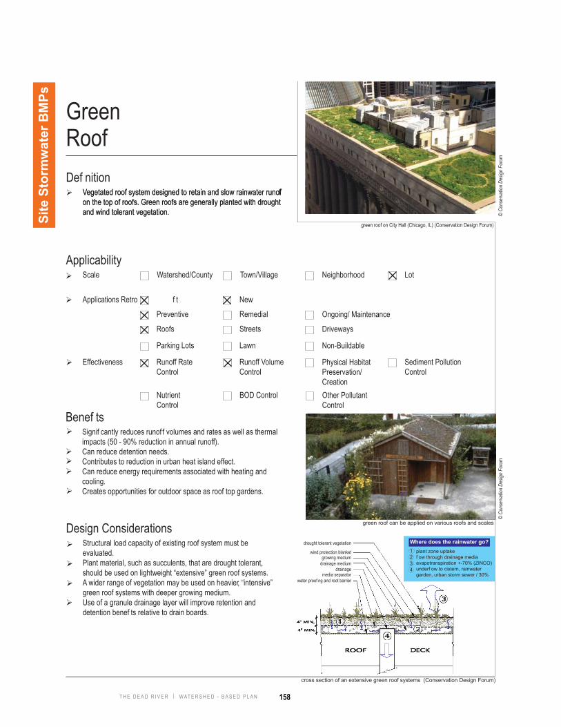
Green Roof Def nition
Vegetated roof system designed to retain and slow rainwater runoff on the top of roofs. Green roofs are generally planted with drought and wind tolerant vegetation.
cross section of an extensive green roof systems (Conservation Design Forum)
Benef tsSignif cantly reduces runof f volumes and rates as well as thermal impacts (50 - 90% reduction in annual runoff).Can reduce detention needs.Contributes to reduction in urban heat island effect.Can reduce energy requirements associated with heating and cooling. Creates opportunities for outdoor space as roof top gardens.
Design ConsiderationsStructural load capacity of existing roof system must be evaluated. Plant material, such as succulents, that are drought tolerant, should be used on lightweight “extensive” green roof systems.A wider range of vegetation may be used on heavier, “intensive” green roof systems with deeper growing medium.Use of a granule drainage layer will improve retention and detention benef ts relative to drain boards.
Site
Sto
rmw
ater
BM
Ps
green roof can be applied on various roofs and scales
green roof on City Hall (Chicago, IL) (Conservation Design Forum)
drought tolerant vegetation
wind protection blanketgrowing medium
drainage mediumdrainage
media separatorwater proof ng and root barrier
plant zone uptakef ow through drainage mediaevapotranspiration +-70% (ZINCO)underf ow to cistern, rainwater garden, urban storm sewer / 30%
1234
Where does the rainwater go?
Vegetated roof system designed to retain and slow rainwater runoff on the top of roofs. Green roofs are generally planted with drought and wind tolerant vegetation.
ApplicabilityScale
Effectiveness
Watershed/County
Roofs Streets
Parking Lots Lawn
Applications Retro f t New
Town/Village Neighborhood Lot
Driveways
Non-Buildable
Runoff Rate Control
Runoff Volume Control
Nutrient Control
BOD Control
Physical Habitat Preservation/CreationOther Pollutant Control
Sediment Pollution Control
Preventive Remedial Ongoing/ Maintenance
© Co
nser
vatio
n De
sign
Foru
m©
Cons
erva
tion
Desig
n Fo
rum
159 T H E D E A D R I V E R | W AT E R S H E D - B A S E D P L A N
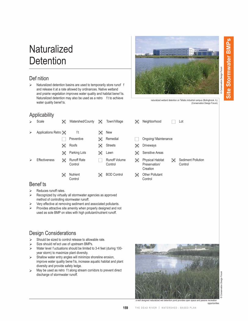
NaturalizedDetentionDef nition
Naturalized detention basins are used to temporarily store runof f and release it at a rate allowed by ordinances. Native wetland and prairie vegetation improves water quality and habitat bene f ts. Naturalized detention may also be used as a retro f t to achieve water quality benef ts.
naturalized wetland detention on Tellabs industrial campus (Bolingbrook, IL)(Conservation Design Forum)
Benef tsReduces runoff rates.Recognized by virtually all stormwater agencies as approved method of controlling stormwater runoff.Very effective at removing sediment and associated pollutants.Provides attractive site amenity when properly designed and not used as sole BMP on sites with high pollutant/nutrient runoff.
Design ConsiderationsShould be sized to control release to allowable rate.Size should ref ect use of upstream BMPs.Water level f uctuations should be limited to 3-4 feet (during 100-year storm) to maximize plant diversity.Shallow water entry angles will minimize shoreline erosion, improve water quality bene f ts, increase aquatic habitat and plant diversity and provide safety ledge.May be used as retro f t along stream corridors to prevent direct discharge of stormwater runoff.
Site
Sto
rmw
ater
BM
Ps
a well designed naturalized wet detention pond provides open space and passive recreation opportunities
ApplicabilityScale
Effectiveness
Watershed/County
Roofs Streets
Parking Lots Lawn
Applications Retro f t New
Town/Village Neighborhood Lot
Driveways
Sensitive Areas
Runoff Rate Control
Runoff Volume Control
Nutrient Control
BOD Control
Physical Habitat Preservation/CreationOther Pollutant Control
Sediment Pollution Control
Preventive Remedial Ongoing/ Maintenance
© Co
nser
vatio
n De
sign
Foru
m©
Cons
erva
tion
Desig
n Fo
rum
160T H E D E A D R I V E R | W AT E R S H E D - B A S E D P L A N
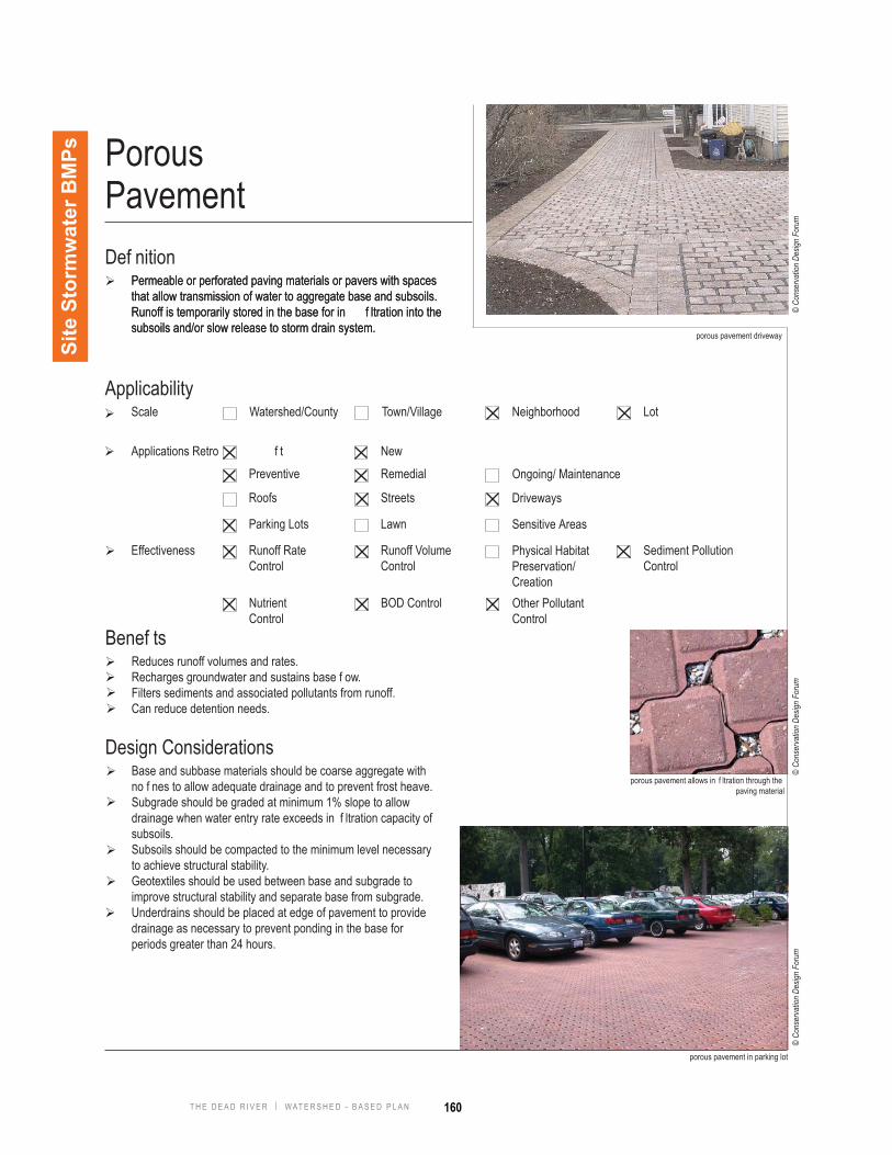
Porous PavementDef nition
Permeable or perforated paving materials or pavers with spaces that allow transmission of water to aggregate base and subsoils. Runoff is temporarily stored in the base for in f ltration into the subsoils and/or slow release to storm drain system.
porous pavement driveway
porous pavement allows in f ltration through the paving material
porous pavement in parking lot
Benef tsReduces runoff volumes and rates.Recharges groundwater and sustains base f ow.Filters sediments and associated pollutants from runoff.Can reduce detention needs.
Design ConsiderationsBase and subbase materials should be coarse aggregate with no f nes to allow adequate drainage and to prevent frost heave.Subgrade should be graded at minimum 1% slope to allow drainage when water entry rate exceeds in f ltration capacity of subsoils.Subsoils should be compacted to the minimum level necessary to achieve structural stability. Geotextiles should be used between base and subgrade to improve structural stability and separate base from subgrade.Underdrains should be placed at edge of pavement to provide drainage as necessary to prevent ponding in the base for periods greater than 24 hours.
Site
Sto
rmw
ater
BM
Ps
Permeable or perforated paving materials or pavers with spaces that allow transmission of water to aggregate base and subsoils. Runoff is temporarily stored in the base for in f ltration into the subsoils and/or slow release to storm drain system.
ApplicabilityScale
Effectiveness
Watershed/County
Roofs Streets
Parking Lots Lawn
Applications Retro f t New
Town/Village Neighborhood Lot
Driveways
Sensitive Areas
Runoff Rate Control
Runoff Volume Control
Nutrient Control
BOD Control
Physical Habitat Preservation/CreationOther Pollutant Control
Sediment Pollution Control
Preventive Remedial Ongoing/ Maintenance
© Co
nser
vatio
n De
sign
Foru
m©
Cons
erva
tion
Desig
n Fo
rum
© Co
nser
vatio
n De
sign
Foru
m
161 T H E D E A D R I V E R | W AT E R S H E D - B A S E D P L A N
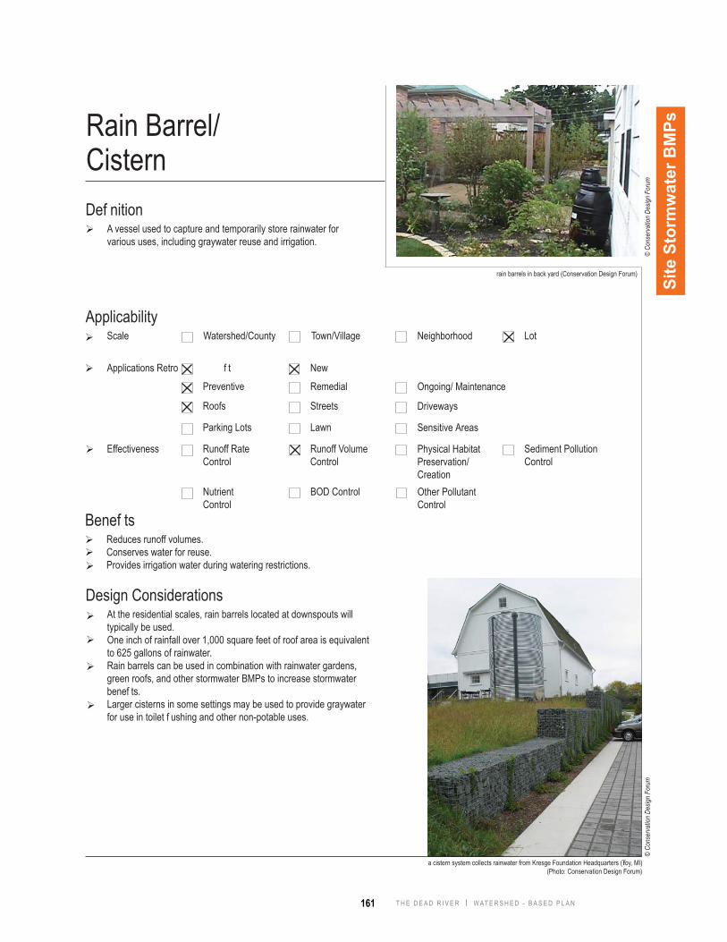
Rain Barrel/ CisternDef nition
A vessel used to capture and temporarily store rainwater for various uses, including graywater reuse and irrigation.
rain barrels in back yard (Conservation Design Forum)
a cistern system collects rainwater from Kresge Foundation Headquarters (Troy, MI) (Photo: Conservation Design Forum)
Benef tsReduces runoff volumes.Conserves water for reuse.Provides irrigation water during watering restrictions.
Design ConsiderationsAt the residential scales, rain barrels located at downspouts will typically be used. One inch of rainfall over 1,000 square feet of roof area is equivalent to 625 gallons of rainwater.Rain barrels can be used in combination with rainwater gardens, green roofs, and other stormwater BMPs to increase stormwater benef ts.Larger cisterns in some settings may be used to provide graywater for use in toilet f ushing and other non-potable uses.
Site
Sto
rmw
ater
BM
Ps
ApplicabilityScale
Effectiveness
Watershed/County
Roofs Streets
Parking Lots Lawn
Applications Retro f t New
Town/Village Neighborhood Lot
Driveways
Sensitive Areas
Runoff Rate Control
Runoff Volume Control
Nutrient Control
BOD Control
Physical Habitat Preservation/CreationOther Pollutant Control
Sediment Pollution Control
Preventive Remedial Ongoing/ Maintenance
© Co
nser
vatio
n De
sign
Foru
m©
Cons
erva
tion
Desig
n Fo
rum
162T H E D E A D R I V E R | W AT E R S H E D - B A S E D P L A N
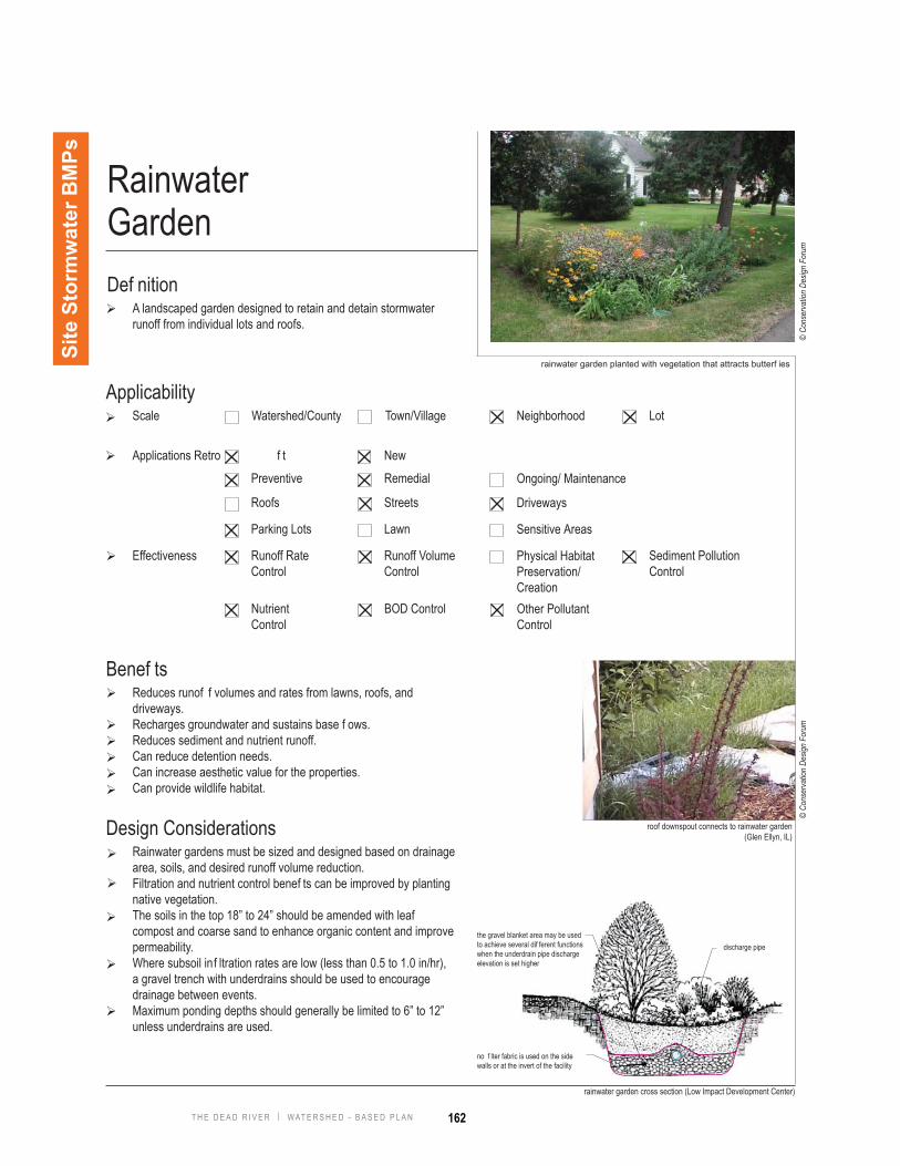
Rainwater GardenDef nition
A landscaped garden designed to retain and detain stormwater runoff from individual lots and roofs.
rainwater garden planted with vegetation that attracts butterf ies
Benef tsReduces runof f volumes and rates from lawns, roofs, and driveways.Recharges groundwater and sustains base f ows.Reduces sediment and nutrient runoff.Can reduce detention needs.Can increase aesthetic value for the properties.Can provide wildlife habitat.
Design ConsiderationsRainwater gardens must be sized and designed based on drainage area, soils, and desired runoff volume reduction.Filtration and nutrient control benef ts can be improved by planting native vegetation.The soils in the top 18” to 24” should be amended with leaf compost and coarse sand to enhance organic content and improve permeability.Where subsoil inf ltration rates are low (less than 0.5 to 1.0 in/hr), a gravel trench with underdrains should be used to encourage drainage between events.Maximum ponding depths should generally be limited to 6” to 12” unless underdrains are used.
Site
Sto
rmw
ater
BM
Ps
rainwater garden cross section (Low Impact Development Center)
roof downspout connects to rainwater garden(Glen Ellyn, IL)
the gravel blanket area may be used to achieve several dif ferent functions when the underdrain pipe discharge elevation is set higher
discharge pipe
no f lter fabric is used on the side walls or at the invert of the facility
ApplicabilityScale
Effectiveness
Watershed/County
Roofs Streets
Parking Lots Lawn
Applications Retro f t New
Town/Village Neighborhood Lot
Driveways
Sensitive Areas
Runoff Rate Control
Runoff Volume Control
Nutrient Control
BOD Control
Physical Habitat Preservation/CreationOther Pollutant Control
Sediment Pollution Control
Preventive Remedial Ongoing/ Maintenance
© Co
nser
vatio
n De
sign
Foru
m©
Cons
erva
tion
Desig
n Fo
rum

163 T H E D E A D R I V E R | W AT E R S H E D - B A S E D P L A N
Def nitionVegetated swales are planted stormwater features that convey , retain, inf ltrate, and cleanse stormwater.
vegetated swales planted with native grasses and forbs along the street
Vegetated Swales
Benef tsReduces runoff volumes and rates.Provides conveyance and water quality benef ts in one stormwater feature.Reduces sediment and nutrient runoff.With proper design, can reduce detention needs.
Design ConsiderationsVegetated swales must be sized to convey design runof f rate (typically 10-year storm).Filtration bene f ts can be substantially improved by planting native deep-rooted grasses and forbs and by minimizing the slope.Topsoil may be amended with compost and/or coarse sand to improve organic content for f ltering and to improve in f ltration and retention of runoff.Vegetated swales should be protected from construction site runoff to prevent sealing of topsoil and/or subsoils.
Site
Sto
rmw
ater
BM
Ps
urban bioswale
schematic plan of back yard vegetated swale system (Conservation Design Forum)
vegetated swalesvegetated swales
runoff directions
runoff directions
runo
ff di
rect
ions
ApplicabilityScale
Effectiveness
Watershed/County
Roofs Streets
Parking Lots Lawn
Applications Retro f t New
Town/Village Neighborhood Lot
Driveways
Sensitive Areas
Runoff Rate Control
Runoff Volume Control
Nutrient Control
BOD Control
Physical Habitat Preservation/CreationOther Pollutant Control
Sediment Pollution Control
Preventive Remedial Ongoing/ Maintenance
© Co
nser
vatio
n De
sign
Foru
m©
Cons
erva
tion
Desig
n Fo
rum
© Co
nser
vatio
n De
sign
Foru
m
164T H E D E A D R I V E R | W AT E R S H E D - B A S E D P L A N
Lawn
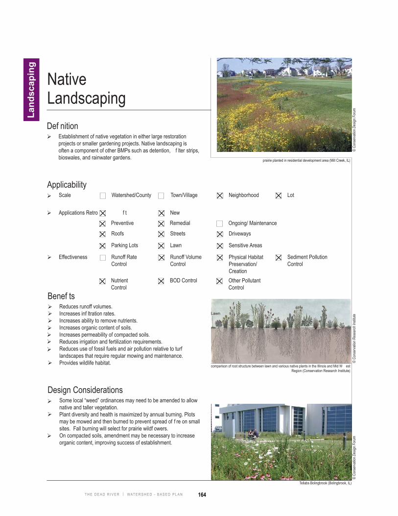
Native LandscapingDef nition
Establishment of native vegetation in either large restoration projects or smaller gardening projects. Native landscaping is often a component of other BMPs such as detention, f lter strips, bioswales, and rainwater gardens.
Tellabs Bolingbrook (Bolingbrook, IL)
prairie planted in residential development area (Mill Creek, IL)
comparison of root structure between lawn and various native plants in the Illinois and Mid W est Region (Conservation Research Institute)
Land
scap
ing
Benef tsReduces runoff volumes.Increases inf ltration rates.Increases ability to remove nutrients.Increases organic content of soils.Increases permeability of compacted soils.Reduces irrigation and fertilization requirements.Reduces use of fossil fuels and air pollution relative to turf landscapes that require regular mowing and maintenance.Provides wildlife habitat.
Design ConsiderationsSome local “weed” ordinances may need to be amended to allow native and taller vegetation.Plant diversity and health is maximized by annual burning. Plots may be mowed and then burned to prevent spread of f re on small sites. Fall burning will select for prairie wildf owers.On compacted soils, amendment may be necessary to increase organic content, improving success of establishment.
ApplicabilityScale
Effectiveness
Watershed/County
Roofs Streets
Parking Lots Lawn
Applications Retro f t New
Town/Village Neighborhood Lot
Driveways
Sensitive Areas
Runoff Rate Control
Runoff Volume Control
Nutrient Control
BOD Control
Physical Habitat Preservation/CreationOther Pollutant Control
Sediment Pollution Control
Preventive Remedial Ongoing/ Maintenance
© Co
nser
vatio
n De
sign
Foru
m©
Cons
erva
tion
Desig
n Fo
rum
© Co
nser
vatio
n Re
sear
ch In
stitu
te