weather forecasting in mid-latitude regions in mid-latitude regions prepared in close collaboration...
TRANSCRIPT

CONVECTI ON
WEATHER FORECASTINGWEATHER FORECASTING IN MID-LATITUDE REGIONS IN MID-LATITUDE REGIONS
Prepared in close collaboration with the “Working Group on Convection” in the Prepared in close collaboration with the “Working Group on Convection” in the frame of the Plan de Formation des Prévisionnistes program of Météo-France. This frame of the Plan de Formation des Prévisionnistes program of Météo-France. This group, headed by J-Ch Rivrain group, headed by J-Ch Rivrain and with the support of the scientific expertise and with the support of the scientific expertise provided by J-Ph Laforeprovided by J-Ph Lafore, is composed of Mrs Canonici, Mercier, Mithieux and Mr , is composed of Mrs Canonici, Mercier, Mithieux and Mr Boissel, Bourrianne, Celhay, Jakob, Hagenmuller, Hameau, Lafore, Lavergne, Boissel, Bourrianne, Celhay, Jakob, Hagenmuller, Hameau, Lafore, Lavergne, Lecam, Lequen, Mounayar, Rebillout, Rivrain, Rochon, Robin, Sanson, Santurette, Lecam, Lequen, Mounayar, Rebillout, Rivrain, Rochon, Robin, Sanson, Santurette, Voisin and many others. Proofreading, references by Jean Paul Billerot. Voisin and many others. Proofreading, references by Jean Paul Billerot.

• At mid latitudes, over France, the development of severe convective systems is most of the time associated with a synoptic forcing and with convective potential instability.
• Intense convective storms occur if the synoptic situation allows for convective ascents developing over the whole depth of the troposphere, up to the tropopause.
Convection and Synoptic Situation
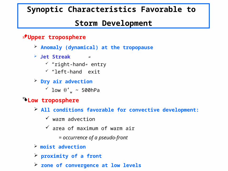
Upper troposphere
Anomaly (dynamical) at the tropopause
Jet Streak “right-hand” entry “left-hand” exit
Dry air advection low ’w ~ 500hPa
Low troposphere
All conditions favorable for convective development:
warm advection
area of maximum of warm air
= occurrence of a pseudo-front
moist advection
proximity of a front
zone of convergence at low levels
Synoptic Characteristics Favorable to
Storm Development
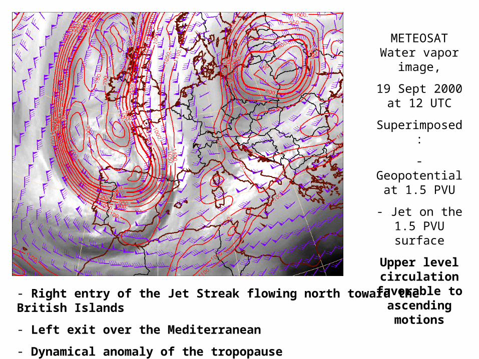
METEOSAT Water vapor
image,
19 Sept 2000 at 12 UTC
Superimposed:
- Geopotential at 1.5 PVU
- Jet on the 1.5 PVU surface
Upper level circulation
favorable to ascending motions
- Right entry of the Jet Streak flowing north toward the British Islands
- Left exit over the Mediterranean
- Dynamical anomaly of the tropopause

- to a maximum of warm air at low levels: ’w = 18°C at 850 hPa
- with a clearly defined line organization in the convergence zone between southerly and westerly flows
- to a cold air advection at mid levels: ’w = 14° at 500hPa
Radar image, 19 Sept. 2000 at 15 UTC
Superimposed:
’w at 850 hPa (red) and at 500 hPa (blue)
- wind at 500 m height
The main convective activity
corresponds:

00 UTC
12 UTC
06 UTC
18 UTC
’w at 850hPa (shaded)
19 Sept 2000
Wind at 500 m

19 Sept 2000
1, 2, 3: Radar images
at 12, 15, 18UTC
4: Thunder impacts between
12 and 18
UTC
1
3
2
4

ANASYG, 19 Sept 2000 at 12 UTC