weather theory, class 6 - aefco
TRANSCRIPT

Weather Theory
– Atmospheric Stability
– Temperature Inversions
– Relative Humidity & Dew Point
– Cloud Classification
AEFCO 2014
Phase II
Class 6
Slideshare:
http://slideshare.net/egg9
Atmospheric Stability
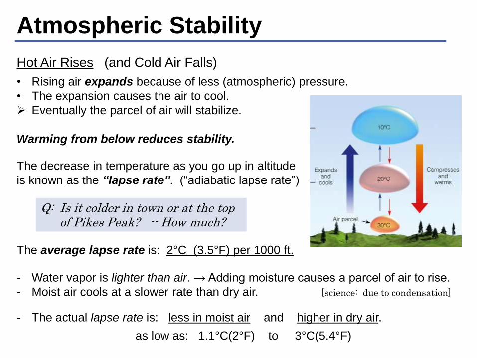
Hot Air Rises (and Cold Air Falls)
• Rising air expands because of less (atmospheric) pressure.
• The expansion causes the air to cool.
Eventually the parcel of air will stabilize.
Warming from below reduces stability.
The decrease in temperature as you go up in altitude
is known as the “lapse rate”. (“adiabatic lapse rate”)
Q: Is it colder in town or at the top of Pikes Peak? -- How much?
The average lapse rate is: 2°C (3.5°F) per 1000 ft.
- Water vapor is lighter than air. → Adding moisture causes a parcel of air to rise.
- Moist air cools at a slower rate than dry air. [science: due to condensation]
- The actual lapse rate is: less in moist air and higher in dry air.
as low as: 1.1°C(2°F) to 3°C(5.4°F)
Temperature Inversions
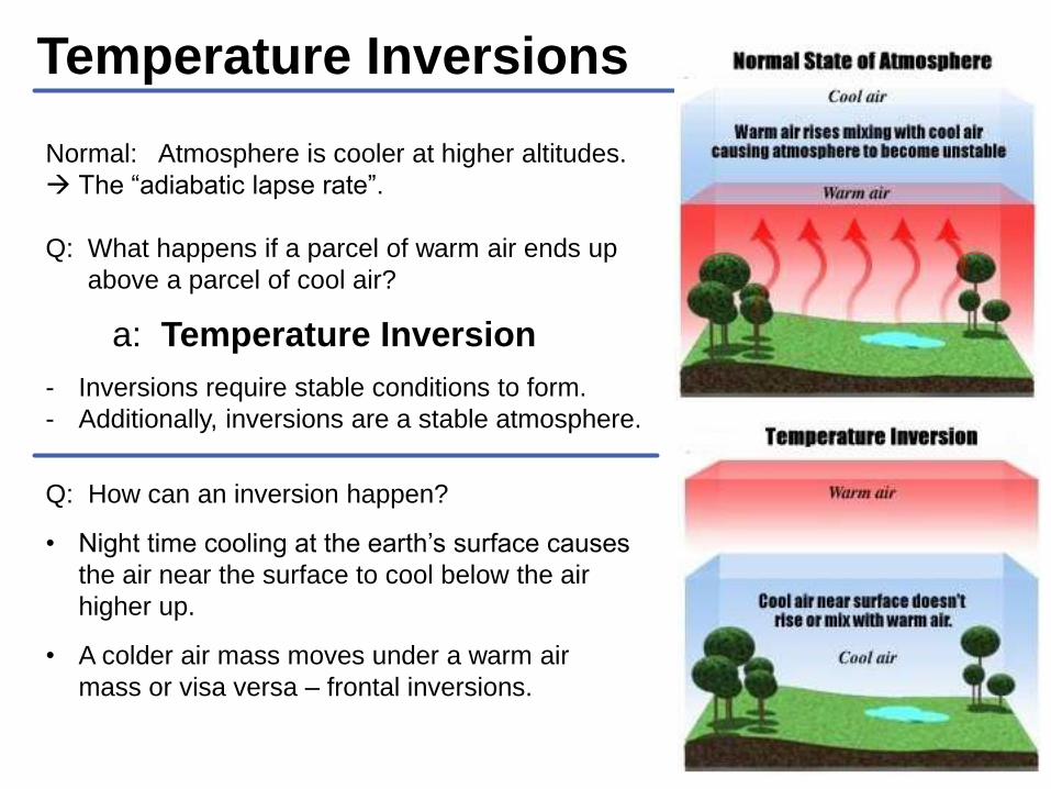
Normal: Atmosphere is cooler at higher altitudes.
The “adiabatic lapse rate”.
Q: What happens if a parcel of warm air ends up
above a parcel of cool air?
a: Temperature Inversion
Q: How can an inversion happen?
• Night time cooling at the earth’s surface causes
the air near the surface to cool below the air
higher up.
• A colder air mass moves under a warm air
mass or visa versa – frontal inversions.
- Inversions require stable conditions to form.
- Additionally, inversions are a stable atmosphere.

Temperature Inversions
Humidity
Q: What is Humidity? -- A: Moisture (water) in the air
Relative Humidity is measured between 0% and 100%
Q: What happens at 100% humidity?
A: The air is “full” of moisture Condensation (Clouds, Fog)
The moisture ‘beyond’ 100% humidity can not remain as a gas
(vapor) and condenses out as liquid. Liquid water is visible. It
is know by many names: “steam”, “clouds”, “fog”.
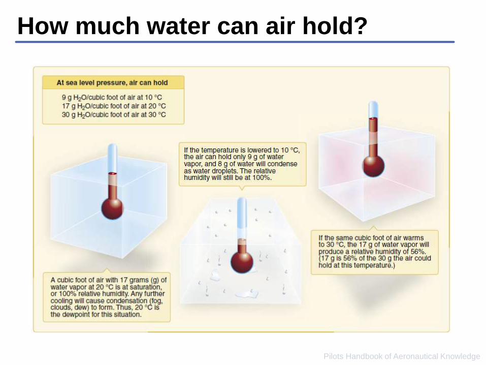
Q: How much water can a cubic foot of air hold?
A: It depends!
1. It depends on the Temperature of the air(and)
2. It depends on the Pressure of the air. [pressure = Altitude]
How much water can air hold?
Pilots Handbook of Aeronautical Knowledge

Dew Point
A better question: At what temperature does air reach 100% humidity?
A: at the Dew Point.
• The Dew Point is the temperature at which the air will be saturated.• In other words: if you cool air to the dew point it will become saturated – fog,
clouds, …
• It is reported for every airport in the METAR. -- you can look it up.
A math word problem: At what altitude are the bases of the clouds outside?
We know the answer – because we know:
1. The outside temperature – from a METAR.
2. The dew point – from a METAR.
3. The adiabatic lapse rate, which is 4.4°F per 1000 ft. for air near the dew
point.
𝑇𝑒𝑚𝑝𝑒𝑟𝑎𝑡𝑢𝑟𝑒(°F ) − 𝐷𝑒𝑤𝑝𝑜𝑖𝑛𝑡(°F )
4.4(°F /1000𝑓𝑡)× 1,000 (𝑓𝑡) In the text
book.
Dew Point (cont)
Terminology:
“Temperature / Dew Point Spread”
- The difference (spread) between the reported Temperature and Dew Point.
• When the spread is 4°F(2°C) and decreasing.
Fog and low clouds are likely – because the air is near saturation.
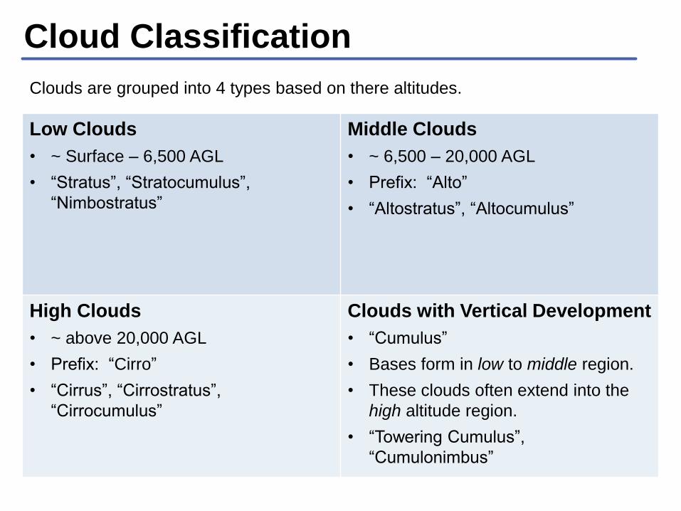
Cloud Classification
Clouds are grouped into 4 types based on there altitudes.
Low Clouds
• ~ Surface – 6,500 AGL
• “Stratus”, “Stratocumulus”,
“Nimbostratus”
Middle Clouds
• ~ 6,500 – 20,000 AGL
• Prefix: “Alto”
• “Altostratus”, “Altocumulus”
High Clouds
• ~ above 20,000 AGL
• Prefix: “Cirro”
• “Cirrus”, “Cirrostratus”,
“Cirrocumulus”
Clouds with Vertical Development
• “Cumulus”
• Bases form in low to middle region.
• These clouds often extend into the
high altitude region.
• “Towering Cumulus”,
“Cumulonimbus”
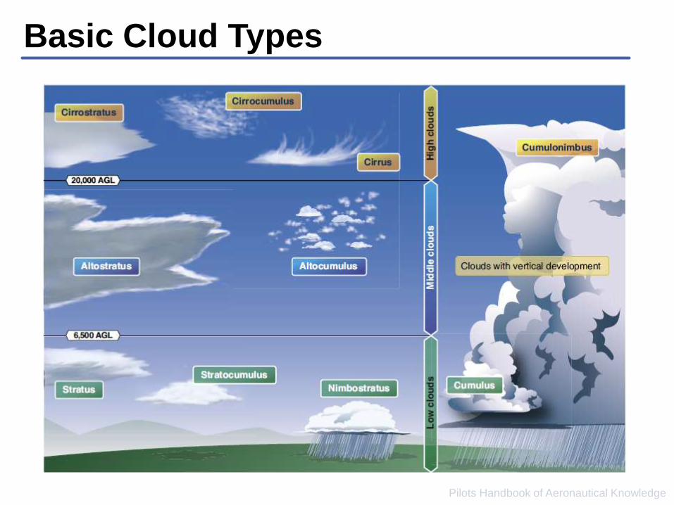
Basic Cloud Types
Pilots Handbook of Aeronautical Knowledge
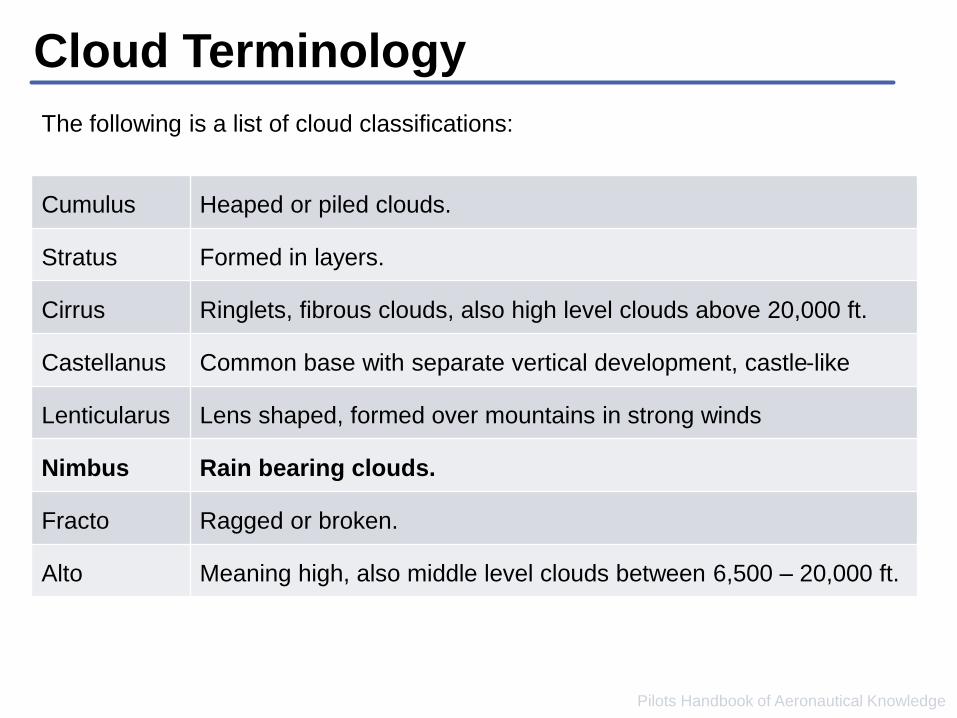
Cloud Terminology
Pilots Handbook of Aeronautical Knowledge
The following is a list of cloud classifications:
Cumulus Heaped or piled clouds.
Stratus Formed in layers.
Cirrus Ringlets, fibrous clouds, also high level clouds above 20,000 ft.
Castellanus Common base with separate vertical development, castle-like
Lenticularus Lens shaped, formed over mountains in strong winds
Nimbus Rain bearing clouds.
Fracto Ragged or broken.
Alto Meaning high, also middle level clouds between 6,500 – 20,000 ft.
QUESTIONS ?
References
Slideshare: http://slideshare.net/egg9
Pilots Handbook of Aeronautical Knowledge• http://www.faa.gov/regulations_policies/handbooks_manuals/aviation/pilot_handbook/
AC 00-6A - Aviation Weather for Pilots and Flight Operations Personnel• Google search for “AC 00-6A”
• http://www.faa.gov/regulations_policies/advisory_circulars/index.cfm/go/document.information/d
ocumentid/22268