weatherman walking aberdyfi walk -...
TRANSCRIPT

Weatherman Walking Aberdyfi Walk
bbc.co.uk/weathermanwalking © 2013
1
Reproduced by permission of Ordnance Survey on behalf of HMSO. © Crown copyright and database right 2009.All rights reserved. Ordnance Survey Licence number 100019855
The Weatherman Walking maps are intended as a guide to help you walk the route. We recommend using an OS map of the area in conjunction with this guide. Routes and conditions may have changed since this guide was written. The BBC takes no responsibility for any accident or injury that may occur while following the route. Always wear appropriate clothing and footwear and check weather conditions before heading out.
N
S
W E
Approximate distance: 6 milesFor this walk we’ve included OS grid references should you wish to use them.
EndStart
5
6
78
9
1
2
3
4

Weatherman Walking Aberdyfi Walk
bbc.co.uk/weathermanwalking © 2013
2
Start: At the pier (pay & display car parking nearby) Starting ref: SN 6137 9589 Distance: About 6 milesGrade: Easy/Moderate Walk time : Allow 2.5 hours
DirectionsStart on the quayside opposite the pier (in front of the lifeboat station).
This is a glorious and varied walk starting from the centre of this charming seaside town. Aft er following a delightful rock-cut path beside the Dyfi
estuary the route rises steeply up to a high-level ridge. On a clear day the views from the ridge, part of the Panorama walk, are simply wonderful. The
route follows the level ridge before dropping down a small valley to cross the Tywyn road, the railway line (at a pedestrian level crossing) and the golf
course before cutting through sand dunes and returning along a fabulous wide sandy beach back to Aberdyfi .
Pavement leading from the quay
Pier with the bell suspended below it just visible on the far left
Time and Tide Bell (SN 613 958)
Take a minute to look at the Time and Tide Bell, an art installation which hangs below the pier which was commissioned from sculptor Marcus Vergette in July 2011. Near the top of the rising or falling tide, a gentle tolling of the bell can be heard and is a reminder of the well-known legend of the lost land of ‘Cantre’r Gwaelod’. Gwyddno Garanhir, the 6th century king who ruled over the low lying land, had a man in charge of a system of sluices, dykes and embankments that kept the sea at bay. Unfortunately aft er feasting and drinking heavily one night the guard forgot to close the sluice gates and the sea rushed in, drowning the land and its people. It’s said that its the bells can still be heard ringing from beneath the water.
1
Continue along the quayside and pavement beside the estuary, taking great care where the pavement runs out for a short section before The Penhelig Arms.

Weatherman Walking Aberdyfi Walk
bbc.co.uk/weathermanwalking © 2013
3
Walk guide David Roberts in front of the remains of an old shipbuilding yard.
Remains of an old shipyard (SN 620 961)
In the estuary just over the sea wall opposite the Penhelig Arms are a row of upright wooden posts - the remains of an old dry dock. Towards the end of the nineteenth century, this small sleepy village became a boom town for ship building, transforming it into a busy, vibrant place. From the 1840’s onwards there were seven major ship builders in the town, three on this site alone, and they built some beautiful schooners and brigs.
2
Memorial stone commemorating World War Two commandos
3
Just before the railway bridge turn right along a back lane behind a row of terraced houses avoiding another section without a pavement and on a dangerous bend. Then turn right into and through the small park, looking out for the memorial stone for World War Two Commandos who were trained in the area.
Commando Memorial (SN 621 960)
The stone is inscribed with the words: ‘For the members of 3 troop10 (1A) commando who were warmly welcomed in Aberdyfi while training for special duties in battle 1942-1943. Twenty were killed in action.’
A total of 130 men served in the troop which was a very unusual unit of the British Army with most of the troop having German, Austrian or Eastern European backgrounds, others were political or religious refugees from Nazi Germany. All members of the troop adopted British names and false personnel histories.
Continue to the far corner of the park and on to the delightful rock-cut steps and path of the known as the Roman Road which runs beside the estuary.

Weatherman Walking Aberdyfi Walk
bbc.co.uk/weathermanwalking © 2013
4
The scenic rock-cut path of the ‘Roman Road’
Looking along the ‘Roman Road’ towards Picnic Island
Roman Road (SN 622 960)
Although known as the ‘Roman Road’ it was in fact built for horse and carriage in 1808. The sea has by now eroded much of this old road but it rarely fl oods even at high tide so it’s safe for a stroll any time of the day – just make sure you wear good shoes as it can get quite slippery when wet.
4
Continue along the rocks and then a gravel path beside the fence next to the railway line to reach the steps up onto the small hillock of Picnic Island.
Picnic Island (SN 626 962)
Picnic island is another misnomer – it was in fact a small peninsula now separated from the ‘mainland’ aft er being cut off by a cutting for the railway in 1863. Nevertheless it has a small grassy area on top with a bench that would be a pleasant spot for a picnic.
5
Weatherman Walking Aberdyfi Walk
bbc.co.uk/weathermanwalking © 2013
5
Through Trefrifawr farmyard
Cambrian coast railway line from the bridge near ‘Picnic Island’.
Path up through fi elds above the Outward Bound centre
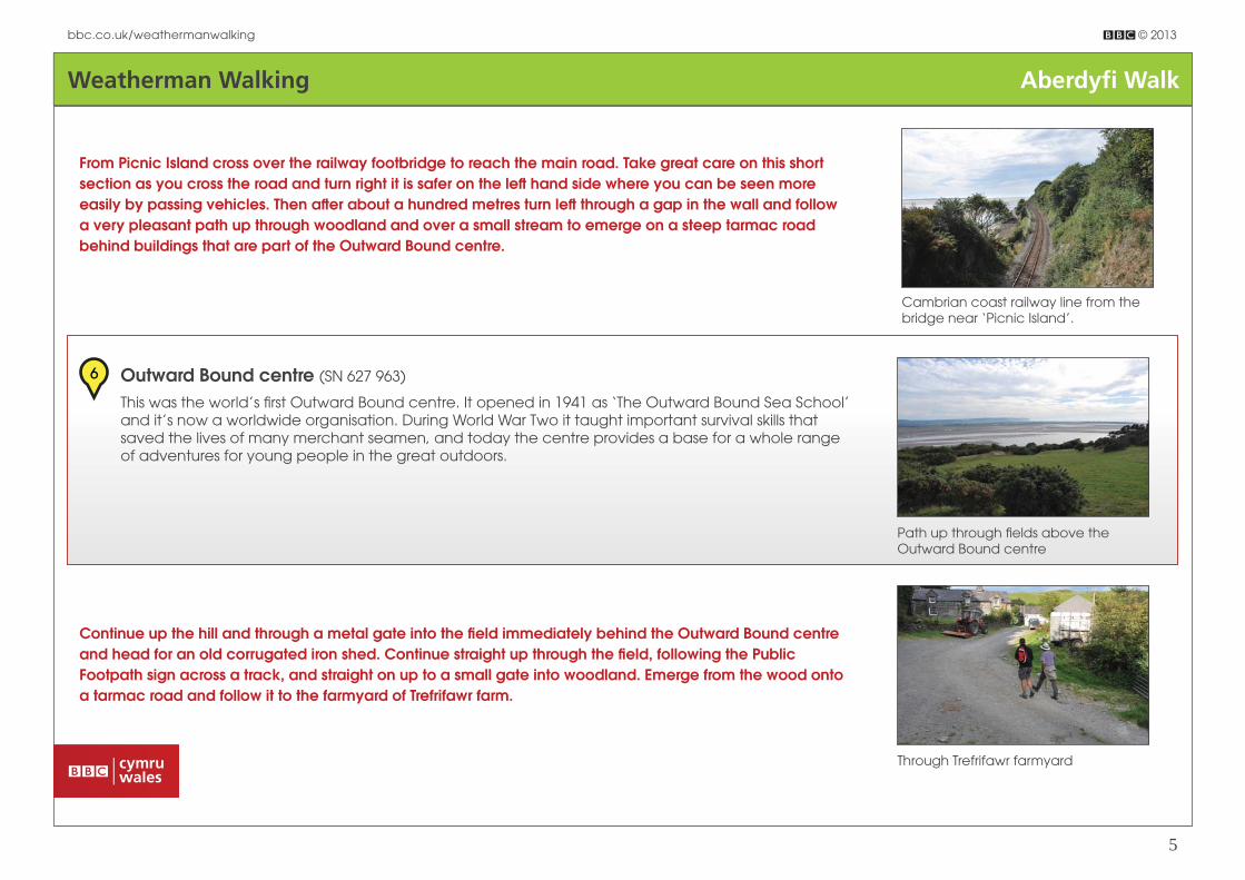
From Picnic Island cross over the railway footbridge to reach the main road. Take great care on this short section as you cross the road and turn right it is safer on the left hand side where you can be seen more easily by passing vehicles. Then aft er about a hundred metres turn left through a gap in the wall and follow a very pleasant path up through woodland and over a small stream to emerge on a steep tarmac road behind buildings that are part of the Outward Bound centre.
Outward Bound centre (SN 627 963)
This was the world’s fi rst Outward Bound centre. It opened in 1941 as ‘The Outward Bound Sea School’ and it’s now a worldwide organisation. During World War Two it taught important survival skills that saved the lives of many merchant seamen, and today the centre provides a base for a whole range of adventures for young people in the great outdoors.
6
Continue up the hill and through a metal gate into the fi eld immediately behind the Outward Bound centre and head for an old corrugated iron shed. Continue straight up through the fi eld, following the Public Footpath sign across a track, and straight on up to a small gate into woodland. Emerge from the wood onto a tarmac road and follow it to the farmyard of Trefrifawr farm.

Weatherman Walking Aberdyfi Walk
bbc.co.uk/weathermanwalking © 2013
6
Looking back down from near top of ridge.
Continue through the farmyard and turn left almost immediately behind the farmhouse, through a short section of woodland and through a wooden gate out onto the open hillside. Follow the steep path, keeping right near the fence towards the top of the hill, to reach a gate through to level ground and the top of the ridge.
Steeper walking above Trefrifawr
World War Two plane crash (SN 629 976)
On a nearby hillside to the right is the site of a World War Two aeroplane crash. The plane came up from the south across the Dyfi estuary in thick mist and mistook this ridge for the next one along. It banked over to the right and ended up crashing into the fi eld nearby. Sadly two of the crew were killed although one did survive. Following the crash the RAF put a manned beacon here for the remainder of the war with a light fl ashing day and night to prevent it happening again.
7
Beyond the gate bear left onto a single track tarmac road. From here, on a clear day, there are wonderful views of the Tarrennau hills nearby, of the mountains of Snowdonia further north, of Cardigan Bay and the Lleyn Peninsula, and of the peaceful green Cwm Maethlon also known as Happy Valley, immediately on the right below the ridge.

Weatherman Walking Aberdyfi Walk
bbc.co.uk/weathermanwalking © 2013
7
Track down valley leading to the Tywyn road.
Wooden gates by Crychnant farm
Warning signs at the railway crossing
8 Cwm Maethlon (SN 624 975)
Since Victorian times it has been known as Happy Valley. The lane that runs through the valley was originally a turnpike road linking Machynlleth with Tywyn. A car park beside the lane is a good starting point for walks to Llyn Barfog and the Tarrenau mountains.
Go straight across at a T-junction along a rough track to reach another tarmac section of road leading to Crychnant farm.Turn left just before the farmyard through the wider of two wooden gates. The signpost between the two gates seems to suggest going through the smaller gate, but this leads to a fully enclosed and fenced off fi eld.
Head straight through the narrow fi eld to a gate in the furthest corner, then keep to the right near the fence (no obvious path here) to reach a wide track. Turn left along this track and head all the way down the narrow valley, with a beautiful view of the beach and sea beyond.
Taking great care, head straight across the Aberdyfi to Tywyn road to reach the layby opposite, and down a track on the left which leads to a railway level crossing.

Weatherman Walking Aberdyfi Walk
bbc.co.uk/weathermanwalking © 2013
8
Heading across the golf course
Walking along the stunning beach back to Aberdyfi
Heed the warnings here and continue to the golf course.
Golf Course (SN 595 970)
This world class course was founded in 1895 when a Colonol Ruck, who was holidaying in the area, borrowed nine fl ower pots from a local woman and used them to line nine holes dug in the marsh, and hey presto Aberdyfi Golf course was born.
9
It’s a good idea to check the tide times beforehand so that you don’t miss out on the beach walk, however if the tide is high then it’s either a more diffi cult walk along the pebbles at the top of the beach or retrace your steps back across the golf course and turn right before the railway crossing. Follow a public footpath and track through the golf course to reach another railway level crossing which leads to the main road on the outskirts of Aberdyfi .