weatherman walking llansteffan walk -...
TRANSCRIPT

Weatherman Walking Llansteffan Walk
bbc.co.uk/weathermanwalking © 2013
1
Reproduced by permission of Ordnance Survey on behalf of HMSO. © Crown copyright and database right 2009.All rights reserved. Ordnance Survey Licence number 100019855
The Weatherman Walking maps are intended as a guide to help you walk the route. We recommend using an OS map of the area in conjunction with this guide. Routes and conditions may have changed since this guide was written. The BBC takes no responsibility for any accident or injury that may occur while following the route. Always wear appropriate clothing and footwear and check weather conditions before heading out.
N
S
W E
Approximate distance: 12 milesFor this walk we’ve included OS grid references should you wish to use them.
End
Start
2
3
4
1
5
6

Weatherman Walking Llansteffan Walk
bbc.co.uk/weathermanwalking © 2013
2
Start: The B4312 Llansteff an to Carmarthen Road – at the turn off to LlangynogStarting ref: SN 376 155Distance: About 12 milesGrade: Moderately strenuousWalk time : 5-6 hours
This delightful walk takes you through the scattered farms and lanes of the Llansteff an Peninsula and around its spectacular headland, off ering
commanding views of the South Wales coast. The walk begins in countryside farmed by Dylan Thomas’s family. It’s an area where he spent many
holidays as a child and which inspired the much-loved poem Fern Hill. It leads on to the Taf estuary with views over to Laugharne, and then rounds
the headland where there are spectacular views out to sea and across a long stretch of the south Wales coast. The walk ends in the picturesque
village of Llansteff an with its vast sandy beach. This is a long walk but the paths are mostly good and the climbs, while long, are not too steep.
Get off the bus at the turning to Llangynog and follow the road downhill
Directions
Park your car in Llansteff an and catch the bus to Carmarthen from outside the Sticks Hotel. Buses were running every two hours in Spring 2014 so it is worth timing your arrival to coincide with the bus timetable. You can fi nd bus timetable information online or from Carmarthen Tourist Information (01267 231557). Get off at the request stop near Fernhill – the junction for Llangynog.
Aft er getting off the bus follow the minor road towards Llangynog. Ahead you will see electricity pylons and a farm called Rhydlydan. Continue to follow the road past the farm, where it starts to climb. As the road levels out you will see the house, Fernhill, to your right.
Weatherman Walking Llansteffan Walk
bbc.co.uk/weathermanwalking © 2013
3
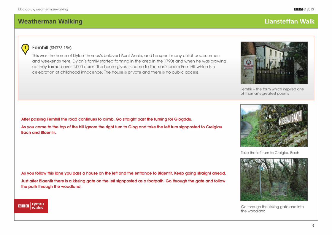
As you follow this lane you pass a house on the left and the entrance to Blaentir. Keep going straight ahead.
Just aft er Blaentir there is a kissing gate on the left signposted as a footpath. Go through the gate and follow the path through the woodland.
Go through the kissing gate and into the woodland
Fernhill – the farm which inspired one of Thomas’s greatest poems
Fernhill (SN373 156)
This was the home of Dylan Thomas’s beloved Aunt Annie, and he spent many childhood summers
and weekends here. Dylan’s family started farming in the area in the 1790s and when he was growing
up they farmed over 1,000 acres. The house gives its name to Thomas’s poem Fern Hill which is a
celebration of childhood innocence. The house is private and there is no public access.
1
Aft er passing Fernhill the road continues to climb. Go straight past the turning for Glogddu.
As you come to the top of the hill ignore the right turn to Glog and take the left turn signposted to Creigiau Bach and Blaentir.
Take the left turn to Creigiau Bach

Weatherman Walking Llansteffan Walk
bbc.co.uk/weathermanwalking © 2013
4
The path through the woodland is pretty clear and there are footpath waymarkers on the way. It can be a little muddy in places. At the other end of the wood is a stile into a fi eld.
A wooden stile takes you out of the wood into a fi eld
Over the stile head straight across the fi eld and look for a gap in the hedge ahead. There is no path evident on the ground here. Keep a look out for hares in this area – you might be lucky enough to spot one.
Head towards the gap in the hedge
Once through the gap in the hedge head diagonally down towards the bottom left hand corner of the fi eld and enjoy the lovely views of hills and farmland. At the corner of the fi eld there is a stile which you cross into another fi eld. Now head towards the farmhouse. When you get there look for a stile in the bushes just below the farmhouse.
There is a stile in the bushes just below the farmhouse

Weatherman Walking Llansteffan Walk
bbc.co.uk/weathermanwalking © 2013
5
The path here follows the road between a hedge on the left and a fence on the right. Continue to follow beside the road on the coast path through two further gates. Eventually the path re-joins the road for about 25 yards, crossing a bridge over a stream.
Take the minor road to the right aft er the bridge and head up the hill. This is still signposted as the Wales Coast Path but as you start to climb the hill the coast path heads off to the left . Ignore this turning and walk straight up the hill past Blaencwm – another house that was dear to Dylan – on the right.
The farm is Pentrewyman – once home to another of Thomas’s aunts. Cross the stile and follow the fence along in front of the farmhouse and then join the farm track – continuing away from the farmhouse. It becomes a metalled road when it reaches a couple of modern bungalows. The road now drops down to join the main B4312 at Brook. There is a traditional red phone box on the other side of the road.
Turn right and follow the main road for around 100 yards. Be careful as there is no pavement and the traffi c can be travelling quickly. On the right you will soon come to a metal kissing gate – signed as a footpath and as part of the Wales Coast Path.
The kissing gate on the right of the road is signed as part of the Wales Coast Path
Dylan was a regular guest at Blaencwm
Blaencwm (SN 370 140)
The charming Blaencwm was home to Thomas’s aunt and uncle Polly and Bob Williams in the late
1920s and for much of the 1930s. Thomas would oft en stay here and wrote draft s of some of his early
poems here. Later, in the 1940s, Thomas’s parents moved into the house and it became a refuge from
war-ravaged London. Thomas and his wife Caitlin spent two summers here. The house is private and
there is no public access.
2

Weatherman Walking Llansteffan Walk
bbc.co.uk/weathermanwalking © 2013
6
Aft er the house the road rises steadily and you follow it for at least a mile and a half. The road passes through picturesque woodland, open farmland and passes isolated groups of houses. On the left you will pass the access road to Llwyngwyn Farm. The farm has been in Thomas’s family since the 1790s. There is no public access to the farm.
Llwyngwyn Farm has been in Thomas’s family since the 1790s
The road takes a sharp left aft er a white cottage on the left and at this point another road goes off to the right. Take the road to the left .
Follow the road as it bends to the left around a white cottage
The road continues to climb passing, at times, between tall hedges. The road will then turn sharply to the right and there are two gates in front of you. One has a sign saying “Penpicillon Next Left ”. At this point there is a sometimes muddy farm road to the left which is signposted as a footpath.
You will see two gates in front of you. Take the farm track to your left
Weatherman Walking Llansteffan Walk
bbc.co.uk/weathermanwalking © 2013
7
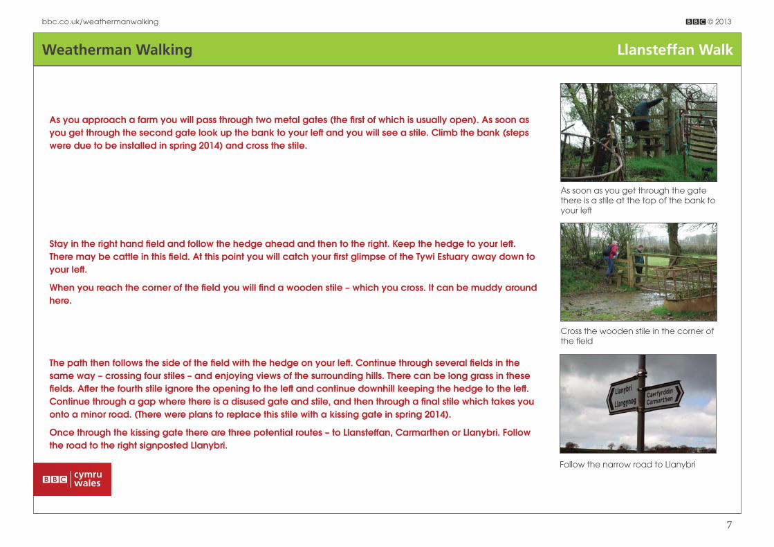
Stay in the right hand fi eld and follow the hedge ahead and then to the right. Keep the hedge to your left . There may be cattle in this fi eld. At this point you will catch your fi rst glimpse of the Tywi Estuary away down to your left .
When you reach the corner of the fi eld you will fi nd a wooden stile – which you cross. It can be muddy around here.
Cross the wooden stile in the corner of the fi eld
As you approach a farm you will pass through two metal gates (the fi rst of which is usually open). As soon as you get through the second gate look up the bank to your left and you will see a stile. Climb the bank (steps were due to be installed in spring 2014) and cross the stile.
As soon as you get through the gate there is a stile at the top of the bank to your left
The path then follows the side of the fi eld with the hedge on your left . Continue through several fi elds in the same way – crossing four stiles – and enjoying views of the surrounding hills. There can be long grass in these fi elds. Aft er the fourth stile ignore the opening to the left and continue downhill keeping the hedge to the left . Continue through a gap where there is a disused gate and stile, and then through a fi nal stile which takes you onto a minor road. (There were plans to replace this stile with a kissing gate in spring 2014).
Once through the kissing gate there are three potential routes – to Llansteff an, Carmarthen or Llanybri. Follow the road to the right signposted Llanybri.
Follow the narrow road to Llanybri

Weatherman Walking Llansteffan Walk
bbc.co.uk/weathermanwalking © 2013
8
The road soon bends to the right but our route carries straight on up the dirt track. There is a sign saying: “Unsuitable for heavy goods vehicles”.
When the road turns right carry straight on up the farm track
The track takes you on a climb between hedges but watch for views of the Tywi estuary in the gaps on the left . The path eventually levels out and takes you into the village of Llanybri near a modern house called Brynllai.
Take the road left towards the Farmers Arms public house – where Thomas used to enjoy a drink - and continue past the pub. On your left is the ruined chapel Yr Hen Gapel.
Yr Hen Gapel is on an ancient pilgrimage trail
Yr Hen Gapel (SN 338 126)
Llanybri has a long religious history and there has been a church here since at least the 1380s. In the
Middle Ages it was a stopping off point for pilgrims on their way to St Davids. The chapel is called
Yr Hen Gapel, which means The Old Chapel, and is probably the only medieval church in Wales to
become an Anglican church and then a non-conformist chapel. The chapel closed in 1962 and was
largely demolished following a fi re in 1974. If you leave the road and walk to the other side of the
chapel there is a war memorial and an information board with details of the chapel’s history. Dylan’s
beloved aunt, Ann Jones, who lived at Fernhill, is buried at the nearby Capel Newydd. Dylan wrote
the poem, Aft er the Funeral, following her funeral there.
3

Weatherman Walking Llansteffan Walk
bbc.co.uk/weathermanwalking © 2013
9
Continue along the road past the ruined chapel until you get to a crossroads at the junction with the Llansteff an to St Clears road. Go straight across the crossroads beside a white house called Lynwood which was once the Black Horse pub.
You will soon pass Holy Trinity Church on your right. As you continue along this road you will begin to get views over the Taf Estuary through gaps in the hedges. The road continues down and as it rounds a white house (called Parc Yr Hendy) you will get wonderful views across the Taf Estuary to Laugharne. The sharp eyed will be able to pick out Dylan Thomas’s Boathouse to the right of the town.
When the road rounds a corner you get spectacular views over to Laugharne
The road continues downhill past a house called Hatch Hill and then comes out at a T-junction. Turn left towards the modern house at Mwche. Opposite the modern house is a metal farm gate – signposted as the Wales Coast Path.
Opposite the modern house go through the gate and follow the coast path
Go through the gate and turn left through a second gate. Then turn right and follow the fence. Keep following along the fence until you reach a wooden stile. Cross the stile and carry on along the other side of the fence.
Cross over the fence at the wooden stile

Weatherman Walking Llansteffan Walk
bbc.co.uk/weathermanwalking © 2013
10
Head for the stile in the fence ahead of you. Cross into another fi eld and then follow along the top of that fi eld. You will be heading towards the bottom of a small wood where you will cross a wooden stile over the fence. Go over the stile and follow the short path into another fi eld.
Cross the wooden stile at the bottom of the wood
Follow along the top of this fi eld keeping the fence to your left . In the top corner (some 10 yards above the gate) there’s a stile which takes you into woodland.
Cross the wooden stile into woodland
Aft er crossing the stile step across the small brook and follow the path which drops slightly before joining a long clear grassy path. This is fl at and then starts to rise. Look out for views across to Laugharne on the right. The path then meets a stile by metal farm gate. Cross the stile and turn left .
Cross a stile next to a metal gate and turn left

Weatherman Walking Llansteffan Walk
bbc.co.uk/weathermanwalking © 2013
11
Follow the path straight along beside the fence and then between two fences. It is waymarked as the Wales Coast Path.
The path here is marked as the Wales Coast Path
Aft er the path turns to the right it drops to a kissing gate and there are steps down the bank to a single track road. Turn right and follow the road downhill. Go straight on past a farm entrance on the left and a road to Pentowyn on the right. Aft er the lane to Pond Cottage the metalled surface ends and you walk down an unsurfaced road. The road eventually reaches a metal farm gate. Pass through this and down a grassy path, ignoring the farm gates to the left . This path can get increasingly muddy as it continues towards the estuary.
When you reach a wooden stile and gate you have reached the end of the public right of way at Black Scar Point. From here you get clear views across the estuary to Laugharne.
The view across to Laugharne from Black Scar Point
Black Scar Point (SN 311 107)
Until the middle of the 20th century there was a ferry service from Black Scar Point to Laugharne.
Ferries had operated across the Taf for centuries, carrying pilgrims as well as passengers across the
water. The ferry was also used by Dylan Thomas. From the end of the path you can get clear views of
the Boathouse and the Writing Shed at Laugharne, as well as Sir John’s Hill and the town itself.
4

Weatherman Walking Llansteffan Walk
bbc.co.uk/weathermanwalking © 2013
12
To continue the walk turn around and retrace your steps up the road. Continue past the kissing gate where you initially joined the road. There is a long climb ahead.
As the road fl attens out you begin to get views out to sea on your right. Soon you will be able to look out across the sands at the Pendine fi ring range. Ignore two roads turning off to the left – but immediately aft er the second road take the turning to the right. The road is marked as the Wales Coast Path and is also signposted to Lord’s Park Farm and Laques Fawr.
Turn right on the road signposted to Lord’s Park Farm and Laques Fawr
As you go down this road – ignoring the turning to Laques Fawr on the right – you can enjoy views of the Tywi Estuary to the left and the sea on the right. You will pass a National Trust sign on your right.
A National Trust sign welcomes you to Wharley
As you continue along the road look out for a wooden gate on the right which is signposted as the Wales Coast Path (The wooden signpost is on the left side of the road). There is also a sign to Wharley Point.
Go through the gate and follow the path uphill. At the top you are rewarded with fi ne views across the Bristol Channel and over the expanse of sand at the MoD’s Pendine fi ring range. Continue through another gate wooden gate with coast path and National Trust signs.
The views on this section of the walk are spectacular, and there are benches dotted along the route from which you can enjoy them.

Weatherman Walking Llansteffan Walk
bbc.co.uk/weathermanwalking © 2013
13
The path here is clear and continues around the headland. Ignore the turning down to “Cold Blow”. The route continues through another gate with coast path waymarkers. The path begins to descend through woodland. The sea is on your right – and at a scenic viewpoint you get a great view of across Scott’s Bay to Ferryside on the other side of the Tywi. You should just be able to make out the top of the tower of Llansteff an Castle ahead of you.
The view across Scott’s Bay to Ferryside
You will eventually reach a fork in the path on the approach to a small stone cottage. Our route takes the lower fork past the cottage. Note that this is a permissive right of way and if the path is closed you need to take the upper fork around the cottage. (If you do go on the upper fork head up until you get to the top. Then take a sharp right, which takes you down beside a stone wall. You will then reach a white gate).
Both the upper and lower paths rejoin at a white gate
Benches along the path are a great place to rest and enjoy the view
Wharley Point (SN 340 093)
The highlight of this walk are the views across the Bristol Channel and along the coast from Wharley
Point. From the headland you can see from Caldey Island to the west to Worms Head on Gower to
the east. The headland also gives spectacular views over the confl uence of the three estuaries which
meet here. This is clearer at low tide. To the east you can see the end of Cefn Sidan beach at the
mouth of the Gwendraeth Estuary. Immediately to the east is the Tywi Estuary and to the west the Taf
Estuary.
5

Weatherman Walking Llansteffan Walk
bbc.co.uk/weathermanwalking © 2013
14
Both paths reach the white gate, which you pass through, and continue the walk along the coast path, through another white gate which gives access to the large sandy beach. From here look for the path heading uphill behind the beach. Don’t take the grassy track to the left .
Head along the footpath uphill behind the beach
As the path fl attens out another path joins from the left . Carry straight ahead. As you continue you will pass benches and, at one point, an information board about the estuary. You will continue to enjoy fi ne views. There is access to the beach at several points on your right. You will also pass a stone shelter at one scenic viewpoint.
Pass a stone shelter on your left
Aft er the shelter you begin to get views of the vast sands of Llansteff an beach through the trees on your right. You might also spy Llansteff an Castle through the trees on your left .
You will see views of Llansteff an beach through the trees

Weatherman Walking Llansteffan Walk
bbc.co.uk/weathermanwalking © 2013
15
You are now in Sticks Wood where you will pass an information board about its history. At this point the path forks and you take the upper (left ) fork.
You soon join a road - carry straight ahead here. The hill to the left leads up to the castle and a road to the right goes down towards the beach. You are now heading into Llansteff an, with views of the beach on your right and Plas Mansion on the top of a hill to the left . In a fi eld on the left of the road is a dead tree which was struck by lightning in the 1970s. Continue along the road past the vicarage until you reach the end of the walk beside the church in the town centre.
The walk ends in the centre of the village by Llansteff an Church
Llansteff an (SN355 110)
The quiet village of Llansteff an takes its name from St Ystyff an who founded a church here in the 6th
century. It became an important staging post between the ferries over the Tywi and Taf estuaries –
and its strategic importance was immediately recognised by the Normans who built a wooden castle
above the village. The stone castle was built on the same site by the Camville family who owned it
from the 12th to the 14th centuries. The village became a popular holiday resort in the 19th century,
especially aft er the railway reached Ferryside in 1852. There were major redevelopments in the town to
cater for the holiday-makers, many of whom were from mining communities in the south Wales valleys.
6