west central lio lio 5-year ecosystem recovery plan first ... · lio 5-year ecosystem recovery plan...
TRANSCRIPT

West Central LIO 1
West Central LIO LIO 5-Year Ecosystem Recovery Plan – First Elements
Submitted: October 8, 2015

West Central LIO 2
Table of Contents
Section 1. LIO Overview ......................................................................................................... 4
Section 2. Local Ecosystem Recovery Context – Priority Vital Signs and Pressures ................... 6
LIO Priority Vital Signs ................................................................................................................. 6
LIO Priority Pressures .................................................................................................................. 7
LIO Decision Process .................................................................................................................... 8
2014 NTAs ................................................................................................................................ 8
Vital Signs .............................................................................................................................. 10
Pressures ................................................................................................................................ 10
Section 3. Local Ecosystem Recovery Approaches ................................................................ 11
3.a. LIO Recovery Approach for Priority Vital Signs .................................................................. 11
Vital Sign: Marine Water Quality .......................................................................................... 11
Vital Sign: Freshwater Quality ............................................................................................... 11
Vital Sign: Shellfish Beds ........................................................................................................ 12
Vital Sign: Shoreline Armoring ............................................................................................... 12
Vital Sign: Chinook Salmon .................................................................................................... 12
Vital Sign: Land Development and Cover .............................................................................. 13
Vital Sign: Eelgrass ................................................................................................................. 13
3.b. LIO Recovery Approaches Aligned with 2016/17 Puget Sound Strategic Initiatives ......... 14
Habitat Strategic Initiative .................................................................................................... 14
Shellfish Strategic Initiative ................................................................................................... 15
Stormwater Strategic Initiative ............................................................................................. 16
Tables and Figures ............................................................................................................... 18
Table 1. LIO Priority Vital Signs and Relevant 2020 Recovery Targets. ............................. 18
Table 2. Content Considered in LIO Selection of Priority Vital Signs. ................................. 20
Figure 1. Conceptual Model Showing LIO Priority Pressures (Sources and Stressors), Vital Signs and Priority Relationships. ........................................................................................ 24
Table 3. LIO Priority Pressures and Related LIO Priority Vital Signs. ................................. 25
Table 4. Content Considered in Selection of LIO Priority Pressures (Sources and Stressors)............................................................................................................................................ 27
Appendices ......................................................................................................................... 32
Appendix 1. LIO NTAs Mapped to Puget Sound Recovery Prototype Results Chains .............. 32
Appendix 2. LIO Vital Signs Schematics .............................................................................. 33
Appendix 3. Additional LIO Documents .................................................................................... 34
3.a. Tier 2 Projects ................................................................................................................. 34
3.b. Tier 2 Sources and Stressors List ..................................................................................... 35

West Central LIO 3
Authors: Kirvie Mesebeluu-Yobech (Kitsap County), Dave Nash (Kitsap County), Tom Ostrom (Suquamish Tribe), Tristan Peter-Contesse (Puget Sound Partnership), Kathy Peters (Kitsap County), Claire Chase (West Central LIO Coordination Team – Triangle Associates), Rachel Caldwell (West Central LIO Coordination Team – Triangle Associates), and many members of the LIO Working Group.
Review/Approval Status: List any LIO committees/groups/boards that have reviewed and/or approved the content in this document.
Group Name Reviewed Approved
West Central LIO Executive Committee ☒ ☒
West Central LIO Working Group ☒ ☒

West Central LIO 4
Section 1. LIO Overview
The West Central Local Integrating Organization (LIO) covers land in the geographic center of the Puget Sound basin. With over 220 miles of shoreline and extensive bluffs, estuaries, protected bays, harbors, and lagoons, the area’s most prominent feature is its expanse of nearshore reaches. Bluffs and small streams along the coastline provide a supply of sediment that drifts along the shore, building beaches and forming spits, lagoons, deltas, and tideflats. Bainbridge Island, approximately 5 miles wide by 10 miles long, is one of the largest islands in Puget Sound and has 53 miles of shoreline. Agate Passage, Port Washington Narrows, and Rich Passage are characterized by high currents due to the circulation of Puget Sound tides through these narrow openings. Streams originate from lakes, groundwater discharge, or headwater wetlands that often contribute flow to multiple watersheds. These unique lowland freshwater ecosystems are highly productive habitat for salmon and trout. The Suquamish and their ancestors have occupied the region for the past 14,000 years. Important Suquamish leaders in the early historic period such as Kitsap, Challicum, and Seattle controlled extended Suquamish families who occupied more than 15 winter villages. The major Suquamish winter village was at Old Man House on the shoreline of Agate Passage at d’suq’wub, meaning “clear salt water” in Lushootseed. The Suquamish name translates into “people of the clear salt water.” Old Man House was occupied for over 5,000 years with a historic period cedar plank longhouse. The Port Madison Indian Reservation, straddling Miller Bay between the communities of Suquamish and Indianola, is the center of the Suquamish culture. Incorporated cities in the area include Bainbridge Island, Port Orchard, Poulsbo, Bremerton, and Gig Harbor. Bremerton is the largest city in the area, with a population of more than 39,000. These five cities began as dock locations for the historic Puget Sound “Mosquito Fleet,” which consisted of small steamers and sternwheelers that carried passengers and cargo up and down Puget Sound prior to bridges and state-run ferries. Businesses, homes, and eventually roads were all located close to the shorelines of Puget Sound. Gig Harbor and Poulsbo were also home to cod and salmon fishing fleets. The area’s port districts are important as centers for commerce and military installations and as critical hubs for marine transportation. More than half of the 23 million annual passengers on the Washington State Ferries (WSF) system travel between the area and the greater Seattle metropolitan area. Eagle Harbor on Bainbridge Island hosts the WSF maintenance and repair facility. Bridges at Agate Passage and the Tacoma Narrows link the Action Area by road to the rest of Puget Sound. Recreational vessels are moored throughout the Action Area, with over 2,000 permanent and transient slips. Other recreational amenities of the region include several state and local parks used for camping, boat launching, beach walking, hiking, bird watching, swimming, picnicking, shellfishing, and kayaking.

West Central LIO 5
The U.S. military presence in the Action Area began in 1891, and since that time the area has played a pivotal role in military operations in several wars and conflicts. Naval Base Kitsap has facilities at Bremerton, Keyport, and Manchester, and is the Action Area’s largest employer.
This area constitutes almost half of the nearshore habitat in the Central Basin of Puget Sound. This habitat includes dozens of embayments including open coastal inlets and estuaries, bluffed back beaches, and the only rocky coastline in the basin. The subtidal and intertidal portions of the Action Area support some of the densest and highest quality wild stock geoduck clam fisheries in the world. The area has 90 streams used by wild populations of chum, coho, steelhead, and cutthroat trout. The shoreline provides refuge, food, and rearing areas for other juvenile salmon, including Puget Sound Chinook and Hood Canal summer chum, as they enter Puget Sound from larger rivers on the eastern shore and Hood Canal. Much of the nearshore is used for spawning by native marine fishes including Pacific herring, surf smelt, and Pacific sand lance. Commercial, recreational, and tribal shellfish activity is prominent along most of area’s shorelines. Hatchery programs operated by the Suquamish Tribe at Gorst and Grovers Creek provide salmon harvest opportunities for tribal and non-tribal commercial, recreational, and subsistence fishers. A history of commercial, industrial, and military activities, including ship building, left toxic contaminated sites including those at Eagle Harbor, Keyport, Dyes Inlet, Sinclair Inlet, and Manchester. Many sites are being remediated as part of state and federal clean-up processes. Many people move to the area because of its rural feel, and the majority of residents choose to live outside of the incorporated cities. This can result in conversion from existing rural and forestland to an urban/suburban landscape, resulting in fragmented or degraded habitat. The population is expected to continue growing in a pattern similar to the rest of Puget Sound. The increased population will require additional drinking water and on-site and municipal wastewater systems. Since the area depends almost exclusively on groundwater supplies for all of its residential, commercial, and industrial needs, key aquifer recharge areas need to be protected. An urbanizing landscape will also increase stormwater runoff, which threatens water quality, patterns of streamflow, and the availability of groundwater for human use. Stormwater has also been noted as a vector for pathogens, which have closed shellfish harvesting in some bays in the Action Area.

West Central LIO 6
Section 2. Local Ecosystem Recovery Context – Priority Vital Signs and Pressures
This section provides a description of the parts of the ecosystem that the LIO is most interested in protecting and recovering, the key pressures threatening those ecosystem and human wellbeing components, and their relationship to Vital Signs and associated 2020 recovery targets.
LIO Priority Vital Signs The LIO priority Vital Signs are summarized in Table 1 and the information used to select the LIO’s Vital Signs is summarized in Table 2. The pressures affecting priority Vital Signs are shown in Figure 1 and are discussed further in the next section. The LIO identified priority Vital Signs by first comparing the full list to all the current Near Term Actions (NTAs) in the 2014 Action Agenda. By seeing how many Vital Signs are addressed by current NTAs, we narrowed to a list of seven priority Vital Signs for the entire Action Area. These were approved by the LIO Executive Committee, but may be refined through more study in Fall 2015 and Winter 2016. Freshwater Quality and Marine Water Quality are priority Vital Signs for the LIO due to the amount of small stream networks and nearshore miles that require clean cool water for salmonids and shellfish. Shellfish Beds is a priority Vital Sign for the LIO due to the importance (culturally, recreationally, and commercially) of shellfish harvesting. Land Cover & Development and Shoreline Armoring are priority Vital Signs because of the amount of influence they have as a pressure source for the Action Area. The stressors include loss of freshwater and nearshore habitat. Eelgrass is a priority Vital Sign for the LIO due to the importance of eelgrass beds as subtidal habitat for many priority species. Chinook Salmon is an important Vital Sign for the LIO due to the quantity and quality of nearshore habitat and its function as rearing and migratory habitat for multiple Puget Sound Chinook populations. Other salmonids, including chum, pink, and coho salmon, and sea-run cutthroat trout, utilize the nearshore as rearing and/or migratory habitat. As an indicator of Puget Sound ecosystem recovery, a broader vital sign reflecting the abundance, productivity, diversity, and spatial structure of all of our native, wild salmonid species (all of which are locally important ecosystem components) would serve as a better metric of the progress and effectiveness of this LIO’s efforts.

West Central LIO 7
LIO Priority Pressures The LIO priority pressures (including sources of pressure and associated stressors) are summarized in Table 3 and the information used to select LIO priority pressures is summarized in Table 4. The LIO priority Vital Signs most affected by priority pressures are shown in Figure 1. The LIO has not yet ranked or sequenced the pressure sources or stressors; we are currently using them all as priority and we will work more on ranking/sequencing in Fall 2015 and Winter 2016. We will also likely look again at the Tier 2 Sources and Stressors List (Appendix 3.b.), which outlines pressure sources and stressors that are not currently addressed by an NTA but may in the future be important to address. Housing & Urban Areas and Commercial & Industrial Areas (including Ports) are priority pressure sources due to the number and magnitude of stressors they exert on the landscape. Of particular concern to the LIO are the fragmentation and loss of freshwater salmonid habitats, stormwater runoff, wastewater, and shoreline development including intertidal culverts. Reduction of this pressure source will contribute directly to achieving the Land Development and Cover Vital Sign targets. Roads & Railroads (including Culverts) is a priority pressure source because they lead to more development, increase stormwater runoff, and can restrict function for healthy shorelines. Recreational Activities is a priority pressure source in part due to the need for pump-out stations at marinas as listed in the LIO’s NTAs. Marine Levees, Floodgates, & Tidegates is a priority pressure source because these all lead to a loss of functioning nearshore habitat. Freshwater Shoreline Infrastructure and Marine Shoreline Infrastructure are priority pressure sources because they lead to a loss of freshwater and nearshore habitat and loss, degradation, and/or fragmentation of riparian areas. Reduction of this pressure source will contribute directly to achieving the Shoreline Armoring Vital Sign targets. Domestic & Municipal Wastewater to Sewer and Domestic and Commercial Wastewater to Onsite Sewage Systems (OSS) are priority pressure sources because they can result in shellfish growing area closures, or challenge efforts to upgrade areas. Failing OSS and municipal systems can lead to water quality issues associated with outfalls, Combined Sewer Overflows (CSOs), and intertidal conveyance systems (sewer pipes under the beach). Runoff from Residential and Commercial Lands is a priority pressure source for the LIO because of untreated stormwater run- off and alteration of stream flow (flashiness). Reduction of this pressure source will contribute directly to achieving the Land Development and Cover Vital Sign targets.

West Central LIO 8
LIO Decision Process
2014 NTAs To identify new NTAs for the 2016 Action Agenda, the West Central LIO intends to use the process and criteria used for the current (NTAs) along with priority Vital Signs, priority pressures, and priority sub-strategies identified by the Strategic Initiative Transition Teams (SITTs). Below is a brief snapshot of the process and criteria used by the LIO for identifying NTAs for the 2014 Action Agenda. Step One: The Working Group first identified subgroups based on the three Strategic Initiatives. Below are criteria used by each of the subgroups for identifying those lists of proposed actions. Habitat Subgroup Criteria: The Habitat Subgroup used the West Sound Watersheds Council (WSWC) to identify the LIO region’s priority projects related to habitat recovery. The WSWC Coordinator and Technical Advisory Group (TAG) chair developed this list with various TAG members. The TAG reviewed project lists in various plans and assessments to identify actions for the LIO to consider as NTAs. Plans and assessments included the nearshore assessments from Kitsap and Pierce Counties and Bainbridge Island, the WRIA 15 East Limiting Factors Analysis, the Lower Chico Restoration Plan, Habitat Work Schedule, and the 2013 3-year work plan. The TAG then used five criteria to select NTAs. These criteria are: --Protect and restore the habitat and ecological functions in priority watersheds. The largest and most important are Chico, Curley, Blackjack, and Gorst, as well as habitat in smaller streams used by steelhead. --Maintain the health of core salmonid populations (particularly chum, steelhead, and coho). --Protect intact nearshore habitat. --Restore nearshore habitat functions. --Action will result in improvement of a treaty rights salmon population Shellfish Subgroup Criteria: The Shellfish Subgroup considered a range of projects brought forward by the Suquamish Tribe, Kitsap Public Health District, City of Bremerton, and Pierce County, and included input from Washington Department of Health and Kitsap Conservation District. The Shellfish Subgroup used the following criteria to evaluate each project: --Will the project lose funding after the EPA grant funding ends in 2014? --Will the project be matched with Kitsap County funding? --Will the project support monitoring/maintenance of existing sewer serviced areas or relate to installing sewers to areas with historically high OSS failure rates and associated water quality problems?

West Central LIO 9
The Shellfish Subgroup identified projects that would focus on extending the public sewer system. This is a necessary step for any potential upgrades to shellfish classification in commercial growing areas. Stormwater Subgroup Criteria: The Stormwater Subgroup identified the following 13 criteria to test each proposed action. After scoring each project, the Subgroup ranked each based on the score, then discussed its rank compared to other projects. It was clear that projects with a habitat component generally ranked higher than those including conveyance or retrofits. --Benefits Puget Sound --Has cross-over with salmon and/or shellfish (co-location) --Has motivation to accomplish milestones within 2 years (i.e., staff and political will) --Provides community engagement/education --Restores natural flow regimes --Improves water quality/increases treatment --Takes advantage of infiltration opportunities (encourages cost-benefit) --Improves access to habitat --Has aquatic habitat restoration component (habitat besides water quality/quantity) --Can be maintained --Has construction feasibility --Has primary contact to water --Provides significant amount of water treated or habitat restored Step Two: Once all subgroups provided a list of proposed actions, a Core Team of the Working Group reviewed all proposed actions and identified three additional criteria for the proposed actions: --Does the project’s location create synergy with other priority projects? --Does completing this project simultaneously accomplish other objectives? --Is the project’s impact reliant on immediate funding? If the Core Team answered “yes” to all three questions, the project was considered for the Tier 1 list and was proposed to the Executive Committee to consider submitting as an NTA. If the Core Team answered “yes” to at least two questions, the project was included in the Tier 2 Projects (see Appendix 3.a). Below is a graphic outlining the process used for identifying the 2014 NTAs:

West Central LIO 10
Vital Signs The seven priority Vital Signs were identified by comparing the full list of Vital Signs against the
current list of NTAs. Once the LIO saw how many Vital Signs were affected by how many NTAs,
it was clear which Vital Signs are currently the highest priorities in West Sound (for example,
some Vital Signs were affected by six or more NTAs, while other Vital Signs were affected by
one or none). The Working Group then recommended that list of seven Vital Signs to the
Executive Committee, which then approved the list.
Pressures The priority pressures were identified by comparing the full list of pressures against current NTAs to see which pressures each NTA addresses. The Working Group recommended the list of priority pressures to the Executive Committee, which then approved the list. The Executive Committee proposed additional pressures including agriculture and forestry effluents, invasive species, and toxics and legacy contaminants, which were added to the list of priority pressures. However, the three proposed pressures are not addressed by current NTAs, and therefore were moved to the Tier 2 Sources and Stressors List (see Appendix 3.b.).

West Central LIO 11
Section 3. Local Ecosystem Recovery Approaches
This section describes the LIO’s approach to reducing priority pressures and addressing each of the LIO’s priority Vital Signs. Information is first presented by Vital Sign (also shown in the Schematics in Appendix 2) and then by Strategic Initiative (also shown in the Prototype Results Chains in Appendix 1).
3.a. LIO Recovery Approach for Priority Vital Signs
Vital Sign: Marine Water Quality The LIO approaches to recovering this Vital Sign are summarized in Appendix 2, Figure A2.1. The West Central LIO is improving Marine Water Quality by reducing pressures that directly affect water condition and level of dissolved oxygen in marine waters. These pressures include impacts from land conversion specifically from housing and urban areas and runoff from residential and commercial areas, discharge from domestic and municipal wastewater treatment plants to sewer, domestic and commercial wastewater to OSS, impacts from commercial and industrial areas including ports, and impacts from recreational activities (specifically wastewater from recreational vessels). Approaches are directly linked to intermediate results and NTAs that reduce each pressure. These approaches include: identifying and prioritizing areas most suitable for protection, restoration, or development; training and education about Low Impact Development (LID); redevelopment actions to install new flow control and treatment to existing infrastructure; develop and implement Pollution, Identification, and Correction (PIC) programs to restore shellfish beds; and properly operate and maintain permitted OSS. Implementation of NTAs linked to each approach is intended to improve the Marine Water Condition Index and increase dissolved oxygen in marine waters. The LIO has numerous current actions for protecting and restoring this Vital Sign, including wastewater and stormwater treatment and conveyance projects, and municipal stormwater retrofit studies. Several of the NTAs noted in the schematics (Appendix 2) are complete.
Vital Sign: Freshwater Quality The LIO approaches to recovering this Vital Sign are summarized in Appendix 2, Figure A2.2. Freshwater quality is a priority for the Action Area, due to the large number of small streams and wetlands present, and the potential for pressure reduction to protect and improve this sign. Improving the Benthic Index of Biological Integrity (BIBI) is important across the stream network, as well as removing streams on the Washington Department of Ecology’s 303(d) list of polluted waters. Efforts to monitor and improve BIBI and water quality standards are monitored by state agencies, health districts, cities, tribes, and counties. Many of the same NTAs to achieve the Marine Water Quality and Chinook Salmon Vital Signs are also achieving the Freshwater Quality Vital Sign. The actions include stormwater retrofit

West Central LIO 12
studies, wastewater and stormwater treatment, and protection of undeveloped land and floodplains.
Vital Sign: Shellfish Beds The LIO approaches to recovering this Vital Sign are summarized in Appendix 2, Figure A2.3. Shellfish beds are important to protect and restore in the Action Area for the cultural significance to our tribes, and to provide more recreational and commercial shellfishing opportunities. Shellfish beds are related to both freshwater and marine water quality, so many of the actions those Vital Signs are related to advancing progress on the shellfish beds Vital Sign as well.
Vital Sign: Shoreline Armoring The LIO approaches to recovering this Vital Sign are summarized in Appendix 2, Figure A2.4. Shoreline armoring is a major pressure source for the miles of shoreline of the West Central Action Area. Residential, commercial, and industrial development increase the amount of shoreline armoring, while reducing the ability for the area to naturally provide habitat for salmonids, forage fish, and eelgrass. Nearshore habitats in our Action Area are used extensively by salmonids from all parts of Puget Sound. The LIO is focused on this Vital Sign since we have the opportunity to reduce this pressure source through on-going state and federal shoreline armor removal projects. The NTAs helping to reduce this pressure source (or helping to advance progress on this Vital Sign) are mostly related to salmonid habitat protection/restoration and eelgrass restoration. Readers of Figure 1 will note that Shoreline Armoring is captured as both a pressure and a Vital Sign by having a green box around sources and stressors (not a green oval at the far right).
Vital Sign: Chinook Salmon The LIO strategies and actions related to recovering the Chinook Salmon Vital Sign are summarized in Appendix 2, Figure A2.5. The West Sound Watersheds Council implements a multi-species strategy in its local recovery chapter and 3-year work plan. This strategy focuses efforts on protecting, restoring, and enhancing nearshore and freshwater processes that form and sustain habitat so that naturally spawning populations achieve stable, harvestable levels. Local monitoring has shown that multiple salmon species (including Puget Sound Chinook) rear in nearshore habitats in the West Sound and are found in local nearshore waters nearly year round. The LIO is focused on protecting and restoring nearshore processes so that ecological inputs of sediment, insects, and leaves and wood to drift cells and mudflats function properly to support all salmonid species and the species they prey upon. These nearshore protection and restoration actions are particularly relevant to Chinook salmon.
West Central LIO 13
NTAs helping to advance progress on this Vital Sign include intertidal culvert replacements, protection of upland habitat and floodplains, and a better understanding of how eelgrass and forage fish can be protected and restored.
Vital Sign: Land Development and Cover The LIO approaches to recovering this Vital Sign are summarized in Appendix 2, Figure A2.6. The Action Area is urbanized or semi-developed for residential, commercial, or industrial purposes. Therefore, the LIO listed Land Development and Cover as an important pressure source in the area, contributing to higher stormwater runoff, transportation of invasive species, shoreline armoring, and a greater need for wastewater treatment. The NTAs contributing to a reduction in land development pressures (or more strategic land development) include identifying and correcting water pollution, better understanding LID and training professionals to use it in planning projects, protecting undeveloped land and marshes, and removing or replacing ill-fitting culverts. All of these actions will also help advance progress on other Vital Signs, such as freshwater and marine water quality. Readers of Figure 1 will note that we put “Land Cover” in the conceptual model as a Vital Sign, since the “Land Development” component of the Vital Sign is already included as a green box around the pressure sources on the left.
Vital Sign: Eelgrass The LIO strategies and actions related to recovering this Vital Sign are summarized in Appendix 2, Figure A2.7. Eelgrass provides an important ecosystem function for the Action Area. Eelgrass is a perennial marine plant that provides a valuable source of food and shelter for many marine species while reducing erosion and improving water quality. Eelgrass is an important habitat component for many salmonids, and is one of several essential spawning substrates used by Pacific herring. It is generally accepted that the extent of eelgrass in Puget Sound is significantly reduced from historic times. To address considerable uncertainty in its local extent and condition, the Suquamish Tribe is currently working with the Washington Department of Natural Resources to document the status and trend of eelgrass in the east Kitsap portion of the LIO. The NTAs related to achieving the target for the Eelgrass Vital Sign include identifying and correcting water quality, restoring marshes, restoring native eelgrass areas, and identifying shoreline armoring and transportation projects that contribute to a loss of water quality that negatively impacts the ability for eelgrass to flourish.

West Central LIO 14
3.b. LIO Recovery Approaches Aligned with 2016/17 Puget Sound Strategic Initiatives
Habitat Strategic Initiative The LIO approaches to recovering Vital Signs and reducing pressures under this Strategic Initiative are summarized in Figure A1.1. The Vital Signs related to this Strategic Initiative are: Freshwater Quality, Shellfish Beds, Land Cover & Development, Eelgrass, Chinook Salmon, Marine Water Quality, and Shoreline Armoring. The types of actions to address this Strategic Initiative are: replacing or removing culverts; restoring floodplains, riparian areas, and marshes; protecting upland habitat and undeveloped land; reviewing local plans, regulations, and policies that protect the nearshore and estuaries; accomplishing high-priority projects in the lead entity’s 3-year workplan; and continued monitoring of shorelines for water pollution sources. There is one cross-cutting sub-strategy addressed in this Strategic Initiative: “Implement a coordinated, integrated ecosystem monitoring program”. The pressure sources related to this Strategic Initiative include: shoreline armoring; residential, commercial, and industrial land development; roads and railroads; fishing & harvesting aquatic resources; marine levees, floodgates, and tidegates; and runoff from commercial and residential lands. The stressors related to this Strategic Initiative include: conversion of land cover for transportation & utilities; conversion of land cover for residential, commercial, and industrial use; terrestrial habitat fragmentation; terrestrial and freshwater species disturbance in human-dominated areas; shoreline hardening; shading of shallow water habitat; culverts and other fish passage barriers; species disturbance – marine; terrestrial and freshwater species disturbance in natural landscapes; altered peak flows from land cover change; altered low flows from land cover change; in-channel structural barriers for water, sediment, or debris “flows”; other structural barriers for water, sediment, or debris “flows”; non-point source, persistent toxic chemicals in aquatic systems; non-point source, non-persistent toxic chemicals in aquatic systems; non-point source, conventional water pollutants; and changes in water temperature from local causes. There are some actions for this Strategic Initiative that have been completed, such as identifying alternatives to shoreline armoring to include in Shoreline Management Plans (all of which have been submitted). Additionally, there are some ongoing actions that have been funded such as the PIC program run by Kitsap Public Health District. There are other actions that have not yet been funded so the LIO will likely keep these as a priority for the 2016 Action Agenda. The primary gap in our Action Area for the Habitat Strategic Initiative is the determination of “priority” locations for many of the actions. Some of our existing NTAs address this

West Central LIO 15
prioritization issue and will assist our determination of priority actions in the 2016 process. Additionally, there is an information gap concerning the lack of a restoration and protection strategy for nearshore habitat in the Action Area. Several Tier 2 Projects (see Appendix 3.a) relate to multiple sub-strategies within this Strategic Initiative and suggest areas where the LIO will continue (and expand) its ecosystem recovery work in 2016 and beyond. For example, several Tier 2 NTAs from 2014 relate to addressing intertidal culverts that are barriers to fish passage and tidal exchange. With results of the current nearshore integration project (Action ID A1.1 WS1), addressing these restricting intertidal culverts and other hard nearshore infrastructure will likely be an expanded area of focus for the LIO in future years. Similarly, addressing high priority barriers to upstream fish passage will be an area of continued and expanded focus for the LIO in future years. We noted that several of our NTAs for this Strategic Initiative were addressing sub-strategies that the SITTs determined would not be included in the 2016 Action Agenda (such as “Protect and recover steelhead and other imperiled salmonid species”). Through the association of those NTAs with other SITT priority sub-strategies in our results chains, we suggested where we feel those actions should be considered moving forward.
Shellfish Strategic Initiative The LIO approaches to recovering Vital Signs and reducing pressures under this Strategic Initiative are summarized in Figure A1.2. The Vital Signs related to this Strategic Initiative are: Freshwater Quality, Shellfish Beds, Land Cover & Development, Eelgrass, Chinook Salmon, Marine Water Quality, and Shoreline Armoring. The types of actions related to this Strategic Initiative include: identifying and correcting water pollution; improving wastewater and stormwater treatment infrastructure; and better managing onsite sewage systems. The pressure sources related to this Strategic Initiative are: runoff from residential and commercial lands; domestic & municipal wastewater to sewer; recreational activities; and domestic and commercial wastewater to onsite sewage systems (OSS). The stressors related to this Strategic Initiative are: species disturbance – marine; terrestrial and freshwater species disturbance in natural landscapes; non-point source, persistent toxic chemicals in aquatic systems; non-point source, non-persistent toxic chemicals in aquatic systems; non-point source, conventional water pollutants; and changes in water temperature from local causes. There are some actions for this Strategic Initiative that are complete, such as the West Sound Sewer Feasibility. Others are in the process of securing funding and beginning implementation.

West Central LIO 16
Others have been partially funded or not at all, and will likely carry into the 2016 Action Agenda. The South Dyes Inlet Wastewater Infrastructure NTA is a combination of several projects, all of which require a lot of funding which has been challenging to secure. We anticipate re-configuring this NTA for the 2016 Action Agenda so that it is better phased and can be more achievable in a two-year timeframe. The only gap in our past efforts is better coordination in communication about the health and harvest of shellfish in our Action Area. The LIO Recovery Planning process alone should assist us with identifying how to address this issue. Looking ahead, there may be some gaps to address in the 2016 Action Agenda, such as the role of garbage and solid waste management in spreading pathogens. Also, there are intersections between the pressures affecting both the shellfish and habitat initiatives that may merit discussion.
Stormwater Strategic Initiative The LIO approaches to recovering Vital Signs and reducing pressures under this Strategic Initiative are summarized in Figure A1.3. The Vital Signs related to this Strategic Initiative are: Freshwater Quality, Shellfish Beds, Land Cover & Development, Eelgrass, Chinook Salmon, Marine Water Quality, and Shoreline Armoring. The types of actions related to this Strategic Initiative include: identifying and correcting water pollution; studying stormwater retrofit projects and funding needs; and creating a professionals network for LID. The pressure sources related to this Strategic Initiative are: housing & urban areas; commercial and industrial areas (including ports); and runoff from residential and commercial lands. The stressors related to this Strategic Initiative are: conversion of land cover for residential, commercial, and industrial use; terrestrial habitat fragmentation; terrestrial and freshwater species disturbance in human-dominated areas; species disturbance – marine; altered peak flows from land cover change; altered low flows from land cover change; non-point source, persistent toxic chemicals in aquatic systems; non-point source, non-persistent toxic chemicals in aquatic systems; non-point source, conventional water pollutants; and changes in water temperature from local causes. There were some NTAs that addressed Action Agenda sub-strategies that will not be included in Strategic Initiatives for the 2016 Action Agenda. The LIO will consider this when developing NTAs for the 2016 Action Agenda. Some NTAs, such as the LID training, are complete. Others have secured funding and are into implementation, so they may also not be included in the 2016 Action Agenda. Others, similar to the ones discussed under the Shellfish Strategic Initiative, are larger and expensive projects that may be broken into smaller phases for the two-year implementation plan.

West Central LIO 17
The primary gap in our past efforts is better communication and coordination for watersheds that cross city/county lines. Similar to the Shellfish Strategic Initiative, the LIO Recovery Planning process alone should assist us with identifying how to address this issue. Looking ahead, there may be some gaps to address in the 2016 Action Agenda, such as assessing the impacts of changing precipitation patterns and altered stream flows on stormwater quality that may be the result of air-borne pollutants. In addition, the role of stormwater in transporting pathogens and non-native genetic material with this LIO may be worth investigating.

West Central LIO 18
Tables and Figures
Table 1. LIO Priority Vital Signs and Relevant 2020 Recovery Targets.
Priority LIO Vital Signs
Related ecosystem or human wellbeing components; or related pressure (sources or stressors)
2020 recovery targets that LIO ecosystem recovery will contribute to directly
Freshwater Quality
Ecosystem Components: freshwater quality
- Water Quality Index: At least half of all monitored stations should score 80 or above. - BIBI: Protect all small streams that are currently ranked “excellent” by the BIBI for biological condition, and improve and restore at least 30 streams ranked “fair” so that their average scores become “good.”
Chinook Salmon
Ecosystem Components: salmonids
- Stop the overall decline and start seeing improvements in wild Chinook abundance in two to four populations in each biogeographic region.
Shellfish Beds Ecosystem Components: shellfish beds
- A net increase of 10,800 harvestable shellfish acres, including 7,000 acres where harvest had been prohibited, between 2007 and 2020.
Land Development and Cover
Pressures: Housing & Urban areas; commercial & Industrial Areas Ecosystem Components: Upland forests; rivers and riparian areas
- Land cover change: (a) Forest loss: The average annual loss of forested land cover to developed land cover in non-federal lands does not exceed 1,000 acres per year, as measured with Landsat-based change detection. (b) Land cover loss: Restore 268 miles of riparian vegetation or have an equivalent extent of restoration projects under way. - Land development pressure: Conversion of ecologically important lands: Basin-wide loss of vegetation cover on ecologically important lands under high pressure from development does not exceed 0.15% of the total 2011 baseline land area over a five-year period. - Growth in Urban Growth Areas (UGAs): The proportion of basin-wide growth occurring within urban growth areas is at least 86.5% (equivalent to all counties exceeding their population growth goals by 3%), with all counties showing an increase over their 2000−2010 percentage.
Marine Water
Ecosystem Components:
- Marine Water Condition Index: Could include pH and temperature

West Central LIO 19
Priority LIO Vital Signs
Related ecosystem or human wellbeing components; or related pressure (sources or stressors)
2020 recovery targets that LIO ecosystem recovery will contribute to directly
Quality marine water quality - Dissolved Oxygen: Keep dissolved oxygen levels from declining more than 0.2 milligrams per liter in any part of Puget Sound as a result of human input.
Shoreline Armoring
Pressures: armored, unnatural shorelines unable to contribute to ecosystem function Ecosystem Components: salmonid habitat
- From 2011 to 2020, the total amount of armoring removed should be greater than the total amount of new armoring in Puget Sound (total miles removed is greater than the total miles added).
Eelgrass Ecosystem Components: eelgrass
- A 20% increase in the area of eelgrass in Puget Sound relative to the 2000-2008 baseline reference by the year 2020.

West Central LIO 20
Table 2. Content Considered in LIO Selection of Priority Vital Signs.
LIO Ecosystem component or Pressure
Information Source(s): related elements
Related Vital Signs: relevant Indicators/ Targets
Included in 2-year plan (Y/N/Under consider-ation)
Reason for including/not including in the 2-year plan
Freshwater quality
2014 Action Agenda; previous LIO work
Freshwater Quality: Targets:
Water Quality Index
Number of impaired waters
BIBI Indicators:
Water Quality Index: At least half of monitored stations should score 80 or above
Yes These priorities reflect the LIO’s current strategic framework, but will be subject to additional analysis and discussion this Fall/Winter.
Salmonids 2014 Action Agenda; previous LIO work
Chinook Salmon: Targets:
Stop overall decline and see improvements in wild Chinook abundance in 2-4 populations in each biogeographic region
Indicators:
Chinook salmon population abundance as measured by the number of natural origin adult fish returning to spawn (# of natural origin spawners and # of natural origin recruits)
Yes These priorities reflect the LIO’s current strategic framework, but will be subject to additional analysis and discussion this Fall/Winter
Shellfish beds
2014 Action Agenda; previous LIO work
Shellfish beds: Targets:
Net increase of 10,800 harvestable shellfish acres, including 7,000 acres where harvest had been prohibited between 2007 and 2020.
Yes These priorities reflect the LIO’s current strategic framework, but will be subject to additional analysis and discussion this

West Central LIO 21
LIO Ecosystem component or Pressure
Information Source(s): related elements
Related Vital Signs: relevant Indicators/ Targets
Included in 2-year plan (Y/N/Under consider-ation)
Reason for including/not including in the 2-year plan
Indicators:
Acres of harvestable shellfish beds
* The LIO noted that the frequency and duration of shellfish harvest closures could also be an indicator.
Fall/Winter
Upland forests; rivers and riparian areas
2014 Action Agenda; previous LIO work
Land Development and Cover: Targets:
Land cover change: - Forest loss - Land cover loss
Land development pressure:
- Conversion of ecologically important lands
- Growth in UGAs Indicators:
Land cover change indicators:
- Forest loss, measured by number of acres of forest cover converted to development
- Riparian vegetation restoration, measured by amount of new vegetated cover delivered by restoration projects along riparian corridors
Land development indicators:
- Conversion of ecologically important lands, measured by the proportion of vegetated
Yes These priorities reflect the LIO’s current strategic framework, but will be subject to additional analysis and discussion this Fall/Winter

West Central LIO 22
LIO Ecosystem component or Pressure
Information Source(s): related elements
Related Vital Signs: relevant Indicators/ Targets
Included in 2-year plan (Y/N/Under consider-ation)
Reason for including/not including in the 2-year plan
cover converted to developed cover on undeveloped land identified as ecologically important and that are under high pressure from development for residential, commercial, and industrial uses.
- Growth in UGAs, measured by proportion of population growth occurring in UGAs.
Marine water quality
2014 Action Agenda; previous LIO work
Marine Water Quality: Targets:
pH and temperature; dissolved oxygen: keep dissolved oxygen levels from declining more than 0.2mg/liter in any part of Puget Sound as a result of human impact
Indicators:
Marine Water Condition Index and dissolved oxygen
Swimming beach and shellfish harvest closures
Yes These priorities reflect the LIO’s current strategic framework, but will be subject to additional analysis and discussion this Fall/Winter
Salmonid habitat (affected by armored shorelines)
2014 Action Agenda; previous LIO work
Shoreline Armoring: Targets:
From 2011-2020, total amount of armoring removed should be greater than the total amount of new armoring in Puget Sound.
*The LIO noted that
Yes These priorities reflect the LIO’s current strategic framework, but will be subject to additional analysis and discussion this

West Central LIO 23
LIO Ecosystem component or Pressure
Information Source(s): related elements
Related Vital Signs: relevant Indicators/ Targets
Included in 2-year plan (Y/N/Under consider-ation)
Reason for including/not including in the 2-year plan
Targets should also address unpermitted bulkheads and that locally, a target could be the number of new armoring structures ad armoring removals.
Indicators:
Length of shoreline and the overall amount of existing shoreline armoring in Puget Sound.
Fall/Winter
Eelgrass 2014 Action Agenda; previous LIO work
Eelgrass: Targets:
A 20% increase in the area of eelgrass in Puget Sound relative to the 2000-2008 baseline reference by the year 2020
Indicators:
Sound-wide native seagrass area:
- The total area of eelgrass and other native seagrass species in Puget Sound
Number of increasing, decreasing, or stable eelgrass beds:
- Count of eelgrass gains and losses on a per-site basis.
Yes These priorities reflect the LIO’s current strategic framework, but will be subject to additional analysis and discussion this Fall/Winter

West Central LIO 24
Figure 1. Conceptual Model Showing LIO Priority Pressures (Sources and Stressors), Vital Signs and Priority Relationships. Relationships among the elements are shown with arrows. Vital Signs are either shown as ecosystem and human wellbeing components (green and brown ovals) or identified with green text boxes for pressure-related Vital Signs. (NOTE: Figure 1 is also included as an attachment)

West Central LIO 25
Table 3. LIO Priority Pressures and Related LIO Priority Vital Signs.
LIO Priority Sources
Related Stressors* that are a priority for the LIO Related LIO Priority Vital Sign
Housing and Urban Areas
Conversion of land cover for residential, commercial, or industrial use
Land Development and Cover
Terrestrial habitat fragmentation
Terrestrial and freshwater species disturbance in human dominated landscapes
Species disturbance
Altered peak flows from land cover change
Altered low flows from land cover change
Commercial and Industrial Areas (including Ports)
Conversion of land cover for residential, commercial, or industrial use
Land Development and Cover
Terrestrial habitat fragmentation
Terrestrial and freshwater species disturbance in human dominated landscapes
Species disturbance
Altered peak flows from land cover change
Altered low flows from land cover change
Roads and Railroads (including Culverts)
Terrestrial habitat fragmentation
Land Development and Cover/ Shoreline Armoring
Terrestrial and freshwater species disturbance in human dominated landscapes
Culverts and other fish passage barriers
Species disturbance - marine
Terrestrial and freshwater species disturbance in natural landscapes
Altered peak flows from land cover change
Altered low flows from land cover change
Fishing and Harvesting Aquatic
Resources
Species disturbance - marine
N/A Terrestrial and freshwater species disturbance in natural landscapes
Recreational Activities
Species disturbance – marine
N/A Terrestrial and freshwater species disturbance in natural landscapes
Marine Levees, Floodgates, Tidegates
Shoreline hardening
Shoreline Armoring
Culverts and other fish passage barriers
Species disturbance – marine
Other structural barriers to water, sediment, debris flows

West Central LIO 26
LIO Priority Sources
Related Stressors* that are a priority for the LIO Related LIO Priority Vital Sign
Freshwater Shoreline
Infrastructure
Terrestrial and freshwater species disturbance in natural landscapes
Shoreline Armoring
Terrestrial and freshwater species disturbance in human dominated landscapes
In channel structural barriers to water, sediment, debris flows
Other structural barriers to water, sediment, debris flows
Shoreline hardening
Shading of shallow water habitat
Culverts and other fish passage barriers
Marine Shoreline Infrastructure
Species disturbance - marine
Shoreline Armoring
Shoreline hardening
Shading of shallow water habitat
Culverts and other fish passage barriers
Other structural barriers to water, sediment, debris flows
Sewer – Domestic and Municipal Wastewater to
Sewer
Changes in water temperature from local causes
N/A
OSS-Domestic and Commercial
Wastewater to Onsite Sewage Systems (OSS)
(LIO priority but not rated High or
Very High in PSPA)
Non-point source, persistent toxic pollution
N/A
Non-point source conventional water pollutants
Runoff from Residential and
Commercial Lands
Non-point source, persistent toxic chemicals in aquatic systems
N/A Non-point source, non-persistent toxic chemicals in aquatic systems
Non-point source conventional water pollutants
Changes in water temperature from local causes
*There may be more stressors that relate to these sources, but they are not rated as High or Very High in the Puget Sound Pressures Assessment (PSPA).

West Central LIO 27
Table 4. Content Considered in Selection of LIO Priority Pressures (Sources and Stressors)
LIO Priority Source
Related LIO Priority Stressor
Vital Sign(s) affected by Source or Stressor
Information Source(s)
Included in 2-year plan (Y/N/Under consider- ation)
Reason for including/ not including
Housing and Urban Areas
Conversion of land cover for residential, commercial, or industrial use; terrestrial and freshwater species disturbance in human dominated landscapes; species disturbance; altered peak flows from land cover change; altered low flows from land cover change
- Freshwater Quality - Land Cover - Chinook Salmon
PSPA, LIO priority
Yes These priorities reflect the LIO’s current strategic framework, but will be subject to additional analysis and discussion this Fall/Winter
Commercial and Industrial Areas (including Ports)
Conversion of land cover for residential, commercial, or industrial use; terrestrial and freshwater species disturbance in human dominated landscapes; species disturbance; altered peak flows from land cover change; altered low flows from land cover change
- Freshwater Quality - Land Cover - Chinook Salmon
PSPA, LIO priority
Yes These priorities reflect the LIO’s current strategic framework, but will be subject to additional analysis and discussion this Fall/Winter
Roads and Railroads (including Culverts)
Conversion of land cover for transportation and utilities; conversion of land cover for residential, commercial, or industrial use; terrestrial habitat fragmentation; terrestrial and freshwater species
- Freshwater Quality -Shellfish Beds - Land Cover - Eelgrass - Chinook Salmon - Marine Water
PSPA, LIO priority
Yes These priorities reflect the LIO’s current strategic framework, but will be subject to additional analysis and

West Central LIO 28
LIO Priority Source
Related LIO Priority Stressor
Vital Sign(s) affected by Source or Stressor
Information Source(s)
Included in 2-year plan (Y/N/Under consider- ation)
Reason for including/ not including
disturbance in human dominated landscapes; culverts and other fish passage barriers; species disturbance – marine; terrestrial and freshwater species disturbance in natural landscapes; altered peak flows from land cover change; altered low flows from land cover change
Quality discussion this Fall/Winter
Fishing and Harvesting Aquatic Resources
Species disturbance – marine; terrestrial and freshwater species disturbance in natural landscapes;
- Freshwater Quality -Shellfish Beds - Land Cover - Eelgrass - Chinook Salmon - Marine Water Quality
PSPA, LIO priority
Yes These priorities reflect the LIO’s current strategic framework, but will be subject to additional analysis and discussion this Fall/Winter
Recreational Activities
Species disturbance – marine; terrestrial and freshwater species disturbance in natural landscapes
- Freshwater Quality -Shellfish Beds - Land Cover - Eelgrass - Chinook Salmon - Marine Water Quality
PSPA, LIO priority
Yes These priorities reflect the LIO’s current strategic framework, but will be subject to additional analysis and discussion this Fall/Winter

West Central LIO 29
LIO Priority Source
Related LIO Priority Stressor
Vital Sign(s) affected by Source or Stressor
Information Source(s)
Included in 2-year plan (Y/N/Under consider- ation)
Reason for including/ not including
Marine Levees, Floodgates, Tidegates
Shoreline hardening; culverts and other fish passage barriers; species disturbance – marine; other structural barriers to water, sediment, debris flows
-Freshwater Quality -Shellfish Beds - Land Cover - Eelgrass - Chinook Salmon - Marine Water Quality
PSPA, LIO priority
Yes These priorities reflect the LIO’s current strategic framework, but will be subject to additional analysis and discussion this Fall/Winter
Freshwater Shoreline Infra-structure
Terrestrial and freshwater species disturbance in natural landscapes; terrestrial and freshwater species disturbance in human dominated landscapes; shoreline hardening; shading of shallow water habitat; in channel structural barriers to water, sediment, debris flows; culverts and other fish passage barriers; other structural barriers to water, sediment; debris flows
- Freshwater Quality -Shellfish Beds - Land Cover - Eelgrass - Chinook Salmon
PSPA, LIO priority
Yes These priorities reflect the LIO’s current strategic framework, but will be subject to additional analysis and discussion this Fall/Winter
Marine Shoreline Infra-structure
Shoreline hardening; shading of shallow water habitat; culverts and other fish passage barriers; other structural barriers to water, sediment, debris
- Freshwater Quality -Shellfish Beds - Land Cover - Eelgrass - Chinook
PSPA, LIO priority
Yes These priorities reflect the LIO’s current strategic framework, but will be

West Central LIO 30
LIO Priority Source
Related LIO Priority Stressor
Vital Sign(s) affected by Source or Stressor
Information Source(s)
Included in 2-year plan (Y/N/Under consider- ation)
Reason for including/ not including
flows, species disturbance – marine
Salmon subject to additional analysis and discussion this Fall/Winter
Sewer – Domestic and Municipal Wastewater to Sewer
Changes in water temperature from local causes
- Freshwater Quality -Shellfish Beds - Chinook Salmon - Marine Water Quality
PSPA, LIO priority
Yes These priorities reflect the LIO’s current strategic framework, but will be subject to additional analysis and discussion this Fall/Winter
OSS-Domestic and Commercial Wastewater to Onsite Sewage Systems (OSS) (LIO priority but not rated High or Very High in PSPA)
Non-point source conventional water pollutants; non-point source, persistent toxic pollution
- Freshwater Quality -Shellfish Beds - Chinook Salmon - Marine Water Quality
PSPA, LIO priority
Yes These priorities reflect the LIO’s current strategic framework, but will be subject to additional analysis and discussion this Fall/Winter
Runoff from Residential and Commercial Lands
Non-point source, persistent toxic chemicals in aquatic systems; non-point source, non-
- Freshwater Quality -Shellfish Beds - Chinook
PSPA, LIO priority
Yes These priorities reflect the LIO’s current strategic

West Central LIO 31
LIO Priority Source
Related LIO Priority Stressor
Vital Sign(s) affected by Source or Stressor
Information Source(s)
Included in 2-year plan (Y/N/Under consider- ation)
Reason for including/ not including
persistent toxic chemicals in aquatic systems; non-point source conventional water pollutants; changes in water temperature from local causes
Salmon - Marine Water Quality
framework, but will be subject to additional analysis and discussion this Fall/Winter

West Central LIO 32
Appendices
Appendix 1. LIO NTAs Mapped to Puget Sound Recovery Prototype Results Chains Figure A1.1: Habitat: “Habitat Results Chain,” see attached
Figure A1.2: Shellfish: “Shellfish Results Chain,” see attached
Figure A1.3: Stormwater: “Stormwater Strategic Initiative,” see attached

West Central LIO 33
Appendix 2. LIO Vital Signs Schematics Figure A2.1: Marine Water Quality: see attached
Figure A2.2: Freshwater Quality: see attached
Figure A2.3: Shellfish Beds: see attached
FigureA2.4: Shoreline Armoring: see attached
FigureA2.5: Chinook Salmon: see attached
FigureA2.6: Land Development and Cover: see attached
FigureA2.7: Eelgrass: see attached

West Central LIO 34
Appendix 3. Additional LIO Documents The LIO also developed other supporting documents that are included here 3.a. Tier 2 Projects – When developing the 2014 NTAs, the LIO developed criteria to assess all proposed NTAs. After that exercise, we were left with 24 NTAs that qualified as NTAs, while 6 actions remained as important but not as highly ranked as NTAs. These became known as the “Tier 2 list”, which the LIO will likely re-address when looking at actions for the 2016 Action Agenda. Some dates have been updated while others remained unchanged from the 2013 LIO discussions. WC #2.1 Crescent Creek Salmon Habitat Restoration With the goal of improving fish passage and flood control along Crescent Creek, the City of Gig Harbor, South Puget Sound Salmon Enhancement Group (SPSSEG), and Pierce County will seek funds to advance a conceptual design for a culvert replacement at the mouth of Crescent Creek from January to July 2016. The next phase will be to secure project permits and a 60% design. Currently, funds are not secured for this next phase, so this likely will not occur until January 2018 (Salmon Recovery Funding Board (SRFB) application in 2017), and then could continue through January 2019. Concurrently, project partners may pursue efforts upstream to protect and restore habitat, reduce sources of bacterial contamination, and reduce flood risk. Note: These dates have been updated from the 2013 LIO discussions. WC #2.2 Keyport Lagoon Feasibility By June 30, 2016, the West Central LIO, in coordination with the US Navy and Washington Department of Ecology, will complete a feasibility study for real estate entitlements on Navy property. Concurrently, the LIO will seek assurance from ECY on sediment standards for dioxins known to be present at the project site. WC #2.3 Clam Bay Lagoon Feasibility By June 30, 2016, the West Central LIO, in coordination with the US Navy and Washington Department of Ecology, will complete a feasibility study for real estate entitlements on Navy property. Concurrently, the LIO will seek assurance from ECY on sediment standards for dioxins potentially present at the project site. WC #2.4 Chico Creek SR3 Bridge By June 30, 2016, the West Central LIO, in coordination with Washington Department of Transportation, will develop conceptual and preliminary designs and a funding strategy for replacing the SR3 culvert with a bridge near the mouth of Chico Creek. WC #2.5 Curley Creek Conservation Easement/Acquisition Feasibility With the goal of acquiring or otherwise protecting a portion of riparian and uplands located on the mainstem of lower Curley Creek watershed at immediate risk of development, the Suquamish Tribe and Great Peninsula Conservancy will complete a feasibility study by

West Central LIO 35
December 31, 2014 that identifies the most effective mechanisms for land protection in the lower Curley Creek watershed. WC # 2.6 Manitou Beach Salt Marsh Restoration By June 30, 2016, the City of Bainbridge Island will employ the results of a feasibility study to replace a tidal control gate with a large culvert at the Manitou Beach Salt Marsh, improving tidal exchange and access for juvenile salmonids.
3.b. Tier 2 Sources and Stressors List When developing the results chains, the LIO identified numerous sources and stressors that are not directly affected by the current NTAs. To reduce confusion, we put them in the Tier 2 Sources and Stressors List, so that they are easily accessible for later consideration, but are not in the mix of the information in the results chains (this group is referred to as the “Parking Lot” grouped pressure sources in Figure A3.b.1.). We anticipate fully considering these pressure sources and stressors as we refine these First Elements for the 5-year LIO Strategic Recovery Plan in September 2016. Particularly, the LIO Executive Committee identified industrial wastewater, agriculture & forestry effluents, and invasive species as important pressures, though they are currently not addressed by any NTAs. Figure A3.b.1: “Tier 2 Sources and Stressors List,” see attached.


Figure A2.1:
Marine Water Quality

Figure A2.7:
Eelgrass
Figure A2.2:
Freshwater Quality

Figure A2.3:
Shellfish Beds
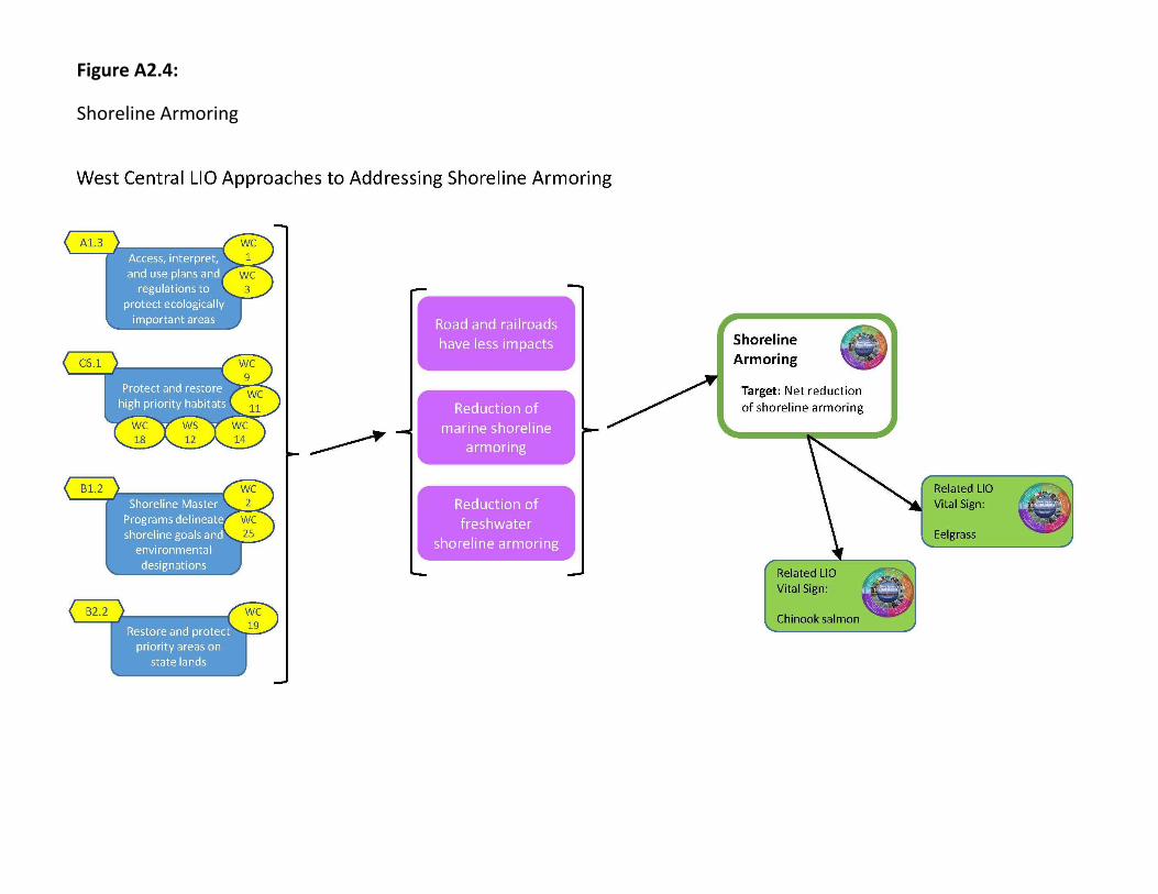
Figure A2.4:
Shoreline Armoring

Figure A2.5:
Chinook Salmon

Figure A2.6:
Land Cover

Figure A2.7:
Eelgrass

