westside creeks ecosystem restoration, san antonio, texas
TRANSCRIPT

SAN ANTONIO CHANNEL IMPROVEMENT
PROJECT, GENERAL RE-EVALUATION
REPORT AND ENVIRONMENTAL
ASSESSMENT
Westside Creeks Ecosystem Restoration, San Antonio, Texas
Draft Report
July 2013


Last Edited: 24 July 2013 13:03 Page i
EXECUTIVE SUMMARY
The purpose of the San Antonio Channel Improvement Project (SACIP) General Re-evaluation Report (GRR) and Environmental Assessment (EA), Westside Creeks (WSC), Ecosystem Restoration, San Antonio, Texas, is to identify ecosystem restoration measures to restore the riverine ecosystem within the WSC that is severely degraded due to the construction and continuing maintenance of the authorized and constructed SACIP and identify recreation opportunities that are compatible with the ecosystem restoration objectives. The GRR and integrated EA describe the characteristics of the existing and future without project conditions, water related resource problems and opportunities, planning objectives and constraints, formulation, evaluation, and comparison of alternatives, and identifies a recommended plan.
The SACIP was authorized under the Flood Control Act of 1954, Section 203, as part of a comprehensive plan for Flood Risk Management (FRM) in the Guadalupe and San Antonio River Basins. The authorization was modified in the Water Resources Development Act (WRDA) of 1976, Section 103, and WRDA 2000, Section 335. The modifications added ecosystem restoration and recreation as authorized purposes. The SACIP, GRR and EA was initiated at the request of the San Antonio River Authority (SARA) to evaluate the addition of ecosystem restoration and recreation purposes to the WSC. The Feasibility Cost Sharing Agreement for the study was executed on February 25, 2012.
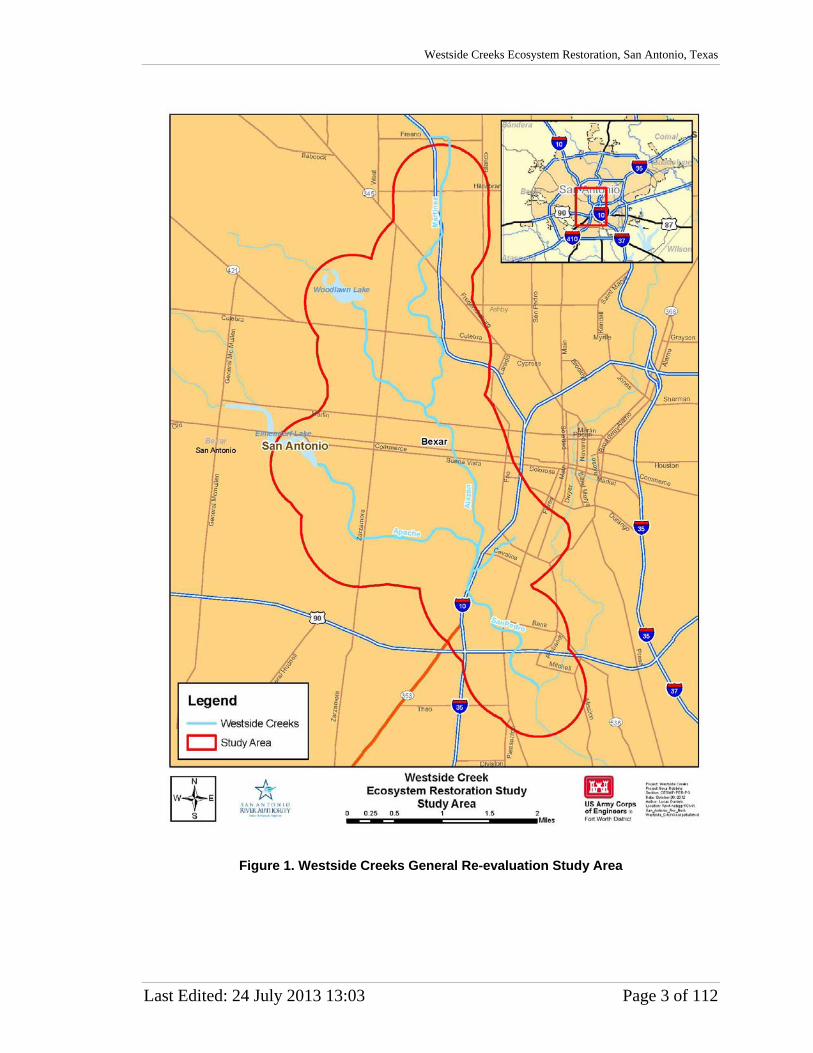
The WSC study area encompasses those portions of Martinez Creek, Alazán Creek, Apache Creek, and San Pedro Creek within the originally constructed SACIP footprint. These creeks, collectively known as the WSC, are located west of the San Antonio River on the west side of San Antonio (Figure ES1).
Changes in the hydraulic regime of the WSC over the last half-century are largely due to shifts in urbanization, the construction of the SACIP, and required operation and maintenance practices. Historic cross sections depict a more natural stream, consisting of a baseflow channel, a wider channel and a large floodplain. Straightening and channelization of the WSC yielded grass-lined trapezoidal channels, concrete banks, and an underground bypass tunnel (San Pedro). While the SACIP conveys flood flows more quickly out of the urban area, the channelization and required maintenance have resulted in unconsidered consequences for the riverine ecosystem along the 35 miles of the SACIP. Channelization has led to an increased bed slope and loss of sinuosity. The result is a system where the sediment transport is out of balance, few to none of the aquatic structures necessary to support and sustain the life cycle of aquatic organisms native to the system remain, and the required shading and allochthonous inputs from the riparian corridor have been removed, severely altering the function of the historic riverine habitat.

San Antonio Channel Improvement Project, General Re-evaluation Report and Environmental Assessment
Page ii Last Edited: 24 July 2013 13:03
Figure ES1. Westside Creeks Study Area

Westside Creeks Ecosystem Restoration, San Antonio, Texas
Last Edited: 24 July 2013 13:03 Page iii
The Resource of National Significance for the study has been identified as migratory birds using the Central Flyway. The study area lies in a critical portion of that flyway, providing stop over habitat, feeding and breeding grounds during crucial times of the migrations.
Measures identified for the ecosystem restoration of the WSC to a more natural condition include riparian meadow (RM) in all areas of the creek, pilot channel (PC) for the length of the creek (with the exception of Apache where only the lower 0.8 miles of pilot channel would be restored), riparian woody vegetation (RWV) at densities of 30- and 70-trees per acre depending on hydraulic constraints, slackwater (SW) areas for the length of the restored pilot channel, and wetlands (WL). Table ES1 lists the seven alternatives in the final array along with specific creeks and associated management measures that are included for each alternative.
Table ES1 Final array of alternatives for Westside Creeks study.
San Pedro Apache Alazán Martinez Alt. 1 No Action No Action No Action No Action Alt. 2 RM, PC, SW, RWV No Action No Action No Action Alt. 3 RM, PC, SW, RWV RM, PC, SW, RWV No Action No Action Alt. 4 RM, PC, SW, RWV RM, PC, SW, RWV RM No Action Alt. 5 RM, PC, SW, RWV RM, PC, SW, RWV RM RM Alt. 6 RM, PC, SW, RWV RM, PC, SW, RWV RM, PC, SW, RWV RM Alt. 7 RM, PC, SW, RWV RM, PC, SW, RWV RM, PC, SW, RWV RM, PC, SW, RWV,WL
RM = Riparian Meadow; PC=Pilot Channel; RWV=Riparian Woody Vegetation at 30 & 70 stems per acre; SW= Slackwater; WL=Wetland.
The recommended plan is the combined National Ecosystem Restoration (NER)/National Economic Development (NED) plan. The NER plan, Alternative 6, would restore 67% of the lower trophic organism carrying capacity possible for the WSC riverine system and provide 114% improvement in habitat quality over the no action alternative for 11 miles along the WSC. At maturity (75 years), the NER plan would provide 222 acres of mixed riparian meadow and riparian woody vegetation. The 6.5 mile pilot channel network would incorporate 146 pool-riffle-run sections and 143 off-channel slackwater areas in the existing SACIP right of way contributing to the restoration of aquatic habitat. The implementation of the NER plan would provide a total migratory bird diversity benefit of 101 average annual avian community units, which represents 82% of the diversity benefits available in the system, at a first cost (October 2012 prices) of approximately $39.4 million. The National Economic Development (NED) plan for recreation would provide 44,600 linear feet of concrete walk, jog, and bike trails. In addition to trails, other components include shade structures (6), interpretive/directional signage (50), benches (15), water fountains (15), picnic tables with pads (23), and trash receptacles (23). The first cost for recreational facilities is approximately $5.1 million with an average annual cost of approximately $272 thousand. With visitor days per year estimated at 481 thousand, the annual benefit is $3.9 million. The resulting net annual benefits are $3.6 million, and the benefit to cost ratio is 14.25. Monitoring and adaptive management is estimated at $800,000. First cost of the combined NER/NED plan is estimated at $45.3 million.
Restoration of the WSC riverine system will add to a larger habitat complex of the San Antonio River. With implementation of Alternative 6, this complex of preserved and restored riverine and upland habitat would amount to 1,492 acres and approximately 20 miles. Restoration of the WSC system and of the larger San Antonio River complex will provide benefits for diverse communities of aquatic organisms and wildlife.

Page 4 Last Edited: 24 July 2013 13:03
San Antonio Channel Improvement Project, General Re-evaluation Report and Environmental Assessment
Taken as a whole, restoration of the WSC system represents a potential for a significant contribution of riverine habitat benefits in a region where such habitats are scarce and declining. In addition to helping to reverse the national trend of declining riverine habitat, restoration of the WSC in conjunction with the on-going restoration along the San Antonio River would provide much needed riverine habitat benefits for migratory birds utilizing the Central Flyway during their Spring and Fall migrations. The recommended plan would effectively provide approximately 20 miles of connected, restored riverine system along a critical stop-over corridor for the birds utilizing the Central Flyway.
The San Antonio Channel Improvement Project, Westside Creeks Ecosystem Restoration Recommended plan:
• fulfills the U.S. Army Corps of Engineers (USACE) restoration mission, • is in accordance with the USACE Civil Works Strategic Plan, • is in accordance with the USACE Environmental Operating Principles, • is in compliance with USACE restoration and recreation policies, • is sustainable though the application of geomorphologic principles for sediment transport,
hydraulic modeling, native vegetation species survivability, and synergistic effects, • restores biological and environmental resources that were present prior to the construction of
the SACIP, • restores limiting habitat for neotropical migratory bird species, • complements other Federal, state, and local restoration programs and projects, • demonstrates ecosystem restoration and recreation co-exists effectively with the existing
SACIP purpose of flood risk management, • provides connection to adjacent restored and preserved habitats within the San Antonio River
watershed, • restores the creeks to a more natural structure and function resulting in the greatest practicable
sinuosity, slope gradient, velocity, and sediment transport while maintaining the current effectiveness of the flood risk management function of the SACIP, and
• is supported by U.S. Fish and Wildlife Service, and Texas Parks and Wildlife Department, as well as having widespread local support.
The San Antonio River Authority (SARA), on behalf of the City of San Antonio and Bexar County, is identified as the non-Federal sponsor. SARA, City of San Antonio, and Bexar County support the recommended plan and, should the plan be approved, intend to participate in its implementation.
The draft GRR and EA will be available for public review July 31 – August 30, 2013. Two public meetings were held in the study area the week of June 24 – 28, 2013. The report is available in PDF on the Fort Worth District website, http://www.swf.usace.army.mil, and hard copies are available at the SARA office located at 100 E. Guenther St., San Antonio, Texas.
Comments or questions regarding the SACIP GRR and EA or the recommended plan should be addressed to Mr. Danny Allen, Environmental Planner, CESWF-PER-EC, U.S. Army Corps of Engineers, Fort Worth District, P.O. Box 17300, Fort Worth, Texas, 76102-0300, or call 817- 886-1821, or use electronic mail at [email protected].

Last Edited: 24 July 2013 13:03 Page v
TABLE OF CONTENTS * Indicates this section satisfies one or more of the requirements of the National Environmental Policy Act
Executive Summary .........................................................................................................................................i
List of Figures ................................................................................................................................................ix
List of Tables ................................................................................................................................................... x
Chapter 1: Introduction ................................................................................................................................... 1
Study Purpose and Need* ........................................................................................................................... 1 Scope* ......................................................................................................................................................... 1 Study Authority ........................................................................................................................................... 2 Study Location* .......................................................................................................................................... 2 Previously Constructed Projects ................................................................................................................. 4
San Antonio Channel Improvement Project (SACIP) ............................................................................. 4 Eagleland, Section 1135 ......................................................................................................................... 4 Mission Reach ........................................................................................................................................ 4
Problem Identification ................................................................................................................................ 6 Ecosystem Restoration ............................................................................................................................ 6 Flood Risk Management ......................................................................................................................... 7 Recreation............................................................................................................................................... 7 Study Focus ............................................................................................................................................ 7
Chapter 2: Existing Conditions and Future Without Project Conditions ......................................................... 9
Climate* ...................................................................................................................................................... 9 Geology and Topography* .......................................................................................................................... 9 Soils, Including Prime Farmlands* ........................................................................................................... 10 Land Use* ................................................................................................................................................. 10 Air Quality* .............................................................................................................................................. 10 Noise* ....................................................................................................................................................... 10 Transportation* ......................................................................................................................................... 10 Light* ........................................................................................................................................................ 11 Hydrology & Hydraulics ........................................................................................................................... 11
Watershed Description* ....................................................................................................................... 11 Flood History ........................................................................................................................................ 11 Hydrology ............................................................................................................................................. 14 Hydraulics ............................................................................................................................................ 14
Socioeconomics* ...................................................................................................................................... 14 Cultural Resources .................................................................................................................................... 15
Archeological Resources* .................................................................................................................... 16 Architectural Resources* ..................................................................................................................... 16
Hazardous, Toxic and Radioactive Waste* ............................................................................................... 16 Visual Esthetics* ....................................................................................................................................... 16 Other Social Effects* ................................................................................................................................ 16 Real Estate ................................................................................................................................................ 17 Recreation Resources* .............................................................................................................................. 17 Riverine Resources ................................................................................................................................... 18
Aquatic Resources ................................................................................................................................ 18 Wetlands* ............................................................................................................................................. 19

San Antonio Channel Improvement Project, General Re-evaluation Report and Environmental Assessment
Page vi Last Edited: 24 July 2013 13:03
Riparian Resources* ............................................................................................................................ 19 Surface Water Quality*........................................................................................................................ 21 Groundwater* ...................................................................................................................................... 21 Wildlife* ............................................................................................................................................... 21 Threatened and Endangered Species* ................................................................................................. 22 Migratory Bird Stop-Over Habitat ...................................................................................................... 23 WSC Ecological Food Web .................................................................................................................. 24
Chapter 3: Plan Formulation ......................................................................................................................... 27
Problems and Opportunities ..................................................................................................................... 27 Problem 1 – Degraded and Lost Riverine Structure and Function ..................................................... 27 Problem 2 – Residual Flood Risk ........................................................................................................ 28 Problem 3 –Disconnected Communities .............................................................................................. 29
Planning Goal and Objectives .................................................................................................................. 29 Planning Goal ...................................................................................................................................... 29 Objective 1 – Riverine Ecosystem Restoration (Problem Statement 1) ............................................... 29 Objective 2 – Community Connectivity Through Recreation (Problem Statement 3) .......................... 29
Constraints................................................................................................................................................ 29 Ecosystem Restoration Benefits ............................................................................................................... 30 Preliminary Measures, Criteria, and Screening ........................................................................................ 30
Ecosystem Restoration Management Measures ................................................................................... 31 Recreation Management Measures ...................................................................................................... 33 Initial Screening Criteria ..................................................................................................................... 33 Key Uncertainties ................................................................................................................................ 34 Screening and Scaling of Management Measures – Ecosystem Restoration ....................................... 36 Evaluation of Final List of Management Measures ............................................................................. 38
Alternative Comparison ........................................................................................................................... 41 Comparison Criteria ............................................................................................................................ 41 Cost Effective and Incremental Cost Analysis ..................................................................................... 42
National Ecosystem Restoration Plan ...................................................................................................... 44 Selection Criteria for the National Ecosystem Restoration Plan ......................................................... 45 Is It Worth It Analysis on Final Array of Alternatives ......................................................................... 47 Selection of National Ecosystem Restoration Plan .............................................................................. 54
National Economic Development Plan .................................................................................................... 54 Tentatively Selected Plan ......................................................................................................................... 55
Regional Economic Development, Environmental Quality, and Other Social Effects ......................... 56 Efficiency, acceptability, completeness, and effectiveness ................................................................... 57
Chapter 4: Environmental Consequences* ................................................................................................... 59
Land Use .................................................................................................................................................. 59 Geology .................................................................................................................................................... 59 Soils .......................................................................................................................................................... 60
No Action ............................................................................................................................................. 60 Action Alternatives ............................................................................................................................... 60
Climate ..................................................................................................................................................... 60 Riverine Resources ................................................................................................................................... 60
Vegetation ............................................................................................................................................ 61 Wetlands and Waters of the U.S........................................................................................................... 61 Surface Water Quality ......................................................................................................................... 62

Westside Creeks Ecosystem Restoration, San Antonio, Texas
Last Edited: 24 July 2013 13:03 Page vii
Floodplains ........................................................................................................................................... 63 Groundwater ......................................................................................................................................... 63 Wildlife ................................................................................................................................................. 63
Threatened and Endangered Species ......................................................................................................... 65 Air Quality ................................................................................................................................................ 65 Noise ......................................................................................................................................................... 65 Transportation ........................................................................................................................................... 66 Light .......................................................................................................................................................... 66 Cultural Resources .................................................................................................................................... 67
Archeological Resources ...................................................................................................................... 67 Architectural Resources ....................................................................................................................... 67
Hazardous, Toxic, and Radioactive Waste ................................................................................................ 68 Visual Aesthetics ...................................................................................................................................... 68 Socioeconomics ........................................................................................................................................ 69 Other Social Effects .................................................................................................................................. 69 Recreation ................................................................................................................................................. 69 Irreversible And Irretrievable Commitment Of Resources ....................................................................... 70 Indirect Effects .......................................................................................................................................... 70 Cumulative Impacts .................................................................................................................................. 71
Riverine Habitat ................................................................................................................................... 72 Wildlife ................................................................................................................................................. 73
Mitigation Requirements........................................................................................................................... 74 Environmental Compliance ....................................................................................................................... 74
Advisory Circular 150/5200-33A - Hazardous Wildlife Attractants on Near Airports ........................ 74 Section 404 of the Clean Water Act ...................................................................................................... 74 Section 402 of Clean Water Act ............................................................................................................ 75 Section 176(c) Clean Air Act ................................................................................................................ 75 Executive Order 13112, Invasive Species ............................................................................................. 75 Executive Order 11988, Floodplain Management ................................................................................ 76 Executive Order 13186, Migratory Birds ............................................................................................. 76 Texas Senate Bill 2 ............................................................................................................................... 77 Executive Order 12898, Environmental Justice ................................................................................... 77 Executive Order 13045, Protection of Children ................................................................................... 77 Fish and Wildlife Coordination Act ...................................................................................................... 78
Adaptive Management And Monitoring Plans .......................................................................................... 78 Conclusions ............................................................................................................................................... 78
Chapter 5: Recommended Plan ..................................................................................................................... 81
Description of the Recommended Plan ..................................................................................................... 81 Restoration Features ............................................................................................................................ 81 Recreation Features ............................................................................................................................. 87 Impact of Recommended Plan on Existing Flood Risk Management Project ....................................... 88
Benefits Gained for Nationally, Regionally, and Locally Significant Resources ..................................... 88 Scarcity ................................................................................................................................................. 88 Representativeness................................................................................................................................ 89 Status and Trends ................................................................................................................................. 89 Connectivity .......................................................................................................................................... 89 Limiting Habitat ................................................................................................................................... 90 Biodiversity ........................................................................................................................................... 90

San Antonio Channel Improvement Project, General Re-evaluation Report and Environmental Assessment
Page viii Last Edited: 24 July 2013 13:03
Benefits of the Recommended Plan to Other Federal Goals and Objectives ........................................... 90 Project Implementation ............................................................................................................................ 93
Pre-Construction Engineering and Design .......................................................................................... 93 Real Estate Acquisition ........................................................................................................................ 95 Contract Advertisement and Award ..................................................................................................... 95 Project Construction ............................................................................................................................ 95 Monitoring and Adaptive Management ............................................................................................... 96 Operation, Maintenance, Repair, Replacement, Rehabilitation (OMRR&R) ...................................... 96 Total Project Cost and Cost Sharing ................................................................................................... 97 Project Implementation Schedule ........................................................................................................ 97 Financial Plan and Capability Assessment .......................................................................................... 97 View of the Local Sponsor ................................................................................................................. 100 Views of Resource Agencies ............................................................................................................... 101 Environmental Operating Procedures ............................................................................................... 101 Chief of Engineers Campaign Plan ................................................................................................... 101 Conclusions ........................................................................................................................................ 102
Recommendation ........................................................................................................................................ 105
Draft Finding of No Significance Impact ................................................................................................... 106
Chapter 6: Public Involvement ................................................................................................................... 107
Agency Coordination ............................................................................................................................. 107 Public Information and Review .............................................................................................................. 107
List of Preparers.......................................................................................................................................... 108
Acronyms ................................................................................................................................................... 109
References .................................................................................................................................................. 112
LIST OF APPENDICES Appendix A: Geomorphology Appendix B: Hydrology and Hydraulics Appendix C: Natural Resources Appendix D: Cost Effectiveness – Incremental Cost Analysis Appendix E: Civil Engineering Design Appendix F: Geotechnical Appendix G: Hazardous, Toxic, and Radioactive Waste Appendix H: Cultural Resources Appendix I: Socio-Economics Appendix J: Recreation Appendix K: Other Social Effects Appendix L: Real Estate Appendix M: Cost Estimating Appendix N: Public Communication Appendix O: Review Comments and Responses

Westside Creeks Ecosystem Restoration, San Antonio, Texas
Last Edited: 24 July 2013 13:03 Page ix
LIST OF FIGURES Figure 1. Westside Creeks General Re-evaluation Study Area ....................................................................... 3 Figure 2. Previously Constructed Projects ...................................................................................................... 5 Figure 3. Land Use within the Westside Creeks Study Area ......................................................................... 12 Figure 4. Limits of the 1% Annual Chance Exceedance Floodplain for the Westside Creeks Study Area ... 13 Figure 5. Current Appearance of Westside Creeks ....................................................................................... 19 Figure 6. Ecological Trophic Levels and Foodweb Pathways of the Westside Creeks Riverine System. ..... 25 Figure 7. Final Array of Alternatives Resulting from the Cost Effective Incremental Cost Analysis for
Westside Creeks Study. ........................................................................................................................ 43 Figure 8. Relative change of carrying capacity and system quality selection criteria for the of Westside
Creeks alternative array. ....................................................................................................................... 49 Figure 9. Typical Pilot Channel Cross Section for the Westside Creeks Recommended Plan ...................... 82 Figure 10. Typical Section for Rock Cross Vanes in the Westside Creeks Recommended Plan .................. 82 Figure 11. Typical Rock Cross Vane Anticipated for the Pilot Channels in the Westside Creeks Proposed
Project ................................................................................................................................................... 83 Figure 12. Photo of a Representative Functioning Rock Cross Vane ............................................................ 84 Figure 13. Representative Concept of Maximum Practicable Restoration for the Westside Creeks ............. 86

San Antonio Channel Improvement Project, General Re-evaluation Report and Environmental Assessment
Page x Last Edited: 24 July 2013 13:03
LIST OF TABLES Table 1. 2010 Median Household and Per Capita Incomes for the WSC Study Area. ................................. 15 Table 2. Federal and State listed species potentially occurring within the WSC study area. ....................... 23 Table 3. Potential ecosystem restoration management measures to address specific areas of structure and/or
function loss or degradation in the Westside Creeks Study Area. ....................................................... 31 Table 4. Average Annual Avian Community Units (AAACU) and Average Annual Cost (AAC) for
Alternative Comparison During the Westside Creeks Ecosystem Restoration Study. ......................... 42 Table 5. Final Array of Alternatives for Westside Creeks Study. ................................................................ 43 Table 6. Cost and Benefit parameters for six action alternatives in the final alternative array of the Westside
Creek study. ......................................................................................................................................... 44 Table 7. Comparison of Action Alternatives Against National Ecosystem Restoration Plan Selection
Criteria for the Westside Creeks Study. ............................................................................................... 48 Table 8. First Annual Cost for the Westside Creeks Tentatively Selected Plan Using the 2010 Cost Book. 56 Table 9. First annual cost for the Westside Creeks tentatively selected plan using the 2012 Cost Book. .... 56 Table 10. Past, Present, and Future Projects Impacting Rivierine Habitats in the WSC Cumulative Study
Area ..................................................................................................................................................... 72 Table 11. Total Project First Cost and Cost Share Summary of the Recommended Plan for the Westside
Creeks .................................................................................................................................................. 98 Table 12. Westside Creeks Proposed Project Implementation Schedule and Funding ($000) ..................... 99

Last Edited: 24 July 2013 13:03 Page 1 of 112
CHAPTER 1: INTRODUCTION
The riverine habitat of the San Antonio River system within the boundaries of the San Antonio Channel Improvement Project (SACIP) in Bexar County has been severely degraded. The SACIP has successfully performed the single purpose of Flood Risk Management (FRM); however, construction and continued operations and maintenance have had severe ecological consequences for the riverine system along the 35 mile SACIP that were not considered at the time of design and construction. In 2000, the single purpose project authorization for SACIP was modified to allow ecosystem restoration and recreation to be added as project purposes, thereby providing an opportunity to consider the ecological losses to the riverine habitat and the impacts those losses may have to the Nation’s natural resources including loss of stop-over habitat for migratory and nesting birds utilizing the Central Flyway. Restoration opportunities for the SACIP along nine miles of the San Antonio River have already been studied and are in the final stages of implementation. The remaining components of the SACIP under consideration for ecosystem restoration and recreation are the four tributaries along the western side of the San Antonio River mainstem. These four tributaries are Alazán Creek, Apache Creek, Martinez Creek, and San Pedro Creek, and are referred to collectively as the Westside Creeks (WSC).
STUDY PURPOSE AND NEED*
The purpose of the study is to identify and implement ecosystem restoration measures to restore the riverine ecosystem within the WSC that is severely degraded due to the construction and continuing maintenance of the original SACIP.
The quantity and quality of riverine habitat is degraded and no longer supports the historic level of organism diversity at all trophic levels. Degraded aquatic habitat fails to support the diversity of aquatic plants and macroinvertebrates that form the foundation of riverine (aquatic and riparian) biotic ecosystems. An increase in biomass and biotic diversity at the fundamental trophic levels is required to restore sustainable fish, amphibian, reptile, mammal, and avian communities.
SCOPE*
This General Re-evaluation Report (GRR) describes the existing and future without project conditions with regard to the water related resource problems and opportunities, planning objectives and constraints, development, analysis, and evaluation of measures and alternatives. A potential United States Army Corps of Engineers (USACE) project is identified with associated USACE and other Federal interests, and a recommended plan commensurate with USACE authorities and interests for an investment decision.
The Environmental Assessment (EA) integrated into the GRR has been prepared pursuant to Section 102 of the National Environmental Policy Act (NEPA) of 1969 as implemented by the regulations promulgated by the Council on Environmental Quality (40 CFR Parts 1500-1508 and ER 200-2-2). The objectives of NEPA are to ensure consideration of the environmental aspects of the Proposed Action in Federal decision-making processes and to disclose environmental information to the public and collect their input before decisions are made and actions are taken. The EA provides sufficient evidence for determining whether to prepare an Environmental Impact Statement (EIS) or Finding of No Significant Impact (FONSI). This EA evaluates the

San Antonio Channel Improvement Project, General Re-evaluation Report and Environmental Assessment
Page 2 of 112 Last Edited: 24 July 2013 13:03
potential environmental impacts associated with seven alternatives, including the No Action alternative. The scope of the alternatives analyzed in this EA is limited to the SACIP boundaries of the WSC.
STUDY AUTHORITY
The GRR for the WSC is conducted under the SACIP authorization. The SACIP was authorized by Section 203 of the Flood Control Act (FCA) of 1954 as part of a comprehensive plan for flood protection on the Guadalupe and San Antonio Rivers.
SEC. 203. SAN ANTONIO CHANNEL, SAN ANTONIO, TEXAS
“The project for flood protection on the Guadalupe and San Antonio River, Texas is herby authorized substantially in accordance with the recommendation of the Chief of Engineers in the House Document Numbered 344, Eight-Third Congress at an estimated cost of $20,254,000.”
A modification to the original authorization was documented in Section 335 of WRDA 2000, which reads as follows:
SEC. 335. SAN ANTONIO CHANNEL, SAN ANTONIO, TEXAS
The project for flood control, San Antonio channel, Texas, authorized by section 203 of the Flood Control Act of 1954 (68 Stat. 1259) as part of the comprehensive plan for flood protection on the Guadalupe and San Antonio Rivers in Texas, and modified by section 103 of the Water Resources Development Act of 1976 (90 Stat. 2921), is further modified to include environmental restoration and recreation as project purposes.
The above cited legislation defines the area of investigation known as the SACIP in San Antonio, Texas. The four creeks that make up the WSC are included in the SACIP. This study is therefore authorized under this legislation. The study fits into the overall concept of the SACIP authorization to conduct an integrated and coordinated approach to locating and implementing opportunities for FRM, ecosystem restoration, and recreation along the San Antonio River system. The goal of this study is to develop a recommendation whether or not to construct additional project purposes of ecosystem restoration and recreation in the San Antonio River watershed without compromising the functioning of the existing FRM project.
STUDY LOCATION*
While the SACIP footprint for the WSC represents a focal point for USACE actions and decisions, USACE recognizes that factors outside the SACIP footprint influence the feasibility and sustainability of any actions that might be undertaken. Likewise, any actions that might be undertaken in cooperation with USACE could have positive or negative impacts on the surrounding area. In order to identify those factors and consider them in the analysis and recommendations, the study area cannot be limited to the footprint of the authorized SACIP, even if any recommended measures are. Therefore, the study area (Figure 1) includes the WSC and one half mile on either side of each of the four creeks in the WSC.
Westside Creeks Ecosystem Restoration, San Antonio, Texas
Last Edited: 24 July 2013 13:03 Page 3 of 112
Figure 1. Westside Creeks General Re-evaluation Study Area

San Antonio Channel Improvement Project, General Re-evaluation Report and Environmental Assessment
Page 4 of 112 Last Edited: 24 July 2013 13:03
PREVIOUSLY CONSTRUCTED PROJECTS
SAN ANTONIO CHANNEL IMPROVEMENT PROJECT (SACIP)
Guadalupe and San Antonio Rivers, Texas – Chief of Engineers Report (February 1954). This USACE report served as the decision document for the authorized project (House Document Numbered 344, 83rd Congress, 2nd Session). The report concluded, in part, “that a serious flood problem exists within the city of San Antonio, an important military center and distribution point for a vast area in southwest Texas, and that a flood-protection project for this city to eliminate the
flood menace is economically justified.” Further, the report recommended “that a channel improvement project in San Antonio, Texas, be authorized at this time for construction by the Federal Government, substantially as outlined in this report, at an estimated first cost to the United States of $12,906,900…”
The project was constructed in increments beginning in 1957, and the FRM component was completed in 1998. The total length of the constructed project is 34.9 miles. Two flood diversion tunnels, each approximately 24 feet in diameter, were constructed beneath the downtown area. The authorized project cost was $20.3 million. This equates to $263.3 million in October 2012. Figure 2 shows the construction footprints of the previously constructed projects.
EAGLELAND, SECTION 1135
Eagleland Habitat Restoration, San Antonio, Texas – Section 1135 of the Water Resources Development Act (WRDA) of 1986, as amended. The Eagleland project is located in San Antonio along the portion of the SACIP from the Alamo Street dam downstream to the Lone Star Boulevard bridge. Clearing of the floodway and channel re-alignment for the SACIP destroyed the vast majority of the high quality riparian habitat. This project incorporated ecosystem restoration and recreation purposes into the existing FRM project while maintaining the existing FRM performance. The Eagleland project restored approximately one mile of the San Antonio River, relocating the base flow channel to meander primarily along the outside of the existing bends. Native grasses, trees, and shrubs were planted along channel side slopes, the top of the floodway bank, and within the flood control channel to restore riverine habitat. A riffle-pool complex was created in the base flow channel, and storm water outfall structures were naturalized through the use of native stone and wetland plantings. Construction was completed in 2006 with a total project cost of $2.8 million in 2006 (approximately $3.4 million in October 2012 dollars).
MISSION REACH
San Antonio River, San Antonio, Texas, Channel Improvement Project, General Re-evaluation Report (GRR) (July 2006). The Mission Reach project continued the restoration downstream along the San Antonio River that began with the above mentioned Eagleland project. This project also incorporates ecosystem restoration and recreation while maintaining the existing FRM level of performance. This report concluded “the hydrologic regime of the San Antonio River within the Mission Reach has been severely altered by the construction, operation, and maintenance of the SACIP.” In addition, “while conveying flood flows more quickly downstream, the geomorphic impact is erosion, scour, headcutting, and sediment accumulation. Together with the lack of vegetation, there is insufficient suitable aquatic feeding, breeding, and resting habitat for native fishes.” The National Environmental Restoration (NER) plan recommended in the 2006 report is comprised of a series of pools-riffle-chute complexes, restored river remnants, nine embayments, four tributary mouths, a wetland, and riparian vegetation

Westside Creeks Ecosystem Restoration, San Antonio, Texas
Last Edited: 24 July 2013 13:03 Page 5 of 112
Figure 2. Previously Constructed Projects

San Antonio Channel Improvement Project, General Re-evaluation Report and Environmental Assessment
Page 6 of 112 Last Edited: 24 July 2013 13:03
resulting in 113 acres of restored aquatic habitat, and 320 acres of restored riparian habitat. The recommended plan in the 2006 report also includes the following recreation features: multi-purpose trails, shade shelters, picnic tables, water fountains, trash receptacles, benches, lighting and signage. The total estimated cost of this plan was $93.8 million in September 2004. When updated to October 2012, this cost is $134.8 million. Construction of the Mission Reach project began in 2008 and is scheduled to be completed in the winter of 2014.
PROBLEM IDENTIFICATION
The non-Federal sponsor, the San Antonio River Authority (SARA) requested the USACE re-evaluate the WSC area of the SACIP to determine if Federal interest exists for ecosystem restoration and recreation. SARA expressed interest in evaluating the potential to reverse to the extent possible the ecological losses to the riverine habitat, reduce the residual flood risk in the study area remaining following the construction of the SACIP, and provide recreation facilities.
ECOSYSTEM RESTORATION
Under natural river and stream morphological processes occurring during channel forming flow events, the longitudinal slope of the river bed is formed through the natural formation of curves (sinuosity) which lengthens the river and slows water velocities around the outer bends; subsequently, the slower velocities allow sediment to drop from the water column forming natural pools and riffles. As the channel forming flow continues through the river channel, the velocities increase around the inside bend of the river and in the straighter sections (runs), and additional sediment is picked up in the water column. The resulting habitat is sustained by the morphological processes repeating at each curve of the river creating a series of pool-riffle-run sequences. These pool-riffle-run sequences are the structural foundation of aquatic ecosystem habitat and in combination with the adjacent riparian corridor constitute the riverine ecosystem. Organic materials provided by both the riparian corridor and the aquatic environment are moved through the system largely through the flow of water where the diversity of water velocity along with subtle to dramatic changes in substrates, aquatic vegetation, and river banks cause the organic materials to become trapped and deposited. The process of organic movement, deposition, and decomposition is the foundation of a highly functional riverine ecosystem.
The riverine ecosystem within the WSC is severely degraded due to the construction and continuing maintenance of the original SACIP. Construction of the FRM measures for the SACIP included channelization which straightened the historically sinuous course of the San Antonio River and tributaries as well as removed the historic riparian woody vegetation and native herbaceous meadow vegetation. Continued maintenance of the FRM channel suppresses the re-establishment of a woody vegetation corridor and creates an environment which gives a competitive advantage to non-native and invasive herbaceous plants and non-native and tolerant aquatic organisms. The result is a riverine ecoysystem that no longer resembles the historically physically and faunistically distinctive riverine basin of the western Gulf Slope (Appendix C, Natural Resources).
The losses in riparian vegetation (with associated allochthonous inputs) and riffle-pool-run sequences (with associated habitat complexity) and the subsequent impact to organisms utilizing these habitats prompted this feasibility study to identify measures for restoration of riverine structure and function.

Westside Creeks Ecosystem Restoration, San Antonio, Texas
Last Edited: 24 July 2013 13:03 Page 7 of 112
FLOOD RISK MANAGEMENT
The WSC study takes place within the footprint of an existing successful FRM project. The SACIP project was designed to contain the transposed 1946 storm event. Subsequent analysis indicates that the 1946 storm was an event slightly more frequent than a 1% Annual Chance Exceedance (ACE) probability, commonly known as the 100-year flood. Though the earlier channel modifications and subsequent removal of structures significantly reduced flood risk in San Antonio and the WSC community, residual damages remain within the 1% ACE floodplain delineation. Discussion with the non-Federal sponsor revealed that some structures in the study area experience recurring localized flooding. However, public safety is the more prevalent problem due to the loss of emergency access to neighborhoods when roads and bridges are covered in water. A preliminary analysis was performed to determine if the remaining flood risk would support Federal investment within USACE authorities prior to expending funds on formulation for FRM.
Building footprints, stream banks, contours, and the 1% ACE flood plain delineation based on Federal Emergency Management Agency (FEMA) Digitized Flood Insurance Rate Mapping (DFIRM) were identified in Geographic Information Systems (GIS). The depth of flooding was determined based on the difference between the water surface elevation and the top of bank elevation at cross sections along each of the creeks. Flooding was assumed to occur if the water surface elevation exceeded the top of bank elevation. The depths of flooding at structures were calculated using floor corrections ranging from 1.5 feet to 3 feet to obtain a range of finished floor elevations. Using contour shape files, a ground elevation, and stream station were assigned to each structure. The GIS analysis places water at floor elevation or higher for less than 50% of the structures remaining in the 1% ACE floodplain.
Based on Bexar County appraisal district information, the average age of homes in the WSC study community is 60 years, and the average valuation as of 2010 was $52 thousand. Since damages would accrue to less than 50% of the remaining structures, and the depreciated replacement value of these structures would be exceedingly low, the remaining damages would be insufficient to support any structural alternative. Furthermore, since non-structural measures have already been applied where desired through the Federal Emergency Management Agency Voluntary Acquisition Program (FEMA VAP), real estate acquisition costs would exceed the benefits for non-structural measures.
RECREATION
The availability of recreation facilities in the study area is disproportionately less than in other areas of the City of San Antonio (City), the State of Texas (State), and the nation. As a result, if ecosystem restoration is recommended, the study will assess the feasibility of incorporating recreation compatible in scale and type with ecosystem restoration.
STUDY FOCUS
The level of degradation to the riverine ecosystem and the potential ecosystems restoration benefit potential drive the scope and scale of the formulation for ecosystem restoration. Recreation is formulated and evaluated in a scope and scale consistent with the recommended NER plan and identified recreation problems and opportunities. Though some residual flood risk remains following construction of the SACIP, no formulation specifically for the purpose of FRM is performed. However, ecosystem restoration and recreation formulation are constrained by the existing water surface elevations so that the functionality of the existing FRM project remains intact.


Last Edited: 24 July 2013 13:03 Page 9 of 112
CHAPTER 2: EXISTING CONDITIONS AND FUTURE WITHOUT
PROJECT CONDITIONS
This chapter describes the existing conditions and expected conditions in the future that affect plan formulation and selection of a recommended plan. In addition, it includes discussion on the affected environment as it relates to NEPA. The affected environment is the natural and physical environment as well as the relationship of people with the environment.
Because the WSC study area is located within the existing SACIP project area, the future without-project condition for aquatic and riparian habitat would continue to be equivalent to the existing conditions. As continued mowing and maintenance of the floodway would continue to minimize the habitat value of the floodway, the Index of Human Disturbance and Avian IBI scores would fluctuate with yearly rainfall and management actions but on average remain the unchanged over the next 75 years. In order to maintain the existing flood protection, any woody vegetation invading the floodway would have to be removed and the invasive non-native Bermudagrass and Johnsongrass would continue to dominate the herbaceous vegetation. Sedimentation and erosion problems would also persist throughout the next 75 years, requiring frequent maintenance to keep flood conveyance within existing expected conditions.
CLIMATE*
San Antonio has a modified subtropical climate with more continental influence during winter and greater maritime influence from the Gulf of Mexico during summer. The mean annual temperature is 69°F. Mild weather prevails most of the winter, with freezing temperatures occurring approximately 20 days per year. Summers are usually long and hot with daily maximum temperatures over 90˚F occurring approximately 80% of the time. The mean annual precipitation is 29 inches per year. San Antonio is situated between more arid areas to the north and west, and more humid areas to the east. This results in large variations in monthly and annual precipitation, which can fluctuate between 10 and 50 inches annually.
In Texas, temperatures are expected to increase by 4° F by 2050 because of rising levels of carbon dioxide and other greenhouse gases in the atmosphere. The intensity of hurricanes and resulting precipitation is expected to increase; however, these pulsed periods of high precipitation are expected to be followed by increasingly long periods of drought (U.S. EPA 2013). Although temperatures are expected to increase according to the latest climate models, future changes to precipitation in Texas resulting from climate change are highly variable and continue to have a high level of uncertainty (Schmandt et al. 2011).
GEOLOGY AND TOPOGRAPHY*
Bexar County includes three physiographic provinces: the Edwards Plateau, Blackland Prairie, and Interior Coastal Plain. The Edwards Plateau is located to the northwest and the Interior Coastal Plain encompasses the southeastern part of Bexar County. The Balcones Escarpment and fault zone makes up the dividing line between the Edwards Plateau and the Blackland Prairie. The WSC study area is located downslope of the Balcones Fault Zone in the Blackland Prairie physiographic province, as is most of the city of San Antonio.
Geologic formations outcropping in the project study area are Cretaceous and Paleocene in age. In order of deposition from oldest to youngest, the Cretaceous age formations include the Austin

San Antonio Channel Improvement Project, General Re-evaluation Report and Environmental Assessment
Page 10 of 112 Last Edited: 24 July 2013 13:03
Chalk, Anacacho Limestone, Taylor Marl, and Navarro Group. The Wills Point formation of the Midway Group is Paleocene in age and outcrops at the southernmost extent of the study area.
Topography in the study area is typical of heavily urbanized areas. Beyond the SACIP, the terrain is gently sloped. Drainage swales effectively direct storm water and other run off into storm sewers or local creeks.
SOILS, INCLUDING PRIME FARMLANDS*
Within the WSC study area, historic soils were comprised of the Austin-Tarrant, Lewisville-Houston Black terrace, and Venus-Frio-Trinity associations. Today the overburden soils are composed of a mixture of the historic parent materials mixed with fill materials as a result of urban development and construction of the SACIP. Other historical soils in the study area include: Austin silty clay, Houston Black clay, Branyon clay, Houston Black gravelly clay, Lewisville silty clay, and Patrick soils.
Historically, the study area contained prime farmland soils; however, the area is urbanized and no longer falls under the jurisdiction of the Farmland Protection Policy Act (FPPA).
LAND USE*
Land in the study area is dominated by urban uses (Figure 3). The most abundant land use is residential followed by commercial, industrial, open space and municipal. Roads, sidewalks, buildings, parking lots, and other impervious surfaces are common. The San Antonio central business district adjoins the east side of the study area. The upper portion of San Pedro Creek is located within the downtown area, partly flowing underground through a manmade tunnel for several blocks in downtown San Antonio. The remainder of the creeks in the study area flow through combinations of residential, commercial, and industrial areas.
AIR QUALITY*
The study area is located in Bexar County which is currently in attainment or unclassifiable status for all National Ambient Air Quality Standards (NAAQS) criteria pollutants as established and monitored by the EPA.
NOISE*
Pursuant to Chapter 21, Article III of the City Municipal Code, maximum permissible noise levels depend on the land use of the property that contains the noise source (e.g., industrial, commercial, or residential) and the land use of the property receiving that noise. Maximum permissible noise levels range from the 63 A-frequency weighted decibels (dBA) in residential zoning districts to 85 dBA in the entertainment zoned districts. Baseline noise levels within the immediate vicinity are typical of urbanized areas.
TRANSPORTATION*
The main traffic arteries in the WSC study area include I-35 and I-10. Numerous two-lane roads form the primary transportation grid throughout the WSC neighborhoods. Four-lane collector roads such as Zarzamora, Brazos, Culebra, Guadalupe, Nogalitos, Buena Vista, Commerce,

Westside Creeks Ecosystem Restoration, San Antonio, Texas
Last Edited: 24 July 2013 13:03 Page 11 of 112
Probandt, and Flores Streets are interspersed at relatively equal distances throughout the WSC study area.
LIGHT*
Existing artificial light sources within the WSC study area can be attributed to streetlights, traffic at bridge crossings, and fugitive light from parks, neighborhoods, businesses, and industries adjacent to the floodway. The existing Apache Creek Park hike and bike trail follows both sides of Apache Creek from Elmendorf Lake downstream to the intersection of Tampico and Hidalgo Streets. The existing trail is illuminated by overhead lighting dedicated to the trail. Because of the urban landscape, sky glow (diffuse light escaping from urban sources) is potentially the greatest source of artificial light for the remainder of the study area.
HYDROLOGY & HYDRAULICS
WATERSHED DESCRIPTION*
San Pedro Creek is classified as a perennial stream while the remaining three creeks in WSC are classified as ephemeral. However, site visits show that even in drought conditions there is generally water in all four creeks, and the few life-sustaining pools remaining in the system continue to have water at depths of 4 to 6 feet.
Flood potential is evaluated by the FEMA, which determines the floodplain for 1% ACE and 0.2% ACE flood events. Federal, state, and local regulations often limit floodplain development to passive uses such as recreational and preservation activities in order to reduce the risks to human health and safety. The SACIP improvements were designed to convey flood flows for the storm of record that occurred in 1946 as transposed over the San Antonio River Basin. Flood elevations during the 1946 flood did not approach the 1% ACE flood elevation; therefore, the 1% ACE floodplain extends beyond the SACIP boundary (Figure 4).
FLOOD HISTORY
High intensity precipitation coupled with urbanized rocky terrain makes the WSC prone to flash floods which rise and fall in rapid response to storms. The National Climatic Data Center (NCDC) storm event data base (www.ncdc.noaa.gov/stormevents, accessed May 23, 2013) reports 33 flood events and 142 flash flood events in Bexar County between January 2000 and February 2013. The June 30 – July 4, 2002 flash flood event affected the study area and precipitated the FEMA VAP grant used by the City to permanently evacuate and demolish flood prone residences between 2002 and 2004.

San Antonio Channel Improvement Project, General Re-evaluation Report and Environmental Assessment
Page 12 of 112 Last Edited: 24 July 2013 13:03
Figure 3. Land Use within the Westside Creeks Study Area

Westside Creeks Ecosystem Restoration, San Antonio, Texas
Last Edited: 24 July 2013 13:03 Page 13 of 112
Figure 4. Limits of the 1% Annual Chance Exceedance Floodplain for the Westside Creeks Study Area

San Antonio Channel Improvement Project, General Re-evaluation Report and Environmental Assessment
Page 14 of 112 Last Edited: 24 July 2013 13:03
The October 16-18, 1998 flood event is reflective of the performance of the SACIP. The October 1998 storm broke rainfall records across South Central Texas, producing 18 floods of record in South Central Texas streams over seven river basins. Rainfall for a 24-hour period was approximately 13 inches at the San Antonio International Airport. All rivers, creeks and streams along and east of a San Antonio to Austin line remained at or above flood stage from Saturday, October 17th through Sunday, October 18th, with a majority continuing to flood through Monday, October 19th. On Tuesday, October 20th and Wednesday, October 21st, flooding was confined to rivers, streams and creeks in the southeastern portion of the basin. Of the $750 million ($1.2 billion in October 2012 dollars) in reported damages resulting from this storm, $8 million ($12.9 million in October 2012 dollars) occurred in Bexar County; however, SACIP reportedly prevented an estimated $296 million in damages (equivalent to $478 million in October 2012 dollars). Eleven of the 31 deaths associated with this event occurred in Bexar County. All eleven Bexar County drownings resulted from vehicles driven into water or swept away by rapidly rising water, and none took place in the WSC study area.
HYDROLOGY
The contributing watershed for the WSC is highly developed, with extensive residential areas, and some retail and industrial zoning. The ground cover is typical of highly urbanized areas and predominantly impervious. The areas of contributing watersheds for WSC are:
Alazán Creek, 17.5 square miles, Apache Creek, 40.3 square miles, Martinez Creek, 7.2 square miles, and San Pedro Creek, 44.9 square miles.
Following the 1946 flood, Federal and community efforts were undertaken to manage flood risk in the area. The efforts included the comprehensive SACIP which converted the natural creeks to efficient drainage channels for the purposes of conveying flood waters out of the neighborhoods as quickly as possible. The channelization is effective and for many years has provided reduction in flood risk for the area.
HYDRAULICS
Changes in the WSC over the last half-century are largely due to shifts in urbanization and in flood risk management and maintenance practices. Historic cross sections depict a more natural stream, consisting of a baseflow channel, a wider channel and a large floodplain. Straightening and channelization of the creeks has resulted in grass-lined trapezoidal channels, concrete banks, and an underground bypass tunnel on San Pedro Creek.
No gauge data is available to accurately determine the current base flow category for the WSC. The bankfull discharge is the event that drives the natural formation of the stream channel. This is the discharge at which the channel is most effective with regard to maintaining sediment transport. Studies have found that the bankfull discharge is typically associated with a 67% ACE or 1.5-year return period flow (USACE, 2001); however, this can vary greatly given differing hydrologic and geologic parameters.
SOCIOECONOMICS*
San Antonio is the 7th largest city in the U.S, with a total population of 1.3 million in 2010. Approximately 6% of the population of San Antonio lives within the WSC communities, equating

Westside Creeks Ecosystem Restoration, San Antonio, Texas
Last Edited: 24 July 2013 13:03 Page 15 of 112
to 78,000 persons. The population is predominantly of Hispanic Origin (89%), and 72% of the population considered themselves as White on the 2010 census. With regards to age, the two largest age groups are 20-34 (23%) and 45-64 (23%). The population under nine years of age is 16%, and 11% are 65 years or older. The median age is 32.3 years.
Households are predominantly made up of two or more persons (72%), family households (66%) and have a higher multi-generational makeup (11%) than the state (5%), county (7%) and city (7%). With regards to housing, 89% of available housing units are occupied, and 50% are owner occupied, though the ownership rate is 3% less than the city of San Antonio and 9% less than Bexar County.
The population residing in the study area has attained less education in comparison to the populations of San Antonio, Bexar County, and Texas. Almost 50% of the WSC population 25 years of age and older does not have a high school diploma, 29% have a high school diploma, and 9% completed some type of formal education beyond high school.
Similarly, the residents of the WSC study area tend to be economically depressed in comparison to city, county, and state populations. With a median household income of $23 thousand, the income is about half of what is experienced in the other geographical areas. Per capita income ($13 thousand) is also about half of per capita incomes in the other geographical areas. Table 1 shows the 2010 median household and per capita incomes within the state, county, city, and study area.
Table 1. 2010 Median Household and Per Capita Incomes for the WSC Study Area.
Geographical Area Median Household Income Per Capita Income Texas $47,753 $24,332Bexar County 45,689 23,545San Antonio city 42,612 22,457Westside Creeks Study Area 22,739 12,813Source: ESRI Community Analyst citing U.S Bureau of the Census, 2010 Census of Population and Housing
Service sector and retail establishments make up the largest number of employers in the study area; however, most people working in the study area are in either public administration, educational services, or health care. The unemployment in the area is around 6.0%.
CULTURAL RESOURCES
Section 106 (16 U.S.C. 470f) of the National Historic Preservation Act of 1966, as amended, (NHPA) requires that Federal agencies consider their undertakings, or projects, and the potential of those undertakings to impact significant cultural resources through the procedures found in 36 Code of Federal Regulations(CFR) Part 800 (Protection of Historic Properties). To fully consider the effects of a proposed project on cultural resources, USACE must consult with the Texas State Historic Preservation Office (SHPO) and federally recognized Native American tribes who have traditionally or historically used the area affected by the proposed action. USACE initiated consultation with the SHPO and appropriate Native American tribes in 2011.
The potential cultural resources within the WSC study area are expected to be archeological, consisting primarily of evidence of the presence of prehistoric and historic peoples. Cultural resources are evaluated for eligibility or listing in the National Register of Historic Places (NRHP). The Area of Potential Effects (APE) for archeological resources lies within the existing right of way of the SACIP. The limits of the APE for above ground and architectural properties

San Antonio Channel Improvement Project, General Re-evaluation Report and Environmental Assessment
Page 16 of 112 Last Edited: 24 July 2013 13:03
and associated view sheds is half a mile from the limits of the SACIP since proposed construction activities are unlikely to be perceived beyond this point. The view shed of WSC is primarily a built environment, which was highly modified by residential and other developments in the mid-20th Century.
ARCHEOLOGICAL RESOURCES*
A review of the Texas Historical Commission (THC) data files was conducted to identify any cultural resources investigations that have been conducted within the WSC APE and the results of those investigations. The THC records search revealed that no archeological surveys have been conducted within the WSC study area and no known cultural resources have been recorded within the APE. Construction activities along portions of the San Antonio River from 2006 to present uncovered several archeological sites. However, given the rapid rate at which alluvial soils are deposited, the sites encountered along the SACIP to date have been deeply buried.
ARCHITECTURAL RESOURCES*
As part of the WSC communities’ Conceptual Plan, SARA conducted a reconnaissance level survey of known and potential NRHP - eligible architectural resources within the APE. The THC records search indicated that no known NRHP eligible architectural resources have been recorded within the WSC APE for above ground resources.
HAZARDOUS, TOXIC AND RADIOACTIVE WASTE*
In accordance with American Society of Testing and Materials (ASTM) E1527-05 requirements, a Phase I Environmental Site Assessment (ESA) was completed for the WSC study area. As part of the ESA, an Environmental Data Resources, Incorporated (EDR) database report identifies areas having reported spills, past activities, or current activities which could result in contaminated areas within the study area. The EDR report identifies one site of environmental concern along San Pedro Creek at an abandoned railroad yard, Sloan Market Yard site, located within a quarter mile of San Pedro Creek. During the ESA field investigations conducted in 2012, recognized environmental conditions were visually observed on the identified property. No other concerns are identified on the remaining extent of the WSC study area.
VISUAL ESTHETICS*
The study area consists of a somewhat straightened, engineered grass-lined trapezoidal channel, devoid of trees or woody understory plant species. This type of channel is frequently ecologically impoverished and perceived as aesthetically displeasing because it lacks the local instream and riparian heterogeneity and complexity found in naturally meandering rivers.
OTHER SOCIAL EFFECTS*
During public workshops spearheaded by SARA, the communities reflected on the unique, rich history of WSC prior to the channelization when the creeks were known for swimming, fishing, a source for community gathering, enjoyment, and relaxation. The current condition of the channelized WSC causes the community to be physically and psychologically disconnected from other communities and community amenities as well as from the creeks. The outcome of multiple impediments that prevent individuals or groups from participating fully in the social and environmental life of the society in which they live is key to the communities’ perspective of their

Westside Creeks Ecosystem Restoration, San Antonio, Texas
Last Edited: 24 July 2013 13:03 Page 17 of 112
social exclusion. This concept characterizes a form of social disadvantage or obstruction from environmental resources.
After extensive public outreach, SARA established Other Social Effects (OSE) goals which are documented in the Westside Creeks Restoration Project Conceptual Plan (June 2011). Ecosystem restoration and recreation development could assist the local community in addressing some of the issues identified in the 2011 Conceptual Plan such as:
a high rate of bicycle related crashes and fatalities in comparison to national, state, and local rates,
the highest rating in child obesity for the city of San Antonio, loss of social connectedness and social identity, and safety.
REAL ESTATE
The real estate interests in the WSC are owned by SARA and the City. SARA ownership is reported to be within the floodway and City ownership is reportedly at the street closure points along the creeks. The SARA website indicates they are the title holder for the entire beds and banks of the San Antonio River and its creeks and tributaries. The operation and maintenance of the SACIP and included WSC is the responsibility of the City.
Public utilities are located within the SACIP ROW. Water and sanitary sewer lines are owned by San Antonio Water Systems, gas and electrical lines are owned by CPS Energy, cable and communication lines, including fiber optic cables within Apache Creek and Martinez Creek, are owned by Time Warner, Grande Communications, and WilTel Communications. Any proposed utility relocations in the WSC project ROW will require an Attorney’s Opinion of Compensability Report prepared by USACE or SARA’s Office of Counsel.
RECREATION RESOURCES*
Recreation facilities within one half mile of the WSC include seven Downtown Runs and Walks and Bike Rides, bike racks, roads with designated bike lanes, and numerous small parks. Approximately 20 parks and greenways maintained by the City and Bexar County lie in the WSC study area. All of the parks are open to the public free of charge; however, several community centers charge rental fees.
The San Antonio Park and Recreation System Strategic Plan (SAPRSSP) 2006 identifies recreation deficits and acreages for general park needs. The SAPRSSP 2006 quotes the national average for parklands as 16 acres per 1,000 residents. In June 2005, the City owned 602.26 acres of park land, 2.84 acres per 1,000 residents, in the West Subarea, which includes the WSC study area. Based on the national average quoted in the SAPRSSP 2006, there is a shortage of 2,787 acres of parklands for the WSC community.
Existing recreation opportunities along Apache Creek include Elmendorf Lake near the campus of Our Lady of the Lake University at the upper extent of the study area. Apache Creek runs southeast near Avenida Guadalupe and several schools including Lanier High School. Several parks bound Apache Creek including Amistad Park, Escobar Field, Cassiano Park, Apache Creek Park, Elmendorf Lake Park, and Rosedale Park. Apache Creek Park, a linear park along the creek, contains 17 picnic units, one multipurpose field, one basketball court, and a 3.8-mile hike and bike trail that loops a portion of Apache Creek.

San Antonio Channel Improvement Project, General Re-evaluation Report and Environmental Assessment
Page 18 of 112 Last Edited: 24 July 2013 13:03
Existing Alazán Creek community and recreation opportunities include Woodlawn Lake Park, the Josephine Tobin Recreation Center, and the National Basilica of the Little Flower. Alazán Creek also flows past the housing authority’s Alazán Courts. Alazán Creek continues south of Avenida Guadalupe near San Fernando Cemetery until it merges with Martinez Creek at Mario Farias Park. Other adjacent parks to this creek are John Tobin and Smith Parks. Five roads with designated bike lanes cross Alazán Creek.
The Beacon Hill Neighborhood Association is in the process of implementing a conceptual design for a linear park and a community garden along the northern extent of Martinez Creek in the heart of the neighborhood. The starting point of the VIA Metropolitan’s proposed Bus Rapid Transit Line is located near Martinez Creek at Fredericksburg Road and continues downtown to the medical center. This area is also the beginning of the revitalized Deco District commercial strip on Fredericksburg Road, and home to the Jefferson Woodlawn Community Development Corporation and several active neighborhood associations. Willie Ojeda Park bounds a portion of Martinez Creek. Two designated bike lanes cross Martinez Creek.
Of the WSC, only San Pedro Creek flows within the boundaries of downtown San Antonio. The confluence of San Pedro Creek with the San Antonio River is marked with Concepcion Park which provides access to one of the San Antonio Missions National Historic Parks, the Pro Vida Academy Charter High school, and Knox Early Childhood Center.
RIVERINE RESOURCES
AQUATIC RESOURCES
Havard (1885) describes an extremely rich and diverse aquatic ecosystem within the San Antonio River watershed during the late 19th century. Historically, San Antonio aquatic habitats supported a diverse array of high quality emergent aquatic plant species. Beckham (1887) provides further insight into the historic morphology of the San Antonio River and its tributaries writing “These [San Antonio] springs or fountains unite to form a river, which, after winding through the town in a very tortuous course, is joined some distance below by the San Pedro, a large creek having a source of supply similar to that of the river.” Menger (1913) described San Pedro Creek as once “broader in most places than our present riverbed; and it was studded all along the serpentine course from San Pedro Springs to its communication with the San Antonio River, with man-high reeds, or tule, with wide open places where we caught eels and catfish weighing over 30 pounds and shot ducks close to the Salinas Street bridge.”
Not only has the WSC aquatic ecosystem been affected by increased urbanization and its associated encroachment on riparian habitats throughout the 20th century, construction of the SACIP project between 1957 and 1998 eradicated any semblance of the historical streams that Havard and Beckham described almost 130 years ago. The SACIP straightened approximately 35 miles of the San Antonio River and its tributaries in the San Antonio area and converted the aquatic and riparian habitats to maintained grass-lined FRM channels (Figure 5). By straightening the once winding watercourses, water velocities increased, disrupting the substrate composition of the aquatic habitats resulting in increased erosion and sedimentation downstream. The homogeneous, shallow pilot channel that replaced the sinuous natural pool-riffle-run habitats severely degraded the quality of the aquatic habitat. Additionally, the loss of overstory vegetation provided by shrubs and trees, and to a limited extent herbaceous vegetation has led to increased water temperatures, lower dissolved oxygen concentrations, and limited organic inputs into the aquatic system.

Westside Creeks Ecosystem Restoration, San Antonio, Texas
Last Edited: 24 July 2013 13:03 Page 19 of 112
Figure 5. Current Appearance of Westside Creeks
Aquatic habitat surveys were conducted in April 2012. The methodology and results of the survey are provided in Appendix C, Natural Resources. The aquatic habitat survey indicates that most of the fish species captured are indicative of fish tolerant of poor water quality, including common carp (Cyprinus carpio), red shiners (Cyprinella lutrensis), golden shiners (Notemigonus crysoleucus), sailfin molly (Poecilia latipinna), western mosquitofish (Gambusia affinis), green sunfish (Lepomis cyanellus), warmouth (L. gulosus), bluegill (L. macrochirus), and largemouth bass (Micropterus salmoides). Typical aquatic plant species found in the WSC study area include southern cattail (Typha dominensis), softstem bulrush (Schoenoplectus tabernaemontani), curly dock (Rumex crispus), swamp smartweed (Polygonum hydropiperoides), pickerelweed (Pontederia cordata), creeping primrose-willow (Ludwigia repens), Mexican primrose-willow (L. octovalvis), spikerush (Eleocharis spp.), fragrant flatsedge (Cyperus odoratus), Carex sedges (Carex spp.), giant reed (Arundo donax), and alligatorweed (Alternanthera philoxeroides).
WETLANDS*
According to the U.S. Environmental Protection Agency (EPA) and USACE, wetlands are areas that are inundated or saturated by surface or groundwater at a frequency and duration sufficient to support, and under normal circumstances do support, a prevalence of vegetation typically adapted to life in saturated soils. During site surveys conducted in April 2012, sporadic fringe wetlands were identified adjacent to the WSC.
Since the WSC are considered jurisdictional waters of the U.S. as identified in 40 CFR 122.2, they are subject to protection under Sections 401 and 404 of the Clean Water Act (CWA) and Section 10 of the Rivers and Harbors Act of 1899.
RIPARIAN RESOURCES*
The study area is located near the intersection of three major ecological regions: Oaks and Prairies, Edwards Plateau, and South Texas Brushlands. Because of the proximity of the study area to each of these ecoregions, the vegetation and wildlife of the study area exhibits characteristics of each region. Bexar County is located within a transition area between arid climates to the west and mesic climates to the east. Furthermore, the study area is located at the southern edge of many temperate species ranges and at the northern edge of many tropical species ranges. This unique location provides a highly diverse and dynamic biotic ecosystem, particularly within the riparian zone.

San Antonio Channel Improvement Project, General Re-evaluation Report and Environmental Assessment
Page 20 of 112 Last Edited: 24 July 2013 13:03
The aquatic and associated riparian habitats of a highly functioning riverine system are some of the most productive and diverse ecosystems in North America. There is little doubt that the naturally spring fed system of the San Antonio River and tributaries historically provided huge riverine benefits to South Texas ecosystems. Numerous historic accounts have documented the structure and high function of this system. The high level of ecological diversity associated with natural, intact riparian habitats located along the transition areas between the three ecoregions in the area is particularly evident in the aquatic ecosystems. The complex and robust foodweb with high diversity and high biomass (populations of individual organisms) at the lower aquatic trophic levels supplies the energy and drives the ecosystem through all higher aquatic and terrestrial trophic levels.
HISTORIC VEGETATION*
Historically, the vegetation of San Antonio was dominated by honey mesquite (Prosopis glandulosa), huisache (Acacia farnesiana), bluewood (Condalia hookeri), and lotebush (Ziziphus obtusifolia), mescal bean (Sophora secudiflora), and retama (Parkinsonia aculeata) (Havard, 1885). Along the riparian habitats, large pecans (Carya illinoinensis) and cottonwoods (Populus deltoides) dominated the overstory with black walnut (Juglans nigra), bald cypress (Taxodium distichum), black willow (Salix nigra), and Texas ash (Fraxinus texensis) also present. Other trees in the San Antonio area included sugar hackberry (Celtis laevigata), netleaf hackberry (Celtis reticulata), red mulberry (Morus rubra), and Osage orange (Maclura pomifera). Upland habitats were dominated by live oak (Quercus virginiana), lime prickly ash (Zanthoxylum fagara), algerita (Mahonia trifoliata), Texas persimmon (Diospyros texana), gum bumelia (Sideroxylon lanuginosum), yaupon (Ilex vomitoria), and deciduous holly (Ilex decidua). Along with numerous herbaceous forbs, dominant grasses in the uplands included buffalograss (Bouteloua dactyloides), hairy grama (B. hirsuta), purple threeawn (Aristida purpurea), little bluestem (Schizachyrium scoparium). Panic grass (Panicum spp.) and Indian woodoats (Chasmanthium latifolium) dominated riparian habitats. Havard (1885) documented the exotic and invasive Bermudagrass (Cynodon dactylon), Johnsongrass (Sorghum halepense), giant cane, and chinaberry (Melia azedarach) in San Antonio as early as the mid 1880’s.
CURRENT VEGETATION*
Current vegetation in San Antonio is typical of urbanized central Texas communities with manicured lawns and landscaped vegetation. Vegetation along the WSC consists primarily of non-native herbaceous species and shrub saplings that are routinely mowed. Because of the age of the communities adjacent to the WSC, the vegetation bordering the SACIP floodway ROW consists of relatively large and mature trees associated with the surrounding neighborhoods. Although many of the trees and shrubs first described by Havard in the 1880’s are still evident in San Antonio today, the dominant landscaped trees found today include live oak, pecan, hackberry, and crapemyrtle (Lagerstroemia indica). Dominant herbaceous species include Bermudagrass, Johnsongrass, giant ragweed (Ambrosia trifida), yellow bluestem (Bothriochloa ischaemum), and common sunflower (Helianthus annuus). As with other urbanized areas, exotic plant species have escaped the landscaped settings and become established in natural areas throughout the city.
Although the study area is heavily disturbed and urbanized, the presence of the high quality overstory component of the adjacent neighborhood habitat provides invaluable habitat for wildlife, including resident and migratory bird species. In addition, many residential properties have planted shrubs and trees along the fence lines abutting the WSC floodway, providing a distinct edge habitat in contrast to the maintained non-native grasses of the floodway.

Westside Creeks Ecosystem Restoration, San Antonio, Texas
Last Edited: 24 July 2013 13:03 Page 21 of 112
SURFACE WATER QUALITY*
Existing water quality in the WSC is affected by rainfall and associated stormwater flows originating from residential, commercial, and industrial point and nonpoint sources. The State of Texas List of Impaired Water Bodies, also known as the CWA Section 303(d) List, identifies: 1) water bodies that do not meet the standards set for their use; 2) which pollutants are responsible for the failure of the water body to meet standards; and 3) water bodies that are targeted for clean-up activities within the next two state fiscal years. According to the Draft 2012 Texas Commission on Environmental Quality (TCEQ) Section 303(d) list (TCEQ, 2012), the TCEQ has designated the Alazán Creek, Apache Creek, and San Pedro Creek segments of the San Antonio River Basin (Segments 1911C, 1911B, and 1911D, respectively) as impaired water bodies. Based on samples collected by TCEQ in December 2001 and 2003, all three creeks fail to meet the criteria for recreational uses due to elevated concentrations of E. coli bacteria. In addition, Apache Creek and San Pedro Creek exceed screening levels for aquatic life use due to depressed dissolved oxygen. Alazán Creek and San Pedro Creek exceed screening levels for general use due to elevated nutrients (ammonia and chlorophyll-a, Alazán Creek; nitrates, San Pedro Creek).
GROUNDWATER*
The Edwards Aquifer lies beneath the study area. It is the primary source of water for the City, and is designated by the EPA as a sole source aquifer for the area (USGS 2013). The Edwards Aquifer surface features include the contributing zone, recharge zone, and artesian zone. The contributing zone and recharge zone are both located to the northwest of the study area. The recharge zone occurs along the Balcones Escarpment and is associated with the faults upslope of the WSC study area. The study area is located in the artesian zone.
WILDLIFE*
The presence of numerous springs and streams along the Balcones Escarpment and the convergence of the Edwards Plateau, South Texas Brushlands, and Blackland Prairies ecological regions have long been recognized as providing valuable habitat for many wildlife species in the San Antonio area, particularly birds (Beckham, 1887; Attwater, 1892; Quinlan and Holleman, 1918; Griscom, 1920).
Wildlife inhabiting the study area includes species typical of herbaceous habitats tolerant of human activity and disturbance. These include eastern fox squirrel (Sciurus niger), Virginia opossum (Didelphis virginiana), striped skunk (Mephitus mephitus), Guadalupe spiny softshell turtle (Apalone spinifera guadalupensis), water snakes (Nerodia spp.), red-eared sliders (Trachemys scripta), eastern cottontail rabbits (Sylvilagus floridanus), and small rodents. Avian species utilizing the existing WSC aquatic habitats are limited to birds that prefer open water and shoreline habitats such as herons, egrets, cormorants, and migrating shorebirds. Since riparian woodland and shrubland habitats are absent, many species of warblers, wrens, orioles, buntings, flycatchers, and tanagers dependent on aquatic and riparian habitats are absent from the avian community in the WSC study area.
The San Antonio Audubon Society lists 540 bird species on the Bexar County bird list. Many of these species utilize the riparian corridors in San Antonio, such as the WSC, for migration, wintering, breeding, and foraging habitats. During the 2012 spring and fall migrations, 75 bird species were identified during surveys specifically utilizing the WSC aquatic and riparian habitats and an additional 33 bird species were identified utilizing adjacent neighborhood habitats. Bird species associated with the WSC study were dominated by species typical of mowed, maintained, urban habitats including Great-tailed Grackles (Quiscalus quiscula), White-winged Doves

San Antonio Channel Improvement Project, General Re-evaluation Report and Environmental Assessment
Page 22 of 112 Last Edited: 24 July 2013 13:03
(Zenaida asiatica), Rock Pigeons (Columda livia), House Sparrows (Passer domesticus), and European Starlings (Starrus vulgaris). Species often found in aquatic habitats included Neotropic Cormorants (Phalacrocorax brasiliensis), Snowy Egrets (Egretta thula), Mallards (Anas platyrhynchos), Double-crested Cormorants (Phalacrocorax auritus), Great Egrets (Ardea alba), Black-bellied Whistling Ducks (Dendrocygna autumnalis), and Yellow-crowned Night-herons (Nyctanassa violacea). Other species typical of urban greenspaces utilizing the WSC include Northern Mockingbird (Mimus polyglottos), Northern Cardinal (Cardinalis cardinalis), House Finch (Carpodacus mexicanus), Cedar Waxwing (Bombycilla cedrorum), Mourning Dove (Zenaida macroura), and Blue Jays (Cyanocitta cristata).
A total of 141 bird species potentially found within Bexar County are listed as a species of concern by one or more entities (Appendix C, Natural Resources, Institutional Recognition). The list of bird species that have been observed in Bexar County includes three Federally listed endangered species and eleven state listed endangered, threatened, or species of concern. Additionally, other species of concern have been identified by the USFWS (2008), Partners in Flight (PIF) (Rich et al., 2004), the Audubon Society (Butcher et al., 2007), the U.S. Shorebird Conservation Plan (2004), and the Draft Waterfowl Conservation Plan (2012). The USFWS lists 78 Birds of Conservation Concern that occur in Bexar County and the Department of Defense PIF, Edwards Plateau BCR Oaks and Prairies BCR, and Tamaulipan Brushland BCR designate 92 bird species occurring in Bexar County as conservation species. The Audubon Society places species of highest national concerns on the Red Watchlist and species that are declining and rare species on the Yellow Watchlist. In Bexar County, 14 species are designated as Red Watchlist species, 32 Yellow Watchlist species are designated as declining, and 11 species are designated as rare. The U.S. Shorebird Conservation Plan identifies four shorebirds occurring in Bexar County as highly imperiled and another 15 species of high concern. Finally, the 2012 North American Waterfowl Management Plan identified six waterfowl species found in Bexar County that are declining and are of conservation concern.
THREATENED AND ENDANGERED SPECIES*
The USFWS Threatened and Endangered Species list for Bexar County lists 19 species, and all, with the exception of the Whooping Crane (Grus Americana), are associated with karst and Edwards Aquifer dependent habitats, or are associated with the live oak/Ashe juniper (Juniperus ashei) habitats of the Edwards Plateau. Neither of these habitat features is found in the WSC study area. San Antonio is on the extreme western edge of the Whooping Crane’s migration corridor, and the species is considered a rare migrant to Bexar County. The complete list of Federally listed threatened and endangered species for Bexar County can be found at the USFWS Southwest Region website (http://www.fws.gov/southwest/es/ES_ListSpecies.cfm).
Similarly, the majority of the rare, threatened, and endangered species listed by the Texas Parks and Wildlife Department (TPWD) are not found in the study area. However, the Peregrine Falcon (Falco peregrinus) and State-threatened Zone-tailed Hawk (Buteo albonotatus) were observed in the WSC study area during the avian surveys for this study. Potential habitat for the Texas garter snake (Thamnophis sirtalis annectens) exists within the study area. The complete state list can be found at the TPWD endangered species website (http://www.tpwd.state.tx.us/gis/ris/es/ES_Reports.aspx?county=Bexar).
Table 2 identifies the Federal and State listed species that utilize riverine habitats and could potentially utilize the WSC.

Westside Creeks Ecosystem Restoration, San Antonio, Texas
Last Edited: 24 July 2013 13:03 Page 23 of 112
Table 2. Federal and State listed species potentially occurring within the WSC study area.
Common Name Scientific Name Listing1
Utilizes Aquatic/ Riparian Habitats
Habitat within
Westside Creeks
Study Area
Birds
American Peregrine Falcon Falco peregrines anatum ST Yes Yes2
Arctic Peregrine Falcon Falco peregrines tundrius SOC Yes Yes2
Interior Least Tern Sterna antillarum athalassos SE Yes Yes2
White-faced Ibis Plegadis chihi ST Yes Yes2
Whooping Crane Grus americana FE, SE Yes Yes2,3
Wood Stork Mycteria americana ST Yes Yes2
Zone-tailed Hawk Buteo albonotatus ST Yes Yes2
Insects
Rawson’s metalmark Calephelis rawsoni SOC Yes Yes
Mammals
Cave myotis bat Myotis velifer SOC No Yes4
Ghost-faced bat Mormoops megalophylla SOC No Yes4
Mollusks
Creeper (squawfoot) Strophitus undulatus SOC Yes Yes5
Golden orb Quadrula aurea FC, ST Yes Yes5
Reptiles
Texas garter snake Thamnophis sirtalis annectens SOC Yes Yes
Texas indigo snake Drymarchon melanurus erebennus
ST Yes Yes3
Timber/Canebrake rattlesnake
Crotalus horridus ST Yes Yes3
Plants
Big red sage Salvia pentstemenoides SOC Yes Yes5
Correll’s false dragon-head Physostegia correllii SOC Yes Yes5
1FE – Federally Endangered, FC – Federal Candidate, SE – State-listed Endangered; ST – State-listed Threatened; SOC – State Species of Concern; 2Potential migrant; 3Limit of known range; 4Potential foraging area;5Historic WSC habitat may have been suitable for species
MIGRATORY BIRD STOP-OVER HABITAT
Migrating and breeding birds utilize riparian habitats more than any other habitat in North America with many species considered riparian obligates because they require quality riparian habitat as a life requisite. During migration, riparian habitats serve a critical role as stop-over habitat. The past several decades have seen a decline in Neotropical migratory bird numbers. Recently, it has been recognized that the loss, fragmentation, and degradation of migratory stop-over habitat is potentially the greatest threat to the survival and conservation of Neotropical birds.

San Antonio Channel Improvement Project, General Re-evaluation Report and Environmental Assessment
Page 24 of 112 Last Edited: 24 July 2013 13:03
In arid areas of the United States, stop-over sites are restricted, and the riparian corridors of south central Texas are the primary stop-over resource for migrating birds. Avian surveys in the WSC study area further demonstrate the value of aquatic and riparian habitats in urban landscapes for migratory birds. Avian surveys conducted near the WSC on the relatively pristine Medina River and an urban stream (Medio Creek) where the high quality riparian corridor remains intact. Avian diversity between these two sites was statistically insignificant, even though the avian community on Medio Creek was subjected to urban impacts such as noise and light pollution. As is the trend throughout the nation, naturally functioning riverine ecosystems in the southwest are decreasing. Due to the historic rarity of these systems in the southwest the impact of their loss or degradation is more acutely felt. Their loss and/or degradation places extreme pressures on the carrying capacity for the few remaining functional systems and places further stress on the South Texas ecoregion when considered in connection with the life requisites of the migratory birds of the Central Flyway.
The WSC study area is an ecologically unique system important to a successful migration and breeding of neotropical migrants utilizing the Central Flyway. Riverine habitats bordering coastal regions serve as a last opportunity for Trans-Gulf migrants to refuel during fall migration or provide a first stop for recovery and replenishment of energy reserves during spring migration. The location and historical ecological diversity of the WSC supports stop-over habitat needs for a wide range of migratory bird species.
Historically, after passing through the Texas coast, the riverine system of the San Antonio area was one of the first productive stop-over habitats for northbound neotropical migratory birds, and one of the last highly productive stop-over habitats during the southern migration. The energy reserves for birds are severely depleted during spring and fall migrations, and with the current trend of decreasing availability of structurally sound and functioning riverine systems, stop-over habitat has been identified as a limiting factor for their successful completion of migration and subsequent breeding success.
WSC ECOLOGICAL FOOD WEB
The WSC riverine food web has experienced trophic level collapse. Figure 6 depicts the trophic level relationships of the WSC foodweb. The basic concept is that energy requirements for a species within an upper trophic level require an order of magnitude of energy from the trophic level immediately below it. For example, to drive a single unit of biomass (a single organism) at the top of the foodweb (tertiary and secondary consumers) 100 to1000 units of biomass are required at the bottom of the foodweb (primary producers). For the WSC riverine system, the tertiary and secondary avian consumers are hawks, herons, kingfishers, and insectivorous birds, while the primary avian consumers include birds that consume seeds and other plant materials. Primary producers are organisms that convert solar energy directly into food such as aquatic and terrestrial plants and algae. Based on this relationship, for the WSC riverine system to support a greater diversity and number of higher trophic organisms such as the bird species, it must support an even greater diversity and number of primary producers and consumers. The homogenous nature of the aquatic and riparian habitats along the WSC does not support species diversity or an adequate quantity of primary producers, and therefore, tertiary and secondary consumers are not able to find the necessary fuel to meet their life requisites for survival, breeding, and reproducing.

Westside Creeks Ecosystem Restoration, San Antonio, Texas
Last Edited: 24 July 2013 13:03 Page 25 of 112
Figure 6. Ecological Trophic Levels and Foodweb Pathways of the Westside Creeks Riverine System.


Last Edited: 24 July 2013 13:03 Page 27 of 112
CHAPTER 3: PLAN FORMULATION
Planning is the deliberate activity of developing an optimal strategy for solving problems and achieving a desired set of goals. The goal of the WSC study is to restore structure and function to the riverine habitat within the WSC segment of the SACIP. Inherent in this goal is the requirement to ensure that ecosystem restoration and recreation features do not adversely affect the FRM benefits and complement the FRM benefits where possible. The plan formulation for ecosystem restoration and recreation for the WSC study uses established, documented, and proven methodologies in an incremental approach.
PROBLEMS AND OPPORTUNITIES
The problem and opportunity statements guide formulation. Specific problems for the WSC can be ascribed to the degradation of the riverine ecosystem, residual flood risk, and a shortage of recreation facilities.
Problem 1 – Construction and maintenance of engineered FRM channels has resulted in the loss of natural ecological structure and function in the existing floodplain as exhibited by the degraded or absent riverine habitats. This degradation and loss is part of a larger National and International concern for degraded and lost stop-over habitat for migratory birds.
Opportunity 1 – Restore natural ecological structure and function to the riparian and aquatic components of the WSC riverine system such that they support a diversity of aquatic life. Restoration of riverine structure and function may also provide stop-over habitat benefits for migratory birds.
Problem 2 – Depths of flooding at structures within the 1% ACE floodplain for the WSC study area range from 0.0008 feet to 7.1 feet, with median flood depths of 1.3 feet on Apache Creek to 1.9 feet on Martinez Creek.
Opportunity 2 – Manage residual flood risk to those structures within the WSC study area that could be affected by the 1% ACE.
Problem 3 – An unaccounted for affect of the SACIP FRM project is the cultural, social, and economical separation of communities previously connected by physical paths and common/shared recreation activities.
Opportunity 3 –Provide recreation opportunities to restore community connections and reduce the shortage of recreation opportunities in the WSC as appropriate for the scale and sensitivity of the ecosystem restoration. Though USACE does not formulate for OSE, the positive effects of common recreation areas are well documented. Those positive effects related to WSC include the potential for improvements in health, sense of security and community, air quality, and water quality.
PROBLEM 1 – DEGRADED AND LOST RIVERINE STRUCTURE AND FUNCTION
Channelization of the WSC led to a number of ecological consequences for the riverine habitat. Historically, these creeks provided natural pool-riffle-run sequences through natural channel forming processes which balanced the sediment load through continuous changes in sinuosity. The natural channel forming process influenced and supported the function, structure, and diversity of riparian and aquatic components of the riverine ecosystem. The effect of channelization was a loss of sinuosity and the reduction in and degradation of pool-riffle-run

San Antonio Channel Improvement Project, General Re-evaluation Report and Environmental Assessment
Page 28 of 112 Last Edited: 24 July 2013 13:03
sequences. The continuous cycle of transportation and deposition of sediments through the system which supports all levels of aquatic life is disrupted. Increased water velocities result in severe erosion within the project area and increase sedimentation downstream where velocities and bed slope return to a more natural and gentle condition. Continued maintenance of the channel ensures no woody vegetation grows and the non-native herbaceous vegetation is maintained to an average of six inches in height. Excessive erosion caused by the increased bed slope and resulting increased velocities generates a requirement for continuous maintenance of the pilot channel through lining with concrete rubble and other components, which effectively restrains the natural process by which streams balance bed slope, velocity, and sediment. The degradation of the aquatic lower trophic levels resulting from the effects of the channelization greatly reduces the biotic productivity that organisms in the upper trophic levels require; this is especially true for migratory birds that key in on riparian habitats and places additional stress on birds that are already low on energy reserves.
Broadly, the losses to structure and function of the WSC riverine system resulting from channelization and maintenance include:
Loss of vertical and horizontal vegetative structure, Loss of woody vegetation, Lack of soft and hard mast diversity, Loss of native herbaceous vegetation to support a functioning riparian meadow habitat, Reduced allochthonous material inputs to the aquatic habitat, Restriction of natural channel forming processes, Loss of pool-riffle-run sequences, Lack of proper substrates to support aquatic life requisites caused from the lack of balanced
sediment transport, Severe increase in aquatic and terrestrial temperatures, Lower dissolved oxygen concentrations in the aquatic system, Loss of slackwater habitats, and Loss of riparian and aquatic structure to support a healthy and adequate community of lower
trophic level organisms to fuel energy needs through higher trophic levels
The above listed degradations paint an accurate picture of the structurally and functionally homogenous and restrained riverine system which characterizes the existing conditions and future without-project conditions of the WSC. The result is degraded riverine habitat which no longer supports the historic level of organism diversity at any trophic level. Capitalizing on the restoration opportunity for WSC and the opportunity to provide benefits to a diversity of migratory bird species requires addressing, to some level of restoration, the components of structural and functional losses listed above.
PROBLEM 2 – RESIDUAL FLOOD RISK
A preliminary analysis resulted in a determination that residual flood risk following the construction of SACIP is insufficient to support a structural alternative to further reduce flood risk in the WSC study area. Non-structural measures have already been applied where desired in the WSC study area as a result of the FEMA VAP grant. Therefore, no objective was developed for problem 2. However, protection of the existing levels of flood risk mitigation is a constraint for the ecosystem restoration and recreation formulation.

Westside Creeks Ecosystem Restoration, San Antonio, Texas
Last Edited: 24 July 2013 13:03 Page 29 of 112
PROBLEM 3 –DISCONNECTED COMMUNITIES
The City owned 602.26 acres of park land in the study area in 2005 or 2.84 acres per 1,000 residents. Based on the national average of 16 acres of park lands for 1,000 residents, there is a shortage of 2,787 acres of parklands for the residents of the communities included in the WSC study area. The shortage of recreation facilities and the current condition of the channelized WSC plays a part in the physical and psychological well-being in the population residing in the WSC study area. The WSC communities are disconnected from each other, community amenities, and the creeks that once connected the residents through recreation.
PLANNING GOAL AND OBJECTIVES
PLANNING GOAL
The goal of this study is to examine ways to restore structure and function of the riverine habitat and provide complementery recreational opportunities within the WSC while maintaining the existing flood risk management benefits.
OBJECTIVE 1 – RIVERINE ECOSYSTEM RESTORATION (PROBLEM STATEMENT
1)
Objective 1 – Restore, to the extent practicable, a sustainable, dynamic riverine ecosystem providing habitat for aquatic and riparian dependent migratory and native resident bird species in the Westside Creeks study area over the next 75 years.
Construction and maintenance of FRM measures have resulted in unconsidered consequences for the riverine ecosystem along the 35 miles of the SACIP. Channelization increased bed slope and removed sinuosity, severely altering the function and biotic viability of the historic WSC riverine habitat. The result is a system where the sediment transport is out of balance, few to none of the aquatic structures remain that are necessary to support and sustain a diverse community of native aquatic organisms, and the required shading and allochthonous inputs from the riparian vegetation have been removed.
OBJECTIVE 2 – COMMUNITY CONNECTIVITY THROUGH RECREATION (PROBLEM
STATEMENT 3)
Objective 2 – Maximize, to the extent practicable, recreation benefits along the Westside Creeks compatible in scope and scale of the project’s ecosystem restoration objective and consistent with national, regional, and local recreation goals.
Including recreation in the WSC study addresses the shortage of recreation facilities in the WSC study area. More importantly, formulating for recreation in conjunction with any ecosystem improvements that might be recommended ensures disturbances to any critical habitats are within tolerable limits.
CONSTRAINTS
The following planning constraints are applicable to the WSC study.
Avoid increasing water surface elevations as established by the DFIRM completed for FEMA, effective date 29 September 2010.

San Antonio Channel Improvement Project, General Re-evaluation Report and Environmental Assessment
Page 30 of 112 Last Edited: 24 July 2013 13:03
Opportunities to expand the existing ROW are limited to those identified in the San Antonio River Watershed Master Plan.
ECOSYSTEM RESTORATION BENEFITS
The WSC study uses a measure of avian community response as the ecological metric (criteria) to compare alternatives against their ability to address the ecosystem restoration objective. Riverine structure and function from pre-restoration conditions through completed restoration can be quantified by using migratory birds as a representative of the highest trophic levels in the WSC ecological system to measure the success of the ecosystem restoration objective. Therefore, restoration management measures are largely identified for their ability to restore the lower trophic levels (primary producers and primary consumers) of the riverine ecosystem, thereby providing the necessary biomass required to satisfy the increased energy requirements of a more diverse avian community.
The WSC Avian Index of Biotic Integrity (AIBI) allows for characterization of the existing biotic integrity of the WSC and the future with-project biotic integrity of the creeks resulting from the various measures and combinations of measures considered during the study. In addition to applying the AIBI model to the existing conditions of the WSC, the model was applied to two reference reaches. The comparison of the WSC with a moderately human-disturbed suburban reference reach (Medio Creek) and a primarily undisturbed rural reference reach (Medina River) set an acceptable expectation for the level of restoration achievable for the creeks in the study. The product of AIBI and acres are utilized as a single unit of measure, average annual avian community unit (AAACU), which along with average annual cost (AAC) is used to compare and rank the numerous combinations of management measures.
Comparison and ranking ultimately provides an array of alternatives that, for their cost, provide the best return in ecological benefit. For the purpose of the WSC study, the measured ecological benefit is the ability of the riverine restoration to provide the life requisites to a diverse community of migratory bird species. Because birds reside at the highest trophic levels of the WSC food web, they are a good biomarker of the health of the riverine ecosystem, and inherently, it can be assumed that alternatives that provide high benefits to bird species are providing high aquatic and riparian benefits as well.
PRELIMINARY MEASURES, CRITERIA, AND SCREENING
Construction of the SACIP straightened the San Antonio River and its tributaries and converted the woodland and riparian meadow habitats of the associated riparian corridor to a mowed, primarily non-native, grass-lined channel within the FRM project area. Prior to channelization, the creeks served as a focal point for recreational activity and community cohesiveness for the families of the WSC neighborhoods. Channelization segmented roads that once crossed creeks, creating dead-ends at the banks of the floodway channel. Identification of management measures for ecosystem restoration seek to address the degradation of the WSC habitats such that specific management measures are identified to provide incremental benefits along an array of plans that address the restoration objectives. Recreation measures seek to reduce the shortage of recreation facilities while ensuring adverse impacts to the restoration are minimized, and connectivity to existing recreation and other public resources in the WSC communities is maximized.

Westside Creeks Ecosystem Restoration, San Antonio, Texas
Last Edited: 24 July 2013 13:03 Page 31 of 112
ECOSYSTEM RESTORATION MANAGEMENT MEASURES
Minimal restoration of the WSC riverine system should address at least one of the degraded or lost structural/functional components for one of the four WSC. The maximum level of restoration achievable for the study area would begin to address all the loss of function and structure listed for all four WSC. A description of each management measure identified is provided below, and Table 3 provides a cross-reference of how each identified management measure addresses the structural and functional degraded features. In the table, fully shaded circles indicate that the management measure fully addresses the loss of structure or function, while empty circles indicate that the measure does not address the loss whatsoever.
Table 3. Potential ecosystem restoration management measures to address specific areas of structure and/or function loss or degradation in the Westside Creeks Study Area.
*Shaded circles = level to which a management measure addresses structure & function loss (fully shaded = fully addresses); empty circle = management measure does not address structure & function loss.
Change Maintenance: Implement maintenance regime changes to allow an increase in structural diversity within the herbaceous component of the riparian corridor. Specifically, this management measure consists of a reduction in the frequency of mowing within the floodway channel.
Riparian Meadow: Plant native mesic and hydrophilic grasses and forbs to restore the native herbaceous component of the riverine riparian habitat, which would increase diversity within the riparian corridor, provide some limited increase in carrying capacity at the lower trophic level, and increase structural diversity of allochthonous materials in the aquatic component of the riverine system.

San Antonio Channel Improvement Project, General Re-evaluation Report and Environmental Assessment
Page 32 of 112 Last Edited: 24 July 2013 13:03
Pilot Channel: Utilize Natural Channel Design (NCD) principles to restore the sinuosity function and structural diversity of the aquatic habitat component of the riverine system. Specifically, re-construct the creek bed utilizing a pilot channel sized to the channel forming flow. The NCD methods include using vertical and horizontal structures in the form of rock vanes appropriately spaced within the pilot channel to balance the sediment transport function of the creek. The NCD methods also restore pool and riffle habitats with proper substrates to support aquatic organisms. The pool and riffle habitats provide habitat diversity which increases the species diversity of lower trophic level organisms such as aquatic invertebrates, small fish, and amphibians that provide energy to migratory and breeding birds. The NCD method develops a functional, self-sustaining system providing valuable hydraulic transport, geomorphic functions, and ecological functions. Thus, NCD creates a stable channel that effectively transports water and sediment while maintaining the structural characteristics necessary to ensure habitat sustainability and biotic productivity across all trophic levels.
Riparian Woody Vegetation: Plant native woody species, where hydraulically feasible, to restore the structure and function of the riparian corridor. This management measure in conjunction with the riparian meadow management measure restores the historical vegetative, structural, and functional diversities of the riparian habitat as well as providing structural and functional components necessary for a highly productive aquatic habitat to include shade, woody debris, leaf pack, and other vital allochthonous materials. The input of allochthonous materials to the aquatic system is the organic driving force of the aquatic ecosystem. As organisms at the bottom of the trophic level consume the detritus they in turn provide energy to higher level trophic organisms. The energy utilized by organisms up the trophic level increases by an order of magnitude; therefore, the more allochthonous material provided to the aquatic system, the more productive the lower trophic levels will be to better support the upper trophic level organisms including migratory and breeding birds.
Slackwater: Perform minor grading and excavation along the banks of the pilot channel to create slackwater areas that mimic the function of natural velocity refugia. The slower or non-existent velocities of these habitats allow the accumulation of organic materials, and the resulting detritus supports a highly productive and diverse micro-organism community. These slackwater areas are vital microhabitats within the aquatic system which provide nursery, cover, foraging, and resting areas away from the main channel flows. As an increased number of lower trophic organisms are concentrated in the slackwater habitats, higher trophic organisms, especially migratory birds in need of quick and easily obtainable energy resources, are able to concentrate feeding efforts with minimal energy expended.
Wetlands: Where appropriate hydrology and hydric soil conditions exist, provide shallow depressions adjacent to the pilot channel with hydric plants to create off-channel wetlands. Wetlands increase habitat diversity, providing a different type of productive habitat that supports the biota of the in-stream aquatic community at the lower trophic levels.
Bridge Modifications: Modification to bridges is a management measure which could indirectly support more specific restoration management measures mentioned above. Specifically, modification to bridge abutments could create additional hydraulic capacity which would allow inclusion of woody vegetation within the floodway without increasing the existing 1% ACE water surface elevation.
Right of Way (ROW) Expansion: Similar to bridge modifications, expansion of the ROW could indirectly support more direct restoration management measures. ROW expansion could provide additional area for restoration management measures such as wetlands and slackwater as well as increasing hydraulic capacity and allowing additional woody riparian vegetation plantings within the floodway.

Westside Creeks Ecosystem Restoration, San Antonio, Texas
Last Edited: 24 July 2013 13:03 Page 33 of 112
RECREATION MANAGEMENT MEASURES
As part of the channelization of SACIP, the bed and banks of the WSC channels are no longer conducive to recreational uses once enjoyed by the community such as fishing, swimming, and general community gatherings. The formulation of recreation for WSC identifies individual management measures which could address these impacts while not detracting from ecosystem restoration efforts. A description of each management measure identified is provided below.
Trails: A linear system of hike and bike trails within the ROW of the WSC floodway channel is the primary measure evaluated. Conceptual development connects the new trail to existing hike and bike trails and public transit connections. A linear recreational pathway connected to existing recreation and transportation amenities provides a platform for the local community to become more cohesive through the ability to recreate as well as appreciate and value nature together.
Shade Structures: Shade structures are considered at trailhead and overlook locations where riparian woody vegetation is deemed unfeasible. These structures include picnic tables and water fountains, and provide gathering areas for community activities as well as rest points from active recreation. Placement is evaluated with regard to locations that provide opportunities to appreciate nature while minimizing the disturbance to the ecosystem.
Interpretive Boards: Interpretive sign placement takes advantage of the educational value of the ecosystem restoration without distracting from the restoration. Way-finding signs at trailheads and various locations along the trails instruct users on navigating the trails, locations of recreation and community amenities relative to their position, and care and conduct while using the trails to preserve access, health, safety, and the restoration management measures.
INITIAL SCREENING CRITERIA
INITIAL SCREENING CRITERIA – ECOSYSTEM RESTORATION
The potential project area for the WSC lies within an existing and highly functional FRM channelized floodway. Additionally, the potential ecosystem restoration project area is located in the middle of the 7th largest city in the U.S. The requirement to maintain the existing protection provided by the constructed FRM project combined with the reality that a complete return to pre-construction ecosystem benefits is not feasible guided some early screening of management measures. Potential management measures are screened early in the formulation process based on identified risks, and knowledge of costs and benefits based on institutional knowledge of other projects and data collected specifically for the WSC study. The following represent the general categories of criteria utilized for initial screening:
level of ecological lift in comparison to potential implementation cost, likelihood of triggering an adverse cost risk, likelihood of triggering an adverse floodway performance risk, and likelihood of affecting performance or sustainability of previous downstream ecosystem
restoration projects.
INITIAL SCREENING CRITERIA – RECREATION
The recreation plan was developed after the NER plan was identified. The following criteria are utilized in the development of the recreation plan:
comply with and complement local, city, and state recreation master plans, tie into existing trails where possible,

San Antonio Channel Improvement Project, General Re-evaluation Report and Environmental Assessment
Page 34 of 112 Last Edited: 24 July 2013 13:03
limit trails and interpretive boards to one side of the creek, and minimize their placement through higher density vegetation to minimize adverse impacts to ecosystem restoration benefits,
create cohesive linear trail corridors with no dead ends, street level connections are to streets with designated bike lanes and/or access to public
transportation, avoid connection to streets without sidewalks, avoid connections to streets in close proximity to interstates, railroads, high traffic parking
lots, industrial areas, or other incompatible uses, maximize access to common public facilities such as parks, schools, churches, etc., minimize creek crossings and locate downstream of vehicular bridges to minimize adverse
impacts to ecosystem restoration measures, and position any trail crossing perpendicular to the creek to minimize hydraulic impacts.
KEY UNCERTAINTIES
Key uncertainties were identified early in the study phase and monitored throughout the plan formulation process. These uncertainties are listed below with a description of the associated risk and the steps taken throughout the formulation process to reduce that risk.
Civil: Utilities within the study area include water, sanitary sewer, electric, gas, and communications. Quantities for utility relocation estimates were based on available information with the understanding that a detailed survey of the project site will be required at the beginning of Preconstruction Engineering and Design (PED). The exact depth of those utilities and the completeness and accuracy of the available files remain unknown. This is true of most feasibility studies, and a contingency factor is applied to compensate, but the accuracy of this factor will not be known until the detailed survey is completed in PED.
Costs: As with any feasibility level cost estimate, contingency costs are estimated to account for risks associated with the project. The contingencies during formulation are calculated using the Abbreviated Cost Schedule Risk Analysis (ACSRA) worksheet recommended by the USACE Mandatory Center of Expertise (MCX) for Cost Engineering. As with all potential projects, there are several design details that are not completed until PED. The following items are identified as risks which warranted higher contingencies in the cost estimate:
o utility relocation uncertainties discussed in civil uncertainties; contingencies associated with utility relocation were increased to 27.08% in the ACSRA to account for uncertainties,
o utility line fractures during construction due to age of the existing infrastructure, o limitations on accessibility for construction equipment, particularly near bridges, o intent that excess material is discarded within 5 miles of the project site to a licensed site;
contingencies associated with channel excavation were increased to 14.58% in the ACSRA to cover cost if disposal sites are located outside of the 5 mile radius, and
o slope stability at points of excavation that are notably deep or near the existing floodway channel banks.
o Quantities for excavation are based on Hydrologic Engineering Center River Analysis System (HEC-RAS) modeling rather than detailed topography surveys. Historically these numbers have been very close on other projects, but the HEC-RAS model was, in large part, an existing model rather than one developed by USACE specific to this project.
o Quantities for plantings are based on conceptual level modeling and an assumed ROW based on scanned drawings of the SACIP designs. Once the detailed survey and

Westside Creeks Ecosystem Restoration, San Antonio, Texas
Last Edited: 24 July 2013 13:03 Page 35 of 112
engineering is complete, it could be determined that the lands and densities for vegetation have a variance from the conceptual plan.
Geotechnical: Twenty-one fault lines are identified in the study area. There could be issues with existing slopes that would not be revealed until detailed design/construction analysis. Faulting can contribute to poor performance of slopes and structures, contribute to seepage issues, result in increased construction costs, and can result in increased maintenance requirements over time. The largest initial risks stemmed from twenty-one fault crossings at various locations in the study area and long-term stability of the existing slopes. These concerns are largely based upon experience from design and construction of the adjacent SACIP Mission Reach project; so, it is set as a benchmark by which to assess qualitative risk. Specifically, design and construction cost impacts and evaluation metrics for fault crossings and slope instability are used to assess the likelihood and consequences of these risks to the WSC project. This allowed the cost of these risks to be incorporated into the contingency costs for the project alternatives.
Cultural Resources: Discovery of a significant cultural resource in any proposed project footprint may require mitigation due to unavoidable impacts. The literature search of THC records revealed that no cultural resources have been recorded within the WSC APE. There have been other projects in the San Antonio River basin that have turned up previously undocumented sites of varying archeological significance during construction even after detailed archeological surveys. However, the sites discovered along the San Antonio River are deeply buried between 4 and 6 feet below the ground surface and outside the river bed within the floodplain. All sites encountered during construction were found when the creek banks were laid back or removed. All of the measures under consideration for the WSC study area limit ground disturbance to 18-24 inches below the current surface and are confined within the channel, therefore, the risk of encountering deeply buried cultural deposits while implementing these measures is very low. To further reduce the risk of impacts to cultural resources, USACE will have an archeological monitor who meets the Secretary of the Interior’s standards on site during ground disturbing activities. In accordance with a Programmatic Agreement developed through consultation with the Texas SHPO, the monitor will watch the construction and identify the presence of cultural materials if they are encountered. If a potential site is found, the monitor will be afforded the time to make an assessment of a site’s significance and carry out appropriate mitigation on NRHP eligible sites before construction is allowed to continue in the vicinity of the site. This type of monitoring has been used successfully in other areas of the SACIP, and the Texas SHPO agrees it is an effective approach for the WSC project area. Finally, the monitor will educate the construction crew what to look for as they work to aid the monitoring in identifying all potential cultural materials.
Real Estate: To minimize adverse effects to schedule and cost, investigation has already commenced with regard to ownership and easements within the SACIP limits of construction as it relates to the WSC study area. A more accurate real estate assessment for uncertainties will continue to be coordinated between the PDT District level leadership, SARA and Real Estate Division. The following items are identified as risks which warrant further real estate actions:
o a detailed survey of the WSC project site will be required immediately upon the initiation of PED,
o identify temporary work areas (construction staging sites) during WSC construction, o identify disposal site (licensed site or real estate property of SARA or the City) for
discarding excavated material, and

San Antonio Channel Improvement Project, General Re-evaluation Report and Environmental Assessment
Page 36 of 112 Last Edited: 24 July 2013 13:03
o USACE or SARA will perform the Attorney Opinion of Compensability Report for each of the utility relocations within the WSC project area.
Environmental: Three years of ongoing drought conditions may affect existing conditions and the no action alternative resulting in under/over stating benefits. The environmental risk is minimized by planting site-specific native plant species adapted to the periodic droughts consistent with the local climate. Irrigation after planting/seeding ensures the establishment of the vegetation so that the plants can build enough energy reserves to withstand extended drought in the future.
SCREENING AND SCALING OF MANAGEMENT MEASURES – ECOSYSTEM
RESTORATION
MANAGEMENT MEASURES SCREENED FROM FURTHER CONSIDERATION
Change Maintenance: Potential habitat improvements might result from simply changing the maintenance regime by mowing less frequently. The existing vegetation is 98% non-native and is dominated by invasive species. The current maintenance regime, while not eliminating seed production, does provide some reduction in seeding. Less frequent mowing would allow these species to significantly increase the amount of seed produced. This increased seed production would have negative impacts as the seeds from non-native, invasive species spread downstream and take root where restoration efforts have already been implemented. Further, the roughness coefficient for the non-native species is not the same as for native riparian meadow species. For example, Johnsongrass is a non-native species currently occupying the WSC. This grass stem, which can reach six feet in height, is stiffer and will not lie down during high flow conditions like the more flexible native herbaceous species. With a change to less frequent mowing, it is highly likely that Johnsongrass becomes the dominant species along the WSC. Changing the maintenance regime without changing to native vegetation could have a slight negative impact on the existing flood risk reduction provided by the SACIP. Due to increased/expanded proliferation from increased seed production, which would lead to a net negative impact for the San Antonio River Watershed, and the potential for some negative impact to the existing flood risk reduction within the WSC area, the management measure to change the maintenance regime is removed from further consideration.
Bridge Modification: Bridge modifications are considered for the purpose of increasing conveyance and allowing concrete removal to provide additional opportunities for restoration management measures. Full scale removal and reconstruction of bridges represents an unacceptable cost in relationship to the scale of potential benefits. A sensitivity analysis conducted to determine the rough order of magnitude change in water surface elevation that might result from modifying only the bridge abutments determined the change in water surface elevation (0.1-0.2 feet) is not sufficient to allow for the increased roughness and slower velocities that would result from concrete removal. Furthermore, this introduces geotechnical risk to the existing infrastructure which exceeds risk tolerance limits and necessitates increased costs for geotechnical remediation. The bridge modifications raise the same concerns as full scale removal and replacement of bridges; costs are not proportionate to the potential benefits. Therefore, bridge modifications were removed from further consideration.
SCALING THE POTENTIAL PROJECT SIZE
During the screening process, the potential project footprint was scaled to include only those areas most likely to provide ecosystem restoration benefits commensurate with the potential costs. This exercise considered possible costs for ecosystem restoration, as well as external

Westside Creeks Ecosystem Restoration, San Antonio, Texas
Last Edited: 24 July 2013 13:03 Page 37 of 112
limitations from the surrounding landscape. Portions of the original study area where undue burden would be placed on the sponsor for maintenance to sustain the restoration or where the restoration benefits would be severely limited due to external pressures were screened from further ecosystem restoration study. The boundaries of the potential project area as further refined by this scaling process are identified below.
San Pedro Creek –The potential project area is bounded by Camp St, just downstream of the San Pedro Creek tunnel outlet and continues to the confluence with the San Antonio River.
Apache Creek – The upstream end of the potential project area is at the dam at Elmendorf Lake, and extends downstream to the confluence with San Pedro Creek.
Alazán Creek – The upstream potential project area limit is set at the dam for Woodlawn Lake, and continues downstream to the confluence with Apache.
Martinez Creek – The upstream end of the potential project area is set at Hildebrand Avenue, and continues downstream to the confluence with Alazán Creek.
ROW Expansion: This study area is highly urbanized, making acquisition of additional ROW relatively expensive. The result is a general desire to stay within the existing ROW to keep costs scaled relative to the achievable restoration benefits. However, some publicly owned lands were considered for ROW expansion. These lands are adjacent to the creeks and include public parks and properties evacuated using funds provided by FEMA in 2002-2004 as a result of the flooding that occurred during the October 1998 storms. The public lands considered include:
portions of Mario-Farias Park at the confluence of Martinez Creek and Alazán Creek, City property adjacent to Elmendorf Lake downstream of General McMullen, evacuated as
part of the FEMA VAP, portions of Amistad Park on Apache Creek, downstream of Navidad, and City property adjacent to Martinez Creek, between Magnolia and Craig Place, evacuated as
part of the FEMA VAP.
Considerations regarding topography, surrounding land use, and hydraulics result in dropping all potential ROW expansions except the City property adjacent to Martinez Creek from further formulation efforts. The ROW expansion adjacent to Martinez Creek, because of the low floodway banks in this area, is deemed a suitable location for a small scale off channel wetland area.
Pilot Channel: Large portions of creek bed and floodway slope for Apache Creek are concrete lined. Installation of the pilot channel management measure for the entire 2.7 miles of Apache Creek requires removal of most of the concrete, and introduces geotechnical risk. The geotechnical risk can be addressed, but remediation measures are extremely costly. The increased cost triggers the initial management measure screening criteria associated with ecological lift versus high costs to implement. However, when considering the WSC system, especially the aquatic ecological connectedness and sediment transport functions along with the location of Apache Creek within the context of Martinez Creek and Alazán Creek, it does not make sense to completely abandon the pilot channel concept for Apache Creek. A more detailed analysis indicated the pilot channel measure can be implemented on the lower third of the creek (0.8 miles) without extreme cost or unacceptable geotechnical risks. Implementing the pilot channel in this location maintains the continuity of sediment transport and aquatic ecological functions.

San Antonio Channel Improvement Project, General Re-evaluation Report and Environmental Assessment
Page 38 of 112 Last Edited: 24 July 2013 13:03
EVALUATION OF FINAL LIST OF MANAGEMENT MEASURES
Through the screening process discussed above, a final list of potential management measures is developed for each creek. The major cost elements and additional detail of how each management measure addresses the structure and function degradation and losses shown in Table 3 are discussed below. This final list of management measures is utilized to formulate alternative plans for addressing the ecosystem restoration objective. Some management measures can stand alone as an alternative plan or be combined with other management measures; other management measures must be combined to form an alternative plan. The stand alone ability and relationship between management measures is discussed for each measure below.
No Action: The no action management measure would result in no additional costs beyond the current annual expenditure for regular operation and maintenance of the existing FRM channel features. The no action management measure does not address the ecosystem restoration objective, but is included for comparison of action management measures. The no action would continue to provide minimal habitat for most migratory, breeding, and wintering birds in the San Antonio Area. Migratory birds will continue to focus on the WSC as they key in on riparian systems in general, but waste precious energy and time attempting to replenish energy reserves in a system with low biotic productivity. Although the degraded ecosystem in WSC may not directly result in the decline of species populations, it would remain a component of an ever increasing landscape of degraded habitats which cumulatively lead to the decline and loss of avian species.
Riparian Meadow (RM): Restoration of the riparian meadow would partially address the restoration objective for the WSC by providing some increased vertical structure diversity in the riparian habitat, some increased insect (primary consumer) biomass production, and some increased allochthonous material input to the aquatic habitat. The increase in allochthonous materials and temperature reduction from minimal shading would provide limited benefits in dissolved oxygen levels for the aquatic environment. The increase in allochthonous materials provides energy at the base of the food web and fuels the lower trophic organisms that feed in the aquatic system. In addition, the habitat diversity provided by the riparian meadow would increase the population and diversity of invertebrates required by many riparian and grassland migratory and breeding birds. The increased height of the riparian meadow vegetation also provides nesting and feeding cover for ground nesting birds.
Major cost components for establishment of a native riparian meadow include:
removal of top six inches of existing soil to remove the non-native seed bank, ripping to a depth of 12-18 inches to reduce compaction and provide an acceptable strata for
deep root growth, incorporation of compost material into the top 2-4 inches to promote germination and
sustained growth, planting a diverse mix of native riparian meadow seeds, and provisions for short-term watering to aid in quick establishment of ground cover of the
exposed floodway slopes.
The change from non-native herbaceous vegetation to a restored native riparian meadow would be a hydraulically neutral action. It can be implemented as a standalone alternative.
Pilot Channel (PC): The pilot channel management measure supports the ecosystem restoration objective by addressing the problems associated with the increased bed slope and loss of aquatic habitat structure and function.

Westside Creeks Ecosystem Restoration, San Antonio, Texas
Last Edited: 24 July 2013 13:03 Page 39 of 112
Specifically, the pilot channel management measure would mimic the ecological functions of the channel forming process through construction of a pilot channel sized to carry the channel forming flow and the use of in-stream structures. The pilot channel and associated in-stream structures flatten the bed slope during channel forming events thereby balancing movement of sediment through the system creating a stable stream channel. The in-stream structures will restore pool-riffle complexes and support appropriate substrate deposition for pool and riffle habitats. Further, the pilot channel management measure, primarily through the pool/riffle habitats, will allow some slackwater micro habitat formation. Riffles increase dissolved oxygen levels, and increased pool depths provide high temperature refugia for aquatic life. Properly functioning riffles and pools are important primary consumer habitats, serving as breeding, brooding, and foraging grounds for a diverse list of benthic organisms, aquatic insects, and fish. Pools support the aquatic functional need for allochthonous material inputs by providing a low velocity location where these materials fall out of the velocity stream and begin the decaying process to return energy to the system. As previously mentioned, migratory and breeding birds are attracted to riparian ecosystems because of the high diversity and productivity these systems offer. The pools and riffles provide the substrate and habitat for the organisms that efficiently provide the energy required to support migratory and breeding birds.
Major cost components for establishment of the pilot channel include:
excavation to accommodate the pilot channel and initial pool depths, and construct riffle structures,
grading to form the pilot channel and transition to existing floodway slopes, rock constructed in-stream structures, armoring, and utility relocation.
The amount of ground disturbance from the excavation to construct the pilot channel would require re-establishment of a large portion of the slope vegetation. For this reason, the pilot channel management measure is not considered as a stand-alone management measure, but rather implementable only in combination with the riparian meadow management measure.
Riparian Woody Vegetation (RWV): The riparian woody vegetation management measure would support the ecosystem restoration objective by addressing the problems of lack of aquatic shading, reduced allochthonous material inputs, lack of stratification of vertical structure, lack of terrestrial shading, and lack of soft and hard mast diversity.
A well developed, age and species diverse woody riparian habitat provides numerous ecological benefits to the riparian and aquatic components of the riverine system which are requirements for many migratory birds. Woody vegetation provides an important source of allochthonous material to the aquatic environment through leaf drop to small and large woody debris. These allochthonous inputs add energy to the aquatic system required by the organisms lowest on the primary producer and consumer scale; these organisms are at the true base of the system and are required in large sustained numbers of individuals to ensure there is adequate energy surplus at each trophic level to feed the next higher level through to the upper level consumers. In addition to providing the allochthonous material that is the foundation of the aquatic and riparian food web, the woody vegetation provides additional nesting, foraging, and cover habitats for a greater diversity of migratory and breeding birds. Different species of breeding birds require different nesting substrates (ground, shrub, lower canopy, upper canopy, cavity, etc.) and the inclusion of woody vegetation in the landscape significantly increases the nesting opportunities to a larger diversity of birds as well as increasing the carrying capacity of the riverine system. In addition, the cover habitat for migratory birds utilizing the WSC as a stop-over provided by the woody

San Antonio Channel Improvement Project, General Re-evaluation Report and Environmental Assessment
Page 40 of 112 Last Edited: 24 July 2013 13:03
vegetation near a more productive aquatic system reduces the energy expended during stop-over and the risk of predation by foraging in a more open area.
Major cost components for the establishment of the RWV include:
spot treatment herbicide to remove herbaceous competition in the immediate area around the seedling,
purchase of seedlings in a diverse mix of native riparian shrubs and trees, planting of seedlings, and provisions for short term watering to aid in quick establishment.
Consistent with the study constraints, implementation of the RWV would require an increase in hydraulic capacity within the floodway to accommodate the increased hydraulic roughness of RWV. Implementation of the pilot channel management measure would gain some hydraulic capacity through the excavation required to implement that management measure. Therefore, the RWV management measure would be implemented only in combination with the pilot channel management measure. To further assist with maintaining hydraulic neutrality and implementing the RWV measure, two stem densities were considered. Seventy stems per acre is a density most closely related to the natural late successional density of a wooded riparian corridor for the region. Therefore, a density of 70 stems per acre was the preference during planning, but where 70 stems could not be achieved due to hydraulic constraints, a density of 30 stems per acre was tested against the hydraulic conditions.
Slackwater (SW): The slackwater management measure would support the ecosystem restoration objective by adding an important micro-habitat to the aquatic ecosystem.
Natural channel forming processes create areas, generally along the bank margins, where the velocity is slower. These are generally small areas, but they pay big benefits to the aquatic system. Slackwater habitats serve as velocity refugia for many aquatic organisms to rest and forage. Due to the slower velocities, allochthonous materials tend to congregate and pack in these areas, and therefore slackwaters are generally locations with high energy for the lower trophic aquatic organisms. The aquatic food chain of primary producers through to primary consumer is supported at a micro level in slackwater habitats. These are the locations that provide easy hunting and foraging for primary consumers due to the small area – high population effect of these habitats. Migratory birds utilizing stop-over habitats must consume a significant amount of energy in as little time as possible. Slackwater habitats provide a highly productive and concentrated energy resource that many migratory birds key into. Similarly, the slackwater habitats continue to provide a dependable energy resource for breeding birds to meet the energy demands of breeding and fledging young.
Major cost components for the establishment of slackwater are:
minor excavation, minor grading, and slope armoring.
Implementation of the slackwater management measure would require mobilization of equipment and staging sites for each location. Since the pilot channel is continuous and requires multiple staging sites, significant cost reduction for this management measure would be realized by combining the slackwater work with the pilot channel work. Furthermore, due to the highly erosive nature of the existing channel, the slackwater areas would remain difficult to maintain without the installation of the pilot channel which would slow velocities. Therefore, slackwater would only be implemented in combination with the pilot channel.

Westside Creeks Ecosystem Restoration, San Antonio, Texas
Last Edited: 24 July 2013 13:03 Page 41 of 112
Wetland (WL): The wetland management measure would support the ecosystem restoration objective by addressing the loss of aquatic habitat structure and function.
Off channel wetlands occur in low lying areas that retain overflow of the adjacent creek during overbank flow events. Because these areas are intermittently inundated and the underlying soils are saturated for longer periods of time, the vegetation in the wetland area is dominated by plant species that are adapted to wetter soil conditions such as sedges, rushes, and other wetland species. The relatively lush vegetation supports a rich and diverse invertebrate community that serve as the primary food resource for many upper level consumers. In addition, the dense wetland vegetation provides cover for many wildlife species, especially secretive species such as bitterns and rails which are camouflaged to blend in with the tall reeds and rushes of the wetland habitats.
Furthermore, the wetlands provide water quality benefits by trapping sediments and capturing excess nutrients and other pollutants from stormwater runoff. Wetlands also function as ‘sponges’ and provide some measure of flood protection by absorbing excess runoff and releasing it slowly after flood events.
Major cost components for the establishment of wetland include:
real estate acquisition, excavation, grading, armoring, planting a diverse mixture of wetland vegetation, and provisions for short term actions to aide in establishment.
Implementation of the wetland management measure would require ensuring a consistent, if intermittent, source of water. The nearest source is Martinez Creek, but modifications to the existing channel would be required. Operation and maintenance of a wetland area would be labor intensive without a balanced sediment transport system. For this reason the team determined the wetland management measure would only be implemented in combination with the pilot channel management measure.
ALTERNATIVE COMPARISON
COMPARISON CRITERIA
The next step in formulation is to compare combinations of the final list of management measures through a Cost-Effective Incremental Cost Analysis. This analysis requires two criteria for the comparison: an ecological benefit criterion and a cost criterion.
The AIBI Model was used for the WSC to determine potential benefits gained with regard to the ecosystem restoration objective. The index is multiplied by the number of acres over which the measure(s) will be applied to derive the associated Avian Community Units (ACUs). The ACUs are annualized over a 75 year period to get Average Annual ACUs (AAACUs). A 75 year period was selected based on the length of time required for trees to reach maturity and provide full benefits. AAACUs for the future with project condition were subtracted from the future without project to determine the AAACU benefit for each fully formed plan; this represents the level of ecological lift of a plan over the future without project condition. First costs were annualized over 75 years at 3.75% to get average annual costs (AAC).

San Antonio Channel Improvement Project, General Re-evaluation Report and Environmental Assessment
Page 42 of 112 Last Edited: 24 July 2013 13:03
COST EFFECTIVE AND INCREMENTAL COST ANALYSIS
Utilizing the list of final management measures, a set of incrementally combined fully formed plans for each creek was developed. Table 4 displays the fully formed plans for each creek and associated AAACU and AAC. Riparian meadow was the only stand-alone management measure to be a fully formed plan. Seven incrementally formed plans were developed for San Pedro Creek, Alazán Creek, and Apache Creek, and thirteen plans were formed for Martinez Creek. Martinez Creek is the only one of the four creeks where the wetland management measure was
Table 4. Average Annual Avian Community Units (AAACU) and Average Annual Cost (AAC) for Alternative Comparison During the Westside Creeks Ecosystem Restoration Study.
Fully Formed Plans
San Pedro Alazán Martinez Apache AAACU
(Lift) AAC
($1,000) AAACU
(Lift) AAC
($1,000) AAACU
(Lift) AAC
($1,000) AAACU
(Lift) AAC
($1,000) Riparian Meadow (RM) 13 230 16 240 11 173 5 93 Riparian Meadow + Pilot Channel (PC)
16 555 19 615 14 666 6 211
RM + PC + RWV (30) 32 557 31 616 22 667 12 212 RM + PC + RWV (70) 36 558 33 617 24 668 14 212 RM + PC + Slackwater (SW) 20 573 23 633 16 670 6 216 RM + PC + Wetland (WL) n/a n/a n/a n/a 21 729 n/a n/a RM + PC + WL + SW n/a n/a n/a n/a 24 734 n/a n/a RM + PC + SW + RWV (30) 36 575 34 635 24 671 12 217 RM + PC + SW + RWV (70) 39 577 36 635 26 672 14 218 RM + PC + WL + RWV (30) n/a n/a n/a n/a 29 730 n/a n/a RM + PC + WL + RWV (70) n/a n/a n/a n/a 31 731 n/a n/a RM + PC + SW + WL + RWV (30)
n/a n/a n/a n/a 32 735 n/a n/a
RM + PC + SW + WL + RWV (70)
n/a n/a n/a n/a 34 736 n/a n/a
RM = Riparian Meadow; PC=Pilot Channel; RWV=Riparian Woody Vegetation; 30 & 70 refer to stem density per acre; SW= Slackwater; WL=Wetland.
feasible; incrementally building plans to accommodate this additional management measure accounts for the additional fully formed plans for Martinez Creek.
All fully formed plans and associated AAACU and AAC were input in to the Institute for Water Resources (IWR) Planning Suite, version 2.0.6.0. This version of the Planning Suite has been certified for use as a planning model in USACE studies. IWR Planning Suite builds all combinations possible from the plans input and the relationships assigned. The combinations are compared for cost effectiveness and an incremental cost analysis (CE/ICA) is performed on the remaining cost effective combinations. The purpose of this CE/ICA analysis is to find a cost-effective final array of the incrementally justified plans. This final array would indicate which combinations of fully formed plans, when the creeks are combined, provide the best incremental annual benefit for the incremental annual cost. The final array of plans is referred to as the best buy array.
The CE/ICA analyzed 7,168 possible combinations; ninety-six of those plans were determined to be cost-effective. Of the cost-effective plans six action plans and the no-action plan were identified as the best-buy array. The best-buy array was carried forward as the final array of alternative plans for ecosystem restoration of the WSC, and the best-buy plans will be referred to as alternatives from this point forward.

Westside Creeks Ecosystem Restoration, San Antonio, Texas
Last Edited: 24 July 2013 13:03 Page 43 of 112
Table 5 lists the seven alternatives, and which creeks and associated management measures are included for each alternative. Figure 7 is a graphical representation of the final array of alternatives and their and their respective incremental annual cost per output unit and incremental outputs.
Table 6 displays the costs and benefits characteristics for the six action alternatives in the final array.
Table 5. Final Array of Alternatives for Westside Creeks Study.
San Pedro Apache Alazán Martinez Alt. 1 No Action No Action No Action No Action Alt. 2 RM, PC, SW, RWV No Action No Action No Action Alt. 3 RM, PC, SW, RWV RM, PC, SW, RWV No Action No Action Alt. 4 RM, PC, SW, RWV RM, PC, SW, RWV RM No Action Alt. 5 RM, PC, SW, RWV RM, PC, SW, RWV RM RM Alt. 6 RM, PC, SW, RWV RM, PC, SW, RWV RM, PC, SW, RWV RM Alt. 7 RM, PC, SW, RWV RM, PC, SW, RWV RM, PC, SW, RWV RM, PC, SW, RWV,WL
RM = Riparian Meadow; PC=Pilot Channel; RWV=Riparian Woody Vegetation at 30 & 70 stems per acre; SW= Slackwater; WL=Wetland.
Figure 7. Final Array of Alternatives Resulting from the Cost Effective Incremental Cost Analysis for Westside Creeks Study.

San Antonio Channel Improvement Project, General Re-evaluation Report and Environmental Assessment
Page 44 of 112 Last Edited: 24 July 2013 13:03
Table 6. Cost and Benefit parameters for six action alternatives in the final alternative array of the Westside Creek study.
Cost and Benefit Category Alternative
2 3 4 5 6 7
First Cost (October 2012 Prices) $14,030,105 $19,340,894 $25,181,767 $29,392,546 $39,008,264 $52,700,093
Average Annual Cost $576,550 $794,791 $1,034,815 $1,207,852 $1,602,998 $2,165,647
Total Average Annual Avian Community Units (with project) 101 147 227 285 305 328
Existing TAACU 62 94 158 204 204 204
Without Project Acres 67 101 172 222 222 222
With Project Acres 67 101 172 222 222 227
With Project TAAACU / Acre 1.49 1.45 1.32 1.28 1.37 1.44
Existing TAACU/ Acre 0.91 0.92 0.92 0.92 0.92 0.92
Benefit (ACCU) 39 53 69 81 101 124
Benefit Per Acre 0.58 0.53 0.40 0.36 0.46 0.54
First Cost ($1,000) $14,030 $19,341 $25,182 $29,393 $39,008 $52,700
Annual Cost ($1000) $577 $795 $1,035 $1,208 $1,603 $2,166
Incremental Benefit (AACU) 39 14 16 11 21 22 Average Annual Cost per AACU ($1000) $15 $15 $15 $15 $16 $17
Incremental Annual Cost ($1,000) $577 $218 $240 $173 $395 $563 Incremental Annual Cost per unit (AACU) ($1,000) $15 $15 $15 $15 $19 $25 Incremental Annual Cost Per Acre ($1,000) $8.56 $2.15 $1.40 $0.78 $1.78 $2.47
Total Cost Per Acre ($1,000) $208 $191 $147 $132 $175 $232
Annual Cost Per Acre ($1,000) $9 $8 $6 $5 $7 $10
The final array of alternatives represents an incremental cost ranking of those plans that best meet some level of the restoration to the WSC study area and improves the study area’s ability to provide habitat to a diversity of migratory bird species. Some plans come closer to fully meeting the objective than others, but all provide some level of restoration that is cost effective.
NATIONAL ECOSYSTEM RESTORATION PLAN
The ACU measures avian diversity; the avian community resides at the higher trophic levels within the WSC riverine system. At the foundation of ecological principles is the fact that diversity at lower trophic levels is necessary to provide diversity at higher trophic levels. Therefore, a diverse avian community implies a diversity of organisms exists at the lower trophic levels. Because all the action plans in the final array of alternatives represent some level of restoration and provide limiting habitat for diverse mix of migratory bird species, additional

Westside Creeks Ecosystem Restoration, San Antonio, Texas
Last Edited: 24 July 2013 13:03 Page 45 of 112
criteria need to be considered during the “is it worth it” analysis to help differentiate each alternative from the others in selecting the recommended NER.
SELECTION CRITERIA FOR THE NATIONAL ECOSYSTEM RESTORATION PLAN
Each plan in the final array represents an incremental increase in the level of restoration which can be viewed from two perspectives – quantity of restoration (acres restored versus acres available) and quality of restoration achieved. Inherent in the concepts of quantity and quality for restoration of the WSC riverine system is also the idea of providing restoration that, to the extent practicable, addresses the carrying capacity potential of the study area. A large quantity of low quality restoration does not optimize the carrying capacity potential of the restoration area.
QUANTITY OF RESTORED RIVERINE HABITAT AS A SELECTION CRITERIA
Through the plan formulation process and the CE/ICA, the largest possible level of riverine restoration for the WSC study area was identified as Alternative 7. Therefore, the potential quantity of restoration along the WSC, as developed through this study, is limited to 227 acres of riparian habitat and 11.2 miles of creeks, and a total lift of 123 AAACU. With these maximum quantity parameters, selection criteria can be established for “the percent of available restoration achieved” to be considered with other criteria in deciding whether an alternative “is worth it”. Some alternatives in the final array provide a full suite of management measures applied to a particular amount of acres and stream miles; these alternatives offer the greatest level of restoration (full restoration) achievable for the specific area applied. Other alternatives provide a mix of full restoration along with partial restoration (riparian meadow only) on different portions of the WSC riverine system. The percent of available restoration achieved will therefore include the descriptive text “full restoration”, “partial restoration”, or “mixed levels of restoration” to help differentiate between alternatives regarding the restoration achieved.
QUALITY OF RESTORED RIVERINE HABITAT AS A SELECTION CRITERIA
The ACU provides a quantitative way to express benefits gained. However, the ACU by itself does not provide a measure of habitat quality. More habitat units do not necessarily indicate higher quality as simply adding more acres with a minimal increase in the suitability index will raise the number of habitat units. The suitability index, or in the case of WSC the avian index of biotic integrity (AIBI), is the measure of quality. For this analysis, the following formula was used to indicate a percent increase in quality for a plan over the no action alternative.
1 100
Examining the percent increase in habitat quality of each alternative over the no action alternative quality as a selection criterion allows a better understanding of the full benefits provided by each alternative in the final array.
CARRYING CAPACITY OF LOWER TROPHIC LEVEL ORGANISMS AS A SELECTION CRITERIA
The WSC restoration study objective is to provide a diversity of riverine habitat to better serve a diversity of migratory bird species (widest possible number of groups), but it is also to increase the amount of this limiting habitat available for migratory birds to serve the widest possible number of individuals. The AIBI addresses the question of species diversity (groups), but other criteria are needed to understand how the different alternatives address increasing carrying capacity (individuals) of any riverine migratory bird habitat restored.

San Antonio Channel Improvement Project, General Re-evaluation Report and Environmental Assessment
Page 46 of 112 Last Edited: 24 July 2013 13:03
Specific areas of structure and function losses within the WSC riverine system are discussed in Problem 1 – Degraded and Lost Riverine Structure and Function. The structural and functional degradation within the WSC culminates in lost habitat at the lowest levels of the riverine trophic system resulting not only in an inability for the existing habitat to support a diversity of primary consumer species, but also a loss of ability to support large numbers of individuals from any species at any trophic level (See Figure 6 and the WSC Ecological Food Web section). In ecological terminology, the WSC potential carrying capacity is not realized under the no action alternative. Plans which provide the greatest increase in the carrying capacity of the WSC study area are the most effective in realizing the objective of restoring a dynamic riverine ecosystem which supports migratory birds.
Carrying capacity was not directly measured for WSC. However, utilizing accepted ecological concepts regarding the number of individuals, or biomass, required to fuel a single unit of biomass at the next level of the trophic system can be utilized in a semi-quantitative assessment. Specifically, for the “is it worth it” analysis, a conceptual level of biomass (individual organisms) achieved at the primary producer level for each plan will be discussed. This conceptual level of primary producer biomass was developed using the common ecological concept that energy requirements for a species within an upper trophic level require an order of magnitude of energy from the trophic level immediately below it. For this analysis, the PDT assumed a single unit of biomass for each acre of restored riparian meadow, woody vegetation, or wetland, and a single unit of biomass for each riffle-pool complex restored as a result of the pilot channel management measure. The total percent biomass attributed to each best buy plan is a function of the contribution of each habitat’s biomass:
4 100
Where: wi= the number of pool/riffle/run sequences for best buy plan i
xi= the number of acres of restored riparian meadow for best buy plan i yi= the number of acres of restored woody vegetation for best buy plan i zi= the number of acres of restored wetlands for best buy plan i; and
B= the potential percent total biomass achieved by best buy plan i
UNCERTAINTY AND RISK CONSIDERATIONS AS SELECTION CRITERIA
The largest source of risk and uncertainty is associated with utility relocations. Based on professional judgment and past experiences in the region, utility relocations at or under 10% of project first costs are within the expected and acceptable levels for an urban waterway. Utility relocations are only associated with those plans which include the pilot channel management measure. For each alternative in the “is it worth it” analysis the proportion of first cost which is associated with utility relocations is reported. This is not so much a criteria for selection as it is a means to ensure that the utility risk and uncertainty of any plan considered for selection as the NER is understood, and that any plan which exceeds the 10% of first cost parameter is fully explained prior to consideration as the NER plan.
SELECTION CRITERIA FOR “IS IT WORTH IT” ANALYSIS OF FINAL ALTERNATIVE ARRAY
The “is it worth it” analysis for each action alternative includes quantitative and qualitative discussions utilizing the following selection criteria:
incremental cost (AAC), incremental benefit (AAACU),

Westside Creeks Ecosystem Restoration, San Antonio, Texas
Last Edited: 24 July 2013 13:03 Page 47 of 112
quantity of available riverine habitat restored (expressed as percent of 227 riparian acres, 11.2 miles of stream, and the potential 123 AAACUs possible under full restoration),
quality of restoration as compared to no action alternative (expressed as a percent of total WSC system),
carrying capacity for lower trophic levels (expressed as a percent of total available), and uncertainty and risk as related to the percentage of costs to implement ecosystem restoration
that are attributable to utility relocations.
Table 7 displays the selection criteria values for the six action alternatives. Each plan along the array represents an “enlargement” of the project in size and/or quality. Table 7 also shows the relative increase in the selection criteria values as the project is “enlarged”. The following “is it worth it” section provides a discussion and analysis of the information presented in Table 7 and Figure 8.
IS IT WORTH IT ANALYSIS ON FINAL ARRAY OF ALTERNATIVES
NO ACTION – ALTERNATIVE 1
The no action plan is included as a point of comparison to other alternatives. With the no action plan, the WSC riverine system would continue to exist in its degraded state, and likely worsen as invasive vegetation continues to dominate. There would be no increase in habitat for migratory birds. The PDT feels that the no action plan is not acceptable.
IS IT WORTH IT? – ALTERNATIVE 2
Alternative 2 provides restoration for 67 of the 227 acres available for riparian restoration and restores 2.4 miles of the 11.2 miles available for aquatic restoration within the WSC riverine system. This alternative includes a mixed meadow and woody vegetation riparian corridor and a pilot channel that restores 51 pool-riffle complexes along San Pedro Creek. Alternative 2 represents the fullest extent of riverine restoration possible for San Pedro Creek as found through the formulation of this study. The remaining 160 acres of riparian corridor and 8.8 miles of stream in the WSC riverine system would not receive any restoration under this alternative. Alternative 2 has a first cost (October 2012 prices) of approximately $14 million. The estimated cost of utility relocations along San Pedro Creek is $961 thousand, which represents 6.8% of the total first cost of this alternative.
The restoration measures implemented with Alternative 2 fully address, to the extent possible, all the previously described areas of structure and/or function loss or degradation along San Pedro Creek (Problem 1 – Degraded and Lost Riverine Structure and Function). Restoration of 51 pool-riffle complexes and a mixed meadow and woody vegetation riparian corridor would provide primary producer habitats necessary to restore a sustainable foodweb through all trophic levels of San Pedro Creek’s riverine system.
From a quantity of available restoration perspective, Alternative 2 represents a 30% achievement in acres of riparian restoration, 21% in miles of aquatic restoration, and 32% of the available avian community units to be gained within the WSC riverine system (Table 7). The quality of the habitat for the WSC riverine system would increase 37% over the future without-project condition. The carrying capacity for lower trophic organisms would be 23% of the achievable carrying capacity restoration for the WSC system. This alternative provides 39 units of benefit at an incremental AAC of $15 thousand per incremental AAACU.

San Antonio Channel Improvement Project, General Re-evaluation Report and Environmental Assessment
Page 48 of 112 Last Edited: 24 July 2013 13:03
Table 7. Comparison of Action Alternatives Against National Ecosystem Restoration Plan Selection Criteria for the Westside Creeks Study.
Incremental
Cost (AAC)
Incremental Benefit
(AAACU)
Incremental Cost per Output
(AAC per AAACU)
Habitat Quality Increase Over
no action (%)
Extent of Potential Restoration Achieved Primary Producer
Carry Capacity Restored
(% of potential)
Total Utility Relocation Cost as a Percent of Total ER First
Cost
% of Total
AAACU % of Total
Acres % of Total
Miles Alternative 2 $577 39 $15,000 37 32 30 21 23 6.8% Alternative 3 $218 14 $15,000 70 43 44 46 34 7.5% Alternative 4 $240 16 $15,000 77 56 44 46 49 5.8% Alternative 5 $173 11 $15,000 83 65 44 46 52 4.9% Alternative 6 $395 21 $19,000 114 82 98 75 67 6.8% Alternative 7 $563 25 $25,000 139 100 100 100 100 18.9%

Westside Creeks Ecosystem Restoration, San Antonio, Texas
Last Edited: 24 July 2013 13:03 Page 49 of 112
Figure 8. Relative change of carrying capacity and system quality selection criteria for the of Westside Creeks alternative array.
Alternative 2 Alternative 3 Alternative 4 Alternative 5 Alternative 6 Alternative 7
Contribution to Lower Trophic Carrying Capacity Restortation (%)
23 34 49 52 67 100
Changes in System Quality over future without project (%)
37 70 77 83 114 139
0
20
40
60
80
100
120
140
160Pcercent Con
tribution to Low
er Troph
ic Carrying Ca
pacity Restoratio
nPe
rche
t Cha
nge in System Qua
lity Over F
uture WIth
out P
roject

San Antonio Channel Improvement Project, General Re-evaluation Report and Environmental Assessment
Page 50 of 112 Last Edited: 24 July 2013 13:03
Alternative 2 is worth the Federal and local investment. The addition of this diverse, high quality, high energy producing riverine habitat will allow a greater diversity and number of migratory birds to find the cover, resting, nesting, and most importantly the energy requirements necessary to successfully complete their migration or successfully complete nesting and breeding activities.
IS IT WORTH IT? – ALTERNATIVE 3
Alternative 3 provides restoration of an additional 34 acres of riparian corridor and 2.7 miles of aquatic habitat. Combined with restoration from Alternative 2, this alternative provides restoration for 101 of the 227 acres available for riparian restoration and provides the full restoration possible for 5.1 miles of the 11.2 miles available for aquatic restoration within the WSC riverine system. This alternative includes riparian meadow for 1.9 miles and mixed meadow and woody vegetation for 0.8 miles of the 2.7 mile riparian corridor of the creek. Alternative 3 achieves the fullest extent possible of riverine restoration for San Pedro Creek and Apache Creek. The remaining 126 acres of riparian corridor and 6.1 miles of stream along Alazán Creek and Martinez Creek would not receive any ecosystem restoration under this alternative. Alternative 3 has a first cost (October 2012 prices) of approximately $19 million and an average annual cost of $795 thousand. Utility relocations would be required for 0.8 miles along Apache Creek. The estimated costs of utility relocation for Alternative 3 are approximately $1.4 million, or 7.5% of the total first cost.
The restoration measures implemented with Alternative 3 fully address, to the extent possible, all the previously described areas of structure and/or function loss or degradation along San Pedro Creek and Apache Creek (Problem 1 – Degraded and Lost Riverine Structure and Function). Restoration of 67 pool-riffle complexes and a mixed meadow and woody vegetation riparian corridor will provide primary producer habitats necessary to restore a sustainable foodweb through all trophic levels for San Pedro Creek and Apache Creek.
For the WSC riverine ecosystem, Alternative 3 achieves 44% of the available restoration for riparian habitats, 46% of available of aquatic habitats, and 43% of the available AAACU benefit available. The quality of habitat over the no-action plan is increased by 70%, and of the restoration available 34% of the carrying capacity for lower trophic organisms is achieved with Alternative 3. This alternative provides 53 AAACU of benefit for an incremental AAC of $15 thousand per incremental AAACU.
Alternative 3 is worth the Federal and local investment. Alternative 3 furthers the riverine restoration of Alternative 2 upstream thereby increasing the total available quality habitat for diversity of migratory bird species and for a larger number of individuals within those species. For a 38% increase in first cost over Alternative 2, there is a 33% increase in the quality of the riverine habitat, and an 11% increase in avian diversity over Alternative 2. Alternative 3 provides an additional 14 units of benefit for the same incremental cost per incremental AAACU as Alternative 2 ($15 thousand per AAACU).
IS IT WORTH IT? – ALTERNATIVE 4
Alternative 4 provides partial restoration of an additional 71 acres of riparian corridor and 3.3 miles of aquatic habitat along Alazán Creek. Alazán Creek is the longest creek in the WSC riverine system and flows to Apache Creek. Combined with Alternative 3, a total of 172 acres of the 227 acres of available riparian corridor will have some level of restoration achieved, and of the available 11.2 miles of stream a total of 8.4 miles will have some level of restored function and/or structure. This alternative adds the riparian meadow management measure to Alazán Creek, thereby achieving the fullest possible riverine restoration for San Pedro Creek and Apache

Westside Creeks Ecosystem Restoration, San Antonio, Texas
Last Edited: 24 July 2013 13:03 Page 51 of 112
and providing partial restoration along Alazán Creek. The remaining 55 acres and 2.8 miles of riverine habitat along Martinez Creek would remain in the future without-project condition. Alternative 4 has a first cost (October 2012 prices) of approximately $25 million with an AAC of approximately $1 million. There would be no additional utility relocation beyond those reported for the previous alternative to implement Alternative 4; therefore, the utility relocation cost remains at approximately $1.4 million, which equates to 5.8% of total first cost.
The restoration implemented with Alternative 4 addresses structure and/or function loss and degradation along San Pedro Creek, Apache Creek, and Alazán Creek. Adding riparian meadow to Alazán Creek will improve carrying capacity for lower trophic organisms within the riparian corridor and provide limited improvement within the aquatic habitat within Alazán Creek. When combined with the full restoration achieved for San Pedro Creek and Apache Creek, this alternative increases carrying capacity for all trophic levels within the WSC riverine system. While this alternative does not achieve the full extent of restoration possible for Alazán Creek, it does incrementally increase the quality of habitat for the WSC riverine system by 7% over the previous alternative for a total increase of 77% in habitat quality over the no action alternative. Alternative 4 does not add any pool-riffle complexes, but it does add 71 acres of riparian meadow which achieves restoration of 49% of the potential primary producer carrying capacity achievable for the WSC riverine system.
Alternative 4 is worth the Federal and local investment. This alternative increases the total contiguous riverine habitat available for a diversity of migratory bird species and individuals. An incremental increase of 16 AAACUs occurs with Alternative 4 for a combined total of 69 units of total benefit at an incremental AAC of $15 thousand per incremental AAACU. Lower trophic level carrying capacity is increased by 12% over the previous alternative. Alternative 4 would achieve 56% of the total available avian diversity benefit achievable for the WSC riverine system, which is an increase of 13% over Alternative 3. Avian diversity benefits are increased by 16 units with Alternative 4 at the same incremental cost per incremental AAACU as Alternatives 2 and 3 ($15 thousand per AAACU).
IS IT WORTH IT? – ALTERNATIVE 5
Alternative 5 provides partial restoration of an additional 50 acres of riparian corridor and 2.8 miles of aquatic habitat along Martinez Creek. Combined with Alternative 4, a total of 222 acres of the 227 acres of available riparian corridor will have some level of restoration achieved, and all of the 11.2 miles of available stream will have some level of restored function and/or structure. Only 5 acres of available riparian acreage would remain without some level of restoration applied. The incremental habitat restoration gained with Alternative 5 is riparian meadow along Martinez Creek. With this alternative some level of restoration would be achieved for all creek segments within the WSC riverine system. The fullest possible restoration identified would occur along San Pedro Creek and Apache Creek with partial restoration along Alazán Creek and Martinez Creek. Alternative 5 has a first cost (October 2012 prices) of approximately $29.4 million with an AAC of approximately $1.2 million.
No additional utility relocations would be required for implementation of this alternative, and utility relocation cost remains at $1.4 million, equating to 4.9% of total first cost
Implementation of Alternative 5 provides improved lower trophic level carrying capacity for the entire WSC riverine system and achieves 52% of the total available restored capacity identified. Similar to Alternative 4, the full potential of restoration is not achieved for Martinez Creek; however, this alternative does incrementally increase the quality of habitat for the entire WSC riverine system by 6% over the previous alternative for a total increase of 83% over the no action alternative.

San Antonio Channel Improvement Project, General Re-evaluation Report and Environmental Assessment
Page 52 of 112 Last Edited: 24 July 2013 13:03
Alternative 5 has a first cost (October 2012 prices) of approximately $29.4 million with an AAC of approximately $1.2 million). An incremental increase of 11 AAACUs occurs with Alternative 5 for a combined total of 80 units of total benefit at an incremental AAC of $15 thousand per incremental AAACU.
Alternative 5 is worth the Federal and local investment. Alternative 5 provides an increasing level of benefit for the same incremental cost per incremental AAACU as Alternatives 2, 3 and 4 ($15 thousand per AAACU). Alternative 5 requires an incremental increase of approximately $4.2 million over the approximate $25 million first cost of Alternative 4. The 80 total AAACUs achieved with Alternative 5 represent 65% of the total benefits determined as achievable for the WSC system, an increase of 9% over the previous alternative. Alternative 5 increases the available restored habitat for use by migratory birds by approximately 31% for a 17% increase in first cost.
IS IT WORTH IT? – ALTERNATIVE 6
There are no additional acres of riparian meadow or miles of creek added with this alternative. But, Alternative 6 increases the quality of restoration and increases the lower trophic organism carrying capacity for 71 acres of riparian corridor and 3.3 miles of aquatic habitat within the WSC riverine system. The increment of restoration achieved with this alternative is the addition of the pilot channel, slackwater, and riparian woody vegetation management measures to Alazán Creek. When combined with the riparian meadow restoration achieved in Alazán Creek from Alternative 4, this alternative represents restoration to the fullest extent possible for this 3.3 mile creek. Therefore, with this alternative partial restoration would be achieved along 8.4 miles of aquatic and 222 acres of riparian corridor, or 75% and 98%, respectively, of these riverine habitats types available in the WSC system. The implementation of Alternative 6 provides a 114% improvement in habitat quality over the no action alternative, and represents an incremental increase of 31% in habitat quality over Alternative 5.
Alternative 6 more than doubles lower trophic productivity and carrying capacity compared to Alternative 5 enabling the WSC sytem to support significantly higher numbers of organisms within each species. This is done in part by adding 79 pool-riffle complexes for a restoration of 146 pool-riffle sequences in the 11.2 mile WSC riverine system. When combined with the riparian meadow, riparian woody vegetation, and slackwater management measures implemented with this alternative, 67% of the lower trophic organism carrying capacity is restored for the WSC riverine system. Twenty-one AAACUs are incrementally added for a total migratory bird diversity benefit of 101 AAACUs, which represents 82% of the diversity benefits available in the system.
Alternative 6 has a first cost (October 2012 prices) of approximately $39 million with an AAC of approximately $1.6 million. Additional utility relocations would be required with implementation of this alternative. Moving from Alternative 5 to Alternative 6, first costs increase by $9.6 million dollars while utility relocation costs increase by $1.2 million. The total utility relocation cost associated with Alternative 6 is $2.7 million, or 6.8% of the total first cost to implement.
While Alternative 6 represents a 33% increase in first cost and a 25% increase in AAC, which is the largest increase in first cost and AAC of all previous alternatives, this alternative is worth the Federal and local investment. As demonstrated in Figure 8, Alternative 6 represents surge in habitat quality and lower trophic carrying capacity benefits. While the values for these two benefit categories continued to increase with previous alternatives, these increases were demonstrating a flattening trend; however, with Alternative 6 the graph demonstrates the sharp rise in these benefits. Alternative 6 has an incremental average annual cost of $19 thousand per

Westside Creeks Ecosystem Restoration, San Antonio, Texas
Last Edited: 24 July 2013 13:03 Page 53 of 112
incremental AAACU, which is $4 thousand more per AAACU than previous alternatives. This represents a 27% increase in cost per unit of migratory bird diversity benefit. However, this alternative provides an overall increase in habitat quality of 31%, and the 116% increase in pool-riffle complexes contributes to the achievement of over two thirds of the available carrying capacity for lower trophic organisms. Alternative 6 provides limiting habitat to a diverse group of migratory bird species and, in comparison to Alternative 5, more than doubles the carrying capacity of the WSC system. Millions of birds utilize the Central Flyway during their migratory journey each spring and fall, and each individual must compete for the limited amount of quality riverine stop-over habitat available. The ability of Alternative 6 to support large numbers of individuals as well as a variety of bird species more fully addresses the restoration objective than the previous alternatives in the final array.
IS IT WORTH IT? – ALTERNATIVE 7
Partial restoration of Martinez Creek was achieved with Alternative 5 which added riparian meadow to the creek corridor. Alternative 7 increases the quality of restoration for 50 acres of riparian corridor and for 2.8 miles of aquatic habitat with the WSC riverine system by adding the pilot channel, riparian woody vegetation, and slackwater measures to Martinez Creek. Alternative 7 also adds a 5 acre wetland adjacent to Martinez Creek, bringing the total acreage restored to 227. The additional restoration achieved with Alternative 7 is a diverse mix of meadow and woody vegetation in the riparian corridor of Martinez Creek and increased aquatic restoration. The implementation of the pilot channel measure provides an additional 77 pool-riffle complexes in the creek’s aquatic habitat. Alternative 7 has a first cost (October 2012 prices) of approximately $52.7 million with an AAC of approximately $2.2 million. This alternative incrementally provides 22 AAACU for a combined benefit of 123 AAACU at an incremental AAC of $25 thousand per incremental AAACU.
Alternative 7 represents a 35% increase in first cost and AAC. This increase in cost is larger than the increase seen for Alternative 6, but the increase in AAACU is only approximately 22% as compared to the 26% increase shown with Alternative 6. The alternative provides a 52% increase in pool-riffle complexes as compared to the 116% increase provided by Alternative 6. Alternative 7 does provide an overall increase of 139% in habitat quality for the WSC riverine system as compared to the no action alternative.
The single largest reason for the significant increase in cost for Alternative 7 is associated with utility relocations required to implement the pilot channel management measure. The estimated utility relocation cost for Alternative 7 is approximately $9.9 million, which represents approximately 19% of the total first cost to implement Alternative 7. This is twice the percent of first cost for utility relocation considered acceptable by the PDT for urban ecosystem restoration. Moving from Alternative 5 to Alternative 6, first costs increase by $9.6 million dollars while utility relocation costs increase by $1.2 million. Approximately 12.7% of the increase in total cost relates to relocations, and 87.3% of the costs would be directly related to constructing ecosystem restoration measures in Alternative 6. Moving from Alternative 6 to Alternative 7, first costs increase by $13.7 million while utility relocation costs increase by $7.3 million; approximately 53% of the increase in costs is due to utility relocations. Only 47% of the increase in total costs results from constructing additional ecosystem restoration measures. Since most of the cost increase associated with Alternative 6 is directly attributable to ecosystem restoration measures, and the ecosystem restoration benefits (AAACU, quality and capacity) are increasing as well, moving to Alternative 6 is justified. However, a high percentage of the cost increase incurred when moving from Alternative 6 to Alternative 7 is associated with utility relocations and not construction of ecosystem restoration measures. Therefore, Alternative 7 is not deemed worth the increase in cost for the benefits gained.
San Antonio Channel Improvement Project, General Re-evaluation Report and Environmental Assessment
Page 54 of 112 Last Edited: 24 July 2013 13:03
Given the risk and uncertainty associated with the buried utilities, and the 35% increase in first cost compared to the 22% increase in AAACUs, the benefits of Alternative 7 are not worth the cost and risks associated with implementation of this alternative.
SELECTION OF NATIONAL ECOSYSTEM RESTORATION PLAN
Alternative 6 is recommended as the National Ecosystem Restoration (NER) Plan. This alternative achieves an 86% restoration solution and provides the most practicable alternative to address the ecosystem restoration objective for WSC.
NATIONAL SIGNIFICANCE – MIGRATORY BIRDS AND THE CENTRAL FLYWAY
Migrating and breeding birds utilize riparian habitats more than any other habitat in North America with many species considered riparian obligates because quality riparian habitat is a life requisite. As is the trend throughout the nation, naturally functioning riverine ecosystems in the southwest are decreasing. Due to the historic rarity of these systems in the southwest the impact of their loss or degradation is more acutely felt. Their loss and/or degradation places extreme pressures on the carrying capacity for the few remaining functional systems and places further stress on the South Texas ecoregion when considered in connection with the life requisites of the migratory birds of the Central Flyway.
The WSC study area represents an ecologically unique location important to a successful migration and breeding of neotropical migrants utilizing the Central Flyway. Whether from a broad multi-national perspective or a regional perspective, the WSC study area is recognized as sitting on a conceptual transition zone between arid and mesic, as well as, tropical and temperate climates. The uniqueness of the WSC study area is attributed to not only its location along the southern portion of the Central Flyway, but also to its ability to provide a last stop for fall migration or first stop for spring migration providing ecological diversity to accommodate the riverine stop-over habitat needs to a wide range of migratory bird species. Specifically, the WSC study area offers an opportunity to provide riverine habitat at a critical location along the Central Flyway.
Although migratory birds are capable of making spectacular nonstop flights over large distances, few migrants actually engage in nonstop flights between wintering and breeding habitats. Instead, migration is divided into alternating phases of flight and stop-over. Cumulatively, the time migratory birds spend at stop-over sites far exceeds the time spent in flight and is the primary determinant in the total duration of the migration. Riverine habitats provide more productive foraging environments in a concentrated area than associated uplands, and many bird species key into riparian areas as they fly through unfamiliar habitats, especially those migrating through the southwestern U.S. Because migratory birds in the southwestern U.S. depend on these riparian and aquatic habitats to successfully complete their northward migration to breeding grounds, these stop-over habitats, including WSC, are essential for the conservation, survival, or recovery of migratory birds and can be defined as “limiting habitats” as defined in the PGN.
NATIONAL ECONOMIC DEVELOPMENT PLAN
In addition to the NER component, the recommended plan will also include a recreation component that will generate National Economic Development (NED) benefits. The recreation component would be similar in features for each alternative, differing only in scale. For this reason, recreation was only formulated for the recommended NER plan. As described in ER 1105-2-100, recreation features cannot increase the Federal cost of the ecosystem restoration

Westside Creeks Ecosystem Restoration, San Antonio, Texas
Last Edited: 24 July 2013 13:03 Page 55 of 112
project by more than 10%. The recreation component was formulated at a first cost of $ 5.3 million, which increases the Federal cost of the ecosystem restoration project by less than 10%.
Formulation for recreation was performed at a broad level. Because recreation must be consistent with the ecosystem restoration so that ecosystem restoration benefits are not reduced by recreation features, the final number and placement of recreation features will require a greater degree of ecosystem restoration design than exists in the WSC GRR. In addition to compatibility with the ecosystem restoration component, formulation for recreation is also consistent with the Westside Creeks Restoration Conceptual Plan and City of San Antonio parks master planning. The central element of the recreation plan is a 44,600 linear foot trail system placed within the authorized SACIP ROW connecting existing trails, parks, and the Mission Reach trails where possible. In addition to trails, other components include shade structures (6), interpretive/directional signage (50), benches (15), water fountains (15), picnic tables with pads (23), and trash receptacles (23).
To determine annual costs, net benefits and the benefit-to-cost ratio, the following parameters were used: 3.75% Federal discount rate (per EGM 13-01 for FY 13), a 50 year period of analysis, 18 month construction time, and an annual OMR&R cost of $39 thousand. The recreation first cost was rounded up to $5.3 million. The annual cost for the recreation component is $282 thousand. Annual benefits, estimated using the Unit Day Value Method, are $3.9 million. Net benefits for recreation are $3.6 million. The benefit-to-cost ratio for recreation is 3.74.
TENTATIVELY SELECTED PLAN
The recommended plan for the WSC is the combination of the recommended NER and NED plans. It provides partial to full restoration for 222 acres and 11.2 stream miles covering all four creeks in the WSC as well as 8.4 miles of concrete trails while maintaining the current performance level of the existing FRM channels. The restoration features include the establishment of mixed native riparian meadows and woodlands, and in stream features to restore and sustain pool-riffle complexes and slack water areas. Recreation features associated with the walk, jog, and bike trails include shade structures, water fountains, picnic tables, benches, and information boards providing directions, safety information, and educational information.
For the Westside community, restoration of the WSC ecological structure and function will bring back an urban creekway ecosystem that once was known for social gathering, fishing, swimming holes and natural summer wading pools, crawdads, bullfrogs and birds. Interaction with these creeks is as much a part of the culture of the community as they are part of the ecosystem. Through the local creation of the Westside Creeks Restoration Conceptual Plan and the first round of this feasibility study’s NEPA public meetings, the local neighborhoods have spoken passionately about what a restored ecosystem would mean today, tomorrow and for generations to come. They envision all generations once again safely interacting with the creeks, enjoying hike and bike trails and reconnecting with nature in an urban setting. The Westside neighborhoods have great pride in all four creeks and they look forward to witnessing their environment restored and seeing it contribute to the broader health of the San Antonio River Watershed, the Central Flyway, and the existing Mission Reach and Eagleland ecosystem restoration projects.
Migratory bird numbers are declining, and stop-over habitat has just recently been recognized as a limiting habitat that is essential for the conservation and survival for these birds. From a national perspective, the recommended plan will provide 222 acres and 11 miles of restored riverine habitat to counter the negative trend of loss and degradation occurring in riverine systems, one of the most sought out stop-over habitats by migratory birds. Ecosystem restoration benefits garnered from implementation of the WSC NER plan will be amplified through the

San Antonio Channel Improvement Project, General Re-evaluation Report and Environmental Assessment
Page 56 of 112 Last Edited: 24 July 2013 13:03
connection the project will have with previously restored and protected riverine and upland habitats within and alongside the SACIP. As stated by Dr. Rodewald in the Cornell Lab of Ornithology letter of support, the cumulative impact of restoration to WSC, when added to other national efforts for reversing the trend of loss and degradation of migratory bird stop-over habitat is tremendous (Appendix N).
As shown in Table 8, the combined ecosystem restoration and recreation recommended plan first cost is $42.9 million with an annual cost of $1.8 million.
Table 8. First Annual Cost for the Westside Creeks Tentatively Selected Plan Using the 2010 Cost Book.
Component First Cost ($ millions)
Ecosystem Restoration $39.0
Recreation 3.9
Recommended Plan $42.9
Annual Cost at 3.75% over 75 years $1.8
Costs during plan formulation were developed using MII V 4.1 software and the 2010 Cost Book. The effective date of costs was set at October 2012. After the NER Plan was chosen and concurred with by USACEHQ, the Fort Worth District upgraded to MII V4.2 and the 2012 Cost Book. Costs for the recommended plan were updated with the 2012 Cost Book, with the effective date remaining at October 2012. The change in costs of restoration alternatives was proportional, and 4% or less for every alternative. The resulting change in cost for the NER Plan is an increase of $6.3 million; so, the estimated first cost for the NER plan using the 2012 Cost Book is $45.3 million. The estimated first cost for the NED Plan using the 2012 Cost Book is $5.3 million. Therefore, the estimated first cost for the NED/NER Plan is $51 million (Table 9).
Table 9. First annual cost for the Westside Creeks tentatively selected plan using the 2012 Cost Book.
Component First Cost ($ millions)
Ecosystem Restoration $45.3
Recreation 5.3
Recommended Plan $50.6
Annual Cost at 3.75% over 75 years $2.1
REGIONAL ECONOMIC DEVELOPMENT, ENVIRONMENTAL QUALITY, AND OTHER
SOCIAL EFFECTS
In addition to the NED and NER accounts, three other accounts for consideration are identified in the Economic and Environmental Principles and Guidelines for Water and Related Land Resources Implementation Studies (P&G) and ER 1105-2-100, Planning Guidance Notebook (PGN): Regional Economic Development (RED), OSE, and Environmental Quality (EQ). The

Westside Creeks Ecosystem Restoration, San Antonio, Texas
Last Edited: 24 July 2013 13:03 Page 57 of 112
following provides a description of these accounts and the potential effects of the RECOMMENDED PLAN.
RED considers the changes in the distribution of regional economic activity that could result from the plan. It is expected that providing recreation opportunities to this currently underserved area could result in an increase in overall recreation use. Additionally, since there is a shortage of recreation in the San Antonio area, it could be expected that recreation activities could shift from currently overburdened areas to the newer trails.
EQ considers effects of significant natural and cultural resources. EQ in the WSC would be improved by restoring a more natural riverine system as well as by the community response to the restoration and recreation opportunities. The RECOMMENDED PLAN is expected to generate renewed pride and social connectivity in the WSC communities to each other and the creeks, increasing interest in local programs to improve the environmental quality of the creeks for additional recreation opportunities in the future. In addition, studies have shown natural riparian corridors have positive impacts on water quality and air quality in the immediately surrounding area.
OSE registers plan effects that are relevant to the planning process, but not reflected in the other three accounts. Residents of the WSC communities share tales of a childhood where the creeks were a gathering point for community social activities. The RECOMMENDED PLAN provides facilities to support these social gatherings in a way that minimizes the risk to the restored environment. Providing trails for biking reduces bike traffic on the roads and complements the Department of Transportation’s plan to reduce bicycle related crashes and fatalities. Providing easily accessible recreation opportunities supports national programs to reduce obesity in a community that has the highest rate of childhood obesity in San Antonio. The RECOMMENDED PLAN provides opportunities for improved physical and psychological health.
EFFICIENCY, ACCEPTABILITY, COMPLETENESS, AND EFFECTIVENESS
Both the P&G and the PGN require plans be considered for completeness, effectiveness, efficiency, and acceptability. Below is a discussion of the four evaluation criteria as related to the RECOMMENDED PLAN for the WSC.
Efficiency is the extent to which an alternative is the most cost-effective means of addressing the identified problems and opportunities. Formulation of the NER component of the RECOMMENDED PLAN utilized a cost effective incremental cost analysis which resulted in an array of cost-effective plans. The recommended NER was selected from the final array of cost-effective plans through a qualitative and quantitative analysis presented in the section entitled National Ecosystem Restoration Plan. The RECOMMENDED PLAN would be implemented within a previous USACE authorized and constructed FRM project and therefore requires a level of engineering expertise more appropriate to USACE than other agencies.
Acceptability is addressed in two ways – implementability and satisfaction. Implementation of WSC RECOMMENDED PLAN is technically feasible and environmentally acceptable. The addition of ecosystem restoration and recreation purposes as described in the RECOMMENDED PLAN would not have adverse impacts on the existing FRM component of the SACIP. The restored riverine benefits and their positive contribution to limiting habitat for migratory birds is supported by the U.S. Fish and Wildlife Service and other agencies and groups. The local sponsor and WSC community are supportive of the efforts to restore the ecological function of the creeks as well as the community cohesiveness lost with channelization.

San Antonio Channel Improvement Project, General Re-evaluation Report and Environmental Assessment
Page 58 of 112 Last Edited: 24 July 2013 13:03
Completeness ensures all necessary components of the plan are accounted for so that benefits are realized. The planning team worked throughout the formulation process to address to the extent possible all necessary investments or actions to ensure benefits would be realized with implementation of any plan. However, some factors are beyond the control of the planning or implementation teams. Perhaps the biggest factor that would not eliminate but could delay the realization of all the recommended plan benefits is the potential for prolonged drought conditions in the south Texas region. Currently, there has been three years of on-going drought conditions. Such conditions can complicate establishment of restored vegetation. However, another similar river restoration project in the area is having success in establishing native vegetation during these conditions, and the lessons learned from that project are available in advance of implementation of a project for WSC. Conversely, the on-going drought conditions only emphasize the importance of restoration for the aquatic component of the WSC riverine system. For south Texas creeks and rivers, the most critical summer-time component to aquatic organisms is properly functioning, and spaced pools of adequate depth. The recommended plan would provide an appropriate number of functional pool habitats in San Pedro, Apache, and Alazán Creeks to sustain a healthy robust aquatic community during the hot summer months and drought conditions.
Effectiveness is how well a plan addresses the stated problems and opportunities and contributes to attaining the stated objective(s). The recommended plan for WSC would achieve restoration on 98% of the available acres and 75% of the available stream miles identified for the project. The restoration would increase the habitat quality for the WSC riverine system by 114% over the no-action alternative, and optimizes 67% of the carrying capacity for lower trophic organisms in the system. These numbers indicate that the restoration objective to restore the riverine ecosystem and provide habitat for aquatic and riparian dependent migratory birds is achieved to the extent practicable. Combined with the recreation NED plan, the restoration features of the WSC recommended plan will provide a hospitable environment for families of the WSC community to enjoy, learn, and value the natural environment while building a combined socially and ecologically sustainable community.

Last Edited: 24 July 2013 13:03 Page 59 of 112
CHAPTER 4: ENVIRONMENTAL CONSEQUENCES*
Generally, an environmental consequences section would include discussion regarding the impacts of various alternative plans on the natural resources of the study area, allowing the study team to determine whether any potential adverse environmental impacts might preclude the selection of one alternative over another. However, since all the creeks included in this study were in the same homogenous state (grass-lined trapezoidal flood channels with no native riparian habitat), the restoration measures identified for each creek are the same, only differing in scale of application. This resulted in a final set of alternatives that are additive, meaning that each progressive alternative includes all restoration elements of the previous alternative and then adds another increment of restoration, until the final alternative includes full restoration of all the creeks to the extent practicable. Thus, discussions of environmental consequences have been limited to the “no action” alternative and Alternatives 5, 6 and 7, which all include at least partial restoration to all the four creeks and would impact the majority of the acreage within the study area.
LAND USE
As stated in Chapter 2, Land Use*, the WSC study area is completely developed with residential, industrial, and urban land uses. Under the No Action Alternative this wouldn’t change.
Ecosystem restoration along the WSC is consistent with current land uses and enhances existing public use areas and the general quality of life for local residents. For Alternatives 5, 6, and 7, a total of 222 to 227 acres of riparian corridor would have some level of ecosystem restoration achieved. In addition, 8.4 miles of recreational trails would be constructed along the four WSC with each of these alternatives; however, the land use and FRM function of the study area would remain unchanged.
For Alternatives 5, 6, and 7, there would be an insignificant impact to land use for the disposal site, since site selection criteria includes compatibility with existing land uses and compliance with the FPPA. There would be an inconsequential impact to the disposal site resulting from implementation of the proposed alternatives. The excavated soil would be mounded at the disposal site then contoured to blend into the surrounding area. Appropriate runoff and erosion management Best Management Practices (BMPs) would be utilized at the disposal site until the successful establishment of site-specific native vegetation. The placement of spoil on this site would result in a change to the topography of a small geographic area.
GEOLOGY
The existing faults that cross portions of the study area are inactive and would not be impacted by the proposed project activities. Since the No Action Alternative would leave the floodway in its existing condition, no adverse impacts to the WSC geology would result. Although Alternatives 5, 6 and 7 would require excavation of a pilot channel within the floodway, the maximum depth of the excavation would only be approximately 6 feet with an average of 2 feet; therefore the excavation would not impact any sensitive or significant geological features.

San Antonio Channel Improvement Project, General Re-evaluation Report and Environmental Assessment
Page 60 of 112 Last Edited: 24 July 2013 13:03
SOILS
Because the study area is located within the city limits of San Antonio, Section 1541(b) of the FPPA of 1980 and 1995, 7 U.S.C. 4202(b), does not apply to prime farmland soil types within the study area. Furthermore, the soil structure within the existing SACIP project area has been previously disturbed and modified and is now more consistent with urban soil complexes.
NO ACTION
Under the No Action Alternative, soils would not be directly impacted by ground disturbance; however, sediment transport within the WSC would remain imbalanced requiring continued maintenance of the floodway and channel due to erosion and sedimentation.
ACTION ALTERNATIVES
Under implementation of any of the action alternatives, several activities have the potential to expose soils. These include: 1) excavation of various lengths and segments of the existing channels in one or more of the WSC’s to establish pilot channels that would restore pool/riffle/run complexes in the system; 2) reconfiguration of most of the stormwater outfalls within the applicable reaches to a more natural condition through removal of existing concrete headwalls and linings; 3) removal of concrete and rock riprap armoring along the applicable reaches, with the exception of the upper reaches of Apache Creek. In addition, for each alternative the upper six inches of soil within the floodway would be excavated to remove the non-native seedbank, herbicide would be applied to prevent non-native species from resprouting, the exposed subsoil would then be ripped to a depth of 12-inches, 8-inches of organic topsoil would be distributed throughout, and the affected area revegetated with site-specific native vegetation to stabilize the soils and restore ecological functions. During project implementation, appropriate BMPs would be applied to reduce and control runoff and erosion until the vegetation becomes sufficiently established.
Implementation of any of the action alternatives would result in temporary impacts to soils during construction since the removal of vegetation would expose the soils to increased wind and water erosion. These impacts would be minimized by the use of appropriate BMPs for controlling runoff, erosion, and sedimentation.
In the long-term, soils along the WSC would be stabilized through the presence of native riparian vegetation. Additionally, soils would improve in richness over time, due to the large contribution of organic matter from the establishment of native trees and shrubs.
CLIMATE
Because of the limited scale of the WSC study area, none of the alternatives, including the No Action Alternative, would affect climatic conditions.
RIVERINE RESOURCES
Each proposed alternative for the WSC study would restore a level of riverine ecosystem function to the WSC floodway. The riverine resources for WSC encompass the ecological elements that comprise a healthy, functional, aquatic ecosystem, including the aquatic, riparian, and adjacent upland environments in the WSC study area. Because the WSC study is an ecosystem restoration

Westside Creeks Ecosystem Restoration, San Antonio, Texas
Last Edited: 24 July 2013 13:03 Page 61 of 112
study, impacts to the WSC riverine resources are designed to be beneficial. The potential impacts to riverine resources resulting from the implementation of each alternative are assessed below.
VEGETATION
NO ACTION
Under the No Action Alternative, there would be no direct impacts, but the floodway vegetation would continue to be routinely mowed and maintained. The existing non-native, invasive species would continue to provide a seed source for dispersal downstream, contributing to the spread of non-native invasive species and adversely impacting downstream restoration efforts.
ACTION ALTERNATIVES
As part of ecosystem restoration, all action alternatives include the reestablishment of site-specific, native plant species. Creek margins, slackwater areas, and wetlands would be planted with hydrophilic (water loving) vegetation making these areas highly productive environments for many species of fish, reptiles, amphibians, birds, and small mammals. There would be significant beneficial effects from planting approximately 222 to 227 acres of native riparian vegetation, and establishing hydrophilic vegetation in the wetter areas. Appropriate native vegetation would improve water quality by filtering out sediments and chemical constituents. Additionally, it would provide forage, cover, and organic inputs to the riverine ecosystem, developing the lower trophic levels utilized by fish and wildlife species that have been absent from the WSC for the past 40 to 50 years and improving aquatic habitat quality. Site-specific native vegetation would also be planted on the disposal site where the excavated material from WSC is placed.
For each of the action alternatives, the proposed wetland and woody vegetation would further increase the organic allochthonous material to the aquatic system and provide the energy to the lower level trophic organisms that drive and support the WSC ecosystem.
The appropriate use of BMPs such as erosion control practices and tree protection devices at construction sites would protect existing trees and large blocks of vegetation/habitat adjacent to the construction areas. Temporary construction impacts to vegetation within staging areas are not anticipated, since staging areas would be either within the SACIP boundaries or located next to the boundaries on hardened surfaced (i.e. concreted) areas. Additionally, temporary impacts to vegetation within temporary construction easements would not occur since the WSC proposed alternatives are located primarily within the original SACIP footprint. Installation of appropriate vegetation within the WSC would provide connectivity of these upland sites with riparian forest and stream habitats, more closely mimicking historical conditions.
WETLANDS AND WATERS OF THE U.S.
The WSC are jurisdictional waters of the U.S. and subject to protection under Sections 401 and 404 of the CWA. Although a USACE permit would not be issued for the proposed ecosystem restoration (USACE does not permit its own actions), probable construction activities associated with implementation of any of the proposed action alternatives have been reviewed by USACE (Fort Worth District Regulatory Branch), and would be covered by Nationwide Permit (NWP) 27, Stream and Wetland Restoration Activities.
In Texas, all activities carried out in compliance with the terms and conditions of NWP 27 are also considered to be in compliance with Section 401 of the CWA and do not require separate permitting for Water Quality Certification from TCEQ. A more detailed description of how the

San Antonio Channel Improvement Project, General Re-evaluation Report and Environmental Assessment
Page 62 of 112 Last Edited: 24 July 2013 13:03
proposed alternatives meet the criteria set forth under NWP 27 is provided in the Environmental Compliance, Section 404 of the Clean Water Act section of this GRR and integrated EA.
NO ACTION
Under the No Action Alternative, there would be no direct impacts to waters of the U.S. other than those that routinely occur from on-going maintenance activities and due to unbalanced sediment transport processes, such as erosion and sediment deposition.
ACTION ALTERNATIVES
There would be no net loss of wetlands or waters of the U.S. resulting from construction of any of the action alternatives and, although the WSCs would not be restored to their original conditions, sediment transport and biological function would be restored by implementation of any of the alternatives for the stream segments impacted as each higher numbered alternative adds channel restoration activities to greater lengths of streams segments than the previous alternative.
The disposal site will be located in an upland environment and will not impact waters of the United States.
SURFACE WATER QUALITY
As stated in Chapter 2, Surface Water Quality*, segments 1911B, 1911C, and 1911D of the San Antonio River (Apache, Alazán, and San Pedro Creeks) are listed as impaired waterbodies in the 2012 Draft 303(d) list for aquatic life, recreational, and/or general uses. Stormwater, which is important to surface water quality, has the potential to introduce sediments and other contaminants (petroleum products, chemicals, etc.) into lakes, rivers, and streams. Generally, higher densities of development (i.e. urban areas such as the WSC study area) require greater degrees of storm water management due to higher proportions of impervious surfaces, and rapid runoff that occurs following a storm.
NO ACTION
Under the No Action Alternative, there would be no direct impacts to surface waters, except those resulting from routine maintenance required to repair erosion and/or remove sediment and the existing disturbance; water quality impairments to San Pedro, Apache, and Alazán Creeks would remain.
ACTION ALTERNATIVES
Implementation of any of the proposed action alternatives would directly impact surface waters in the study area through construction activities associated with excavation and recontouring of pilot channels and development of riffle/run/pool complexes and slackwater areas over an increasing number of creeks and lengths of river miles moving from Alternative 5 to Alternative 7.
During the construction period, these impacts are expected to temporarily degrade water quality as a result of ground disturbing activities. Erosion and sedimentation controls, such as silt fencing and sediment traps, the application of water sprays, and the prompt revegetation of disturbed areas would be required during construction to reduce and control siltation or erosion impacts. In addition, every construction project poses a potential contamination risk from petroleum or chemical spills. The contractor would be required to prepare and follow a site-specific Spill Prevention Plan during construction, which would include use of BMPs such as proper storage, handling, and emergency preparedness, reducing the risk of such contamination.

Westside Creeks Ecosystem Restoration, San Antonio, Texas
Last Edited: 24 July 2013 13:03 Page 63 of 112
Thus, impacts to surface waters during construction are considered to be temporary and insignificant.
Impacts to surface waters following implementation of any of the action alternatives is expected to be increasingly beneficial moving from the lower to the higher numbered alternative. This is because each subsequently higher numbered alternative adds additional areas of restoration that will benefit surface water impacts.
Excavation of the creeks to reconfigure pilot channels and develop riffle/run/pool complexes and slackwater areas would increase the acres of surface waters in the study area additively from Alternative 5 to Alternative 7. Establishment of aquatic plants and revegetation of the stream banks with native grasses, forbs, and woody species, which would act as effective vegetative filters, reducing amounts of sediments and other contaminants that would otherwise flow directly into/thru the WSC, would improve water quality over existing conditions. The long-term water quality impacts of constructing any of the proposed alternatives would be beneficial, and include an increase in surface water area, reduction in water temperature by vegetational influences, improved water chemistry, and an increase in organic allochthonous materials.
As previously discussed, Section 401 Water Quality Certification would not be required as activities conducted under a NWP 27 would comply with Section 401 of the CWA.
FLOODPLAINS
NO ACTION
Under the No Action Alternative, the floodplain of the WSC would remain unchanged.
ACTION ALTERNATIVES
Although the alternatives are located entirely within the 100-year floodplain, the primary design consideration of all alternatives is to ensure that the combination of all ecosystem restoration measures proposed would maintain hydraulic neutrality, i.e. not result in a decrease in floodplain capacity or an increase in flood risk within the study area. Similarly, the disposal site would be located in an upland area outside of both the 100- and 500-year floodplains. All alternatives would comply with Executive Order (E.O.) 11988 (see Environmental Compliance Section of this Chapter).
GROUNDWATER
The WSC study area is located outside of the Edwards Aquifer Recharge Zone; therefore, no impacts on groundwater are anticipated from the No Action Alternative or any Action Alternatives.
WILDLIFE
NO ACTION
Under the No Action Alternative, the wildlife habitat conditions in the WSC would remain unchanged. The insufficient populations of lower trophic level organisms in the creeks would continue to limit diversity of the wildlife community.

San Antonio Channel Improvement Project, General Re-evaluation Report and Environmental Assessment
Page 64 of 112 Last Edited: 24 July 2013 13:03
ACTION ALTERNATIVES
As discussed in the Plan Formulation section of the GRR, there would be significant long-term beneficial effects on fish and wildlife populations from the implementation of the proposed alternatives through geographic expansion and improved quality of their respective habitats. By removing the existing concrete-lined channels and restoring the WSC to a more natural condition, native fish populations could repopulate areas that have not been favorable for their existence or survival. Water quality improvements (resulting from planting riparian and hydrophilic vegetation) would improve habitat conditions for intolerant native species, and would restore balance to the native tolerant/native intolerant species over time.
The restoration of riparian vegetative structure would provide additional wildlife habitat (food, shelter, and reproductive resources) for small mammals, amphibians, reptiles, and birds. The restoration measures would also connect adjacent park and woodland areas and downstream habitats by reducing the existing fragmentation. The proposed study area, which is located in the Central Flyway for migratory waterfowl and neotropical bird species, would increase the amount of scarce riparian habitat and water resources along this migratory bird corridor. The ability of these species to find adequate resources along their migration route ultimately determines their ability to arrive at their breeding grounds in a healthy condition to establish territories, find mates, reproduce, and fledge young. For birds breeding in the riparian zones of the southwest, the improvement of the habitat increases the breeding bird’s ability to successfully breed and fledge young.
ALTERNATIVE 5
Alternative 5 would restore wildlife habitat to the extent possible to San Pedro Creek and Apache Creek. Although native plant species would be restored to Alazán Creek and Martinez Creek, the lack of instream habitat and woody habitat would be a limiting factor in providing wildlife habitat in these two streams.
ALTERNATIVE 6 (PROPOSED ACTION)
In addition to the wildlife habitat benefits provided in Alternative 5, Alternative 6 would restore wildlife habitat to the extent possible for Alazán Creek. Although native plant species would be restored to Martinez Creek, the lack of instream habitat and woody habitat would be a limiting factor in providing wildlife habitat in that stream.
ALTERNATIVE 7
In addition to the wildlife habitat benefits provided in Alternative 6, Alternative 7 would restore wildlife habitat to the extent possible for Martinez Creek.
Where construction or disposal is proposed, there would be an increased level of human disturbance, such as noise, vehicular traffic, and construction equipment, which could lead to temporary localized displacement of affected existing fish and wildlife populations. Mortality of fish or wildlife individuals is possible during the construction phase, but would be rare, as most species would avoid the areas of disturbance.

Westside Creeks Ecosystem Restoration, San Antonio, Texas
Last Edited: 24 July 2013 13:03 Page 65 of 112
THREATENED AND ENDANGERED SPECIES
NO ACTION
Under the No Action Alternative, there would be no added benefits to listed species. Two state threatened species were observed within the WSC study area during field surveys (Peregrine Falcon and Zone-tailed Hawk).
ACTION ALTERNATIVES
As no Federally listed threatened or endangered species are expected to occur within the study area, no adverse impacts to these species would occur. Although there would be temporary disturbances to foraging areas for the Peregrine Falcon and Zone-tailed Hawk, the long-term habitat benefits of the project would significantly outweigh these impacts. Under the action alternatives, forging habitat for listed species migrating through the study area would be improved.
AIR QUALITY
NO ACTION
Under the No Action Alternative, there would be no adverse impacts to air quality within the study area.
ACTION ALTERNATIVES
For the action alternatives there would be a short-term inconsequential impact to air quality during implementation. Construction would generate fugitive dust from ground disturbing activities (e.g., grading, demolition, soil piles, etc.) in addition to the emissions of all criteria pollutants from the combustion of fuels in construction equipment. Fugitive dust emissions would be greatest during the initial site preparation activities and would vary from day-to-day depending on the construction phase, level of activity, and prevailing weather conditions. The quantity of uncontrolled fugitive dust emissions from a construction site is proportional to the area of land being worked and the level of construction activity. Emissions would be temporary in nature. The use of BMPs during construction (e.g. application of water for dust control) would minimize these emissions, including the use of cleaner burning fuels and energy efficient equipment.
NOISE
NO ACTION
Under the No Action Alternative, there would be periodic noise attributed to heavy equipment during the excavation of sediments from the routine maintenance.
ACTION ALTERNATIVES
For the action alternatives heavy equipment such as backhoes, front-end loaders, and cement and dump trucks would cause short-term, localized increases in noise levels. These short-term increases are not expected to substantially affect adjacent noise sensitive receptors or wildlife areas. Construction activities would increase noise levels temporarily at locations immediately adjacent to the study area, but would be attenuated by distance, topography, and vegetation.

San Antonio Channel Improvement Project, General Re-evaluation Report and Environmental Assessment
Page 66 of 112 Last Edited: 24 July 2013 13:03
Noise levels created by construction equipment would vary greatly depending on factors such as the type of equipment, the specific model, the operation being performed, and the condition of the equipment. The equivalent sound level of the construction activity also depends on the fraction of time that the equipment is operated over the period of time of the construction. Construction would occur during daylight hours, thus reducing the Day-night Average Sound Levels and the chances of causing annoyances. Because much of the construction activities would occur within the existing SACIP floodway, adjacent properties would be partially buffered from construction noises. The use of BMPs such as keeping equipment in good operating condition, proper training, and providing appropriate health and safety equipment would minimize the potential noise impacts associated with the proposed action. Construction would be conducted in accordance with City ordinances cited in Chapter 2, Noise*.
TRANSPORTATION
NO ACTION
Under the No Action Alternative, there would be no impacts to transportation.
ACTION ALTERNATIVES
For the proposed action alternatives, short-term, insignificant impacts to traffic volumes would be expected during construction activities. Local roads are well designed and are capable of handling a large volume of vehicles. However, during construction, traffic congestion could occur, particularly during the morning and evening rush hour as construction vehicles enter and exit the project area, or transport construction debris to the disposal site. Road closures or restricted access would not be anticipated; however, temporary detours or traffic control may be needed during working hours. A traffic control plan would be prepared by the construction contractor and submitted for approval to Federal and local officials prior to the start of any construction activities.
LIGHT
NO ACTION
Under the No Action Alternative and the action alternatives, the existing light sources in the WSC study area would remain.
ACTION ALTERNATIVES
The action alternatives would not introduce additional lighting to the WSC study area. Construction would occur during daylight hours and no construction lighting would be required. Therefore, no adverse impacts from lighting would be anticipated.

Westside Creeks Ecosystem Restoration, San Antonio, Texas
Last Edited: 24 July 2013 13:03 Page 67 of 112
CULTURAL RESOURCES
ARCHEOLOGICAL RESOURCES
NO ACTION
Under the No Action Alternative, cultural resources would not be impacted by the USACE undertaking. Any significant cultural resources will remain deeply buried and protected. Overall, no known significant impact to cultural resources under the No Action alternative would occur.
ACTION ALTERNATIVES
Riparian meadow restoration included in all of the action alternatives requires the removal of the top six inches of existing soil to eliminate the non-native seed bank and ripping to a depth of 12-18 inches to reduce compaction and provide acceptable strata for deep root growth. Soils accumulate rapidly in alluvial riverine settings, therefore, cultural bearing deposits would not be expected within that first 18 to 24 inches of top soil. As such, implementation of riparian meadow measures for any of the action alternatives would result in no significant consequences to cultural resources.
Creation of slackwater areas requires minor excavation, grading and armoring within the channel. Creation of a pilot channel requires excavation, grading of slopes, placement of rock for riffle structures, slope armoring, and utility relocation. For the channel restoration activities, the depth of ground disturbance would be zero to four feet. Construction would be confined to the existing channel and would not extend to the flood plain beyond the current banks. The excavation of the pilot channel would primarily affect the center of the existing creek channel. The likelihood of intact cultural resources within the channel bed is very low. However, slope shaping and utility excavation have a slightly higher potential to encounter cultural resources, although initial utility placement would have disturbed resources in those locations. Significant cultural resources could therefore be adversely affected by these activities.
For Alternative 7, the land for the five acre wetland site was part of a buy-out under a FEMA program to remove a residential structure from the flood plain. The potential to impact significant cultural resources under this alternative are minimal due to previous disturbance from residential construction and the shallow depth of the proposed ground disturbing activities. While low, the likelihood of intact cultural bearing deposits in the proposed wetland area is slightly higher than in the rest of the proposed project areas.
Coordination with the Texas SHPO resulted in the development of a draft Programmatic Agreement to ensure compliance with Section 106 of the NHPA. To minimize the impacts to resources that may be encountered during construction, an archeological monitor would be on site to identify cultural resources should they be discovered. The monitor would assess the significance of the resource and mitigate the impacts to sites determined eligible for the NRHP before ground disturbing activities would be allowed to continue in the vicinity. In this way, no significant impacts for the implementation of the action alternatives would be expected.
ARCHITECTURAL RESOURCES
For all alternatives, including the No Action, there is no potential to effect above ground resources, specifically buildings and structures along the WSC construction footprint. No above ground significant resources are located within the proposed construction footprint for any of the WSC alternative plans. The limit for the APE for architectural view sheds is up to ½ mile from

San Antonio Channel Improvement Project, General Re-evaluation Report and Environmental Assessment
Page 68 of 112 Last Edited: 24 July 2013 13:03
the existing boundary of the SACIP. However, ecosystem restoration along the creeks is not considered to be an adverse impact to view shed. The THC has concluded that no additional above-ground identification efforts are required for the WSC APE.
HAZARDOUS, TOXIC, AND RADIOACTIVE WASTE
NO ACTION
One potential hazardous material site (the Sloan Market Yard) located near San Pedro Creek was identified in Appendix G, HTRW. However, the Sloan Market Yard is located outside of the existing SACIP floodplain. Under the No Action, no hazardous, toxic, or radioactive waste would be uncovered as there would be no excavation of the pilot channel.
ACTION ALTERNATIVES
As noted above, the Sloan Market Yard is located outside of the existing SACIP floodplain where no excavation would occur. Therefore, no anticipated adverse impacts are expected by implementation of Alternatives 5, 6, or 7. The exposure of any unanticipated hazardous materials unearthed during excavation activities would be dealt with in a manner consistent with Engineering Regulation 1165-2-132 Hazardous, Toxic and Radioactive Waste Guidance for Civil Works Projects.
To minimize potential impacts from hazardous and regulated materials during construction, all fuels, waste oils, and solvents would be collected and stored in tanks or drums within a secondary containment system that consists of an impervious floor and bermed sidewalls capable of containing the volume of the largest container stored therein.
The refueling of machinery would be done following accepted guidelines, and all vehicles would have drip pans, when not in use, to contain minor spills and drips. Although it would be unlikely for a major spill to occur, any spill of five gallons or more would be contained immediately within an earthen dike, and the application of an absorbent (e.g., granular, pillow, sock, etc.) would be used to absorb and contain the spill. Any major spill of a hazardous or regulated substance would be reported immediately to SARA and USACE environmental personnel who would notify appropriate Federal and State agencies.
Additionally, all construction personnel would be briefed as to the correct procedures for preventing and responding to a spill. All waste oil and solvents would be recycled if practicable. All non-recyclable hazardous and regulated wastes would be collected, characterized, labeled, stored, transported, and disposed of in accordance with all Federal, State, and local regulations, including proper waste manifesting procedures. A Spill Prevention Plan would be in place prior to the start of construction, and all personnel shall be briefed on the implementation and responsibilities of this plan. Adoption and full implementation of the construction measures described above would reduce adverse hazardous/regulated substances impacts to insignificant levels.
VISUAL AESTHETICS
NO ACTION
The No Action Alternative would result in the same continuously mowed and maintained floodway with concrete armoring. These conditions would not do anything to alleviate the aesthetic conditions for which residents built fences in their backyards to block from view.

Westside Creeks Ecosystem Restoration, San Antonio, Texas
Last Edited: 24 July 2013 13:03 Page 69 of 112
ACTION ALTERNATIVES
The action alternatives would improve the visual aesthetics of the WSC floodway by restoring native vegetation. The diversity of native plant species and vertical vegetative structure would emulate the natural aquatic and riparian habitats of the region, creating a more natural view shed within the WSC.
SOCIOECONOMICS
NO ACTION
Under the No Action Alternative, no changes would be made to the socioeconomic environment of the WSC neighborhoods.
ACTION ALTERNATIVES
One of the constraints of the study is the need to maintain water surface elevations, so that there would be no increase in adverse flood risk to WSC population. An ancillary benefit of the ecosystem restoration of the action alternatives is the reconnection of neighborhoods aesthetically and physically divided by earlier channel modifications to the creeks. With recreation also being considered, benefits would not only accrue to the local neighborhoods, but to the city as a whole. Given these expectations, no economic justice concerns are anticipated and the proposed project would be consistent with EO12898 (see Environmental Compliance section of this Chapter).
Since the project area is located near residential areas where children may be present, EO13045 is considered in this EA (see Environmental Compliance section of this Chapter). The construction area would be flagged or otherwise fenced. Therefore, issues regarding Protection of Children are not anticipated.
OTHER SOCIAL EFFECTS
NO ACTION
Under the No Action Alternative, the WSC would continue to be aesthetically displeasing to the community and the WSC would continue to be fenced off from the adjacent communities.
ACTION ALTERNATIVES
Under the action alternatives, the WSC would provide recreational value to the community and the natural aesthetics of the restored riverine habitats would be something the community would appreciate instead of ignore.
RECREATION
NO ACTION
Under the No Action Alternative, there would be no recreational trails provided for Alazán Creek, Martinez Creek, and San Pedro Creek or the lower portion of Apache Creek. The shortage of recreation facilities in the WSC community would remain unaddressed.

San Antonio Channel Improvement Project, General Re-evaluation Report and Environmental Assessment
Page 70 of 112 Last Edited: 24 July 2013 13:03
ACTION ALTERNATIVES
For the action alternatives approximately 8.4 miles of recreational trails would be constructed along the WSC in locations that would be compatible with the ecosystem restoration measures. The linking of the WSC trails to the existing trails in the upper portion of Apache Creek, Elmendorf Lake, Woodlawn Lake and the San Antonio Trail system at Mission Reach would result in beneficial effects to recreation within the city and region. All 222 to 227 acres of the proposed ecosystem restoration project would be accessible for public use. The trails would improve and increase outdoor recreational opportunities (i.e. hiking, biking, and bird watching).
IRREVERSIBLE AND IRRETRIEVABLE COMMITMENT OF RESOURCES
The Proposed Action would not entail any significant irretrievable or irreversible commitments of resources. Construction of ecosystem restoration and recreation management measures would require minor consumption of petroleum products, and importing materials such as rock, soil, gravel, and vegetation. The Proposed Action would entail long-term sustainability of restored environmental resources.
INDIRECT EFFECTS
Indirect effects, as defined by CEQ’s regulations, are “caused by the proposed action and occur later in time or farther removed in distance, but are still reasonably foreseeable. Indirect effects may include growth inducing effects and other effects related to induced changes in the pattern of land use, population density or growth rate, and related effects on air and water and other natural systems, including ecosystems” (40 Code of Federal Regulations [CFR] 1508.8). Indirect effects differ from direct impacts associated with the construction and operation of the proposed project and are caused by an action or actions that have an established relationship or connection to the proposed project. However, indirect effects can be linked to direct effects in a causal chain, which can be extended as indirect effects that produce further consequences.
As previously discussed, implementation of the proposed action would directly result in a net beneficial impact to the WSC and the associated vegetation and wildlife. In addition, the proposed WSC ecosystem restoration measures would result in benefits that extend further outside the study area for several notable environmental resources. These benefits would increase over time as the WSC habitats develop and mature.
The indirect effects were examined for the study area as identified in Figure 1. As discussed below, even though portions of the indirect effects study area are located outside the proposed WSC restoration limits, these areas would receive ecological benefits resulting from restoration activities.
Wildlife often utilize riparian habitats, especially in urban landscapes, as travel corridors to move between patches of habitat. The proposed study would extend the existing wildlife corridor located downstream of WSC through the study area facilitating the dispersal and gene flow into previously isolated patches of habitat.
The establishment of native plant species in the study area and the removal and control of non-native, invasive species provides significant indirect benefits. The seed production of the vegetation in the study area can be transported downstream, especially during flood events, and deposited in previously restored areas such as the Mission Reach on the San Antonio River. Under the No Action Alternative, these seeds would generally be comprised of non-native invasive species resulting in increased maintenance costs for invasive species control efforts in

Westside Creeks Ecosystem Restoration, San Antonio, Texas
Last Edited: 24 July 2013 13:03 Page 71 of 112
the soon to be completed Mission Reach aquatic restoration project area. With implementation of the recommended plan, the seed source would generally be comprised of native species adapted to the conditions of the floodway and would support and enhance previous restoration efforts along the San Antonio River. The improved riverine habitats of the WSC would improve water quality downstream as the aquatic, wetland, and riparian vegetation would filter pollutants and sediments. The habitat restored as the result of the WSC study would connect with the riverine habitats downstream.
CUMULATIVE IMPACTS
CEQ regulations define a cumulative impact as an effect which results from the incremental impact of the action when added to other past, present and reasonably foreseeable future actions regardless of what agency (Federal or non-Federal) or person undertakes such other actions (40 CFR Section 1508.7). Relatively minor individual impacts may collectively result in significant cumulative impacts. Project-related direct and indirect impacts must be analyzed in the context of non-project-related impacts that may affect the same resources. Cumulative impacts are the incremental impacts that the project’s direct or indirect impacts have on a resource in the context of other past, present and future impacts on that resource from related or unrelated activities. Unlike direct impacts, quantifying cumulative impacts may be difficult since a large part of the analysis requires forecasting future trends of resources in the study area and future projects that may impact these resources.
The initial step of the cumulative impacts analysis uses information from the evaluation of direct and indirect impacts in the selection of environmental resources that should be evaluated for cumulative impacts. The proposed action would not contribute to a cumulative impact if it would not have a direct or indirect effect on the resource. Similarly, CEQ guidance recommends narrowing the focus of cumulative impacts analysis to important issues of national, regional, or local significance. Therefore, the cumulative impact analysis for WSC was focused on those resources that were substantially directly or indirectly impacted by the study and resources that were at risk or in declining health even if the direct/indirect impacts were insignificant.
The resources considered for cumulative impacts assessment include: riverine habitat (riparian and aquatic vegetation and pool/riffle/run complexes) and wildlife. Each of these resources would be substantially directly and/or indirectly impacted by the WSC study. For the purposes of this cumulative impact analysis, the resource study area for riverine habitat and wildlife is the non-recharge floodplains of tributaries to and the San Antonio River within and downstream of Bexar County.
Past, present and future projects influencing riverine habitats and wildlife in the cumulative study area are presented in Table 10. Transportation, utility, development, and other construction projects have occurred in the past and impacted riverine resources in the WSC cumulative study area. After 1972, these impacts would have been regulated by USACE under the Clean Water Act. These types of development projects would be expected to continue in the future and would be regulated through the USACE permitting process.
The health and historic context of the riverine habitat and wildlife resources, specifically migratory birds utilizing the Central Flyway, has been described in previous sections of this report (Existing Conditions, Alternative Formulation, and Consequences). In fact, the historic and continued decline of these resources lies at the core of the significance and need for the WSC ecosystem restoration project.

San Antonio Channel Improvement Project, General Re-evaluation Report and Environmental Assessment
Page 72 of 112 Last Edited: 24 July 2013 13:03
Table 10. Past, Present, and Future Projects Impacting Rivierine Habitats in the WSC Cumulative Study Area
Projects Riverine Resources Cumulative Impact1
Wildlife Resources Cumulative Impact1
Past Projects
SACIP2 - -
Eagleland Section 1135 Ecosystem Restoration Project2 + +
Mitchell Lake Improvements Project + +
Creation of Elmendorf and Woodlawn Lakes - 0
Salatrillo Creek Demonstration Project + +
Construction of Fort Sam - -
Honey Creek Demonstration Project + +
Camp Bullis Military Reservation 0 -
Randolph Air Force Base 0 0
Lackland Air Force Base 0 0
Lackland Air Force Base Wetland Restoration Project
+ +
Kelly Air Force Base 0 0
Present Projects San Antonio River Channel Improvement Project Ecosystem Restoration and Recreation (Mission Reach)2
+ +
Fort Sam Medical Facilities 0 0 San Antonio River Improvement Project, Section 408
+ +
Reasonably Foreseeable Projects Leon Creek Watershed Flood Damage Reduction Feasibility Study2 - -
Straus Medina Mitigation Bank + +
Future Fort Sam Construction Activities 0 0
Elmendorf and Woodlawn Lakes Improvements 0 0 Olmos Creek Section 206 Ecosystem Restoration Project2 + +
1 A positive symbol (+) denotes a positive impact, a zero (0) denotes no impact, and a negative symbol (-) denotes a negative impact. 2USACE Civil Works Project
RIVERINE HABITAT
Past impacts specific to the WSC and San Antonio River riverine habitats are documented in Chapter 2, Riverine Resources. Over the past 125 years, pristine riverine habitats in Bexar County have been lost due to demand for natural resources, agriculture, urbanization, channelization to address flood risks, and the introduction of non-native invasive species. As

Westside Creeks Ecosystem Restoration, San Antonio, Texas
Last Edited: 24 July 2013 13:03 Page 73 of 112
urban sprawl incorporates the remaining areas of Bexar County, the importance of riverine habitats and their associated floodplains in the outer areas of the county has been realized. As a result, with the exception of some non-cultivated agricultural areas, much of the riparian buffers surrounding these stream channels have been severely degraded. Several restoration projects have been and are currently under construction including the Eagleland and Mission Reach projects on the San Antonio River. The conservation of riverine resources in Bexar County continues to be a priority and initiatives by the City, SARA, SAWS, Bexar County, TPWD, and non-profit conservation organizations such as the Nature Conservancy and the Texas Land Conservancy are making progress in increasing the extent of restored and protected riverine habitats. Although future restoration and conservation initiatives will undoubtedly continue, the City and Bexar County are one of the top ten urban growth centers in the U.S. As a result urban pressures would continue to encroach on the county’s suburban and rural riverine ecosystems. Because of projected future population growth and subsequent urbanization, the sustainability and ecological viability of riverine habitats for fish and wildlife as well as human uses, highlights one of the greatest ecological needs of the county. The proposed action would effectively provide approximately19 miles of connected, restored riverine system along a critical stop-over corridor for the birds utilizing the Central Flyway.
WILDLIFE
Fish and wildlife inhabiting the WSC prior to urbanization and channelization would have consisted of a diverse community of native invertebrate, fish, amphibian, reptile, mammal, and bird species. As the area urbanized, wildlife species intolerant of urban impacts such as the Texas tortoise, indigo snakes, bobcat, and black bear migrated out of the area over time and tolerant species such as raccoons, opossums, and Great-tailed Grackles now thrive. After channelization of WSC and other streams in Bexar County, the aquatic habitat that supported a diverse community of amphibians and aquatic invertebrates disappeared, further reducing wildlife diversity in the urbanized areas. Finally, the introduction of non-native fish and wildlife species such as tilapia, tetras, house mice, Norway rats, European Starlings, Rock Doves, and feral cats and vegetative species such as Johnsongrass, Bermuda grass, KR bluestem, and giant cane that have reduced habitat values, placed increased demands on scarce wildlife resources, and resulted in the non-native species out-competing native species. Currently the habitat conservation efforts discussed in the habitat section above have mitigated these effects in some limited areas, but without additional restoration of riverine and terrestrial habitats, improvements to the viability and diversity of fish and wildlife would be limited.
In the earlier discussion of direct impacts of the proposed actions, substantial beneficial effects were recognized that improve habitat not only for migratory birds and other upper tier trophic species, but more importantly for lower trophic level organisms that support these more visible and mobile species. As further discussed, these beneficial impacts are not limited to the WSC study area, but expand further into the San Antonio River Basin. For migratory birds, the benefits of the proposed WSC habitats might be realized several thousand miles away after the successful breeding and fledging of young on the arctic tundra.
The proposed actions alone cannot ensure the continued survival and existence of migratory birds and other organisms depending on riverine resources in the southwest. However, the proposed actions can contribute to the cumulative conservation, preservation, and restoration efforts underway both locally, regionally, nationally, and internationally. Locally, previous and ongoing restoration efforts on the San Antonio River at Eagleland and Mission Reach will improve migratory bird habitats in the San Antonio area. Additional conservation efforts in the region, including the implementation of the South Edwards Habitat Conservation Plan, conservation easements initiated by non-governmental conservation organizations, and international initiatives

San Antonio Channel Improvement Project, General Re-evaluation Report and Environmental Assessment
Page 74 of 112 Last Edited: 24 July 2013 13:03
such as the Partners in Flight and Joint Ventures will continue to provide pieces of the migratory bird habitat puzzle that will ensure migratory birds have the resources to complete migration and successfully breed and fledge young.
The cumulative habitat incorporated into these migratory bird conservation efforts are predicated on the establishment of the lower trophic levels by ensuring that aquatic, riparian, and upland habitats properly function ecologically.
MITIGATION REQUIREMENTS
No mitigation would be required with the implementation of the TSP.
ENVIRONMENTAL COMPLIANCE
This section demonstrates how the Proposed Action would comply with applicable environmental laws and regulations.
ADVISORY CIRCULAR 150/5200-33A - HAZARDOUS WILDLIFE ATTRACTANTS
ON NEAR AIRPORTS
The advisory circular provides guidance on locating certain land uses having the potential to attract hazardous wildlife to or in the vicinity of public-use airports. The circular provides guidance on wetlands in and around airports and establishes notification procedures if reasonably foreseeable projects either attract or may attract wildlife.
In response to the Advisory Circular, the United States Army as well as other Federal agencies, signed a Memorandum of Agreement (MOA) with the Federal Aviation Administration (FAA) to address aircraft-wildlife strikes. The MOA establishes procedures necessary to coordinate their missions to more effectively address existing and future environmental conditions contributing to aircraft-wildlife strikes throughout the United States. All of Apache Creek and portions of Alazán Creek and San Pedro Creek are located within the 10 mile radius of Kelly Air Force Base. The lower portion of San Pedro Creek is within the 10-mile radius of Stinson Municipal Airport. While a portion of Martinez Creek is within the 10-mile radius of the San Antonio International Airport, the only measure implemented in this area would be the restoration of native riparian meadow and aquatic vegetation.
In accordance with the Advisory Circular, USACE is coordinating with the FAA and the Animal and Plant Health Inspection Service (APHIS) of the U.S. Department of Agriculture to address potential hazardous wildlife attractants near airports within San Antonio with respect to the Proposed Action. Copies of all coordination letters are included in Appendix N.
SECTION 404 OF THE CLEAN WATER ACT
USACE under direction of Congress regulates the discharge of dredged and fill material into all waters of the United States, including wetlands. Although USACE does not issue itself permits for construction activities that would affect waters of the United States, USACE must meet the legal requirement of the Act. As stated in Chapter 4, Wetlands and Waters of the U.S. the proposed project would meet the qualifications for a NWP 27. Activities authorized under NWP 27 include:
“the removal of accumulated sediments,

Westside Creeks Ecosystem Restoration, San Antonio, Texas
Last Edited: 24 July 2013 13:03 Page 75 of 112
the installation, removal, and maintenance of small water control structures, dikes, and berms,
the installation of current deflectors, the enhancement, restoration, or creation of riffle and pool stream structure, the placement of in-stream habitat structures, modifications of the stream bed and/or banks to restore or create stream meanders, the backfilling of artificial channels and drainage ditches, the removal of existing drainage structures, the construction of small nesting islands, the construction of open water areas, the construction of oyster habitat over un-vegetated bottom in tidal waters, activities needed to reestablish vegetation, including plowing or disking for seed bed
preparation and the planting of appropriate wetland species, mechanized land clearing to remove non-native invasive, exotic or nuisance vegetation, and other related activities.”
Aforementioned activities highlighted in bold and italicized text are those that apply to the WSC proposed alternatives. No net loss of waters of the United States would occur under the proposed alternatives. Under a NWP 27, the conditions for a water quality certification would be met and a Section 401 water quality certification would not be required by the TCEQ.
SECTION 402 OF CLEAN WATER ACT
The construction activities that disturb upland areas (land above Section 404 jurisdictional waters) are subject to National Pollutant Discharge Elimination System (NPDES) requirements of Section 402(p) of the Clean Water Act (CWA). Within Texas, TCEQ is the permitting authority and administers the Federal NPDES program through its Texas Pollutant Discharge Elimination System (TPDES) program. Construction activities that disturb one or more acres are subject to complying with TPDES requirements. Operators of construction activities that disturb 5 or greater acres must prepare a Storm Water Pollution Prevention Plan (SWPPP), submit a Notice of Intent to TCEQ, conduct onsite posting and periodic self-inspection, and follow and maintain the requirements of the SWPPP. During construction, the operator shall assure that measures are taken to control erosion, reduce litter and sediment carried offsite (silt fences, hay bales, sediment retention ponds, litter pick-up, etc.), promptly clean-up accidental spills, utilize BMPs onsite, and stabilize site against erosion before completion.
SECTION 176(C) CLEAN AIR ACT
Federal agencies are required by this Act to review all air emissions resulting from Federal funded projects or permits to insure conformity with the SIPs in non-attainment areas. The San Antonio metropolitan area is currently in attainment for all air emissions; therefore, the proposed study would be in compliance with the Clean Air Act.
EXECUTIVE ORDER 13112, INVASIVE SPECIES
The Executive Order (EO) 13112 recognizes the significant contribution native species make to the well-being of the Nation's natural environment and directs Federal agencies to take preventive and responsive action to the threat of the invasion of non-native plants and wildlife species in the United States. This EO establishes processes to deal with invasive species and among other items establishes that Federal agencies “will not authorize, fund, or carry out actions that it believes are

San Antonio Channel Improvement Project, General Re-evaluation Report and Environmental Assessment
Page 76 of 112 Last Edited: 24 July 2013 13:03
likely to cause or promote the introduction or spread of invasive species in the United States or elsewhere unless, pursuant to guidelines that it has prescribed, the agency has determined and made public its determination that the benefits of such actions clearly outweigh the potential harm caused by invasive species; and that all feasible and prudent measures to minimize risk of harm will be taken in conjunction with the actions.”
The channelization of the WSC has caused degradation of the riverine environment resulting in the loss of an aquatic environment supporting native aquatic species. Linked to the aquatic degradation is the loss of native riparian vegetation species, which is vital to the aquatic environment and supports native residential and migratory, game and nongame wildlife species. Virtually no natural, native riverine environment remains. The loss of appropriate native riparian vegetation has resulted in the loss of the necessary components for the life cycle of the numerous insect species, which are the vital prey base for the native aquatic and riparian-dependent insectivore species. The imbalance in the predator/prey relationship has assisted in the invasion of non-native invasive species into the aquatic and riparian habitats. The measures included in the WSC ecosystem restoration study would remove the invasive plant species and the seed bank in the top six inches of topsoil and replace them with native plant species adapted to the study area. Required operation and maintenance of the WSC study area by the non-Federal sponsor during long-term management of that area would keep the negative influence of non-native invasive plants at a minimum. The Proposed Action would be in compliance with EO 13112 by restoring native aquatic and riparian vegetation species to the degraded habit. The WSC floodway is dominated by non-native invasive plant species.
EXECUTIVE ORDER 11988, FLOODPLAIN MANAGEMENT
EO 11988 was enacted May 24, 1977, in furtherance of the National Environment Policy Act of 1969, as amended (42 U.S.C. 4321 et seq.), the National Flood Insurance Act of 1968, as amended (42 U.S.C. 4001 et seq.), and the Flood Disaster Protection Act of 1973 (Public Law 93-234, 87 Star. 975). The purpose of the EO was to avoid to the extent possible the long and short-term adverse impacts associated with the occupancy and modification of floodplains and to avoid direct or indirect support of floodplain development wherever there is a practicable alternative.
The order states that each agency shall provide and shall take action to reduce the risk of flood loss, to minimize the impact of floods on human safety, health and welfare, and to restore and preserve the natural and beneficial values served by floodplains in carrying out its responsibilities for (1) acquiring, managing, and disposing of Federal lands and facilities; (2) providing Federally undertaken, financed, or assisted construction and improvements; and (3) conducting Federal activities and programs affecting land use, including but not limited to water and related land resources planning, regulating, and licensing activities. FEMA’s DFIRM of the study area data were analyzed to establish the locations of the 100-year and 500-year flood zones. All alternatives were designed to ensure that the combination of all ecosystem restoration measures proposed would not result in a decrease in the floodplain capacity and an increase in flood risk to the study area. The Proposed Action would remain in compliance with EO 11988 by protecting the values of the WSC floodplains.
EXECUTIVE ORDER 13186, MIGRATORY BIRDS
The importance of migratory non-game birds to the nation is embodied in numerous laws, executive orders, and partnerships. The Fish and Wildlife Conservation Act demonstrates the Federal commitment to conservation of non-game species. Amendments to the Act adopted in 1988 and 1989 direct the Secretary to undertake activities to research and conserve migratory

Westside Creeks Ecosystem Restoration, San Antonio, Texas
Last Edited: 24 July 2013 13:03 Page 77 of 112
non-game birds. EO13186 directs Federal agencies to promote the conservation of migratory bird populations, including restoring and enhancing habitat. Migratory Non-game Birds of Management Concern is a list maintained by the USFWS. The list helps fulfill a primary goal of the USFWS to conserve avian diversity in North America. Additionally, the USFWS' Migratory Bird Plan is a draft strategic plan to strengthen and guide the agency's Migratory Bird Program. The proposed ecosystem restoration would contribute directly to the U.S. Fish and Wildlife Service Migratory Bird Program goals to protect, conserve, and restore migratory bird habitats to ensure long-term sustainability of all migratory bird populations.
TEXAS SENATE BILL 2
In Texas, Senate Bill 2, 77th Legislature of Texas recognizes the San Antonio River basin as a critical fish and wildlife resource. This bill requires TPWD, Texas Water Development Board (TWDB), TCEQ, and other agencies to establish an interagency instream flow program to determine conditions necessary to support a sound ecological environment. In restoring the ecological and hydraulic functions of the WSC, the Proposed Action is consistent with this State legislation.
EXECUTIVE ORDER 12898, ENVIRONMENTAL JUSTICE
EO 12898 “Federal Actions to Address Environmental Justice in Minority Populations and Low-Income Populations” dated February 11, 1994, requires all Federal agencies to identify and address disproportionately high and adverse effect of its programs, policies, and activities on minority and low-income populations. Data was compiled to assess the potential impacts to minority and low-income populations within the study area. Environmental justice is the fair treatment and meaningful involvement of all people regardless of race, color, national origin, or income with respect to the development, implementation and enforcement of environmental laws, regulations and policies. Even though minorities account for a large portion of the local population and the low-income population is above the national and local averages, construction of the proposed alternatives would not have a disproportionately high or adverse affect on these populations. Because of the high number of Spanish speaking individual in the WSC area, public meetings had and will continue to have translators. All notices regarding the project would have Spanish versions and construction signs would be posted in both Spanish and English. No environmental justice concerns are anticipated and the Proposed Action would be consistent with EO 12898.
EXECUTIVE ORDER 13045, PROTECTION OF CHILDREN
EO 13045 “Protection of Children from Environmental Health Risks” dated April 21, 1997 requires Federal agencies to identify and address the potential to generate disproportionately high environmental health and safety risks to children. This EO was prompted by the recognition that children, still undergoing physiological growth and development, are more sensitive to adverse environmental health and safety risks than adults.
Short-term impacts on the protection of children would be expected. Numerous types of construction equipment such as backhoes, bulldozers, graders, and dump trucks, and other large construction equipment would be used throughout the duration of construction of the Proposed Action. Because construction sites and equipment can be enticing to children, construction activity could create an increased safety risk. The risk to children would be greatest in construction areas near densely populated residential neighborhoods. During construction, safety measures would be followed to protect the health and safety of residents as well as construction workers. Barriers and “No Trespassing” signs would be placed around construction sites to deter

San Antonio Channel Improvement Project, General Re-evaluation Report and Environmental Assessment
Page 78 of 112 Last Edited: 24 July 2013 13:03
children from playing in these areas, and construction vehicles and equipment would be secured when not in use. Since the construction area would be flagged or otherwise fenced, issues regarding Protection of Children are not anticipated.
FISH AND WILDLIFE COORDINATION ACT
The Fish and Wildlife Coordination Act (FWCA) requires Federal agencies that are impounding, diverting, channelizing, controlling, or modifying the waters of any stream or other body of water to consult with the USFWS and appropriate State fish and game agency to ensure that wildlife conservation receives equal consideration in the development of such projects. From the initial stages of the WSC study, the USFWS and TPWD have been involved in the planning process. Both agencies provided comments through regular briefings throughout the planning process, and the USFWS signed a planning aid letter fully supporting the WSC (Appendix N). TPWD biologists participated in the WSC avian point count and field surveys and provided comments on the Avian IBI model used to assess existing and future WSC habitat conditions. USFWS and TPWD will continue to be involved, as agency resource availability permit, throughout the WSC study. A draft Coordination Act Report supporting Alternative 6 and the associated recreation facilities is expected from the USFWS following the public review period of the draft GRR and integrated EA.
ADAPTIVE MANAGEMENT AND MONITORING PLANS
In an effort to ensure the success of the proposed action, the restoration measures implemented will be periodically surveyed to provide feedback on the response of the ecosystem and its resources to the management measures taken. By connecting the ecosystem response to the restoration as well as the management measures, potential beneficial adaptations and adjustments to the project or management plan can be identified to ensure continued success of the project. This is especially true of the plantings that will have to be frequently monitored from their initial planting until reasonable stabilization is achieved. To accomplish this goal, periodic monitoring of the restoration measures will be conducted over a three-year period beginning after the completion of the construction of project features and the initial plantings. An adaptive management and monitoring plan is included in Appendix C. SARA will implement the plan to ensure successful establishment and maintenance of riverine habitat throughout the WSC study area.
CONCLUSIONS
The proposed alternatives, including the No Action, have been evaluated in this EA. No significant impacts to the human environment are identified from the implementation of the Proposed Action. The Proposed Action consists of a 6.5 mile pilot channel, approximately 150 pools/riffle/run complexes, slackwater habitats, approximately 220 acres of native aquatic and riparian herbaceous and/or woody vegetation as flood conveyance allows, and roughly 8 linear miles of recreation features.
The Proposed Action will cause no long-term adverse environmental impacts within the study area. There are no impacts to habitat for threatened or endangered species, and all impacts to wetlands and waters of the U.S. would be authorized by NWP 27. Adverse impacts to cultural resources, either buried or in the cultural landscape will be identified and appropriate mitigation will be completed prior to project construction.

Westside Creeks Ecosystem Restoration, San Antonio, Texas
Last Edited: 24 July 2013 13:03 Page 79 of 112
As an ecosystem restoration project, the Proposed Action is intended to have long-term beneficial impacts to the WSC and surrounding areas. The Proposed Action is supported by the San Antonio River Authority, the City of San Antonio, Bexar County, the U.S. Fish and Wildlife service, the Texas Parks and Wildlife Department, and the WSC Restoration Oversight Committee.
Taking into account the findings of this section, an EIS would not be necessary. Accordingly, a Draft Finding of No Significant Impact (FONSI) was prepared for the Proposed Action.


Last Edited: 24 July 2013 13:03 Page 81 of 112
CHAPTER 5: RECOMMENDED PLAN
The NER plan, Alternative 6, would achieve partial restoration of 11 miles of stream and 222 acres of riparian corridor, and restore 67% of the lower trophic organism carrying capacity for the WSC riverine system. The implementation of NER plan would provide a 114% improvement in habitat quality over the no action alternative, providing a total migratory bird diversity benefit of 101 AAACUs, which represents 82% of the diversity benefits available in the system, at a first cost (October 2012 prices) of approximately $46.1 million with an AAC of approximately $1.8 million.
The NED plan for recreation would provide 44,600 linear feet of walk, jog, and bike trails with associated recreational facilities at a first cost of $5.3 million, an AAC of approximately $281 thousand. With visitor days per year estimated at 481 thousand, the annual benefit is $3.9 million. The resulting net annual benefits are $3.6 million, and the benefit-to-cost ratio is 13.74.
The combined NER and NED plans are the recommended plan.
DESCRIPTION OF THE RECOMMENDED PLAN
The NER plan provides some level of restoration for 222 acres and 11 stream miles of aquatic habitat, and also puts in place approximately 8.4 miles of recreation trails and features. At maturity (75 years) the recommended plan would provide 222 acres of mixed riparian meadow and riparian woody vegetation. The 6.5 mile (34,517 linear feet) pilot channel network would incorporate 146 pool-riffle-run sections and 143 off channel slackwater areas in the existing SACIP ROW contributing to the restoration of aquatic habitat. Average Annual Avian Community Units would increase by 101, a 114% increase in habitat quality.
The recreation (NED) component would provide a 44,600 linear foot trail system placed within the project area with connections to existing trails, parks and the Mission Reach project where possible. In addition to trails, other components include shade structures (6), interpretive/directional signage (50), benches (15), water fountains (15), picnic tables with pads (23), and trash receptacles (23). The proposed recreation facilities would support approximately 481 thousand user days annually, providing an estimated $3.6 million in annual net benefits.
RESTORATION FEATURES
PILOT CHANNEL
For purposes of the feasibility study, the pilot channel was placed at or below the existing channel invert. Decreases in water surface elevation related to the construction of the pilot channel are used to determine the amount of woody vegetation the channel can support without adversely affecting the flood risk management function. Typical cross sections for the pilot channel and the rock cross vanes that sustain the pools are depicted in Figure 9 & Figure 10. Final pool placement will be determined during PED with consideration for minimizing utility relocations and ensuring geotechnical slope stability. In-stream structures would be constructed from natural materials, predominantly large rock and wood. These structures would consist of cross vanes, constructed riffles, rock vanes, and double wing deflectors which are installed to control the elevation (vertical stability) of the stream bed, provide bank protection, and improve habitat for aquatic life. A plan view of the proposed rock cross vanes is shown in Figure 11, and a photo of a functioning rock cross vane in another project is shown in Figure 12. Bioengineering methods

San Antonio Channel Improvement Project, General Re-evaluation Report and Environmental Assessment
Page 82 of 112 Last Edited: 24 July 2013 13:03
Figure 9. Typical Pilot Channel Cross Section for the Westside Creeks Recommended Plan
Figure 10. Typical Section for Rock Cross Vanes in the Westside Creeks Recommended Plan
or “soft armoring” measures such as turf reinforcement mats (TRM) would provide lateral steambank stability.
SAN PEDRO CREEK PILOT CHANNEL
The resulting channel between the confluence with San Antonio River and the confluence with Apache Creek is at the existing invert elevation, and has a bottom width of 44.7 feet, a top width of 67.1 feet, and a depth of 4.5 feet with 1V:2.5H side slopes. The channel invert elevation at the confluence with the San Antonio River with the pilot channel in place is 570.29 feet. Pilot channel placement reduced the water surface elevation 3-8 inches between the confluence with the San Antonio River and the confluence with Apache Creek.
From the confluence with Apache Creek upstream to Camp Street, the bankfull pilot channel required excavation to support long term sustainability of the NCD. The channel dimensions for

Westside Creeks Ecosystem Restoration, San Antonio, Texas
Last Edited: 24 July 2013 13:03 Page 83 of 112
Figure 11. Typical Rock Cross Vane Anticipated for the Pilot Channels in the Westside Creeks Proposed Project

San Antonio Channel Improvement Project, General Re-evaluation Report and Environmental Assessment
Page 84 of 112 Last Edited: 24 July 2013 13:03
Figure 12. Photo of a Representative Functioning Rock Cross Vane
flow

Westside Creeks Ecosystem Restoration, San Antonio, Texas
Last Edited: 24 July 2013 13:03 Page 85 of 112
this segment are 14.7 feet bottom width, side slope of 1V:2.5H, depth of 1.7 feet, and a top width of 21.8 feet. The reduction in water surface elevation for this segment was 12-16 inches.
APACHE CREEK PILOT CHANNEL
The stream segment between the confluence with San Pedro Creek and the confluence with Alazán Creek provides a pilot channel width a bottom width of 41.6 feet, and a top width of 62.4 feet with 1V:2.5H side slopes. The channel depth is 4.2 feet. The resulting decrease in water surface elevation is 2-3 inches.
The stream segment from the confluence with Alazán Creek to just downstream of Trinity would have a pilot channel with a bottom width of 33.8 feet, a side slope of 1V:2.5H, a top width of 50.7 feet and a depth of 3 feet. With the pilot channel placed 2-3 feet below the existing invert elevation, the water surface elevation for the 1% ACE in this segment falls only 0.02-0.04 inches.
ALAZÁN CREEK PILOT CHANNEL
The first stream segment in Alazán Creek is marked by the confluence with Apache Creek on the downstream end, and the confluence with Martinez Creek on the upstream end. The pilot channel for this stretch of the creek has a bottom width of 30.6 feet with side slopes of 1V:2.5H. At a depth of 3.1 feet, the resulting top width is 45.9 feet. The pilot channel is placed at the existing invert elevation at the confluence with Apache Creek. The grade to the confluence with Martinez Creek results in the water surface elevation for the 1% ACE being lowered by 2-3 inches.
The second stream segment begins at the confluence with Martinez Creek and continues upstream to the dam’s outlet works. For this segment, the bottom width is 24.2 feet, and the top width is 36.2 feet. By maintaining the 1V:2.5H side slopes, the resulting channel depth is 2.4 feet. The corresponding decrease in 1% ACE water surface elevation for this segment is 2-3 inches.
RIPARIAN VEGATION
Mixed riparian meadow and riparian woody vegetation would be planted to cover 222 acres within the existing ROW of the SACIP. The location and density of the riparian woody vegetation is based on the constraint to not exceed the water surface elevations identified in the September 2010, FEMA DFIRM.
Riparian meadow plantings would be a mixture similar in nature to those used in other projects within the San Antonio River basin which include both terrestrial and aquatic vegetation representative of the historic vegetation for the study area documented in Chapter 2. Some examples are panic grass, and indian woodoats. It is expected that the correct herbaceous vegetation mixture would allow the vertical vegetative structure to flatten during events that are less frequent and have higher velocities. Therefore, the increased vertical height would not have adverse impacts on the existing hydraulic regime while providing environmental benefit. This measure is applicable on each of the four creeks in all areas not currently covered with concrete.
A conceptual plan for riparian woody vegetation plantings was developed based on the criteria established, but the exact nature and density of riparian woody vegetation plantings will be determined during PED. Figure 13 is a representative section of this conceptual plan. These woody vegetation plantings could be expected to include species consistent with historic vegetative composition, such as pecan, bald cypress, Texas ash, buttonbush, black willow, and common hoptree.

San Antonio Channel Improvement Project, General Re-evaluation Report and Environmental Assessment
Page 86 of 112 Last Edited: 24 July 2013 13:03
Figure 13. Representative Concept of Maximum Practicable Restoration for the Westside Creeks

Westside Creeks Ecosystem Restoration, San Antonio, Texas
Last Edited: 24 July 2013 13:03 Page 87 of 112
RECREATION FEATURES
Recreation must be consistent with the ecosystem restoration so that ecosystem restoration benefits are not reduced by recreation features, therefore the final number and placement of recreation features will be determined during PED. However, a conceptual plan has been developed based on NED criteria and the planning criteria for the WSC study. In addition to compatibility with the ecosystem restoration component, formulation for recreation was done consistent with the Westside Creeks Restoration Conceptual Plan and City of San Antonio parks master planning. This resulted in the central element of the recreation component to be a trail system placed within the project area with connections to existing trails, parks and the Mission Reach project where possible. In addition to trails, other components include shade structures, interpretive/directional signage, benches, water fountains, picnic tables with pads, and trash receptacles.
The multi-purpose trail would be designed for walking, jogging, and bicycling. Trails constructed as part of the proposed WSC project will be limited to one side of the creek and located to avoid or minimize adverse impacts to riparian woody vegetation. The trails would be located to allow for access to the WSC project existing hike and bike trails, parks, community/recreation centers, public transit, schools, libraries, churches, bus stops, and community centers with places to work, shop, and play.
The primary recreation feature in the proposed plan is 44,600 linear feet of new trail. All trails would be ten feet wide and constructed of concrete. There would be approximately eight creek crossings designed perpendicular to the creek to minimize hydraulic impacts. Also, to promote accessibility from the local communities and existing recreation amenities, there would be approximately fourteen trailheads at street locations supporting an array of public amenities such as parks, schools, churches, bike lanes, and public transit. The conceptual recreation plan is shown in Appendix J.
There would be six shade structures located along the trails. These structures provide a resting area for trail users and shelter from climatic conditions. The shelters would likely be wood frame structures on concrete slabs, and have a roof but be open on all four sides. Shade structures would be proposed at trailheads and throughout the project at overlook locations, picnic/bench areas, and water fountain areas only where riparian woody vegetation is deemed unfeasible.
Day use facilities at various locations would provide approximately twenty-three picnic tables, fifteen water fountains, fifteen benches, and twenty three trash receptacles. These recreation amenities would be situated to take advantage of unique perspectives along the trail and be located at several trailheads, under trees and shade structures, and along the trail to alleviate the tired trail users.
Approximately fifty interpretive and directional signs would be provided. Most would be located in proximity to shade structures, day use facilities, trailheads at street connections, and in locations throughout the project to take advantage of the educational value of the ecosystem restoration.
A trail system of this type is expected to accommodate approximately 57,000 visitors per year per mile of trail, resulting in a capacity of 481,000 visitor days per year.

San Antonio Channel Improvement Project, General Re-evaluation Report and Environmental Assessment
Page 88 of 112 Last Edited: 24 July 2013 13:03
IMPACT OF RECOMMENDED PLAN ON EXISTING FLOOD RISK MANAGEMENT
PROJECT
The data utilized in the study is the most up-to-date, and the water surface elevations computed for each alternative meet the criteria of not allowing the water surface elevation to exceed those published in the 2010 DFIRM. The hydraulic modeling will be refined during PED to insure the final design does not raise the water surface elevation.
BENEFITS GAINED FOR NATIONALLY, REGIONALLY, AND LOCALLY
SIGNIFICANT RESOURCES
Restoration of the WSC riverine system will add to a larger habitat complex of the San Antonio River. With implementation of Alternative 6, this complex of preserved and restored riverine and upland habitat would increase from 1,270 contiguous acres to 1,492 acres and from 9 miles of contiguous restored aquatic habitat to approximately 20 miles. Restoration of the WSC system and of the larger San Antonio River complex will provide habitat benefits for a diverse community of aquatic organisms and wildlife; the most significant of which is the stop-over habitat benefits restoration would provide for nationally and internationally significant migratory birds of the Central Flyway.
As evidenced by the numerous conservation and management cooperatives established to address adverse impacts to avian populations in North America, migratory birds are of great ecological value and contribute immensely to biological diversity. Bexar County, Texas, provides essential feeding and resting habitat for migratory birds and is located in the heart of the Central Flyway. Over 300 species of birds are listed as neoarctic or neotropical migrants in North America and over 98% of those have been recorded in Texas. Therefore, of the more than 600 species of birds documented in Texas, 54% are neotropical species which depend on Texas to provide nesting or migration habitats. Many of these species are specifically dependent on south central Texas riparian areas such as those represented by Alternative 6. Neotropical migratory birds have been declining in numbers for several decades. Initially, the focus of conservation for this important group of birds was breeding habitat and wintering grounds; however, recently it has been recognized that the loss, fragmentation, and degradation of migratory stop-over habitat is potentially the greatest threat to the survival and conservation of neotropical birds (Smithsonian Migratory Bird Center). In arid areas of the United States stop-over sites are restricted to small defined habitats along shelter belts, hedgerows, desert oases and riparian corridors. The riparian corridors of south central Texas provide an opportunity for the birds to replenish fat reserves, provide shelter from predators and water for re-hydration prior to continuing, what is for most neotropical, a trip of over 1000 miles one-way. During the fall migration, the San Antonio area is located towards the end of the long flight, and therefore, provides the vital link between having enough fat reserves to complete the trip or perish.
SCARCITY
Historically, approximately one percent of the southwestern landscape was comprised of riparian habitats. The USFWS estimates 70% of the riparian habitats nationwide have been lost or altered. In the southwest, loss of native riparian vegetation exceeds 95% of historic habitats. These riparian habitats have been lost or altered due to river channelization, water impoundments, agricultural practices, and urbanization (Krueper, 1995). As riparian habitats across the country diminish, remaining riparian habitats become overcrowded and limited energy resources are not able to replenish fast enough for late arriving migrants or species that migrate later in the season.

Westside Creeks Ecosystem Restoration, San Antonio, Texas
Last Edited: 24 July 2013 13:03 Page 89 of 112
In addition, species breeding in the riparian habitats must compete with a continuous onslaught of migratory birds utilizing their breeding habitat as stop-over habitats. Therefore, the restoration of riparian habitats across the country is essential for the continued existence of many migratory bird species.
REPRESENTATIVENESS
The ability of the WSC to exemplify a natural habitat or ecosystem in the south-central Texas area can be demonstrated by the results of the point count surveys conducted on the WSC and two reference reaches (Median River and Medio Creek). The Medina River is an example of one of the most ‘natural’ riverine systems in the study area. In fact, several Texas Birding Trail sites are located within the WSC reference reach for the Medina River emphasizing the high quality of habitat associated with the river. Medio Creek is located in a developing area of San Antonio with similar urban pressures of WSC. However, the functional riparian corridor adjacent to Medio Creek has been left intact. For the WSC study, Medio Creek is used as a model of the potential for the WSC restoration goals; i.e. what the WSC restoration efforts could ultimately achieve. Interestingly, the difference between the avian community diversity of Medio Creek and the Medina River is statistically insignificant. Therefore, using Medio Creek as a model, the WSC has the potential to be restored to a similar functional riverine habitat for migratory birds. The resulting restored WSC riverine habitat would therefore provide similar stop-over and breeding habitat for migratory birds.
STATUS AND TRENDS
The loss of riparian habitat throughout the nation, southwest region, and state is even more pronounced within Bexar County. Woody vegetation within the City of San Antonio has decreased by nearly 39% from 63,522 acres in 1985 to 38,753 acres in 2001. Additionally, the ranges of non-native, invasive species continue to expand throughout greater San Antonio as increased development and disturbances provide the catalyst enabling the species to establish in new areas. Without proactive restoration measures, encroachment and degradation of woodland and riparian habitats will continue. The steady decline of riparian habitat, especially woody riparian habitat, coincides with the decline of migratory bird populations across the country. Although the loss of riparian habitats is not the only factor, the loss of stop-over habitats, of which riparian habitats is the most productive, certainly contributes heavily to the decline of migratory bird populations.
CONNECTIVITY
In addition to connecting to previous USACE ecosystem restoration investments downstream at Mission Reach and Eagleland, the WSC would expand on a network of migratory bird “traps”, patches of highly productive habitats that attract an unusually high diversity of bird species throughout Bexar County. In particular, the WSC would connect two existing migratory bird traps, Woodlawn Lake Park and Mission San Juan. The WSC ecosystem restoration would provide connectivity of aquatic habitat and riparian habitat with the San Antonio River and also provide an additional “stepping stone habitat” between wintering and breeding neotropical migrant habitats. The addition of WSC to this network of habitats increases the avian “value” of the San Antonio area for migratory birds as it increases the range of foraging and nesting sites and provides a continuum of habitats which facilitates an efficient foraging strategy as birds feed up and down the WSC and between other productive areas.

San Antonio Channel Improvement Project, General Re-evaluation Report and Environmental Assessment
Page 90 of 112 Last Edited: 24 July 2013 13:03
LIMITING HABITAT
Limiting habitat is defined in the PGN as “habitat that is essential for the conservation, survival, or recovery of one or more species”. Adequate migratory stop-over and breeding habitats are essential for the reproduction of migratory bird species, including numerous species of conservation concern. The number of migratory bird traps in Bexar County that are the result of avian conservation initiatives illustrates the importance of the study area within the Central Flyway as well as the magnitude and diversity of birds dependent on the area as wintering, stop-over, and breeding habitats. Even with the acreage of habitats preserved through conservation initiatives in Bexar County, the demand for stop-over habitats exceeds what is available. During avian point count surveys, a migrating American Bittern was observed feeding in Alazán Creek. The American Bittern is camouflaged to blend in with tall grasses and reeds and tends to be secretive, both as a foraging strategy and for defense. Having to forage out in the open in subpar habitat no doubt increased the biological stress on the bittern during a time when the replacement of energy reserves to complete its migration was essential. Even more telling was the observation of an Audubon’s Yellow Watchlist species, the White-rumped Sandpiper, during point count surveys on Apache Creek. The White-rumped Sandpiper has one of the longest migration routes of any bird in the western hemisphere. It winters in the southern portion of South America and breeds in the northern tundra and Arctic islands in Canada and Alaska. During this migration, the sandpiper flies up to 2,500 miles and stops only to refuel for the next migration leg. The extensive body fat that the sandpiper needs to build up requires shoreline habitats associated with lakes, rivers, and wetlands where food is especially abundant. The loss of these limiting habitats makes the White-rumped Sandpiper particularly vulnerable to the loss of this strategic habitat, especially when the locations of major staging areas remain unknown.
BIODIVERSITY
The central concept driving the entire WSC study is the restoration of a diversity of habitats within the WSC study area. The diversity of habitats provides resources for a diverse community of lower trophic level organisms which in turn supports a more diverse upper level trophic community. The primary metric of the study, avian diversity, not only addresses the WSC resource of national significance, but measures the degree in which biodiversity improves throughout the WSC ecosystem. In essence, the success of the WSC study is defined by the degree and magnitude of biodiversity attained through the proposed ecosystem restoration measures.
BENEFITS OF THE RECOMMENDED PLAN TO OTHER FEDERAL GOALS
AND OBJECTIVES
USACE formulates, designs, and constructs projects for specific missions and authorities including ecosystem restoration and recreation. USACE investment decisions are based on an established methodology to account for a project’s benefit toward advancing a specific mission area. However, the lack of an accepted method to quantify the benefits a USACE project may have toward advancing other national priorities can leave much of the project’s value to the nation unaccounted. Using the ecosystem restoration and recreation benefits as a foundation, a project such as the proposed WSC restoration could provide other nationally significant benefits such as meeting environmental and water quality goals in a densely populated urban area, promoting comprehensive watershed management, improving neighborhood transportation safety, providing access to outdoor recreation activities in communities with higher than average rates of obesity and diabetes, and reconnecting city residents to an urban creekway system

Westside Creeks Ecosystem Restoration, San Antonio, Texas
Last Edited: 24 July 2013 13:03 Page 91 of 112
through an outdoor living classroom for students of all ages to explore and learn about a restored urban ecosystem. Projects that more holistically meet the goals of multiple Federal agencies reflect a more realistic and modern view of governmental spending. The proposed WSC Restoration Project could assist in advancing several other Federal goals, initiatives and missions including the Executive Office, Environmental Protection Agency (EPA), Department of Interior (DOI), Council on Environmental Quality (CEQ), the Centers for Disease Control and Prevention (CDC), Housing and Urban Development (HUD) and First Lady Michelle Obama’s campaign to improve the health of America’s youth through the Let’s Move and Let’s Move Outside initiatives.
President Clinton signed EO 13186 regarding the Responsibilities of Federal Agencies to Protect Migratory Birds and EO 13112 regarding Invasive Species. EO 13186 states “…each agency shall, to the extent permitted by law and subject to the availability of appropriations and within Administration budgetary limits and harmony with agency missions … restore and enhance the habitat of migratory birds as practicable; and design migratory bird habitat and population conservation principles, measures, and practices into agency plans and planning processes (…watershed planning) as practicable, and coordinate with other agencies and non-Federal partners in planning efforts.” EO 13112 states “Each Federal agency whose actions may affect the status of invasive species shall, to the extent practicable and permitted by law, identify such actions; …to provide for restoration of native species and habitat conditions in ecosystems that have been invaded.” The restoration of the WSC would have net positive impacts on the goals of both EOs.
The EPA has taken the lead on the Urban Waters Federal Partnership that aims to stimulate regional and local economies, create local jobs, improve quality of life, and protect Americans' health by revitalizing urban waterways in under-served communities across the country. As discussed in Chapter 2, Socioeconomics*, the residents of the WSC study area are predominantly economically disadvantaged minorities. EPA notes that “urban patterns of development often make waterways inaccessible to adjacent neighborhoods. Lack of access limits a community's ability to reap the benefits of living so close to the water, whether through recreation, fishing or access to real estate.” Such is the case with this project where the SACIP reduced flood risk but disconnected neighborhoods. The EPA notes that if “maintained properly, urban waters can also yield positive impacts for populations in both urban and upstream communities. The proposed WSC Restoration Project would restore the aquatic and riparian habitats of the creeks as well as add hike and bike trails where appropriate thus addressing several of the Partnership goals.
The DOI is spearheading the America’s Great Outdoors (AGO) Initiative that President Obama launched to develop a 21st Century conservation and recreation agenda. The goals of AGO as stated in President Obama’s April 16, 2010 memo are:
Reconnect Americans, especially children, to America's rivers and waterways, landscapes of national significance, ranches, farms and forests, great parks, and coasts and beaches by exploring a variety of efforts, including:
o promoting community-based recreation and conservation, including local parks, greenways, beaches, and waterways,
o advancing job and volunteer opportunities related to conservation and outdoor recreation, and
o supporting existing programs and projects that educate and engage Americans in our history, culture, and natural bounty.
The proposed WSC Restoration Project supports these Administration goals by creating corridors and connectivity across outdoor spaces, and promoting community-based recreation and

San Antonio Channel Improvement Project, General Re-evaluation Report and Environmental Assessment
Page 92 of 112 Last Edited: 24 July 2013 13:03
conservation. The proposed ecosystem restoration of the creeks would reconnect families to the creeks and provide an outdoor classroom for young and old alike to learn about watersheds, riparian zones, migratory birds, and native plants and animals.
The TCEQ is advancing President Obama’s Commitment to Clean Water by “designing and deploying innovative policies, programs and initiatives to directly address today’s clean water challenges” including enhancing communities and economies by restoring water bodies. The proposed restoration of the WSC, in conjunction with other locally funded projects, is aligned with the TCEQ goal to enhance the use, enjoyment and stewardship of America’s waters.
Centers for Disease Control (CDC) addresses healthy community design seeking to improve people’s health by increasing physical activity, reducing injuries, increasing access to healthy foods, improving air and water quality, minimizing climate change and strengthening the social fabric of a community amongst other goals. The proposed WSC Restoration Project is located in neighborhoods that have some of the highest bicycle accident fatalities in the area as well as higher than average rates of diabetes and obesity. The proposed restoration of the WSC will bring native grasses, flowers, shrubs and trees into the area that will assist in addressing urban air quality issues and the natural channel design of the aquatic habitat will increase dissolved oxygen and restore the sediment transport mechanisms of the creeks. The recreation components of the project, hike and bike trails will provide safe, new recreation and basic transportation infrastructure to underserved communities. The native trees that will be planted within the urban core of the 7th largest city in the nation are carbon sinks that will help improve stormwater runoff, provide shade and cool water temperatures, control noise pollution, and clean urban air. All of these benefits address CDC healthy community design issues.
Housing and Urban Development (HUD) emphasizes sustainable communities that address health, bikeable cities, and community accessible parks while promoting ‘livability principles’ such as supporting existing communities, value communities, and neighborhoods, providing more transportation choices and coordinating policies and leveraging investments. The proposed WSC Restoration Project will positively touch on each one of these issues although none of them are the project’s main objective.
Lastly, the First Lady’s Let’s Move and Let’s Move Outside initiatives are aimed at addressing childhood obesity in America. “Let’s Move Outside, administered by the Department of Interior, was created to get kids and families to take advantage of America’s great outdoors-which abound in every city, town and community. Kids need at least 60 minutes of active and vigorous play each day to stay healthy, and one of the easiest and most enjoyable ways to meet this goal is by playing outside. By linking parents to nearby parks, trails and waters – and providing tips and ideas – Let’s Move Outside can help families develop a more active lifestyle.” The proposed WSC project provides facilities near homes and schools to engage in recreational activities consistent with the goals of the Let’s Move Outside program.
As demonstrated in this section, the national benefits that can result from the proposed WSC Restoration Project extend beyond the analysis used to assess the interest of USACE in this proposed project. The environmental and recreation benefits serve as the foundation for a greater national value. The proposed WSC Restoration Project supports healthy living, sustainable communities, stewardship of natural resources, and urban outdoor recreation, to name only a few.

Westside Creeks Ecosystem Restoration, San Antonio, Texas
Last Edited: 24 July 2013 13:03 Page 93 of 112
PROJECT IMPLEMENTATION
Project implementation for ecosystem restoration projects is comprised of three phases - Pre-construction Engineering and Design (PED), construction, and monitoring and adaptive management.
PRE-CONSTRUCTION ENGINEERING AND DESIGN
The PED phase is cost shared 75% Federal, 25% non-Federal. Prior to initiating the PED phase, the design team must develop a Project Management Plan (PMP) which defines the scope, work breakdown structure, schedule, and budget to complete PED. Additional items in the PMP are related to value management and engineering, quality control, communication, change management, and acquisition strategy. The draft PMP must be developed, negotiated, and agreed upon by all parties of the PED phase prior to initiation of the PED phase.
A number of activities are expected to take place during PED. These include the completion of a Design Documentation Report (DDR), plans and specifications (P&S), execution of the Project Partnership Agreement (PPA), and contract award activities.
The development of the DDR includes completing the final design of project features. As part of the DDR, the team will complete any ground surveys, utility surveys, and drilling and testing for subsurface (geotechnical) conditions as necessary to complete the final design. If the final design appears to disturb the Sloan Market Yard site immediately east of San Pedro Creek upstream of the confluence with Apache Creek, testing for site specific contaminants will be required. The pilot channel alignment, pool-riffle structure locations, and erosion protection locations will be further defined based on surveys, hydraulic analysis, and testing. Design parameters for all project features will be defined for development of the plans and specifications. Continued coordination with SHPO will ensure requirements for archeological resource investigations and mitigation continue to be met with an archeologist on site during construction for monitoring, identification, and proper documentation/preservation of any cultural resources that might be uncovered during construction.
P&S includes the development of project construction drawings and specifications, estimation of final quantities, and completion of the government cost estimate. Drawings and specifications are made available to contractors interested in bidding on the construction of the proposed project. It is estimated that as many as 4 sets of P&S will be developed for the pilot channel, aquatic features, and riparian vegetation. Arrangements for onsite archeological monitoring during construction should be finalized prior to the conclusion of P&S so they may be documented in the PPA.
A PMP for the construction phase must be developed, negotiated, and agreed upon by all parties of the construction phase prior to initiation of the construction phase.
The PPA is a binding agreement between the Federal government and the non-Federal sponsor which must be approved and executed prior to the start of construction. The PPA sets forth the obligations of each party. The non-Federal sponsor must agree to meet the requirements for non-Federal responsibilities which will be identified in future legal documents. Some of the likely responsibilities are:
Provide 35% of the separable project costs allocated to environmental restoration. These include, but may not be limited to:

San Antonio Channel Improvement Project, General Re-evaluation Report and Environmental Assessment
Page 94 of 112 Last Edited: 24 July 2013 13:03
o provide 25% of design costs allocated by the Government to ecosystem restoration in accordance with the terms of the design agreement entered into prior to commencing the PED phase for the project,
o provide all easements and rights of way (all lands are within the existing SACIP project area), including suitable borrow and dredged or excavated material disposal areas, necessary for construction, operation, and maintenance of the ecosystem restoration features,
o perform, or ensure performance of all utility relocations necessary for construction, operation, and maintenance of the ecosystem restoration features, and
o provide or pay to the Government the cost of providing all retaining dikes, wasteweirs, bulkheads, and embankments, including any monitoring features and stilling basins, that may be required at any dredged or excavated material disposal areas required for construction, operation, and maintenance of the ecosystem restoration features.
Provide 50% of the separable project costs allocated to recreation. These include, but may not be limited to:
o provide 25% of design costs allocated by the Government to recreation in accordance with the terms of the design agreement entered into prior to commencing the PED phase for the project,
o provide all easements and rights of way (all lands are within the existing SACIP project area), including suitable borrow and dredged or excavated material disposal areas, necessary for construction, operation, and maintenance of the recreation features,
o perform, or ensure performance of all utility relocations necessary for construction, operation, and maintenance of the recreation features, and
o provide, during construction, any additional costs necessary to make the total non-Federal contribution equal to 50% of the separable project costs allocated to recreation.
For so long as the project remains authorized, operate, maintain, repair, replace, and rehabilitate the completed project at no cost to the Federal Government in a manner compatible with the project’s authorized purposes and in accordance with applicable Federal laws, State laws, and specific directions prescribed by the Federal Government.
Give the Government a right to enter, at reasonable times and in a reasonable manner, property which the non-Federal sponsor owns or controls to gain access to the project for the purposes of inspection, completion, operation, maintenance, repair, replacement, or rehabilitation of the project.
Comply with Section 221 of Public Law 91-611, Flood Control Act of 1970 as amended, and Section 103 of the WRDA 1986, Public Law 99-662 as amended, which provide that the Secretary of the Army shall not commence the construction of any water resources project or separable element thereof until the non-Federal sponsor has entered into a written agreement to furnish its required cooperation for the project or separable element.
Hold and save the United States free from all damages arising for the construction, operation, maintenance, repair, replacement, and rehabilitation of the project except for damages due to the fault or negligence of the United States or its contractors.
Keep and maintain books, records, documents, and other evidence pertaining to the costs and expenses incurred pursuant to the project for a minimum of three years following completion of the project accounting for which such books, records, documents, or other evidence is required, to the extent and in such detail as will properly reflect total project costs, and in accordance with financial management systems set forth in the Uniform Administrative Requirements for Grants and Cooperative Agreements to State and Local Governments at 32 Code of Federal Regulations (CFR) Section 33.20.

Westside Creeks Ecosystem Restoration, San Antonio, Texas
Last Edited: 24 July 2013 13:03 Page 95 of 112
Prevent obstructions or encroachments on the project which might interfere with the proper functioning of the project, hinder operation and maintenance, or reduce the benefits of the project.
Comply with the applicable provisions of the Uniform Relocation Assistance and Real Property Acquisition Policies Act of 1970, Public Law 91-646, as amended by title IV of the Surface Transportation and Uniform Relocation Assistance Act of 1987, Public Law 100-17, and the Uniform Regulations contained in 49 CFR part 24, in acquiring easements, rights of way, and performing relocations for construction, operation, and maintenance of the project, and inform all affected persons of applicable benefits, policies, and procedures in connection with said acts.
Comply with all applicable Federal and State laws and regulations, including Section 601 of the Civil Rights Act of 1964, Public Law 88-352, and Department of Defense Directive 5500.11 issued pursuant thereto, as well as Army Regulation 600-7, entitled “Nondiscrimination on the Basis of Handicap Programs and Activities Assisted or Conducted by the Department of the Army.”
Do not use funds from other Federal programs, including any non-Federal contribution required as a matching share, to meet the non-Federal obligations for the project unless the Federal agency providing the Federal portion of such funds verifies in writing that the expenditure of such funds for such purpose is appropriate and authorized.
Provide and maintain recreation features, access roads, parking areas, and public use facilities open and available to all on equal terms.
Obtain any and all water rights necessary for the operation of the project.
REAL ESTATE ACQUISITION
The non-Federal sponsor is responsible for the lands, easements, rights-of-way, relocations, and disposal areas required for project construction, operation, and maintenance of WSC. No lands beyond the existing Federal project (SACIP) are required for this proposed project. Following the Execution of the PPA, the non-Federal sponsor will be provided a right of way map delineating the real estate necessary for construction, operation, and maintenance of the proposed project. Real estate activities will be coordinated between SARA’s Real Estate Office and the Real Estate Office of the Fort Worth District. Also, prior to any solicitation of construction contracts for WSC, the District Chief of Real Estate is required to certify in writing that sufficient real property interest is available to support construction of the contract.
CONTRACT ADVERTISEMENT AND AWARD
Once the PPA is executed, the plans and specifications completed, and the rights of entry provided to SWF, a construction contract will be solicited and advertised. Prior to awarding the contract, the non-Federal sponsor must provide any applicable cash contribution. The contract will be awarded to the lowest responsive bidder and notice to proceed can be expected within 30-45 days from bid opening.
PROJECT CONSTRUCTION
After award of the construction contract, the Government will manage project construction. Up to 5 contracts may be awarded. Inherent with this contract, a warranty period for actual construction items and plantings will be specified. Construction of the pilot channel, riffle structures, cross vane structures, and pools is estimated to take 36 months to complete. Planting of riparian meadow will begin in areas where the channel work is complete. Planting will occur over at least two seasons within the same planting area. There will be a 2 year contract period

San Antonio Channel Improvement Project, General Re-evaluation Report and Environmental Assessment
Page 96 of 112 Last Edited: 24 July 2013 13:03
beyond each specific planting period to ensure the riparian meadow is alive and thriving. This activity includes removing any non-native or invasive species, watering (if needed), and replacement vegetation to ensure a minimum survival rate. During construction, an archeologist will monitor excavation. Should any significant cultural resources be identified, mitigation procedures will take place prior to further excavation. Total implementation time is expected to be 60 months.
MONITORING AND ADAPTIVE MANAGEMENT
Monitoring and if necessary, adaptive management will occur for a period of three years as evidence for successful establishment of the project prior to the project being turned over to the non-Federal sponsor for operation and maintenance. Monitoring efforts will be conducted with SARA and USACE personnel. See Appendix C for a draft copy of the Monitoring and Adaptive Management Plan.
OPERATION, MAINTENANCE, REPAIR, REPLACEMENT, REHABILITATION
(OMRR&R)
The non-Federal sponsor is responsible for the OMRR&R of the completed project. SWF will update the existing SACIP OMRR&R plan which also includes management strategies for sustainable riverine ecosystem management. SWF will provide the updated plan upon successful completion of the project (or a representative portion thereof) construction, prior to turning over the project to the non-Federal sponsor for OMRR&R. OMRR&R of the proposed restoration project is comprised of the structural integrity of the riffle structures, cross vane structures, and recreation facilities. Based on a survey of other riparian ecosystem recreation studies, OMRR&R costs are estimated at $1,895 per acre, yielding a total cost of $420,690 for WSC. It is assumed that after five years, plantings and structures would become self-sustaining and OMRR&R costs would decrease by half for the remainder of the planning horizon. Annualized OMRR&R costs for the ecosystem restoration components is estimated to be $248,095. For the recreation component, annualized OMRR&R is estimated to be $39,000.
PILOT CHANNEL, RIFFLE STRUCTURES, ROCK CROSS VANES, POOLS, AND SLACKWATER
Routine maintenance will include periodic inspection, repair of localized erosion, removal of excess sediment and debris, and replacement of dislodged riprap and rock. Structures within the creeks will help to maintain the pilot channel alignment during flood events.
RIPARIAN MEADOW AND RIPARIAN WOODY VEGETATION
Selected mowing within the restoration area may be required periodically to maintain the FRM capability of the project, but is not required for the restoration. These costs should be significantly reduced with the restoration project in place since mowing would be limited for ecosystem restoration management measures.
Some vegetation loss will likely occur during years 3-5 of the project, particularly if the area experiences a significant flood event. This potential loss of habitat is mitigated by the use of seedlings for tree and shrub plantings. Seedlings are more likely to withstand flood forces while root systems become firmly established. An increase in debris is expected during and after flood events. The removal of this debris is accounted for in the OMRR&R estimate.

Westside Creeks Ecosystem Restoration, San Antonio, Texas
Last Edited: 24 July 2013 13:03 Page 97 of 112
RECREATION FEATURES
Trails and creek crossings will require periodic inspection, repairing minor cracks and scaling, and clearing of debris. Comfort stations will require periodic cleaning and trash removal. It is expected that picnic tables, benches, water fountains, and signage will require nominal funding for repair and replacement.
TOTAL PROJECT COST AND COST SHARING
Since all lands required for the proposed project are within the existing ROW for the previously constructed SACIP, total project cost as shown in Table 11 for the recommended plan includes utility relocations, channels and canals, fish and wildlife, and recreation facilities as well as planning, engineering, and design, and construction management. Utility relocations include the demolition and reconstruction of water, and waste water lines as necessary to construct, operate, and maintain the proposed project. Channels and canals include excavation, grading, construction materials for the rock cross vane and riffle structures, and armoring. Fish and wildlife includes the removal of the top six inches of soil, ripping to a depth of 12-18 inches, herbicide, compost material, seeds, planting, and provisions for short-term watering. Recreation facilities include walk, jog, and bike trails, shade structures, signage, benches, water fountains, picnic tables, and trash receptacles. Planning, engineering, and design is the cost to complete the DDR, P&S, and PPA, and to award the construction contract(s). Construction management reflects the costs to oversee the construction of the proposed project, and complete the Operation and Maintenance Manual.
Restoration project features are cost shared 65% Federal and 35% non-Federal. The non-Federal share includes the value of all easements, rights of way, relocations, and disposal areas required for the recommended plan. In the event this value is less than 35% of the total project cost, a cash contribution is required to make the non-Federal share at least 35%.
Recreation project features are cost shared 50% Federal and 50% non-Federal. The non-Federal share is provided in cash prior to the fiscal year in which it will be expended.
Table 11 displays a summary of the cost sharing for the proposed project.
PROJECT IMPLEMENTATION SCHEDULE
Table 12 displays a draft project implementation schedule. The final schedule will be coordinated and approved by the non-Federal sponsor and included in the PED PMP.
FINANCIAL PLAN AND CAPABILITY ASSESSMENT
Total financial obligation of the non-Federal sponsor during project implementation is estimated to be $18.8 million. The annual obligation for OMRR&R is estimated at $286 thousand.
Table 12 displays the estimated non-Federal sponsor financial obligation by fiscal year assuming PED commences October 1, 2014.
The statement of financial capability is based on information provided by SARA, and SARA’s description of its capability to meet the non-Federal financial obligations for the recommended plan.

San Antonio Channel Improvement Project, General Re-evaluation Report and Environmental Assessment
Page 98 of 112 Last Edited: 24 July 2013 13:03
Table 11. Total Project First Cost and Cost Share Summary of the Recommended Plan for the Westside Creeks
October2012Prices (000’s)
Feature Federal Non‐Federal TotalEcosystemRestorationUtilityRelocations $3,109 $3,109ChannelsandCanals $13,658 $13,658FishandWildlife $19,481 $19,481MonitoringandAdaptiveManagement 520 280 800Planning,Engineering&Design $3439 $1,146 $45,344ConstructionManagement $4,511 $4,511 Unadjustedtotal $41,609 $4,535 $46,144Adjustmenttoachieve65/35 $(11,615) $11615SubtotalER $29,994 $16,150 $46,144Recreation RecreationFacilities $3,863 $3,863 Preconstruction,Engineering&Design $545 $182 $727 ConstructionManagement $715 $715 Unadjustedtotal $5,123 $182 $5,305Adjustmenttoachieve65/35 $(2,471) $2,471 SubtotalRecreation $2,652.5 $2,652.5 $5,305TotalCostApportionment $32,646 $18,803 $51,449CostPercentage 63% 37% 100%

Westside Creeks Ecosystem Restoration, San Antonio, Texas
Last Edited: 24 July 2013 13:03 Page 99 of 112
Table 12. Westside Creeks Proposed Project Implementation Schedule and Funding ($000)
Total 2014 2015 2016 2017 2018 2019 2020
Federal ER Planning Engineering and Design $3,505 $2,927 $578 Utility Relocations Channels and Canals $10,904 $8,089 $704 $704 $704 $704 Fish and Wildlife $12,425 $9,245 $795 $795 $795 $795 Construction Managements $2,790 $571 $763 $555 $555 $347 Monitoring and Adaptive Management $520Total Federal ER $30,144 $2,927 $578 $17,905 $2,262 $2,054 $2,054 $1,846Non-Federal ER Planning Engineering and Design $1,091 $1,091 Utility Relocations $3,143 $3,143 Channels and Canals $5,858 $3,547 $578 $578 $578 $578 Fish and Wildlife $4,126 $2,970 $289 $289 $289 $289 Construction Managements $1,733 $404 $520 $289 $231 $289 Monitoring and Adaptive Management $180Total Non-Federal ER $16,131 $1,091 $0 $10,064 $1,387 $1,156 $1,098 $1,156Federal REC Planning Engineering and Design $603 $603 Recreation Facilities $1,967 $1,733 $118 $116 Construction Management $367 $98 $81 $86 $55 $46Total Federal REC $2,937 $603 $98 $81 $1,820 $173 $162Non Federal REC Planning Engineering and Design $201 $201 Recreation Facilities $2,311 $2,022 $144 $144 Construction Management $425 $90 $92 $97 $83 $73Total Non Federal REC $2,937 $201 $90 $92 $2,109 $228 $217Total Federal $33,081 $3,530 $578 $18,003 $2,343 $3,873 $2,227 $2,007Total Non-Federal $19,068 $1,292 0 $10,154 $1,479 $3,265 $1,325 $1,373Total $52,149 $4,822 $578 $28,157 $3,822 $7,138 $3,552 $3,380

San Antonio Channel Improvement Project, General Re-evaluation Report and Environmental Assessment
Page 100 of 112 Last Edited: 24 July 2013 13:03
Typically, based upon past SACIP projects, SARA serves as the local sponsor working with the City of San Antonio and Bexar County to identify funding strategies to meet local funding requirements. Past SACIP projects including two flood tunnels and the Mission Reach project have been funded through Interlocal Agreements as approved by the City, County and SARA governing bodies.
A previous source of funding for Bexar County has been an ad valorem flood tax collected from property owners in Bexar County. The County, with past projects has obligated itself to meet debt service requirements through an Interlocal Agreement. SARA, on these past projects, as would be the case today if this strategy is chosen, is required to secure authorizations from the County prior to proceeding with design and construction. Following approval, the County commits the appropriations to support the authorization requested. Funding authorizations and appropriations, especially for construction, may be secured in phases over the life of the project. SARA has issued debt incrementally over the life of the project as needed to fund the County's approved appropriations for the project.
In the past, the City of San Antonio has utilized various sources of funding when participating as a local funding entity. These funding sources have included the City's Capital Improvement Program supported by general obligation bonds, revenue bonds, special revenue funds, and other funds managed by the City. As with the County, SARA has been required to request authorization to proceed with design and construction of the project. Following approval, the City appropriates the required funds. Funding authorizations and appropriations, especially for construction, may be secured in phases over the life of the project. SARA invoices the City for actual expenses to be paid from the City's funding.
SARA is also exploring implementing a revenue strategy authorized under Chapter 49 of the Texas Water Code that would allow SARA to fund Capital Improvement Projects such as the Westside Creeks Restoration Project. Texas Water Code 49.107 authorizes a water district, following an affirmative election of certified voters of the district, to “levy and collect a tax for operation and maintenance purposes, including funds for planning, constructing, acquiring, maintaining, repairing, and operating all necessary land, plants, works, facilities, improvements, appliances, and equipment of the district and for paying costs of proper services, engineering and legal fees, and organization and administrative expenses.” If voters in SARA’s district approve the Chapter 49 tax, another local financing tool will be available to consider for use in implementing the WSC Restoration Project.
Coordinated and financed projects within the Westside Creeks Restoration Project study area include the City of San Antonio Linear Creekways Project that will be providing hike and bike recreation trails in the study area, Bexar County’s San Pedro Creek Restoration Project and the City of San Antonio and Bexar County Proposed Improvements to Elmendorf Lake. The implementation of these area projects demonstrate the commitment local government entities have in improving and restoring the Westside Creeks.
Based on the review of the financial capabilities and plan, it is reasonable to expect sufficient resources will be available to satisfy the non-Federal financial obligations of the recommended plan.
VIEW OF THE LOCAL SPONSOR
SARA, on behalf of the City of San Antonio and Bexar County, is identified as the non-Federal sponsor. SARA, City of San Antonio, and Bexar County support the recommended plan and intend to participate in its implementation. A letter of support stating this intent is included in Appendix N.

Westside Creeks Ecosystem Restoration, San Antonio, Texas
Last Edited: 24 July 2013 13:03 Page 101 of 112
VIEWS OF RESOURCE AGENCIES
The USFWS and TPWD are supportive of the recommended plan. The recommended plan fulfills a number of their missions and objectives. TPWD has been involved in the data collection and model development for the study, and provided input throughout the study. Letters from these agencies announcing their support for the recommended plan are expected once the public review period is complete.
ENVIRONMENTAL OPERATING PROCEDURES
The Westside Creeks Ecosystem Restoration Project incorporates environmental sustainability by returning channelized streams into more a more naturally functioning riverine systems to create aquatic habitats and balanced sediment flows. The project balances ecosystem restoration and flood risk management within an existing flood risk management project by restoring habitat without increasing the existing flood risk. The plan was consistent with all applicable laws and policies, and the Corps and its non-Federal sponsors continued to meet our corporate responsibility and accountability for the project in accordance with those laws and policies. The study team used appropriate ways and means to assess cumulative impacts to the environment through the National Environmental Policy Act and the use of engineering models, environmental surveys and coordination with natural resource agencies. As a result of employing a risk management and systems approach throughout the life cycle of the project, the project design evolved to address as many concerns as possible with no mitigation required to address adverse impacts.
CHIEF OF ENGINEERS CAMPAIGN PLAN
In 2006, the Chief of Engineers released 12 Actions for Change, as set of actions that the Corps of Engineers will focus on to transform its priorities, process and planning. These Actions for Change are organized into four groupings. The Westside Creeks Ecosystem Restoration study addresses the Chief of Engineers Campaign Plan, as described below.
EFFECTIVELY IMPLEMENT A COMPREHENSIVE SYSTEMS APPROACH
The Westside Creeks study considered the study area as interconnected environmental, hydraulic, economic and community system. Each of these elements was important and the study strived to find balance within this system by maximizing the environmental habitat possible while ensuring there were no induced flood risk form the project.
RISK INFORMED DECISION MAKING
At each level of decision making, the Westside Creeks PDT considered what risk existed, what new risks may have been created, and what actions could be taken to minimize these risk to both planning and costs. Risks and risk reduction were continuously discusses with the vertical team at each decision point.
COMMUNICATION OF RISK TO THE PUBLIC
In addition to four public meetings, the Westside Creeks PDT spoke at oversight board committees in the communities to describe the project and discuss the studies impact on existing flood risk measures.

San Antonio Channel Improvement Project, General Re-evaluation Report and Environmental Assessment
Page 102 of 112 Last Edited: 24 July 2013 13:03
PROFESSIONAL AND TECHNICAL EXPERTISE
As a pilot study, the Westside Creek Study pressed each discipline to identify more cost effective and timely ways to reach technically sound decisions with minimal risk. Throughout the plan formulation process, each discipline exercised professional judgment in apply risk informed decision making .
CONCLUSIONS
The Fort Worth District recommends the approval and implementation of the NER/NED Plan as described in this chapter. The following conclusions are based on the study findings in connection with the General Re-evaluation Report and Integrated Environmental Assessment.
The recommended plan is a multi-objective project consisting of ecosystem restoration features and recreation features which do not adversely affect the performance of the existing flood risk management project.
A significant need is identified to warrant implementation of ecosystem restoration measures and construction of recreation facilities for these project purposes.
The recommended plan consists of 222 acres of riparian vegetation, and 6.5 miles of pilot channel with 147 riffle-pool-run segments and 144 slackwater areas. The average annual habitat gain for the restoration area is 101 Avian Community Units.
The total restoration project cost is estimated at $45.3 million. The annual cost is $2.1 million at the 2013 Federal Discount Rate of 3.75%. The annual cost for the last habitat unit gained is $19 thousand.
The total recreation project cost is $5.3 million, which increases the Federal share of the project cost by 9.0%. The annual cost is $282 thousand at the 2013 Federal Discount Rate of 3.75%.
Monitoring and Adaptive Management costs are estimated at $800 thousand. The San Antonio River Authority is identified as the non-Federal sponsor for the
implementation of the recommended plan. Federal and non-Federal cost apportionments for the recommended restoration plan are estimated at $30 million and $16.2 million, respectively. Federal and non-Federal cost apportionments for the recommended recreation plan are estimated at $2.7 million each.
The potential to impact cultural resources under this alternative are minimal due to previous activities conducted at the site and the shallow depth of most proposed ground disturbing activities. To minimize the impacts to resources that may be encountered during construction, an archeological monitor would be on site to identify cultural resources should they be discovered. The monitor would assess the significance of the resource and mitigate for impacts before ground disturbing activities would be allowed to continue in the vicinity. In this way, no significant impacts for the implementation of the action alternatives would be expected.
The recommended plan will cause no long term adverse environmental impacts within the study area. A draft Finding of No Significant Impact (FONSI) has been prepared and is included in the documentation for the General Re-evaluation Report and Integrated Environmental Assessment. Distribution of the report, including the draft FONSI, was made available for public review and comment in July/August 2013.
The recommended plan is supported by the San Antonio River Authority, City of San Antonio, Bexar County, U.S. Fish and Wildlife Service, Texas Parks and Wildlife Department, and the Westside Creeks Restoration Oversight Committee.

Westside Creeks Ecosystem Restoration, San Antonio, Texas
Last Edited: 24 July 2013 13:03 Page 103 of 112
The San Antonio Channel Improvement Project, Westside Creeks Ecosystem Restoration Recommended plan:
fulfills the USACE restoration mission, is in accordance with the USACE Civil Works Strategic Plan, is in accordance with the USACE Environmental Operating Principles, is in compliance with USACE restoration and recreation policies, is technically sound, is sustainable though the application of geomorphologic principles for sediment transport,
hydraulic modeling, native vegetation species survivability, and synergistic effects, restores biological and environmental resources that were present prior to the construction of
the SACIP, restores limiting habitat for neotropical migratory bird species, complements other Federal, state, and local restoration programs and projects, demonstrates ecosystem restoration and recreation co-exists effectively with the existing
SACIP purpose of flood risk management, provides connection to adjacent restored and preserved habitats within the San Antonio River
Watershed, restores the creeks to a more natural structure and function resulting in the greatest practicable
sinuosity, slope gradient, velocity, and sediment transport while maintaining the current effectiveness of the flood risk management function of the SACIP, and
is supported by U.S. Fish and Wildlife Service, and Texas Parks and Wildlife Department, as well as having widespread local support.
Should there be a mention here of the USACE Campaign plan? I realize that this project is in accordance with the USACE EOPs, but it also demonstrates compliance with 2a and 2b of the Campaign plan to deliver integrated, sustainable, water resource solutions in a collaborative manner. Also, it's possible that the EOPs should be spelled out here with a short description of how this project embraces these EOPs.


Last Edited: 24 July 2013 13:03 Page 105 of 112
RECOMMENDATION
I propose the ecosystem and recreation features identified as the recommended plan in the San Antonio Channel Improvement Project, General Re-evaluation Report and Environmental Assessment, Westside Creeks, San Antonio, Texas, proceed with implementation in accordance with the cost sharing provisions set forth in this report.
This recommendation is made with the provision that, prior to project implementation, the non-Federal sponsor shall enter into a binding agreement with the Secretary of the Army to perform the items of local cooperation, as specified in this document.
The recommendations contained herein reflect the information available at this time, and current Department of the Army, and U.S. Army Corps of Engineer policies governing formulation of individual projects. The recommendations do not reflect the program and budget priorities inherent to the formulation of a national Civil Works construction program, not the perspective of higher review levels within the Executive Branch of the U.S. Government. Consequently, the recommendations may be modified before they are transmitted to Congress as proposals for implementation funding. However, prior to transmittal to Congress, the sponsor, the State, interested Federal agencies, and other interested parties will be advised of any modifications, and be afforded the opportunity to comment further.
___________________________
Charles H. Klinge
Colonel, U.S. Army Corps of Engineers
District Engineer
Date _______________________

Last Edited: 24 July 2013 13:03 Page 106 of 112
DRAFT FINDING OF NO SIGNIFICANCE IMPACT
At the request of the San Antonio River Authority, and under authority of section 335 of the Water Resources Development Act of 2000, the Fort Worth District Corps of Engineers conducted a re-evaluation study to include the purposes of ecosystem restoration and recreation in the flood control project authorized by section 203 of the Flood Control Act of 1954, as modified. Study results are presented in an integrated General Re-evaluation Report and Environmental Assessment (EA).
Seven alternative plans, including the "no action", were examined to identify the National Ecosystem Restoration (NER) Plan. The NER Plan would balance sediment transport and native woody vegetation in San Pedro, Apache, and Alazán Creeks, and native herbaceous aquatic and riparian vegetation in Martinez Creek. The restoration would include 222 acres of riverine habitat corridor including riparian meadow and woody vegetative habitat with 6.5 miles of natural channel design pilot channel. Incorporating the recreation component (NED Plan) with the NER Plan results in the recommended plan for the WSC project. The San Antonio River Authority, as the local sponsor for this study, fully supports the recommended plan
The recommended plan would have no effect on federally listed threatened and endangered resources. The recommended plan would impact waters of the United States and subject to provisions of Section 404 of the Clean Water Act. Restoration activities would meet the terms and conditions of Nationwide Permit (NWP) 27, Wetland and Riparian Restoration and Creation Activities. The State of Texas issued a water quality certificate for NWP 27 and, therefore, no further coordination is required under Section 404.
The proposed project is located within the flood control channel of the Westside Creeks, and requires siting within the floodplain to meet its intended purpose. The project has been formulated to not induce or increase flood damages; therefore, the proposed project is in compliance with Executive Order 11988, Floodplain Management. The proposed project would neither adversely impact nor result in loss of wetland areas so the project is in compliance with Executive Order 11990.
In accordance with 36 CFR Part 800.6(b), should adverse impacts to any cultural or historic resources throughout the project corridor be unavoidable, an appropriate mitigation plan will be sought in consultation with the Texas Historical Commission and other interested parties and agencies, and fully implemented prior to project construction. Cultural resources compliance issues for the project area are being addressed through on-going consultation with the Texas State Historic Preservation Office (SHPO) in accordance with Section 106 of the National Historic Preservation Act.
Based on a review of the information, it is determined that the implementation of the Proposed Action is not a major federal action, which would significantly affect the quality of the human environment within the meaning of Section 102(2)(c) of the National Environmental Policy Act of 1969, as amended. Therefore, the preparation of an Environmental Impact Statement is not required.
CHARLES H. KLINGE Date Colonel, EN Commanding

Last Edited: 24 July 2013 13:03 Page 107 of 112
CHAPTER 6: PUBLIC INVOLVEMENT
This chapter discusses consultation and coordination that has or will occur during preparation of this document. This includes contacts made during development of the proposed action, other alternatives considered, and writing of the GRR and EA.
AGENCY COORDINATION
Copies of agency coordination letters are presented in Appendix N. Formal and informal coordination has been and will continue to be conducted with the following agencies:
U.S. Army Corps of Engineers, State Historic Preservation Office, U.S. Fish and Wildlife Service, Environmental Protection Agency, Region 6 Office Texas Parks and Wildlife Department, Texas Commission on Environmental Quality Federal Aviation Administration Texas Historical Commission Animal and Plant Health Inspection Service of the U.S. Department of Agriculture Comanche Nation NAGPRA Kiowa Tribe of Oklahoma Mescalero Apache Tribe Tonkawa Tribe of Oklahoma
TPWD and USFWS were involved throughout the study process. They participated in initial brainstorming and problem identification and provided comments throughout the WSC study process. TPWD also participated in the data collection and field surveys and contributed in the development of the AIBI model.
PUBLIC INFORMATION AND REVIEW
A scoping meeting was conducted in July 2012. Due to the nature of the community, two meetings were conducted to ensure a location was provided that was convenient to all residents and business owners in the study area. Seventy-seven public comments have been received to date. Keys concerns from the public include the return of recreation opportunities to the creeks, safety, and the return of ecological habitats. Multiple State and Federal agencies were invited to attend these meetings. Those that chose to attend included TCEQ, EPA, and USGS.
In accordance with NEPA, a 30-day review period of the GRR, integrated EA, and Draft FONSI will be provided via a Notice of Availability, posting of the document on the Fort Worth District Website (www.swf.usace.army.mil), and a local mailing (Appendix N).

San Antonio Channel Improvement Project, General Re-evaluation Report and Environmental Assessment
Page 108 of 112 Last Edited: 24 July 2013 13:03
LIST OF PREPARERS
Danny Allen (USACE) – Environmental Resources Loree Baldi (USACE) – Civil Design Dave Bowersock (USACE) – Hazardous, Toxic, & Radioactive Waste Steven Caparco (USACE) – Planning, Economics Randy Cephus (USACE) – Public Communications & Outreach Dermus Cesur (SARA) – Geographical Information Systems Cameron Cornett (USACE) – Hydraulics Lucas Daniels (USACE) – Geographical Information Systems Rudy Farias (SARA) – Project Manager Stacy Gray (USACE) –Regional Technical Specialist, Plan Formulation Rachel Guthmueller (USACE) – Civil Design Claude Harding (SARA) – Real Estate Ronnie Hernandez (SARA) – Hazardous, Toxic, & Radioactive Waste Charissa Kelly (USACE) –Principle in Charge, Planning Section Chief Kendra Laffe (USACE) – Counsel Norman Lewis (USACE) – Economics Steve Lusk (SARA) – Environmental Resources LeeAnne Lutz (SARA) – Hydrology, Geomorphology, & Hydraulics Amanda McGuire (USACE) – Environmental Resources Lee Marlowe (SARA) – Environmental Resources Brian Mast (SARA) – Intergovernmental Communications Ernest Moran (SARA) – Environmental Resources Tami Norton (Michael Baker Inc.) – Hydrology, Geomorphology, & Hydraulics Nancy Parrish (USACE) – Cultural Resources Russell Persyn (SARA) – Hydrology, Hydraulics, & Geotechnical Design Josh Pickering (USACE) – Geotechnical Design Nova Robbins (USACE) – Project Manager Gloria Rodriguez (SARA) – Public Communications & Outreach Rene Russell (USACE) – Real Estate Suzanne Scott (SARA) – General Manager Ninfa Taggart (USACE) – Cost Estimating Sheeba Thomas (SARA) – Engineering Al Vega (SARA) – Engineering Mike Velasquez (USACE) – Hydraulics David Wilson (USACE) – Hydraulics Susan Wolters (USACE) – Recreation Planner, Low Impact Development Specialist

Westside Creeks Ecosystem Restoration, San Antonio, Texas
Last Edited: 24 July 2013 13:03 Page 109 of 112
ACRONYMS
ACE- Annual Chance Exceedance ADA- American Disabilities Act AIBI – Avian Index of Biotic Integrity APE- Area of Potential Effects APHIS - Animal and Plant Health Inspection Service ASTM - American Society of Testing and Materials ATR- Agency Technical Review BCRs-Bird Conservation Regions CE/ICA- Cost Effective-Incremental Cost Analysis CEQ- Council of Environmental Quality City- City of San Antonio City HPO- City of San Antonio Historic Preservation Office CPS – CPS Energy, owner of electric and gas distribution lines for the City of San Antonio CWA – Clean Water Act DFIRM- Digital Flood Insurance Rate Maps EA- Environmental Assessment EDR - Environmental Data Resources, Incorporated EO - Executive Order EPA- Environmental Protection Agency ER- Engineering Regulation ERDC- Engineering Research and Development Center ESA – Environmental Site Assessment ESRI- Environmental Systems Research Institute FAA – Federal Aviation Administration FCA- Flood Control Act FEMA- Federal Emergency Management Agency FEMA VAP- Federal Emergency Management Agency Voluntary Acquisition Program FIS- Flood Insurance Study FONSI- Finding of no Significant Impact FPPA - Farmland Protection Policy Act FRM- Flood Risk Management FWCA – Fish and Wildlife Coordination Act GED- General Equivalency Degree GIS- Geographic Information Systems GRR- General Re-evaluation Report HEC- Hydrologic Engineering Center HKHC- Healthy Kids, Healthy Communities HTRW- Hazardous, Toxic, and Radioactive Waste IBI- Index of Biological Integrity IHD- Index of Human Disturbance Ka- Austin Chalk Kan- Anacacho Limestone

San Antonio Channel Improvement Project, General Re-evaluation Report and Environmental Assessment
Page 110 of 112 Last Edited: 24 July 2013 13:03
Kn- Navarro Group Kta- Taylor Marl LID- Low Impact Development MOA – Memorandum of Agreement NAAQS- National Ambient Air Quality Standards NABCI- North American Bird Conservation Initiative NCD- Natural Channel Design NED- National Economic Development NEPA- National Environmental Policy Act NER- National Ecosystem Restoration NER- National Environmental Restoration NHPA – National Historic Preservation Act NOAA- National Oceanic and Atmospheric Administration NPDES - National Pollutant Discharge Elimination System NRC- National Research Council NRCS- Natural Resource Conservation Service NRHP- National Register of Historic Places OMRRR- Operation, Maintenance, Repair, Rehabilitation, and Replacement OSE- Other Social Effects OWPR- Office of Water Project Review P&G- Principals and Guidelines PDT- Project Delivery Team PED- Pre-construction Engineering and Design PGN – Engineering Regulation 1105-2-100, Planning Guidance Notebook PMP- Project Management Plan RAS- River Analysis Software RE- Real Estate ROE- Rights of Entry ROW- Right of Way RTHL- Recorded Texas Historic Landmarks SACIP - San Antonio Channel Improvement Project SAL- State Archeological Landmarks SAPRSSP - San Antonio Park and Recreation System Strategic Plan SARA- San Antonio River Authority SAWS- San Antonio Water Systems SHPO- State Historic Preservation Officer SWPPP - Storm Water Pollution Prevention Plan TCEQ- Texas Commission on Environmental Quality THC- Texas Historical Commission TPDES - Texas Pollutant Discharge Elimination System TPWD- Texas Parks and Wildlife Department TRM – Turf Reinforcement Mat TSP- Tentatively Selected Plan TWP- The Wills Point

Westside Creeks Ecosystem Restoration, San Antonio, Texas
Last Edited: 24 July 2013 13:03 Page 111 of 112
TX- Texas USACE- United States Army Corps of Engineers USFWS- United States Fish and Wildlife Service USGS- United States Geological Survey WRDA- Water Resources Development Act WSC- Westside Creeks (encompasses San Pedro Creek, Martinez Creek, Alazán Creek, and
Apache Creek) WCROC- Westside Creeks Restoration Oversight Committee

San Antonio Channel Improvement Project, General Re-evaluation Report and Environmental Assessment
Page 112 of 112 Last Edited: 24 July 2013 13:03
REFERENCES
Beckham, CW. 1887. Observations on the birds of southwestern Texas. Proceedings of the United States National Museum: 633-696.
Griscom, L. 1920. Notes on the winter birds of San Antonio, Texas. The Auk 37:49-55.
Havard, V. 1885. Report on the Flora of Western and Southern Texas. Proceedings of the United States National Museum. Washington D.C. Sept. 23, 1885. Vol. VIII, No. 29:449-533.
Menger, R. 1913. Texas Nature Observations and Reminiscences. San Antonio Guessaz & Ferlat Co. San Antonio, TX.
Quinlan, RW and R Holleman. 1918. The breeding birds of Bexar County. The Condor 20:37-44.
Schmandt, J, G.R. North, J Clarkson. 2011. The Impact of Global Warming on Texas. 2nd Ed. University of Texas Press, Austin, TX. 318 pp.
Texas Commission on Environmental Quality. 2013. Draft 2012 Texas Integrated Report – Texas 303(d) List. http://www.tceq.texas.gov/assets/public/waterquality/swqm/assess/12twqi/2012_303d.pdf Accessed March 24, 2013.
U. S. Environmental Protection Agency. 2013. Future Climate Change. http://www.epa.gov/climatechange/science/future.html
U.S. Geological Survey (USGS). 2013. Edwards Balcones Fault Zone Aquifer. http://water.usgs.gov/ogw/karst/aquifers/edwards/index