wetland inventory for the lower south east - department of
TRANSCRIPT

i i
www.environment.sa.gov.au
Lower South East
Government
of South Australia
Department for Env ronment and Her tage
South Australia 2006
Wetland Inventory

This report may be cited as:
Taylor, B (2006). Wetland Inventory for the Lower South East, South Australia.
(Department for Environment and Heritage: Mount Gambier, South Australia)
Author, Cartography, Photography and Design
Ben Taylor, Wetlands Project Officer, South East Region, DEH
Claire Harding, Wetland Ecologist, South East Region, DEH
Darren Herpich, Regional GIS Co-ordinator, South East Region, DEH
Felicity Smith, GIS Team Leader, Environmental Information, DEH
Regional Conservation, Department for Environment and Heritage
Funding Sources
Natural Heritage Trust
Department for Environment and Heritage
Commonly Used Acronyms
BDBSA Biological Database of South Australia
CAMBA China – Australia Migratory Bird Agreement
DEH South Australian Government Department for Environment and
Heritage
DIWA Directory of Important Wetlands in Australia
EPBC Act Environmental Protection and Biodiversity Conservation Act (Federal)
JAMBA Japan – Australia Migratory Bird Agreement
LSE Lower South East
LSEWI Lower South East Wetland Inventory
NPW Act National Parks and Wildlife Act (State)
SAWID South Australian Wetland Inventory Database
SENRMB South East Natural Resources Management Board
SEWCDB South East Water Conservation and Drainage Board
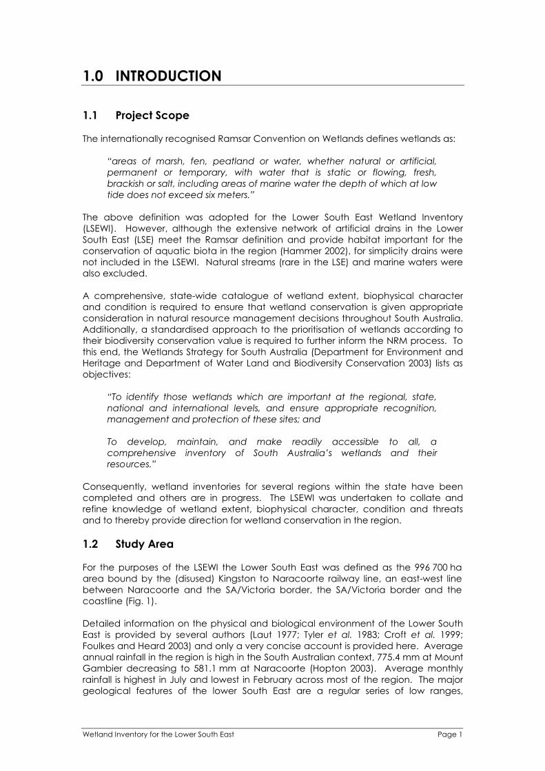
Front Cover
Clockwise from top left: Banded stilt at Lake George February 2005 (photo Iain
Stewart), front page of The Border Watch 29August 2006, Bool Lagoon 1 October
2004, thrombolites at Lake Hawdon South 2 January 2005, wetland mapping of
Honan Native Forest Reserve.
Inside Cover
Tina Fowler and Dan Harley surveying waterfowl at Broadlands (S0108578) 7 February
2005.
Acknowledgements
Field surveys for the LSEWI were undertaken with the generous volunteer help of
Serina Lattanzio. Many thanks to all the LSE landholders for access to their properties.
Thank you to my colleagues at DEH for all your help and support, particularly Darren
Herpich, Claire Harding and Felicity Smith.
Page ii Wetland Inventory for the Lower South East

Department for Environment and Heritage
Wetland Inventory Lower South East
South Australia 2006

This report is dedicated to the Bunganditj, Meintangk and
Marditjali peoples who, for thousands of years,
sustainably utilised and greatly valued
the wetlands of the Lower South East.

EXECUTIVE SUMMARY
In the South Australian context, the Lower South East (LSE) is a region of high rainfall,
high biodiversity and high endemism, with a high proportion of native species being
wetland dependent. Prior to European colonisation wetland ecosystems are
believed to have covered approximately 50 % of the region. Work undertaken for this
report indicates that the figure today is closer to 10 %, but much of what remains is
degraded and fragmented. Despite their protection under legislation including the
Native Vegetation Act (1991) and the Natural Resources Management Act (2004),
the conservation of many wetlands is not assured. Wetlands of the LSE face ever
increasing competition for water resources from expanding plantation forestry,
industrial and agricultural groundwater extraction and surface water drainage.
Providing for the environmental water requirements of wetlands in the face of these
intensifying threats is a difficult but central challenge of natural resource
management in the Lower South East.
Work undertaken for the Lower South East Wetland Inventory has enhanced the
capacity for wetland conservation and management in the LSE in three ways. Firstly,
mapping undertaken has vastly improved knowledge of the contemporary extent of
wetlands in the region. Secondly, biophysical wetland data has been strategically
collected and collated and stored within a single purpose built database (the South
Australian Wetland Inventory Database (SAWID)). Thirdly, the available information
has been interpreted to identify those wetlands of significance at the international,
national, state and regional levels, providing focus for future wetland conservation
efforts in the region. This report provides a transparent account of each of the above
stages. Priority recommendations regarding policy and planning, on-ground works
and future research are made based upon the findings.
Page iv Wetland Inventory for the Lower South East

CONTENTS
EXECUTIVE SUMMARY ................................................................................................................iv 1.0 INTRODUCTION.............................................................................................................. 1
1.1 Project Scope ........................................................................................................... 1 1.2 Study Area................................................................................................................. 1 1.3 Pre-existing Information ........................................................................................... 4
2.0 INVENTORY METHODS .................................................................................................. 6 2.1 Wetland Extent ......................................................................................................... 6 2.2 Field Survey ............................................................................................................... 6 2.3 Data Management, Storage and Retrieval: SAWID........................................... 9 2.4 Population of Database ......................................................................................... 9 2.5 Biodiversity Conservation Value ............................................................................ 9
3.0 INVENTORY RESULTS .................................................................................................... 12 3.1 Wetland Extent ....................................................................................................... 12 3.2 Wetland Biophysical Character, Condition and Threats ................................. 12 3.3 Biodiversity Conservation Value .......................................................................... 16
4.0 CONCLUSIONS & RECOMMENDATIONS.................................................................. 21 4.1 Significance ............................................................................................................ 21 4.2 Policy and Planning ............................................................................................... 23 4.3 On-Ground Works .................................................................................................. 26 4.4 Future Research...................................................................................................... 27
REFERENCES .............................................................................................................................. 31 APPENDIX 1 – Data Sources Populating LSE SAWID............................................................ 34 APPENDIX 2 – DEH Wetland Mapping Rules ........................................................................ 35 APPENDIX 3 – SAWID: A Users Guide ..................................................................................... 46 APPENDIX 4 – LSE Wetlands Ranked by BCV Score ............................................................ 49 APPENDIX 5 – LSE Wetland Significance............................................................................... 63 APPENDIX 6 – LSE Wetlands of Priority for Field Survey ....................................................... 73 APPENDIX 7 – LSEWI Field Data Sheets.................................................................................. 75 APPENDIX 8 – Instructions for LSEWI Field Data Sheets ....................................................... 78 APPENDIX 9 – Criteria for the International and National Importance of Wetlands ..... 91 APPENDIX 10 – Inventory of LSE Wetland Literature............................................................ 92
Wetland Inventory for the Lower South East Page v
1.0 INTRODUCTION
1.1 Project Scope
The internationally recognised Ramsar Convention on Wetlands defines wetlands as:
“areas of marsh, fen, peatland or water, whether natural or artificial,
permanent or temporary, with water that is static or flowing, fresh,
brackish or salt, including areas of marine water the depth of which at low
tide does not exceed six meters.”
The above definition was adopted for the Lower South East Wetland Inventory
(LSEWI). However, although the extensive network of artificial drains in the Lower
South East (LSE) meet the Ramsar definition and provide habitat important for the
conservation of aquatic biota in the region (Hammer 2002), for simplicity drains were
not included in the LSEWI. Natural streams (rare in the LSE) and marine waters were
also excluded.
A comprehensive, state-wide catalogue of wetland extent, biophysical character
and condition is required to ensure that wetland conservation is given appropriate
consideration in natural resource management decisions throughout South Australia.
Additionally, a standardised approach to the prioritisation of wetlands according to
their biodiversity conservation value is required to further inform the NRM process. To
this end, the Wetlands Strategy for South Australia (Department for Environment and
Heritage and Department of Water Land and Biodiversity Conservation 2003) lists as
objectives:
“To identify those wetlands which are important at the regional, state,
national and international levels, and ensure appropriate recognition,
management and protection of these sites; and
To develop, maintain, and make readily accessible to all, a
comprehensive inventory of South Australia’s wetlands and their
resources.”
Consequently, wetland inventories for several regions within the state have been
completed and others are in progress. The LSEWI was undertaken to collate and
refine knowledge of wetland extent, biophysical character, condition and threats
and to thereby provide direction for wetland conservation in the region.
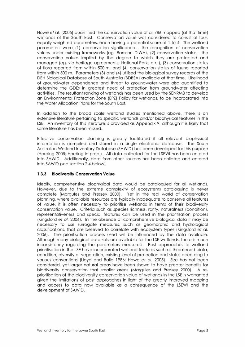
1.2 Study Area
For the purposes of the LSEWI the Lower South East was defined as the 996 700 ha
area bound by the (disused) Kingston to Naracoorte railway line, an east-west line
between Naracoorte and the SA/Victoria border, the SA/Victoria border and the
coastline (Fig. 1).
Detailed information on the physical and biological environment of the Lower South
East is provided by several authors (Laut 1977; Tyler et al. 1983; Croft et al. 1999;
Foulkes and Heard 2003) and only a very concise account is provided here. Average
annual rainfall in the region is high in the South Australian context, 775.4 mm at Mount
Gambier decreasing to 581.1 mm at Naracoorte (Hopton 2003). Average monthly
rainfall is highest in July and lowest in February across most of the region. The major
geological features of the lower South East are a regular series of low ranges,
Wetland Inventory for the Lower South East Page 1

calcareous sand ridges, aligned parallel with the coast, the legacy of rapid sea level
fluctuations and gradual uplift during the Quaternary (Benbow 2003). Additionally,
evidence of recent volcanic activity exists in the Mount Gambier region and of more
ancient volcanic activity in the Mount Burr region.
Fig. 1. The study area for the Lower South East Wetland Inventory.
The native vegetation of the South East consists predominantly of heathy woodlands
and mallee shrublands on the ridges, wet heaths and swamps in the interdunal flats
and damp sclerophyll forests, woodlands and grasslands in the Lower South East
(Department of the Environment and Heritage 2005). Historically, large areas of
wetland vegetation were present in the interdunal flats, a consequence of the
accumulation of surface water during the winter. Prior to European colonisation,
intermittent, seasonal and permanent wetlands covered approximately 55% of the
Lower South East (Foulkes and Heard 2003). A shallow water table is a feature of
much of the Lower South East. Depth to the Tertiary Limestone Aquifer, generally
referred to as the unconfined aquifer, is less than 2 m over large areas of the region
(Holmes and Waterhouse 1983). Many LSE wetlands are likely to intersect the water
table intermittently, seasonally or permanently. Thus many LSE wetlands depend
upon groundwater inputs to a greater or lesser degree and can therefore be
described as groundwater dependent ecosystems (GDEs).
Despite being only 2% of South Australia by area, prior to European colonisation the
region supported high proportions of the State’s biota; 77% of bird, 53% of mammal,
42% of plant and 42% of frog species native to South Australia occurred in the region
(Croft et al. 1999). A large proportion of these species are wetland dependent to
various degrees. The Australian Government’s Threatened Species Scientific
Committee has identified the South East as one of Australia’s 15 biodiversity hotspots
(AGDEH 2006). This listing implies the South East has a high number of endemic
species and the current or predicted future level of threat to biodiversity is high. Pre-
European wetland extent in the LSE has been massively reduced (Department for
Environment Heritage and Aboriginal Affairs 1998; Bachmann 2002), and much of
Page 2 Wetland Inventory for the Lower South East

what remains is degraded. Land clearance and drainage for agriculture have been
the primary causes of wetland loss. Although 977 km2 (9.8 %) of native vegetation
remains in the Lower South East, a lower proportion of wetlands have been retained
because the fertile, interdunal flats have been preferentially cleared and drained for
agriculture. Drainage works began in 1863 (Jolly et al. 1985) and continue today.
Drains have diverted water more directly and rapidly to the sea and greatly reduced
the duration of inundation across much of the landscape. Additionally, drainage
and plantation forestry are likely to have reduced groundwater recharge throughout
the region. Reduced recharge and groundwater extraction are almost certainly
contributing to water table decline in the LSE. Depth to the unconfined aquifer is
increasing by an average of approximately 0.1 m per year throughout much of the
LSE, and as rapidly as 0.3 m per year in some areas (Brown et al. 2006). Given the
high biodiversity, high endemism, degree of loss and intensity of current threat, the
South East, and the Lower South East in particular, is arguably the most important
region in the state for wetland conservation.
Wetland Inventory for the Lower South East Page 3

1.3 Pre-existing Information
1.3.1 Wetland Extent
Pre-existing information regarding wetland extent for the LSE consisted of the GIS layer
LANDSCAPE_Wetlands held by DEH. This layer consisted of 545 polygons (i.e. 545
distinct wetlands) covering a total area of 38 688 ha and appears to have been
derived primarily from the work of Jolly et al. (1985). Additionally the layer
TOPO_Waterbodies_50k consists of 5778 polygons covering a total area of 63 706 ha.
All mapped waterbodies are wetlands according to the Ramsar definition; therefore
this second layer provided additional information regarding wetland extent. Another
DEH layer, VEG_SthEast, is a map of remnant native vegetation of the region. The
selection of only wetland vegetation types in the LSE from this shapefile consists of
1973 polygons covering a total area of 22 690 ha.
Fieldwork and aerial reconnaissance during the early stages of the project revealed
that the available wetland mapping, i.e. the combined extent of the above three
layers, was inaccurate and inadequate for much of the LSE. Creating an accurate
and comprehensive digital map of the contemporary extent of LSE wetlands thereby
become a high priority for the LSEWI.
1.3.2 Wetland Biophysical Character, Condition and Conservation Value
Jones (1978) documented the wetlands of the Lower South East for the purpose of
assessing their conservation value. Jones described 34 wetlands or wetland
complexes within the geographic area of the LSEWI. Jones collected and collated
information, much of it qualitative, on wetland biota, type, size and condition and
thereby made assessments of conservation value. A primary objective of Jones was
to prioritise recommendations for addition to the State reserve system. Jones
recommendations, in order of priority, were that the following wetland complexes
should be proclaimed as conservation reserves under the National Parks and Wildlife
Act (1972): Lake Frome/Mullins Swamp, The Marshes, Lake Hawdon South, Honans
Scrub and Deadmans Swamp. To date Lake Frome is the only one of this list to have
been so proclaimed. However, the outlook for wetland areas managed by the then
Woods and Forest Department (now ForestrySA), namely The Marshes, Honans Scrub
and Deadmans Swamp, improved markedly with the introduction of the Native
Vegetation Act (1991).
A similar but more detailed and extensive approach was employed by Jolly et al.
(1985), who described 56 wetlands or wetland complexes within the LSEWI study area.
Jolly et al. made a considerable number of recommendations regarding wetland
management and future research, many of which were acted upon. The wetland
mapping of Jolly et al. had not been updated until the LSEWI and has formed the
basis for much wetland and policy and management in the LSE for 20 years, despite
its obvious limitations. Notably, several wetlands identified by Jolly et al. as worthy of
protection have since become highly degraded. Such wetlands include Island
Swamp (S0120532) and Sawpit Swamp (S0109194).
The aim of Lloyd and Balla (1986) was to summarise the wetland resources of South
Australia and to highlight environmentally important areas. Environmental
importance was assigned according to a score derived by quantifying features of
wetland fauna, vegetation, condition and special features. Wetlands were then
grouped by score into five categories of conservation significance. Lloyd and Balla
documented seventy wetlands or wetland complexes in the LSEWI study area, 60 of
which were assigned a score.
Page 4 Wetland Inventory for the Lower South East
Howe et al. (2005) quantified the conservation value of all 786 mapped (at that time)
wetlands of the South East. Conservation value was considered to consist of four,
equally weighted parameters, each having a potential score of 1 to 4. The wetland
parameters were (1) conservation significance - the recognition of conservation
values under existing frameworks (eg. Ramsar, DIWA), (2) conservation status - the
conservation values implied by the degree to which they are protected and
managed (eg. via heritage agreements, National Parks etc.), (3) conservation status
of flora reported from within 500 m, and (4) conservation status of fauna reported
from within 500 m. Parameters (3) and (4) utilised the biological survey records of the
DEH Biological Database of South Australia (BDBSA) available at that time. Likelihood
of groundwater dependence and threat to groundwater were also quantified to
determine the GDEs in greatest need of protection from groundwater affecting
activities. The resultant ranking of wetlands has been used by the SENRMB to develop
an Environmental Protection Zone (EPZ) Policy for wetlands, to be incorporated into
the Water Allocation Plans for the South East.
In addition to the broad scale wetland studies mentioned above, there is an
extensive literature pertaining to specific wetlands and/or biophysical features in the
LSE. An inventory of this literature is provided as Appendix 9, although it is likely that
some literature has been missed.
Effective conservation planning is greatly facilitated if all relevant biophysical
information is compiled and stored in a single electronic database. The South
Australian Wetland Inventory Database (SAWID) has been developed for this purpose
(Harding 2005; Harding in prep.). All data collected for the LSEWI has been entered
into SAWID. Additionally, data from other sources has been collated and entered
into SAWID (see section 2.4 below).
1.3.3 Biodiversity Conservation Value
Ideally, comprehensive biophysical data would be catalogued for all wetlands.
However, due to the extreme complexity of ecosystems cataloguing is never
complete (Margules and Pressey 2000). Yet in the real world of conservation
planning, where available resources are typically inadequate to conserve all features
of value, it is often necessary to prioritise wetlands in terms of their biodiversity
conservation value. Criteria such as species richness, rarity, naturalness (condition),
representativeness and special features can be used in the prioritisation process
(Kingsford et al. 2006). In the absence of comprehensive biological data it may be
necessary to use surrogate measures, such as geomorphic and hydrological
classifications, that are believed to correlate with ecosystem types (Kingsford et al.
2006). The prioritisation process used will be influenced by the data available.
Although many biological data sets are available for the LSE wetlands, there is much
inconsistency regarding the parameters measured. Past approaches to wetland
prioritisation in the LSE have incorporated wetland features such as threatened biota,
condition, diversity of vegetation, existing level of protection and status according to
various conventions (Lloyd and Balla 1986; Howe et al. 2005). Size has not been
considered, yet larger natural areas have been shown to have greater benefits for
biodiversity conservation that smaller areas (Margules and Pressey 2000). A re-
prioritisation of the biodiversity conservation value of wetlands in the LSE is warranted
given the limitations of past approaches in light of the greatly improved mapping
and access to data now available as a consequence of the LSEWI and the
development of SAWID.
Wetland Inventory for the Lower South East Page 5
2.0 INVENTORY METHODS
2.1 Wetland Extent
Mapping standards, topology rules, attribute specifications, domains and associated
metadata, which meet minimum data standards required by DEH, were defined prior
to the commencement of mapping. A minimum set of attributes for each polygon
were defined (Appendix 2). Each wetland polygon has been given a unique
identifier which follows the South Australian wetland numbering system developed by
DEH. The LANDSCAPE_Wetlands layer was updated using ArcGIS® 9 to create an
accurate and comprehensive map of the contemporary extent of LSE wetlands.
Several steps were involved. First, the TOPO_Waterbodies_50k layer was merged with
LANDSCAPE_Wetlands. Second, all polygons in the resulting shapefile were overlaid
upon orthorectified, infra-red aerial photography of the region taken in January 2003.
Infra-red aerial photography taken in summer provides a relatively clear indication of
wetland extent because surface water and wetland vegetation contrast strongly with
other landscape features. All polygons were aligned with wetlands as indicated by
the aerial photography and many additional polygons were added. The minimum
scale used for mapping was 1:5000. Other layers including VEG_SthEast and
TOPO_Contours_50k were also referred to for guidance. For wetlands surveyed for
the LSEWI, the mapping was ground-truthed. Additionally, aerial reconnaissance of
the LSE on 1 October 2004, when the extent of inundation was maximal over most of
the region, informed the mapping process. An attempt was made to ensure all
mapped wetland boundaries represent real ecological boundaries. For example,
mapped wetlands are generally not split along land section boundaries. However, if
section boundaries have ecological significance, eg. one side of the fence is intact
native vegetation while the other is grazed pasture, despite hydrological connectivity
between the two sections the wetland has been split into two or more polygons.
The updated wetland mapping was compared with the DEH pre-European
vegetation mapping to obtain an estimate of post colonisation wetland loss. For this
purpose, the pre-European vegetation types considered as wetland are listed in
Table 1.
Table 1. Pre-European vegetation types considered wetland for comparison against
contemporary wetland extent. MU250 Code Pre-European wetland vegetation type
0 No vegetation but obviously wetland (eg. lakes)
4 Eucalyptus camaldulensis var. camaldulensis Woodland
11 Eucalyptus ovata Woodland
15 Melaleuca halmaturorum ssp. halmaturorum or M. brevifolia Low open forest to
Shrubland
29 Leptospermum lanigerum Tall closed shrubland
35 Muehlenbeckia florulenta Shrubland
37 Halosarcia spp. Low shrubland
38 Baumea juncea, Chorizandra enodis Sedgeland
39 Gahnia filum Sedgeland
40 Gahnia trifida Sedgteland
41 Phragmites australis, Typha domingensis Grassland
45 Floating water plants herbland
46 Selliera radicans, +/- Wilsonia backhousei Herbland
2.2 Field Survey
Field survey of wetlands was conducted between May 2004 and November 2005.
Most wetlands were surveyed during winter and spring. The documentation of each
wetland utilised the approach developed for the Fleurieu Peninsula wetland inventory
Page 6 Wetland Inventory for the Lower South East
(Harding 2005), with the parameters measured or described corresponding to fields in
the SAWID. The data sheets completed for each survey site are provided in
Appendix 7 and detailed instructions on how each parameter was measured or
described are provided in Appendix 8. Appendices 7 and 8 pertain to any wetland
survey in South Australia intended for addition to the SAWID. Further information
specific to the LSEWI is provided below.
2.2.1 Survey Site Prioritisation
Initial field work for the LSEWI was undertaken with the intention of surveying all 545
wetlands identified at that time in the GIS layer LANDSCAPE_Wetlands. When it
became apparent that the existing wetland mapping was grossly inadequate a
prioritisation of field survey sites was undertaken. Well documented wetlands (e.g.
Piccaninnie Ponds, Bool Lagoon) were generally not surveyed. Priority was given to
wetlands that were poorly documented, large, in apparently good condition and
outside of existing conservation reserves, however not all of the wetlands surveyed
met all of these criteria. It was anticipated this approach would provide the most
useful information for the identification of opportunities to further protect and/or
restore wetlands in the region. The January 2003 infra-red aerial photography, which
became available towards the end of the field survey phase, was a particularly useful
tool for the prioritisation of sites for field survey.
2.2.2 General Hydrology and Landform
Determination of water regime, water source, average depth when full and
maximum depth when full was typically a ‘best guess’ based on the evidence
available. For some wetlands landholders were a source of information.
2.2.3 Water Chemistry
Surface water, when present at the time of survey, was measured for temperature
and dissolved oxygen using a YSI 5739 model field probe (YSI Incorporated, Yellow
Springs, Ohio, USA) attached to a TPS WP-82Y model dissolved oxygen meter (TPS Pty
Ltd, Brisbane, Australia). The conductivity and pH of surface water was also
measured using a TPS k=1 conductivity sensor and TPS pH electrode respectively,
both attached to a TPS WP-81 model meter. All readings were taken at
approximately 5cm depth unless wetland depth was less than 5cm. Turbidity was
measured to a low level of precision using a tube nephelometer filled with surface
water.
2.2.4 Wetland Fauna
Fauna was not systematically surveyed at most sites. However, opportunistic fauna
sightings were documented where species were confidently identified. Additionally,
an audio recording was made at the survey site for most wetlands. These recordings
were analysed by frog call identification expert Steve Walker and records entered
into SAWID.
2.2.5 Flora Species Record
To describe the vegetation, each wetland was divided into up to seven vegetation
zones across the elevation gradient:
Zone 1: Buffer (peripheral non-wetland native vegetation); Zone 2: Bank (buffer to high water mark); Zone 3: Shore (high water to low water);
Wetland Inventory for the Lower South East Page 7

Zone 4: Emergent (damp to < 0.2m depth); Zone 5: Aquatic submerged/Emergent (0.2 to 1m depth); Zone 6: Aquatic (depth > 1m) and; Zone 7: Open water (no vegetation).
For each zone present the cover/abundance of plant species was recorded
according to a semi-quantitative scale modified from Braun-Blanquet (1965). Only
those plant species with a cover/abundance score of 2 were routinely recorded.
Plant species of lesser cover/abundance score were recorded only opportunistically,
therefore the list of plant species recorded at each site should not be considered
comprehensive. Plant species regularly occurred within more than one vegetation
zone. The score for a given species was therefore assigned for the zone within which
it’s cover/abundance was maximal. At each wetland the vegetation was described
along a radial transect of approximately 10 m width and of length adequate to
include all vegetation zones present. Plant species were identified in the field by the
author. Where identification was uncertain, a specimen was collected for later
identification by professional botanist Rosemary Taplin. Identification to the species
level was not possible for all plants because reproductive structures were not always
present at the time of survey.
Because wetland vegetation is generally not uniform around the perimeter, a single
survey cannot be considered a comprehensive description of floristic composition for
any wetland. However, the location of each survey site was always chosen in an
attempt to be as comprehensive as possible. Thus, survey sites at each wetland
were chosen to have vegetation typical of the wetland and to have the greatest
number of distinct vegetation zones. Inaccessibility occasionally caused some
compromise in site selection. The confidence of a single survey as a representation of
floristic composition for the entire wetland decreases with increasing wetland size.
2.2.6 Subjective Assessment
The final parameters recorded at each site were the subjective assessment of the
condition of aquatic vegetation, riparian vegetation and the wetland overall.
Although the descriptors used are qualitative, given that all other parameters had
been given consideration before assigning condition and that only one assessor, the
author, assigned condition for all wetlands surveyed, the subjective assessment
provides a useful comparison between wetlands. The condition ratings assigned to
the wetland overall via this process are explained in Table 2.
Table 2. Description of condition ratings used for the LSEWI. Wetland Condition
Rating
Description
Pristine No (or very minor) obvious degradation, with a high proportion of native
species diversity and cover. Native vegetation buffer present for the majority
of the wetland perimeter. Received vegetation condition assessments of
‘intact’. Water regime unaltered or only slightly altered from pre-European
state. Usually formally conserved within the reserve system or similar.
Intact Small amounts of relatively insignificant degradation evident, with a high
proportion of native species diversity. Native vegetation buffer present for at
least some of the wetland perimeter. Water regime unaltered to somewhat
modified from pre-European state. Degradation generally rectifiable.
Received vegetation condition assessments of ‘intact’ or ‘moderate’.
Moderate Degradation obvious although many natural values remaining. Most damage
rectifiable with improved management. Native vegetation buffer typically
absent. Water regime somewhat to considerably altered from pre-European
state. Received vegetation condition assessment scores of mostly ‘moderate’.
Page 8 Wetland Inventory for the Lower South East
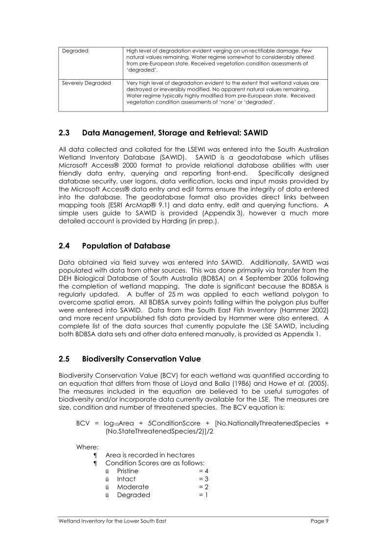
Degraded High level of degradation evident verging on un-rectifiable damage. Few
natural values remaining. Water regime somewhat to considerably altered
from pre-European state. Received vegetation condition assessments of
‘degraded’.
Severely Degraded Very high level of degradation evident to the extent that wetland values are
destroyed or irreversibly modified. No apparent natural values remaining.
Water regime typically highly modified from pre-European state. Received
vegetation condition assessments of ‘none’ or ‘degraded’.
2.3 Data Management, Storage and Retrieval: SAWID
All data collected and collated for the LSEWI was entered into the South Australian
Wetland Inventory Database (SAWID). SAWID is a geodatabase which utilises
Microsoft Access® 2000 format to provide relational database abilities with user
friendly data entry, querying and reporting front-end. Specifically designed
database security, user logons, data verification, locks and input masks provided by
the Microsoft Access® data entry and edit forms ensure the integrity of data entered
into the database. The geodatabase format also provides direct links between
mapping tools (ESRI ArcMap® 9.1) and data entry, edit and querying functions. A
simple users guide to SAWID is provided (Appendix 3), however a much more
detailed account is provided by Harding (in prep.).
2.4 Population of Database
Data obtained via field survey was entered into SAWID. Additionally, SAWID was
populated with data from other sources. This was done primarily via transfer from the
DEH Biological Database of South Australia (BDBSA) on 4 September 2006 following
the completion of wetland mapping. The date is significant because the BDBSA is
regularly updated. A buffer of 25 m was applied to each wetland polygon to
overcome spatial errors. All BDBSA survey points falling within the polygon plus buffer
were entered into SAWID. Data from the South East Fish Inventory (Hammer 2002)
and more recent unpublished fish data provided by Hammer were also entered. A
complete list of the data sources that currently populate the LSE SAWID, including
both BDBSA data sets and other data entered manually, is provided as Appendix 1.
2.5 Biodiversity Conservation Value
Biodiversity Conservation Value (BCV) for each wetland was quantified according to
an equation that differs from those of Lloyd and Balla (1986) and Howe et al. (2005).
The measures included in the equation are believed to be useful surrogates of
biodiversity and/or incorporate data currently available for the LSE. The measures are
size, condition and number of threatened species. The BCV equation is:
BCV = log10Area + 5ConditionScore + [No.NationallyThreatenedSpecies +
(No.StateThreatenedSpecies/2)]/2
Where:
Area is recorded in hectares
Condition Scores are as follows: Pristine = 4 Intact = 3 Moderate = 2 Degraded = 1
Wetland Inventory for the Lower South East Page 9
Severely Degraded = 0
No. Nationally Threatened Species includes all EPBC Act listed species
(fauna plus flora) including JAMBA and CAMBA listed species
No. State Threatened Species includes all NPW Act listed species that
are not also EPBC Act listed
The maximum score for area was 3.92 (Lake Bonney), for condition was 20 (all pristine
wetlands) and for threatened species was 24.5 (Bool Lagoon), giving an approximate
weighting of 1:5:6 respectively. Wetlands were classified according to their BCV
scores as follows:
BCV Score BCV Class
21.00 Very High 15.50 High 10.00 Moderate
< 10.00 Low No surveys Insufficient Data
Wetlands without flora or fauna records, or not visited for the LSEWI, were classified as
‘Insufficient Data’ (11 892 wetlands). All other wetlands were assigned a condition
score. It is important to note that the condition scores assigned have three levels of
confidence. Condition score confidence is high for those wetlands surveyed for the
LSEWI (258 wetlands), medium for those wetlands visited for the LSEWI but not
surveyed (36 wetlands), and low for those wetlands not visited but with condition
assigned via assessment of January 2003 infra-red aerial photography (345 wetlands).
The cut-off BCV scores for each BCV class were chosen to reflect wetland condition.
For example, a pristine wetland needs to score only one additional point, either for its
size or its threatened species, to be classified Very High BCV. A wetland in poorer
condition would have to score highly for area and/or threatened species to be
classified Very High BCV.
There are several limitations to the prioritisation of LSE wetlands according to BCV
score and the resultant ranking should be used as a guide only. Limitations, i.e.
factors that may contribute to misleading results, include:
The number of threatened species recorded for a wetland is, in part, a
reflection of the number of surveys that have been undertaken. Poorly
surveyed wetlands are more likely to have undiscovered populations of
threatened species that do not contribute to the BCV score than well
documented wetlands.
The BDBSA data includes SA Museum records from as early as 1900. Species
recorded for a wetland may have become locally extinct since the record
was obtained.
The BDBSA does not contain all known records. While the LSE SAWID has been
populated with data from sources other than BDBSA, the information in SAWID
is not a complete catalogue of all known data.
It is assumed that the national and state threatened species lists are an
accurate reflection of the status of native species in the wild. This may not be
the case.
The variable confidence with which condition has been assigned.
The condition of wetlands may not be consistent across the area of the
wetland. This is increasingly likely with increasing wetland size.
The BCV approach may not work as well for small sinkholes and other karst
features than it does for palustrine wetlands. It is very difficult to remotely
assign a condition score to a small sinkhole.
Page 10 Wetland Inventory for the Lower South East
The incorporation of wetland type into the BCV equation was investigated because it
was assumed that, all other factors being equal, a wetland type with a lower %
remnancy would have higher conservation value. The DEH pre-European vegetation
mapping was used to assign wetland type. The % remnancy values for the various
wetland vegetation types were those identified by Foulkes and Heard (2003). Various
approaches to assigning a score according for wetland type were attempted but all
gave very similar scores to most wetlands. Therefore wetland type was not
incorporated into the BCV equation. This reflects the fact that % remnancy is similar
for most wetland vegetation types in the LSE. It is typically less than 10 %.
Wetland Inventory for the Lower South East Page 11

3.0 INVENTORY RESULTS
3.1 Wetland Extent
Updated wetland mapping for the LSE is a major achievement of the LSEWI. It is
important to note that the mapping methods employed were not completely
unambiguous and there is scope for further refinement. However, the mapping is a
vast improvement upon what was previously available. The shapefile
LANDSCAPE_Wetlands now contains 12 531 polygons (distinct wetlands) for the LSE
(this includes a narrow band within Victoria adjacent to the border), covering a total
area of 100 034 ha, or 10 % of the region (Fig. 2). The pre-European vegetation
mapping indicates that 544 106 ha, or 54.6% of the LSE was originally wetland.
Therefore, the updated wetland mapping indicates that 18.3% of the pre-European
wetland area of the LSE can still be described as wetland. This is a marked increase
on previous estimates of 6% (Bachmann 2002) and 2% (Department for Environment
Heritage and Aboriginal Affairs 1998) for the South East as a whole. However, it is
important to note that much of the additional wetland area now mapped is likely to
be degraded. Also, the definition of ‘wetland’ used for previous estimates of
contemporary extent may differ from that used for the LSEWI.
Fig. 2. Comparison of old wetland mapping (a) with updated wetland
mapping undertaken for the LSEWI (b).
3.2 Wetland Biophysical Character, Condition and Threats
Field surveys of 258 wetlands were undertaken for the LSEWI. The complete
information for each surveyed wetland is stored within SAWID. There are many
questions that could be investigated using the LSEWI data. Some of the more
interesting features of the data, with relevance to wetland conservation and
restoration, are discussed in this section.
Page 12 Wetland Inventory for the Lower South East

3.2.1 Wetland Flora
New records of 32 threatened flora species were obtained via field survey for the
LSEWI. Table 3 summarises this information.
Table 3. Summary of new threatened flora records obtained via field survey for the
LSEWI.
Species
Acacia stricta
Allittia cardiocarpa
Amphibromus recurvatus
Baloskion tetraphyllum ssp.
tetraphyllum
Baumea acuta
Baumea laxa
Brachyscome graminea
Cardamine tenuifolia
Chorizandra australis
Cladium procerum
Dillwynia cinerascens
Eucalyptus fasciculosa
Euphrasia collina ssp. collina
Gahnia clarkei
Gleichenia microphylla
Gonocarpus micranthus ssp.
micranthus
Haloragis brownii
Isotoma fluviatilis ssp. australis
Juncus amabilis
Juncus procerus
Lobelia pratioides
Melaleuca squamea
Melaleuca squarrosa
Montia australasica
Myoporum parvifolium
Poa meionectes
Pratia concolor
Schoenus tesquorum
Senecio psilocarpus
Triglochin alcockiae
Viola betonicifolia ssp. betonicifolia
Zoysia macrantha ssp. walshii
Common Name
Hop Wattle
Swamp Daisy
Dark Swamp Wallaby-grass
Tassel Cord-rush
Pale Twig-rush
Lax Twig-rush
Grass Daisy
Slender Bitter-cress
Bristle-rush
Leafy Twig-rush
Grey Parrot-pea
Pink Gum
Purple Eyebright
Tall Saw-sedge
Coral Fern
Creeping Raspwort
Swamp Raspwort
Swamp Isotome
Tall Rush
Poison Lobelia
Swamp Honey-myrtle
Bottlebrush Tea-tree
White Purslane
Creeping Boobialla
Fine-leaf Tussock-grass
Poison Pratia
Grassy Bog-rush
Alcock's Water-ribbons
Showy Violet
Manila Grass
NPW Act
(State)*
EPBC Act
(Federal)*
No. Sites
Recorded
(max. 258)
R 1
R 2
R 1
V 11
R 1
R 1
R 1
R 1
E 3
R 1
E 1
R 2
V 2
R 61
R 6
R 2
R 1
R 1
V 1
R 57
R 1
R 7
R 89
R 4
R 3
V 1
R 1
R 1
V V 7
R 12
E 1
R 2
*R = rare, V = vulnerable, E = endangered
For the surveyed wetland sites that had an intact buffer (112 sites) the distribution of
species across the elevation gradient is summarised in Table 4. The total number of
species recorded in each zone for all 112 wetlands is shown. The number of species
that are unique to each zone, occurring in no other zone, is also shown. The number
of species unique to each zone is similar for buffer, bank, shore and emergent zones.
This indicates that conservation of all zones is necessary for the conservation of the
complete floristic diversity of LSE wetlands. Wetlands with all zones intact are rare in
the LSE and should be a very high priority for conservation. Note that the BCV score
developed for this report takes this feature into account.
Wetland Inventory for the Lower South East Page 13

Table 4. Summary of plant distribution across the elevation gradient for LSEWI survey
sites with an intact buffer.
Zone No. Species Recorded
No. Species Unique
to Zone
1 – Buffer 80 37
2 – Bank 140 46
3 – Shore 158 44
4 – Emergent 131 34
5 - Aquatic submerged/Emergent 34 1
Exotic plants are ubiquitous in the LSE and not even the most pristine sites are entirely
weed free. By far the most commonly recorded exotic plant of the LSEWI was Holcus
lanatus (Yorkshire Fog), which was present at 104 of the 258 sites surveyed for flora. A
summary of the 12 most commonly recorded weeds is shown in Table 5. Summing the
zone number in which a species was recorded at each site and dividing by the total
number of sites at which it was recorded determined the “Average Zone” for a
species. The Average Zone indicates the favoured zone for the species. Table 5
indicates that the most commonly recorded exotic plants tend to favour wetland
edges. There were few specialist aquatic weeds present at LSEWI survey sites, and
those that were present, eg. Potamogeton crispus, are not of great concern.
Table 5. Exotic plants most commonly recorded ( 10 sites) for the LSEWI.
Species Common Name
No. Sites
Recorded
(max. 258) Average Zone
Holcus lanatus Yorkshire Fog 104 2.8
Cirsium vulgare Spear Thistle 40 3.1
Trifolium sp.
/T. fragiferum var. fragiferum
Clover
/Strawberry clover
35 2.9
Rubus sp. Blackberry 30 2.2
Leontodon taraxacoides ssp.
taraxacoides
Lesser Hawkbit 30 3.0
Phalaris sp./Phalaris aquatica Canary grass
/Phalaris
21 1.8
Pinus radiata Radiata pine 19 1.5
Potamogeton crispus Curly pondweed 16 4.2
Hypochaeris radicata Rough Cat's Ear 13 2
Festuca arundinacea Tall Meadow Fescue
(Williams Grass)
12 2.7
Critesion marinum Sea Barley-grass 11 3
Lagurus ovatus Hare's Tail Grass 11 2
Note that exotic plants not listed Table 5 are present in the LSE and have the potential
to cause significant wetland degradation. A recently observed infestation of spikey
rush (Juncus acutus) near the outlet of Lake George (S0101818) is an example.
3.2.2 Wetland Fauna
Fauna records were collected only opportunistically for the LSEWI. However, new
records of 14 threatened fauna species were obtained. These records are
summarised in Table 6.
Page 14 Wetland Inventory for the Lower South East

Table 6. Summary of new threatened fauna records obtained via field survey for the
LSEWI.
Species
Anas rhynchotis
Biziura lobata
Botaurus
poiciloptilus
Calyptorhynchus
funereus
Cisticola exilis
Falco peregrinus
Gallinago
hardwickii
Geocrinia laevis
Grus rubicunda
Litoria raniformis
Macropus
giganteus
Neophema
chrysostoma
Oxyura australis
Rallus pectoralis
Common Name
Australasian Shoveler
Musk Duck
Australasian Bittern
Yellow-tailed Black-
cockatoo
Golden-headed
Cisticola
Peregrine Falcon
Latham's Snipe
Smooth Frog
Brolga
Growling Grass Frog
Eastern Grey
Kangaroo
Blue-winged Parrot
Blue-billed Duck
Lewin's Rail
NPW Act
(State)*
R
R
V
V
R
R
V
R
V
V
R
V
R
V
EPBC Act
(Federal)*
V
Breeding
Record?
Yes
Yes
Yes
Wetland Name
SALT LAKE
SALT LAKE
OSCHAR SWAMP
WATERHOUSE
GHOST LAKE
LAKE FROME
HONAN NFR
MT LYON LF
THE EVERGLADES
THE MARSHES
TOPPERWEIN NFR
DISMAL SWAMP
LONGS C
TRIAL WATERHOLE
HORSESHOE
PADDOCK
DISMAL SWAMP
HONAN NFR
HONAN NFR
CLAYPANS
MCROSTIES NFR
OLD WASHPOOL
SWAMP
TILLAR SWAMP
NANGKITA
TWIG RUSH LAGOONS
GOOSE NECK SWAMP
TOPPERWEIN NFR
HACKET HILL NFR
Wetland
S0108578
S0116936
S0110344
S0110925
S0110556
S0110539
S0105943
S0110764
S0110227
S0110944
S0110595
S0105797
S0110689
S0108578
S0108578
S0110904
S0110601
S0120851
S0107704
S0110764
S0110767
S0110945
S0113560
S0106829
S0105847
S0120741
S0120842
S0107894
S0105797
S0108578
S0108998
S0108578
S0110661
ID
*R = rare, V = vulnerable
3.2.3 Wetland Condition
A wetland condition score was assigned via field survey at 272 sites within 258
wetlands. Of those sites 64 were pristine, 93 were intact, 83 were moderate, 25 were
degraded and 7 were severely degraded. These numbers reflect the LSEWI priority to
survey wetlands in the best condition. They do not reflect the proportions of wetlands
in each condition class across the LSE.
Wetland Inventory for the Lower South East Page 15
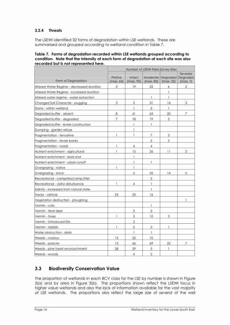
3.2.4 Threats
The LSEWI identified 32 forms of degradation within LSE wetlands. These are
summarised and grouped according to wetland condition in Table 7.
Table 7. Forms of degradation recorded within LSE wetlands grouped according to
condition. Note that the intensity of each form of degradation at each site was also
Altered Water Regime - decreased duration
recorded but is not represented here.
Form of Degradation
3
Pristine
(max. 64)
19
Number of LSEWI
Intact
(max. 93)
Moderate
(max. 83)
22 6
Field Survey Sites
Degraded
(max. 25)
2
Severely
Degraded
(max. 7)
Altered Water Regime - increased duration 1
Altered water regime - water extraction 1 1
Changed Soil Character - pugging 3 5 31 14 3
Dams - within wetland 1 3 1
Degraded buffer - absent 8 41 63 20 7
Degraded buffer - degraded 7 18 19 3
Degraded buffer - levee construction 1 1
Dumping - garden refuse 1
Fragmentation - fenceline 1 1 7 3
Fragmentation - levee banks 2 2
Fragmentation - roads 1 4 4
Nutrient enrichment - agricultural 1 15 26 11 2
Nutrient enrichment - lead shot 1
Nutrient enrichment - urban runoff 1 1
Overgrazing - native 1 1
Overgrazing - stock 5 35 14 5
Recreational - campsites/camp litter 2
Recreational - visitor disturbance 1 4 1
Salinity - increased from natural state 1
Tracks - vehicle 23 33 16
Vegetation destruction - ploughing 1
Vermin - cats 1
Vermin - feral deer 3 2
Vermin - foxes 1 5 10 3
Vermin - introduced fish 2
Vermin - rabbits 1 2 2 1
Water obstruction - drain 1 1
Weeds - noxious 13 22 10
Weeds - pasture 13 66 69 22 7
Weeds - pine forest encroachment 28 29 5 1
Weeds - woody 4 2
3.3 Biodiversity Conservation Value
The proportion of wetlands in each BCV class for the LSE by number is shown in Figure
3(a) and by area in Figure 3(b). The proportions shown reflect the LSEWI focus in
higher value wetlands and also the lack of information available for the vast majority
of LSE wetlands. The proportions also reflect the large size of several of the well
Page 16 Wetland Inventory for the Lower South East

documented wetlands that were assigned a BCV score and were classified as “High”
or “Very High”.
High
Low
I ici
95%
Very High
0.5 %
1.3 % Moderate
1.7 %
1.7 %
nsuff ent Data
(a) Number of wetlands
Insufficient Data Very High
14%
23%
Low
45%
High
Moderate
6% 12%
(b) Area of wetlands
Fig. 3. Pie chart showing proportion of wetlands in each Biodiversity
Conservation Value class in the LSE (a) by number and (b) by area.
Classification as “Low” does not imply that a wetland is devoid of conservation value.
For example, wetland S0108706 (Stratman Pond) is classified as low due to its
degraded condition yet it is home to a population of nationally vulnerable Ewen’s
pygmy perch (Nannoperca variegata). The degree of caution required when using
BCV classification as a decision making tool cannot be overstated. BCV classification
has been developed to guide wetland conservation efforts, not to legitimise the
future degradation of particular wetlands. Note also that classification as “Insufficient
Data” does not imply a wetland has low conservation value. On the contrary, many
wetlands without flora or fauna records appear to be in good condition and may turn
Wetland Inventory for the Lower South East Page 17
out to have high value following further investigation (see section 4.4.4). A map
showing the LSE wetlands according to BCV Class is provided (Fig. 4) and the same
information is provided in table form (Appendix 4).
Page 18 Wetland Inventory for the Lower South East

Ro
be
Pe
no
la
Be
ac
hp
ort
Na
rac
oo
rte
Kin
gst
on
SE
LSEW
I Su
rve
y S
ite
s
We
tla
nd
Bio
div
ers
ity
Co
nse
rva
tio
n V
alu
e
Ve
ry H
igh
Hig
h
Mo
de
rate
Low
Insu
ffic
ien
t D
ata
Ma
in r
oa
d
Dra
in /
Wa
terc
ou
rse
Pla
nta
tio
ns
So
ftw
oo
d
Ha
rdw
oo
d
40
48
2
km
Pro
du
ce
d b
y:
Pro
du
ce
d fo
r:D
ata
So
urc
e:
Co
mp
iled
:R
efe
ren
ce
:D
atu
m:
Pro
jection
:
So
uth
East
Reso
urce In
form
ati
on
Cen
tre
PO
Bo
x 3
58
7 M
oun
t G
am
bie
r S
A 5
29
0D
epa
rtm
ent
for
Enviro
nm
en
t a
nd
He
rita
ge
De
pa
rtm
ent
for
Enviro
nm
en
t a
nd
He
rita
ge,
20
06
18
Octo
be
r 2
00
661
40
(v
ers
ion
1)
Ge
oce
ntr
ic D
atu
m o
fA
ustr
alia
, 1
994
Un
ive
rsa
l T
ran
sve
rse M
erc
ato
r
Fig
. 4(a
). W
etla
nd
s o
f th
en
ort
he
rnh
alf o
f th
e L
ow
er
So
uth
Ea
st
© N
o p
art
of
this
ma
p m
ay b
e r
ep
rod
uce
d o
rp
ub
lish
ed
in a
ny f
orm
with
ou
t th
e e
xp
ress
writt
en
pe
rmis
sio
n o
fS
ER
IC.

Pe
no
la
Mill
ice
nt
Be
ac
hp
ort
Po
rt M
ac
Do
nn
ell
MO
UN
TG
AM
BIE
R
LSEW
I Su
rve
y S
ite
s
We
tla
nd
Bio
div
ers
ity
Co
nse
rva
tio
n V
alu
e
Ve
ry H
igh
Hig
h
Mo
de
rate
Low
Insu
ffic
ien
t D
ata
Ma
in r
oa
d
Dra
in /
Wa
terc
ou
rse
Pla
nta
tio
ns
So
ftw
oo
d
Ha
rdw
oo
d
40
48
2
km
Pro
du
ce
d b
y:
Pro
du
ce
d fo
r:D
ata
So
urc
e:
Co
mp
iled
:R
efe
ren
ce
:D
atu
m:
Pro
jection
:
So
uth
Ea
st
Re
so
urc
e In
form
ati
on
Ce
ntr
e
PO
Bo
x 3
58
7 M
oun
t G
am
bie
r S
A 5
29
0D
epa
rtm
ent
for
Enviro
nm
en
t a
nd
He
rita
ge
De
pa
rtm
ent
for
Enviro
nm
en
t a
nd
He
rita
ge,
20
06
18
Octo
be
r 2
00
661
40
(v
ers
ion
1)
Ge
oce
ntr
ic D
atu
m o
fA
ustr
alia
, 1
994
Un
ive
rsa
l T
ran
sve
rse M
erc
ato
r
Fig
. 4(b
). W
etla
nd
s o
f th
eso
uth
ern
ha
lf o
f th
e L
ow
er
So
uth
Ea
st
© N
o p
art
of
this
ma
p m
ay b
e r
ep
rod
uce
d o
rp
ub
lish
ed
in a
ny f
orm
with
ou
t th
e e
xp
ress
writt
en
pe
rmis
sio
n o
fS
ER
IC.
4.0 CONCLUSIONS & RECOMMENDATIONS
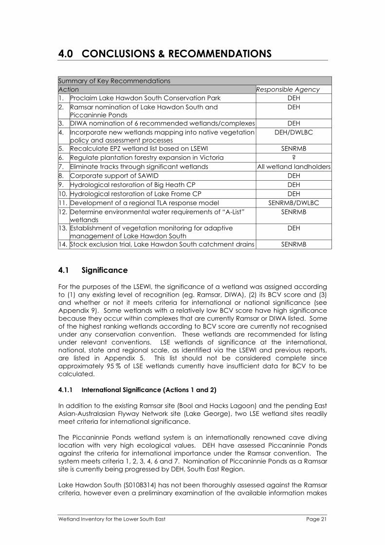
Summary of Key Recommendations
Action
1. Proclaim Lake Hawdon South Conservation Park
2. Ramsar nomination of Lake Hawdon South and
Piccaninnie Ponds
3. DIWA nomination of 6 recommended wetlands/complexes
4. Incorporate new wetlands mapping into native vegetation
policy and assessment processes
5. Recalculate EPZ wetland list based on LSEWI
6. Regulate plantation forestry expansion in Victoria
7. Eliminate tracks through significant wetlands
8. Corporate support of SAWID
9. Hydrological restoration of Big Heath CP
10. Hydrological restoration of Lake Frome CP
11. Development of a regional TLA response model
12. Determine environmental water requirements of “A-List”
wetlands
13. Establishment of vegetation monitoring for adaptive
management of Lake Hawdon South
14. Stock exclusion trial, Lake Hawdon South catchment drains
Responsible Agency
DEH
DEH
DEH
DEH/DWLBC
SENRMB
?
All wetland landholders
DEH
DEH
DEH
SENRMB/DWLBC
SENRMB
DEH
SENRMB
4.1 Significance
For the purposes of the LSEWI, the significance of a wetland was assigned according
to (1) any existing level of recognition (eg. Ramsar, DIWA), (2) its BCV score and (3)
and whether or not it meets criteria for international or national significance (see
Appendix 9). Some wetlands with a relatively low BCV score have high significance
because they occur within complexes that are currently Ramsar or DIWA listed. Some
of the highest ranking wetlands according to BCV score are currently not recognised
under any conservation convention. These wetlands are recommended for listing
under relevant conventions. LSE wetlands of significance at the international,
national, state and regional scale, as identified via the LSEWI and previous reports,
are listed in Appendix 5. This list should not be considered complete since
approximately 95 % of LSE wetlands currently have insufficient data for BCV to be
calculated.
4.1.1 International Significance (Actions 1 and 2)
In addition to the existing Ramsar site (Bool and Hacks Lagoon) and the pending East
Asian-Australasian Flyway Network site (Lake George), two LSE wetland sites readily
meet criteria for international significance.
The Piccaninnie Ponds wetland system is an internationally renowned cave diving
location with very high ecological values. DEH have assessed Piccaninnie Ponds
against the criteria for international importance under the Ramsar convention. The
system meets criteria 1, 2, 3, 4, 6 and 7. Nomination of Piccaninnie Ponds as a Ramsar
site is currently being progressed by DEH, South East Region.
Lake Hawdon South (S0108314) has not been thoroughly assessed against the Ramsar
criteria, however even a preliminary examination of the available information makes
Wetland Inventory for the Lower South East Page 21

a very strong case for its international importance. Lake Hawdon South meets
Ramsar criteria 1, 2, 3, 4 and 6. It is possibly the largest and most intact wetland of its
type in existence and its highly unusual thrombolites are likely to be of international
scientific significance. Its current water regime appears relatively unaltered from the
pre-European state. The wetland regularly supports a population of sharp-tailed
sandpiper (Calidris acuminata) of international significance, as well as large numbers
of other JAMBA and/or CAMBA listed species (Gosbell and Christie 2005). The current
tenure of Lake Hawdon South is unallotted crown land over which a single grazing
licence exists. However, its proclamation as a Conservation Park is anticipated within
the next two years. The process for its Ramsar nomination should commence as soon
as possible. Ramsar nomination should not proceed without the support of the Lake
Hawdon Management Planning Steering Committee or its replacement body.
Note that Big Heath Conservation Park (S0120855) and The Marshes (S0110548) are
not recommended for Ramsar nomination, despite receiving BCV scores similar to
Piccaninnie Ponds and Lake Hawdon South. Although Big Heath meets Ramsar
criterion 2 and possibly criterion 3, its water regime appears to have been
dramatically altered by Drain M and, potentially, by the recent establishment of
plantation forestry in its immediate vicinity. Given recent changes to the Ramsar
nomination process, Ramsar nomination is now an undertaking that requires
considerable financial resources. For Big Heath, the highest priority at the present
time is hydrological restoration and available resources should be directed toward
that end. If hydrological restoration is achieved, Ramsar nomination of Big Heath
could be investigated. The Marshes also meets Ramsar criterion 2 and possibly
criterion 3. The Marshes is not recommended for Ramsar nomination at the present
time because the case for nomination of Lake Hawdon South and Piccaninnie Ponds
is considerably stronger, the latter wetlands meeting more of the Ramsar criteria. It
should be noted that many, perhaps hundreds, of LSE wetlands meet Ramsar
criterion 2.
4.1.2 National Significance (Action 3)
In addition to the 9 LSE wetlands/wetland complexes currently listed in the DIWA, the
LSEWI has identified a further 6 wetlands/wetland complexes worthy of DIWA listing
and thus of national significance. These additional wetlands are those that received
a BCV score of 22 yet are not currently listed in the DIWA. The BCV cut-off of 22 is
somewhat arbitrary but was selected in order to include those wetlands of obvious
importance while keeping the number of new nominations to a reasonable level.
Note that many of the currently DIWA listed wetlands received a BCV score of less
than 22. Thus the cut-off of BCV 22 in no way lowers the standard for DIWA listing in
the LSE. Where such a wetland was part of an obvious wetland complex, the entire
complex is recommended for DIWA listing, as is the case with currently DIWA listed
sites.
Big Heath Conservation Park (S0120855) had a BCV score second only to Bool Lagoon
(see Appendix 4), meaning it has greater biodiversity conservation value than 8 of the
9 LSE wetland complexes currently listed in the DIWA. Big Heath provides habitat for
no less than 10 species protected under the EPBC Act and an additional 65 species
listed under the NPW Act. The wetland contains wet heath and some macrophyte
dominated vegetation in “intact” condition. Its large size also contributes to its value.
Big Heath meets DIWA criteria 1, 2 and 5 and possibly others.
As a wetland that readily meets the criteria for Ramsar listing, Lake Hawdon South is
also worthy of DIWA listing. The Lake Hawdon Management Planning Steering
Committee has expressed its support for the DIWA nomination of the lake and should
be involved in the nomination process.
Page 22 Wetland Inventory for the Lower South East

The current DIWA listing of Lake George appears to exclude the small peripheral
wetlands known as Two Lakes (S0109691) and Lake Wooley (S0106227). The BDBSA
suggests that Two Lakes provides habitat for many of the threatened species that
occur within Lake George. Both wetlands appear to be in pristine condition and both
rated highly according to BCV score. Two Lakes and Lake Wooley should be
incorporated into the “South East Coastal Salt Lakes” DIWA site.
Lake Hawdon North (S0109028) rated very highly according to BCV score. Although
grazed it is relatively intact and provides habitat for no less than 7 species protected
under the EPBC Act and an additional 7 listed under the NPW Act. Its large size also
contributes to its value. Lake Hawdon North appears to meet DIWA criteria 1, 2, 3
and 5. Its nomination as a DIWA site should not proceed without the endorsement of
the Lake Hawdon Management Planning Steering Committee or its replacement
body.
Penola Conservation Park contains several wetlands (S0110581, S0110576, S0120241,
S0110629) that rated very highly according to BCV score. These wetlands are in
pristine condition with intact buffers of terrestrial vegetation in a district in which
clearance has been extensive. Although the duration of inundation of these
wetlands may be shorter than other DIWA sites in the LSE, they clearly meet DIWA
criteria 1, 5 and possibly others. The Penola Conservation Park wetlands provide
habitat for no less than 3 species protected under the EPBC Act and an additional 7
listed under the NPW Act.
Hog Lake (S0120847) received a very high BCV score due largely to its pristine
condition. This wetland and a small, adjacent unnamed wetland (S0120237) are
within a band of remnant coastal vegetation that is contiguous with the “Butchers
and Salt Lakes” DIWA site. However, unlike the adjacent DIWA listed wetlands, Hog
Lake is not formally reserved for conservation. Hog Lake is similar to the Butchers and
Salt Lakes wetlands in many respects and could readily be considered part of the
same complex. Hog Lake may in fact have superior conservation value since, unlike
Butchers and Salt Lakes, its hydrology is unaffected by a drain. Hog Lake also
features areas of silky tea-tree (Leptospermum lanigerum), suggesting the presence
of freshwater springs. Hog Lake is likely to provide habitat for the orange-bellied
parrot (Neophema chrysogaster) that is known to utilise the Butchers and Salt Lakes
wetlands (Australian Nature Conservation Agency 1996). Either the Butchers and Salt
Lakes DIWA site should be extended to include Hog Lake and wetland S0120237, or a
separate site should be nominated.
4.1.3 State and Regional Significance
There are currently no standard criteria against which to assess wetlands for
significance at the state and regional levels. It is therefore proposed that all LSE
wetlands that fall within BCV classes “High” and “Very High” are significant at the
state level while those in BCV class “Moderate” are significant at the regional level.
LSE wetlands of state significance include the majority of wetlands in pristine or intact
condition. Many are within existing conservation reserves. LSE wetlands of regional
significance include the majority of wetlands in at least moderate condition.
4.2 Policy and Planning
4.2.1 Native Vegetation Act (Action 4)
The Native Vegetation Act (1991) states that:
Wetland Inventory for the Lower South East Page 23
“Native vegetation should not be cleared if, in the opinion of the [Native
Vegetation] Council—
(f) it is growing in, or in association with, a wetland environment;”
It is likely that the majority, if not all, of the 12 531 wetlands now mapped for LSE
contain native vegetation. For many wetlands in poor condition native vegetation is
not apparent during summer and autumn because terrestrial species, typically exotic
pasture grasses, become dominant when wetlands are dry. However, when even
poor condition wetlands become inundated the shoots of native aquatic plants
emerge from below ground storage organs. This vegetation has ecological value
providing habitat, food and nesting material for native fauna. A large proportion of
the wetlands mapped for the LSEWI are not mapped as native vegetation in the DEH
GIS database. It is therefore likely that the native vegetation within these wetlands is
not being given due consideration under the Native Vegetation Act. To ensure that
native vegetation within wetlands is given due consideration under the Act, the
updated GIS layer LANDSCAPE_Wetlands should be used as a map of the
contemporary extent of native vegetation in addition to other DEH GIS layers
currently used for this purpose.
It is widely accepted that water regime is the primary ecological determinant in
wetlands (Bunn and Arthington 2002). The conservation of water regime is therefore
fundamental to the conservation of wetlands. Water regime is a complex variable
consisting of the depth, duration, rate, timing, frequency, and predictability of the
inundation of a wetland with water (Blanch 1997). The vegetation of a wetland
reflects its water regime and wetland vegetation is readily degraded by changes to
water regime. Although the clearance of wetland vegetation is illegal in South
Australia without the consent of the Native Vegetation Council, land use change that
results in altered wetland water regimes, both in the immediate vicinity and at
downstream locations, continues to occur. Such changes have the same result as
land clearance: the loss or degradation of native wetland vegetation and
biodiversity. There is an urgent need to regulate the clearance of wetland
vegetation via water regime alteration in the LSE.
4.2.2 Water Allocation Planning (Actions 5 and 6)
The vast majority of LSE wetlands are groundwater dependent ecosystems (GDEs) to
a greater or lesser degree. The groundwater source for these wetlands is typically the
Tertiary Limestone Aquifer (TLA), also referred to as the unconfined aquifer. GDEs
require the maintenance of water table levels for their ongoing existence. Water
table levels in the immediate vicinity of a wetland, as well as levels at upstream
locations for those wetlands directly connected to the drainage network, are
important for maintaining wetland water regime. Water table levels are influenced
by a variety of factors including season, climatic trends, surface water drainage,
groundwater drainage, direct groundwater extraction and landuse. The primary
planning mechanisms to manage groundwater extraction are the Water Allocation
Plans (WAPs) for prescribed water resources, developed and administered by the
South East Natural Resources Management Board (SENRMB). Historically, the WAPs
have accounted for the influence of direct groundwater extraction upon water table
levels. Policies are under development to account for surface water drainage and
landuse (e.g. plantation forestry) upon groundwater resources.
A recent initiative of the SENRMB is the development of an Environmental Protection
Zone (EPZ) policy as part of the review process for the Water Allocation Plans pursuant
to the NRM Act. While this policy will not protect the vast majority of LSE wetlands, nor
those wetlands that depend upon surface water (e.g. drain) inflows, it is a promising
Page 24 Wetland Inventory for the Lower South East

step forward for wetland conservation. The EPZ aims to protect a small number of
important wetlands at high risk of degradation via water table decline (Howe et al.
2005). The EPZ will limit new water effecting activities within a buffer or protection
zone around selected wetlands, thus reducing the risk of water table decline. The
method used by Howe et al. (2005) to select wetlands for inclusion in the EPZ policy is
discussed in section 1.3.2 above. In the light of updated mapping and data
availability and the BCV classification developed for the LSEWI, the EPZ wetland list is
now out of date. The SENRMB should undertake to recalculate the EPZ list based
upon the new information contained in this report. Recalculation should also include
recent wetland inventory and risk assessment work undertaken for the Upper South
East (Harding in prep.). Additionally, the development of improved techniques for
determining the degree of groundwater dependence of a wetland (Fass and Cook
2006) may provide more certainty to the EPZ list than the approach used by Howe
et al. (2005). It is important to note that the vast majority of LSE wetlands are
completely lacking in biophysical information (see section 3.3) and therefore their
value is unknown. The precautionary principle dictates that such wetlands should be
protected until their value is ascertained.
The influence of plantation development upon water tables and stream/drain
discharge is an issue that crosses state borders. Mosquito Creek is the main water
source for the Ramsar listed Bool Lagoon wetlands protected under the EPBC Act.
The catchment area of Mosquito Creek extends well into Victoria. The current
expansion of plantation forestry in the Mosquito Creek catchment in Victoria poses a
serious threat to flows in Mosquito Creek. The ecological character of Bool Lagoon is
at risk but the EPBC Act is not being enforced because in Victoria there is no licence
requirement for new plantations. Victorian planning regulations pertaining to the
establishment of plantation forestry are in urgent need of review.
4.2.3 Tracks Through Wetlands (Action 7)
One of the most common forms of wetland degradation documented for the LSEWI,
particularly for pristine and intact wetlands, was vehicular tracks (Table 7). Tracks
through wetlands promote the establishment of weeds, detract from aesthetic
appeal and may render wetlands less favourable for cryptic species such as crakes
and rails. Where tracks are on raised causeways they can also impact upon wetland
water regime. Where opportunities exist, tracks through wetlands should be closed.
(a) (b)
Fig. 5. The Marshes NFR showing (a) extensive network of tracks passing
through wetlands, and (b) track through a pristine wetland.
4.2.4 Corporate Support of SAWID (Action 8)
There is currently no formal commitment from DEH for the future maintenance,
management and development of SAWID. Consequently, the biophysical wetland
data collected for the LSEWI, and also for the Fleurieu Peninsula and Upper South East
inventories, is at risk. If the objectives of the Wetlands Strategy for South Australia
Wetland Inventory for the Lower South East Page 25

(Department for Environment and Heritage and Department of Water Land and
Biodiversity Conservation 2003) are to be realised, e.g. if a comprehensive inventory
of South Australia’s wetlands and their resources is to be developed, maintained and
make readily accessible to all, adequate resourcing of a wetland inventory database
is a necessity. SAWID provides the best example currently available but requires
further development and support to meet the objectives of the Wetlands Strategy.
The development of SAWID will enable all regional wetland inventories to be
combined within a single database, facilitating a more consistent and coordinated
approach to wetland management and research in the state. In the short term,
amalgamation of the LSE and Upper South East versions of SAWID should be
undertaken to ensure coordination within the South East NRM region.
4.3 On-Ground Works
The prioritisation of wetlands according to their biodiversity conservation value can
inform the prioritisation of on-ground wetland works. However, other factors such as
cost/benefit and the willingness of landholders to commit to restoration need to be
considered. The LSEWI has not involved a detailed analysis to prioritise potential
wetland restoration projects. However, conservation actions that could combat
degrading processes have been identified at survey sites and this information is stored
within SAWID. Together with the BCV ranking system, this information should be used
to prioritise future on-ground works. Additionally, several obvious high-priority projects
are discussed below.
4.3.1 Big Heath Conservation Park (Action 9)
The wetland within Big Heath Conservation Park (S0120855) scored a BCV value
second only to Bool Lagoon and is therefore one of the most important wetlands in
the LSE. The water regime of Big Heath has almost certainly been dramatically
altered by the construction of Drain M. Big Heath’s water regime is also greatly
threatened by surrounding blue gum plantations that have been planted within the
last 5 years or so. According to Jolly et al. (1985) the main source of water for Big
Heath, post Drain M, is local run-off from the north east. A considerable proportion of
this area is now planted with blue gums. Extensive recently established blue gum
plantations also occur to the Park’s immediate south west. Jolly et al. (1985)
commissioned a study that found it was feasible to divert water from Drain M into Big
Heath. The study has been ignored to date, however it should now be re-examined
as a matter of priority, given the greatly increased intensity of threat to the hydrology
of Big Heath. It may be possible to construct a viaduct from the Bool Lagoon
regulator to Big Heath that diverts a proportion of the water from Drain M. Increased
inflows to Big Heath may require the construction of low stopbanks around some of
the perimeter of the Park. The hydrological restoration of Big Heath should be
incorporated into the feasibility of the proposed LSE to Upper South East connection
project.
4.3.2 Lake Frome Conservation Park (Action 10)
Lake Frome (S0105943) is drained to the sea via the Lake From Outlet Drain. The spoil
bank of this drain lies adjacent to the wetland for a distance of approximately 3.5 km
and acts as a barrier to flow, ensuring water exits the wetland only at the head of the
drain. However, in several locations, low points in the spoil bank have been
breached. The maximum depth and duration of inundation of Lake Frome may
consequently have been reduced. Blocking these low points would be a relatively
simple task and would restore the hydrology of this large wetland of very high
biodiversity conservation value. Additionally, the sill of Lake Frome, at the head of the
Page 26 Wetland Inventory for the Lower South East

Lake Frome Outlet Drain, appears to be lowering via erosion. The Lake Frome
Technical Committee should be established to investigate options for the
maintenance/restoration of the hydrology of this wetland, as recommended in the
Lake Frome Conservation Park Management Plan (Department for Environment and
Heritage 2003).
4.3.3 Other Sites
Middle Point Swamp (S0107004) has recently been partially hydrologically restored
(Taylor 2006). The complete hydrological restoration of this large (172 ha) wetland of
significance at the regional scale could be simply and cheaply achieved via the
installation of a flow control structure across its western outlet drain. Discussions with
relevant landholders are yet to occur. The need to maintain connectivity between
the wetland and the sea for fish migration should be investigated. One nationally
threatened fauna species (growling grass frog (Litoria raniformis)) and four state
threatened fauna species are known to occur at Middle Point Swamp.
There are a number of wetland restoration projects proposed by Bachmann (2002).
Some of these projects have subsequently been completed (Taylor 2005; Taylor 2006)
while others require attention.
4.4 Future Research
4.4.1 Regional TLA Response Model (Action 11)
One of the major threats to water table levels in the LSE is the expansion of plantation
forestry. While it has been known for some time that plantations reduce groundwater
recharge (Holmes and Waterhouse 1983), recent work has shown that plantations
also take up groundwater directly (Leaney et al. 2005; Benyon et al. 2006), leading to
a likely decline in water table level in recently planted areas. However, there is a
paucity of research illustrating a link between plantation forestry and water table
decline in the LSE. It may be possible, using existing knowledge of plantation extent,
age and water table trends, to confirm the influence of plantation forestry upon
water table levels. Furthermore, it may be possible to quantify the impact of
plantation forestry upon rates of water table change at the regional scale. A model
could then be developed to predict past, current and future impacts of plantation
development upon wetland water regimes. Such a model would be likely to require
fine scale topographical mapping of the land surface and of the water table surface.
The model could potentially be extended to all major water effecting activities
including surface water drainage, groundwater drainage, direct extraction and other
forms of land use (e.g. grazing, native vegetation conservation) to become a
regional TLA response model. Ultimately the model could play a role in protecting
GDEs from water table decline.
4.4.2 Environmental Water Requirements of “A-List” Wetlands (Action 12)
There is a need for a proactive approach to the conservation of the water regimes of
the most significant wetlands in the LSE irrespective of their water source. The list of
wetlands to be protected under the EPZ policy of the SENRMB will omit some highly
significant wetlands because they have low groundwater dependence or are
currently at low risk of degradation due to the intensification of water effecting
activities. However, it is preferable to take action to protect the best habitat than to
restore habitat that has become degraded. It is proposed that a list of highly
significant wetlands, that are to be protected from water effecting activities, be
compiled. For simplicity this list shall be referred to as the “A-List”. Appendices 4 and
Wetland Inventory for the Lower South East Page 27

5 of this report provide a useful guide to develop the A-List. In order to conserve A-List
wetlands it will be necessary to determine their environmental water requirements
(EWRs). Research will need to be undertaken to answer the following questions:
1. What is the ideal water regime for the wetland (i.e. the ideal depth,
duration, rate, timing, frequency, and predictability of the inundation of
the wetland with water)?
2. What is the range of water regime conditions required to maintain the
ecological character of the wetland?
3. What are the sources of water for the wetland (e.g. drain flows, TLA, local
run off etc.) and their proportional contributions to total supply?
4. What is the catchment area for the wetland?
By answering the above questions it will be possible to protect the hydrology of A-List
wetlands via the regulation of water effecting activities. Remarkably, information of
this nature is currently unavailable for even the most iconic of LSE wetlands. For
example, although the water source of the Piccaninnie Ponds is obviously ground
water, knowledge of which part of the aquifer the water comes from is currently
lacking. It is therefore currently impossible to put in place measures to conserve the
water regime of this wetland.
It should be noted that the knowledge of the EWRs of A-List wetlands is required for
the listing of a wetland as internationally significant under the Ramsar convention. In
theory, the EWRs of Ramsar listed Bool Lagoon are protected under the EPBC Act
(1999). However, as discussed in section 4.2.2, Bool Lagoon’s EWRs are not being
adequately protected. The research required to determine EWRs to a degree
adequate to ensure protection is already a necessity for Bool Lagoon and will
become a necessity for Piccaninnie Ponds and Lake Hawdon South should they be
Ramsar listed. The A-List should include at least these three wetlands/wetland
complexes and the additional internationally significant wetland of Lake George.
4.4.3 Refinement of Mapping
Further refinement of the wetland mapping of the LSE, although not a high priority,
may be desirable in some areas for some purposes. The recently funded project
“Regional Flows Management Strategy for the South East” proposes to develop a
digital elevation model (DEM) for the entire South East region. It is important that any
consequent refinement of wetland mapping builds on current knowledge rather than
developing something new. Attributes in the existing GIS layer LANDSCAPE_Wetlands,
particularly the wetland polygon unique identifier, need to be retained so that
existing inventory work remains compatible with mapping.
4.4.4 Field Survey
The wetland mapping process involved a close examination of January 2003 infra-red
aerial photography for the entire LSE. During this process 143 wetlands were identified
as high priority for future survey because they appear in good condition and/or are
data poor. These wetlands are listed in Appendix 6.
4.4.5 Lake Hawdon South (Actions 13 and 14)
The Lake Hawdon Management Planning Steering Committee (LHMPSC) has recently
agreed to extinguish the grazing licence over Lake Hawdon South (S0108314) and
have the lake proclaimed as a conservation park. It is likely that Lake Hawdon South
has been grazed continuously since European colonisation approximately 150 years
ago. The grazing of stock will probably cease in early 2008. This will be a profound
Page 28 Wetland Inventory for the Lower South East

change to the disturbance regime of the lake’s vegetation and may have
unforeseen consequences. It is essential that a vegetation monitoring program be
established to inform the adaptive management of Lake Hawdon South into the
future. Ideally, each of the various vegetation types within the lake would be
monitored within a statistically robust monitoring framework. It is essential that
monitoring be established as soon as possible to capture important pre stock
exclusion data. Monitoring should utilise the existing stock exclosure within the lake
but will need to expand considerably upon this limited investigation. Monitoring
should also be used to investigate the impact of the Lake Hawdon Connecting Drain
upon the vegetation of the northern most area of the lake as this will inform the need
for future hydrological restoration. The adaptive management of Lake Hawdon
South is likely to require the use of a disturbance tool (eg. fire) to optimise species
richness. The intermediate disturbance hypothesis (Connell 1978) should be
considered in the management of this very high biodiversity conservation value
wetland. The intermediate disturbance hypothesis predicts that higher species
richness is maintained at an intermediate level of disturbance than if disturbance
levels are high (eg. very frequent fires) or low (eg. very infrequent fires).
Maintaining or improving the quality and quantity of water supply to Lake Hawdon
South is a matter of the highest priority. Profound ecological changes have recently
occurred within Lake George (S0101818) that are likely to be related to the quality
and quantity of inflows. Lake Hawdon South, and indeed many other LSE wetlands, is
not immune to such impacts and prevention is far more cost effective and
achievable than cure. Water quality testing of drain water in the catchment of Lake
Hawdon South has been carried out on four occasions; autumn and spring in 1997
and 1998 as part of the national river health program. Samples were collected from
the Bray drain at the gauging station near Lake Hawdon homestead (E410600,
N5880250) and Biscuit Flat drain near the Robe to Naracoorte road bridge (E416300,
N5875350). In autumn 1997 water in the Bray drain had very high oxidized nitrogen
measurement of 0.6 mg/L. Water in the Biscuit Flat drain was occasionally turbid,
showed elevated concentrations of total phosphorus (>0.2 mg/L) in autumn 1998 and
high oxidized nitrogen concentration (0.3 mg/L) in spring 1998. These results suggest
that there is a source of sediment, nitrogen and phosphorus in the catchment that
may be adversely impacting on the condition of this drain and potentially of Lake
Hawdon South.
Most of the drains that form the catchment of Lake Hawdon South occur within
drainage reserves, land parcels that are managed by the SEWCDB. The SEWCDB
leases most of its drainage reserves to pastoralists. This arrangement benefits
pastoralists and the SEWCDB by controlling weeds and providing fodder for stock.
However, the grazing of drainage reserves could be contributing to poor water
quality and thereby putting at risk the ecological values of the lake. Livestock
defecating and urinating directly into drains may impact water quality. Additionally,
by preventing the establishment of vegetation (native or non-native), livestock may
be reducing the buffering effect of drainage reserves. Research suggests that buffer
zones of riparian vegetation can reduce nutrient inputs to streams in agricultural
landscapes (Kuusemets et al. 2001; Lee et al. 2003; Sabater et al. 2003). Grasses can
be more effective than other vegetation types in this regard (Kuusemets et al. 2001).
A study should be undertaken to answer the following questions:
1. How does contemporary water quality in the catchment of Lake Hawdon
South compare to pre-European water quality?
2. Where are the water quality impact “hotspots” in the Lake Hawdon South
catchment?
3. How does water quality in drains respond following the exclusion of
livestock from drainage reserves?
Wetland Inventory for the Lower South East Page 29

Such a research project would need to include funding for the alternative
management of proclaimed weeds within livestock excluded drainage reserves for
the life of the study. The findings of such a study could have region-wide implications
and applications.
4.4.6 Use of Wetlands to Reverse Climate Change
Due to the relatively low rates of decomposition of organic matter in wetlands as
compared to other ecosystems, wetlands can act as long term carbon reservoirs
(Kusler 1999). Coal deposits illustrate the effectiveness of long term carbon storage in
wetlands because these deposits were formed in wetlands or wetland-like conditions.
Wetlands can also function as active carbon sinks, taking up atmospheric carbon at
faster rates than it is decomposed and released back into the atmosphere. The
drainage of wetlands can cause carbon stored in sediments to be released into the
atmosphere (Kusler 1999), exacerbating anthropogenic climate change. Protecting
existing wetlands and restoring those that have been drained or otherwise degraded
is a potentially powerful tool to reverse climate change. If economic incentives for
greenhouse gas reduction and long term carbon sequestration are ever
implemented in Australia, it may become more profitable for landholders to protect
and restore wetlands than to utilise drained wetlands for agriculture. The LSE has
great potential in this regard.
Page 30 Wetland Inventory for the Lower South East
REFERENCES
AGDEH (2006). 'Examples of Biodiversity Hotspots - National Biodiversity Hotspots'.
(Australian Government Department of the Environment and Heritage:
http://www.deh.gov.au/biodiversity/hotspots/examples.html#national)
Australian Nature Conservation Agency (1996). A Directory of Important Wetlands in
Australia Second Edition. (ANCA: Canberra, ACT.)
Bachmann, M. R. (2002). Silky Tea-tree and Cutting Grass Wetland Rehabilitation
Project 1999-2002. (Nature Conservation Society of South Australia: Adelaide.)
Benbow, M. C. (2003). Geology and Geomorphology. In 'A Biological Survey of the
South East, South Australia. 1991 and 1997.' (Eds Foulkes, J. N. and Heard, L. M.
B.) pp. 27-41 (Department for Environment and Heritage: Adelaide, South
Australia.)
Benyon, R. G., Theiveyanathan, S. and Doody, T. M. (2006). Impacts of tree
plantations on groundwater in south-eastern Australia. Australian Journal of
Botany 54, 181-192.
Blanch, S. J. (1997). 'Influence of water regime on the growth and resource allocation
in aquatic macrophytes of the Lower River Murray, Australia' PhD Thesis. (The
University of Adelaide: Adelaide.)
Braun-Blanquet, J. (1965). 'Plant Sociology. The Study of Plant Communities'. (Hafner
Publishing Company: New York, USA.)
Brown, K., Harrington, G. and Lawson, J. (2006). Review of groundwater resource
condition and management principles for the Tertiary Limestone Aquifer in the
South East of South Australia. (Department of Water, Land and Biodiversity
Conservation: South Australia.)
Bunn, S. E. and Arthington, A. H. (2002). Basic principles and ecological consequences
of altered flow regimes for aquatic biodiversity. Environmental Management
30, 492-507.
Connell, J. H. (1978). Diversity in tropical rainforests and coral reefs. Science 199, 1302-
1310.
Croft, T., Carruthers, S., Possingham, H. and Inns, B. (1999). Biodiversity Plan for the
South East of South Australia. (Department for Environment, Heritage and
Aboriginal Affairs: Adelaide, South Australia.)
Department for Environment and Heritage (2003). Lake Frome Conservation Park
Management Plan. (DEH: Adelaide, South Australia.)
Department for Environment and Heritage and Department of Water Land and
Biodiversity Conservation (2003). Wetlands Strategy for South Australia.
(Department for Environment and Heritage: Adelaide, South Australia.)
Department for Environment Heritage and Aboriginal Affairs (1998). State of the
Environment Report for South Australia. (Department for Environment, Heritage
and Aboriginal Affairs: Adelaide, South Australia.)
Wetland Inventory for the Lower South East Page 31

Department of the Environment and Heritage (2005). 'Australia's Biogeographic
Regions'. (Commonwealth of Australia: Canberra, ACT)
Fass, T. and Cook, P. G. (2006). Reconnaissance survey of groundwater dependent
wetlands, South East, South Australia, using a mass ballance of radon and
chloride. Draft Report. (CSIRO:
Foulkes, J. N. and Heard, L. M. B. (2003). A Biological Survey of the South East, South
Australia. 1991 and 1997. (Department for Environment and Heritage:
Adelaide, South Australia.)
Gosbell, K. and Christie, M. (2005). Wader Surveys in the Coorong and South East
Coastal Lakes February 2005. (Australasian Wader Studies Group: Mount
Gambier, South Australia.)
Hammer, M. (2002). The South East Fish Inventory: Distribution and Conservation of
Freshwater Fishes of South East South Australia. (Native Fish Australia (SA) Inc:
Adelaide, South Australia.)
Harding, C. L. (2005). Wetland Inventory for the Fleurieu Peninsula, South Australia.
(Department for Environment and Heritage: Adelaide, South Australia.)
Harding, C. L. (in prep.). Wetland Inventory and Risk Assessment for water dependent
ecosystems of the Upper South East, South Australia. (Department for
Environment and Heritage: Mount Gambier, South Australia.)
Holmes, J. W. and Waterhouse, J. D. (1983). Hydrology. In 'Natural History of the South
East'. (Eds Tyler, M. J., Twidale, C. R., Ling, J. K. and Holmes, J. W.) pp. 49-59
(Royal Society of South Australia Inc.: Adelaide, South Australia.)
Hopton, D. (2003). Climate. In 'A Biological Survey of the South East, South Australia.
1991 and 1997.' (Eds Foulkes, J. N. and Heard, L. M. B.) pp. 13-15 (Department
for Environment and Heritage: Adelaide, South Australia.)
Howe, P., Cooling, M., McIlwee, A. and Martin, R. (2005). A Review of the
Environmental Water Requirements of the GDEs of the South East Prescribed
Wells Areas - Stage 1 Report. (Resource and Environmental Management Pty
Ltd: Adelaide, South Australia.)
Jolly, L. C., Weinert, R. M. and Jensen, A. E. (1985). Wetland Resources of the South
East of South Australia. (South Eastern Wetlands Committee: Adelaide, South
Australia.)
Jones, W. (1978). The Wetlands of the South-East of South Australia. (Nature
Conservation Society of South Australia: Adelaide, South Australia.)
Kingsford, R. T., Beaver, D. and Brandis, K. (2006). Developing a methodology to
conduct a scientific assessment of the ecological values of wetlands in the
Lake Eyre Basin - Draft Final Report. (School of Biological, Earth and
Envrironmental Science, University of NSW: Sydney, New South Wales.)
Kusler, J. (1999). 'Climate Change in Wetland Areas Part II: Carbon Cycle
Implications'. (US National Assessment of the Potential Consequences of
Climate Variability and Change:
http://www.usgcrp.gov/usgcrp/Library/nationalassessment/newsletter/1999.08
/Wet.html)
Page 32 Wetland Inventory for the Lower South East

Kuusemets, V., Mander, U., Lohmus, K. and Ivask, M. (2001). Nitrogen and phosphorus
variation in shallow groundwater and assimilation in plants in complex riparian
buffer zones. Water Science and Technology 44, 615-622.
Laut, P. (1977). 'Environments of South Australia'. (CSIRO Division of Land Use Research:
Canberra, Australia.)
Leaney, F. W., Mustafa, S. and Lawson, J. (2005). Salt accumulation and water
balance under different land use in Bakers Range area. (CSIRO Land and
Water: Mount Gambier, South Australia.)
Lee, K. H., Isenhart, T. M. and Schultz, R. C. (2003). Sediment and nutrient removal in
an established multi-species riparian buffer. Journal of Soil and Water
Conservation 58, 1-8.
Lloyd, L. and Balla, S. (1986). Wetlands and Water Resources of South Australia.
(Department of Environment and Planning: Adelaide, South Australia.)
Margules, C. R. and Pressey, R. L. (2000). Systematic Conservation Planning. Nature
405, 243-253.
Sabater, S., Butturini, A., Clement, J. C., Burt, T., Dowrick, D., Hefting, M., Maitre, V.,
Pinay, G., Postolache, C., Rzepecki, M. and Sabater, F. (2003). Nitrogen
removal by riparian buffers along a European climatic gradient: Patterns and
factors of variation. Ecosystems 6, 20-30.
Taylor, B. (2005). Wetland Restoration in the Lower South East - Natural Heritage Trust
Project No. 22661 Final Report. (Department for Environment and Heritage:
Mount Gambier, South Australia.)
Taylor, B. (2006). Wetland Restoration in the Lower South East - Phase 2. Project ISSE
033591 Restoration Report. (Department for Environment and Heritage: Mount
Gambier, South Australia.)
Tyler, M. J., Twidale, C. R., Ling, J. K. and Holmes, J. W. (1983). 'Natural History of the
South East'. (Royal Society of South Australia Inc.: Adelaide, South Australia.)
Wetland Inventory for the Lower South East Page 33

APPENDIX 1 – Data Sources Populating LSE SAWID
ID
Project Name No. Surveys in
LSE SAW
Data Source
A Directory of Important Wetlands in Australia (in
part)
Australasian Wader Study Group -SA, Birds
Australia
Biological Database - Opportune records (no
project)
Biological Database - Plant Population (no
project)
Biological Database - Reserve records (no project)
Bird Atlas Data (Birds Australia)
Brolga Survey (Ballarat University - honours study)
Coastal Dune and Clifftop
EPA Frogwatch - census data
Gordon Swamp assessment
Lake Hawdon
5 Report - manual entry
119 BDBSA - electronic transfer 04/09/2006
84 BDBSA - electronic transfer 04/09/2006
19 BDBSA - electronic transfer 04/09/2006
72 BDBSA - electronic transfer 04/09/2006
284 BDBSA - electronic transfer 04/09/2006
5 Report - manual entry
1 BDBSA - electronic transfer 04/09/2006
214 BDBSA - electronic transfer 04/09/2006
1 Report - manual entry
69 BDBSA - el
l 293 ID - manual
ectronic transfer 04/09/2006
Lower South East Wet and Inventory SAW entry
Mundulla Yellows Project 6 BDBSA - electronic transfer 04/09/2006
PAMS - Park asset database 22 BDBSA - electronic transfer 04/09/2006
SA Museum Vertebrate Data Load (copy)
SAOA Parks Database (originally collated by Bob
Detman)
400
12
BDBSA - electronic transfer 04/09/2006
BDBSA - electronic transfer 04/09/2006
South East 203 BDBSA - electronic transfer 04/09/2006
South East Fish Inventory 85 BDBSA - electronic transfer 04/09/2006
South-East (Woods & Forests) 8 BDBSA - electronic transfer 04/09/2006
South-East Coast 94 BDBSA - electronic transfer 04/09/2006
State Herbarium (AD) Download 911 BDBSA - electronic transfer 04/09/2006
Striped Legless Lizard Survey
Threatened South-East Mammal (Van Weenen
1997)
1
42
Report - manual entry
BDBSA - electronic transfer 04/09/2006
Wetland Resources of South East SA (in part) 1 Report - manual entry
Page 34 Wetland Inventory for the Lower South East

APPENDIX 2 – DEH Wetland Mapping Rules
GIS Wetland Spatial Management
What are Wetlands?
The wetland layer is seen as an amalgamation of water body and vegetation information. From a
management perspective the data will be a stand alone layer, with information derived from waterbodies
as they stood in April 2005, vegetation, imagery and field work. To achieve this EI has identified through
discussion with Darren Herpich, Ben Taylor, Claire Harding and Paul Wainwright the business needs of
wetlands GIS data in conjunction with the current approach undertaken for other corporate datasets.
Spatial Management Overview
The following is the model for the wetlands mapping.
1. SDE will be the storage location of the data.
2. ArcMap is the software to be used to undertake the mapping, and will require editing licence to
ensure domains and topology rules are accessible.
3. The new layer has been created for the State that is a copy of the DEH water body layer
(TOPO.Waterbodies) and the Geoscience 250k Water body data (TOPO.Geo_250k_Waterbodies) to
provide a complete statewide picture of the water body data as of April 2005.
4. For the wetlands that are not represented in any form in the waterbody layer they have been copied
into the wetland GDB.
5. Wetlands for Eyre Peninsula, Kangaroo Island, Mount Lofty, NAD and Murray Valley have been added
to the water body features that represent the similar/same feature in the new wetland layer. No
changes to the water body line work has been undertaken, except for around Lake Albert where
some LANDSCAPE.Wetland features better represented the imagery and replaced the water body
features. Work still needs to be undertaken by EI on the mapping, for example around Lake
Alexandrina and along the River Murray, to ensure that the original mapping is all represented.
Check Out databases
1. Data was extracted within the project boundaries. There is overlap of wetland features between
the two databases.
2. Contains the Wetlands Feature Dataset (editing dataset) that contains the following feature
classes (figure represents the dataset as you will see it in the geodatabase): Wetlands_Topology
Wetlands_Map Wetlands_Construct
3. Other layers of interest:
Wetlands – original wetlands mapping
Wetlands_Coastal (only in LSE) –
wetlands along the coastline identified in National Directory and mapped from available
data by Alison Wright and Debra
NvisDraft – vegetation mapping. This is the joined regional layers of the SthEast and Murray
Mallee. Within LSE all mu_250 are as one would recognize from the regional data and be
able to query on. For interest these have been translated to the SA1, SA2, SA3 fields as a
unique statewide code. For USE the regional mapping from stheast and murray mallee are
within mu_250 and mu_50 codes respectively and these have been translated to the SA1,
SA2, SA3 fields as a unique statewide code. To determine which region the mapping is from
refer to the MAP_REGION field which can then enable you to search for the desired regional
group code.
WaterCoursesPoly – polygons of watercourses in region
WaterCourses – lines of watercourses in region
HYDRO_COASTLINE_LINE – coastline being mapped/updated by Brian Batty’s group
PlaceNames_50 – this would not extract from SDE, unfortunately.
Process for mapping by South East staff
1. Two disconnected versions will be created based on the USE and LSE boundaries.
2. There is overlap of features between the regions and there needs to be agreement between the
officers as to which wetlands are to be picked up in which project region before both start
mapping/editing all the features in their database.
3. The data should be checked in and out on a biweekly/monthly basis.
4. This will be managed through Felicity.
5. There will be a polygon feature layer and a construct layer, the latter to enable the editing as lines to
construct polygons.
6. Topology rules of “no overlap of polygons”, “must not have dangles”, “must not self intersect”.
7. Currently the wetland numbers for South East are S0100001 to S0100338, these will only be used to map
what they were from the first South East Wetland Inventory.
Wetland Inventory for the Lower South East Page 35
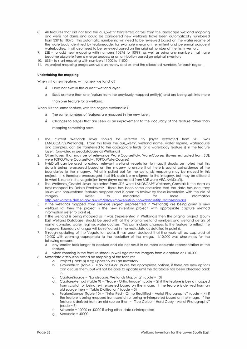
8. All features that did not had the aus_wetnr transferred across from the landscape wetland mapping
and were not dams and could be considered new wetlands have been automatically numbered
from 339 to 10375. This automatic numbering will need to be reviewed based on the water regime of
the waterbody identified by featurecode, for example merging intermittent and perennial adjacent
waterbodies. It will also need to be reviewed based on the original number of the first inventory.
9. LSE – to add new mapping with numbers 10376 to 10999, as well as using any numbers that have
become obsolete from a merge process or an attribution based on original inventory
10. USE – to start mapping with numbers 11000 to 11500.
11. As project mapping progresses we can review and extend the allocated numbers for each region.
Undertaking the mapping
When is it a new feature, with a new wetland id?
Does not exist in the current wetland layer.
Exists as more than one feature from the previously mapped entity(s) and are being split into more
than one feature for a wetland.
When is it the same feature, with the original wetland id?
The same numbers of features are mapped in the new layer.
Changes to edges that are seen as an improvement to the accuracy of the feature rather than
mapping something new.
1. The current Wetlands layer should be referred to (layer extracted from SDE was
LANDSCAPES.Wetlands). From this layer the aus_wetnr, wetland name, water regime, watercourse
and complex, can be transferred to the appropriate fields for a waterbody feature(s) in the feature
layer. (provided in geodatabase as Wetlands)
2. Other layers that may be of relevance WaterCoursesPoly, WaterCourses (layers extracted from SDE
were TOPO.WaterCoursesPoly , TOPO.WaterCourses)
3. NvisDraft can be used to extract relevant wetland vegetation to map, it should be noted that this
data is being re-assessed based on the imagery to ensure that there is spatial coincidence of the
boundaries to the imagery. What is pulled out for the wetlands mapping may be moved in this
project. It is therefore encouraged that this data be re-aligned to the imagery, but may be different
to what is done in the vegetation layer (layer extracted from SDE were VEG.NvisDraft).
4. The Wetlands_Coastal (layer extracted from SDE were LANDSCAPE.Wetlands_Coastal) is the data as
best mapped by Debra Frankeweiz. There has been some discussion that the data has accuracy
issues with non-wetland features mapped and is open to review by these inventories with the aid of
imagery. Refer to metadata for more information
http://envoracle.deh.sa.gov.au/sim/plsql/simpwebutil.p_showdataset?p_datasetnr=683
5. If the wetlands mapped from previous project (represented in Wetlands) are being given a new
wetland id, then the project is the new inventory project, with appropriate capture method
information (refer to point 6).
6. If the wetland is being mapped as it was (represented in Wetlands) then the original project (South
East Wetland Database) should be used with all the original wetland numbers and wetland details of
name, complex, water_regime, water courses. This can include changes to the feature to reflect the
imagery. Boundary changes will be reflected in the metadata as detailed in point 6.
7. Through updating of the Vegetation data, it has been decided that line work will be captured at
10,000 with zooming appropriate to the resolution of the image. 1:10,000 was chosen as for the
following reasons:
any smaller took longer to capture and did not result in no more accurate representation of the
feature,
when zooming in the feature stood up well against the imagery from a capture at 1:10,000.
8. Metadata attribution based on mapping of the feature:
a. Project (Table 8) = eg Upper South East Inventory
b. Groundtruth (Table 7) = NV or GT or UN are the appropriate options, if there are new options
can discuss them, but will not be able to update until the database has been checked back
in.
c. CaptureSource = “Landscape: Wetlands Mapping” (code = 13)
d. CaptureMethod (Table 9) = “Trace - Ortho Image” (code = 2) if the feature is being mapped
from scratch or being re-interpreted based on the image. If the feature is derived from an
old source then = “Table Digitisation” (code = 3)
e. FeatureSource (Table 10) = “Infra Red - Ortho Recitified - Aerial Photography” (code = 4) if
the feature is being mapped from scratch or being re-interpreted based on the image. If the
feature is derived from an old source then = “True Colour - Hard Copy - Aerial Photography”
(code = 3)
f. Minscale = 10000 or 40000 if using other data uninterpreted.
g. Maxscale = 40000
Page 36 Wetland Inventory for the Lower South East

h. HorizontalAccuracy = 5 (imagery is +/- 5m) or 25 if using other data uninterpreted.
i. FeatureReliabilityDate = 23/1/2004
j. AttributeReliabilityDate = 23/1/2005 or date of visit if ground truthed
9. New types can be added to domain but involve “checkin” and “checkout” to refresh the changes.
Spatial Table and Domains
Table 1 Wetland Attributes, those in italics are not to be included.
Name Description Domain
FeatureCode Australian standard coding for mapped dWetland_FeatureCode (Table
information 1)
The pre-existing waterbody data can provide
information for the water regime attribute.
All wetlands mapped should be = 4520
Region Unique code for each region. For example S00 is dWetland_RegionCode (Table
Murray Valley, S01 is South East 2)
All mapping should be S01
WetlandId Unique number within the region to identify the NA
wetland. Altready generated but requires re-
visiting based on water regimes and original
data.
Aus_wetnr Unique identifier for labelling all South Australian Generated
wetlands.
Format: S0000001 S = South Australia; 00 = region;
00001 = unique number for wetland
This will be generated from RegionCode and
WetlandId field
Aus_wetnr_old Unique identifier for labeling all South Australian NA
wetlands. All wetlands begin with S followed by
an assigned number eg S0001
Name Individual name of Wetland. Use Title Case NA
format.
Complex Name of group of wetland sharing NA
hydrogeological properties. Use Title Case
format.
WetlandType Wetland classification system adopted by dWetland_Type (Table 3)
Ramsar
WaterRegime Item describes the type of water regimes of the dWaterRegime (Table 4)
waterbodies that comprise each major area of a
wetland, such as permanent, temporary, runoff
or seepage, seasonal etc and combinations of
these.
Feature Code from waterbodies layer will be
informative here.
WetlandSystem Basic classification system for wetlands agreed dWetland_SystemCode (Table
upon at the National level. 5)
AusDir_no This is the official Directory of Important Wetlands dWetland_AusDirNum (Table 6)
identifier (taken from the 3rd Edition - 2001)
**Create a domain of all the current list of
idenitifiers in the directory SA001 to SA063
Watercourse Name of the watercourse that the wetland is part NA
of. Not complete for Murray wetlands. Use Title
Case format.
InternationalStatus Ramsar listed wetlands of International Y/N
Importance
NationalStatus Directory of Important Wetlands (ANCA 1996) Y/N
listed wetlands of National Importance
GroundTruth Detail on reliability of the wetland mapped, has it dVegGroundTruth (Table 7)
been visited?
Project Description to describe the project undertaking dWetland_Project (Table 8)
the mapping
CaptureSource Type of Data Layer, all wetlands captured and dCaptureSource
described should be coded with 13 Landscape:
Wetland Mapping
CaptureMethod Indicates whether digital, hardcopy maps etc dCaptureMethod (Table 9)
FeatureSource Information used to delineate the boundary dFeatureSource (Table 10)
FeatureRelDate Date of the Feature source = date of NA
photography used to map the wetland
Wetland Inventory for the Lower South East Page 37

AttributeRelDate Date of digitizing or field work to verify the NA
wetland
HorizontalAccuracy Accuracy of image or base data NA
Minscale Scale of photography at which feature was NA
captured
Maxscale Scale of photography or base data. NA
EditDate Automatic NA
UserId Automatic when loaded back as CHARDING, NA
DHERPICH
Shape Automatic NA
Area Automatic NA
Table 1 Domain for Feature Code
Code Description
3236 Reservoir
4400 Inland Water Feature
4401
4402
Lake – Perennial
Lake - Intermittent
4403 Lake - Mainly Dry
4404 Lake – Perennial – change all these to 4431 if River Murray
4407 Land Subject to Inundation (STI)
4420 Double Line Watercourse
4431 River Murray
4450 Wetland
4812 Dam
4870 Double Line Channel, Drain, Canal, Ditch
Table 2 Region Code domain
Code Description
S00 Murray Valley
S01 South East
S02 Mount Lofty
S03 Eyre Peninsula
S04 Northern Agricultural Districts
S05 Kangaroo Island
Table 3 Wetland type domain
Code Description
A1 Marine waters - permanent shallow waters less than six metres deep at low tide, includes sea
bays straits
A2 Subtidal aquatic beds, includes kelp beds, sea-grasses, tropical marine meadows
A3 Coral reefs
A4 Rocky marine shores, includes rocky offshore islands, sea cliffs
A5 Sand, shingle or pebble beaches, includes sand bars, spits, sandy islets
A6 Estuarine waters, permanent waters of estuaries and estuarine systems of deltas
A7 Intertidal mud, sand or salt flats
A8 Intertidal marshes, includes salt marshes, salt meadows, saltings, raised salt marshes, tidal
brackish and freshwater marshes
A9 Intertidal forested wetlands, includes mangrove swamps, nipa swamps, tidal freshwater
swamps forests
A10 Brackish to saline lagoons and marshes with one or more relatively narrow connections with the
sea
A11 Freshwater lagoons and marshes in the coastal zone
A12 Non tidal freshwater forested wetlands
B1 Permanent rivers and streams includes waterfalls
B2 Seasonal and irregular rivers and streams
B3 Inland deltas(permanent)
B4 Riverine floodplains, includes river flats, flooded river basins, seasonally flooded grassland,
savanna and palm savanna
B5 Permanent freshwater lakes (8 ha) includes large oxbow lakes
B6 Seasonal/intermittent freshwater lakes (>8 ha) floodplain lakes
B7 Permanent saline /brackish lakes
B8 Seasonal/intermittent saline lakes
B9 Permanent freshwater ponds (<8 ha) marshes and swamps on inorganic sols, with emergent
Page 38 Wetland Inventory for the Lower South East

vegetation waterlogged for at least most of the growing season
B10 Seasonal/intermittent freshwater ponds and marshes on inorganic soils includes sloughs,
potholes, seasonally flooded meadows, sedge marshes
B11 Permanent saline/brackish marshes
B12 Seasonal saline marshes
B13 Shrub swamps, shrub dominated freshwater marsh, shrub carr, alder thicket on inorganic soil
B14 Freshwater swamp forest, seasonally flooded forest, wooded swamps, on inorganic soils
B15 Pearlands, forest, shrubs or open bogs
B16 Alpine and tundra wetlands: includes alpine meadows, tundra pools, temporary waters from
snow melt
B17 Freshwater springs, oasis and rock pools
B18 Geothermal wetlands
B19 Inland, subterranean karst wetlands
C1 Water storage areas; reservoirs, barrages, hydro-electric dams, impoundment’s (generally over
8 ha).
C2 Ponds; includes farm ponds, stock ponds, small tanks; (generally below 8 ha).
C3 Aquaculture ponds; fish ponds shrimp ponds
C4 Salt exploitation, salt pans, salines
C5 Excavations; gravel pits; borrow pits, mining pools.
C6 Wastewater treatment areas; sewage farms, settling ponds, oxidation basins.
C7 Irrigated land; includes irrigation channels and rice fields, canals, ditches
C8 Seasonally flooded arable land, farm land
C9 Canals
C10 Artificial wetlands with conservation values, Includes constructed wetlands and dams
Table 4 List of codes and descriptions for the Water Regime Domain, those italised should not be used.
Code and Description Definition
Artificially Dry Inland: Water source cut off or wetland drained
Controlled Irrigation
Episodic Inland: Only contains water at infrequent and irregular intervals (<1year in
10)
Intermittent Inland: Floods irregularly
Intertidal Flat Marine: Inundated by most if not all high tides
Permanent Inland: Contains water throughout the year, although level may vary.
Permanent Soak
Permanent / Seasonal Not to be used in future, need removal of combination word
Permanent / Temporary Not to be used in future
Runoff or Seepage
Runoff / Permanent Not to be used in future
Runoff / Temporary Not to be used in future
Seasonal Inland: Floods and dries in most years
Seasonal Soak
Seasonal / Permanent Not to be used in future
Semi-permanent Inland: Contains water throughout the year but dries out in dry years (e.g.
1 year in 10).
Semi- Permanent / Permanent Not to be used in future
Supratidal Flat Marine: Covered only at spring tides or less frequently
Supratidal Flat & Flooding Marine: Relatively rare tidal coverage is combined with seasonal
freshwater flooding.
Temporary
Unknown
Not Assessed
Table 5 List of Wetland Systems as defined by National guidelines
SystemCode System Description
EST Estuarine Tidal habitats with a range of fresh-brackish-marine water chemistry and daily
tidal cycles. Includes salt and brackish marshes, intertidal mudflats, and
mangrove swamps.
LAC Lacustrine Inland waterbodies that are situated in topographic depressions, lack emergent
trees and shrubs, have <30% vegetation cover. E.g. large lakes.
MAR Marine Open ocean, continental shelf, including beaches, rocky shores, lagoons, and
shallow coral reefs. Minimal influence from rivers or estuaries.
PAL Palustrine All non-tidal wetlands that are substantially covered with emergent vegetation.
Includes bogs, swamps, floodplains and marshes.
RIV Riverine Perennial streams and rivers. Excludes floodplains adjacent to the channel.
Wetland Inventory for the Lower South East Page 39

Table 6 Domain for the list of Australian Directory of Important Wetlands
Code Wetland name
SA021 American River Wetland System
SA004 Baird Bay
SA039 Banrock Swamp Wetland Complex
SA005 Barker Inlet & St Kilda
SA006 Big Swamp
SA022 Birchmore Lagoon
SA052 Bool & Hacks Lagoons
SA023 Busby and Beatrice Islets
SA053 Butchers & Salt Lakes
SA007 Clinton
SA008 Coffin Bay Coastal Wetland System
SA001 Coongie Lakes
SA024 Cygnet Estuary
SA025 Cygnet River
SA067 Dalhousie Springs
SA009 Davenport Creek
SA054 Deadmans Swamp
SA026 D'Estrees Bay
SA002 Diamantina River Wetland System
SA055 Ewens Ponds
SA027 Flinders Chase River Systems
SA010 Franklin Harbour
SA028 Grassdale Lagoons
SA040 Gurra Lakes Wetland Complex
SA056 Honans Scrub
SA065 Inland Saline Lakes
SA041 Irwin Flat
SA029 Lake Ada
SA066 Lake Eyre
SA068 Lake Eyre Mound Springs
SA057 Lake Frome & Mullins Swamp
SA011 Lake Hamilton
SA012 Lake Newland
SA030 Lanacoona Road Swamps
SA031 Lashmar Lagoon
SA042 Loch Luna Wetland Complex
SA043 Loveday Swamps
SA044 Lower Murray Swamps
SA045 Marne River Mouth
SA058 Marshes Swamp
SA069 Murray Bridge Army Training Area
Wetlands
SA032 Murrays Lagoon
SA059 Naen Naen Swamp & Gum Lagoon
SA046 Noora Evaporation Lakes
SA033 Onkaparinga Estuary
SA060 Piccaninnie Ponds
SA047 Pike-Mundic Wetland Complex
SA013 Point Davenport
SA014 Point Labatt
SA061 Poocher & Mundulla Swamps
SA015 Port Gawler & Buckland Park Lake
SA048 Riverland Wetland Complex
SA062 South East Coastal Salt Lakes
SA049 Spectacle Lakes
SA050 Stockyard Plain
SA016 Streaky Bay
SA003 Strzelecki Creek Wetland System
SA051 Swan Reach Wetland Complex
SA063 The Coorong, Lake Alexandrina &
Lake Albert
SA017 Tod River Wetland System
SA034 Tookayerta & Finniss Catchments
SA018 Tumby Bay
SA035 Upper Hindmarsh River Catchment
SA020 Upper Spencer Gulf
SA036 Upper Tunkalilla Creek Swamps
SA037 Waidrowski Lagoon
SA064 Watervalley Wetlands
SA038 White Lagoon Wetland System
SA019 Wills Creek
Page 40 Wetland Inventory for the Lower South East
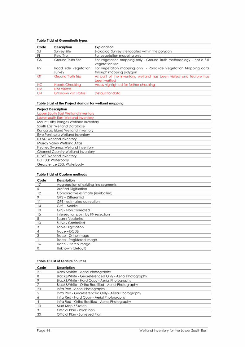
11
14
10
Table 7 List of Groundtruth types
Code Description Explanation
SU Survey Site Biological Survey site located within the polygon
FT Field Trip For vegetation mapping only
GS Ground Truth Site For vegetation mapping only - Ground Truth methodology – not a full
vegetation site.
RV Road side vegetation For vegetation mapping only - Roadside Vegetation Mapping data
survey through mapping polygon
GT Ground Truth Trip As part of the inventory, wetland has been visited and feature has
been verified
NC Needs Checking Areas highlighted for further checking
NV Not Visited
UN Unknown visit status Default for data
Table 8 List of the Project domain for wetland mapping
Project Description
Upper South East Wetland Inventory
Lower south East Wetland Inventory
Mount Lofty Ranges Wetland Inventory
South East Wetland Database
Kangaroo Island Wetland Inventory
Eyre Peninsula Wetland Inventory
NYAD Wetland Inventory
Murray Valley Wetland Atlas
Fleurieu Swamps Wetland Inventory
Channel Country Wetland Inventory
NPWS Wetland Inventory
DEH 50k Waterbody
Geoscience 250k Waterbody
Table 9 List of Capture methods
Code Description
17 Aggregation of existing line segments
5 ArcPad Digitisation
12 Comparative estimate (eyeballed)
9 GPS – Differential
GPS - estimated correction
GPS – Mobile
GPS - Non corrected
15 Intersection point by FN resection
8 Scan / Vectorize
13 Survey Controlled
3 Table Digitisation
4 Trace – DCDB
2 Trace - Ortho Image
1 Trace - Registered Image
16 Trace - Stereo Image
0 Unknown (default)
Table 10 List of Feature Sources
Code Description
21 Black&White - Aerial Photography
8 Black&White - Georeferenced Only - Aerial Photography
9 Black&White - Hard Copy - Aerial Photography
7 Black&White - Ortho Rectified - Aerial Photography
23 Infra Red - Aerial Photography
5 Infra Red - Georeferenced Only - Aerial Photography
6 Infra Red - Hard Copy - Aerial Photography
4 Infra Red - Ortho Recified - Aerial Photography
13 Mud Map / Sketch
31 Official Plan - Rack Plan
Official Plan - Surveyed Plan
Page 44 Wetland Inventory for the Lower South East
30

26 Satellite - MSS Imagery
24 Satellite - Non Landsat
25 Satellite - TM Imagery
10 Satellite Imagery
22 True Colour - Aerial Photography
2 True Colour - Georeferenced Only - Aerial Photography
3 True Colour - Hard Copy - Aerial Photography
1 True Colour - Ortho Rectified - Aerial Photography
0 Unknown
Wetland Inventory for the Lower South East Page 45

APPENDIX 3 – SAWID: A Users Guide
In ArcMap, using the hyperlink tool,
click on a wetland of interest.
A form appears, providing you with 8
options.
Clicking on the “Edit” option
enables you to add new
information and data for that
wetland.
Clicking the “View Photos” option
enables you to view the available
photographs of that wetland.
Page 46 Wetland Inventory for the Lower South East

Clicking “wetland Summary Report” produces
a report summarising the biophysical
information for all surveys of that wetland. The
report includes available information on
location, status, tenure, hydrology, water
chemistry, type, threats, conservation
measures, flora and fauna.
Clicking “Calculate Ecological Significance”
provides the BCV Score and BCV Class of that
wetland.
The “Flora and Fauna” list button
provides a list of all flora and fauna
records for all surveys of that
wetland stored in the database.
Wetland Inventory for the Lower South East Page 47

The “Main Menu” button takes you
to the front end of the database
from where you can search the
entire database for other wetlands
or wetland features.
By clicking on “Quick Search” you can find all the wetlands with records of a specific feature of interest.
Page 48 Wetland Inventory for the Lower South East

APPENDIX 4 – LSE Wetlands Ranked by BCV Score
This list does not include those wetlands in BCV Class “Insufficient Data”. Note: Confidence in BCV score varies according to method used to determine condition as follows:
Field Survey = High Confidence
Site Visit = Medium Confidence
Aerial Photograph = Lowest Confidence
Wetland ID Name
S0110446 BOOL LAGOON
S0120855 BIG HEATH CP
S0110548 THE MARSHES
S0101060 PICCANINNIE
PONDS
S0101818 LAKE GEORGE
S0108314 LAKE HAWDON
SOUTH
S0109691 TWO LAKES
S0110750 HONAN NFR
S0110764 HONAN NFR
S0100098 BUTCHERS LAKE
S0107299 THE MARSHES
S0109028 LAKE HAWDON
NORTH
S0120800 HONAN NFR
S0107373 THE MARSHES
S0105592 MULLINS SWAMP
S0120280 BUTCHERS LAKE
S0110629 PENOLA
CONSERVATION
PARK
S0120246 DEADMANS
SWAMP NFR
S0109071 HACKS LAGOON
S0105943 LAKE FROME
S0110595 THE MARSHES
S0110817 HONAN NFR
S0107026 PICCANINNIE
PONDS Eastern
Wetland
S0110576 PENOLA
CONSERVATION
PARK
S0110765 HONAN NFR
S0120847 HOG LAKE
S0107273 BLUE TEA TREE
SWAMP
S0110767 HONAN NFR
S0110622 THE MARSHES
S0110634 MT LYON LF
S0110787 HONAN NFR
S0120244 BIG DIP LAKE
S0107240 THE MARSHES
S0107304 THE MARSHES
Area
Score
Condition
Score
Threatened
Species
Score
Number
of
Surveys
Method Used to
Determine
Condition
BCV
Score
BCV
Class
3.38 15 24.5 365 Site Visit 42.88
3.22 15 21.25 164 Site Visit 39.47
2.01 20 4.75 17 Site Visit 26.76
2.25 20 4 78 Field Survey 26.25
3.81 15 7 102 Site Visit 25.81
3.52 15 7 61 Field Survey 25.52
0.42 20 5 13 Site Visit 25.42
0.71 20 4.25 7 Field Survey 24.96
1.52 20 3.25 10 Field Survey 24.77
1.78 20 2.25 6 Field Survey 24.03
1.68 20 2.25 4 Field Survey 23.93
3.39 15 5.25 34 Site Visit 23.64
0.97 20 2.5 20 Field Survey 23.47
1.08 20 2.25 10 Field Survey 23.33
2.44 15 5.75 28 Aerial Photograph 23.19
1.16 20 2 2 Field Survey 23.16
0.56 20 2.5 7 Aerial Photograph 23.06
2.06 20 1 11 Field Survey 23.06
2.20 15 5.75 21 Site Visit 22.95
2.95 15 4.75 22 Site Visit 22.70
0.60 20 2 1 Field Survey 22.60
1.49 20 1 2 Field Survey 22.49
1.10 20 1.25 3 Field Survey 22.35
1.00 20 1.25 5 Aerial Photograph 22.25
1.22 20 1 2 Field Survey 22.22
2.00 20 0 1 Field Survey 22.00
1.18 20 0.75 2 Field Survey 21.93
1.10 20 0.75 1 Field Survey 21.85
0.00 20 1.75 6 Site Visit 21.75
0.23 20 1.5 1 Field Survey 21.73
0.71 20 1 4 Site Visit 21.71
1.66 20 0 1 Aerial Photograph 21.66
0.89 20 0.75 1 Field Survey 21.64
1.13 20 0.5 1 Field Survey 21.63
Ve
ry H
igh
Wetland Inventory for the Lower South East Page 49

l Name Number
of
i
S0110661 20 1 l
S0116936 20 2 l
S0105650 DI 15 34 l
S0120241
ION
PARK
20 0 2 l
S0110581 20 5 l
S0107267 20 1 l
S0110562 20 1 Fiel
S0101778 15 6 l
S0110534 20 0 l
S0110344 20 1 l
S0105778 20 0 1 l
S0108357 15 41
S0110521 20 5 l
S0120212 20 2 Fiel
S0108474 I 15
S0110014 20 1 l
S0120251 20 1 1 Fiel
S0110734 20 2 l
S0110773 20 1 Fiel
S0110742 20 1 Fiel
S0110760 20 1 l
S0107281 20 1 l
S0110621 20 1
S0110373 20 1 1 l
S0110632 20 1 1 Fiel
S0106799 20 1 Fiel
Ve
ry H
igh
S0110539 20 1 l
S0110500 20 0 2
S0110563 15 l
S0110579 20 1
S0108264 20 0 2 l
S0110703 20 1 l
S0110775 20 1 l
S0108290 20 1 l
S0106227 20 7 l
S0110599 20 1 l
S0110648 20 1 l
S0110677 20 1 l
S0110522 20 1 Fiel
S0108280 LI 20 0 3 l
S0110639 20 1 l
S0108304 20 0 1 l
S0110377 20 1
S0106317 20 1 Fiel
S0110371 20 1
S0110763 20 1 Fiel
S0106778 20 0 1 Fiel
Hig
h
Wet and ID Area
Score
Condition
Score
Threatened
Species
Score Surveys
Method Used to
Determine
Condit on
BCV
Score
BCV
Class
HACKET HILL NFR 0.38 1.25 Fie d Survey 21.63
SALT LAKE 1.36 0.25 Fie d Survey 21.61
SCOVERY BAY 1.78 4.75 Aeria Photograph 21.53
PENOLA
CONSERVAT
1.51 Aeria Photograph 21.51
GREEN SWAMP 1.23 0.25 Fie d Survey 21.48
THE MARSHES 0.69 0.75 Fie d Survey 21.44
HONAN NFR 0.92 0.5 d Survey 21.42
POOL OF SILOAM 0.41 46 Aeria Photograph 21.41
LAKE ROBE GAME
RESERVE
1.40 10 Fie d Survey 21.40
SALT LAKE 1.15 0.25 Fie d Survey 21.40
1.32 Aeria Photograph 21.32
LAKE ROBE 2.56 3.75 Site Visit 21.31
DEADMANS
SWAMP NFR
1.02 0.25 Fie d Survey 21.27
HONAN NFR 0.74 0.5 d Survey 21.24
LAKE EL ZA 3.71 2.5 51 Site Visit 21.21
HONAN NFR 0.45 0.75 Fie d Survey 21.20
OLD WOOLWASH 0.08 d Survey 21.08
HONAN NFR 0.33 0.75 Fie d Survey 21.08
HONAN NFR 0.58 0.5 d Survey 21.08
HONAN NFR 0.58 0.5 d Survey 21.08
HONAN NFR 0.79 0.25 Fie d Survey 21.04
THE MARSHES 0.77 0.25 Fie d Survey 21.02
THE MARSHES 0.75 0.25 Site Visit 21.00
OLD WOOLWASH 0.00 Aeria Photograph 21.00
MT LYON LF 0.00 d Survey 21.00
OLD WOOLWASH 0.50 0.5 d Survey 21.00
GHOST LAKE 0.71 0.25 Fie d Survey 20.96
WHENNAN NFR 0.96 Site Visit 20.96
LAKE ST. CLAIR 3.45 2.5 41 Aeria Photograph 20.95
THE MARSHES 0.68 0.25 Site Visit 20.93
FRESH DIP LAKE 0.87 Aeria Photograph 20.87
GRUNDY LANE NFR 0.59 0.25 Fie d Survey 20.84
HONAN NFR 0.58 0.25 Fie d Survey 20.83
0.30 0.5 Aeria Photograph 20.80
LAKE WOOLEY 0.53 0.25 Aeria Photograph 20.78
MT MCINTYRE NFR 0.00 0.75 Fie d Survey 20.75
HACKET HILL NFR 0.00 0.75 Fie d Survey 20.75
HACKET HILL NFR 0.49 0.25 Fie d Survey 20.74
THE MARSHES 0.21 0.5 d Survey 20.71
TTLE DIP LAKE 0.70 Aeria Photograph 20.70
HACKET HILL NFR 0.37 0.25 Fie d Survey 20.62
0.59 Aeria Photograph 20.59
OLD WOOLWASH 0.07 0.5 Site Visit 20.57
LONGS NFR 0.00 0.5 d Survey 20.50
OLD WOOLWASH 0.00 0.5 Site Visit 20.50
HONAN NFR 0.00 0.5 d Survey 20.50
OLD WOOLWASH 0.46 d Survey 20.46
Page 50 Wetland Inventory for the Lower South East

l Name Number
of
i
S0110788 20 1 l
S0110746 20 1 l
S0109690 20 0 1
S0110998 20 1 l
S0110659 20 1 l
S0110554 20 2 l
S0110667 20 1 l
S0110761 20 1 l
S0110825 20 1 l
S0110920 I
CHAIN RD
20 1 l
S0121483 10 45
S0109688 20 0 1
S0110913 20 0 1 Fiel
S0107060 15 23 Fiel
S0110912 20 0 1 Fiel
S0109973 PERCH HOLE 20 0 1 l
S0110499 20 0 1 Fiel
S0110717 20 0 1 Fiel
S0110680 I 20 0 1 Fiel
S0110718 20 0 1 Fiel
S0107045 15 25 l
S0108578 15 3 7 Fiel
S0113806 5 17 l
S0120854 15
S0120240 15 4 5 l
S0110343 PI 15 6
S0105797 15 2 9 Fiel
S0110497 15 8 l
S0110759 DI 15 6 l
S0110533 GORDON 15 11 Fiel
S0120859
ION
PARK
15
S0107079 15 5 l
S0106808 15 l
S0116933
ION
PARK
15 2
S0107062 15 6 l
S0116890 15 2 l
S0113840 15 5 l
S0120851 15 5 l
S0110945 15 1 Fiel
S0107056 15 2 l
S0108757 15 11 Fiel
S0116900 15 1 l
S0121482 15 6 Fiel
Hig
h
Wet and ID Area
Score
Condition
Score
Threatened
Species
Score Surveys
Method Used to
Determine
Condit on
BCV
Score
BCV
Class
HONAN NFR 0.14 0.25 Fie d Survey 20.39
HONAN NFR 0.12 0.25 Fie d Survey 20.37
SEA LAKE 0.32 Site Visit 20.32
GRUNDY LANE NFR 0.05 0.25 Fie d Survey 20.30
HACKET HILL NFR 0.04 0.25 Aeria Photograph 20.29
HACKET HILL NFR 0.00 0.25 Fie d Survey 20.25
HACKET HILL NFR 0.00 0.25 Aeria Photograph 20.25
HONAN NFR 0.00 0.25 Fie d Survey 20.25
HONAN NFR 0.00 0.25 Fie d Survey 20.25
WAND LLO / THREE 0.00 0.25 Fie d Survey 20.25
LAKE BONNEY S.E. 3.92 6.25 Site Visit 20.17
BOUCHIES LAKE 0.12 Site Visit 20.12
GRUNDY LANE NFR 0.12 d Survey 20.12
BUCKS LAKE 1.85 3.25 d Survey 20.10
GRUNDY LANE NFR 0.09 d Survey 20.09
0.05 Aeria Photograph 20.05
WHENNAN NFR 0.03 d Survey 20.03
GRUNDY LANE NFR 0.00 d Survey 20.00
WAND LO NFR 0.00 d Survey 20.00
GRUNDY LANE NFR 0.00 d Survey 20.00
BLACKFELLOWS
CAVE WETLAND
1.60 3.25 Aeria Photograph 19.85
1.63 d Survey 19.63
2.87 11.75 Aeria Photograph 19.62
EWENS PONDS 1.01 3.5 15 Site Visit 19.51
BUTCHERS LAKE 0.00 Aeria Photograph 19.00
CK SWAMP 2.17 1.75 Site Visit 18.92
TOPPERWEIN NFR 1.87 d Survey 18.87
LAKE
FELLMONGERY
1.49 2.25 Fie d Survey 18.74
AGONAL ROAD 0.93 2.75 Fie d Survey 18.68
LAGOON
1.38 2.25 d Survey 18.63
MARY SEYMOUR
CONSERVAT
2.10 1.5 21 Site Visit 18.60
BLACKFELLOWS
CAVE WETLAND
1.81 1.75 Aeria Photograph 18.56
TELFORD SCRUB CP 1.57 1.5 10 Aeria Photograph 18.07
MARY SEYMOUR
CONSERVAT
1.53 1.25 Site Visit 17.78
1.42 1.25 Fie d Survey 17.67
1.83 0.75 Fie d Survey 17.58
1.77 0.75 Aeria Photograph 17.52
HORSESHOE
PADDOCK
1.77 0.75 Fie d Survey 17.52
CLAYPANS 0.89 1.5 d Survey 17.39
1.63 0.75 Fie d Survey 17.38
MCINNES WETLAND 2.13 0.25 d Survey 17.38
1.11 1.25 Fie d Survey 17.36
THE MARSHES 0.61 1.5 d Survey 17.11
Wetland Inventory for the Lower South East Page 51

l Name Number
of
i
S0101999 I 15 5 l
S0110997 15 3 l
S0107052 15 3 Fiel
S0115665 15 4 l
S0110601 15 1 l
S0110947 15 1 1 Fiel
S0108952 15 2 l
S0110443 LI 10 5 l
S0108479 INE CR 15 1 1 l
S0110944 15 4 l
S0120253 15 14
S0110600 15 1 2 Fiel
S0110771 15 1 2 Fiel
S0114971 15 1 4 l
S0120842 I 15 1 Fiel
S0106954 15 0 7
S0107313 15 5 l
S0110108 15 3 l
S0120659 15 2 l
S0106202 15 1 l
S0110737 15 2 Fiel
S0120856 10 l
S0108130 15 1 l
S0110394 15 1 l
S0121485 I 15 1 l
S0114982 15 1
S0110749 15 1 l
S0110901 15 1 Fiel
S0114945 15 0 3 l
S0114763 15 0 1 l
S0110740 15 1 Fiel
S0114989 15 1 l
S0117807 HI I 15 2 l
S0109485 15 0 1 l
S0113560 MCROSTI 15 2 Fiel
S0120846 15 0 1 Fiel
S0110702 15 1 l
S0107937 15 0 l
S0110291 15 2 l
S0107058 15 0 1 l
S0110925 15 2 l
S0110664 15 1 l
S0107493 15 3 l
S0110731 15 1 Fiel
S0115817 15 0 3 l
Hig
h
Wet and ID Area
Score
Condition
Score
Threatened
Species
Score Surveys
Method Used to
Determine
Condit on
BCV
Score
BCV
Class
KATAN PARK
WETLAND
1.86 0.25 Fie d Survey 17.11
HORSESHOE
PADDOCK
1.32 0.75 Fie d Survey 17.07
1.51 0.5 d Survey 17.01
NANGWARRY NFR 1.71 0.25 Aeria Photograph 16.96
TRIAL WATERHOLE 1.70 0.25 Fie d Survey 16.95
CLAYPANS 0.92 d Survey 16.92
1.67 0.25 Aeria Photograph 16.92
TTLE BOOL
LAGOON
1.91 12 Fie d Survey 16.91
WOAKW 0.89 Aeria Photograph 16.89
THE EVERGLADES 1.13 0.75 Fie d Survey 16.88
GLENELG RIVER 1.63 0.25 Site Visit 16.88
MT MCINTYRE NFR 0.87 d Survey 16.87
HONAN NFR 0.83 d Survey 16.83
0.83 Aeria Photograph 16.83
TW G RUSH
LAGOONS
1.32 0.5 d Survey 16.82
BLUE LAKE 1.78 Site Visit 16.78
1.52 0.25 Aeria Photograph 16.77
SHEEPWASH
SWAMP
1.51 0.25 Fie d Survey 16.76
0.96 0.75 Aeria Photograph 16.71
BURKS ISLAND -
WEST
0.94 0.75 Fie d Survey 16.69
KANGAROO FLAT 1.17 0.5 d Survey 16.67
REEDY CREEK LF 2.16 4.5 14 Fie d Survey 16.66
LAKE NUNAN 1.35 0.25 Aeria Photograph 16.60
LONGS NFR 0.84 0.75 Fie d Survey 16.59
SLAND SWAMP LF 1.34 0.25 Fie d Survey 16.59
CRESS CREEK
SPRING
1.07 0.5 Site Visit 16.57
HONAN NFR 0.81 0.75 Fie d Survey 16.56
CLAYPANS EAST 1.02 0.5 d Survey 16.52
1.51 Aeria Photograph 16.51
PENOLA FOREST 1.50 Aeria Photograph 16.50
KANGAROO FLAT 0.98 0.5 d Survey 16.48
JERUSALEM CREEK
SPRING
1.23 0.25 Aeria Photograph 16.48
LLV EW 1.21 0.25 Aeria Photograph 16.46
MONBULLA 1.46 Aeria Photograph 16.46
ES NFR 0.95 0.5 d Survey 16.45
SALT LAKE 1.44 d Survey 16.44
KANGAROO FLAT 0.93 0.5 Aeria Photograph 16.43
LAKE BATTYE 1.38 10 Aeria Photograph 16.38
WHENNAN NFR 0.62 0.75 Fie d Survey 16.37
1.36 Aeria Photograph 16.36
OSCHAR SWAMP 1.11 0.25 Fie d Survey 16.36
HACKET HILL NFR 0.60 0.75 Fie d Survey 16.35
THE MARSHES 0.59 0.75 Fie d Survey 16.34
KANGAROO FLAT 0.84 0.5 d Survey 16.34
LOWAN LANE LF 1.33 Aeria Photograph 16.33
Page 52 Wetland Inventory for the Lower South East

l Name Number
of
i
S0110635 15 1 1 Fiel
S0110848 15 1 l
S0120841 DI 15 2 l
S0110744 15 2 Fiel
S0108154 15 1 l
S0120858 15 1 Fiel
S0110630 15 1 l
S0110672 15 2 Fiel
S0108849 15 0 2 l
S0110627 15 1 1 Fiel
S0110656 15 1 l
S0110903 15 1 l
S0108171 15 0 1 l
S0120486 15 0 2 l
S0109883 I 15 1 l
S0110919 15 2 l
S0110679 I 15 1 l
S0110536 15 0 2 Fiel
S0108211 15 2 l
S0121513 15 1 1 l
S0110272 15 1 l
S0110251 I 15 1 l
S0120643 15 1 l
S0107894 15 1 Fiel
S0110857 15 0 1 Fiel
S0117816 HI I 15 0 1 l
S0110729 15 1 Fiel
S0110647 15 2 Fiel
S0110655 15 1 l
S0110905 15 1 Fiel
S0107805 15 0 1 Fiel
S0120824 15 1 l
S0110668 15 1 l
S0110626 15 1 l
S0110631 15 1 l
S0114903 15 0 1 l
S0110922 I
CHAIN RD
15 1 l
S0108866 15 0 3 l
S0120605 DI 15 0 1 Fiel
S0121514 15 1 l
S0107043 15 2 l
S0110670 15 0 1 l
S0110878 10 5 l
S0110682 I 15 0 1 Fiel
S0110704 15 1 l
S0110654 15 1 Fiel
S0110676 15 1 Fiel
S0110243 I 15 0 1 l
Hig
h
Wet and ID Area
Score
Condition
Score
Threatened
Species
Score Surveys
Method Used to
Determine
Condit on
BCV
Score
BCV
Class
MT LYON LF 0.32 d Survey 16.32
KANGAROO FLAT 0.55 0.75 Aeria Photograph 16.30
SMAL SWAMP 1.04 0.25 Fie d Survey 16.29
HONAN NFR 0.79 0.5 d Survey 16.29
LAKE FOX 0.76 0.5 Aeria Photograph 16.26
TOPPERWEIN NFR 0.75 0.5 d Survey 16.25
MT LYON LF 0.00 1.25 Fie d Survey 16.25
HACKET HILL NFR 0.74 0.5 d Survey 16.24
1.22 Aeria Photograph 16.22
MT LYON LF 0.21 d Survey 16.21
HACKET HILL NFR 0.92 0.25 Fie d Survey 16.17
LONGS NFR 0.42 0.75 Fie d Survey 16.17
THE PUB LAKE 1.16 Aeria Photograph 16.16
HACKET HILL NFR 1.14 Aeria Photograph 16.14
KAR NYA 0.87 0.25 Aeria Photograph 16.12
WOOLWASH C 0.35 0.75 Fie d Survey 16.10
WAND LO NFR 0.34 0.75 Fie d Survey 16.09
LAKE AMY 1.09 d Survey 16.09
RULE SWAMP 0.80 0.25 Fie d Survey 16.05
Spencers Pond 0.00 Aeria Photograph 16.00
WHENNAN NFR 0.23 0.75 Fie d Survey 15.98
WAND LO NFR 0.71 0.25 Fie d Survey 15.96
COMAUM FOREST 0.71 0.25 Aeria Photograph 15.96
GOOSE NECK
SWAMP
0.46 0.5 d Survey 15.96
0.92 d Survey 15.92
LLV EW 0.91 Aeria Photograph 15.91
HONAN NFR 0.40 0.5 d Survey 15.90
HACKET HILL NFR 0.39 0.5 d Survey 15.89
HACKET HILL NFR 0.62 0.25 Fie d Survey 15.87
LONGS NFR 0.37 0.5 d Survey 15.87
PLEASANT PARK 0.87 d Survey 15.87
KANGAROO FLAT 0.09 0.75 Fie d Survey 15.84
HACKET HILL NFR 0.51 0.25 Fie d Survey 15.76
MT LYON LF 0.00 0.75 Fie d Survey 15.75
MT LYON LF 0.00 0.75 Fie d Survey 15.75
0.74 Aeria Photograph 15.74
WAND LLO / THREE 0.48 0.25 Fie d Survey 15.73
0.72 Aeria Photograph 15.72
AGONAL ROAD 0.71 d Survey 15.71
Bones Pond 0.19 0.5 Aeria Photograph 15.69
0.43 0.25 Aeria Photograph 15.68
HACKET HILL NFR 0.68 Aeria Photograph 15.68
KANGAROO FLAT 0.65 39 Aeria Photograph 15.65
WAND LO NFR 0.63 d Survey 15.63
GRUNDYS
WOODLANDS
0.38 0.25 Fie d Survey 15.63
HACKET HILL NFR 0.11 0.5 d Survey 15.61
HACKET HILL NFR 0.09 0.5 d Survey 15.59
WAND LO NFR 0.56 Aeria Photograph 15.56
Wetland Inventory for the Lower South East Page 53
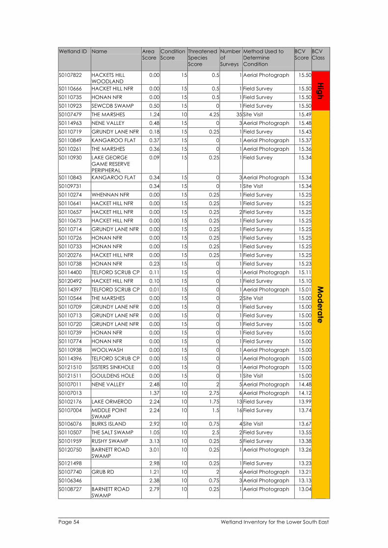
l Name Number
of
i
S0107822 15 1 l
S0110666 15 1 Fiel
S0110735 15 1 Fiel
S0110923 15 0 1 Fiel
Hig
h
S0107479 10 35
S0114963 15 0 3 l
S0110719 15 1 l
S0110849 15 0 1 l
S0110261 15 0 1 l
S0110930
PERI
15 1 l
S0110843 15 0 3 l
S0109731 15 0 1
S0110274 15 1 l
S0110641 15 1 l
S0110657 15 2 l
S0110673 15 1 l
S0110714 15 1 l
S0110726 15 1 l
S0110733 15 1 l
S0120276 15 1 l
S0110738 15 0 1 Fiel
S0114400 15 0 1 l
S0120492 15 0 1 Fiel
S0114397 15 0 1 l
S0110544 15 0 2
S0110709 15 0 1 Fiel
S0110713 15 0 1 Fiel
S0110720 15 0 1 Fiel
S0110739 15 0 1 Fiel
S0110774 15 0 1 Fiel
S0110938 15 0 1 l
S0114396 15 0 1 l
S0121510 15 0 1 l
S0121511 15 0 1
S0107011 10 2 5 l
S0107013 10 6 l
S0102176 10 13 Fiel
S0107004 I 10 l
S0106076 I 10 4
S0110507 10 2 Fiel
S0101959 10 5 l
S0120750 10 1 l
S0121498 10 1 l
S0107740 10 2 6 l
S0106346 10 3 l
S0108727 10 1 l
Mo
de
rate
Wet and ID Area
Score
Condition
Score
Threatened
Species
Score Surveys
Method Used to
Determine
Condit on
BCV
Score
BCV
Class
HACKETS HILL
WOODLAND
0.00 0.5 Aeria Photograph 15.50
HACKET HILL NFR 0.00 0.5 d Survey 15.50
HONAN NFR 0.00 0.5 d Survey 15.50
SEWCDB SWAMP 0.50 d Survey 15.50
THE MARSHES 1.24 4.25 Site Visit 15.49
NENE VALLEY 0.48 Aeria Photograph 15.48
GRUNDY LANE NFR 0.18 0.25 Fie d Survey 15.43
KANGAROO FLAT 0.37 Aeria Photograph 15.37
THE MARSHES 0.36 Aeria Photograph 15.36
LAKE GEORGE
GAME RESERVE
PHERAL
0.09 0.25 Fie d Survey 15.34
KANGAROO FLAT 0.34 Aeria Photograph 15.34
0.34 Site Visit 15.34
WHENNAN NFR 0.00 0.25 Fie d Survey 15.25
HACKET HILL NFR 0.00 0.25 Fie d Survey 15.25
HACKET HILL NFR 0.00 0.25 Fie d Survey 15.25
HACKET HILL NFR 0.00 0.25 Fie d Survey 15.25
GRUNDY LANE NFR 0.00 0.25 Fie d Survey 15.25
HONAN NFR 0.00 0.25 Fie d Survey 15.25
HONAN NFR 0.00 0.25 Fie d Survey 15.25
HACKET HILL NFR 0.00 0.25 Fie d Survey 15.25
HONAN NFR 0.23 d Survey 15.23
TELFORD SCRUB CP 0.11 Aeria Photograph 15.11
HACKET HILL NFR 0.10 d Survey 15.10
TELFORD SCRUB CP 0.01 Aeria Photograph 15.01
THE MARSHES 0.00 Site Visit 15.00
GRUNDY LANE NFR 0.00 d Survey 15.00
GRUNDY LANE NFR 0.00 d Survey 15.00
GRUNDY LANE NFR 0.00 d Survey 15.00
HONAN NFR 0.00 d Survey 15.00
HONAN NFR 0.00 d Survey 15.00
WOOLWASH 0.00 Aeria Photograph 15.00
TELFORD SCRUB CP 0.00 Aeria Photograph 15.00
SISTERS SINKHOLE 0.00 Aeria Photograph 15.00
GOULDENS HOLE 0.00 Site Visit 15.00
NENE VALLEY 2.48 Aeria Photograph 14.48
1.37 2.75 Aeria Photograph 14.12
LAKE ORMEROD 2.24 1.75 d Survey 13.99
MIDDLE PO NT
SWAMP
2.24 1.5 16 Fie d Survey 13.74
BURKS SLAND 2.92 0.75 Site Visit 13.67
THE SALT SWAMP 1.05 2.5 d Survey 13.55
RUSHY SWAMP 3.13 0.25 Fie d Survey 13.38
BARNETT ROAD
SWAMP
3.01 0.25 Aeria Photograph 13.26
2.98 0.25 Fie d Survey 13.23
GRUB RD 1.21 Aeria Photograph 13.21
2.38 0.75 Aeria Photograph 13.13
BARNETT ROAD
SWAMP
2.79 0.25 Aeria Photograph 13.04
Page 54 Wetland Inventory for the Lower South East

l Name Number
of
i
S0107295 10 1 6 Fiel
S0120227 10 2 Fiel
S0105970 10 12 l
S0108734 I 10 0 l
S0108794 10 0 1 Fiel
S0108610 10 2 Fiel
S0107690 10 4 l
S0120652 10 8 l
S0107035 10 8
S0109310 WI 10 8 l
S0110585 10 4 Fiel
S0113839 10 4 l
S0120264 10 0 1
S0107599 10 3 l
S0110366 DI 10 0 2 Fiel
S0107023 10 4 l
S0108901 10 0 1 Fiel
S0107833 10 0 2 l
S0113818 10 1 l
S0102800 10 1 l
S0110435 COPPI 10 l
S0110625 10 2 l
S0108755 10 1 2 l
S0107867 10 1 l
S0108514 10 3 l
S0110587 10 1 4 Fiel
S0106688 I 10 0 1 Fiel
S0114968 WI I 10 6 l
S0120744 10 0 1 Fiel
S0114813 10 1 4 l
S0110028 10 5 l
S0107949 10 0 1 l
S0114954 10 4 l
S0107291 10 13 l
S0108779 10 0 1 l
S0110074 10 0 1 l
S0110586 I 10 2 l
S0109696 10 3 l
S0110584 10 0 1 Fiel
S0110540 10 0 1 Fiel
S0108737 10 1 l
S0108213 10 0 1 Fiel
S0101642 10 0 2 l
S0108805 10 2 l
S0105547 MOCORCO 10 0 1 l
S0107036 5 14 l
S0107959 10 0 1 l
S0109874 10 2 l
Mo
de
rate
Wet and ID Area
Score
Condition
Score
Threatened
Species
Score Surveys
Method Used to
Determine
Condit on
BCV
Score
BCV
Class
LAKE LEAKE 1.94 d Survey 12.94
2.40 0.5 d Survey 12.90
2.64 0.25 Aeria Photograph 12.89
MAR A CREEK
SWAMP
2.86 11 Aeria Photograph 12.86
MOYHALL SWAMP 2.85 d Survey 12.85
WEST OF LAKE
HAWDON NORTH
2.34 0.5 d Survey 12.84
KALADBRO SWAMP 2.07 0.75 Aeria Photograph 12.82
2.51 0.25 Aeria Photograph 12.76
GERMEIN RESERVE 1.49 1.25 Site Visit 12.74
NDAMERE 1.40 1.25 Aeria Photograph 12.65
2.14 0.5 d Survey 12.64
CANUNDA FLAT 2.34 0.25 Aeria Photograph 12.59
LEGOES SWAMP 2.54 Site Visit 12.54
KEARNEY LAKE 1.77 0.75 Aeria Photograph 12.52
NE SWAMP 2.48 d Survey 12.48
EIGHT MILE CREEK 1.22 1.25 Aeria Photograph 12.47
2.44 d Survey 12.44
2.43 Aeria Photograph 12.43
1.12 1.25 Aeria Photograph 12.37
2.07 0.25 Fie d Survey 12.32
NGS SWAMP 1.80 0.5 23 Fie d Survey 12.30
LAKE EDWARD 1.55 0.75 Fie d Survey 12.30
BARNETT ROAD
SWAMP
1.27 Aeria Photograph 12.27
DEADMANS LF 1.43 0.75 Aeria Photograph 12.18
1.92 0.25 Aeria Photograph 12.17
1.12 d Survey 12.12
CONDSID NE 2.10 d Survey 12.10
NTERF ELD CREEK 0.31 1.75 Fie d Survey 12.06
MANGE SWAMP 2.02 d Survey 12.02
PENOLA FOREST 0.96 Aeria Photograph 11.96
1.69 0.25 Fie d Survey 11.94
1.91 Aeria Photograph 11.91
1.65 0.25 Aeria Photograph 11.90
LAKE LEAKE 1.09 0.75 Aeria Photograph 11.84
1.83 Aeria Photograph 11.83
1.83 Aeria Photograph 11.83
WH TES FLAT 1.53 0.25 Fie d Survey 11.78
DEADMAN SWAMP 1.23 0.5 Aeria Photograph 11.73
1.69 d Survey 11.69
BACHMANN 1.69 d Survey 11.69
1.44 0.25 Aeria Photograph 11.69
ARCOONA 1.68 d Survey 11.68
1.67 Aeria Photograph 11.67
ST. HELENA SWAMP 1.41 0.25 Aeria Photograph 11.66
1.63 Aeria Photograph 11.63
2.12 4.5 Aeria Photograph 11.62
1.61 Aeria Photograph 11.61
LAKE ST CLAIR 1.31 0.25 Fie d Survey 11.56
Wetland Inventory for the Lower South East Page 55

l Name Number
of
i
S0106925 10 0 3 l
S0115657 I 10 5 l
S0107021 LI 10 1 l
S0110473 10 0 1 l
S0110203 10 2
S0120806 10 0 1 Fiel
S0106551 10 12 l
S0102605 10 0 2 l
S0110556 10 2 Fiel
S0107552 10 0 1 Fiel
S0108263 10 0 2 l
S0109818 10 0 1 Fiel
S0106951 10 0 1
S0108998 10 3 l
S0110674 10 0 1 Fiel
S0114975 10 0 1 l
S0120805 10 0 7 l
S0110859 10 0 1 Fiel
S0106897 10 1 l
S0120321 I 10 1 l
S0120681 10 0 2 Fiel
S0110660 DI 10 0 1 Fiel
S0110227 10 1 l
S0110628 10 1 l
S0115825 10 17 l
S0106486 I I 10 0 7 l
S0108550 10 0 1 l
S0105847 TI 10 1 l
S0110571 10 0 1 l
S0107625 I 10 0 2 Fiel
S0108476 WI 10 0 1 l
S0110991 I 10 0 1 Fiel
S0108347
PERI
10 1 l
S0108342 10 0 3 l
S0120655 10 0 3 l
S0110225 I 10 1 l
S0112301 10 3 l
S0110453 10 2 l
S0110653 DI 10 0 1 Fiel
S0113849 I 10 18 l
S0112558 TI 10 0 1 l
S0110904 10 1 1 Fiel
S0110509 10 0 1 Fiel
S0110858 10 0 1 Fiel
S0110646 10 1 7 Fiel
Mo
de
rate
Wet and ID Area
Score
Condition
Score
Threatened
Species
Score Surveys
Method Used to
Determine
Condit on
BCV
Score
BCV
Class
BENARA CREEK 1.52 Aeria Photograph 11.52
NVERLOCH 0.27 1.25 Aeria Photograph 11.52
ONS PARK 1.26 0.25 Aeria Photograph 11.51
BOOL LAGOON 1.49 Aeria Photograph 11.49
CAT SWAMP 1.24 0.25 Site Visit 11.49
1.48 d Survey 11.48
REEDY LAGOON 1.23 0.25 Aeria Photograph 11.48
1.48 Aeria Photograph 11.48
WATERHOUSE 0.97 0.5 d Survey 11.47
LYNWOOD 1.46 d Survey 11.46
ALLAMBI 1.45 Aeria Photograph 11.45
NE LAKE ST CLAIR 1.45 d Survey 11.45
VALLEY LAKE 1.42 Site Visit 11.42
1.16 0.25 Fie d Survey 11.41
LYNWOOD 1.34 d Survey 11.34
1.32 Aeria Photograph 11.32
TEA TREE GULLY 1.31 Aeria Photograph 11.31
1.31 d Survey 11.31
PENOLA ROAD LF 1.05 0.25 Aeria Photograph 11.30
MUNDI-SELK RK
WETLAND
1.04 0.25 Aeria Photograph 11.29
1.29 d Survey 11.29
SMAL SWAMP 1.28 d Survey 11.28
MT LYON LF 0.00 1.25 Fie d Survey 11.25
MT LYON PERCHED
SWAMP
0.00 1.25 Fie d Survey 11.25
NANGWARRY MILL 0.00 1.25 Aeria Photograph 11.25
RAM LL ES 1.20 Aeria Photograph 11.20
1.19 Aeria Photograph 11.19
LLAR SWAMP 0.93 0.25 Fie d Survey 11.18
1.17 Aeria Photograph 11.17
MAGP E SWAMP 1.16 d Survey 11.16
RRINGULLA 1.15 Aeria Photograph 11.15
TW G RUSH
LAGOONS
1.14 d Survey 11.14
LAKE ROBE GAME
RESERVE
PHERAL
0.88 0.25 Fie d Survey 11.13
GREEN SWAMP 1.13 Aeria Photograph 11.13
1.12 Aeria Photograph 11.12
WAND LO NFR 0.84 0.25 Fie d Survey 11.09
AUSPINE -
CHEVRON DOWNS
0.58 0.5 Aeria Photograph 11.08
BOOL LAGOON /
HACKS LAGOON
0.83 0.25 Fie d Survey 11.08
SMAL SWAMP 1.06 d Survey 11.06
LAKE MC NTYRE 0.80 0.25 Aeria Photograph 11.05
MOTHY SWAMP 1.04 Aeria Photograph 11.04
LONGS C 0.03 d Survey 11.03
BOOL LAGOON 1.02 d Survey 11.02
1.01 d Survey 11.01
HACKET HILL NFR 0.00 d Survey 11.00
Page 56 Wetland Inventory for the Lower South East

l Name Number
of
i
S0116934 10 0 4 l
S0110748 10 1 l
S0109472 10 0 1 l
S0110476 10 0 1 Fiel
S0105784 I 10 1 l
S0108056 10 0 1 Fiel
S0110689 DI 10 1 l
S0109353 GREENVI 10 0 1 l
S0110637 10 1 l
S0109951 10 0 1 l
S0110560 10 0 1 Fiel
S0121478 10 2 l
S0113997 10 0 2 l
S0110906 10 1 l
S0109727 I 10 0 1 l
S0106938 10 0 1 l
S0108396 10 0 1 l
S0110694 DI 10 0 1 Fiel
S0108870 10 0 1 l
S0107446 I 10 1 l
S0120479 10 0 1 l
S0102537 10 1 l
S0107298 10 0 1 l
S0107063 10 0 1 l
S0115792 10 0 1 l
S0115039 I 10 4 l
S0110926 10 0 1 l
S0107711 10 0 2 l
S0115886 WI 10 1 l
S0110558 10 0 1 Fiel
S0120457 I 10 0 1 l
S0101696 10 0 1 Fiel
S0109433 GREENVI 10 1 l
S0110793 10 0 1 l
S0107946 STI I 10 1 l
S0110776 10 0 3 Fiel
S0106829 10 1 l
S0110662 10 1 l
S0110855 DI 10 0 1 Fiel
S0112471 IE 10 0 1 l
S0108258 10 0 3 l
S0110671 10 1 Fiel
S0110724 10 1 Fiel
S0112232 10 1 l
S0110721 10 2 Fiel
S0106491 10 1 l
Mo
de
rate
Wet and ID Area
Score
Condition
Score
Threatened
Species
Score Surveys
Method Used to
Determine
Condit on
BCV
Score
BCV
Class
1.00 Aeria Photograph 11.00
KANGAROO FLAT 0.74 0.25 Fie d Survey 10.99
MAE-BURNE 0.95 Aeria Photograph 10.95
0.95 d Survey 10.95
GALP N SWAMP 0.69 0.25 Aeria Photograph 10.94
0.94 d Survey 10.94
SMAL SWAMP 0.69 0.25 Fie d Survey 10.94
EW 0.93 Aeria Photograph 10.93
PALTRIDGE
SWAMPS
0.64 0.25 Fie d Survey 10.89
ALLAMBI 0.88 Aeria Photograph 10.88
GRANTS SWAMP 0.86 d Survey 10.86
MT LYON LF 0.10 0.75 Fie d Survey 10.85
PENOLA ROAD LF 0.85 Aeria Photograph 10.85
LONGS D 0.09 0.75 Fie d Survey 10.84
TREV NCE 0.82 Aeria Photograph 10.82
0.81 Aeria Photograph 10.81
0.81 Aeria Photograph 10.81
SMAL SWAMP 0.79 d Survey 10.79
ABERDARE 0.78 Aeria Photograph 10.78
SLAND SWAMP LF 0.53 0.25 Aeria Photograph 10.78
MAAOUPE 0.78 Aeria Photograph 10.78
0.51 0.25 Fie d Survey 10.76
HEMMINGS LF 0.75 Aeria Photograph 10.75
0.75 Aeria Photograph 10.75
PENOLA FOREST 0.72 Aeria Photograph 10.72
LACHEN STAT ON 0.22 0.5 Aeria Photograph 10.72
WOOLAWAY 0.70 Aeria Photograph 10.70
PALTRIDGE
SWAMPS
0.68 Aeria Photograph 10.68
LDERNESS LF 0.42 0.25 Aeria Photograph 10.67
GRANTS SWAMP 0.66 d Survey 10.66
WAND LLO 0.66 Aeria Photograph 10.66
MACKERETH 0.66 d Survey 10.66
EW 0.40 0.25 Aeria Photograph 10.65
HONAN NFR 0.65 Aeria Photograph 10.65
RL NG 0.14 0.5 Aeria Photograph 10.64
HONAN NFR 0.62 d Survey 10.62
OLD WASHPOOL
SWAMP
0.37 0.25 Fie d Survey 10.62
HACKET HILL NFR 0.36 0.25 Fie d Survey 10.61
SMAL SWAMP 0.59 d Survey 10.59
COOLOOL 0.56 Aeria Photograph 10.56
SAMS FOREST
RESERVE
0.55 Aeria Photograph 10.55
HACKET HILL NFR 0.00 0.5 d Survey 10.50
HONAN NFR 0.00 0.5 d Survey 10.50
AUSPINE -
NANGWARRY
NORTH
0.00 0.5 Aeria Photograph 10.50
GRUNDY LANE NFR 0.00 0.5 d Survey 10.50
MIDLAND PARK 0.21 0.25 Aeria Photograph 10.46
Wetland Inventory for the Lower South East Page 57
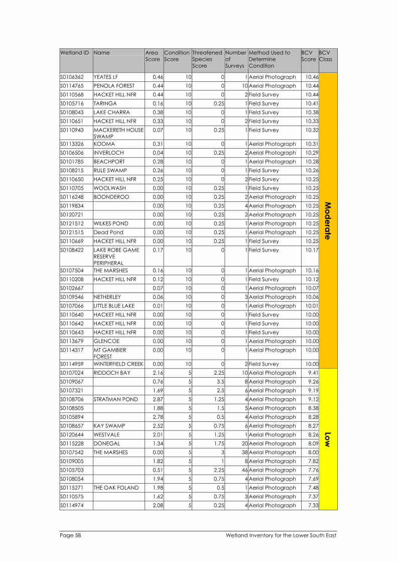
l Name Number
of
i
S0106362 10 0 1 l
S0114765 10 0 l
S0110568 10 0 2 Fiel
S0105716 I 10 1 l
S0108043 10 0 1 Fiel
S0110651 10 0 2 Fiel
S0110943 10 1 l
S0113326 KOOMA 10 0 1 l
S0106506 I 10 2 l
S0101785 10 0 1 l
S0108215 10 0 1 Fiel
S0110650 10 0 2 Fiel
S0110705 10 1 l
S0116248 10 2 l
S0119834 10 4 l
S0120721 10 2 l
S0121512 WI 10 1 l
S0121515 10 1 l
S0110669 10 1 l
S0108422
PERI
10 0 1 Fiel
S0107504 10 0 1 l
S0110208 10 0 1 Fiel
S0102667 10 0 1 l
S0109546 10 0 3 l
S0107066 LI 10 0 1 l
S0110640 10 0 1 Fiel
S0110642 10 0 1 Fiel
S0110643 10 0 1 Fiel
S0113679 10 0 1 l
S0114317 10 0 1 l
S0114959 WI I 10 0 2 Fiel
Mo
de
rate
S0107024 RI 5 l
S0109067 5 8 l
S0107321 5 6 l
S0108706 5 4 l
S0108505 5 5 l
S0105894 5 4 l
S0108657 5 6 l
S0120644 5 1 l
S0115228 5 l
S0107542 5 3 38 l
S0109005 5 1 8 l
S0105703 5 l
S0108054 5 4 l
S0115271 5 1 l
S0110575 5 3 l
S0114974 5 4 l
Low
Wet and ID Area
Score
Condition
Score
Threatened
Species
Score Surveys
Method Used to
Determine
Condit on
BCV
Score
BCV
Class
YEATES LF 0.46 Aeria Photograph 10.46
PENOLA FOREST 0.44 10 Aeria Photograph 10.44
HACKET HILL NFR 0.44 d Survey 10.44
TAR NGA 0.16 0.25 Fie d Survey 10.41
LAKE CHARRA 0.38 d Survey 10.38
HACKET HILL NFR 0.33 d Survey 10.33
MACKERETH HOUSE
SWAMP
0.07 0.25 Fie d Survey 10.32
0.31 Aeria Photograph 10.31
NVERLOCH 0.04 0.25 Aeria Photograph 10.29
BEACHPORT 0.28 Aeria Photograph 10.28
RULE SWAMP 0.26 d Survey 10.26
HACKET HILL NFR 0.25 d Survey 10.25
WOOLWASH 0.00 0.25 Fie d Survey 10.25
BOONDEROO 0.00 0.25 Aeria Photograph 10.25
0.00 0.25 Aeria Photograph 10.25
0.00 0.25 Aeria Photograph 10.25
LKES POND 0.00 0.25 Aeria Photograph 10.25
Dead Pond 0.00 0.25 Aeria Photograph 10.25
HACKET HILL NFR 0.00 0.25 Fie d Survey 10.25
LAKE ROBE GAME
RESERVE
PHERAL
0.17 d Survey 10.17
THE MARSHES 0.16 Aeria Photograph 10.16
HACKET HILL NFR 0.12 d Survey 10.12
0.07 Aeria Photograph 10.07
NETHERLEY 0.06 Aeria Photograph 10.06
TTLE BLUE LAKE 0.01 Aeria Photograph 10.01
HACKET HILL NFR 0.00 d Survey 10.00
HACKET HILL NFR 0.00 d Survey 10.00
HACKET HILL NFR 0.00 d Survey 10.00
GLENCOE 0.00 Aeria Photograph 10.00
MT GAMBIER
FOREST
0.00 Aeria Photograph 10.00
NTERF ELD CREEK 0.00 d Survey 10.00
DDOCH BAY 2.16 2.25 10 Aeria Photograph 9.41
0.76 3.5 Aeria Photograph 9.26
1.69 2.5 Aeria Photograph 9.19
STRATMAN POND 2.87 1.25 Aeria Photograph 9.12
1.88 1.5 Aeria Photograph 8.38
2.78 0.5 Aeria Photograph 8.28
KAY SWAMP 2.52 0.75 Aeria Photograph 8.27
WESTVALE 2.01 1.25 Aeria Photograph 8.26
DONEGAL 1.34 1.75 20 Aeria Photograph 8.09
THE MARSHES 0.00 Aeria Photograph 8.00
1.82 Aeria Photograph 7.82
0.51 2.25 46 Aeria Photograph 7.76
1.94 0.75 Aeria Photograph 7.69
THE OAK FOLAND 1.98 0.5 Aeria Photograph 7.48
1.62 0.75 Aeria Photograph 7.37
2.08 0.25 Aeria Photograph 7.33
Page 58 Wetland Inventory for the Lower South East

l Name Number
of
i
S0114972 5 2 l
S0106098 STI 5 6 l
S0102535 5 0 1 l
S0106437 5 0 3 l
S0106539 I 5 0 1 l
S0115069 5 2 l
S0108942 5 7 l
S0120576 5 0 1 l
S0113808 5 0 2 l
S0105544 5 1 l
S0108751 5 9 l
S0110058 5 0 1 l
S0102199 5 0 1 l
S0110079 5 0 1 l
S0105776 5 0 3 l
S0106858 5 1 Fiel
S0102186 5 0 1 l
S0121490 IE 5 2 l
S0109627 5 0 1 l
S0110693 DI 5 0 1 l
S0107042 5 0 1 l
S0113853 5 0 2 l
S0105880 IHI 5 0 1 l
S0107404 5 1 l
S0105381 5 2 l
S0108356 I 5 0 1 l
S0101702 5 0 6 l
S0113857 5 0 1 l
S0114177 DI 5 0 1 l
S0113802 5 1 l
S0115276 I 5 1 l
S0110745 DI 5 31 Fiel
S0106498 5 0 1 l
S0109992 5 0 3 l
S0106549 5 0 2 l
S0121491 5 1 l
S0110426 COPPI 5 0 7 l
S0106929 5 0 1 l
S0114984 5 0 1 l
S0108068 5 0 1 l
S0102056 5 0 1 l
S0120532 I 5 1 Fiel
S0108962 5 0 1 l
S0101788
2
5 0 1 l
S0108955 5 0 1 l
S0106594 I 5 0 1 l
S0114280 5 1 l
Low
Wet and ID Area
Score
Condition
Score
Threatened
Species
Score Surveys
Method Used to
Determine
Condit on
BCV
Score
BCV
Class
0.57 1.75 Aeria Photograph 7.32
LL WATERS 2.06 0.25 Aeria Photograph 7.31
2.28 Aeria Photograph 7.28
THE LONG SWAMP 2.28 Aeria Photograph 7.28
MACK NNON
SWAMP
2.18 Aeria Photograph 7.18
AVONDALE 1.92 0.25 Aeria Photograph 7.17
1.61 0.5 Aeria Photograph 7.11
ANDABAGO 2.11 Aeria Photograph 7.11
2.09 Aeria Photograph 7.09
SWANLEY 1.41 0.5 Aeria Photograph 6.91
1.64 0.25 Aeria Photograph 6.89
1.87 Aeria Photograph 6.87
LANGKYNE 1.85 Aeria Photograph 6.85
1.81 Aeria Photograph 6.81
TERINGA 1.80 Aeria Photograph 6.80
GERMAN FLAT 1.53 0.25 d Survey 6.78
LANGKYNE 1.78 Aeria Photograph 6.78
LAKE WANWARR 1.28 0.5 Fie d Survey 6.78
1.77 Aeria Photograph 6.77
SMAL SWAMP 1.76 Aeria Photograph 6.76
1.74 Aeria Photograph 6.74
1.71 Aeria Photograph 6.71
TR 1.71 Aeria Photograph 6.71
AKOOLYA SWAMP 1.42 0.25 Aeria Photograph 6.67
MANGA 1.39 0.25 Aeria Photograph 6.64
KAR NGAL 1.64 Aeria Photograph 6.64
1.60 Aeria Photograph 6.60
1.56 Aeria Photograph 6.56
SMAL DOWNS 1.53 Aeria Photograph 6.53
SEBASTOPOL
SPRINGS
1.28 0.25 Aeria Photograph 6.53
PENOLA STAT ON 1.25 0.25 Aeria Photograph 6.50
SMAL SWAMP 0.00 1.5 d Survey 6.50
GLENBROOK 1.49 Aeria Photograph 6.49
UNDOOLYA PARK 1.48 Aeria Photograph 6.48
GLENBROOK 1.47 Aeria Photograph 6.47
0.95 0.5 Aeria Photograph 6.45
NGS SWAMP 1.45 Fie d Survey 6.45
1.43 Aeria Photograph 6.43
JERUSALEM CREEK
WETLAND
1.42 Aeria Photograph 6.42
1.41 Aeria Photograph 6.41
1.40 Aeria Photograph 6.40
SLAND SWAMP 1.14 0.25 d Survey 6.39
1.38 Aeria Photograph 6.38
WATER RESERVE N0. 1.37 Fie d Survey 6.37
1.36 Aeria Photograph 6.36
MACK NNON
SWAMP
1.35 Aeria Photograph 6.35
HACKET HILL NFR 1.10 0.25 Aeria Photograph 6.35
Wetland Inventory for the Lower South East Page 59

l Name Number
of
i
S0107034 5 0 1 l
S0108044 5 0 1 l
S0109277 I 5 0 2 l
S0115065 5 1 l
S0113941 5 0 1 l
S0108772 5 1 3 l
S0107585 5 0 1 l
S0108383 5 l
S0116944 5 0 6 l
S0110716 DI 5 0 1 l
S0106138 COOMOOROO 5 1 l
S0109625 5 0 1 l
S0102036 5 7 l
S0110715 DI 5 l
S0119968 ROSSMORE 5 0 1 l
S0120628 5 0 2 l
S0110020 5 0 1 l
S0109208 5 0 1 l
S0110245 5 0 2 l
S0108391 5 0 1 l
S0108069 5 0 3 l
S0110031 5 1 l
S0108656 5 0 1 l
S0120617 GREENVI 5 0 1 l
S0110708 DI 5 0 1 l
S0110430 5 0 1 l
S0108862 5 0 1 l
S0110419 COPPI 5 0 1 l
S0118188 I 5 0 1 l
S0102544 5 1 l
S0109740 5 0 1 l
S0110688 DI 5 0 1 l
S0107790 5 0 1 l
S0108052 5 0 1 l
S0115026 I 5 0 1 l
S0107538 5 0 1 l
S0109674 I 5 0 4 l
S0102040 5 0 1 l
S0110863 INNA 5 0 1 l
S0109670 I 5 0 1 l
S0108799 5 0 2 l
S0114973 5 0 1 l
S0120741 I 5 5 Fiel
S0105694 I 5 1 l
S0119790 5 0 1 l
S0105737 5 0 6 l
S0109547 I 5 3 l
S0115300 DI 5 0 1 l
S0110852 DI 5 1 l
Low
Wet and ID Area
Score
Condition
Score
Threatened
Species
Score Surveys
Method Used to
Determine
Condit on
BCV
Score
BCV
Class
1.33 Aeria Photograph 6.33
1.32 Aeria Photograph 6.32
LE CESTER PARK 1.31 Aeria Photograph 6.31
AVONDALE 0.80 0.5 Aeria Photograph 6.30
BORDERLANDS 1.27 Aeria Photograph 6.27
0.26 Aeria Photograph 6.26
BRAKEPOLE MARSH 1.25 Aeria Photograph 6.25
0.00 1.25 47 Aeria Photograph 6.25
1.24 Aeria Photograph 6.24
SMAL SWAMP 1.24 Fie d Survey 6.24
0.97 0.25 Aeria Photograph 6.22
1.22 Aeria Photograph 6.22
0.96 0.25 Aeria Photograph 6.21
SMAL SWAMP 0.95 0.25 11 Aeria Photograph 6.20
1.18 Aeria Photograph 6.18
PLANA 1.17 Aeria Photograph 6.17
GEANNA 1.16 Aeria Photograph 6.16
ALLEENA 1.16 Aeria Photograph 6.16
MAAOUPE 1.15 Aeria Photograph 6.15
1.15 Aeria Photograph 6.15
KARALEE 1.13 Aeria Photograph 6.13
WARRA-MURRA 0.63 0.5 Aeria Photograph 6.13
1.11 Aeria Photograph 6.11
EW 1.10 Aeria Photograph 6.10
SMAL SWAMP 1.10 Aeria Photograph 6.10
ROUND SWAMP 1.09 Aeria Photograph 6.09
1.09 Aeria Photograph 6.09
NGS SWAMP 1.08 Fie d Survey 6.08
PENOLA STAT ON 1.07 Aeria Photograph 6.07
0.82 0.25 Aeria Photograph 6.07
DEADMAN SWAMP 1.06 Aeria Photograph 6.06
SMAL SWAMP 1.04 Fie d Survey 6.04
PLEASANT PARK 1.04 Aeria Photograph 6.04
1.03 Aeria Photograph 6.03
LACHEN STAT ON 1.01 Aeria Photograph 6.01
THE MARSHES 1.00 Aeria Photograph 6.00
PENOLA STAT ON 0.98 Aeria Photograph 5.98
0.97 Aeria Photograph 5.97
CARUNGW
SWAMP
0.96 Aeria Photograph 5.96
PENOLA STAT ON 0.96 Aeria Photograph 5.96
ST HELENA SWAMP 0.94 Aeria Photograph 5.94
0.93 Aeria Photograph 5.93
NANGK TA 0.67 0.25 d Survey 5.92
POOLNA SPR NG 0.65 0.25 Aeria Photograph 5.90
0.89 Aeria Photograph 5.89
0.87 Aeria Photograph 5.87
WOODLE GH PARK 0.61 0.25 Aeria Photograph 5.86
SMAL SWAMP 0.86 Aeria Photograph 5.86
SMAL SWAMP 0.61 0.25 Aeria Photograph 5.86
Page 60 Wetland Inventory for the Lower South East

l Name Number
of
i
S0119172 I 5 0 1 l
S0110244 5 0 2 l
S0119948 5 0 1 l
S0108691 5 0 1 l
S0115438 5 0 1 l
S0109092 5 0 1 l
S0110127 PI 5 0 1 l
S0116039 5 0 1 l
S0110514 5 0 1 l
S0114205 5 0 1 l
S0105388 5 2 l
S0107478 5 1 l
S0114985 5 0 1 l
S0109449 5 0 1 l
S0106953 5 l
S0119180 TIBOOROO 5 1 l
S0114969 WI I 5 0 1 l
S0106310 MORGEN 5 0 2 l
S0110512 5 0 1 l
S0116913 5 2 l
S0109286 I 5 1 l
S0110432 5 0 1 l
S0120286 5 0 1 l
S0109171 IMBIE 5 0 1 l
S0115115 5 0 1 l
S0109136 5 0 1 l
S0106561 5 0 1 l
S0102044 5 0 5 l
S0119930 5 0 1 l
S0108076 5 0 1 l
S0110722 DI 5 0 1 l
S0108463
PERI
5 0 3 l
S0107788 5 0 1 l
S0109375 5 0 1 l
S0107516 5 0 2 l
S0107188 5 2 l
S0108667 5 0 3 l
S0107810 5 2 l
S0114857 5 0 1 l
S0110336 5 0 1 l
S0106276 COOMOOROO 5 0 1 l
S0110866 DI 5 0 1 l
S0109405 5 0 1 l
S0107975 5 0 3 l
S0112897 5 0 3 l
S0106351 5 0 1 l
S0116238 5 0 1 l
S0119218 5 0 1 l
Low
Wet and ID Area
Score
Condition
Score
Threatened
Species
Score Surveys
Method Used to
Determine
Condit on
BCV
Score
BCV
Class
BULL SLAND 0.84 Aeria Photograph 5.84
0.83 Aeria Photograph 5.83
AVONLEA 0.83 Aeria Photograph 5.83
0.83 Aeria Photograph 5.83
SUNNYMEADE 0.83 Aeria Photograph 5.83
0.83 Aeria Photograph 5.83
C PONDS AREA 0.82 Aeria Photograph 5.82
GLENRISE 0.82 Aeria Photograph 5.82
BOOL LAGOON 0.81 Fie d Survey 5.81
HACKET HILL NFR 0.77 Aeria Photograph 5.77
CHETWYND 0.51 0.25 Aeria Photograph 5.76
THE MARSHES 0.25 0.5 Aeria Photograph 5.75
0.74 Aeria Photograph 5.74
RACKHAMS 0.74 Aeria Photograph 5.74
BROWNE LAKE 0.48 0.25 13 Aeria Photograph 5.73
0.23 0.5 Aeria Photograph 5.73
NTERF ELD CREEK 0.72 Fie d Survey 5.72
0.70 Aeria Photograph 5.70
BOOL LAGOON 0.70 Fie d Survey 5.70
0.45 0.25 Aeria Photograph 5.70
LE CESTER PARK 0.17 0.5 Aeria Photograph 5.67
HOUSE SWAMP 0.65 Fie d Survey 5.65
REEDY CREEK 0.61 Aeria Photograph 5.61
BIMBR 0.61 Aeria Photograph 5.61
AVONDALE 0.60 Aeria Photograph 5.60
0.60 Aeria Photograph 5.60
GLENBROOK 0.59 Aeria Photograph 5.59
0.58 Aeria Photograph 5.58
CHETWYND 0.58 Aeria Photograph 5.58
0.56 Aeria Photograph 5.56
SMAL SWAMP 0.55 Fie d Survey 5.55
LAKE ROBE GAME
RESERVE
PHERAL
0.54 Aeria Photograph 5.54
PLEASANT PARK 0.54 Fie d Survey 5.54
WOOMERA 0.53 Aeria Photograph 5.53
THE MARSHES 0.52 Aeria Photograph 5.52
TEA TREE SWAMP 0.26 0.25 Aeria Photograph 5.51
0.51 Aeria Photograph 5.51
GLENHAVEN 0.24 0.25 Aeria Photograph 5.49
ECHO VALLEY 0.46 Aeria Photograph 5.46
REEDY CREEK 0.44 Aeria Photograph 5.44
0.44 Aeria Photograph 5.44
SMAL SWAMP 0.42 Fie d Survey 5.42
0.40 Aeria Photograph 5.40
WALNAMERE 0.37 Aeria Photograph 5.37
TALLALA 0.36 Aeria Photograph 5.36
GLENBROOK 0.35 Aeria Photograph 5.35
ABERDARE 0.35 Aeria Photograph 5.35
RUTLEIGH 0.33 Aeria Photograph 5.33
Wetland Inventory for the Lower South East Page 61

l Name Number
of
i
S0114192 DI 5 0 1 l
S0105406 5 0 1 l
S0105500 5 1 l
S0106934 5 l
S0113627 5 2 l
S0114867 5 1 l
S0118002 5 1 l
S0119966 ROSSMORE 5 2 l
S0101794 5 0 1 l
S0106258 5 0 1 l
S0107115 5 0 1 l
S0120585 I 5 0 1 l
S0110884 5 0 1 l
S0119801 5 0 1 l
S0107965 5 0 1 l
S0105609 STI 5 0 1 l
S0108411 STI I 5 0 3 l
S0106603 5 0 1 l
S0109715 SPI 5 0 2 l
S0113698 5 0 1 l
S0113983 5 0 1 l
S0115150 5 0 1 l
S0115319 DI 5 0 1 l
S0118071 5 0 1 l
S0119803 KOOMA 5 0 1 l
S0120048 5 0 1 l
S0120773 5 0 1 l
S0114987 0 8 l
S0107049 0 1 1 l
S0110697 DI 0 0 1 l
S0110690 0 0 1 l
S0110636 0 0 1 l
S0110652 0 0 1 l
S0109194 I 0 0 1 l
S0102216 DI 0 0 1 l
S0120078 HI I 0 3 l
S0110699 DI 0 0 1 l
S0113370 0 4 l
S0107704 DI 0 1 Fiel
S0110695 DI 0 0 1 l
S0114924 0 0 2 l
S0102171 I 0 0 1 l
S0107553 0 0 1 l
S0110331 KI 0 0 1 l
S0112474 IE 0 0 1 l
S0115650 I 0 0 1 l
Low
Wet and ID Area
Score
Condition
Score
Threatened
Species
Score Surveys
Method Used to
Determine
Condit on
BCV
Score
BCV
Class
SMAL DOWNS 0.28 Aeria Photograph 5.28
GUNGA-DIN 0.26 Aeria Photograph 5.26
WATTLE PARK 0.00 0.25 Aeria Photograph 5.25
BROWNES LAKE 0.00 0.25 13 Aeria Photograph 5.25
GLENCOE FOREST 0.00 0.25 Aeria Photograph 5.25
ECHO VALLEY 0.00 0.25 Aeria Photograph 5.25
GEANNA 0.00 0.25 Aeria Photograph 5.25
0.00 0.25 Aeria Photograph 5.25
THE GUMS 0.24 Aeria Photograph 5.24
ANNAN 0.20 Aeria Photograph 5.20
BORDERLANDS 0.18 Aeria Photograph 5.18
KA LLARNEY 0.13 Aeria Photograph 5.13
0.11 Aeria Photograph 5.11
0.08 Aeria Photograph 5.08
0.06 Aeria Photograph 5.06
LL WATERS 0.04 Aeria Photograph 5.04
RL NG 0.02 Aeria Photograph 5.02
ARGYLL 0.00 Aeria Photograph 5.00
ON KOP 0.00 Aeria Photograph 5.00
MT BURR 0.00 Aeria Photograph 5.00
MT GAMBIER
FOREST
0.00 Aeria Photograph 5.00
RONELSIANDE 0.00 Aeria Photograph 5.00
SMAL SWAMP 0.00 Aeria Photograph 5.00
COMAUM FOREST 0.00 Aeria Photograph 5.00
0.00 Aeria Photograph 5.00
0.00 Aeria Photograph 5.00
0.00 Aeria Photograph 5.00
JERUSALEM CREEK
WETLAND
1.91 2.75 Aeria Photograph 4.66
1.02 Aeria Photograph 2.02
SMAL SWAMP 1.81 Fie d Survey 1.81
BRAKEPOLE MARSH 1.51 Aeria Photograph 1.51
MINGBOOL
SWAMP
1.37 Fie d Survey 1.37
PLEASANT PARK 1.23 Fie d Survey 1.23
SAWP T SWAMP 1.22 Aeria Photograph 1.22
NE SWAMP 1.22 Aeria Photograph 1.22
LLS DE 0.85 0.25 Aeria Photograph 1.10
SMAL SWAMP 0.99 Fie d Survey 0.99
MT GAMBIER
FOREST
0.70 0.25 Aeria Photograph 0.95
SMAL SWAMP 0.67 0.25 d Survey 0.92
SMAL SWAMP 0.83 Fie d Survey 0.83
0.82 Aeria Photograph 0.82
STUNT LES 0.60 Aeria Photograph 0.60
0.57 Aeria Photograph 0.57
LLANOOLA 0.33 Aeria Photograph 0.33
COOLOOL 0.00 Aeria Photograph 0.00
NVERLOCH 0.00 Aeria Photograph 0.00
Page 62 Wetland Inventory for the Lower South East
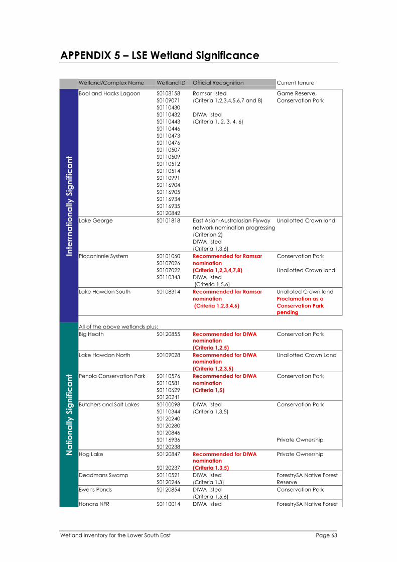
APPENDIX 5 – LSE Wetland Significance In
terr
na
tio
na
lly
Sig
nific
an
t
Wetland/Complex Name
Lake George
Piccaninnie System
Lake Hawdon South
All of the above wetlands plus:
Big Heath S0120855
Lake Hawdon North S0109028
Penola Conservation Park S0110576
Butchers and Salt Lakes S0100098
Hog Lake S0120847
Deadmans Swamp S0110521
Ewens Ponds S0120854
Na
tio
na
lly
Sig
nific
an
t
Honans NFR S0110014
Bool and Hacks Lagoon S0108158 Ramsar listed Game Reserve,
S0109071 (Criteria 1,2,3,4,5,6,7 and 8) Conservation Park
S0110430
S0110432 DIWA listed
S0110443 (Criteria 1, 2, 3, 4, 6)
S0110446
S0110473
S0110476
S0110507
S0110509
S0110512
S0110514
S0110991
S0116904
S0116905
S0116934
S0116935
S0120842
Wetland ID Official Recognition Current tenure
S0101818 East Asian-Australasian Flyway Unallotted Crown land
network nomination progressing
(Criterion 2)
DIWA listed
(Criteria 1,3,6)
S0101060 Recommended for Ramsar Conservation Park
S0107026 nomination
S0107022 (Criteria 1,2,3,4,7,8) Unallotted Crown land
S0110343 DIWA listed
(Criteria 1,5,6)
S0108314 Recommended for Ramsar Unalloted Crown land
nomination Proclamation as a
(Criteria 1,2,3,4,6) Conservation Park
pending
Recommended for DIWA
nomination
Conservation Park
(Criteria 1,2,5)
Recommended for DIWA
nomination
Unallotted Crown Land
(Criteria 1,2,3,5)
Recommended for DIWA Conservation Park
S0110581 nomination
S0110629 (Criteria 1,5)
S0120241
DIWA listed Conservation Park
S0110344 (Criteria 1,3,5)
S0120240
S0120280
S0120846
S0116936 Private Ownership
S0120238
Recommended for DIWA
nomination
Private Ownership
S0120237 (Criteria 1,3,5)
DIWA listed ForestrySA Native Forest
S0120246 (Criteria 1,3) Reserve
DIWA listed Conservation Park
(Criteria 1,5,6)
DIWA listed ForestrySA Native Forest
Wetland Inventory for the Lower South East Page 63

Wetland Inventory for the Lower South East Page 64
Wetland/Complex Name Wetland ID Official Recognition Current tenure
S0110538 (Criteria 1,5) Reserve
S0110561
S0110562
S0110564
S0110565
S0110566
S0110567
S0110724
S0110726
S0110729
S0110732
S0110733
S0110734
S0110735
S0110739
S0110742
S0110743
S0110744
S0110746
S0110749
S0110750
S0110752
S0110755
S0110756
S0110757
S0110758
S0110760
S0110761
S0110763
S0110764
S0110765
S0110766
S0110767
S0110769
S0110771
S0110772
S0110773
S0110774
S0110775
S0110776
S0110787
S0110788
S0110789
S0110790
S0110791
S0110794
S0110795
S0110796
S0110797
S0110802
S0110803
S0110808
S0110809
S0110810
S0110811
S0110812
S0110813
S0110814
S0110815
S0110816
S0110817
S0110818
S0110820
Na
tio
na
lly
Sig
nific
an
t
S0110825

Wetland/Complex Name Wetland ID Official Recognition
S0110826
S0110827
S0110828
S0110829
S0110871
S0110963
S0120212
The Marshes NFR
Lake Frome and Mullins
Swamp
S0107240
S0120800
S0105592 DIWA l
S0105943
DIWA listed
isted
(Criteria 1,2,3)
ForestrySA Native Forest
Reserve
Current tenure
Private Ownership
Conservation Park
Na
tio
na
lly
Sig
nific
an
t
S0107267
S0107273
S0107281
S0107299
S0107304
S0107367
S0107373
S0107493
S0107493
S0107498
S0110265
S0110503
S0110504
S0110505
S0110506
S0110522
S0110523
S0110524
S0110525
S0110526
S0110527
S0110528
S0110529
S0110530
S0110531
S0110532
S0110541
S0110542
S0110543
S0110544
S0110545
S0110546
S0110547
S0110548
S0110549
S0110550
S0110578
S0110579
S0110580
S0110582
S0110583
S0110588
S0110589
S0110590
S0110591
S0110592
S0110593
S0110594
S0110595
S0110596
S0110597
(Criteria 1,3,5)
Wetland Inventory for the Lower South East Page 65

land/Compl l Official
S0110598
S0110602
S0110603
S0110604
S0110605
S0110606
S0110607
S0110608
S0110609
S0110610
S0110611
S0110612
S0110613
S0110614
S0110615
S0110616
S0110617
S0110619
S0110621
S0120224
S0120245
S0120247
S0120449
S0120451
S0120864
l S0108357 DI l
S0110534
S0108474
S0110563
S0109691 IWA
nomination
i
S0106227 i
Na
tio
na
lly
Sig
nific
an
t
l
S0110634
I S0120244
S0110661
S0101778
S0105778
S0120251
S0110373
S0110632
S0106799
S0110539
S0110500
S0108264
S0110703
S0108290
S0110599
S0110648
S0110677
LI S0108280
S0110639
S0108304
S0110377
S0106317
S0110371
S0106778
S0109690
S0110998
S0110659
S0110554
S0110667
Sta
te S
ign
ific
an
t
I
Wet ex Name Wet and ID Recognition Current tenure
South East Coasta Salt Lakes WA isted Game Reserve
(Criteria 1,3,6)
Unallotted Crown Land
Recommended for D Conservat on Park
(Criter a 1,3,6)
All of the above wet ands plus:
MT LYON LF
BIG D P LAKE
HACKET HILL NFR
POOL OF SILOAM
OLD WOOLWASH
OLD WOOLWASH
MT LYON LF
OLD WOOLWASH
GHOST LAKE
WHENNAN NFR
FRESH DIP LAKE
GRUNDY LANE NFR
MT MCINTYRE NFR
HACKET HILL NFR
HACKET HILL NFR
TTLE DIP LAKE
HACKET HILL NFR
OLD WOOLWASH
LONGS NFR
OLD WOOLWASH
OLD WOOLWASH
SEA LAKE
GRUNDY LANE NFR
HACKET HILL NFR
HACKET HILL NFR
HACKET HILL NFR
WAND LLO / THREE CHAIN RD S0110920
Page 66 Wetland Inventory for the Lower South East

land/Compl l Official
S0121483
S0109688
S0110913
S0107060
S0110912
PERCH HOLE S0109973
S0110499
S0110717
I S0110680
S0110718
S0107045
S0108578
S0113806
PI S0110343
S0105797
S0110497
DI S0110759
S0110533
I
S0120859
S0107079
S0106808
I
S0116933
S0107062
S0116890
S0113840
S0120851
S0110945
S0107056
S0108757
S0116900
I S0101999
S0110997
S0107052
S0115665
S0110601
S0110947
S0108952
INE CR S0108479
S0110944
S0120253
S0110600
S0114971
S0106954
S0107313
S0110108
S0120659
S0106202
S0110737
S0120856
S0108130
S0110394
I S0121485
CRESS CREEK SPRI S0114982
S0110901
S0114945
S0114763
S0110740
S0114989
HI I S0117807
Sta
te S
ign
ific
an
t
S0109485
Wet ex Name Wet and ID Recognition Current tenure
LAKE BONNEY S.E.
BOUCHIES LAKE
GRUNDY LANE NFR
BUCKS LAKE
GRUNDY LANE NFR
WHENNAN NFR
GRUNDY LANE NFR
WAND LO NFR
GRUNDY LANE NFR
BLACKFELLOWS CAVE
WETLAND
CK SWAMP
TOPPERWEIN NFR
LAKE FELLMONGERY
AGONAL ROAD
GORDON LAGOON
MARY SEYMOUR
CONSERVAT ON PARK
BLACKFELLOWS CAVE
WETLAND
TELFORD SCRUB CP
MARY SEYMOUR
CONSERVAT ON PARK
HORSESHOE PADDOCK
CLAYPANS
MCINNES WETLAND
KATAN PARK WETLAND
HORSESHOE PADDOCK
NANGWARRY NFR
TRIAL WATERHOLE
CLAYPANS
WOAKW
THE EVERGLADES
GLENELG RIVER
MT MCINTYRE NFR
BLUE LAKE
SHEEPWASH SWAMP
BURKS ISLAND - WEST
KANGAROO FLAT
REEDY CREEK LF
LAKE NUNAN
LONGS NFR
SLAND SWAMP LF
NG
CLAYPANS EAST
PENOLA FOREST
KANGAROO FLAT
JERUSALEM CREEK SPRING
LLV EW
MONBULLA
Wetland Inventory for the Lower South East Page 67

land/Compl l Official
MCROSTI S0113560
S0110702
S0107937
S0110291
S0107058
S0110664
S0110925
S0110731
S0115817
S0110635
S0110848
DI S0120841
S0108154
S0120858
S0110630
S0110672
S0108849
S0110627
S0110656
S0110903
S0108171
S0120486
I S0109883
S0110919
I S0110679
S0110536
S0108211
S0121513
S0110272
I S0110251
S0120643
S0107894
S0110857
HI I S0117816
S0110647
S0110655
S0110905
S0107805
S0120824
S0110668
S0110626
S0110631
S0114903
I
S0108866
DI S0120605
S0121514
S0107043
S0110670
S0110878
I S0110682
S0110704
S0110654
S0110676
I S0110243
S0107822
S0110666
Sta
te S
ign
ific
an
t
l
S0110923
S0107479
S0114963
S0110719
Wet ex Name Wet and ID Recognition Current tenure
ES NFR
KANGAROO FLAT
LAKE BATTYE
WHENNAN NFR
HACKET HILL NFR
OSCHAR SWAMP
KANGAROO FLAT
LOWAN LANE LF
MT LYON LF
KANGAROO FLAT
SMAL SWAMP
LAKE FOX
TOPPERWEIN NFR
MT LYON LF
HACKET HILL NFR
MT LYON LF
HACKET HILL NFR
LONGS NFR
THE PUB LAKE
HACKET HILL NFR
KAR NYA
WOOLWASH C
WAND LO NFR
LAKE AMY
RULE SWAMP
Spencers Pond
WHENNAN NFR
WAND LO NFR
COMAUM FOREST
GOOSE NECK SWAMP
LLV EW
HACKET HILL NFR
HACKET HILL NFR
LONGS NFR
PLEASANT PARK
KANGAROO FLAT
HACKET HILL NFR
MT LYON LF
MT LYON LF
WAND LLO / THREE CHAIN RD S0110922
AGONAL ROAD
Bones Pond
HACKET HILL NFR
KANGAROO FLAT
WAND LO NFR
GRUNDYS WOODLANDS
HACKET HILL NFR
HACKET HILL NFR
WAND LO NFR
HACKETS HILL WOODLAND
HACKET HILL NFR
All of the above wet ands
plus:
SEWCDB SWAMP
THE MARSHES
NENE VALLEY
GRUNDY LANE NFR
Page 68 Wetland Inventory for the Lower South East
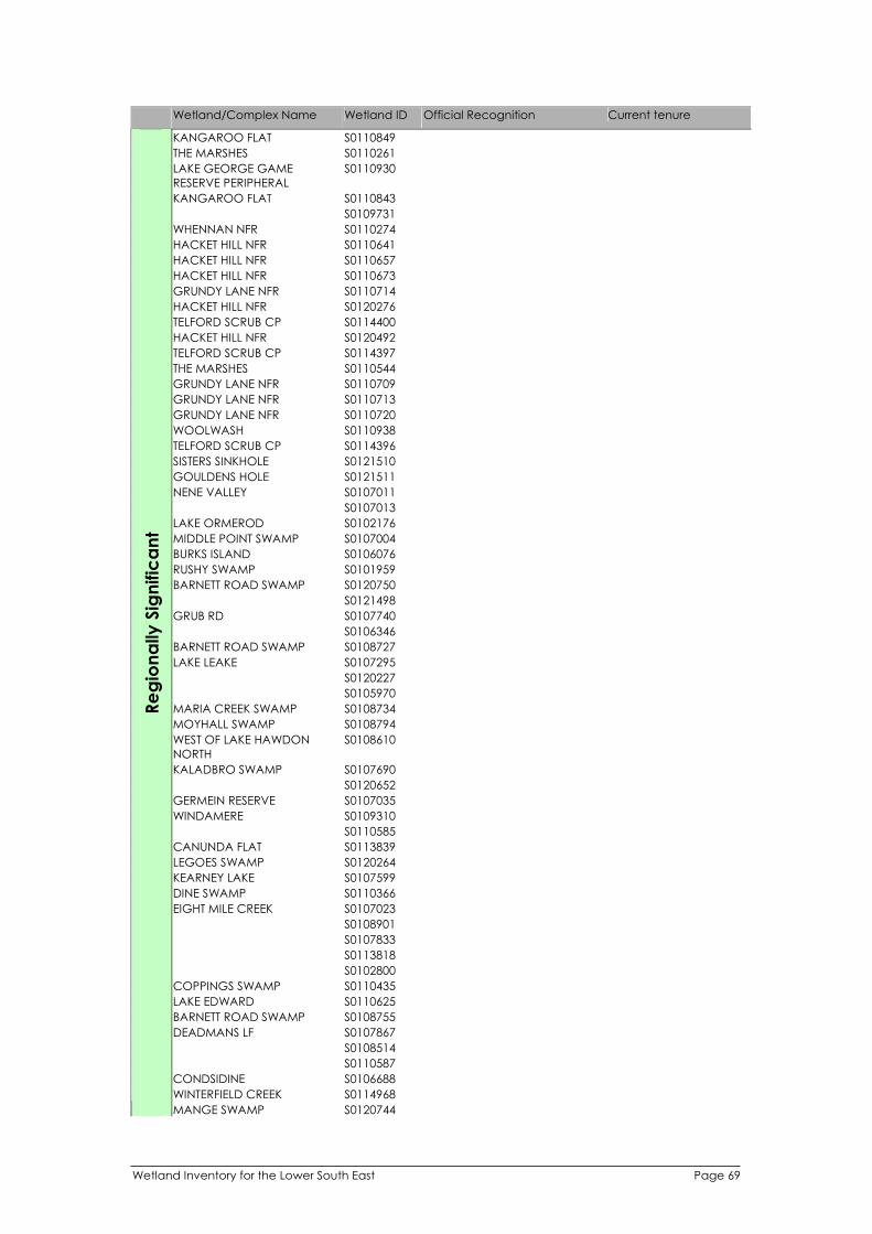
land/Compl l Official
S0110849
S0110261
S0110930
S0110843
S0109731
S0110274
S0110641
S0110657
S0110673
S0110714
S0120276
S0114400
S0120492
S0114397
S0110544
S0110709
S0110713
S0110720
S0110938
S0114396
S0121510
S0121511
S0107011
S0107013
S0102176
I S0107004
S0106076
S0101959
S0120750
S0121498
S0107740
S0106346
S0108727
S0107295
S0120227
S0105970
I S0108734
S0108794
S0108610
S0107690
S0120652
S0107035
WI S0109310
S0110585
S0113839
S0120264
S0107599
DI S0110366
S0107023
S0108901
S0107833
S0113818
S0102800
COPPI S0110435
S0110625
S0108755
S0107867
S0108514
S0110587
I S0106688
WI I S0114968
Re
gio
na
lly
Sig
nific
an
t
S0120744
Wet ex Name Wet and ID Recognition Current tenure
KANGAROO FLAT
THE MARSHES
LAKE GEORGE GAME
RESERVE PERIPHERAL
KANGAROO FLAT
WHENNAN NFR
HACKET HILL NFR
HACKET HILL NFR
HACKET HILL NFR
GRUNDY LANE NFR
HACKET HILL NFR
TELFORD SCRUB CP
HACKET HILL NFR
TELFORD SCRUB CP
THE MARSHES
GRUNDY LANE NFR
GRUNDY LANE NFR
GRUNDY LANE NFR
WOOLWASH
TELFORD SCRUB CP
SISTERS SINKHOLE
GOULDENS HOLE
NENE VALLEY
LAKE ORMEROD
MIDDLE PO NT SWAMP
BURKS ISLAND
RUSHY SWAMP
BARNETT ROAD SWAMP
GRUB RD
BARNETT ROAD SWAMP
LAKE LEAKE
MAR A CREEK SWAMP
MOYHALL SWAMP
WEST OF LAKE HAWDON
NORTH
KALADBRO SWAMP
GERMEIN RESERVE
NDAMERE
CANUNDA FLAT
LEGOES SWAMP
KEARNEY LAKE
NE SWAMP
EIGHT MILE CREEK
NGS SWAMP
LAKE EDWARD
BARNETT ROAD SWAMP
DEADMANS LF
CONDSID NE
NTERF ELD CREEK
MANGE SWAMP
Wetland Inventory for the Lower South East Page 69

land/Compl l Official
S0114813
S0110028
S0107949
S0114954
S0107291
S0108779
S0110074
I S0110586
S0109696
S0110584
S0110540
S0108737
S0108213
S0101642
S0108805
MOCORCO S0105547
S0107036
S0107959
S0109874
S0106925
I S0115657
LI S0107021
S0110203
S0120806
S0106551
S0102605
S0110556
S0107552
S0108263
S0109818
S0106951
S0108998
S0110674
S0114975
S0120805
S0110859
S0106897
I S0120321
DI S0110660
S0110227
S0110628
S0115825
I I S0106486
S0108550
TI S0105847
S0110571
I S0107625
WI S0108476
PERI
S0108347
S0108342
S0120655
I S0110225
S0112301
DI S0110653
I S0113849
TI S0112558
S0110904
S0110858
S0110646
S0116934
S0110748
S0109472
Re
gio
na
lly
Sig
nific
an
t
S0110476
Wet ex Name Wet and ID Recognition Current tenure
PENOLA FOREST
LAKE LEAKE
WH TES FLAT
DEADMAN SWAMP
BACHMANN
ARCOONA
ST. HELENA SWAMP
LAKE ST CLAIR
BENARA CREEK
NVERLOCH
ONS PARK
CAT SWAMP
REEDY LAGOON
WATERHOUSE
LYNWOOD
ALLAMBI
NE LAKE ST CLAIR
VALLEY LAKE
LYNWOOD
TEA TREE GULLY
PENOLA ROAD LF
MUNDI-SELK RK WETLAND
SMAL SWAMP
MT LYON LF
MT LYON PERCHED SWAMP
NANGWARRY MILL
RAM LL ES
LLAR SWAMP
MAGP E SWAMP
RRINGULLA
LAKE ROBE GAME RESERVE
PHERAL
GREEN SWAMP
WAND LO NFR
AUSPINE - CHEVRON DOWNS
SMAL SWAMP
LAKE MC NTYRE
MOTHY SWAMP
LONGS C
HACKET HILL NFR
KANGAROO FLAT
MAE-BURNE
Page 70 Wetland Inventory for the Lower South East

land/Compl l Official
I S0105784
S0108056
DI S0110689
GREENVI S0109353
S0110637
S0109951
S0110560
S0121478
S0113997
S0110906
I S0109727
S0106938
S0108396
DI S0110694
S0108870
I S0107446
S0120479
S0102537
S0107298
S0107063
S0115792
I S0115039
S0110926
S0107711
WI S0115886
S0110558
I S0120457
S0101696
GREENVI S0109433
S0110793
STI I S0107946
S0106829
S0110662
DI S0110855
IE S0112471
S0108258
S0110671
I S0112232
S0110721
S0106491
S0106362
S0114765
S0110568
I S0105716
S0108043
S0110651
S0110943
KOOMA S0113326
I S0106506
S0101785
S0108215
S0110650
S0110705
S0116248
S0119834
S0120721
WI S0121512
S0121515
S0110669
PERI
S0108422
S0107504
Re
gio
na
lly
Sig
nific
an
t
S0110208
Wet ex Name Wet and ID Recognition Current tenure
GALP N SWAMP
SMAL SWAMP
EW
PALTRIDGE SWAMPS
ALLAMBI
GRANTS SWAMP
MT LYON LF
PENOLA ROAD LF
LONGS D
TREV NCE
SMAL SWAMP
ABERDARE
SLAND SWAMP LF
MAAOUPE
HEMMINGS LF
PENOLA FOREST
LACHEN STAT ON
WOOLAWAY
PALTRIDGE SWAMPS
LDERNESS LF
GRANTS SWAMP
WAND LLO
MACKERETH
EW
HONAN NFR
RL NG
OLD WASHPOOL SWAMP
HACKET HILL NFR
SMAL SWAMP
COOLOOL
SAMS FOREST RESERVE
HACKET HILL NFR
AUSP NE - NANGWARRY
NORTH
GRUNDY LANE NFR
MIDLAND PARK
YEATES LF
PENOLA FOREST
HACKET HILL NFR
TAR NGA
LAKE CHARRA
HACKET HILL NFR
MACKERETH HOUSE SWAMP
NVERLOCH
BEACHPORT
RULE SWAMP
HACKET HILL NFR
WOOLWASH
BOONDEROO
LKES POND
Dead Pond
HACKET HILL NFR
LAKE ROBE GAME RESERVE
PHERAL
THE MARSHES
HACKET HILL NFR
Wetland Inventory for the Lower South East Page 71

land/Compl l Official
S0102667
S0109546
LI S0107066
S0110640
S0110642
S0110643
S0113679
S0114317
S0110943
KOOMA S0113326
I S0106506
S0101785
S0108215
S0110705
S0116248
S0119834
S0120721
WI S0121512
S0121515
S0110669
PERI
S0108422
S0107504
S0110208
S0102667
S0109546
LI S0107066
S0110640
S0110642
S0110643
S0113679
S0114317
Re
gio
na
lly
Sig
nific
an
t
Wet ex Name Wet and ID Recognition Current tenure
NETHERLEY
TTLE BLUE LAKE
HACKET HILL NFR
HACKET HILL NFR
HACKET HILL NFR
GLENCOE
MT GAMBIER FOREST
MACKERETH HOUSE SWAMP
NVERLOCH
BEACHPORT
RULE SWAMP
WOOLWASH
BOONDEROO
LKES POND
Dead Pond
HACKET HILL NFR
LAKE ROBE GAME RESERVE
PHERAL
THE MARSHES
HACKET HILL NFR
NETHERLEY
TTLE BLUE LAKE
HACKET HILL NFR
HACKET HILL NFR
HACKET HILL NFR
GLENCOE
MT GAMBIER FOREST
Page 72 Wetland Inventory for the Lower South East

APPENDIX 6 – LSE Wetlands of Priority for Field Survey
l NameWet and ID
S0102054
S0105395 COTTAGE GARDEN SWAMP
S0105437 COTTAGE GARDEN SWAMP
S0105471 COTTAGE GARDEN SWAMP
S0105507 COTTAGE GARDEN SWAMP
S0105671 GUM FLAT SWAMP
S0105681
S0105700 ECHO VALLEY
S0105749 TOPPERWEIN NFR
S0105755 COLE SWAMP
S0105764 PENOLA FOREST
S0105765 NANGWARRY STATION
S0105780 ISLAND SWAMP LF
S0105782 ECHO VALLEY
S0105784 GALPIN SWAMP
S0105785 CARUNGWINNA SWAMP
S0105786 ISLAND SWAMP LF
S0105791 TOPPERWEIN NFR
S0105842 NANGKITA
S0105904 NANGKITA
S0105937 WATTLE PARK
S0106145 JULIA HILL
S0106170 INVERLOCH
S0106362 YEATES LF
S0106599 AUSPINE - NANGWARRY NORTH
S0106836
S0106846 BORDERLEA
S0107275 RUSTS
S0107335 RIGBY DOWNS
S0107338 PLEASANT PARK
S0107376 ARALUEN
S0107394 TEA TREE GULLY
S0107446 ISLAND SWAMP LF
S0107499 LANDS LF
S0107608 PLEASANT PARK
S0107775 PLEASANT PARK
S0108185 INVERGLEN
S0108261 BALMACARRA
S0108262 WIRREEBILLA
S0108263 ALLAMBI
S0108271 ALLAMBI
S0108276 ALLAMBI
S0108285 ALLAMBI
S0108288 ALLAMBI
S0108322 WIRREEBILLA
S0108539
S0108726
S0108737
S0109485 MONBULLA
S0109731
Wetland ID Name
S0109799 COLES
S0109825 PUD LAKE
S0109873 LAKE ELIZA PERIPHERAL WETLANDS
S0109947 ALLAMBI
S0109951 ALLAMBI
S0109978 ALLAMBI
S0109996 ERRINGTON HOLE LAKE
S0110011 DOLLY LAKE
S0110024 NEW-FIELDS
S0110025
S0110056 KARINYA
S0110559 LAKE ELIZA PERIPHERAL WETLANDS
S0110570
S0110572
S0110573
S0110574
S0110725 LANDS LF
S0110867
S0110935 ISLAND SWAMP LF
S0112086 COTTAGE GARDEN SWAMP
S0112087 COTTAGE GARDEN SWAMP
S0112088 COTTAGE GARDEN SWAMP
S0112089 COTTAGE GARDEN SWAMP
S0112090 COTTAGE GARDEN SWAMP
S0112197 NANGWARRY NFR
S0112198 NANGWARRY NFR
S0112199 NANGWARRY NFR
S0112201 NANGWARRY NFR
S0112202 AUSPINE - NANGWARRY NORTH
S0112204 AUSPINE - NANGWARRY NORTH
S0112214 AUSPINE - NANGWARRY NORTH
AUSPINE - PENOLA SOUTH_NATIVE
S0112404 VEG
AUSPINE - PENOLA SOUTH_NATIVE
S0112405 VEG
S0113560 MCROSTIES NFR
S0113718 3 GATES TRACK LF
S0113997 PENOLA ROAD LF
S0114062
S0114195 DISMAL DOWNS
S0114196 HACKET HILL NFR
S0114427 PLEASANT PARK
S0114483 THE HEATH NFR
S0114484 THE HEATH NFR
S0114485 THE HEATH NFR
S0114750 YANGERY LF
S0114752 ISLAND SWAMP LF
S0114763 PENOLA FOREST
S0114800 NANGWARRY STATION
S0114900
S0114942
Wetland Inventory for the Lower South East Page 73

Wetland ID Name
S0114960
S0114963 NENE VALLEY
S0114992 PENOLA FOREST
S0114994 PENOLA FOREST
S0115031 LACHEN STATION
S0115177 GLENCOE FOREST
S0115198 SKAMIR
S0115209 KEDRON
S0115392 MONTANA
S0115482 SUNNYMEADE
S0115483 SUNNYMEADE
S0115487 THE MARSHES
S0115490 THE MARSHES
S0115500 TARQUA RD FOREST
S0115665 NANGWARRY NFR
S0115669 NANGWARRY NFR
S0115672 NANGWARRY NFR
S0115673 NANGWARRY NFR
S0115674 NANGWARRY NFR
S0115677 NANGWARRY NFR
S0115766 HACKET HILL NFR
S0115779 PENOLA FOREST
S0115786 PENOLA FOREST
S0115787 PENOLA FOREST
S0115794 PENOLA FOREST
S0115801 LOWAN LANE LF
S0115817 LOWAN LANE LF
S0115822 LOWAN LANE LF
S0115824 YEATES LF
S0115833 YEATES LF
S0115972 STILL WATERS
S0116662 BORDER EDGE
S0116834
S0119385 WEST AVENUE
S0119386 WEST AVENUE
S0119387 WEST AVENUE
S0119456 SCOTGLADE
S0119900 ROUND WATERHOLE NFR
S0120316
S0120339 OVERLAND NFR
S0120440 OVERLAND NFR
S0120648 KARINYA
S0120659
S0120805 TEA TREE GULLY
Page 74 Wetland Inventory for the Lower South East

APPENDIX 7 – LSEWI Field Data Sheets
Data sheets completed for each wetland survey site
Wetland Inventory for the Lower South East Page 75

Page 76 Wetland Inventory for the Lower South East

Wetland Inventory for the Lower South East Page 77

APPENDIX 8 – Instructions for LSEWI Field Data Sheets
General field instructions
l l li
i i
l l
l i fiel
i
l i l
Data collected from the fie d survey of wet ands for this inventory is base ne data and is not
required to be overly comprehensive or t me consuming to collect. Try to keep actual t me
spent surveying a particular wet and (or sector) under 1.5 hours if possib e.
Use ead pencil or other water resistant nk when filling out d survey sheets and
annotat ng field maps.
Staple all sheets re at ng to each wet and together and store in a safe dry place.
Wetland data collection
Location Reference Data
Wetland ID
Habitat
Mapping
Compiler
details
Organisation
Location
description
GPS Position
Landholder
Aggregation
Wetlands
Date/Time
SurveyNo
Biol Survey No
Wetland Name
Photo no.s
The date of data collection should be stated (day/month/year) including the time of field survey to the nearest half hour.
A code specific to the wetland being surveyed must identify each wetland. Wetlands are to be numbered using State-wide numbering protocols (see report).
Where an individual wetland is very large or has differing character, conditions and management, it may be appropriate to assess individual sectors of wetlands separately (ie, different surveys). In this instance surveys of the wetland should be numbered sequentially (sector 1, 2, 3 etc.). Note that a separate survey form should be completed for each survey. Leave Survey no. box blank if the wetland is not assessed in sectors.
Indicate if habitat mapping of the wetland was performed as part of the wetland inventory survey, including the number of additional habitat assessment sheets that were completed. All sheets for an individual wetland should be stapled together following completion.
State the name/s of person/s undertaking data collection.
State the organisation that is managing the data collection.
Record the Biological Survey Number assigned to the survey (DEH, Biological Survey Team), if applicable.
Provide a general description of the location of the wetland using landscape features or closest roads.
The name of the wetland should be stated. Where multiple names exist use them all. Where no name for the wetland exits, use descriptive qualifiers, landmarks, or ask the landowner to provide a name.
(WGS 84). Geographic location of wetlands should be recorded using GPS (WGS 84, Zone 54 projection). In such a system, the coordinates would be expressed as metres of Eastings and Northings. All boxes provided should contain a number if recorded correctly. GPS locations of wetlands should reflect the approximate centre of the wetland. If the wetland is assessed in sectors, the GPS location should reflect the approximate centre of the sector area being assessed. Maps provided will indicate an AMG position for each wetland. This location data can be used on the data sheet if considered accurate enough.
Digital photographs are to be taken where possible of wetlands surveyed. Record number/s of photo/s on data sheet to identify wetlands when downloading. Rename downloaded photos using respective Wetland ID numbers and survey numbers where appropriate.
Record landholder information. This is for reference purposes only and is regarded as confidential. Landholder details will no be entered into databases.
Indicate other wetlands (using respective wetland ID’s) that are directly hydrologically related to the wetland being surveyed. Indicate the general hydrological connection of each aggregation wetland identified: Up - Upstream of the wetland being surveyed Down – Downstream of the wetland being surveyed Ann – Wetland is on a stream anabranch which relates to the wetland being surveyed.
Page 78 Wetland Inventory for the Lower South East
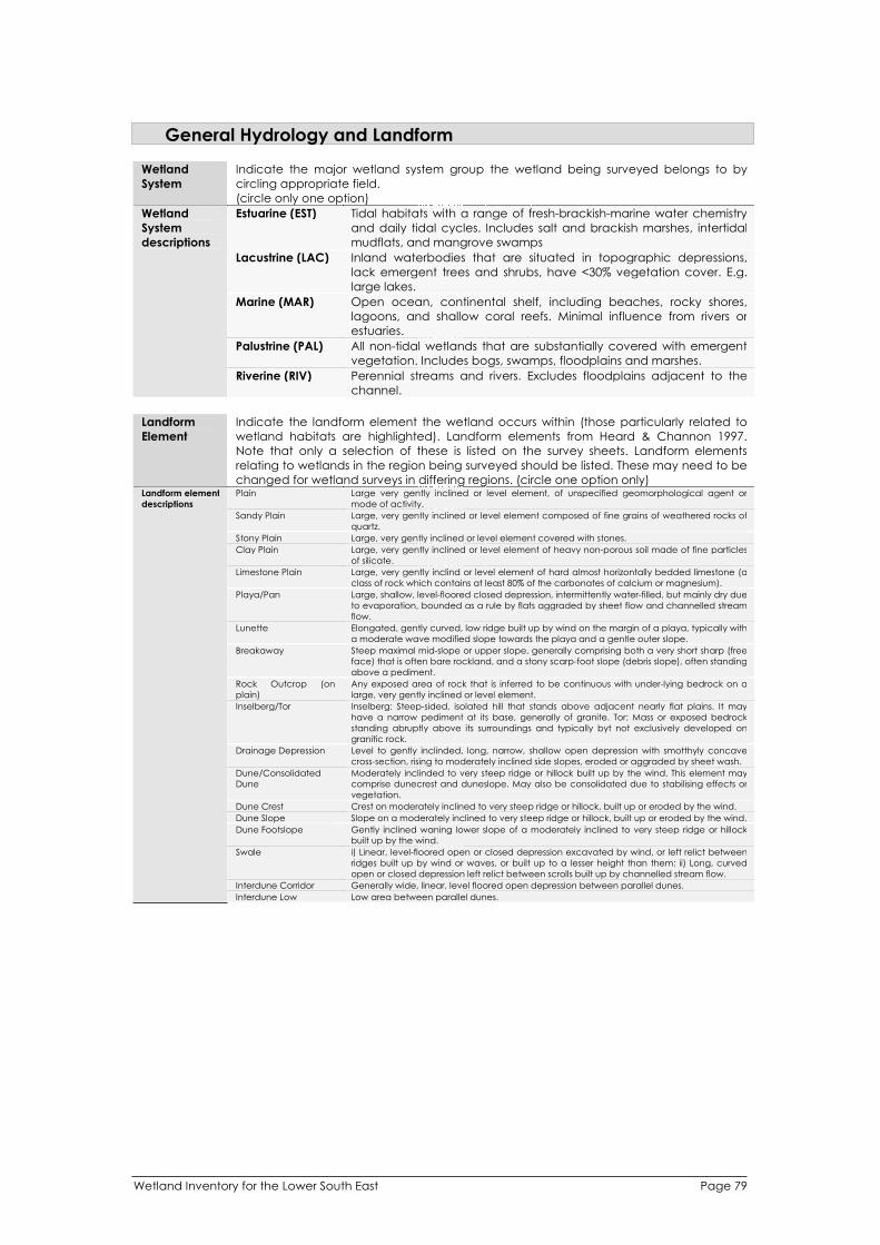
Wetland Inventory for the Lower South East Page 79
General Hydrology and Landform
Wetland
System
Indicate the major wetland system group the wetland being surveyed belongs to by
circling appropriate field.
(circle only one option)
Estuarine (EST) Tidal habitats with a range of fresh-brackish-marine water chemistry
and daily tidal cycles. Includes salt and brackish marshes, intertidal
mudflats, and mangrove swamps
Lacustrine (LAC) Inland waterbodies that are situated in topographic depressions,
lack emergent trees and shrubs, have <30% vegetation cover. E.g.
large lakes.
Marine (MAR) Open ocean, continental shelf, including beaches, rocky shores,
lagoons, and shallow coral reefs. Minimal influence from rivers or
estuaries.
Palustrine (PAL) All non-tidal wetlands that are substantially covered with emergent
vegetation. Includes bogs, swamps, floodplains and marshes.
Wetland
System
descriptions
Riverine (RIV) Perennial streams and rivers. Excludes floodplains adjacent to the
channel.
Landform
Element
Indicate the landform element the wetland occurs within (those particularly related to
wetland habitats are highlighted). Landform elements from Heard & Channon 1997.
Note that only a selection of these is listed on the survey sheets. Landform elements
relating to wetlands in the region being surveyed should be listed. These may need to be
changed for wetland surveys in differing regions. (circle one option only) Plain Large very gently inclined or level element, of unspecified geomorphological agent or
mode of activity.
Sandy Plain Large, very gently inclined or level element composed of fine grains of weathered rocks of
quartz.
Stony Plain Large, very gently inclined or level element covered with stones.
Clay Plain Large, very gently inclined or level element of heavy non-porous soil made of fine particles
of silicate.
Limestone Plain Large, very gently inclind or level element of hard almost horizontally bedded limestone (a
class of rock which contains at least 80% of the carbonates of calcium or magnesium).
Playa/Pan Large, shallow, level-floored closed depression, intermittently water-filled, but mainly dry due
to evaporation, bounded as a rule by flats aggraded by sheet flow and channelled stream
flow.
Lunette Elongated, gently curved, low ridge built up by wind on the margin of a playa, typically with
a moderate wave modified slope towards the playa and a gentle outer slope.
Breakaway Steep maximal mid-slope or upper slope, generally comprising both a very short sharp (free
face) that is often bare rockland, and a stony scarp-foot slope (debris slope), often standing
above a pediment.
Rock Outcrop (on
plain)
Any exposed area of rock that is inferred to be continuous with under-lying bedrock on a
large, very gently inclined or level element.
Inselberg/Tor Inselberg: Steep-sided, isolated hill that stands above adjacent nearly flat plains. It may
have a narrow pediment at its base, generally of granite. Tor: Mass or exposed bedrock
standing abruptly above its surroundings and typically byt not exclusively developed on
granitic rock.
Drainage Depression Level to gently inclinded, long, narrow, shallow open depression with smotthyly concave
cross-section, rising to moderately inclined side slopes, eroded or aggraded by sheet wash.
Dune/Consolidated
Dune
Moderately inclinded to very steep ridge or hillock built up by the wind. This element may
comprise dunecrest and duneslope. May also be consolidated due to stabilising effects or
vegetation.
Dune Crest Crest on moderately inclined to very steep ridge or hillock, built up or eroded by the wind.
Dune Slope Slope on a moderately inclined to very steep ridge or hillock, built up or eroded by the wind.
Dune Footslope Gently inclined waning lower slope of a moderately inclined to very steep ridge or hillock
built up by the wind.
Swale i) Linear, level-floored open or closed depression excavated by wind, or left relict between
ridges built up by wind or waves, or built up to a lesser height than them: ii) Long, curved
open or closed depression left relict between scrolls built up by channelled stream flow.
Interdune Corridor Generally wide, linear, level floored open depression between parallel dunes.
Landform element
descriptions
Interdune Low Low area between parallel dunes.

Wetland Inventory for the Lower South East Page 80
Hill Crest Very gently inclined to steep crest, smoothly convex, eroded mainly by creep and sheet
wash. A typical element of mountains, hills, low hills and rises.
Hill Slope Gently inclined to precipitous slope, commonly simple and maximal, eroded by sheet wash,
creep, or water-aided mass movement. A typical element of mountains, hills, low hills and
rises.
Hill Footslope Moderately to very gently inclined waning lower slope of a hill resulting from aggradation of
erosion by sheet flow, earth flow or creep.
Talus Moderately inclined or steep waning lower slope, consisting of rock fragments aggraded by
gravity.
Alcove Moderately incline to very steep, short open depression with concave cross-section, eroded
by collapse, landslides, creep or surface wash.
Ridge Compound landform element comprising a narrow crest and short adjoining slopes, the
crest length being greater than the width of the landform element.
Gully Open depression with short, precipitous walls and moderatley inclined to very gently
inclined floor or small stream channel, eroded by channelled stream flow and consequent
collaps and water-aided mass movement.
Playa/Pan Large, shallow, level-floored closed depression, intermittently water-filled, but mainly dry due
to evaporation, bounded as a rule by flats aggraded by sheet flow and channelled stream
flow.
Lunette Elongated, gently curved, low ridge built up by wind on the margin of a playa, typically with
a moderate wave modified slope towards the playa and a gentle outer slope.
Breakaway Steep maximal mid-slope or upper slope, generally comprising both a very short sharp (free
face) that is often bare rockland, and a stony scarp-foot slope (debris slope), often standing
above a pediment.
Rock Outcrop (on
plain)
Any exposed area of rock that is inferred to be continuous with under-lying bedrock on a
large, very gently inclined or level element.
Inselberg/Tor Inselberg: Steep-sided, isolated hill that stands above adjacent nearly flat plains. It may
have a narrow pediment at its base, generally of granite. Tor: Mass or exposed bedrock
standing abruptly above its surroundings and typically byt not exclusively developed on
granitic rock.
Drainage Depression Level to gently inclined, long, narrow, shallow open depression with smoothly concave
cross-section, rising to moderately inclined side slopes, eroded or aggraded by sheet wash.
Dune/Consolidated
Dune
Moderately inclined to very steep ridge or hillock built up by the wind. This element may
comprise dunecrest and duneslope. May also be consolidated due to stabilising effects or
vegetation.
Gorge A narrow passage, with precipitous, rocky sides, enclosed among mountains.
Cliff Very wide cliffed (>72 degrees) maximal slope usually eroded by gravitational fall as a result
of erosion of the base by various agents: sometimes built up by marine organisms.
Cliff Footslope Slope situated below a cliff, with its contours generally parallel to the line of the cliff, eroded
by sheet wash or water-aided mass movement, and aggraded locally by collapsed
material from above.
Scarp Very wide steep to precipitous maximal slope eroded by gravity, water-aided mass
movement or sheet flow.
Scarp Foothill Waning or minimal slope situated below a scarp, with its contours generally parallel tot eh
line of the scarp.
Pediment Large gently inclined to level (less than 1%) waning lower slope, with slope lines inclined in a
single direction, or somewhat convergent or divergent, eroded or sometimes slightly
aggraded by sheet flow. It is underlain by bedrock.
Rock Outcrop (on hill) An exposed area of rock that is inferred to be continuous with underlying bedrock and is on
either a mountain, hill, low hill or rise/
Stream Channel Linear, generally sinuous open depression, in parts eroded, excavated, built up and
aggraded by channelled stream flow. This element comprises stream bed and banks.
Stream Bed Linear, generally sinuous open depression forming the bottom of a stream channel eroded
and locally excavated, aggraded or built up by channelled stream flow.
Stream Bank Very short, very wide slope, moderately inclined to precipitous, forming the marginal upper
parts of a stream channel and resulting from erosion or aggradation by channelled stream
flow.
Stream Bar Elongated, gently to moderately inclined low ridge built up by channelled steam flow: part
of a stream bed.
Levee Very long, very low, nearly level sinuous ridge immediately adjacent to a stream channel,
built up by over-bank flow. Levees are built, usually in pairs bounding the two sides of a
stream channel, at the level reached by frequent floods. This element is part of a covered
plain landform pattern.
Channel Bench Flat at the margin of a stream channel aggraded and in part eroded by over-bank and
channelled stream flow - an incipient flood plain.
Terrace Flat Small flat aggraded or eroded by channelled or over-bank stream flow, standing above a
scarp and no longer frequently inundated: a former valley flat or part of a former flood
plain.
Terrace Plain Large or very large flat aggraded by channelled or over-bank stream flow, standing above
a scarp and no longer frequently inundated: part of a former flood plain.
Flood Out Flat inclined radially away form a point on the margin or at the end of a stream channel,
aggraded by over-bank stream flow, or by channelled stream flow associated with
channels developed within the over-bank flow: part of a covered plain landform pattern.
Back Plain Large flat resulting from aggradation by over-bank stream flow at some distance from the
stream channel and in some cases biological (peat) accumulation: often characterised by
a high water table and the presence of swamps or lakes: part of a covered plain landform
pattern.
Gorge A narrow passage, with precipitous, rocky sides, enclosed among mountains.
Cliff Very wide cliffed (>72 degrees) maximal slope usually eroded by gravitational fall as a result
of erosion of the base by various agents: sometimes built up by marine organisms.
Cliff Footslope Slope situated below a cliff, with its contours generally parallel to the line of the cliff, eroded
by sheet wash or water-aided mass movement, and aggraded locally by collapsed
material from above.
Scarp Very wide steep to precipitous maximal slope eroded by gravity, water-aided mass
movement or sheet flow.
Scarp Foothill Waning or minimal slope situated below a scarp, with its contours generally parallel tot eh
line of the scarp.
Pediment Large gently inclined to level (less than 1%) waning lower slope, with slope lines inclined in a
single direction, or somewhat convergent or divergent, eroded or sometimes slightly
aggraded by sheet flow. It is underlain by bedrock.
Rock Outcrop (on hill) An exposed area of rock that is inferred to be continuous with underlying bedrock and is on
either a mountain, hill, low hill or rise/

Wetland Inventory for the Lower South East Page 81
Fan-alluvial Large gently inclined to level element with radial slope lines inclined away from a point,
resulting from aggradation, or occasionally from erosion by channelled, often braided
stream flow or possibly by sheet flow.
Oxbow Long, curved, commonly water-filled closed depression eroded by channelled stream flow
but closed as a result of aggradation by channelled or over-bank stream flow, during the
formation of a meander plain landform patter.
Scroll Complex Long, curved very low ridge built up by channelled stream flow and left relict by channel
migration. Part of a meander plain landform pattern.
Estuary Stream channel close to its junction with a sea or lake, where the action of channelled
stream flow is modified by tide and waves. The width typically increases downstream.
Lake Large water-filled closed depression.
Salt Lake Lake which contains a concentration of meral salts (predominantly sodium chloride in
solution as well as magnesium and calcium sulphate)
Swamp Almost level closed, or almos closed depression with a seasonal or permanent water table
at or above the surface, commonly aggraded by over-bank stream flow and sometimes
biological (peat) accumulation.
Perched Swamp A tract of land which is permanently saturated with moisture and is positioned on an
elevated landform.
Terminal Lake Large water-filled closed depression at the end of a drainage area.
Salt Crust Extensive flat surface found in hot deserts consisting of salts that have accumulated in a
shallow saline lake or playa. Evaporation then produces a crust of varying hardness.
Beach Short, low, very wide slope, gently or moderately inclined, built up or eroded by waves,
forming the shore of a lake or sea.
Beach Ridge Very long, nearly straight low ridge, built up by waves and usually modified by wind. A
beach ridge is often a relict feature remote from the beach.
Fore Dune Very long, nearly straight, moderately inclined to very steep ridge built up by the wind from
material from an adjacent beach.
Lagoon Closed depression filled with water that is typically salt or brackish, bounded at least in part
by forms aggraded or built up by waves or reef-building organisms.
Cone Hillock with a circular symmetry built up by volcanism. The crest may form a ring around a
crater.
Crater Steep to precipitous closed depression excavated by explosions due to volcanism, human
action, or impact of an extraterrestrial object.
Maar Level floored, commonly water-filled closed depression with a nearly circular steep rim,
excavated by volcanism.
Ashplain Large, very gently inclined or level element, or the unconsolidated fien grained material
formed as a result of volcanic explosions.
Tumulus Hillock heaved up by volcanism (or, elsewhere, built up by human activity at a burial site).
Open Depression Landform element that extends at the same elevation, or lower, beyond the locality where
it is observed.
Closed Depression Landform element that stands below all points in the adjacent terrain.
Flat Planar landform element that is neither a crest nor a depression and is level or very gently
inclined.
Doline/Sinkhole Steep-sided closed depression eroded by solution directed towards an underground
drainage way, or by collapse consequent on such solution. A typical element of a karst
landform pattern.
Cave A natural cavity, recess, chamer or series of chambers beneath the surface of the earth,
within a mountain, a ledge of rocks.
Other
Origin Describe the geomorphic origin of the wetland using the codes provided. Wetland origin
is separated into categories within different wetland morphologies as described above.
Shallow or Deep Basin OXB Oxbow Billabong (cut-off anabranch) in floodplain.
WHO Waterhole Depressions within river or creek channels which retain water when the
channel is otherwise dry.
DEP Depositional basin Broad depressions which have formed by deposition in old deflation
basins, may be linked or discrete.
PSD Prior stream
depression
Generally long, sinuous depression marking an old stream bed.
LAV Lava flow Basins formed on the edge of or within lava flows.
Origin codes
CRA Crater Roughly circular basins with deep margins formed in the vent of a volcano.
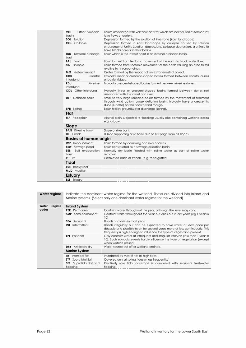
Wetland Inventory for the Lower South East Page 82
VOL Other volcanic
basins
Basins associated with volcanic activity which are neither basins formed by
lava flows or craters.
SOL Solution Depression formed by the solution of limestone (karst landscape).
COL Collapse Depression formed in karst landscape by collapse caused by solution
underground. Unlike Solution depressions, collapse depressions are likely to
have blocks of rock in their basins.
TDB Terminal drainage
basin
Basin which is the lowest point in an internal drainage basin.
FAU Fault Basin formed from tectonic movement of the earth to block water flow.
SIN Sinkhole Basin formed from tectonic movement of the earth causing an area to fall
relative to its surroundings.
MET Meteor impact Crater formed by the impact of an extra terrestrial object.
CDU Coastal
interdunal
Typically linear or crescent-shaped basins formed between coastal dunes
or barrier ridges.
RDU Riverine
interdunal
Typically crescent-shaped basins formed between riverine dunes.
ODU Other interdunal Typically linear or crescent-shaped basins formed between dunes not
associated with the coast or a river.
DEF Deflation basin Small to very large rounded basins formed by the movement of sediment
through wind action. Large deflation basins typically have a crescentic
dune (lunette) on their down-wind margin.
SPR Spring Basin fed by groundwater discharge (spring).
FlatFLP Floodplain Alluvial plain subjected to flooding; usually also containing wetland basins
e.g. oxbow.
SlopeBAN Riverine bank Slope of river bank
HIL Hillside Hillside supporting a wetland due to seepage from hill slopes.
Basins of human origin IMP Impoundment Basin formed by damming of a river or creek.
SEW Sewage pond Basin constructed as a sewage oxidation basin.
SEB Salt evaporation
basin
Normally dry basin flooded with saline water as part of saline water
removal.
PIT Pit Excavated basin or trench. (e.g. road gutter)
TidalRRE Rocky reef
MUD Mudflat
EstuaryEST Estuary
Water regime Indicate the dominant water regime for the wetland. These are divided into Inland and
Marine systems. (Select only one dominant water regime for the wetland)
Inland System PER Permanent Contains water throughout the year, although the level may vary.
SMP Semi-permanent Contains water throughout the year but dries out in dry years (eg 1 year in
10)
SEA Seasonal Floods and dries in most years.
INT Intermittent Floods irregularly but can be expected to have water at least once per
decade and possibly even for several years more or less continuously. This
frequency is high enough to influence the type of vegetation present.
EPI Episodic Only contains water at infrequent and irregular intervals (less than 1 year in
10). Such episodic events hardly influence the type of vegetation (except
when water is present).
DRY Artificially dry Water source cut off or wetland drained.
Marine System
ITF Intertidal flat Inundated by most if not all high tides.
STF Supratidal flat Covered only at spring tides or less frequently/
Water regime
codes
SFF Supratidal flat and
flooding
Relatively rare tidal coverage is combined with seasonal freshwater
flooding.

Water source l i l
i i
iti i l
(i i i
i i
LOC l i i i ini l
rai
Channel l l ificial l.
OFF Fed by the ri i
STR i i i
IRR I i i igation i l i l
I i i l l is i l
GRW ifer.
SPR
Water source
codes
i i i
Depth
i ll i
Water
Depth
i i ll i is
Watercourse
Name
i l
Flow
structures
pl
(
The source of water inflow shou d be recorded. (Mult ple sources can be se ected).
Source of water is determined from on-site inspect on, considerat on of hydrology
mapping and groundwater depth mapping. Groundwater dependency is determined
by the type of vegetation present, and the pos on of the wetland n the andscape
e, assessment of run-off potential, presence of vegetat on communit es such as peat-
based swamp spec es, water reg mes).
Loca runoff Fed by runoff and nfiltrat on generated by precip tation in the vic ty p us
nfall on the wetland surface; no defined stream.
CHA fed Fed by loca runoff entering wet and in art channe
Off-stream ver only dur ng floods.
Stream-fed Fed by r ver/stream with a cont nuous connect on.
rr gat on
runoff
Fed by runoff generated from irr so ated from ts natura source.
rr gat on runoff wil be through a channe so th s a subset of Channe -fed.
Groundwater
Fed by groundwater from underground aqu
Spring Fed by groundwater coming to surface at a spring beyond the wetland
boundary.
MAR Mar ne Fed by nflows from the sea, ncluding tides.
Av. Water Prov de an estimation of the average depth of the entire wetland when fu n metres.
This applies to inland systems only.
Max. Prov de an estimation of the max mum depth of the wetland when fu n metres. Th
applies to inland systems only.
Prov de the name of the watercourse that feeds the wetland (where re evant).
control Indicate Yes or No if flow control structures are in ace that effect the wetland.
Describe the type of flow control structures e.g. weir).
Land Tenure and Use
Tenure
Landuse
Management
Authority
Fire History
Social &
Cultural Values
Recreation
Facilities / uses
Indicate if the wetland (on-site and surrounding) is privately or publicly owned by
ticking the appropriate box. Specify other option if private and public are not
applicable (e.g. Commonwealth land). (note that more than one tenure can be
indicated).
Indicate the on-site use and surrounding use of the wetland by ticking appropriate landuse. Specify other landuse if appropriate description is not listed. (note that more than one landuse code can be indicated).
Indicate the appropriate management authority responsible for the management of
the wetland.
Indicate any known years of fire and the approximate area of wetland burnt. This
information is usually obtained from the landholder or management authority.
Record any social and cultural values relevant to the wetland. This may require
consultation with the landholder (where possible) or review of literature.
Record any recreational facilities present at the wetland site by circling appropriate
attributes. Specify other recreation uses / facilities in the space provided.
Wetland Inventory for the Lower South East Page 83

Wetland Inventory for the Lower South East Page 84
Wetland classification
Category Wetland classification is based on that used by Ramsar Convention in describing
Wetlands of International Importance and Directory of Important Wetlands in Australia.
Indicate which broad category the wetland belongs to (A – marine and coastal zone;
B – inland; C – human made).
Number Indicate which sub-category the wetland belongs to using definitions provided below.
A – Marine and Coastal Zone Wetlands
1 Marine waters – permanent shallow waters less than six metres deep at low tide; includes
sea bays, straits.
2 Subtidal aquatic beds; includes kelp beds, seagrasses, tropical marine meadows.
3 Coral reefs
4 Rocky marine shores; includes rocky offshore islands, sea cliffs.
5 Sand, shingle or pebble beaches; includes sand bars, spits, sandy islets.
6 Estuarine waters; permanent waters of estuaries and estuarine systems of deltas.
7 Intertidal mud, sand or salt flats.
8 Intertidal marshes; includes saltmarshes, salt meadows, saltings, raised salt marshes, tidal
brackish and freshwater marshes.
9 Intertidal forested wetlands; includes mangrove swamps, nipa swamps, tidal freshwater
swamp forests.
10 Brackish to saline lagoons and marshes with one or more relatively narrow connections with
the sea.
11 Freshwater lagoons and marshes in the coastal zone.
12 Non-tidal freshwater forested wetlands.
B – Inland Wetlands
1 Permanent rivers and streams; includes waterfalls.
2 Seasonal and irregular rivers and streams.
3 Inland deltas (permanent)
4 Riverine floodplains; includes river flats, flooded river basins, seasonally flooded grassland,
savanna and palm savanna.
5 Permanent freshwater lakes (>8ha); includes large oxbow lakes.
6 Seasonal/intermittent freshwater lakes (>8ha), floodplain lakes.
7 Permanent saline/brackish lakes.
8 Seasonal/intermittent saline lakes.
9 Permanent freshwater ponds (<8ha), marshes and swamps on inorganic soils; with
emergent vegetation waterlogged for at least most of the growing season.
10 Seasonal/intermittent freshwater ponds and marshes on inorganic soils; including sloughs,
potholes; seasonally flooded meadows, sedge marshes.
11 Permanent saline/brackish marshes
12 Seasonal saline marshes
13 Shrub swamps; shrub dominated freshwater marsh, shrub carr, alder thicket on inorganic
soils.
14 Freshwater swamp forest; seasonally flooded forest, wooded swamps; on inorganic soils.
15 Peatlands; forest, shrub or open bogs.
16 Alpine and tundra wetlands; includes alpine meadows, tundra pools, temporary water from
snow melt.
17 Freshwater springs, oases and rock pools.
18 Geothermal wetlands.
19 Inland, subterranean karst wetlands.
C – Human-made Wetlands
1 Water storage areas; reservoirs, barrages, hydro-electric dams, impoundments (generally
>8ha).
2 Ponds, including farm ponds, stock ponds, small tanks (generally <8ha).
3 Aquaculture ponds, fish ponds, shrimp ponds.
4 Salt exploitation; salt pans, salines.
5 Excavations; gravel pits, borrow pits, mining pools.
6 Wastewater treatment; sewage farms; settling ponds, oxidation basins.
7 Irrigated land and irrigation channels; rice fields, canals, ditches.
8 Seasonally flooded arable land, farm land.
Definition of
wetland
classification
9 Canals.

Criteria i l i
I l i
l
I i if j i ia lly i
1 It i l l i i i
2 It is l l ecol l or l l l
ioni l
3 It i l i l
li l i il.
4 l i l l i ive pl i l
5 l i l l i
l l ional l l.
Definition of
criteria
6 l i i l l l si
General
Description
l l
li l
General comments about the wetland as a whole
l l
Water Chemistry and Substrate Type
Criteria for determining nat onally important wet ands in Austral a, and hence inclusion
in the Directory of mportant Wet ands in Austral a. Criteria agreed to by the ANZECC
Wet ands Network in 1994.
nd cate the wetland meets any of the ma or cr ter for nationa mportant
wetlands. s a good examp e of a wet and type occurring with n a b ogeographic reg on in Australia.
a wet and which p ays an important ogica hydro ogica role in the natura
funct ng of a major wet and system / complex.
s a wet and which is important as the habitat for an ma taxa at a vulnerable stage in their
fe cyc es, or provides a refuge when adverse cond tions such as drought preva
The wet and supports 1% or more of the nat ona popu at ons of any nat ant or an ma
taxa.
The wet and supports nat ve p ant or anima taxa or commun ties which are considered
endangered or vu nerab e at the nat eve
The wet and is of outstand ng h storica or cu tura gnificance.
Provide a general description of the wet and. This description is re evant to the project.
eg. Juncus spp. Brackish Creek ne F oodplain; Spring-fed Peat Bog etc.
Provide any comments/sketch maps that assist in describing the wet and / wet and complex as a whole.
Water chemistry readings are taken from specified equipment. More than one set of recordings are recommended in different parts of the wetlands. Complete a new survey sheet for each additional water chemistry survey. Where a wetland is dry or has insufficient water at the time of survey, no water chemistry data can be collected.
pH Measured using a TPS pH electrode attached to a TPS WP-81 meter.
Turbidity Measured using a tube nephelometer.
Conductivity Measured using a TPS k=1 conductivity sensor attached to a TPS WP-81 meter.
Dissolved O2 Measured using a YSI 5739 field probe attached to a TPS WP-82Y dissolved oxygen meter.
Temperature Measured using a YSI 5739 field probe attached to a TPS WP-82Y dissolved oxygen
meter.
Water Flow Record the flow of water at the site where water chemistry readings are taken. Circle
appropriate description of flow: Standing / Slow flow / Rapid flow.
Water Depth Record the total depth of water at the site where water chemistry readings are taken
(value in meters).
Record the depth at which the water chemistry readings were taken within the Reading Depth
available depth (value in meters).
%Cover Indicate the area of water present relative to full at the time of survey.
Duration of If the wetland is dry, indicate the number of months since the last inundation (if
inundation known).
Sediment size Indicate dominant sediment size (substrate grain size) category by circling
appropriate code.
Wetland Inventory for the Lower South East Page 85
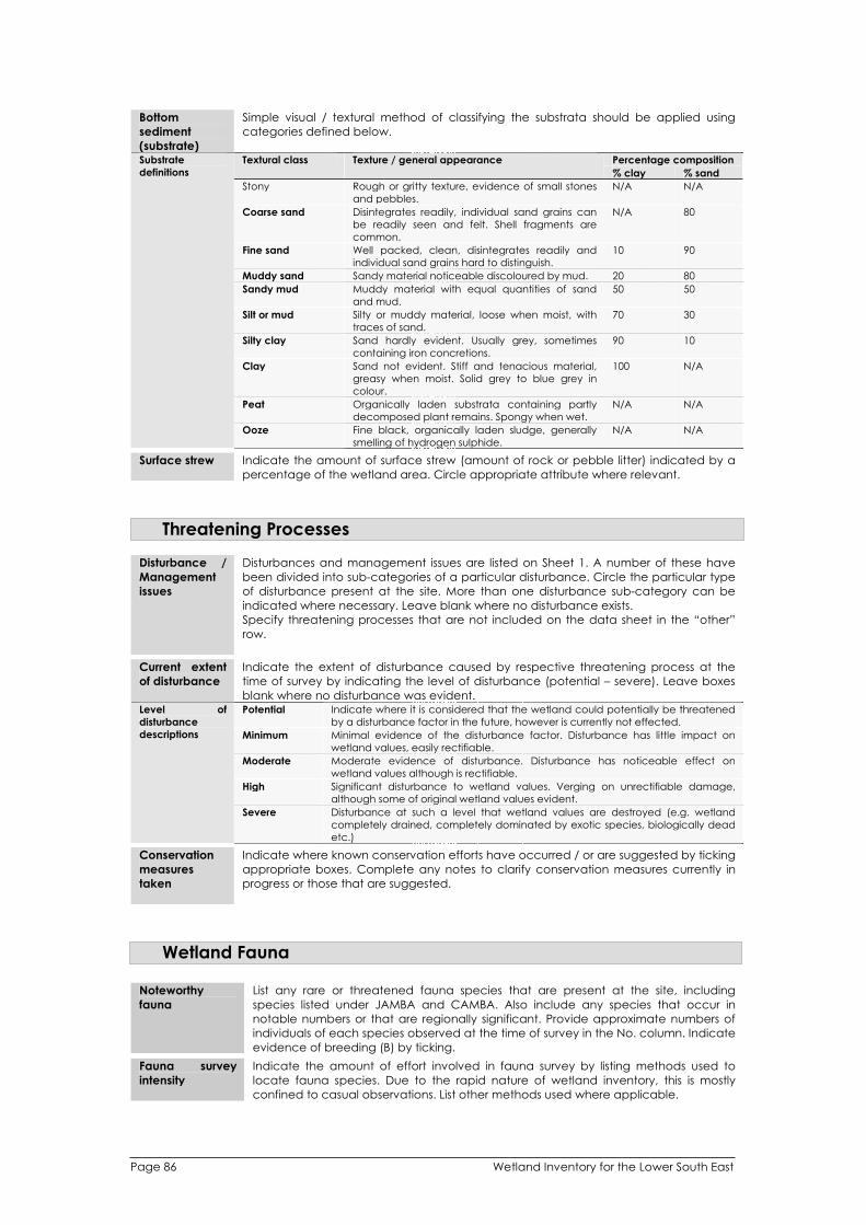
Wetland Inventory for the Lower South East Page 86
Bottom
sediment
(substrate)
Simple visual / textural method of classifying the substrata should be applied using
categories defined below.
Percentage composition Textural class Texture / general appearance
% clay % sand
Stony Rough or gritty texture, evidence of small stones
and pebbles.
N/A N/A
Coarse sand Disintegrates readily, individual sand grains can
be readily seen and felt. Shell fragments are
common.
N/A 80
Fine sand Well packed, clean, disintegrates readily and
individual sand grains hard to distinguish.
10 90
Muddy sand Sandy material noticeable discoloured by mud. 20 80
Sandy mud Muddy material with equal quantities of sand
and mud.
50 50
Silt or mud Silty or muddy material, loose when moist, with
traces of sand.
70 30
Silty clay Sand hardly evident. Usually grey, sometimes
containing iron concretions.
90 10
Clay Sand not evident. Stiff and tenacious material,
greasy when moist. Solid grey to blue grey in
colour.
100 N/A
Peat Organically laden substrata containing partly
decomposed plant remains. Spongy when wet.
N/A N/A
Substrate
definitions
Ooze Fine black, organically laden sludge, generally
smelling of hydrogen sulphide.
N/A N/A
Surface strew Indicate the amount of surface strew (amount of rock or pebble litter) indicated by a
percentage of the wetland area. Circle appropriate attribute where relevant.
Threatening Processes
Disturbance /
Management
issues
Disturbances and management issues are listed on Sheet 1. A number of these have
been divided into sub-categories of a particular disturbance. Circle the particular type
of disturbance present at the site. More than one disturbance sub-category can be
indicated where necessary. Leave blank where no disturbance exists.
Specify threatening processes that are not included on the data sheet in the “other”
row.
Current extent
of disturbance
Indicate the extent of disturbance caused by respective threatening process at the
time of survey by indicating the level of disturbance (potential – severe). Leave boxes
blank where no disturbance was evident. Potential Indicate where it is considered that the wetland could potentially be threatened
by a disturbance factor in the future, however is currently not effected.
Minimum Minimal evidence of the disturbance factor. Disturbance has little impact on
wetland values, easily rectifiable.
Moderate Moderate evidence of disturbance. Disturbance has noticeable effect on
wetland values although is rectifiable.
High Significant disturbance to wetland values. Verging on unrectifiable damage,
although some of original wetland values evident.
Level of
disturbance
descriptions
Severe Disturbance at such a level that wetland values are destroyed (e.g. wetland
completely drained, completely dominated by exotic species, biologically dead
etc.)
Conservation
measures
taken
Indicate where known conservation efforts have occurred / or are suggested by ticking
appropriate boxes. Complete any notes to clarify conservation measures currently in
progress or those that are suggested.
Wetland Fauna
Noteworthy
fauna
List any rare or threatened fauna species that are present at the site, including
species listed under JAMBA and CAMBA. Also include any species that occur in
notable numbers or that are regionally significant. Provide approximate numbers of
individuals of each species observed at the time of survey in the No. column. Indicate
evidence of breeding (B) by ticking.
Fauna survey
intensity
Indicate the amount of effort involved in fauna survey by listing methods used to
locate fauna species. Due to the rapid nature of wetland inventory, this is mostly
confined to casual observations. List other methods used where applicable.

Wetland Inventory for the Lower South East Page 87
Microhabitats Indicate micro-habitats that are present within the wetland. Micro-habitats refer to
habitat components that have relevance for their importance to fauna. Specify
other un-listed micro-habitats where relevant.
Wetland Vegetation - Summary
Total Veg.
Cover
Indicate the cover of aquatic vegetation as a percentage of the wetland area should
be estimated by eye.
US Cover Indicate the cover of understorey species as a percentage of the wetland area.
Estimated by eye. (note: the cover of understorey species should not exceed the value
for Total Veg. Cover).
OS Cover Indicate the cover of overstorey species as a percentage of the wetland area.
Estimated by eye. (note: the cover of overstorey species should not exceed the value
for Total Veg. Cover).
Age Indicate dominant vegetation maturity within the wetland by circling appropriate
category
Juv Juvenile:
Mat Mature:
Vegetation
age
descriptions Sen Senescent:
Av. Width of
Buffer
Indicate the average width of fringing native vegetation based on visual estimates
(record in meters).
% Buffer Indicate the approximate percentage of the wetland body surrounded by native
vegetation buffer.
Attached
algae
An indication of the amount of macroalgae present should be recorded as little,
medium or abundant.
Little No obvious macroalgae present.
Medium Clumps of significant macroalgae present.
Attached
algae
descriptions Abundant Macroalgae present over at least one-third of water area.
Weediness Indicate the presence and abundance of exotic species by circling the appropriate
code for total weed cover / abundance. (note: an abbreviated key to cover
abundance codes can be found at the top of Survey Sheet 2).
N Not many, 1 – 10 individuals, insignificant cover.
T Sparsely or very sparsely present; cover less than 5%.
1 Plentiful, but of small cover: less than 5% cover.
2 Any number of individuals, 6-25% cover.
3 Any number of individuals, 26-50% cover.
4 Any number of individuals, 51-75% cover.
Weediness
cover
abundance
scale
5 Any number of individuals, 76-100% cover.
Structural
formation
Provide the Structural Formation description for the wetland using the categories listed
below.
Tall Closed Wet Forest Trees >30m; Dense (70-100%) cover (wetland)
Tall Open Wet Forest Trees >30m; Mid-dense (30-70%) cover (wetland)
Tall Wet Woodland Trees >30m; Sparse (10-30%) cover (wetland)
Tall Open Wet Woodland Trees >30m; Very Sparse (<10%) cover (wetland)
Closed Wet Forest Trees 10-30m; Dense (70-100%) cover (wetland)
Open Wet Forest Trees 10-30m; Mid-dense (30-70%) cover (wetland)
Wet Woodland Trees 10-30m; Sparse (10-30%) cover (wetland)
Open Wet Woodland Trees 10-30m; Very Sparse (<10%) cover (wetland)
Low Closed Wet Forest Trees 5-10m; Dense (70-100%) cover (wetland)
Low Open Wet Forest Trees 5-10m; Mid-dense (30-70%) cover (wetland)
Low Wet Woodland Trees 5-10m; Sparse (10-30%) cover (wetland)
Low Open Wet Woodland Trees 5-10m; Very Sparse (<10%) cover (wetland)
Very Low Closed Wet Forest Trees <5m; Dense (70-100%) cover (wetland)
Very Low Open Wet Forest Trees <5m; Mid-dense (30-70%) cover (wetland)
Very Low Wet Woodland Trees <5m; Sparse (10-30%) cover (wetland)
Very Low Open Wet
Woodland
Trees <5m; Very Sparse (<10%) cover (wetland)
Tall Closed Wet Shrubland Shrubs >2m; Dense (70-100%) cover (wetland)
Tall Wet Shrubland Shrubs >2m; Mid-dense (30-70%) cover (wetland)
Tall Open Wet Shrubland Shrubs >2m; Sparse (10-30%) cover (wetland)
Tall Very Open Wet
Shrubland
Shrubs >2m; Very Sparse (<10%) cover (wetland)
Closed Wet Shrubland Shrubs 1-2m; Dense (70-100%) cover (wetland)
Wet Shrubland Shrubs 1-2m; Mid-dense (30-70%) cover (wetland)
Open Wet Shrubland Shrubs 1-2m; Sparse (10-30%) cover (wetland)
Structural
formation
descriptions
Very Open Wet Shrubland Shrubs 1-2m; Very Sparse (<10%) cover (wetland)
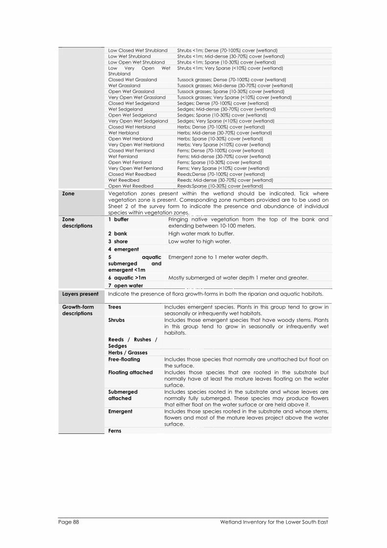
Wetland Inventory for the Lower South East Page 88
Low Closed Wet Shrubland Shrubs <1m; Dense (70-100%) cover (wetland)
Low Wet Shrubland Shrubs <1m; Mid-dense (30-70%) cover (wetland)
Low Open Wet Shrubland Shrubs <1m; Sparse (10-30%) cover (wetland)
Low Very Open Wet
Shrubland
Shrubs <1m; Very Sparse (<10%) cover (wetland)
Closed Wet Grassland Tussock grasses; Dense (70-100%) cover (wetland)
Wet Grassland Tussock grasses; Mid-dense (30-70%) cover (wetland)
Open Wet Grassland Tussock grasses; Sparse (10-30%) cover (wetland)
Very Open Wet Grassland Tussock grasses; Very Sparse (<10%) cover (wetland)
Closed Wet Sedgeland Sedges; Dense (70-100%) cover (wetland)
Wet Sedgeland Sedges; Mid-dense (30-70%) cover (wetland)
Open Wet Sedgeland Sedges; Sparse (10-30%) cover (wetland)
Very Open Wet Sedgeland Sedges; Very Sparse (<10%) cover (wetland)
Closed Wet Herbland Herbs; Dense (70-100%) cover (wetland)
Wet Herbland Herbs; Mid-dense (30-70%) cover (wetland)
Open Wet Herbland Herbs; Sparse (10-30%) cover (wetland)
Very Open Wet Herbland Herbs; Very Sparse (<10%) cover (wetland)
Closed Wet Fernland Ferns; Dense (70-100%) cover (wetland)
Wet Fernland Ferns; Mid-dense (30-70%) cover (wetland)
Open Wet Fernland Ferns; Sparse (10-30%) cover (wetland)
Very Open Wet Fernland Ferns; Very Sparse (<10%) cover (wetland)
Closed Wet Reedbed Reeds;Dense (70-100%) cover (wetland)
Wet Reedbed Reeds; Mid-dense (30-70%) cover (wetland)
Open Wet Reedbed Reeds;Sparse (10-30%) cover (wetland)
Zone Vegetation zones present within the wetland should be indicated. Tick where
vegetation zone is present. Corresponding zone numbers provided are to be used on
Sheet 2 of the survey form to indicate the presence and abundance of individual
species within vegetation zones.
1 buffer Fringing native vegetation from the top of the bank and
extending between 10-100 meters.
2 bank High water mark to buffer.
3 shore Low water to high water.
4 emergent
5 aquatic
submerged and
emergent <1m
Emergent zone to 1 meter water depth.
6 aquatic >1m Mostly submerged at water depth 1 meter and greater.
Zone
descriptions
7 open water
Layers present Indicate the presence of flora growth-forms in both the riparian and aquatic habitats.
Trees Includes emergent species. Plants in this group tend to grow in
seasonally or infrequently wet habitats.
Shrubs Includes those emergent species that have woody stems. Plants
in this group tend to grow in seasonally or infrequently wet
habitats.
Reeds / Rushes /
Sedges
Herbs / Grasses
Free-floating Includes those species that normally are unattached but float on
the surface.
Floating attached Includes those species that are rooted in the substrate but
normally have at least the mature leaves floating on the water
surface.
Submerged
attached
Includes species rooted in the substrate and whose leaves are
normally fully submerged. These species may produce flowers
that either float on the water surface or are held above it.
Emergent Includes those species rooted in the substrate and whose stems,
flowers and most of the mature leaves project above the water
surface.
Growth-form
descriptions
Ferns

Wetland Inventory for the Lower South East Page 89
Subjective Assessment
The rapid assessment component of the survey provides a snap shot of the vegetation association and
condition within different riparian habitats. Scores are subjective and should provide an indication of the
condition of wetlands at time of survey as determined by the surveyor. Subjective scores will be
compared with condition index scores generated from data collected above and should provide an
indication of the accuracy of condition index scores following data analysis.
Water
dependent
fauna
Subjective score according to the abundance and diversity and relative condition of
invertebrates, fish and birds located within or on the water body determined by
observation.
None No habitat present to support
Low Very few or no species present.
Moderate Moderate species diversity and abundance, usually more common
species.
Water
dependent
fauna
descriptions
High High species diversity and abundance, presence of more sensitive
species.
Aquatic
vegetation
Subjective score according to the abundance and diversity and relative condition of
aquatic vegetation determined by observation.
None No aquatic vegetation observed.
Degraded Indicates no or very little aquatic vegetation present, notable
presence of exotic species, with low species diversity.
Moderate Indicates some aquatic vegetation cover, most vegetation layers
present, some exotic species present.
Aquatic
vegetation
descriptions
Intact High diversity of aquatic vegetation with few exotics. Most or all
aquatic vegetation layers represented.
Riparian
vegetation
The vegetation of each zone is subjectively scored considering the level of disturbance
and vegetation cover within each zone.
None No riparian vegetation present. (ie, completely removed)
Degraded < 30% native vegetation cover with an abundance or exotic species
and evidence of a high level of disturbance.
Moderate Between 30-75% native vegetation cover, few exotics with little
evidence of disturbance.
Riparian
vegetation
descriptions
Intact >75% native vegetation cover with little or no evidence of disturbance.
Wetland
condition
The overall wetland condition score should reflect the previous rapid assessment
scores. The combination of these values and the interpretation of other parameters
recorded during the survey (such as land degradation and water chemistry) form the
basis of the wetland condition score.
Completely
degraded
Severely
degraded
Very high level of disturbance evident to the extent that wetland
values are destroyed or irreversibly modified (e.g. wetland drained,
eutrophication). Received low rapid assessment scores.
Degraded High level of disturbance evident. Verging on unrectifiable damage.
Received mostly low rapid assessment scores.
Moderate Significant level of disturbance evident although some natural values
present. Most damage rectifiable. Received mostly moderate rapid
assessment scores.
Intact Small amounts of disturbance evident, with high native species
diversity. Damage easily rectifiable. Received mostly moderate - intact
rapid assessment scores.
Wetland
condition
descriptions
Pristine No obvious disturbance, with high native species diversity. Scored
mostly intact rapid assessment scores. Usually formally conserved within
the reserve system.
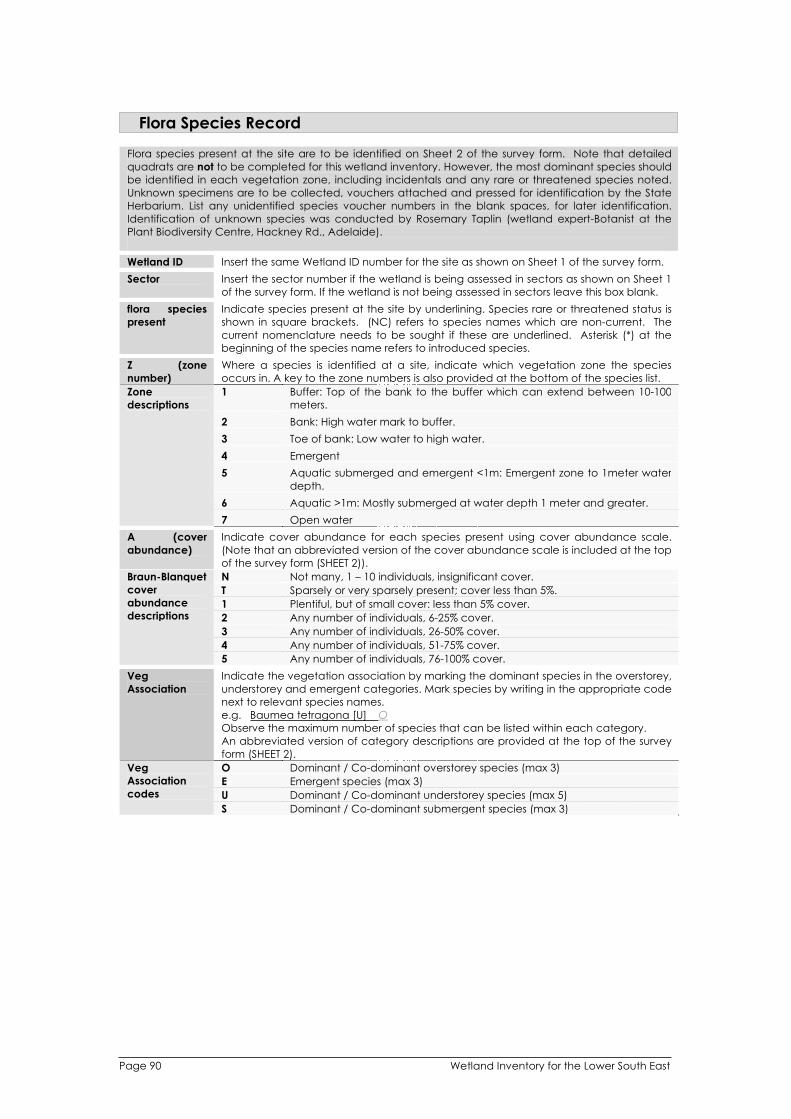
Wetland Inventory for the Lower South East Page 90
Flora Species Record
Flora species present at the site are to be identified on Sheet 2 of the survey form. Note that detailed
quadrats are not to be completed for this wetland inventory. However, the most dominant species should
be identified in each vegetation zone, including incidentals and any rare or threatened species noted.
Unknown specimens are to be collected, vouchers attached and pressed for identification by the State
Herbarium. List any unidentified species voucher numbers in the blank spaces, for later identification.
Identification of unknown species was conducted by Rosemary Taplin (wetland expert-Botanist at the
Plant Biodiversity Centre, Hackney Rd., Adelaide).
Wetland ID Insert the same Wetland ID number for the site as shown on Sheet 1 of the survey form.
Sector Insert the sector number if the wetland is being assessed in sectors as shown on Sheet 1
of the survey form. If the wetland is not being assessed in sectors leave this box blank.
flora species
present
Indicate species present at the site by underlining. Species rare or threatened status is
shown in square brackets. (NC) refers to species names which are non-current. The
current nomenclature needs to be sought if these are underlined. Asterisk (*) at the
beginning of the species name refers to introduced species.
Z (zone
number)
Where a species is identified at a site, indicate which vegetation zone the species
occurs in. A key to the zone numbers is also provided at the bottom of the species list.
1 Buffer: Top of the bank to the buffer which can extend between 10-100
meters.
2 Bank: High water mark to buffer.
3 Toe of bank: Low water to high water.
4 Emergent
5 Aquatic submerged and emergent <1m: Emergent zone to 1meter water
depth.
6 Aquatic >1m: Mostly submerged at water depth 1 meter and greater.
Zone
descriptions
7 Open water
A (cover
abundance)
Indicate cover abundance for each species present using cover abundance scale.
(Note that an abbreviated version of the cover abundance scale is included at the top
of the survey form (SHEET 2)).
N Not many, 1 – 10 individuals, insignificant cover.
T Sparsely or very sparsely present; cover less than 5%.
1 Plentiful, but of small cover: less than 5% cover.
2 Any number of individuals, 6-25% cover.
3 Any number of individuals, 26-50% cover.
4 Any number of individuals, 51-75% cover.
Braun-Blanquet
cover
abundance
descriptions
5 Any number of individuals, 76-100% cover.
Veg
Association
Indicate the vegetation association by marking the dominant species in the overstorey,
understorey and emergent categories. Mark species by writing in the appropriate code
next to relevant species names.
e.g. Baumea tetragona [U] O
Observe the maximum number of species that can be listed within each category.
An abbreviated version of category descriptions are provided at the top of the survey
form (SHEET 2).
O Dominant / Co-dominant overstorey species (max 3)
E Emergent species (max 3)
U Dominant / Co-dominant understorey species (max 5)
Veg
Association
codes
S Dominant / Co-dominant submergent species (max 3)

APPENDIX 9 – Criteria for the International and
National Importance of Wetlands
International Recognition
The Ramsar Convention on Wetlands
A wetland must meet at least one of the following criteria to be Ramsar listed:
Criterion 1: A wetland should be considered internationally important if it contains a representative, rare, or
unique example of a natural or near-natural wetland type found within the appropriate biogeographic
region.
Criterion 2: A wetland should be considered internationally important if it supports vulnerable, endangered,
or critically endangered species or threatened ecological communities.
Criterion 3: A wetland should be considered internationally important if it supports populations of plant
and/or animal species important for maintaining the biological diversity of a particular biogeographic
region.
Criterion 4: A wetland should be considered internationally important if it supports plant and/or animal
species at a critical stage in their life cycles, or provides refuge during adverse conditions.
Criterion 5: A wetland should be considered internationally important if it regularly supports 20,000 or more
waterbirds.
Criterion 6: A wetland should be considered internationally important if it regularly supports 1% of the
individuals in a population of one species or subspecies of waterbird.
Criterion 7: A wetland should be considered internationally important if it supports a significant proportion
of indigenous fish subspecies, species or families, life-history stages, species interactions and/or populations
that are representative of wetland benefits and/or values and thereby contributes to global biological
diversity.
Criterion 8: A wetland should be considered internationally important if it is an important source of food for
fishes, spawning ground, nursery and/or migration path on which fish stocks, either within the wetland or
elsewhere, depend.
Criterion 9: A wetland should be considered internationally important if it regularly supports 1% of the
individuals in a population of one species or subspecies of wetland-dependent non-avian animal species.
East Asian-Australasian Flyway Network
A wetland must meet at least one of the following criteria to be listed on the East Asian-Australasian Flyway Network: Criterion 1: The regularly supports 20,000 or more waterbirds. Criterion 2: The wetland regularly supports 1% of the individuals in a population of one species or subspecies of waterbird.
National Recognition
Directory of Important Wetlands in Australia
A wetland may be considered nationally important if it meets at least one of the following criteria:
1. It is a good example of a wetland type occurring within a biogeographic region in Australia.
2. It is a wetland which plays an important ecological or hydrological role in the natural
functioning of a major wetland system/complex.
3. It is a wetland which is important as the habitat for animal taxa at a vulnerable stage in their life
cycles, or provides refuge when adverse conditions such as drought prevail.
4. The wetland supports 1% or more of the national populations of any native plant or animal
taxa.
5. The wetland supports native plant or animal taxa or communities which are considered
endangered or vulnerable at the national level.
6. The wetland is of outstanding historical or cultural significance.
Wetland Inventory for the Lower South East Page 91

APPENDIX 10 – Inventory of LSE Wetland Literature
Anon. (1864). Drainage Works, South Eastern District. (Parliamentary Paper No.
181/1864: Adelaide, South Australia.)
Anon. (1869). Report on South-East Drainage Works. (Parliamentary Paper No.
88/1869: Adelaide, South Australia.)
Anon. (1892). Report of the Royal Commission on the South-East Drainage System.
(Parliamentary Paper No. 35/1892: Adelaide, South Australia.)
Ashby, E. (1927). Notes on birds observed during a motor trip to the South-East of
South Australia and coastal western Victoria. South Australian Ornithologist 9, 131-141.
Atkins, B. P. (1977). Rediscovery of the Swamp Antechinus in South Australia after 37
years. South Australian Naturalist 2, pp.
Atkins, B. P. and Gray, J. D. (1988). Wetlands of the Bakers Range and Marcollat
Watercourses. Wetlands Management Plan. (Department of Environment and
Planning: Adelaide, South Australia.)
Attiwill, A. R. (1972). A list of the birds of Big Heath. South Australian Naturalist 47, 38-40.
Austin, C. (1951). Birds of the southern end of the Victoria-South Australian border.
South Australian Ornithologist 20, 14-15.
Australian Nature Conservation Agency (1996). A Directory of Important Wetlands in
Australia. (ANCA: Canberra, ACT.)
Bachmann, M. R. (2002). Silky Tea-tree and Cutting Grass Wetland Rehabilitation
Project 1999-2002. (Nature Conservation Society of South Australia: Adelaide.)
Bachmann, M. R. and van Weenen, J. (2001). The distribution and status of the swamp
antechinus in South Australia. (Nature Conservation Society of South Australia:
Adelaide, South Australia.)
Bayly, I. A. E. and Williams, W. D. (1964). Chemical and biological observations on
some volcanic lakes in the south-east of South Australia. Australian Journal of Marine
and Freshwater Research 15, 123-32.
Bayly, I. A. E. and Williams, W. D. (1966). Further chemical observations on some
volcanic lakes in the south-east of South Australia. Australian Journal of Marine and
Freshwater Research 17, 229-237.
Beaney, H. L. (1957). Mt Gambier Water Supply. Report P.D. 7. (Engineering & Water
Supply Department: Adelaide, South Australia.)
Beauglehole, C. and Kraehenbuehl, D. N. (1964). Report of the Natural History of
Piccaninnie Blue Lake, Lower South-East S.A. (Field Naturalists Society of S.A.
Incorporated: Adelaide, South Australia.)
Beck, R. G. (1975). Factors affecting the distribution of the leptodactylid frog
Geocrinia laevis in the South East of South Australia. Transactions of the Royal Society
of South Australia 99, 143-149.
Page 92 Wetland Inventory for the Lower South East

Beck, R. G. (1985). Field observations upon the Dwarf Galaxiid Galaxiella pusilla
(Mack) (Pisces: Galaxiidae) in the South-east of South Australia, Australia. South
Australian Naturalist 60, 12-22.
Braithwaite, L. W. and Norman, F. I. (1974). The 1972 open season on waterfowl in
South-eastern Australia. Technical Paper 29. (CSIRO Division of Wildlife Research:
Canberra, ACT.)
Braithwaite, L. W. and Norman, F. I. (1977). The 1975 and 1976 open seasons on
waterfowl in South-eastern Australia. Technical Memorandum 13. (CSIRO Division of
Wildlife Research: Canberra, ACT.)
Bransbury, J. (1991). The Brolga in south-eastern South Australia. (Department of
Environment and Planning: Adelaide, South Australia.)
Brown, H. Y. L. (1894). Report by Government geologists on lakes in Mount Gambier
District. Parliamentary Papers, South Australia, No. 256. Adelaide, South Australia.)
Brown, P. B. and Wilson, R. I. (1984). Orange-bellied Parrot Recovery Plan. (Tasmania
National Parks and Wildlife Service: Hobart, Tasmania.)
Brownlow, M. D. (1997). 'Water Regime and the Aquatic Vegetation of Bool Lagoon,
South Australia' PhD Thesis. (The University of Adelaide: Adelaide, South Australia.)
Chandler, W. J., Sandercock, R. K. and D.J., C. (1979). Reedy Creek Conservation
Zone Management Plan. (Department for the Environment: Adelaide, South
Australia.)
Clisby, R. L. (1972). Spring Discharges, Hundreds MacDonnell and Caroline, South East
Region, South Australia. (Engineering and Water Supply Department: Adelaide, South
Australia.)
Cole, D. A., Hodder, M. W., Auricht, C., Botting, J., Read, P. K., Wiltshire, D. and Prosser,
G. (1883). Lake Frome - Mullins Swamp Wetlands Study. (South East Wetlands
Committee: Adelaide, South Australia.)
Condon, H. T. (1942). The Ground Parrot (Pezoporus wallicus) in South Australia. The
South Australian Ornithologist 16, 407.
Coombe, A. R. (1977). Diversion of water flow - Piccaninnie Ponds Conservation Park.
S.A. Department of Environment and Planning Docket DE 3311/76. (DEP: Adelaide,
South Australia.)
Coombe, A. R. and Hinsliff, M. (1982). 'A feasibility study of the diversion of the
watercourse at Piccaninnie Ponds Conservation Park. Report for Asscoc. Dip. in
Wildlife and Park Management' Associate Diploma Thesis. (South Australian College
of Advanced Education: Salisbury, South Australia.)
Cox, J. B. (1978). Japanese Snipe in South Australia. (National Parks and Wildlife
Service: Adelaide, South Australia.)
Crocker, R. L. and Eardley, C. M. (1939). A South Australian Sphagnum Bog.
Transactions of the Royal Society of South Australia 63, 210-214.
Wetland Inventory for the Lower South East Page 93

Croft, T., Carruthers, S., Possingham, H. and Inns, B. (1999). Biodiversity Plan for the
South East of South Australia. (Department for Environment, Heritage and Aboriginal
Affairs: Adelaide, South Australia.)
D'Arcy, R. D., Austin, S., Cohen, B., Mooney, P. and Murray, D. (1984). South East
Environmental Profile Study. (Department of Environment and Planning: Adelaide,
South Australia.)
Davies, R. J. P. (1982). The Conservation of Major Plant Associations in South Australia.
(Conservation Council of South Australia Inc.: Adelaide, South Australia.)
Day, P. (1979). Lake Bonney Study. (Department of Lands: Adelaide, South Australia.)
Department for Environment and Heritage (2002). Lake Hawdon Management Plan -
Draft. (DEH: Adelaide, South Australia.)
Department for Environment and Heritage (2003). Lake Frome Conservation Park
Management Plan. (DEH: Adelaide, South Australia.)
Department for Environment Heritage and Aboriginal Affairs (1997). Lake George
Management Plan. (DENR: Adelaide, South Australia.)
Department for Environment Heritage and Aboriginal Affairs (1999). Ewen Ponds
Conservation Park Management Plan. (DEHAA: Adelaide, South Australia.)
Department for Environment Heritage and Aboriginal Affairs (1999). Small Coastal
Parks of the South East Management Plan - Amendment to Plan of Management:
Lake Robe Game Reserve. (DEHAA: Adelaide, South Australia.)
Department of Environment and Natural Resources (1994). Small Coastal Parks of the
South East - Management Plan. (DENR: Adelaide, South Australia.)
Department of Environment and Natural Resources (1994). Small Inland Parks of the
South East - Management Plan. (DENR: Adelaide, South Australia.)
Department of Environment and Natural Resources (1996). Lake Bonney South East
Management Plan 1996-2000. (DENR: Adelaide, South Australia.)
Department of Environment and Planning (1983). Wetland Conservation in South
Australia. (DEP: Adelaide, South Australia.)
Department of Environment and Planning (1985). Bool Lagoon Game Reserve, South
East South Australia - Draft Management Plan. (DEP: Adelaide, South Australia.)
Department of Environment and Planning (1988). Wetlands of the Bakers Range and
Marcollat Watercourses. Environmental Characteristics. (DEP: Adelaide, South
Australia.)
Department of Environment and Planning (1990). Small Parks of the Lower South East -
Management Plans. (DEP: Adelaide, South Australia.)
Department of Environment and Planning (1992). Bool Lagoon Game Reserve and
Hacks Lagoon Conservation Park Amended Management Plan. (DEP: Adelaide,
South Australia.)
Page 94 Wetland Inventory for the Lower South East

Department of Environment and Planning (1992). Little Dip Conservation Park
Management Plan. (DEP: Adelaide, South Australia.)
Department of Environment and Planning (1992). Piccaninnie Ponds Conservation
Park Management Plan. (DEP: Adelaide, South Australia.)
Dodson, J. R. (1974). Vegetation history and water fluctuations at Lake Leake, south-
eastern South Australia. 1: 10000 B. P. to present. Australian Journal of Botany 22, 719-
741.
Dodson, J. R. (1975). Vegetation history and water fluctuations at Lake Leake, south-
eastern South Australia. 2: 50000 B. P. to 10000 B. P. Australian Journal of Botany 23,
815-831.
Dodson, J. R. and Wilson, I. B. (1975). Past and Present Vegetation of Marshes Swamp
in South Eastern South Australia. Australian Journal of Botany 23, 123-150.
Eardley, C. M. (1943). An Ecological Study of the Vegetation of Eight Mile Creek
Swamp. A South Australian Coastal Fen Formation. Transactions of the Royal Society
of South Australia 67, 200-223.
Eckert, J. (1976). The Distribution of the Emu-wrens (Stipiturus malachurus and S.
ruficeps mallee) in South Australia. South Australian Ornithologist 27, 186-187.
Engineering and Water Supply Department (1991). Hydrological Study of Bakers
Range and Marcollat Watercourses. (E&WS Department: Adelaide, South Australia.)
Fenner, C. (1921). The craters and lakes of Mount Gambier, South Australia.
Transactions of the Royal Society of South Australia 45, 169-205.
Floegel, H. (1972). 'The position of the Lower Tertiary Artesian aquifer within the
hydrogeology and hydrochemistry of the Gambier Embayment area (South
Australia/Victoria)' PhD Thesis. (Breslau University: Breslau, West Germany.)
ForestrySA (1998). Nangwarry Native Forest Reserve Management Plan. (ForestrySA:
Mount Gambier.)
ForestrySA (1999). Bunganditj Native Forest Reserve Management Plan. (ForestrySA:
Mount Gambier.)
ForestrySA (1999). The Reedy Creek Range Native Forest Reserve Management Plan.
(ForestrySA: Mount Gambier.)
ForestrySA (1999). Woolwash Native Forest Reserve Management Plan. (ForestrySA:
Mount Gambier.)
ForestrySA (2000). Wandilo Native Forest Reserve Management Plan. (ForestrySA:
Mount Gambier.)
ForestrySA (2001). Comaum Native Forest Reserve Management Plan. (ForestrySA:
Mount Gambier.)
ForestrySA (2001). Mount Benson Native Forest Reserve Management Plan.
(ForestrySA: Mount Gambier.)
Wetland Inventory for the Lower South East Page 95

ForestrySA (2001). Mount McIntyre Native Forest Reserve Management Plan.
(ForestrySA: Mount Gambier.)
ForestrySA (2001). POW Lane Native Forest Reserve Management Plan. (ForestrySA:
Mount Gambier.)
ForestrySA (2001). The Red Gum Native Forest Reserve Management Plan. (ForestrySA:
Mount Gambier.)
ForestrySA (2002). Kangaroo Flat Native Forest Reserve Management Plan.
(ForestrySA: Mount Gambier.)
ForestrySA (2002). Khayyam Native Forest Reserve Management Plan. (ForestrySA:
Mount Gambier.)
ForestrySA (2003). The Marshes Native Forest Reserve Management Plan. (ForestrySA:
Mount Gambier.)
ForestrySA (2004). Deadmans Swamp Revised Management Plan. (ForestrySA: Mount
Gambier, South Australia.)
ForestrySA (2004). Topperwein Native Forest Reserve Revised Management Plan.
(ForestrySA: Mount Gambier.)
ForestrySA (2005). Honan Native Forest Reserve Draft Revised Management Plan.
(ForestrySA: Mount Gambier.)
Foulkes, J. N. and Heard, L. M. B. (2003). A Biological Survey of the South East, South
Australia. 1991 and 1997. (Department for Environment and Heritage: Adelaide,
South Australia.)
Glover, B. (1975). Lake Bonney (SE) Ecological Study. (Engineering and Water Supply
Department: Adelaide, South Australia.)
Hallam, N. D. and Thurgate, M. E. (1992). The Biology of Piccaninnie and Ewens Ponds
and Woolwash, Blacks and Gouldens Holes, South Australia. (Monash University:
Clayton, Victoria.)
Hammer, M. (2002). The South East Fish Inventory: Distribution and Conservation of
Freshwater Fishes of South East South Australia. (Native Fish Australia (SA) Inc:
Adelaide, South Australia.)
Hood, J. B. (1932). Bool Lagoon notes. South Australian Ornithologist 11, 140-141.
Hood, J. B. (1934). Bird notes. Bool Lagoon, S.E. S.A. South Australian Ornithologist 12,
177-178.
Hood, J. B. (1935). Nesting, etc. in the Bool Lagoon district, S.E. S.A., during the 1934
season. South Australian Ornithologist 13, 107-119.
Hood, J. B. (1935). Notes from Bool Lagoon, S.E. S.A. South Australian Ornithologist 13,
18-19.
Hood, J. B. (1936). Bird notes. South Australian Ornithologist 13, 175.
Page 96 Wetland Inventory for the Lower South East
Jaensch, R. (1982). Bool Lagoon: Premier Waterfowl Refuge. South Australian Parks and Conservation 5, 10-13.
Jaensch, R. (1982). Little Ringed Plover at little Bool Lagoon. South Australian Ornithologist 28, 201-204.
Jaensch, R. and Auricht, C. (1989). Waterbirds in the South-East of South Austrlalia - 1981. (National Parks and Wildlife Service: Adelaide, South Australia.)
Jolly, L. C., Weinert, R. M. and Jensen, A. E. (1985). Wetland Resources of the South East of South Australia. (South Eastern Wetlands Committee: Adelaide, South Australia.)
Jones, W. (1978). The Wetlands of the South-East of South Australia. (Nature Conservation Society of South Australia: Adelaide, South Australia.)
Kitt, R. (1981). The Mount. The Scuba Diver 1, Kraehenbuehl, D. N. (1968). Report on the natural history of Piccaninnie Blue Lake. (Field Naturalists Society of South Australia: Adelaide.)
Kuiter, R. H. (1983). Fish in Focus (Mount Gambier Fishes). The Scuba Diver 2, Lands SA (1991). The South East Coastal Lakes Strategy. (Lands SA: Mount Gambier, South Auastralia.)
Laut, P. (1977). 'Environments of South Australia'. (CSIRO Division of Land Use Research: Canberra, Australia.)
Lipson, R. (1982). Mount Gambier's Wonderful Underland Part 1. Skindiving 12, Lloyd, L. and Balla, S. (1986). Wetlands and Water Resources of South Australia. (Department of Environment and Planning: Adelaide, South Australia.)
Lothian, J. A. and Williams, W. D. (1988). Wetland Conservation in South Australia. In 'The Conservation of Australian Wetlands'. (Eds McComb, A. J. and Lake, P. S.) pp. 147-165 (Surrey Beatty and Sons Pty Ltd: Chipping Bay, New South Wales.)
Margules, C. (1978). The Status of Rare Plant Alliances, Birds and Mammals in South Australia. (CSIRO Division of Land Use Research: Canberra, ACT.)
Marker, E. M. (1975). The Lower South East of South Australia: A Karst Province. (Department of Geography and Environmental Studies, University of Witwatersand: Johannesberg, South Africa.)
Meredith, C. W. (1983). The Ground Parrot Pezoporus wallicus Kerr. Conservation Statement No. 1. (Royal Australian Ornithological Union: Hawthorn East, Victoria.)
Mooney, P. A. (1982). Geology of Piccaninnie Ponds Conservation Park, Nene Valley Conservation Park and Lower South East Coastal Park. (Department of Environment and Planning: Adelaide, South Australia.)
Morelli, J. and Drewien, G. (1993). South Australian Directory of Important Wetlands. (Department of Environment and Land Management: Adelaide, South Australia.)
Mowling, F. A. and Barritt, M. K. (1980). The Natural Vegetation of the South East. (Nature Conservation Society of South Australia: Adelaide.)
Wetland Inventory for the Lower South East Page 97

Nature Conservation Society of South Australia (1969). Big Heath National Park. A
Survey of its Natural History and its Uses. (NCSSA: Adelaide, South Australia.)
Nature Conservation Society of South Australia (1970). Lake Bonney. (NCSSA:
Adelaide.)
Nature Conservation Society of South Australia (1970). Nature Conservation in the
South East of South Australia. (NCSSA: Adelaide.)
Nature Conservation Society of South Australia (1976). Lake Bonney (S. E.) - A Second
Report and Recommendations. (NCSSA: Adelaide.)
Parsons, F. E. (1927). Further notes on birds of the South-East of South Australia. South
Australian Ornithologist 9, 67-68.
Parsons, F. E. (1928). A trip to the South-East of South Australia. South Australian
Ornithologist 9, 191-206.
Paton, P. A. (1983). An Ecological Survey of Big Heath Conservation Park.
(Department of Environment and Planning: Adelaide, South Australia.)
Pierce, B., Lloyd, L. and Horne, P. (1985). The Biology of Blue Lake, Mt Gambier. South
Australian Naturalist 59, 63-66.
Rea, N. and Ganf, G. G. (1992). Vegetation Changes in Bool Lagoon and the Role of
Water Regime. (Department of Environment and Land Management: Adelaide,
South Australia.)
Scholz, O. (1987). 'The Biology of Piccaninie Ponds and Ewens Ponds, South Australia,
with reference to recent disturbances in the aquatic vegetation at Piccaninnie
Ponds' Honours Thesis. (Monash University: Melbourne, Victoria.)
Scholz, O. (1990). Physicochemistry and Vegetation of Piccaninnie Ponds, a Coastal
Aquifer-fed Pond in South-eastern South Australia. Australian Journal of Marine and
Freshwater Research 41, 237-246.
Shepherd, R. G. (1958). Report on the Hydrology of the Bool Lagoon Area.
Unpublished Report 58/67. (South Australian Department of Mines: Adelaide, South
Australia.)
Smyth, M. (1969). Big Heath National Park - A Survey of it's Natural History and it's Uses.
(Nature Conservation Society of South Australia: Adelaide.)
Smyth, M. (1972). Big Heath Conservation Park: a guide to it's Natural History. South
Australian Naturalist 47, 21-42.
South Australian Department for the Environment (1980). The Effect of Drainage in the
South East of South Australia. Assessment of the Final Environmental Impact
Statement. (SADE: Adelaide.)
South Eastern Drainage Board (1980). Environmental Impact Study on the Effect of
Drainage in the South East of South Australia. (SEDB: Adelaide, South Australia.)
Specht, R. L. (1972). 'The Vegetation of South Australia'. (Government Printer:
Adelaide, South Australia.)
Page 98 Wetland Inventory for the Lower South East

Stewart, H. J., Hudspith, T. J., Graham, K. L., Milne, S. J. and Carpenter, G. A. (2001). A
Biological Survey of Lake Hawdon South, South Australia. (Department for
Environment and Heritage: Adelaide, South Australia.)
Storr, G. M. (1951). Notes on some species breeding at Bool Lagoon. South Australian
Ornithologist 20, 6-8.
Sutton, J. (1923). A trip to the South-East of South Australia. South Australian
Ornithologist 7, 51-61.
Sutton, J. (1927). A week in the Robe district. South Australian Ornithologist 9, 5-29.
Sutton, J. (1929). A trip to the South-East of South Australia. South Australian
Ornithologist 10, 56-71.
Sutton, J. (1931). A trip to Bool Lagoon, South East, S. A. South Australian Ornithologist
9, 74-92.
Thurgate, M. E. (1995). Sinkholes, Caves and Spring Lakes - An Introduction to the
Unusual Aquatic Ecosystems of the Lower South East of South Australia. South
Australian Underwater Speleological Society Occassional Paper Number 1. (SAUSS:
Adelaide, South Australia.)
Timms, B. V. (1974). Morphology and benthos of three volcanic lakes in the Mt
Gambier district, South Australia. Australian Journal of Marine and Freshwater
Research 25, 287-279.
Tyler, M. J., Twidale, C. R., Ling, J. K. and Holmes, J. W. (1983). 'Natural History of the
South East'. (Royal Society of South Australia Inc.: Adelaide, South Australia.)
Urban Environmental Planning Group (1979). Robe Conservation Study. Part 1 -
Baseline Study, Part 2 - Policy and Guideline Document. (South Australian Department
of Urban and Regional Affairs: Adelaide.)
Walker, S. J. and Goonan, P. M. (2000). Re-evaluation of the distribution of Geocrinia
laevis (Anura: Leptodactylidae) in South Australia. Transactions of the Royal Society of
South Australia 124, 135-139.
Whisson, C. (1983). Report on Hog Lake. (South Australian National Parks and Wildlife
Service: Adelaide.)
Wood, J. G. (1937). 'The Vegetation of South Australia'. (South Australian Government
Printer: Adelaide.)
Wetland Inventory for the Lower South East Page 99

For further information please contact:
Phone Information Line (08)8204 1910, or see SA White Pages for your local Department for Environment and Heritage office.
Online information available at: http://www.environment.sa.gov.au
© Department for Environment and Heritage
Revised June 2004
FIS 2627.06
ISBN: 1 921238 38 0