w.h. weatherspoon power plant, npdes permit quality/npdes coal ash/2014 duke...w.h. weatherspoon...
TRANSCRIPT
Receptor Survey October 2014 W.H. Weatherspoon Power Plant, NPDES Permit # NC0005363 SynTerra
TABLE OF CONTENTS SECTION PAGE
1.0 Introduction ..................................................................................................................... 1
2.0 Background ...................................................................................................................... 2
2.1 Plant and Ash Basin Area Description.................................................................... 2
2.2 Description of Surrounding Properties .................................................................. 2
3.0 Receptor Survey Activities ............................................................................................ 3
3.1 NCDENR Records Review ....................................................................................... 3
3.2 Robeson County GIS.................................................................................................. 3
3.3 Environmental Data Resources, Inc. Records Review .......................................... 3
3.4 USGS Hydrography Review .................................................................................... 4
3.5 SynTerra Field Survey ............................................................................................... 4
3.6 Previous Water Supply Well Survey Information ................................................ 4
4.0 Findings ............................................................................................................................ 5
4.1 NCDENR Records ...................................................................................................... 5
4.2 Environmental Data Resources, Inc. Records ........................................................ 5
4.3 USGS Hydrography Review .................................................................................... 5
4.4 SynTerra Field Survey ............................................................................................... 5
4.5 S&ME Receptor Survey ............................................................................................. 6
4.6 Summary of Receptor Survey Findings .................................................................. 7
List of Figures Figure 1. Receptor Survey Map List of Tables Table 1. Public and Private Water Supply Wells List of Appendices Appendix A EDR Report
Page i P:\Duke Energy Progress.1026\ALL NC SITES\NPDES Permit Deliverables\Weatherspoon\Receptor
Survey\Weatherspoon Receptor Survey.docx
Receptor Survey October 2014 W.H. Weatherspoon Power Plant, NPDES Permit # NC0005363 SynTerra
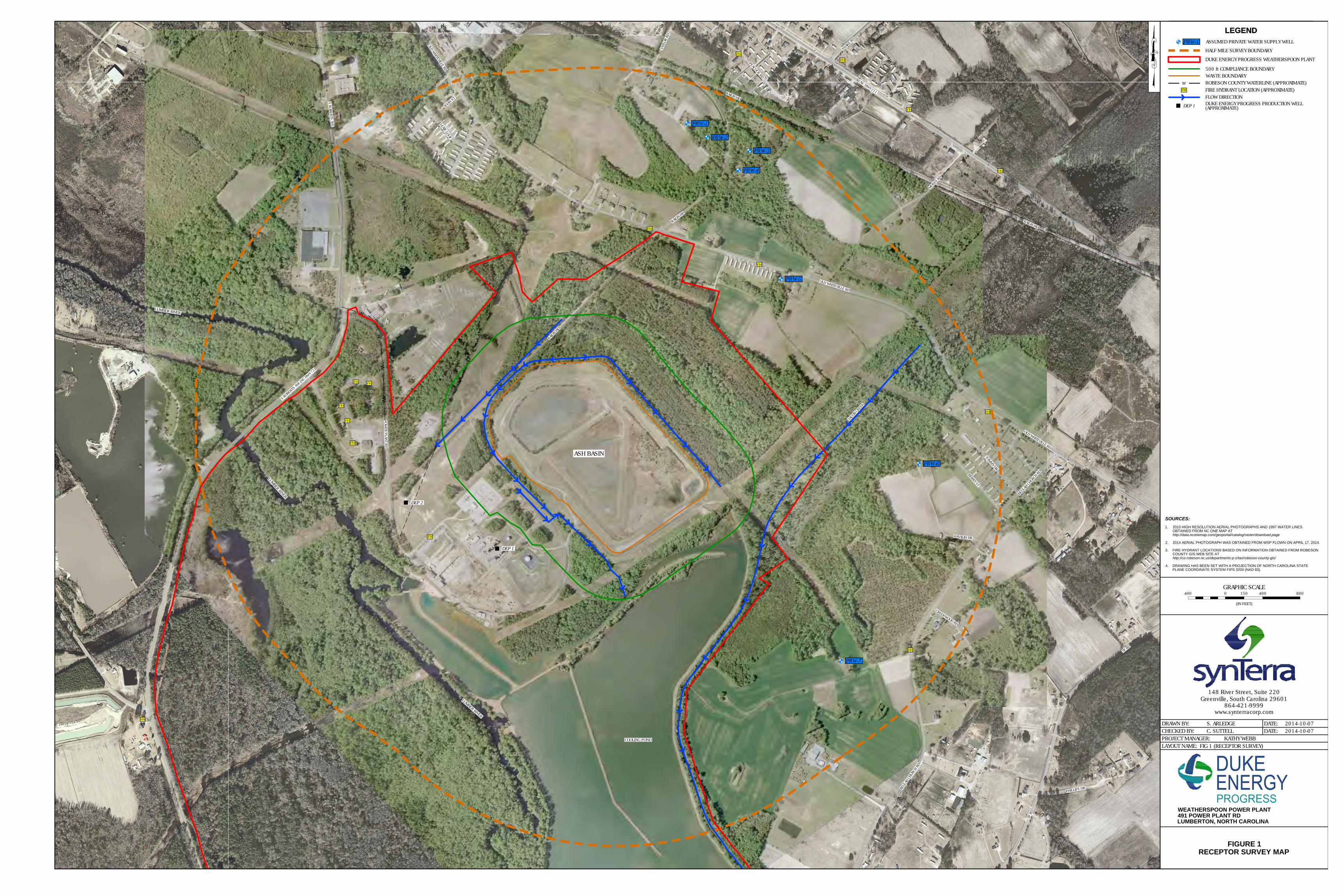
1.0 INTRODUCTION Duke Energy Progress, Inc. (Duke Energy) owns and operates the W.H. Weatherspoon Power Plant (Weatherspoon Plant) site. The Weatherspoon Plant is located at 491 Power Plant Road, Lumberton, North Carolina. The property encompasses approximately 985 acres, including the 65-acre ash basin. The property includes the cooling pond, located to the south of the plant operations area. The property borders the Lumber River to the southwest as shown on Figure 1.
The Weatherspoon Plant began commercial operation in 1949, with additions in the 1950s and 1970s, and consisted of three coal-fired units to produce power. As of October 2011, all of the coal-fired units were retired. Coal ash is no longer produced at the site. Ash generated from the coal combustion has been stored on-site in an ash basin. The ash basin is shown on Figure 1.
Discharge from the ash basin is permitted by the North Carolina Department of Environment and Natural Resources (NCDENR) Division of Water Resources (DWR) under the National Pollution Discharge Elimination System (NPDES) Permit NC0005363.
SynTerra has completed a receptor survey to identify water supply wells, public water supplies, surface water bodies, and wellhead protection areas (if present) within a 0.5 mile radius of the Weatherspoon Plant ash basin compliance boundary (Figure 1). The compliance boundary for groundwater quality in relation to the ash basin is defined in accordance with 15A NCAC 02L .0107(a) as being established at either 500 feet from the waste boundary or at the property boundary, whichever is closer to the source.
The survey scope and findings are presented in the following sections.
Page 1 P:\Duke Energy Progress.1026\ALL NC SITES\NPDES Permit Deliverables\Weatherspoon\Receptor
Survey\Weatherspoon Receptor Survey.docx

Receptor Survey October 2014 W.H. Weatherspoon Power Plant, NPDES Permit # NC0005363 SynTerra
2.0 BACKGROUND
2.1 Plant and Ash Basin Area Description The Weatherspoon Plant generated electricity via the three coal-fired generating units between 1949 and 2011. In 2011, the coal-fired units were retired from operation and are in the process of being decommissioned.
Between approximately 1949 and 1955, ash was sluiced to a low area that was eventually encompassed by the ash basin. The ash basin, as it currently exists, was constructed in phases, using a combination of excavation and earthen dike construction techniques, between 1955 and 1979.
Although the basin is a single unit, several internal divisions constructed over the operational years have facilitated basin management and maintenance.
The ash basin is permitted under National Pollutant Discharge Elimination System (NPDES) Permit NC0005363 as a wastewater treatment unit. Permitted waste streams included (1) ash sluice water (bottom and fly ash), (2) chemical and metal cleaning waste materials, (3) storm water runoff, and (4) various low-volume wastes.
2.2 Description of Surrounding Properties Properties located within a 0.5 mile radius of the Weatherspoon Plant compliance boundary are located in Robeson County, North Carolina. The properties uses include residential, commercial, industrial, and agricultural. The Lumber River flows south through the southwestern portion of the Plant property.
Figure 1 depicts the properties surrounding the Weatherspoon Plant.
Page 2 P:\Duke Energy Progress.1026\ALL NC SITES\NPDES Permit Deliverables\Weatherspoon\Receptor
Survey\Weatherspoon Receptor Survey.docx
Receptor Survey October 2014 W.H. Weatherspoon Power Plant, NPDES Permit # NC0005363 SynTerra
3.0 RECEPTOR SURVEY ACTIVITIES
3.1 NCDENR Records Review SynTerra reviewed the NCDENR Department of Environmental Health (DEH) Public Water Supply Section’s (PWSS) Public Water Supply Water Sources Geographic Information System (GIS) point data set (pwsws.shp) and the Water Distribution Map Service (WDMS) data set obtained from the NC OneMap GeoSpatial Portal (http://data.nconemap.com/geoportal/catalog/main/home.page) to identify public water supply sources and water supply lines within a 0.5 mile radius of the Weatherspoon Plant compliance boundary.
According to the NC OneMap website, the Public Water Supply Water Sources point data was current through November 18, 2009, and that it is the most current GIS data set of public water supply locations available from North Carolina state agencies. The GIS point data for the public water supply wells includes, but is not limited to, information such as public water supply (PWS) system identification numbers, ownership information, PWS source type, well depth, and well yield. The WDMS data set contains information on municipal water lines and other appurtenances.
On June 24, 2014, SynTerra reviewed the NCDENR DWR Source Water Assessment Program (SWAP) online database for public water supply sources to identify wells located within a 0.5 mile radius of the compliance boundary; to confirm the location of wells included in the Public Water Supply Water Sources GIS point data set, and to identify any wellhead protection areas located within a 0.5 mile radius of the compliance boundary. The NCDENR SWAP database provides detailed assessments of all public drinking water intakes and wellhead protection areas in North Carolina. The website address is: (http://swap.ncwater.org/website/swap/viewer.htm).
3.2 Robeson County GIS Information obtained from the Robeson County GIS system show fire hydrants located along Old Whiteville Road and Beulah Church Road. These locations are shown on Figure 1.
3.3 Environmental Data Resources, Inc. Records Review A review of public database information provided by Environmental Data Resources, Inc. (EDR) was also conducted. The public water well information has been incorporated in the summary table (Table 1) and on Figure 1. A copy of the EDR report is included as Appendix A.
Page 3 P:\Duke Energy Progress.1026\ALL NC SITES\NPDES Permit Deliverables\Weatherspoon\Receptor
Survey\Weatherspoon Receptor Survey.docx
Receptor Survey October 2014 W.H. Weatherspoon Power Plant, NPDES Permit # NC0005363 SynTerra
3.4 USGS Hydrography Review SynTerra reviewed the United States Geological Survey (USGS) National Hydrography Dataset (NHD) obtained from the USGS National Map Viewer (http://viewer.nationalmap.gov/viewer/) to identify surface waters within a 0.5 mile radius of the compliance boundary. Hydrography data obtained from the USGS NHD is included on Figure 1.
3.5 SynTerra Field Survey During February and March, 2014, SynTerra personnel conducted a vehicular survey along public roads located within 0.5 mile radius of the compliance boundary. Observations on property use, apparent proximity to available municipal water lines and structures that may represent potential water supply wells were noted.
3.6 Previous Water Supply Well Survey Information A receptor survey was conducted by S&ME in February and May 2012. During that survey, S&ME contacted City of Lumberton and Robeson County personnel regarding municipal water present within the Plant vicinity. The results of the S&ME Survey have been incorporated into the findings of this report.
Page 4 P:\Duke Energy Progress.1026\ALL NC SITES\NPDES Permit Deliverables\Weatherspoon\Receptor
Survey\Weatherspoon Receptor Survey.docx
Receptor Survey October 2014 W.H. Weatherspoon Power Plant, NPDES Permit # NC0005363 SynTerra
4.0 FINDINGS
4.1 NCDENR Records No public water supply wells were identified in the Public Water Supply Water Sources GIS point data set (obtained from NC OneMap GeoSpatial Portal) or on the NCDENR SWAP online database within a 0.5 mile radius of the compliance boundary, with the exception of the two supply wells, DEP #1 and #2, located on the Plant property.
No wellhead protection areas were identified on the NCDENR SWAP online database within a 0.5 mile radius of the compliance boundary, with the exception of the two supply wells, DEP #1 and #2, located on the Plant property.
According to the Water Distribution Map Service (WDMS) data set obtained from the NC OneMap GeoSpatial Portal, municipal water supply lines are located along Old Whiteville Road and Beulah Church Road east and southeast of the Plant, as well as along a portion of Power Plant Road and South Roberts Ave north of the Plant.
4.2 Environmental Data Resources, Inc. Records The EDR report did not identify any municipal water supply wells or off-site private water supply wells located within 0.5 mile radius of the compliance boundary. The only water supply wells identified in the EDR report are the two on-site supply wells (DEP #1 and #2). According to the EDR report, both wells are approximately 200 feet deep and screened within the Black Creek Formation. Both are located west of the ash basin compliance boundary. A copy of the EDR Report is provided in Appendix A.
4.3 USGS Hydrography Review An approximate 8,600 foot long section of the Lumber River is located within the western portion of the survey radius (Figure 1). The Lumber River flows south.
In addition to the Lumber River and the cooling pond for the Plant, several small surface water features, including Jacob Swamp to the southeast, are present within the 0.5 mile radius of the compliance boundary. Jacob Swamp is fed by a number of tributaries to the northeast and flows southwest along the southeastern side of the cooling pond until it joins the Lumber River.
4.4 SynTerra Field Survey SynTerra conducted a visual reconnaissance of the survey area by driving public road-ways and noting properties that appeared to be developed or occupied. Much of the area is serviced by municipal water. Water valves and fire hydrants were observed along Old Whiteville Road and Beulah Church Road. No structures resembling water
Page 5 P:\Duke Energy Progress.1026\ALL NC SITES\NPDES Permit Deliverables\Weatherspoon\Receptor
Survey\Weatherspoon Receptor Survey.docx
Receptor Survey October 2014 W.H. Weatherspoon Power Plant, NPDES Permit # NC0005363 SynTerra
supply wells or well houses were noted during the visual reconnaissance. Properties within 0.5 mile radius of the compliance boundary that appeared to be developed and in-use (occupied) with no apparent municipal water supply were assumed to have private water supply wells (PRW). These properties are noted on Figure 1.
4.5 S&ME Receptor Survey According to the S&ME survey, the City of Lumberton’s potable water sources include eight deep groundwater wells and the Lumber River. The locations for each of the source wells and surface water intake are greater than 1 mile from the Plant, and therefore beyond the 0.5 mile radius of the compliance boundary. The Robeson County municipal water supply wells are located approximately 4 miles from the Plant.
The City of Lumberton has a water distribution line along South Roberts Avenue to the Lumber River. The City also maintains a water line that runs east along Old Whiteville Road to the Southern States facility. Beyond the Southern States facility, Robeson County maintains the water line to the County line.
The County water system also provides service along Beulah Church Road. Portions of Old Whiteville Road and Beulah Church Road are within the 0.5-mile radius of the receptor survey.
The S&ME survey reported seven possible residential water supply wells located within 0.5 mile radius of the compliance boundary. These locations were identified by S&ME as potentially having a water supply well based on the property having a structure that may be occupied and not having a municipal water account.
• Four potential well locations (Well ID # PRW-1 through PRW- 4) are located along Taylor Drive, approximately 2,200 feet north-northeast of the compliance boundary. Taylor Drive is clearly marked as a private road, therefore SynTerra did not trespass to visually confirm the possible existence of these wells. The County GIS information does not indicate fire hydrants along Taylor Drive. Aerial photography indicates likely residences at locations #1, 3 and 4. However, the structure referenced as possible well location PRW-2, does not appear to be maintained or may not be a residence. County GIS information also indicates no improvement value for this parcel. Therefore, the PRW-2 well location is characterized as possible rather than suspected.
• A potential well location (Well ID PRW-5) is located on Old Whiteville Road, approximately 1,500 feet northeast of the compliance boundary. A fire hydrant is located near the property. The location is noted as a potential well due to the
Page 6 P:\Duke Energy Progress.1026\ALL NC SITES\NPDES Permit Deliverables\Weatherspoon\Receptor
Survey\Weatherspoon Receptor Survey.docx

Receptor Survey October 2014 W.H. Weatherspoon Power Plant, NPDES Permit # NC0005363 SynTerra
S&ME report indicating no public water account information. A possible well structure was not observed during the drive-by survey. The residence was not well maintained and may not be occupied.
• A suspected well (Well ID PRW-6) may be located at the end of Havalih Drive, approximately 1,750 feet east of the compliance boundary. Havalih Drive is marked as a private road. SynTerra did not trespass to visually confirm the possible existence of the well. The County GIS information does not show a fire hydrant on Havalih Drive. Aerial photography indicates a likely residence at this location.
• A possible well (Well ID PRW-7) may be located off of Beulah Church Road, approximately 1,800 feet southeast of the compliance boundary. The location is noted as a possible well due to the S&ME report indicating no public water account information. The location was not observed during the drive-by survey due to the distance from the public road. The structure visible on the aerial photograph at this location is smaller than a typical residence and may be a small barn or shed.
4.6 Summary of Receptor Survey Findings A summary of the receptor survey is discussed below. The suspected water supply well locations shown on Figure 1 are based upon field observations, S&ME, EDR, and NCDENR information. The suspected well locations are numbered on the map to cross-reference information provided in Table 1. The table summarizes property location and owner information where a water supply well may be present based upon drive-by observations, S&ME or EDR information.
• No wellhead protection areas were identified within a 0.5 mile radius of the compliance boundary, with the exception of the two supply wells, DEP #1 and #2, which are located on the Plant property;
• Approximately seven (7) possible private water supply wells are assumed to be located within 0.5 mile radius of the compliance boundary;
• A number of surface water features and wetlands are present within the 0.5 mile radius of the compliance boundary, including Jacob Swamp. The surface water features flow toward the Lumber River;
• An approximate 8,600 foot long section of the Lumber River is located within the western portion of the survey radius. The Lumber River flows southeast.
Page 7 P:\Duke Energy Progress.1026\ALL NC SITES\NPDES Permit Deliverables\Weatherspoon\Receptor
Survey\Weatherspoon Receptor Survey.docx

FIGURE
W
WW
W
W
W
W
FIG 1 (RECEPTOR SURVEY)
2014-10-072014-10-07C. SUTTELL
S. ARLEDGE
PROJECT MANAGER:LAYOUT NAME:
DRAWN BY:CHECKED BY:
KATHY WEBB
DATE:DATE:
800GRAPHIC SCALE
(IN FEET)
0 400150400
www.synterracorp.com
148 River Street, Suite 220Greenville, South Carolina 29601
864-421-9999
FIGURE 1RECEPTOR SURVEY MAP
WEATHERSPOON POWER PLANT491 POWER PLANT RDLUMBERTON, NORTH CAROLINA
BEULA
H CHURCH RDBERRY ST
TOMMY DR
BEUL
AH C
HURCH
RD
OLD WHITEVILLE RD
OLD WHITEVILLE RD
OLD WHITEVILLE RD
RAILROAD
RAILROAD
ASH BASIN
LUMBER RIVER
COOLING POND
LUMBER RIVER
POWER PLAN
T RD
S ROBERTS AVE
S ROBERTS AVE (N
C HWY 72)
RAILROAD
RAILROAD
TP R
D
PHILLIPS DR
TP RD
LUMBER RIVER
HAVALIH DR
CREEKWOOD RD
TAYL
OR R
D
MOSES RD
LEXIE LOOP
RYAN ST
FH
FH
FH
FHFH
FH
FH
FH
FH
FH
FH
FH
FHFH
SNAKE RD
PEACOCK RD
NC HWY 211
FH
JACOB CREE
K
LEGEND
HALF MILE SURVEY BOUNDARY
ROBESON COUNTY WATERLINE (APPROXIMATE)W
500 ft COMPLIANCE BOUNDARY
DUKE ENERGY PROGRESS WEATHERSPOON PLANT
LEGEND
WASTE BOUNDARY
FIRE HYDRANT LOCATION (APPROXIMATE)FH
PRW-1 ASSUMED PRIVATE WATER SUPPLY WELL
SOURCES:1. 2010 HIGH RESOLUTION AERIAL PHOTOGRAPHS AND 1997 WATER LINES
OBTAINED FROM NC ONE MAP AThttp://data.nconemap.com/geoportal/catalog/raster/download.page
2. 2014 AERIAL PHOTOGRAPH WAS OBTAINED FROM WSP FLOWN ON APRIL 17, 2014.
3. FIRE HYDRANT LOCATIONS BASED ON INFORMATION OBTAINED FROM ROBESONCOUNTY GIS WEB SITE AThttp://co.robeson.nc.us/departments-p-z/tax/robeson-county-gis/
4. DRAWING HAS BEEN SET WITH A PROJECTION OF NORTH CAROLINA STATEPLANE COORDINATE SYSTEM FIPS 3200 (NAD 83).
FLOW DIRECTION
PRW-1
PRW-2
PRW-3
PRW-4
PRW-5
PRW-6
PRW-7
DUKE ENERGY PROGRESS PRODUCTION WELL(APPROXIMATE)DEP 1
DEP 2
DEP 1

TABLE
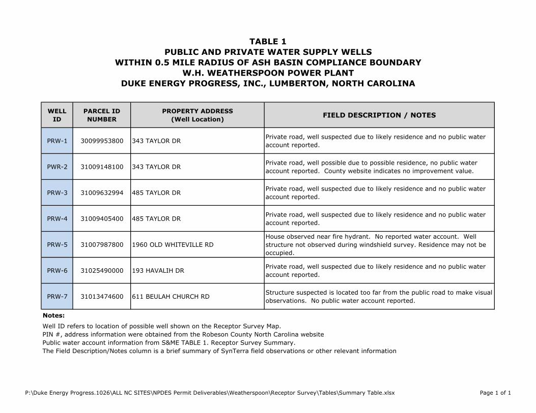
TABLE 1
PUBLIC AND PRIVATE WATER SUPPLY WELLS
WITHIN 0.5 MILE RADIUS OF ASH BASIN COMPLIANCE BOUNDARY
W.H. WEATHERSPOON POWER PLANT
DUKE ENERGY PROGRESS, INC., LUMBERTON, NORTH CAROLINA
WELL
ID
PARCEL ID
NUMBER
PROPERTY ADDRESS
(Well Location)FIELD DESCRIPTION / NOTES
PRW-1 30099953800 343 TAYLOR DRPrivate road, well suspected due to likely residence and no public water
account reported.
PWR-2 31009148100 343 TAYLOR DRPrivate road, well possible due to possible residence, no public water
account reported. County website indicates no improvement value.
PRW-3 31009632994 485 TAYLOR DRPrivate road, well suspected due to likely residence and no public water
account reported.
PRW-4 31009405400 485 TAYLOR DRPrivate road, well suspected due to likely residence and no public water
account reported.
PRW-5 31007987800 1960 OLD WHITEVILLE RD
House observed near fire hydrant. No reported water account. Well
structure not observed during windshield survey. Residence may not be
occupied.
PRW-6 31025490000 193 HAVALIH DRPrivate road, well suspected due to likely residence and no public water
account reported.
PRW-7 31013474600 611 BEULAH CHURCH RDStructure suspected is located too far from the public road to make visual
observations. No public water account reported.
The Field Description/Notes column is a brief summary of SynTerra field observations or other relevant information
PIN #, address information were obtained from the Robeson County North Carolina website
Notes:
Well ID refers to location of possible well shown on the Receptor Survey Map.
Public water account information from S&ME TABLE 1. Receptor Survey Summary.
P:\Duke Energy Progress.1026\ALL NC SITES\NPDES Permit Deliverables\Weatherspoon\Receptor Survey\Tables\Summary Table.xlsx Page 1 of 1
APPENDIX A
EDR REPORT
FORM-NULL-CCA
tropeR ®kcehCoeG RDE ehT
6 Armstrong Road, 4th floorShelton, CT 06484Toll Free: 800.352.0050www.edrnet.com
Duke Energy - Weatherspoon491 Power Plant Rd.Lumberton, NC 28358
Inquiry Number: 3887612.1sMarch 21, 2014
SECTION PAGE
GEOCHECK ADDENDUM
Physical Setting Source Addendum A-1
Physical Setting Source Summary A-2
Physical Setting Source Map A-7
Physical Setting Source Map Findings A-8
Physical Setting Source Records Searched A-13
TC3887612.1s Page 1
Thank you for your business.Please contact EDR at 1-800-352-0050
with any questions or comments.
Disclaimer - Copyright and Trademark Notice
This Report contains certain information obtained from a variety of public and other sources reasonably available to Environmental DataResources, Inc. It cannot be concluded from this Report that coverage information for the target and surrounding properties does not exist fromother sources. NO WARRANTY EXPRESSED OR IMPLIED, IS MADE WHATSOEVER IN CONNECTION WITH THIS REPORT. ENVIRONMENTALDATA RESOURCES, INC. SPECIFICALLY DISCLAIMS THE MAKING OF ANY SUCH WARRANTIES, INCLUDING WITHOUT LIMITATION,MERCHANTABILITY OR FITNESS FOR A PARTICULAR USE OR PURPOSE. ALL RISK IS ASSUMED BY THE USER. IN NO EVENT SHALLENVIRONMENTAL DATA RESOURCES, INC. BE LIABLE TO ANYONE, WHETHER ARISING OUT OF ERRORS OR OMISSIONS, NEGLIGENCE,ACCIDENT OR ANY OTHER CAUSE, FOR ANY LOSS OF DAMAGE, INCLUDING, WITHOUT LIMITATION, SPECIAL, INCIDENTAL,CONSEQUENTIAL, OR EXEMPLARY DAMAGES. ANY LIABILITY ON THE PART OF ENVIRONMENTAL DATA RESOURCES, INC. IS STRICTLYLIMITED TO A REFUND OF THE AMOUNT PAID FOR THIS REPORT. Purchaser accepts this Report "AS IS". Any analyses, estimates, ratings,environmental risk levels or risk codes provided in this Report are provided for illustrative purposes only, and are not intended to provide, norshould they be interpreted as providing any facts regarding, or prediction or forecast of, any environmental risk for any property. Only a Phase IEnvironmental Site Assessment performed by an environmental professional can provide information regarding the environmental risk for anyproperty. Additionally, the information provided in this Report is not to be construed as legal advice.
Copyright 2014 by Environmental Data Resources, Inc. All rights reserved. Reproduction in any media or format, in wholeor in part, of any report or map of Environmental Data Resources, Inc., or its affiliates, is prohibited without prior written permission.
EDR and its logos (including Sanborn and Sanborn Map) are trademarks of Environmental Data Resources, Inc. or its affiliates. All othertrademarks used herein are the property of their respective owners.
TABLE OF CONTENTS

TC3887612.1s Page 1
geologic strata.of the soil, and nearby wells. Groundwater flow velocity is generally impacted by the nature of theGroundwater flow direction may be impacted by surface topography, hydrology, hydrogeology, characteristics
2. Groundwater flow velocity. 1. Groundwater flow direction, and
Assessment of the impact of contaminant migration generally has two principal investigative components:
forming an opinion about the impact of potential contaminant migration.EDR’s GeoCheck Physical Setting Source Addendum is provided to assist the environmental professional in
1997Most Recent Revision:34078-E8 SOUTHEAST LUMBERTON, NCTarget Property Map:
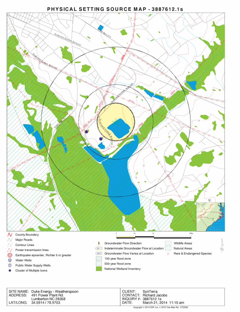
USGS TOPOGRAPHIC MAP
140 ft. above sea levelElevation:3829408.5UTM Y (Meters): 686147.7UTM X (Meters): Zone 17Universal Tranverse Mercator: 78.9703 - 78˚ 58’ 13.08’’Longitude (West): 34.5914 - 34˚ 35’ 29.04’’Latitude (North):
TARGET PROPERTY COORDINATES
LUMBERTON, NC 28358491 POWER PLANT RD.DUKE ENERGY - WEATHERSPOON
TARGET PROPERTY ADDRESS
®GEOCHECK - PHYSICAL SETTING SOURCE REPORT ®

TC3887612.1s Page 2
should be field verified.on a relative (not an absolute) basis. Relative elevation information between sites of close proximitySource: Topography has been determined from the USGS 7.5’ Digital Elevation Model and should be evaluated
SURROUNDING TOPOGRAPHY: ELEVATION PROFILES
Ele
vatio
n (f
t)E
leva
tion
(ft)
TP
TP0 1/2 1 Miles
✩Target Property Elevation: 140 ft.
North South
West East
104
104
104
104
104
104
114
122
127
140
139
135
137
140
141
142
148
149
154104
104
104
106
119
140
140
139
139
140
136 118
114
109
111
115
122
124
131
General SEGeneral Topographic Gradient:TARGET PROPERTY TOPOGRAPHY
should contamination exist on the target property, what downgradient sites might be impacted.assist the environmental professional in forming an opinion about the impact of nearby contaminated properties or,Surface topography may be indicative of the direction of surficial groundwater flow. This information can be used toTOPOGRAPHIC INFORMATION
collected on nearby properties, and regional groundwater flow information (from deep aquifers).sources of information, such as surface topographic information, hydrologic information, hydrogeologic datausing site-specific well data. If such data is not reasonably ascertainable, it may be necessary to rely on otherGroundwater flow direction for a particular site is best determined by a qualified environmental professionalGROUNDWATER FLOW DIRECTION INFORMATION
®GEOCHECK - PHYSICAL SETTING SOURCE SUMMARY®
TC3887612.1s Page 3
Not Reported
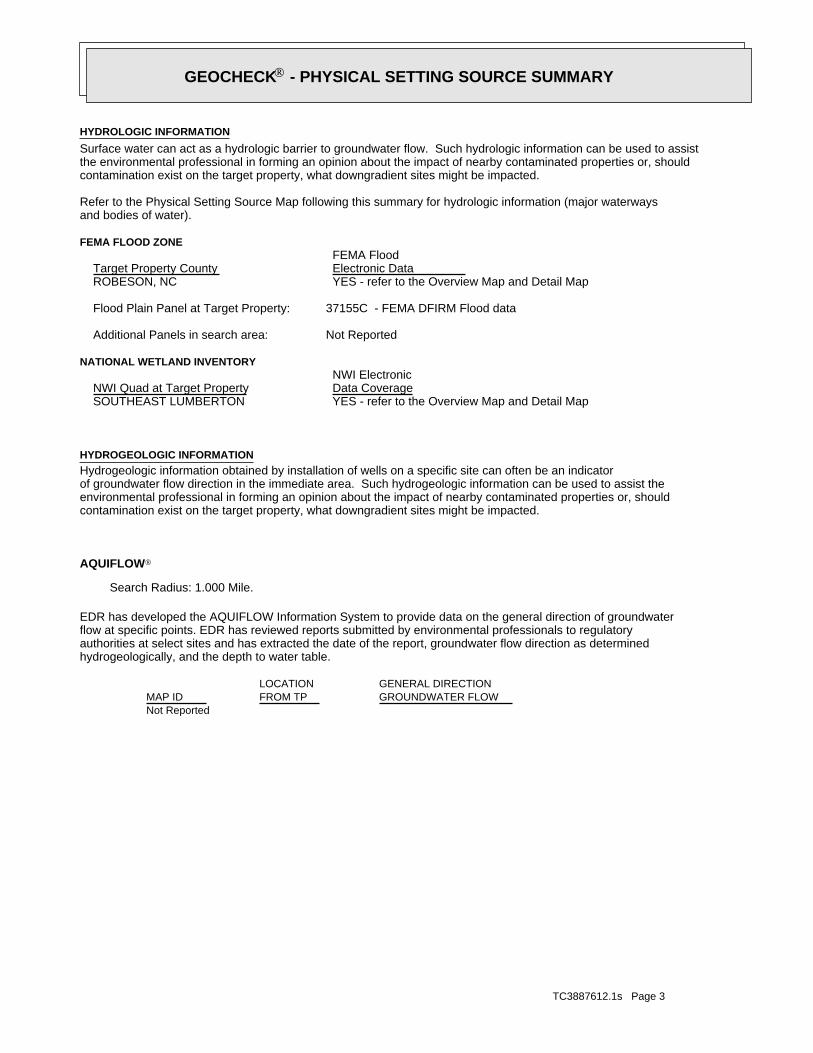
GENERAL DIRECTIONLOCATIONGROUNDWATER FLOWFROM TPMAP ID
hydrogeologically, and the depth to water table.authorities at select sites and has extracted the date of the report, groundwater flow direction as determinedflow at specific points. EDR has reviewed reports submitted by environmental professionals to regulatoryEDR has developed the AQUIFLOW Information System to provide data on the general direction of groundwater
AQUIFLOW®
Search Radius: 1.000 Mile.
contamination exist on the target property, what downgradient sites might be impacted.environmental professional in forming an opinion about the impact of nearby contaminated properties or, shouldof groundwater flow direction in the immediate area. Such hydrogeologic information can be used to assist theHydrogeologic information obtained by installation of wells on a specific site can often be an indicatorHYDROGEOLOGIC INFORMATION
YES - refer to the Overview Map and Detail MapSOUTHEAST LUMBERTON
NATIONAL WETLAND INVENTORYNWI ElectronicData CoverageNWI Quad at Target Property
Not ReportedAdditional Panels in search area:
37155C - FEMA DFIRM Flood dataFlood Plain Panel at Target Property:
YES - refer to the Overview Map and Detail MapROBESON, NC
FEMA FLOOD ZONEFEMA FloodElectronic DataTarget Property County
and bodies of water).Refer to the Physical Setting Source Map following this summary for hydrologic information (major waterways
contamination exist on the target property, what downgradient sites might be impacted.the environmental professional in forming an opinion about the impact of nearby contaminated properties or, shouldSurface water can act as a hydrologic barrier to groundwater flow. Such hydrologic information can be used to assistHYDROLOGIC INFORMATION
®GEOCHECK - PHYSICAL SETTING SOURCE SUMMARY®
TC3887612.1s Page 4
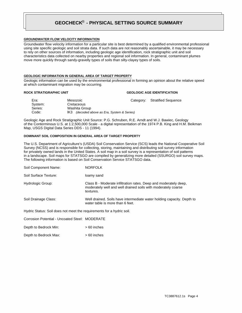
> 60 inchesDepth to Bedrock Max:
> 60 inchesDepth to Bedrock Min:
MODERATECorrosion Potential - Uncoated Steel:
Hydric Status: Soil does not meet the requirements for a hydric soil.
water table is more than 6 feet.Well drained. Soils have intermediate water holding capacity. Depth toSoil Drainage Class:
textures.moderately well and well drained soils with moderately coarseClass B - Moderate infiltration rates. Deep and moderately deep,Hydrologic Group:
loamy sandSoil Surface Texture:
NORFOLK Soil Component Name:
The following information is based on Soil Conservation Service STATSGO data.in a landscape. Soil maps for STATSGO are compiled by generalizing more detailed (SSURGO) soil survey maps.for privately owned lands in the United States. A soil map in a soil survey is a representation of soil patternsSurvey (NCSS) and is responsible for collecting, storing, maintaining and distributing soil survey informationThe U.S. Department of Agriculture’s (USDA) Soil Conservation Service (SCS) leads the National Cooperative Soil
DOMINANT SOIL COMPOSITION IN GENERAL AREA OF TARGET PROPERTY
Map, USGS Digital Data Series DDS - 11 (1994).of the Conterminous U.S. at 1:2,500,000 Scale - a digital representation of the 1974 P.B. King and H.M. BeikmanGeologic Age and Rock Stratigraphic Unit Source: P.G. Schruben, R.E. Arndt and W.J. Bawiec, Geology
ROCK STRATIGRAPHIC UNIT GEOLOGIC AGE IDENTIFICATION
Stratified SequenceCategory:MesozoicEra:CretaceousSystem:Washita GroupSeries:lK3Code: (decoded above as Era, System & Series)
at which contaminant migration may be occurring.Geologic information can be used by the environmental professional in forming an opinion about the relative speedGEOLOGIC INFORMATION IN GENERAL AREA OF TARGET PROPERTY
move more quickly through sandy-gravelly types of soils than silty-clayey types of soils.characteristics data collected on nearby properties and regional soil information. In general, contaminant plumesto rely on other sources of information, including geologic age identification, rock stratigraphic unit and soilusing site specific geologic and soil strata data. If such data are not reasonably ascertainable, it may be necessaryGroundwater flow velocity information for a particular site is best determined by a qualified environmental professionalGROUNDWATER FLOW VELOCITY INFORMATION
®GEOCHECK - PHYSICAL SETTING SOURCE SUMMARY®
TC3887612.1s Page 5
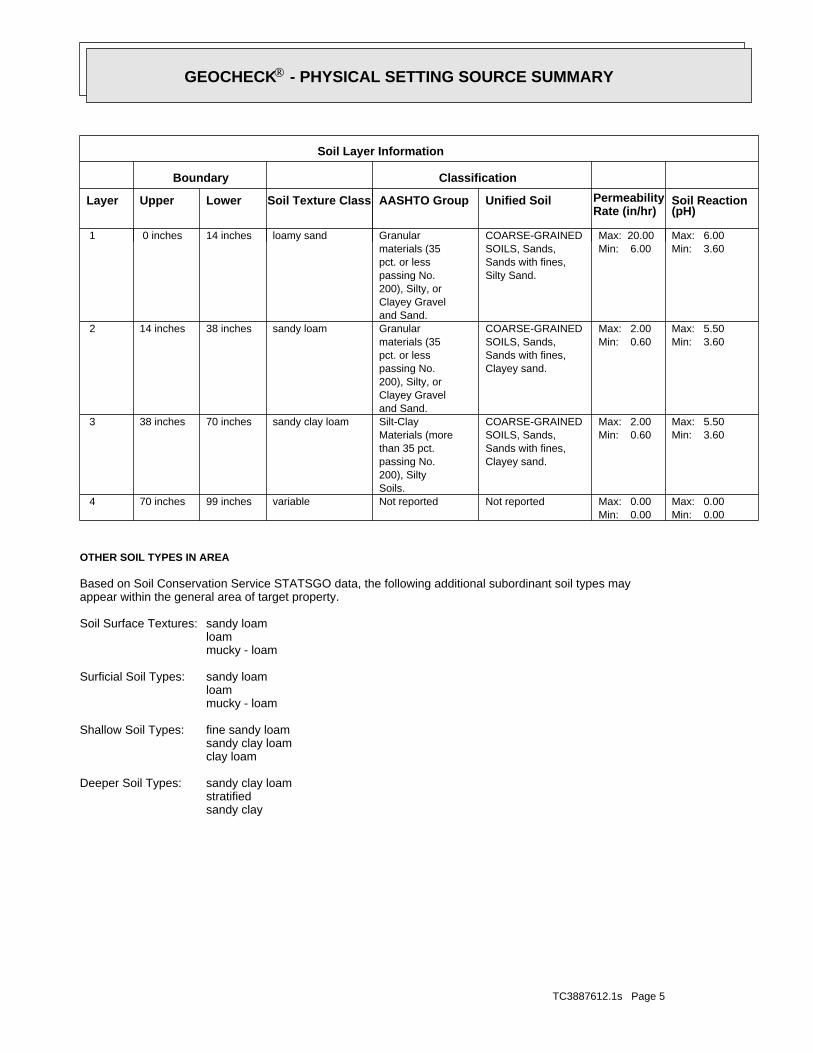
sandy claystratifiedsandy clay loamDeeper Soil Types:
clay loamsandy clay loamfine sandy loamShallow Soil Types:
mucky - loamloamsandy loamSurficial Soil Types:
mucky - loamloamsandy loamSoil Surface Textures:
appear within the general area of target property.Based on Soil Conservation Service STATSGO data, the following additional subordinant soil types may
OTHER SOIL TYPES IN AREA
Min: 0.00Max: 0.00
Min: 0.00Max: 0.00Not reportedNot reportedvariable99 inches70 inches 4
Min: 3.60Max: 5.50
Min: 0.60Max: 2.00
Clayey sand.Sands with fines,SOILS, Sands,COARSE-GRAINED
Soils.200), Siltypassing No.than 35 pct.Materials (moreSilt-Claysandy clay loam70 inches38 inches 3
Min: 3.60Max: 5.50
Min: 0.60Max: 2.00
Clayey sand.Sands with fines,SOILS, Sands,COARSE-GRAINED
and Sand.Clayey Gravel200), Silty, orpassing No.pct. or lessmaterials (35Granularsandy loam38 inches14 inches 2
Min: 3.60Max: 6.00
Min: 6.00Max: 20.00
Silty Sand.Sands with fines,SOILS, Sands,COARSE-GRAINED
and Sand.Clayey Gravel200), Silty, orpassing No.pct. or lessmaterials (35Granularloamy sand14 inches 0 inches 1
Soil Layer Information
Boundary Classification
PermeabilityRate (in/hr)
Layer Upper Lower Soil Texture Class AASHTO Group Unified Soil Soil Reaction(pH)
®GEOCHECK - PHYSICAL SETTING SOURCE SUMMARY®

TC3887612.1s Page 6
Plants NC50016878_________ ___Class ID
NORTH CAROLINA NATURAL HERITAGE ELEMENT OCCURRENCES
OTHER STATE DATABASE INFORMATION
1/4 - 1/2 Mile WSWNC2000000000640 B31/4 - 1/2 Mile SWNC2000000000639 A2
STATE DATABASE WELL INFORMATION
LOCATIONFROM TPWELL IDMAP ID
Note: PWS System location is not always the same as well location.
No PWS System Found
FEDERAL FRDS PUBLIC WATER SUPPLY SYSTEM INFORMATION
LOCATIONFROM TPWELL IDMAP ID
1/4 - 1/2 Mile WSWUSGS40000882622 B51/4 - 1/2 Mile WSWUSGS40000882623 B41/4 - 1/2 Mile SWUSGS40000882617 A1
FEDERAL USGS WELL INFORMATION
LOCATIONFROM TPWELL IDMAP ID
1.000State Database1.000Federal FRDS PWS1.000Federal USGS
WELL SEARCH DISTANCE INFORMATION
SEARCH DISTANCE (miles)DATABASE
opinion about the impact of contaminant migration on nearby drinking water wells.professional in assessing sources that may impact ground water flow direction, and in forming anEDR Local/Regional Water Agency records provide water well information to assist the environmental
LOCAL / REGIONAL WATER AGENCY RECORDS
®GEOCHECK - PHYSICAL SETTING SOURCE SUMMARY®
EDR Inc.EDR Inc.EDR Inc.EDR Inc.EDR Inc.EDR Inc.EDR Inc.EDR Inc.EDR Inc.EDR Inc.EDR Inc.EDR Inc.EDR Inc.EDR Inc.EDR Inc.EDR Inc.EDR Inc.EDR Inc.EDR Inc.EDR Inc.EDR Inc.EDR Inc.EDR Inc.EDR Inc.EDR Inc.EDR Inc.EDR Inc.EDR Inc.EDR Inc.EDR Inc.EDR Inc.EDR Inc.EDR Inc.EDR Inc.EDR Inc.EDR Inc.EDR Inc.EDR Inc.EDR Inc.EDR Inc.
120
120
120
130
130
130
130
140
140
150
110
110
230kv
230 k
v
230 k
v
115
kv
115 kv23
0 kv
230 k
v
230
kv 115
kv
230
kv
0
115
kv
115 kv
BBBBB
AAAAA
0 1/4 1/2 1 Miles
NC
TC3887612.1s Page 8
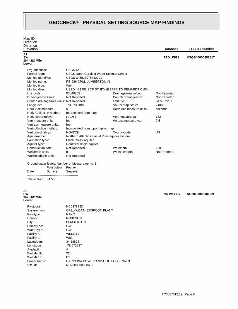
NC2000000000639Site id:CAROLINA POWER AND LIGHT CO_378733Owner name:FTWell dep 1:220Well depth:AAvailavili:-78.973727Longitude :34.58802Latitude m:W01Facility a:WELL #1Facility n:GWWater type:GWPrimary so:LUMBERTONCity:ROBESONCounty:NTNCPws type:CP&L-WEATHERSPOON PLANTSystem nam:NC0378733Pwsidentif:
A2SW1/4 - 1/2 MileLower
NC2000000000639NC WELLS
1992-10-22 64.50
DateFeet belowSurface
Feet toSealevel
-------------------------------------------------
Ground-water levels, Number of Measurements: 1
Not ReportedWellholedepth units:Not ReportedWellholedepth:ftWelldepth units:220Welldepth:Not ReportedConstruction date:
Confined single aquiferAquifer type:Black Creek AquiferFormation type:Northern Atlantic Coastal Plain aquifer systemAquifername:
USCountrycode:NGVD29Vert coord refsys:Interpolated from topographic mapVertcollection method:feetVert accmeasure units:
2.5Vertacc measure val:feetVert measure units:132Vert measure val:NAD83Horiz coord refsys:
Interpolated from mapHoriz Collection method:secondsHoriz Acc measure units:5Horiz Acc measure:24000Sourcemap scale:-78.9739188Longitude:34.5882207Latitude:Not ReportedContrib drainagearea units:Not ReportedContrib drainagearea:Not ReportedDrainagearea Units:Not ReportedDrainagearea value:03040203Huc code:
USED IN 1992 SCP STUDY (REFER TO REMARKS C185)Monloc desc:WellMonloc type:RB-226 CP&L LUMBERTON #1Monloc name:USGS-343517078582701Monloc Identifier:USGS North Carolina Water Science CenterFormal name:USGS-NCOrg. Identifier:
A1SW1/4 - 1/2 MileLower
USGS40000882617FED USGS
Map IDDirectionDistanceElevation EDR ID NumberDatabase
®GEOCHECK - PHYSICAL SETTING SOURCE MAP FINDINGS®

TC3887612.1s Page 9
Note: A nearby site that taps the same aquifer was being pumped.1992-10-22 82.3
DateFeet belowSurface
Feet toSealevel
-------------------------------------------------
Ground-water levels, Number of Measurements: 1
ftWellholedepth units:200Wellholedepth:ftWelldepth units:200Welldepth:Not ReportedConstruction date:
Confined single aquiferAquifer type:Black Creek AquiferFormation type:Northern Atlantic Coastal Plain aquifer systemAquifername:
USCountrycode:NGVD29Vert coord refsys:Interpolated from topographic mapVertcollection method:feetVert accmeasure units:
2.5Vertacc measure val:feetVert measure units:137Vert measure val:NAD83Horiz coord refsys:
Interpolated from mapHoriz Collection method:secondsHoriz Acc measure units:5Horiz Acc measure:24000Sourcemap scale:-78.9772523Longitude:34.5896095Latitude:Not ReportedContrib drainagearea units:Not ReportedContrib drainagearea:Not ReportedDrainagearea Units:Not ReportedDrainagearea value:03040203Huc code:
USED IN 1992 SCP STUDY (REFER TO REMARK IN C185)Monloc desc:WellMonloc type:RB-228 CP&L LUMBRTN-1992Monloc name:USGS-343522078583902Monloc Identifier:USGS North Carolina Water Science CenterFormal name:USGS-NCOrg. Identifier:
B4WSW1/4 - 1/2 MileLower
USGS40000882623FED USGS
NC2000000000640Site id:CAROLINA POWER AND LIGHT CO_378733Owner name:FTWell dep 1:193Well depth:AAvailavili:-78.977115Longitude :34.58929Latitude m:W02Facility a:WELL #2Facility n:GWWater type:GWPrimary so:LUMBERTONCity:ROBESONCounty:NTNCPws type:CP&L-WEATHERSPOON PLANTSystem nam:NC0378733Pwsidentif:
B3WSW1/4 - 1/2 MileLower
NC2000000000640NC WELLS
Map IDDirectionDistanceElevation EDR ID NumberDatabase
®GEOCHECK - PHYSICAL SETTING SOURCE MAP FINDINGS®

TC3887612.1s Page 10
Ground-water levels, Number of Measurements: 0
Not ReportedWellholedepth units:Not ReportedWellholedepth:ftWelldepth units:193Welldepth:Not ReportedConstruction date:
Confined single aquiferAquifer type:Black Creek AquiferFormation type:Northern Atlantic Coastal Plain aquifer systemAquifername:
USCountrycode:NGVD29Vert coord refsys:Interpolated from topographic mapVertcollection method:feetVert accmeasure units:
2.5Vertacc measure val:feetVert measure units:137Vert measure val:NAD83Horiz coord refsys:
Interpolated from mapHoriz Collection method:secondsHoriz Acc measure units:5Horiz Acc measure:24000Sourcemap scale:-78.9772523Longitude:34.5896095Latitude:Not ReportedContrib drainagearea units:Not ReportedContrib drainagearea:Not ReportedDrainagearea Units:Not ReportedDrainagearea value:03040203Huc code:
WELL TO BE REPLACED W/ NEARBY WELL (DRILLED 4/92)Monloc desc:WellMonloc type:RB-227 CP&L LUMBERTON #2Monloc name:USGS-343522078583901Monloc Identifier:USGS North Carolina Water Science CenterFormal name:USGS-NCOrg. Identifier:
B5WSW1/4 - 1/2 MileLower
USGS40000882622FED USGS
Map IDDirectionDistanceElevation EDR ID NumberDatabase
®GEOCHECK - PHYSICAL SETTING SOURCE MAP FINDINGS®

TC3887612.1s Page 11
Historic, no evidence of destructionOccurrence Status:PlantsClassification by Type:12558GIS ID:
NC50016878NC_NHEO
Map IDDirectionDistance EDR ID NumberDatabase
®GEOCHECK - PHYSICAL SETTING SOURCE MAP FINDINGS®

TC3887612.1s Page 12
Not ReportedNot ReportedNot ReportedNot ReportedBasementNot ReportedNot ReportedNot ReportedNot ReportedLiving Area - 2nd Floor0%0%100%0.350 pCi/LLiving Area - 1st Floor
% >20 pCi/L% 4-20 pCi/L% <4 pCi/LAverage ActivityArea
Number of sites tested: 6
Federal Area Radon Information for Zip Code: 28358
: Zone 3 indoor average level < 2 pCi/L. : Zone 2 indoor average level >= 2 pCi/L and <= 4 pCi/L. Note: Zone 1 indoor average level > 4 pCi/L.
Federal EPA Radon Zone for ROBESON County: 3
0.30.30.301
__________________________________Max pCi/LMin pCi/LAvg pCi/LNum Results
Radon Test Results
State Database: NC Radon
AREA RADON INFORMATION
®GEOCHECK - PHYSICAL SETTING SOURCE MAP FINDINGSRADON
®
TOPOGRAPHIC INFORMATION
USGS 7.5’ Digital Elevation Model (DEM)Source: United States Geologic SurveyEDR acquired the USGS 7.5’ Digital Elevation Model in 2002 and updated it in 2006. The 7.5 minute DEM correspondsto the USGS 1:24,000- and 1:25,000-scale topographic quadrangle maps. The DEM provides elevation datawith consistent elevation units and projection.
HYDROLOGIC INFORMATION
Flood Zone Data: This data, available in select counties across the country, was obtained by EDR in 2003 & 2011 from the FederalEmergency Management Agency (FEMA). Data depicts 100-year and 500-year flood zones as defined by FEMA.
NWI: National Wetlands Inventory. This data, available in select counties across the country, was obtained by EDRin 2002, 2005 and 2010 from the U.S. Fish and Wildlife Service.
State Wetlands Data: Wetlands InventorySource: Department of Environment & Natural ResourcesTelephone: 919-733-2090
HYDROGEOLOGIC INFORMATION
AQUIFLOW Information SystemR
Source: EDR proprietary database of groundwater flow informationEDR has developed the AQUIFLOW Information System (AIS) to provide data on the general direction of groundwater
flow at specific points. EDR has reviewed reports submitted to regulatory authorities at select sites and hasextracted the date of the report, hydrogeologically determined groundwater flow direction and depth to water tableinformation.
GEOLOGIC INFORMATION
Geologic Age and Rock Stratigraphic UnitSource: P.G. Schruben, R.E. Arndt and W.J. Bawiec, Geology of the Conterminous U.S. at 1:2,500,000 Scale - A digitalrepresentation of the 1974 P.B. King and H.M. Beikman Map, USGS Digital Data Series DDS - 11 (1994).
STATSGO: State Soil Geographic DatabaseSource: Department of Agriculture, Natural Resources Conservation ServicesThe U.S. Department of Agriculture’s (USDA) Natural Resources Conservation Service (NRCS) leads the nationalConservation Soil Survey (NCSS) and is responsible for collecting, storing, maintaining and distributing soilsurvey information for privately owned lands in the United States. A soil map in a soil survey is a representationof soil patterns in a landscape. Soil maps for STATSGO are compiled by generalizing more detailed (SSURGO)soil survey maps.
SSURGO: Soil Survey Geographic DatabaseSource: Department of Agriculture, Natural Resources Conservation Services (NRCS)Telephone: 800-672-5559SSURGO is the most detailed level of mapping done by the Natural Resources Conservation Services, mappingscales generally range from 1:12,000 to 1:63,360. Field mapping methods using national standards are used toconstruct the soil maps in the Soil Survey Geographic (SSURGO) database. SSURGO digitizing duplicates theoriginal soil survey maps. This level of mapping is designed for use by landowners, townships and countynatural resource planning and management.
TC3887612.1s Page A-13
PHYSICAL SETTING SOURCE RECORDS SEARCHED
LOCAL / REGIONAL WATER AGENCY RECORDS
FEDERAL WATER WELLS
PWS: Public Water SystemsSource: EPA/Office of Drinking WaterTelephone: 202-564-3750Public Water System data from the Federal Reporting Data System. A PWS is any water system which provides water to at
least 25 people for at least 60 days annually. PWSs provide water from wells, rivers and other sources.
PWS ENF: Public Water Systems Violation and Enforcement DataSource: EPA/Office of Drinking WaterTelephone: 202-564-3750Violation and Enforcement data for Public Water Systems from the Safe Drinking Water Information System (SDWIS) after
August 1995. Prior to August 1995, the data came from the Federal Reporting Data System (FRDS).
USGS Water Wells: USGS National Water Inventory System (NWIS)This database contains descriptive information on sites where the USGS collects or has collected data on surfacewater and/or groundwater. The groundwater data includes information on wells, springs, and other sources of groundwater.
STATE RECORDS
North Carolina Public Water Supply WellsSource: Department of Environmental HealthTelephone: 919-715-3243
OTHER STATE DATABASE INFORMATION
NC Natural Areas: Significant Natural Heritage AreasSource: Center for Geographic Information and AnalysisTelephone: 919-733-2090A polygon converage identifying sites (terrestrial or aquatic that have particular biodiversity significance.
A site’s significance may be due to the presenceof rare species, rare or hight quality natural communities, orother important ecological features.
NC Game Lands: Wildlife Resources Commission Game LandsSource: Center for Geographic Information and AnalysisTelephone: 919-733-2090All publicly owned game lands managed by the North Carolina Wildlife Resources Commission and as listed in Hunting
and Fishing Maps.
NC Natural Heritage Sites: Natural Heritage Element Occurrence SitesSource: Center for Geographic Information and AnalysisTelephone: 919-733-2090A point coverage identifying locations of rare and endangered species, occurrences of exemplary or unique natural
ecosystems (terrestrial or aquatic), and special animal habitats (e.g., colonial waterbird nesting sites).
RADON
State Database: NC RadonSource: Department of Environment & Natural ResourcesTelephone: 919-733-4984Radon Statistical and Non Statiscal Data
Area Radon InformationSource: USGSTelephone: 703-356-4020The National Radon Database has been developed by the U.S. Environmental Protection Agency(USEPA) and is a compilation of the EPA/State Residential Radon Survey and the National Residential Radon Survey.The study covers the years 1986 - 1992. Where necessary data has been supplemented by information collected atprivate sources such as universities and research institutions.
TC3887612.1s Page A-14
PHYSICAL SETTING SOURCE RECORDS SEARCHED
EPA Radon ZonesSource: EPATelephone: 703-356-4020Sections 307 & 309 of IRAA directed EPA to list and identify areas of U.S. with the potential for elevated indoorradon levels.
OTHER
Airport Landing Facilities: Private and public use landing facilitiesSource: Federal Aviation Administration, 800-457-6656
Epicenters: World earthquake epicenters, Richter 5 or greaterSource: Department of Commerce, National Oceanic and Atmospheric Administration
Earthquake Fault Lines: The fault lines displayed on EDR’s Topographic map are digitized quaternary faultlines, preparedin 1975 by the United State Geological Survey
STREET AND ADDRESS INFORMATION
© 2010 Tele Atlas North America, Inc. All rights reserved. This material is proprietary and the subject of copyright protectionand other intellectual property rights owned by or licensed to Tele Atlas North America, Inc. The use of this material is subjectto the terms of a license agreement. You will be held liable for any unauthorized copying or disclosure of this material.
TC3887612.1s Page A-15
PHYSICAL SETTING SOURCE RECORDS SEARCHED