when disaster strikes, again
TRANSCRIPT

1
Flood Mitigation ProgramProtecting Lives, Protecting Property | Floodplain Management, Mapping, and Mitigation
www.dnr.sc.gov/flood
WHEN DISASTER
STRIKES, AGAIN
Maria Cox Lamm, CFM
Ed Dickson, PE, CFM
May 3, 2017

2
Agenda
• Introduction/2015 Recovery
• Hurricane Matthew
• 2015/Matthew Compare
• Flood Mitigation Program
• Response and Recovery
• Lessons Learned
• Path Toward Resilience

3
Introduction

4
Introduction
• 2015 Recovery was progressing in some cases

5
Introduction
• 2015 Recovery not progressing well in other cases

6
v
Hurricane
Matthew

7
Hurricane Matthew - Coastal
Landfall – McClellanville, SC on morning of October 8, 2016
GoogleMaps

8
State of Emergency and Evacuations
• State of Emergency issued Tuesday October 4
• Evacuations for entire coast of SC began Wednesday October 5
• Interstate 26 reversed on Wednesday October 5
• Lane reversal ended on Friday October 7
Hurricane Matthew - Coastal
• Lifted evacuation
orders on Sunday and
Monday, October 9th
and 10th

9
Hurricane Matthew - Coastal
Edisto Beach, SC - Before: Mapbox, Digital Globe and OpenStreetMap
After: NOAA National Geodetic Survey
Storm Surges:
Edisto Beach – 6.6’
Charleston – 6.1’
Myrtle Beach – 4.4’

10
Hurricane Matthew - Coastal
Edisto Beach - Palmetto Blvd

11
Hurricane Matthew - Riverine
Max 48-hr Precipitation
Darkest Blue = > 16 inches
Little Pee Dee and Waccamaw Watersheds 12 -18 in
Max 48-hr ARI
Darkest Maroon = > 1,000-year ARI
Little Pee Dee and Waccamaw Watersheds > 100 yr events

12
Hurricane Matthew - Riverine
Pee Dee, Little Pee Dee and Waccamaw gages set all-time stage records

13
2015 / 2016

14
2015 / 2016 Storm Data
The % area of South Carolina that received rainfall within a given ARI range is below
20162015

15
2015 / 2016 Impact Stats
2016Damage
Total Public Damage
SC Direct Cost
Infrastructure
Agriculture
FEMA public aid
Private insurance claims
Housing restore needs
SBA loans
FEMA Individual Aid
Tourism Losses
$2,200
$150
$150
$580
$300
$280
$140
$80
$90
NA
$340
$64
$100
$50
$32
$70
3*
$25
$28
$32
Dollar amounts in Millions
* Estimated
2015

16
SCDNR Flood
Mitigation Program
17
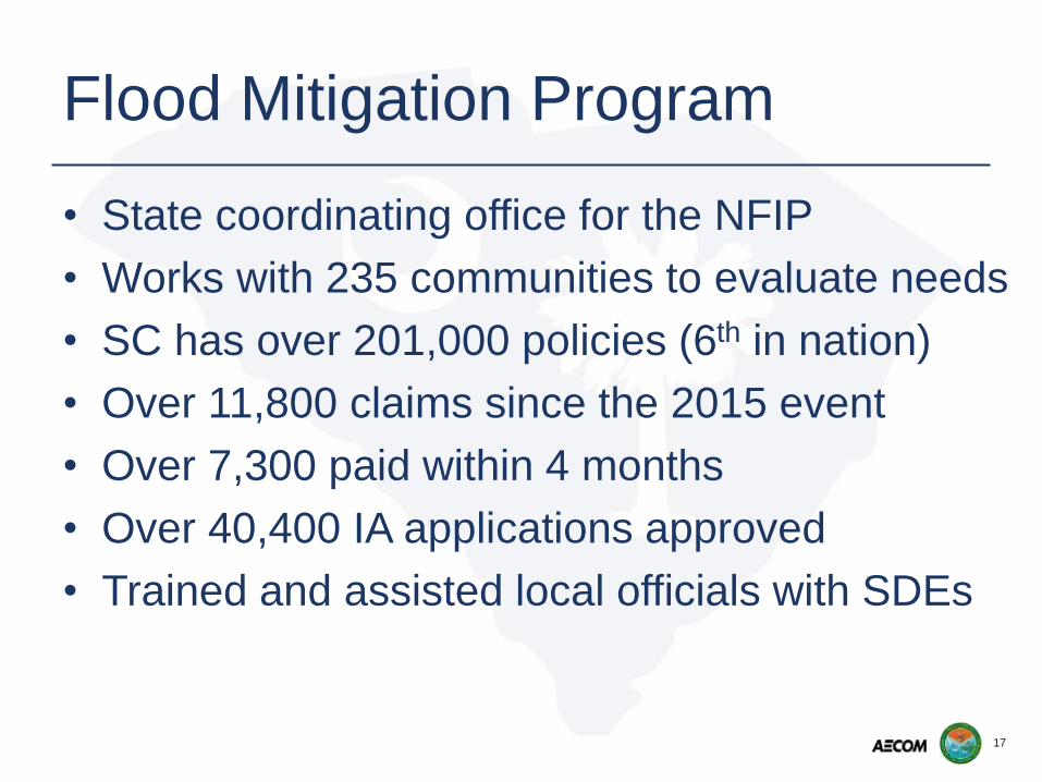
Flood Mitigation Program
• State coordinating office for the NFIP
• Works with 235 communities to evaluate needs
• SC has over 201,000 policies (6th in nation)
• Over 11,800 claims since the 2015 event
• Over 7,300 paid within 4 months
• Over 40,400 IA applications approved
• Trained and assisted local officials with SDEs

18
Flood Mitigation Program
• Assist in any way possible
• Began to look at impact of potential significant rainfall before the storm
• Identified Little Pee Dee (LPD), Pee Dee, and Waccamaw as potential issues
• After landfall analyzed rainfall totals in SC & NC
• Concern raised about available flood forecasts

19
Flood Mitigation Program
• Concern about LPD, and Waccamaw forecasts
• Both blackwater rivers
• Had a moment to investigate
• Whitewater vs blackwater

20
Response &
Recovery

21
Response & Recovery
• Voiced concerns at SEOC
• Town of Nichols requested evacuation assistance
• SCDNR requested inundation map
• Law Enforcement used map to organize and stage resources

22
Response & Recovery
• Produced inundation information and peak arrival time estimates
• Provided specialized information for officers in the field

23
Response & Recovery
• Officers
shared info
from the
field to verify
inundation

24
Drone Ortho Overlay

25
Response & Recovery
Finally ahead of the water…
• Bucksport

26
Response & Recovery
– SCDOT – use to assist in determining what roads to close and for how long
– SCDNR Wildlife and Freshwater Fisheries – used to assist in determining where to close deer season
– Local Floodplain Managers – used to assist in evacuations
– SCDHEC – used Drone information from Nichols
• Word got out

27
Lessons Learned

28
Lessons Learned
• Flood Mitigation Program responded immediately to assist
• Need a clearly defined communication tree
• Emergency Response people did not know who to contact
• Called several people off hours

29
Lessons Learned
• The way you communicate is paramount
• Focus your communication in a precise and detailed manner
• How much do you push?
• Have to speak for all impacted communities
• If you have more in depth knowledge or information don’t be afraid to share

30
Path Toward
Resilience

32
Path Toward Resilience
• Dedicated website
– Platform to display digital data
– Develop SC specific database
– Point and click BFEs, risk assessment, and
downloadable data and models
– Flood warning system

33
Path Toward Resilience
• Flood warning system
– Statewide, seamless system
– Real-time mapping
– State-of-the art tools and approach
– Integrate riverine and coastal hazards
– Holistic approach
– Plan, Prepare, Respond, and Recover

34
Be prepared to take the heat

35
Flood Mitigation ProgramProtecting Lives, Protecting Property | Floodplain Management, Mapping, and Mitigation
www.dnr.sc.gov/flood
QUESTIONS&COMMENTS
Maria Cox Lamm, CFM
Ed Dickson, PE, CFM
May 3, 2017