will millard - journey of a lifetime 2013 · 1.2 sierra leone and liberia: towards peace and...
TRANSCRIPT
!"#$%&'()*+,-.*/!
0"1)2+3("4')/-.5)2+6"5.(&1+7#.&-+893:+;+<"='$(1+">+)+?.>(&.*(+@.$$('+ABCD+
!"#$%&'()"*)"&+,-"-.&$%/."-.(".(+&-"$,"01(&&+"2($'("+'3"21*(&1+45"6(+7("6+&8"EF/(G.&."$+0(/"'&+H.(2G+G)&(%I+J&-+K/'.2+;+DB&-+L)1+ABCD+"""""""""""
" " " "" " " " !
!!!!!!!!!!!!!!!!!!!!!!!!!!!!!!!!!!!!!!!!!!!!!!!!!!!!!!!!!!!!!!!!!!!!!!!!!!!!!!!!!!!!!!!!!!!!!!!!!!!!!!!!!!!!!!!!!!
!!!!!!!!!!!!!!!!!!!!!!!!!!!!!!!!!!!!!!!!!!!!!!!!
!!!!!!!!!!!Will Millard www.willmillard.com
[email protected] t. @MillardWill
m. (+44)(0)7979747500
Contents 1.1 Abstract…………………………...………………………………….……......p.3 1.2 Sierra Leone and Liberia: towards peace and development………......…..p.4 1.3 The Upper Guinean Forest belt: an area of global importance…………...p.5 1. 4 The Peace Park………………………………….…………………………....p.6 2.0 My aims………………………………………..………………………...…….p.8 2.2 Sponsorship and Support…………………………………………………...p.10 2.3 Team Members………………………………………………………....….....p.11 3.0 The Journey of a Lifetime – An introduction………………………….….p.12 3.1 The Journey of a Lifetime – the Expedition………………………..……..p.12 3.2 the Journey of a Lifetime – The Peace Park, an impossible dream?.........p.29 4.0 Acknowledgements…………………………………………………….……..p.33 5.0 Expenses………………………………………………………………………p.35

1.1 Abstract In the spring of 2013 the nations of Sierra Leone and Liberia were due to combine their sections of Gola forest to form one unbroken ‘Peace Park’ – a visionary project aiming to protect the most critically endangered African JUNGLE: the Upper Guinean forest belt. My aim was to packraft the length of their shared international border, down the Moro and Mano rivers and through the heart of the newly formed conservation area - raising awareness of the forest and investigating conservation and community in this much misunderstood region. However, I soon discovered the Peace Park project had been setback by six months due to a delay in the establishment of the Gola National Park in Liberia. Without National Parks to cover both sections of forest the Transboundary Peace Park would be meaningless as over half of the area would be effectively unmanaged. In Liberia disagreements over the location of the Park’s border, accusations of corruption within the Forestry Department, and the involvement of mining and logging concessions, have blighted the delivery of the dream. I discovered disgruntlement within local forest communities on both sides of the river, which felt the establishment of the Park did not have their best interests at heart and claimed it would restrict their access to commercial forest products. I had arrived at probably the perfect time. Not only were the environmental conditions ideal for the descent, but the conflicting arguments afforded me a privileged glimpse into the work required to balance conservation ambitions with community development. I found the Gola Rainforest National Park (GRNP) in Sierra Leone to be very well managed with effective community development and research departments. Their support for my expedition proved invaluable to the success of this project, particularly after I contracted malaria during the descent. They act as an excellent template looking forwards to the future of the Transboundary Park. Map 1 – Project area and line of descent
1.2 Sierra Leone and Liberia: towards peace and development +From 1991 to 2002 the nations of Sierra Leone and Liberia were synonymous with a brutal civil war revolving around blood diamonds, child soldiers and vicious mass amputations. Their bloody history has overwhelmed these small nations to such an extent that the great strides both have made since the war are often overlooked; by 2012 in Sierra Leone the UN peace building office had scaled down its staff from 300 to just a few dozen, Sierra Leone’s army now contributes to peacekeeping missions elsewhere in Africa, and over in Liberia a truth and reconciliation commission has been active since 2006. Further progress has been felt with peaceful and democratic elections in both nations: 2012 saw President Bai Koroma re-elected in Freetown in a free and fair election for his second-term running and in 2005 Ellen Johnson Sir Leaf became the first female President in Africa. Yet both nations remain rooted to the very base of the Human Development Index and are heavily reliant on donor aid. The war ground almost all commercial mineral and logging infrastructure to a complete halt. As such both nations are keen today to attract foreign investors to profit from their comparatively abundant natural resources including: diamonds, iron ore, timber and oil, yet, despite assurances, the age-old criticisms of nepotism, corruption and environmentally insensitive exploitation continue to dog progress. An audit of lucrative resource deals in Liberia found almost all the concessions awarded by the government since 2009 have not been compliant with the law. In a damning report commissioned by the Liberian government, international auditors found that only two out of 68 resource contracts worth $8bn (£5.1bn) were conducted properly. Concessions granted in agriculture, forestry, mining and oil – including a lucrative deal with oil company Chevron – were either wholly or partially flawed. In Sierra Leone Al Jazeera revealed Koroma’s vice President, Sam Sumana, had accepted a bribe to allow a particular timber sanction to go ahead and, despite widespread criticism, kept his office. The embarrassment caused by this incident in particular created a hurdle when it came to gaining my Government permissions for this BBC Radio project. As both nation’s emerge from the shadow of war there is a clear need for money to be made available to continue economic growth and the development of infrastructure. The challenge they face is ensuring the reasonable and fair use of the resources they have, taking into account the critically endangered forest within their nations, and receiving prompt recuperation from schemes such as REDD as reward for their preservation. Critical to gaining local support is the commitment of profits from natural resource harvesting to local infrastructure, especially roads, hospitals and schools. As I shall highlight in this report, in my project area and in both districts either side of the Mano/Moro Rivers, the level of community development was significantly poorer than the rest of the nation (particularly when compared with the capitals Monrovia and Freetown) in spite of the commercial activities already present in this area (mining, palm oil, commercial cocoa plantations and timber extraction). Indeed, east of the Sierra Leone diamond-trading centre, Kenema, the main road leading to the Liberian border was little more than a dirt track in places, reachable only by foot for the majority of forest communities.
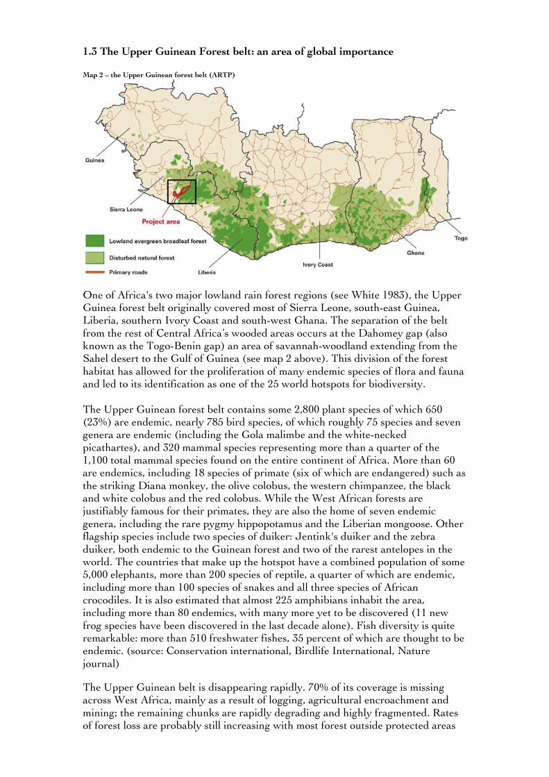
1.3 The Upper Guinean Forest belt: an area of global importance Map 2 – the Upper Guinean forest belt (ARTP)
One of Africa's two major lowland rain forest regions (see White 1983), the Upper Guinea forest belt originally covered most of Sierra Leone, south-east Guinea, Liberia, southern Ivory Coast and south-west Ghana. The separation of the belt from the rest of Central Africa’s wooded areas occurs at the Dahomey gap (also known as the Togo-Benin gap) an area of savannah-woodland extending from the Sahel desert to the Gulf of Guinea (see map 2 above). This division of the forest habitat has allowed for the proliferation of many endemic species of flora and fauna and led to its identification as one of the 25 world hotspots for biodiversity. The Upper Guinean forest belt contains some 2,800 plant species of which 650 (23%) are endemic, nearly 785 bird species, of which roughly 75 species and seven genera are endemic (including the Gola malimbe and the white-necked picathartes), and 320 mammal species representing more than a quarter of the 1,100 total mammal species found on the entire continent of Africa. More than 60 are endemics, including 18 species of primate (six of which are endangered) such as the striking Diana monkey, the olive colobus, the western chimpanzee, the black and white colobus and the red colobus. While the West African forests are justifiably famous for their primates, they are also the home of seven endemic genera, including the rare pygmy hippopotamus and the Liberian mongoose. Other flagship species include two species of duiker: Jentink's duiker and the zebra duiker, both endemic to the Guinean forest and two of the rarest antelopes in the world. The countries that make up the hotspot have a combined population of some 5,000 elephants, more than 200 species of reptile, a quarter of which are endemic, including more than 100 species of snakes and all three species of African crocodiles. It is also estimated that almost 225 amphibians inhabit the area, including more than 80 endemics, with many more yet to be discovered (11 new frog species have been discovered in the last decade alone). Fish diversity is quite remarkable: more than 510 freshwater fishes, 35 percent of which are thought to be endemic. (source: Conservation international, Birdlife International, Nature journal)
The Upper Guinean belt is disappearing rapidly. 70% of its coverage is missing across West Africa, mainly as a result of logging, agricultural encroachment and mining; the remaining chunks are rapidly degrading and highly fragmented. Rates of forest loss are probably still increasing with most forest outside protected areas
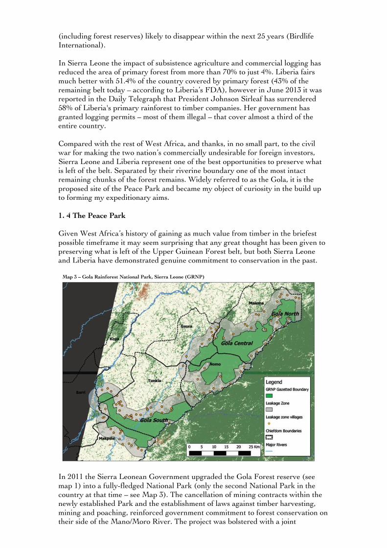
(including forest reserves) likely to disappear within the next 25 years (Birdlife International). In Sierra Leone the impact of subsistence agriculture and commercial logging has reduced the area of primary forest from more than 70% to just 4%. Liberia fairs much better with 51.4% of the country covered by primary forest (43% of the remaining belt today – according to Liberia’s FDA), however in June 2013 it was reported in the Daily Telegraph that President Johnson Sirleaf has surrendered 58% of Liberia's primary rainforest to timber companies. Her government has granted logging permits – most of them illegal – that cover almost a third of the entire country. Compared with the rest of West Africa, and thanks, in no small part, to the civil war for making the two nation’s commercially undesirable for foreign investors, Sierra Leone and Liberia represent one of the best opportunities to preserve what is left of the belt. Separated by their riverine boundary one of the most intact remaining chunks of the forest remains. Widely referred to as the Gola, it is the proposed site of the Peace Park and became my object of curiosity in the build up to forming my expeditionary aims. 1. 4 The Peace Park Given West Africa’s history of gaining as much value from timber in the briefest possible timeframe it may seem surprising that any great thought has been given to preserving what is left of the Upper Guinean Forest belt, but both Sierra Leone and Liberia have demonstrated genuine commitment to conservation in the past. Map 3 – Gola Rainforest National Park, Sierra Leone (GRNP)
In 2011 the Sierra Leonean Government upgraded the Gola Forest reserve (see map 1) into a fully-fledged National Park (only the second National Park in the country at that time – see Map 3). The cancellation of mining contracts within the newly established Park and the establishment of laws against timber harvesting, mining and poaching, reinforced government commitment to forest conservation on their side of the Mano/Moro River. The project was bolstered with a joint
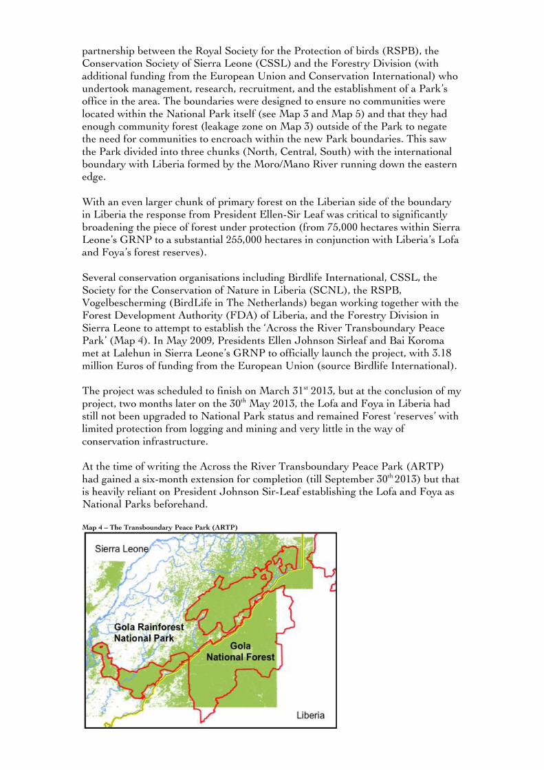
partnership between the Royal Society for the Protection of birds (RSPB), the Conservation Society of Sierra Leone (CSSL) and the Forestry Division (with additional funding from the European Union and Conservation International) who undertook management, research, recruitment, and the establishment of a Park’s office in the area. The boundaries were designed to ensure no communities were located within the National Park itself (see Map 3 and Map 5) and that they had enough community forest (leakage zone on Map 3) outside of the Park to negate the need for communities to encroach within the new Park boundaries. This saw the Park divided into three chunks (North, Central, South) with the international boundary with Liberia formed by the Moro/Mano River running down the eastern edge. With an even larger chunk of primary forest on the Liberian side of the boundary in Liberia the response from President Ellen-Sir Leaf was critical to significantly broadening the piece of forest under protection (from 75,000 hectares within Sierra Leone’s GRNP to a substantial 255,000 hectares in conjunction with Liberia’s Lofa and Foya’s forest reserves). Several conservation organisations including Birdlife International, CSSL, the Society for the Conservation of Nature in Liberia (SCNL), the RSPB, Vogelbescherming (BirdLife in The Netherlands) began working together with the Forest Development Authority (FDA) of Liberia, and the Forestry Division in Sierra Leone to attempt to establish the ‘Across the River Transboundary Peace Park’ (Map 4). In May 2009, Presidents Ellen Johnson Sirleaf and Bai Koroma met at Lalehun in Sierra Leone’s GRNP to officially launch the project, with 3.18 million Euros of funding from the European Union (source Birdlife International). The project was scheduled to finish on March 31st 2013, but at the conclusion of my project, two months later on the 30th May 2013, the Lofa and Foya in Liberia had still not been upgraded to National Park status and remained Forest ‘reserves’ with limited protection from logging and mining and very little in the way of conservation infrastructure. At the time of writing the Across the River Transboundary Peace Park (ARTP) had gained a six-month extension for completion (till September 30th 2013) but that is heavily reliant on President Johnson Sir-Leaf establishing the Lofa and Foya as National Parks beforehand. Map 4 – The Transboundary Peace Park (ARTP)
2.0 My aims I first came across the Peace Park whilst researching BBC Documentary ideas at Indus films back in 2010. A colleague and friend of mine, Will Lorimer, had recently returned from another Royal Geographical Society sponsored trip, ‘Atlantic Rising’, which was aiming to raise awareness of sea level rise through climate change. Will had spent a brief amount of time in the Gola during his journey and remembered the Peace Park in particular. As we were looking for new ideas for a wildlife television series based in post-conflict zones it sounded ideal on paper and I began the process of building up a case for its inclusion. In the event the entire series was dropped but I held on to my research notes, captivated by the forest’s ecology and, what I felt, genuine chance of survival. I left Indus in late 2011 and spent six months crossing West Papua in the first half of 2012 before applying in Autumn for the Royal Geographical Society’s ‘Journey of a Lifetime’ grant. I had been immensely privileged to spend almost two years exploring West Papua between 2007-12 but increasingly I found myself wanting to branch out and explore other unique parts of the planet. The grant appealed to me directly as an opportunity to combine both my journalistic and exploration ambitions with proper funds and a radio slot already guaranteed on my return – providing I didn’t lose the kit. As I investigated the Peace Park project further the list of wildlife species surpassed my wildest expectations and with the hostile histories of both nations firmly in the past the timing felt right for my idea. Then I discovered that the Peace Park was also bisected by a 100-mile long river, this, I felt, was the missing element to my Journey of a Lifetime application: an adventurous first descent of a jungle river in one of the most unknown and endangered forest habitats in all of Africa. I applied and numerous applications, an interview and a training day later, I received the news that I had been awarded the grant whilst out attempting a January ascent of the Pennine Way for Outdoor Fitness magazine. I was absolutely thrilled. My aims were two fold:
• Make a first descent of the Moro and Mano rivers from the point they form the international boundaries of Sierra Leone and Liberia to the river mouth in the Atlantic – a distance of 100 miles through the heart of the Peace Park – recording my journey, the hazards, the beauty and any animals I may encounter on the descent.
• Explore and record the challenges implicit in establishing conservation initiatives in Africa including: interviews with local politicians and policy makers, visiting the forest edge communities (including, where possible, illegal poachers, miners and loggers) and working alongside National Park employees and rangers.
To my mind the Peace Park was a microcosm of the wider challenges of establishing meaningful conservation in developing countries. I was compelled by the international cooperation on display, particularly across a boundary that had seen so much bloodshed in the past and remained entrenched in so much poverty. If it could work here then surely it could work anywhere. A model which could be rolled out across Africa, or so I thought.
2.1 Managing risk – pre-descent assessment vs on the ground reality With help from Shane Winser of the RGS Geography Outdoors department I drew up a Risk Assessment and Management plan (available on request, contact details on cover sheet) based on what I believed to be the greatest risks. The below outlines a few of the primary hazards and describes some of the risk reduction measures I took both before and during the project.
• Risks associated with being in a remote environment, particularly difficulties reaching professional medical aid.
I had decided to use local guiding from the Sierra Leonean side to get me to the most northerly part of the river (the very point it forms the international border – see map 1). Although it would not be possible to have company on the descent itself (locals did not use their dug outs to descend the entire river due to rapids, rocks and waterfalls) having a local guide on the walk-in meant I could take more safety equipment and provisions than I normally would be capable of carrying alone. I mapped the river’s course carefully with help from the GRNP who provided GPS details for all riverside communities, affording me a safety net should I have to abort and giving me a good knowledge of where and when my opportunities to resupply were, if required. At any rate, the furthest I would be from the main road to Kenema (in Sierra Leone – the closest medical facility) was roughly 18 miles – between a half-day to a days walk followed by a bike from the various riverside villages. Additionally, with just a total distance of approximately 100 miles to descend, 70 miles of which were within the forest, I felt that the maximum amount of time I would be descending the remotest portion would be no more than two weeks – a manageable period in terms of the food and first aid I would require. I took a satellite phone and endeavored to GPS tag and message out my progress every 24 hours to my contacts within the GRNP, who had access to two 4x4s, and made an emergency evacuation/search and rescue plan with them in the event of no contact (available on request). I have built up a good working knowledge of wilderness medicine over the last five years of exploration in West Papua and felt much better prepared in terms of navigational intelligence (of the route) than on any other previous international expedition, but I still endeavored to take a full first-aid kit and malaria treatment.
• Wild Animals - poisonous snakes and spiders, crocodiles, rabies and Lassa fever.
This was my first time in Africa. I have had a lot of previous experience with venomous snakes in New Guinea but didn’t wish to take anything for granted. I was advised the snakes in the region were not aggressive and that bites were uncommon. It also became clear the threat from crocodiles was very low (they were found only towards the river mouth and were not considered a threat), the hippos present were pygmies, a real rarity and naturally shy of people, likewise with leopards and forest elephants; the only cases of death had been to hunters who had wounded or threatened these animals first. I was inoculated against rabies prior to arrival and ensured all of my foodstuffs were properly prepared and packed away from rodents when not in use (Lassa is carried in rodent’s urine).
• River hazards – flooding, rapids and obstacles The risk of flooding was very low, water levels were down as my project began at the very end of the dry season, but flash flooding was a remote possibility. As such I endeavored to make camp on high ground when possible. There was one night

where it did rain very heavily. I kept a vigilant eye on the water level and did not notice any significant rise; again, the timing of my descent to meet the end of the dry season was critical. Rapids were ever present and represented one of my biggest risks. Capsizes, aside from being potentially deadly, could also see all my gear swept away in the current. I placed all gear within waterproof sacks provided by Aquapac and tied them securely to the raft, but this would not help if I lost my raft. Ultimately it came down to judgment, despite portaging being time consuming and exhausting it was the only way to guarantee safe passage through rapids. With experience I learnt which rapids I could risk with the raft and I generally made the correct judgments. Again, local information from the GRNP was useful – the largest waterfall was GPS marked prior to the descent and I was advised that low water would be my biggest adversary, certainly in the upper reaches of the Moro this proved to be the case and I found myself grounded on several occasions but this was not hazardous.
• Malaria A risk worthy of its own special mention: the biggest killer after road traffic accidents in this part of West Africa. I took Malarone as a prophylaxis1 and carried treatment in the event of a fever. I carried a thermometer, wore long sleeves and slept in a DD hammock with a mosquito net incorporated in the design. I still got malaria but the symptoms were far reduced thanks to the Malarone and the treatment I was able to apply immediately. "
• People Almost overwhelmingly the people I met were friendly and positive about the project, however there were instances where anger flared. Some of the forest communities living on the edges of the Park viewed the GRNP in a negative light. As the only westerners they had met in the Park were from the GRNP I was guilty by association. I will describe this in greater detail in the Expedition section of this report, but it is worth noting that full openness about my intentions went a long way, as did having a guide who walked the first couple of days of my descent to inform downstream villagers of my intentions prior to my arrival. On the few occasions I encountered hostility (exclusively from the Liberian bank where English is spoken) I was able to explain myself calmly and clearly and was always allowed to continue. It helped that the BBC were received very well thanks to the World Service being enormously popular in both nations. I found Governmental support in both Liberia and Sierra Leone (particularly so in Sierra Leone through the Forestry Division) and received adequate Governmental permissions as a result. Generally speaking, common sense was key. I felt far more at risk in the capital cities than I ever did in the forest and having received some excellent specifics on customs within the Mende community (greet the chief first in his local dialect, bring a small gift, avoid secret society bush land, learn the hand shake and get a Mende name as soon as possible) I found meeting communities to be a real pleasure. +2.2 Sponsorship and Support The Journey gained support from the 2013 Royal Geographical Society (with IBG) ‘Journey of a Lifetime’ grant. I was awarded £4000 to cover expenses and a one-off slot on BBC Radio 4 to broadcast the project. On my return I was amazed
!!!!!!!!!!!!!!!!!!!!!!!!!!!!!!!!!!!!!!!!!!!!!!!!!!!!!!!!"!#$%&'()&!*'+,-,-$./0!12,!&230!400/!2!40%%05!-&'.-0!26!%&.6!.6!0770-%.30!2%!85030/%./)!5.305!4$./*/0669!:&0-;!<.%&!,'(5!=5230$!:$./.-9!!

to find that my Journey of a Lifetime slot was to be doubled: from a one-off thirty minutes to a two part series. I am very greatful to the Producer Simon Elmes and his editor for pressing for the extension. As the £4000 didn’t quite cover my expenses (I recquired a £500 satellite phone for the expedition) I started a ‘Kickstarter’ campaign. Kickstarter is an online crowd funding initiative that gives you space to advertise your project and a funding target for the public in exchange for ‘gifts’ such as a souvenir from the expedition or, in my case, tickets to a talk in London following the project. Through the site I was able to raise the money within 24 hours. I also gained valuable kit sponsorship from: Lifesystems and Lifeventure: who supplied repellents, puritabs, body wallets, drywash, flasks and a host of other essentials. Aquapac: who provided waterproof duffles, drybags, compression sacks and waterproof housings for my camera and radio gear. Brasher boots: who provided me with a pair of Ahklun GTX boots. DD Hammocks: who provided a tarp. 2.3 Team Members Will Millard – Expedition Leader Will is an expedition leader based in the UK. He has received Fellowship at the Royal Geographical Society and the Winston Churchill Memorial Trust for his work in Indonesian West Papua including the rediscovery of the Great Road, an ancient inter-tribal trade route, and a 6-month unsupported crossing of the state. He has also received the Royal Geographical Society’s ‘Neville Shulman Challenge Award’ for ‘furthering our understanding of the planet and its cultures’, the Berghaus Adventure Travel Award and the Mike Jones Memorial Award, in recognition of his endeavours. Will has written numerous feature articles on adventurous destinations and endurance challenges for Geographical Magazine, Outdoor Fitness, WWF, Wanderlust and BBC Wildlife and has spoken about his journeys at the RGS, the National Geographic Store, Adventure Travel Live, the Wilderness Lectures and the BBC World Service. He is a graduate of the University of Leeds and the National University of Singapore having majored in Sociology and Southeast Asian studies. When he’s not on expedition he works as an Assistant Producer for Indus Films based in Cardiff, who made the Bruce Parry series Tribe, Amazon and Arctic for the BBC.

3.0 The Journey of a Lifetime – An introduction This was a journey of two parts. The first half, running from my in-country arrival in Sierra Leone on the 8th April to my evacuation to hospital in Freetown on the 1st May, will describe the packraft expedition down the Moro and Mano rivers. The second half, running from 1st May to the 30th May, will describe my efforts to interoperate and understand the multitude of opinions and conflicts within the park by travelling between bush communities, capital cities and forestry offices in both Liberia and Sierra Leone. I will be drawing on my diaries, interviews and recordings throughout this section, highlighting any logistical, technical and cultural issues as and when I encountered them. 3.1 The Journey of a Lifetime – the Expedition Freetown to Kenema 8th – 22nd April Having arrived in Freetown I contacted CSSL (Conservation Society of Sierra Leone). I wanted to speak to the Society to gather opinions from Conservationists prior to experiencing the forest first hand; I also needed advice regarding obtaining permits and permissions from the Forestry Division in Sierra Leone. The Society was established in 1986 and had a major hand alongside the RSPB and Birdlife International in finally establishing the Gola Rainforest as a National Park in 2011. I met and interviewed Dr. Monde, the Director of CSSL and formerly a Security Minister and Minister for Agriculture in the last Government. “The Gola forest was under extreme pressure: mining, logging, land grabbing, bio fuel projects, agricultural encroachment. The people were not able to stem this tide alone. We are trying to bring sanity for the wise use of resources and also make sure that those people living in the forest areas are provided with the means to improve their livelihoods.” A balance has to be struck, he explained. The days of fencing off and guarding National Parks by force are through. Dr. Monde insisted communities need to be involved directly in the benefits of conservation, everything from improvements in infrastructure, education and healthcare to aid and advice in the improvement of their agricultural practices. Without community support a meaningful National Park that protects and conserves the ecosystem within its boundary is not possible: “Local people must find meaning in conserving the forest and not continue to live off exploitation of the forest. The Gola is the best example of our efforts.” Huge challenges remain, but the very establishment of the Park itself represents a genuine Governmental commitment to conservation; one that would have been unthinkable a decade before.
* * * My Forestry Division access application was facilitated by Richard Lloyd of the RSPB. After initial reluctance, several request letters, and a weeklong wait, my application made its way via the Permanent Secretary to President Koroma and
back down with full approval. The Forestry Division were suspicious of foreign journalists following the Al Jazeera embarrassment mentioned in section 1.2 but my apparent transparency, and doubtless the use of the Royal Geographical Society and BBC names, certainly helped. I learnt from Richard that the dearth of tourists to the GRNP2 means they are now looking to schemes such as REDD+ (a World Bank, UN and Norwegian funded and backed initiative to compensate developing world countries for conserving their forests) for the future funding needs of the Park and its projects. He estimated it costs over $1million US dollars each year to run the Park. That includes the running of the office, their projects, the wages of its 130 staff members and its four vehicles (which need to be replaced every four years due to the road conditions). With 75,000 hectares of forest within the GRNP and 96 forest edge communities (with somewhere in the region of 25 – 30,000 residents) fundraising is a persistent challenge. The rangers are already stretched, numbering just 50, yet tasked with implementing rules in 75,000 hectares of forest filled with desirable commercial products. The best way of implementing projects and long lasting conservation is to carefully choose a community, ideally one with limited opposition to the Park, and introduce a small pilot project, “make a success there and you have a template you can roll out across the region, other communities that may have been at conflict with us before will come on board as the benefits are pre-proven by their own people.”
* * * By the evening of the 14th April I had made the journey to Kenema, in the far east of Sierra Leone (see map 1), where I met Nicolas Tubbs, the visiting Tropical Forests manager from the RSPB. Nicolas built on the sentiments expressed by Richard highlighting a recent proposal to facilitate the formation of cocoa corridors between the three chunks of forest that comprise the GRNP (see map 3). The growth of cocoa will not only be a commercially valuable crop for the people but is also environmentally sensitive: “one of the major benefits in terms of forest conservation is that cocoa can be shade-grown, which encourages natural pollination and reduces the need for water, whilst producing reliable and high yields. It is much more resilient (e.g. to diseases) than sun-grown cocoa and supports other crops to be grown (e.g. coffee); hence rainforest-friendly sustainable cocoa is a win-win as it provides a direct commercial incentive for communities not to log their forest.” In addition he described eco-credit schemes targeting women involved in the bushmeat trade, field schools for farmers, restocking projects for cattle and goats and initiatives aimed at improving garri processing techniques (one of the staple carbohydrates of the region), as well as 13 to 1400 scholarships for primary aged children. Should the Gola receive the REDD+ funding they hope it will cover their costs for the next 30 years and afford the GRNP and its partners the time required to put in place funding strategies that will guarantee the Park’s long-term survival.
* * *
!!!!!!!!!!!!!!!!!!!!!!!!!!!!!!!!!!!!!!!!!!!!!!!!!!!!!!!!>!?/!>@">!25'(/*!"A@!80'8$0!3.6.%0*!%&0!BCDE!F!2!752-%.'/!<&0/!-'18250*!<.%&!%&0!D2%.'/2$!E25;6!'7!G'(%&05/!#75.-2H!%&0!G050/)0%.!50-0.306!>I@J@@@!3.6.%'56!0305,!,0259!!
!

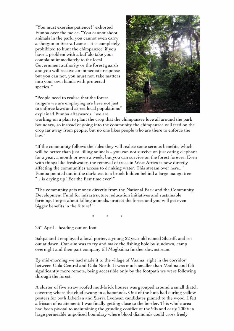
Kenema was very much the heart of the present day diamond trade. As one guidebook put it: “as far east as most of the diamond dealers are prepared to go and as far west as most of the diamond miners dare stray from their concessions.” The small town centre was packed with diamond merchants, hand painted signs of impossibly large sparkling stones advertising their industry, whilst inside the mostly Lebanese businessmen did a fair side trade in electronics, tools and TVs. I spent much of the next week preparing and refining my route in the GRNP office. I was aiming to make it to the most northerly section of river, to the very point it formed the boundary between Sierra Leone and Liberia, but I had very little idea how I would actually make it there or how long it would take. Conferring with members of management and the research team allowed me to build a much fuller picture of the region. Although no communities were located within the park itself it was clear that in the Gola North portion of the park there was a network of paths, indeed it appeared there were paths at locations all through the forest connecting the various border communities. This was vital in establishing a good access point and also building in a safety net should I need to evacuate along the way. I was introduced to Sakpa, a researcher who was between contracts with the GRNP and came highly recommended as a guide. I liked him straight away; he had a brilliant ‘can do’ attitude and an encyclopaedic knowledge of the park thanks to his former work as bushmeat hunter. I hired him on the spot. Sakpa knew of a small fishing hole, near a deserted village called Peyama, which was right on my target start point. We could hitch a ride with the Community development department to Madina village, roughly situated at the midway point between the Gola North and Central sections of forest in Malema district (see map 3), and walk for a day on a track to the village of Levuma (at the base of Gola North) before looking for the path to Peyama and beyond, to the old fishing hole. Sakpa was confident we could do it in a day despite not being 100% sure of the route, I knew two was more likely, but either way I was more than happy that there was a path at all; the distance totalled over 15km as the crow flies but I could see from satellite imagery that the terrain was made up of heavily forested ridges, if I’d had to cut the route it would’ve taken a week. Fumba Kaneh, from the Community development department, and Dr Annika Hillers, who heads Research, aided me greatly with mapping and community relations information: dos and don’ts for the villages, permissions I’d need to seek, the traditional bush crossing points (Mogbaima, Kponobu) where I would encounter people, and the places where they had met the most aggressive resistance to the Park (Nomo Chiefdom in the south, where rangers had been targets of gunfire in the previous month). I was surprised, and heartened, by the amount of people I would meet on the descent. I could count at least 20 mapped villages on my course and it was clear from talking to the research department there were even more that were missing from my map. It was not all good news however, the first few sections of river in the north were less populated and there was a very large waterfall where I would have to portage. I would also be the only person descending any significant distance on the river, the villages that populated the banks only made short journeys in their dugouts due to the prevalence of obstacles (rocks and rapids), to go larger distances they would use bush tracks within the forest itself, mostly away from the riverbanks and heading in towards the main road network on the far west side of the Gola forest (and in Liberia, far east). This did mean that in an emergency I would have to make a village no matter what. We decided that Sakpa would walk in with me, then walk downstream to the village of Mogbaima to warn them I was coming and wait. If I had encountered any
real problems in the first few days that would represent a great opportunity to find a quick fix without necessarily having to leave the forest altogether. He would then meet me once more, further downstream at the Vangaima waterfall, the largest of the obstacles, before leaving for good. In terms of language the tribes on the Sierra Leonean bank were Mende speaking but I could usually rely on encountering at least one person who spoke basic English, in Liberia almost everyone spoke English, nevertheless I recorded Sakpa giving a basic Mende introduction to who I was and what my intentions were on my camera for playback in villages. I would carry enough food in the form of high calorie ration packs and snacks to last for one month but approximated from experience that it would probably only take two weeks to descend the 100 mile section. I had GPS co-ordinates for the entire area preprogrammed into my Garmin and a basic electronic basemap overlaid on the system to compliment the hard copy maps I had been given from the GRNP. The GRNP office was an absolute inspiration. I was very impressed by their scope and ambition with such limited resources and found it exceptionally managed and organised from top to bottom. All of the local employees had been directly effected by the war, some had witnessed war crimes, most had lost family members, some were former poachers and very few had formal education, yet all were pulling together to make the park work and the levels of motivation and learning were very high. “I have a great deal of pride in our staff” explained Dr Hillers one afternoon, “take Sakpa for example, he has gone from being a former hunter to a committed conservationist with skills in word processing, radio operation, GPS, wildlife research and camera trapping. Every day he is here, even when he does not have a contract, just to continue his learning.” The Descent of the Moro and Mano rivers 22nd April – Madina village Madina was to be my introduction to the reality of implementing the GRNP’s aims on a practical level. As with all the villages they had buffer zones, patches of community forest where they were allowed to continue their commercial practices unhindered, between themselves and the Park. The boundaries and buffers had been agreed by the communities with the GRNP prior to the Park’s establishment in exchange for the benefits of the Park’s projects and infrastructure, and, in effect, the boundaries were placed back far enough to negate the need for any of the population to enter the Park at all. “They have enough in the community forest to subsist” described Fumba, who was chairing the Community development’s Roadshow in Madina, “there really is no need to enter the forest, I am from a village near here, we never entered the parts of the forest now demarcated as the National Park, except during wartime, when we hid.” However, as the roadshow progressed through to its conclusion it became clear all was not well. Following some excellent children’s plays reenacting the carbon cycle and the punishment of a poacher, a question and answer session saw the village elders take over the mantle and harangue the GRNP representatives: “what happens if your conservation causes the number of chimps to quadruple and they eat all our cocoa?” shouted one elderly gentleman, “Can I shoot animals that stray outside the park?” retorted another, following with “what do I do if a forest buffalo (a protected species) is destroying my crops?”
“You must exercise patience!” exhorted Fumba over the melee. “You cannot shoot animals in the park, you cannot even carry a shotgun in Sierra Leone – it is completely prohibited to hunt the chimpanzee, if you have a problem with a buffalo take your complaint immediately to the local Government authority or the forest guards and you will receive an immediate response but you can not, you must not, take matters into your own hands with protected species!” “People need to realise that the forest rangers we are employing are here not just to enforce laws and arrest local populations” explained Fumba afterwards, “we are working on a plan to plant the crop that the chimpanzee love all around the park boundary, so instead of going into the community the chimpanzee will feed on the crop far away from people, but no one likes people who are there to enforce the law.” “If the community follows the rules they will realise some serious benefits, which will be better than just killing animals – you can not survive on just eating elephant for a year, a month or even a week, but you can survive on the forest forever. Even with things like freshwater, the removal of trees in West Africa is now directly affecting the communities access to drinking water. This stream over here...” Fumba pointed out in the darkness to a brook hidden behind a large mango tree “…is drying up! For the first time ever!” “The community gets money directly from the National Park and the Community Development Fund for infrastructure, education initiatives and sustainable farming. Forget about killing animals, protect the forest and you will get even bigger benefits in the future!”
* * * 23rd April – heading out on foot Sakpa and I employed a local porter, a young 22 year old named Shariff, and set out at dawn. Our aim was to try and make the fishing hole by sundown, camp overnight and then part company till Mogbaima further downstream. By mid-morning we had made it to the village of Vaama, right in the corridor between Gola Central and Gola North. It was much smaller than Madina and felt significantly more remote, being accessible only by the footpath we were following through the forest. A cluster of five straw roofed mud-brick houses was grouped around a small thatch covering where the chief swung in a hammock. One of the huts had curling yellow posters for both Liberian and Sierra Leonean candidates pinned to the wood. I felt a frisson of excitement; I was finally getting close to the border. This whole area had been pivotal to maintaining the grinding conflict of the 90s and early 2000s; a large permeable unpoliced boundary where blood diamonds could cross freely
through an impenetrable forest with innumerous hiding places and a free supply of food: an enormous natural supermarket where no one need pay for the goods, except, of course, for every single indigenous forest resident who were either murdered, fled, or took up a near permanent state of hiding for years on end. Today, after ten years of peace, things had settled back to a sense of timelessness. Chickens scrabbled around in the dust for insects and seeds, a tightly woven fish-trap full of finger size fish stood in a corner and two women ground a pot of stringy fibrous looking roots into a thick viscous oil. I recorded a small piece with Sakpa who had brought the hind-quarters of a Maxwell’s duiker to show me. It was my first encounter with bushmeat beyond the cane rats for sale on the road to Freetown, and was, I was assured, trapped in the community forest and not the National Park. Soon after I recorded a further, shocking piece, with a young man called Mohammed who had a horrendous skin infection on his calf muscle. It was another first, but this would be one that would be repeated time again throughout my journey: the greatest threat to life for forest communities was the lack of access to basic medical healthcare. Not only was it up to three days walk away it was prohibitively expensive for this society who relied so much on hunter gathering. The GRNP were doing what they could, but these, I realised, were long term issues associated with rural poverty that would take far more resources to solve than the GRNP could ever reasonably offer. Seven hours later we made it to the village of Levuma. The remote abandoned fishing hole was still a half days walk away so we would enter a second day’s walking after all, but we were pleased to take the opportunity to rest in the village where I could purchase one last meal before starting on my rations the next day.
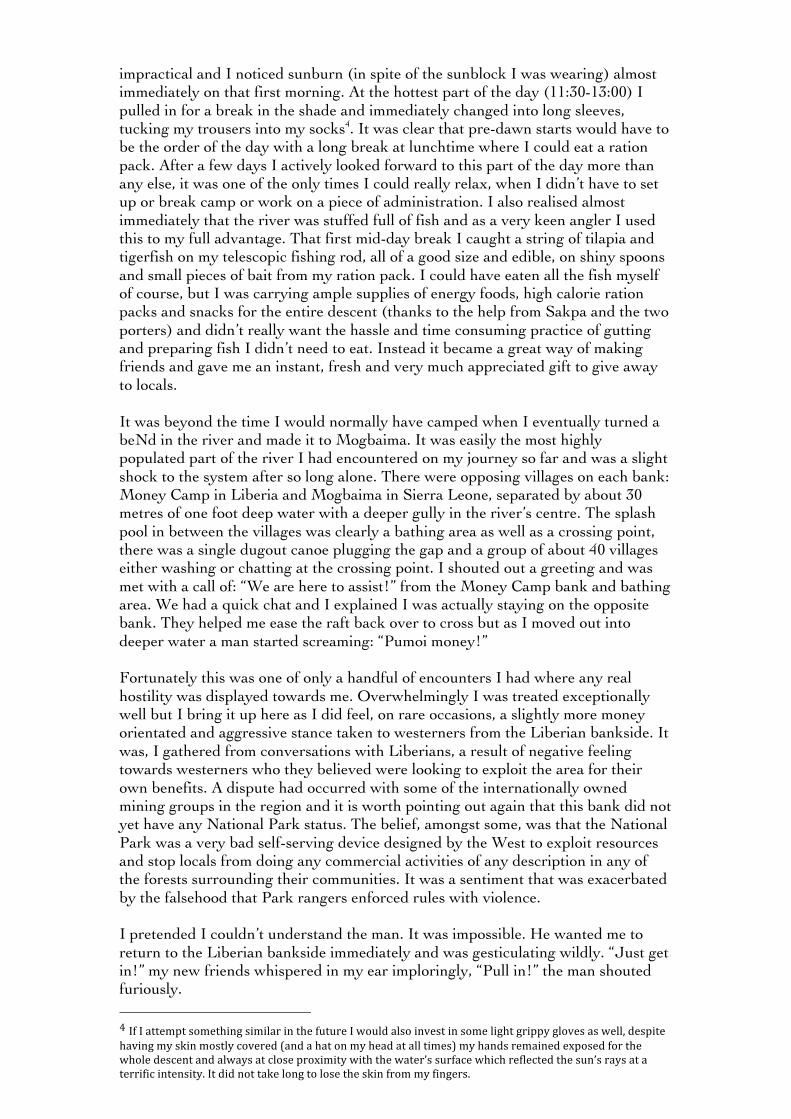
* * * 24th April – The first day on the river Sakpa and I swapped porters in Levuma. Sakpa was honest about not knowing the precise direction to the fishing hole so I employed a local man named Yusofu who lived in Levuma but worked locally looking for diamonds and claimed to know the way. It was clear, by no fault of Yusofu’s, that finding the fishing hole was going to be more challenging than he expected. Peyama, the nearest village, had emptied during the war, the path had quickly become overgrown and almost inevitably we spent some time lost. Nevertheless Yusofu, good to his word, did find it later and soon we made the sandy banks of the river. As mentioned I timed the descent to meet the end of the dry season deliberately to catch the river level at its lowest. I had studied satellite images from December (the end of the rains) and had seen numerous very difficult sections of rapids that would have been unsuitable for my packraft, and indeed my skill level. Low water levels would result in beaching, but that was preferable to being capsized on a deadly heavily swollen cataract. First view of the river conditions revealed a moderate flow and a depth of between one foot in the central channel and six inches at the banksides. It was almost perfect for a good steady start and quite narrow at approximately 25 metres in width.

Leaving Sakpa and Yusufo I launched off into the most pristine jungle habitat. I had not gone more than 10 minutes down the river before a solitary otter buzzed past the nose of the raft, hornbills, fish eagles, kingfishers, bee eaters, swallows and a couple of snakes followed. It was beyond my wildest expectations and in terms of accessibility it was the richest rainforest I have visited. I felt immensely privileged.
That day passed blissfully with no real obstacles. I had descended below Levuma by the day’s end and made a steady 7.18 km of direct progress in the 4.5 hours I had been paddling since leaving Sakpa. I was 11.75 km from our meeting point of Mogbaima and felt very confident of making the village in one full day. Originally I had hoped to erect a hammock away from the river every night of the expedition, utilising the trees to hang, and ensuring I was always on higher ground. In reality the bank side vegetation was almost always either too thick to cut back without investing significant time and energy in clearing it or simply inaccessible due to a very steep bank side; more often than not I slept on wide beaches or just within the lip of the forest 3. My DD hammock had a waterproof base (as well as a mosquito net) so I was able to erect a serviceable shelter on the ground when a pair of trees was not readily available and I had a large DD tarp overhead, which was big enough for the hammock and all my equipment. The system worked very well and the olive green natural coloration ensured I blended in well to the background, something I was very happy about when I encountered poachers later in the descent.
* * * 25th April Mogbaima The morning of the second day was tough. The river continued to hold its width and depth but cataracts started coming in sets. They varied in their frequency but would last anywhere from 20 to 150 metres in length with fast water and several sets (sometimes up to a dozen) in stretches of up to three or four kilometres. An experienced kayaker would have no trouble whatsoever in negotiating this stretch, but my packraft had 50 kilos of equipment and was not easy to maneuver at pace. I was still finding my feet at this very early stage and erred on the side of caution, portaging when necessary. Another issue was the extreme heat. There was minimal overhead cover and temperatures were at their most severe; peaking around 40°C. For comfort I had begun the descent in shorts and short sleeves, I was having to climb out of the raft both when it became beached and when I needed to portage, but this was obviously
!!!!!!!!!!!!!!!!!!!!!!!!!!!!!!!!!!!!!!!!!!!!!!!!!!!!!!!!K!L/0!&'(5!407'50!6(/60%J!(6(2$$,!25'(/*!MHK@!F!A81!?!<'($*!40!6-2//./)!%&0!42/;!6.*0!7'5!)''*!-218./)!)5'(/*H!.*02$$,!2!7$2%J!52.60*J!50$2%.30$,!-$025!8.0-0!'7!6'$.*!)5'(/*!<.%&!2%!$026%!'/0!6%5'/)!%500!%&2%!<'($*!/'%!50-N(.50!%''!1(-&!12-&0%0!<'5;9!?/!%0516!'7!$0)2$.%,!?!<26!6(88'60*!%'!5012./!'/!%&0!G.0552!O0'/02/!6.*0J!2/*!./*00*J!-'/*(-%!%&0!*06-0/%!75'1!%&0.5!6.*0!'7!%&0!5.305J!4(%!%&.6!<26!(%%05$,!.1852-%.-2$!<&0/!.%!-210!%'!6270$,!/0)'%.2%./)!%&0!5.3059!P&050!%&050!<050!/'!6.)/6!'7!&(12/!&24.%2%.'/!Q2885'+!IAR!'7!%&0!%.10S!?!-2180*!./!%&0!62706%!68'%!50)25*$066!'7!1,!82668'5%!6%21869!!!
impractical and I noticed sunburn (in spite of the sunblock I was wearing) almost immediately on that first morning. At the hottest part of the day (11:30-13:00) I pulled in for a break in the shade and immediately changed into long sleeves, tucking my trousers into my socks4. It was clear that pre-dawn starts would have to be the order of the day with a long break at lunchtime where I could eat a ration pack. After a few days I actively looked forward to this part of the day more than any else, it was one of the only times I could really relax, when I didn’t have to set up or break camp or work on a piece of administration. I also realised almost immediately that the river was stuffed full of fish and as a very keen angler I used this to my full advantage. That first mid-day break I caught a string of tilapia and tigerfish on my telescopic fishing rod, all of a good size and edible, on shiny spoons and small pieces of bait from my ration pack. I could have eaten all the fish myself of course, but I was carrying ample supplies of energy foods, high calorie ration packs and snacks for the entire descent (thanks to the help from Sakpa and the two porters) and didn’t really want the hassle and time consuming practice of gutting and preparing fish I didn’t need to eat. Instead it became a great way of making friends and gave me an instant, fresh and very much appreciated gift to give away to locals. It was beyond the time I would normally have camped when I eventually turned a beNd in the river and made it to Mogbaima. It was easily the most highly populated part of the river I had encountered on my journey so far and was a slight shock to the system after so long alone. There were opposing villages on each bank: Money Camp in Liberia and Mogbaima in Sierra Leone, separated by about 30 metres of one foot deep water with a deeper gully in the river’s centre. The splash pool in between the villages was clearly a bathing area as well as a crossing point, there was a single dugout canoe plugging the gap and a group of about 40 villages either washing or chatting at the crossing point. I shouted out a greeting and was met with a call of: “We are here to assist!” from the Money Camp bank and bathing area. We had a quick chat and I explained I was actually staying on the opposite bank. They helped me ease the raft back over to cross but as I moved out into deeper water a man started screaming: “Pumoi money!” Fortunately this was one of only a handful of encounters I had where any real hostility was displayed towards me. Overwhelmingly I was treated exceptionally well but I bring it up here as I did feel, on rare occasions, a slightly more money orientated and aggressive stance taken to westerners from the Liberian bankside. It was, I gathered from conversations with Liberians, a result of negative feeling towards westerners who they believed were looking to exploit the area for their own benefits. A dispute had occurred with some of the internationally owned mining groups in the region and it is worth pointing out again that this bank did not yet have any National Park status. The belief, amongst some, was that the National Park was a very bad self-serving device designed by the West to exploit resources and stop locals from doing any commercial activities of any description in any of the forests surrounding their communities. It was a sentiment that was exacerbated by the falsehood that Park rangers enforced rules with violence. I pretended I couldn’t understand the man. It was impossible. He wanted me to return to the Liberian bankside immediately and was gesticulating wildly. “Just get in!” my new friends whispered in my ear imploringly, “Pull in!” the man shouted furiously. !!!!!!!!!!!!!!!!!!!!!!!!!!!!!!!!!!!!!!!!!!!!!!!!!!!!!!!!M!?7!?!2%%018%!6'10%&./)!6.1.$25!./!%&0!7(%(50!?!<'($*!2$6'!./306%!./!6'10!$.)&%!)5.88,!)$'306!26!<0$$J!*068.%0!&23./)!1,!6;./!1'6%$,!-'3050*!Q2/*!2!&2%!'/!1,!&02*!2%!2$$!%.106S!1,!&2/*6!5012./0*!0+8'60*!7'5!%&0!<&'$0!*06-0/%!2/*!2$<2,6!2%!-$'60!85'+.1.%,!<.%&!%&0!<2%05T6!6(572-0!<&.-&!507$0-%0*!%&0!6(/T6!52,6!2%!2!%055.7.-!./%0/6.%,9!?%!*.*!/'%!%2;0!$'/)!%'!$'60!%&0!6;./!75'1!1,!7./)0569!!
I thought it through quickly. I could go back, calm things down and inevitably end up paying money or getting into an argument, or I could continue to cross into the deeper water where, unless this man could swim (which was highly unlikely) I wouldn’t be followed. In the end I did a mix of both, sort of shouting across a few friendly remarks, whilst very clearly moving off to the opposite bank. I found Sakpa waiting under the village mango tree grinning ear-to-ear. “No problem Will!” he smiled coolly. He had done his job very well, both Money Camp and Mogbaima had been expecting me and, bar that one individual, my reception was incredibly welcoming. Night fell and I was sat down in a wicker chair and given a small fish to eat. Children crowded around along with a goat and dozens of tiny chicks. I had, as instructed, headed directly to the chief’s hut and was now waiting for an audience with the man. Eventually he emerged from his hut and sat down opposite me, wearing a smart white skullcap and grey gown. Things quickly got serious. “The Gola Rainforest National Park have not delivered on their promise to build a feeder road connecting this village with the main road.” I was about to discover that there is no such thing as a free lunch. I reached for the recorder and Sakpa offered to help translate my questions into the Mende language. The nearest road, I was told, was sixteen miles directly through the bush. “So what do you do if you need healthcare or education?” I asked. “When people get sick we have to place them in a hammock and carry them to the feeder road. Also, we have a lot of children here.” It was true, there were at least 30 stood around me, watching quietly in the dark in grubby t-shirts and ripped shorts. “None of them have access to education…give us the feeder road and we can take our commercial products to sell in the market, get the finances we need and send our children to school.” I asked if there had been any improvements in their lives since the Gola Rainforest became a National Park. “No” he answered flatly. “We don’t even have a proper toilet, most people here just use the river.” There was a pause at this point. “But chief, that’s where I’ve been swimming and rafting?” Everyone found that most amusing. “We used to use the forest products to educate the children but now we get no benefit whatsoever from the Park, the situation is ridiculous. We go to meetings but nothing ever happens. The patch of forest that we are allowed to use is insufficient. We are really suffering.”
This was at odds with what I had been told so far. Working closely with the researchers at the GRNP offices in Kenema had shown that a great deal of thought and compromise had gone into establishing the 2011 boundary line so this very situation would not arise. “There were 32 houses here before the war, everything got destroyed, we’ve barely rebuilded, and now Gola has taken over and restricted our access to money – there are no old people here, every one of our elderly was massacred – maybe if we still had our important elders alive we could build the pressure and political will to help us rebuild, but they are dead and we don’t have access to the right contacts.” I was curious, just over on the other side of the river the Liberian forest was considered ‘protected’ but was not yet officially a National Park (a fact that had considerably slowed the establishment of the Transboundary Peace Park), if they truly had suffered as a result of the National Park on the Sierra Leonean bank then surely the most obvious comparison would be with their neighbours in National Park-free Liberia. “Yes. Of course they are better off. They can do what they like” responded the Chief. With that answer I knew whatever unfolded on the rest of the journey I was now committed to an arduous overland journey across the border and into Liberia and then back into the bush on their side of the riverbank. I had to find out if that comment bore any weight. There was no getting away from the fact that people out here were poor, among the poorest in Africa, so whether or not people were better off in Liberia was purely relative. The question really is who, ultimately, is responsible for the plight of these people living in the bush? The GRNP are the target of these peoples anger as they are the only outsiders they regularly come into contact with, but it seemed to me that the GRNP were having to take up the considerable deficit in rural development without ever really having adequate financial or human resources to fully meet the multitude of demands from the border communities. The Chief blamed the National Park for their suffering but it was clear from taking in the demographic of the village that the vast majority of young adults, the strongest and most vital workforce for this deeply physical environment, were already missing from the scene, with or without the National Park. Weeks later I raised the point with the paramount chief of the neighbouring district in Liberia, having since experienced an identical set of circumstances over the border, she answered: “you grow up out here, you covet education and jobs, you get an opportunity to leave and earn hard money in the town, gain experience and look to the big city for the big break, you provide for your family from outside of the village, but you don’t come back if you have the opportunity to leave.” Africa has the highest rate of urban growth in the world with a handful of the fastest growing megacities already established in the last decade. As desertification squeezes agriculture at the top of the sub-Saharan region and land grabs mop up traditional pastoral lands elsewhere there has never been a worse time to be a hunter-gatherer. Relative to the rest of Africa Sierra Leone and Liberia’s populations are very low and, thanks to the civil war crippling all foreign investment in the region for an entire decade, their natural resources and forests remain quite intact - if they can be managed responsibly their future could yet be bright.
I tried to wrap up the interview but before I could the chief made one more comment: “Thanks for explaining your purpose to us. When we saw you, a white, coming down the river, we felt that maybe you were coming to take over our river along with the forest you already taken from us.” Sakpa started laughing, giggling uncontrollably in fact, but the chief wasn’t laughing and I had gone bright red. I changed tack slightly and asked him what he would do for fun if he had the money. The chief considered the question for a moment. “If I was a rich man I would take an adventure in the western world. New York I think” suddenly the chief switched to English: “ I definitely would not go rafting.”
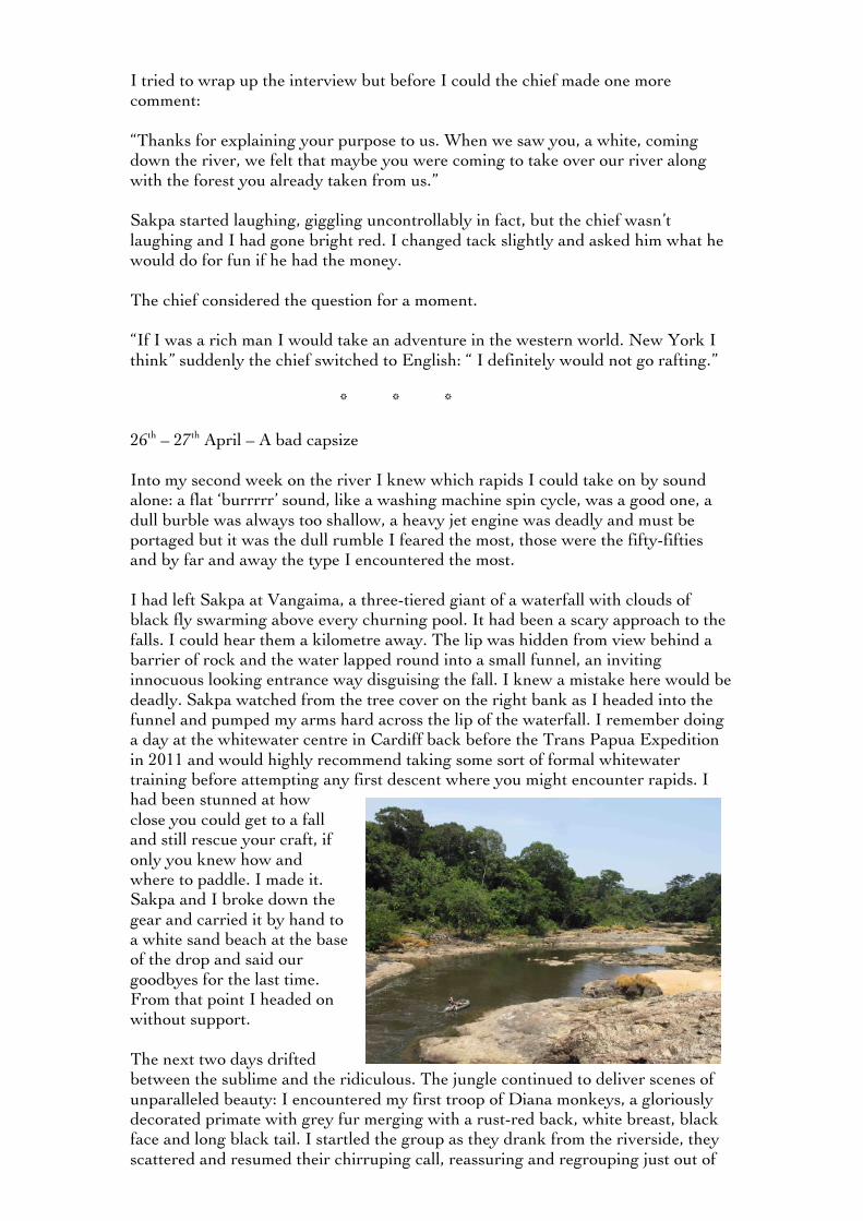
* * * 26th – 27th April – A bad capsize Into my second week on the river I knew which rapids I could take on by sound alone: a flat ‘burrrrr’ sound, like a washing machine spin cycle, was a good one, a dull burble was always too shallow, a heavy jet engine was deadly and must be portaged but it was the dull rumble I feared the most, those were the fifty-fifties and by far and away the type I encountered the most. I had left Sakpa at Vangaima, a three-tiered giant of a waterfall with clouds of black fly swarming above every churning pool. It had been a scary approach to the falls. I could hear them a kilometre away. The lip was hidden from view behind a barrier of rock and the water lapped round into a small funnel, an inviting innocuous looking entrance way disguising the fall. I knew a mistake here would be deadly. Sakpa watched from the tree cover on the right bank as I headed into the funnel and pumped my arms hard across the lip of the waterfall. I remember doing a day at the whitewater centre in Cardiff back before the Trans Papua Expedition in 2011 and would highly recommend taking some sort of formal whitewater training before attempting any first descent where you might encounter rapids. I had been stunned at how close you could get to a fall and still rescue your craft, if only you knew how and where to paddle. I made it. Sakpa and I broke down the gear and carried it by hand to a white sand beach at the base of the drop and said our goodbyes for the last time. From that point I headed on without support. The next two days drifted between the sublime and the ridiculous. The jungle continued to deliver scenes of unparalleled beauty: I encountered my first troop of Diana monkeys, a gloriously decorated primate with grey fur merging with a rust-red back, white breast, black face and long black tail. I startled the group as they drank from the riverside, they scattered and resumed their chirruping call, reassuring and regrouping just out of
sight. I started to make excellent progress, knocking off regular distances of 8 to 9 direct kilometres downstream despite numerous rapid sets and was soon travelling amongst a backdrop of 70-metre trees in the very heart of the ‘Peace Park’. I never knew what I might see round the corner; I heard my first chimps, encountered catfish the size of Staffordshire bull-terriers, saw snakes hunting frogs, eagles snatching fish, and was continually awestruck by the constant whirling presence of hundreds of different bird species: hornbills, herons, egrets, the stalking Tiger bittern and giant wooly necked stork, an array of ducks, the pygmy kingfisher and the brilliant blue cuckoo-shrike. Then there were the animals I didn’t see but was continually made aware of their presence: the micro-second flashes of colour, the creaks, croaks, thumps and grumbles from the bushes and the large animal that I felt sliding along my packraft base as I drifted free in one particularly deep and dark pool. It wasn’t all plain sailing though. My sleeping mat was doubling as a useful cushion for my packraft base but after numerous collisions with the riverbed it punctured badly, the stove I had picked up in Kenema (ironically named the ‘safety camping’) exploded on one of my afternoon breaks, I faced down an enormous midnight storm, tore my raft base on the rocks and continually spilt, dropped and lost things, classically I would pack away all my kit and discover something vital staring me down outside the drybags or that something I needed for the day was buried deep within my backpack. Slowly though I gained control and momentum. I found simple fixes for my problems, I was putting in longer days, growing in confidence and had my portage routine down to a fine art; realising I could leave the heaviest bag tied in the raft base and use the straps to carry the load and raft on my back simultaneously became a real timesaver. Then, on the last, tiny rapid before camp on the 27th April, I capsized the raft. It was innocuous enough; a small rock, the dimensions of a small coffee table with a slight ridge across the centre, but I hit it head on at pace and the raft flipped clean over to the right. I managed to retrieve the raft quickly, luckily it hadn’t gone far and the straps held all my kit in place. My primary fear, having rescued all my essential kit successfully, was for the radio kit. The mixer had got damp which had affected the LCD screen. I realised I could about to become the first person to destroy the kit in the history of the ‘Journey of a Lifetime’. “People have taken this recorder to the Himalaya and come back fine” said Simon Elmes, the Creative Director of Radio 4, as he handed me the equipment in Broadcasting house. I had been given a spare but was loathed to lose the primary mixer. I removed the battery pack, the mic, headphones and anything else that might stop the release of moisture: the case, any jacks in any of the outputs etc. The next morning I let it dry on some rocks and repeated the process again at lunchtime, the screen, mercifully, returned to normal. I promised myself I would take more care. No more fifty-fifty calls or unnecessary blind descents. Unless I could see all of a run, forget it, get out and portage. That night I became aware of lights on the river. I quickly flipped off my headlamp and peered out into the gloom. I could make out two men working the far bank. They were using their lamps to try and find ‘eyeshine’, the reflection off a mammal’s eyes and a dead give away for any hunter looking for an easy kill.

I was beyond the halfway mark now and emerging into a more populated part of the descent. This was the first sign of illegal activity I had encountered and was to be a warning of even bigger things to come.
* * * 28th April – An illegal diamond mine I had lost so much time drying out the kit that morning I opted to skip my break that afternoon and paddle on through the heat. At mid-day I rounded a corner and my stomach dropped. There, consuming the Liberian bankside, was a massive open pit full of huge Liberian men. This, almost certainly, was an illegal diamond mine. As I got close I could make out at least 30 men stood on top of a massive bank of excavated sand, staring me down, a generator whirring in the background, pumping water out of the pit and back into the river. This was certainly going to be a test. I was totally alone. A white man who had already been mistakenly assumed to be a neo-colonial exploiter or a member of the GRNP, no one could guess the nigh-on inconceivable reality that I was in fact a professional adventurer here to make a radio program about the forest. It wasn’t like I could avoid the camp either; it took up half the river. It’s hard not to talk about Sierra Leone and Liberia without reverting to the ‘blood diamond’ crutch. It’s a lazy stereotype, yet a bad reputation sticks. There are no more ‘blood diamonds’ in Sierra Leone or Liberia. The practice of mining the
region’s diamonds to finance the conflict ended along with the war over a decade ago. However, the industry remains largely unmechanised with 80% controlled by 300,000 artisanal miners who mainly mine by hand. As such the Government makes little: only $3-4 million from an estimated $100 million industry. Smuggling and illegal activity are rife and, as I was about to find out, the industry remains largely unpoliced and unregulated.
I paddled up to the mine with my heart in my mouth. I shouted ‘hello’. No one answered. They were talking in raised voices among themselves, more people poured from the tarpaulin tents at the back, crowding to see this ridiculous and unlikely scene. I couldn’t look beyond their muscles, like coiled steel cables on impossibly large frames, some had towels on their heads, ripped t-shirts and shorts, no one had shoes. I didn’t want to think it but I couldn’t help it. This was illegal activity on a massive scale; I was a solo, unannounced and almost certainly an unwelcome intruder. This suddenly felt very dangerous indeed. Diamonds are typically formed in the region of 90 to 120 miles below the earth’s surface under intense pressure and heat over a period of 1 to 3 billion years. The only way anyone can ever hope to get access to them, even with cutting edge mining equipment, is when a massive subterranean volcanic eruption forces them up towards the earth’s surface. Control the spout of the volcano and you control the
mineral, just ask Cecil Rhodes who in 1871 discovered a 83.5 carat diamond on his farm in South Africa’s Kimberley, used the profits to buy up the claims of other small holders in the region and established ‘De Beers’, today the largest diamond mining and trading corporation on the planet. Sierra Leone had a volcanic eruption on the scale of the Kimberley at some point, and certainly had the equivalent number of diamonds, yet a total lack of infrastructural development meant this eruption went unnoticed and with one of the heaviest rainy seasons on the planet the precious stones were spread right across the eastern province. Diamonds could be found virtually anywhere by anyone: cleared roads, housing foundations and increasingly in riverbeds, where the stones had slowly washed downstream. The diamond rush, when it came, caused thousands to down tools and walk from their farms in the hope of finding a life-changing gem. Food shortages became a massive problem and then, of course, there was that war. I kept shouting “hello” as I approached before finally receiving a friendly enough “good morning” in return. That settled me down a bit but it was obvious I was not welcome. There was nothing I could do; this confrontation was literally unavoidable. I was hauled out of the raft and taken to the top of a huge bank of mud. I decided to just go for the jugular from the off: “So have you found any diamonds?” I asked jovially, “Yes” came the response from one, which was immediately adjusted to an emphatic “no” by another. Listening back to the recording it was incredible that they were forthcoming with answers at all. I had literally come from nowhere, waltzed onto their illegal mine with a recorder and huge fluffy microphone and started asking them about their work. I asked a few more questions and a couple of the guys spoke up: “we are just prospecting, we dig and look for the gravel where the diamond lives. Then we wash the gravel through the shaker…” They had been there for two months digging by hand with shovels. A wily middle-aged man who introduced himself as ‘the boss’ approached me, “Who do you work for?” he asked me straight up and everyone fell silent. It was a very fair question. I explained what I was doing, about the adventure and the BBC. It was clear he still thought I worked for the National Park, it was equally clear what the consequences would be if I did, but the two things going distinctly in my favour was the radio kit I had in my hands and the fact that I was alone. “Whites from the National Park are never alone” the boss man eventually concluded to my immense relief. What followed over the next hour was actually perfectly pleasant. I chatted to most of the workers, asked who was the best digger, had a go at digging my own diamond and generally carried on like I was presenting a Blue Peter special on illegal mining and not in fact, a door-stepping adventurer way out of his depth in the middle of a remote forest. It was staggering what they had achieved in two months. The pit was big: 30 metres long and at least 18 foot deep with sheer mud sides, all dug by hand. Water poured in constantly, ensuring work always took place in a thick dirt pudding, plus everything they needed (fuel, generators, shelter, food, tools) had to be carried in from the town, five hours away through the forest. “It must get very hot,” I said, pointing out the obvious whilst stood in a tent no more than 6 x 6 foot intended for
8 people. The noise of the generator was deafening but the heat, at midday, with no overhead cover, was bordering on the intolerable. At one side of the pit stood a four-foot high pile of gravel, the grand sum of two months of toil on less than a dollar a day. It was enough to justify another month’s investment from the big boss in Kenema. Find a stone and it is party time, find nothing and you at least leave with a few dollars, which is more than most of these lads could hope for otherwise. A range of men worked the mine, mostly though they were in their twenties, all with kids, and at least one wife. I met one 18-year-old still wearing his school football top. It was his first time in the industry, he liked it but didn’t want a wife yet, “not till I’m ready”, he said. The only man who hadn’t stopped working in the entire mine was also the oldest: 69 years old, and up to his knees in mud. “Has anyone here ever actually seen a diamond?” I asked as I made my exit. “No”, came the universal response. I thought about it afterwards. I couldn’t believe it was true. Some of these men had spent their lives digging for diamonds, it was the ultimate discovery, but they weren’t so rare that not one person in a fifty strong team was yet to lay eyes on one, it would be commercial suicide. In these circumstances the actual ‘cut’ of the sale you would receive as a digger would be small, certainly not enough to hang up your spade for good, but probably enough to keep you hanging on for more. Admitting you had seen or received money for diamonds you’d found in the past could be a potentially divisive move, especially when working in a diamond mine with others who were yet to find their first stone. I wouldn’t want to jeopardise the camp atmosphere in a three-month stint of shoveling by revealing my work experience and past riches. Just as likely though, from their perspective I was a journo outsider possibly looking to stir up trouble, maybe even looking to steal: why would they tell me anything? Mining is one of the biggest threats to the Gola and the Peace Park, but it was difficult to reconcile the image of the big, bad destructive industry with this clutch of impoverished Liberians. They were just looking for work, any work, and a regular wage. They treat me with a degree of warmth during my hour, which I certainly didn’t feel I deserved, particularly as they insisted on washing my feet as I climbed back into my raft. Increasingly on expedition I have discovered the people actually getting hands-on in illegal industries are among the world’s friendliest, risking life and limb whilst someone else becomes a millionaire. I just listened back to my recording, at one point I ask the boss if he has a wife: “yes” he responds. “It must be difficult?” I continue, meaning, it must be difficult being away all the time. “yes, married life is difficult” he replied, to much laughter.
* * * 29th April to 1st May – illness and evacuation 12:25 - I woke at 2am with a splitting headache and couldn’t get back to sleep. At 6:30am I got up feeling groggy and have slightly recovered at lunch. Am treating the symptoms with

ibuprofen and paracetamol and hoping it is just fatigue. If I worsen tonight I’ll take my malaria treatment and look to abandon the project. 20:00 – A beautiful camp by the wide river Mano. I have made my target but it hardly matters right now. I’ve had a dip into the river to bring my temperature down and have taken another couple of paracetamol and ibuprofen. I am really worried about my health. My mouth is filling with ulcers. I can’t eat. I was getting into serious trouble. I was looking at just another four days to the river mouth and the end of the expedition but I knew that unless I made a remarkable recovery in the night the project was over and I’d have to figure out a way of extracting myself from the forest. “When you have made up your mind to go to West Africa the very best thing you can do is to get it unmade and go to Scotland instead but if your intelligence is not strong enough to do so, abstain from exposing yourself to the direct rays of the sun, take 4 grains of quinine every day and get an introduction to the Wesleyans; they are the only people on the Gold coast who have got a hearse with feathers.” So said a veteran of 7 years on the continent in the 17th century. As British colonist dropped like flies through the early establishment of Sierra Leone as a colony in 1808 the region was given the unenviable moniker: ‘the white man’s grave’. Of course health standards have elevated since the days leeches were used to treat Lassa but both Sierra Leone and Liberia remain at the base of the United Nation’s Human Development Index with one of the highest rates of maternal and child mortality in the world and regular outbreaks of hepatitis, cholera, typhoid, yellow fever and of course the biggest killer of all: malaria. As my headache developed into fever I started to fret, not least because among the last words of warning given to me before heading solo into the bush was the tale of a German lady who had complained of flu-like symptoms, not gone directly to hospital, and died, with an undiagnosed hemorrhagic fever, 48 hours later. I was truly in the middle of nowhere, utterly alone and getting sicker by the minute. I needed to make contact with someone on the Sierra Leone bank and find my own way to the road: my lifeline to the hospital and proper treatment. On the 30th April I executed my pre-planned evacuation strategy, beginning with a call to the GRNP offices with the following:
• Where I was with a follow up SMS message with GPS co-ords • Where I was planning on going • An exit plan and timeframe for its execution
I started to paddle out. I was aiming for the village of Tolo – my first evacuation option on the Sierra Leone bank roughly three hours paddle from my camp. My headache had worsened to the point that I could barely keep my eyes open and the pain in my joints was bordering on the spectacular. My bones felt like they were grinding to dust with every movement plus I had developed a massive abscess
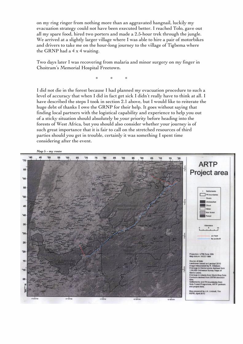
on my ring ringer from nothing more than an aggravated hangnail, luckily my evacuation strategy could not have been executed better. I reached Tolo, gave out all my spare food, hired two porters and made a 2.5-hour trek through the jungle. We arrived at a slightly larger village where I was able to hire a pair of motorbikes and drivers to take me on the hour-long journey to the village of Tigbema where the GRNP had a 4 x 4 waiting. Two days later I was recovering from malaria and minor surgery on my finger in Choitram’s Memorial Hospital Freetown.
* * * I did not die in the forest because I had planned my evacuation procedure to such a level of accuracy that when I did in fact get sick I didn’t really have to think at all. I have described the steps I took in section 2.1 above, but I would like to reiterate the huge debt of thanks I owe the GRNP for their help. It goes without saying that finding local partners with the logistical capability and experience to help you out of a sticky situation should absolutely be your priority before heading into the forests of West Africa, but you should also consider whether your journey is of such great importance that it is fair to call on the stretched resources of third parties should you get in trouble, certainly it was something I spent time considering after the event. Map 5 – my route
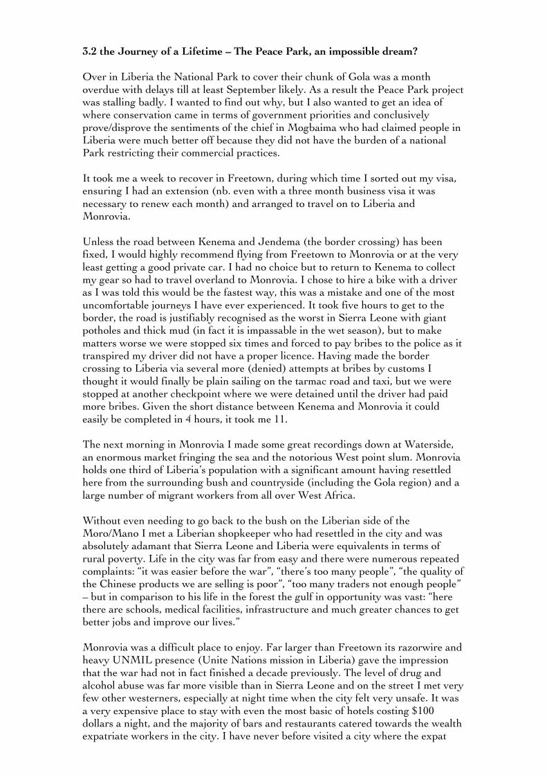
3.2 the Journey of a Lifetime – The Peace Park, an impossible dream? Over in Liberia the National Park to cover their chunk of Gola was a month overdue with delays till at least September likely. As a result the Peace Park project was stalling badly. I wanted to find out why, but I also wanted to get an idea of where conservation came in terms of government priorities and conclusively prove/disprove the sentiments of the chief in Mogbaima who had claimed people in Liberia were much better off because they did not have the burden of a national Park restricting their commercial practices. It took me a week to recover in Freetown, during which time I sorted out my visa, ensuring I had an extension (nb. even with a three month business visa it was necessary to renew each month) and arranged to travel on to Liberia and Monrovia. Unless the road between Kenema and Jendema (the border crossing) has been fixed, I would highly recommend flying from Freetown to Monrovia or at the very least getting a good private car. I had no choice but to return to Kenema to collect my gear so had to travel overland to Monrovia. I chose to hire a bike with a driver as I was told this would be the fastest way, this was a mistake and one of the most uncomfortable journeys I have ever experienced. It took five hours to get to the border, the road is justifiably recognised as the worst in Sierra Leone with giant potholes and thick mud (in fact it is impassable in the wet season), but to make matters worse we were stopped six times and forced to pay bribes to the police as it transpired my driver did not have a proper licence. Having made the border crossing to Liberia via several more (denied) attempts at bribes by customs I thought it would finally be plain sailing on the tarmac road and taxi, but we were stopped at another checkpoint where we were detained until the driver had paid more bribes. Given the short distance between Kenema and Monrovia it could easily be completed in 4 hours, it took me 11. The next morning in Monrovia I made some great recordings down at Waterside, an enormous market fringing the sea and the notorious West point slum. Monrovia holds one third of Liberia’s population with a significant amount having resettled here from the surrounding bush and countryside (including the Gola region) and a large number of migrant workers from all over West Africa. Without even needing to go back to the bush on the Liberian side of the Moro/Mano I met a Liberian shopkeeper who had resettled in the city and was absolutely adamant that Sierra Leone and Liberia were equivalents in terms of rural poverty. Life in the city was far from easy and there were numerous repeated complaints: “it was easier before the war”, “there’s too many people”, “the quality of the Chinese products we are selling is poor”, “too many traders not enough people” – but in comparison to his life in the forest the gulf in opportunity was vast: “here there are schools, medical facilities, infrastructure and much greater chances to get better jobs and improve our lives.” Monrovia was a difficult place to enjoy. Far larger than Freetown its razorwire and heavy UNMIL presence (Unite Nations mission in Liberia) gave the impression that the war had not in fact finished a decade previously. The level of drug and alcohol abuse was far more visible than in Sierra Leone and on the street I met very few other westerners, especially at night time when the city felt very unsafe. It was a very expensive place to stay with even the most basic of hotels costing $100 dollars a night, and the majority of bars and restaurants catered towards the wealth expatriate workers in the city. I have never before visited a city where the expat
and NGO presence was so visible yet so detached from the lives of the average Monrovian.
* * * In terms of meeting the aims of this second part of the journey my week long stay in Liberia was a great success. I had a brilliant interview with Michael Garbo and Alex Peel of the Society for the Conservation of Nature Liberia (SCNL). Effusive and honest, they admitted being embarrassed at the lack of progress in getting the Peace Park project off the ground – particularly as they were behind their neighbours Sierra Leone: “I am a competitive man” admitted Alex, “conservation is still in its primary stage in Liberia” added Michael, “Science and conservation are not popular subjects in Liberia, many are not educated in conservation…when we talk to the Government there might be one person who knows something about conservation.” For a very long time, they argued, people thought the trees and wildlife were an infinite resource, but increasingly people are coming to the idea that the environment is changing, that things aren’t the same as they were in the past. It became clear that the Government’s Forestry Division, the Forestry Development Authority (FDA), were largely to blame for the slow progress, quite why, wasn’t clear. Michael remained guarded, probably as he could lose his job if he criticised the Government on record, but it was suggested the vast mineral and logging resources (and the kickbacks that were being received for granting concessions) was a major driver, a fact that was confirmed the month after I returned (June 2013) in the article published in the Daily Telegraph and described in this report in section 1.3. “Maybe it was the leaders at the time, they had their own problems” – they have a new leader now, they pointed out, so things were perhaps more positive: “but the Government needs to seriously sit down and review the promises it made regarding conservation in the nation.” As the National Park continues to stall commercial firms hoping to exploit resources are getting a jump-start on the areas Alex and Michael are hoping to protect. “The communities say we talk too much, not enough action…right now in Liberia we don’t even have 7% of the forest under protection.” I was shocked, the aim was 30%, less than 7% was awful by anyone’s standards, “there is no way that we are protecting our patch of the Gola properly” Michael concluded, but added it isn’t yet too late: “if we can get the National Park in Liberia today we can have the Peace Park tomorrow”. Security, money and immediate action are needed, but as long as the environment remains intact there is still hope.
* * * Alex and Michael arranged for me to be taken back to the bush in Liberia, this time to a pair of villages just the other side of the Mano river on the border of the Gola National forest. I was to meet Jamia tu Watson, a formidable articulate lady who was the elected paramount chief of the majority of villages in the region most likely to be effected should the Peace Park ever materialise. Almost immediately after we arrived at the villages an argument erupted. One man was shouting at Jamia that they didn’t want the National Park under any circumstances and I was verbally attacked for having descended the river without expressed permission from their village chief (10 km away). Jamia exploded,
screaming down the man who was against the park: “can’t you see the benefits it will bring for you and this community! You are the only village that is causing problems! Now you have cut yourself from the deal!” She was storming back to the car, “and you” now shouting directly at the man who had berated me for my apparent lack of courtesy, “the river he was on was miles away and it is an international border shared with Sierra Leone! Not one section is owned by your village and how dare you be so rude to our guest!” It wasn’t a great start. Further up the road I interviewed the chief of the Sukpo clan alongside Jamia. Here the atmosphere was much more positive. The chief raised the same issues as Mogbaima: the lack of adequate road access to health and education services and he rubbished claims that they were much better off than people in Sierra Leone. It was clear from just looking around that they faced an identical set of challenges with or without the park, but at least in Mogbaima someone was listening and taking into account their thoughts, concerns and interests, and actively trying to help them improve their situation. “We want the Park” concluded the chief, “we want progress and education for our children, we want food security and a future, but we also want to conserve this area for our future generations, that is most important of all.”
* * * Before I left Liberia I managed to get an interview at the FDA with the Managing Director Harrison Kanwei. It had taken a bit of pleading to secure my slot and I had to submit all of my identification details. Criticism of the government could land me in very hot water, if not arrest, yet with so many pointing the finger at Liberia’s FDA for the apparent lack of progress on the Peace Park I was going to have to broach the subject somehow. In the event, the Director was more than forthcoming. The FDA were up a large hill overlooking the west of the city. Mr Kanwei was sat behind a large hardwood desk, the Liberian flag resting against the wall behind him. The interview began with an overview of the FDA’s work: “the FDA is responsible for sustainably managing the Liberian forest. We have 4.5 million hectares of primary forest and have committed ourselves as a government to set aside 30% as a protected area. with the National Parks and protected forests we already have in place we have conserved 20% but we still have a deficit of 10%” This flew in the face of the statistics given by SCNL, who insisted just 7% of forests were protected. Regarding the Peace Park, Harrison conceded their had been delays but the Park was on target for the revised September deadline, but qualified that: “If we go beyond this target date we will have to look for additional funding”, management had been “dragging their feet.”

The issue was monetary: “Conservation activities are challenging here, most especially a country coming out of conflict that requires revenue for its reconstruction. We are under pressure to go the commercial way, but the Government has made a commitment to contribute to the mitigation of greenhouse gas emission with this 30% set aside…but we are definitely challenged by cost: we have to have forest rangers, we have to pay them, provide communication and mobility, but we are hopeful that once we are committed to the process that help will come from somewhere.” Another significant contributor to the delay, perhaps the biggest within the FDA, was the fact that the entire board of directors had recently been dissolved. Harrison had been brought in by the President as a “man of integrity” in an office, which, by all accounts, had been riddled with corruption. “Integrity is in short supply in our country,” he concluded. No one has been indicted or convicted yet, but accusations suggested kickbacks were being taken over the liberal use of ‘Private and Personal use Permits’, which afford people with private forests the rights to sell commercial species. “The suspicions is that their activities may have been influenced” Harrison explained, “61 of those concessions were given in so short a period…in contravention of the forestry law of 2006, some of them were issued based on fake deeds.” “If we have a budgetary limitation that the Ministry of Finance does not fund, we are pressurised – if we fail to meet our fiscal quotas then we will not get the funding to do our work. I suggest that right now we have huge deficits, I have liabilities to vendors that I inherited in excess of $500,000, I have a $420,000 payroll deficit, which effects my ability to be efficient.” In finding the funds to meet the deficit Harrison argued he has to make major cuts, he can’t send staff around the country, maintain vehicles and provide communications infrastructure for their work. I pointed out I was concerned that with such a deficit meeting the 30% target would be difficult but Harrison countered that “conservation has the potential to generate money as well”. He brought up the carbon trade as a revenue source, but this became a prickly issue: “you have to satisfy all these preliminaries” he lifted a large tome from REDD+ on his desk. I got the impression Harrison was less than impressed, doubly so when he complained that: “we are actually mitigating greenhouse gas emissions in the west without pay and then you come and tell us to keep the forest and set all kinds of conditions before we can get paid for our carbon credit – I think that’s unfair.” “43% of the Upper Guinean Forest belt left in the whole of West Africa is found within Liberia, we have done the best, those other nations have logged extensively – we deserve to be rewarded” I was extremely grateful Harrison had been so open but it was clear from the interview that the FDA were picking up the pieces from a corrupt and unsustainable period of poor leadership. Their were some positive signs, Harrison seemed confident that the government would meet its conservation target and even spoke of replanting projects in the north, but with such a deficit and a slow moving bureaucratic process I anticipated their were probably more delays to come before the Peace Park would be established. Furthermore, their income streams from REDD+, the ecotourism hopes, the reforestation and the establishment of the Park, all take time to generate revenue, whereas logging is almost instantaneous in comparison. I worried the temptation to log could be too great, especially as their conservation funding was heavily reliant on international donors who would surely be less than impressed with their apparent lack of progress.
I left Liberia a week later, picking up further stories of the bushmeat trade, where I recorded a piece surrounded by piles of dead primates and duikers, and found myself victim several more times to the highly corrupt police. Money was so aggressively pursued throughout the emerging nation I wondered whether the government would ever deliver on their 30% promise or even if they had the capacity to protect the forest if they did. What was without doubt was that without any sort of National Park on the Liberian side of the Mano/Moro the Peace Park would remain little more than a symbolic gesture of goodwill.
9" 9" 9" The second half of the journey was a sobering reality check following the euphoria of the descent. After so much time in the city and the one highly conflicting experience back in the bush I was feeling a little flat and was eager to return to the forest one last time. I travelled with GRNP researchers to Tiwai, a jungle island in the middle of the Moa River, where I recorded yet more primates, bird species and wild pig, but it was a final, unplanned visit to a cave just outside the village of Lalehun, in the central Gola section in Sierra Leone, that left a final indelible memory. Just before dusk, after 30 minutes of waiting hidden from view, a pair of white-necked picathartes bounded into the scene. The bird, a species of guinea fowl, is found only in the Upper Guinean forest in the most specific roosting habitat: large caves with an overhanging lip, on which they are able to plaster their nests. Very few places exist with such conditions and as such the bird is vulnerable to extinction, with just 2500 pairs left in the world. They were truly extraordinary creatures, with their black and white bodies, a mustard-yellow head and jet black eye, they looked almost reptilian, and hopped round the mouth of the cave with a jerky skittish motion before retiring to their hanging nest. It was a very brief wildlife encounter, but one that left a reminder of just how important a habitat this Gola forest truly is. It cannot be overstated just how far both Liberia and Sierra Leone have come since the war; in the proper protection of the Gola both nations have an opportunity to send a very clear conservation message as to just what is achievable regardless of historical background and circumstance. I hope for the sake of the forest, its wildlife, and its peoples, they are given every possible support available. 4.0 Acknowledgements I owe a huge debt of thanks to Simon Elmes at BBC Radio 4, the Royal Geographical Society, especially Shane, Catherine, Alex and Joanne and everyone involved with the Journey of a Lifetime grant scheme, seriously apply if you have a travel idea that you think would make great radio. I also want to thank my kit sponsors Aquapac, Brasher, Lifeventure, Lifesystems and DD hammocks for their support, and everyone that donated money towards my satellite phone on the Kickstarter campaign – it probably saved my life! My heartfelt thanks to everyone at the GRNP office in Kenema, especially Sakpa, Annika, Guy, Hannah, Frazer, Fumba, Patrick and Sheku, you guys made me feel extraordinarily welcome and my project wouldn’t have come anything close to being a success if it wasn’t for your help. I also want to thank all my new friends in Freetown for being there for me in between the bush and the hospital, especially Tim and Lynn who quite literally through their doors (and fridge) open to me throughout my stay. Jeremy, Richard and Nicolas at the RSPB helped enormously with facts, contacts and
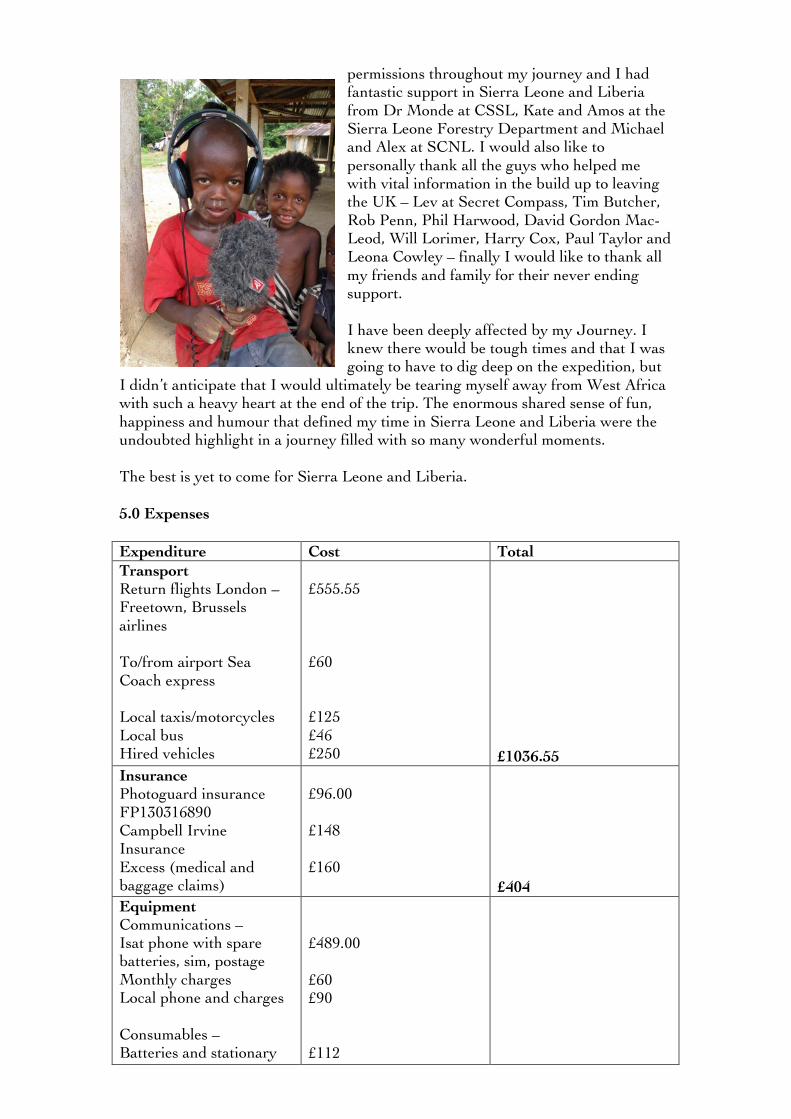
permissions throughout my journey and I had fantastic support in Sierra Leone and Liberia from Dr Monde at CSSL, Kate and Amos at the Sierra Leone Forestry Department and Michael and Alex at SCNL. I would also like to personally thank all the guys who helped me with vital information in the build up to leaving the UK – Lev at Secret Compass, Tim Butcher, Rob Penn, Phil Harwood, David Gordon Mac-Leod, Will Lorimer, Harry Cox, Paul Taylor and Leona Cowley – finally I would like to thank all my friends and family for their never ending support. I have been deeply affected by my Journey. I knew there would be tough times and that I was going to have to dig deep on the expedition, but
I didn’t anticipate that I would ultimately be tearing myself away from West Africa with such a heavy heart at the end of the trip. The enormous shared sense of fun, happiness and humour that defined my time in Sierra Leone and Liberia were the undoubted highlight in a journey filled with so many wonderful moments. The best is yet to come for Sierra Leone and Liberia. 5.0 Expenses Expenditure Cost Total Transport Return flights London – Freetown, Brussels airlines To/from airport Sea Coach express Local taxis/motorcycles Local bus Hired vehicles
£555.55 £60 £125 £46 £250
£1036.55
Insurance Photoguard insurance FP130316890 Campbell Irvine Insurance Excess (medical and baggage claims)
£96.00 £148 £160
£404
Equipment Communications – Isat phone with spare batteries, sim, postage Monthly charges Local phone and charges Consumables – Batteries and stationary
£489.00 £60 £90 £112
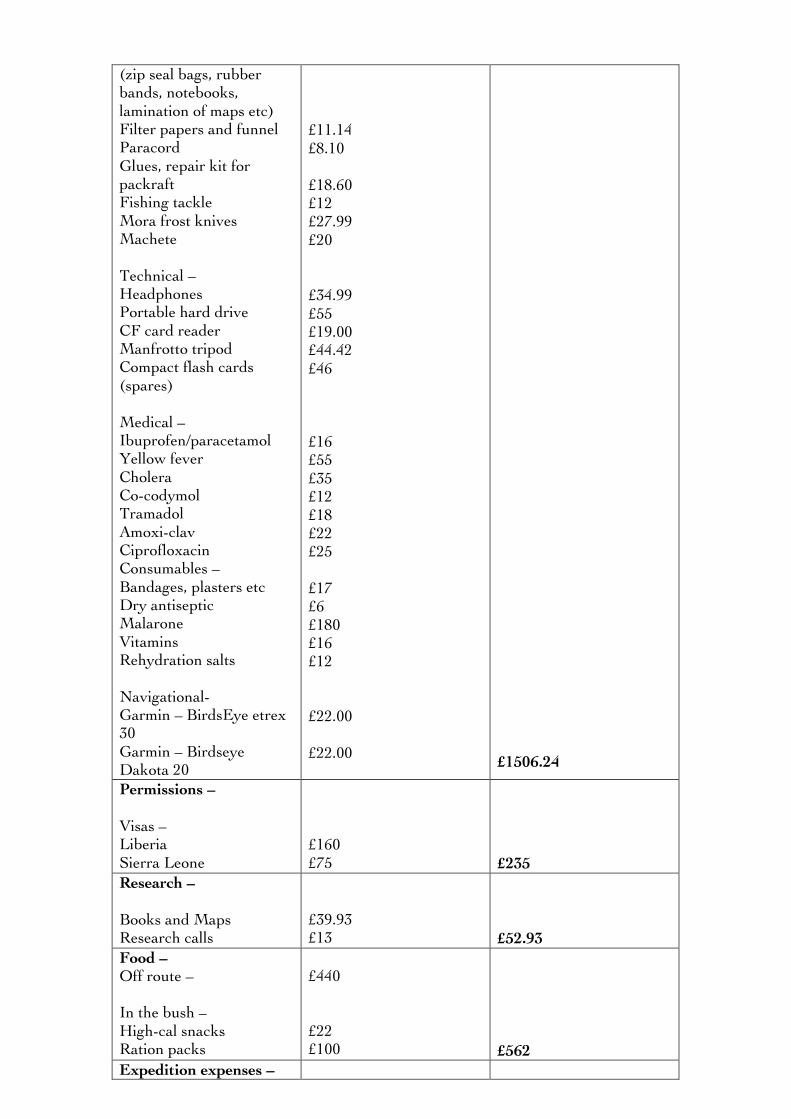
(zip seal bags, rubber bands, notebooks, lamination of maps etc) Filter papers and funnel Paracord Glues, repair kit for packraft Fishing tackle Mora frost knives Machete Technical – Headphones Portable hard drive CF card reader Manfrotto tripod Compact flash cards (spares) Medical – Ibuprofen/paracetamol Yellow fever Cholera Co-codymol Tramadol Amoxi-clav Ciprofloxacin Consumables – Bandages, plasters etc Dry antiseptic Malarone Vitamins Rehydration salts Navigational- Garmin – BirdsEye etrex 30 Garmin – Birdseye Dakota 20
£11.14 £8.10 £18.60 £12 £27.99 £20 £34.99 £55 £19.00 £44.42 £46 £16 £55 £35 £12 £18 £22 £25 £17 £6 £180 £16 £12 £22.00 £22.00
£1506.24
Permissions – Visas – Liberia Sierra Leone
£160 £75
£235
Research – Books and Maps Research calls
£39.93 £13
£52.93
Food – Off route – In the bush – High-cal snacks Ration packs
£440 £22 £100
£562
Expedition expenses –
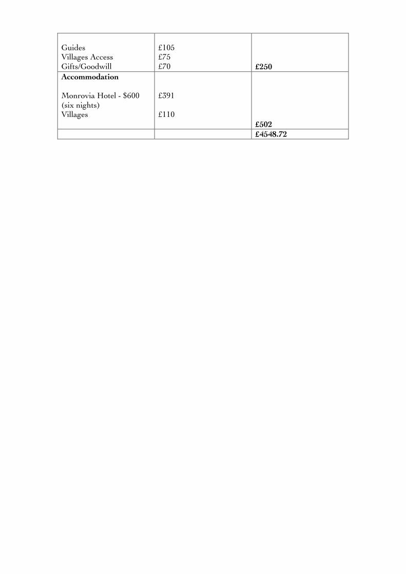
Guides Villages Access Gifts/Goodwill
£105 £75 £70
£250
Accommodation Monrovia Hotel - $600 (six nights) Villages
£391 £110
£502
£4548.72