with progressive mine closure planenvironmentclearance.nic.in/writereaddata/online/ec/... · ·...
TRANSCRIPT

1
MINING PLAN WITH
PROGRESSIVE MINE CLOSURE PLAN (Submitted Under Rule(s) 37B, 37 E(6), 37G of Rajasthan Minor Mineral Concession
(2nd Amendment) Rules 2012)
OF
BAJRI (MINOR MINERAL) MINE
Mr. MANJEET CHAWLA
VILLAGE(s) – KHEDLI KHALSA, GHATA JHARANYA, DOWDA KHURD, SURANG,
DHUNDA, DUBBIBIND RAKKHA, JADAWATA, KHATKHURD, KHATKALAN, PDHANA,
KIRPURA/ ODWADA, NIWADI
TEHSIL & DISTRICT – SAWAI MADHOPUR (RAJASTHAN)
LEASE AREA – 802.38 Hectares
LEASE PERIOD FROM – 5 YEARS FROM 05.03.2013
LESSEE Mr. MANJEET CHAWLA
S/o SHRI AMARJEET SINGH CHAWLA
R/o – G, 201, PREET VIHAR, NEW DELHI
PREPARED BY UMESH DATT SHARMA
REGISTRATION NO. RQP/AJM/277/2005-A (VALID UPTO – 2015)
M/s ENKAY ENVIRO SERVICES PVT. LTD. CORPORATE OFFICE: L-G-6, LOWER GROUND FLOOR, CORPORATE PARK,
GOPAL BARI, AJMER ROAD, JAIPUR – 302 001
Phone: - 0141-4013996, 4016996, Fax No.:- 0141 – 4026996
Email – [email protected], web site: - www.enkayenviro.com
2
INTRODUCTION
Letter of Intent has been issued by the Joint Secretary Administration, Govt. of
Rajasthan to Mr. Manjeet Chawla vide letter no P.6(3) Khan/ Gr. – 2/ 2013, Jaipur
dated 5th March 2013 for Removal of Bajri (Minor Mineral) from Gair mumkin Nadi,
Nallah and Khasara areas (excluding prohibited areas) in revenue villages of
Tehsil &District – Sawai Madhopur, Rajasthan.
Mining Lease is 802.38 ha (Excluding prohibited area) (Annexure – I). Validity
period is 5 years. River area spreads in 12 villages of Sawai Madhopur tehsil as
per details given by Assistant Mining Engineer, DMG, Tonk (Raj.) (Annexure – II).
Mr. Manjeet Chawla S/o Shri Amarjeet Singh Chawla is an individual and resident
of G, 201, Preet Vihar, New Delhi.
* * *

3
1. General information about lessee/ Licencee
a) Name & address of the lessee
Mr. Manjeet Chawla
S/o Shri Amarjeet Chawla
R/o – G, 201, Preet Vihar
New Delhi.
b) Status of the applicant
Mr. Manjeet Chawla is private individual, intrested in mining activity.
c) Name & Address of the RQP preparing the mining plan
Umesh Datt Sharma
(RQP/AJM/277/2005-A valid up to 2015 (Annexure-III).
56, Doctor Colony, DCM
Ajmer Road, Jaipur – 302 021 (Rajasthan)
Phone – 0141-6532876
Mobile – 98280 44233
E-mail – [email protected]
4
2.0 Details of the Mining Lease
a) ML No.
Mining Lease of Bajri (Minor Mineral) in an area of 802.38 ha (Excluding prohibited area)
is located in Tehsil- Sawai Madhopur. Details of the Khasara number and villages are
given below:
Table 1: Lease Area (Ha.)
S. No.
Village Khasara No. Area (Ha.) Grazing Land falling in River Area (Ha.)
1 Khedli Khalsa 1 199.59 -
2 Ghata Jharanya 1, 2 & 3 21.54 -
3 Dowda Khurd 1 & 2 130.18 -
4 Surang 1 22.34 -
5 Dhunda 297 28.30 -
6 Dubbibind
Rakkha
1,271,272,750,654 &
655
138.24 -
7 Jadawata 1, 2, 4 & 6 117.94 117.94
8 Khatkhurd 1 & 20 32.67 32.67
9 Khatkalan 1,32,37,38 & 55 42.30 -
10 Padhana 19 200.74 -
11 Kirpura/ Odwada 440 & 441 19.15 -
12 Niwadi 1, 2, 3, 4, 5 & 150 122.59 122.59
Total -- 1075.58 273.20
List enclosed as Annexure – II.
b) Name of Mineral Bajri (minor mineral) is occurring in the lease area.
c) Description report of the mining lease/ quarry license with plan (enclose
copy of sanction order/ lease deed/ license)
Based on the letter (Annexure-II) issued by Assistant Mining Engineer, Tonk and the
Khasra map submitted by the applicant, survey of the area was carried out and
demarcated along the course of the river Banas which flows from West side to East side.
Workings will be restricted within the lease area. Mining activities will be carried out in a
manner so that there is no obstruction to the movement of water flow, if any, during rainy
season. Lease area extends from village Khedli Khalsa on West side to Niwadi on East
side. Total length of the allotted area (Inclusive of prohibited area) is 32.80 km. Effective
length of the lease area, where mining activities will be carried out is 17.8 km. However,
there is 15.0 km length of grazing land, where no activity will be carried out in the lease
area. Copy of Letter of Intent issued is enclosed as Annexure – I.
5
d) Key plan of the area
Key plan is enclosed as Plate – 01.
e) Location map of the mining lease showing the details of the approach
roads up to the mine
Proposed lease area can be approached both from Sawai Madhopur on South side of
the river and Malarna on North side of the river. Distance of proposed lease area from
Sawai Madhopur side is approximately 16.0 km. Various link roads on the river course
stretch, merges with the tar road which connects Sawai Madhopur and Lalsot. North part
of the lease area towards Malarna side can be approached by a road almost parallel to
railway line which connects Sawai Madhopur and Malarna. Lease extends upto village
Niwadi. Lease area is shown on the Key Plan. It forms a part of G. T. Sheet No’s –
54B/7, 54B/8, 54B/11 & 54B/12. Toposheet is enclosed as Plate –02. Area is located
between following Latitude and Longitudes:
Latitude – 26°11’37.9” N to 26°12’03.7” N
Longitude - 76°18’19.3” E to 76°32’44.8” E
f) Details of the mining lease
Near villages - Khedli Khalsa, Ghata Jharanya, Dowda Khurd, Surang, Dhunda,
Dubbibind Rakkha, Jadawata, Khatkhurd, Khatkalan, Padhana, Kirpura/ Odwada,
Niwadi
Tehsil - Sawai Madhopur
District - Sawai Madhopur
State - Rajasthan
Khasra Number - List of villages and khasra numbers of the lease area as given by
Asst. Mining Engineer, DMG, Tonk (Rajasthan) is enclosed as
Annexure – II.
Status of land - Gair mumkin nadi, nallah.
Area - 802.38 hectare (Excluding prohibited area)
Period - Validity period is 5 year as per letter no. P.6(3) Khan/ Gr.– 2/
2013, Jaipur dated 5th March 2013.
g) Superimposed map of Proposed area on revenue map, duly attested by the
concerned Tehsildar/ SDO
Surveyed map of the proposed river area superimposed with the villages (Khasara no
and area as provided by lessee) is enclosed as Plate – 03.
6
h) Infrastructure facilities:
Nearest railway station Malarna – 3.25 km – N of the lease.
Police station Malarna Dungar – 7.0 km – N of the lease.
Post office Malarna Dungar – 7.0 km – N of the lease.
Medical facilities Malarna Dungar – 7.0 km – N of the lease.
Electricity JVVNL electrical supply is available in all nearby
villages.
Education facilities Govt. Secondary School at Dubbi and Govt. Middle School
at Jarawata respectively at – 1.25 km and 1.0 km - S of
the lease.
Mode of transportation of
mineral
Mineral Bajri will be transported by hired trucks. Loaded
trucks will travel on Kuccha road made for plying of trucks.
No’s of such temporary road will provide access to the
river bed and the movement of loaded trucks. As the lease
area stretches in a length of around 32.80 km, working will
be carried out in number of blocks called as “Peda” in local
language. Each Peda has its outlet meeting the tar road on
Sawai Madhopur side area from where the mineral is sent
to various destinations. Similarly, mineral will be
transported on the other side of the river by hired trucks
through approach roads towards Lalsot/ Gangapur city
side on the North side and finally merging with tar roads
for final destinations.
River/ canal/ port None within the lease area.
3.1 No. of Existing Mining Pits, their dimesnsion and locations
Mineral Bajri is the critical component in construction activities. Presently the mineral is
permited to be removed by DMG department. Royalty and other dues are collected by
Government authoritised collection agents at various outlets called “Naka’s”. Activities
are confined at various locations along the river course.
Bajri from tehsil Sawai Madhopur is transported from the road network on the both sides,
viz., Sawaimadhopur and Malarna ultimately to various destinations. Area is divided in
blocks around 3 numbers. Surface map is enclosed as Plate –04.

7
3.2 Physiography and Drainage Lease area is gently dipping towards East side indicating the flow direction of river. Highest elevation is 232.0 MSL and lowest elevation is 208.0 MSL. The district has a dry climate except during short rainy season. The winter extends from December to March and summer from March end to June third week, followed by rainy season which lasts upto third week of September. The normal actual rainfall in the district is 689.2 mm. On an average, there are 35 rainy days in a year. The mean maximum temperature is about 40°C and the mean minimum temperature is about 3°C (Source: India Water Portal). Toposheet is enclosed as Plate –03.
3.2 Geology of the Area 3.2.1 Regional Geology
Sawai Madhopur terrain is mostly formed by pre-Cambrian metamorphic, igneous and sedimentary rocks belonging to Pre-Aravalli & Vindhyanas. Pre Aravalli rock units comprising quartzite, mica, schist, gneiss and migmatite cover the north western part of the district between Lalsot and west of Bayana. The rocks of Vindhyan Super Group are represented by Rewa, Kaimur, Sand and Satola Group in increasing order of antiquity. These rocks occupy the eastern part of the district and are separated from the older rocks by a major reverse fault, The Great Boundary Fault. A major part of the district is occupied by the thick alluvium related to the various river systems. The geological succession of the district is given:-
Table 2: Geological Succession
Recent Alluvium VINDHYAN
SUPERGROUP Bhander Group Upper Bhander (Maihar) Sandstone
a- Sirbu Shale b – Limestone Lower Bhander (Bundi Hill) Sandstone Samria Shale Lakheri Limestone Ganugarh Shale
Rewa Group Upper Rewa (Govindgarh) Sandstone Jhiri Shale Lower Rewa (Indergarh) Sandstone Panna Shale
Kaimur Group Kaimur Sandstone Sand Group Tirohan Breccia Satola Group Tirohan Limestone
Sandstone with grit and Conglomerate
Delhi Super Group Intrusive Alwar Group Granite Quartzite with Schist
Bhilwara Super Group
Intrusive Dolerite
Ranthambore Group Mandalgarh Quartzite with shale and slate
Hindoli Group a – Bhadesar shale, slate and phyllite b - Quarzite
Mangalwar Complex Quartzite and schist Source: Memoirs and Records of Geological Survey of India
8
3.2.2 LOCAL GEOLOGY
Soil/ alluvium varying in thickness from 3.0 to 8.0 m constitute the top horizons in the
area suitable for agriculture. Banas river meanders through the area exposing the
alluvium and soil at the banks. Hard rock is exposed at places along the banks in the
lease area. Bajri is found in the river bed. This bed is presently dry and flows only during
the rainy season. Geological map and section is enclosed as Plate 05 (A) & 05(B).
In Sawai Madhopur district Bajri is obtained from river dry river bed of Banas.
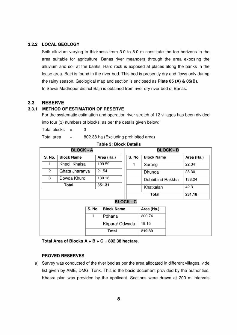
3.3 RESERVE
3.3.1 METHOD OF ESTIMATION OF RESERVE
For the systematic estimation and operation river stretch of 12 villages has been divided
into four (3) numbers of blocks, as per the details given below:
Total blocks = 3
Total area = 802.38 ha (Excluding prohibited area)
Table 3: Block Details
BLOCK - A
S. No. Block Name Area (Ha.)
1 Khedli Khalsa 199.59
2 Ghata Jharanya 21.54
3 Dowda Khurd 130.18
Total 351.31
BLOCK - B
S. No. Block Name Area (Ha.)
1 Surang 22.34
Dhunda 28.30
Dubbibind Rakkha 138.24
Khatkalan 42.3
Total 231.18
BLOCK - C
S. No. Block Name Area (Ha.)
1 Pdhana 200.74
Kirpura/ Odwada 19.15
Total 219.89
Total Area of Blocks A + B + C = 802.38 hectare.
PROVED RESERVES
a) Survey was conducted of the river bed as per the area allocated in different villages, vide
list given by AME, DMG, Tonk. This is the basic document provided by the authorities.
Khasra plan was provided by the applicant. Sections were drawn at 200 m intervals

9
along the course of the river. Details are given in the section plan, enclosed as Plate–
05 (A) & 05(B).
b) As per Rule 18 of Rules, 2012 of RMMCR, 1986 clause 32 stipulates “In case of mining
lease of mineral Bajri, the lessee/ lessees shall abstain from mining beyond depth of 3.0
m from the surface and below the water in such a manner that natural path of river/
nallah is not altered”.
c) Further as per notification no. F-14(1) Mines/ Gr11/ 2012 dated 21 June, 2012 from Dy.
Secretary to Government of Rajasthan clause 3 “No person shall excavate Bajri beyond
the depth of 3.0 m from the surface below the water level of river/ nallah and within 45 m
of any rail/ road bridge”.
d) A road bridge exists on the Banas river near Dubbibind Rakkha which connects the
South side with North side. It also provides way for transportation of Mineral also. In
addition, 45.0 m safety zone on upstream side and 45.0 m on downstream side has
been provided as a measure of safeguard. No workings will be extended in this zone.
e) In addition a road exists in the lease area providing access from North side to South
side of the river. A safety zone of 45 m on each side of roads will also be earmarked. In
this zone no activities will be conducted.
f) Working area as per Khasra no’s is confined in Tehsil Sawai Madhopur only. A barrier of
7.5 m width will be left from the lease limits if falling in the river bed.
g) 7.5 m offset will also be left against the banks to protect side collapse/scouring and
riparian vegetation.
h) River is not having any water flow during post monsoon period and sand bed remains
dry.
i) Mineral reserves are calculated up to 3 m depth from river bed surface RL.
j) A safety zone of 45.0 m radius is being earmarked for the wells located in the river bed.
Total 6 no’s of wells are located in the river bed supplying water to nearby villages.
k) All reserves are proved reserves. Details are given as below.
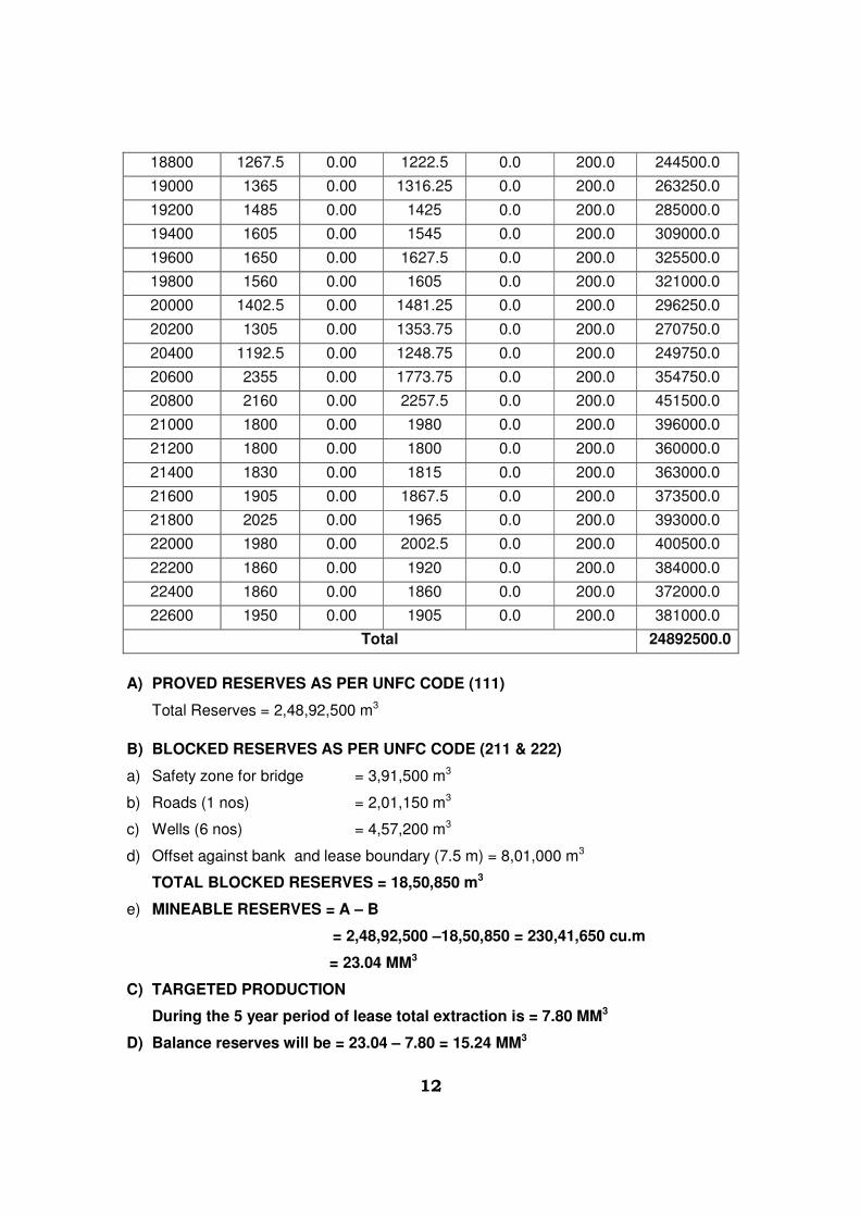
SECTIONS
Survey was conducted of the entire patch and sections were drawn at 200 m intervals. This
has been considered as influence length for the sections. Detailed calculations, location of
sections, sectional area with 3.0 m depth of excavation from surface river bed for the allotted
lease area has been carried out. Total reserves/ quantity thus calculated are given below:

10
Table 4: Section Details
CHAINAGE X-SECTION AREA
SQUARE METERS
AV. X-SECTION
AREA
SQUARE METERS
LENGTH QUANTITY
IN CUM
0 2595 0.00 2595.0 0.0 200.0 519000.0
200 2572.5 0.00 2583.8 0.0 200.0 516750.0
400 2512.5 0.00 2542.5 0.0 200.0 508500.0
600 2475 0.00 2493.8 0.0 200.0 498750.0
800 2452.5 0.00 2463.8 0.0 200.0 492750.0
1000 2400 0.00 2426.3 0.0 200.0 485250.0
1200 2287.5 0.00 2343.8 0.0 200.0 468750.0
1400 2017.5 0.00 2152.5 0.0 200.0 430500.0
1600 1755 0.00 1886.3 0.0 200.0 377250.0
1800 1605 0.00 1680.0 0.0 200.0 336000.0
2000 1537.5 0.00 1571.3 0.0 200.0 314250.0
2200 1462.5 0.00 1500.0 0.0 200.0 300000.0
2400 2940 0.00 2201.3 0.0 200.0 440250.0
2600 2625 0.00 2782.5 0.0 200.0 556500.0
2800 2550 0.00 2587.5 0.0 200.0 517500.0
3000 2460 0.00 2505.0 0.0 200.0 501000.0
3200 2310 0.00 2385.0 0.0 200.0 477000.0
3400 2235 0.00 2272.5 0.0 200.0 454500.0
3600 2130 0.00 2182.5 0.0 200.0 436500.0
3800 1935 0.00 2032.5 0.0 200.0 406500.0
4000 1770 0.00 1852.5 0.0 200.0 370500.0
4200 1485 0.00 1627.5 0.0 200.0 325500.0
4400 1365 0.00 1425.0 0.0 200.0 285000.0
4600 630 0.00 997.5 0.0 200.0 199500.0
4800 742.5 0.00 686.3 0.0 200.0 137250.0
5000 840 0.00 791.3 0.0 200.0 158250.0
5200 840 0.00 840.0 0.0 200.0 168000.0
5400 870 0.00 855.0 0.0 200.0 171000.0
5600 877.5 0.00 873.8 0.0 200.0 174750.0
5800 817.5 0.00 847.5 0.0 200.0 169500.0
6000 742.5 0.00 780.0 0.0 200.0 156000.0
6200 697.5 0.00 720.0 0.0 200.0 144000.0
6400 750 0.00 723.8 0.0 200.0 144750.0
6600 750 0.00 750.0 0.0 200.0 150000.0

11
6800 742.5 0.00 746.3 0.0 200.0 149250.0
7000 787.5 0.00 765.0 0.0 200.0 153000.0
7200 832.5 0.00 810.0 0.0 200.0 162000.0
7400 1005 0.00 918.8 0.0 200.0 183750.0
7600 1200 0.00 1102.5 0.0 200.0 220500.0
7800 1207.5 0.00 1203.8 0.0 200.0 240750.0
8000 1290 0.00 1248.8 0.0 200.0 249750.0
8200 1087.5 0.00 1188.8 0.0 200.0 237750.0
8400 967.5 0.00 1027.5 0.0 200.0 205500.0
8600 907.5 0.00 937.5 0.0 200.0 187500.0
8800 772.5 0.00 840.0 0.0 200.0 168000.0
9000 682.5 0.00 727.5 0.0 200.0 145500.0
9200 615 0.00 648.8 0.0 200.0 129750.0
9400 532.5 0.00 573.8 0.0 200.0 114750.0
9600 442.5 0.00 487.5 0.0 200.0 97500.0
9800 540 0.00 491.3 0.0 200.0 98250.0
10000 607.5 0.00 573.8 0.0 200.0 114750.0
10200 600 0.00 603.8 0.0 200.0 120750.0
10400 577.5 0.00 588.8 0.0 200.0 117750.0
10600 472.5 0.00 525.0 0.0 200.0 105000.0
10800 502.5 0.00 487.5 0.0 200.0 97500.0
11000 307.5 0.00 405.0 0.0 200.0 81000.0
11200 345 0.00 326.3 0.0 200.0 65250.0
11400 390 0.00 367.5 0.0 200.0 73500.0
11600 457.5 0.00 423.8 0.0 200.0 84750.0
11800 630 0.00 543.8 0.0 200.0 108750.0
12000 937.5 0.00 783.8 0.0 200.0 156750.0
12200 2655 0.00 1796.3 0.0 200.0 359250.0
14400 2160 0.00 2287.5 0.0 200.0 457500.0
14600 990 0.00 1575 0.0 200.0 315000.0
14800 825 0.00 907.5 0.0 200.0 181500.0
15000 780 0.00 802.5 0.0 200.0 160500.0
15200 765 0.00 772.5 0.0 200.0 154500.0
15400 870 0.00 817.5 0.0 200.0 163500.0
18000 757.5 0.00 378.75 0.0 200.0 75750.0
18200 825 0.00 791.25 0.0 200.0 158250.0
18400 1057.5 0.00 941.25 0.0 200.0 188250.0
18600 1177.5 0.00 1117.5 0.0 200.0 223500.0
12
18800 1267.5 0.00 1222.5 0.0 200.0 244500.0
19000 1365 0.00 1316.25 0.0 200.0 263250.0
19200 1485 0.00 1425 0.0 200.0 285000.0
19400 1605 0.00 1545 0.0 200.0 309000.0
19600 1650 0.00 1627.5 0.0 200.0 325500.0
19800 1560 0.00 1605 0.0 200.0 321000.0
20000 1402.5 0.00 1481.25 0.0 200.0 296250.0
20200 1305 0.00 1353.75 0.0 200.0 270750.0
20400 1192.5 0.00 1248.75 0.0 200.0 249750.0
20600 2355 0.00 1773.75 0.0 200.0 354750.0
20800 2160 0.00 2257.5 0.0 200.0 451500.0
21000 1800 0.00 1980 0.0 200.0 396000.0
21200 1800 0.00 1800 0.0 200.0 360000.0
21400 1830 0.00 1815 0.0 200.0 363000.0
21600 1905 0.00 1867.5 0.0 200.0 373500.0
21800 2025 0.00 1965 0.0 200.0 393000.0
22000 1980 0.00 2002.5 0.0 200.0 400500.0
22200 1860 0.00 1920 0.0 200.0 384000.0
22400 1860 0.00 1860 0.0 200.0 372000.0
22600 1950 0.00 1905 0.0 200.0 381000.0
Total 24892500.0
A) PROVED RESERVES AS PER UNFC CODE (111)
Total Reserves = 2,48,92,500 m3
B) BLOCKED RESERVES AS PER UNFC CODE (211 & 222)
a) Safety zone for bridge = 3,91,500 m3
b) Roads (1 nos) = 2,01,150 m3
c) Wells (6 nos) = 4,57,200 m3
d) Offset against bank and lease boundary (7.5 m) = 8,01,000 m3
TOTAL BLOCKED RESERVES = 18,50,850 m3
e) MINEABLE RESERVES = A – B
= 2,48,92,500 –18,50,850 = 230,41,650 cu.m
= 23.04 MM3
C) TARGETED PRODUCTION
During the 5 year period of lease total extraction is = 7.80 MM3
D) Balance reserves will be = 23.04 – 7.80 = 15.24 MM3

13
4.0 Details of Production & Dispatches of Five Years
This is a new lease area being allotted to the applicant.
Future production programme has been planned as per the details given below:
Production Programme
Proposed lease will be allotted for a period of 5 years only. Proposed lease consist of
802.38 ha area in 12 villages (Khasara) in a stretch of 32.80 km. It is proposed to work in
3 blocks as per the details given earlier.
Production programme is 8000 trips/ day.
Working days have been taken as 280 days per annum.which can be increased
depending on the conditions prevailing at the time of execution.
Projected Production Per Year = 280 x 8000 = 22,40,000 Tons
= 2.24 MMTA
Specific Density = 1.40 ton/ cu.m
Volumetric Production = 1.60 MM3
Table 5: Five Years Proposed Production Details
MMTA Year Block
- A
MTPA MM3 Block -
B
MTPA MM3 Block -
C
MTPA MM3 Total MTPA MM3
I 150 0.84 0.6 100 0.56 0.4 100 0.56 0.4 350 1.96 1.4
II 200 1.12 0.8 100 0.56 0.4 100 0.56 0.4 400 2.24 1.6
III 180 1.008 0.72 120 0.872 0.48 100 0.56 0.4 400 2.24 1.6
IV 180 1.008 0.72 100 0.56 0.4 120 0.672 0.48 400 2.24 1.6
V 200 1.12 0.8 100 0.56 0.4 100 0.56 0.4 400 2.24 1.6
Total 910 5.096 3.64 520 2.912 2.08 520 2.912 2.08 1950 10.92 7.8
Table 6: Five Years Block wise extraction Area Details are as given below:- HECTARE
S. No. Year Block - A Block - B Block - C Total
1. I 20.0 13.33 13.33 46.66
2. II 26.66 13.33 13.33 53.33
3. III 24.0 16.0 13.33 53.33
4. IV 24.0 13.33 16.0 53.33
5. V 26.66 13.33 13.33 53.33
Total 121.32 69.32 69.32 259.96
Length of lease
area (Km)
4.6 9.0 4.2 17.80

14
Table 7: Width of Strips/ Slices (Meters)
Year Block - A Block - B Block – C
I 43.47 14.81 31.73
II 57.95 14.81 31.73 III 52.17 17.78 31.73 IV 52.17 14.81 38.09
V 57.95 14.81 31.73
Total 263.71 77.02 165.01
5.0 Physical and Geological Characteristics of the Deposit
Deposit is moderate to good quality Bajri. It is widely used in construction, buildings,
bridges and other infrastructure. It is free from clay and non sticky in nature.
6.0 Details of Mining Machinery Deployed or to be Deployed and the detail
specifications
This is a new mining lease. Following equipments are proposed to be deployed for the
desired production.
Table 8: List of Machinery
S. No. Name of machinery Capacity Nos.
1 Excavators 0.9 to 1.2 m3 8
2 Tippers/ Trucks 20 tons -
3 Water Tanker 4000 liters 2
4 Payloader JCB -- 1
5 Light vehicles -- 3
7.0 Method of Mining
Proposed river bed mining is for extracting sand from Banas river bed. As per RMMC
Rules, 1986 extraction is limited to 3.0 m depth only from the surface area. River bed is
dry. Lease area allotted is 802.38 ha in tehsil & district – Sawai Madhopur. However,
there are intervening patches of land falling in the river bed and reserved as grazing land
as per the description list supplied by Assistant Mining Engineer, DMG Department,
Tonk. Total length of the area as per the description report stretches in the length of
32.80 km. However, two patches each of 4.8 km and 10.2 km length (total 15.0 km) have
been earmarked as grazing land, prohibited for mining activity. No mining activity will be
carried out in these prohibited areas, enclosed as Annexure –I.
Effective length of lease area for wining of mineral is 17.80 km. The area is further
divided in three blocks for ease of operation as the lease area is not in one stretch. Total

15
production envisaged is 8,000 TPD. Activities will be carried out as per the production
schedule given earlier. These blocks will be working as self sustained units with all
facilities like site office, rest shelter, first aid and drinking water etc. All these blocks will
be connected suitably with communication system.
Light weight excavators will be deployed for extraction. Mineral will be removed in 3.0 m
layer only forming one bench. This is as per the digging depth of the equipments.
Mineral will be loaded in trucks of 20 tons capacity. There will be no OB/waste
generation as the bajri is exposed in the river bed.
Bench will advance parallel to the banks of the river. Height of bench will be 3.0 m.
Width of the bench will be around 20.0 m. Workings will be restricted within the lease
area/ khasras as per the description report. Mining activities will be carried out in a
manner so that there is no obstruction to the movement of water flow, if any, during rainy
season. The bench will be in the form of slices/ strips parallel to the banks of the river.
Roads in the lease area for the movement of loaded trippers/ trucks will not have slopes
more than 1 in 20. However, movement of trucks after mineral loading will be towards
both sides through approach roads connecting to tar roads. Every block will have its own
approach roads, well connected to main highways.
7.1 Proposed year wise development for five years
Bajri lease is proposed to be granted for a period of five years only. Calendar plan has
already been made and details have been given. Sequence of operation has been
depicted in Plate No – 06 (A) & 06 (B).
Ultimate limit will be 3.0 m below surface RL as indicated in the working section.
7.2 Proposed rate of production when the mine is fully developed
Year wise production during the plan period will be as follows:
Table 9: Proposed Production
S.
No.
Targeted Production
(in MMTA)
Targeted Production
(in MM3)
OB/ Waste
(M3)
1 1.96 1.4 -
2 2.24 1.6 -
3 2.24 1.6 -
4 2.24 1.6 -
5 2.24 1.6 -
Total 10.92 7.8 -
Conversion factor is 1.4 ton/ m3

16
7.3 Mineable reserves and anticipated life of the mine
Lease period is of 5 years only as per RMMCR (Amendment) 1986 after extraction of
targeted production appreciable quantity of mineral will be available for future. During
rainy season there is some replenishment of the mineral, which helps in sustaining the
production.
Estimated Minable reserves up to 3.0 m available are = 23.04 MM3
Anticipated production during lease period will be = 7.80 MM3
7.4 Proposed method of mining
Mining activity will be carried out by open cast semi-mechanized method.
� Light weight excavators will be used for loading of mineral in tippers.
� No OB/ waste material will be produced.
� No drilling/ blasting is required as the material is loose in nature.
� Proper benching of not more than 3.0 m height will be maintained.
� Roads will be properly made and sprayed for suppression of dust.
� Roads in the lease area for the movement of loaded trippers/ trucks will not have slopes
more than 1 in 20.
� Total extent of lease is 32.80 km including prohibited area.
� Extraction activities will start in the blocks from the upstream side to downstream side.
This will not obstruct the movement of water, if any, during monsoon period in the river
course.
� Approach roads from the various blocks as already described earlier will be merging with
permanent tar roads on both sides of the river for transportation of the mineral to final
destinations.
7.5 Conceptual Mining Plan
Mine lease area will be worked in blocks for ease of operation. However, as the digging
depth will be restricted to 3.0 m only, material will still be available below. This will be
further replenished to some extends during rainy season. Blocks will be worked
systematically as the width is limited while length is much more. Sequence of working
has been shown on Plate no – 06 (A) & 06(B) of working plan and sections. As the
lease period is only 5 years, some of the area will be left un-worked at the end of lease
period.

17
(i) Final Slope Angle To Be Adopted
Thickness of the bench is limited to 3.0 m only and width is 20.0 m. River bank side will be
protected by 7.5 m offset. Bank side natural slope will not be disturbed. This will prevent
collapse of bank and erosion. However, the height of the bank with respect to river bed is
varying from 4.0 to 6.0 m only.
(ii) During plan period workings will be carried out in the blocks of the lease area
simultaneously. Scattered workings will ensure safety, remove congestion of vehicles
and will have better control and management.
(iii) Ultimate Capacity Of Dumps
There will be no OB removal and waste generation during the plan period. No dumping
area is needed. No outside material will be filled up in the extracted zone.
a) Landuse Pattern of Mining Lease Area at Various Stages
Land use pattern will be as follows:
Table 10: Land Use Pattern of Mining Lease area at Various Phases
S. No.
Particulars Present land use
(ha.)
At the End of 3rd Year
(ha.)
At the end of 5th year (ha.)
1. Pit area - 153.32 259.96 2. Dump area - - -
3. Safety zone
Road (1 no.) 6.7 6.7 6.7 Bridge (1 no.) 13.05 13.05 13.05 Wells (6 no.) 15.24 15.24 15.24
4. Infrastructure (Office, Temp. shelter etc)
- 0.30 0.30
5. Mineral Storage - - -
6. Plantation - - -
7. Un-worked 767.39 613.77 507.13 Total 802.38 802.38 802.38
7.6 Blasting
Bajri extraction will not require any drilling, blasting activities.
7.7 Mines Drainage
General topography has the slopes towards the river both on North and South side. Area
is generally flat in nature. River flows from West to East side i.e., Tonk to Sawai
Madhopur side. Highest elevation on the banks of river at the beginning of the lease
area is 232.0 MSL and lowest is 208.0 MSL at the end of lease area.
RL details along the river course are as given below:
18
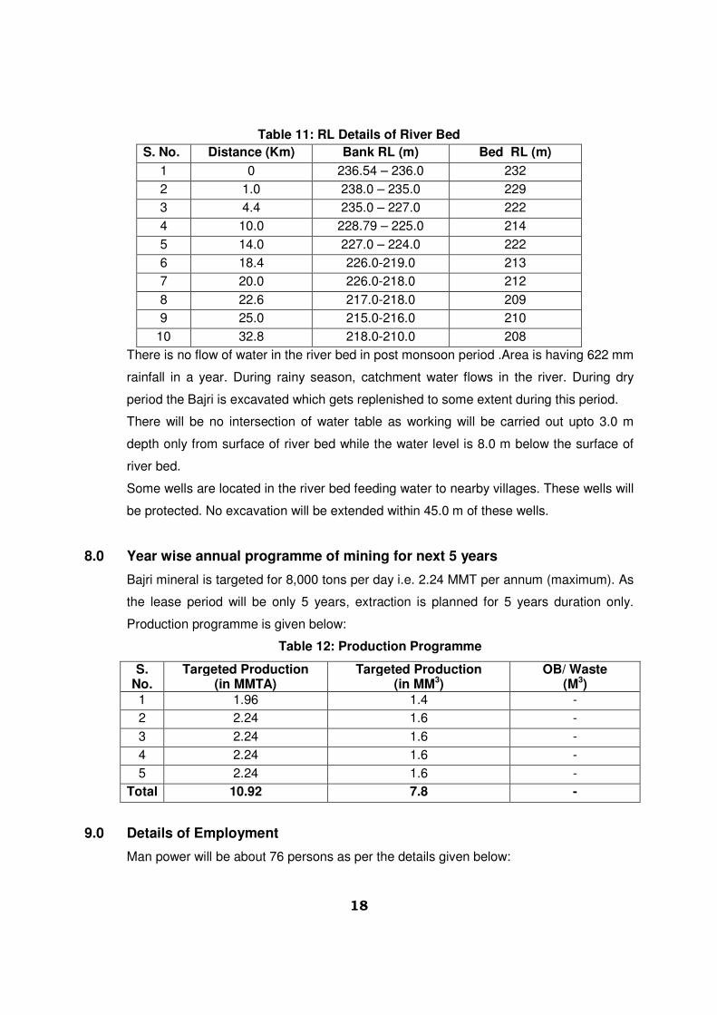
Table 11: RL Details of River Bed
S. No. Distance (Km) Bank RL (m) Bed RL (m)
1 0 236.54 – 236.0 232
2 1.0 238.0 – 235.0 229
3 4.4 235.0 – 227.0 222
4 10.0 228.79 – 225.0 214
5 14.0 227.0 – 224.0 222
6 18.4 226.0-219.0 213
7 20.0 226.0-218.0 212
8 22.6 217.0-218.0 209
9 25.0 215.0-216.0 210
10 32.8 218.0-210.0 208
There is no flow of water in the river bed in post monsoon period .Area is having 622 mm
rainfall in a year. During rainy season, catchment water flows in the river. During dry
period the Bajri is excavated which gets replenished to some extent during this period.
There will be no intersection of water table as working will be carried out upto 3.0 m
depth only from surface of river bed while the water level is 8.0 m below the surface of
river bed.
Some wells are located in the river bed feeding water to nearby villages. These wells will
be protected. No excavation will be extended within 45.0 m of these wells.
8.0 Year wise annual programme of mining for next 5 years
Bajri mineral is targeted for 8,000 tons per day i.e. 2.24 MMT per annum (maximum). As
the lease period will be only 5 years, extraction is planned for 5 years duration only.
Production programme is given below:
Table 12: Production Programme
S. No.
Targeted Production (in MMTA)
Targeted Production (in MM3)
OB/ Waste (M3)
1 1.96 1.4 -
2 2.24 1.6 -
3 2.24 1.6 -
4 2.24 1.6 -
5 2.24 1.6 -
Total 10.92 7.8 -
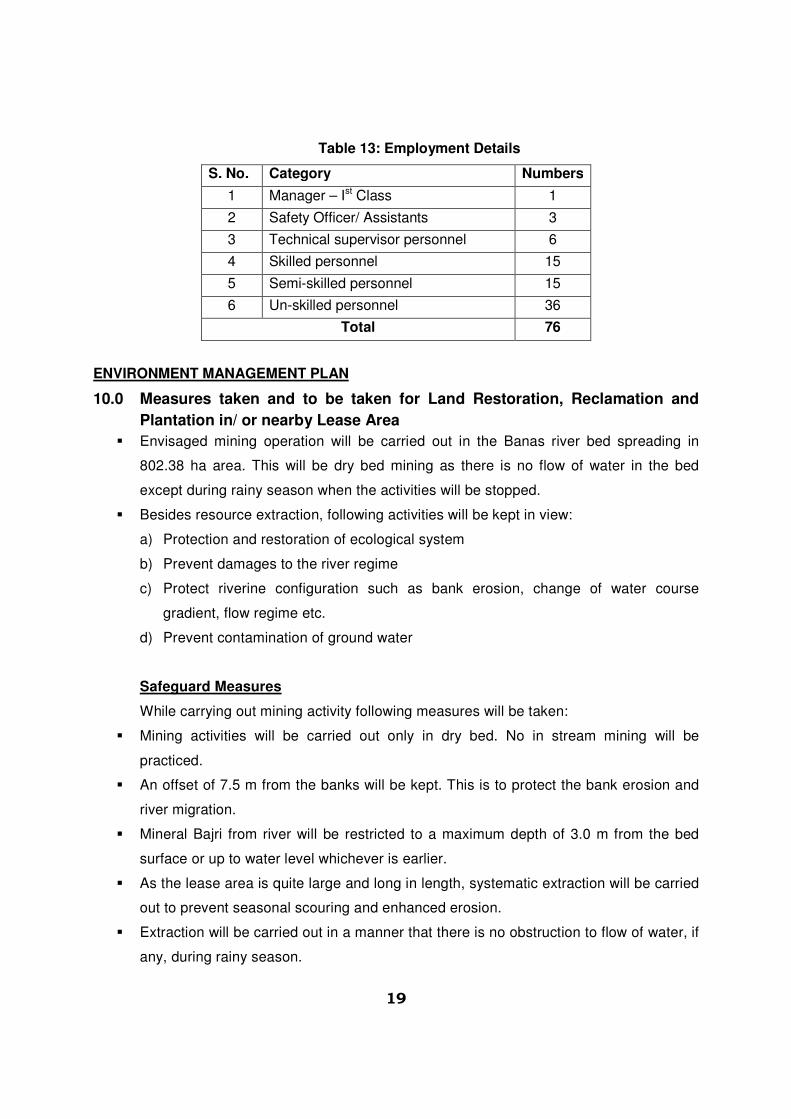
9.0 Details of Employment
Man power will be about 76 persons as per the details given below:
19
Table 13: Employment Details
S. No. Category Numbers
1 Manager – Ist Class 1
2 Safety Officer/ Assistants 3
3 Technical supervisor personnel 6
4 Skilled personnel 15
5 Semi-skilled personnel 15
6 Un-skilled personnel 36
Total 76
ENVIRONMENT MANAGEMENT PLAN
10.0 Measures taken and to be taken for Land Restoration, Reclamation and
Plantation in/ or nearby Lease Area
� Envisaged mining operation will be carried out in the Banas river bed spreading in
802.38 ha area. This will be dry bed mining as there is no flow of water in the bed
except during rainy season when the activities will be stopped.
� Besides resource extraction, following activities will be kept in view:
a) Protection and restoration of ecological system
b) Prevent damages to the river regime
c) Protect riverine configuration such as bank erosion, change of water course
gradient, flow regime etc.
d) Prevent contamination of ground water
Safeguard Measures
While carrying out mining activity following measures will be taken:
� Mining activities will be carried out only in dry bed. No in stream mining will be
practiced.
� An offset of 7.5 m from the banks will be kept. This is to protect the bank erosion and
river migration.
� Mineral Bajri from river will be restricted to a maximum depth of 3.0 m from the bed
surface or up to water level whichever is earlier.
� As the lease area is quite large and long in length, systematic extraction will be carried
out to prevent seasonal scouring and enhanced erosion.
� Extraction will be carried out in a manner that there is no obstruction to flow of water, if
any, during rainy season.

20
� Simultaneously 45.0.0 m radius around the well located in the river bed will not have
any mining activity.
� Mining on the concave side of the river channel should be avoided to prevent bank
erosion. Similarly meandering segment of river will be selected to prevent natural
eroding banks and to promote mining on natural building (aggrading) meanders
component
Reclamation of Mined Out Area
There is no generation of OB/ waste material. No backfilling has been proposed in the
excavated zone. River to some extent will be replenished by sediments during rainy
season.
Greenbelt
The lease area is in the river bed and devoid of any vegetation. Mining activities will
not cause any harm to riparian vegetation cover as the working will not extend beyond
the 7.5 m offset left against the banks in the river. Land on both sides is the private
agriculture land. Link road from the active zone pass through the areas. It is proposed
to have plantation on both sides of the roads as greenbelt to provide cover against
dust dissemination. Plantation will also be carried out as social forestry programme in
villages, school and the areas allocated by the Panchayat/ State authorities.
Native plants like Neem, Pipal, Khejri, Mango and other local species will be planted. A
suitable combination of trees that can grow fast and also have good leaf cover shall be
adopted to develop the greenbelt. It is proposed to plant 9,100 no’s of native species
along with some fruit bearing and medicinal trees during the plan period.
Table 14: Greenbelt Programme
Year No. of Saplings Survival Rate (80%)
Species Place of Plantation
I 1820 1456 Neem, Peepal,
Mango, Shisham,
Sirish, Ardu,
Babool,
Gulmohar and
Khejri.
Along the roads, in
schools and public
building and other
social forestry
programme.
II 1820 1456
III 1820 1456
IV 1820 1456
V 1820 1456
Total 9,100 7280
11.0 Measures taken and to be taken for Protection of Environment in and
around Mining Lease Area
� Dry bed mining will be carried out only.
� Mining activities will be confined to 3.0 m depth from surface level of river bed.

21
� All link roads from the mining area to the tar road will be properly sprayed with water for
dust suppression.
� Greenbelt and plantation on road side will help in dust suppression and will also reduce
noise level.
� Plantation will improve ecology and aesthetic beauty of the area
� Measures will be taken to prevent the workings from crossing safety zones, cutting the
banks and exceeding 3.0 m depth limit from the river bed surface.
12.0 Measures taken and to be taken for dumping overburden, stacking of top
soil and utilization of top soil
There is no topsoil in the lease area. No overburden and waste is likely to be generated
during lease period. There will be neither any stacking of soil nor creation of OB dumps.
13.0 Measures taken and to be taken for the control of water, noise and air
pollution
Air Pollution:
Emission of gases and dust takes place due to movement of vehicles. Spraying of water
and plantation along the road side prevents the spread of dust. Plantation also acts as
barrier for restricting pollution. Impact on air environment has been assessed taking in to
consideration the proposed production and increase emissions. The sources of air
pollution are given below:
� Operation of mining machinery/ loading operations
� Transportation of mineral
� Wind erosion from barren area and river bed
Air pollutants released during production can be checked by:
� Dust suppression system/ water spraying would be adopted at mine working and
loading points
� Excavation operations to be suspended during very strong wind conditions
� Afforestation will be carried out for control of dust
� Plantation with wide canopy trees along approach road will help in dust
suppression
� Persons to be provided with dust mask and other personal protective equipments
,particularly during summer months and dust storm periods
22
Transportation
� Regular water spraying on haulage roads during mineral transportation by water
sprinklers,
� Avoid over loading of tippers & consequent spillage on the roads,
� Mineral carrying trucks will be effectively covered by tarpaulin to avoid escape of
fines to atmosphere,
� Air quality shall be regularly monitored both in the core zone and the buffer zone.
Controlling of NOx level
The source of NOx is due to vehicular emission. This can be controlled by proper
maintenance and servicing of vehicles.
Only P.U.C. certificated vehicles will be permitted
Noise Pollution
There is no drilling and blasting for mineral extraction. Noise pollution due to
transportation will not cause any problem to the inhabitants of this area because there is
no human settlement in close proximity to the link roads in lease area.
Effective steps will be taken to keep the noise level well below the DGMS prescribed
limit of 85 dBA.
Noise control is achieved by the following:
• Proper care and maintenance of the equipments will be carried out.
• Personal protective equipments will be provided to the workers.
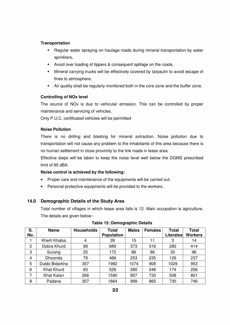
14.0 Demographic Details of the Study Area
Total number of villages in which lease area falls is 12. Main occupation is agriculture.
The details are given below:-
Table 15: Demographic Details
S. No.
Name Households Total Population
Males Females Total Literates
Total Workers
1 Kherli Khalsa 4 26 15 11 3 14
2 Dobra Khurd 99 689 373 316 280 414
3 Surang 25 172 86 86 35 96
4 Dhoonda 79 488 253 235 126 237
5 Dubbi Bidarkha 307 1982 1074 908 1029 953
6 Khat Khurd 83 528 280 248 174 256
7 Khat Kalan 266 1590 857 733 508 801
8 Padana 307 1864 999 865 730 746
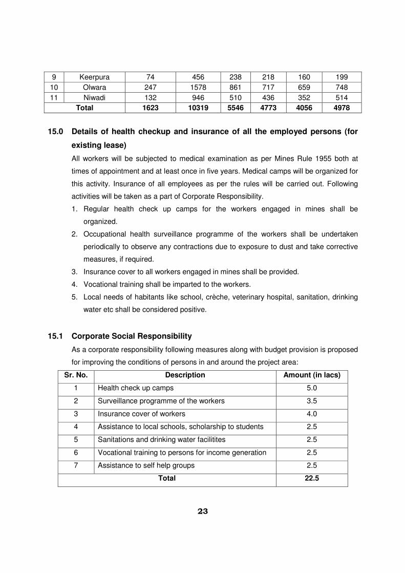
23
9 Keerpura 74 456 238 218 160 199
10 Olwara 247 1578 861 717 659 748
11 Niwadi 132 946 510 436 352 514
Total 1623 10319 5546 4773 4056 4978
15.0 Details of health checkup and insurance of all the employed persons (for
existing lease)
All workers will be subjected to medical examination as per Mines Rule 1955 both at
times of appointment and at least once in five years. Medical camps will be organized for
this activity. Insurance of all employees as per the rules will be carried out. Following
activities will be taken as a part of Corporate Responsibility.
1. Regular health check up camps for the workers engaged in mines shall be
organized.
2. Occupational health surveillance programme of the workers shall be undertaken
periodically to observe any contractions due to exposure to dust and take corrective
measures, if required.
3. Insurance cover to all workers engaged in mines shall be provided.
4. Vocational training shall be imparted to the workers.
5. Local needs of habitants like school, crèche, veterinary hospital, sanitation, drinking
water etc shall be considered positive.
15.1 Corporate Social Responsibility
As a corporate responsibility following measures along with budget provision is proposed
for improving the conditions of persons in and around the project area:
Sr. No. Description Amount (in lacs)
1 Health check up camps 5.0
2 Surveillance programme of the workers 3.5
3 Insurance cover of workers 4.0
4 Assistance to local schools, scholarship to students 2.5
5 Sanitations and drinking water facilitites 2.5
6 Vocational training to persons for income generation 2.5
7 Assistance to self help groups 2.5
Total 22.5

24
15.2 Fund Provision for Environmental Management
It is proposed to create an Environment Management Fund at the rate of Rs./- 5 ton on
mineral production. This fund will be kept seprately and will be utilised for CSR, Well
fare, Plantaion and Ecology improvement as per MMCR-1986.
Yearly generation of fund at the proposed rate of production is estimated Rs.
1,12,00,000/- per year.
Fund allocation for CSR activities will be around Rs/- 22.50 lac and for EMP measure
Rs/- 32.50 lacs.
Balance funds will be utilised as per requirement in additional activities concerning
overall growth of the area.
15.3 Fund Provision for EMP Measures
Following provisions are proposed to be taken for improving, control and monitoring of
environment protection measures
Sr. No. Particulars Amount (in lacs)
1 Pollution monitoring – Air, Water, Noise 12.0
2 Pollution monitoring – Water sprinkling 12.0
3 Wire fencing at plantation sites 2.0
4 Plantation including maintinance 2.0
5 Rainwater harvesting 2.5
6 Haul road and other roads repair and maintinance 2.0
Total 32.50
The protection measures will be dynamic and subject to perodic review so that
measures remain effective and appropriate.
***
25
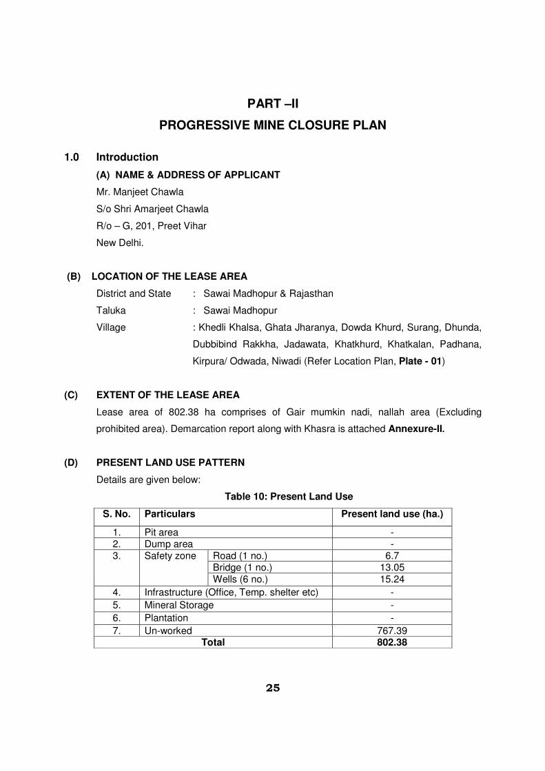
PART –II
PROGRESSIVE MINE CLOSURE PLAN
1.0 Introduction
(A) NAME & ADDRESS OF APPLICANT
Mr. Manjeet Chawla
S/o Shri Amarjeet Chawla
R/o – G, 201, Preet Vihar
New Delhi.
(B) LOCATION OF THE LEASE AREA
District and State : Sawai Madhopur & Rajasthan
Taluka : Sawai Madhopur
Village : Khedli Khalsa, Ghata Jharanya, Dowda Khurd, Surang, Dhunda,
Dubbibind Rakkha, Jadawata, Khatkhurd, Khatkalan, Padhana,
Kirpura/ Odwada, Niwadi (Refer Location Plan, Plate - 01)
(C) EXTENT OF THE LEASE AREA
Lease area of 802.38 ha comprises of Gair mumkin nadi, nallah area (Excluding
prohibited area). Demarcation report along with Khasra is attached Annexure-II.
(D) PRESENT LAND USE PATTERN
Details are given below:
Table 10: Present Land Use
S. No. Particulars Present land use (ha.)
1. Pit area - 2. Dump area - 3. Safety zone
Road (1 no.) 6.7 Bridge (1 no.) 13.05 Wells (6 no.) 15.24
4. Infrastructure (Office, Temp. shelter etc) -
5. Mineral Storage -
6. Plantation -
7. Un-worked 767.39 Total 802.38

26
(E) METHOD OF MINING:
River bed mining is for extracting sand from Banas river bed. As per RMMC Rules, 1986
extraction is limited to 3.0 m depth only from the river bed surface or above water level
whichever is earlier. Proposed lease area is 802.38 ha (excluding prohibited area) in
tehsil & district – Sawai Madhopur. However, there are intervening patches of land falling
in the river bed and reserved as grazing land as per the description list supplied by
Assistant Mining Engineer, DMG Department, Tonk. Total length of the area as per the
description report stretches in the length of 32.80 km. However, two patches each of 4.8
km and 10.2 km length (total 15.0 km) have been earmarked as grazing land, prohibited
for mining activity. No mining activity will be carried out in these prohibited areas,
enclosed as Annexure –I.
Effective length of lease area for mining of mineral is 17.80 km. The area is further
divided in three blocks for ease of operation as the lease area is not in one stretch. Total
production envisaged is 8,000 TPD. Activities will be carried out as per the production
schedule given earlier. These blocks will be working as self sustained units with all
facilities like site office, rest shelter, first aid and drinking water etc. All these blocks will
be connected suitably with communication system.
Light weight excavators will be deployed for extraction. Mineral will be removed in 3.0 m
layer only forming one bench. This is as per the digging depth of the equipments.
Mineral will be loaded in trucks of 20 tons capacity. There will be no OB or waste
generation as the sand is exposed in the river bed.
Bench will advance parallel to the banks of the river. Height of bench will be 3.0 m.
Width of the bench will be around 20.0 m. Workings will be restricted within the lease
area/ khasras as per the description report. Mining activities will be carried out in a
manner so that there is no obstruction to the movement of water flow, if any, during rainy
season. The bench will be in the form of slices/ strips parallel to the banks of the river.
Roads in the lease area for the movement of loaded trippers/ trucks will not have slopes
more than 1 in 20. However, movement of trucks after mineral loading will be towards
both sides through approach roads connecting to tar roads. Every block will have its own
approach roads, well connected to main highways.
(F) MINERAL PROCESSING OPERATION:
No mineral processing is envisaged for Bajri (minor mineral) .
27
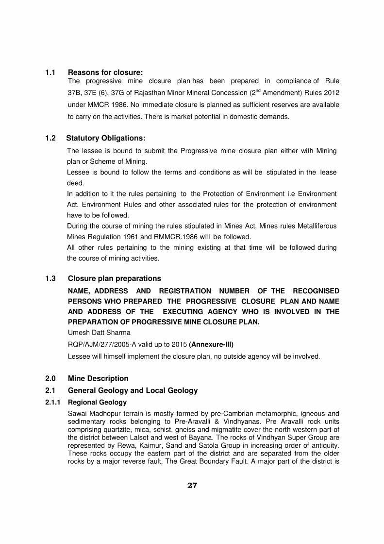
1.1 Reasons for closure: The progressive mine closure plan has been prepared in compliance of Rule
37B, 37E (6), 37G of Rajasthan Minor Mineral Concession (2nd Amendment) Rules 2012
under MMCR 1986. No immediate closure is planned as sufficient reserves are available
to carry on the activities. There is market potential in domestic demands.
1.2 Statutory Obligations:
The lessee is bound to submit the Progressive mine closure plan either with Mining
plan or Scheme of Mining.
Lessee is bound to follow the terms and conditions as will be stipulated in the lease
deed.
In addition to it the rules pertaining to the Protection of Environment i.e Environment
Act. Environment Rules and other associated rules for the protection of environment
have to be followed.
During the course of mining the rules stipulated in Mines Act, Mines rules Metalliferous
Mines Regulation 1961 and RMMCR.1986 will be followed.
All other rules pertaining to the mining existing at that time will be followed during
the course of mining activities.
1.3 Closure plan preparations
NAME, ADDRESS AND REGISTRATION NUMBER OF THE RECOGNISED
PERSONS WHO PREPARED THE PROGRESSIVE CLOSURE PLAN AND NAME
AND ADDRESS OF THE EXECUTING AGENCY WHO IS INVOLVED IN THE
PREPARATION OF PROGRESSIVE MINE CLOSURE PLAN.
Umesh Datt Sharma
RQP/AJM/277/2005-A valid up to 2015 (Annexure-III)
Lessee will himself implement the closure plan, no outside agency will be involved.
2.0 Mine Description
2.1 General Geology and Local Geology
2.1.1 Regional Geology
Sawai Madhopur terrain is mostly formed by pre-Cambrian metamorphic, igneous and sedimentary rocks belonging to Pre-Aravalli & Vindhyanas. Pre Aravalli rock units comprising quartzite, mica, schist, gneiss and migmatite cover the north western part of the district between Lalsot and west of Bayana. The rocks of Vindhyan Super Group are represented by Rewa, Kaimur, Sand and Satola Group in increasing order of antiquity. These rocks occupy the eastern part of the district and are separated from the older rocks by a major reverse fault, The Great Boundary Fault. A major part of the district is

28
occupied by the thick alluvium related to the various river systems. The geological succession of the district is given:-
Table 2: Geological Succession
Recent Alluvium VINDHYAN
SUPERGROUP Bhander Group Upper Bhander (Maihar) Sandstone
b- Sirbu Shale b – Limestone Lower Bhander (Bundi Hill) Sandstone Samria Shale Lakheri Limestone Ganugarh Shale
Rewa Group Upper Rewa (Govindgarh) Sandstone Jhiri Shale Lower Rewa (Indergarh) Sandstone Panna Shale
Kaimur Group Kaimur Sandstone Sand Group Tirohan Breccia Satola Group Tirohan Limestone
Sandstone with grit and Conglomerate
Delhi Super Group Intrusive Alwar Group Granite Quartzite with Schist
Bhilwara Super Group
Intrusive Dolerite
Ranthambore Group Mandalgarh Quartzite with shale and slate
Hindoli Group a – Bhadesar shale, slate and phyllite b - Quarzite
Mangalwar Complex Quartzite and schist Source: Memoirs and Records of Geological Survey of India.
2.1.2 Local Geology
Soil/ alluvium varying in thickness from 3.0 to 8.0 m constitute the top horizons in the
area suitable for agriculture. Banas river meanders through the area exposing the
alluvium and soil at the banks. Hard rock is exposed at places along the banks in the
proposed lease area. Bajri is found in the river bed. This bed is presently dry and flows
only during the rainy season. Geological map and section is enclosed as Plate 05 (A) &
05(B).
In Sawai Madhopur district Bajri is obtained from river bed of Banas.
2.2 Reserves Method of Estimation of Reserve Total blocks = 3
Total area = 802.38 ha (Excluding prohibited area)
Say 3 (three) blocks as follow:

29
Table 3: Block Details
BLOCK - A
S. No. Block Name Area (Ha.)
1 Khedli Khalsa 199.59
2 Ghata Jharanya 21.54
3 Dowda Khurd 130.18
Total 351.31
BLOCK - B
S. No. Block Name Area (Ha.)
1 Surang 22.34
Dhunda 28.30
Dubbibind Rakkha 138.24
Khatkalan 42.3
Total 231.18
BLOCK - C
S. No. Block Name Area (Ha.)
1 Pdhana 200.74
Kirpura/ Odwada 19.15
Total 219.89
Total Area of Blocks A+ B+ C = 802.38 ha. (Excluding prohibited area).
PROVED RESERVES
a) Survey was conducted of the river bed as per the area allocated in different villages, vide
list given by AME, DMG, Tonk. This is the basic document provided by the authorities.
Khasra plan was provided by the applicant. Sections were drawn at 200 m intervals
along the course of the river. Details are given in the section plan, enclosed as Plate– 05
(A) & 05 (B).
b) As per Rule 18 of Rules, 2012 of RMMCR, 1986 clause 32 stipulates “In case of mining
lease of mineral Bajri, the lessee/ lessees shall abstain from mining beyond depth of 3.0
m from the surface and below the water in such a manner that natural path of river/
nallah is not altered”.
c) Further as per notification no. F-14(1) Mines/ Gr11/ 2012 dated 21 June, 2012 from Dy.
Secretary to Government of Rajasthan clause 3 “No person shall excavate Bajri beyond
the depth of 3.0 m from the surface below the water level of river/ nallah and within 45 m
of any rail/ road bridge”.
d) A road bridge exists on the Banas river near Dubbibind Rakkha which connects the
South side with North side. It also provides way for transportation of Mineral also. In
addition to the width of bridge, 45.0 m safety zone on upstream side and 45.0 m on
downstream side has been provided as a measure of safeguard. No workings will be
extended in this zone.

30
e) In addition a road exists in the lease area providing access from North side to South
side of the river. A safety zone of 45 m on each side of roads will also be earmarked. In
this zone no activities will be conducted.
f) Working area as per Khasra no’s is confined in Tehsil Sawai Madhopur only. A barrier of
7.5 m width will be left from the lease limits if falling in the river bed.
g) 7.5 m offset will also be left against the banks to protect side collapse/scouring and
riparian vegetation.
h) River is not having any water flow during post monsoon period and sand bed remains
dry.
i) Mineral reserves are calculated up to 3 m depth from river bed surface RL.
j) A safety zone of 45.0 m radius is being earmarked for the wells located in the river bed.
Total 6 no’s of wells are located in the river bed supplying water to nearby villages.
k) All reserves are proved reserves.
2.3 Mining Method
Mining method to be followed is described in point no. 7.1 of mining plan.
2.4 Mineral Beneficiation
No mineral beneficiation is envisaged.
3 Review of implementation of mining plan including five years progressive
closure plan upto the final closure plan
Mining Plan and Progressive mine closure plan are being submitted for the first time. It
will be reviewed after five years and review of implementation will be given with next
mining scheme.
4.0 Closure Plan
4.1 Mined - out land
At the end of mining plan period, about 259.96 ha area will be mined out. Landuse at
various stages is given in the table below:
Table 10: Land Use at the end of lease period
S. No.
Particulars Present land use
(ha.)
At the End of 3rd Year
(ha.)
At the end of 5th year (ha.)
1. Pit area - 153.32 259.96 2. Dump area - - - 3. Safety
zone Road (1 no.) 6.7 6.7 6.7 Bridge (1 no.) 13.05 13.05 13.05

31
Wells (6 no.) 15.24 15.24 15.24
4. Infrastructure (Office, Temp. shelter etc)
- 0.30 0.30
5. Mineral Storage - - -
6. Plantation - - -
7. Un-worked 767.39 613.77 507.13 Total 802.38 802.38 802.38
4.2 Water quality management
General topography has the slopes towards the river both on North and South side. Area
is generally flat in nature. River flows from West to East i.e., Tonk to Sawai Madhopur.
Lease area is gently dipping towards East side indicating the flow direction of river.
Highest elevation is 232.0 MSL and lowest elevation is 208.0 MSL. RL details along
the river course are as given below:
Table 11: RL Details of River Bed
S. No. Distance (Km) Bank RL (m) Bed RL (m)
1 0 236.54 – 236.0 232
2 1.0 238.0 – 235.0 229
3 4.4 235.0 – 227.0 222
4 10.0 228.79 – 225.0 214
5 14.0 227.0 – 224.0 222
6 18.4 226.0-219.0 213
7 20.0 226.0-218.0 212
8 22.6 217.0-218.0 209
9 25.0 215.0-216.0 210
10 32.8 218.0-210.0 208
There is no flow of water in the river bed in post monsoon period. Area is having 622 mm
rainfall in a year. During rainy season, catchment water flows in the river. During dry
period the Bajri is excavated which gets replenished to some extent during this period.
There will be no intersection of water table as working will be carried out upto 3.0 m
depth only from surface of river bed while the water level is 8.0 m below the surface of
river bed.
Some wells are located in the river bed feeding water to nearby villages. These wells will
be protected. No excavation will be extended within 45.0 m of these wells.
32
4.3 Air Quality Management:
The proposed mining method is not likely to produce much of dust and fugitive emissions
to cause damage to ambient air quality of the area. Workers will be provided with
personnel protective equipment like face mask, ear plug/ muffs.
For air pollution management at the progressive mine closure of mine, green belt will be
developed to prevent and control air pollution.
4.4 Waste Management:
As stated in mining method, there will be no OB/ waste generation and there will not
be any OB/ waste dumps.
4.5 Top Soil Management
There is no topsoil.
4.6 Tailing dam management
There is no proposal of beneficiation of mineral. No tailing dam is envisaged.
4.7 Infrastructure:
Temporary infrastructure facilities like site office with first –aid station, rest shelter/
store, drinking water etc. will be established.
4.8 Disposal of mining machinery:
Machinery will be shifted to other location at the end of the lease period. Hence no
decommissioning of mining machinery is proposed.
4.9 Safety & Security:
Safety measures will be implemented to prevent access to excavation area by un-
authorized persons as per Mine Act 1952, MMR 1961.
i. Safety measures will be implemented as per Mine Act 1952, MMR 1961, Mines Rules
1955.
ii. Provisions of MMR1961 shall be followed strictly and all roads shall be 10 m wide and
have a gradient of not more than 1 in 20.
iii. Excavation will be not more than 3m depth.
iv. Width of bench will be kept around 20.0 m for ease of operations and provide sufficient
room for the movement of equipments.
v. Protective equipment like dust masks, ear plugs/ muffs and other equipments shall be
provided for use by the work persons.
vi. Notices warning to prevent inadvertent entry of persons shall be displayed at all
33
conspicuous places and in particular near mine entries.
vii. Danger signs shall be displayed near the excavations.
viii. Security guards will be posted.
ix. In the event of temporary closer, approaches will be fenced off and notice displayed.
4.10 DISATER MANAGEMENT AND RISK ASSESSMENT:
This should deal with action plan for high risk accidents like landslides,
subsidence, flood, inundation in underground mines, fire, seismic activities,
tailing dam failures etc. and emergency plan proposed for quick evacuation,
ameliorative measures to be taken etc. The capability of lessee to meet such
eventualities and the assistance to be required from the local authorities should
be described.
� The shallow depth of activities in river bed mining does not involve any high risk accident
due to side falls/collapse.
� The complete mining operation will be carried out under the Management and control of
experienced and qualified Mines Manager having Certificate of Competency to manage
the mines granted by DGMS.
� All the provisions of Mines Act 1952, MMR 1961 and Mines Rules 1955 and other laws
applicable to mine will strictly be complied with.
� All persons in supervisory capacity will be provided with proper communication facilities.
� Competent persons will be given first aid training and provided with first aid kits which
they will always carry while on duty.
CARE AND MAINTENANCE DURING TEMPORARY DISCONTINUANCE:
In case of any temporary discontinuance due to court order or due to statutory
requirement or any other unforeseen circumstance following measures shall be taken for
care, maintenance and monitoring of conditions.
� Notice of temporary discontinuance of work in mine shall be given to the DGMS as
per the MMR 1961.
� All the mining machinery shall be shifted to a safe place.
� Entrance to the mines or part of the mines to be discontinued shall be fenced off.
Fencing shall be as per the circular 11/1959 from DGMS.
� Security Guards shall be posted for the safety and to restrict any unauthorized entry
to the area.

34
� Carry out regular maintenance of the facilities/area detailed below in such a way as
would have been done as if the mines were operation:
Mine roads and approach roads,
Fencing on approach roads,
Checking and maintenance of machines and equipment,
Drinking water arrangements,
Mine office, first aid stations etc.
� Competent persons shall inspect the area regularly.
� Air, water and other environmental monitoring shall be carried out as per CPCB and
IBM Guideline.
� Care and upkeep of plantation shall be carried out on regular basis.
� Status of the working and status monitoring for re-opening of the mines shall be
discussed daily.
In case of discontinuance due to any natural calamities/abnormal conditions, mining
operation will be restarted as early as possible after completing rescue work, restoring
safety and security, repairs of roads etc.
5.0 ECONOMIC REPERCUSSION OF CLOSURE OF MINE AND MANPOWER
RETRENCHMENTS
Lease area will be given for a period of five years only. As per the production
programme envisaged, at the end of lease period, still sufficient un-worked area would
be left available for continuing production activities further. Hence, no closure is planned.
There will be no affect on the man power as the persons belong to nearby villages and
will have an option either to be available for employment for the next contract/ lease or
do the agriculture in their fields.
6.0 TIME SCHEDULING FOR ABANDONMENT
The lease area has enormous potential for continuance of operations even after the
expiry of the awarded period. The details of time schedule of all abandonment will be
given at the time of final closer plan. Mining activities are confined to river bed, up to 3.0
m. depth, relatively shallow depth of workings. Partial replenishment of the bajri being
removed from the river bed is a natural process particularly during monsoon periods.
Proposed lease period is 5 years only.
35
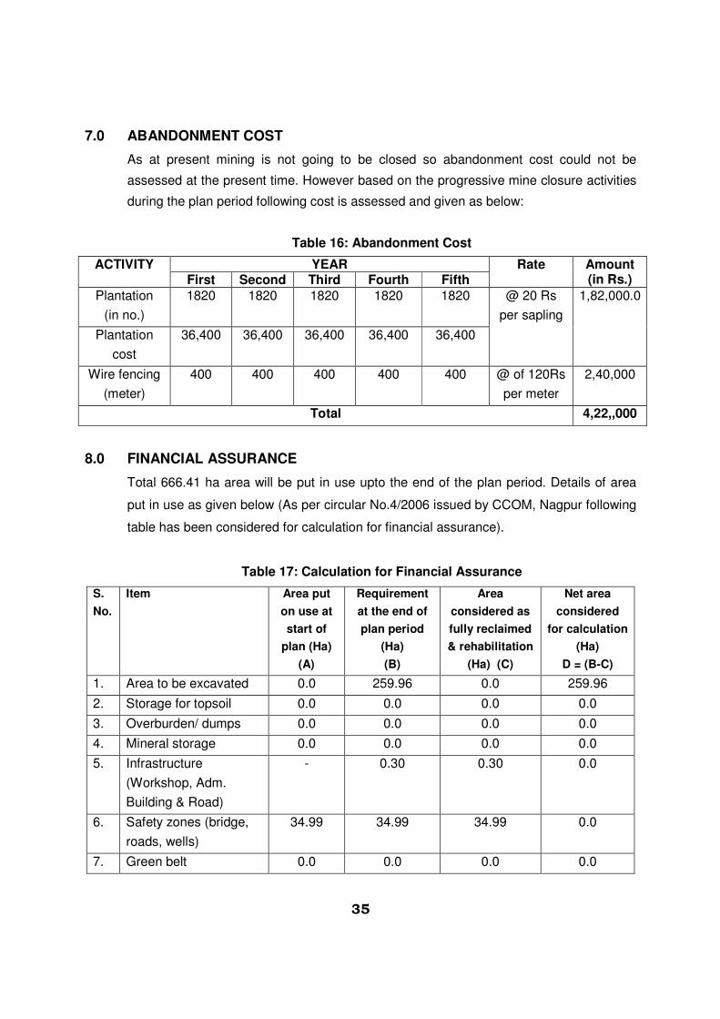
7.0 ABANDONMENT COST
As at present mining is not going to be closed so abandonment cost could not be
assessed at the present time. However based on the progressive mine closure activities
during the plan period following cost is assessed and given as below:
Table 16: Abandonment Cost
ACTIVITY YEAR Rate Amount (in Rs.) First Second Third Fourth Fifth
Plantation
(in no.)
1820 1820 1820 1820 1820 @ 20 Rs
per sapling
1,82,000.0
Plantation
cost
36,400 36,400 36,400 36,400 36,400
Wire fencing
(meter)
400 400 400 400 400 @ of 120Rs
per meter
2,40,000
Total 4,22,,000
8.0 FINANCIAL ASSURANCE
Total 666.41 ha area will be put in use upto the end of the plan period. Details of area
put in use as given below (As per circular No.4/2006 issued by CCOM, Nagpur following
table has been considered for calculation for financial assurance).
Table 17: Calculation for Financial Assurance
S.
No.
Item Area put
on use at
start of
plan (Ha)
(A)
Requirement
at the end of
plan period
(Ha)
(B)
Area
considered as
fully reclaimed
& rehabilitation
(Ha) (C)
Net area
considered
for calculation
(Ha)
D = (B-C)
1. Area to be excavated 0.0 259.96 0.0 259.96
2. Storage for topsoil 0.0 0.0 0.0 0.0
3. Overburden/ dumps 0.0 0.0 0.0 0.0
4. Mineral storage 0.0 0.0 0.0 0.0
5. Infrastructure
(Workshop, Adm.
Building & Road)
- 0.30 0.30 0.0
6. Safety zones (bridge,
roads, wells)
34.99 34.99 34.99 0.0
7. Green belt 0.0 0.0 0.0 0.0

36
8. Tailing pond 0.0 0.0 0.0 0.0
9. Effluent treatment plan 0.0 0.0 0.0 0.0
10. Mineral separation
plant
0.0 0.0 0.0 0.0
11. Township area 0.0 0.0 0.0 0.0
12. Others (Used for Ag.
Purpose)
0.0 0.0 0.0 0.0
Total 34.99 295.25 35.29 259.96
Total 259.96 ha area will be put in use. Against this mined out area the total financial
assurance (@15000/- per ha. will be of Rs/- 38,99,400. However the maximum limit of
financial assurance as per RMMCR (Fourth Amendment), 1986 has been notified as
Rs.30.0 lacs. This will be given by lessee as per rule 37 (J) of MMCR 1986 as amended
in 2012.
9.0 CERTIFICATE
It is enclosed with the report.
10.0 PLAN AND SECTION
Plan and section are prepared and enclosed with the mining plan.
Umesh Datt Sharma
(RQP/AJM/277/2005-A valid up to 2015)