woodward corridor neighborhood bicycle network - 2016 tap award
TRANSCRIPT

2016 TAP Summary:Woodward Corridor
Neighborhood Bicycle Network
Ferndale Community and Economic Development Department
April 27, 2015

2016 TAP Grant Application
CED staff recently completed an application through SEMCOG/MDOT to be awarded 2016 Transportation Alternatives Funding (TAP)
Proposed transportation improvements that qualify must benefit pedestrian and cycling infrastructure, such as shared-use paths, streetscapes, etc.
City of Ferndale has previously been awarded for street improvement projects on West Nine Mile Road and Livernois Street

Project Purpose
Enhance quality of life for residents, businesses and visitors along in Ferndale and surrounding Woodward Corridor by creating a connected neighborhood bicycle route with adjacent cities:
Hazel Park
Huntington Woods
Oak Park
Pleasant Ridge
Royal Oak

Woodward Corridor Neighborhood Bicycle Network
The goal is to create a highly visible, connected neighborhood bicycle route that enhances linkages and builds relationships with communities surrounding Woodward Corridor:
17.1 Mile Loop includes:
Central Business Districts
Employment Centers
13 Parks
10 Schools
2 Libraries
1 University
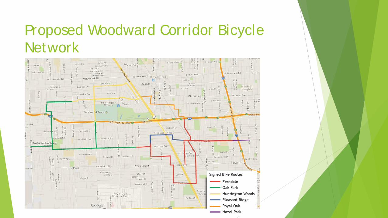
Proposed Woodward Corridor Bicycle Network
…

Grant Funded Elements
Participating items of work for the project include:
Local bike route signage
Shared lane markings and bike lanes
High visibility crosswalks
Wayfinding hubs

Wayfinding Signage Benefits
There are a variety of beneficial reasons for communities to install wayfindingsignage on a bicycle network:
Familiarize users with the bicycle network
Identify the best routes to destinations
Overcome a “barrier to entry” for infrequent bicyclists
Denote mileage and travel time to destinations to help educate and minimize the tendency to overestimate bicycle travel time
Visually indicate to motorists the presence of a bicycle route and use caution
Market the bicycle network and neighborhoods by providing unique and consistent imagery throughout the jurisdiction
Source: National Association of City Transportation Officials

Complete Streets Coordination The Woodward Corridor Neighborhood Bicycle
Network supports the City of Ferndale’s Complete Streets ordinance by improving roadways to “safely accommodate all users of the right-of-way”
Enhances collective space to give pedestrians and cyclists an equitable share of streets
Aligns with recent non-motorized projects:
TAP funded: West Nine Mile Rd, Livernois Street (from Eight to Nine Mile), Fourth Street (Royal Oak)
Non-TAP funded: Hilton Road, East Nine Mile Road
W. Nine Mile Improvements
Livernois Street Improvements

Project Alignment With Existing Plans The Woodward Corridor Neighborhood Bicycle
Route is pursuant of regional transportation coordination and aligns with many of the participating communities’ specific plans: City of Ferndale Non-Motorized Plan and 2008
Master Plan
Huntington Woods 2014 Master Plan
Oak Park 2014 Strategic Economic Development Plan
Oakland County Routes Map
Pleasant Ridge 2015 Community Master Plan
Royal Oak 2012 Non-Motorized Plan
SEMCOG Regional Non-Motorized Plan for Oakland County
City of Royal Oak 2013 Non-Motorized Plan

Ferndale Proposed Improvements Aside from updating signage to MMUTCD standards and including more way-finding
information, the City’s grant proposal includes enhancements as part of Ferndale’s Non-Motorized Plan:
Shared lane markings and bike lanes
Improved pedestrian crossings with flashing beacons and curb extensions
Wayfinding Hubs with maps, repair stations, and bike parking

Project Summary
The Woodward Corridor Neighborhood Bicycle Network is a competitive project and efficient use of grant funds to better connect six adjacent communities
The project showcases unique collaboration between these six communities in the creation of a 17 mile loop
The route provides better circulation among communities and provides a safe route for levels of cycling comfort
The six communities are backing up their commitment to Complete Streets and Non-Motorized Improvements with a 30% match

Tentative Milestone Timeline
Sep. 2015 – Plans and Estimate Complete
Oct. 2015 – Grade Inspection Package submitted to MDOT
Nov. 2015: Right of Way Certified
Dec. 2015: Matching Funds Certified
Jan. 2016: Project Listed in Approved TIP/STIP
Feb. 2016: Advertisement Start Date
Mar. 2016: Construction Letting Date
Apr. 2016: Construction Start Date
Jul. 2016: Construction End Date