work shag - bonanza mining
TRANSCRIPT

.-
D. Bending August 1979
Work Performed on the Shag Claims
CLAIMS RECORD NO.
Shag 1-8 158 - 165 RECORDED
August 29, 1977
Latitude: 50°38 IN Longitude: 11So30'W Operator: Rio Tinto Canadian Exploration Limited
.
I

shag Claims Golden Mining Division N.T.S. S 2 J/11 and 12
D. Bending Auqu s t 1 9 7 9
Summary
The 1979 field programme on the Shag Claims consisted of remapping the geology in the vicinity of an occurrence of replacement sphalerite with minor galena at a dolostone- limestone contact (the C-4 showing), soil sampling over the C-4 showing, and prospecting along key contacts associated with soil lead-zinc anomalies iletected in 1978. Three new showings were discovered, providing indication that the C-4 showing and vicinity should be tested by drilling. The Contact zone along which C-4 type showings occur, was detected by mapping in Queen Mary Creek south of Shag Claims. further prospecting, remains unexplained.
Th; largest lead anomaly on the property, despite

Table of Contents
Paqe No .
1 . 2 . 3 . 4 . 5 . 6 .
7 . 8 . 9 .
10 .
Introduction ..................................... 1 Location and Access .............................. 1 Previous Work .................................... 2
Description of Claims ............................ 3 1979 Field Programme ............................. 3 Geology .......................................... 4 6.1 Regional Geology ........................... 4
6.2 Geology of the Shag Claims ................. 4
6.2.1 Stratigraphy ........................ 5 6.2.2 Structural Geology .................. 9
Mineralization ................................... 11 Discussion ....................................... 14 Recommendation ................................... 16 References ....................................... 17

Drawing (DWG.) N o .
L-6526
C-8687
G-8688
G-6603
GC-6600
GC-6601
G-6602
G-7537
G-6599
Figures
1
2
LIST OF ILLUSTRATIONS
Descr ip t ion Location i n Report
Location Map
Location of Claims and D r i l l Holes
Geology - Shag Claims
Cor re l a t ion of Monarch- Kicking Horse, Marvel and Shag
C-4 showing - S o i l survey l o c a t i o n s
C-4 showing - Lead Zinc s o i l survey r e s u l t s
C-4 showing - Revised geology, s o i l anomalies and proposed d r i l l i n g
C-4 showing - Deta i led geology s e c t i o n
3egional Geological S e t t i n g
Summary of S t r a t i g r a p h i c Rela t ionships on Shag Claims
Queen Mary Creek - Geology and Follow up.
a f t e r page 1
i n pocket
i n pocket
a f t e r page 1 5
a f t e r page 1 7
a f t e r page 1 7
a f t e r page 1 7
i n pocket
addendum #1
a f t e r page 8
a f t e r page 1 7

'c
Appendices
I. Reappraisal of Stratigraphy 11. Geochemical Results
111. Statement of Qualifications
IV. Cost Statement
c) 0 TY Lc
X
X
X
X
X
X
X
X

1. INTRODUCTION
This report describes a two-week investigation of the Shag claims prior to further drilling. The programme was *
directed at prospecting of unexplained geochemical anomalies and reapprasal of certain aspects of the stratigraphy, notably regional correlation. Stratigraphic descriptions contained in this report are taken,with minor modifications, from Riocanex report no. 547.
2. LOCATION AND ACCESS (Dwg. L-6526)
The claims are located near 50°38'N, 115°30'W, in the Albert River Drainage about 35 km east of Radium. The north end of the claims can be reached by logging roads, about 65 km from Canal Flats or 60 km from Radium. Higher elevations and the southern parts of the claim group are best approached by helicopter which is available through Okanagan Helicopters in Cranbrook and Golden, or Bow Helicopters in Fairmont.
R I O TINT0 C A N A D I A N EXPLORATION LTD. i
P A Q E 2
3 . PREVIOUS WORK
Initial work is summarized in the report on the 1977 programme by C. Graf (Riocanex No. 526). The 1977 programme .
provided a stratigraphic framework through regional mapping '
of Cambrian Formation boundaries at a scale of 1:50,000.
In 1978, a five man crew, of which the writer was party chief, spent s i x weeks on the property, producing a 1:10,000 scale geological map and a soil sample survey covering accessible areas. Eight zinc-lead showings were discovered and observed to occur along two key stratigraphic interfaces termed the "C-4 Horizon'' and "BM Horizon". The BM horizon was subsequently tested with three short drill holes.
The soil survey detected numerous zinc soil anomalies and one significant lead anomaly not associated with known mineralization (Riocanex report no. 547).
Leech (1979) released an open file map covering the area on a 1:126,720 scale.
.

PAOER
4. DESCRIPTION OF CLAIMS
Eight claim blocks consisting of 127 claims were staked in 1977 (Dwg. C-8687).
Claim Name
Shag 1 2 3
4 5 6 7
No. of Units
20 12 20 20 12 18 15
Record No.
158 159 160 161 162 163 164
Recording Date
Aug 29, 1973 II
II
II
I1
8 10 165 11
5. 1979 FIELD PROGWME
The 1979 field programme in the Shag area consisted of follow up prospecting on soil anomalies, detailed mapping of the C-4 showing, soil sampling over the C-4 showing on a 5 x 6 metre grid, remapping of the key contact that hosts the C-4 showing, extrapolation of this contact to Queen Mary Creek, and stream silt sampling to help define the'south- ern extensions of mineralization off the claims. The writer and an assistant camped for seven days along the upper parts of Shag Creek, near the center of the claim block, and, on three days, approached parts of the property from the road below.
RIO TINT0 C A N A D I A N EXPLORATION LTD.

PAOE 4
6. GEOLOGY
The geology of the Shag claims is displayed at 1:10,000 scale in Dwg. 8688 and in diagramatic section Figure 1.
6.1 Regional Geology
The major -formations in the area of interest are the Middle Cambrian Cathedral carbonates, laterally equivalent chancellor Group shales and limestones, Steven Formation and Sullivan Formation shaley limestones, Eldon Formation dolostones, and the Upper Cambrian McKay Group shales. These are mapped according to definitions outlined in the 1977 study. The showings are hosted by dolostones of the Cathedral Formation within 1 km of the north-south trending Chancellor facies front.
The rich Monarch-Kicking Horse deposits are hosted by the Cathedral Formation 50 km north, in Yoho National Park, in a similar position with respect to the facies front but lower in the section. It is probable that this position in the section is within several hundred feet of the Albert River. The idea that it comprises the lower part of the lowest dolostone unit exposed on the property is likely to be true but is not firmly established. These deposits represent a clearly different style of mineralization but demonstrate the availability of metals and potential for concentration in this belt.
6.2 Geologytof the Shag Claims
To facilitate interpretations and impmve stratigraphic control on the mineralized zones, the Cathedral Formation
R I O T I N T O C A N A D I A N EXPLORATION LTD. i

PAQE
was subdivided into nine mappable units on the basis of a combination of depositional and diagenetic features. Overall stratigraphic relationships are shown idealized in Figure 1.
6.2.1 Stratigraphy (See Addenr?ur? #1 for alternative. interpretation)
Albert River Dolostone (Cl): Base of the exposed section. Pale grey variably crystalline massive dolostone.
Thin Limestone ((22): Limestone and dolostone facies equivalents with dolomitic facies dominating northeast;+.
- ward away from the facies front. Approximate unit thickness about 50m. The lower contact of the limestones is very porous with modern caves. The limestone is dark grey, finely crystalline, uniformly bedded, subtidal lime mudstone, and the dolostone is pale creamy-grey, sucrosic, uniform and massive.
BM Host Dolostone ((23): A generally uniform cyclic intertidal dolostone; mostly light grey, variably (mostly fine) crystalline, burrowed, laminated birdseye textured or intraclastic dolomite mudstone; 120-130m of generally uniform cyclic intertidal dolostone. Burrowed, delicate laminae, stylolites, and intraclastic zones are common. The upper contact is marked by a pronounced transgression. This is reflected in a change from pale, finely crystalline dolostone through dark grey, burrowed and birdseye textured rocks (with some sedimentary boundinage and slump textures) to dark bioclastic packstone limestones.
This transgression, especially the lower parts of the dark birdseyed beds and packstones, hosts the BM type mineralization. It is the first of a series of minor fluctuations in water depth that mark the boundary
R10 T I N T O C A N A D I A N EXPLORATION LTD.

P A Q E
between the BM Host Dolostone and the Dividing Limestone.
Dividing Limestone ((24): 20-30m of diverse, usually recessive limestones, and shaly limestones: more massive beds are burrowed and may be notably silty. This unit displays more tectonism that rocks above and below.
Second Dolostone (C5): Is about a 40m generally intertidal to supratidal dominantly sucrosic dolostone. It has been observed to display a consistent general pattern where mapped in detail.
The base is a gradational transition marked by a sequence shallowing upward from massive and bedded lime- stones through intercalated finely crystalline, grey dolostone and burrowed dolomitic limestone (occasionally oncolitic) to a more uniform sequence of dolostones that show striking cyclicity (1-2m cycles) in places. Cross- cutting recrystallization fronts disrupt the cyclic pattern in some areas, allowing uniform pale sucrosic dolostones to lie closely along strike with a cyclic sequence of dark birdseye textured, pseudobreccia, and pale sucrosic dolostones.
These lateral variations occasionally prevent conclusive subdivision of this unit from the more widespread cyclic dolostone suite.
This generally cyclic sequence is overlain by uniformly light creamy tan-to-grey sucrosic dolostone with occasional interbeds of darker dolostone. This package represents a shallower intertidal environment.
R I D TINT0 C A N A D I A N EXPLORATION LTD. A

P A D E 7
Overlying this dolostone package is a supratidal facies with light creamy grey-to-tan locally rust-stained sucrosic to coarsely crystalline dolostone with occasional pods of pseudobreccia, zebroid textures, and vuggy, heavily recrystallized zones that may contain masses of rusty, weathering, ferroan dolomite. Near the upper contact calcite-filled open spaces and small breccia pods may be prominent. Bedding is usually massive.
The uppermost contact zone hosts the C-4, Pieces, Redbed, Crackle, Rush, Stripes, Red Bed type float, and Christmas showings and appears to be associated with lead and zinc soil anomalies unrelated to known lead-zinc occurences.
Cliff and Step Limestone (C6): A sequence of lime- stones and shaly limestones that varies from lOOm to about 160m in thickness.
This variability in thickness indicates that some parts are laterally equivalent to some of the bounding dolostone units. Parts of this unit are equivalent to the Steven Shale as mapped in Assiniboine creek exposures, and the transitional dolomitic rocks near the upper contact are partly equivalent to Eldon Formation.
Top Dolostone ( ( 2 7 ) : 30-100 metres of sucrosic to coarsely crystalline pale tan and creamy coloured dolostone, equivalent to Eldon Formation.
The lower contact zone is a transition from a dark grey crystalline limestone through a zone of oncolites and burrow-mottled dolomitic limestone to a gradually paler sucrosic dolostone. The upper parts of the package are characterized by breccias cemented by ferroan dolomite
i R I O TINT0 C A N A D I A N EXPLORATION LTD.

h#
P A O E 8
(and occasional pyrite), zebroid beds and lenses, coarsely recrystallized pockets and white calcite masses.
Cyclic Dolostone (CS): In places a prominantly cyclic dolostone with dark algal and pale sucrosic tex- tures occupies up to 250m of section and appears to abut on the more widespread and uniform units. This represents a locally emergent part of low "arch" that persisted when minor fluctuations in water depth caused pronounced variations in lithology. This has probably been accentuated by reflux. This shows a lateral equivalence to the Second Dolostone, Dividing Limestone and the upper parts of the BM Host
. Dolostone that renders mapping of these contacts ambiguous in places.
Eastern Transgressive Dolostone (C9): Alonq the southeast side of the property, the Cliff and St'ep Lime- stone Unit shows a laterally equivalent irregular facies change to a pale crystalline dolostone not readily distinguishable from the supratidal facies above it. This posed a problem of mapping that was solved arbitrarily by projecting idealized contacts. Further work in Queen Mary Creek will probably show this is a localized phenome- non, and the C-4 horizon will be mappable.
At the top of the Cathedral Formation as mapped, a prominant red marker bed has been observed from Queen Mary Creek to Mount Brussilov. This is more extensive that the Arctomys Formation as previously mapped by Graf (1977) but is equivalent. It is a rust-coloured unit, usually shaly, 2 ~ 3 m thick, that contains lenses of a sparry
R I O T I N T O C A N A D I A N E X P L O R A T I O N LTD.

s . E . N. W.
M c K a y G r o u p s h a l e s
- - - - - - - - - - - - - - - - - - - - $ - - - - - _ - - - - - - - - rctomvs Form a t i on
c 7 E l d o n F o r m a t i o n e q u i v a l e n t
C 6 L o w e r p a r t s equ iva lent t o S t e v e n F o r m a t i o n
c 5 c 5
c 4 c 0 c 4
c 3 c 3
c 2
C I
L
S U M M A R Y O F S T R A T I G R A P H I C R E L A T I O N S H I P S O N S H A G
( See Ac-mdum No. F i g u r e I
for an Alternative Interpretation )

crystalline limestone (apparently an algal packstone) with iron oxide cement.
6.2.2 Structural Geology
Structural geology of the Shag Claims is characterized by three styles of response to compression and a mondclinal flexure along the Chancellor-Cathedral facies front.
Chancellor and McKay shales and carbonates are cleaved, isoclinally folded, and internally thrust faulted, with deformation especially complex near contacts with the more competent Cathedral carbonates. Deformation within the Cathedral Formation is dominated by a monoclinal flexure that strikes parallel to the facies front in all the areas mapped. Within this context, styles of deformation vary considerably and are influenced by rock type and position in the section relative to heavily tectonized McKay Group rocks. The Cliff and Step Limestone, the uppermost limestone unit, is characterized in places by small s-folds, overturned folds, and small thrusts indicating compressive forces per- pendicular to the N-S trending facies front. These areas are characterized by white quartz veins and calcite tension gashes. The competent dolostone units bounding this limestone are almost completely undisturbed apart from pervasive fracturing. A more subtle contrast can be noted in other Limestone units lower in the section, with gently folded limestones bounded by relatively unyielding massive dolostones.
Steep N-S trending oblique normal faults of small displacement.(one has been mapped with about 25m of throw: most are only 1-3m if measurable) can be observed in several
R I O T I N T O C A N A D I A N EXPLORATION LTD. 8
- - - - - _
P A D E lo
locations near the Shag Claims.
Large scale thrusts are not generally apparent in the Cathedral although a thrust with hundreds of meters of throw can be observed in isoclinally folded Cliff and Step Limestone and Top Dolostone along the east flank of Mount Soderholm five km north of the claims. Small scale bedding plane slips are pervasive in the upper limestone units.
The influence of structure on mineralization is unclear. Fractures appear to have influenced C-3 and BM Extension mineralization.
RIO TINT0 C A N A D I A N EXPLORATION LTD. 1

7. MINERALIZATION
Thirteen occurences of zinc and lead sulphides have been observed on the claims. Two of these, the C-3 and C-4 showings were discovered by the Graf crew in 1977. Eight more, the BM, BM Extension, Pieces, Redbed, Crackle, . Box, Bush, and Christmas showings were discovered in 1978. Follow up soil lead-zinc anomalies and remapping of part of the C-4 horizon in 1979 has revealed three new showings, the Stripes, Redbed-type float, and BM fractures.
The "Stripes" and "Redbed type Float" showings occur along strike from the C-4 showing southwest of Shag Creek, along the upper margins of an extensive zinc soil anomaly detected in the 1978 survey. The reader is referred to DWG 3 .
The "Stripes" showing as exposed consists of numerous talus blocks with fracture fillings and bed-like replacements of ZnS. One large block, believed to be approximately in place, displays three bed-like belts of 15-30% reddish orange, 0.2-0.5 cm sphalerite. Each bed is about 25centimetres thick, over a total exposed thickness of over 1 metre. These belts display a relic pseudobreccia texture and are separated by more uniformly cyrstalline grey dolostone with only traces of sphalerite. Exposure is poor, but the cyclicity, high grade of some selected grab samples (up to 80% sphalerite), and apparent lateral continuity of the mineralization are very encouraging features.
,
The "Redbed-type float" showing is known only as float containing 3-5% red sphalerite in talus blocks up to 0.8 metresacross. The texture is a relic pseudobreccia,
R I O TINT0 C A N A D I A N EXPLORATION LTD.

like the Stripes showing. Few samples have been found but those seen lack the grade and bed-like appearance of the Stripes replacements. As indicated by the name, the appearance of the mineralization is very similar to the Redbed types of showings across the canyon of Shag Creek. Although no galena has been observed to date, the soil sample that drew attention to the location contains 650 ppm lead and probably indicates galena occurrences in the showing.
The C-4 showing was examined closely in 1979 as part of a programme to evaluate the C-4 horizon as a drilling target (see DWg- G - 7 5 3 7 ) . The most attractive feature of the showing as presently exposed is the galena-sphalerite- sparry dolomite cemented breccia pod exposed in the southwest face. The exposure indicates that the attractive mineralization is only a lense but weak indications of a linear trend and improvement to the southwest are encouraging. The richest grab samples observed at the showing occur in a small bedding plane shear in the north- east face. The role of this type of structure as an influence on the C-4 showing is unknown. One significant feature of the occurrences is the fact that the hangingwall limestone is bounded above by another dolostone bed which itself contains sphalerite and galena. This area is one mapped in 1978 as characterized by lateral facies changes. The combination of an attractive style of mineralization with the potential for vertical repetitions along an interfingering contact are ample reasons to recommend drilling along the projected trend. .
The C-4 showing has no soil lead-zinc expression in the 1978 survey. To understand how attractive it is
R I O TINT0 C A N A D I A N EXPLORATION LTD.

13 PAQE
compared to highly anomalous areas along strike the immediate vicinity of the showing was s o i l sampled on a 5 x 10 metre grid. This grid also lacked a significant soil lead-zinc expression. The ocurrences could have lacked soil geochemical expression for a variety of reasons, notably topography, the likelihood of transported over- burden in the valley bottom, the significant presence of mineralization only along a cigar-like feature that isonly exposed in the stream cut, or simply too little mineralization for soil expression.
BM Fractures is fracture fillings and related replace- ments identical to those of the BM extension and need no further descriptions (See Riocanex report no. 5 4 7 ) .
,
R I O T I N T O C A N A D I A N EXPLORATION LTD. I

PABEL
8. DISCUSSION
Five significant conclusions have developed from work on the Shag claims in 1979.
(1) The soil anomalies near the C-4 showing, shown in )bg. G - 6 6 0 2 , the grade of the Stripes occurrence, the likelihood of repetition and lateral continuity of these replacement beds as illustrated by the Stripes showing, and the attractive habit and grade of parts of the C-4 showing indicate widespread, possibly attractive mineralization
- along this key contact. The mineralized bodies may be planar, elipsoida1,or cigar-shaped.
(2) High zinc values persist well above known mineralization in the BM =tension area and indicate wide- spread, blind,untested mineralization along the BM Horizon. The locally high grades noted along the C-4 Horizon and lateral continuity of the BM Extension are features that indicate the potential for sphalerite bodies of attractive grade and size. The BM horizon remains largely untested despite drilling around the known exposure.
( 3 ) Intensive prospecting of the lead anomaly, (1100s-6OOW) west of the BM showing, has revealed no exposed mineralization. The very porous, recrystallized dolostones there may contain some small blind galena replacements. The area is steep and irregularly exposed. Further attempts, if any are made, to find the source of the lead could be by hand trenching.
R I O TINTO C A N A D I A N EXPLORATION LTD. f

15 PABE
(4) The "C-4 Horizon" does crop out in the western wall of the middle Queen Mary Creek valley. No mineralizatior was discovered during the day of prospecting.
-
(5)* The lower exposed parts of the Albert River Dolostone unit (Cl) are texturally similar to the central parts of the rock unit hosting the Monarch-Kicking Horse deposits in Yoho Park. The potential size, habit and grade of these deposits is very attractive and if this type of mineralization occurs in the area it represents the best target for large, rich orebodies. Zinc-lead showings are widespread on the property and geochemical data indicate it is a regional centre of mineralization. Testing for this is a much higher risk than drilling the exposed horizons but potential returns are also very high. DWG. G - 6 6 0 3 is a tentative correlation that supports this discussion.
* See Addendum #1 for alternative conclusion.
i
RIO TINT0 C A N A D I A N EXPLORATION LTD. 1

R l O T I N T O C A N A D I A N EXPLORATION LTD. ,
P A Q E 16
9. RECOMMENDATIONS
It is recommended that:
(1) The C-4 "Horizon" be tested by at least four drill holes, located as indicated on Dwg. G - 6 6 0 2 .
(2) The BM "horizon" be tested by drilling along the "BM Extension" and probably also up Shag Creek, to look for lateral improvements in grade and thickness.
( 3 ) The open zinc-lead soil anomaly southwest of the BM showing, up the hill along the C-4 horizon, be soil sampled and prospected. The zinc ancmaly that is continuous along the upper parts of the valley is distrupted by slides from Avalanche ridge but the mineralization probably continues along the same key contact.
(4) The Albert River Dolostone, not covered by the 1978 soil survey or property prospected, be examined carefully and traversed by six soil, lines to investigate the possibility of mineral- ization along this section.
(5) Soil anomalies in lead along line 1000 south from the 1978 survey be h m d trenched prior to negating the lead anomaly as a target. Other methods, such as examining heavy mineral concentrates in the seasonal streams draining the area, should also be attempted to evaluate the significance of this anomaly.

17 PAQE
10. REFERENCES
Graf 1977 Graf Lead Zinc Reconnaissance, Southern
Rocky Mountains
Riocanex Report No. 526
Bending 1 9 7 9
Shag C l a i m s
Riocanex Report N o . 547
R I O TINT0 C A N A D I A N EXPLORATION LTD. i

I
, S H A G C L A I M S ' \
I
/' A I w
t
I
N O T E : See A d d e n d u m I f a r a l t e r n o f i v e
s t r a t i g r a p h i c i n f e r p r e t a t i o n
f
L E G E N D U n i t s n o t e d we80
o b s e r v e d d u r i n g 1979 r e c o n n a i s s o n c o
- - McKay Format ion - .
Arctomys F o r m a t i o n C a t h e d r a l F o r m a t i o n
I ( o s m a p p e d i n 1978 I
C5 S E C O N D D O L O S T O N E
G E O L O G I C A L C O N T A C T S - O B S E R V E D - - - - - I N F E R R E D
N.T.S. 8 2 5 / 1 1
C -
C 6 C L I F F 8 S T E P L I M E S T O N E t p o r t l y e q u i v a l e n l t o S t e v e n Format ion)
C 7 T O P D O L O S T O N E ( e q u i v a l e n t l o E l d o n F o r m o l i o n 1
S C A L E 1~50,000
1000 500 0 1000 2000 3000 4000 Metres
RIO T I N T 0 CANADIAN E X P L . LTD.
SHAG C L A I M S
QUEEN M A R Y CREEK
GEOLOGY
I I
I , I F IG. 2 D.E. 1 b.w. NOV 1979 c

Addendum #1
Reappraisal of Stratigraphy
.

Addendum #1 3 December 1 9 7 9
Reappraisal of Stratigraphy
After writing this report, D. Bend.ing further investigated the regional stratigraphic correlation around the Shag claims and came to the following conclusions.
The units mapped on the Shag claims are actually higher in the regional stratigraphy then initially believed. The seven main units mapped as Cathedral Formation in 1 9 7 8 have been reallocated equivalent formations.
Unit 7 Top Dolostone = Lye11 Fm. Unit 6 Cliff & Step Limestone' Sullivan Fm. Unit 5 Second Dolostone=Waterfowl Fm. and
probably Arctomys euuivalent Unit 4 Dividing LimestoneGPika Fm. Unit 3 BM Host Dolostone= Eldom Fm. Unit 2 Thin Limestone= Stephen Fm. Unit 1 Albert River Dolostone =Cathedral Fm.
This can be made to agree with the regional map by G.B. Leech (GSC, 1 9 7 9 ) by extending his contacts onto the Shag claims.
By t h i s framework, the Albert River Dolostone exposed at Shag would represent the top of the Cathedral Formation. Using an ide,al thickness of 1200 feet for the Cathedral Formation, the setting of the Monarch-Kicking Horse deposits would lie 400-900 feet below the Albert River exposures. This clearly negates the attractiveness of exploring for a Monarch-Kicking Horse setting at Shag.

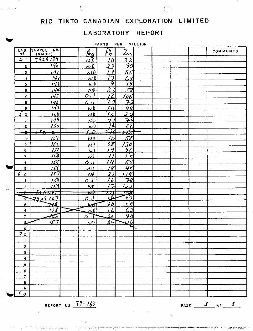
APPENDIX II
Geochemical Results

.\ . *
Riocanex
'c, Rio Tinto Canadian Exploration Limited
LABORATORY REPORT
SAMPLE TYPE ( / )
Soil a/or Stream Sediments
0 Rock
Water
U 0 Results Sent To R, Low,
At &
STATISTICAL SUMMARY
(Value for it and u in ppm ) w
Date Reported
Acct. No. Pro / skwc- 7 . Project Name
Size Fraction - Extract ion /%u d y - - /&, Sample Wt .
Analytical Method & & a,l! g , Volume 2- ml
Analyst (s)
DlSTR I BUTlON
0 Log Normal
0 Normal
Comments :
W Report No. 77 4 . 3 Page 1 of 3

R I O T I N T 0 CANADIAN EXPLORATION L I M I T E D
LABORATORY REPORT
PARTS PER MILLION
w REPORT N-O. 77- 163 PAGE 2 o f 3
(. r . R I O T I N T 0 CANADIAN EXPLORATION L I M I T E D
LABORATORY REPORT
P A R T S PER M I L L I O N
._ . t ..
R E P O R T N-O. 7?-/63 PAGE 3 of 3
i

APPENDIX 111
Statement of Qualifications

w
STATEMENT OF OUALIFICATIONS
D. A. G. Bending
Academic
1976 B.Sc., Geology University of Oregon
1977 to present M.Sc. Programme University of Toronto
Practical
1978-1979 (Summers)
1976-1977
i
Rio Tinto Canadian Exploration Ltd. Party Chief 'on Exploration for Mississippi Valley-type Lead and Zinc occurrences, S.E. British Columbia, Property examination and area selection.
Gulf Resources and Chemical Mine and Exploration Geologist Kellog, Idaho
i

APPENDIX IV
COST STATEMENT

V
COST STATEMENT
B.C. SHAG CLAIMS
2 3 J u l y t o 2 1 October 1 9 7 9
GENERAL COSTS
2 3 J u l y - 2 1 October 1 9 7 9
SUPPLIES _ I
1 3 0 man days @ $ 4 . 0 8
FOOD & ACCOM?YODATION
1 3 0 man days @ $ 1 8
RENTAL EQUIPMENT
T r a e g e r SSB50C rad io , 3 1 Aug-21 O c t ,
Redhawk, 4WD Jimmy, 23 J u l - 2 1 O c t , 5 2 days @ $ 6
9 0 days @ $ 2 2
FIXED WING
Un ive r sa l T r a v e l A g e n c y , 6 J u l - 2 O c t , 6 t r i p s , V a n / C a n a l F l a t s , r e t u r n
HELICOPTER
$ 3 1 2
1 , 9 8 0
$ 5 3 0
2 , 3 4 0
2 , 2 9 2
7 2 9
C r o w s n e s t , CF AHH, 31 J u l ,
Okanagan, 206B, 1 8 J u l - 2 4 Sep, 1 . 9 h r s @ $ 3 2 3
1 8 . 4 h r s @ $ 3 7 5
$ 6 2 9 . 5 0
6 , 8 8 4 . 6 5 7 , 5 1 4
* c

RIOCANEX EOUIPMENT
1 3 0 man days @ $ 3
REPORT PREPARATION
3 9 0
2,886
TOTAL GENERAL COSTS
TRENCHING
$ 1 6 , 6 8 1
S A L A R I E S & WAGES
2 4 S e p - 1 4 Oct, 3 men, 6 man days @ $42/man day
B E N E F I T S @ 2 0 %
GENERAL COSTS
6 / 1 3 0 X $ 1 6 , 6 8 1
TRENCHING TOTAL
GEOCHEMISTRY
S A L A R I E S & WAGES
4 A u g , 1 man, 1 man day C! $ 4 8
B E N E F I T S @ 2 0 %
ANALY S I S
Riocanex Lab, 5 9 s o i l s fo r A g , Pb, Zn @ $ 3 . 6 0
$ 2 5 2
50
7 6 9
$ 1,071
4 8
10
2 1 2
i

GENERAL C O S T S
1/130 X $16,681
GEOCHEMISTRY TOTAL
GEOLOGY
S A L A R I E S & WAGES
128
$ 398
23 Jul-21 O c t , 7 m e n , (3 $50/man day
B E N E F I T S @ 20%
44 man days $ 2,200
440
GENERAL C O S T S
43/130 X
GEOLOGY TOTAL
$16,681
DIAMOND D R I L L I N G
S A L A R I E S & WAGES
9 Sep-21 O c t , 7 men, @ $50/man day
B E N E F I T S @ 20%
DIAMOND D R I L L I N G CONTRACT
5 ,518
$ 8,158
80 man days $ 4,000
800
Longeyar C a n a d a , 1 7 Sep-26 O c t , 456.29 m @ $ l l l / m 50,856

HELICOPTER MDB, DEMOBILIZATION & MOVES
BOW, 206B, 15-21 Sep, 11 h r s
Okanagan, 206B, 27 Sep-22 Oct, @ $360
23 hrs @ $375
ASSAYS
Bondar-Clegg Lab 11 core f o r Ag, Pb,
@ $25
GENERAL COSTS
80/130 X $16,681
DIAMOND DRILLING TOTAL
Zn, Cd
TOTAL COSTS
COSTS APPORTIONED TO CLAIMS
CLAIM SHAG 1
2 3 4 5 6 7 8
TOTALS
UNITS 20 12 20 20 12 18 15 10 - 127
GEOLOGY 1 , 284.73 770.83
1,284.73 1,284.73 770.83
1,156.25 963.54 642.36
8,158.00
$ 4,072
12,881 16,953
275
10,265
83 , 149
92,776
TRENCHING DRILLING GEOCHEMISTRY TOTAL 1,284.73 770.83
20 , 051.30 21,336.03 1,071.00 63,097.70 398.00 65,851.43
770.83 1,156.25 963.54 642.36
1,071.00 83,149.00 398.00 92,776.00


