wria 7 wrec meeting materials packet - ezview.wa.gov
TRANSCRIPT
DRAFT Meeting Summary Snohomish (WRIA 7) Watershed Restoration and Enhancement Committee meeting April 9, 2020 | 12:30 p.m. - 3:30 p.m. WRIA 7 Committee Webpage
Location Webex
Committee Chair Ingria Jones [email protected] (425) 649-4210
Handouts Draft March Meeting Summary Water Right Acquisitions Handout Non-Acquisition Water Offset Work Plan
Attendance Committee Representatives and Alternates *
Ingria Jones (WA Dept. of Ecology) Stacy Vynne McKinstry (alternate-WA Dept. of Ecology) Daryl Williams (Tulalip Tribes) Anne Savery (alternate - Tulalip Tribes) Matt Baerwalde (Snoqualmie Indian Tribe) Julie Lewis (alternate -Snoqualmie Indian Tribe) Denise Di Santo (King County) Cynthia Krass (Snoqualmie Valley WID) Brant Wood (Snohomish PUD) Keith Binkley (alternate - Snohomish PUD) Kirk Lakey (WA Dept. of Fish & Wildlife) Lindsey Desmul (alternate - WA Dept. of Fish &
Wildlife) Emily Dick (Washington Water Trust) William Stelle (alternate - Washington Water
Trust)
Bobbi Lindemulder (Snohomish Conservation District)
Dylan Sluder (MBA of King and Snohomish Counties)
Mike Wolanek (City of Arlington) Michael Remington (City of Duvall) Jim Miller (City of Everett) Matthew Eyer (City of Marysville) Jordan Ottow (City of Monroe) Jamie Burrell (City of North Bend) Elissa Ostergaard (Snoqualmie Watershed
Forum ex-officio) Elizabeth Ablow (City of Seattle ex-officio) Glen Pickus (City of Snohomish) Steve Nelson (City of Snoqualmie) Terri Strandberg (Snohomish County)
Committee Representatives and Alternates in Not Attendance*
City of Lake Stevens Snohomish Basin Salmon Recovery Forum (ex-officio)
City of Carnation City of Gold Bar Town of Index
Other Attendees Susan O’Neil (ESA) (facilitator) Angela Pietschmann (Cascadia) (info manager) Joe Hovenkotter (King County) Megan Darrow (City of Monroe) Stephanie Potts (WA Dept. of Ecology) John Covert (WA Dept. of Ecology) Paulina Levy (WA Dept.of Ecology)
Kevin Lee (WA Dept. of Fish & Wildlife) Bridget August (GeoEngineers) Jonathan Rudders (GeoEngineers) Alexa Ramos (Snohomish County) Yorik Stevens-Wajda (Snohomish County) Ann Harrie (Snoqualmie Indian Tribe)
Introductions and standing business Susan welcomed the group, began introductions, and reviewed the agenda. No revisions to the agenda.
Ecology received corrections from Washington Water Trust on the draft March meeting summary about their methodology for the water rights assessment. Ecology included Snohomish County’s approval (provided via email) of consumptive use estimates in the summary. The meeting summary was approved without further changes.
Ecology updates:
• The City of Lake Stevens has not provided their decision on consumptive use estimate and currently does not have staff capacity to send a representative to Committee meetings. The City did not previously voice concern over the estimate.
• The deadline for submitting streamflow restoration grant applications has been extended to April 30, 2020 at 5PM.
• Ecology is launching an Advisory Group on Water Trust, Banking, and Transfers. The first meeting is on April 16, 2020. To receive info, sign up for the Advisory Group email listserv.
• The project subgroup now has a standing meeting date –every 4th Wednesday from 2PM -4PM. The subgroup met on March 25th to provide direction to GeoEngineers on their non-acquisition water offset work plan and to discuss existing non-acquisition water offset projects. The subgroup sought more feedback and ideas from the Committee during this meeting. Their next meeting will focus on beavers, beaver dam analogues (BDA), and other habitat projects.
Committee member updates: • Daryl provided updates on Tulalip Tribes’ capacity for engagement. Daryl and Anne anticipate
being able to continue involvement in the WREC meetings, but time and resources are limited with other staff being furloughed.
Non-acquisition water offset projects presentation and discussion Currently, non-acquisition water offset projects are underrepresented in the WRIA 7 project inventory, which consists largely of habitat and other related projects. Non-acquisition water offset projects are largely centered around changes in how and when water is diverted, withdrawn, conveyed, or used to benefit streamflow and instream resources.
Jonathan Rudders (GeoEngineers) provided an overview of the work plan GeoEngineers developed which outlines the process they will use to identify and preliminarily evaluate non-acquisition water offset projects within the watershed. GeoEngineers is planning to do the work in phases, to get information and feedback from the Project Subgroup and Committee on which projects to prioritize:
• Phase 1: Identify contacts with key knowledge of the project type or area, conduct a desktop screening for candidate potential project sites/areas, if necessary, and work with key contacts to develop a list of preliminary concepts for non-acquisition water offset projects.
• Phase 2: Prioritization and further analysis. Work with the WRIA 7 Project subgroup and Committee to identify priority projects that should be further analyzed. Conduct further analysis for priority projects.
• Phase 3: selection of projects for inclusion in the plan. Develop a short (approximately 1 to 2 pages) project summary sheet for each project or action the Committee selects for inclusion in the Plan.
John Covert (Ecology) provided examples of non-acquisition water offset projects:
• Water Storage and Retiming Projects • Stormwater Infrastructure • Modification to Reservoir Operations • Water Right Source Switches • Conservation and Efficiency Projects • Streamflow Augmentation
Resources:
• Preliminary Work Plan: Non-Acquisition Water Offset Project Identification • Meeting slides (slide 7-42)
Discussion: The Committee discussed non-acquisition water offset project ideas for WRIA 7.The following is a list of project ideas brought forth by Committee members, including ideas shared through the WebEx chat function. • Water Storage and Retiming
o Gravel pit on the Pilchuck River (also potential for MAR). o Raising outfalls of numerous high-elevation ponds and lakes by installing concrete/wood
beam weirs at the outlets. Challenges: permitting, environmental issues, downstream consequences. Smaller projects easier to permit/locate and get landowner cooperation.
o Oxbow ponds: tend to harbor a lot of invasive predatory fish and bullfrogs (bad for salmon). Where reconnection cannot happen, consider raising the outlet. Sloughs along the Skykomish River / Raging River delta. Connect with King County
Rivers Group to make sure this wouldn't violate rules about zero rise. Flood risk is a concern if this would decrease the capacity of the floodplain to store waters during a flood.
PUD fisheries staff could be a resource for identifying opportunities. o Modification of existing storage facilities:
WDFW and Tulalip are evaluating a flow control weir at headwaters of Tulalip Creek (Lake Shoecraft).
There was a suggestion to consider mimicking Lake Shoecraft on the numerous small lakes and ponds at higher elevations (but not so high where you'd lose shading and temperature control).
Twin Lakes (South of Marysville Costco). Lake Stevens weir. SVWID would consider being a project proponent for Lake Margaret (potential to
impact high flows in Cherry Creek, which have been problematic). o Managed Aquifer Recharge (MAR)
John has identified potential MAR project ideas and discussed with project subgroup:
• One potential project (Three Forks Park) is on King County property. MAR sites may be compatible with King County Parks, but not in designated natural areas.
Shallow monitoring wells are likely needed when building MAR projects. Ecology would issue a new (junior/interruptible) water right for MAR sites. Cannot
issue new water right in subbasins or tributaries with year-round closures (requires rulemaking – further discussed later in meeting).
Proper project citing is important (e.g., avoid putting projects close to active floodplains or known landslide areas) to avoid adverse impacts (e.g., potential
changes to groundwater movement, new springs popping up in unexpected places – causing landslides or surface water expressing itself in unexpected areas).
Snoqualmie Sand and Gravel is within a mile of City of Snoqualmie’s wastewater treatment plant. Potential to infiltrate Class A reclaimed water there. Currently being discharged to Snoqualmie and irrigation of golf course/City landscaping.
• Stormwater Infrastructure o Cannot take credit for the stormwater management that is required under regulatory
authority (i.e., must go “above and beyond” minimum requirements to count as offset). Can increase the size of an existing reservoir (include additional volume as offset in portfolio). Advantage – do not need a water right for stormwater management projects. o Opportunities to expand existing stormwater ponds. Snohomish Conservation District is
looking at potential sites in Marysville. o Nexus between stormwater and farm water activities. o Large-scale cisterns at residences and businesses to capture winter rains and reuse
indoors or for irrigation. Consider expanding Seattle-King County incentive program (Rainwise) beyond the current CSO/WTD service area to encourage people to build rain gardens and use rooftop cisterns.
o Mimic constructed stormwater wetland at Arlington. Eight acres takes runoff from 280 acres of pre-regulatory development. Recharges near-channel aquifer, rather than direct discharge to river.
o Use existing retention/detention ponds that do not work or have not been maintained. • Water Right Source Switches Note: The Committee could identify surface to groundwater source switches, but the Foster Supreme Court decision currently limits the ability to permit these.
o Pilots for capturing and storing/using water from drain tiles. o Create project similar to “Walking Wetlands” project in Skagit/Whatcom County. o Identify deep, marine-discharging aquifers to benefit valley bottom tributaries lower in
the basin. o Switching from surface tributaries to surface mainstem. Surface water source switches
may be easier to permit. They can provide habitat benefit, but limited offset potential. o Connect smaller water systems lower in Snohomish to Everett and or Snohomish PUD
water service. o City of Snohomish could put their Pilchuck water right into permanent trust (the City of
Snohomish does not support this idea). o City of Arlington could have lots of water for Quilceda but waiting on Foster pilots to
identify opportunities for the City (timing does not align with our final plan target date). • Streamflow Augmentation
o WWT may identify potential streamflow augmentation and irrigation efficiency projects through water rights analysis (permanent – put into trust).
• Conservation and Efficiency o Snohomish CD is continuing to look for opportunities to improve irrigation efficiencies
assistance with NRCS and farm bill funding and hope to expand that program this next year and beyond.
o WWT identified a water right that has a source in WRIA 5, but discharges into WRIA 7 (Little Pilchuck). Consider how Committee would look at acquiring foreign flow rights. Arlington noted concerns over out-of-basin water moves, especially if Ecology
has closed the source basin to new appropriations.
Discuss interest in reservoir release projects City of Seattle and Snohomish PUD have had internal discussions and would like to know if the Committee is supportive of reservoir releases from Spada Reservoir and Tolt Reservoir as water offset
projects before doing more work on it internally (development is time intensive). These projects could (1) provide certain water offset, (2) be part of our suite of projects, (3) help us go above and beyond, and/or (4) allow us to spend time focusing on habitat improvements and other projects. Meeting materials:
• Meeting slides (slides 43-49) Discussion:
• Matt Baerwalde (Snoqualmie Tribe) asked whether there are Instream Flow Incremental Methodology (IFIM) studies on the Sultan and Tolt that indicate a need for additional flow.
o IFIM studies for Sultan are about 10 years old. IFIM flows in the Sultan offer percentages of habitat for each life stage and species.
o IFIM studies are only on the South Fork Tolt, not the mainstem, and are 20 years old. • Committee members shared the following benefits and related considerations:
o Ingria Jones (Ecology) noted that the project would be measurable, have a certain water offset quantity, and be memorialized through an agreement or water right change that guaranteed benefits in perpetuity.
o Mike Wolanek (City of Arlington) expressed support for agreements with operators of Spada and Tolt reservoirs.
o If falling short of water needs for Chinook (or similar need), even a little more water might help.
o Flexible: it could be 1 cfs year-round or a 12 cfs in a summer month. o Improved water temperature is a consideration. Tolt cools the mainstem in summer. o Climate resilient solution; water will always exist but might come as rain instead of
snowpack (should have good outlook). • Committee members shared the following concerns and related considerations:
o Denise DiSanto (King County) suggested considering reservoir releases a temporary measure, given uncertainty, changing conditions, and political acceptance. She suggested the project could operate in tandem with other projects and actions but questioned whether it is a reliable offset over time.
o Committee members discussed limitations in quantifying the benefits for fish species. Models can quantify habitat changes, however it is challenging to do this for small quantities of water (e.g. 1 or 2 cfs), since IFIM is relatively course when considering the amount of water we are talking about. Several Committee members expressed concern that adding additional flow of only 1 or 2 cfs may not result in any real benefit for fish.
o Consider alternatives that would provide benefits to pipe water to small tributaries with greater need and ways to benefit groundwater.
o Consider how additive streamflow benefit would be affected by future changes in FERC instream flow requirements. The Tolt river instream flow requirements will be reassessed during the next few years as the current FERC license expires and Seattle applies for a new license.
o Daryl Williams (Tulalip Tribes) expressed that he would rather see additional flows restored in the streams being hardest hit by new developments or the streams that have the greatest need for higher flows.
• Next steps: The project will remain on the table as an option; the Committee can revisit in the future if unable to find sufficient offset projects.
Water rights acquisitions: prioritization results Washington Water Trust (WWT) provided an overview of (1) their initial water rights assessment and prioritization and (2) next steps.
Resources: • Draft WRIA 7 Water Rights Assessment Due Diligence Technical Memo
Discussion:
• All potential projects would still need to be further developed to clarify uncertainties. o WWT has not yet contacted landowners, other than a couple identified by Ecology. o WWT will determine whether projects are feasible based on water rights/past use
before conducting outreach with water rights holder. • Recommendations from Committee members:
o Snoqualmie Valley WID may have concerns with specific projects and will work with WWT.
o Look into big 127 AFY water rights on Patterson (sources are Snoqualmie River and groundwater within Snoqualmie basin). Not sure how much direct Patterson benefit there would be.
o Snoqualmie Indian Tribe will provide WWT feedback on acquisitions in the Raging. o WWT will work with Arlington to address concerns about potential acquisitions near the
City’s water service area. o Suggestion to bring forward some opportunities that might be smaller/further down the
list but have greater consensus among Committee members. • Next step: WWT will develop 15 project opportunities with further due diligence (could include
multiple types of projects) by June 30, 2020. Send WWT feedback by next week.
Policy and regulatory actions discussion Committee members interested in including policy and regulatory recommendations in plan will need to lead the further development of those policy recommendations (facilitation team can support). Ecology can offer technical assistance but is not able to take the lead drafting proposals for the Committee to consider. Some existing and forthcoming resources related to policy recommendations include:
• Facilitation team is developing broad language for committee members to consider around adaptive management.
• WDFW is working on a proposal for project tracking to facilitate adaptive management. WDFW cannot lead on policy and regulatory recommendations.
• Ecology has compiled initial responses from outreach to water purveyors in WRIA 7, 8, and 9. • Ecology has prepared a Foster Pilot projects update. • Ecology is preparing an overview of existing permit-exempt well metering programs. • Ecology is preparing an FAQ on well decommissioning.
Committee members sent feedback on the policy ideas brainstormed at the December meeting and some self-selected as leads to develop proposals and background information. Ecology summarized the feedback it received (list the categories), some of the feedback arriving day of meeting. Additional comments and nuances are in the notes and that Ecology can share with the leads. Ingria shared slides showing the feedback on each policy idea organized by those with leads, supporters and potential opposition. A few ideas have strong support but no lead, or leads but no strong support. The Committee supported moving forward with developing policy recommendations that had self-selected leads and also strong support from Committee members. The initial work will be for policy leads on those with the most promise to develop proposals, connect with those who have potential concerns, and provide additional background information to assist in clarity around decisions when these come back to the Committee. Susan will convene a task force meeting in May for the policy leads to discuss proposals for recommendation to the Committee.
Discussion: • Snoqualmie Valley WID could help facilitate source switching in WID, but they are resource
constrained and would want to closely examine cost/benefits. • Snoqualmie Indian Tribe encourages reframing these as ideas that could lead to project or policy
recommendations to avoid using loaded terms like regulatory actions. • Snohomish Conservation District interested in supporting irrigation efficiencies that are more
applicable to the broader ag sector. Also interested in opportunities for roof water catchment. • Snoqualmie Watershed Forum and Snoqualmie Valley WID will collaborate on source switching
with irrigators and see if King County Conservation District could support. Ecology would like to stay in the loop on these conversations.
• Ingria reminded the Committee that Ecology has four new staff funded through legislative appropriations tied to Puget Sound Orca recovery (compliance and enforcement staff). One FTE is dedicated to metering.
• City of Arlington supports "One Water" principle; i.e., maintain consistency in water use allocations based on actual physical availability. If water use for a specific purpose by a specific method is denied because of lack of water availability, it should be understood to be unavailable for any other purpose (consumptive) or method (individual or corporate/public). (This proposal may be inconsistent with Ecology’s existing policy and guidance.)
Policy Recommendations and Policy Leads:
• Increase water service connection and well decommissioning: strengthen requirements for new homes to connect to water service (timely & reasonable language), require/incentives for homes that connect to decommission wells, incentives for homes to connect. Example: CWD's code language. Matt Baerwalde, Snoqualmie Indian Tribe. Policy lead: Matthew Baerwalde, Snoqualmie Indian Tribe ([email protected]); Support: Mike Wolanek, City of Arlington ([email protected])
• Metering of permit-exempt wells: policy could include just new wells or also existing wells. Could include a pilot in a specific subbasin; could be voluntary or mandatory. Policy leads: Denise Di Santo, King County ([email protected]); Matthew Baerwalde, Snoqualmie Indian Tribe ([email protected])
• Change the fee for permit exempt well construction: could include recommendation to Ecology to increase permit fees to cover the lifecycle costs of PE wells; Ecology would need to go through rulemaking to change the fees. Other ideas include a tiered fee based on property value or lawn size to fund adaptive management or incentivize reduced irrigation, low impact development, or salmon-friendly landscaping; annual irrigation fee for domestic permit-exempt wells; or waive $500 fee if someone joins an educational program, plants native plants, reduces outdoor water use, etc. Policy Lead: Emily Dick, Washington Water Trust ([email protected]).
• Increased funding for water right acquisitions: could be a recommendation to the legislature to increase funding for the trust water rights program; could recommend additional funding for certain types of acquisitions or certain watersheds. Policy Lead: Washington Water Trust ([email protected]).
• Improve Ecology well tracking: Improve the Ecology well log database to include GPS coordinates, link records for new and decommissioned wells, identify permit-exempt wells. Policy Lead: Matthew Baerwalde, Snoqualmie Indian Tribe ([email protected])
• Education/outreach/incentives for water conservation: incentivize rain catchment and storage for outdoor irrigation, landscaping and outdoor water use, native plants, planting technical assistance for new homeowners. Policy Leads: Matthew Baerwalde, Snoqualmie Indian Tribe ([email protected]) and Bobbi Lindemulder, Snohomish Conservation District ([email protected])

• Additional funding for plan implementation: Funding/legislative authority for Ecology to implement the WRE plan. Policy lead: Emily Dick, Washington Water Trust ([email protected])
• Develop mitigation bank: No additional details have been discussed to-date. Policy Lead: Emily Dick, Washington Water Trust ([email protected])
Public comment There was no public comment.
Action Items for Committee Members • Send location/ownership ideas on using oxbows that cannot be reconnected to Jonathan
Rudders (GeoEngineers). • WA Water Trust will develop 15 water rights acquisition project opportunities with further due
diligence (could include multiple types of projects) by June 30, 2020. • Send WA Water Trust feedback on Draft Due Diligence Technical Memo by next week. • If committee members want to request a deadline extension for the WRE plan, contact your
legislator to help make that happen (Ecology does not anticipate making this request). • Reach out to Susan if you would like to lead an additional policy proposal for consideration by
the committee ([email protected]).
Action Items for Technical Consultants and Ecology • Ecology to send language from Nooksack plan for proposed rulemaking. The committee
requested more information/examples where rulemaking went differently than expected.
Next Steps • Next WRIA 7 Committee meeting: Thursday, June 11 • Next Project Subgroup meeting: April 22, 2PM-4PM; WebEx. • Next Technical Workgroup meeting: N/A; Technical workgroup on pause to allow Committee to
focus on project development.
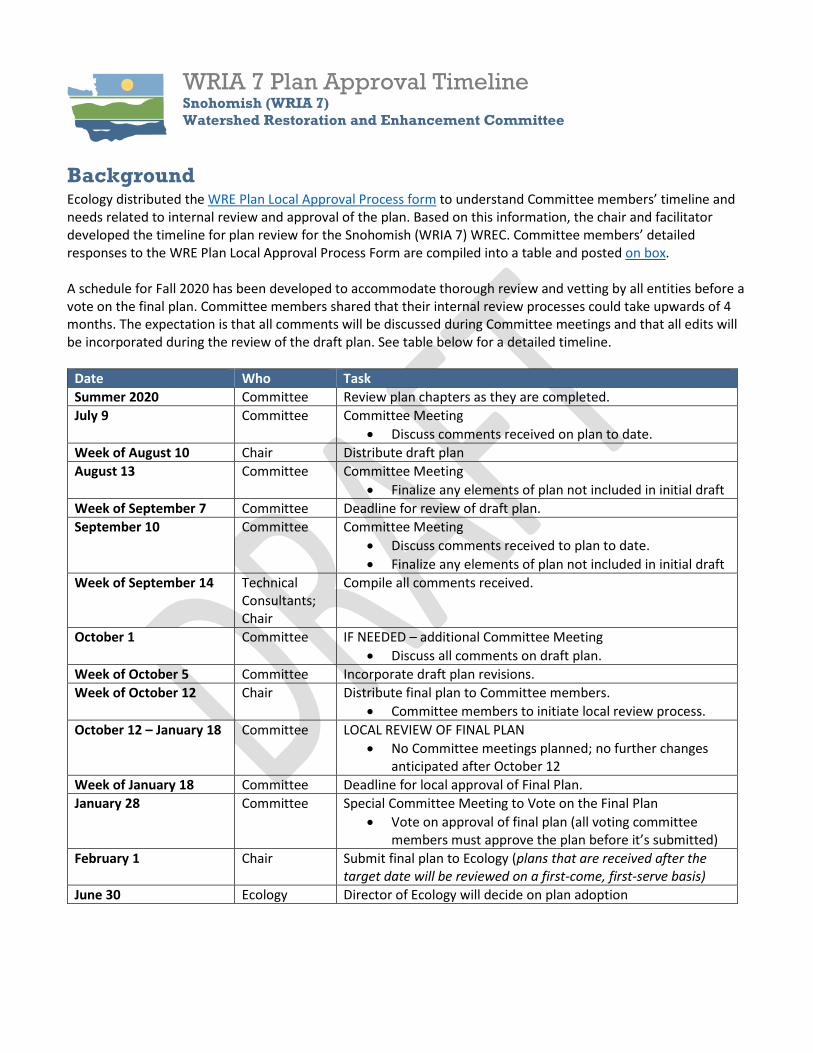
WRIA 7 Plan Approval Timeline Snohomish (WRIA 7) Watershed Restoration and Enhancement Committee
Background Ecology distributed the WRE Plan Local Approval Process form to understand Committee members’ timeline and needs related to internal review and approval of the plan. Based on this information, the chair and facilitator developed the timeline for plan review for the Snohomish (WRIA 7) WREC. Committee members’ detailed responses to the WRE Plan Local Approval Process Form are compiled into a table and posted on box. A schedule for Fall 2020 has been developed to accommodate thorough review and vetting by all entities before a vote on the final plan. Committee members shared that their internal review processes could take upwards of 4 months. The expectation is that all comments will be discussed during Committee meetings and that all edits will be incorporated during the review of the draft plan. See table below for a detailed timeline.
Date Who Task Summer 2020 Committee Review plan chapters as they are completed. July 9 Committee Committee Meeting
• Discuss comments received on plan to date. Week of August 10 Chair Distribute draft plan August 13 Committee Committee Meeting
• Finalize any elements of plan not included in initial draft Week of September 7 Committee Deadline for review of draft plan. September 10 Committee Committee Meeting
• Discuss comments received to plan to date. • Finalize any elements of plan not included in initial draft
Week of September 14 Technical Consultants; Chair
Compile all comments received.
October 1 Committee IF NEEDED – additional Committee Meeting • Discuss all comments on draft plan.
Week of October 5 Committee Incorporate draft plan revisions. Week of October 12 Chair Distribute final plan to Committee members.
• Committee members to initiate local review process. October 12 – January 18 Committee LOCAL REVIEW OF FINAL PLAN
• No Committee meetings planned; no further changes anticipated after October 12
Week of January 18 Committee Deadline for local approval of Final Plan. January 28 Committee Special Committee Meeting to Vote on the Final Plan
• Vote on approval of final plan (all voting committee members must approve the plan before it’s submitted)
February 1 Chair Submit final plan to Ecology (plans that are received after the target date will be reviewed on a first-come, first-serve basis)
June 30 Ecology Director of Ecology will decide on plan adoption

WRIA 7 Project Opportunity Profile - Lower Pilchuck 11
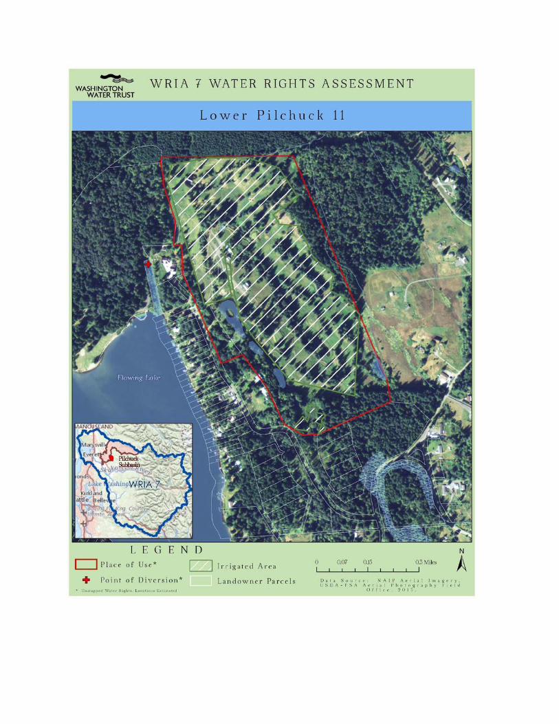
Project Summary FLOW BENEFIT: Additional 0.13 cfs in 5.5 miles of Pilchuck tributaries (Flowing Lake, Panther Creek, Dubuque Creek), 6.5 miles Pilchuck Mainstem, 13 miles Snohomish Mainstem
PRIORITY SUBBASIN: Lower Pilchuck River
ESTIMATED OFFSET: 2.09 AFY consumptive1
PRIORITY DATE: 07/23/1947
INSTREAM FLOW RULE (1979): There is an instream flow established in the Pilchuck River2
ESA LISTED FISH: Spring, Summer, and Fall Chinook (Threatened), Coho (Species of Concern), Winter and Summer Steelhead (Threatened)
OUTREACH STATUS: None
Project Description
The Lower Pilchuck 11 water right was included in the WRIA 7 water rights analysis by Ecology request. The land, and underlying water right, was previously used as a golf course, which according to online news sources, closed in 2013. The property is located northeast of the City of Snohomish. The parcels which comprise the property have been under the same family ownership since 1947. Since the golf course closed, Ecology has received metering records that indicate water is still being used, although the purpose is unknown. The property change of use, may provide an opportunity for water rights acquisition. The water right holder has had a history of litigation with Washington State surrounding this water right and may be reluctant to engage in a transaction with the state. To our knowledge, no outreach to the water right holder has been completed by any entity at this time.
Watershed
Flowing Lake is a part of the Pilchuck River sub-basin. Flowing Lake drains into Panther Creek which flows into Dubuque Creek which joins the Pilchuck River at RM 6.5. The Pilchuck River has an instream flow in this downstream reach, and low flow has been cited as a limiting factor in the Pilchuck sub-basin by several local salmon recovery efforts and by WREC committee members.
1 Assumed 2 acres irrigation based on water right documents. Delineations may be inaccurate based on management practices of watering only tees and greens on the golf course. 2 WAC 173-507
Land Use & Ownership
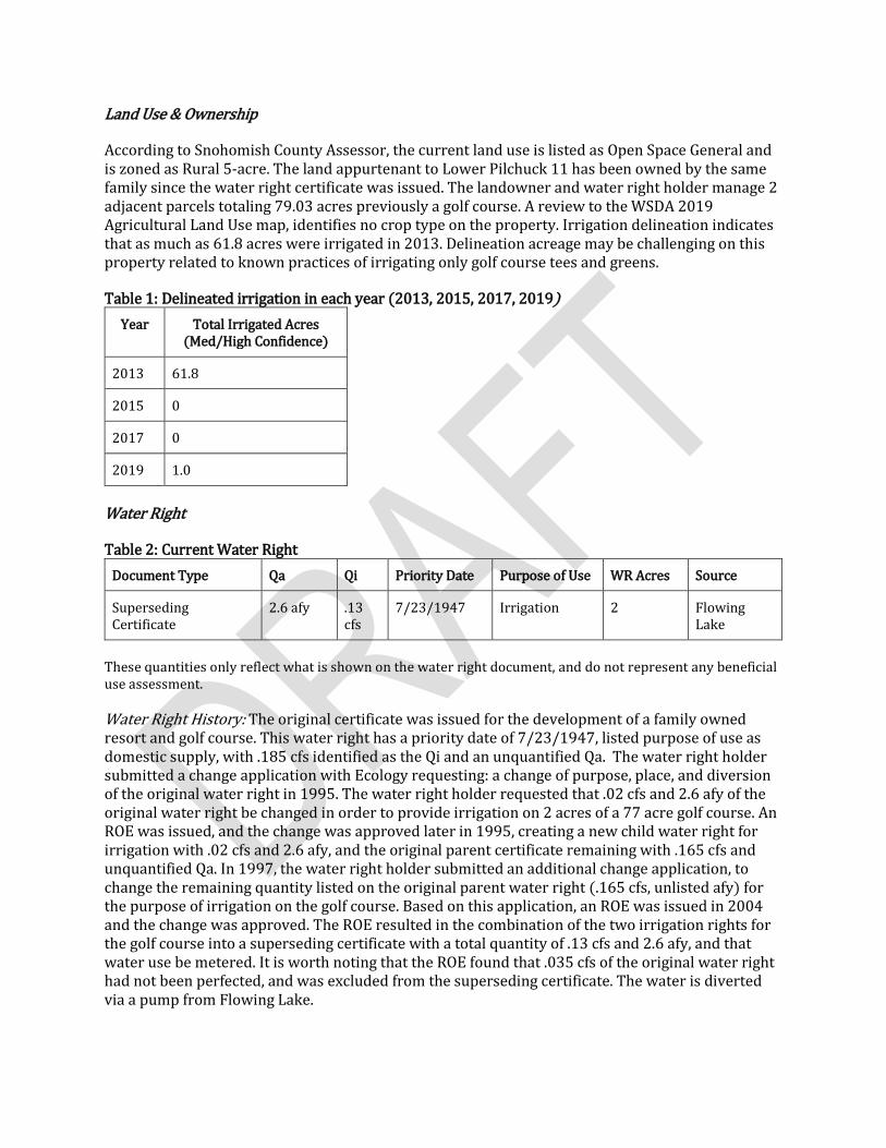
According to Snohomish County Assessor, the current land use is listed as Open Space General and is zoned as Rural 5-acre. The land appurtenant to Lower Pilchuck 11 has been owned by the same family since the water right certificate was issued. The landowner and water right holder manage 2 adjacent parcels totaling 79.03 acres previously a golf course. A review to the WSDA 2019 Agricultural Land Use map, identifies no crop type on the property. Irrigation delineation indicates that as much as 61.8 acres were irrigated in 2013. Delineation acreage may be challenging on this property related to known practices of irrigating only golf course tees and greens.
Table 1: Delineated irrigation in each year (2013, 2015, 2017, 2019) Year Total Irrigated Acres
(Med/High Confidence)
2013 61.8
2015 0
2017 0
2019 1.0
Water Right
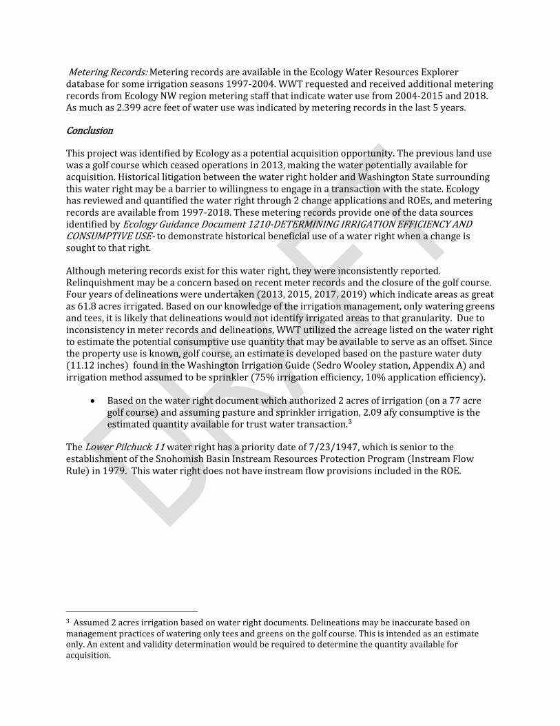
Table 2: Current Water Right Document Type Qa Qi Priority Date Purpose of Use WR Acres Source
Superseding Certificate
2.6 afy .13 cfs
7/23/1947 Irrigation 2 Flowing Lake
These quantities only reflect what is shown on the water right document, and do not represent any beneficial use assessment.
Water Right History: The original certificate was issued for the development of a family owned resort and golf course. This water right has a priority date of 7/23/1947, listed purpose of use as domestic supply, with .185 cfs identified as the Qi and an unquantified Qa. The water right holder submitted a change application with Ecology requesting: a change of purpose, place, and diversion of the original water right in 1995. The water right holder requested that .02 cfs and 2.6 afy of the original water right be changed in order to provide irrigation on 2 acres of a 77 acre golf course. An ROE was issued, and the change was approved later in 1995, creating a new child water right for irrigation with .02 cfs and 2.6 afy, and the original parent certificate remaining with .165 cfs and unquantified Qa. In 1997, the water right holder submitted an additional change application, to change the remaining quantity listed on the original parent water right (.165 cfs, unlisted afy) for the purpose of irrigation on the golf course. Based on this application, an ROE was issued in 2004 and the change was approved. The ROE resulted in the combination of the two irrigation rights for the golf course into a superseding certificate with a total quantity of .13 cfs and 2.6 afy, and that water use be metered. It is worth noting that the ROE found that .035 cfs of the original water right had not been perfected, and was excluded from the superseding certificate. The water is diverted via a pump from Flowing Lake.
Metering Records: Metering records are available in the Ecology Water Resources Explorer database for some irrigation seasons 1997-2004. WWT requested and received additional metering records from Ecology NW region metering staff that indicate water use from 2004-2015 and 2018. As much as 2.399 acre feet of water use was indicated by metering records in the last 5 years.
Conclusion
This project was identified by Ecology as a potential acquisition opportunity. The previous land use was a golf course which ceased operations in 2013, making the water potentially available for acquisition. Historical litigation between the water right holder and Washington State surrounding this water right may be a barrier to willingness to engage in a transaction with the state. Ecology has reviewed and quantified the water right through 2 change applications and ROEs, and metering records are available from 1997-2018. These metering records provide one of the data sources identified by Ecology Guidance Document 1210-DETERMINING IRRIGATION EFFICIENCY AND CONSUMPTIVE USE- to demonstrate historical beneficial use of a water right when a change is sought to that right.
Although metering records exist for this water right, they were inconsistently reported. Relinquishment may be a concern based on recent meter records and the closure of the golf course. Four years of delineations were undertaken (2013, 2015, 2017, 2019) which indicate areas as great as 61.8 acres irrigated. Based on our knowledge of the irrigation management, only watering greens and tees, it is likely that delineations would not identify irrigated areas to that granularity. Due to inconsistency in meter records and delineations, WWT utilized the acreage listed on the water right to estimate the potential consumptive use quantity that may be available to serve as an offset. Since the property use is known, golf course, an estimate is developed based on the pasture water duty (11.12 inches) found in the Washington Irrigation Guide (Sedro Wooley station, Appendix A) and irrigation method assumed to be sprinkler (75% irrigation efficiency, 10% application efficiency).
• Based on the water right document which authorized 2 acres of irrigation (on a 77 acre golf course) and assuming pasture and sprinkler irrigation, 2.09 afy consumptive is the estimated quantity available for trust water transaction.3
The Lower Pilchuck 11 water right has a priority date of 7/23/1947, which is senior to the establishment of the Snohomish Basin Instream Resources Protection Program (Instream Flow Rule) in 1979. This water right does not have instream flow provisions included in the ROE.
3 Assumed 2 acres irrigation based on water right documents. Delineations may be inaccurate based on management practices of watering only tees and greens on the golf course. This is intended as an estimate only. An extent and validity determination would be required to determine the quantity available for acquisition.
1
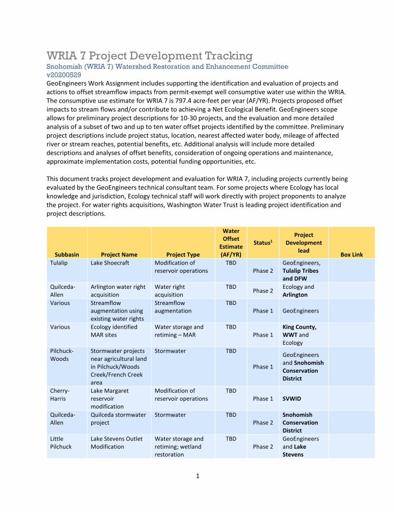
WRIA 7 Project Development Tracking Snohomish (WRIA 7) Watershed Restoration and Enhancement Committee v20200529 GeoEngineers Work Assignment includes supporting the identification and evaluation of projects and actions to offset streamflow impacts from permit-exempt well consumptive water use within the WRIA. The consumptive use estimate for WRIA 7 is 797.4 acre-feet per year (AF/YR). Projects proposed offset impacts to stream flows and/or contribute to achieving a Net Ecological Benefit. GeoEngineers scope allows for preliminary project descriptions for 10-30 projects, and the evaluation and more detailed analysis of a subset of two and up to ten water offset projects identified by the committee. Preliminary project descriptions include project status, location, nearest affected water body, mileage of affected river or stream reaches, potential benefits, etc. Additional analysis will include more detailed descriptions and analyses of offset benefits, consideration of ongoing operations and maintenance, approximate implementation costs, potential funding opportunities, etc. This document tracks project development and evaluation for WRIA 7, including projects currently being evaluated by the GeoEngineers technical consultant team. For some projects where Ecology has local knowledge and jurisdiction, Ecology technical staff will work directly with project proponents to analyze the project. For water rights acquisitions, Washington Water Trust is leading project identification and project descriptions.
Subbasin Project Name Project Type
Water Offset
Estimate (AF/YR)
Status1 Project
Development lead Box Link
Tulalip Lake Shoecraft Modification of reservoir operations
TBD Phase 2
GeoEngineers, Tulalip Tribes and DFW
Quilceda-Allen
Arlington water right acquisition
Water right acquisition
TBD Phase 2 Ecology and Arlington
Various Streamflow augmentation using existing water rights
Streamflow augmentation
TBD Phase 1 GeoEngineers
Various Ecology identified MAR sites
Water storage and retiming – MAR
TBD Phase 1
King County, WWT and Ecology
Pilchuck-Woods
Stormwater projects near agricultural land in Pilchuck/Woods Creek/French Creek area
Stormwater TBD
Phase 1
GeoEngineers and Snohomish Conservation District
Cherry- Harris
Lake Margaret reservoir modification
Modification of reservoir operations
TBD Phase 1 SVWID
Quilceda-Allen
Quilceda stormwater project
Stormwater TBD Phase 2
Snohomish Conservation District
Little Pilchuck
Lake Stevens Outlet Modification
Water storage and retiming; wetland restoration
TBD Phase 2
GeoEngineers and Lake Stevens
2
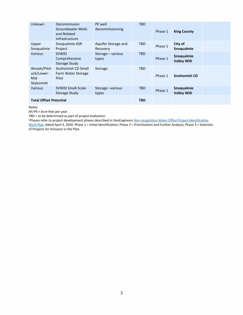
Unkown Decommission Groundwater Wells and Related Infrastructure
PE well decommissioning
TBD
Phase 1 King County
Upper Snoqualmie
Snoqualmie ASR Project
Aquifer Storage and Recovery
TBD Phase 1 City of Snoqualmie
Various SVWID Comprehensive Storage Study
Storage – various types
TBD Phase 1 Snoqualmie
Valley WID
Woods/Pilchuck/Lower-Mid Skykomish
Snohomish CD Small Farm Water Storage Pilot
Storage TBD
Phase 1 Snohomish CD
Various SVWID Small-Scale Storage Study
Storage –various types
TBD Phase 1 Snoqualmie Valley WID
Total Offset Potential TBD
Notes: AF/YR = Acre-feet per year TBD = to be determined as part of project evaluation 1Phases refer to project development phases described in GeoEngineers Non-Acquisition Water Offset Project Identification Work Plan, dated April 4, 2020. Phase 1 = Initial Identification; Phase 2 = Prioritization and Further Analysis; Phase 3 = Selection of Projects for Inclusion in the Plan.
State of Washington DEPARTMENT OF FISH AND WILDLIFE
Mailing Address: 600 Capitol Way N, Olympia, WA 98501-1091 • (360) 902-2200 • TDD (360) 902-2207 Main Office Location: Natural Resources Building, 1111 Washington Street SE, Olympia, WA
May 27, 2020
WRIA 7 WREC Members
c/o Ms. Ingria Jones
PO Box 47600
Olympia, WA 98504
Re: Quantification of streamflow contributions from habitat restoration projects
Dear Watershed Restoration and Enhancement Committee members,
I am writing on behalf of the Washington Department of Fish and Wildlife (WDFW) to share the
agency’s perspective on quantifying streamflow contributions from habitat restoration projects.
WDFW’s mission is to preserve, protect and perpetuate fish, wildlife, and ecosystems while
providing sustainable fish and wildlife recreational and commercial opportunities. One strategy
WDFW employs to achieve this mission is to conserve and restore ecosystems necessary for the
long-term sustainability of fish and wildlife populations. The streamflow restoration planning
process occurring in some Washington watersheds provides an important means to protect and
improve ecosystem health and function. Increasing demands for water (especially its
consumptive use), coupled with changing land-use and climatic conditions, have harmed the
ecological function of many Washington streams and rivers. In some years, streamflow levels
required by law may go unmet in many watersheds. These impaired streamflows are detrimental
to the productivity and long-term viability of many aquatic species, including those that are
endangered or at-risk. Considering this, WDFW enthusiastically participates in the streamflow
restoration planning processes to ensure future impacts are adequately offset by projects that
replace water and restore flow. WDFW supports streamflow restoration planning processes that
are informed by science, identify tenable assumptions and uncertainties, and seek to reduce those
uncertainties. This letter intends to outline our perspective based on current scientific
understanding of streamflow restoration.
In 2018, the Legislature enacted ESSB 6091, codified primarily under RCW 90.94, to guide the
protection and restoration of streamflows impacted by new domestic permit-exempt well
development. A primary objective of RCW 90.94 is to initiate watershed planning to offset
projected streamflow impacts from new permit-exempt domestic groundwater withdrawals using
projects that replace water as well as additional projects to achieve a Net Ecological Benefit
(NEB). An important feature of this new legal framework is the flexibility to (1) replace water
lost from consumptive impacts due to new domestic well use on a watershed-scale as opposed to
at the place of impact and, (2) replace water asynchronously with the impact so long as the
streamflow benefits accrue during critical flow periods. Allowing the replacement of water to
occur out-of-place and/or out-of-time of the projected streamflow impacts could be detrimental
to watershed function; however, the law further requires the watershed plans to propose projects
Watershed Restoration and Enhancement Committee
May 27, 2020
Page 2
that will result in a NEB within the watershed. To achieve NEB, proposed projects will likely
incorporate a variety of habitat restoration techniques targeting broad ecological benefits such as
increasing habitat heterogeneity and improving water quality. WDFW strongly supports the use
of habitat restoration projects in the streamflow restoration planning process as a strategy to
enhance instream resources, improve watershed functions, and achieve NEB.
Some habitat restoration projects may benefit streamflows in addition to providing other
ecological benefits. Understandably, there has been interest in quantifying those benefits so they
may be counted as part of the water needed to offset impacts from future domestic permit-
exempt wells. As noted above, WDFW believes habitat restoration and enhancement projects
are valuable tools to improve ecosystem function; however, we are very cautious about
accepting estimated streamflow benefits as a replacement for consumptive quantities of water
without the use of scientifically rigorous methods. The ability of habitat projects to contribute to
streamflow is driven by many variables and is difficult to predict. The agency’s primary
concerns with the quantification of streamflow contributions from habitat restoration and
enhancement projects are:
1) Benefits may not be achieved each year or in perpetuity. Due to the inherent variability of the
processes that mediate streamflow (e.g. runoff, aquifer storage, surface-groundwater exchange,
etc.), it is difficult to determine with certainty that enhanced contributions to streamflow
associated with a restoration project will be achieved annually or in successive years. While
robust (i.e. accurate, long-term, temporally continuous) baseline streamflow data can help reduce
this uncertainty, changes in local site conditions, land-use, or climate may diminish or eliminate
all anticipated long-term benefits from habitat projects. By design or otherwise, most habitat
projects will have an effective lifetime much shorter than the presumed perpetual impacts of
domestic permit-exempt wells.
2) Volumetric increases in surface or groundwater storage may not correspond to increased
streamflows during critical flow periods or at all. River-floodplains tend to act predominantly as
transient storage corridors, making the contributions of a given reach to streamflow following
high flow events either short lived or widely variable depending on the geomorphic, vegetative,
and hydrologic conditions of the site. Within river segments where longer surface and
groundwater storage becomes activated during high-flow periods, hydrologic connectivity (i.e.
exchange) may not be maintained during low flow periods; potentially negating anticipated late-
season streamflow benefits.
3) Simplified methods are unlikely to reflect true processes. Using simple modeling to estimate
potential water storage or steady-state late-season groundwater contributions to streamflow may
increase the risk that a given project fails to achieve the anticipated offset by mischaracterizing
its potential benefits. Methods that employ generalized annual estimates of water quantities
derived from simple geometric equations or numerical models cannot accurately predict the
quantity or timing of water contribution a project will have to streamflow.
These concerns are underscored by a lack of clear scientific consensus about the effects of
habitat restoration on streamflow. Field data documenting changes in streamflow following
Watershed Restoration and Enhancement Committee
May 27, 2020
Page 3
restoration are sparse, often rely on relatively short-term datasets, or report results from only a
single case study. The robust quantification of streamflow benefits from habitat projects is also
hindered by several poorly understood streamflow processes including the influence of
evapotranspiration, surface-groundwater exchange, and the relationship between watershed-scale
dynamics and site-scale hydrology. For example, many restoration projects aim to enhance
riparian vegetation growth, but the magnitude of streamflow impacts resulting from increased
evapotranspiration during low flow periods presents a large uncertainty. In addition, the interface
between surface, hyporheic, and groundwater sources can be strongly impacted by channel
morphology, substrate type, and hydrology, limiting the degree of certainty with which we can
project long-term groundwater contributions to streamflow. Lastly, increased water storage does
not always equate to increased streamflow. Research examining the processes governing
transient and long-term storage in river corridors is a relatively nascent and active area of study,
warranting caution when attributing benefits that will be used to restore impaired streamflows in
perpetuity.
Given these concerns with the ability of habitat restoration and enhancement projects to provide
ascertainable streamflow benefits in perpetuity, we prefer the use of water-for-water (in-kind)
projects to replace consumptive quantities of water from new domestic permit-exempt wells. In
place of attempting to estimate streamflow contributions from habitat projects using simplified
approaches, we propose focusing resources towards identifying projects with more certain
contributions to streamflow. We recommend attributing benefits from habitat projects more
generally towards meeting NEB requirements and not towards water replacement quantities.
Should streamflow benefits of habitat projects be estimated, we encourage project proponents to
use well documented and conservative methods employing field validated modeling that is
inclusive of historical runoff, soil porosity, transmissivity, and channel hydraulics. Additionally,
methods should include reporting estimates of measurement and modelling error and consider
the natural range of flow variability, estimates of storage potential, and changes in baseflow
contributions to improve the likelihood that flow benefits are accurately reflected.
WDFW values and supports the use of habitat restoration and enhancement projects to improve
conditions for aquatic species and is working to better understand potential streamflow benefits
from out-of-kind projects. To this end, WDFW has contracted with Washington State University
to conduct a literature review examining the state-of-the-science on streamflow and groundwater
benefits from various habitat restoration projects. Expected in summer of 2020, this work will
further inform WDFW’s position and help develop additional guidance.
Thank you for considering our recommendations, and we look forward to robust discussions
about this topic in the streamflow restoration planning process.
Sincerely,
Tristan Weiss
Streamflow Restoration Ecologist